Embed Size (px)
Citation preview
Political Geography 27 (2008) 630e651www.elsevier.com/locate/polgeo
Inscribing empire: Guam and the War in the PacificNational Historical Park
R.D.K. Herman*
Research Unit, Smithsonian National Museum of the American Indian, PO Box 37012, Washington,
DC 20013-7012, USA
Abstract
National parks form an archipelago of government-run, on-site ‘‘museums,’’ geographic sites ofterritorial and rhetorical nation-building. The War in the Pacific National Historical Park, which occupiesseven parcels of land on the small island of Guam, celebrates the ‘‘freedom’’ that the U.S. brought to theregion in World War II. But in fact, this landscape sits at the nexus of several contested territories. Guamwas seized in the 1898 SpanisheAmerican Wardthe final wave of American territorial expansiondandexperienced 50 years of dictatorship under the U.S. Navy, despite vigorous efforts by islanders to gaincitizenship and basic rights. The post-war transformation of the island by the military came at the furtherexpense of local land rights, and the park itself later got caught up in the struggle over federal landownership. Disagreements within the park service and between the park service and the local people addedto the contests. Finally and most importantly, the park-as-text presents a discourse of American militaryheroism against the Japanese, at the expense of recognition of Chamorro suffering, or of any historicalmarker tying the indigenous history of Guam into U.S. historical memory. The contradiction between U.S.expansionism and U.S. ideals is apparent in the way the park serves as a colonial tool in this remnant ofthe American empire. This paper examines the park as a narrative landscape within the fields ofcontestation that characterize U.S. rule on Guam.Published by Elsevier Ltd.
Keywords: Empire; National parks; Guam; Landscape
* Tel.: þ1 202 633 8843; fax: þ1 202 633 6894.
E-mail address: [email protected]
0962-6298/$ - see front matter Published by Elsevier Ltd.
doi:10.1016/j.polgeo.2008.07.003
631R.D.K. Herman / Political Geography 27 (2008) 630e651
On December 7th, 1941, Japanese aircraft launched a surprise attack on Pearl Harbor in theU.S. Territory of Hawai‘i. 2300 U.S. Military and 48 civilians were killed in what PresidentRoosevelt called ‘‘a day that will live in infamy.’’ Virtually unknown to Americans, however, isthe attack that took place about 4 h later, on a far more remote U.S. Territory: the island ofGuam. In a brief but locally well-remembered air and sea attack, Japanese troops seized controlof this small American colony and began an occupation that lasted three years. Over 13,000American subjects suffered injury, forced labor, forced march, or internment. At least 1123 died(National Park Service, n.d.).
The differencesdand the similaritiesdof these two memories illuminate the workings ofAmerican empire. At the time, both island entities were unincorporated colonies of the U.S.,and in both cases, the indigenous peoples had not been consulted regarding their acquisition bythe U.S. But while the anniversary of the Pearl Harbor attack receives abundant commemo-ration, re-showings (and re-makings) of relevant movies, the seizure of Guam and the plight ofthe Chamorros remain virtually unknown outside of Guam and Micronesia.
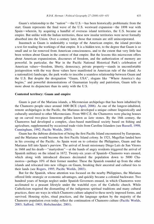
I arrived on Guam in 2001 to work with community members on an oral-based indigenous-geography project. By way of familiarizing myself with the lay of the land, I used my first daythere to drive around the island. I had not traveled far out of Hagatna1 when I encountereda large, familiar-shaped sign announcing the War in the Pacific National Historical Park.Perhaps five minutes later, I passed another such sign. And five minutes after that, still another.The highway then ended at a T-intersection facing imposing gates with armed guards and largelettering announcing ‘‘U.S. Naval Base Guam.’’ The highway itself is called ‘‘Marine Drive,’’but my na€ıve assumption that this reflected the road’s location along the ocean was dispelled bya newer sign, in 2006, clarifying that it is ‘‘Marine Corps Drive.’’2 Given that my own concernwas to research and present an indigenous perspective on the island, I found this series of signsoverwhelming (Fig. 1). Americans who know anything of Guam know that the island is host toU.S. military bases, and the route I drove was littered with symbols of the military presence(Fig. 2). The signs denoting a national park commemorating war, operating in conjunction withthe large military presence, too easily mark out a narrative terrain on an island otherwiselacking in alternative narrative for most Americans.
The presence of this national landscape on Guam is an uneasy juxtaposition, and this studyexamines how the park sits at the nexus of several contested terrainsdgeographic and dis-cursivedthat characterize the relationship between the U.S. and this remote possession. Theisland is one of the U.S.’s remaining colonies (‘‘unincorporated territories’’), located only 14�
above the equator and over 6000 miles away from North America’s west coast. Conversely,Guam is about 1400 miles from either the Philippines or Tokyo. The island is officiallyAmerican soil, yet American citizens need a passport to enter. Seventy-six percent of thepopulation is of Micronesian or Asian ancestry (mostly Chamorro and Filipino)3, with only 7%
1 The capital of Guam, widely known as Agana or Agana, is herein designated by its Chamoru name, Hagatna. The
vowel a is pronounced as in mat, while a is pronounced as in father.2 I am informed that Chamorro Marines petitioned for this change of name.3 After the American takeover of Guam, and especially after World War II, much of the literature refers to Guam
residents as ‘‘Guamanians.’’ For mainland American writers, this reflected the insistence that the Chamorros were no
longer a ‘‘pure race.’’ The term was also used post-war by the indigenous population to distinguish themselves from new
residents who were not native. On Guam today, Chamorros refer to themselves as ‘‘Chamorros’’ when referring to their
ethnicity, and the term ‘‘Guamanian’’’’ is used by the local media to refer to all residents of Guam much in the same as
‘‘New Yorker’’ or ‘‘Californian.’’ But given the demographic shifts post-war, one can no longer refer to the islanders as
a whole as ‘‘Chamorro.’’
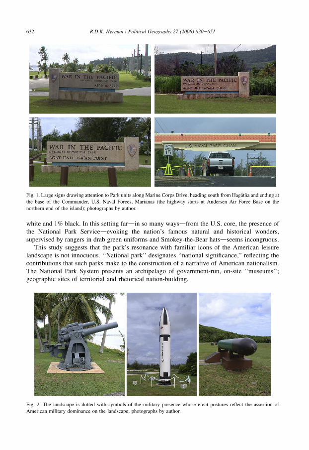
Fig. 1. Large signs drawing attention to Park units along Marine Corps Drive, heading south from Hagatna and ending at
the base of the Commander, U.S. Naval Forces, Marianas (the highway starts at Andersen Air Force Base on the
northern end of the island); photographs by author.
632 R.D.K. Herman / Political Geography 27 (2008) 630e651
white and 1% black. In this setting fardin so many waysdfrom the U.S. core, the presence ofthe National Park Servicedevoking the nation’s famous natural and historical wonders,supervised by rangers in drab green uniforms and Smokey-the-Bear hatsdseems incongruous.
This study suggests that the park’s resonance with familiar icons of the American leisurelandscape is not innocuous. ‘‘National park’’ designates ‘‘national significance,’’ reflecting thecontributions that such parks make to the construction of a narrative of American nationalism.The National Park System presents an archipelago of government-run, on-site ‘‘museums’’;geographic sites of territorial and rhetorical nation-building.
Fig. 2. The landscape is dotted with symbols of the military presence whose erect postures reflect the assertion of
American military dominance on the landscape; photographs by author.
633R.D.K. Herman / Political Geography 27 (2008) 630e651
Guam’s relationship to the ‘‘nation’’dthe U.S.dhas been historically problematic from thestart. Guam represents the final wave of the U.S. westward expansiondthe 1898 war withSpaindwherein, by acquiring a handful of overseas island territories, the U.S. became anempire. But unlike with the Indian territories, these new insular territories were never formallyabsorbed into the Union. Over a century later, those that remain are still unincorporated.
Inasmuch as Guam is undeniably a vestige of the American empire, the island providesa text for reading the workings of that empire. It is a hidden text, to the degree that Guam is sosmall and so far removed from American consciousness, and to the extent that very little hasbeen written about Guam in the context of that empire. But the lessons this microcosm offersabout American expansionism, discourses of freedom, and the authorization of memory arepowerful. In particular, the War in the Pacific National Historical Park’s celebration ofAmerican valuesdfreedom, liberty, democracy, private propertydstands in uncomfortablejuxtaposition with the way those values have manifested in American rule of the island. Asa national(ist) landscape, the park works to inscribe a seamless relationship between Guam andthe U.S. But despite the designation ‘‘Guam, USA’’, slogans like ‘‘Where America’s daybegins,’’ and powerful demonstrations of Guamanian loyalty and patriotism, Guam tells usmore about its disjuncture than its unity with the U.S.
Contested territory: Guam and empire
Guam is part of the Mariana islands, a Micronesian archipelago that has been inhabited bythe Chamorro people since around 1600 BCE (April, 2006). As one of the longest-inhabited,remote archipelagos in the Pacific, the Marianas developed a unique culture linguistically andculturally unrelated to other Micronesians. From 900 C.E. the Chamorros were placing housesup on carved two-piece limestone pillars known as latte stones. By the 16th century, theChamorros had developed a complex, class-based matrilineal society based on fishing andagriculture, supplemented by occasional trade visits from Caroline Islanders (see Russell, 1998;Cunningham, 1992; Pacific Worlds, 2003).
Guam has the dubious distinction of being the first Pacific Island encountered by Europeans,and the Marianas would become the first Pacific Island colony. In 1521, Magellan landed herein his crossing of the Pacific. As Spain went on to colonize the Philippines, Guam and theMarianas fell into Spain’s purview. The arrival of Jesuit missionary Diego Luıs de San Vitoresin 1668 and his deathd‘‘martyrdom’’dat the hands of angry residents triggered the arrival ofSpanish military on the island in 1672. Twenty-six years of SpanisheChamorro wars ensued,which along with introduced diseases decimated the population down to 5000 Cha-morrosdperhaps 10% of their former number. These the Spanish rounded up from the otherislands and relocated into new villages on Guam, breaking their ancestral and cultural ties totheir lands (see Rogers, 1995; Pacific Worlds, 2003).
But for the Spanish, whose attention was focused on the nearby Philippines, the Marianasoffered little strategic or economic advantages, and quickly became a colonial backwater. Twohundred years of benign neglect under Spanish Governors ensued, in which Chamorros wereacclimated to a peasant lifestyle under the watchful eyes of the Catholic church. WhileCatholicism required the dismantling of the indigenous spiritual traditions and many culturalpractices, there are ways in which Chamorro culture adapted to these newly imposed forms, andsurvived. Housing styles, ritual practices, and the language spoken by the majority of theChamorro population even today reflect the continuation of Chamorro culture (Pacific Worlds,2003; Safford, 1903; Hofschneider, 2001).
634 R.D.K. Herman / Political Geography 27 (2008) 630e651
The Spanish empire was approaching its twilight years by the time the young U.S. acquiredCalifornia from Mexico in 1848. Having expanded westward from the original 13 colonies ina mere 60 years, this young nation-state had stunned the world with its rapid growth. As thatgrowth came at the expense of indigenous inhabitants, it is important to note the ideologywhereby a country espousing freedom could engage in conquest. Drinnon (1980) presentsa progressive development of racisteexpansionist thinking that Merk (1963) breaks into twothemes: first is a sense of mission that was inherently Christian, with a strong belief that DivineProvidence was guiding the nation, and always focused on notions of freedom, equality, andrepublican ideals (Merk, 1963; Segal & Stineback, 1977; Horsman, 1981). These combined ina firm conviction that American institutions would spread by the natural attraction ofsurrounding peoples to this high standard of civilization: freedom.
Added to that, however, was an expansionist agenda held by some, asserting the prerogativeof the U.S. to acquire new territory as it pleased. From the earliest days of the nation there werethose who foresaw the U.S. incorporating all of North America; for others, the entire WesternHemisphere; and for still others, American ideals and institutions should be planted on everyshore. Mission and expansionism combined into the discourse of Manifest Destiny.
Forcible expansionism was justified by a racial factor, whereby peoples deemed ‘‘not readyfor civilization’’ were candidates for colonization. This was first formalized in Chief JusticeJohn Marshall 1838 Supreme Court ruling in Cherokee Nation v. Georgia, wherein he statedthat American Indians constituted ‘‘domestic dependent nations’’ that ‘‘occupy a territory towhich we assert a title independent of their will’’ and whose ‘‘relation to the U.S. resemblesthat of a ward to his guardian.’’ (Cherokee Nation v. Georgia, 1831) As the American nationwas, in Lepore’s (1999) argument, based on justifiable violence towards Indians, the discoursesof mission and expansionism had always had a racial component (Berkhofer, 1978; Drinnon,1980; Horsman, 1981; Deloria, 1998). Particularly in its 1890s manifestation, Manifest Destinywas an overtly racist ideology, extending ‘‘Indian-hating’’ to the far western Pacific.
These were the notions at work when the USS Charleston seized Guam at the outset of theSpanisheAmerican War in 1898. The 1898 Treaty of Paris between Spain and the U.S.formalized the handover of Guam. What then unfolded over the next century cannot beunderstood apart from this ideological paradox between freedom and conquest.
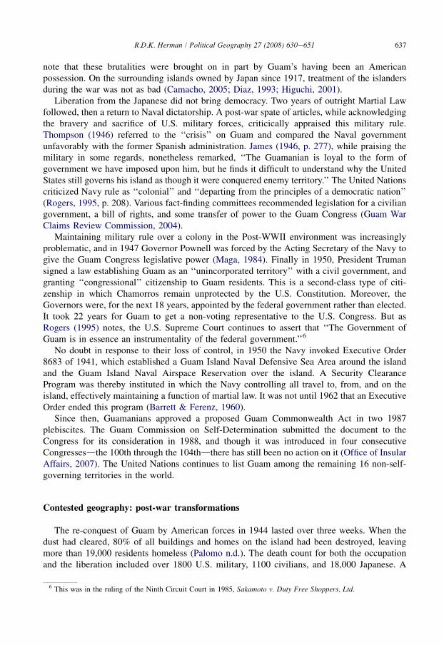
The American takeover of Guam was peacefully accomplished, but in an ironic accident ofhistory and geography, the American officers neglected to take the rest of the Marianas andmuch more of Micronesia claimed at that time by the Spanish (Figs. 3 and 4). Spain quicklysold these other islands to Germany, leaving Guam and the Philippines isolated by thousands ofmiles of ocean from the next nearest (newly annexed) American territory, the HawaiianIslands.
That the island was conquered by the U.S. marks the first way in which Guam is a contestedterrain. It is a place taken in conquest from another state that earlier took it by conquest, with nochoice on the part of the indigenous inhabitants in either case (Blaz, 1994; Rogers, 1995).
Contested nationhood: Guam, USA
Until the 1898 war, U.S. territories had customarily progressed into states, and theConstitution had ‘‘followed the flag.’’ But there was no such intention here. This reversal ofpolicy was confirmed by the Insular Cases of 1901. New territories, it was decided, might neverbe incorporated into the union, and were to receive only unspecified ‘‘fundamental’’ Consti-tutional protections. They were to be governed without the consent of the governed in a system
Japan
Taiwan
Philippines
Palau
Yap
ChuukPohnpei
Marshall Islands
C a r o l i n e I s l a n d s
Guam N. M
aria
na Is
.
Saipan
Federated States of Micronesia
Kosrae
Fig. 3. Map of ‘‘American’’ Micronesia. Guam, the Northern Mariana Islands, and the Caroline Islands were all
nominally claimed by Spain by 1898. After the U.S. captured Guam, Spain sold the rest to Germany, which already
controlled the Marshall Islands. Germany lost its holdings to Japan in World War I. The larger loop shows the Japanese-
controlled region that became the Trust Territory of the Pacific under U.S. control after World War II. In the
1980s, it broke up into the countries represented. Except during Japan’s occupation, Guam has been separate from this
region.
635R.D.K. Herman / Political Geography 27 (2008) 630e651
that lacked the checks and balances that underlie the principle of limited government (Sparrow,2006, p. 5). The new insular possessions became ‘‘real dependencies.territories inhabited bya settled population differing from us in race and civilization to such an extent that assimilationseems impossible’’ (Coudert, 1903, p. 13). Thus in the 1898 war the U.S. became an empire inthe manner of Britain, France and Germany (see Williams, 1980). The contradiction ofa ‘‘free,’’ ‘‘democratic’’ country holding colonies unfolded powerfully on Guam over theensuing century.
Given the unincorporated status of Guam as a territory, the status of the people of Guam issimilarly liminal. And indeed, it is the contest over the relationship of Guamanians to the U.S.that most clearly affirms Guam as contested territory. The Chamorros adapted quickly to thenotion of American rule, and efforts at Americanization were both employed and appropriated,resulting in an early apparent patriotism towards the U.S. But the resulting Chamorro strugglefor citizenship and civil rights stands in contradiction to the highly touted ‘‘freedom’’ that U.S.rule was supposed to have brought. Writers on the 1898 war and on Manifest Destiny havethemselves ignored the implications of what unfolded on Guam after the U.S. takeover(Camacho, 2005; Maga, 1984).
Right after the U.S takover, the leading families of Guam met and established a legislature inanticipation of a democratic, representative government. To their surprise, the island wasinstead placed under the Secretary of the Navy, and ruled by a series of military governors who,though generally benign, wielded absolute power. The Navy maintained the islanddbothphysically and discursivelydas an essential American forward base, and under their
636 R.D.K. Herman / Political Geography 27 (2008) 630e651
administrations, Guam was run like a well-ordered battleship with what was essentially martiallaw (Thompson, 1946).4 Practices deemed incompatible with military order were suppressed,including (at various times) the Chamorro language, Catholic rituals, drinking, gambling, andwhistling on the streets. Trials were by military court. There was no civilian government.
From the start, the contradiction of American rule without American democracy wasapparent to the Chamorros. The actions they took over the next few decades demonstrated theirdetermination:
� In 1901, 32 leading citizens of Guam sent a petition to the U.S. Congress stating that‘‘fewer permanent guarantees of liberty and property rights exist now than when under theSpanish.We believe ourselves fully justified in asking relief from a system of governmentthat subjects a thoroughly loyal people to the absolute rule of a single person.’’ (cited inHofschneider, 2001, pp. 48e49). This petition, like so many that followed, was ignored.� The first Guam Congress was established in 1917. To the dismay of the local people, the
Naval governor insisted that its members be appointed by his office, rather than elected, andtreated the Congress as merely an advisory body to enable his goals of civil administration(Hofschneider, 2001).� In 1929 a different governor pushed for Chamorro citizenship and self-rule, and even signed
a bill of rights. The second Guam Congress was formed with, for the first time, electedmembers, but was treated as merely an advisory body with no actual power. The proposedmeasure for self-rule and civil rights was rejected by the Navy Department (Rogers, 1995).� In 1933 the Guam Congress sent a citizenship petition to the U.S. Congress. This petition
was filed away and ignored.� In 1936, two Guam delegates, Baltazar J. Bordallo and Francisco B. Leon Guerrero, went to
Washington to petition in person for Chamorro citizenship. They were positively receivedby the President and by members of Congress. But the Navy convinced the federalgovernment to reject the petition (Rogers, 1995). The Navy cited, among other things, ‘‘theracial problems of that locality’’ and asserted that ‘‘these people have not yet reached a stateof development commensurate with the personal independence, obligations, and respon-sibilities of United States citizenship’’ (Hofschneider, 2001, p. 93).
Yet despite their insistence on military rule, the Navy was completely unprepared when theJapanese arrived in December of 1941. Five thousand Japanese troops quickly overpowered thevery small and ill-armed U.S. military and Chamorro Insular Force Guards. Then began threeyears of an increasingly brutal occupation of the island (see Palomo & Borja, 1994). During thisperiod, Chamorros were executed for aiding and abetting a few American hideouts. In the mostprominent case, Father Jesus Baza Duenas was tortured and executed for allegedly aidingradioman George Tweed (Flores, n.d.; Pacific Worlds, 2003). Towards the end of the War,Chamorros were herded into concentration camps, and some were massacred.5 It is important to
4 Thompson (1946) remarked that the Naval Civil Government offered even fewer rights and protections than regular
Naval Martial Law, since the naval governor was the lawdthere was no appeal beyond him. Cox (1904, p. 395) noted
the government’s ‘‘failure to provide a code of laws and to limit the powers of the executive, whose orders.have all the
effects of statute law.’’5 Experiences recounted by Chamorros who survived the Occupation are recounted in the ‘‘Hopkins Committee
Report for the Secretary on the Civil Government of Guam and American Samoa’’ (1947), reprinted in Guam War
Claims Review Commission (2004).
637R.D.K. Herman / Political Geography 27 (2008) 630e651
note that these brutalities were brought on in part by Guam’s having been an Americanpossession. On the surrounding islands owned by Japan since 1917, treatment of the islandersduring the war was not as bad (Camacho, 2005; Diaz, 1993; Higuchi, 2001).
Liberation from the Japanese did not bring democracy. Two years of outright Martial Lawfollowed, then a return to Naval dictatorship. A post-war spate of articles, while acknowledgingthe bravery and sacrifice of U.S. military forces, criticically appraised this military rule.Thompson (1946) referred to the ‘‘crisis’’ on Guam and compared the Naval governmentunfavorably with the former Spanish administration. James (1946, p. 277), while praising themilitary in some regards, nonetheless remarked, ‘‘The Guamanian is loyal to the form ofgovernment we have imposed upon him, but he finds it difficult to understand why the UnitedStates still governs his island as though it were conquered enemy territory.’’ The United Nationscriticized Navy rule as ‘‘colonial’’ and ‘‘departing from the principles of a democratic nation’’(Rogers, 1995, p. 208). Various fact-finding committees recommended legislation for a civiliangovernment, a bill of rights, and some transfer of power to the Guam Congress (Guam WarClaims Review Commission, 2004).
Maintaining military rule over a colony in the Post-WWII environment was increasinglyproblematic, and in 1947 Governor Pownell was forced by the Acting Secretary of the Navy togive the Guam Congress legislative power (Maga, 1984). Finally in 1950, President Trumansigned a law establishing Guam as an ‘‘unincorporated territory’’ with a civil government, andgranting ‘‘congressional’’ citizenship to Guam residents. This is a second-class type of citi-zenship in which Chamorros remain unprotected by the U.S. Constitution. Moreover, theGovernors were, for the next 18 years, appointed by the federal government rather than elected.It took 22 years for Guam to get a non-voting representative to the U.S. Congress. But asRogers (1995) notes, the U.S. Supreme Court continues to assert that ‘‘The Government ofGuam is in essence an instrumentality of the federal government.’’6
No doubt in response to their loss of control, in 1950 the Navy invoked Executive Order8683 of 1941, which established a Guam Island Naval Defensive Sea Area around the islandand the Guam Island Naval Airspace Reservation over the island. A Security ClearanceProgram was thereby instituted in which the Navy controlling all travel to, from, and on theisland, effectively maintaining a function of martial law. It was not until 1962 that an ExecutiveOrder ended this program (Barrett & Ferenz, 1960).
Since then, Guamanians approved a proposed Guam Commonwealth Act in two 1987plebiscites. The Guam Commission on Self-Determination submitted the document to theCongress for its consideration in 1988, and though it was introduced in four consecutiveCongressesdthe 100th through the 104thdthere has still been no action on it (Office of InsularAffairs, 2007). The United Nations continues to list Guam among the remaining 16 non-self-governing territories in the world.
Contested geography: post-war transformations
The re-conquest of Guam by American forces in 1944 lasted over three weeks. When thedust had cleared, 80% of all buildings and homes on the island had been destroyed, leavingmore than 19,000 residents homeless (Palomo n.d.). The death count for both the occupationand the liberation included over 1800 U.S. military, 1100 civilians, and 18,000 Japanese. A
6 This was in the ruling of the Ninth Circuit Court in 1985, Sakamoto v. Duty Free Shoppers, Ltd.
638 R.D.K. Herman / Political Geography 27 (2008) 630e651
lesser-known engagement of the Pacific War, the battle of Guam was still a major militarycampaign.
Admiral Nimitz, who took command of the island after its liberation, envisioned Guam asa Pacific Base ‘‘second only to Pearl Harbor,’’ and this required land acquisition. The Navalgovernment had taken up to a third of the island from Chamorros prior to the war, much of itarguably through fraud (Evans-Hatch & Associates, Inc., 2004; Rogers, 1995). In 1945, Nimitzwrote the U.S. chief of Naval operations that U.S. post-war objectives would require about 55%of the entire island, or 75,700 acres. The federal government already controlled 28,345 acresthrough pre-war purchases and tax confiscations. With the Land Acquisition Act of 1946, theNavy Department purchased or condemned another 29,460 acres. The remaining 17,895 acreswere to be leased from local owners at $0.60 per acre. The prices were based on 1941 levels,but real prices had increased 100% by 1947.
Moreover, the Land and Claims commission on Guam cut corners in appraisals and legaltechnicalities in their rush to acquire land (Rogers, 1995). While some Guamanians, out ofpatriotism, willingly loaned or sold land to the military, others began taking their cases to court.By September 1945, more than a third of Guam’s total land area was condemned by the NavalGovernment, increasing the federal government’s land claims to approximately two-thirds ofthe entire island. Admiral Nimitz had an 18-hole golf course builtdfor military-onlyd150 acresof it on private land. In 1947 Governor Pownell created a one-man Superior Court witha statesider judge, John C. Fischer, to accelerate land condemnations outside of any Gua-manian control. It was later found that threats, coercion, appeals to patriotism, and fear ofreprisal from the all-powerful Naval government led many Guamanians to sell or lease landfor less than fair compensation (Evans-Hatch & Associates, Inc., 2004; Rogers, 1995).Chamorro historian Anne Perez Hattori asserts that ‘‘the appropriation of land by the militaryintervened in Chamorro lives unlike any other imposition of the U.S. government. By 1947,a total of 1350 families had lost their land and homes due to military policy.’’7
The enormity of the spatial reorganization of Guam goes beyond the acquisition of land.Immediately after Liberation, the military took complete control of the island for a massivemilitary buildup, pushing around residents (now mostly refugees) as deemed necessary. Afterthe war, despite the November 1945 Land Transfer Act that made federal land available toGuam residents, it was not until 1948 and 1949 the Navy offered Guamanians the opportunityof buying their new government-provided lots instead of waiting to rebuild on their old pre-warproperties. This resulted in a massive rearrangement of the pre-war village patterns in thecentral and northern villages, where the majority of Chamorros resided (Rogers, 1995).
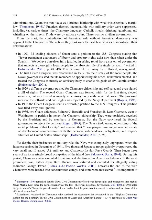
The rearrangement of Guam villages around military-claimed lands is apparent from thecomparison of census maps. The 1930 map shows the eight administrative districts created by thefirst naval government. The 1950 map shows a new complexity in the immediate post-war period,with the 1960e1970 map then showing the intensification of population in the north, but also thedisappearance of Machanao in the north and the realignment of Barrigada and other districts toaccommodate land taken for the military. The complexity added by military districts is made moreexplicit in the 1980 map. In short, Guam was restructured around these new military holdings.
Because of the massive labor needs to assist the military buildup, imported labor from theU.S. and the Philippines (in particular) radically changed the demographic structure of Guam’s
7 Anne Perez Hattori, ‘‘Guardians of Our Soil: Indigenous Responses to Post-World War II Military Land Appro-
priation on Guam,’’ in Farms, Firms, and Runways: Perspectives on U.S. Military Bases in the Western Pacific, ed. L.
Eve Armentrout Ma (Chicago: Imprint Publications, 2001). Cited in Camacho, 2005, pp. 137e138.
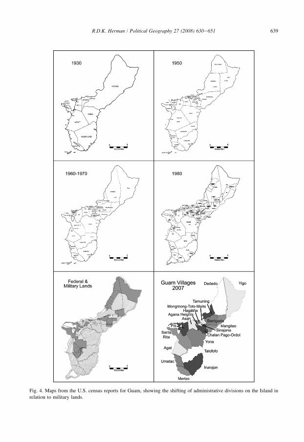
Fig. 4. Maps from the U.S. census reports for Guam, showing the shifting of administrative divisions on the Island in
relation to military lands.
639R.D.K. Herman / Political Geography 27 (2008) 630e651
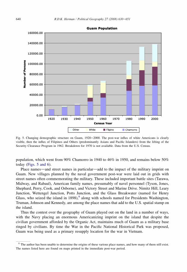
Fig. 5. Changing demographic structure on Guam, 1920e2000. The post-war influx of white Americans is clearly
visible, then the influx of Filipinos and Others (predominantly Asians and Pacific Islanders) from the lifting of the
Security Clearance Program in 1962. Breakdown for 1970 is not available. Data from the U.S. Census.
640 R.D.K. Herman / Political Geography 27 (2008) 630e651
population, which went from 90% Chamorro in 1940 to 46% in 1950, and remains below 50%today (Figs. 5 and 6).
Place namesdand street names in particulardadd to the impact of the military imprint onGuam. New villages planned by the naval government post-war were laid out in grids withstreet names often commemorating the military. These included important battle sites (Tarawa,Midway, and Rabaul), American family names, presumably of navel personnel (Tyson, Jones,Shephard, Perry, Cook, and Osborne), and Victory Street and Marine Drive. Nimitz Hill, LearyJunction, Wettengel Junction, Potts Junction, and the Glass Breakwater (named for HenryGlass, who seized the island in 1898),8 along with schools named for Presidents Washington,Truman, Johnson and Kennedy, are among the place names that add to the U.S. spatial stamp onthe island.
Thus the contest over the geography of Guam played out on the land in a number of ways,with the Navy placing an enormous Americanizing imprint on the island that despite thecivilian government afforded by the Organic Act, maintains much of Guam as a military baseringed by civilians. By time the War in the Pacific National Historical Park was proposed,Guam was being used as a primary resupply location for the war in Vietnam.
8 The author has been unable to determine the origins of these various place names, and how many of them still exist.
The names listed here are found on maps printed in the immediate post-war period.
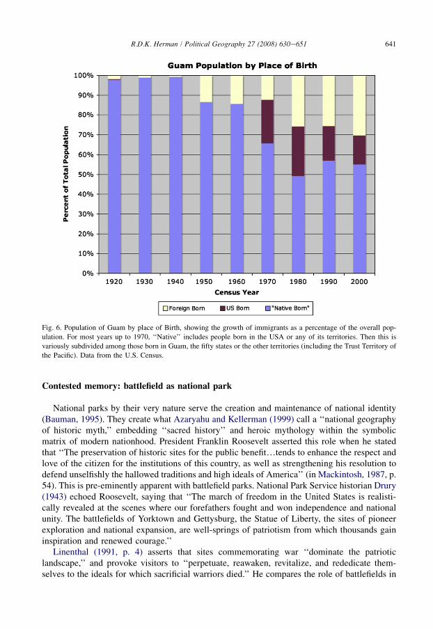
Fig. 6. Population of Guam by place of Birth, showing the growth of immigrants as a percentage of the overall pop-
ulation. For most years up to 1970, ‘‘Native’’ includes people born in the USA or any of its territories. Then this is
variously subdivided among those born in Guam, the fifty states or the other territories (including the Trust Territory of
the Pacific). Data from the U.S. Census.
641R.D.K. Herman / Political Geography 27 (2008) 630e651
Contested memory: battlefield as national park
National parks by their very nature serve the creation and maintenance of national identity(Bauman, 1995). They create what Azaryahu and Kellerman (1999) call a ‘‘national geographyof historic myth,’’ embedding ‘‘sacred history’’ and heroic mythology within the symbolicmatrix of modern nationhood. President Franklin Roosevelt asserted this role when he statedthat ‘‘The preservation of historic sites for the public benefit.tends to enhance the respect andlove of the citizen for the institutions of this country, as well as strengthening his resolution todefend unselfishly the hallowed traditions and high ideals of America’’ (in Mackintosh, 1987, p.54). This is pre-eminently apparent with battlefield parks. National Park Service historian Drury(1943) echoed Roosevelt, saying that ‘‘The march of freedom in the United States is realisti-cally revealed at the scenes where our forefathers fought and won independence and nationalunity. The battlefields of Yorktown and Gettysburg, the Statue of Liberty, the sites of pioneerexploration and national expansion, are well-springs of patriotism from which thousands gaininspiration and renewed courage.’’
Linenthal (1991, p. 4) asserts that sites commemorating war ‘‘dominate the patrioticlandscape,’’ and provoke visitors to ‘‘perpetuate, reawaken, revitalize, and rededicate them-selves to the ideals for which sacrificial warriors died.’’ He compares the role of battlefields in
642 R.D.K. Herman / Political Geography 27 (2008) 630e651
American patriotism to that of medieval cathedrals to Christianity: they provide conduitsthrough which citizens ‘‘are able to participate in the power of a heroic pastda past thatcontinues to demand allegiance to its cherished principles.’’ Campo (1998. p. 44) similarlycalls battlefields ‘‘pilgrimage sites’’ connected with ‘‘the values, symbols and practices ofAmerican civil religion.primarily with the production of patriotic loyalty to the UnitedStates.’’
The establishment of battlefields as historical parks in the U.S. is a practice older than theNational Park Service itself. It began in 1886 with the establishment of the National Cemeteryof Custer’s Battlefield Reservation (redesignated Little Bighorn Battlefield National Monu-ment in 1991). This first battlefield park marked the rhetorical transformation of violentexpansionism into a nationalist commemorative site for American soldier-heroes. From there,Congress established two Civil War battlefield sites as historical parks in 1890, and threemore in the ensuing decade. These were administered under the War Department. TheNational Park Service (NPS) was created by an act of Congress in 1916, and when HoraceAlbright became director in 1929, he looked to subsume battlefields and coastal fortificationsadministered by the War Department into the park system. These were added to the NPS in1933, making battlefields a disproportionate component of Park Service historical areas(Bearss, 1987).
Verne Chatelain, hired by Albright as the first Park Service interpretive historian, wrote that‘‘The sum total of the sites which we select should make it possible for us to tell a more orless complete story of American History’’ (Mackintosh, 1987, p. 53). But that history includesthe destructive encounter with American Indians as they were cleared out of the way forAmerican expansion. Particularly as American Indians and other minorities have become morevocal and more politically powerful, the positioning of those others who were subsumed bythe U.S. has been an ongoing problem for the National Park Service (see Bouse, 1996;Linenthal, 1991). The resulting rhetorical strategies at national parks vary widely in theirattempts to balance patriotic commemoration with indigenous tragedy. For Guam, the island’sunincorporated status makes such a landscape of nationhood all the more unwieldy. The endresult manifests as a park that celebrates America on Guam without celebrating Guam asAmerica.
The National Park Service first arrived on Guam when Irving C. Root was sent to study theneed for parks and recreation areas on the island. Root arrived in 1952dnot long after theOrganic Act, and only seven years since the end of World War II. But unlike those that wouldfollow more than a decade later, Root’s study was critical of the military control of land andempathetic towards both the recreational needs of the Guamanians and the need to preservesites of Chamorro cultural heritage. On this latter point, the report calls at the outset forenacting a statute protecting historic sites, arguing later that ‘‘The first and fundamental need isgeneral protection by law of surviving historic structures, historical monuments, and archae-ological sites from destruction and vandalism,’’ especially for lands transferred out of the publicdomain that were not therefore protected by the Antiquities Act of 1906. The report recom-mends that a Territorial Statute be promptly enacted. Root points to the Spanish remains at theOld Plaza near Hagatna, remarking that ‘‘Examples of Spanish architecture are so few but sobasic in the Guamanian culture that those remaining in the Plaza should be carefully preserved’’(Root, 1952, p. 6). Finally, the report argues that ‘‘Organization and development for educa-tional uses of a Territorial Museum on Guam is much the most important step in an interpretiveprogram, without which the preservation of the sites and remains does not become fullconservation for public use. Markers and additional explanatory exhibits at major sites are also
643R.D.K. Herman / Political Geography 27 (2008) 630e651
important features of the program, but probably can best be handled in connection witha central museum’’ (pp. 45e48).9
Regarding the military, the report points out with clear annoyance that the best recreationareas on the island are controlled for exclusive military use. Of Tumon Bay, the nearest goodbathing beach to the capital, Root notes that ‘‘The central and best portion of the beach isowned by the Federal Government and is restricted to the use of Navy personnel. This portionof the beach is improved with cottages, bathhouses, beach club, refreshment stand, picnic areas,roads, and parking spaces. The popularity of this improved portion of the beach indicates thedemand for similar facilities for the citizens of Guam who have no improved public beaches’’(p. 21, emphasis in original). The report goes on to say that ‘‘The citizens of Guam wouldappreciate and use such facilities for I have seen them by the jeep load at abandoned CampDealy and using the beach for swimming and picnicking..I feel that the acquisition of thebeach areas for recreation and scenic purposes as recommended in this report is so importantthat the program should be started at once’’ (p. 36). Root further recommended that surplusmilitary land be released to the Government of Guam, and that harvesting of coconuts, fruit andtimber be permitted on military reservations.
Root clearly acted in the best tradition of the National Park Service, recognizing historyworth preserving and balancing that with needs for recreation. He speaks to a tradition ofbuilding civic pride through landscapes that celebrate the people and their culture.
That little came of Root’s recommendations is clear from the subsequent NPS reports. TheNPS next came in 1965 at the request of Guam Governor Manuel F. L. Gerrero and the Officeof Territories, who wanted the NPS ‘‘to determine whether sites of national significance exist onGuam’’ (National Park Service, 1969, p. 1). This might have come as a response to thedesignation of Pu‘u o Mahuka heiau (a Hawaiian temple site) on O‘ahu as a National HistoricLandmark in 1962. That designation, according to the plaque at the site, identifies thisHawaiian cultural landscape as ‘‘possessing exceptional value in commemorating and illus-trating the history of the United States.’’ It is likely that the Government of Guam was lookingfor similar recognition for Guam’s heritage. Instead, the 1965 study proposed a Philippine SeaNational Seashore and a War in the Pacific National Historical Park (known in the NPS by theacronym WAPA), neither of which aimed at connecting the history of Guam and its indigenousinhabitants to the American national discourse.
The timing of the park’s initiation contributes context to a reading of the resulting landscape.The 1965 visit came a mere three years after the cessation of the Navy’s Security ClearancePolicy ended the last vestiges of U.S. military rule on the island. It also came during theescalation of the Vietnam War, when the island was being used as a military resupply station.Anti-war protests were already taking place back on the continental U.S.. While there is nodirect connection between the military and the park service, both are branches of the federalgovernment, and this larger context of U.S.-Guam relations cannot be ignored in assessing whythis type of park was chosen over one that recognizes Chamorro heritage.
Moreover, in January of 1967, before the Master Plan study was undertaken, members ofJapan’s South Pacific Memorial Association, representing the Buddhist and Catholic faiths,arrived on Guam to initiate construction of a peace memorial dedicated all the war dead. Notlong after the inauguration of this memorial, criticism came loudly from (especially) over-seas Americans who saw the Japanese memorial as an affront to the American war dead.
9 The section of Root’s report on ‘‘Historic Sites and Archeological Remains’’ was prepared by Dr. Erik K. Reed,
Chief Archeologist for Region Three, National Park Service.

644 R.D.K. Herman / Political Geography 27 (2008) 630e651
Thus when a few months later the Advisory Board on National Parks, Historic Sites,Buildings and Monuments approved the proposal to create the War in the Pacific NationalHistoric Park, they indicated that pressure to develop the Park increased due to the proposeddevelopment of the Japanese peace memorial (Camacho, 2005). In Camacho’s estimation,this sequence of events revealed ‘‘one outstanding truth. Clearly, American veterans andpoliticians in the 1960s possessed the political, emotional, and social license to determinehow the war should be commemorated at a national level in Guam’’ (Camacho, 2005, pp.172e173).
The 1967 draft Master Plan for WAPA stands in marked contrast to Root’s study by itsdismissal of Chamorros and their history. Noting the presence of latte stones and other artifactsof the early Chamorro culture, the study remarks upon the inadequate funding available to thelocal museum (clearly Root’s emphasis on the importance of such a museum did not translateinto federal funding) but contains no suggestion of funding any efforts to preserve pre-Warhistory. Sites of pre-war historical significance are instead designated as important only in termsof the War. The ‘‘reputed’’ ruins of old Spanish Fort Santa Agueda is important because ‘‘Thiswas the site of a Japanese gun emplacement’’ (National Park Service, 1969, p. 21, emphasis inthe original). Such remarks cast doubt on the validity of pre-war history, stripping the sites oftheir local significance and integrating them into the American war narrative.
While the report boasts that ‘‘Such a park would be a source of pride to Guamanians and toother Americans’’ (p. 7), it otherwise virtually ignores those same Guamanians and their plightin the War. Sites associated with the War that have local significance but which had no role inthe U.S. campaign do not merit recognition. This is particularly apparent in Thompson’s (1985)Historic Resource Study. He lists as ‘‘Other’’ those sites associated with Chamorro sufferingunder the Japanese occupation. These include the site where the Chamorro priest Father Duenaswas executed, and the concentration camp at Manengon where over 10,000 Chamorros wererounded up.
All of this comes despite the fact that during public hearings for the park in the late 1970s,two of the major concerns voiced were greater recognition of Chamorro involvement in theWar, and the identification and protection of prehistoric Chamorro sites. Instead, in the 1970sthe Park Service turned its concern onto the growing influx of Japanese tourists to the island,and moved to make the Park more relevant to the Japanese visitors. All interpretive materialsand signage, it was decided, were to be bilingual English-Japanese (Evans-Hatch & Associates,Inc., 2004). The sense of the Park as a sort of ambassador for United States policy had beenpresaged in the 1967 plan, which stated that such a park ‘‘would be of considerable interest toforeign visitors not only for its historic significance, but as an example of an American insti-tutiondthe National Park System’’ (p. 7).10 The big combatants of the Battle of Guam meetagain at this park, and again the local people are marginalized.
Indeed, in the 1969 report, Chamorros disappear first as a ‘‘race’’d‘‘true native pre-Magellan Chamorro blood can no longer be readily identified’’ (National Park Service, 1969,p. 9)dand then as historical actors of any sort. By dismissing both the people and theirlandscapes, the report renders Guam a tabula rasa for talking about the American War effort.Where Root’s study advocated the handover of military lands, the 1969 study first minimizesthe aggression of 1898 wherein Guam was seized and then asserts that ‘‘the requirements ofnational strategy in an unpeaceful world have dictated that large chunks of Guam remain in the
10 The Park Service noted in 2001 that 75% of WAPA’s visitors were Japanese tourists (Dittmar, 2001).
645R.D.K. Herman / Political Geography 27 (2008) 630e651
control of the U.S. Defense Department’’ (p. 19). The military is naturalized, and Chamorrosare erased.
Thus the choice to create the War in the Pacific park continues the colonialist treatment ofGuam in two ways: first, it comes at the expense of any such national site recognizing Cha-morro history and culture; second, it chooses to commemorate the war in a way that focuses onthe U.S. military rather than on Guam itself, thus minimizing both the Chamorro wartimeexperience and their presence as active inhabitants of the island. Through these two mecha-nisms the park becomes a site of American military memory rather than Chamorro history.
Contested location
It should come as no surprise that by the time the National Park Service wanted to appro-priate land for the park on Guam, their reception by Guamanians was less than cordial. An NPSmemorandum in 1972 stated that ‘‘The Territorial government is resentful of the U.S. Navy andthe Navy in turn sometimes appear [sic] contemptuous of the Government of Guam.’’11 Thepark’s Administrative History called the environment ‘‘unsympathetic’’ to the Park Serviceneeds, adding that ‘‘some would characterize it as hostile’’ (Evans-Hatch & Associates, Inc.,2004, p. 63).
This antagonism came not only from the history of naval dictatorship and federal land grabsat Chamorro expense, but also from the resultant spatial reorganization limiting land for civilianuse at a time of rapidly growing population. This plus the additional land pressures of the newtourist economy were creating greater demand for open spaces. And land prices were esca-lating. Into this mix arrived the National Park Service, looking to establish a historic battlefieldpark in which recreational uses would be limited.
The first issue for the park was the acquisition of the land itself. When Congress establishedthe park in 1978, the boundaries they set did not correspond with the boundaries earlierenvisioned, and of the 850 acres transferred by the Government of Guam to the NPS, only 521were inside the park boundaries. Moreover, the NPS had no title to about 240 privately ownedacres within the new park boundaries. Those holding title to these lands ‘‘wanted either to selltheir land at a reasonable price to the park service, sell their land to commercial developers, orto be free to develop the land themselves’’ (Evans-Hatch & Associates, Inc., 2004, pp. 84e85).These residents thought that since $16 million had been approved for the park, that this moneywas immediately available. Evans-Hatch notes that ‘‘the subtleties of United States governmentappropriations machinery was not completely appreciated’’ by them, and distrust set in as thepark was unable to purchase their lands.
Land acquisition for the park was raised at public meetings held in the 1970s as the mostsignificant issue to local people, with many who testified expressing concern about the amountof land that would be incorporated into the park (Evans-Hatch & Associates, Inc., 2004).Among comments at park planning hearings in the late 1970s, the top three concerns were landacquisition, boundary adjustments, and the conflict of public recreational uses with NPS policy.Battles would subsequently be fought with the government of Guam over a small boat ramp theGuam Government wanted to build in one proposed park section, and plans to build a subdi-vision in another one. Facing these obstacles, in the mid 1970s the Park Service declared the
11 Memorandum from General Superintendent, Hawaii Group, to Director, Western Region, NPS, March 15, 1972.
WAPA archives. Cited in Evans-Hatch & Associates, Inc., 2004, p. 57. Disputes between the Governor and the
Legislature also held things up.
TUMON FUEL DEPOTTANGUISSON POWER PLANTANDERSEN HARMON ANNEXNAVAL COMMUNICATIONS STATION
FAA
NAVCAMS WESTPACFINEGAYA
NORTHWEST FIELD
NAVFAC
CAMP EDUSA(USAF)
SANTAROSA
RADAR STATION
ANDERSEN SOUTH(MARBO ANNEX)
U.S. NAVAL COMMUNICATIONSTATION, BARRIGADA
COMNAVMARNIMITZ HILL
APRA HARBOR COMPLEX
APRA HARBOR COMPLEX:
Naval StationNaval Supply DepotPublic Words CenterShip Repair FacilityCamp CovingtonPiti Power Plant
FENANAVAL
MAGAZINE
0 5Statute Miles
ANDERSEN AIRFORCE BASE
(2)
ASAN
BEACH
UNIT
(1)
FONTE
PLATEAU
UNIT
(5)
MT. CHACHAO/
MT. TENJO UNIT
(3)
ASAN
INLAND
UNIT
ANDERSEN AFBCOMMUNICATION ANNEX
NAVAL HOSPITAL
NAVAL HOSPITAL ANNEX
NAVAL AIR STATION
(4)
PITI GUNS
UNIT
(7)
MT. ALIFAN
UNIT
(6)
AGAT
UNIT
Apaca Pt.
Ga’an Pt.
U.S. NAVAL RESERVATION
U.S. NAVAL RESERVATION
U.S. NAVAL RESERVATION
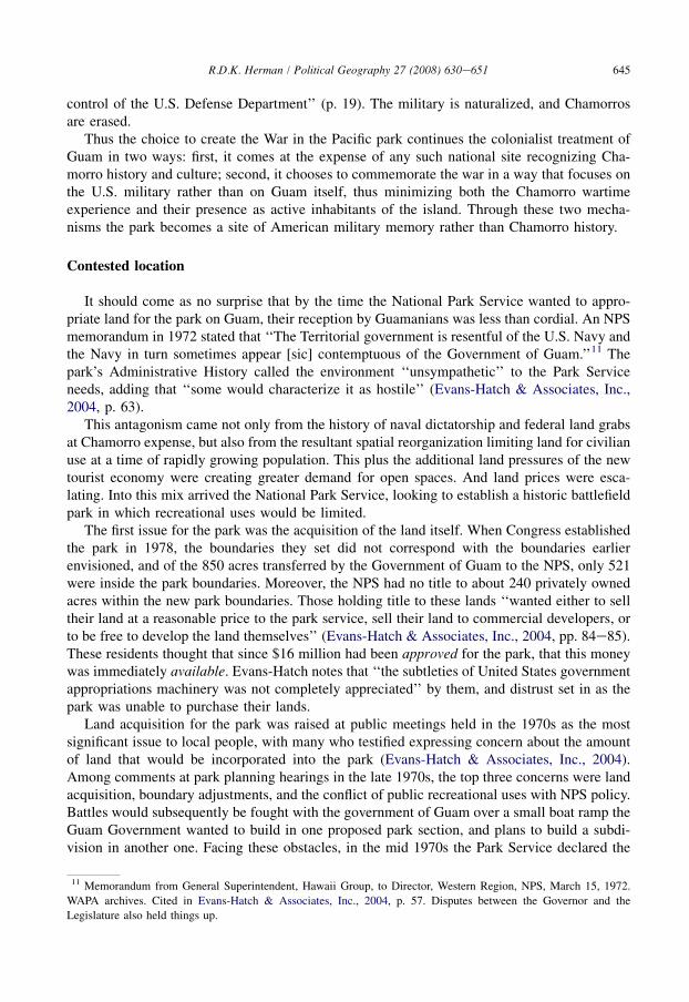
Fig. 7. Map of Guam showing the seven units of the Park and lands held by the U.S. military, after Rogers (1995).
646 R.D.K. Herman / Political Geography 27 (2008) 630e651
park no longer viable, and looked into leasing the lands to the Guam Government fora recreational park. Guam Representative Antonio Won Pat stepped in and asked why no onefrom NPS had gone to Guam to assess the impact of these developments in person.The resultant 1976 trip resulted in a more favorable report, and the park went forward. But theacquisition of land would prove to be ‘‘an abiding irritant to those who would later manage thenew park’’ (Evans-Hatch & Associates, Inc., 2004, p. 63).
The location of the park would also be site of contestation within the National Park Serviceitself. NPS Chief of Park History Studies Roy Appleman and NPS research historian Ed Bearssboth argued against Guam as best location for such a park, declaring it historically inappro-priate. NPS chief historian Robert Utley concurred. They argued that the battle for Guam wasnot a turning point in the Pacificdnot even the most important battle for the Marianasdand
647R.D.K. Herman / Political Geography 27 (2008) 630e651
was not the only American soil lost to the Japanese.12 Other islands in the Trust Territory of thePacific, then under American control and being considered for annexation, were of equal orgreater importance. They argued for O‘ahu in the Hawaiian islands. They also argued that, interms of the proposed park boundaries, the Japanese rarely contested beaches, so higher-groundsites were more important. Their arguments did result in the inclusion of more higher-groundsites, but were otherwise dismissed.
Given their concerns, and given the long history of the U.S.’s cavalier attitude towardsGuam, the reasons for establishing this park on Guam in the first place deserve deeper inquiry.Indeed, it must be embedded in the greater context of national historic battlefield parks in theU.S.
Signs of empire
National parks, as a genre of representation, are essentially museological institutions, notonly because they preserve and conserve, ‘‘but because they employ many of the techniques ofdisplay, exhibition, and presentation that have been used by museums to organize and regulatethe vision of visitors’’ (Patin, 1999, p. 41). Patin calls this the ‘‘museum effect,’’ including thevarious modes of organizing vision through the presentation of objects and spaces into the‘‘museological gaze.’’ The park can be seen as a state-controlled mechanism for reproducingmemory of the War. The choice of sites and signage (and those that are left out) all function toconstruct memory in a specific way, presenting an authorized narrative landscape throughwhich the visitor is guided.
The structure for that narrative is outlined in the Army War College’s 1926 study onbattlefield commemoration (Bach, 1926), which states that national military parks should covera comparatively large area and be usable ‘‘for detailed study by military authorities, the battlelines and operations being clearly indicated on the ground.’’ The story told at WAPA followsthis dictate in the aim of the original (1969) master plan: to tell the ‘‘epic story of that phase ofWorld War II.which involved the conquest of island strongholds on the road to victory in thePacific Theatre; and, within this framework, to tell the story of the recapture of Guam itself, asa classic example of invasion techniques employed by our armed services against a bitterlydetermined enemy’’ (National Park Service, 1969, p. 2). The park brochure provides a chro-nology of the overall War in the Pacific, with information about the capture, occupation, andliberation of Guam.
In his critical analysis of Liberation Day commemorations in the Marianas, Camacho (2005,pp. 13e14) remarks that in Military narratives of the War in the Pacific, Pacific Islanders playno central role. Instead, military historians tend to envision the Pacific Islands as ‘‘a tabula rasaon which to inscribe their histories of heroism and victimization,’’ forming ‘‘a body ofdiscourse in which only Japanese and Americans constitute the agents of change and continuityin the region, erasing the agency and voice of indigenous peoples.’’ While particularly in morerecent years the WAPA staff have tried to incorporate more Chamorro heritage in theirprogramming, a casual visitor to the parkdobserving the signs, the bunkers, the guns, the mapsand the photographsdencounters an almost relentless narrative of the Battle of Guam.
The Park constitutes seven different units. Encountered in person, these are large chunks ofland. Yet the big, open park areas obscure the far larger extent of military land ownership on the
12 Also occupied by the Japanese were the sparely inhabited islands of Attu, Agattu, and Kiska in the Aleutians, and
Wake Island.
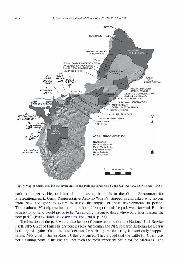
Fig. 8. Interpretive sign at the Asan Beach unit, showing the text in English, Chamorro, and Japanese.
648 R.D.K. Herman / Political Geography 27 (2008) 630e651
island. Most civilian visitors would see, at best, the gates of the large bases, so the true extent ofmilitary lands remains hidden (Fig. 7).
Each section of the park represents a particular aspect of the battle. As one of the signs notes,‘‘By traveling from unit to unit, you can trace the three-week battle that began at the beaches,spread inland, and swept across the island.’’ You are invited to focus on American liberators,Japanese defenders, and passive Chamorro occupants ‘‘whose land and lives were changed bythe war.’’ At Ga’an Point, one sign explains how after the Americans secured the island, theNavy set up shelters for Chamorros released from a Japanese concentration camp. A photo-graph shows bedraggled but thankful Chamorros kneeling in prayer at the Agat refugee campduring mass held by a military chaplain. This representation positions them as passive, patheticvictims saved by heroic Americans. Those brave Chamorros who withstood the Occupation, orwho stood up to the Japanese and were executed for it, are not a part of this narrative.13
It was not until 1993, with the 50th anniversary of the Liberation approaching, that the U.S.Congress was moved by Guam’s congressional representative, Robert Underwood, to overtlyrecognize the suffering of the Chamorros. Public Law 103e197 authorized construction ofa monument to commemorate, by individual names, those people of Guam who suffered duringthe occupation (National Park Service, n.d.). And in the enddit is not clear when the decisionwas madedall the park’s signage became tri-lingual: English, Chamoru, and Japanese (Fig. 8).But apart from the 1993 monument, references to the Chamorro people are very few.
13 While official policy almost completely ignored the role of local people in the War, the reality on the ground took on
slightly different contours. After Public Law 95-348 finally established WAPA in 1978, park superintendent T. Stell
Newman established close ties with the local community. Newman teamed up with Dr. Dirk Ballendorf, then director of
the Micronesia Area Research Center (MARC), to gather testimony from Guamanians as well as U.S. and Japanese
soldiers (Evans-Hatch & Associates, Inc., 2004). The original Visitor’s Center for the park apparently told more of
Guam’s story. It was destroyed by Supertyphoon Pongsona in 2002. The author has been unable to visit the newly
opened (2007) Visitor’s Center.
649R.D.K. Herman / Political Geography 27 (2008) 630e651
The position of this park as a large, highly visible landscape off the edge of Guam’s mainpopulation area reflects the position of the American military on Guam: central yet peripheral;obvious yet removed; appreciated yet reviled. In the ongoing refusal of the U.S. to considercommonwealth status for Guam, Guamanian reverence for the U.S. military is mixed. The post-war economic development of the island has raised most people to a standard of livingcomparable to average Americans, and a large measure of this growth is owed to the militarypresence. Some local leaders have encouraged greater military buildup on the island because ofthe benefits to the economy, and at this writing, 9000 U.S. Marines are preparing to relocate toGuam from Okinawa (Pacific Islands Report, 2003; Murphy, 2006). Despite all the failings ofthe military on Guam, its presence there is considered by many to be a plus, and the park isa reminder that they owe it all to the Liberation forces in 1944.
But not all perceive this debt favorably. Perez (2002, pp. 463e464) argues that since theLiberation, Chamorros have become ‘‘locked in a mentality of paying back the U.S. for their‘generosity’.’’ Chamorro scholar Laura Souder asserts that Chamorros ‘‘have become the worstkind of mistress to Uncle Sam.whopped into docile submission..Our psyches are undersiege. Our spirits as indigenous people are held under lock and key. We are typically afraid tospeak out for fear of reprisal. Our creativity and self-sufficiency have been stymied. We long forjustice.’’14 The image of conquered but liberated Chamorros in prayer at Agat under theleadership of a military chaplain comes to mind. ‘‘The pride and enthusiasm attached to theWar in the Pacific may have been shared by veterans and survivors of the war,’’ writes Camacho(2005, pp. 171e172), ‘‘but it was not as widespread among Chamorros as some assu-med...The War in the Pacific National Historic Park, at that time, simply represented anotherexample of how a national government, as well as its affiliates, could commemorate the war.’’
Conclusion
By creating the War in the Pacific National Historical Park, the Park Service continued theAmerican colonial tradition by framing Guam as American-yet-not. The park landscape, asa text within the overall landscape of Guam (as well as on the internet and in publications), isthe nationally authorized narrative by which Guam is framed into American historical memory.And it is a memory in which Guam and its indigenous peoples figure very little.
Today at the Ga’an Point section of the park, three flags are flown which, according to thesign’s ambiguous language, ‘‘commemorate those who died for their country: Americans,Chamorros, and Japanese.’’ For which ‘‘country’’ did the Chamorros die? In words that echo thepre-war articles about Guam, WAPA curator Ana Dittmar (2001, p. 38) writes that the ‘‘War inthe Pacific National Historical Park on Guam contributes to an American presence on thisdensely populated island.’’ One would not say that Yellowstone ‘‘contributes to an Americanpresence’’ in Wyoming, or that Gettysburg does so in Pennsylvania. Is Guam American, or not?What is more, the overall population density on Guam is less than that of New York state, so‘‘densely populated’’ reflects how much of the land is off limits to civilian settlement. In short,Dittmar’s remarks reaffirm Guam as a colony, WAPA as a colonial instrument, and the militaryas otherwise invisible.
14 Laura Torres Souder (1992) Daughters of the Island: Contemporary Chamorro Women Organizers on Guam, 2nd
ed., Lanham, MD: University Press of America; Mangilao, Guam: Micronesian Area Research Center, 1992, p. 143;
cited in Perez (2002 p. 464).
650 R.D.K. Herman / Political Geography 27 (2008) 630e651
The story of Guam demonstrates the need to remain wary of rhetoric about spreadingfreedom and democracy. The War in the Pacific National Historical Park reminds us of the rolethat battlefield preservation plays in national discourse. The battlefield-cum-national park isa space that manifests nationalist rhetoric and symbolism with the reproduction of citizenship,reaffirmed through the violent encounters of American expansion. On Guam, the lofty ideals ofthe nation were vigorously denied for more than half a century, and remain unrealized. The Warin the Pacific National Historical Park frames the island as a site where American militaryheroism brought ‘‘liberation.’’ By designating Guam as a place where U.S. troops weresacrificed in the name of freedom, it works to obscure the story of freedoms denied for the sakeof empire.
References
April, V. (2006). Talagi Pictograph Cave, Guam. Micronesian Journal of the Humanities and Social Sciences, 5, 53e69.
Azaryahu, M., & Kellerman, A. (1999). Symbolic places of national history and revival: a study in Zionist mythical
geography. Transactions of the Institute of British Geographers New Series, 24(1), 109e123.
Bach, C. (1926). Study and investigation of battle fields in the United States for commemorative purposes. In
L. Dilsaver (Ed.), (1994) America’s national park system: the critical documents. Lanham, MD: Rowman &
Littlefield Publishers. http://www.nps.gov/history/history/online_books/anps/anps_2d.htm. Accessed 04.02.08.
Barrett, W. S., & Ferenz, W. S. (1960). Peacetime martial law in Guam. California Law Review, 48(1), 1e30.
Bauman, J. (1995). Designer heritage: Israeli national parks and the politics of historical representation. Middle East
Report, 196, 20e23.
Bearss, E. C. (1987). The national park service and its history program: 1864e1986: an overview. The Public Historian,
9(2), 10e18.
Berkhofer, R. F., Jr (1978). The White Man’s Indian: Images of the American Indian from Columbus to the Present. New
York: Alfred A. Knopf.
Blaz, B. (1994). Chamorros yearn for freedom. In Palomo, & Borja (Eds.), LiberationdGuam remembers. Maite,
Guam: Graphic Center, Inc. for the Golden Salute Committee. http://www.nps.gov/archive/wapa/indepth/extContent/
Lib/liberation32.htm. Accessed 07.11.07.
Bouse, D. (1996). Culture as nature: how native American cultural antiquities became part of the natural world. ThePublic Historian, 18(4), 75e98.
Camacho, K. (2005). Cultures of commemoration: the politics of war, memory and history in the Mariana Islands. PhD
dissertation in History, the University of Hawai‘i at Manoa (ms), Honolulu.
Campo, J. E. (1998). American pilgrimage landscapes. Annals of the American Academy of Political and Social Science,558, 40e56.
Cherokee Nation v. Georgia U.S. Supreme Court, 30 U.S. 1 (1831).
Coudert, F. R., Jr. (1903). Our new peoples: citizens, subjects, nationals or aliens. Columbia Law Review, 3(1), 13e32.
Cox, L. M. (1904). The Island of Guam. Bulletin of the American Geographical Society, 36(7), 385e395.
Cunningham, L. J. (1992). Ancient Chamorro Society. Honolulu: The Bess Press.
Deloria, P. J. (1998). Playing Indian. New Haven: Yale University Press.
Diaz, V. (1993). Pious sites: Chamorro culture between Spanish Catholicism and American Liberal Individualism. In
A. Kaplan, & D. E. Pease (Eds.), Cultures of United States Imperialism (pp. 312e339). Durham & London: Duke
University Press.
Dittmar, A. (2001). Tourism and native cultures. Cultural Resource Management, 24(5), 38.
Drinnon, R. (1980). Facing west: the metaphysics of Indian-hating and empire-building. Minneapolis: University of
Minnesota Press.
Drury, N. (1943). The national parks in wartime. In L. Dilsaver (Ed.), (1994) America’s national park system: the
critical documents. Lanham, MD: Rowman & Littlefield Publishers. http://www.nps.gov/history/history/
online_books/anps/anps_4a.htm. Accessed 06.06.07.
Evans-Hatch & Associates, Inc. (2004). War in the Pacific National Historical Park: an administrative history.
Washington, D.C.: National Park Service.
Flores, E. (n.d.).. Chamoru protectors: the story of how the people of Guam protected six navy men fleeing Japanese
invaders. http://www.nps.gov/archive/wapa/indepth/Guam/Texts/Tweed.htm. Accessed 06.06.07.
651R.D.K. Herman / Political Geography 27 (2008) 630e651
Guam War Claims Review Commission. (2004). Report on the implementation of the Guam Meritorious Claims Act of
1945, including findings and recommendations. Washington, D.C.: Department of the Interior. http://www.doi.gov/
oia/Stories/warclaim/finalwarclaimrpt/Gumwarclaimsum.htm. Accessed 25.09.07.
Higuchi, W. (2001). The Japanisation policy for the Chamorros of Guam, 1941e1944. The Journal of Pacific History,
36(1), 19e35.
Hofschneider, P. B. (2001). A campaign for political rights on the Island of Guam, 1899e1950. In: Occasional
Historical Papers Series, No. 8. Saipan: CNMI Division of Historic Preservation.
Horsman, R. (1981). Race and Manifest Destiny: the origins of American racial Anglo-Saxonism. Cambridge: Harvard
University Press.
James, R. E. (1946). Military government: Guam. Far Eastern Survey, 15(18), 273e277.
Lepore, J. (1999). The Name of War: King Philip’s War and the origins of American identity. New York: Vintage Books.
Linenthal, E. T. (1991). Sacred ground: Americans and their battlefields. Urbana and Chicago: University of Illinois
Press.
Mackintosh, B. (1987). The national park service moves into historical interpretation. The Public Historian, 9(2),
50e63.
Maga, T. P. (1984). The citizenship movement in Guam, 1946e1950. The Pacific Historical Review, 53(1), 59e77.
Merk, F. (1963). Manifest Destiny and mission in American History. New York:. Vintage Books.
Murphy, J. (2006). In praise of military buildup on Guam. Pacific Daily News. http://archives.pireport.org/archive/2006/
december/12%2D04%2Dcomm1.htm. Accessed 15.01.07 from Pacific Islands Report.
National Park Service. (1969). Master plan, proposed War in the Pacific National Historical Park. Washington, DC:
U.S. Department of the Interior (Second Printing).
National Park Service (n.d.). World War II Memorial to the people of Guam. http://www.nps.gov/archive/wapa/indepth/
extContent/wapa/memorial_wall/index.htm. Accessed 06.06.07.
Office of Insular Affairs, Department of the Interior. (2007). Guam: overview: history. http://www.doi.gov/oia/Island-
pages/gumpage.htm#History. Accessed 04.02.07.
Pacific Islands Report. (2003). Guam readies for military buildup. http://archives.pireport.org/archive/2003/february/
02%2D05%2D01.htm. Accessed 13.09.07.
Pacific Worlds. (2003). Guam: Inarajan. Website produced by the author. http://www.pacificworlds.com/guam/index.
cfm.
Palomo, T. (n.d.), Rising sun dawns on Guam. http://www.nps.gov/archive/wapa/indepth/extContent/Lib/liberation4.
htm. Accessed 06.06.07.
Palomo, T., & Borja, P. J. (1994). In LiberationdGuam remembers. Maite, Guam: Graphic Center, Inc. for the Golden
Salute Committee.
Patin, T. (1999). Exhibitions and empire: national parks and the performance of Manifest Destiny. Journal of American &
Comparative Cultures, 22(1), 41e60.
Perez, M. P. (2002). Pacific identities beyond US racial formations: the case of Chamorro ambivalence and flux. SocialIdentities, 8(3), 457e479.
Rogers, R. F. (1995). Destiny’s landfall: a history of Guam. Honolulu: University of Hawai‘i Press.
Root, I. C. (1952). Report on parks and recreation areas, territory of Guam. Washington, DC: National Park Service.
Russell, S. (1998). Tiempon I Manmofo’na: Ancient Chamorro Culture and History of the Northern Mariana Islands.
Micronesian Archaeology survey no. 32. Saipan: CNMI Division of Historic Preservation.
Safford, W. E. (1903). The Chamorro language of Guam. American Anthropologist New Series, 5(2), 289e311.
Segal, C. M., & Stineback, D. C. (1977). Puritans, Indians, and Manifest Destiny. New York: Putnam.
Sparrow, B. H. (2006). The insular cases and the emergence of American empire. Lawrence: University of Kansas Press.
Thompson, E. N. (1985). Historic resource study: War in the Pacific National Historical Park, Guam. Washington, DC:
U.S. Department of the Interior/National Park Service.
Thompson, L. (1946). Crisis on Guam. The Far Eastern Quarterly, 6, 5e11.
Williams, W. L. (1980). United States indian policy and the debate over Philippine Annexation: implications for the
origins of American imperialism. The Journal of American History, 66(4), 810e831.


![INSCRIBING RELIGIous PRAcTIcE AND BELIEFuser-raw]/papers... · 130 INSCRIBING RELIGIous PRAcTIcE AND BELIEF ... em Siam,”Aséanie 19 (2007): 91—112 (98—101). ... Tt merely indicates](https://img.pdfslide.us/doc/110x75/5c14952b09d3f245038bd642/inscribing-religious-practice-and-belief-user-rawpapers-130-inscribing.jpg)