Embed Size (px)
Citation preview
I I I I I I I I I I I ,I I I, ,I I ' I ', ,I ,I
I
" . ' .
" , ' .
CO Mi\fi Oi\lWIE Alnf Of AUSTRAUA ,
Inr~M ~~i ,J;..I1 ~ttt~L-~
" ,, [Q)[E~~~1rM[E~1r : (Q)f , , ", ' ,,' , " N~1r~(o)N~~ [D)WlEt(Q)~MrE~'1r : ·
, rn5(UJOO~~(LJJ(Q)[F mroo~~~~[L , ' , , ~[E~@(UJ~~[E~a®[E@[LCQ)(~w. ,
",'. ' ~~[Q) ' @~@,[F)~W~O~~
SMR Record
1971/144 c.3
Record 1971/144
, . , "
, , , "
' . "
,. VISIT TQ TUMUT3PR,oJECT, SNOWY MOUNTAINS, " ., ANDLITTLESCOTtANn 'DAM, V'ICrORIA,MAY 1971.
. '... . . " . , . . '
. , '
. :, ': .':'. , ' . .
. " . -,,'.
, by
. , ' .
'J~A. Salt~tandG.B. , Simpson
" .. ~.
, The info~mation contained inthis~~~rt ' has been obtained by the Department of Natio~al ' Development as part of th'e policy of the :cOmmonw'eaith 'Gcivernment to assist in t''Ie ex'pioration and development of
" mineral resources, It may not be published in any form. or used ' in 8 ,company prospectus or stateme~t without the pe(mission in writing cif. the Director, ,8ureauof Minerai Resources, Geology .& Geophysics.
.'

I I I I I I I I I I I I I I I I I I I I
Record 1971/144
VISIT TO TUMUT 3 PROJECT, SNOWY MOUNTAINS, AND LITTLE SCOTLAND DAM, VICTORIA, MAY 1971.
by
J.A. Saltet and G.B. Simpson

I I I I I I I I I I I I I I I I I I I I
INTRODUCTION
TUMUT 3 PROJECT
Engineering Geology
LITTLE SCOTLAND DAM SITE
General Construction Engineering Geology
CONCLUSIONS
REFERENCE
CONTENTS
1
1
1
2
2 2 2
3
3

I I I I I I I I I I I I I I I I I I I I
INTRODUCTION
This report covers a short visit by geologists J .A. Saltet and G.B. Simpson of the engineering geology sub-section, BMR, to the Tumut 3 Project, Snowy Mountains, and Little Scotland dam site, Victoria, in May 1971. The purpose of the trip was to gain further engineering geological experience before the start of the design stage of the Googong Dam, to compare Bureau methods in engineering geology with those of other organizations, and to develop a sound liaison with these organizations.
Tumut 3 was inspected on Monday 3rd May, under the guidance of Mr G. Stawsky of the Snowy Mountains Engineering Corporation (SMEC).
Little Scotland dam site was visited on 4th May, and discussions were held with Messrs J.F. Tadgell and F. Cox, of the Victorian state Rivers and Water Supply Commission (SRWSC).
TUMUT 3 PROJECT
The Tumut 3 Project is being constructed for the SMEC by several contractors. The Talbingo Dam is one of the principal parts of the project. The main contract was let to Thiess Bros at the end of 1967. The Talbingo Dam was finished on 1st May 1971; several other parts of the project were still under construction when visited.
Engineering Geology
The foundations of Talbingo Dam consist of rhyolite flows and welded tuffs, moderately to intensely fractured. The top of the right abutment is formed by a highly weathered tuff, intruded by porphyry. The permeable nature of this section made the application of a seepage blanket necessary.
The spillway (Fig. 1) is excavated in rhyolite, welded tuff, and some ignimbrite. Only the crest is protected by a cement slab; the remainder of the spillway is unlined. The rock cropping out in the spillway is fresh to sHghtly weathered, and, although strongly fractured, it was considered to be sufficiently sound to withstand extensive scouring.
The headrace channel is excavated in the same rock types, striking approximately parallel to the channel, and is almost completely untreated. It was decided that occasional cleaning out of the debris with earthmoving equipment is cheaper than lining the entire route of the channel. However ~ a small section on the right hand side of the channel was lined with a cement wall to prevent the eroding of a weathered tuff bed.

-2-
The power house was still under construction when visited, and several stages in the installation of the turbines were inSpected. During excavation the foundation rock (rhyolite) was found to be fresh but intensely fractured, particularly in the southwest corner; this resulted in considerable over-excavation. The rocks were considered to be too weak in themselves to withstand the grout pressures required to give strength and good sealing properties in the foundations, so the retaining walls of the power-house were constructed before grouting. More exploration and subsequent relocation of the design might have avoided this problem.
LITTLE SCOTLAND DAM SITE
General
The Little Scotland Dam is being built by the SRWSC on Jackson's Creek, near Gisborne, approximately 30 miles northwest of Melbourne. The construction is in an early stage: when visited the site was being cleared. In contrast to the Snowy Mountains projects, construction is carried out by day labour of the SRWSC; only minor parts of this project are done by small local contractors.
The proposed dam is for water supply. The water is to be sold untreated by the SRWSC, so no need exists to build a treatment plant. Storage will be approximately 20,000,000 cubic metres (15,000 acre/feet).
Construction
The proposed dam is a rockfill dam with clay core; the height will be 100 ft. Rockfill will be provided from a basalt flow that forms a cliff three hundred yards downstream of the dam site. Clay is to be taken from alluvial deposits, half a mile upstream of the dam site.
Diversion will be carried out by a pipe in the river bed; the pipe will be plugged after the completing of the dam. The spillway is to be excavated on the left abutment and will have a concrete-lined chute.
Engineering Geology
The rocks forming the foundations are highly weathered sandstone and siltstone of OrdoviCian age; they are tightly folded, and overlain by sediments of Tertiary age. An eroded surface occurs between the units; part of the eroded surface is formed by an old river channel running apprOximately at right angles to the present river course. The old river channel is filled with Tertiary gravel and silty sandstone which thins and becomes more clayey on either side of the channel. The Tertiary sediments are highly weathered.
I I I I I I I I I I I I I I I I I I I I

I I I I I I I I I I I I I I I I I I I I
-3-
Two basalt flows overly the Tertiary sediments. The basalts differ slightly in composition, are generally fresh, and are separated from each other by a lateritic soil horizon.
Originally the axis of the proposed dam was situated in the most favourable topographic position in the gorge. However the discovery of the Tertiary river channel, filled with permeable deposits, made this location unsuitable. The axis of the dam was therefore moved upstream, where the Tertiary deposits are thinner and less permeable.
The SRWSC did not carry out water pressure tests in the test holes drilled, and do not intend to do this later in the investigation. Three lines of curtain grout holes parallel to the dam axis are proposed, to a minimum depth of 100 ft. The basic grout pattern may be modified where the grout take indicates a need. No blanket grouting will be carried out.
Weathering is described by SRWSC geologists as follows: decomposed, weathered and fresh rock; these categories are further subdivided into soft, firm and hard rock, where applicable; for example: soft decomposed, and firm weathered.
The logsheets used by the SRWSC are based on the original SMA. logsheets, with only minor alterations. No rock quality designation is used.
CONCL USIONS
The visit provided the officers with a valuable addition to their engineering geological experience. Observation of the geological techniques employed at the construction stage by the two major engineering organizations should prove useful in similar Bureau projects.
REFERENCE
ANCOLD Bulletin - Issued No. 31, July 1970. Published by Aust. Nat. Committee on Large Dams.

I I I I I I I I I I I I I I I I I I I I
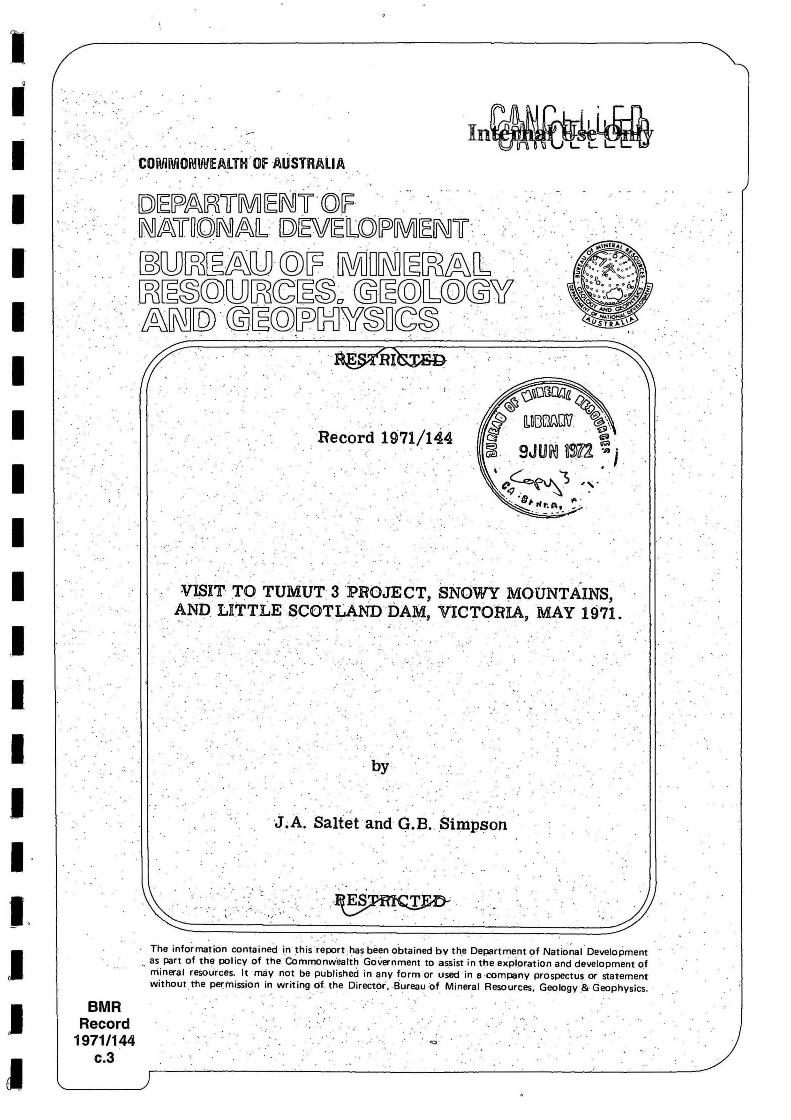
~oo 1!>OO l00U ~~~~~I~ .~
SCAli 01 1111
((Mop reprinted from ANCOLD Bulletin
Issue No 31.)
Pig. 1 . J'wnut 3 Project - General Layout.
1 \ i
\


![TTT TTTT TTTD TTTTT TTTT TTT - datrix.it · '$75,; tttt ttt tttt tttd ttttt tttt ttt ttttt ttdt tttt ttt 'dwd˛ ˘ 3dj ˛ 6l]h˛ t $9(˛ t 7ludwxud˛ 'liixvlrqh˛ ˇˇ ˝ /hwwrul˛](https://img.pdfslide.us/doc/110x75/5f41f4077d7bcc38d64069a0/ttt-tttt-tttd-ttttt-tttt-ttt-75-tttt-ttt-tttt-tttd-ttttt-tttt-ttt-ttttt-ttdt.jpg)