Embed Size (px)
Citation preview
FMS-800 Software User's ManualINU, GPS, and Integrated INU-GPS Navigation
INo, GPS, and Integrated INU-GPS Navigation
19.1 NAVIGATIONAL SYSTEM OVERVIEW
Five independent navigational selections for thepilot's and copilot's steering functions are provided.The normal navigational selections are GPS, INUl,INUl/GPS, INU2, and INU2/GPS. If a pilot selectsINU3 as the attitude and navigational source using theexternal auxiliary selector, then INU3 replaces INUIor INU2 as a selectable navigational source.
The fundamental difference between the INU
solutions and the INU/GPS solutions following loss ofGPS information (INUI- - -) is that the INU outputsin the INU/- - - solution are corrected with theKalman Filter estimated INU "real time" drift errorscomputed while GPS data was available, resulting in amore accurate navigational solution than the INUalone would provide.
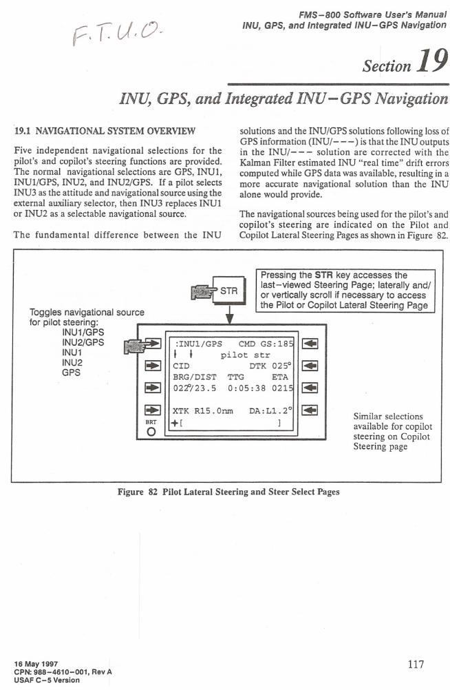
The navigational sources being used for the pilot's andcopilot's steering are indicated on the Pilot andCopilot Lateral Steering Pages as shown in Figure 82.
Similar selectionsavailable for copilotsteering on CopilotSteering page
Pressing the STR key accesses thelast-viewed Steering Page; laterally and/or vertically scroll if necessary to accessthe Pilot or Copilot Lateral Steering Page
DA:L1.2°
:INU1/GPS CMD GS: 18::pilot str
DTK 025°
TTG ETA0:05:38 021"
CID
BRG/DIST02~/23. 5
XTK R15.0nm
+[
~
~
~BRT
o
Toggles navigational sourcefor pilot steering:
INU1/GPSINU2/GPSINU1INU2GPS
Figure 82 Pilot Lateral Steering and Steer Select Pages
16 May 1997CPN: 988-4610-001, Rev AUSAF C-5 Version
117
FMS-800 Software User's Manual
INU, GPS, and Integrated INU-GPS Navigation
19.2 POSITION, TRACK, AND AIR DATA DISPLAYS
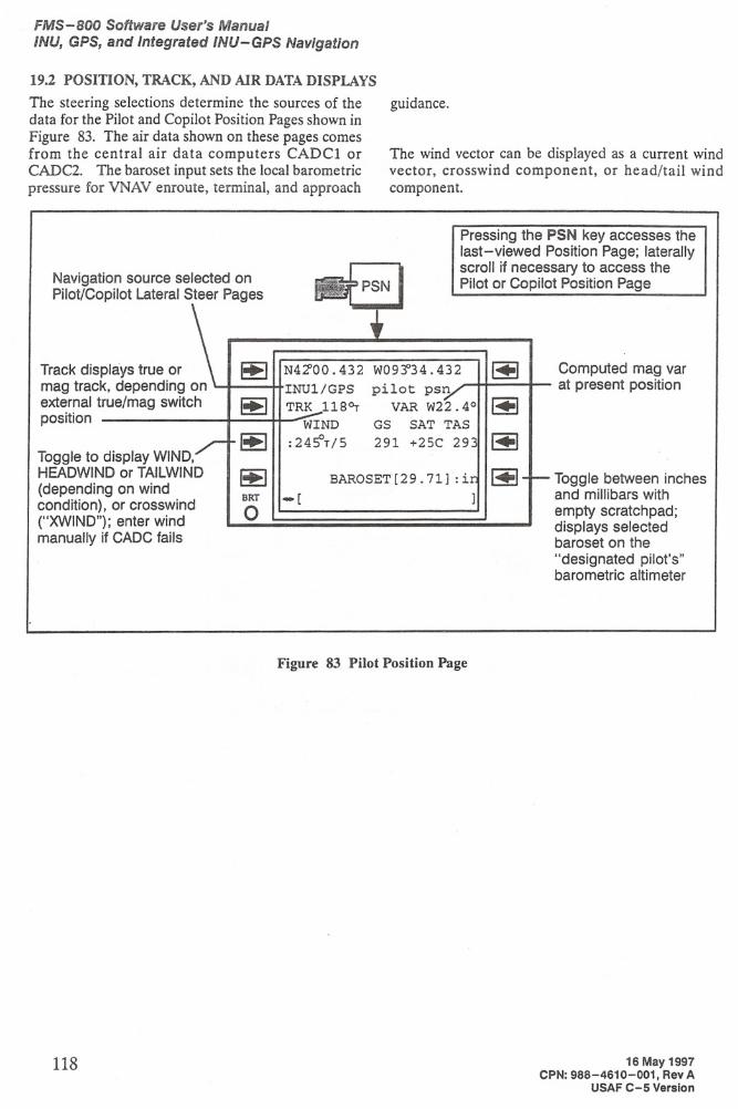
The steering selections determine the sources of thedata for the Pilot and Copilot Position Pages shown inFigure 83. The air data shown on these pages comesfrom the central air data computers CADCl orCADC2. The baroset input sets the local barometricpressure for VNAV enroute, terminal, and approach
guidance.
The wind vector can be displayed as a current windvector, crosswind component, or head/tail windcomponent.
Pressing the PSN key accesses thelast-viewed Position Page; laterallyscroll if necessary to access thePilot or Copilot Position Page
Computed mag varat present position
Toggle between inchesand millibars withempty scratchpad;displays selectedbaroset on the
"designated pilot's"barometric altimeter
N4~OO.432 W09~34.432
INU1/GPS pilot psnTRK 118~ VAR W22.4°WIND GS SAT TAS
:24~T/5 291 +25C 293
BAROSET[29.71]:i-[ ]
Track displays true ormag track, depending onexternal true/mag switchposition
Toggle to display WIND,HEADWIND or TAILWIND(depending on windcondition), or crosswind("XWIND"); enter windmanually if CADC fails
Navigation source selected onPilot/Copilot Lateral Steer Pages
Figure 83 Pilot Position Page
118 16 May 1997CPN: 988-4610-001, Rev A
USAF C-5 Version
FMS-800 Software User's ManualINU, GPS, and Integrated INU-GPS Navigation
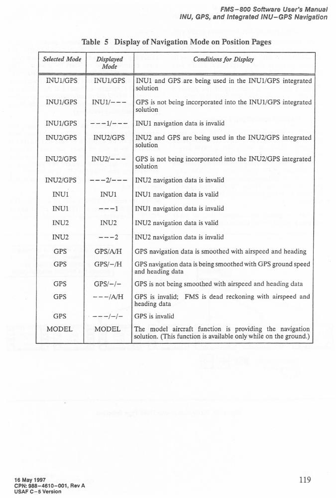
Table 5 Display of Navigation Mode on Position Pages
Selected Mode
INU1/GPS
INU1/GPS
INU1/GPS
INU2/GPS
DisplayedMode
INUl/GPS
INU1/---
---1/---INU2/GPS
Conditions for Display
INU1 and GPS .are being used in the INU1/GPS integratedsolution
GPS is not being incorporated into the INUl/GPS integratedsolution
INU1 navigation data is invalid
INU2 and GPS are being used in the INU2/GPS integratedsolution
INU2/GPS INU2/---
INU2/GPS
---2/---
INU1
INU1
INU1
---1
INU2
INU2
INU2
---2
GPS
GPS/A/H
GPS
GPS/-/H
GPS
GPS/-/-
GPS
---/A/H
GPS
. ---/-/-MODEL
MODEL
16 May 1997CPN:988-4610-001, Rev AUSAF C-5 Version
GPS is not being incorporated into the INU2/GPS integratedsolution
INU2 navigation data is invalid
INU1 navigation data is valid
INU1 navigation data is invalid
INU2 navigation data is valid
INU2 navigation data is invalid
GPS navigation data is smoothed with airspeed and heading
GPS navigation data is being smoothed with GPS ground speedand heading data
GPS is not being smoothed with airspeed and heading data
GPS is invalid; FMS is dead reckoning with airspeed andheading data
GPS is invalid
The model aircraft function is providing the navigationsolution. (This function is available only while on the ground.)
119
FMS-BOO Software User's Manual
/NU, GPS, and Integrated /NU-GPS Navigation
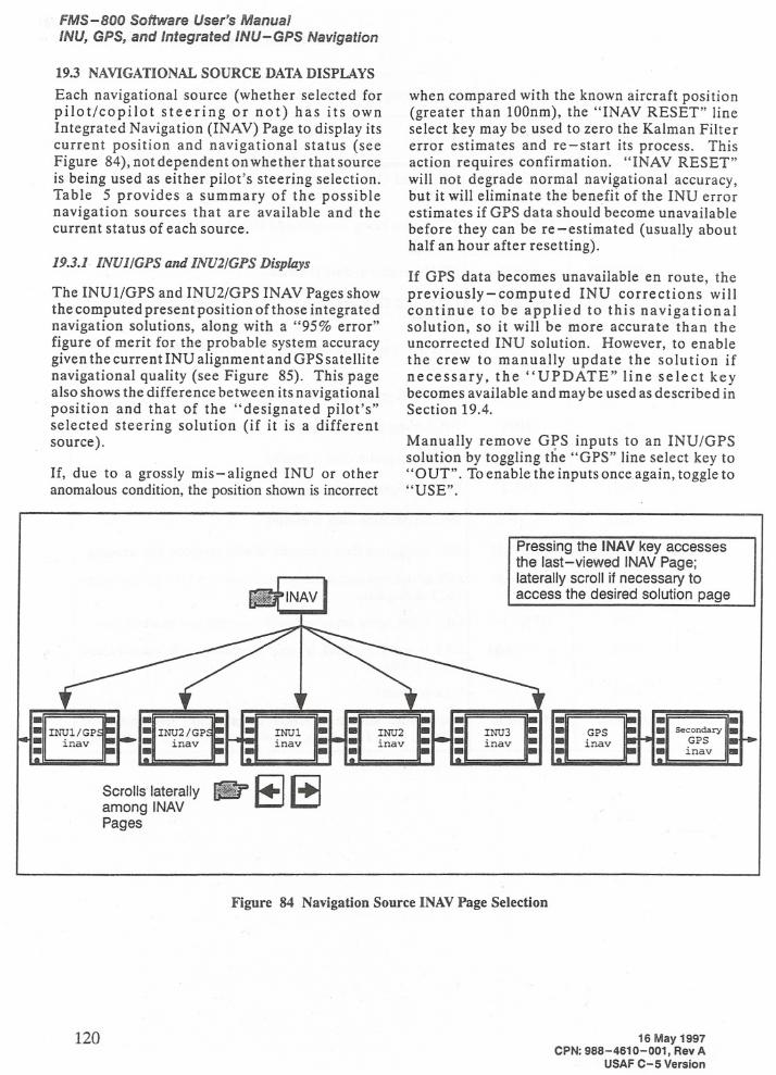
19.3 NAVIGATIONAL SOURCE DATA DISPLAYS
Each navigational source (whether selected forpilot/copilot steering or not) has its ownIntegrated Navigation (INAV) Page to display itscurrent position and navigational status (seeFigure 84), not dependent on whether that sourceis being used as either pilot's steering selection.Table 5 provides a summary of the possiblenavigation sources that are available and thecurrent status of each source.
19.3.1 INUl/GPS and INU2/GPS Displays
The INUl/GPS and INU2/GPS INAV Pages showthe computed present position of those integratednavigation solutions, along with a "95% error"figure of merit for the probable system accuracygiven the currentINU alignment and GPSsatellitenavigational quality (see Figure 85). This pagealso shows the difference between its navigationalposition and that of the "designated pilot's"selected steering solution (if it is a differentsource).
If, due to a grossly mis - aligned INU or otheranomalous condition, the position shown is incorrect
. -lNUl • -inav -. -
Scrolls laterally IiIJr 8~among INAVPages
when compared with the known aircraft position(greater than lOOnm), the "INAV RESET" lineselect key may be used to zero the Kalman Filtererror estimates and re-start its process. Thisaction requires confirmation. "INAV RESET"will not degrade normal navigational accuracy,but it will eliminate the benefit of the INU errorestimates if GPS data should become unavailable
before they can be re-estimated (usually abouthalf an hour after resetting).
If GPS data becomes unavailable en route, thepreviously-computed INU corrections willcontinue to be applied to this navigationalsolution, so it will be more accurate than theuncorrected INU solution. However, to enablethe crew to manually update the solution ifnecessary, the "UPDATE" line select keybecomes available and may be used as described inSection 19.4.
Manually remove GPS inputs to an INU/GPSsolution by toggling the "GPS" line select key to"OUT". To enable the inputs once again, toggle to"USE".
Pressing the lNAV key accessesthe last-viewed INAV Page;laterally scroll if necessary toaccess the desired solution page
•~
- •• GPS •Secondary•• inav=••• GPS•..• •inav•
120
Figure 84 Navigation Source INAV Page Selection
16 May 1997CPN: 988-4610-001, Rev A
USAF C-5 Version
INU1/GPS present position
FMS - 800 Software User's Manual
INU, GPS, and Integrated INU-GPS Navigation
95% probableposition error
Difference from"designated pilot's"source
Resets Kalman Filterestimation of INUerrors to zero
N42°00.432 W093° 4.43
lNU1/GPS inav
95%ERR 0.07
DIFF lNU1/GPS
INAV RESET
-[
Figure 85 INU/GPS Integrated Navigation Page
Toggles betweenGPS USE or OUT inKALMAN filter
Selects the INU1/GPSUpdate Page. Thisselection appears and isavailable only when GPSdata is unavailable, seeSection 19.4.
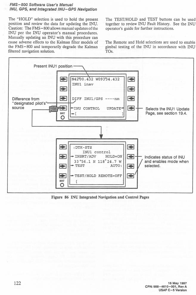
19.3.2 INUI,INU2 and INU3 Displays
The INUI and INU2 and INU3 INAV Pages show thepresent position from the respective INUs, along withthe alignment circular error probable (CEP) (seeFigure 86). The current alignment mode is alsodisplayed. The "DIFF" readout shows the differencebetween the INU position and the "designatedpilot's" selected steering solution (if it is a differentsource).
These pages also provide access to the individual INUcontrol page functions of the Carousel IV INUs, asshown in Figure 86.
Each INU's Control Page may only be accessed fromthe CDU which directly interfaces with that INU; i.e.,INUI may only be controlled via CDUl, INU2 mayonly be controlled via CDU2, and INU3 may only becontrolled via CDU3. Once a control page has beenaccessed for an INU, the procedures for initializing,controlling and displaying data for that INU is asdescribed in the Carousel IV operational procedures.
The "DTK-STS" selection is provided to access theINU status codes and enter modes and code data intothe INU. Normal entries from the INU operator'sguide are provided.
To enable Triple Mix operations, enter "4" and press"INSERT". Caution: Triple Mix is a reversionarynavigation state that should be used only when GPSdata is unavailable. Use of a Triple Mix INU solution
16 May 1997CPN: 988-4610-001, Rev AUSAF C-5 Version
with the GPS integrated solutions can causeunpredictable behavior in the integrated solution.DO NOT use Triple Mix modes with the INU/GPSsolutions.
To disable Triple Mix operations, enter "5" and press"INSERT".
The "POSITION" selection is provided for enteringalignment present position. As a reminder to enterthe present position, the annunciation line will displayINUx PP (where x = 1, 2, or 3). After selecting theposition function, the alignment position is entered,first a latitude, followed by "INSERT", then alongitude, followed by "INSERT". After the INUMode Select Unit has transitioned to alignment, thecurrent alignment state can be monitored by selecting"DTK-STS".
The "TEST" and AUTO/MAN selections areprovided to initiate INU tests and verify properbehavior of the Inertial system. When on theDTK-STS selection, TEST is used to review each ofthe INU status codes.
The "WAY PT" selection is used to review the pureinertial data prior to disabling Triple Mix operation.To review pure inertial data, press "HOLD", thenselect the WAY PT toggle selection. Note: Truewaypoints are entered into the FMS flight plan, not onthe INU waypoint list.
The "HDG-DA" selection is used to review thecurrent INU heading and drift angle.
121
FMS-800 Software User's Manual/NU, GPS, and Integrated INU-GPS Navigation
The "HOLD" selection is used to hold the presentposition and review the data for updating the INU.Caution: The FMS-800 allows manual updates of theINU per the INU operator's manual procedures.Manually updating an INU with this procedure cancause adverse effects to the Kalman filter models ofthe FMS-800 and temporarily degrade the Kalmanfiltered navigation solution.
Present INU1 position
The TESTIHOLD and TEST buttons can be usedtogether to review INU Fault History. See the INUoperator's guide for further instructions.
The Remote and Hold selections are used to enablegimbal testing of the INU in accordance with INUTOs.
Difference from
"designated pilot's"source
~
~
~
~BRT
o
N42~O.432 W093~4.432lNUl inav
DIFF lNU1/GPS ----nm
:DTK-STSlNUl control
- INSRT/ADV HOLD=ON33°56.1 N 118°24.7 W
- TEST AUTO:
-TEST/HOLD REMOTE=OFF
Selects the INU1 UpdatePage, see section 19.4.
Indicates status of INUand enables mode whenselected.
122
Figure 86 INU Integrated Navigation and Control Pages
16 May 1997CPN: 988-4610-001, Rev A
USAF C-5 Version
FMS-BOO Software User's ManualINU, GPS, and Integrated INU-GPS Navigation
19.3.3 GPS Display
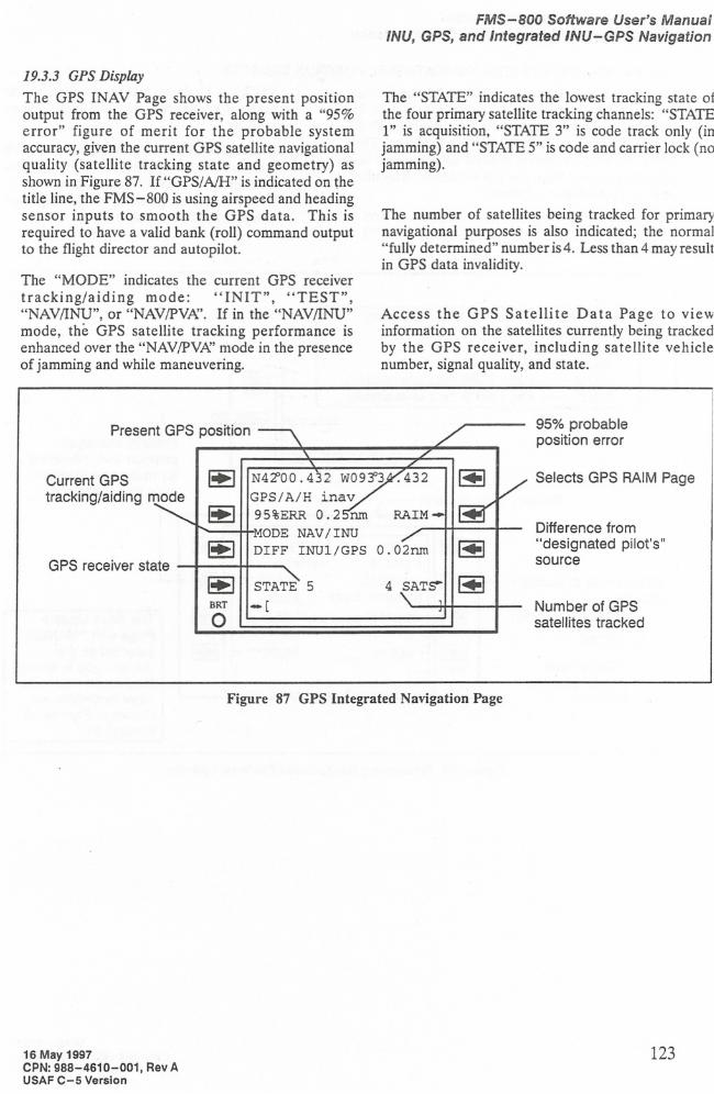
The GPS INAV Page shows the present positionoutput from the GPS receiver, along with a "95%error" figure of merit for the probable systemaccuracy, given the current GPS satellite navigationalquality (satellite tracking state and geometry) asshown in Figure 87. If "GPS/A/H" is indicated on thetitle line, the FMS-800 is using airspeed and headingsensor inputs to smooth the GPS data. This isrequired to have a valid bank (roll) command outputto the flight director and autopilot.
The "MODE" indicates the current GPS receivertracking/aiding mode: "INIT", "TEST","NAVIINU", or "NAVIPVI\'. If in the "NAVIINU"mode, the GPS satellite tracking performance isenhanced over the "NAV/PV/\' mode in the presenceof jamming and while maneuvering.
The "STATE" indicates the lowest tracking state 01the four primary satellite tracking channels: "STATE1" is acquisition, "STATE 3" is code track only (injamming) and "STATE 5" is code and carrier lock (nojamming).
The number of satellites being tracked for primarynavigational purposes is also indicated; the normal"fully determined" number is 4. Less than 4 may resultin GPS data invalidity.
Access the GPS Satellite Data Page to viewinformation on the satellites currently being trackedby the GPS receiver, including satellite vehiclenumber, signal quality, and state.
Present GPS position 95% probableposition error
Selects GPS RAIM Page
Difference from"designated pilot's"source
Number of GPSsatellites tracked
4 SATfr
N42'00.432 W093"3
GPS/A/H inav95%ERR 0.2 run
MODE NAV /INUDIFF lNU1/GPS O.02run
STATE 5
-[
~
~
~
~BRT
o
GPS receiver state
Current GPS
tracking/aiding mode
Figure 87 GPS Integrated Navigation Page
16 May 1997CPN: 988-4610-001, Rev AUSAF C-5 Version
123
FMS-800 Software User's Manual
INU, GPS, and Integrated INU-GPS Navigation
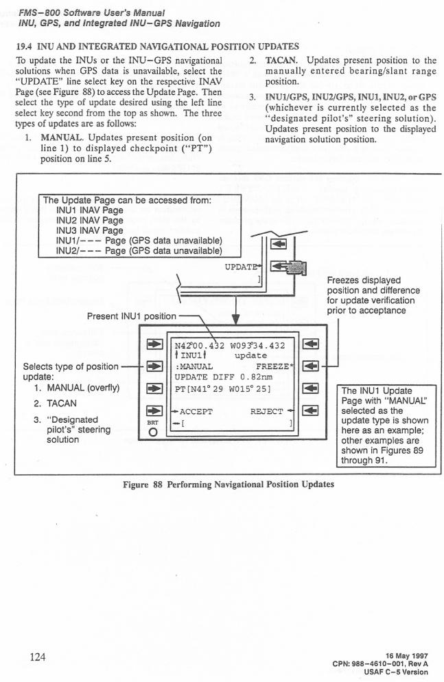
19.4 INU AND INTEGRATED NAVIGATIONAL POSITION UPDATES
To update the INUs or the INU-GPS navigationalsolutions when GP$ data is unavailable, select the"UPDATE" line select key on the respective INAVPage (see Figure 88) to access the Update Page. Thenselect the type of update desired using the left lineselect key second from the top as shown. Tne threetypes of updates are as follows:
1. MANUAL. Updates present position (online 1) to displayed checkpoint ("PT")position on line 5.
2. TACAN. Updates present position to themanually entered bearing/slant rangeposition.
3. INUI/GPS, INU2/GPS, INUI, INU2, or GPS(whichever is currently selected as the"designated pilot's" steering solution).Updates present position to the displayednavigation solution position.
The Update Page can be accessed from:INU1 INAV PageINU2 INAV PageINU3 INAV PageINU1/--- Page (GPS data unavailable)INU2/- - - Page (GPS data unavailable)
The INU1 UpdatePage with "MANUAL:'selected as theupdate type is shownhere as an example;other examples areshown in Figures 89through 91.
REJECT
Freezes displayedposition and differencefor update verificationprior to acceptance
N4~OO.432 W09~34.432tINUlt update:MANUAL FREEZE*UPDATE DIFF O.82nm
PT[N41029 W01~25J
ACCEPT
-[
~
~
~
~BRT
o
Present INU1 position
3. "Designatedpilot's" steeringsolution
Selects type of positionupdate:
1. MANUAL (overfly)
2. TACAN
Figure 88 Performing Navigational Position Updates
124 16 May 1997CPN: 988-4610-001, Rev A
USAF C-5 Version
FMS-800 Software User's Manual/NU, GPS, and Integrated INU-GPS Navigation
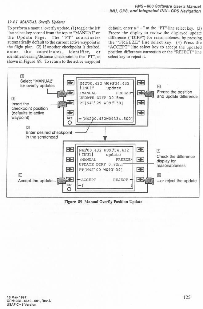
19.4.1 MANUAL Overfly Updates
To perform a manual overfly update, (1) toggle the leftline select key second from the top to "MANUAe' onthe Update Page. The "PT" coordinatesautomatically default to the current active waypoint inthe flight plan. (2) If another checkpoint is desired,enter the coordinates, identifier, oridentifierlbearingldistance checkpoint as the "PT", asshown in Figure 89. To return to the active waypoint
default, enter a "-" at the "PT" line select key. (3)Freeze the display to review the displayed updatedifference ("DIFF") for reasonableness by pressingthe "FREEZE" line select key. (4) Press the"ACCEPT" line select key to accept the updatedposition difference correction or the "REJECT" lineselect key to reject it.
[ZJ
Enter desired checkpointin the scratch pad
@
Freeze the positionand update difference
N4~OO.432 W09~34.432
tINUl t update:MANUAL FREEZUPDATE DIFF 30.5nm
PT[N410 29 W093° 30]
-[N42 0.432W09334.500]
~BRT
o
rnSelect "MANUAt.:'for overfly updates
[]J
Insert thecheckpoint position(defaults to activewaypoint)
N4~00.432 W09~34.432
tINUlt update:MANUAL FREEZEUPDATE DIFF 0.82nm
PT [N42°00 W093° 34]
ACCEPT
-[REJECT
ffiJ
Check the differencedisplay forreasonableness
lID
...or reject the update
Figure 89 Manual Overfly Position Update
16 May 1997CPN: 988-4610-001, Rev AUSAF C-5 Version
125
FMS-800 Software User's Manual
/NU, GPS, and Integrated /NU-GPS Navigation
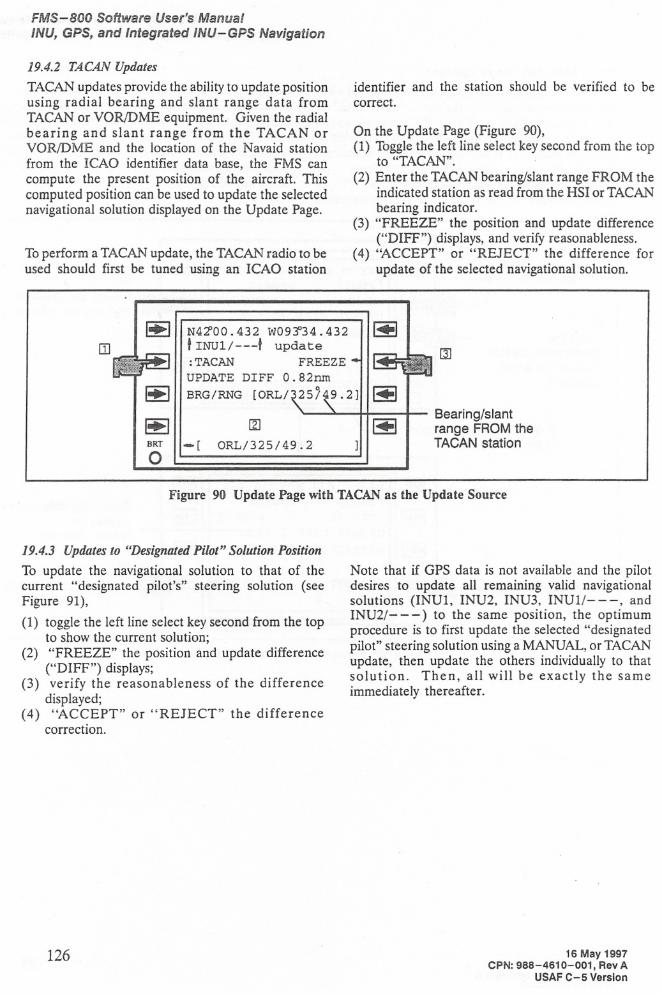
19.4.2 TACAN Updates
TACAN updates provide the ability to update positionusing radial bearing and slant range data fromTACAN or VORJDME equipment. Given the radialbearing and slant range from the TACAN orVOR/DME and the location of the Navaid stationfrom the ICAO identifier data base, the FMS cancompute the present position of the aircraft. Thiscomputed position can be used to update the selectednavigational solution displayed on the Update Page.
To perform a TACAN update, the TACAN radio to beused should first be tuned using an ICAO station
identifier and the station should be verified to becorrect.
On the Update Page (Figure 90),(1) Toggle the left line select key second from the top
to "TACAN".(2) Enter the TACAN bearing/slant range FROM the
indicated station as read from the HSI or TACANbearing indicator.
(3) "FREEZE" the position and update difference("DIFF") displays, and verify reasonableness.
(4) "ACCEPT" or "REJECT" the difference forupdate of the selected navigational solution.
~N4~OO.432 W09~34.432~
OJ
tlNU1/---tupdate (JJ:TACAN
FREEZEUPDATE DIFF O.82nm~
BRG/RNG [ORL/325/49.2]~
~
lZJ ~Bearing/slant
range FROM theBRT
-[ORL/325/49.2 TACAN station
0
Figure 90 Update Page with TACANas the Update Source
19.4.3 Updates to "Designated Pilot" Solution Position
To update the navigational solution to that of thecurrent "designated pilot's" steering solution (seeFigure 91),
(1) toggle the left line select key second from the topto show the current solution;
(2) "FREEZE" the position and update difference("DIFF") displays;
(3) verify the reasonableness of the differencedisplayed;
(4) "ACCEPT" or "REJECT" the differencecorrection.
Note that if GPS data is not available and the pilotdesires to update all remaining valid navigationalsolutions (INU1, INU2, INU3, INUlI---, andINU2/- - -) to the same position, the optimumprocedure is to first update the selected "designatedpilot" steering solution using a MANUAL, or TACANupdate, then update the others individually to thatsolution. Then, all will be exactly the sameimmediately thereafter.
126 16 May 1997CPN:988-4610-001, Rev A
USAF C-5 Version
FMS-800 Software User's Manual/NU, GPS, and Integrated INU-GPS Navigation
~
N4~OO.432 W09~34.432~
tINU1/---t
update,., :INU1/GPS FREEZ~~UPDATE DIFF O.82nm ~
PSN N41029 W015°25 ~
~
~BRT
-[ ]0
"Designated pilot's"solution present position
Figure 91 Update Page with "Designated Pilot" as the Update Source
16 May 1997CPN: 988-4610-001, Rev AUSAF C-5 Version
127
FMS-800 Software User's Manual
/NU, GPS, and Integrated INU-GPS Navigation
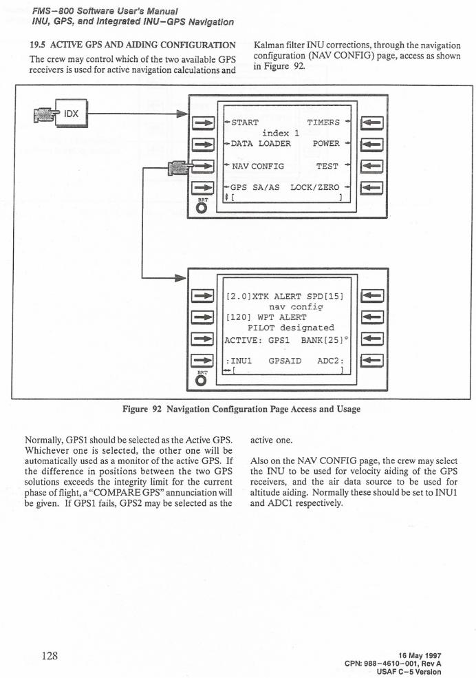
19.5 ACTIVE GPS AND AIDING CONFIGURATION
The crew may control which of the two available GPSreceivers is used for active navigation calculations and
Kalman filter INU corrections, through the navigationconfiguration (NAV CONFIG) page, access as shownin Figure 92.
~ 1 ••••••• 1START
TIMERS""-1index 1I-~l
DATA LOADERPOWER'·--1NAV CONFIG
TEST"4-1
GPS
SA/ASLOCK/ZEROt"'-It [
]
[2.0]XTK ALERT SPD[15]
n3.V <::onfig
[120] WPT ALERT
PILOT designated
ACTIVE: GPSl BANK[25]O
1-'·'1--"
1-'"I-··l
BP.To:INU1
[
GPSAID ADC2:]
Figure 92 Navigation Configuration Page Access and Usage
Normally, GPSI should be selected as the Active GPS.Whichever one is selected, the other one will beautomatically used as a monitor of the active GPS. Ifthe difference in positions between the two GPSsolutions exceeds the integrity limit for the currentphase of flight, a "COMPARE GPS" annunciation willbe given. If GPSI fails, GPS2 may be selected as the
active one.
Also on the NAV CONFIG page, the crew may selectthe INU to be used for velocity aiding of the GPSreceivers, and the air data source to be used for
altitude aiding. Normally these should be set to INUIand ADCl respectively.
128 16 May 1997CPN: 988-4610-001, Rev A
USAF C-S Version
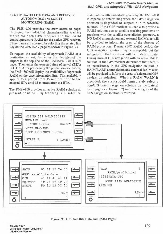
19.6 GPS SATELLITE DATAAND RECEIVERAUTONOMOUS INTEGRITYMONITORING (RAIM)
The FMS-800 provides the crew access to pagesdisplaying the individual channel/satellite trackingstatus for each GPS receiver and the RAIMcontrol/predictive RAIM for the active GPS receiver.These pages are accessed by selecting the related linekey on the GPS INAV page as shown in Figure 93.
To request the availability of approach RAIM at adestination airport, first enter the identifier of theairport in the top line of the RAIMIPREDICfIONpage. Then enter the expected time of arrival (ETA)in UTe. After performing the prediction calculation,the FMS-800 will display the availability of approachRAIM on the page information line. This availabilityapplies to a period from 15 minutes prior to theentered ETA until 15 minutes after the ETA.
The FMS-800 provides an active RAIM solution atpresent position. By tracking GPS satellite
FMS-BOO Software User's ManualINU, GPS, and Integrated INU-GPS Navigation
state -of- health and orbital geometry, the FMS -800is capable of determining when the GPS navigationsolution is degraded or suspect due to satellitefailures. If the GPS receiver is unable to provide aRAIM solution due to satellite tracking problems orproblems with the satellite constellation geometry, aNO RAIM annunciation and external RAIM alert will
be provided to inform the crew of the absence ofRAIM protection. During a NO RAIM period, theGPS navigation solution may be acceptable but theintegrity of that solution will be indeterminate.During normal GPS navigation with an active RAIMsolution, if the GPS receiver determines that there isan inconsistency in the GPS navigation solution, aRAIM WARN annunciation and external RAIM alert
will be provided to inform the crew of a degraded GPSnavigation solution. When a RAIM WARN isprovided, the crew should immediately select anon-GPS based navigation solution on the LateralSteer page (see Figure 82) until the integrity of theGPS navigation solution is restored.
I-~IN4P29.329 W015 25 ~183~-.-l
I-~I
~PS/A/H inav
1-.•-1.-95%ERR 0.25nmRAIM -
I-~lMODE NAV/lNU
~-·-IDIFF INU1/GPS 0.02nm
1--'11+-1
-STATE
5 4SATS - ~BRT
-[ ]0+
,
1--"
SATS0111152430,---II-~I[CID ]1---1GPS1
satellite data RAIM/prediction
1--.1C/N
41 414141411"'-1I-~·I[1212]ETA UTC 1'4-1FQ/CODE
1P 2P 1P 1P2C
1--.1
APPRRAIM AVAILl\BLE
1"'-11--" STATE5D 5D lS 3I3D~---I RAIM:ON
1-·'RTN-f·-I1--.1 RTN -1-·-1
BRT
[ ]BRT[ ]
0 0
Figure 93 GPS Satellite Data and RAIM Pages
16 May 1997CPN: 988-4610-001, Rev AUSAF C-5 Version
129

FMS-BOO Software User's ManualINU, GPS, and Integrated INU-GPS Navigation
This page intentionally left blank.
130 16 May 1997CPN: 988-4610-001, Rev A
USAF C-S Version