Embed Size (px)
DESCRIPTION
Inlet Island Urban Design Plan by the City of Ithaca Department of Planning & Development, LA Landscape Architecture and Engineering, and Argus Architecture & Preservation. The intent of this plan is to provide the City of Ithaca with a vision for the use and development of the Inlet Island area in a way that encourages private development opportunities and provides the public with increased waterfront access. To accomplish this intent, the plan strives to preserve the waterfront's natural beauty, protect scenic resources and improve the design quality of development as it occurs. The Inlet Island Urban Design Plan sets forth guidelines and implementation strategies for use by developers, City of Ithaca officials, board members, and the general public for the development of both public and private lands located along Taughannock Boulevard and on Inlet Island.
Citation preview

Inlet Island Urban Design Plan City of Ithaca, New York
October 1998
Adopted by Common Council November 4, 1998

Inlet 'Island Urban Design Plan City of Ithaca, New York
Alan J. Cohen - Mayor
With special thanks to members of the Inlet Island Urban Design Plan Committee: Scott Whitham - Chairperson Susan Blumenthal - Chairperson of City of Ithaca's Planning & Economic Development Committee of Common Council Stuart Stein - Tompkins County Board of Representatives Barbara Blanchard- Tompkins County Board of Representatives Ellen McCollister - Planning & Development Board, City of Ithaca Steve Ehrhardt- Board of Public Works, City oflthaca Robert Lama - Lama Real Estate, Ithaca, NY John Novarr- Novarr-Mackesey Development Company, Ithaca, NY John Schroeder- Chairperson of Inlet Island Land Use Committee H. Matthys Van Cort- Director of Planning & Development, City oflthaca JoAnn Cornish- Environmental/Landscape Planner, City of Ithaca
A joint effort by:
The City of Ithaca Department of Planning & Development and
The LA Group, Landscape Architecture and Engineering, P.C. 40 Long Alley
Saratoga Springs, NY 12866 and
Argus Architecture & Preservation 297 River Street--Suite 303
Troy, NY 12180

Inlet Island Urban Design Plan
Table of Contents
Chapter 1 Preamble: Purpose and Intent of This Plan •.......•.....•...........•..•......•...•................................•..•..••................•............. 2
Chapter 2 Inlet Island: A Conceptual Plan for Improvement ...........•.............••...•...••.....•••......•.....•..•....•..••.•••........•.....•.....•.•.•. 4
Chapter 3 Public Realm: Guidelines for Public Infrastructure- Design and Form •........••.....•.....•.•.................•............•......•.. 8 A. Applicability ............................................................................................................................................................... 8 B. Goals and Objectives ................................................................................................................................................ I 0 C. General Guidelines ................................................................................................................................................... 11 D. Specific Guidelines .................................................................................................................................................. 15
Chapter 4 Private Realm: Guidelines For Development ...................... ~ .................................................................................... 29 A. Applicability ............................................................................................................................................................. 29 B. Goals and Objectives ................................................................................................................................................ 31 C. Specific Guidelines .............................................................................................................................................. 33
Chapter 5 Implementation ............................................................................................................................................................ 46 A. Administration .......................................................................................................................................................... 46 B. Capital Improvements .............................................................................................................................................. 48 C. Property Acquisition/Disposition ........................................................................................................ , .................... 49 D. Funding .................. , ................................................................................................................................................. 50
Appendix A: Waterfront Zoning District
Adoption of Inlet Island Urban Design Plan
Adopted November 4, 1998

Inlet Island Urban Design Plan
List of Figures
Figure 1-1 Figure 1-2
Figure 2-1 Figure 2-2 Figure 2-3 Figure 2-4
Figure 3-1 Figure 3-2 Figure 3-3 Figure 3-4 Figure 3-5 Figure 3-6 Figure 3-7· Figure 3-8 Figure 3-9 Figure 3-10 Figure 3-11 Figure 3-12 Figure 3-13 Figure 3-14 Figure 3-15 Figure 3-16 Figure 3-17 Figure 3-18 Figure 3-19 Figure 3-20
List of Figures and Maps
Photograph of Inlet Island Western Shore ............................................................................................ 2 Photograph of Brindley Park Drinking Fountain .................................................................................. 3
Concept Plan ......................................................................................................................................... 5 Perspective View of the Promenade ..................................................................................................... 6 Perspective View of Lookout Point ...................................................................................................... 7 Plan View of Lookout Point .................................................................................................................. 7
Photograph of Taughannock Boulevard and Buffalo Street Construction ............................................ 8 Perspective View of Taughannock Boulevard and Buffalo Street Entrance ........................................ 8 Photograph of Esplanade in Battery Park, Manhattan ........................................................................ 10 Photograph of Waterfront Area of Battery Park, Manhattan .............................................................. 11 Plan View of Pedestrian Way to West Shore of the Flood Control Channel.. .................................... 12 Section View ofTaughannock Boulevard Looking North ................................................................. 12 Plan View of Parking Placement Concept .......................................................................................... 13 Photograph of Sign Board ................................................................................................................... 13 Photograph of Battery Park, Manhattan .............................................................................................. 14 Plan View of a Concept Plan for Brindley Park ................................................................................. 14 Plan View of Promenade ..................................................................................................................... 15 Section View of Promenade ................................................................................................................ 15 Photograph of Example of Park Bench ............................................................................................... 16 Photograph of Example of Lighting Fixture ....................................................................................... 16 Photograph of Example of Pavement Texture .................................................................................... 17 Plan View ofTaughannock Boulevard and Buffalo Street Intersection ............................................. 19 Plan View of Surface Level Parking ................................................................................................... 21 Plan View of Surface Level Parking ................................................................................................... 21 Plan View of Parking Structure ........................................................................................................... 22 Plan View of Parking Structure ........................................................................................................... 22
Adopted November 4, 1998

Inlet Island Urban Design Plan
Figure 3-21 Figure 3-22 Figure 3-23 Figure 3-24. Figure 3-25 Figure 3-26 Figure 3-27 Figure 3-28 Figure 3-29
Figure 4-1 Figure 4-2 Figure 4-3 Figure 4-4 Figure 4-5 Figure 4-6 Figure 4-7 Figure 4-8 Figure 4-9 Figure 4-10 Figure 4-11 Figure 4-12 Figure 4-13
List of Maps
Map 1-1
Map 3-1
Map4-1
Plan View of Plaza ......................................................................................................................... 23 Plan View of Pedestrian Access .......................................................................................................... 24 Plan View of Terminus ....................................................................................................................... 24 Lighting Design Photograph ............................................................................................................... 25 Lighting Fixture Photograph ............................................................................................................... 26 Lighting Fixture Photograph ............................................................................................................... 26 Lighting Fixture Photograph ............................................................................................................... 26 Photograph of Pole Banners ................................................................................................................ 28 Photograph of Public Tables ............................................................................................................... 28
Streetscape Character Example ........................................................................................................... 31 Continuous Building Wall Architectural Example ............................................................................. 31 Example ofProperly Oriented Buildings ............................................................................................ 32 Perspective Views for Building Height Guidelines ............................................................................ 34 Perspective Views for Building Height Guidelines ............................................................................ 34 Illustration of Cornice Example .......................................................................................................... 35 Illustration of Curved Comers ............................................................................................................ 3 7 Illustration of Canopy Effect ............................................................................................................... 3 7 Recessed First Floor Arcade Example ................................................................................................ 38 Recessed Balcony Example ................................................................................................................ 38 Section View of Building Height and ROW Relationship .................................................................. 39 Variation in Cornice Illustration ......................................................................................................... 40 Retail Store Glazing Example ............................................................................................................. 41
Inlet Island Project Area Map .............................................................................................................. 1
Proposed Public/Private Parcels ............................................................................................................ 9
Proposed Waterfront Zone Sub-Districts ............................. , .............................................................. 30
Adopted November 4, 1998
Inlet Island Urban Design Plan
Adopted November 4, 1998
INLET ISLAND URBAN DESIGN PLAN
PROJECT AREA MAP MAP 1-1
Page 1

Inlet Island Urban Design Plan
Figure 1-1 Western shore of Inlet Island along the Flood Control Channel.
Adopted November 4, 1998
Chapter 1 Preamble: Intent and Purpose of This Urban Design Plan
The intent of this plan is to provide the City of Ithaca with a vision for the use and development of the Inlet Island area in a way that encourages private development opportunities and provides the public with increased waterfront access. To accomplish this intent, the plan strives to preserve the waterfront's natural beauty, protect scenic resources and improve the design quality of development as it occurs. The Inlet Island Urban Design Plan sets forth guidelines and implementation strategies for use by developers, City of Ithaca officials, board members, and the general public for the development of both public and private lands located along Taughannock Boulevard and on Inlet Island.
Ithaca, located at the southern end of Cayuga Lake and connected directly to the Erie Canal via the Cayuga Seneca Canal, experienced dramatic economic development during the 1800s as it developed as a regional trans-shipment center. The focus of this activity was located in the City's west end in the area now known as Inlet Island (See Map 1-1). As noted in the Report of the Inlet Island Land Use Committee, adopted by the City of Ithaca's Planning & Development Board in 1992, the development of this area was "shaped and reshaped by some of the most powerful forces that have transformed American cities over the past 150 years." As that report noted, the creation of the canal system in the early 19th century, growth and subsequent decline of railroads from the mid-19th to the mid-20th centuries, the development of arterial highway systems beginning in the 1950s and the massive flood control project undertaken by the Army Corps of Engineers in the 1960s have all contributed to the creation of a unique waterfront area. The legacy of these transformations has also created a number of constraints that have hindered the City's ability to fully capitalize on the development potential of the area. Today, with the most recent transformation completed - the realignment of State Routes 79, 89, and 96 and the construction of two new bridges spanning the Flood Control Channel - the area is poised for redevelopment.
The improved access to Inlet Island, the presence of water-related and recreational facilities in the area, the adjoining shoreline areas that feature public park land and waterbased businesses, have all contributed to a desire to redevelop this unique area of the City. In recognition of this opportunity, the City of Ithaca's Common Council approved the formation of a committee to produce an urban design plan for the redevelopment of Inlet Island, based upon the 1992 Report of the Inlet Island Land Use Committee.
Page 2

Inlet Island Urban Design Plan
Figure 1-2 Drinkingfountain in Brindley Park
Adopted November 4, 1998
This plan, along with the Report from the Inlet Island Land Use Committee and the Tompkins County Waterfront Plan (January 1997), proposes to direct development on the island while allowing for creativity and innovation in final detailed designs. Public improvements such as the public promenade, the streetscapes, the pedestrian ways, and the parking facilities are all intended to contribute to the island's character in a manner consistent with the overall concept presented here.
The island and the waterfront area are envisioned as vibrant, urban environments, encouraging contact with the waterfront through extensive pedestrian access and protection of views. The proposed land use is varied and is intended to contribute to the appeal of the island, providing a destination for living, shopping, dining, entertainment, as well as other recreational activities. When completed, private development and public improvements should present an exciting waterfront experience achieving the goals set for this unique and important area of the city.
Page 3

Inlet Island Urban Design Plan
Adopted November 4, 1998
Chapter 2 Inlet Island: A Conceptual Plan For Improvement
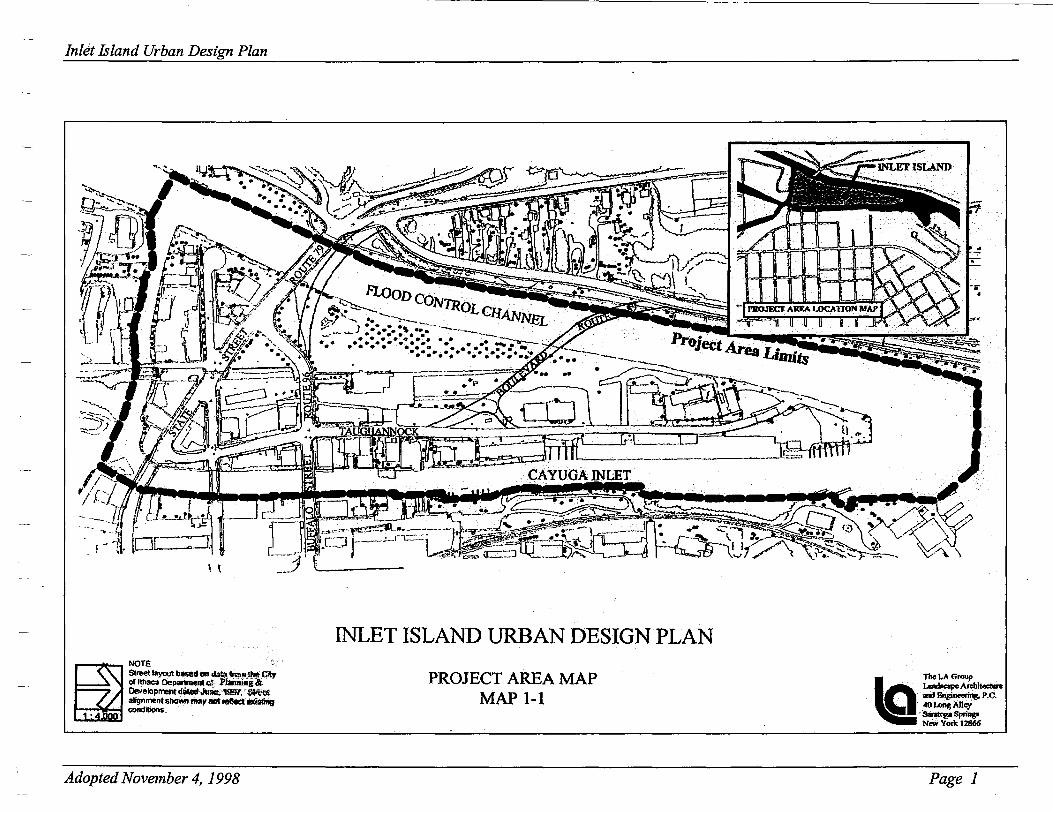
The design developed by the committee for improvement of Inlet Island is conceptual in nature and long term in scope. A careful review of the plan will reveal the interrelated elements developing and establishing a special character for this area of the City (see Figure 2-1). The committee's conceptual plan is intended to create a visually attractive waterfront in an intimate urban setting. The plan strives to establish a continuous network of streets, pedestrian ways, and well-defined, appealing public spaces.
The concept envisioned for public infrastructure is intended to build on the recently completed broad-based improvements to the area's highway system by the New York State Department of Transportation (NYSDOT). The most prominent public improvement in the plan is the proposed provision of a continuous pedestrian promenade, to be named Rick's Way in memory of Richard Gray and Richard Lawrence, along the Flood Control Channel (see Figure 2-2). This places pedestrian access directly at the water's edge. The promenade's design is intended to attract people to the shoreline by providing an interesting, secure environment which will encompass a wide spectrum of opportunities for people to live, visit or work on Inlet Island. The light fixtures, landscaping, benches, public open spaces, establishment and maintenance ofview corridors, installation of seasonal banners, and strategically placed directional signage are all elements of an infrastructure plan intended to enhance the waterfront promenade as an attractive destination.
Lookout Point is another prominent feature on the landscape of the Island. Care was taken to develop a design concept that allows for maintenance of views from locations to the south, while also providing visitors the opportunity to enjoy views up the inlet. The suggestion of an elevated, covered platform is one approach to view enhancement (see Figures 2-3 and 2-4).
The pedestrian system illustrated in the conceptual plan emphasizes access to the waterfront and provides continuous multiple links to destinations throughout the Island, as well as to other nearby areas of the City along the inlet such as the Farmers' Market. Links to recreation attractions across the Flood Control Channel such as Cass Park and Treman Marina are also included in the plan. Visitors will be able to park their vehicles in one location and enjoy continuous pedestrian access to all destinations in this section of the City.
Page 4
Inlet Island Urban Design Plan
·--''-...._
------· /
;·-·· . ',) ----.... ______ /
Figure 2-1 The overall concept plan illustrates a potential development pattern to be developed according to guidelines presented in this plan.
Adopted November 4, 1998
-------
Page 5

Inlet Island Urban Design Plan
...
..
... -- . ...
... .......
Adopted November 4, 1998 Page 6

Inlet Island Urban Design Plan
rr/~·li: Doald,n.!J ,...,,,;o;t,,z.
~ {..oM> ·~.,.~;"""-"kr ~ l» / t-_. 5/>rub !"Mr>N'?!f
Figure 2-3 This perspective view of Lookout Point shows a concept for the provision of an observation platform and sloping lawn area at Lookout Point.
. . . ~ .:·~.~ .. ' . :
Figure 2-4 A plan view of the concept for Lookout Point.
' -· ---~·-·.-
'
Adopted November 4, 1998
The plan also sets forth a vision for private development within the area. The plan proposes mixed land use for the area, which may include residential dwellings, office space, craft/artist workshops, retail outlets, restaurants, etc. The intent is to establish an active, 24-hour community.
These uses would occur in a vital urban setting with extensive building coverage and a range ofbuilding massing, up to five stories. Building massing would occur in a "stepped" arrangement from the Waterfront. Such an approach would have a lower maximum building height of one to two stories on parcels directly adjacent to the waterfront, and up to five stories for buildings on the Island's interior. The resulting benefit will be an attractive and varied landscape when viewed from the water or from areas surrounding the Island. The tiered buildings will also maximize water views from each building on the Island. Building orientation, as illustrated in the plan, places building walls parallel to the water's edge. This serves to improve views of the water and to utilize building components that would maximize enjoyment of the waterfront, such as patios, terraces and balconies.
The pedestrian ways on private parcels are designed to integrate seamlessly with the public pedestrian ways. The pedestrian walks are designed to maintain views to the waterfront and to attract people to the proposed promenade.
The elements of the conceptual plan, highlighted above, have served as a basis for the development of design guidelines that will direct and shape redevelopment of . the Island. The guidelines are not intended to be regulations requiring strict compliance. Rather, they convey certain themes to be included in the creative and dynamic design processes that will shape Inlet Island in the years to come.
Additionally, the plan makes recommendations for an amendment to the City's zoning code. The zoning amendment would revise dimension and height requirements so that they would comply with recommendations set forth in this plan. The suggested revision is included in Appendix A.
Page 7

Inlet Island Urban Design Plan
Figure 3-1 Intersection ofTaughannock Boulevard and Buffalo Street as it exists at the time of plan development.
Figure 3-2 Perspective view of a concept for the intersection ofTaughannock Boulevard and Buffalo Street.
Adopted November 4, 1998
Chapter 3 Public Realm: Guidelines for Public Infrastructure -Design and Form
A. Applicability
1. The public realm of the Taughannock Boulevard and Inlet Island area is defined as development occurring on proposed public property (see Map 3-1). Significant elements which will shape the character of the island and the surrounding area include: • Three waterways: the Flood Control Channel, Cayuga Inlet and Six Mile Creek. • Sections of the shoreline adjoining these waterways. • Lookout Point at the northern tip of Inlet Island. • The park land on the island and on the surrounding waterfront. • The streets providing vehicular access to and from the island. • Pedestrian facilities including a proposed promenade along the Flood Control
Channel and Cayuga Inlet, sidewalks, pedestrian ways and crosswalks. • Entrance points at certain intersections which, because of their location, serve to
distinguish a point of arrival (see Figures 3-1 and 3-2). • Landscape treatments along streets, the promenade, sidewalks and pedestrian
ways, in parks, at entrance points, in parking areas, etc. • Lighting along streets and the promenade, sidewalks and pedestrian ways, in
parks, in parking areas, etc. • Ancillary components including benches, tables, railings, trash receptacles,
bicycle racks, drinking fountains, etc. • Parking facilities including surface lots, structures, and on-street parking. • Signage including directories identifying street names and route numbers, park
signs and signs identifying notable landmarks or points of interest.
Page 8

Inlet Island Urban Design Plan
NOTE Street layout based on data fronJJhe Clly of Ithaca Department of· Plannmg & Development dated June, 1997. Street alignment shown may not reflect exisling conditions.
Adopted November 4, 1998
INLET ISLAND URBAN DESIGN PLAN
PROPOSED PUBLIC I PRIVATE PARCELS MAP3-l
LEGEND
1!1 Proposed Public Parcels
J:J Proposed Private Parcels
Page 9

Inlet Island Urban Design Plan
Figure 3-3 Public waterfront areas are special places that if properly designed provide opportunities for varied recreation and enjoyment.
Adopted November 4, 1998
2. The geographic area to which these guidelines apply is bounded by Cascadilla Creek to the north, the shoreline of the Cayuga Inlet to the east, Six Mile Creek to the south and the Flood Control Channel to the west (see Map 3-1).
3. The guidelines for the public realm are intended to be used by public agencies as they consider improvements to any of the elements listed above. This document is to be used by appropriate departments of the City, County, State and/or Federal governments as a means to understand the City's vision for development within the area defined above. Designers of public improvements are encouraged to employ innovation and creativity while working within the conceptual framework of the guidelines. The following guidelines should be reviewed, understood and creatively applied during the development of designs intended to improve public infrastructure. Unlike zoning, these guidelines are not requirements. Rather, the guidelines are intended to be referenced throughout the design development process.
B. Goals and Objectives
These guidelines are intended to promote the provision of public spaces and infrastructure that will:
• Provide people with the opportunity to enjoy and interact with the waterfront in an urban setting (see Figure 3-3).
• Contribute to the character and appeal of the area as attractive, secure and functional.
• Provide spaces that are well-defined, pedestrian-scaled and memorable. • Complement the design and function of redeveloped private parcels.
Specific objectives to fulfill the stated goals include:
• Maintenance of clean, attractive waterways. • Development of shoreline areas in a manner that provides interaction with the
waterway and establishes and preserves views (see Figure 3-4). • Provision of park areas that are aesthetically pleasing as well as functional for active
and passive recreation. • Well-designed streetscapes that safely move vehicles and pedestrians in a
functional, aesthetically pleasing manner.
Page 10

Inlet Island Urban Design Plan
Figure 3 -4 This waterfront area in Manhattan effectively provides opportunities
for views of the water.
Adopted November 4, 1998
• Creation of a well-planned, secure pedestrian network that provides a continuous link to and along the waterfront, to areas of interest throughout the island and to adjoining areas of the City.
• Providing a special sense of arrival will enhance prominent points of access. • · Provision of landscape treatments that complement the urban character and enhance
the attractiveness of the area. • Emphasis on Lookout Point, located at the northern tip of the Island, as a prominent
destination. • Provision of lighting and lighting fixtures that are functional, attractive and
contribute to the establishment of a safe and festive environment. • Placement of ancillary components in a manner that is both functional and designed
to support the vibrant, urban character of public infrastructure and private development.
C. General Guidelines
General guidelines for the development of public infrastructure are intended to provide broad concepts and themes that will serve as a basis for the specific guidelines. The general guidelines provide a framework and directive that should be carefully considered prior to applying the specific guidelines during design development. General guidelines for each element of the public realm are as follows:
1. Waterways - Leave waterways open and free of obstructions, to the extent possible. The development, operation and use of adjoining lands should, to the extent possible, maintain water quality and reduce potential contamination of the waterway.
2. Shoreline- Maintain the Flood Control Channel shoreline area free of obstructions. Development should occur in a planned manner, maintaining view corridors and allowing for interaction with the waterfront. Shorelines should allow for continuous pedestrian, (walking, bicycling, jogging, roller-blading, sitting, etc.), and should comply with Americans with Disabilities Act (ADA) standards. Shoreline areas should be attractive and secure, maximizing opportunities for views of the waterway along the entire length of the shoreline. Buildings on the shoreline area should be sized and oriented to maintain views of, and access to, the waterfront.
Page 11

Inlet Island Urban Design Plan
Un.n~-..n~/ Vk'w CornOt~r-lb ~,..dol!.
Figure 3-5 ~edestrian ways provide access to parcels and view corridors to the waterfront.
$li#W4ti/C. ~~ r:tf~ t11~ ~,,.,.IJC...
+---~~~~~~-~~--~
Figure 3-6 This is a conceptual section looking through the Taughannock Boulevard streetscape.
Adopted November 4, 1998
3. Pedestrian Ways - These should be designed and located to allow for continuous exposure and access to the waterfront (see Figure 3-5). Waterfront pedestrian ways should link to pedestrian ways on the Island's interior. They should also link to adjoining areas of the City. Ultimately, there should be continuous pedestrian access along and around all ofTaughannock Boulevard and Inlet Island. Further, there should be pedestrian access between all parcels, reducing the need for vehicle transportation. All pedestrian ways should comply with ADA standards.
4. Streets and Streetscapes - Provide proportional relationships between buildings, streets, sidewalks and travel lanes (see Figure 3-6). The overall atmosphere should contribute to the urban character and scale of the Island, while providing acceptable means for passenger and service vehicles to reach individual parcels and buildings. Current levels of service at intersections throughout the island should be maintained.
5. Landscape Treatments- Design landscape treatments to enhance the area's urban character and the appearance of streetscapes and pedestrian ways. Landscape design should be in accordance with design criteria for the Island. Landscape design of public and private parcels should be coordinated to reduce visual conflicts and to link separate parcels.
6. Lookout Point - Emphasize this area as a prominent location for significant views northward toward the lake. The design should serve to attract visitors to this area. Any structures should be designed and located to maintain views from the south.
7. Lighting/Lighting Fixtures - Utilize lighting as a technique to enhance the attractiveness and security of all locations along Taughannock Boulevard and Inlet Island. Ample lighting of moderate intensity should illuminate pedestrian ways, streetscapes, parking areas and areas of general public assembly. Accessory lighting, such as up-lighting along landscaped areas and building facades, should enhance the area's vibrant festive character. Lighting fixtures should follow established design criteria that will enhance the urban, waterfront character of the area.
8. Parking Areas and Facilities -Locate parking to provide convenient access to the waterfront and to destination points throughout the island (see Figure 3-7). Parking
Page 12

Inlet Island Urban Design Plan
~if~M:. wjs-j~
Ti"u C-t~d On>p- orr 2.n.: tl-jN(9h~ "'/Tree io/•m''~.t ti!hfi".J,~f"'? / tK~w ~
{J.n</=Ap.e .:&.Hv>d
Figure 3-7 This plan view represents how parking areas should be designed to allow for access to multiple destinations_
Adopted Novembr;r 4, 1998
access should be located and designed to allow for the future development of multilevel structures where surface-level structures are initially proposed. The future parking structures would be located along the west side ofTaughannock Boulevard just north of the Station Restaurant and at the northwest comer of Taughannock Boulevard and Old Taughannock Boulevard. The overall parking approach should include a mix of on-street and off-street parking.
9. Signage- Coordinate and design signage that will contribute to the Island's urban waterfront character (see Figure 3-8). Signage should be strategically located and positioned to provide information to people using all modes of transportation: vehicular, public transit, bicycles, boats, pedestrian, etc.
10. Ancillary Components - Locate benches, bicycle racks, banners, tables, drinking fountains, public restrooms, etc. at planned locations throughout the island and along Taughannock Boulevard (see Figure 3-9). These facilities should complement existing and planned land uses and infrastructure and should be responsive to the needs of visitors and residents.
11. Public Transit Stops -Public transit stops and/or shelters should be provided at strategic locations throughout the Island. The stops will provide linkage to other parts of the public transit system and will increase activity on the Island.
12. Public Park Areas - Design and shape these public park areas to allow for varied recreational uses (see Figure 3-10). To the extent possible, the design should provide varied year-round use. The landscape design should retain as much of the existing vegetation as possible. Park areas should be secure, festive places that are attractive to a wide range of age groups and users. Park areas should have planned multiple access points. Park designs should highlight the area's history.
Page 13

Inlet Island Urban Design Plan
Figure 3-9 As shown in this view from Battery Park in Manhattan, the style of lighting fixtures and other ancillary components, such as railings, contribute to the character of an area.
Adopted November 4, 1998
.··." .. ~r-b,-,,~~·· ·.: .. · .. ·
·~·~'~ . ·•·· · .. ·.=::-:_;c, Figure 3-10 This is a plan view of Brindley Park illustrating a concept for the layout of the park and its relationship to surrounding land uses.
Page 14
Inlet Island Urban Design Plan
liJht f',j(fv~
r----- rliklfi"'!J o"'* ,---- 1?4iling r----!61 h'""""fn;.n Way ,---- JQ
1 t.antls~ I:s/IVld ,--- 15' P~kfrian w .. .,r
f'tvmr::nacl~ r~a!J'Z
Pe.desl-nim Ctmnt:dien/ Ill~ Ccrr;tlt>r-_ _.
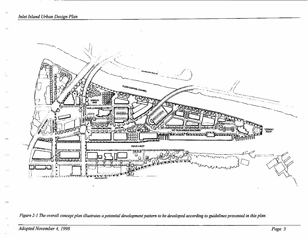
Figure 3-11 This view of the promenade from the conceptual plan illustrates the relationship between design elements.
~ I Figure 3-12 The section view of the promenade from the conceptual plan illustrates the typical relationship between buildings, the promenade and the waterfront.
Adopted November 4, 1998
D. Specific Guidelines
1. Waterways - specific guidelines for the maintenance of waterways are as follows:
a) Utilize stormwater management techniques in order to maintain the predevelopment rate of flow, to the extent possible.
b) Recognize and promote the use of landscaped areas as stormwater collection and infiltration points.
c) Utilize temporary erosion control measures to prevent direct sedimentation and discharge into the waterways throughout periods of construction-related
· ground disturbance.
d) Utilize removable floating docks in the Flood Control Channel to keep the waterway free from permanent obstruction.
2. Shorelines - the specific guidelines for shoreline development are as follows:
a) Develop a promenade along the entire western shore of Inlet Island and along the eastern shore where possible. The promenade would run along the Flood Control Channel from the Route 96 bridge to Lookout Point. From Lookout Point it would run southward along the eastern shore of Inlet Island to the State Street bridge. The promenade would then run northward along the opposite shoreline of Cayuga Inlet, where it will connect to the proposed Cayuga Inlet Trail (see Figure 2-1). The design of the promenade should contain the following characteristics (see Figure 3-11 and 3-12):
i) A steel sheet piled edge to facilitate shoreline stability, maintain the Flood Control Channel and establish a pedestrian way at the water's edge.
Page 15

Inlet Island Urban Design Plan
Figure 3 -13 The style of ancillary components, such as the bench pictured above, can contribute to the overall character of the waterfront.
Figure 3-14 Design oflightingfzxturesfrom the Taughannock Boulevard Bridge could be duplicated along the promenade.
Adopted November 4, 1998
ii) Varied width: A forty ( 40) foot wide promenade along the western shoreline of the Flood Control Channel, to be maintained for a distance of approximately seventeen-hundred (1,700) feet, which includes Lookout Point. The forty foot width is as follows: A fifteen (15) foot wide pedestrian lane along the shoreline, a ten (1 0) foot wide landscaped island, and a fifteen ( 15) foot wide pedestrian lane along the building frontage (see Figure 3-11 and 3-12).
iii) Ancillary components, including:
a) Ornamental railings, benches, bicycle racks, drinking fountains, etc., at logical points along the promenade (see Figure 3-13). Lighting fixtures should be located at regular intervals depending on light intensity. Consideration should be given to the incorporation of the lighting fixture into the promenade railing post (see Figure 3-14).
b) Pedestrian ways that link the following: Lookout Point, the island's interior, parking areas, parks, the Taughannock Boulevard bridge, the western and eastern Buffalo Street bridges, the Seneca Street bridge, and the western and eastern State Street bridges.
c) A variety of paved surfaces, including textured color surfaces, to provide a visually pleasing and safe walking surface (see Figure 3-15).
d) Where possible, a floating dock to be removed during the winter months, running parallel to the promenade. Access to the dock shall come directly from the promenade at logical nodes.
3. Pedestrian Ways- the specific guidelines for the layout and design of the pedestrian system are as follows:
a) Consider pedestrian origins and destinations, as shown on the conceptual public improvement plan for Inlet Island (see Figure 2-1), when determining the location of the pedestrian way( s) within an individual parcel.
Page 16

Inlet Island Urban Design Plan
Figure 3-15 Stamped concrete or asphalt improves the visual effect of the walking surface.
Adopted November 4, 1998
b) Provide, at minimum, five (5) foot wide pedestrian ways on the island's interior and along rights-of-way, when the pedestrian way is flanked with one building wall. Pedestrian ways located along rights-of-way with two building walls shall be a minimum of ten (1 0) feet in width. The specified widths are intended to provide safe, open movement for pedestrians.
c) Comply with the Americans with Disabilities Act (ADA).
d) Provide logical links between parcels, allowing for direct functional access.
e) Maximize views and access to the waterfront and to the proposed promenade by selecting appropriate dimensions and locations for pedestrian ways.
f) Provide emergency and service vehicle access to locations/buildings off the public right-of-way (ROW), where practical.
4. Bicycle Ways - the specific guidelines for the layout and design of the bicycle system are as follows:
a) Consider linkage to other trail systems, such as the proposed multi-use trail as shown in the Tompkins County Waterfront Plan.
b) Consider origins and destinations of people moving through this locale of the City when selecting the location of bicycle routes.
c) Provide adequate signage to direct bicyclists to and through the system.
5. Streets and Streetscapes- the following specific guidelines apply to existing and future streets in and around Inlet Island. The existing streets include Taughannock Boulevard, Buffalo Street, State Street, Seneca Street, North Fulton Street and Park Road.
a) Provide for the functional and safe movement of vehicles, emergency vehicles and delivery vehicles in and out of the island area.
Page 17
Inlet Island Urban Design Plan
Adopted November 4, 1998
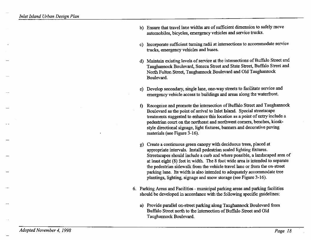
b) Ensure that travel lane widths are of sufficient dimension to safely move automobiles, bicycles, emergency vehicles and service trucks.
c) Incorporate sufficient turning radii at intersections to accommodate service trucks, emergency vehicles and buses.
d) Maintain existing levels of service at the intersections of Buffalo Street and Taughannock Boulevard, Seneca Street and State Street, Buffalo Street and North Fulton Street, Taughannock Boulevard and Old Taughannock Boulevard.
e) Develop secondary, single lane, one-way streets to facilitate service and emergency vehicle access to buildings and areas along the waterfront.
f) Recognize and promote the intersection of Buffalo Street and Taughannock Boulevard as the point of arrival to Inlet Island. Special streetscape treatments suggested to enhance this location as a point of entry include a pedestrian court on the northeast and northwest comers, benches, kioskstyle directional signage, light fixtures, banners and decorative paving materials (see Figure 3-16).
g) Create a continuous green canopy with deciduous trees, placed at appropriate intervals. Install pedestrian scaled lighting fixtures. Streetscapes should include a curb and where possible, a landscaped area of at least eight (8) feet in width. The 8 foot wide area is intended to separate the pedestrian sidewalk from the vehicle travel lane or from the on-street parking lane. Its width is also intended to adequately accommodate tree plantings, lighting, signage and snow storage (see Figure 3-16).
6. Parking Areas and Facilities - municipal parking areas and parking facilities should be developed in accordance with the following specific guidelines:
a) Provide parallel on-street parking along Taughannock Boulevard from Buffalo Street north to the intersection of Buffalo Street and Old Taughannock Boulevard.
Page 18

Inlet Island Urban Design Plan
Figure 3-16 As shown in the overall concept plan in Figure 2-1, this plan view details the conceptual design elements for the intersection ofTaughannock Boulevard and Buffalo Street. These elements include pedestrian plazas, uniform tree plantings, marked pedestrian crossing points, entryway signage, plaza area planting beds, benches, trash receptacles, etc.
Adopted November 4, 1998
P~~fnan PI14Zet$ w / t;,ghf/n!h - /Jan~a;, &f')t:;ht!s 1 51!Jnage,
~ri;sk. aM D:ccr~ fi;e PIIW'In!J . M.ttkri4/:s
Page 19

Inlet Island Urban Design Plan
Adopted November 4, 1998
b) Provide perpendicular on-street parking along Old Taughannock Boulevard, where possible.
c) Provide off-street surface level parking on publicly owned parcels just north ofTaughannock Boulevard (see Figure 3-17 and 3-18). As demand increases and funds become available, multi-level parking structures, paid for by the private sector, should be constructed at these same locations (see Figure 3-19 and 3-20). Structures should be oriented to reduce the visual impact of the building mass and to maintain views to the waterfront.
d) Provide off-street, surface level parking on publicly owned parcels just west of Taughannock Boulevard. As demand increases and funds become available, a parking structure should be constructed at this location.
e) Integrate parking areas and facilities with surrounding land uses via multiple pedestrian linkages to the waterfront, street sidewalks and businesses/amenities located on the interior of Inlet Island.
Page 20

Inlet Island Urban Design Plan
Figure 3-17 This plan view, taken from the concept plan in Figure 2-1, illustrates a design for a public, surface level parking area to the west ofTaughannock Boulevard and north of the existing Station Restaurant parcel. The plan suggests installation of surface level parking at this location early in the redevelopment of Inlet Island.
Figure 3-18 This plan view, taken from the concept plan in Figure 2-1, illustrates a design for a public, surface level parking area to the north ofTaughannock Boulevard and west of Old Taughannock Boulevard. This plan also suggests surface level parking at this location to meet the initial parking needs for the redevelopment of Inlet Island.
Adopted November 4, 1998 Page 21

Inlet Island Urban Design Plan
Figures 3-19 and 3-20 These two figures illustrate the development of multi-level parking structures north of Taughannock Boulevard and at the corner of Taughannock Boulevard and Old Taughannock Boulevard. These structures are proposed as future projects, to be built when there is an increased demand for parking on Inlet Island.
Adopted November 4, 1998 Page 22

Inlet Island Urban Design Plan
~~---f'vbli< f*ni:N- . wJW•Arr~., wshf·.,.~, s.~ •iwl ~f.l .. 1" .. ""'~ .I(..,..,.,., ••
~~~~~ii!iiffili---:=-=---,.~--,.,,:y..a. ~; II ':ft;Z';;,,:,:~.·.t
p,..v,.~M""•n•ls
"""!!/ Wo~~IK
--AI< Figure 3-21 This plan view of the plaza at the intersection ofTaughannockBoulevard and Old Taughannock Boulevard emphasizes pedestrian access.
Adopted November 4, 1998
7. Public Parks and Plazas- the specific guidelines for public parks and plazas are as follows:
a) Brindley Park:
i) Retain approximately46,000 square feet of parkland west ofthe Station Restaurant and north of Buffalo Street.
ii) Relocate the existing flowering crabapple trees to define an open lawn area for passive and active recreation (see Figure 3-10).
iii) Bound the western edge of the park with the proposed promenade. The design of this edge should allow for continuous access between the proposed promenade and Brindley Park.
iv) Retain the trees near the existing water fountain.
v) Renovate the water fountain and incorporate it into the final design as a prominent historic element of the park.
vi) The pedestrian trail system should frame the park to provide direct, unobstructed links.
b) Planned plazas. The following are proposed throughout the island:
i) A temporary or interim plaza on the east side of the intersection of Taughannock Boulevard and Old Taughannock Boulevard (see Figure 3-21). This parcel, because of its shape and location, has the potential to be an attraction. Long-term plans may include the establishment of a vehicular or pedestrian bridge, which would pass through this area and intersect with West Court Street across Cayuga Inlet. A temporary plaza would maintain this location as a future option.
Page 23

Inlet Island Urban Design Plan
Sl--+--:::,.,~~s/ --II'J--+--~htN ~"'
Figure 3-22 This plan view illustrates the continuous pedestrian access across Buffalo Street and State Street.
Adopted November 4, 1998
ii) A public, landscaped area is proposed for either side of State Street on the southwestern section of the Island. (see Figure 3-22).
iii) A public, landscaped area is proposed at the north end of Old Taughannock Boulevard to provide a visually pleasing terminus to the street (see Figure 3-23).
Pedc:sfnan Waq / 1/ie:w Corridor t-o Pr&Y11eneta'e:
~;~~ wj S.ijn«~ Ti"et: l-irJt:d 017?.P_- orr 2~ #jN'J.hf"e~ Ill/Tr-ee /'/eur-lm.;r->1 . ttghf7~,6Jr~lo.:-U?~'i-f: ~
{,a,ndsca.pe ..Ls!an::l
· Peelet~-fnan ~~~
Priel~~ (/?e-si:.unm-1) Pbrf<.mg :t. 56 car.s .
Figure 3-23 This plan view illustrates a concept for the terminus of Old Taughannock Boulevard.
Page 24

Inlet Island Urban Design Plan
Figure 3-24 Properly designed lighting not only contributes to a sense of security, but enhances the visual and aesthetic qualities of the streetscape.
Adopted November 4, 1998
8. Lookout Point- the specific guidelines for the design of Lookout Point are as follows:
a) Maintain open, unobstructed views from all areas towards Buffalo Street or north to Lookout Point.
b) Extend proposed promenades and ancillary facilities to and around Lookout Point (see Figure 2-3).
c) Consider a structure, offset to the east side, to facilitate elevated views in all directions. The structure's design should include a framework system that allows for maximum views through the structure, especially at ground level.
d) Consider a graded area just south of the point to allow for an "amphitheater like" contour of the point (see Figure 2-4). The design of the contour should be done in such a manner so as not to obstruct views. The finished grade should be no higher than three (3) feet.
e) By way of landscape design, provide definition to the point and enhance the uniqueness of its location on the Island. Landscape plantings should not obstruct views from areas to the south.
9. Lighting/Light Fixtures- the specific guidelines are as follows:
a) Provide security and contribute to the festive, vibrant character ofthe area. Uplighting in landscaped areas and building facades will contribute to the area's attractiveness (see Figure 3-24).
b) Provide continuous illumination along the proposed promenade, throughout the island's pedestrian system and streets and to adjoining areas using pedestriansealed street lanterns of distinctive design.
c) Ensure that lighting fixtures are of adequate scale, wattage and mounting height as to provide secure, attractive illumination for vehicular travel lanes and for pedestrian precincts throughout the island. For pedestrian lighting, the light source should be positioned relatively low as to retain a human scale and to provide illumination beneath tree canopies.
Page 25

Inlet Island Urban Design Plan
Figure 3-25 The continued installation of the fixture used with the road improvements of 1997-98 will add continuity and unity to the visual appearance of the Island.
Adopted November 4, 1998
d) Continue the lighting character established by the recently completed NYSDOT project (see Figure 3-25).
e) Install light fixtures of uniform design that contribute to the waterfront quality of the proposed promenade (see Figures 3-26 and 3-27).
10. Landscape Treatments - General guidelines for landscape treatments are as follows:
a) Enhance the island's urban character with landscape design.
b) Promote a landscape design that is sensitive to the area's micro-climate and that uses hardy plant materials.
Figure 3-26 Figure 3-27 These fvctures are representative of options for lighting the promenade.
c) Scale landscape treatments to enhance the pedestrian experience on the Island. Strive for visually appealing treatments that maintain lines of sight for vehicular travel lanes and maintains views of the waterfront.
d) Use landscape treatments to screen utility facilities, dumpsters, etc., where practical.
Page 26
Inlet Island Urban Design Plan
Adopted November 4, 1998
11. Location-specific landscaping guidelines are as follows:
a) Design landscape treatments along the shoreline and/or proposed promenade in order to enhance view sheds of the waterfront, while minimally disturbing waterfront views inland.
b) Utilize lawn/shrub plantings and flowerbeds along the ten (1 0) foot wide promenade planting area along the west side of the island. Spacing and careful species selection should maintain waterfront views from buildings along the promenade and from the Island's interior.
c) Line primary streetscapes with trees. Landscape treatments along Taughannock Boulevard and fulet Island streets may reflect several design approaches, depending on the utility and the availability of areas within the right-of-way.
d) Street tree plantings integral or adjacent to pedestrian lanes should be pruned to allow for unobstructed passage under the tree canopy.
e) Promote variety in landscape treatments for park and plaza areas. Trees, shrubs, ground cover, perennials and bedding plants should be used in multiple combinations where applicable. The design should strive for a four-season coordinated interest of flowers, leaf color, texture, fruit, fall color and branching structure. The design should also be responsive to the four ( 4) tier spatial qualities of plantings, including the ground, vertical and horizontal planes.
12. Signage/Banners- the specific guidelines for signage are as follows:
a) Locate signage at regular, strategic locations along the vehicular and pedestrian transportation systems in order for pedestrians and motorists to easily view them.
b) Depict information for the following uses: direction, location, identification, and display.
c) Design uniform signage to coordinate with the elements of the public realm such as light fixtures, benches, tables, etc.
Page 27

Inlet Island Urban Design Plan
Figure 3-29 This photograph illustrates the type of tables that may be used in public plazas.
Adopted November 4, 1998
d) Plan for the incorporation of banners into the landscape, on free-standing poles or on light fixtures. Banners may be used to promote events and festivals or to reflect seasonal celebrations. Banners should contribute to the visual character of the island (see Figure 3-28).
13. Ancillary Components - the specific guidelines for ancillary components are as follows:
a) Use ancillary components to functionally and visually enhance primary facilities along Taughannock Boulevard and throughout Inlet Island.
b) Coordinate ancillary components, (which include, but are not limited to, bicycle storage racks, water fountains, benches, tables, trash receptacles, tree grates and guards, railing along the proposed promenade), in order to enhance the urban character of the island (see Figure 3-29).
c) Ensure that ancillary components can withstand the multi-seasonal climate of the Island. Choose ancillary components that will minimize maintenance. The use of wood-based products is recommended.
Page 28

Inlet Island Urban Design Plan
Adopted November 4, 1998
Chapter4 Private Realm: Guidelines For Development
A. Applicability
1. The private realm of the Taughannock Boulevard and Inlet Island area is defined as those parcels which are proposed to be privately owned (see Figure 4-1). Significant elements that serve to shape the character of private land and buildings include:
• The various uses of the parcels. • The density of the development. • The height and bulk of the buildings and structures placed on the land. • The placement of building walls in relationship to streets. • The design of building facades. • Exterior lighting of buildings and open spaces accessible to the public. • Signage used to inform or to advertise products or services.
2. The geographic area to which these guidelines apply is bounded by Cascadilla Creek to the north, North Fulton Street and the existing railway line to the east, Six Mile Creek to the south, and Floral Avenue and Park Road to the west (see Map 3-1).
3. The following guidelines are intended to be utilized by private designers prior to initiation of the design process. Project designers are encouraged to employ innovation and creativity while working within the conceptual framework of the following guidelines. The guidelines are also intended to serve as a reference document for members of the Planning and Development Board as they review projects proposed within the geographic area described above.
Page 29

Inlet Island Urban Design Plan
NOTE Street layout based em data from .lho City of Ithaca Department of P1111111ing .i: Development dated June, 1997. Slnlet arrgnment sbcMn Pl8f not reflect ex16tfn; conditions. ·
Adopted November 4, 1998
INLET ISLAND URBAN DESIGN PLAN
PROPOSED PUBLIC I PRIVATE PARCELS MAP4-1
LEGEND Ill Proposed Pubfic Pareels
1:] Proposed Private Parcels
Page 30

Inlet Island Urban Design Plan
Figure 4-1 Varying architectural elements, as illustrated above, contribute to the character of a streets cape.
Figure 4-2 As illustrated in this photograph, a continuous building wall serves to define the public space.
Adopted November 4, 1998
B. Goals and Objectives
The goals for the redevelopment of parcels along Taughannock Boulevard and throughout Inlet Island are as follows:
• Density and scale commensurate with an urban setting. • Building heights that are scaled to street widths and that maintain visual access
to the waterfront. • Mixed land uses that reflect the island's historic uses and promote an active
24-hour community.
Specific objectives to fulfill the stated goals include:
• Land Use: Encourage retail, restaurants, offices, multi-family dwellings, hotels, residential studios/lofts, home offices, craft/artist workshops, health care facilities, museums/galleries, and maritime uses. Light boating and waterbased manufacturing, as well as wholesale business, will be conditionally allowed. Mixed-use buildings are encouraged. Public access to retail, restaurants, museums/galleries, workshops with retail outlets and offices is encouraged at the street level as it will generate desirable pedestrian traffic.
• Density: Create a critical mass of development by encouraging maximum built parcels within the lot right-of-way. Building coverage shall be consistent with height and bulk guidelines.
• Building Height and Mass: Develop a range of permissible building heights from a minimum of two (2) stories to a maximum of five ( 5)stories. Buildings shall graduate to lower heights toward the west and north ends of the island (see Figure 4-1).
• Streetwall: Construct buildings to establish a virtually continuous facade or ·streetwall. The full building height will establish the streetwallline, forming the sides of the street and defining public space. The purpose of the streetwall guidelines is to develop both well-defined public spaces and a critical density of pedestrian-oriented street frontage (see Figures 4-2 and 4-3).
Page 31

Inlet Island Urban Design Plan
Figure 4-3 Properly oriented buildings can create spaces that enhance the pedestrian experience.
Adopted November 4, 1998
• Facades: Ensure that building facades on public rights-of-way contribute to a coherent streetscape, promoting street-level pedestrian use, such as retail shops, while refraining from dictating uniformity, specific building design, or style (see Figure 4-3).
• Ancillary Building Elements: Design ancillary elements such as trash dumpsters, grade level equipment, roof-top equipment, service and loading docks, etc., to be integral components ofbuildings, adhering to the objectives of the streetwall and facade guidelines.
Page 32

Inlet Island Urban Design Plan
Adopted November 4, 1998
C. Specific Guidelines
The specific guidelines for development on private parcels are intended to frame design concepts in a manner that will be consistent with the goals and objectives stated above. Guidance related to building mass, promenade frontage, street wall design, facade design, signage and lighting is provided to assist the designer in the establishment of an urban/pedestrian scaled development pattern that emphasizes contact with the street and the waterfront.
The guidelines for the elements referenced above are as follows:
1. Building Mass - the specific guidelines relating to building mass are as follows:
a.) On parcels of fifty (50) feet or less in width, exclusive of promenade frontage, the footprint ofbuildings maybe one-hundred percent (100%) of the lot area. On parcels with three (3) or more boundaries greater than fifty (50) feet, the maximum footprint maybe ninety percent (90%) of the lot area. Footprint guidelines apply to all private parcels except that portion of any parcel designated as promenade frontage.
b.) Publicly accessible and usable covered spaces which are naturally lit, such as arcades, atriums, and public recreational facilities, shall not be counted towards the maximum footprint area.
2. Height Guidelines: Statutory requirements for building height for this area will be listed in the City's Zoning Ordinance. Building height requirements on Inlet Island will be determined by the position of the proposed building and its relationship to the waterfront. Buildings along or close to the shoreline should be of a lesser height in order to maintain views from the center of the island. As a general description, building height is limited to two (2) or three (3) stories along the shoreline and increases to a maximum of five (5) stories in the center of the Island. The zoning ordinance will set forth sub zones on Inlet Island for the purpose of specifically describing where the varying building height restrictions are located (see Appendix A).
Page 33

Inlet Island Urban Design Plan
Figure 4-4 The perspective views above and below illustrate guidelines for building height.
/·~
Figure 4-5
Adopted November 4, 1998
The procedure for measuring building height will be as follows: height of buildings will be measured in stories, allowing a minimum of twelve (12) feet to a maximum of fifteen (15) feet for the first (street level) story, and up to twelve (12) feet for each additional story, measured from grade (sidewalk), plus an additional allowance of :five (5) feet for a building cornice (see Figures 4-4 and 4-5).
a.) The top story of any building exceeding three (3) stories should not cover more than ninety percent (90%) of the footprint area of the building as defined in the area and bulk guidelines. A half-story consists of up to fifty percent (50%) coverage of the footprint area of the building.
b.) An allowance of a maximum of five (5) feet should be made for the cornice area of a building as defined in the facade guidelines. The interior height of the top floor of the building may include the cornice height allowance (see Figure 4-6).
c.) Sample calculations of maximum building height and bulk guidelines are as follows:
2Yl-story structure, with an allowable footprint area of9,000 SF 1st story max. ht 15' max. GSF 9,000 2nd story max. ht. 12' max. GSF 9,000 3rd (halt) story max. ht. 12' max GSF 4,500 Cornice max. ht. 5'
Total max. ht. and area 44' GSF 22,500
4 story structure, with an allowable footprint area of7,000 SF 1st story max. ht. 15' max. GSF 7,000 2nd-3rd stories max. ht. 24' max. GSF 14,000 4th story max. ht. 12' max. GSF 6,300 Cornice max. ht. 5'
Total max. ht. and area 56' 27,300 GSF
Page 34

Inlet Island Urban Design Plan
Figure 4-6 This photograph illustrates the effect of a cornice on building height.
Adopted November 4, 1998
d.) Height ofbuildings shall be measured at the streetwall on each side of the building. Roofs sloping away from the streetwall at a maximum pitch of eight to twelve (8: 12) shall be exempt from the building height limitation. For such sloped roofs, a cornice allowance shall not be added to the maximum top floor height. Gables facing the street shall be counted in the building height at 112 the vertical height from eaves to ridge. This dimension shall not exceed five (5) feet. Mansard roofs shall be counted in the same manner as a vertical wall. Railings and roof top garden structures are exempt from the height guidelines.
e.) Height exceptions may be made by the City of Ithaca's Planning and Development Board during site plan review for rooftop features or components such as towers, finials, parapet walls, and equipment enclosures when the design of such features contributes positively to the streetscape.
3. Special Promenade Frontage Zone- the specific guidelines relating to promenade frontage along the western edge of Inlet Island are as follows:
a) For a depth of twenty (20) feet from the lot line, along the length of the parcel fronting this pedestrian promenade, the following mass and height guidelines shall apply:
i) Maximum height of portions of buildings within this promenade frontage zone shall be two (2) stories.
ii) Promenade frontage may consist of covered or uncovered open space.
iii) The building facade fronting the promenade shall conform to the facade guidelines.
iv) The amount of building square footage should not exceed the equivalent of one ( 1) story over the entire promenade frontage.
v) A minimum ofthirtypercent (30%) ofthe length ofthe promenade frontage shall remain as uncovered or covered open space.
Page 35

Inlet Island Urban Design Plan
Adopted November 4, 1998
vi) The edge of the promenade frontage should be differentiated from the public right-of-way by planters, low and open fencing, piers or columns defining an arcade or covered outdoor space, or a predominantly glazed wall as defined under the facade guidelines.
vii) Appropriate uses for promenade frontage include outdoor dining areas, sidewalk cafes, gardens or landscaped play areas.
viii) Appropriate second floor use for promenade frontage, where applicable, includes retail, restaurants, galleries and meeting rooms, dwellings and outdoor decks.
ix) The provision of publicly accessible restrooms on each property's section of promenade frontage is strongly encouraged.
4. Streetwall Guidelines- the specific guidelines relating to streetwalls are as follows:
a) Buildings shall be built out to the right-of-way line or lot line and shall create a continuous streetwall to the full height of the building, except as noted in these guidelines and with the following allowable exceptions:
i) The area along the east side ofTaughannock Boulevard and north of Buffalo Street.
ii) Publicly accessible plazas or outdoor spaces created on private parcels, including street plazas.
iii) Pedestrian passageways and courtyards that are visible and accessible from the street.
iv) The aforementioned spaces should not interrupt more than 25% of the streetwall or 20% of the streetwall at comers.
Page 36

Inlet Island Urban Design Plan
Figure 4-7 This illustration shows the effect of curved corners and recessed entrances.
Figure 4-8 This photograph illustrates the efficacy of a canopy in faflade design.
Adopted November 4, 1998
b) Plazas and outdoor spaces adjacent to the streetwallline shall conform to the following guidelines:
i) Be configured and scaled as usable pedestrian space.
ii) Provide seating and adequate lighting.
iii) If subject to a southern exposure, provide fifty percent (50%) shade at noon during the summer season by means of shade trees, trellises, awnings, umbrellas or other suitable shading devices.
iv) Be fronted by active retail or restaurant use, or by features of special interest to pedestrians such as fountains, play equipment, sculpture, or historical interpretive materials.
v) Paving may consist of poured and scored concrete; poured and textured concrete; or unit pavers. Asphalt shall not be used.
c) Articulated building comer treatments, (such as curved or angled comers, recessed comer entrances at street level, and projecting comers at the first or lower levels of the building), that set the upper floors of the streetwall slightly back, are encouraged. (See Figure 4-7).
d) Building comers on the first floor need not establish the streetwallline. In this instance, the streetwallline along the comer may be set back on the upper levels. Conversely, if a building's comer is recessed, then the streetwall should be maintained on upper levels, (i.e., not setback).
e) Curved, recessed, or broken wall planes at mid-block locations associated with building entrances, entrances to pedestrian ways, or special functions are considered to be appropriate breaks in the streetwall. Where such breaks are deeper than ten (1 0) feet from the streetwall, the guidelines for a plaza shall apply.
Page 37

Inlet Island Urban Design Plan
Figure 4-9 This photograph illustrates a recessed first floor arcade supported by columns.
Figure 4-10 This photograph illustrates the effect of a recessed balcony
Adopted November 4, 1998
f) In instances where a building contains greenhouse type spaces (on any floor) and therefore requires recessing the streetwall above, the cumulative length of greenhouse space should not exceed 30% of the cumulative street frontage of the principal building facade.
g) Awnings or canopies projecting from the building may extend into the rightof-way a maximum of eight (8) feet or half the width of the sidewalk, whichever is less. Awnings and canopies shall have a minimum height of eight (8) feet, measured from the sidewalk (see Figure 4-8).
h) First floor arcades should have a maximum depth of ten (1 0) feet and be supported by a continuous row of piers at the streetwallline (see Figure 4-9).
i) Recessed balconies along upper floors should be limited to a maximum length of thirty percent (30%) of the building's frontage (see Figure 4-1 0).
j) Recessed entrances for storefronts should be limited to a depth of six ( 6) feet and a maximum width of seven (7) feet.
k) Walls may be recessed between piers or pilasters where such piers or pilasters maintain the streetwall.
1) Height at which setbacks must occur shall be determined by the width of the right-of-way. Maximum streetwall height shall be the width of the right-ofway in front of the parcel, minus five (5) feet; subsequent upper stories shall be set back a minimum of ten (1 0) feet. On pedestrian ways, the maximum streetwall height shall be the width of the right-of-way plus five (5) feet; subsequent upper stories shall be set back a minimum of eight (8) feet from the streetwall (see Figure 4-11 ).
m) Buildings with streetwalls of over one hundred (1 00) feet in length should be visually articulated as two or more distinct massing elements by changes in wall height, planes of the facade, breaks in the streetwall or other means.
Page 38

Inlet Island Urban Design Plan
. ~ (::'
~-----~, .~ { ...
r~ l
~ ~ ==71 I'<)
I ~
~ * I I{ ~ ~
~ ... ~ ~ ::::0 ' ~ ~ ~I ~ ~~ "'"'~ r ~ 3t t ~ it. ~ <:)~
~Q iil ~u..::
"' '- C. X 't
tf)
~
~~M,;, '<;,_.,J ~n &' 1 ~.o.w s.~c:.E:.
Figure 4-11 This section view illustrates the relationship between building height and width of ROW.
Adopted November 4, 1998
n) Building entrances and exits may not be recessed more than six (6) feet from the streetwall, unless fronted by public open space as previously defined, and may not be recessed more than six ( 6) feet from the plane of the second story facade .
o) Driveways, service roads, and surface parking lots shall not be allowed on private development parcels, except as follows:
i) Where service access from the right-of-way directly to the building is not available, a driveway to a servicenoading area may be provided. Such a driveway shall be located with regard to maintaining the integrity of the streetwall. Such a driveway shall be the minimum width required for emergency and service vehicles and shall not be utilized for standing or parking.
ii) Where driveway entrances to private parking garages or covered passenger drop-off areas exist as part of a building, the streetwall shall immediately continue on both sides of the driveway/drop off area.
iii) A drop-off lane, taxi stand, or handicapped access driveway that does not substantially alter the streetwall continuity may be allowed, subject to approval by the Planning and Development Board.
iv) The streetwall may be interrupted for a required loading dock/area, a service/building equipment area, a driveway, or for trash collection. Loading areas and service entrances fronting the street should be recessed no more than six ( 6) feet from the streetwall. If further · recessed, the design shall include additional doors or screening at the streetwall. Service yards, including mechanical equipment and trash collection areas shall be screened at the streetwall, as defined in the facade guidelines.
v) Allowable driveways shall be paved with concrete, imprinted and colored asphalt, or unit pavers.
Page 39

Inlet Island Urban Design Plan
8& /'liM~ VJ/ f?.~c~sSt:</ ston:fr~~ ?0~~~~~~
Figure 4-12 The variation of the cornice illustrated in this photograph contributes to a visually interesting streets cape.
Adopted November 4, 1998
p) Top floor setbacks, either resulting from massing requirements or used to articulate the top of the building, may deviate from the streetwall.
5. Facade Guidelines - all elevations of a building visible from a public right-ofway shall be considered public facades for the pmpose of these guidelines. The specific design guidelines relating to facade design are as follows:
a) All public building facades shall be articulated with a base section (bottom), a shaft section (middle), and a cornice section (top), or a base and top for a two-story building. The vertical sections of the facade may be articulated, for example, by differences in materials or patterns of materials, changes in fenestration, changes in heights (proportion), variations in the vertical plane, and horizontal cornice elements. Examples of a building cornice or top include: a traditional cornice in proportion with the height of the building, dormers, or a top floor that is setback in a manner that makes it visible from the street, (visual clues could include a cornice on the floor below or railings for the roof deck). Variations in the configuration and/or height of the building cornice are encouraged within a single large building and are encouraged from one building to the next (see Figure 4-12).
b) Facades shall be composed primarily of durable and/or traditional building materials including brick, stone, clear or light-tinted glass, cast stone, stucco, and solid lumber siding. Secondary facade materials utilized for structural elements, trim, and decorative components may include painted steel, stainless steel, copper, colored glass, colored and textured concrete masonry, poured and detailed or painted concrete, porcelain enamel, or metal composite building panels. The following materials should not be used as principal or secondary facade materials: aluminum or preformed metal siding, vinyl or plastic siding, plain concrete masonry, extensive areas of poured concrete, wood shingles, plywood, dark-tinted or reflective glass.
c) Visible roof forms should be flat, gable, hip, pyramidal, domed, or a combination thereof. Mansard roofs are allowable only as a true mansard on the top floor where an occupied floor is contained within the mansard. Shed (half-gable) roofs are allowable on roof dormers or roofs that terminate at a vertical wall.
Page 40

Inlet Island Urban Design Plan
Cornice
0 % Grlazln:J Verf;Ct< I W}i'>d'<>«<:S
0~6 6/r/AZi~
s~ns M 6oiotSS
Figure 4-13 This photograph illustrates varying levels of glazing between the primary and secondary facades.
Adopted November 4, 1998
d) Roofs visible from a public right-of-way shall have copper, slate, coated metal, or dark-colored asphalt/fiberglass shingle roofing.
e) Roof top mechanical equipment or penthouses shall not be visible from the public right-of-way unless screened by a wall, parapet, or decorative grill that conforms to the facade materials listed above.
t) Window units and framing, including storefront glazing systems, shall be painted or clad wood, painted steel, or color clad aluminum. True mullions shall be used for divided lights.
g) A minimum of fifty percent (50%) of window units in all occupied spaces shall be operable.
h) Windows above the first floor shall be proportional so that the height of individual units is equal to or greater than the width except for transom units. When units are grouped horizontally in bands, the height of each window division shall be greater than the width.
i) Windows above the first floor shall be placed in the fa~tade in a pattern that is visually logical and in a fashion that will avoid large areas of blank wall.
j) Principal facades shall be designed to comply with the following guidelines:
i) For the first ten (1 0) feet, measured vertically from the sidewalk, facades shall have a minimum of seventy percent (70%) glazed area, including framing and glazed doors, except residential lobbies (see Figure 4-13).
ii) Transom glazing may be prismatic or colored glass.
iii) Above the first floor, facades shall have a minimum of twenty-five percent (25%) glazed area, including framing and glazed doors, or twenty-five percent (25%) wall opening area for parking garages.
iv) The minimum average height of windows in upper floor facades shall be four and one-half ( 4.5) feet.
Page 41

Inlet Island Urban Design Plan
Adopted November 4, 1998
k) Secondary facades or upper floor facades shall be designed to comply with the following guidelines:
i) For the first ten (1 0) feet, measured from the sidewalk, facades shall have a minimum of twenty-five percent (25%) glazed area, excluding sections of the facade containing loading areas, service entrances or areas, or residential lobbies.
ii) Above the first floor, facades shall have a minimum of twenty percent (20%) glazed area, including framing and glazed doors, this excludes portions of the fa~ade fronting service or mechanical spaces, stairs, or elevator shafts.
6. Ancillary Building Elements - the specific guidelines for the development of ancillary facilities are as follows:
a) Service yards, equipment yards, and trash collection areas shall be screened from the public right-of-way by use of solid walls and gates, louvered fences which prevent visibility, decorative grills or fences with solid slats or vines, glass block or frosted glass, hedges, or a combination thereof Screens shall be a minimum of six ( 6) feet in height and constructed of masonry, painted wood, steel, aluminum, glass or plant materials. Stockade type and chain link fencing is not pennitted.
b) Rooftop equipment and penthouses shall be screened as described in 5.e., with the exception that open types of screening that effectively screen the equipment from the street level will be permitted.
7. Signage Guidelines - the specific guidelines for signage are as follows:
a) Signage on buildings shall be scaled, located, and designed to be readable by pedestrians. It shall have the pmpose of identifying the names and addresses of buildings, as well as identifying individual businesses. Signage shall conform to the City oflthaca Sign Ordinance, except as specifically . provided herein.
Page 42

Inlet Island Urban Design Plan
Adopted November 4, 1998
b) Permanent advertising signage, including corporate logos, shall not be placed on buildings unless incorporated as a secondary element in the design of an individual sign. Logos may be incorporated into the design of building details, such as carved medallions, capitals, or entablatures, provided that such identification is not overpowering.
c) Freestanding or self-supported signs shall not be placed on private parcels unless such signs are directories that are part of a public signage system.
d) Acceptable materials and construction for signs include painted wood or metal, finished metals such as bronze, copper, and stainless steel, high density plastics, three-dimensional components, individual letters of wood, plastic, or metal, individually backlit letters, neon, fabrics, ceramic tile, stained glass, and vinyl or painted signs on glass.
e) Signs should be in scale with their corresponding building. Size of lettering on storefronts, storefront signs, and building entrances should generally not exceed eight (8) inches in height. Lettering of signs elsewhere on the building should be proportional to the building element on which it is placed and should not be any larger than is required to be readable from the sidewalk.
f) Appropriate locations for storefront signs include the following: the traditional signboard area above the storefront, on or behind display windows, above entrance doors, on awnings, on hanging signs in verandas and on signs projecting perpendicularly from the building's storefront at a height between eight feet and eighteen feet (8 '-18 ') from the sidewalk.
g) Appropriate locations for building addresses and identifying signs include the following: over entrances, within building cornices/entablatures, on hanging signs located in arcades, on awnings, on signs projecting from storefronts and on vertical signs above the first floor that project two (2) feet or less from the face of the building and that span a height of one story or less.
Page 43

Inlet Island Urban Design Plan
Adopted November 4, 1998
h) Special signage, such as a cinema marquee or a parking garage entrance sign, shall be designed as complementary to the building and shall be subject to review for exemption from the Signage Guidelines.M M M M
i) Temporary advertising signage in building windows or storefronts, including sale/promotion and "for lease" signs, shall not cover more than twenty-five percent (25%) of the glass and shall be removed after the offer has ended.
j) Long-term advertising or product signage shall not be placed on windows but may be installed as an integral part of a window display of the product being advertised.
8. Lighting Guidelines - specific guidelines for lighting are as follows:
a) All building entrances and exits, including loading docks, shall be illuminated on the exterior to a minimum level of one-half (.5) foot-candle at night. Lobbies and vestibules accessible or visible from the street shall be illuminated to a minimum level of one (1) foot-candle at night.
b) Storefront windows shall be provided with internal illumination at night, lighting either window displays and/or the window area generally. Internal neon signs may not be the sole source of storefront lighting.
c) All arcades shall be provided with night time illumination at a minimum level of one-half (.5) foot-candle at all locations.
d) Private pedestrian passage ways, private plazas, public pedestrian ways and public sidewalks not provided with City streetlights shall be provided with a minimal illumination level of one-half (.5) foot-candle. Fixtures shall be complementary to the City streetlights and/or approved by the Planning and Development Board.
e.) Building facades and special features may be selectively illuminated, . provided such lighting enhances architectural features and is approximate to the level of visible illumination provided by the streetlights.
Page 44

inlet Island Urban Design Plan
Adopted November 4, 1998
f) Signage on buildings shall be self lit (such as neon or individually lit letters) or lit with focused lighting sufficient to read the signage from the sidewalk.
g) The design of light fixtures for buildings and their supports should be complementary in style and type to the architecture of the building.
Page 45

Inlet Island Urban Design Plan
Adopted November 4, 1998
ChapterS Implementation
The success of a public improvement plan, as the one for Taughannock Boulevard and Inlet Island, lies within the plan's implementation. From the onset, the committee strove to balance creativity and innovation in order to deliver a realistic plan that could be implemented.
The City can provide a flexible and positive atmosphere for redevelopment. However, many of the planned improvements need to occur on private parcels. As such, redevelopment on the private parcels will be contingent on many factors including, but not limited to, the state of the local and regional economies and the market forces which affect the demand for various types of development.
These recommendations for implementation focus on elements that can be addressed by public agencies and that have a direct influence on the development of the island through property ownership, permitting requirements, funding, etc. These recommendations are made in the interest of establishing favorable circumstances so that all aspects of the plan may be fully realized. Recommendations will be made in the following general categories, which will initiate the redevelopment process and begin the creation of the attractive urban waterfront as envisioned in the improvement plan:
A. Administration
The following administrative steps are recommended:
1. Adopt the plan as a part of the City's Comprehensive Plan, including the guidelines outlined for the redevelopment of the Island's public and private spaces. The resolution adopting the plan should require that the guidelines be used by the Planning and Development Board during the review of proposed projects on the island and adjoining shorelines.
2. Adopt a new zoning district to be known as the Waterfront District. The new district will update permitted land uses and bulk requirements in a manner that is consistent with the goals and objectives of this improvement plan.
Page 46

Inlet Island Urban Design Plan
Adopted November 4, 1998
3. Develop a capital improvement program for the planning, design and funding of proposed capital projects.
4. Begin development of detailed designs for the proposed pedestrian promenade along the western shore oflnlet Island and the rehabilitation ofBrindleyPark.
5. Initiate securing needed permits, approvals, and funding to construct the proposed promenade along the western shoreline of Inlet Island, to improve Lookout Point and to rehabilitate Brindley Park.
Page 47

Inlet Island Urban Design Plan
Adopted November 4, 1998
B. Capital Improvements
The following phased improvements on public lands are recommended:
Phase I-- Construct the proposed promenade along the western shore of Inlet Island and at Lookout Point. Rehabilitate Brindley Park.
Phase II- Install a public surface-level parking lot on public lands north of Taughannock Boulevard.
Install pedestrian links between the promenade, existing sidewalks and the parking lot.
Phase m -- Install a public surface-level parking lot on public lands west of Taughannock Boulevard.
Establish a public plaza at the intersection of Taughannock Boulevard and Old Taughannock Boulevard.
Establish a public plaza at the northeast and northwest comers of the intersection at Buffalo Street and Taughannock Boulevard.
Possible Future Phases-- Construct a parking garage on the surface-level lot located north of Taughannock Boulevard.
Construct a parking garage on the surface-level lot located west of Taughannock Boulevard.
Construct a pedestrian bridge or vehicular bridge over Cayuga Inlet to intersect with West Court Street. Timing of phased implementation will be contingent upon the pace of redevelopment.
Page 48

Inlet Island Urban Design Plan
Adopted November 4, 1998
C. PrQperty Acquisition
If planned public improvements are to be fully realized, some property acquisition and disposition will be required.
Property to be acquired includes the parcel now serving as the location for the US Coast Guard Auxiliary. The location of this parcel is key to developing the continuous promenade along the western shore oflnlet Island. The New York State Department of Environmental Conservation (NYSDEC) currently owns the parcel. Also, creation of the promenade requires acquisition of land from Joe Ciaschi and Ithaca Boating Center (or successors). Preliminary inquiries have been made by the City's Planning staff concerning availability of the parcel, the various options available to gain control of the parcel and a mutually acceptable arrangement for possible relocation of the Coast Guard facility. It is recommended that this effort continue in the interest of facilitating the installation of the proposed promenade.
The western shore of Inlet Island that is to be used for the public promenade would remain City property.
The City is required to sell property at fair market value in a competitive bid process. However, with the plan in place, it is recommended that a request for proposal format be considered as the means to dispose of the property. This method will allow for the City to direct future use of property in a manner that is consistent with the concept envisioned in the plan.
Page 49

Inlet Island Urban Design Plan
Adopted November 4, 1998
D. Funding
Forth~ implementation of the Inlet Island Urban Design Plan to occur, considerable thought needs to be given to the procurement of funds to finance the planned improvements. A multi-faceted approach to financing the various improvements is recommended.
The City has already secured a series of grants and loans through the US Department of Housing Urban Development Canal Corridor Initiative. Preliminary approval has been received for approximately $2.6 million and is targeted for a series of improvements along the island and the inlet . Approximately $250,000 is targeted to assist in the installation of the proposed promenade along the Island's western shore. The City, through the Tompkins County Planning Office, has also been awarded an additional $70,000 in funds through the NYS Department of Transportation. These funds will also be directed for the installation of the promenade.
The other substantial public improvement shown in this plan is the installation of two public parking facilities in the center of Inlet Island. The plan envisions that these parking facilities will initially consist of open surface-level lots. However, the plan calls for the design of these lots in such a manner that parking structures could be constructed to supply additional parking should demand increase with the redevelopment of the private parcels. To finance the installation of public parking, in accordance with this plan, the following is recommended:
The City should enact a special parking assessment district for this area. The specific boundaries of the district would be established after reviewing the feasibility of constructing the surface-level lots and, potentially, the parking structures. Any redevelopment within the Waterfront District, as proposed, is not required to provide on-site parking. Parking will be provided solely by on-street parking and by off-street parking in municipal lots or structures. The purpose of the proposed special parking assessment district would be to provide a means to finance the parking improvements as specified in this plan. This could be accomplished by enacting an annual benefit assessment for the purpose of meeting the debt service, operation and maintenance costs on the surface-level lots and, potentially, the parking structures.
Page 50

Inlet Island Urban Design Plan
Adopted November 4, 1998
An additional recommended measure would involve the development and implementation of capital improvement program for the area within the existing City budget. Such a program would involve the establishment of a destination for living, shopping, dining, entertainment, and other recreational activities. When completed, the private development and public improvements should present an exciting waterfront experience that achieves the goals set for this unique and important area of the City.
Page 51

--------- -------------------
APPENDIX

Inlet Island Urban Design Plan
October 1998
Appendix A: Waterfront Zoning District
A. Permitted Uses:
1. Dwelling, multiple residence 2. Garden apartments 3. Gasoline station- without repairs 4. Public parking area 5. Restaurant 6. Retail business 7. Professional office 8. Recreational or cultural facility such as a park, playground, art museum,
fishing pier or yacht club 9. Boatel
10. Sale, rental, repair or storage of marina related recreation equipment such as boats, marine engines, sails, cabin equipment.
11. Public recreation
B. Permitted Accessory Uses:
1. Home occupation 2. Boat fuel dispensing
C. Off-Street Parking Requirements -none
Appendix-]

Inlet Island Urban Design Plan
D. Subdistricts: Subdistricts are as follows:
1. Waterfront - A (WFa) • 2. Waterfront - B (WFb) • 3. Waterfront - C (WFc) •
E. Minimum Lot Size:
1. Area in square feet: 3, 000 sq. ft. 2. Width in feet at street line: 30 ft. 3. Width in feet at shoreline: 30ft.
F. Maximum Building Height:
1. WFa - no building allowed 2. WFb - up to two stories 3. WFc- up to five stories
G. Maximum percent lot coverage by buildings: 100% Except as may be required for provision of pedestrian ways.
H. Yard Dimensions: None
I. Minimum Height of Building: None
• See map for identification of subdistrict boundaries.
October 1998 Appendix-2

- - --- --------------
ADOPTION OF
INLET ISLAND URBAN DESIGN PLAN

Adoption of Inlet Island Urban Design Plan
The following resolution was adopted by the Common Council of the City of Ithaca on November 4, 1998 on a motion by Alderperson Blumenthal, seconded by Alderperson Farrell:
WHEREAS, Common Council has reviewed the proposed fmal draft of the Inlet Island Urban Design Plan, dated October 1998, prepaered by the LA Group, Landscape Architects and Engineers and Argus Architecture and Preservation in co~unction with the Inlet Island Urban Design Guidelines Client Committee
· and City oflthaca Planning and Development Department staff, and
WHEREAS, key proposals and components of the plan include:
• development of an urban mixed-use area with multi-story buildings for housing, offices and shops set back but adjacent to the waterfront; • public access along a waterfront promenade; • ample public views of the water; • connectivity to the West End, West State Street, and The Ithaca Commons via coordinated streetscape improvements and public
transportation; • consolidated parking facilities; • public parks and planned plazas; • linkages to other proposed recreational trail systems; • comprehensive urban design guidelines for public and private projects to promote high quality and aesthetically pleasing development,
and
WHEREAS, Common Council recognizes that the proposed Inlet Island Urban Design Plan is the product of an extensive process which involved public participation including public review and comments of proposals developed by a client committee, a consultant, and Planning Department staff, and
WHEREAS, Common Council recognizes that the Plan is conceptual in nature and that as specific projects are proposed, they will be subject to environmental review in accordance wit SEQR and CEQR and site plan review in accordance with the City oflthaca Site Development Plan Review Ordinance, and
WHEREAS, Common Council recognizes that the Plan includes sufficient flexibility for future decision-makers to allow for the implementation of items proposed in the Plan, and,
WHEREAS, the Guidelines for Development included in the Plan will provide a framework for the Planning and Development Board when reviewing new development proposals in the Inlet Island area; now, therefore, be it
RESOLVED, that the City of Ithaca Common Council hereby adopts the October 19998 Inlet Island Urban Design Plan asa component of the City of Ithaca's Comprehensive Plan subject to final editorial approval of revisions to the Plan by Common Council.