Embed Size (px)
Citation preview
STATE OF MICHIGAN MICHIGAN GEOLOGICAL AND BIOLOGICAL SURVEY
Publication 30. Geological Series 25. INLAND LAKES OF MICHIGAN
PUBLISHED AS A PART OF THE ANNUAL REPORT OF THE BOARD OF GEOLOGICAL SURVEY FOR 1920
LANSING, MICHIGAN WYNKOOP HALLENBECK CRAWFORD CO., STATE PRINTERS
1921
Gull Lake, Kalamazoo County.
Courtesy Gage Printing Co., Battle Creek.
LETTER OF TRANSMITTAL. To the Honorable, the Board of Geological and
Biological Survey of the State of Michigan:
Governor Albert E. Sleeper Hon. Fred Jeffers Hon. Thomas E. Johnson
Gentlemen: I have the honor to submit herewith a monographic report on the Inland Lakes of Michigan, by Dr. I. D. Scott with the recommendation that it be published and bound as Publication 30, Geological Series 25.
This monograph is the result of several years of field study and its object is to describe and explain the large lakes whose history is a part of the history of the Great Lakes, as well as those smaller lakes having an economic or aesthetic value. The book should be of value to students and teachers of physiography, to tourists and those desiring to attract tourists to the State, to State, city and town officials seeking park sites and municipal water supplies, as well as to the fisherman and those who seek recreation.
The field work upon which the greater part of the report is based was made during the summer months of 1913 and 1914. Progress on the writing of the report was interrupted by the War and further field studies and a reconnaisance of a greater number of the smaller lakes were made in the spring and summer of 1920. Earlier
publication was desired but compensation for the delay is afforded in the more comprehensive report of a greater number of small but locally important lakes.
Very respectfully yours, R. A. SMITH, Director. Lansing, Michigan, Dec. 11, 1920.
PREFACE. The number of inland lakes in the State of Michigan is not definitely known but has been placed by some at greater than five thousand. They range in area from thirty-one square miles down to small, unnamed ponds and, in the Southern Peninsula alone, more than seventy have an area of one square mile or more. This number is considerably increased when the lakes of the Northern Peninsula are added. It has been estimated that lakes constitute about one-fiftieth of the total area of the State, a percentage so large that one may, with justice, entertain doubt as to their value to the commonwealth.
This doubt becomes almost a conviction if one considers the well-known fact that most lakes cover land of very high fertility. A classic example of the value of such land is the bed of former Lake Agassiz upon which is grown a large part of the enormous wheat crops of the Dakotas and Minnesota. Assuming that all of the inland lakes of the State could be drained, more than twelve hundred square miles of land of exceptional value would be opened to cultivation. In addition, it is probable that many nearby swampy areas would likewise be made available for use, and sanitary conditions be greatly improved by the extinction of the breeding places for disease-spreading insects. Also lake deposits, such as marl and peat, are frequently of considerable value and their exploitation, which is usually destructive to the lake, may be a legitimate enterprise. But our initial assumption that all of these lakes can be drained is impossible and, inasmuch as the data at hand is not sufficient for a fair estimate of the areas that can be reclaimed in this way, no attempt is made to state definitely their value. It is obvious, however, that it would be enormous.
Yet, on the other hand, lakes in themselves are a very useful resource and function in such varied ways that, although a statement as to their monetary value is impossible, there are many who consider their presence, within limits, a valuable asset. Among the functions performed by lakes may be mentioned their service as natural reservoirs. They accommodate the waters of spring freshets and melting snows with comparatively small rise in water level and thus lessen the flooded condition of streams and hinder the stripping of the land. Also, by throwing dams across the outlets the outflow of the lakes may be controlled for a number of purposes, for example,—power, irrigation, logging operations, city water supply, etc. The consideration of lakes as a source of food supply, as highways of commerce and as a tempering effect on climate applies more particularly to
Publication 30, Geological Series 25 / Chapters 1-4 – Page 1 of 77
Publication 30, Geological Series 25 / Chapters 1-4 – Page 2 of 77
the larger lakes and inland seas and is, therefore, mentioned only in passing.
But the most important function of lakes is, however, not commercial but lies rather in their unique advantages for the recreation of man. Here one may rest
"Escaped awhile, From cares that wear the life away, To eat the lotus of the Nile, And drink the poppies of Cathay, To fling the loads of custom down, Like driftweed, on the sand slopes brown, And in the sea waves drown the restless pack Of duties, claims and needs that barked upon their track."
Whittier.
The pure air, cool temperatures and simple conditions of life stimulate renewed physical and mental vigor. Yet, lakes would fail in their service as recreational centers were opportunities for expression of the revived faculties lacking. This, however, appears contrary to fact, as shown by the ever-increasing numbers which migrate to them each summer.
The mere mention of the familiar water-sports should be sufficient to emphasize the appeal of lakes to our physical natures. But the appeal is deeper. Lakes are attractive not alone for their beauty but to a large extent because they portray so faithfully our own emotions and intensify the condition of our physical environment. During periods of calm, winter's solitude is accentuated by the icebound expanse and, in summer, tranquility is reflected from the unbroken surface. At times its leaden waters appear sullen, fortelling impending storms, at others boisterous and jubilant, and again, whipped to a state of fury.
Nor, is the intellectual side wanting. Of the various phases of the study of nature none is more easily observed and readily interpreted than Earth Science from the physiographic viewpoint and that part devoted to the study of lakes is one of the most interesting. From this viewpoint undrained areas are considered as one of the early phases in the wearing away of a land surface by streams. As the streams deepen their valleys and stretch out tributaries, all parts of the basin become completely drained and lakes are, therefore, considered as transient features of the landscape. From a physiographic standpoint one may study the entire life history of such bodies of water. In this work the principle events to be deciphered are the origin of the basin, its development by the various agencies active upon it and finally its extinction or death. In addition, the study has a much wider application, for lakes are but oceans in miniature, except for tides, and present similar problems on a more convenient scale.
From a practical standpoint the physiographic study of a lake gives a more intimate knowledge of and a closer acquaintance with the conditions not only of the shores but the surrounding country. This knowledge and familiarity cannot fail to be of service to the resorter both in the selection of the lake and the site on it. To illustrate, the larger lakes, although they may often be
treacherous in times of storm, have advantages over smaller ones. The summer temperatures are apt to be lower and the very factors which make the lake dangerous, inasmuch as they work on a large scale, are beneficial in various ways. Thus, better and cleaner beaches are built and the submerged terrace is broader and drops into deep water from depths usually greater than a man's height, lessening the danger of accidents due to walking off the "drop off” or "channel bank". The situation of the lake is important and proximity to other large bodies of water is favorable. The ideal location is to the east of a large lake because the winds, prevailingly from the west, are cooled in their passage over the large expanse of water which has a lower temperature than the air in summer.
It would seem axiomatic that the shores and surrounding country should be well drained, if the lake is to be useful for summer homes, in order to secure healthful living conditions and to insure a minimum of pests. However, the writer has seen far too many resorts planned on a magnificent scale which exist only on plats executed for the use of distant real estate dealers and has helped in locating some of the properties only to find them situated on an insignificant lake in the midst of a swamp. Physiographic study would eliminate this. An ideal site, according to the writer, is to be found on lakes which have stood for a considerable time at an appreciably higher level—of which Michigan has many—for under these conditions a sandy terrace is now exposed high and dry above the level, surmounted by a cliff of varying height from the base of which springs of cool, pure water often flow.
As stated above, lakes have served a useful purpose in the storing of water for various projects which, in most cases, necessitates the building of a dam, thereby interfering with the natural level of the lake in question. This may involve a raising or lowering of the level, or both at different times of the year, and results in serious inconvenience and often damage to property along the shores. A lowering of the level means stranded docks and boat houses; a strip of the bottom exposed that often becomes foul from swampy conditions and decaying vegetation unless the lowering is permanent. A raising of the level is more serious and results in flooded shores and an increased activity of the waves. The latter is very noticeable on many lakes of the State and various means are employed to stop shore destruction by wave action. These, however, afford only temporary relief and are a source of expense and constant attention. In this case the physiographic principles seem to be ignored.
From the educational standpoint the study is also of importance. Physical Geography, in whole or in part, is quite generally taught in the schools of the State and it is truly educational in scope. Furthermore, the process of reasoning is complete. It puts new meaning in familiar things and only moderate teaching ability is demanded to arouse a lively interest on the part of the pupils. But it is not primarily a text book subject. Illustrative material

Publication 30, Geological Series 25 / Chapters 1-4 – Page 3 of 77
is a necessity. Pictures may partially supply the need but by far the best illustrations are those obtained by direct observation. Exceptional Indeed are the localities that do not furnish abundant accessible material for field study. Our lakes illustrate one phase of the subject of physiography and, on account of their number and distribution, should be a most valuable asset to the teachers of the State. Even the smallest pond is of some value in this respect and it is urged that advantage be taken of the opportunities.
It is hoped that from the brief statements concerning the points of view from which lakes may be considered it will be clear that both are well supported. As a matter of fact there are many lakes in our State that might well be exploited commercially but there are others which appear to be of greater value in their natural condition. Each lake, then, becomes a problem in itself and a physiographic study of the lake seems a prerequisite to its solution. The technicalities of such a study need not be overwhelming. No branch of earth science is more interesting that the study of lakes, and no special equipment other than an active brain and a reasonably vigorous physique is necessary. It provides both physical and mental recreation of the best type and is profitable as well as interesting. Familiar features take on new meaning and the changes taking place are a source of continued interest. The writer is convinced that the report of the studies of Michigan's inland lakes, undertaken during the summers of 1913, 1914 and 1920, will be of greatest service if the needs of the increasing number of summer visitors and of those engaged in educational work are kept in mind. Therefore, the attempt has been made to present the essentials of the subject in as untechnical a way as possible in the introductory chapters. Following the introductory work are detailed descriptions and discussions of the physiography of some of the more important lakes.
It is obvious that all of the lakes of the State could not be included in this study and therefore a selection was made based on the importance, accessibility, distribution and promise of scientific results. Mistakes, both of omission and commission, appear in this selection as the work progressed, the principal difficulty being in the matter of distribution. In order to improve this, it was decided to include a large number of lakes in a reconnaisance study during the summer of 1920 and the results of this work are given in the final chapters. In these brief reports an attempt has been made to classify the lake basins and to state the type of the adjustments that have taken place on the shores. Also some information as to the accessibility of the lake, localities where the adjustments may be easily recognized, and the desirability of the lake as a summer resort may be included.
It is recognized that there will be some disappointment in the selection of the lakes described in detail but this need not be serious if one of the objects of this report is attained, namely, to present the underlying principles in
such a way that they may be applied by those who may study these pages. Often the difficulty is in getting a start and it is felt that the final chapters may be of service in this respect.
The first essential in undertaking a study of this kind is to have a reasonably accurate map of the lake and its surroundings. Preferably this should show relief features; and the best to be obtained are the topographic maps made by the United States Geological Survey in co-operation with the State. These maps are about thirteen by seventeen inches in size and are made on a scale of approximately one inch to one mile for most districts, thus including and area of nearly 220 square miles. They are sold by the Director of the United States Geological Survey, and by the Michigan Geological Survey, at a nominal cost of ten cents and by all means should be procured, if they are available. Unfortunately much of the State is as yet unmapped, but encouraging progress has been made recently and we look forward to a more rapid production of these most useful maps as the demand increases.
Other maps that are useful are those issued by the United States Lake Survey, Detroit, Mich. They are very accurate, both as to shores and depth of water, but only a limited amount of the surroundings is included in the map. These maps are made for navigation purposes and represent navigable waters directly connected with the Great Lakes with one exception, the map of the Inland Route including Crooked, Burt and Mullet Lakes.
In most cases the only maps available are the United States Land Survey plats which give only the outline of the lake, and this is not accurate. Those used in this report were corrected in a rough way and, although far from satisfactory, are sufficiently reliable for the purpose. Most county maps and atlases are compiled from these plats and may be relied upon to the same extent.
The three main problems to be studied are, as indicated above, the origin of the basin, its subsequent development, and its extinction. The first of these involves a knowledge of the topographic features of the region and necessitates an examination of the surrounding country. It is often the most difficult to decide, and valuable information will be found in a publication of the Michigan Geological and Biological Survey by Frank Leverett: Publication 25, Geological Series 21, Surface Geology of Michigan.* The inserted maps are especially valuable and should be mounted on cloth to save wear and tear.
The development of the basin and causes working towards extinction are best discovered by making a detailed study of the shores and the off-shore lake bottom. The use of a boat is necessary for the latter and may be serviceable for a traverse of the shores if the lake is large. In general, however, a traverse on foot does away with the inconvenience of landing and gives more satisfactory results for the beginner. The sounding of the shallow water requires some apparatus. The writer found an exhausted dry cell a convenient weight
Publication 30, Geological Series 25 / Chapters 1-4 – Page 4 of 77
but does not recommend any weight under twenty pounds for deep water. Accurate soundings involve both depths and locations. The process is tedious, and expensive instruments are necessary, therefore this is not recommended. For our purposes the depths of the water over the terrace and the width of the terrace are desirable. The width is the more difficult to obtain but an estimation will answer the purpose unless a detailed and serious .study is to be undertaken. If this report is successful, the physiographic study of lakes will be the result. Workers may benefit themselves and others as well if their results are known, and the writer will be glad to receive suggestions, criticisms, and new developments concerning any lakes of the State whether included in this report or not. The use of the camera is strongly recommended also.
The illustrations in the report are from drawings and photogaphs by the author unless otherwise accredited. Acknowledgments are due to the many individuals who by information and services made much of the field work possible. Mr. Frank Leverett, United States Geologist, has aided the writer in glacial problems both by personal communication and by placing at his disposal valuable data at the time unpublished. The advice and assistnce of Mr. R. C. Allen, former Director of the Michigan Geological Survey and Mr. R. A. Smith, present Director, have been of especial service in the prosecution of the field work and the preparation of this report.
*Publication 25 is a revision of two earlier publications, viz.: Pub. 7, Surface Geology of the Northern Peninsula and Pub. 9, Surface Geology of the Southern Peninsula of Michigan. Both these publications are now out of print.
CHAPTER I. THE ORIGIN AND CLASSIFICATION OF LAKE BASINS Lakes are numerous and the types of basins are many. If the basins are classified according to their manner of formation, complications may arise on account of several factors entering into the formation of a single basin. As the study is extended all of the agencies which are shaping the land surfaces of the earth are involved and it is, therefore, necessary to become familiar with the broader phases of the work and results of these agents.
To the beginner, one of the striking facts derived from the study of earth science is that the surface of the earth is slowly but constantly changing. Uplift and subsidence of the land are fundamental conceptions and no longer is the expression "terra firma" strictly applicable. Elevation has lifted the continents higher above the seas, while depression has served to deepen the ocean basins. On the first land waves, currents, and the atmosphere began their work, and with further elevation other agents—running water, ground water, winds, glaciers—became active. In general, the work of these agents is to wear down the land and transport the material elsewhere, eventually to the oceans. The continents occupy only one-fourth of the surface of the earth and are low in average elevation compared to the depth of
the oceans, therefore, if elevation were inefficient or not active, they would soon be worn down nearly to sea level. But the continents have stood for ages far beyond the scope of human experience and, with the land assured, our interest centers on the agents which are fashioning its surface. The agents which are of most importance for our purposes are the atmosphere, running water, wind, ground water, and glaciers.
The Atmosphere. One class of work done by the atmosphere has been given the descriptive term weathering. Under weathering is included the action of such agencies as frost, temperature changes, plants, animals, abrasion by the wind, and the chemical action of the gases of the atmosphere, all of which tend to break up the solid rock into smaller and smaller fragments. The comminution continues until the particles are small enough to be removed by the various agents of transportation and, hence, may be considered a process preparatory to transportation.
The lateral movement of the air, or wind, serves as a transporting agent in addition to its action in the process of weathering. In regions where the earthy material is loosely consolidated and whose surface is unprotected by vegetation, e. g., deserts, sand plains, and the shores of bodies of water, the wind is especially active. The finest particles are picked up and often carried great distances while the coarser sand grains are rolled along the surface, collecting here and there in hills which are called dunes. The material of the dunes is clean sand, irregularly stratified, and the slopes are gentle on the windward side but steep on the lee. Where-ever the sand is widely distributed, as on the sand plains in our State, the dunes tend to assume a crescentic form, but along the shores of lakes the supply is local and the dunes are heaped in wild confusion, with little regularity except that the slopes are characteristic. The latter are well illustrated along the western cost of the Southern Peninsula from Michigan City to the Straits, and the crescentic type may be seen relieving the monotony of the swampy plains of the eastern portion of the Northern Peninsula.
Running Water. Running water is one of the most important agents at work on the surface of the land. Wherever rainfall is sufficient the water collects in channels and flows onward, joining other streams, until it reaches a trunk stream which carries it to the sea. On account of their flow streams are able to pick up and to transport the solid material supplied them by weathering. The more swiftly flowing streams are able to carry larger particles and greater amounts of all sizes. It is usually the case that active streams are not supplied with enough disintegrated material to tax their energy to the limit and some of this unexpended energy is used by the suspended particles in filing, or abrading, the beds of the streams. In addition, the solvent action of the water removes material and the two processes working together deepen the stream beds. Early in the formation of valleys the process of weathering attacks the sides and reduces the slopes until tributaries develop along
Publication 30, Geological Series 25 / Chapters 1-4 – Page 5 of 77
them, repeating the process. Also both the main streams and the tributaries tend to work head ward and increase their length, pushing their tentacles farther and farther into the land and tapping the undrained areas. Eventually the headward extension is halted by encountering streams flowing in the opposite direction, forming divides and limiting the size of the basin. In this manner streams expand into great river systems which occupy definite basins, and the basins are dissected and lowered by the constant removal of material.
Probably the most important factor in determining the velocity of a stream is the slope of its bed, and it is obvious that the slope, and consequently the velocity, must gradually decrease as the downward cutting proceeds, since the mouth of the stream is fixed at sea level. Eventually the transporting power is taxed to its limit and the stream can no longer cut downward because all of its energy is used in transporting suspended material and in friction. This condition is reached first near its mouth and develops upstream, although there may be local exceptions due to more easily eroded rocks.
After the limit of downward cutting has been reached any further reduction in velocity is accompanied by a deposition of some of the load. The largest particles are dropped first and, if the decrease in velocity continues, layers of increasingly fine material are added, forming a deposit composed of layers whose constituent particles are assorted in size and graded from coarse at the bottom to fine at the top. The ideal condition is where a stream enters a body of standing water, in which case the velocity begins to decrease at the mouth and becomes zero at some point out in the lake. But the velocity of streams varies at different times of the year, being greatest at the spring floods, and enables the stream to transport coarser material at this time. Thus, instead of a single layer becoming finer in size of particles off shore, there is formed a verticle series of strata showing the assortment and gradation mentioned above. This assortment and regular stratification are characteristic of deposits by running water.
It must not be assumed that the degrading work of a stream is finished when the downward cutting ceases, for, at about this time, the stream begins to swing laterally, or meander, and develops a flat on both sides which is flooded during high water and is called a flood plain, or better, a valley flat. Also the valley sides are being flattened by rain wash and other agencies until finally, after long periods of time, the areas between the water courses have slopes so flat that the material is not removed. At this time there is the broad valley flat adjacent to the stream and on either side low gently rolling plains stretch outward with almost imperceptible slope toward the sea. Such a region is called a peneplain (almost a plain) and represents the cessation of erosion by running water.
Complete peneplanation is an ideal condition never realized as far as we know because of interruptions of the process by uplift and by the varying resistence of the
rocks, some of which stand in relief above the peneplain and are called monadnocks. In case of uplift of the land the power of the streams is revived and they renew their attack on the land. It is interesting to note in this connection that the peneplains that have been recognized up to the present time have all been elevated above their normal position, but erosion has not as yet obliterated their features.
Ground Water. In some regions underground water is a powerful eroding force, although generally not so effective as surface streams. It is always present in the rocks and its source is rain. Much of the rainfall sinks into the earth and percolates through the interstices and fissures in the rocks until its downward passage is interrupted, when it flows or seeps laterally, finally reaching the surface again. It is interesting and important to note that water is the greatest solvent known and its action is greatly increased when it contains other substances in solution. Thus, limestone, is quite readily soluble in water containing carbon dioxide, one of the atmospheric gases, in solution, and in this way funnels are formed in the surface of the earth through which the water passes underground. The water sooner or later assumes a lateral flow, which is usually localized along the fissures and the beds of the limestone, and dissolves definite channels for itself which are called caves or caverns. As the process continues the interlacing channels enlarge and the roofs become weaker until finally they fall, blocking the cave with rubble.
The surface effects are at first a number of depressions, known as sink holes, which increase in number and extent, forming extremely rough ravines with occasional remnants of the roof standing as natural bridges. The sinks are often clogged with fine material and become lakes.
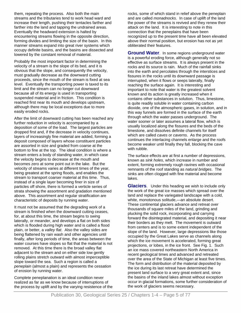
Glaciers. Under this heading we wish to include only the work of the great ice masses which spread over the land and replace the variegated landscape with a cold, white, monotonous solitude,—an absolute desert. These continental glaciers advance and retreat over thousands of square miles of the land, grinding and plucking the solid rock, incorporating and carrying forward the disintegrated material, and depositing it near their borders as they melt. The movement is outward from centers and is to some extent independent of the slope of the land. However, large depressions like those occupied by the Great Lakes serve as channels along which the ice movement is accelerated, forming great projections, or lobes, in the ice front. See Fig. 1. Such an ice mass covered northeastern North America in recent geological times and advanced and retreated over the area of the State of Michigan at least five times. The form and distribution of the material deposited by the ice during its last retreat have determined the present land surface to a very great extent and, since the basins of the inland lakes almost without exception occur in glacial formations, some further consideration of the work of glaciers seems necessary.
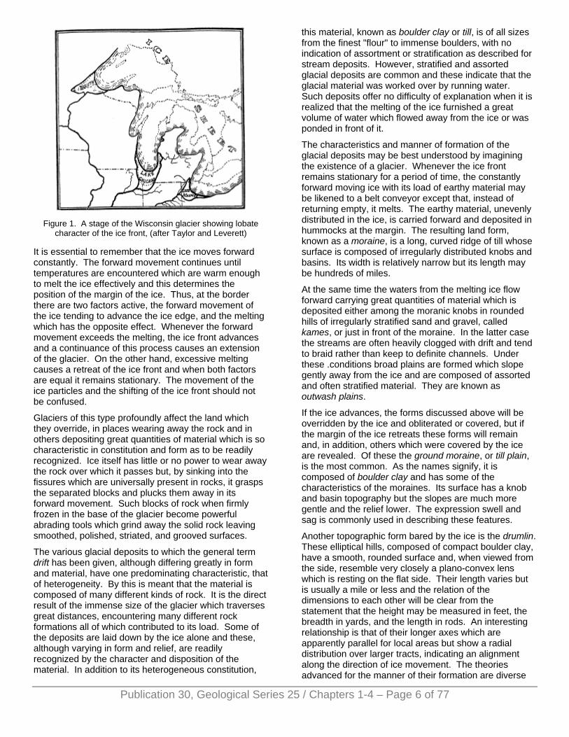
Figure 1. A stage of the Wisconsin glacier showing lobate
character of the ice front, (after Taylor and Leverett)
It is essential to remember that the ice moves forward constantly. The forward movement continues until temperatures are encountered which are warm enough to melt the ice effectively and this determines the position of the margin of the ice. Thus, at the border there are two factors active, the forward movement of the ice tending to advance the ice edge, and the melting which has the opposite effect. Whenever the forward movement exceeds the melting, the ice front advances and a continuance of this process causes an extension of the glacier. On the other hand, excessive melting causes a retreat of the ice front and when both factors are equal it remains stationary. The movement of the ice particles and the shifting of the ice front should not be confused.
Glaciers of this type profoundly affect the land which they override, in places wearing away the rock and in others depositing great quantities of material which is so characteristic in constitution and form as to be readily recognized. Ice itself has little or no power to wear away the rock over which it passes but, by sinking into the fissures which are universally present in rocks, it grasps the separated blocks and plucks them away in its forward movement. Such blocks of rock when firmly frozen in the base of the glacier become powerful abrading tools which grind away the solid rock leaving smoothed, polished, striated, and grooved surfaces.
The various glacial deposits to which the general term drift has been given, although differing greatly in form and material, have one predominating characteristic, that of heterogeneity. By this is meant that the material is composed of many different kinds of rock. It is the direct result of the immense size of the glacier which traverses great distances, encountering many different rock formations all of which contributed to its load. Some of the deposits are laid down by the ice alone and these, although varying in form and relief, are readily recognized by the character and disposition of the material. In addition to its heterogeneous constitution,
this material, known as boulder clay or till, is of all sizes from the finest "flour" to immense boulders, with no indication of assortment or stratification as described for stream deposits. However, stratified and assorted glacial deposits are common and these indicate that the glacial material was worked over by running water. Such deposits offer no difficulty of explanation when it is realized that the melting of the ice furnished a great volume of water which flowed away from the ice or was ponded in front of it.
The characteristics and manner of formation of the glacial deposits may be best understood by imagining the existence of a glacier. Whenever the ice front remains stationary for a period of time, the constantly forward moving ice with its load of earthy material may be likened to a belt conveyor except that, instead of returning empty, it melts. The earthy material, unevenly distributed in the ice, is carried forward and deposited in hummocks at the margin. The resulting land form, known as a moraine, is a long, curved ridge of till whose surface is composed of irregularly distributed knobs and basins. Its width is relatively narrow but its length may be hundreds of miles.
At the same time the waters from the melting ice flow forward carrying great quantities of material which is deposited either among the moranic knobs in rounded hills of irregularly stratified sand and gravel, called kames, or just in front of the moraine. In the latter case the streams are often heavily clogged with drift and tend to braid rather than keep to definite channels. Under these .conditions broad plains are formed which slope gently away from the ice and are composed of assorted and often stratified material. They are known as outwash plains.
If the ice advances, the forms discussed above will be overridden by the ice and obliterated or covered, but if the margin of the ice retreats these forms will remain and, in addition, others which were covered by the ice are revealed. Of these the ground moraine, or till plain, is the most common. As the names signify, it is composed of boulder clay and has some of the characteristics of the moraines. Its surface has a knob and basin topography but the slopes are much more gentle and the relief lower. The expression swell and sag is commonly used in describing these features.
Another topographic form bared by the ice is the drumlin. These elliptical hills, composed of compact boulder clay, have a smooth, rounded surface and, when viewed from the side, resemble very closely a plano-convex lens which is resting on the flat side. Their length varies but is usually a mile or less and the relation of the dimensions to each other will be clear from the statement that the height may be measured in feet, the breadth in yards, and the length in rods. An interesting relationship is that of their longer axes which are apparently parallel for local areas but show a radial distribution over larger tracts, indicating an alignment along the direction of ice movement. The theories advanced for the manner of their formation are diverse
Publication 30, Geological Series 25 / Chapters 1-4 – Page 6 of 77
and need not be considered here.
The last of the forms uncovered by the ice to be considered is the esker, a low serpentine ridge rising above the till plain. It is composed of imperfectly stratified sand and gravel and is usually a few feet high, yards in width, but may extend for miles. It is thought to have been formed by deposition by streams running in definite channels underneath the ice.
The forms discussed above may all, with the exception of drumlins, be referred to a definite position of the ice front. When the ice border is stationary a moraine is piled up, the strength depending on the length of the halt and the amount of material in the ice. At the same time the forms deposited by the water from melting—outwash plains, kames, eskers—are developed locally in their respective positions in front, near-by, and back of the ice margin, and may or may not be present in a given locality. Underneath is the till plain on which drumlins may be formed. The relative position of these forms is shown in Fig. 2.
Figure 2. Relative positions of glacial deposits, (after Tarr and
Martin).
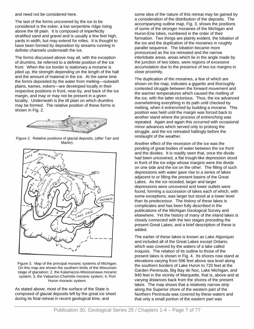
Figure 3. Map of the principal moranic systems of Michigan. On this map are shown the southern limits of the Wisconsin stage of glaciation; 2, the Kalamazoo-Mississinawa moranic system; 3, the Valpariso-Charlotte moranic system; 4, Port
Huron moranic system.
As stated above, most of the surface of the State is composed of glacial deposits left by the great ice sheet during its final retreat in recent geological time, and
some idea of the nature of this retreat may be gained by a consideration of the distribution of the deposits. The accompanying outline map, Fig. 3, shows the positions of some of the stronger moraines of the Michigan and Huron-Erie lobes, numbered in the order of their formation. Two things are plainly evident, the lobation of the ice and the duplication of the moraines in roughly parallel sequence. The lobation became more pronounced as the ice retreated and the narrow interlobate areas, areas which lie in the angle made by the junction of two lobes, were regions of excessive accumulation due to the presence of two ice margins in close proximity.
The duplication of the moraines, a few of which are shown on the map, indicates a gigantic and thoroughly contested struggle between the forward movement and the warmer temperatures which caused the melting of the ice, with the latter victorious. Thus, the ice advanced overwhelming everything in its path until checked by melting, when it entrenched by building a moraine. This position was held until the margin was forced back to another stand where the process of entrenching was repeated. Again and again this occurred with occasional minor advances which served only to prolong the struggle, and the ice retreated haltingly before the onslaught of the weather.
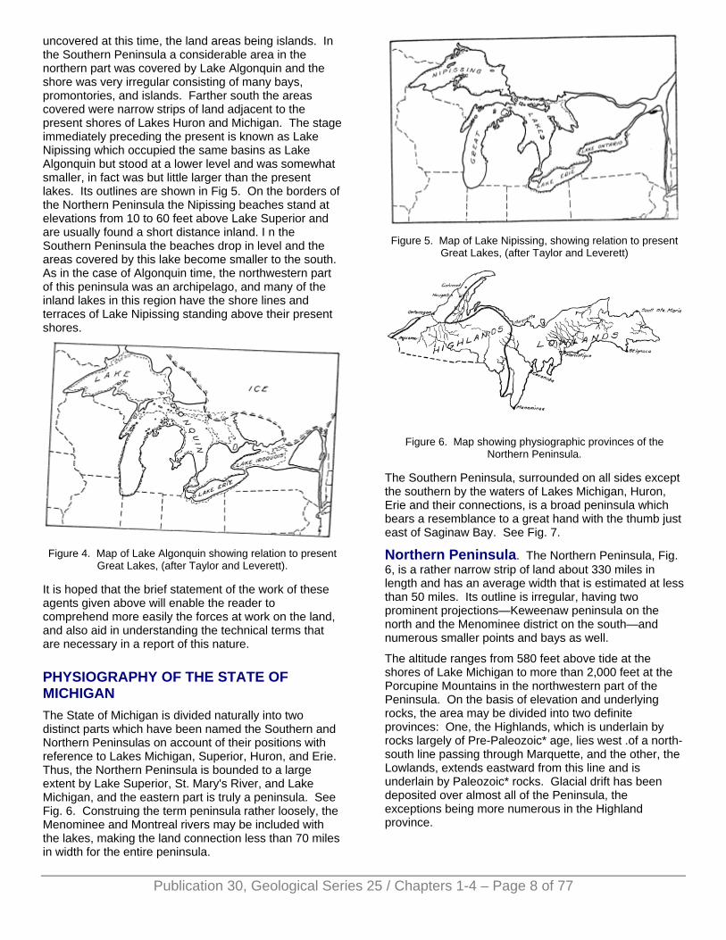
Another effect of the recession of the ice was the ponding of great bodies of water between the ice front and the divides. It is readily seen that, once the divide had been uncovered, a flat trough-like depression stood in front of the ice edge whose margins were the divide on one side and the ice on the other. The filling of such depressions with water gave rise to a series of lakes adjacent to or filling the present basins of the Great Lakes. As the ice receded, larger and larger depressions were uncovered and lower outlets were found, forming a succession of lakes each of which, with some exceptions, was larger but stood at a lower level than its predecessor. The history of these lakes is complicates and has been fully described in the publications of the Michigan Geological Survey and elsewhere. Yet the history of many of the inland lakes is closely connected with the two stages preceding the present Great Lakes, and a brief description of these is added.
The earlier of these lakes is known as Lake Algonquin and included all of the Great Lakes except Ontario, which was covered by the waters of a lake called Iroquois. The relation of its outline to those of the present lakes is shown in Fig. 4. Its shores now stand at elevations varying from 596 feet above sea level along the southern borders of Lake Huron to 720 feet at the Garden Peninsula, Big Bay de Noc, Lake Michigan, and 940 feet in the vicinity of Marquette, that is, above and at varying distances back from the shores of the present lakes. The map shows that a relatively narrow strip along the Superior shore of the western part of the Northern Peninsula was covered by these waters and that only a small portion of the eastern part was
Publication 30, Geological Series 25 / Chapters 1-4 – Page 7 of 77
uncovered at this time, the land areas being islands. In the Southern Peninsula a considerable area in the northern part was covered by Lake Algonquin and the shore was very irregular consisting of many bays, promontories, and islands. Farther south the areas covered were narrow strips of land adjacent to the present shores of Lakes Huron and Michigan. The stage immediately preceding the present is known as Lake Nipissing which occupied the same basins as Lake Algonquin but stood at a lower level and was somewhat smaller, in fact was but little larger than the present lakes. Its outlines are shown in Fig 5. On the borders of the Northern Peninsula the Nipissing beaches stand at elevations from 10 to 60 feet above Lake Superior and are usually found a short distance inland. I n the Southern Peninsula the beaches drop in level and the areas covered by this lake become smaller to the south. As in the case of Algonquin time, the northwestern part of this peninsula was an archipelago, and many of the inland lakes in this region have the shore lines and terraces of Lake Nipissing standing above their present shores.
Figure 4. Map of Lake Algonquin showing relation to present
Great Lakes, (after Taylor and Leverett).
It is hoped that the brief statement of the work of these agents given above will enable the reader to comprehend more easily the forces at work on the land, and also aid in understanding the technical terms that are necessary in a report of this nature.
PHYSIOGRAPHY OF THE STATE OF MICHIGAN The State of Michigan is divided naturally into two distinct parts which have been named the Southern and Northern Peninsulas on account of their positions with reference to Lakes Michigan, Superior, Huron, and Erie. Thus, the Northern Peninsula is bounded to a large extent by Lake Superior, St. Mary's River, and Lake Michigan, and the eastern part is truly a peninsula. See Fig. 6. Construing the term peninsula rather loosely, the Menominee and Montreal rivers may be included with the lakes, making the land connection less than 70 miles in width for the entire peninsula.
Figure 5. Map of Lake Nipissing, showing relation to present
Great Lakes, (after Taylor and Leverett)
Figure 6. Map showing physiographic provinces of the
Northern Peninsula.
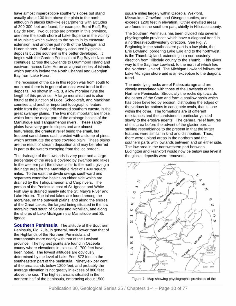
The Southern Peninsula, surrounded on all sides except the southern by the waters of Lakes Michigan, Huron, Erie and their connections, is a broad peninsula which bears a resemblance to a great hand with the thumb just east of Saginaw Bay. See Fig. 7.
Northern Peninsula. The Northern Peninsula, Fig. 6, is a rather narrow strip of land about 330 miles in length and has an average width that is estimated at less than 50 miles. Its outline is irregular, having two prominent projections—Keweenaw peninsula on the north and the Menominee district on the south—and numerous smaller points and bays as well.
The altitude ranges from 580 feet above tide at the shores of Lake Michigan to more than 2,000 feet at the Porcupine Mountains in the northwestern part of the Peninsula. On the basis of elevation and underlying rocks, the area may be divided into two definite provinces: One, the Highlands, which is underlain by rocks largely of Pre-Paleozoic* age, lies west .of a north-south line passing through Marquette, and the other, the Lowlands, extends eastward from this line and is underlain by Paleozoic* rocks. Glacial drift has been deposited over almost all of the Peninsula, the exceptions being more numerous in the Highland province.
Publication 30, Geological Series 25 / Chapters 1-4 – Page 8 of 77

The geological time scale, the main divisions of which are given, is tabulated to give the effect of a great column of superposed rocks, the oldest at the bottom and the youngest above in the order of formation. The position in the scale gives the relative age. It will be seen that the rocks under discussion and of all of Michigan as well, except the glacial deposits, stand low in the scale and are, therefore, ancient.
Publication 30, Geological Series 25 / Chapters 1-4 – Page 9 of 77
Highland Province. This province extends from the meridian of Marquette westward and southward beyond the boundaries of the State, and stands at an average elevation of 1600-1800 feet above sea level, or 1000-1200 feet above Lake Superior. The region is a table-land which rises rapidly from the Lowlands on the east and! north and its surface is covered with a variable thickness of glacial drift through which a relatively small number of hard rock knobs projects. The relief is moderate with differences in elevation which probably do not exceed 500 feet locally and are 100-300 feet on the average. The greatest elevations are rock hills which reach a maximum height of 2023 feet in the Porcupine Mountains.
The Highlands are a part of a great uplifted peneplain which was formed in ancient times. The underlying rocks are mainly of Pre-Paleozoic age and consist of crystalline masses and banded rocks the distribution of which greatly influenced the action of streams, causing, thereby, characteristic topographic forms. The erosion was profound and interrupted by several uplifts but, throughout the vast interval of time during which peneplanation was accomplished, the crystalline masses resisted erosion and stood in relief above the peneplain as monadnocks. The banded rocks were tipped on edge and presented alternately weak and resistant layers to the action of the streams. The hard layers resisted erosion and stood as monadnock ridges whose longer axes are roughly parallel to Lake Superior, while the softer layers were bevelled by the surface of the peneplain. The ridges were not continuous but were crossed by streams, forming gaps which served as channels for the advancing ice of glacial times. Upon the peneplain and about the monadnocks were deposited paleozoic sediments which were largely removed by erosion before the advent of the ice. The effect of the ice action was to scour out the gaps, round off the hills, and fill the valleys with heavy deposits of drift obscuring most of the former surface. Thus, we find today an area covered for the most part with glacial material through which rock knobs, either rounded or linear in form, project. The more important regions where such knobs are found are the Porcupine Mountains, Gogebic Range, Keweenaw Range, Huron Mountains, Marquette Range, Iron River district, and the Menominee district. Of these, Sheridan Hill in the Iron River district and some limestone capped hills in the Menominee district, are composed of Paleozoic rocks.
The glacial deposits of this province were laid down for the most part during the last recession of the ice by the lobes that extended into Lake Superior and Michigan with their subsidiary lobes, Keweenaw and Green Bay. The part first uncovered by the ice is in southern Iron County, an area of till deposits with drumlins or drumlin-like hills. A great moraine swings around this area, formed on the north by the ice of the Superior lobe and on the east by that of the Michigan lobe. The succeeding moraines show the same directions. Thus, the moraines, the inter-moranic till plains, and out wash run roughly parallel to Lake Superior in the western part of this province, except where influenced by the Keweenaw lobe. They have a nearly north-south trend in the eastern part which was covered by the Michigan lobe.
The Highlands are drained to Lakes Superior and Michigan with the exception of a small area in southern Gogebic County which is tapped by the Wisconsin river. The drainage is controlled both by the glacial formations and the pre-glacial topography. In the western part a strong moraine forms the divide, and in the vicinity of Watersmeet are situated the headwaters of the Wisconsin, Ontonagon, and Menominee rivers. To the east the divide shifts northward to a watershed north of Michigamme composed of thinly drift-covered crystalline rocks from which streams flow in all directions. The drainage is incomplete and small lakes and swamps are abundant, especially in the morainic districts and the thinly drift covered area north of Michigamme. There are several lakes of considerable size in this province whose basins are of exceptional interest and will be discussed later.
Lowland Province. The Lowlands extend from the meridian of Marquette eastward to the Sault Ste. Marie and swing to the southwest into Wisconsin and Minnesota in a broad s semicircle. The greatest extension of the Lowlands along the northern edge of the Highland region is found in the continuation of Keweenaw Bay to the southwest and this is connected to the main Lowland area to the east by a narrow coastal strip.
This region is on the average more than 1000 feet lower than the Highlands and its general elevation does not exceed 250 feet above the Great Lakes, although in places it rises considerably above this. It is underlain by Paleozoic rocks which slope gently in a southerly direction. The bevelling of these rocks by stream action in pre-glacial times gave rise to a plain arranged in belts which mark the surface exposures of the various layers of dipping rocks. These belts run roughly parallel to the curve of the north shores of Lakes Huron and Michigan.
The hardness of the different layers varies, and the softer were worn into broad valleys whereas the harder stood in relief in forms peculiar to this type of structure. They consist of low, linear ridges which slope gently on the side formed by the surface of the rock layers but are more abrupt on the side which cuts across the layers. Such forms are known as cuestas. In this region they
have almost imperceptible southerly slopes but stand usually about 100 feet above the plain to the north, although in places bluff-like escarpments with altitudes of 200-300 feet are found, for example, Burnt Bluff, Big Bay de Noc. Two cuestas are present in this province, one near the south shore of Lake Superior in the vicinity of Munising which swings to the south in its eastward extension, and another just north of the Michigan and Huron shores. Both are largely obscured by glacial deposits but the southern is the better developed. It begins with the Garden Peninsula at Big Bay de Noc and continues across the Lowlands to Drummond Island and eastward across Lake Huron as a great series of islands which partially isolate the North Channel and Georgian Bay from Lake Huron.
The recession of the ice in this region was from south to north and there is in general an east-west trend to the deposits. As shown in Fig. 3, a low moraine runs the length of this province. A large morainic tract is also found at the junction of Luce, Schoolcraft, and Mackinac counties and another important topographic feature, aside from the thinly drift covered southern cuesta, is the great swampy plains. The two most important are those which form the major part of the drainage basins of the Manistique and Tahquamenon rivers. These sandy plains have very gentle slopes and are almost featureless, the greatest relief being the small, but frequent sand dunes each crested with a clump of pines which accentuate the grass covered plain. These plains are the result of stream deposition and may be referred in part to the waters escaping from the ice border.
The drainage of the Lowlands is very poor and a large percentage of the area is covered by swamps and lakes. In the western part the divide is far to the north, giving a drainage area for the Manistique river of 1,400 square miles. To the east the divide swings southward and separates extensive basins on either side which are drained by the Tahquamenon and Carp rivers. The portion of the Peninsula east of St. Ignace and White Fish Bay is drained mainly into the St. Mary's River and Lake Huron. The inland lakes are found among the moraines, on the outwash plains, and along the shores of the Great Lakes, the largest being situated in the low morainic tract south of Seney and McMillan, and along the shores of Lake Michigan near Manistique and St. Ignace.
Southern Peninsula. The altitude of the Southern Peninsula, Fig. 7, is, in general, much lower than that of the Highlands of the Northern Peninsula and corresponds more nearly with that of the Lowland province. The highest points are found in Osceola county where elevations in excess of 1700 feet have been noted. The lowest altitudes are obviously determined by the level of Lake Erie, 572 feet, in the southeastern part of the peninsula. Ninety-six per cent of the area stands below 1200 feet, and probably the average elevation is not greatly in excess of 800 feet above the sea. The highest area is situated in the northern half of the peninsula, embracing about 1500
square miles largely within Osceola, Wexford, Missaukee, Crawford, and Otsego counties, and exceeds 1200 feet in elevation. Other elevated areas are found in the southern part, chiefly in Hillsdale county.
The Southern Peninsula has been divided into several physiographic provinces which have a diagonal trend in a northeast-southwesterly direction. See Fig. 7. Beginning in the southeastern part is a low plain, the Erie Lowland, bordering Lake Erie and to the northwest is the Thumb Upland, extending in a northeasterly direction from Hillsdale county to the Thumb. This gives way to the Saginaw Lowland, to the north of which lies the Northern Upland. The Michigan Lowland follows the Lake Michigan shore and is an exception to the diagonal trend.
The underlying rocks are of Paleozoic age and are closely associated with those of the Lowlands of the Northern Peninsula. Structually the rocks dip towards the center of the State and form a shallow basin which has been bevelled by erosion, distributing the edges of the various formations in concentric ovals, that is, one within the other. The formations are of different resistances and the sandstone in particular yielded slowly to the erosive agents. The general relief features of this area before the advent of the glacier bore a striking resemblance to the present in that the larger features were similar in kind and distribution. Thus, there were upland areas in the northern and the southern parts with lowlands between and on either side. The low area in the northwestern part between Ludington and Frankfort would now be below sea level if the glacial deposits were removed.
Figure 7. Map showing physiographic provinces of the
Publication 30, Geological Series 25 / Chapters 1-4 – Page 10 of 77
Publication 30, Geological Series 25 / Chapters 1-4 – Page 11 of 77
Southern Peninsula, (after Leverett). Note: Erie Lowland not designated.
In contrast to the Northern Peninsula, the glacial deposits of the Southern are largely those of an ice invasion just previous to the Wisconsin, or last stage, and form not only the main filling of the valleys but in places prominent ridges. The lobation of the ice of the earlier glaciation was similar to that of the Wisconsin stage and the same areas were, in general, regions of accumulation. It is of interest to one engaged in the study of lakes to know that the present surface features are largely due to the veneer of drift left by the last ice recession.
During its maximum extension the ice of the Wisconsin stage covered the entire Southern Peninsula and its recession uncovered first an area in the southern part of the State. See Fig. 3. Inspection of the moraine numbered 2 on the map shows this area to have been interlobate between the Michigan and the Huron-Erie lobes. With further recession two narrow interlobate areas were formed on either side of the small Saginaw Lobe, as shown by moraines 3 and 4 on the map. Thus, there were areas of excessive accumulation in the southeastern part, more or less coincident with the Thumb Upland, and in the northern part, coincident with the Northern Upland. The latter was an area of especially great accumulation, and here are found extensive moraines, till plains, and broad outwash aprons, the latter constituting the great sand plains. The apparent coincidence of the pre-glacial physiographic provinces of this peninsula with those of the present time would lead one to infer that the pre-glacial topography controls the present relief but such is not the case, since the corresponding areas do not actually coincide except possibly in the Thumb Upland. It is probable, however, that the main influence was the indirect one of determining the positions of the ice lobes and thus the moraines, and that the present topography is due, for the most part, to the distribution of the drift, and near the shores of the large lakes to the working over of this material by the waters of Lakes Algonquin and Nipissing. However, it may be that some of the topography in Hillsdale County and in the region northwest of Thunder Bay is referable to the underlying rocks. Stream action since glacial times has modified the surface so slightly that it is negligible.
The drainage of the Southern Peninsula is determined in its larger aspects by the physiographic provinces discussed above, and the sources of the main streams are found in the high interior portions. In the northern part the divide is situated near the center of the Northern Upland and the streams flow outward to Lakes Michigan and Huron. In this locality the headwaters of the Muskegon, Manistee, and Au Sable rivers are in close proximity. Many of the smaller streams, however, have their sources on the slopes of the upland province and flow more or less directly into the lakes.
In the southern part the long Thumb Upland forms a veritable watershed and on this are located the sources
of the St. Joseph, Kalamazoo; Saginaw (south branches), Huron, and Raisin rivers. As in the northern section, the minor streams head on the slopes of this province and flow directly to the lakes. Between the two upland areas lies the Saginaw Lowland which is drained by the Grand and Saginaw Rivers.
Notable and peculiar drainage patterns are shown by some of the streams, especially the Saginaw and Black (Thumb region), but these are due to the distribution of glacial material, more especially the moraines and the uplifted beaches of the predecessors of the Great Lakes. In Alpena and Presque Isle counties are many sink holes, and the surface drainage is interrupted by these in some cases. From the distribution of the sinks and the presence of "fountains" in parts of Thunder Bay, it has been inferred that there is an extensive underground drainage system, reaching from this region to the vicinity of Black Lake in Cheboygan County, but this has not been carefully worked out as yet.
The abundance of lakes in the Southern Peninsula is an indication of the incompleteness of the drainage, and it is noteworthy that many of the larger as well as the smaller lakes are to be found in the morainic districts, for example, in the northern and southern interlobate areas and in the morainic region within Calhoun, Barry, and Kent counties. Aside from the lakes due to the irregular distribution of the glacial material, there are those bordering Lakes Michigan and Huron which are more important in the extreme northern part of the peninsula.
ORIGIN OF LAKE BASINS A physiographic study of lakes has as its starting point the origin of the basins, and studies in the past have resulted in a classification according to manner of formation which includes many types. The list given, although not complete, will serve to illustrate the diversity of types.
Diastrophism (movements of the earth’s crust)
New-land lakes
Slow movements Ponded lakes
Rapid movements (faulting) Basin range lakes Rift-valley lakes Earthquake lakes
Vulcanism Coullee Lakes Crater lakes
Gradation
Rivers Ox-bow lakes Alluvial dam lakes Saucer lakes Crescentic levee lakesRaft lakes Delta lakes Side-delta lakes
Waves and currents Lagoons
Publication 30, Geological Series 25 / Chapters 1-4 – Page 12 of 77
Wind Dune lakes
Glaciers
Mountain Rock basin lakes Valley moraine lakes
Continental Border lakes Morainal lakes Marginal Ground Morainal dam lakes Inter-morainic lakes Pit lakes Glint lakes Ice dam lakes Glacial lobe lakes Glacial scour lakes Fosse lakes
Ground water Sink lakes Karst lakes
Gravity Landslide lakes
It is seen from the list that diastrophism and the gradational processes of rivers and glaciers produce the greater number of types of basins, but of these, glaciers are productive of the greater number of examples, and the lakes thus formed are of greater importance. Although it is comparatively simple in most cases to assign the general cause of origin, there are many cases where it is difficult to determine the specific cause, inasmuch as several factors, each of which may be sufficient to form a lake basin, have been active. For example, basins due to deposition by continental glaciers are easily recognized but it is often a perplexing study to determine which of the various deposits plays the most important part. In cases where several factors enter the most important must be decided upon and the lake classified accordingly. Within the State of Michigan lake basins of the following types have been recognized:
Glaciers
Continental Glacial scour Morainal Morainal dam Pit Inter-morainic Fosse
Waves and currents Lagoons
Diastrophism Rift-valley Ponded
Ground water Sinks
Rivers Ox-bow
It is clear from this list that a considerable number of types have been recognized but by far the greater number of examples is due either wholly or in part to
glacial action. In fact, there are but few that can be referred to other causes but they are interesting in that they are exceptional, for this State at least, and their characteristics as well as those of glacial origin will be given.
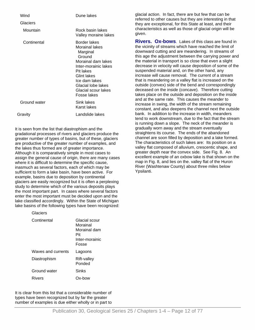
Rivers. Ox-bows. Lakes of this class are found in the vicinity of streams which have reached the limit of downward cutting and are meandering. In streams of this age the adjustment between the carrying power and the material in transport is so close that even a slight decrease in velocity will cause deposition of some of the suspended material and, on the other hand, any increase will cause removal. The current of a stream that is meandering on a valley flat is increased on the outside (convex) side of the bend and correspondingly deceased on the inside (concave). Therefore cutting takes place on the outside and deposition on the inside and at the same rate. This causes the meander to increase in swing, the width of the stream remaining constant, and also deepens the channel next the outside bank. In addition to the increase in width, meanders tend to work downstream, due to the fact that the stream is running down a slope. The neck of the meander is gradually worn away and the stream eventually straightens its course. The ends of the abandoned channel are soon filled by deposition and a lake formed. The characteristics of such lakes are: Its position on a valley flat composed of alluvium, crescentic shape, and greater depth near the convex side. See Fig. 8. An excellent example of an oxbow lake is that shown on the map in Fig. 8, and lies on the. valley flat of the Huron River (Washtenaw County) about three miles below Ypsilanti.
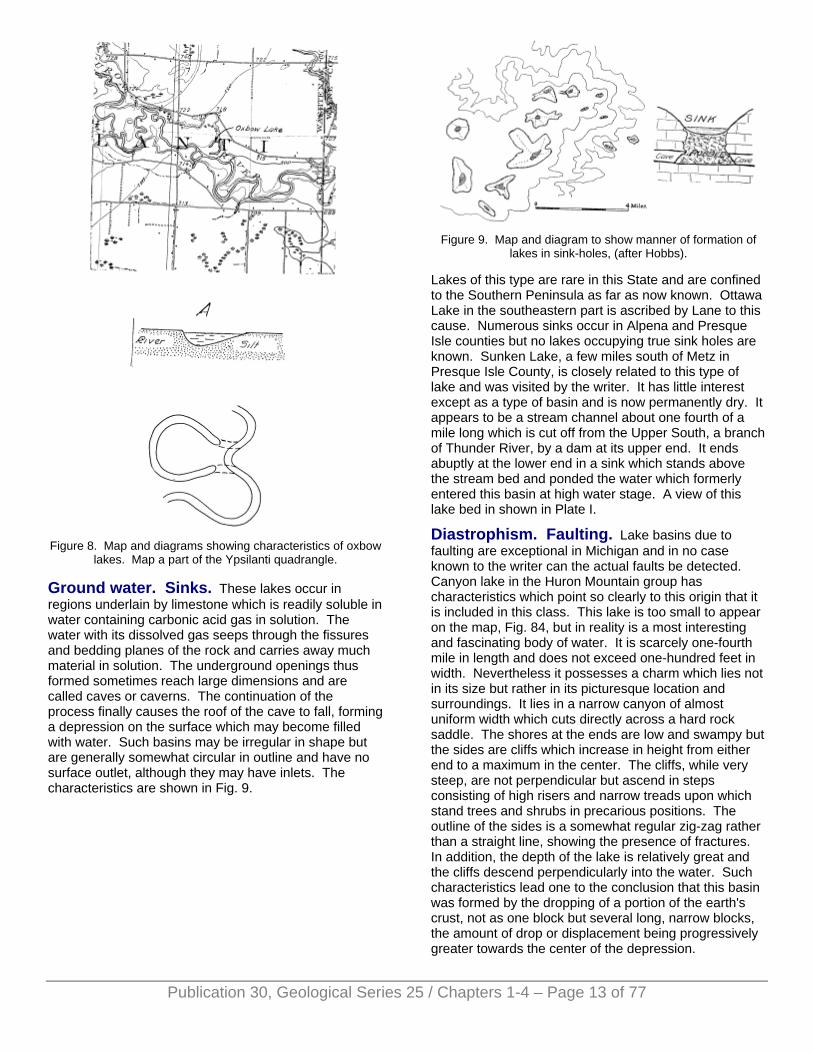
Figure 8. Map and diagrams showing characteristics of oxbow
lakes. Map a part of the Ypsilanti quadrangle.
Ground water. Sinks. These lakes occur in regions underlain by limestone which is readily soluble in water containing carbonic acid gas in solution. The water with its dissolved gas seeps through the fissures and bedding planes of the rock and carries away much material in solution. The underground openings thus formed sometimes reach large dimensions and are called caves or caverns. The continuation of the process finally causes the roof of the cave to fall, forming a depression on the surface which may become filled with water. Such basins may be irregular in shape but are generally somewhat circular in outline and have no surface outlet, although they may have inlets. The characteristics are shown in Fig. 9.
Figure 9. Map and diagram to show manner of formation of
lakes in sink-holes, (after Hobbs).
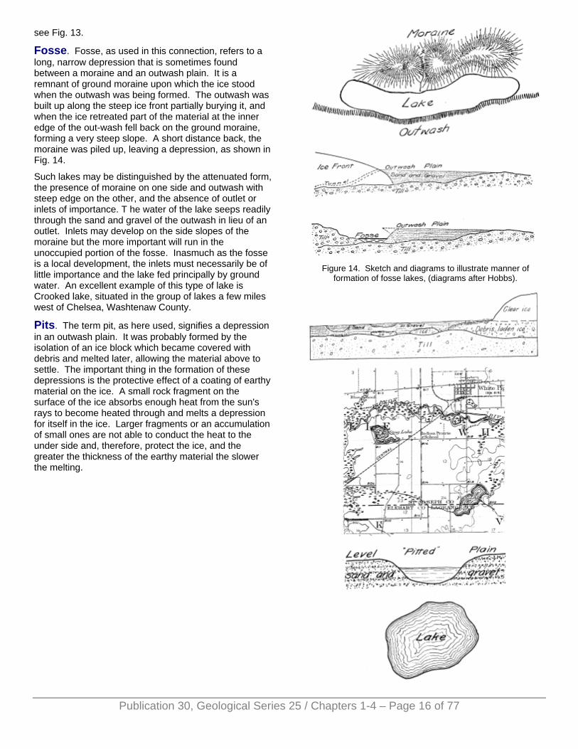
Lakes of this type are rare in this State and are confined to the Southern Peninsula as far as now known. Ottawa Lake in the southeastern part is ascribed by Lane to this cause. Numerous sinks occur in Alpena and Presque Isle counties but no lakes occupying true sink holes are known. Sunken Lake, a few miles south of Metz in Presque Isle County, is closely related to this type of lake and was visited by the writer. It has little interest except as a type of basin and is now permanently dry. It appears to be a stream channel about one fourth of a mile long which is cut off from the Upper South, a branch of Thunder River, by a dam at its upper end. It ends abuptly at the lower end in a sink which stands above the stream bed and ponded the water which formerly entered this basin at high water stage. A view of this lake bed in shown in Plate I.
Diastrophism. Faulting. Lake basins due to faulting are exceptional in Michigan and in no case known to the writer can the actual faults be detected. Canyon lake in the Huron Mountain group has characteristics which point so clearly to this origin that it is included in this class. This lake is too small to appear on the map, Fig. 84, but in reality is a most interesting and fascinating body of water. It is scarcely one-fourth mile in length and does not exceed one-hundred feet in width. Nevertheless it possesses a charm which lies not in its size but rather in its picturesque location and surroundings. It lies in a narrow canyon of almost uniform width which cuts directly across a hard rock saddle. The shores at the ends are low and swampy but the sides are cliffs which increase in height from either end to a maximum in the center. The cliffs, while very steep, are not perpendicular but ascend in steps consisting of high risers and narrow treads upon which stand trees and shrubs in precarious positions. The outline of the sides is a somewhat regular zig-zag rather than a straight line, showing the presence of fractures. In addition, the depth of the lake is relatively great and the cliffs descend perpendicularly into the water. Such characteristics lead one to the conclusion that this basin was formed by the dropping of a portion of the earth's crust, not as one block but several long, narrow blocks, the amount of drop or displacement being progressively greater towards the center of the depression.
Publication 30, Geological Series 25 / Chapters 1-4 – Page 13 of 77
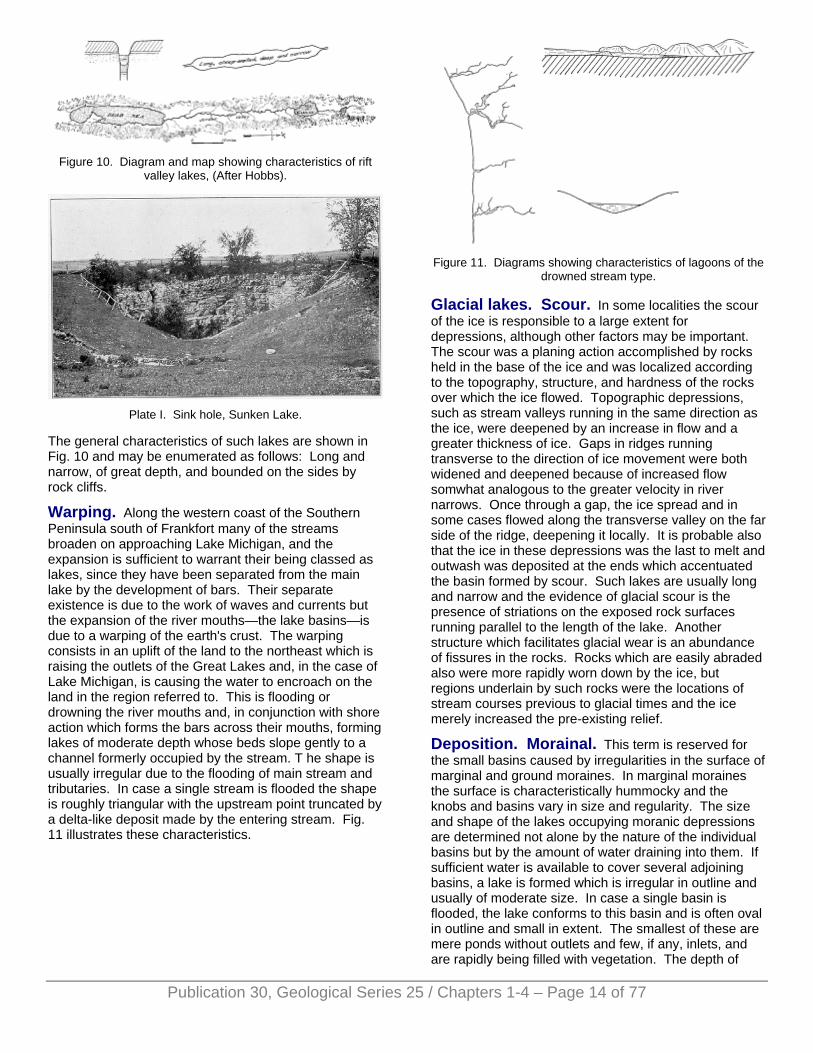
Figure 10. Diagram and map showing characteristics of rift
valley lakes, (After Hobbs).
Plate I. Sink hole, Sunken Lake.
The general characteristics of such lakes are shown in Fig. 10 and may be enumerated as follows: Long and narrow, of great depth, and bounded on the sides by rock cliffs.
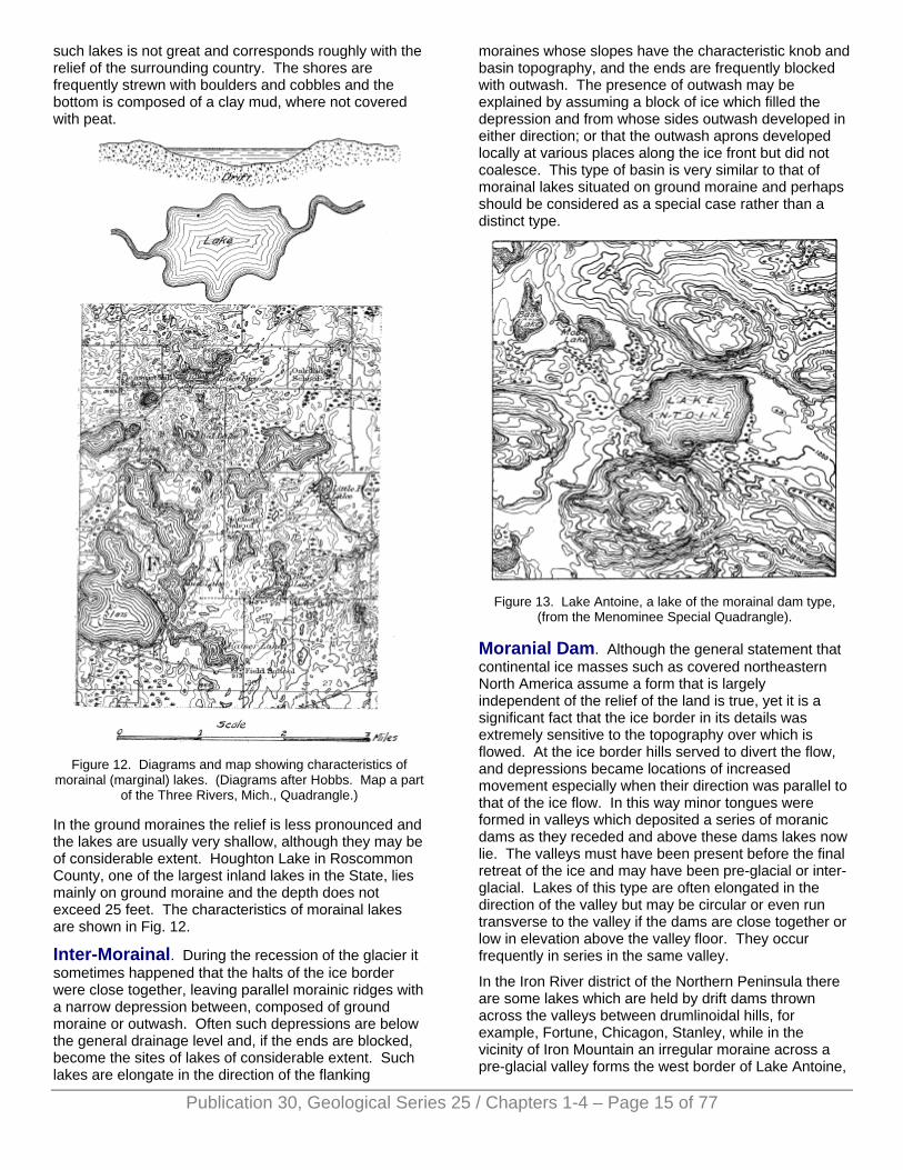
Warping. Along the western coast of the Southern Peninsula south of Frankfort many of the streams broaden on approaching Lake Michigan, and the expansion is sufficient to warrant their being classed as lakes, since they have been separated from the main lake by the development of bars. Their separate existence is due to the work of waves and currents but the expansion of the river mouths—the lake basins—is due to a warping of the earth's crust. The warping consists in an uplift of the land to the northeast which is raising the outlets of the Great Lakes and, in the case of Lake Michigan, is causing the water to encroach on the land in the region referred to. This is flooding or drowning the river mouths and, in conjunction with shore action which forms the bars across their mouths, forming lakes of moderate depth whose beds slope gently to a channel formerly occupied by the stream. T he shape is usually irregular due to the flooding of main stream and tributaries. In case a single stream is flooded the shape is roughly triangular with the upstream point truncated by a delta-like deposit made by the entering stream. Fig. 11 illustrates these characteristics.
Figure 11. Diagrams showing characteristics of lagoons of the
drowned stream type.
Glacial lakes. Scour. In some localities the scour of the ice is responsible to a large extent for depressions, although other factors may be important. The scour was a planing action accomplished by rocks held in the base of the ice and was localized according to the topography, structure, and hardness of the rocks over which the ice flowed. Topographic depressions, such as stream valleys running in the same direction as the ice, were deepened by an increase in flow and a greater thickness of ice. Gaps in ridges running transverse to the direction of ice movement were both widened and deepened because of increased flow somwhat analogous to the greater velocity in river narrows. Once through a gap, the ice spread and in some cases flowed along the transverse valley on the far side of the ridge, deepening it locally. It is probable also that the ice in these depressions was the last to melt and outwash was deposited at the ends which accentuated the basin formed by scour. Such lakes are usually long and narrow and the evidence of glacial scour is the presence of striations on the exposed rock surfaces running parallel to the length of the lake. Another structure which facilitates glacial wear is an abundance of fissures in the rocks. Rocks which are easily abraded also were more rapidly worn down by the ice, but regions underlain by such rocks were the locations of stream courses previous to glacial times and the ice merely increased the pre-existing relief.
Deposition. Morainal. This term is reserved for the small basins caused by irregularities in the surface of marginal and ground moraines. In marginal moraines the surface is characteristically hummocky and the knobs and basins vary in size and regularity. The size and shape of the lakes occupying moranic depressions are determined not alone by the nature of the individual basins but by the amount of water draining into them. If sufficient water is available to cover several adjoining basins, a lake is formed which is irregular in outline and usually of moderate size. In case a single basin is flooded, the lake conforms to this basin and is often oval in outline and small in extent. The smallest of these are mere ponds without outlets and few, if any, inlets, and are rapidly being filled with vegetation. The depth of
Publication 30, Geological Series 25 / Chapters 1-4 – Page 14 of 77
such lakes is not great and corresponds roughly with the relief of the surrounding country. The shores are frequently strewn with boulders and cobbles and the bottom is composed of a clay mud, where not covered with peat.
Figure 12. Diagrams and map showing characteristics of
morainal (marginal) lakes. (Diagrams after Hobbs. Map a part of the Three Rivers, Mich., Quadrangle.)
In the ground moraines the relief is less pronounced and the lakes are usually very shallow, although they may be of considerable extent. Houghton Lake in Roscommon County, one of the largest inland lakes in the State, lies mainly on ground moraine and the depth does not exceed 25 feet. The characteristics of morainal lakes are shown in Fig. 12.
Inter-Morainal. During the recession of the glacier it sometimes happened that the halts of the ice border were close together, leaving parallel morainic ridges with a narrow depression between, composed of ground moraine or outwash. Often such depressions are below the general drainage level and, if the ends are blocked, become the sites of lakes of considerable extent. Such lakes are elongate in the direction of the flanking
moraines whose slopes have the characteristic knob and basin topography, and the ends are frequently blocked with outwash. The presence of outwash may be explained by assuming a block of ice which filled the depression and from whose sides outwash developed in either direction; or that the outwash aprons developed locally at various places along the ice front but did not coalesce. This type of basin is very similar to that of morainal lakes situated on ground moraine and perhaps should be considered as a special case rather than a distinct type.
Figure 13. Lake Antoine, a lake of the morainal dam type,
(from the Menominee Special Quadrangle).
Moranial Dam. Although the general statement that continental ice masses such as covered northeastern North America assume a form that is largely independent of the relief of the land is true, yet it is a significant fact that the ice border in its details was extremely sensitive to the topography over which is flowed. At the ice border hills served to divert the flow, and depressions became locations of increased movement especially when their direction was parallel to that of the ice flow. In this way minor tongues were formed in valleys which deposited a series of moranic dams as they receded and above these dams lakes now lie. The valleys must have been present before the final retreat of the ice and may have been pre-glacial or inter-glacial. Lakes of this type are often elongated in the direction of the valley but may be circular or even run transverse to the valley if the dams are close together or low in elevation above the valley floor. They occur frequently in series in the same valley.
In the Iron River district of the Northern Peninsula there are some lakes which are held by drift dams thrown across the valleys between drumlinoidal hills, for example, Fortune, Chicagon, Stanley, while in the vicinity of Iron Mountain an irregular moraine across a pre-glacial valley forms the west border of Lake Antoine,
Publication 30, Geological Series 25 / Chapters 1-4 – Page 15 of 77
see Fig. 13.
Fosse. Fosse, as used in this connection, refers to a long, narrow depression that is sometimes found between a moraine and an outwash plain. It is a remnant of ground moraine upon which the ice stood when the outwash was being formed. The outwash was built up along the steep ice front partially burying it, and when the ice retreated part of the material at the inner edge of the out-wash fell back on the ground moraine, forming a very steep slope. A short distance back, the moraine was piled up, leaving a depression, as shown in Fig. 14.
Such lakes may be distinguished by the attenuated form, the presence of moraine on one side and outwash with steep edge on the other, and the absence of outlet or inlets of importance. T he water of the lake seeps readily through the sand and gravel of the outwash in lieu of an outlet. Inlets may develop on the side slopes of the moraine but the more important will run in the unoccupied portion of the fosse. Inasmuch as the fosse is a local development, the inlets must necessarily be of little importance and the lake fed principally by ground water. An excellent example of this type of lake is Crooked lake, situated in the group of lakes a few miles west of Chelsea, Washtenaw County.
Pits. The term pit, as here used, signifies a depression in an outwash plain. It was probably formed by the isolation of an ice block which became covered with debris and melted later, allowing the material above to settle. The important thing in the formation of these depressions is the protective effect of a coating of earthy material on the ice. A small rock fragment on the surface of the ice absorbs enough heat from the sun's rays to become heated through and melts a depression for itself in the ice. Larger fragments or an accumulation of small ones are not able to conduct the heat to the under side and, therefore, protect the ice, and the greater the thickness of the earthy material the slower the melting.
Figure 14. Sketch and diagrams to illustrate manner of
formation of fosse lakes, (diagrams after Hobbs).
Publication 30, Geological Series 25 / Chapters 1-4 – Page 16 of 77
Publication 30, Geological Series 25 / Chapters 1-4 – Page 17 of 77
Figure 15. Map and diagrams to illustrate characteristics of pit lakes. Map a part of Three River Quadrangle. Lower diagram
after Hobbs.)
Continental glaciers are characteristically divided into two distinct zones, an upper one comparatively clean and free from debris and a lower which is heavily clogged with rock fragments. Under the sun's rays the clear ice of the upper zone melts rapidly but, when the lower zone is reached, the rock fragments protect the ice directly below them. The portions of the surface not covered with debris melt until earthy material is uncovered and finally a complete rock cover is formed which soon becomes so thick that melting proceeds at a very slow rate. This difference in the rate of melting of the upper and lower zones caused the ice of the upper zone to recede possibly several miles while that of the lower remains stagnant. Wherever the drainage from the ice was vigorous, the protective cover was removed from the stagnant ice and it melted, but where sluggish streams were depositing material, the ice was deeply buried in an outwash plain with an unbroken surface sloping gently away from the ice. The ice blocks did not underlie all of the outwash plain but were more in the nature of scattered fragments, due probably to the uneven distribution of debris in the lower zone of the glacier. Where the load was exceptionally heavy the debris accumulated on the surface until a cover was formed which protected the ice beneath so effectively that it persisted until covered with outwash. At some time subsequent to the formation of the outwash. the ice blocks melted and allowed the material above to subside slowly, causing pits or depressions in the surface of the outwash. This process is illustrated in Fig. 15.
The distinguishing features are: The basin is a depression in a plain, the materials of the plain are water deposits and, therefore, assorted and sometimes stratified, the slope from the plain to the water level is steep, the outline is roughly circular, and there is often no outlet and no important inlets, the lake being supplied and drained by the seepage of ground water through the sandy material of the outwash plain.
Waves and Currents. Lagoons. Shore action often isolates a depression forming a new and usually smaller, detached body of water. The original depression is due to other causes and the shore action is responsible for the isolation only. The work of waves and currents is fully described in Chapter II and needs no discussion here.
It must be stated that some of the inland lakes studied by the writer cannot be definitely included in the classes described above because of the complexity of the origin of the basins and the lack of data concerning them. In particular, attention is called to a series of elongated lake basins along the coast of the northwestern part of the Southern Peninsula—Pine, Torchlight, Elk, Walloon, etc. These lakes exist in long, narrow valleys whose bottoms are filled with thick deposits of loose sand. However, on the sides of the flanking hills at elevations from 100-300 feet above the level of Lake Michigan are found
exposures of clay varying in thickness from a few feet to more than 100. These deposits have been buried by till, showing that they were formed prior to the last advance of the ice over this region. The clays are interpreted by Leverett as lake beds, inasmuch as they are distinctly laminated, nearly free from pebbles, and, in places show sandy partings between the layers of clay. The data are incomplete but indicate the presence of great lakes in this vicinity previous to the last advance of the ice, the extent and duration of which we have merely a suspicion. The puzzling thing is the relation of the valleys in which the present lakes lie to the ancient lakes as signified by the clays. The heavy deposits of sand in the valleys preclude the possibility of determining by direct observation whether or not the sand is underlain by the lake clays found higher on the hills, and it is essential to know this. If underlain by the clays, the basins would be clashed as enormous pits since it would indicate that the clays had sunk from the higher elevation. If not underlain by the clays, it may be assumed that the deposits have been removed or were never formed in the present lake basins. If the material has been removed, streams, ice, or both may have been the eroding agents. If the clays were not deposited in these depressions, we may assume the depressions to have been filled with blocks of ice, probably stagnant, while the clays were settling on the beds of lakes which bordered these ice masses.
REFERENCES General
SALISBURY, R. D., Physiography, Henry Holt and Co., N. Y.
HOBBS, W. H., Earth Features and their Meaning, MacMillan, N. Y.
TARE AND MARTIN, College Physiography, MacMillan, N. Y.
Michigan
LEVERETT, FRANK, Surface Geology of Michigan, Michigan Geological and Biological Survey.
LEVERETT, F. AND TAYLOR, F. B., The Pleistocene of Indiana and Michigan, Monograph 53, U. S. Geological Survey.
VAN HISE, C. R., AND LEITH, C. K., The Geology of the Lake Superior Region, Monograph 52, U. S. Geological Survey, Chapter 4, Physiography by Lawrence Martin.
ALLEN, R. C., The Iron River Iron-bearing District of Michigan, Michigan Geological and Biological Survey.
LEVERETT, FRANK, Folio 155 (reprint), U. S. Geological Survey.
Lakes, origin of basins
FENNEMAN, N. M., Lakes of Southeastern Wisconsin, Wisconsin Geological Survey, Bulletin VIII.
RUSSELL, I. C., The Surface Geology of Portions of Menominee, etc. Annual Report Mich. Geological Survey, 1906.
LANE, A. C., Water Supply and Irrigation Paper, No. 30, U. S. Geological Survey.
CHAPTER II. THE DEVELOPMENT
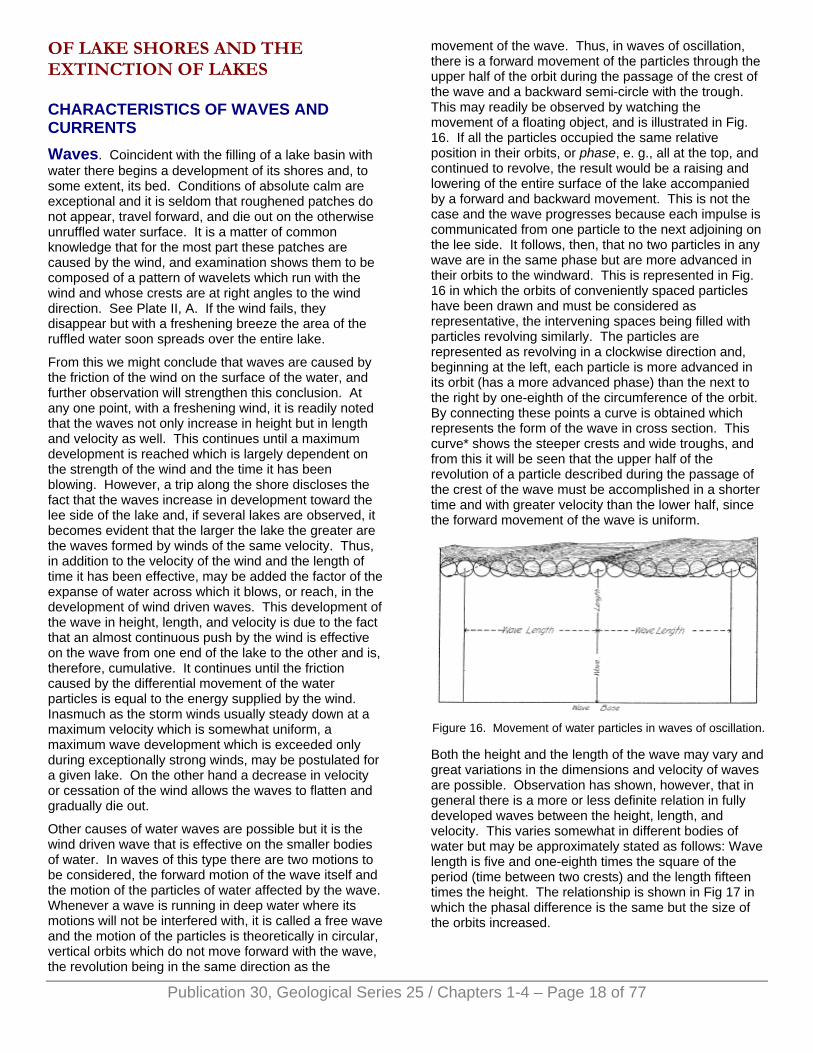
OF LAKE SHORES AND THE EXTINCTION OF LAKES
CHARACTERISTICS OF WAVES AND CURRENTS Waves. Coincident with the filling of a lake basin with water there begins a development of its shores and, to some extent, its bed. Conditions of absolute calm are exceptional and it is seldom that roughened patches do not appear, travel forward, and die out on the otherwise unruffled water surface. It is a matter of common knowledge that for the most part these patches are caused by the wind, and examination shows them to be composed of a pattern of wavelets which run with the wind and whose crests are at right angles to the wind direction. See Plate II, A. If the wind fails, they disappear but with a freshening breeze the area of the ruffled water soon spreads over the entire lake.
From this we might conclude that waves are caused by the friction of the wind on the surface of the water, and further observation will strengthen this conclusion. At any one point, with a freshening wind, it is readily noted that the waves not only increase in height but in length and velocity as well. This continues until a maximum development is reached which is largely dependent on the strength of the wind and the time it has been blowing. However, a trip along the shore discloses the fact that the waves increase in development toward the lee side of the lake and, if several lakes are observed, it becomes evident that the larger the lake the greater are the waves formed by winds of the same velocity. Thus, in addition to the velocity of the wind and the length of time it has been effective, may be added the factor of the expanse of water across which it blows, or reach, in the development of wind driven waves. This development of the wave in height, length, and velocity is due to the fact that an almost continuous push by the wind is effective on the wave from one end of the lake to the other and is, therefore, cumulative. It continues until the friction caused by the differential movement of the water particles is equal to the energy supplied by the wind. Inasmuch as the storm winds usually steady down at a maximum velocity which is somewhat uniform, a maximum wave development which is exceeded only during exceptionally strong winds, may be postulated for a given lake. On the other hand a decrease in velocity or cessation of the wind allows the waves to flatten and gradually die out.
Other causes of water waves are possible but it is the wind driven wave that is effective on the smaller bodies of water. In waves of this type there are two motions to be considered, the forward motion of the wave itself and the motion of the particles of water affected by the wave. Whenever a wave is running in deep water where its motions will not be interfered with, it is called a free wave and the motion of the particles is theoretically in circular, vertical orbits which do not move forward with the wave, the revolution being in the same direction as the
movement of the wave. Thus, in waves of oscillation, there is a forward movement of the particles through the upper half of the orbit during the passage of the crest of the wave and a backward semi-circle with the trough. This may readily be observed by watching the movement of a floating object, and is illustrated in Fig. 16. If all the particles occupied the same relative position in their orbits, or phase, e. g., all at the top, and continued to revolve, the result would be a raising and lowering of the entire surface of the lake accompanied by a forward and backward movement. This is not the case and the wave progresses because each impulse is communicated from one particle to the next adjoining on the lee side. It follows, then, that no two particles in any wave are in the same phase but are more advanced in their orbits to the windward. This is represented in Fig. 16 in which the orbits of conveniently spaced particles have been drawn and must be considered as representative, the intervening spaces being filled with particles revolving similarly. The particles are represented as revolving in a clockwise direction and, beginning at the left, each particle is more advanced in its orbit (has a more advanced phase) than the next to the right by one-eighth of the circumference of the orbit. By connecting these points a curve is obtained which represents the form of the wave in cross section. This curve* shows the steeper crests and wide troughs, and from this it will be seen that the upper half of the revolution of a particle described during the passage of the crest of the wave must be accomplished in a shorter time and with greater velocity than the lower half, since the forward movement of the wave is uniform.
Figure 16. Movement of water particles in waves of oscillation.
Both the height and the length of the wave may vary and great variations in the dimensions and velocity of waves are possible. Observation has shown, however, that in general there is a more or less definite relation in fully developed waves between the height, length, and velocity. This varies somewhat in different bodies of water but may be approximately stated as follows: Wave length is five and one-eighth times the square of the period (time between two crests) and the length fifteen times the height. The relationship is shown in Fig 17 in which the phasal difference is the same but the size of the orbits increased.
Publication 30, Geological Series 25 / Chapters 1-4 – Page 18 of 77

Figure 17. Diagram illustrating the ideal development of
waves.
Publication 30, Geological Series 25 / Chapters 1-4 – Page 19 of 77
*The curve here shown is a trochoid and is obtained from the trace of a point inside the circumference of a rolling circle. A cycloid is formed if the point is on the circumference.
The agitation of the water particles at the surface is communicated to the particles below, but the motion decreases very rapidly and practically dies out at a very limited depth. See Fig. 18. It is usually stated that the size of the orbits is halved for each increase in depth equal to one-ninth of the wave length, but this is only a rough approximation. An illustration may give a better idea of the rapidity of the decrease in motion with depth. A free wave which has a height of three feet at the surface is approximately forty-five feet long and the time of passage about three seconds. At a depth equal to the wave length the diameter of the orbits is less than one five-hundredth of that at the surface, or in the case cited seven-tenths of an inch and the time three seconds. The rate at which the water moves in describing an orbit of this size is about two-thirds of an inch per second, a very feeble current and incapable of geologic work except possibly the transportation of the very finest sediment. The depth of a wave length below the surface has, therefore, been called the wave base, that is, the lower limit of effective wave action, but observations show that this depth is excessive and probably should be placed at less than half the wave length.
Figure 18. Diagram illustrating rapid decrease, with depth, of
motion of water particles in a wave, (after Fenniman).
The relationship in the dimensions of the wave does not hold under a freshening breeze. Under this condition the height increases faster than the length, and the wave gradually becomes steeper until a limit is reached which, if exceeded, would cause the water to describe a loop at the crest of the wave, a condition obviously impossible. Fig. 19, which shows the effect of increasing the height while the length remains constant, illustrates this point. The wave is then said to break into a whitecap, but it is probable that the wind which is moving much more rapidly than the wave blows the crest over into
whitecaps before the theoretical limit of steepness is reached.
As stated previously, from a theoretical standpoint there is no permanent forward movement of the particles of water in waves but, due to the constant forward push by the wind, it happens, in reality, that each revolution of a particle finds it slightly advanced from its former position and there results a drift with the wind. It is probable that the wind has a greater push on the crest of the wave than on the trough because the wind and water are moving in the same direction and the steepness of the crest allows the force to be applied to better advantage. Consequently, most of the forward movement occurs during the passage of the crest and an attempt has been made to show this in Fig. 20. By following the course of this continuous line it will be noted that all of the forward motion is represented as taking place in the upper half of the orbit. The curve is not accurately drawn principally because there are no data from which to construct it but is presented merely to give some idea of the manner in which a forward drift is set up by the wind.
Figure 19. Diagram to illustrate the formation of whitecaps.
For convenience the wave length is kept constant.
Figure 20. Diagram of the path of a particle of water affected
by a number of successive waves.
In addition to the drift, there are other positive forward movements. Of these whitecaps have already been considered. Another takes place when the waves approach the shore. As the water becomes shallower the agitation extends to the bottom and the lower portion of the wave is retarded by friction. The orbits of the water particles are no longer circles but are deformed into ovals. These are more nearly circular at the surface but become flattened with depth until the bottom is reached where the motion is a horizontal oscillation. The retardation of the lower part of the wave is shared by the upper but not in the same degree and results in a decrease in velocity which is less pronounced at the surface. The velocity of the wave is continuously
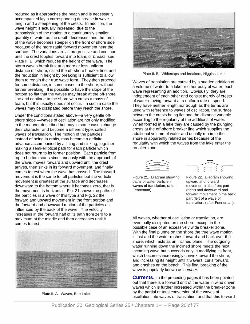
reduced as it approaches the beach and is necessarily accompanied lay a corresponding decrease in wave length and a steepening of the crests. In addition, the wave height is actually increased, due to the transmission of the motion to a continuously smaller quantity of water as the depth decreases, and the form of the wave becomes steeper on the front or shore side because of the more rapid forward movement near the surface. The variations are all progressive and continue until the crest topples forward into foam, or breaks, see Plate II, B, which reduces the height of the wave. The storm waves break first at a more or less uniform distance off shore, called the off-shore breaker line, and the reduction in height by breaking is sufficient to allow them to regain their true wave form. They then proceed for some distance, in some cases to the shore, without further breaking. It is possible to have the slope of the bottom so flat that the waves may break at the off-shore line and continue to the shore with crests a mass of foam, but this usually does not occur. In such a case the waves may be dissipated before they reach the shore.
Under the conditions stated above—a very gentle off-shore slope —waves of oscillation are not only modified in the manner described but may in some cases change their character and become a different type, called waves of translation. The motion of the particles, instead of being in orbits, may become a definite advance accompanied by a lifting and sinking, together making a semi-elliptical path for each particle which does not return to its former position. Each particle from top to bottom starts simultaneously with the approach of the wave, moves forward and upward until the crest arrives, then sinks in its forward movement, and finally comes to rest when the wave has passed. The forward movement is the same for all particles but the verticle movement is greatest at the surface and decreases downward to the bottom where it becomes zero, that is the movement is horizontal. Fig. 21 shows the paths of the particles in a wave of this type and Fig. 22 the forward and upward movement in the front portion and the forward and downward motion of the particles as influenced by the back of the wave. The velocity increases in the forward half of its path from zero to a maximum at the middle and then decreases until it comes to rest.
Plate II. A. Waves, Burt Lake.
Plate II. B. Whitecaps and breakers, Higgins Lake.
Waves of translation are caused by a sudden addition of a volume of water to a lake or other body of water, each wave representing an addition. Obviously, they are independent of each other and consist merely of crests of water moving forward at a uniform rate of speed. They have neither length nor trough as the terms are used with reference to waves of oscillation, the surface between the crests being flat and the distance variable according to the regularity of the additions of water. When formed in a lake they are caused by the plunging crests at the off-shore breaker line which supplies the additional volume of water and usually run in to the shore in apparently related series because of the regularity with which the waves from the lake enter the breaker zone.
Figure 21. Diagram showing paths of water particle in waves of translation, (after Fenneman).
Figure 22. Diagram showing upward and forward movement in the front part (right) and downward and forward movement in the back part (left of a wave of translation, (after Fenneman).
All waves, whether of oscillation or translation, are eventually dissipated on the shore, except in the possible case of an excessively wide breaker zone. With the final plunge on the shore the true wave motion is lost and the water rushes forward and back over the shore, which, acts as an inclined plane. The outgoing water running down the inclined shore meets the next incoming wave but succeeds only in modifying its front, which becomes increasingly convex toward the shore, and increasing its height until it wavers, curls forward, and crashes on the beach. This final breaking of the wave is popularly known as comber.
Currents. In the preceding pages it has been pointed out that there is a forward drift of the water in wind driven waves which is further increased within the breaker zone by the partial or total conversion of the waves of oscillation into waves of translation, and that this forward
Publication 30, Geological Series 25 / Chapters 1-4 – Page 20 of 77
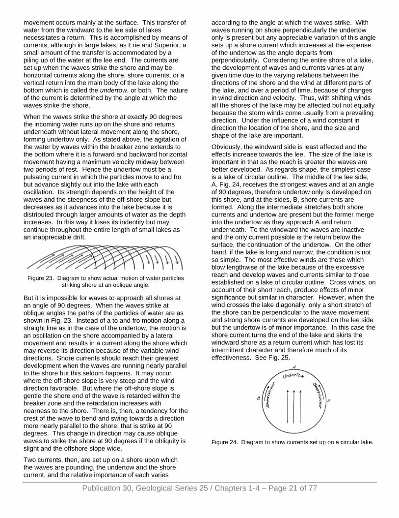
movement occurs mainly at the surface. This transfer of water from the windward to the lee side of lakes necessitates a return. This is accomplished by means of currents, although in large lakes, as Erie and Superior, a small amount of the transfer is accommodated by a piling up of the water at the lee end. The currents are set up when the waves strike the shore and may be horizontal currents along the shore, shore currents, or a vertical return into the main body of the lake along the bottom which is called the undertow, or both. The nature of the current is determined by the angle at which the waves strike the shore.
When the waves strike the shore at exactly 90 degrees the incoming water runs up on the shore and returns underneath without lateral movement along the shore, forming undertow only. As stated above, the agitation of the water by waves within the breaker zone extends to the bottom where it is a forward and backward horizontal movement having a maximum velocity midway between two periods of rest. Hence the undertow must be a pulsating current in which the particles move to and fro but advance slightly out into the lake with each oscillation. Its strength depends on the height of the waves and the steepness of the off-shore slope but decreases as it advances into the lake because it is distributed through larger amounts of water as the depth increases. In this way it loses its indentity but may continue throughout the entire length of small lakes as an inappreciable drift.
Figure 23. Diagram to show actual motion of water particles
striking shore at an oblique angle.
But it is impossible for waves to approach all shores at an angle of 90 degrees. When the waves strike at oblique angles the paths of the particles of water are as shown in Fig. 23. Instead of a to and fro motion along a straight line as in the case of the undertow, the motion is an oscillation on the shore accompanied by a lateral movement and results in a current along the shore which may reverse its direction because of the variable wind directions. Shore currents should reach their greatest development when the waves are running nearly parallel to the shore but this seldom happens. It may occur where the off-shore slope is very steep and the wind direction favorable. But where the off-shore slope is gentle the shore end of the wave is retarded within the breaker zone and the retardation increases with nearness to the shore. There is, then, a tendency for the crest of the wave to bend and swing towards a direction more nearly parallel to the shore, that is strike at 90 degrees. This change in direction may cause oblique waves to strike the shore at 90 degrees if the obliquity is slight and the offshore slope wide.
Two currents, then, are set up on a shore upon which the waves are pounding, the undertow and the shore current, and the relative importance of each varies
according to the angle at which the waves strike. With waves running on shore perpendicularly the undertow only is present but any appreciable variation of this angle sets up a shore current which increases at the expense of the undertow as the angle departs from perpendicularity. Considering the entire shore of a lake, the development of waves and currents varies at any given time due to the varying relations between the directions of the shore and the wind at different parts of the lake, and over a period of time, because of changes in wind direction and velocity. Thus, with shifting winds all the shores of the lake may be affected but not equally because the storm winds come usually from a prevailing direction. Under the influence of a wind constant in direction the location of the shore, and the size and shape of the lake are important.
Obviously, the windward side is least affected and the effects increase towards the lee. The size of the lake is important in that as the reach is greater the waves are better developed. As regards shape, the simplest case is a lake of circular outline. The middle of the lee side, A. Fig. 24, receives the strongest waves and at an angle of 90 degrees, therefore undertow only is developed on this shore, and at the sides, B, shore currents are formed. Along the intermediate stretches both shore currents and undertow are present but the former merge into the undertow as they approach A and return underneath. To the windward the waves are inactive and the only current possible is the return below the surface, the continuation of the undertow. On the other hand, if the lake is long and narrow, the condition is not so simple. The most effective winds are those which blow lengthwise of the lake because of the excessive reach and develop waves and currents similar to those established on a lake of circular outline. Cross winds, on account of their short reach, produce effects of minor significance but similar in character. However, when the wind crosses the lake diagonally, only a short stretch of the shore can be perpendicular to the wave movement and strong shore currents are developed on the lee side but the undertow is of minor importance. In this case the shore current turns the end of the lake and skirts the windward shore as a return current which has lost its intermittent character and therefore much of its effectiveness. See Fig. 25.
Figure 24. Diagram to show currents set up on a circular lake.
Publication 30, Geological Series 25 / Chapters 1-4 – Page 21 of 77
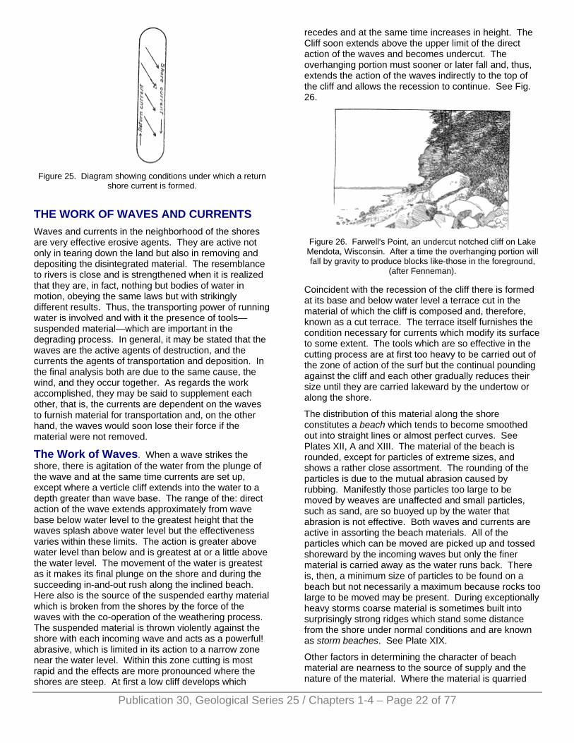
Figure 25. Diagram showing conditions under which a return
shore current is formed.
THE WORK OF WAVES AND CURRENTS Waves and currents in the neighborhood of the shores are very effective erosive agents. They are active not only in tearing down the land but also in removing and depositing the disintegrated material. The resemblance to rivers is close and is strengthened when it is realized that they are, in fact, nothing but bodies of water in motion, obeying the same laws but with strikingly different results. Thus, the transporting power of running water is involved and with it the presence of tools—suspended material—which are important in the degrading process. In general, it may be stated that the waves are the active agents of destruction, and the currents the agents of transportation and deposition. In the final analysis both are due to the same cause, the wind, and they occur together. As regards the work accomplished, they may be said to supplement each other, that is, the currents are dependent on the waves to furnish material for transportation and, on the other hand, the waves would soon lose their force if the material were not removed.
The Work of Waves. When a wave strikes the shore, there is agitation of the water from the plunge of the wave and at the same time currents are set up, except where a verticle cliff extends into the water to a depth greater than wave base. The range of the: direct action of the wave extends approximately from wave base below water level to the greatest height that the waves splash above water level but the effectiveness varies within these limits. The action is greater above water level than below and is greatest at or a little above the water level. The movement of the water is greatest as it makes its final plunge on the shore and during the succeeding in-and-out rush along the inclined beach. Here also is the source of the suspended earthy material which is broken from the shores by the force of the waves with the co-operation of the weathering process. The suspended material is thrown violently against the shore with each incoming wave and acts as a powerful! abrasive, which is limited in its action to a narrow zone near the water level. Within this zone cutting is most rapid and the effects are more pronounced where the shores are steep. At first a low cliff develops which
recedes and at the same time increases in height. The Cliff soon extends above the upper limit of the direct action of the waves and becomes undercut. The overhanging portion must sooner or later fall and, thus, extends the action of the waves indirectly to the top of the cliff and allows the recession to continue. See Fig. 26.
Figure 26. Farwell's Point, an undercut notched cliff on Lake
Mendota, Wisconsin. After a time the overhanging portion will fall by gravity to produce blocks like-those in the foreground,
(after Fenneman).
Coincident with the recession of the cliff there is formed at its base and below water level a terrace cut in the material of which the cliff is composed and, therefore, known as a cut terrace. The terrace itself furnishes the condition necessary for currents which modify its surface to some extent. The tools which are so effective in the cutting process are at first too heavy to be carried out of the zone of action of the surf but the continual pounding against the cliff and each other gradually reduces their size until they are carried lakeward by the undertow or along the shore.
The distribution of this material along the shore constitutes a beach which tends to become smoothed out into straight lines or almost perfect curves. See Plates XII, A and XIII. The material of the beach is rounded, except for particles of extreme sizes, and shows a rather close assortment. The rounding of the particles is due to the mutual abrasion caused by rubbing. Manifestly those particles too large to be moved by weaves are unaffected and small particles, such as sand, are so buoyed up by the water that abrasion is not effective. Both waves and currents are active in assorting the beach materials. All of the particles which can be moved are picked up and tossed shoreward by the incoming waves but only the finer material is carried away as the water runs back. There is, then, a minimum size of particles to be found on a beach but not necessarily a maximum because rocks too large to be moved may be present. During exceptionally heavy storms coarse material is sometimes built into surprisingly strong ridges which stand some distance from the shore under normal conditions and are known as storm beaches. See Plate XIX.
Other factors in determining the character of beach material are nearness to the source of supply and the nature of the material. Where the material is quarried
Publication 30, Geological Series 25 / Chapters 1-4 – Page 22 of 77
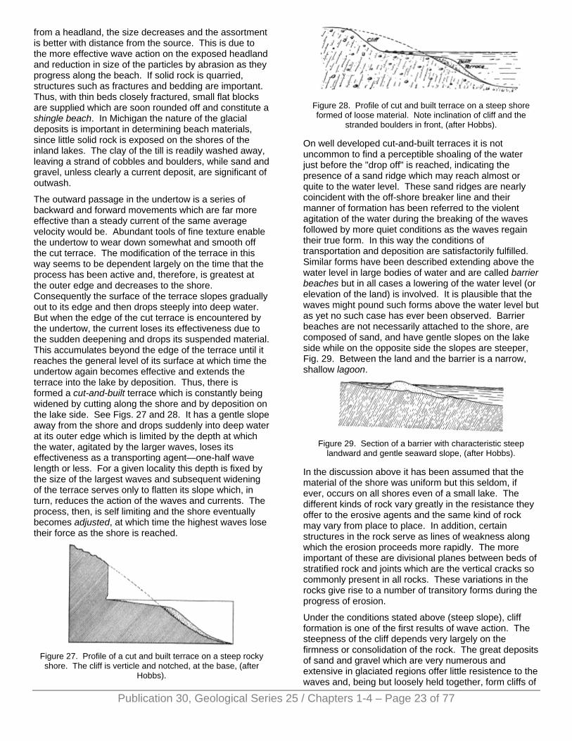
from a headland, the size decreases and the assortment is better with distance from the source. This is due to the more effective wave action on the exposed headland and reduction in size of the particles by abrasion as they progress along the beach. If solid rock is quarried, structures such as fractures and bedding are important. Thus, with thin beds closely fractured, small flat blocks are supplied which are soon rounded off and constitute a shingle beach. In Michigan the nature of the glacial deposits is important in determining beach materials, since little solid rock is exposed on the shores of the inland lakes. The clay of the till is readily washed away, leaving a strand of cobbles and boulders, while sand and gravel, unless clearly a current deposit, are significant of outwash.
The outward passage in the undertow is a series of backward and forward movements which are far more effective than a steady current of the same average velocity would be. Abundant tools of fine texture enable the undertow to wear down somewhat and smooth off the cut terrace. The modification of the terrace in this way seems to be dependent largely on the time that the process has been active and, therefore, is greatest at the outer edge and decreases to the shore. Consequently the surface of the terrace slopes gradually out to its edge and then drops steeply into deep water. But when the edge of the cut terrace is encountered by the undertow, the current loses its effectiveness due to the sudden deepening and drops its suspended material. This accumulates beyond the edge of the terrace until it reaches the general level of its surface at which time the undertow again becomes effective and extends the terrace into the lake by deposition. Thus, there is formed a cut-and-built terrace which is constantly being widened by cutting along the shore and by deposition on the lake side. See Figs. 27 and 28. It has a gentle slope away from the shore and drops suddenly into deep water at its outer edge which is limited by the depth at which the water, agitated by the larger waves, loses its effectiveness as a transporting agent—one-half wave length or less. For a given locality this depth is fixed by the size of the largest waves and subsequent widening of the terrace serves only to flatten its slope which, in turn, reduces the action of the waves and currents. The process, then, is self limiting and the shore eventually becomes adjusted, at which time the highest waves lose their force as the shore is reached.
Figure 27. Profile of a cut and built terrace on a steep rocky shore. The cliff is verticle and notched, at the base, (after
Hobbs).
Figure 28. Profile of cut and built terrace on a steep shore formed of loose material. Note inclination of cliff and the
stranded boulders in front, (after Hobbs).
On well developed cut-and-built terraces it is not uncommon to find a perceptible shoaling of the water just before the "drop off" is reached, indicating the presence of a sand ridge which may reach almost or quite to the water level. These sand ridges are nearly coincident with the off-shore breaker line and their manner of formation has been referred to the violent agitation of the water during the breaking of the waves followed by more quiet conditions as the waves regain their true form. In this way the conditions of transportation and deposition are satisfactorily fulfilled. Similar forms have been described extending above the water level in large bodies of water and are called barrier beaches but in all cases a lowering of the water level (or elevation of the land) is involved. It is plausible that the waves might pound such forms above the water level but as yet no such case has ever been observed. Barrier beaches are not necessarily attached to the shore, are composed of sand, and have gentle slopes on the lake side while on the opposite side the slopes are steeper, Fig. 29. Between the land and the barrier is a narrow, shallow lagoon.
Figure 29. Section of a barrier with characteristic steep
landward and gentle seaward slope, (after Hobbs).
In the discussion above it has been assumed that the material of the shore was uniform but this seldom, if ever, occurs on all shores even of a small lake. The different kinds of rock vary greatly in the resistance they offer to the erosive agents and the same kind of rock may vary from place to place. In addition, certain structures in the rock serve as lines of weakness along which the erosion proceeds more rapidly. The more important of these are divisional planes between beds of stratified rock and joints which are the vertical cracks so commonly present in all rocks. These variations in the rocks give rise to a number of transitory forms during the progress of erosion.
Under the conditions stated above (steep slope), cliff formation is one of the first results of wave action. The steepness of the cliff depends very largely on the firmness or consolidation of the rock. The great deposits of sand and gravel which are very numerous and extensive in glaciated regions offer little resistence to the waves and, being but loosely held together, form cliffs of
Publication 30, Geological Series 25 / Chapters 1-4 – Page 23 of 77
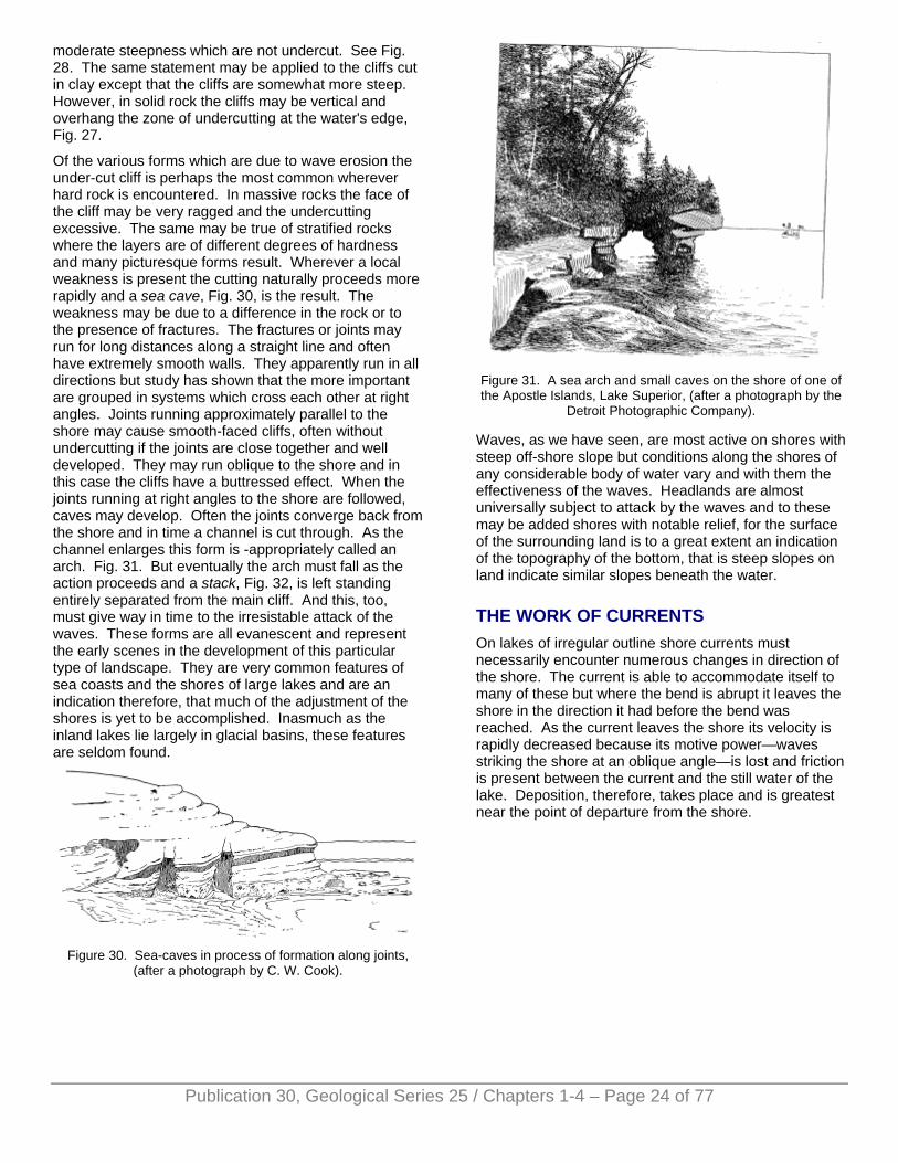
moderate steepness which are not undercut. See Fig. 28. The same statement may be applied to the cliffs cut in clay except that the cliffs are somewhat more steep. However, in solid rock the cliffs may be vertical and overhang the zone of undercutting at the water's edge, Fig. 27.
Of the various forms which are due to wave erosion the under-cut cliff is perhaps the most common wherever hard rock is encountered. In massive rocks the face of the cliff may be very ragged and the undercutting excessive. The same may be true of stratified rocks where the layers are of different degrees of hardness and many picturesque forms result. Wherever a local weakness is present the cutting naturally proceeds more rapidly and a sea cave, Fig. 30, is the result. The weakness may be due to a difference in the rock or to the presence of fractures. The fractures or joints may run for long distances along a straight line and often have extremely smooth walls. They apparently run in all directions but study has shown that the more important are grouped in systems which cross each other at right angles. Joints running approximately parallel to the shore may cause smooth-faced cliffs, often without undercutting if the joints are close together and well developed. They may run oblique to the shore and in this case the cliffs have a buttressed effect. When the joints running at right angles to the shore are followed, caves may develop. Often the joints converge back from the shore and in time a channel is cut through. As the channel enlarges this form is -appropriately called an arch. Fig. 31. But eventually the arch must fall as the action proceeds and a stack, Fig. 32, is left standing entirely separated from the main cliff. And this, too, must give way in time to the irresistable attack of the waves. These forms are all evanescent and represent the early scenes in the development of this particular type of landscape. They are very common features of sea coasts and the shores of large lakes and are an indication therefore, that much of the adjustment of the shores is yet to be accomplished. Inasmuch as the inland lakes lie largely in glacial basins, these features are seldom found.
Figure 30. Sea-caves in process of formation along joints,
(after a photograph by C. W. Cook).
Figure 31. A sea arch and small caves on the shore of one of the Apostle Islands, Lake Superior, (after a photograph by the
Detroit Photographic Company).
Waves, as we have seen, are most active on shores with steep off-shore slope but conditions along the shores of any considerable body of water vary and with them the effectiveness of the waves. Headlands are almost universally subject to attack by the waves and to these may be added shores with notable relief, for the surface of the surrounding land is to a great extent an indication of the topography of the bottom, that is steep slopes on land indicate similar slopes beneath the water.
THE WORK OF CURRENTS On lakes of irregular outline shore currents must necessarily encounter numerous changes in direction of the shore. The current is able to accommodate itself to many of these but where the bend is abrupt it leaves the shore in the direction it had before the bend was reached. As the current leaves the shore its velocity is rapidly decreased because its motive power—waves striking the shore at an oblique angle—is lost and friction is present between the current and the still water of the lake. Deposition, therefore, takes place and is greatest near the point of departure from the shore.
Publication 30, Geological Series 25 / Chapters 1-4 – Page 24 of 77
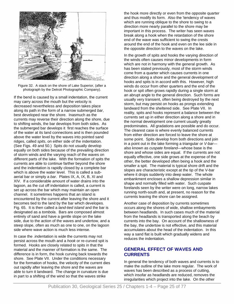
Figure 32. A stack on the shore of Lake Superior, (after a
photograph by the Detroit Photographic Company).
If the bend is caused by a small indentation, the current may carry across the mouth but the velocity is decreased nevertheless and deposition takes place along its path in the form of a narrow submerged bar, best developed near the shore. Inasmuch as the currents may reverse their direction along the shore, due to shifting winds, the bar develops from both sides. As the submerged bar develops it first reaches the surface of the water at its land connections and is then pounded above the water level by the waves into pointed sand ridges, called spits, on either side of the indentation. (See Figs. 49 and 50.) Spits do not usually develop equally on both sides because of the prevailing direction of storm winds and the varying reach of the waves on different parts of the lake. With the formation of spits the currents are able to continue farther beyond the shore and the indentation is rapidly closed by a complete bar which is above the water level. This is called a sub-aerial bar or simply a bar. Plates IX, A, IX, B, XI and XIV. If a considerable amount of water drains into the lagoon, as the cut off indentation is called, a current is set up across the bar which may maintain an open channel. It sometimes happens that an island is encountered by the current after leaving the shore and it becomes tied to the land by the bar which developes. Fig. 65. It is then called a land-tied island and the bar is designated as a tombola. Bars are composed almost entirely of sand and have a gentle slope on the lake side, due to the action of the waves and undertow, and a steep slope, often as much as one to one, on the lagoon side where wave action is much less intense.
In case the .indentation is wide the currents may not persist across the mouth and a hook or re-curved spit is formed. Hooks are closely related to spits in that the material and the manner of formation is the same. The difference is in form, the hook curving back towards the shore. See Plate VII. Under the conditions necessary for the formation of hooks, the velocity of the current dies out rapidly after leaving the shore and the waves are able to turn it landward. The change in curvature is due in part to a shifting of the wind so that the waves strike
the hook more directly or even from the opposite quarter and thus modify its form. Also the 'tendency of waves which are running oblique to the shore to swing to a direction more nearly parallel to the shore may be important in this process. The writer has seen waves break along a hook when the retardation of the shore end of the wave was sufficient to swing the crests around the end of the hook and even on the lee side in the opposite direction to the waves on the lake.
In the growth of spits and hooks the varying direction of the winds often causes minor developments in form which are not in harmony with the general growth. As has been stated previously, most of the storm winds come from a quarter which causes currents in one direction along a shore and the general development of hooks and spits is in accord with this. However, high winds do occur from other quarters and the end of the hook or spit often grows rapidly during a single storm at an abrupt angle to the general direction. Such forms are usually very transient, often being destroyed by the next storm, but may persist on hooks as prongs extending landward from the sheltered side. See Plate VII. In reality, spits and hooks represent a balance between the currents set up in either direction along a shore and in the normal development one current usually greatly predominates. All gradations are possible and do occur. The clearest case is where evenly balanced currents from either direction are forced to leave the shore at some point. Spits develop from both directions and join in a point out in the lake forming a triangular or V-bar—also known as cuspate foreland—whose base is the shore and whose sides are equal. If the currents are not equally effective, one side grows at the expense of the other, the better developed often being a hook and the smaller a spit. The material is typical shore drift and the slopes are characteristic except at the tip of the V-bar where it drops suddenly into deep water. The whole embankment encloses a shallow depression similar in shape and normally filled with water. Such cuspate forelands seen by the writer were on long, narrow lakes running north-south and, at present, no reason for the currents leaving the shore can be assigned.
Another case of deposition by currents sometimes occurs along the shores of wide, shallow embayments between headlands. In such cases much of the material from the headlands is transported along the beach by currents into the bay. On account of the shallowness of the bay, the undertow is not effective, and this material accumulates about the head of the indentation. In this way a sand flat is built which gradually widens and reduces the indentation.
GENERAL EFFECT OF WAVES AND CURRENTS In general the tendency of both waves and currents is to make the outline of the lake more regular. The work of waves has been described as a process of cutting, which insofar as headlands are reduced, removes the irregularities which project into the lake. On the other
Publication 30, Geological Series 25 / Chapters 1-4 – Page 25 of 77
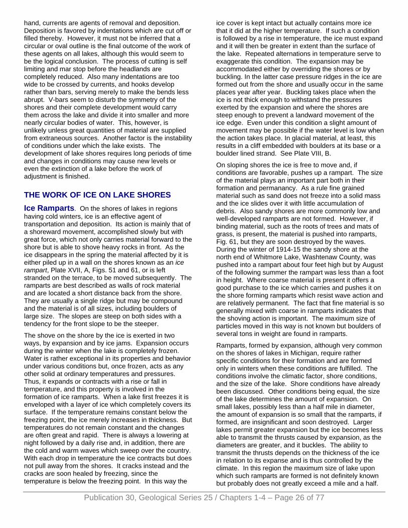
Publication 30, Geological Series 25 / Chapters 1-4 – Page 26 of 77
hand, currents are agents of removal and deposition. Deposition is favored by indentations which are cut off or filled thereby. However, it must not be inferred that a circular or oval outline is the final outcome of the work of these agents on all lakes, although this would seem to be the logical conclusion. The process of cutting is self limiting and mar stop before the headlands are completely reduced. Also many indentations are too wide to be crossed by currents, and hooks develop rather than bars, serving merely to make the bends less abrupt. V-bars seem to disturb the symmetry of the shores and their complete development would carry them across the lake and divide it into smaller and more nearly circular bodies of water. This, however, is unlikely unless great quantities of material are supplied from extraneous sources. Another factor is the instability of conditions under which the lake exists. The development of lake shores requires long periods of time and changes in conditions may cause new levels or even the extinction of a lake before the work of adjustment is finished.
THE WORK OF ICE ON LAKE SHORES Ice Ramparts. On the shores of lakes in regions having cold winters, ice is an effective agent of transportation and deposition. Its action is mainly that of a shoreward movement, accomplished slowly but with great force, which not only carries material forward to the shore but is able to shove heavy rocks in front. As the ice disappears in the spring the material affected by it is either piled up in a wall on the shores known as an ice rampart, Plate XVII, A, Figs. 51 and 61, or is left stranded on the terrace, to be moved subsequently. The ramparts are best described as walls of rock material and are located a short distance back from the shore. They are usually a single ridge but may be compound and the material is of all sizes, including boulders of large size. The slopes are steep on both sides with a tendency for the front slope to be the steeper.
The shove on the shore by the ice is exerted in two ways, by expansion and by ice jams. Expansion occurs during the winter when the lake is completely frozen. Water is rather exceptional in its properties and behavior under various conditions but, once frozen, acts as any other solid at ordinary temperatures and pressures. Thus, it expands or contracts with a rise or fall in temperature, and this property is involved in the formation of ice ramparts. When a lake first freezes it is enveloped with a layer of ice which completely covers its surface. If the temperature remains constant below the freezing point, the ice merely increases in thickness. But temperatures do not remain constant and the changes are often great and rapid. There is always a lowering at night followed by a daily rise and, in addition, there are the cold and warm waves which sweep over the country. With each drop in temperature the ice contracts but does not pull away from the shores. It cracks instead and the cracks are soon healed by freezing, since the temperature is below the freezing point. In this way the
ice cover is kept intact but actually contains more ice that it did at the higher temperature. If such a condition is followed by a rise in temperature, the ice must expand and it will then be greater in extent than the surface of the lake. Repeated alternations in temperature serve to exaggerate this condition. The expansion may be accommodated either by overriding the shores or by buckling. In the latter case pressure ridges in the ice are formed out from the shore and usually occur in the same places year after year. Buckling takes place when the ice is not thick enough to withstand the pressures exerted by the expansion and where the shores are steep enough to prevent a landward movement of the ice edge. Even under this condition a slight amount of movement may be possible if the water level is low when the action takes place. In glacial material, at least, this results in a cliff embedded with boulders at its base or a boulder lined strand. See Plate VIII, B.
On sloping shores the ice is free to move and, if conditions are favorable, pushes up a rampart. The size of the material plays an important part both in their formation and permanancy. As a rule fine grained material such as sand does not freeze into a solid mass and the ice slides over it with little accumulation of debris. Also sandy shores are more commonly low and well-developed ramparts are not formed. However, if binding material, such as the roots of trees and mats of grass, is present, the material is pushed into ramparts, Fig. 61, but they are soon destroyed by the waves. During the winter of 1914-15 the sandy shore at the north end of Whitmore Lake, Washtenaw County, was pushed into a rampart about four feet high but by August of the following summer the rampart was less than a foot in height. Where coarse material is present it offers a good purchase to the ice which carries and pushes it on the shore forming ramparts which resist wave action and are relatively permanent. The fact that fine material is so generally mixed with coarse in ramparts indicates that the shoving action is important. The maximum size of particles moved in this way is not known but boulders of several tons in weight are found in ramparts.
Ramparts, formed by expansion, although very common on the shores of lakes in Michigan, require rather specific conditions for their formation and are formed only in winters when these conditions are fulfilled. The conditions involve the climatic factor, shore conditions, and the size of the lake. Shore conditions have already been discussed. Other conditions being equal, the size of the lake determines the amount of expansion. On small lakes, possibly less than a half mile in diameter, the amount of expansion is so small that the ramparts, if formed, are insignificant and soon destroyed. Larger lakes permit greater expansion but the ice becomes less able to transmit the thrusts caused by expansion, as the diameters are greater, and it buckles. The ability to transmit the thrusts depends on the thickness of the ice in relation to its expanse and is thus controlled by the climate. In this region the maximum size of lake upon which such ramparts are formed is not definitely known but probably does not greatly exceed a mile and a half.
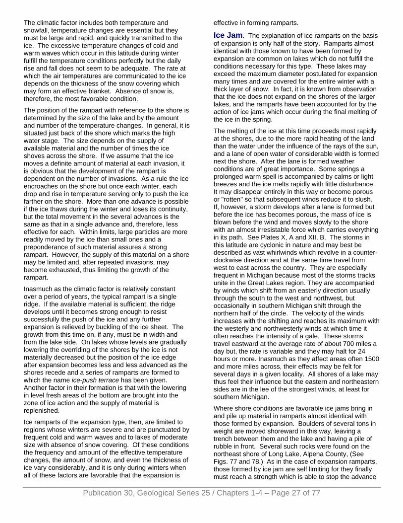
Publication 30, Geological Series 25 / Chapters 1-4 – Page 27 of 77
The climatic factor includes both temperature and snowfall, temperature changes are essential but they must be large and rapid, and quickly transmitted to the ice. The excessive temperature changes of cold and warm waves which occur in this latitude during winter fulfill the temperature conditions perfectly but the daily rise and fall does not seem to be adequate. The rate at which the air temperatures are communicated to the ice depends on the thickness of the snow covering which may form an effective blanket. Absence of snow is, therefore, the most favorable condition.
The position of the rampart with reference to the shore is determined by the size of the lake and by the amount and number of the temperature changes. In general, it is situated just back of the shore which marks the high water stage. The size depends on the supply of available material and the number of times the ice shoves across the shore. If we assume that the ice moves a definite amount of material at each invasion, it is obvious that the development of the rampart is dependent on the number of invasions. As a rule the ice encroaches on the shore but once each winter, each drop and rise in temperature serving only to push the ice farther on the shore. More than one advance is possible if the ice thaws during the winter and loses its continuity, but the total movement in the several advances is the same as that in a single advance and, therefore, less effective for each. Within limits, large particles are more readily moved by the ice than small ones and a preponderance of such material assures a strong rampart. However, the supply of this material on a shore may be limited and, after repeated invasions, may become exhausted, thus limiting the growth of the rampart.
Inasmuch as the climatic factor is relatively constant over a period of years, the typical rampart is a single ridge. If the available material is sufficient, the ridge develops until it becomes strong enough to resist successfully the push of the ice and any further expansion is relieved by buckling of the ice sheet. The growth from this time on, if any, must be in width and from the lake side. On lakes whose levels are gradually lowering the overriding of the shores by the ice is not materially decreased but the position of the ice edge after expansion becomes less and less advanced as the shores recede and a series of ramparts are formed to which the name ice-push terrace has been given. Another factor in their formation is that with the lowering in level fresh areas of the bottom are brought into the zone of ice action and the supply of material is replenished.
Ice ramparts of the expansion type, then, are limited to regions whose winters are severe and are punctuated by frequent cold and warm waves and to lakes of moderate size with absence of snow covering. Of these conditions the frequency and amount of the effective temperature changes, the amount of snow, and even the thickness of ice vary considerably, and it is only during winters when all of these factors are favorable that the expansion is
effective in forming ramparts.
Ice Jam. The explanation of ice ramparts on the basis of expansion is only half of the story. Ramparts almost identical with those known to have been formed by expansion are common on lakes which do not fulfill the conditions necessary for this type. These lakes may exceed the maximum diameter postulated for expansion many times and are covered for the entire winter with a thick layer of snow. In fact, it is known from observation that the ice does not expand on the shores of the larger lakes, and the ramparts have been accounted for by the action of ice jams which occur during the final melting of the ice in the spring.
The melting of the ice at this time proceeds most rapidly at the shores, due to the more rapid heating of the land than the water under the influence of the rays of the sun, and a lane of open water of considerable width is formed next the shore. After the lane is formed weather conditions are of great importance. Some springs a prolonged warm spell is accompanied by calms or light breezes and the ice melts rapidly with little disturbance. It may disappear entirely in this way or become porous or "rotten" so that subsequent winds reduce it to slush. If, however, a storm develops after a lane is formed but before the ice has becomes porous, the mass of ice is blown before the wind and moves slowly to the shore with an almost irresistable force which carries everything in its path. See Plates X, A and XII, B. The storms in this latitude are cyclonic in nature and may best be described as vast whirlwinds which revolve in a counter-clockwise direction and at the same time travel from west to east across the country. They are especially frequent in Michigan because most of the storms tracks unite in the Great Lakes region. They are accompanied by winds which shift from an easterly direction usually through the south to the west and northwest, but occasionally in southern Michigan shift through the northern half of the circle. The velocity of the winds increases with the shifting and reaches its maximum with the westerly and northwesterly winds at which time it often reaches the intensity of a gale. These storms travel eastward at the average rate of about 700 miles a day but, the rate is variable and they may halt for 24 hours or more. Inasmuch as they affect areas often 1500 and more miles across, their effects may be felt for several days in a given locality. All shores of a lake may thus feel their influence but the eastern and northeastern sides are in the lee of the strongest winds, at least for southern Michigan.
Where shore conditions are favorable ice jams bring in and pile up material in ramparts almost identical with those formed by expansion. Boulders of several tons in weight are moved shoreward in this way, leaving a trench between them and the lake and having a pile of rubble in front. Several such rocks were found on the northeast shore of Long Lake, Alpena County, (See Figs. 77 and 78.) As in the case of expansion ramparts, those formed by ice jam are self limiting for they finally must reach a strength which is able to stop the advance
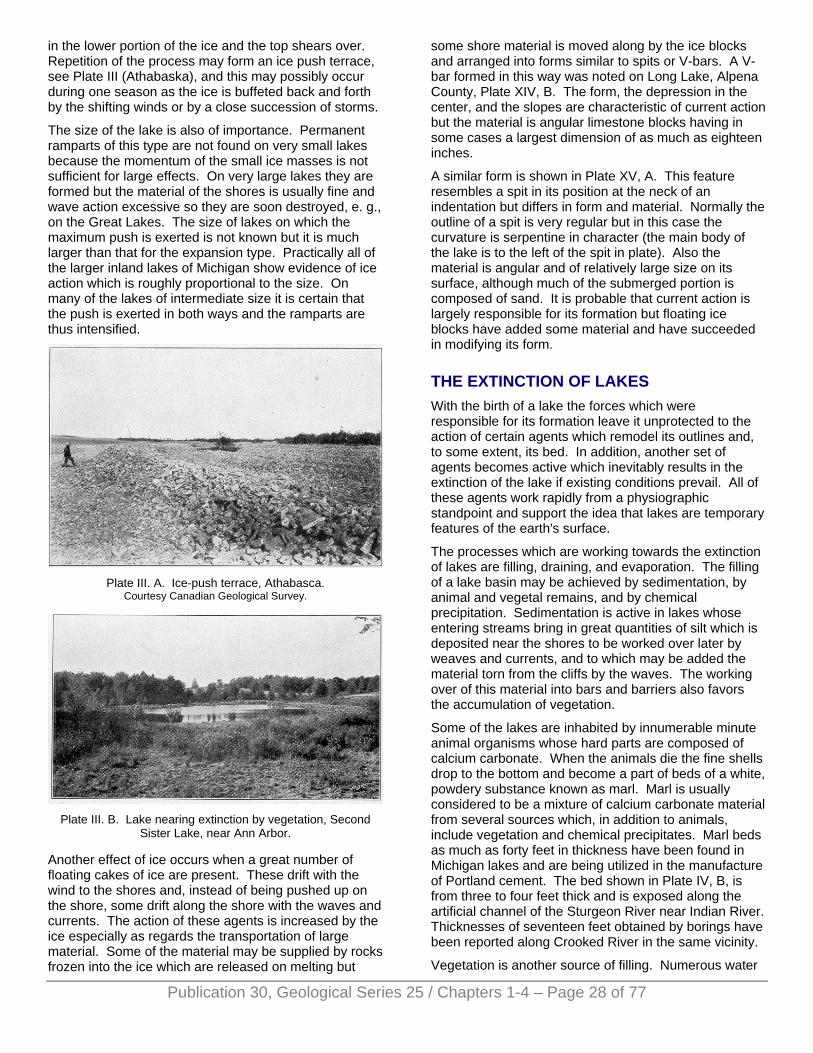
in the lower portion of the ice and the top shears over. Repetition of the process may form an ice push terrace, see Plate III (Athabaska), and this may possibly occur during one season as the ice is buffeted back and forth by the shifting winds or by a close succession of storms.
The size of the lake is also of importance. Permanent ramparts of this type are not found on very small lakes because the momentum of the small ice masses is not sufficient for large effects. On very large lakes they are formed but the material of the shores is usually fine and wave action excessive so they are soon destroyed, e. g., on the Great Lakes. The size of lakes on which the maximum push is exerted is not known but it is much larger than that for the expansion type. Practically all of the larger inland lakes of Michigan show evidence of ice action which is roughly proportional to the size. On many of the lakes of intermediate size it is certain that the push is exerted in both ways and the ramparts are thus intensified.
Plate III. A. Ice-push terrace, Athabasca.
Courtesy Canadian Geological Survey.
Plate III. B. Lake nearing extinction by vegetation, Second
Sister Lake, near Ann Arbor.
Another effect of ice occurs when a great number of floating cakes of ice are present. These drift with the wind to the shores and, instead of being pushed up on the shore, some drift along the shore with the waves and currents. The action of these agents is increased by the ice especially as regards the transportation of large material. Some of the material may be supplied by rocks frozen into the ice which are released on melting but
some shore material is moved along by the ice blocks and arranged into forms similar to spits or V-bars. A V-bar formed in this way was noted on Long Lake, Alpena County, Plate XIV, B. The form, the depression in the center, and the slopes are characteristic of current action but the material is angular limestone blocks having in some cases a largest dimension of as much as eighteen inches.
A similar form is shown in Plate XV, A. This feature resembles a spit in its position at the neck of an indentation but differs in form and material. Normally the outline of a spit is very regular but in this case the curvature is serpentine in character (the main body of the lake is to the left of the spit in plate). Also the material is angular and of relatively large size on its surface, although much of the submerged portion is composed of sand. It is probable that current action is largely responsible for its formation but floating ice blocks have added some material and have succeeded in modifying its form.
THE EXTINCTION OF LAKES With the birth of a lake the forces which were responsible for its formation leave it unprotected to the action of certain agents which remodel its outlines and, to some extent, its bed. In addition, another set of agents becomes active which inevitably results in the extinction of the lake if existing conditions prevail. All of these agents work rapidly from a physiographic standpoint and support the idea that lakes are temporary features of the earth's surface.
The processes which are working towards the extinction of lakes are filling, draining, and evaporation. The filling of a lake basin may be achieved by sedimentation, by animal and vegetal remains, and by chemical precipitation. Sedimentation is active in lakes whose entering streams bring in great quantities of silt which is deposited near the shores to be worked over later by weaves and currents, and to which may be added the material torn from the cliffs by the waves. The working over of this material into bars and barriers also favors the accumulation of vegetation.
Some of the lakes are inhabited by innumerable minute animal organisms whose hard parts are composed of calcium carbonate. When the animals die the fine shells drop to the bottom and become a part of beds of a white, powdery substance known as marl. Marl is usually considered to be a mixture of calcium carbonate material from several sources which, in addition to animals, include vegetation and chemical precipitates. Marl beds as much as forty feet in thickness have been found in Michigan lakes and are being utilized in the manufacture of Portland cement. The bed shown in Plate IV, B, is from three to four feet thick and is exposed along the artificial channel of the Sturgeon River near Indian River. Thicknesses of seventeen feet obtained by borings have been reported along Crooked River in the same vicinity.
Vegetation is another source of filling. Numerous water
Publication 30, Geological Series 25 / Chapters 1-4 – Page 28 of 77
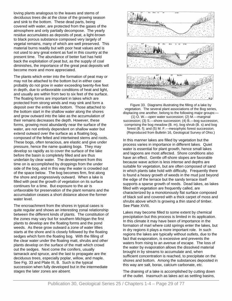
loving plants analogous to the leaves and stems of deciduous trees die at the close of the growing season and sink to the bottom. These dead parts, being covered with water, are protected from the gases of the atmosphere and only partially decompose. The yearly residue accumulates as deposits of peat, a light-brown to black porous substance composed very largely of vegetal remains, many of which are well preserved. This material burns readily but with poor heat values and is not used to any great extent as fuel in this country at the present time. The abundance of better fuel has held back the exploitation of peat but, as the supply of coal diminishes, the importance of the great peat deposits will become more and more appreciated.
The plants which enter into the formation of peat may or may not be attached to the bottom but in either case probably do not grow in water exceeding twenty-five feet in depth, due to unfavorable conditions of heat and light, and usually are within from two to six feet of the surface. The floating forms are important in lakes which are protected from strong winds and may sink and form a deposit over the entire lake bottom. Those attached to the bottom start in the shallow water along the shores and grow outward into the lake as the accumulation of their remains decreases the depth. However, these forms, growing most abundantly near the surface of the water, are not entirely dependent on shallow water but extend outward over the surface as a floating bog, composed of the felted and intertwined stems and roots. These bogs, often tenacious, are elastic and give under pressure, hence the name quaking bogs. They may develop so rapidly as to cover the surface of the lake before the basin is completely filled and are thus underlain by clear water. The development from this time on is accomplished by droppings from the under side of the bog, and in this way the water is crowded out of the space below. The bog becomes firm, first along the shore and progressively outward. When a lake is filled with peat the growth of vegetation on its surface continues for a time. But exposure to the air is unfavorable for preservation of the plant remains and the accumulation ceases a short distance above the former water level.
The encroachment from the shores in typical cases is quite regular and shows an interesting zonal relationship between the different kinds of plants. The constitution of the zones may vary but for southern Michigan the first plants to develop are the floating forms and the pond weeds. As these grow outward a zone of water lillies starts at the shore and is closely followed by the floating sedges which form the floating bog. With the filling of the clear water under the floating matt, shrubs and other plants develop on the surface of the matt which crowd out the sedges. Next come the conifers, usually tamarack and spruce, and the last to propagate are the deciduous trees, especially poplar, willow, and maple. See Fig. 33 and Plate III, B. Such is the typical succession when fully developed but in the intermediate stages the later zones are absent.
Figure 33. Diagrams illustrating the filling of a lake by
vegetation. The several plant associations of the Bog series, displacing one another, belong to the following major groups:—
(1) O. W.—open water succession; (2) M.—marginal succession; (3) S.—shore succession; (4) B.—bog succession, comprising the bog meadow (B. m), bog shrub (B. s) and bog
forest (B. f); and (5) M. F.—mesophytic forest succession. (Reproduced from Bulletin 16, Geological Survey of Ohio.)
In this manner lakes are filled by vegetation but the process varies in importance in different lakes. Quiet water is essential for plant growth, hence small lakes and lagoons are most affected. Shore conditions also have an effect. Gentle off-shore slopes are favorable because wave action is less intense and depths are suitable for vegetation, but are often composed of sand in which plants take hold with difficulty. Frequently there is found a heavy growth of weeds in the mud just beyond the edge of the terrace but the sandy terrace itself supports a sparse growth of reeds. Dead lakes, as lakes filled with vegetation are frequently called, are characterized by a monotonously flat surface composed of black soil and covered with a thick carpet of moss and shrubs above which Is growing a thin stand of timber. See Plate XVIII.
Lakes may become filled to some extent by chemical precipitation but this process is limited in its application. In this climate it may have been of importance in the formation of marl where cold springs enter the lakes, but in dry regions it plays a more important role. In such regions the lakes are typically without outlets, due to the fact that evaporation, is excessive and prevents the waters from rising to an avenue of escape. The loss of the water by evaporation allows the dissolved material brought in by streams to accumulate and, when sufficient concentration is reached, to precipitate on the shores and bottom. Among the substances deposited in this way are salt, borax, calcium carbonate, etc.
The draining of a lake is accomplished by cutting down of the outlet. Inasmuch as lakes act as settling basins,
Publication 30, Geological Series 25 / Chapters 1-4 – Page 29 of 77

Publication 30, Geological Series 25 / Chapters 1-4 – Page 30 of 77
the outlets are relatively free from sediment and in general cut very slowly. The size and velocity of the outlet, and the resistance that the material over which it flows offers to abrasion, determine the rate of down cutting. Certain lakes, on account of their depth reaching below sea level, cannot be drained under existing conditions but, with the cooperation of filling, extinction is always a possibility.
Changes in climate are necessary for the extinction of lakes by evaporation and the change must be such that the supply of water is decreased or the evaporation greatly increased. A more arid climate supplies both conditions and is usually accompanied by an increase in temperature. Many examples of partial or total extinction from this cause are to be found in the arid west but none in Michigan. Great Salt Lake, which has been greatly lowered in level in this way, is one of the best known examples.
The relative importance of the different methods of extinction varies greatly in different regions and with individual lakes. In general, the outlet is deepened rapidly in unconsolidated rocks, but even in hard rock this may be true if the down-cutting is due to the recession of a waterfall, such as Niagara Falls in the outlet of Lake Erie. As a rule deposition is more important than draining but in Michigan this is probably not the case. Down-cutting of the outlet is important because the great majority of the outlet streams run over unconsolidated glacial material which is readily eroded without the help of tools. On the other hand deposition has been slight. Many of the lakes are fed by springs and the drift deposits have as yet been only slightly trenched by streams, in most areas the original slopes being almost intact. In addition, the streams are usually short and the areas draining into the lakes small. An exceptional case is Torch Lake near Houghton where the Sturgeon river has built a large delta at the southern end of the lake. A more important source of material in our lakes is the cliffs which sometimes form a large part of the shores. The cliffs, composed almost entirely of unconsolidated material, are easily eroded by the waves and the debris is distributed along the shores and bottom. It is possible that the enlargement of the lake by shore recession may equal the amount of filling. Where cliffs form a considerable part of the shores the filling must be greater; and the ratio increases according to the height and preponderance of the cliffs. It is probable, however, that the amount of deposition in the lakes of Michigan so far has been a matter of a few inches only on the bottom.
At the present time, draining is probably more important than filling, but with future development the down-cutting of the outlets will gradually decrease as the streams approach grade, and the sediment brought in by tributary streams must increase as these streams extend their courses. At the same time the material deposited by waves and currents will decrease as the terraces widen. The deposition of part of this material in shore-forms reduces the size of the lake by cutting off indentations
and thus facilitates filling, both in the main body of the lake and in the lagoons. Vegetal accumulation seems to be more important in the extinction of lakes In Michigan than either of the two processes discussed above and is especially effective in the smaller lakes and lagoons. It is impossible to give an estimate of the amount of filling that has been accomplished in this way, but the prevalence of "dead lakes" and quaking bogs indicates that vegetal accumulations are of frequent occurence. All peat deposits are not necessarily evidence that a lake basin has been filled, and it is only by a determination of the depth and distribution of the peat and in some cases a recognition of plant zones that the extinction can be proven.
As regards chemical precipitation, marl is practically the only deposit of any significance in the lakes of the State and it may be formed in other ways. Three factors may be active in its formation, plants, animals, and chemical precipitation, and their relative importance is not known. In general, marl is one of the first deposits to be formed on a lake bottom and is often covered with peat. It may be sufficient in itself to fill a lake basin but no cases of such filling have been described in the knowledge of the writer.
THE CYCLE OF SHORE DEVELOPMENT In the preceding pages the development of lake shores under the Influence of waves and currents has been traced. This development is gradual and systematic, and the various stages are marked by definite topographic forms. In other words, the shores pass through a cycle of events which begin with the birth of the lake and terminate when the waves and currents are impotent to further modify them. A change in water level, either up or down, institutes a new cycle which may or may not Interrupt the previous one before it is completed. Following the practice with regard to streams, the stages in the cycle have been likened to the life cycle and are termed youth, maturity, and old age. These terms, in a general way only, indicate corresponding lengths of time during which the forces have been active, but conditions, both as to the constitution of the shores and the force of the waves and currents, are so variable that the emphasis should be placed on the stage of development rather than on the time element.
The youthful stage is a period of active erosion. The shore is marked by irregularities above and below water level, and a general lack of adjustment to the movements of the water. The presence of frequent headlands necessitates numerous bays with sharp curves and the shore currents are consequently poorly defined and discontinuous. As the headlands are reduced and irregularities of the bottom filled, the currents Increase in strength and continuity, and eventually simplify the shoreline by cutting off re-entrants. Youth, then, is a time of relatively rapid changes and is brought to a close when all possible cut-offs have been accomplished.
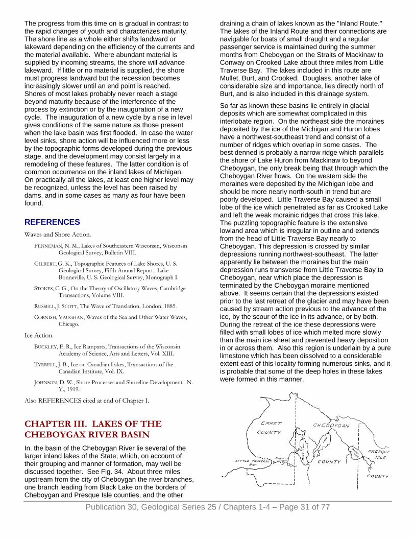
The progress from this time on is gradual in contrast to the rapid changes of youth and characterizes maturity. The shore line as a whole either shifts landward or lakeward depending on the efficiency of the currents and the material available. Where abundant material is supplied by incoming streams, the shore will advance lakeward. If little or no material is supplied, the shore must progress landward but the recession becomes increasingly slower until an end point is reached. Shores of most lakes probably never reach a stage beyond maturity because of the interference of the process by extinction or by the inauguration of a new cycle. The inauguration of a new cycle by a rise in level gives conditions of the same nature as those present when the lake basin was first flooded. In case the water level sinks, shore action will be influenced more or less by the topographic forms developed during the previous stage, and the development may consist largely in a remodeling of these features. The latter condition is of common occurrence on the inland lakes of Michigan. On practically all the lakes, at least one higher level may be recognized, unless the level has been raised by dams, and in some cases as many as four have been found.
REFERENCES Waves and Shore Action.
FENNEMAN, N. M., Lakes of Southeastern Wisconsin, Wisconsin Geological Survey, Bulletin VIII.
GILBERT, G. K., Topographic Features of Lake Shores, U. S. Geological Survey, Fifth Annual Report. Lake Bonneville, U. S. Geological Survey, Monograph I.
STOKES, C. G., On the Theory of Oscillatory Waves, Cambridge Transactions, Volume VIII.
RUSSELL, J. SCOTT, The Wave of Translation, London, 1885.
CORNISH, VAUGHAN, Waves of the Sea and Other Water Waves, Chicago.
Ice Action.
BUCKLEY, E. R., Ice Ramparts, Transactions of the Wisconsin Academy of Science, Arts and Letters, Vol. XIII.
TYRRELL, J. B., Ice on Canadian Lakes, Transactions of the Canadian Institute, Vol. IX.
JOHNSON, D. W., Shore Processes and Shoreline Development. N. Y., 1919.
Also REFERENCES cited at end of Chapter I.
CHAPTER III. LAKES OF THE CHEBOYGAX RIVER BASIN In. the basin of the Cheboygan River lie several of the larger inland lakes of the State, which, on account of their grouping and manner of formation, may well be discussed together. See Fig. 34. About three miles upstream from the city of Cheboygan the river branches, one branch leading from Black Lake on the borders of Cheboygan and Presque Isle counties, and the other
draining a chain of lakes known as the "Inland Route." The lakes of the Inland Route and their connections are navigable for boats of small draught and a regular passenger service is maintained during the summer months from Cheboygan on the Straits of Mackinaw to Conway on Crooked Lake about three miles from Little Traverse Bay. The lakes included in this route are Mullet, Burt, and Crooked. Douglass, another lake of considerable size and importance, lies directly north of Burt, and is also included in this drainage system.
So far as known these basins lie entirely in glacial deposits which are somewhat complicated in this interlobate region. On the northeast side the moraines deposited by the ice of the Michigan and Huron lobes have a northwest-southeast trend and consist of a number of ridges which overlap in some cases. The best denned is probably a narrow ridge which parallels the shore of Lake Huron from Mackinaw to beyond Cheboygan, the only break being that through which the Cheboygan River flows. On the western side the moraines were deposited by the Michigan lobe and should be more nearly north-south in trend but are poorly developed. Little Traverse Bay caused a small lobe of the ice which penetrated as far as Crooked Lake and left the weak morainic ridges that cross this lake. The puzzling topographic feature is the extensive lowland area which is irregular in outline and extends from the head of Little Traverse Bay nearly to Cheboygan. This depression is crossed by similar depressions running northwest-southeast. The latter apparently lie between the moraines but the main depression runs transverse from Little Traverse Bay to Cheboygan, near which place the depression is terminated by the Cheboygan moraine mentioned above. It seems certain that the depressions existed prior to the last retreat of the glacier and may have been caused by stream action previous to the advance of the ice, by the scour of the ice in its advance, or by both. During the retreat of the ice these depressions were filled with small lobes of ice which melted more slowly than the main ice sheet and prevented heavy deposition in or across them. Also this region is underlain by a pure limestone which has been dissolved to a considerable extent east of this locality forming numerous sinks, and it is probable that some of the deep holes in these lakes were formed in this manner.
Publication 30, Geological Series 25 / Chapters 1-4 – Page 31 of 77
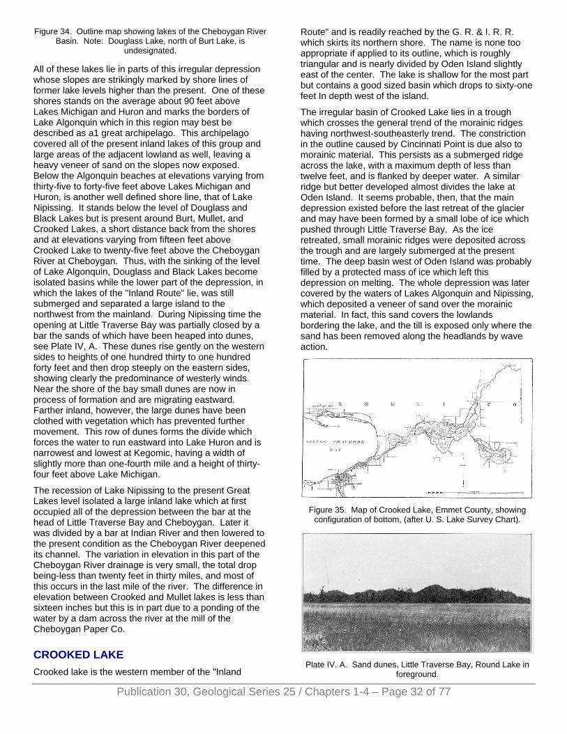
Figure 34. Outline map showing lakes of the Cheboygan River Basin. Note: Douglass Lake, north of Burt Lake, is
undesignated.
All of these lakes lie in parts of this irregular depression whose slopes are strikingly marked by shore lines of former lake levels higher than the present. One of these shores stands on the average about 90 feet above Lakes Michigan and Huron and marks the borders of Lake Algonquin which in this region may best be described as a1 great archipelago. This archipelago covered all of the present inland lakes of this group and large areas of the adjacent lowland as well, leaving a heavy veneer of sand on the slopes now exposed. Below the Algonquin beaches at elevations varying from thirty-five to forty-five feet above Lakes Michigan and Huron, is another well defined shore line, that of Lake Nipissing. It stands below the level of Douglass and Black Lakes but is present around Burt, Mullet, and Crooked Lakes, a short distance back from the shores and at elevations varying from fifteen feet above Crooked Lake to twenty-five feet above the Cheboygan River at Cheboygan. Thus, with the sinking of the level of Lake Algonquin, Douglass and Black Lakes become isolated basins while the lower part of the depression, in which the lakes of the "Inland Route" lie, was still submerged and separated a large island to the northwest from the mainland. During Nipissing time the opening at Little Traverse Bay was partially closed by a bar the sands of which have been heaped into dunes, see Plate IV, A. These dunes rise gently on the western sides to heights of one hundred thirty to one hundred forty feet and then drop steeply on the eastern sides, showing clearly the predominance of westerly winds. Near the shore of the bay small dunes are now in process of formation and are migrating eastward. Farther inland, however, the large dunes have been clothed with vegetation which has prevented further movement. This row of dunes forms the divide which forces the water to run eastward into Lake Huron and is narrowest and lowest at Kegomic, having a width of slightly more than one-fourth mile and a height of thirty-four feet above Lake Michigan.
The recession of Lake Nipissing to the present Great Lakes level isolated a large inland lake which at first occupied all of the depression between the bar at the head of Little Traverse Bay and Cheboygan. Later it was divided by a bar at Indian River and then lowered to the present condition as the Cheboygan River deepened its channel. The variation in elevation in this part of the Cheboygan River drainage is very small, the total drop being-less than twenty feet in thirty miles, and most of this occurs in the last mile of the river. The difference in elevation between Crooked and Mullet lakes is less than sixteen inches but this is in part due to a ponding of the water by a dam across the river at the mill of the Cheboygan Paper Co.
CROOKED LAKE Crooked lake is the western member of the "Inland
Route" and is readily reached by the G. R. & I. R. R. which skirts its northern shore. The name is none too appropriate if applied to its outline, which is roughly triangular and is nearly divided by Oden Island slightly east of the center. The lake is shallow for the most part but contains a good sized basin which drops to sixty-one feet In depth west of the island.
The irregular basin of Crooked Lake lies in a trough which crosses the general trend of the morainic ridges having northwest-southeasterly trend. The constriction in the outline caused by Cincinnati Point is due also to morainic material. This persists as a submerged ridge across the lake, with a maximum depth of less than twelve feet, and is flanked by deeper water. A similar ridge but better developed almost divides the lake at Oden Island. It seems probable, then, that the main depression existed before the last retreat of the glacier and may have been formed by a small lobe of ice which pushed through Little Traverse Bay. As the ice retreated, small morainic ridges were deposited across the trough and are largely submerged at the present time. The deep basin west of Oden Island was probably filled by a protected mass of ice which left this depression on melting. The whole depression was later covered by the waters of Lakes Algonquin and Nipissing, which deposited a veneer of sand over the morainic material. In fact, this sand covers the lowlands bordering the lake, and the till is exposed only where the sand has been removed along the headlands by wave action.
Figure 35. Map of Crooked Lake, Emmet County, showing
configuration of bottom, (after U. S. Lake Survey Chart).
Plate IV. A. Sand dunes, Little Traverse Bay, Round Lake in
foreground.
Publication 30, Geological Series 25 / Chapters 1-4 – Page 32 of 77
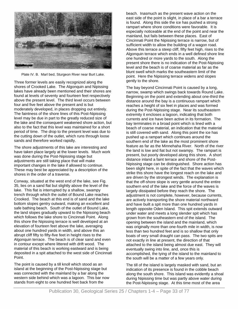
Plate IV. B. Marl bed, Sturgeon River near Burt Lake.
Three former levels are easily recognized along the shores of Crooked Lake. The Algonquin and Nipissing lakes have already been mentioned and their shores are found at levels of seventy and fourteen feet respectively above the present level. The third level occurs between four and five feet above the present and is but moderately developed, in places dropping out entirely. The faintness of the shore lines of this Post-Nipissing level may be due in part to the greatly reduced size of the lake and the consequent weakened shore action, but also to the fact that this level was maintained for a short period of time. The drop to the present level was due to the cutting down of the outlet, which runs through loose sands and therefore worked rapidly.
The shore adjustments of this lake are interesting and have taken place largely at the lower levels. Much work was done during the Post-Nipissing stage but adjustments are still taking place that will make important changes in the lake if allowed to continue. These may best be appreciated by a description of the shores in the order of a traverse.
Conway, situated at the west end of the lake, see Fig. 35, lies on a sand flat but slightly above the level of the lake. This flat is interrupted by a shallow, swampy trench through which the outlet of Bound Lake reaches Crooked. The beach at this end is of sand and the lake bottom slopes gentry outward, making an excellent and safe bathing beach. South of the outlet of Bound Lake, the land slopes gradually upward to the Nipissing beach which follows the lake shore to Cincinnati Point. Along this shore the Nipissing terrace is well developed at an elevation of fourteen feet above the lake, averaging about one hundred yards in width, and above this an abrupt cliff fifty to fifty-five feet in height rises to the Algonquin terrace. The beach is of clear sand and even in contour except where littered with drift wood. The material of this beach is working eastward and is being deposited in a spit attached to the west side of Cincinnati Point.
The point is caused by a till knoll which stood as an island at the beginning of the Post-Nipissing stage but was connected with the mainland by a bar along the western side behind which was a lagoon. This bar now stands from eight to one hundred feet back from the
beach. Inasmuch as the present wave action on the east side of the point is slight, in place of a bar a terrace is found. Along this side the ice has pushed a strong rampart where shore conditions were favorable. It is especially noticeable at the end of the point and near the mainland, but fails between these places. East of Cincinnati Point the Nipissing terrace is narrow, but of sufficient width to allow the building of a wagon road. Above this terrace a steep cliff, fifty feet high, rises to the Algonquin terrace which ends in a well defined shore line one hundred or more yards to the south. Along the present shore there is no indication of the Post-Nipissing level and the beach is of coarse material as far as the blunt swell which marks the southeastern limit of the point. Here the Nipissing terrace widens and slopes gently to the shore.
The bay beyond Cincinnati Point is caused by a long, narrow, swamp which swings back towards Round Lake. Beginning on the point and extending about one-third the distance around the bay is a continuous rampart which reaches a height of six feet in places and was formed during the Post-Nipissing stage. Near its southeastern extremity it encloses a lagoon, indicating that both currents and ice have been active in its formation. The bay terminates in a broad point which is lined with a beach of coarse material, an indication that the material is still covered with sand. Along this point the ice has pushed up a rampart which continues around the southern end of the lake as the most prominent shore feature as far as the Minnehaha River. North of the river the land is low and fiat but not swampy. The rampart is present, but poorly developed along this shore. A short distance inland a faint terrace and shore of the Post-Nipissing stage can be distinguished. Shore action has been slight here, in spite of the fact that the waves which strike this shore have the longest reach on the lake and are driven by the strongest winds. The explanation is that the off-shore slope is very gentle around the entire southern end of the lake and the force of the waves is largely dissipated before they reach the shore. The adjustment is not complete, however, because currents, are actively transporting the shore material northward and have built a spit more than one hundred yards in length opposite Oden Island. This spit extends outward under water and meets a long slender spit which has grown from the southeastern end of the island. The opening between the island and the mainland, which was originally more than one-fourth mile in width, is now less than two hundred feet and is so shallow that only boats of very small draught can pass. The two spits are not exactly in line at present, the direction of that attached to the island being almost due east. They will eventually swing into line, and, once this is accomplished, the tying of the island to the mainland to the south will be a matter of a few years only.
The till of the island is largely masked with sand, but an indication of its presence is found in the cobble beach along the south shore. This island was evidently a shoal during Nipissing time but was partly above water during the Post-Nipissing stage. At this time most of the area
Publication 30, Geological Series 25 / Chapters 1-4 – Page 33 of 77
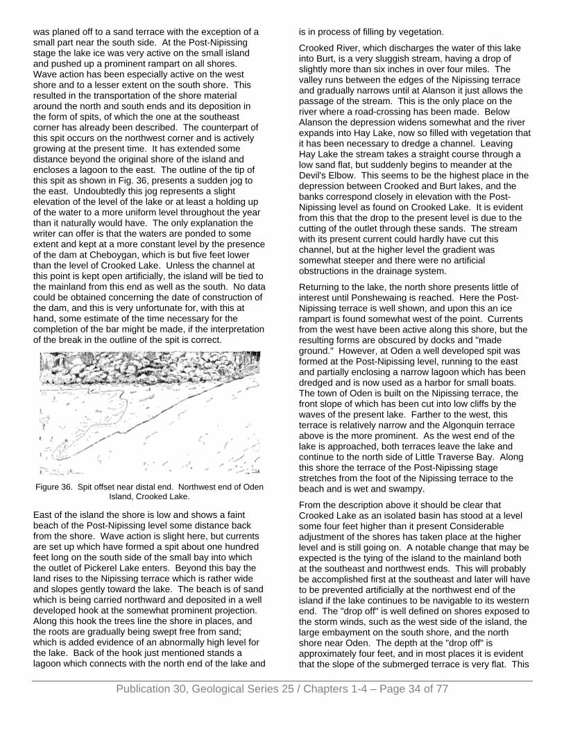
was planed off to a sand terrace with the exception of a small part near the south side. At the Post-Nipissing stage the lake ice was very active on the small island and pushed up a prominent rampart on all shores. Wave action has been especially active on the west shore and to a lesser extent on the south shore. This resulted in the transportation of the shore material around the north and south ends and its deposition in the form of spits, of which the one at the southeast corner has already been described. The counterpart of this spit occurs on the northwest corner and is actively growing at the present time. It has extended some distance beyond the original shore of the island and encloses a lagoon to the east. The outline of the tip of this spit as shown in Fig. 36, presents a sudden jog to the east. Undoubtedly this jog represents a slight elevation of the level of the lake or at least a holding up of the water to a more uniform level throughout the year than it naturally would have. The only explanation the writer can offer is that the waters are ponded to some extent and kept at a more constant level by the presence of the dam at Cheboygan, which is but five feet lower than the level of Crooked Lake. Unless the channel at this point is kept open artificially, the island will be tied to the mainland from this end as well as the south. No data could be obtained concerning the date of construction of the dam, and this is very unfortunate for, with this at hand, some estimate of the time necessary for the completion of the bar might be made, if the interpretation of the break in the outline of the spit is correct.
Figure 36. Spit offset near distal end. Northwest end of Oden
Island, Crooked Lake.
East of the island the shore is low and shows a faint beach of the Post-Nipissing level some distance back from the shore. Wave action is slight here, but currents are set up which have formed a spit about one hundred feet long on the south side of the small bay into which the outlet of Pickerel Lake enters. Beyond this bay the land rises to the Nipissing terrace which is rather wide and slopes gently toward the lake. The beach is of sand which is being carried northward and deposited in a well developed hook at the somewhat prominent projection. Along this hook the trees line the shore in places, and the roots are gradually being swept free from sand; which is added evidence of an abnormally high level for the lake. Back of the hook just mentioned stands a lagoon which connects with the north end of the lake and
is in process of filling by vegetation.
Crooked River, which discharges the water of this lake into Burt, is a very sluggish stream, having a drop of slightly more than six inches in over four miles. The valley runs between the edges of the Nipissing terrace and gradually narrows until at Alanson it just allows the passage of the stream. This is the only place on the river where a road-crossing has been made. Below Alanson the depression widens somewhat and the river expands into Hay Lake, now so filled with vegetation that it has been necessary to dredge a channel. Leaving Hay Lake the stream takes a straight course through a low sand flat, but suddenly begins to meander at the Devil's Elbow. This seems to be the highest place in the depression between Crooked and Burt lakes, and the banks correspond closely in elevation with the Post-Nipissing level as found on Crooked Lake. It is evident from this that the drop to the present level is due to the cutting of the outlet through these sands. The stream with its present current could hardly have cut this channel, but at the higher level the gradient was somewhat steeper and there were no artificial obstructions in the drainage system.
Returning to the lake, the north shore presents little of interest until Ponshewaing is reached. Here the Post-Nipissing terrace is well shown, and upon this an ice rampart is found somewhat west of the point. Currents from the west have been active along this shore, but the resulting forms are obscured by docks and "made ground." However, at Oden a well developed spit was formed at the Post-Nipissing level, running to the east and partially enclosing a narrow lagoon which has been dredged and is now used as a harbor for small boats. The town of Oden is built on the Nipissing terrace, the front slope of which has been cut into low cliffs by the waves of the present lake. Farther to the west, this terrace is relatively narrow and the Algonquin terrace above is the more prominent. As the west end of the lake is approached, both terraces leave the lake and continue to the north side of Little Traverse Bay. Along this shore the terrace of the Post-Nipissing stage stretches from the foot of the Nipissing terrace to the beach and is wet and swampy.
From the description above it should be clear that Crooked Lake as an isolated basin has stood at a level some four feet higher than it present Considerable adjustment of the shores has taken place at the higher level and is still going on. A notable change that may be expected is the tying of the island to the mainland both at the southeast and northwest ends. This will probably be accomplished first at the southeast and later will have to be prevented artificially at the northwest end of the island if the lake continues to be navigable to its western end. The "drop off" is well defined on shores exposed to the storm winds, such as the west side of the island, the large embayment on the south shore, and the north shore near Oden. The depth at the "drop off" is approximately four feet, and in most places it is evident that the slope of the submerged terrace is very flat. This
Publication 30, Geological Series 25 / Chapters 1-4 – Page 34 of 77
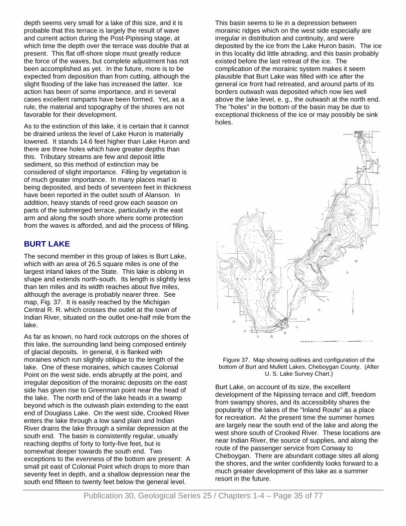
depth seems very small for a lake of this size, and it is probable that this terrace is largely the result of wave and current action during the Post-Pipissing stage, at which time the depth over the terrace was double that at present. This flat off-shore slope must greatly reduce the force of the waves, but complete adjustment has not been accomplished as yet. In the future, more is to be expected from deposition than from cutting, although the slight flooding of the lake has increased the latter. Ice action has been of some importance, and in several cases excellent ramparts have been formed. Yet, as a rule, the material and topography of the shores are not favorable for their development.
As to the extinction of this lake, it is certain that it cannot be drained unless the level of Lake Huron is materially lowered. It stands 14.6 feet higher than Lake Huron and there are three holes which have greater depths than this. Tributary streams are few and deposit little sediment, so this method of extinction may be considered of slight importance. Filling by vegetation is of much greater importance. In many places marl is being deposited, and beds of seventeen feet in thickness have been reported in the outlet south of Alanson. In addition, heavy stands of reed grow each season on parts of the submerged terrace, particularly in the east arm and along the south shore where some protection from the waves is afforded, and aid the process of filling.
BURT LAKE The second member in this group of lakes is Burt Lake, which with an area of 26.5 square miles is one of the largest inland lakes of the State. This lake is oblong in shape and extends north-south. Its length is slightly less than ten miles and its width reaches about five miles, although the average is probably nearer three. See map, Fig. 37. It is easily reached by the Michigan Central R. R. which crosses the outlet at the town of Indian River, situated on the outlet one-half mile from the lake.
As far as known, no hard rock outcrops on the shores of this lake, the surrounding land being composed entirely of glacial deposits. In general, it is flanked with moraines which run slightly oblique to the length of the lake. One of these moraines, which causes Colonial Point on the west side, ends abruptly at the point, and irregular deposition of the morainic deposits on the east side has given rise to Greenman point near the head of the lake. The north end of the lake heads in a swamp beyond which is the outwash plain extending to the east end of Douglass Lake. On the west side, Crooked River enters the lake through a low sand plain and Indian River drains the lake through a similar depression at the south end. The basin is consistently regular, usually reaching depths of forty to forty-five feet, but is somewhat deeper towards the south end. Two exceptions to the evenness of the bottom are present: A small pit east of Colonial Point which drops to more than seventy feet in depth, and a shallow depression near the south end fifteen to twenty feet below the general level.
This basin seems to lie in a depression between morainic ridges which on the west side especially are irregular in distribution and continuity, and were deposited by the ice from the Lake Huron basin. The ice in this locality did little abrading, and this basin probably existed before the last retreat of the ice. The complication of the morainic system makes it seem plausible that Burt Lake was filled with ice after the general ice front had retreated, and around parts of its borders outwash was deposited which now lies well above the lake level, e. g., the outwash at the north end. The "holes" in the bottom of the basin may be due to exceptional thickness of the ice or may possibly be sink holes.
Figure 37. Map showing outlines and configuration of the
bottom of Burt and Mullett Lakes, Cheboygan County. (After U. S. Lake Survey Chart.)
Burt Lake, on account of its size, the excellent development of the Nipissing terrace and cliff, freedom from swampy shores, and its accessibility shares the popularity of the lakes of the "Inland Route" as a place for recreation. At the present time the summer homes are largely near the south end of the lake and along the west shore south of Crooked River. These locations are near Indian River, the source of supplies, and along the route of the passenger service from Conway to Cheboygan. There are abundant cottage sites all along the shores, and the writer confidently looks forward to a much greater development of this lake as a summer resort in the future.
Publication 30, Geological Series 25 / Chapters 1-4 – Page 35 of 77
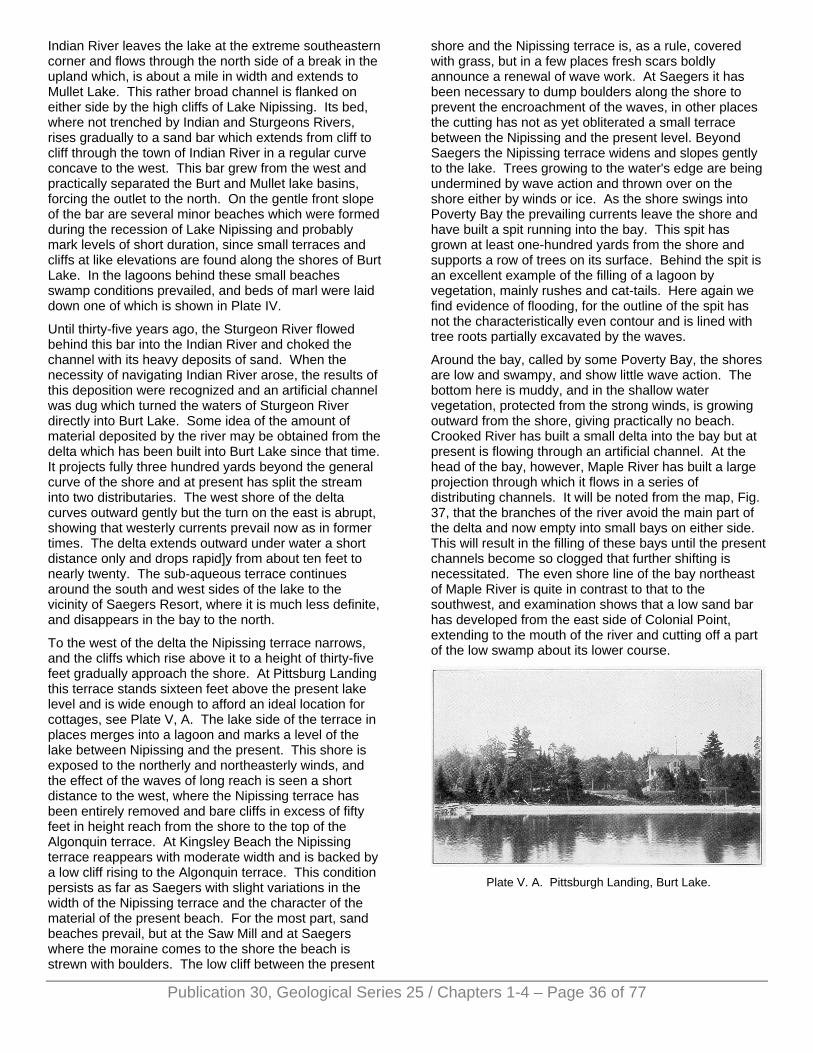
Indian River leaves the lake at the extreme southeastern corner and flows through the north side of a break in the upland which, is about a mile in width and extends to Mullet Lake. This rather broad channel is flanked on either side by the high cliffs of Lake Nipissing. Its bed, where not trenched by Indian and Sturgeons Rivers, rises gradually to a sand bar which extends from cliff to cliff through the town of Indian River in a regular curve concave to the west. This bar grew from the west and practically separated the Burt and Mullet lake basins, forcing the outlet to the north. On the gentle front slope of the bar are several minor beaches which were formed during the recession of Lake Nipissing and probably mark levels of short duration, since small terraces and cliffs at like elevations are found along the shores of Burt Lake. In the lagoons behind these small beaches swamp conditions prevailed, and beds of marl were laid down one of which is shown in Plate IV.
Until thirty-five years ago, the Sturgeon River flowed behind this bar into the Indian River and choked the channel with its heavy deposits of sand. When the necessity of navigating Indian River arose, the results of this deposition were recognized and an artificial channel was dug which turned the waters of Sturgeon River directly into Burt Lake. Some idea of the amount of material deposited by the river may be obtained from the delta which has been built into Burt Lake since that time. It projects fully three hundred yards beyond the general curve of the shore and at present has split the stream into two distributaries. The west shore of the delta curves outward gently but the turn on the east is abrupt, showing that westerly currents prevail now as in former times. The delta extends outward under water a short distance only and drops rapid]y from about ten feet to nearly twenty. The sub-aqueous terrace continues around the south and west sides of the lake to the vicinity of Saegers Resort, where it is much less definite, and disappears in the bay to the north.
To the west of the delta the Nipissing terrace narrows, and the cliffs which rise above it to a height of thirty-five feet gradually approach the shore. At Pittsburg Landing this terrace stands sixteen feet above the present lake level and is wide enough to afford an ideal location for cottages, see Plate V, A. The lake side of the terrace in places merges into a lagoon and marks a level of the lake between Nipissing and the present. This shore is exposed to the northerly and northeasterly winds, and the effect of the waves of long reach is seen a short distance to the west, where the Nipissing terrace has been entirely removed and bare cliffs in excess of fifty feet in height reach from the shore to the top of the Algonquin terrace. At Kingsley Beach the Nipissing terrace reappears with moderate width and is backed by a low cliff rising to the Algonquin terrace. This condition persists as far as Saegers with slight variations in the width of the Nipissing terrace and the character of the material of the present beach. For the most part, sand beaches prevail, but at the Saw Mill and at Saegers where the moraine comes to the shore the beach is strewn with boulders. The low cliff between the present
shore and the Nipissing terrace is, as a rule, covered with grass, but in a few places fresh scars boldly announce a renewal of wave work. At Saegers it has been necessary to dump boulders along the shore to prevent the encroachment of the waves, in other places the cutting has not as yet obliterated a small terrace between the Nipissing and the present level. Beyond Saegers the Nipissing terrace widens and slopes gently to the lake. Trees growing to the water's edge are being undermined by wave action and thrown over on the shore either by winds or ice. As the shore swings into Poverty Bay the prevailing currents leave the shore and have built a spit running into the bay. This spit has grown at least one-hundred yards from the shore and supports a row of trees on its surface. Behind the spit is an excellent example of the filling of a lagoon by vegetation, mainly rushes and cat-tails. Here again we find evidence of flooding, for the outline of the spit has not the characteristically even contour and is lined with tree roots partially excavated by the waves.
Around the bay, called by some Poverty Bay, the shores are low and swampy, and show little wave action. The bottom here is muddy, and in the shallow water vegetation, protected from the strong winds, is growing outward from the shore, giving practically no beach. Crooked River has built a small delta into the bay but at present is flowing through an artificial channel. At the head of the bay, however, Maple River has built a large projection through which it flows in a series of distributing channels. It will be noted from the map, Fig. 37, that the branches of the river avoid the main part of the delta and now empty into small bays on either side. This will result in the filling of these bays until the present channels become so clogged that further shifting is necessitated. The even shore line of the bay northeast of Maple River is quite in contrast to that to the southwest, and examination shows that a low sand bar has developed from the east side of Colonial Point, extending to the mouth of the river and cutting off a part of the low swamp about its lower course.
Plate V. A. Pittsburgh Landing, Burt Lake.
Publication 30, Geological Series 25 / Chapters 1-4 – Page 36 of 77
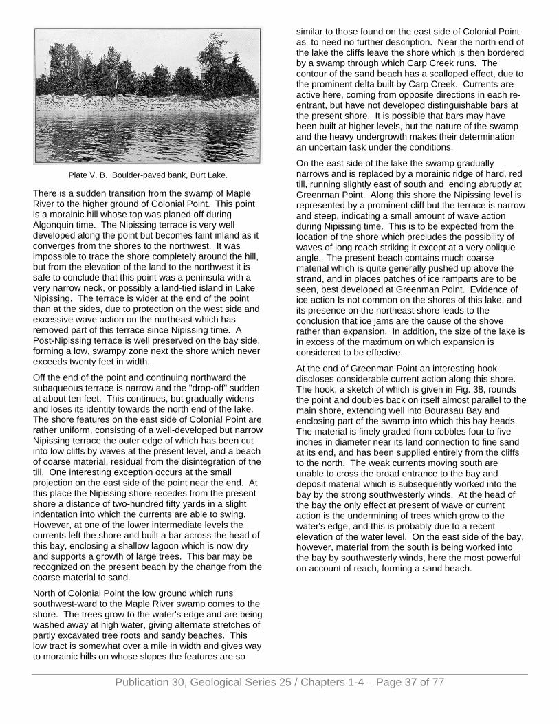
Plate V. B. Boulder-paved bank, Burt Lake.
There is a sudden transition from the swamp of Maple River to the higher ground of Colonial Point. This point is a morainic hill whose top was planed off during Algonquin time. The Nipissing terrace is very well developed along the point but becomes faint inland as it converges from the shores to the northwest. It was impossible to trace the shore completely around the hill, but from the elevation of the land to the northwest it is safe to conclude that this point was a peninsula with a very narrow neck, or possibly a land-tied island in Lake Nipissing. The terrace is wider at the end of the point than at the sides, due to protection on the west side and excessive wave action on the northeast which has removed part of this terrace since Nipissing time. A Post-Nipissing terrace is well preserved on the bay side, forming a low, swampy zone next the shore which never exceeds twenty feet in width.
Off the end of the point and continuing northward the subaqueous terrace is narrow and the "drop-off" sudden at about ten feet. This continues, but gradually widens and loses its identity towards the north end of the lake. The shore features on the east side of Colonial Point are rather uniform, consisting of a well-developed but narrow Nipissing terrace the outer edge of which has been cut into low cliffs by waves at the present level, and a beach of coarse material, residual from the disintegration of the till. One interesting exception occurs at the small projection on the east side of the point near the end. At this place the Nipissing shore recedes from the present shore a distance of two-hundred fifty yards in a slight indentation into which the currents are able to swing. However, at one of the lower intermediate levels the currents left the shore and built a bar across the head of this bay, enclosing a shallow lagoon which is now dry and supports a growth of large trees. This bar may be recognized on the present beach by the change from the coarse material to sand.
North of Colonial Point the low ground which runs southwest-ward to the Maple River swamp comes to the shore. The trees grow to the water's edge and are being washed away at high water, giving alternate stretches of partly excavated tree roots and sandy beaches. This low tract is somewhat over a mile in width and gives way to morainic hills on whose slopes the features are so
similar to those found on the east side of Colonial Point as to need no further description. Near the north end of the lake the cliffs leave the shore which is then bordered by a swamp through which Carp Creek runs. The contour of the sand beach has a scalloped effect, due to the prominent delta built by Carp Creek. Currents are active here, coming from opposite directions in each re-entrant, but have not developed distinguishable bars at the present shore. It is possible that bars may have been built at higher levels, but the nature of the swamp and the heavy undergrowth makes their determination an uncertain task under the conditions.
On the east side of the lake the swamp gradually narrows and is replaced by a morainic ridge of hard, red till, running slightly east of south and ending abruptly at Greenman Point. Along this shore the Nipissing level is represented by a prominent cliff but the terrace is narrow and steep, indicating a small amount of wave action during Nipissing time. This is to be expected from the location of the shore which precludes the possibility of waves of long reach striking it except at a very oblique angle. The present beach contains much coarse material which is quite generally pushed up above the strand, and in places patches of ice ramparts are to be seen, best developed at Greenman Point. Evidence of ice action Is not common on the shores of this lake, and its presence on the northeast shore leads to the conclusion that ice jams are the cause of the shove rather than expansion. In addition, the size of the lake is in excess of the maximum on which expansion is considered to be effective.
At the end of Greenman Point an interesting hook discloses considerable current action along this shore. The hook, a sketch of which is given in Fig. 38, rounds the point and doubles back on itself almost parallel to the main shore, extending well into Bourasau Bay and enclosing part of the swamp into which this bay heads. The material is finely graded from cobbles four to five inches in diameter near its land connection to fine sand at its end, and has been supplied entirely from the cliffs to the north. The weak currents moving south are unable to cross the broad entrance to the bay and deposit material which is subsequently worked into the bay by the strong southwesterly winds. At the head of the bay the only effect at present of wave or current action is the undermining of trees which grow to the water's edge, and this is probably due to a recent elevation of the water level. On the east side of the bay, however, material from the south is being worked into the bay by southwesterly winds, here the most powerful on account of reach, forming a sand beach.
Publication 30, Geological Series 25 / Chapters 1-4 – Page 37 of 77
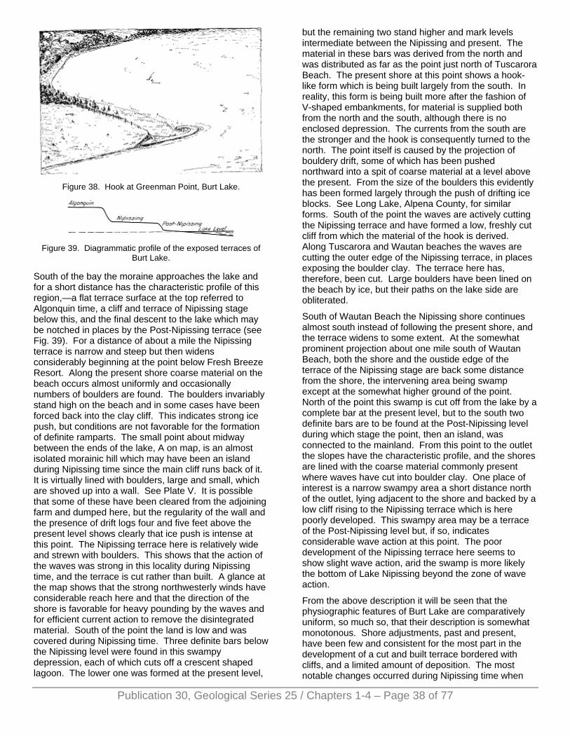
Figure 38. Hook at Greenman Point, Burt Lake.
Figure 39. Diagrammatic profile of the exposed terraces of
Burt Lake.
South of the bay the moraine approaches the lake and for a short distance has the characteristic profile of this region,—a flat terrace surface at the top referred to Algonquin time, a cliff and terrace of Nipissing stage below this, and the final descent to the lake which may be notched in places by the Post-Nipissing terrace (see Fig. 39). For a distance of about a mile the Nipissing terrace is narrow and steep but then widens considerably beginning at the point below Fresh Breeze Resort. Along the present shore coarse material on the beach occurs almost uniformly and occasionally numbers of boulders are found. The boulders invariably stand high on the beach and in some cases have been forced back into the clay cliff. This indicates strong ice push, but conditions are not favorable for the formation of definite ramparts. The small point about midway between the ends of the lake, A on map, is an almost isolated morainic hill which may have been an island during Nipissing time since the main cliff runs back of it. It is virtually lined with boulders, large and small, which are shoved up into a wall. See Plate V. It is possible that some of these have been cleared from the adjoining farm and dumped here, but the regularity of the wall and the presence of drift logs four and five feet above the present level shows clearly that ice push is intense at this point. The Nipissing terrace here is relatively wide and strewn with boulders. This shows that the action of the waves was strong in this locality during Nipissing time, and the terrace is cut rather than built. A glance at the map shows that the strong northwesterly winds have considerable reach here and that the direction of the shore is favorable for heavy pounding by the waves and for efficient current action to remove the disintegrated material. South of the point the land is low and was covered during Nipissing time. Three definite bars below the Nipissing level were found in this swampy depression, each of which cuts off a crescent shaped lagoon. The lower one was formed at the present level,
but the remaining two stand higher and mark levels intermediate between the Nipissing and present. The material in these bars was derived from the north and was distributed as far as the point just north of Tuscarora Beach. The present shore at this point shows a hook-like form which is being built largely from the south. In reality, this form is being built more after the fashion of V-shaped embankments, for material is supplied both from the north and the south, although there is no enclosed depression. The currents from the south are the stronger and the hook is consequently turned to the north. The point itself is caused by the projection of bouldery drift, some of which has been pushed northward into a spit of coarse material at a level above the present. From the size of the boulders this evidently has been formed largely through the push of drifting ice blocks. See Long Lake, Alpena County, for similar forms. South of the point the waves are actively cutting the Nipissing terrace and have formed a low, freshly cut cliff from which the material of the hook is derived. Along Tuscarora and Wautan beaches the waves are cutting the outer edge of the Nipissing terrace, in places exposing the boulder clay. The terrace here has, therefore, been cut. Large boulders have been lined on the beach by ice, but their paths on the lake side are obliterated.
South of Wautan Beach the Nipissing shore continues almost south instead of following the present shore, and the terrace widens to some extent. At the somewhat prominent projection about one mile south of Wautan Beach, both the shore and the oustide edge of the terrace of the Nipissing stage are back some distance from the shore, the intervening area being swamp except at the somewhat higher ground of the point. North of the point this swamp is cut off from the lake by a complete bar at the present level, but to the south two definite bars are to be found at the Post-Nipissing level during which stage the point, then an island, was connected to the mainland. From this point to the outlet the slopes have the characteristic profile, and the shores are lined with the coarse material commonly present where waves have cut into boulder clay. One place of interest is a narrow swampy area a short distance north of the outlet, lying adjacent to the shore and backed by a low cliff rising to the Nipissing terrace which is here poorly developed. This swampy area may be a terrace of the Post-Nipissing level but, if so, indicates considerable wave action at this point. The poor development of the Nipissing terrace here seems to show slight wave action, arid the swamp is more likely the bottom of Lake Nipissing beyond the zone of wave action.
From the above description it will be seen that the physiographic features of Burt Lake are comparatively uniform, so much so, that their description is somewhat monotonous. Shore adjustments, past and present, have been few and consistent for the most part in the development of a cut and built terrace bordered with cliffs, and a limited amount of deposition. The most notable changes occurred during Nipissing time when
Publication 30, Geological Series 25 / Chapters 1-4 – Page 38 of 77
Publication 30, Geological Series 25 / Chapters 1-4 – Page 39 of 77
the basins were cut off from the main lake and partially isolated. The change from Nipissing to the present level was accomplished slowly and with at least two intermediate levels, as shown by beaches and by slopes notched by wave action. The dropping in level was due to the cutting down of the Cheboygan River which varied in rate, due probably to variations in the constitution of the material of the moraine near Cheboygan. A closer packing of the till or heavy accumulation of boulders in the channel would hold up the waters for a time, but, with their removal accomplished, the downward cutting would be renewed.
The intermediate Post-Nipissing levels were of short duration and little work was done. The cliffs and terraces are faint where present and for the most part have been entirely removed by wave action during the present stage. In general, deposition was active in the past in the same localities as at present, but no important reduction in the size of the lake was accomplished by the development of bars across indentations. In fact, under the present conditions it is unlikely that any great changes in outline due to this cause will occur, except possibly at Greenman Point. Here the southerly winds seem to be able to distribute the material brought along the point, and the bay may be filled but not cut off. The only other large point, Colonial, is being attacked by the waves. Possibly the greatest development will be the delta of the Maple River which may fill the bay into which it flows. This depends largely on the rate of deposition, for it seems likely that this stream will be abandoned as an outlet of Douglass Lake (see description of this lake).
Wave action has predominated on this lake and the terraces are the prominent features on the slopes facing the shore. In some cases the Nipissing terrace is complete but, for the most part, has been cut into at lower levels. Under existing conditions, wave action is also the prominent agent, and a relatively narrow terrace and "drop off" is present, especially well developed along the sides and at the south end. The depth of water at its outside edge is between ten and eleven feet and this is much less than the wave base for this lake, which reaches a depth of at least thirty feet. In this case the submerged terrace has been formed mainly at the present level and indicates that the depth at which effective transportation of sand ceases is about one-third of the wave length during the greatest storms.
Burt Lake, on account of its size, depth, regular outline, and slight elevation above Lake Huron will become extinct very slowly. Filling by vegetation, although in progress, is not effective due mainly to the lack of protected shores. It is most active in the bay west of Colonial Point and in Bourasau Bay on the east side. Both of these bays support a heavy growth of rushes during the summer, and in the former marl covers much of the bottom. Considerable sediment is brought to the lake by streams but they supply only the minor part of the water of this lake. The presence of extended areas of sand in this locality increases the importance of
ground water over surface drainage, and much of the water is supplied from this source. In fact, there are but three streams of any importance which enter the lake—Sturgeon, Maple, and Carp—and of these Maple River may possibly be abandoned. There is the possibility that these streams will develop and drain much larger basins in the future, and make sedimentation a factor of importance. Deepening of the outlet at the present time is at a stand-still, due to human interference, and it seems probable that this will continue indefinitely. However, ignoring the human side and assuming that no obstruction will be present in the outlet, the amount of draining must necessarily be limited by the level of Lake Huron, whose present level is but fourteen feet lower than Burt Lake. Lowering of Burt Lake by fourteen feet would decrease its depth more than one-third, but the reduction in area would be relatively slight. Still, the shores would be much lower than at present and the muds of the present bottom would afford excellent conditions for a heavy and rapid growth of vegetation. Another possibility lies in the fact that the land is here rising very slowly, and the consequent dropping in the level of the Great Lakes would allow complete drainage of the lakes of the "Inland Route” provided the uplift continues for a long enough period of time.
MULLET LAKE A short distance east of Burt Lake and connected with it by the Indian River lies Mullet Lake, see map, Figure 37. These two lakes are very similar in shape and size, the greatest difference being in the orientation. Disregarding the extinct arm at the southwest end, Mullet Lake is almost identical in length with Burt Lake, and the average width and size, 26.8 square miles are not materially different. The outline of the shores shows considerable irregularity especially on the southeast side. The points for the most part run directly out into the lake and have about the same general direction as Colonial Point and the northeast shore of Burt Lake.
The surrounding country stands well above the lake and has a somewhat northwest-southeast trend, although this is none too apparent. Across this topography the deep basin of the lake extends as a part of the peculiar depression in which the "Inland Route" lakes lie. Curiously, the deepest part of Mullet Lake is situated in the constricted central portion, whereas the broad expanse at the north end is relatively shallow. Northeast of a line connecting Dodge and Needle points, the water rarely exceeds thirty feet in depth and is, furthermore, marked by several shoals more or less in line with these two points. The drop to deep water is gradual towards the southwest until a deep trough which runs along the narrow part of the lake is reached. This trough is in excess of one-hundred feet deep throughout and extends southwestward to a steep upward slope which follows a sinuous course northwesterly from McArthur Point. It is well defined and is bounded by steep slopes on all but the northeast side. Several "holes" exist in the bottom of the lake, the deepest lying off Long Point and
Publication 30, Geological Series 25 / Chapters 1-4 – Page 40 of 77
reaching a depth of one hundred forty-five feet. Another is Scotts Bay which drops to more than eighty-five feet.
The origin of the depression in which this chain of lakes lies has been discussed at the beginning of this chapter and in Chapter I. The pecularities of the shore line and the bed of the lake are explained by the distribution of the glacial formations. The last ice sheet covered this lake from the northeast and retreated in the same direction. The main depression was in existence previous to the advance of the ice and caused a local advance of the ice front. As the ice retreated over this country its front halted in the vicinity of Red Pine Point, building a moraine. The ice still filled the lake basin at this time, therefore the moraines do not cross the lake. On the west side of the lake, clay hills are present which are in line with Red Pine Point and the morainic ridge near the northeast end of Burt Lake, making it probable that this line marks a position of the ice front. In width the moraine reaches to Round Point and thus accounts for the narrow central part of the lake. This moraine is not of the distinct knob and basin type for it was deposited under the waters of a lake which washed the ice front and, therefore, shows much less relief. Furthermore, it was covered by Lake Algonquin, and, in addition to the planing off of the hilltops, a veneer of sand or clay, depending on the proximity to the shore, was deposited over much of this territory. This moraine is traced with difficulty and some doubt may be expressed as to the correctness of the interpretation given above. It may be that a stagnant block of ice occupied the deep trough of the lake, but at any rate, its border stood at one time at the steep slope running northwestward from McArthur Point. Two moraines also cross the course of the Cheboygan River, running in the same northwest-southeasterly direction. The first moraine crosses the river soon after leaving the lake and is bordered by an outwash plain which extends to the southwest and accounts for the shallow lower end of the lake. The Black River flows between this moraine and a narrow ridge in the vicinity of Cheboygan.
Upon leaving Burt Lake via Indian River, the amount of artificial control of the stream is somewhat surprising and bears strong evidence of the popularity of these lakes as summer resorts, for the main traffic through them is by resorters and tourists. The long piers, the dredged channel, and the diversion of the Sturgeon River into Burt Lake from Indian River are readily explained when it is realized that the drop from Burt Lake to Mullet is less than one foot, most of which occurs in the first mile and a half. Also, the valley spreads to a width of more than one-half mile south of Indian River and becomes a swampy mud-flat through which Indian River meanders. The stream was unable to keep a channel open at its mouth and in its lower course, which was undoubtedly a shallow arm of Mullet Lake now filled by the silt carried down by Sturgeon River before its diversion.
At the entrance to Mullet Lake proper a striking shore feature presents itself on the west side. Currents swinging along this shore from the north have deposited
their load of sand in a long, narrow spit which extends fully half way across the opening. At the end it turns back abruptly, and many of the trees which line it stand in water. These facts indicate an accident in the history of the lake,—the artificial raising of the water level by a dam at Cheboygan. Under normal conditions the spit would have continued straight across the indentation, forcing Indian River to the extreme south side. Under the present .conditions the spit must become adjusted to the higher level, and the probable course of events will be a slow increase in the irregularity of its contour until the trees are removed. Then the work will proceed more rapidly, and the bar be reformed farther back in the swamp, probably in line with the sharp point on the opposite bank, as indicated by the direction of the hook. Mullet Lake illustrates excellently the renewal of activity on lakes whose level has been raised, and further evidence may be found within sight of the bar in the freshly cut cliff to the west which is pounded by the waves driven by the powerful north and northeasterly winds.
Along this shore the rolling topography is covered with sand, but, where sections are exposed, boulder clay, or till, is usually exposed underneath. The till is seen on the cliffs and is much more resistant to wave action than the sand which comes to the shore in the depressions, giving rise to small projections of the shore, as at Cold Springs. The cobbles and, boulders of the beach, indicate till from which the finer particles have been removed. North of Cold Springs a depression extended below lake level and has not only been isolated by a bar but filled. Across this extinct lagoon the Michigan Central R. R. has built an embankment. The raised water level is very evident on this shore from the presence of great quantities of driftwood and from the trees whose roots are washed by the waves.
Near Topinabee, however, the .slopes of the main depression in which this lake lies approach the shore, and the banks are somewhat higher. The slopes are composed of till and much coarse material is found on the beach, which has been pushed into a feeble rampart or lined along the shore by ice action. Topinabee is one of the important resorts of the lakes of the "Inland Route" and there is a geographic reason for this. Along the shore are found a series of terraces and cliffs which mark the higher levels at which the lake formerly stood. The diagram of the terraces on Burt Lake, Fig. 39, will perhaps give an adequate idea of the relations of these terraces. Next the shore a low cliff is found locally which is receding into a terrace about four feet above the present level. This terrace reaches a width of fifty feet at Topinabee and is flanked on the land side by a low grass-covered slope, the bottom of which marks the shore line at the time when the lake stood at this level. Above this cliff is a much wider terrace which gradually rises to a height of sixteen to seventeen feet above the lake and ends abruptly in a steep cliff more than forty feet high. This cliff and terrace were formed by Lake Nipissing and are continuous with those found at approximately the same level on Burt and Crooked
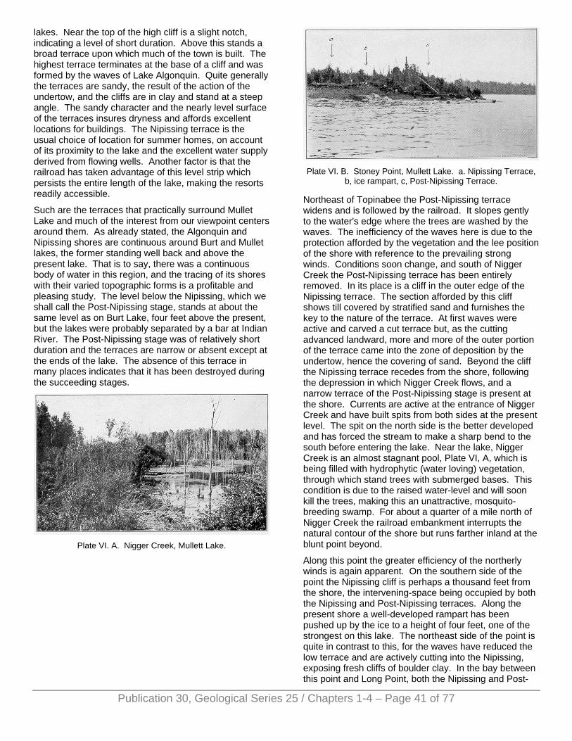
lakes. Near the top of the high cliff is a slight notch, indicating a level of short duration. Above this stands a broad terrace upon which much of the town is built. The highest terrace terminates at the base of a cliff and was formed by the waves of Lake Algonquin. Quite generally the terraces are sandy, the result of the action of the undertow, and the cliffs are in clay and stand at a steep angle. The sandy character and the nearly level surface of the terraces insures dryness and affords excellent locations for buildings. The Nipissing terrace is the usual choice of location for summer homes, on account of its proximity to the lake and the excellent water supply derived from flowing wells. Another factor is that the railroad has taken advantage of this level strip which persists the entire length of the lake, making the resorts readily accessible.
Such are the terraces that practically surround Mullet Lake and much of the interest from our viewpoint centers around them. As already stated, the Algonquin and Nipissing shores are continuous around Burt and Mullet lakes, the former standing well back and above the present lake. That is to say, there was a continuous body of water in this region, and the tracing of its shores with their varied topographic forms is a profitable and pleasing study. The level below the Nipissing, which we shall call the Post-Nipissing stage, stands at about the same level as on Burt Lake, four feet above the present, but the lakes were probably separated by a bar at Indian River. The Post-Nipissing stage was of relatively short duration and the terraces are narrow or absent except at the ends of the lake. The absence of this terrace in many places indicates that it has been destroyed during the succeeding stages.
Plate VI. A. Nigger Creek, Mullett Lake.
Plate VI. B. Stoney Point, Mullett Lake. a. Nipissing Terrace,
b, ice rampart, c, Post-Nipissing Terrace.
Northeast of Topinabee the Post-Nipissing terrace widens and is followed by the railroad. It slopes gently to the water's edge where the trees are washed by the waves. The inefficiency of the waves here is due to the protection afforded by the vegetation and the lee position of the shore with reference to the prevailing strong winds. Conditions soon change, and south of Nigger Creek the Post-Nipissing terrace has been entirely removed. In its place is a cliff in the outer edge of the Nipissing terrace. The section afforded by this cliff shows till covered by stratified sand and furnishes the key to the nature of the terrace. At first waves were active and carved a cut terrace but, as the cutting advanced landward, more and more of the outer portion of the terrace came into the zone of deposition by the undertow, hence the covering of sand. Beyond the cliff the Nipissing terrace recedes from the shore, following the depression in which Nigger Creek flows, and a narrow terrace of the Post-Nipissing stage is present at the shore. Currents are active at the entrance of Nigger Creek and have built spits from both sides at the present level. The spit on the north side is the better developed and has forced the stream to make a sharp bend to the south before entering the lake. Near the lake, Nigger Creek is an almost stagnant pool, Plate VI, A, which is being filled with hydrophytic (water loving) vegetation, through which stand trees with submerged bases. This condition is due to the raised water-level and will soon kill the trees, making this an unattractive, mosquito-breeding swamp. For about a quarter of a mile north of Nigger Creek the railroad embankment interrupts the natural contour of the shore but runs farther inland at the blunt point beyond.
Along this point the greater efficiency of the northerly winds is again apparent. On the southern side of the point the Nipissing cliff is perhaps a thousand feet from the shore, the intervening-space being occupied by both the Nipissing and Post-Nipissing terraces. Along the present shore a well-developed rampart has been pushed up by the ice to a height of four feet, one of the strongest on this lake. The northeast side of the point is quite in contrast to this, for the waves have reduced the low terrace and are actively cutting into the Nipissing, exposing fresh cliffs of boulder clay. In the bay between this point and Long Point, both the Nipissing and Post-
Publication 30, Geological Series 25 / Chapters 1-4 – Page 41 of 77
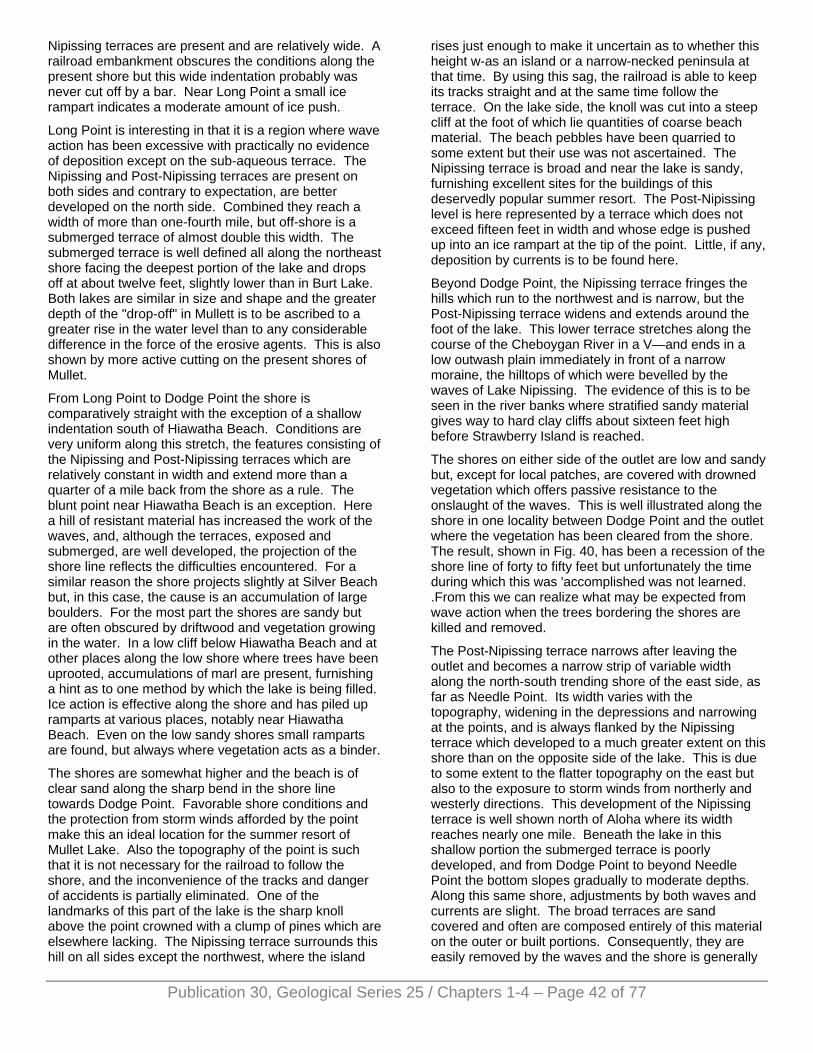
Publication 30, Geological Series 25 / Chapters 1-4 – Page 42 of 77
Nipissing terraces are present and are relatively wide. A railroad embankment obscures the conditions along the present shore but this wide indentation probably was never cut off by a bar. Near Long Point a small ice rampart indicates a moderate amount of ice push.
Long Point is interesting in that it is a region where wave action has been excessive with practically no evidence of deposition except on the sub-aqueous terrace. The Nipissing and Post-Nipissing terraces are present on both sides and contrary to expectation, are better developed on the north side. Combined they reach a width of more than one-fourth mile, but off-shore is a submerged terrace of almost double this width. The submerged terrace is well defined all along the northeast shore facing the deepest portion of the lake and drops off at about twelve feet, slightly lower than in Burt Lake. Both lakes are similar in size and shape and the greater depth of the "drop-off" in Mullett is to be ascribed to a greater rise in the water level than to any considerable difference in the force of the erosive agents. This is also shown by more active cutting on the present shores of Mullet.
From Long Point to Dodge Point the shore is comparatively straight with the exception of a shallow indentation south of Hiawatha Beach. Conditions are very uniform along this stretch, the features consisting of the Nipissing and Post-Nipissing terraces which are relatively constant in width and extend more than a quarter of a mile back from the shore as a rule. The blunt point near Hiawatha Beach is an exception. Here a hill of resistant material has increased the work of the waves, and, although the terraces, exposed and submerged, are well developed, the projection of the shore line reflects the difficulties encountered. For a similar reason the shore projects slightly at Silver Beach but, in this case, the cause is an accumulation of large boulders. For the most part the shores are sandy but are often obscured by driftwood and vegetation growing in the water. In a low cliff below Hiawatha Beach and at other places along the low shore where trees have been uprooted, accumulations of marl are present, furnishing a hint as to one method by which the lake is being filled. Ice action is effective along the shore and has piled up ramparts at various places, notably near Hiawatha Beach. Even on the low sandy shores small ramparts are found, but always where vegetation acts as a binder.
The shores are somewhat higher and the beach is of clear sand along the sharp bend in the shore line towards Dodge Point. Favorable shore conditions and the protection from storm winds afforded by the point make this an ideal location for the summer resort of Mullet Lake. Also the topography of the point is such that it is not necessary for the railroad to follow the shore, and the inconvenience of the tracks and danger of accidents is partially eliminated. One of the landmarks of this part of the lake is the sharp knoll above the point crowned with a clump of pines which are elsewhere lacking. The Nipissing terrace surrounds this hill on all sides except the northwest, where the island
rises just enough to make it uncertain as to whether this height w-as an island or a narrow-necked peninsula at that time. By using this sag, the railroad is able to keep its tracks straight and at the same time follow the terrace. On the lake side, the knoll was cut into a steep cliff at the foot of which lie quantities of coarse beach material. The beach pebbles have been quarried to some extent but their use was not ascertained. The Nipissing terrace is broad and near the lake is sandy, furnishing excellent sites for the buildings of this deservedly popular summer resort. The Post-Nipissing level is here represented by a terrace which does not exceed fifteen feet in width and whose edge is pushed up into an ice rampart at the tip of the point. Little, if any, deposition by currents is to be found here.
Beyond Dodge Point, the Nipissing terrace fringes the hills which run to the northwest and is narrow, but the Post-Nipissing terrace widens and extends around the foot of the lake. This lower terrace stretches along the course of the Cheboygan River in a V—and ends in a low outwash plain immediately in front of a narrow moraine, the hilltops of which were bevelled by the waves of Lake Nipissing. The evidence of this is to be seen in the river banks where stratified sandy material gives way to hard clay cliffs about sixteen feet high before Strawberry Island is reached.
The shores on either side of the outlet are low and sandy but, except for local patches, are covered with drowned vegetation which offers passive resistance to the onslaught of the waves. This is well illustrated along the shore in one locality between Dodge Point and the outlet where the vegetation has been cleared from the shore. The result, shown in Fig. 40, has been a recession of the shore line of forty to fifty feet but unfortunately the time during which this was 'accomplished was not learned. .From this we can realize what may be expected from wave action when the trees bordering the shores are killed and removed.
The Post-Nipissing terrace narrows after leaving the outlet and becomes a narrow strip of variable width along the north-south trending shore of the east side, as far as Needle Point. Its width varies with the topography, widening in the depressions and narrowing at the points, and is always flanked by the Nipissing terrace which developed to a much greater extent on this shore than on the opposite side of the lake. This is due to some extent to the flatter topography on the east but also to the exposure to storm winds from northerly and westerly directions. This development of the Nipissing terrace is well shown north of Aloha where its width reaches nearly one mile. Beneath the lake in this shallow portion the submerged terrace is poorly developed, and from Dodge Point to beyond Needle Point the bottom slopes gradually to moderate depths. Along this same shore, adjustments by both waves and currents are slight. The broad terraces are sand covered and often are composed entirely of this material on the outer or built portions. Consequently, they are easily removed by the waves and the shore is generally
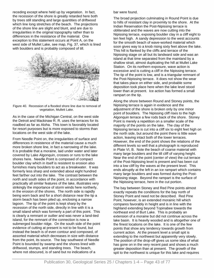
receding except where held up by vegetation. In fact, the recession of the shore is greatly retarded here both by trees still standing and large quantities of driftwood which line long stretches of the beach. The projections of the shore line are slight and blunt, and are due to irregularities in the original topography rather than to differences in the resistance of the material. One exception to this statement occurs at Point A, on the west side of Mullet Lake, see map, Fig. 37, which is lined with boulders and is probably composed of till.
Figure 40. Recession of a flooded shore line due to removal of
vegetation, Mullett Lake.
As in the case of the Michigan Central, on the west side the Detroit and Mackinaw R. R. uses the terraces for its roadbed as far as Aloha. This town is favorably located for resort purposes but is more exposed to storms than locations on the west side of the lake.
From Needle Point on, the irregularities of surface and differences in resistence of the material cause a much more broken shore line, in fact a narrowing of the lake. It is probable that a moraine, laid under water and later covered by Lake Algonquin, crosses or runs to the lake shores here. Needle Point is composed of compact boulder clay which in itself is resistent to erosion also furnishes many boulders to act as a breakwater. It was formerly less sharp and extended about eight hundred feet farther out into the lake. The contrast between the north and south sides of the point, in accordance with practically all similar features of the lake, illustrates very strikingly the importance of storm winds here northerly, in the erosion of the shores. The north side is rapidly being worn back and for a short distance near the tip a storm beach has been piled up, enclosing a narrow lagoon. The tip of the point is kept sharp by the recession of the north side, directly in line with it is a small island which was formerly a part of this point. This is clearly a remnant or outlier and was never a land-tied island, for the remnant of the connection is now a submerged boulder ridge. On the south side of the point evidence of cutting at present is not to be found, but instead the beach is of even contour and composed, of assorted material which decreases in size with distance from the point, its source. The bay southwest of Needle Point is bounded by swamp and the shores lined with driftwood, stumps, and standing trees. The beach, where not obscured, is of sand but no indications of a
bar were found.
The broad projection culminating in Round Point is due to hills of resistant clay in proximity to the shore. At the Indian Reservation the Post-Nipissing terrace is obliterated and the waves are now cutting into the Nipissing terrace, exposing boulder clay in a cliff eight to ten feet high. A sandy depression to the west accounts for the smooth beach of wave-worked material which soon gives way to a knob rising sixty feet above the lake. This hill is flanked by the cliffs and terrace of the Nipissing stage on all but its landward side and was an island at that time separated from the mainland by a shallow strait, almost duplicating the hill at Mullet Lake Station. On its northern exposure, wave action is excessive and is cutting a cliff in the Nipissing terrace. The tip of the point is low, and is a triangular remnant of the Post-Nipissing terrace. It does not show the wear that takes place on either side, and probable some deposition took place here when the lake level stood lower than at present. Ice action has formed a small rampart on the tip.
Along the shore between Round and Stoney points, the Nipissing terrace is again in evidence and the adjustment of the shore is broken only by one minor point of boulders. The Nipissing cliff rises to the high Algonquin terrace a few rods back of the shore. Stoney Point is merely a repetition on a smaller scale of the majority of the points on the lake. The clay of the Nipissing terrace is cut into a cliff six to eight feet high on the north side, but around the point there is little wave action, leaving intact both of the lower terraces. However, the end of the point shows the relations of the different levels so well that a photograph is reproduced in Plate VI, B. Note the beach of coarse material with many large boulders and the till cliff of varying height. Near the end of the point (center of view) the cut terrace of the Post-Nipissing level is present and has been cut into a low cliff by the waves at the present level. This ends abruptly at the left in an ice rampart which contains many large boulders and was formed during the Post-Nipissing stage. Beyond the rampart is the surface of the Nipissing terrace, here in the cut portion.
The bay between Stoney and Red Pine points almost exactly repeats the conditions for the bay north of Stoney Point and need not be described. Red Pine Point, however, is an extended morainic hill which compares favorably in height and is in line with the highland extending beyond Topinabee towards the northeast end of Burt Lake. This is probably an extension of a moraine but did not continue across the lake basin. It is heavily wooded and is altogether one of the finest locations on the lake. It is one of the few points that show any tendency towards growth from current action. At the present level a small spit is extending to the northwest but apparently very slowly. The position of the drop-off gives us some idea of what has gone on in the very recent past and shows a much greater deposition than at present. The growth of the spit to the northwest is unique for this lake and requires
Publication 30, Geological Series 25 / Chapters 1-4 – Page 43 of 77
Publication 30, Geological Series 25 / Chapters 1-4 – Page 44 of 77
explanation. The wind directions which may affect this point are about equally divided between the two sides, but in violence those from the northerly quadrant are the more important. Yet the force of the waves tossed by these winds is lessened by their passage across the gradually shoaling bottom, but on the southwest side the submerged terrace is narrow and the waves strike the shore with but slightly diminished intensity. Also the regular shore to the southwest with its nearly continuous cliffs furnishes abundant material and allows the development of a1 far more efficient current than is possible on the irregular, low shore north of the point.
The end of the point is the key to the events that have happened here. A fragment of the Post-Nipissing terrace is present whose cliff has been pushed into an ice rampart. Landward from this there is the distinct Nipissing terrace of moderate development. On this terrace, closely paralleling the ice rampart, is a strong bar which runs to the southeast, gradually crossing the terrace and merging into the Nipissing cliff. The cliff at the present level on the north side of the point cuts the bar at a sharp angle, furnishing an excellent cross section from which the relations are easily seen. The southeastern side has therefore been a point of departure of currents since the point has existed as such. The Nipissing terrace is narrow but distinct along this shore, and the cliff above it rises steeply to remnants of the Algonquin terrace on the hill top. The Post-Nipissing terrace has for the most part been cut away and the waves are now attacking the terrace above, forming cliffs five to eight feet high.
Scotts Bay is a deep depression and continues to the southeast as a low swamp which supports a heavy growth of vegetation. A narrow lagoon has been formed at the present level by the formation of a low storm beach, but the swamp as a whole was probably never cut off, although it is possible that a bar, thoroughly hidden by vegetation, may exist farther back. The Nipissing terrace swings far back around the swamp but reappears again at McArthur Point where hills of boulder clay stand near the lake. This point was originally of gentle slope towards the lake and the waves of Lake Nipissing quickly reduced it to an elongated terrace fully a half-mile in length. The depression in which the Pigeon River flows is so badly flooded that little could be determined as to the shores except on the south side where we leave the lake with the waves cutting back into the familiar Nipissing terrace.
A reading of the above description has no doubt left the impression that wave cutting is the important work being done on this lake at present. Current action at the present level assumes importance only on the west side of the inlet and at Nigger Creek. The latter probably will be able to maintain a channel through the bar but there is a possibility of greater growth at the entrance of Indian River. This bar should adjust itself to the higher level and extend to the other side, leaving a gap large enough to accommodate the flow of the stream. Undoubtedly other adjustments were made but have been destroyed
in recent times, as may be inferred from the study of Red Pine and Stoney points. The effects of the lifting of the water level are excellently illustrated on this lake. The flooded bays and inlets, the fresh cliffs and the trees standing in water, together with great quantities of driftwood which line the exposed shores stand as evidence of this fact. The future development of the shores of this lake must result from the increased activity of the waves and will consist at first in a recession of the shores. At present this is proceeding somewhat slowly as the shores are protected by vegetation, but it will increase when this protection is no longer available. Adjustment should occur first along the low shores and indentations since here the waves are working in the veneer of sand which covers the entire depression in which the lake lies. Still, such places are regions of deposition rather than degradation, and we may confidently look for a gradual building out of the beaches in such places, except in the limited number of bays where currents may leave the shore and form bars.
Evidences of ice action on this lake indicate moderate effects. Ramparts are found mainly on the points and are discontinuous and poorly developed. In the bays the material is sand and ramparts are not developed or, if so, are quickly reduced by the waves at the present period of excessive activity. We are uncertain as to the shore features of this lake under normal conditions, and encounter difficulties in attempting to discuss the relative importance of expansion and ice jam. In some of the bays expansion should be active, but in general the lake is too large for expansion and powerful ice jams are to be expected.
The agencies working towards the extinction of this lake are apparently making little headway. Filling of any sort is insignificant, especially since the diversion of the Sturgeon River into Burt Lake. Vegetation has made little progress in the main body of the lake on account of the excessive wave action, and there are few localities where it is likely that it can establish itself in the future. Some deposits of marl are present on the shores, it is true, but we can hardly look to this alone to fill such a large basin. The tributary streams are few and as yet have deposited little material. As these streams lengthen their courses, more sediment will be brought to the lake and filling from this source will increase. Aside from a change in climate which cannot be foreseen, there remains the cutting down of the outlet. With conditions as they are at present, this is impossible but might succeed in lowering the level to that of Lake Huron, fourteen feet lower, provided the dam at Cheboygan is not maintained. This would bring the level just low enough to expose the present submerged terrace and would not materially change or reduce the size of the lake except at the north end. However, the rising of the land to the northeast of the Great Lakes, in itself a slow process, increases the importance of the incision of the outlet, but an uplift of seventy-five feet or more is necessary if the lake is to be drained.
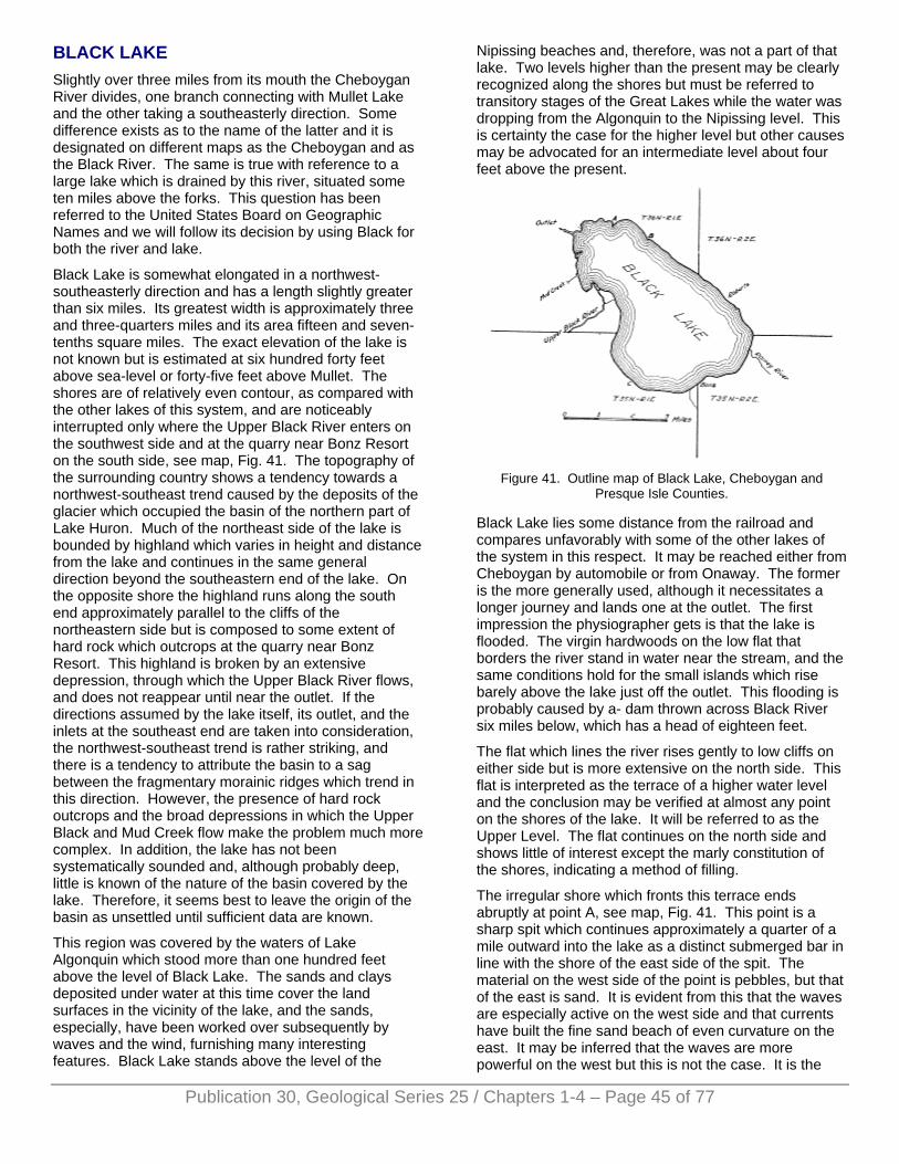
BLACK LAKE Slightly over three miles from its mouth the Cheboygan River divides, one branch connecting with Mullet Lake and the other taking a southeasterly direction. Some difference exists as to the name of the latter and it is designated on different maps as the Cheboygan and as the Black River. The same is true with reference to a large lake which is drained by this river, situated some ten miles above the forks. This question has been referred to the United States Board on Geographic Names and we will follow its decision by using Black for both the river and lake.
Black Lake is somewhat elongated in a northwest-southeasterly direction and has a length slightly greater than six miles. Its greatest width is approximately three and three-quarters miles and its area fifteen and seven-tenths square miles. The exact elevation of the lake is not known but is estimated at six hundred forty feet above sea-level or forty-five feet above Mullet. The shores are of relatively even contour, as compared with the other lakes of this system, and are noticeably interrupted only where the Upper Black River enters on the southwest side and at the quarry near Bonz Resort on the south side, see map, Fig. 41. The topography of the surrounding country shows a tendency towards a northwest-southeast trend caused by the deposits of the glacier which occupied the basin of the northern part of Lake Huron. Much of the northeast side of the lake is bounded by highland which varies in height and distance from the lake and continues in the same general direction beyond the southeastern end of the lake. On the opposite shore the highland runs along the south end approximately parallel to the cliffs of the northeastern side but is composed to some extent of hard rock which outcrops at the quarry near Bonz Resort. This highland is broken by an extensive depression, through which the Upper Black River flows, and does not reappear until near the outlet. If the directions assumed by the lake itself, its outlet, and the inlets at the southeast end are taken into consideration, the northwest-southeast trend is rather striking, and there is a tendency to attribute the basin to a sag between the fragmentary morainic ridges which trend in this direction. However, the presence of hard rock outcrops and the broad depressions in which the Upper Black and Mud Creek flow make the problem much more complex. In addition, the lake has not been systematically sounded and, although probably deep, little is known of the nature of the basin covered by the lake. Therefore, it seems best to leave the origin of the basin as unsettled until sufficient data are known.
This region was covered by the waters of Lake Algonquin which stood more than one hundred feet above the level of Black Lake. The sands and clays deposited under water at this time cover the land surfaces in the vicinity of the lake, and the sands, especially, have been worked over subsequently by waves and the wind, furnishing many interesting features. Black Lake stands above the level of the
Nipissing beaches and, therefore, was not a part of that lake. Two levels higher than the present may be clearly recognized along the shores but must be referred to transitory stages of the Great Lakes while the water was dropping from the Algonquin to the Nipissing level. This is certainty the case for the higher level but other causes may be advocated for an intermediate level about four feet above the present.
Figure 41. Outline map of Black Lake, Cheboygan and
Presque Isle Counties.
Black Lake lies some distance from the railroad and compares unfavorably with some of the other lakes of the system in this respect. It may be reached either from Cheboygan by automobile or from Onaway. The former is the more generally used, although it necessitates a longer journey and lands one at the outlet. The first impression the physiographer gets is that the lake is flooded. The virgin hardwoods on the low flat that borders the river stand in water near the stream, and the same conditions hold for the small islands which rise barely above the lake just off the outlet. This flooding is probably caused by a- dam thrown across Black River six miles below, which has a head of eighteen feet.
The flat which lines the river rises gently to low cliffs on either side but is more extensive on the north side. This flat is interpreted as the terrace of a higher water level and the conclusion may be verified at almost any point on the shores of the lake. It will be referred to as the Upper Level. The flat continues on the north side and shows little of interest except the marly constitution of the shores, indicating a method of filling.
The irregular shore which fronts this terrace ends abruptly at point A, see map, Fig. 41. This point is a sharp spit which continues approximately a quarter of a mile outward into the lake as a distinct submerged bar in line with the shore of the east side of the spit. The material on the west side of the point is pebbles, but that of the east is sand. It is evident from this that the waves are especially active on the west side and that currents have built the fine sand beach of even curvature on the east. It may be inferred that the waves are more powerful on the west but this is not the case. It is the
Publication 30, Geological Series 25 / Chapters 1-4 – Page 45 of 77
Publication 30, Geological Series 25 / Chapters 1-4 – Page 46 of 77
relative strength of wave and current action which determines the character of the beach. Southeasterly and southerly winds, although less powerful than the westerlies, have a long fetch at this end of the lake and set up strong currents on the northeast shore, causing deposition to predominate over cutting on the east side of the point. On the west side waves of less power have been able to throw up a strong storm beach because the shore is not choked by debris carried by currents of very limited development along the irregular shore to the west. Inasmuch as the configuration of the bottom of the lake is not known, no cause for the current leaving the shore at this point is advanced.
East of the point the sandy shore sweeps in a smooth curve to point B. This point seems to have thrown the currents out a short distance from the shore and a low bar enclosing a narrow lagoon has resulted. This swampy lagoon terminates at the foot of a steep bluff, which gradually approaches the north shore of the lake from the northwest, and marks the shore of the Upper Level. This level shows that considerable adjustment in the outline of the lake occurred, and in many places the drop to the present level has exposed a terrace of considerable width which is well shown along this shore.
Point B is due to a local accumulation of boulders and immediately gives war to a sandy terrace. The effects of the flooding of the lake are here apparent in the increased activity of the waves which have cut the edge of the terrace into a low cliff. This cliff is rapidly receding, necessitating the building of breakwaters. Near point B the numerous springs issuing from the high cliff cause a swampy condition of the terrace, although it is well above the water level. Where dry, the terrace proves a suitable location for summer cottages which are furnished with excellent drinking water from the springs. The cliff back of the terrace has its greatest development in this locality and rises generally sixty feet or more above the lake. At the top of the cliff is a flat terrace formed during the existence of Lake Algonquin whose shores stood some distance to the northeast. Above this level now stand a few sand dunes which, in some cases, form part of the cliff, making a sheer drop of nearly one hundred feet, the highest on the lake.
To the east along the lake shore the highland drops suddenly to a low swamp and beyond this is a lowland composed of clay hills with infrequent sags. The terrace is narrow and the shore lined with small boulders, the product of selective wave action on the boulder clay. Beyond Roberts, the hills recede sharply and the low terrace widens into a swamp which encircles the southeastern end of the lake. A stream entering the lake in this vicinity has been turned to the southeast and shows the predominance of westerly winds on this shore. At the Upper Level the eastward moving current left the shore and built a complete bar from the mainland to a narrow island which lies adjacent to the present shore near the bend to the southwest around the upper end of the lake.
The northwest shore beyond point A has been the scene
of intense wave action throughout the history of the lake, as is shown by the preponderance of cliffs which in places are prominent features of the landscape. In addition, the submerged terrace is well developed and was estimated at fifteen hundred or more feet in width. It drops quite regularly to deep water from depths of eight feet, except in one locality a short distance northwest of Roberts. The soundings here showed a terrace which slopes gradually outward to eight feet upon the outer edge of which was found a submerged bar three feet in height. Such a ridge is probably due to the violent agitation of the water where the incoming storm waves first break and may be the forerunner of a barrier. The depth of the water at the "drop off" is certainly less than one-half the wave length of the storm waves on this shore but cannot be taken as indicative of any relationship between the two factors, since uncertainty exists as to the completeness of adjustment to the present level. Inasmuch as the adjustments were so great during the Upper Level, it is probable that the submerged terrace conforms more nearly to conditions at that time than to those existing now.
The low ground through which the Rainey river flows extends to the southeast and is an exposed sandy terrace. At the shore a sand beach curves evenly towards the limestone bluff east of Bonz Resort, and below water the terrace slopes gradually out to a well defined "drop off" more than one-fourth mile off shore. The exposed terrace back of this low ground and beach is poorly drained except on two sand bars which are best seen where the river cuts through. Both bars are attached to the shore near Bonz Resort point and run to the north around the end of the lake. They diverge somewhat as they leave the point and finally play out beyond Rainey river. The bar nearer the lake stands at a level which corresponds to the Upper Level along the northeast shore. Back of it is a narrow swamp above which rises the second bar at a slightly higher level. This bar clearly indicates a water level intermediate between that of Lake Algonquin and the Upper Level. This probably was a transitory stage and, owing to the lack of accurate elevations, it seems best not to attempt to show its relation to any of the Great Lakes stages.
In the early stages of the highest level the lake was of much greater extent with large bays at the southeast end, west of Bonz Resort, at the Upper Black basin, and at the outlet. Adjustments of the shore were few and incomplete. Shore action was of greatest intensity in the Rainey River bay but here the bar was not completed. No such features were found in the other bays. It is interesting to note that the development of the bars in the Rainey River bay was from the west. The reason for this lies in the configuration of the shore rather than in the difference in exposure to storm winds. At this time the northeast shore was irregular and gave little opportunity for the development of currents. On the other hand, Bonz Point was the scene of great wave action and furnished abundant material.
As the point near Bonz Resort is approached, the
Publication 30, Geological Series 25 / Chapters 1-4 – Page 47 of 77
material on the beach rapidly increases in size and the shore becomes rocky. The exposed terraces gradually reduce in width and are very definite. The Upper Level shore is here surmounted by a rock cliff ten to fifteen feet high above which stands the flat terrace and cliff of the highest level. The point is caused by the only exposure of hard rock found on the lake shores, a closely fractured limestone. It stands in a bold cliff thirty or more feet high, which does not come to the water's edge, indicating its formation at the higher levels of the lake. The cliff shows no indication of the highest level, but the weathering of the closely fractured rock would have quickly obscured the poorly developed terrace that may have been formed during this short-lived stage. Along this shore evidence of ice push is seen in the line of large rocks along the present strand. This point is in reality a hard rock ridge which runs northwest-southeast and formed a promontory during the higher levels. To the west stood a broad bay which was separated from the lake by a complete bar during the Upper Level. This shallow lagoon was soon filled with vegetation and now exists as a flat swamp above which rues the bar near the present shore. This bar is the only dry ground near the lake in this vicinity and upon it are built the cottages of Bonz Resort. The maximum width of the swamp is about one-fourth mile and it is bounded by cliffs on the land side. To the west it narrows and the cliffs stand nearer the shore. At locality C (see map) they come within one hundred feet of the shore and form the western attachment of the Bonz Resort bar. The cliffs again recede and another bar continues towards the outlet of the Upper Black. This bar also stands at an elevation corresponding to the shore of the Upper Level along the northeast shore and the lower bar in the Rainey River embayment. It lies some distance back from the shore and splits to the north, assuming the form of a large hook rather than that of the simple spit.
The bars run almost to the present channel of the Upper Black on the surface of a broad delta. This delta causes a large projection of the shore line and is one of the best examples of this feature to be found in Michigan lakes. The river reached the lake by a series of distributaries, some of which still flow during the flood season. The effective currents along this shore are northerly, formed by the easterly and southeasterly winds of long sweep, and have caused the unsymmetrical development of the delta towards the northwest. At present, the shores are being cut away and the material shifted towards the west, turning the present channel of the river in this direction. The movement of the material is so rapid that it is necessary to keep the channel of the river open artificially. The submerged portion of the delta is correspondingly large, and the submerged terrace consequently reaches its greatest development here, fully a half mile in width.
Beyond the delta the low ground persists nearly to the outlet as a swamp. When the lake stood at the higher level this was a locality of great current action, and the results are to be seen in a series of bars standing near the shore on the exposed terrace. Near the delta a
single bar cut off the swamp to the west, but this bar splits three times in its course to the north, forming four distinct bars. They are especially well developed north of the mouth of Mud Creek and lie within forty rods of the shore. The direction of the currents, as shown by the bars and the deflection of Mud Creek to the north, conformed to the general direction along the southwest shore. None of the bars along this shore were complete, but the best developed is that standing next the present shore and reaches to within a few yards of the high ground near the outlet. The end of this bar forms the small hook in the present shore line just south of the islands.
The half mile of shore south of the outlet is bordered by a low, swampy terrace above which a cliff rises to high land. Wave action was active here at the time when the bars to the south were being deposited, and a terrace of moderate width was formed. The small islands at this end of the lake are all flat-topped and stand at a level slightly above the lake. It seems probable that they were small islands during the early stages of the Upper Level but were completely bevelled during that stage.
In brief, we may state that Black Lake first came into existence as a separate body of water during the recession of Lake Algonquin. A high level is recorded in one locality only, the land form being the higher spit attached to Bonz Resort point and extending east around the Rainey River bay. The lake at that time was much more irregular in outline and larger in size than at present. The lack of adjustments of the shoreline indicates that this level was of short duration. Following this the lake halted at a level a few feet higher than the present, which we have called the Upper Level. This level was probably the most important one for the lake, and the shores were maturely adjusted to the waves and currents. Great bays were separated from the main body of the lake by currents and bold cliffs cut by waves. In addition, the Upper Black deposited great quantities of silt forming a large delta at its mouth. In general, the present outline of the lake was determined at this time.
Only minor adjustments have been accomplished since the lake receded from the Upper Level; in fact, there remains little to be done. Of recent years, the ponding of the waters has increased wave action and some readjustment will be the result. It should be largely in the form of cutting back the exposed terrace of the Upper Level. This will continue until equilibrium is established and should progress rapidly, since the material is largely sand. The small points will be reduced more and more by wave action, but the delta of the Upper Black will continue to increase to the north. The growth of the delta must eventually fill the lower end of the lake, after which two possibilities arise: A shifting of the distributaries may pour the silt into the main body of the lake and the filling proceed without interruption, or the Upper Black may connect directly with the outlet. The latter seems the more probable to the writer, since the delta is growing in this direction. Filling by marl or vegetation must be limited to the shallower portions of
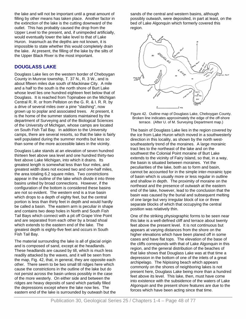
the lake and will not be important until a great amount of filling by other means has taken place. Another factor in the extinction of the lake is the cutting downward of the outlet. This has probably caused the drop from the Upper Level to the present, and, if unimpeded artificially, would eventually lower the lake level to that of Lake Huron. Inasmuch as the depths are not known, it is impossible to state whether this would completely drain the lake. At present, the filling of the lake by the silts of the Upper Black River is the most important.
DOUGLASS LAKE Douglass Lake lies on the western border of Cheboygan County in Munroe township, T. 37 N., R. 3 W., and is about fifteen miles due south of Mackinaw City. A mile and a half to the south is the north shore of Burt Lake whose level lies one hundred eighteen feet below that of Douglass. It is reached from Topinabee on the Michigan Central R. R. or from Pellston on the G. R. & I. R. R. by a drive of several miles over a pine "slashing", now grown up to poplar and associated trees. At present, it is the home of the summer stations maintained by the department of Surveying and of the Biological Sciences of the University of Michigan, whose camps are located on South Fish Tail Bay. In addition to the University camps, there are several resorts, so that the lake is fairly well populated during the summer months but less so than some of the more accessible lakes in the vicinity.
Douglass Lake stands at an elevation of seven hundred thirteen feet above sea level and one hundred thirty-two feet above Lake Michigan, into which it drains. Its greatest length is somewhat less than four miles, and greatest width does not exceed two and one-half miles, the area totaling 6.2 square miles. Two constrictions appear in the outline of the lake which divide it into three basins united by broad connections. However, if the configuration of the bottom is considered these basins are not so evident. The western end is a true basin which drops to a depth of eighty feet, but the central portion is less than thirty feet in depth and would hardly be called a basin. The eastern arm is peculiar in shape and contains two deep holes in North and South Fish Tail Bays which connect with a pit off Grape Vine Point and are separated from each other by a broad shoal which extends to the eastern end of the lake. The greatest depth is eighty-five feet and occurs in South Fish Tail Bay.
The material surrounding the lake is all of glacial origin and is composed of sand, except at the headlands. These headlands are caused by till, which is much less readily attacked by the waves, and it will be seen from the map, Fig. 42, that, in general, they are opposite each other. There seem to be two small till ridges here which cause the constrictions in the outline of the lake but do not persist across the basin unless possibly in the case of the more westerly. On either side and between the ridges are heavy deposits of sand which partially filled the depressions except where the lake now lies. The eastern end of the lake is surrounded by outwash but the
sands of the central and western basins, although possibly outwash, were deposited, in part at least, on the bed of Lake Algonquin which formerly covered this region.
Figure 42. Outline map of Douglass Lake, Cheboygan County. Broken line indicates approximately the edge of the off-shore
terrace. (After U. of M. Surveying Department map.)
The basin of Douglass Lake lies in the region covered by the ice from Lake Huron which moved in a southwesterly direction in this locality, as shown by the north west-southeasterly trend of the moraines. A large morainic tract lies to the northeast of the lake and on the southwest the Colonial Point moraine of Burt Lake extends to the vicinity of Fairy Island, so that, in a way, the basin is situated between moraines. Yet the peculiarities of the lake, both as to form and basin, cannot be accounted for in the simple inter-morainic type of basin which is usually more or less regular in outline and shallow in depth. The proximity of moraine on the northeast and the presence of outwash at the eastern end of the lake, however, lead to the conclusion that the basin was caused by the burial and subsequent melting of one large but very irregular block of ice or three separate blocks of which that occupying the central position was relatively thin.
One of the striking physiographic forms to be seen near this lake is a well-defined cliff and terrace about twenty feet above the present level. It is not continuous but appears at varying distances from the shore on the higher elevations which have been planed off in some cases and have flat tops. The elevation of the base of the cliffs corresponds with that of Lake Algonquin in this region, and the general distribution of the beaches of that lake shows that Douglass Lake was at that time a depression in the bottom of one of the inlets of a great archipelago. The Nipissing beach which appears commonly on the shores of neighboring lakes is not present here, Douglass Lake being more than a hundred feet above its level. This lake, then, must have come into existence with the subsidence of the waters of Lake Algonquin and the present shore features are due to the forces which have been acting since that time.
Publication 30, Geological Series 25 / Chapters 1-4 – Page 48 of 77
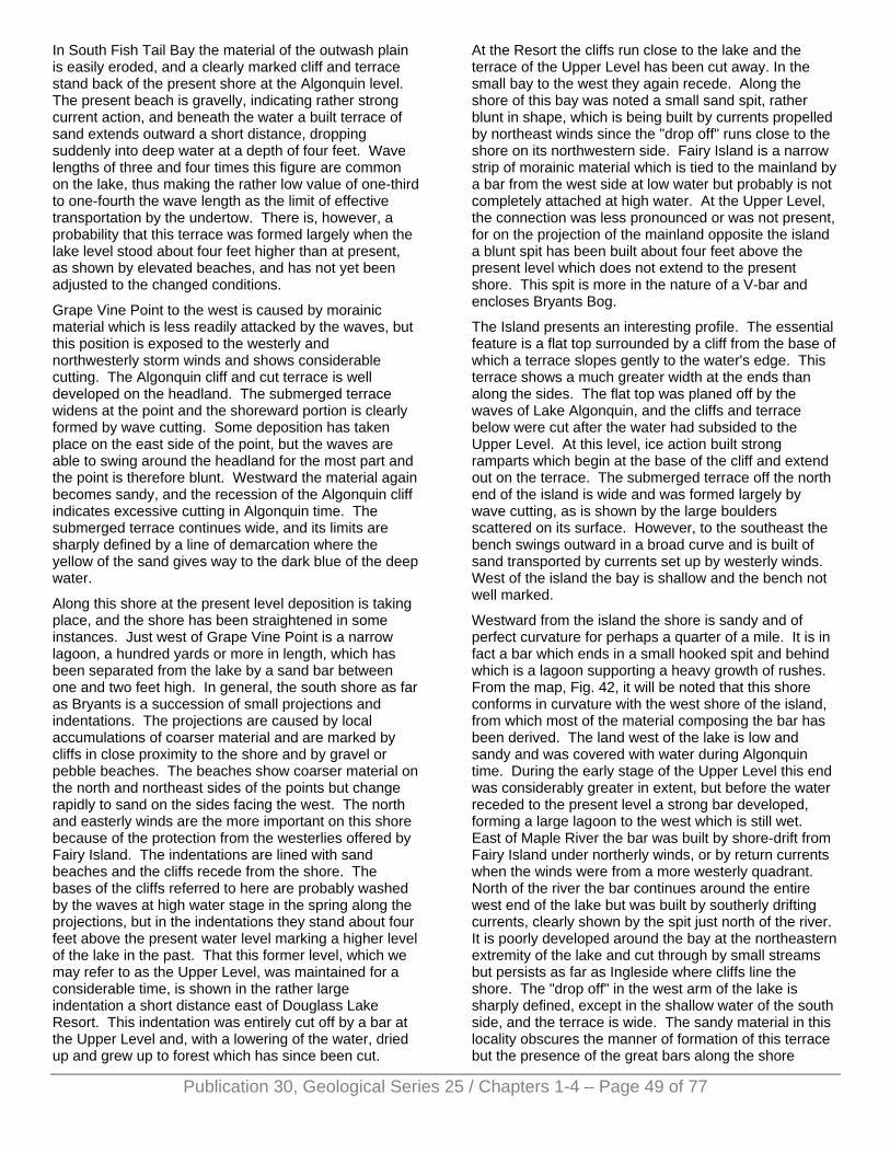
Publication 30, Geological Series 25 / Chapters 1-4 – Page 49 of 77
In South Fish Tail Bay the material of the outwash plain is easily eroded, and a clearly marked cliff and terrace stand back of the present shore at the Algonquin level. The present beach is gravelly, indicating rather strong current action, and beneath the water a built terrace of sand extends outward a short distance, dropping suddenly into deep water at a depth of four feet. Wave lengths of three and four times this figure are common on the lake, thus making the rather low value of one-third to one-fourth the wave length as the limit of effective transportation by the undertow. There is, however, a probability that this terrace was formed largely when the lake level stood about four feet higher than at present, as shown by elevated beaches, and has not yet been adjusted to the changed conditions.
Grape Vine Point to the west is caused by morainic material which is less readily attacked by the waves, but this position is exposed to the westerly and northwesterly storm winds and shows considerable cutting. The Algonquin cliff and cut terrace is well developed on the headland. The submerged terrace widens at the point and the shoreward portion is clearly formed by wave cutting. Some deposition has taken place on the east side of the point, but the waves are able to swing around the headland for the most part and the point is therefore blunt. Westward the material again becomes sandy, and the recession of the Algonquin cliff indicates excessive cutting in Algonquin time. The submerged terrace continues wide, and its limits are sharply defined by a line of demarcation where the yellow of the sand gives way to the dark blue of the deep water.
Along this shore at the present level deposition is taking place, and the shore has been straightened in some instances. Just west of Grape Vine Point is a narrow lagoon, a hundred yards or more in length, which has been separated from the lake by a sand bar between one and two feet high. In general, the south shore as far as Bryants is a succession of small projections and indentations. The projections are caused by local accumulations of coarser material and are marked by cliffs in close proximity to the shore and by gravel or pebble beaches. The beaches show coarser material on the north and northeast sides of the points but change rapidly to sand on the sides facing the west. The north and easterly winds are the more important on this shore because of the protection from the westerlies offered by Fairy Island. The indentations are lined with sand beaches and the cliffs recede from the shore. The bases of the cliffs referred to here are probably washed by the waves at high water stage in the spring along the projections, but in the indentations they stand about four feet above the present water level marking a higher level of the lake in the past. That this former level, which we may refer to as the Upper Level, was maintained for a considerable time, is shown in the rather large indentation a short distance east of Douglass Lake Resort. This indentation was entirely cut off by a bar at the Upper Level and, with a lowering of the water, dried up and grew up to forest which has since been cut.
At the Resort the cliffs run close to the lake and the terrace of the Upper Level has been cut away. In the small bay to the west they again recede. Along the shore of this bay was noted a small sand spit, rather blunt in shape, which is being built by currents propelled by northeast winds since the "drop off" runs close to the shore on its northwestern side. Fairy Island is a narrow strip of morainic material which is tied to the mainland by a bar from the west side at low water but probably is not completely attached at high water. At the Upper Level, the connection was less pronounced or was not present, for on the projection of the mainland opposite the island a blunt spit has been built about four feet above the present level which does not extend to the present shore. This spit is more in the nature of a V-bar and encloses Bryants Bog.
The Island presents an interesting profile. The essential feature is a flat top surrounded by a cliff from the base of which a terrace slopes gently to the water's edge. This terrace shows a much greater width at the ends than along the sides. The flat top was planed off by the waves of Lake Algonquin, and the cliffs and terrace below were cut after the water had subsided to the Upper Level. At this level, ice action built strong ramparts which begin at the base of the cliff and extend out on the terrace. The submerged terrace off the north end of the island is wide and was formed largely by wave cutting, as is shown by the large boulders scattered on its surface. However, to the southeast the bench swings outward in a broad curve and is built of sand transported by currents set up by westerly winds. West of the island the bay is shallow and the bench not well marked.
Westward from the island the shore is sandy and of perfect curvature for perhaps a quarter of a mile. It is in fact a bar which ends in a small hooked spit and behind which is a lagoon supporting a heavy growth of rushes. From the map, Fig. 42, it will be noted that this shore conforms in curvature with the west shore of the island, from which most of the material composing the bar has been derived. The land west of the lake is low and sandy and was covered with water during Algonquin time. During the early stage of the Upper Level this end was considerably greater in extent, but before the water receded to the present level a strong bar developed, forming a large lagoon to the west which is still wet. East of Maple River the bar was built by shore-drift from Fairy Island under northerly winds, or by return currents when the winds were from a more westerly quadrant. North of the river the bar continues around the entire west end of the lake but was built by southerly drifting currents, clearly shown by the spit just north of the river. It is poorly developed around the bay at the northeastern extremity of the lake and cut through by small streams but persists as far as Ingleside where cliffs line the shore. The "drop off" in the west arm of the lake is sharply defined, except in the shallow water of the south side, and the terrace is wide. The sandy material in this locality obscures the manner of formation of this terrace but the presence of the great bars along the shore
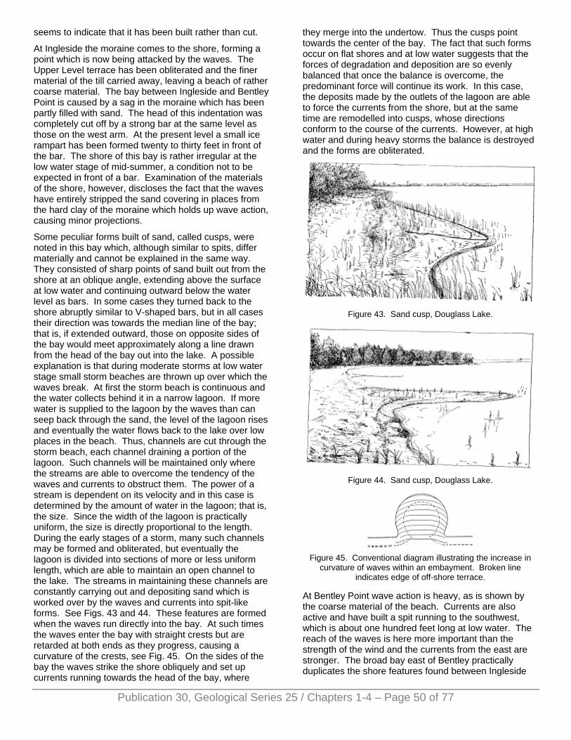
seems to indicate that it has been built rather than cut.
At Ingleside the moraine comes to the shore, forming a point which is now being attacked by the waves. The Upper Level terrace has been obliterated and the finer material of the till carried away, leaving a beach of rather coarse material. The bay between Ingleside and Bentley Point is caused by a sag in the moraine which has been partly filled with sand. The head of this indentation was completely cut off by a strong bar at the same level as those on the west arm. At the present level a small ice rampart has been formed twenty to thirty feet in front of the bar. The shore of this bay is rather irregular at the low water stage of mid-summer, a condition not to be expected in front of a bar. Examination of the materials of the shore, however, discloses the fact that the waves have entirely stripped the sand covering in places from the hard clay of the moraine which holds up wave action, causing minor projections.
Some peculiar forms built of sand, called cusps, were noted in this bay which, although similar to spits, differ materially and cannot be explained in the same way. They consisted of sharp points of sand built out from the shore at an oblique angle, extending above the surface at low water and continuing outward below the water level as bars. In some cases they turned back to the shore abruptly similar to V-shaped bars, but in all cases their direction was towards the median line of the bay; that is, if extended outward, those on opposite sides of the bay would meet approximately along a line drawn from the head of the bay out into the lake. A possible explanation is that during moderate storms at low water stage small storm beaches are thrown up over which the waves break. At first the storm beach is continuous and the water collects behind it in a narrow lagoon. If more water is supplied to the lagoon by the waves than can seep back through the sand, the level of the lagoon rises and eventually the water flows back to the lake over low places in the beach. Thus, channels are cut through the storm beach, each channel draining a portion of the lagoon. Such channels will be maintained only where the streams are able to overcome the tendency of the waves and currents to obstruct them. The power of a stream is dependent on its velocity and in this case is determined by the amount of water in the lagoon; that is, the size. Since the width of the lagoon is practically uniform, the size is directly proportional to the length. During the early stages of a storm, many such channels may be formed and obliterated, but eventually the lagoon is divided into sections of more or less uniform length, which are able to maintain an open channel to the lake. The streams in maintaining these channels are constantly carrying out and depositing sand which is worked over by the waves and currents into spit-like forms. See Figs. 43 and 44. These features are formed when the waves run directly into the bay. At such times the waves enter the bay with straight crests but are retarded at both ends as they progress, causing a curvature of the crests, see Fig. 45. On the sides of the bay the waves strike the shore obliquely and set up currents running towards the head of the bay, where
they merge into the undertow. Thus the cusps point towards the center of the bay. The fact that such forms occur on flat shores and at low water suggests that the forces of degradation and deposition are so evenly balanced that once the balance is overcome, the predominant force will continue its work. In this case, the deposits made by the outlets of the lagoon are able to force the currents from the shore, but at the same time are remodelled into cusps, whose directions conform to the course of the currents. However, at high water and during heavy storms the balance is destroyed and the forms are obliterated.
Figure 43. Sand cusp, Douglass Lake.
Figure 44. Sand cusp, Douglass Lake.
Figure 45. Conventional diagram illustrating the increase in
curvature of waves within an embayment. Broken line indicates edge of off-shore terrace.
At Bentley Point wave action is heavy, as is shown by the coarse material of the beach. Currents are also active and have built a spit running to the southwest, which is about one hundred feet long at low water. The reach of the waves is here more important than the strength of the wind and the currents from the east are stronger. The broad bay east of Bentley practically duplicates the shore features found between Ingleside
Publication 30, Geological Series 25 / Chapters 1-4 – Page 50 of 77
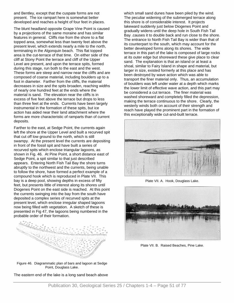
and Bentley, except that the cuspate forms are not present. The ice rampart here is somewhat better developed and reaches a height of four feet in places.
The blunt headland opposite Grape Vine Point is caused by a projections of the same moraine and has similar features in general. Cliffs rise from the shore to a flat topped area, somewhat less than twenty feet above the present level, which extends nearly a mile to the north, terminating in the Algonquin beach. This flat topped area is the cut-terrace of that time. On either side of the cliff at Stony Point the terrace and cliff of the Upper Level are present, and upon the terrace spits, formed during this stage, run both to the east and the west. These forms are steep and narrow near the cliffs and are composed of coarse material, including boulders up to a foot in diameter. Farther from the cliffs, the material decreases in size and the spits broaden, reaching widths of nearly one hundred feet at the ends where the material is sand. The elevation near the cliffs is in excess of five feet above the terrace but drops to less than three feet at the ends. Currents have been largely instrumental in the formation of these spits, but ice action has aided near their land attachment where the forms are more characteristic of ramparts than of current deposits.
Farther to the east, at Sedge Point, the currents again left the shore at the Upper Level and built a recurved spit that cut off low ground to the north, which is still swampy. At the present level the currents are depositing in front of the fossil spit and have built a series of recurved spits which enclose triangular lagoons, as shown in Fig. 46. At Pine Point, a short distance east of Sedge Point, a spit similar to that just described appears. Entering North Fish Tail Bay the shore turns abruptly to the northwest and the currents, being unable to follow the shore, have formed a perfect example of a compound hook which is reproduced in Plate VII. This bay is a deep pool, showing depths in excess of fifty feet, but presents little of interest along its shores until Diogenes Point on the east side is reached. At this point the currents swinging into the bay from the south have deposited a complex series of recurved spits at the present level, which enclose irregular shaped lagoons now being filled with vegetation. A sketch of these is presented in Fig 47, the lagoons being numbered in the probable order of their formation.
Figure 46. Diagrammatic plan of bars and lagoon at Sedge
Point, Douglass Lake.
The eastern end of the lake is a long sand beach above
which small sand dunes have been piled by the wind. The peculiar widening of the submerged terrace along this shore is of considerable interest. It projects lakeward suddenly just below Diogenes Point and gradually widens until the deep hole in South Fish Tail Bay .causes it to double back and run close to the shore. The entrance to North Fish Tail Bay is wider than that of its counterpart to the south, which may account for the better developed forms along its shores. The wide terrace in this part of the lake is composed of large rocks at its outer edge but shoreward these give place to clear sand. The explanation is that an island or at least a shoal, similar to Fairy Island in shape and material, but larger in size, existed formerly at this place and has been destroyed by wave action which was able to transport the finer material only. Thus, an accumulation of boulders was left under water at a depth which marks the lower limit of effective wave action, and this part may be considered a cut terrace. The finer material was washed shoreward and completely filled the depression, making the terrace continuous to the shore. Clearly, the westerly winds both on account of their strength and reach have played the prominent part in the formation of this exceptionally wide cut-and-built terrace.
Plate VII. A. Hook, Douglass Lake.
Plate VII. B. Raised Beaches, Pine Lake.
Publication 30, Geological Series 25 / Chapters 1-4 – Page 51 of 77
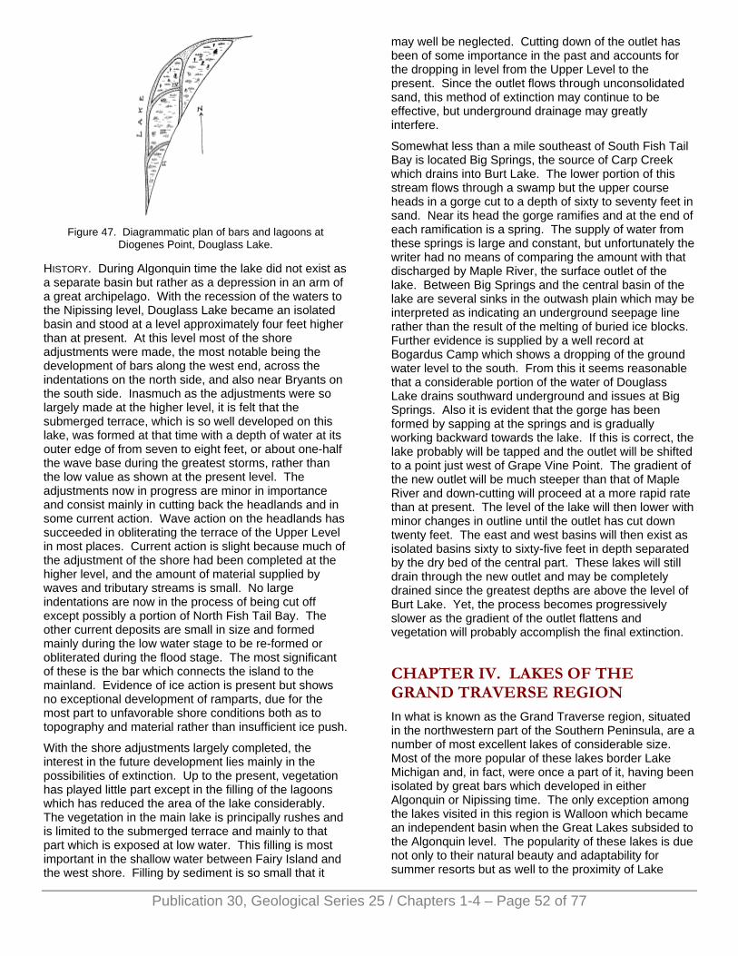
Figure 47. Diagrammatic plan of bars and lagoons at
Diogenes Point, Douglass Lake.
HISTORY. During Algonquin time the lake did not exist as a separate basin but rather as a depression in an arm of a great archipelago. With the recession of the waters to the Nipissing level, Douglass Lake became an isolated basin and stood at a level approximately four feet higher than at present. At this level most of the shore adjustments were made, the most notable being the development of bars along the west end, across the indentations on the north side, and also near Bryants on the south side. Inasmuch as the adjustments were so largely made at the higher level, it is felt that the submerged terrace, which is so well developed on this lake, was formed at that time with a depth of water at its outer edge of from seven to eight feet, or about one-half the wave base during the greatest storms, rather than the low value as shown at the present level. The adjustments now in progress are minor in importance and consist mainly in cutting back the headlands and in some current action. Wave action on the headlands has succeeded in obliterating the terrace of the Upper Level in most places. Current action is slight because much of the adjustment of the shore had been completed at the higher level, and the amount of material supplied by waves and tributary streams is small. No large indentations are now in the process of being cut off except possibly a portion of North Fish Tail Bay. The other current deposits are small in size and formed mainly during the low water stage to be re-formed or obliterated during the flood stage. The most significant of these is the bar which connects the island to the mainland. Evidence of ice action is present but shows no exceptional development of ramparts, due for the most part to unfavorable shore conditions both as to topography and material rather than insufficient ice push.
With the shore adjustments largely completed, the interest in the future development lies mainly in the possibilities of extinction. Up to the present, vegetation has played little part except in the filling of the lagoons which has reduced the area of the lake considerably. The vegetation in the main lake is principally rushes and is limited to the submerged terrace and mainly to that part which is exposed at low water. This filling is most important in the shallow water between Fairy Island and the west shore. Filling by sediment is so small that it
may well be neglected. Cutting down of the outlet has been of some importance in the past and accounts for the dropping in level from the Upper Level to the present. Since the outlet flows through unconsolidated sand, this method of extinction may continue to be effective, but underground drainage may greatly interfere.
Somewhat less than a mile southeast of South Fish Tail Bay is located Big Springs, the source of Carp Creek which drains into Burt Lake. The lower portion of this stream flows through a swamp but the upper course heads in a gorge cut to a depth of sixty to seventy feet in sand. Near its head the gorge ramifies and at the end of each ramification is a spring. The supply of water from these springs is large and constant, but unfortunately the writer had no means of comparing the amount with that discharged by Maple River, the surface outlet of the lake. Between Big Springs and the central basin of the lake are several sinks in the outwash plain which may be interpreted as indicating an underground seepage line rather than the result of the melting of buried ice blocks. Further evidence is supplied by a well record at Bogardus Camp which shows a dropping of the ground water level to the south. From this it seems reasonable that a considerable portion of the water of Douglass Lake drains southward underground and issues at Big Springs. Also it is evident that the gorge has been formed by sapping at the springs and is gradually working backward towards the lake. If this is correct, the lake probably will be tapped and the outlet will be shifted to a point just west of Grape Vine Point. The gradient of the new outlet will be much steeper than that of Maple River and down-cutting will proceed at a more rapid rate than at present. The level of the lake will then lower with minor changes in outline until the outlet has cut down twenty feet. The east and west basins will then exist as isolated basins sixty to sixty-five feet in depth separated by the dry bed of the central part. These lakes will still drain through the new outlet and may be completely drained since the greatest depths are above the level of Burt Lake. Yet, the process becomes progressively slower as the gradient of the outlet flattens and vegetation will probably accomplish the final extinction.
CHAPTER IV. LAKES OF THE GRAND TRAVERSE REGION In what is known as the Grand Traverse region, situated in the northwestern part of the Southern Peninsula, are a number of most excellent lakes of considerable size. Most of the more popular of these lakes border Lake Michigan and, in fact, were once a part of it, having been isolated by great bars which developed in either Algonquin or Nipissing time. The only exception among the lakes visited in this region is Walloon which became an independent basin when the Great Lakes subsided to the Algonquin level. The popularity of these lakes is due not only to their natural beauty and adaptability for summer resorts but as well to the proximity of Lake
Publication 30, Geological Series 25 / Chapters 1-4 – Page 52 of 77
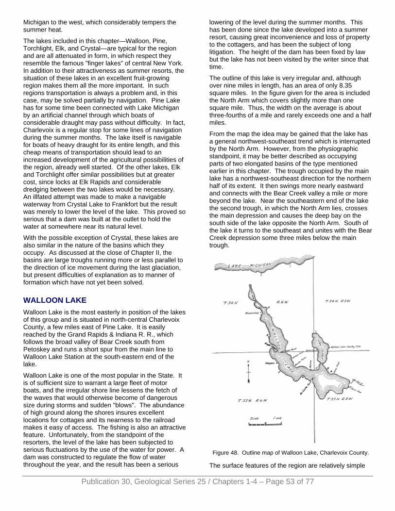
Michigan to the west, which considerably tempers the summer heat.
The lakes included in this chapter—Walloon, Pine, Torchlight, Elk, and Crystal—are typical for the region and are all attenuated in form, in which respect they resemble the famous "finger lakes" of central New York. In addition to their attractiveness as summer resorts, the situation of these lakes in an excellent fruit-growing region makes them all the more important. In such regions transportation is always a problem and, in this case, may be solved partially by navigation. Pine Lake has for some time been connected with Lake Michigan by an artificial channel through which boats of considerable draught may pass without difficulty. In fact, Charlevoix is a regular stop for some lines of navigation during the summer months. The lake itself is navigable for boats of heavy draught for its entire length, and this cheap means of transportation should lead to an increased development of the agricultural possibilities of the region, already well started. Of the other lakes, Elk and Torchlight offer similar possibilities but at greater cost, since locks at Elk Rapids and considerable dredging between the two lakes would be necessary. An illfated attempt was made to make a navigable waterway from Crystal Lake to Frankfort but the result was merely to lower the level of the lake. This proved so serious that a dam was built at the outlet to hold the water at somewhere near its natural level.
With the possible exception of Crystal, these lakes are also similar in the nature of the basins which they occupy. As discussed at the close of Chapter II, the basins are large troughs running more or less parallel to the direction of ice movement during the last glaciation, but present difficulties of explanation as to manner of formation which have not yet been solved.
WALLOON LAKE Walloon Lake is the most easterly in position of the lakes of this group and is situated in north-central Charlevoix County, a few miles east of Pine Lake. It is easily reached by the Grand Rapids & Indiana R. R., which follows the broad valley of Bear Creek south from Petoskey and runs a short spur from the main line to Walloon Lake Station at the south-eastern end of the lake.
Walloon Lake is one of the most popular in the State. It is of sufficient size to warrant a large fleet of motor boats, and the irregular shore line lessens the fetch of the waves that would otherwise become of dangerous size during storms and sudden "blows". The abundance of high ground along the shores insures excellent locations for cottages and its nearness to the railroad makes it easy of access. The fishing is also an attractive feature. Unfortunately, from the standpoint of the resorters, the level of the lake has been subjected to serious fluctuations by the use of the water for power. A dam was constructed to regulate the flow of water throughout the year, and the result has been a serious
lowering of the level during the summer months. This has been done since the lake developed into a summer resort, causing great inconvenience and loss of property to the cottagers, and has been the subject of long litigation. The height of the dam has been fixed by law but the lake has not been visited by the writer since that time.
The outline of this lake is very irregular and, although over nine miles in length, has an area of only 8.35 square miles. In the figure given for the area is included the North Arm which covers slightly more than one square mile. Thus, the width on the average is about three-fourths of a mile and rarely exceeds one and a half miles.
From the map the idea may be gained that the lake has a general northwest-southeast trend which is interrupted by the North Arm. However, from the physiographic standpoint, it may be better described as occupying parts of two elongated basins of the type mentioned earlier in this chapter. The trough occupied by the main lake has a northwest-southeast direction for the northern half of its extent. It then swings more nearly eastward and connects with the Bear Creek valley a mile or more beyond the lake. Near the southeastern end of the lake the second trough, in which the North Arm lies, crosses the main depression and causes the deep bay on the south side of the lake opposite the North Arm. South of the lake it turns to the southeast and unites with the Bear Creek depression some three miles below the main trough.
Figure 48. Outline map of Walloon Lake, Charlevoix County.
The surface features of the region are relatively simple
Publication 30, Geological Series 25 / Chapters 1-4 – Page 53 of 77
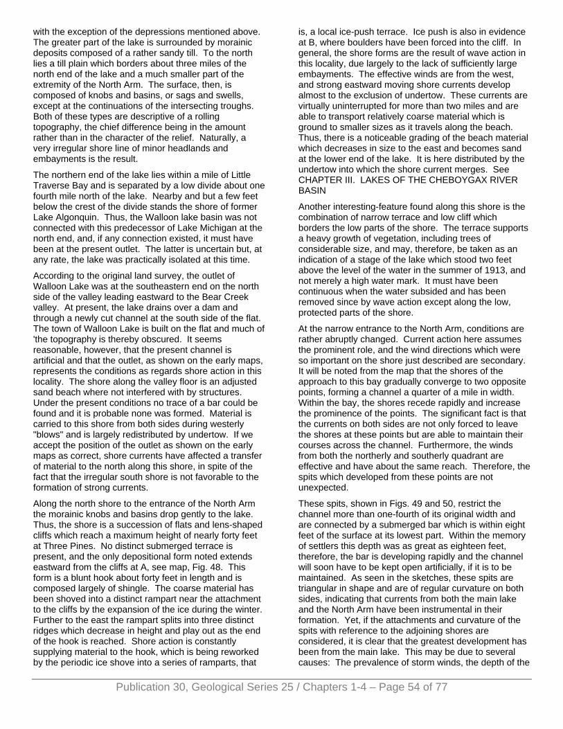
Publication 30, Geological Series 25 / Chapters 1-4 – Page 54 of 77
with the exception of the depressions mentioned above. The greater part of the lake is surrounded by morainic deposits composed of a rather sandy till. To the north lies a till plain which borders about three miles of the north end of the lake and a much smaller part of the extremity of the North Arm. The surface, then, is composed of knobs and basins, or sags and swells, except at the continuations of the intersecting troughs. Both of these types are descriptive of a rolling topography, the chief difference being in the amount rather than in the character of the relief. Naturally, a very irregular shore line of minor headlands and embayments is the result.
The northern end of the lake lies within a mile of Little Traverse Bay and is separated by a low divide about one fourth mile north of the lake. Nearby and but a few feet below the crest of the divide stands the shore of former Lake Algonquin. Thus, the Walloon lake basin was not connected with this predecessor of Lake Michigan at the north end, and, if any connection existed, it must have been at the present outlet. The latter is uncertain but, at any rate, the lake was practically isolated at this time.
According to the original land survey, the outlet of Walloon Lake was at the southeastern end on the north side of the valley leading eastward to the Bear Creek valley. At present, the lake drains over a dam and through a newly cut channel at the south side of the flat. The town of Walloon Lake is built on the flat and much of 'the topography is thereby obscured. It seems reasonable, however, that the present channel is artificial and that the outlet, as shown on the early maps, represents the conditions as regards shore action in this locality. The shore along the valley floor is an adjusted sand beach where not interfered with by structures. Under the present conditions no trace of a bar could be found and it is probable none was formed. Material is carried to this shore from both sides during westerly "blows" and is largely redistributed by undertow. If we accept the position of the outlet as shown on the early maps as correct, shore currents have affected a transfer of material to the north along this shore, in spite of the fact that the irregular south shore is not favorable to the formation of strong currents.
Along the north shore to the entrance of the North Arm the morainic knobs and basins drop gently to the lake. Thus, the shore is a succession of flats and lens-shaped cliffs which reach a maximum height of nearly forty feet at Three Pines. No distinct submerged terrace is present, and the only depositional form noted extends eastward from the cliffs at A, see map, Fig. 48. This form is a blunt hook about forty feet in length and is composed largely of shingle. The coarse material has been shoved into a distinct rampart near the attachment to the cliffs by the expansion of the ice during the winter. Further to the east the rampart splits into three distinct ridges which decrease in height and play out as the end of the hook is reached. Shore action is constantly supplying material to the hook, which is being reworked by the periodic ice shove into a series of ramparts, that
is, a local ice-push terrace. Ice push is also in evidence at B, where boulders have been forced into the cliff. In general, the shore forms are the result of wave action in this locality, due largely to the lack of sufficiently large embayments. The effective winds are from the west, and strong eastward moving shore currents develop almost to the exclusion of undertow. These currents are virtually uninterrupted for more than two miles and are able to transport relatively coarse material which is ground to smaller sizes as it travels along the beach. Thus, there is a noticeable grading of the beach material which decreases in size to the east and becomes sand at the lower end of the lake. It is here distributed by the undertow into which the shore current merges. See CHAPTER III. LAKES OF THE CHEBOYGAX RIVER BASIN
Another interesting-feature found along this shore is the combination of narrow terrace and low cliff which borders the low parts of the shore. The terrace supports a heavy growth of vegetation, including trees of considerable size, and may, therefore, be taken as an indication of a stage of the lake which stood two feet above the level of the water in the summer of 1913, and not merely a high water mark. It must have been continuous when the water subsided and has been removed since by wave action except along the low, protected parts of the shore.
At the narrow entrance to the North Arm, conditions are rather abruptly changed. Current action here assumes the prominent role, and the wind directions which were so important on the shore just described are secondary. It will be noted from the map that the shores of the approach to this bay gradually converge to two opposite points, forming a channel a quarter of a mile in width. Within the bay, the shores recede rapidly and increase the prominence of the points. The significant fact is that the currents on both sides are not only forced to leave the shores at these points but are able to maintain their courses across the channel. Furthermore, the winds from both the northerly and southerly quadrant are effective and have about the same reach. Therefore, the spits which developed from these points are not unexpected.
These spits, shown in Figs. 49 and 50, restrict the channel more than one-fourth of its original width and are connected by a submerged bar which is within eight feet of the surface at its lowest part. Within the memory of settlers this depth was as great as eighteen feet, therefore, the bar is developing rapidly and the channel will soon have to be kept open artificially, if it is to be maintained. As seen in the sketches, these spits are triangular in shape and are of regular curvature on both sides, indicating that currents from both the main lake and the North Arm have been instrumental in their formation. Yet, if the attachments and curvature of the spits with reference to the adjoining shores are considered, it is clear that the greatest development has been from the main lake. This may be due to several causes: The prevalence of storm winds, the depth of the

water affected, and the nature of the shores. Of the first two, we are not certain, but it is probable that the main lake is the deeper, and that the storm winds shift more frequently through the southerly quadrant than the northerly. As to the nature of the shores, we find a greater prevalence of cliffs along the converging approach than in the bay, although the shore affected is shorter. This is probably due to the intensification of the waves and, therefore, current action in the narrowing approach. It appears, then, that all three factors are favorable to growth from the main lake, but detailed study is necessary for a decision.
Figure 49. Spit at the west side of the entrance to the North
Arm, Walloon Lake, (Sketch from photograph).
Figure 50. Spit at east side of the entrance to the North Arm,
Walloon Lake, (Sketch from photograph).
Furthermore, it is apparent that the spit on the east side is the better developed. This is clearly due to the greater shore line affected and the unquestionable prevalence of storm winds having a westerly component. It is also apparent from the sketches that a considerable part of these spits developed during the higher stage. The drop to the present level was so slight that conditions were unchanged and the present growth is a continuation of that of the previous stage.
As regards shore action, the North Arm acts as an isolated basin. Shore conditions are similar on both sides and resemble those of the north shore between the east end of the lake and the entrance to this bay. Moraine borders the southern part of this embayment but drops to a till plain which skirts the shores of the northern half. The characteristic shore features, therefore, are the now familiar cliffs and terrace in front of which runs a sandy beach interspersed at the small points with boulders. Wave action is prominent but the cliffs are considerably lower than on the main lake. Current action, however, has not been productive of any
decided effects unless it be a gradual building out of the fiats to the line of the cliffs. This could not be determined on account of the heavy growth of vegetation which obscures the surface of the lowlands. In but one locality, aside from the spits at the entrance, are currents actively depositing and this occurs on the south side of Birch Point. Here a small spit composed of well assorted pebbles extends southward from the point and continues under water as a sand terrace. The relief is much less near the north end, and much of the shore is swampy. Continuous swamp fringes the north end with the exception of a low but conspicuous swell west of the inlet. The vegetation of this swamp is creeping outward over the marl-covered bottom, indicating the inception of the final stage in the development of this embayment—its extinction by vegetation. Ice shove of the expansion type is active here, but shore conditions are not favorable for decided results. Ramparts of local extent are present on the low cliffs near the Walloon Lake Country Club but are much inferior to those found on the main lake.
In general, it is evident that shore action within the North Arm is much less intense than on the main lake and the adjustments are correspondingly weaker, as may have been inferred from the discussion of the spits at the entrance.
Outside the North Arm the increased activity of shore forces is apparent. Interest centers first at point C, where the shore makes a right-angled bend to the west. Ordinarily, one might expect the currents set up by westerly winds to leave the shore at this point and deposit their suspended material in alignment with the north shore. Instead, however, we find bold cliffs below which stands a narrow terrace of the higher level. Around the point this exposed terrace widens and upon it a well-developed spit, which has been modified by ice-shove, swings from the shore, enclosing a narrow lagoon, now drained. From this it is evident that the south and southeasterly winds which sweep without interruption across the widest part of the lake are the most effective. It is probable that the currents flowing eastward along the north shore deposit material at the point, since lagoons are found further to the west, but any such deposits are subsequently worked around the point by the southerly winds.
The lagoons referred to above are found between C and Bacon farm. The depressions are sags in the moraine, closed by bars at the higher stage of the lake. These bars have been remodelled by ice-push to such an extent that somewhat close observation is necessary to detect current action. The assortment and gradation in size of the material along the bars are the deciding characteristics. The first bar encountered from the east shows two distinct ramparts which rise in steps away from the lake. The elevations of the ramparts correspond with the present and higher levels of the lake, and the ramparts were, therefore, formed during these stages. Farther west the bars across the mouths of the small indentations have been remodelled into
Publication 30, Geological Series 25 / Chapters 1-4 – Page 55 of 77
Publication 30, Geological Series 25 / Chapters 1-4 – Page 56 of 77
single ramparts.
Beyond Bacon farm an almost continuous cliff faces the lake and extends back of Ryan Point to the north part of the lake. The principal break occurs at the slight recession of the shore north of Illinois Point. The gentle slopes which come to the shore here were carved into a distinct terrace at the former level and are now heavily wooded. The smaller initial adjustments by both waves and currents have taken place along this shore, and the shore-line, although sinuous, extends with little variation from the cliffs to flats. The adjustments are far from complete, however, since the submerged terrace is almost entirely lacking at the present level and was poorly developed at the higher level. Near Ryan Point an outcrop of black shale rock was found in the cliff above the lake. This rock offers little resistance to eroding agents, in fact, less than the adjacent boulder clay, and weathering is disintegrating it so rapidly that it exhibits, none of the characteristics of rocky shores. Bock outcrops are so infrequent on the shores of Michigan lakes that it is mentioned in passing. The most noticeable shore activity is due to ice-shove. Expansion must be very active on this shore for its effects are seen on virtually every cliff and flat where conditions are at all favorable, and the enumeration of each rampart and boulder-paved cliff would become monotonous.
At the narrows formed by Eagle Island and Ryan Point the adjustments are of striking proportions. Currents have left the shore on both sides of the lake and have developed spits which have reduced the width of the narrows relatively more than those at the entrance to the North Arm, although the channel is not so restricted nor so shallow. Naturally, we compare these two localities and find that the spits on the east sides show the greater development in both cases, due to the same cause—the greater strength and the prevalence of westerly winds. Ryan Point, however, whose north side has a curvature in conformity with the shore to the north, has been built to a large extent by currents from the north, a fact readily accounted for by its position near the south end of the extended west shore. This spit, which extends almost half way across the narrows, is of clear sand and was built mainly at the abandoned level of the lake. Thus, its surface stands two feet or more above the present level. As the spit developed, grasses and, later, trees took root, forming a mat over its surface. Ice action was then able to form a series of low ramparts parallel to both shores but better developed on the north side. When seen by the writer, this point was being eroded on the north side and built up on the south, a process which, if it continues, will shift the position of the entire spit to the south. This shifting was well shown at the tip of the point by a sudden jog in the shore-line which occurs at the attachment of a recent extension of the spit.
On the opposite side of the lake conditions are similar but the results are on a much smaller scale. The currents leave the shore at the extremity of Eagle Island but are relatively feeble, due to the infrequency of strong east winds and the irregular shore to the north. The
blunt sand spit which reaches southward from the end of this point consists of two parts: A swampy, grass-covered flat next the cliffs and a bare outer zone bordering the lake. There is practically no difference in the elevation of the two parts, but the failure of the grass cover forms a sharp line of division. It is possible, of course, that the vegetation is gradually creeping outward and that the development of the spit has been continuous. Yet, from conditions found elsewhere on the lake, it seems more probable that a broad bar, for the most part submerged, developed during the higher stage, and that the slight lowering of the level exposed a portion of this bar upon which vegetation soon took hold. If this is correct, the bare portion must be an extension of this bar formed under the present conditions. At any rate, it is evident that the currents from the north are the more potent.
On the east side north of Ryan Point, the more or less regular alternation of cliffs and flats again appears. Shore conditions, even to the frequent evidences of ice shove, are very similar to those below the point, but show, in general, greater activity of waves and currents. Thus, a persistent submerged terrace is present which reaches a width of one hundred feet or more on the southern stretches of this shore and drops into deep water at a depth of four or four and a half feet. Opposite the St. Louis Club two small hooks which extend southward from minor projections indicate the prevailing movement of the shore currents. It is evident that here wind direction is more important than reach in the development of currents.
The conspicuous embayment, D on map, in the rather regular shore along the northeast side, is caused by a large amphitheatre-shaped basin, a sag in the moraine. North of this the even slopes of the till plain dip gently to the lake, forming shores which are low but not swampy.
The north end of the lake is called the Mud Hole. True to its name the bottom is covered with an ooze of marl upon which is accumulating the yearly residue of a heavy growth of rushes. It is a distinct basin with a shallow, narrow entrance, which is further constricted by the development of a spit on the west side. Within the Mud Hole shore action is limited to the expansion of the ice, and this is not important at the present level. However, a distinct rampart, containing boulders of considerable size, stands at a higher level near the north end where the width of the bay was not greater than one fourth mile. See Fig. 51. This observation is interesting in view of the rather prevalent opinion that ramparts are not formed on lakes of much less than a half mile in diameter. The north shore of the Mud Hole is fringed by a swamp which extends northward to the low divide which stood between this lake and Lake Algonquin. It seems certain that Walloon Lake stood at the higher level at that time and covered this swamp. This being the case, the divide was but a few rods in width.
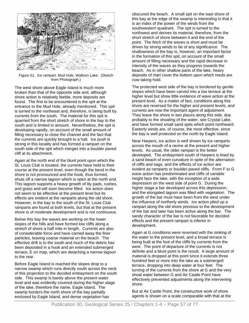
Figure 51. Ice rampart, Mud Hole, Walloon Lake. (Sketch
from Photograph.)
The west shore above Eagle Island is much more broken than that of the opposite side and, although shore action is relatively feeble, more deposits are found. The first to be encountered is the spit at the entrance to the Mud Hole, already mentioned. This spit is turned to the northeast and, therefore, is being built by currents from the south. The material for this spit is quarried from the short stretch of shore in the bay to the south and is limited in amount. Nevertheless, the spit is developing rapidly, on account of the small amount of filling necessary to close the channel and the fact that the currents are quickly brought to a halt. Ice push is strong in this locality and has formed a rampart on the south side of the spit which merges into a boulder paved cliff at its attachment.
Again at the north end of the blunt point upon which the St. Louis Club is located, the currents have held to their course at the present level, even though the bend in the shore is not pronounced and the hook, thus formed, shuts off a narrow lagoon which is open at the north end. This lagoon supports a heavy growth of lily pads, rushes, and grass and will soon become filled. Ice action does not seem to be effective at the present level but its effects are evident at the ramparts along the old shore. However, in the bay to the south of the St. Louis Club ramparts are found at both levels, but that at the present shore is of moderate development and is not continuous.
Below this bay the waves are working on the lower slopes of the hills and have formed low cliffs along a stretch of shore a half mile in length. Currents are also of considerable force and have carried away the finer particles, leaving coarse material on the beach. The effective drift is to the south and much of the debris has been deposited in a hook and an extended submerged terrace, E on map, which are detaching a narrow lagoon to the rear.
Before Eagle Island is reached the slopes drop to a narrow swamp which runs directly south across the neck of this projection to the decided embayment on the south side. This swamp is barely above the present water level and was evidently covered during the higher stage of the lake, therefore the name, Eagle Island. The swamp borders the north shore of the bay partially enclosed by Eagle Island, and dense vegetation has
obscured the beach. A small spit on the east shore of this bay at the edge of the swamp is interesting in that it is an index of the power of the winds from the southwestern quadrant. The spit is turned to the northwest and derives its material, therefore, from the short stretch of shore between it and the end of the point. The fetch of the waves is short and must be driven by strong winds to be of any significance. The shallowness of the bay is, however, an important factor in the formation of this spit, on account of the small amount of filling necessary and the rapid decrease in intensity of the waves as they progress towards the beach. As in other shallow parts of the lake, heavy deposits of marl cover the bottom upon which reeds are now taking hold.
The protected west side of the bay is bordered by gentle slopes which have been carved into a low terrace at the higher level but show little evidence of wave action at the present level. As a matter of fact, conditions along this shore are reversed for the higher and present levels, and currents are now the important agent of adjustment. They leave the shore in two places along this side, due probably to the shoaling of the water, see Crystal Lake, and have formed small sand spits which point northward. Easterly winds are, of course, the most effective, since the bay is well protected on the north by Eagle Island.
Near Harpers, ice action is well shown by ice ramparts across the mouth of a ravine at the present and higher levels. As usual, the older rampart is the better developed. The embayment south of Harpers is lined by a sand beach of even curvature in spite of the alternation of cliffs and sags, and the effects of ice action are evident as ramparts or boulder-paved cliffs. From F to G wave action has predominated and cliffs of variable height face the lake, with the exception of a wide depression on the west side of point G. During the higher stage a bar developed across this depression, and the elongated lagoon was filled with vegetation. The growth of the bar must have been from the west under the influence of northerly winds. Ice action piled up a rampart along the old shore previous to the development of the bar and later has been active along the bar. The sandy character of the bar is not favorable for decided effects and the present rampart is inferior in development.
Again at G conditions were reversed with the sinking of the water to the present level, and a broad terrace is being built at the foot of the cliffs by currents from the west. The point of departure of the currents is not definite and a blunt point is the result. A large amount of material is dropped at this point since it extends three hundred feet or more into the lake as a submerged terrace, dropping into deep water at four feet. The turning of the currents from the shore at G and the very shoal water between G and Air Castle Point have effectively prevented adjustments along the intervening shore.
But at Air Castle Point, the constructive work of shore agents is shown on a scale comparable with that at the
Publication 30, Geological Series 25 / Chapters 1-4 – Page 57 of 77
Publication 30, Geological Series 25 / Chapters 1-4 – Page 58 of 77
entrance to the North Arm and at Ryan Point. This great spit is irregular in outline on the west side but has an even curvature in accordance with the trend of the east shore. Clearly it has been built by currents from the south. Deposition is still taking place, and a submerged portion is growing into the lake as a relatively narrow bar with a somewhat greater curvature than the subaerial part, a form in striking contrast to the re-curved spits or hooks which are usually formed when currents are dissipated in deep water. The increase in curvature occurs along the part of the bar which has grown into deep water and is exposed to the force of the waves from the west, undiminished by the projecting point G and the intervening shoal. Under such conditions the spit will increase in curvature as it grows, and its position wall represent the relative strength of the forces acting on either side. It is probable that this spit will develop to the west of point C and, therefore, will not divide the lake, but it is impossible to make a definite statement on this point considering the present development of the spit. The greater part of the spit was built during the higher level and, after the establishment of vegetation, a continuous ice rampart was pushed up on the east side.
Below Air Castle Point cliffs, unbroken save for a narrow valley which is blocked by ice ramparts, line the shore to the head of the large embayment which forms the southern extremity of the lake. As already stated, this bay is caused by the continuation of the North Arm trough which extends several miles to the south and southeast. The shore is, therefore, low and swampy. The noticeable features are the well-developed submerged terrace and the ice ramparts. The ramparts are three in number and are especially well developed and distinct. They increase in elevation, size, and continuity with distance from the shore. The best developed, the one farthest inland, stands three to five feet above the adjacent land and encircles the bay with but a single break where a small stream crosses. The middle rampart is inferior in development but still is a decided ridge; the lowest is discontinuous and poorly defined in places. Two ramparts are common and may be correlated with the two stages of the lake. The presence of the third rampart in this one locality is, however, somewhat puzzling.
The lake attains its greatest width opposite this bay but still does not exceed the maximum limit for ice expansion. The expansion, then, is greatest in this locality, and the ramparts are exceptionally well developed. From its elevation, the rampart farthest inland may be considered the equivalent of the higher rampart formed in other favorable localities where two are present. Also it is evident that the ramparts nearest the shore are in process of formation at the present time and are correlatives. But a lake stage, corresponding in level with the intermediate rampart, cannot be assumed since corroborative evidence at other localities on the lake is entirely lacking. To the writer this series of ramparts seems to have been formed in a manner similar to that of an ice-push terrace but on a shore of such fiat slope that the ramparts are separate and
distinct ridges. The cause of the lowering of the lake level was the gradual deepening of the outlet by natural processes. The earliest and largest rampart was formed at the highest stage after vegetation had become well established and served to bind the loose sands. The size indicates that the higher stage must have been of relatively long duration. During the lowering of the level the vegetation slowly encroached on the emerging lake bottom and was not disturbed by the ice which, under normal conditions, expanded to positions less and less advanced as the shore receded. But under especially favorable conditions such as high water, light snowfall, and numerous alternations of temperature during the winter, excessive expansion took place, and the ice advanced into the zone of vegetation and pushed up the rampart. The slope seems to be the most important factor in this consideration since the rate of recession of the shore and, therefore, the advanced position of the expanding ice is dependent on the flatness of the slope. Another possible cause for the intermediate rampart is that the lowering of the level was temporarily halted by an obstruction in the outlet, which was sufficient for the formation of a rampart but not for distinguishable effects of the other shore agents.
The shores from this bay to the outlet are of the cliff and sag type, modified locally by ice action. This type has been so frequently mentioned in connection with other localities that repetition is not necessary and the description of the shores may be left at this point.
In resumé, the episodes in the history of this lake are but two, the present level and a stage a few feet higher. This may seem somewhat meager when compared with the numerous stages of several of the nearby lakes, but the many adjustments of the shores, begun at the higher level and continuing at the present, are of sufficient interest to compensate for the deficiency.
Walloon Lake stands well above the levels of the predecessors of the Great Lakes since Algonquin. There is a possibility of a connection with Algonquin at the southeastern end and a certainty that the higher stage was in existence at this time. Whichever may have been the case, the agencies affecting the shores of the higher level were similar in intensity to those active today, since the reduction in area has been slight and the lake was practically enclosed.
The irregularity of the basin and the adjacent slopes afforded many opportunities for large and significant adjustments of the shores, but on the other hand, effectively reduced the intensity of the forces by which such adjustments are accomplished. The limited reach of the winds and the irregularities of the shores permit a moderate development of waves and currents and the results, in general, correspond. Waves have cut back many of the minor salients, reducing the smaller sinuosities of the shore line, but the very limited development of a submerged terrace shows a relatively small amount of wave action. And the currents can neither be of great power nor continuity on account of the short stretches of even shore. The striking thing,
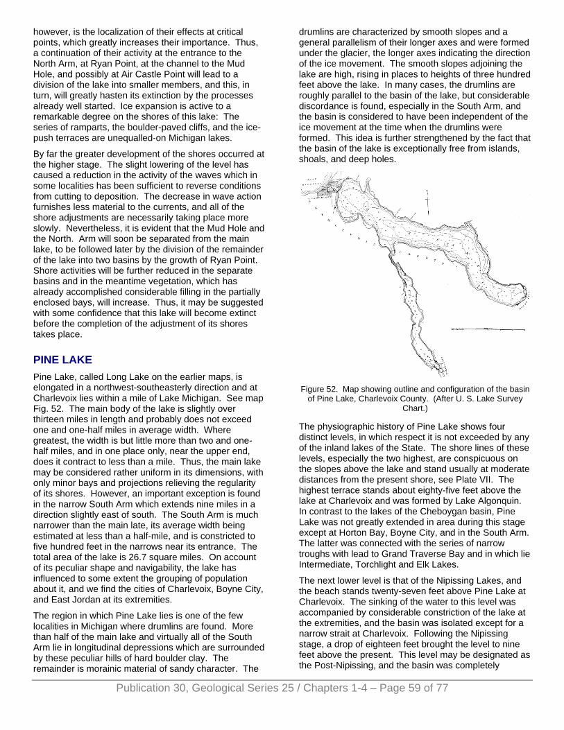
however, is the localization of their effects at critical points, which greatly increases their importance. Thus, a continuation of their activity at the entrance to the North Arm, at Ryan Point, at the channel to the Mud Hole, and possibly at Air Castle Point will lead to a division of the lake into smaller members, and this, in turn, will greatly hasten its extinction by the processes already well started. Ice expansion is active to a remarkable degree on the shores of this lake: The series of ramparts, the boulder-paved cliffs, and the ice-push terraces are unequalled-on Michigan lakes.
By far the greater development of the shores occurred at the higher stage. The slight lowering of the level has caused a reduction in the activity of the waves which in some localities has been sufficient to reverse conditions from cutting to deposition. The decrease in wave action furnishes less material to the currents, and all of the shore adjustments are necessarily taking place more slowly. Nevertheless, it is evident that the Mud Hole and the North. Arm will soon be separated from the main lake, to be followed later by the division of the remainder of the lake into two basins by the growth of Ryan Point. Shore activities will be further reduced in the separate basins and in the meantime vegetation, which has already accomplished considerable filling in the partially enclosed bays, will increase. Thus, it may be suggested with some confidence that this lake will become extinct before the completion of the adjustment of its shores takes place.
PINE LAKE Pine Lake, called Long Lake on the earlier maps, is elongated in a northwest-southeasterly direction and at Charlevoix lies within a mile of Lake Michigan. See map Fig. 52. The main body of the lake is slightly over thirteen miles in length and probably does not exceed one and one-half miles in average width. Where greatest, the width is but little more than two and one-half miles, and in one place only, near the upper end, does it contract to less than a mile. Thus, the main lake may be considered rather uniform in its dimensions, with only minor bays and projections relieving the regularity of its shores. However, an important exception is found in the narrow South Arm which extends nine miles in a direction slightly east of south. The South Arm is much narrower than the main late, its average width being estimated at less than a half-mile, and is constricted to five hundred feet in the narrows near its entrance. The total area of the lake is 26.7 square miles. On account of its peculiar shape and navigability, the lake has influenced to some extent the grouping of population about it, and we find the cities of Charlevoix, Boyne City, and East Jordan at its extremities.
The region in which Pine Lake lies is one of the few localities in Michigan where drumlins are found. More than half of the main lake and virtually all of the South Arm lie in longitudinal depressions which are surrounded by these peculiar hills of hard boulder clay. The remainder is morainic material of sandy character. The
drumlins are characterized by smooth slopes and a general parallelism of their longer axes and were formed under the glacier, the longer axes indicating the direction of the ice movement. The smooth slopes adjoining the lake are high, rising in places to heights of three hundred feet above the lake. In many cases, the drumlins are roughly parallel to the basin of the lake, but considerable discordance is found, especially in the South Arm, and the basin is considered to have been independent of the ice movement at the time when the drumlins were formed. This idea is further strengthened by the fact that the basin of the lake is exceptionally free from islands, shoals, and deep holes.
Figure 52. Map showing outline and configuration of the basin
of Pine Lake, Charlevoix County. (After U. S. Lake Survey Chart.)
The physiographic history of Pine Lake shows four distinct levels, in which respect it is not exceeded by any of the inland lakes of the State. The shore lines of these levels, especially the two highest, are conspicuous on the slopes above the lake and stand usually at moderate distances from the present shore, see Plate VII. The highest terrace stands about eighty-five feet above the lake at Charlevoix and was formed by Lake Algonquin. In contrast to the lakes of the Cheboygan basin, Pine Lake was not greatly extended in area during this stage except at Horton Bay, Boyne City, and in the South Arm. The latter was connected with the series of narrow troughs with lead to Grand Traverse Bay and in which lie Intermediate, Torchlight and Elk Lakes.
The next lower level is that of the Nipissing Lakes, and the beach stands twenty-seven feet above Pine Lake at Charlevoix. The sinking of the water to this level was accompanied by considerable constriction of the lake at the extremities, and the basin was isolated except for a narrow strait at Charlevoix. Following the Nipissing stage, a drop of eighteen feet brought the level to nine feet above the present. This level may be designated as the Post-Nipissing, and the basin was completely
Publication 30, Geological Series 25 / Chapters 1-4 – Page 59 of 77
Publication 30, Geological Series 25 / Chapters 1-4 – Page 60 of 77
isolated for the first time. The drop from the Post-Nipissing stage to a level four feet above the present, which we shall call the Upper Level, probably accompanied the downward cutting of the outlet. This level was abandoned when the lake was connected with Lake Michigan by an artificial channel in 1873, the amount of lowering being 3.62 feet, according to the United States Engineer.
The interesting history of the lake may be profitably supplemented by a study of the shore features at the various levels. In general, it may be stated that the regularity of the basin and the smoothness of the surrounding slopes have not furnished conditions for large adjustments of the shore lines. Also, on account of the greater power of the waves and possibly longer periods of action, the adjustments at the higher levels were of greater magnitude.
The narrow neck of land which separates Pine Lake from Lake Michigan is less than a mile in width. Its surface is composed of a flat terrace, the Nipissing, standing at an elevation of slightly less than thirty feet above Lake Michigan, and above this on either side rises a steep cliff to the Algonquin terrace, more than eighty feet above the lake. A rather deep depression, occupied by Round Lake, breaks the monotony of the Nipissing terrace and connects with Lake Michigan by a narrow channel, artificially deepened and widened. The connection with Pine Lake is now by an artificial channel which isolated Park Island the north side of which is formed by the Old River, the former outlet of Pine Lake. The channels are dug to a minimum depth of twelve feet and allow the entrance of large vessels into Round Lake, which makes an excellent harbor. The town of Charlevoix is built on the higher terraces but largely on the Nipissing terrace west of Round Lake. This thriving town is one of the most popular summer resorts of the State and is by far the best location on the lake. The extension of the lake towards the southeast is almost directly away from Lake Michigan, and the cooling effect of the lake breezes is slight at the farther extremities. Consequently, the lake as a whole is not so extensively patronized by summer visitors as are some others in the State.
On the Lake Michigan side of the Nipissing terrace at Charlevoix stands a narrow sand bar which developed from the southwest and must have crowded the outlet to the north, although it probably did not completely close it. Towards Pine Lake the Nipissing terrace is bordered by a cliff which drops to the Post-Nipissing level. In the early part of this stage Round and Pine lakes were connected by a strait about five hundred feet in width, but this connection was gradually narrowed by a bar which developed in a northeasterly direction from the cliffs on the south side of the present channel to the large bend in the Old River. Sufficient water passed through the Channel to keep it open, but the bar was able to force the stream to the cliffs on the north side. Above the shore of Pine Lake in this vicinity, the Upper and Post-Nipissing shores are well defined, the former
having an especially fresh appearance. Thus, in the vicinity of Charlevoix the four main stages of the lake may be readily distinguished.
Along the north shore the Nipissing terrace narrows and soon disappears. At the present shore are found storm beaches, indicating the existence of powerful waves which develop with a fetch of several miles when the wind is from the southeast. At the most northern tip of the lake is a lowland extension which was the scene of strong current action in former times. The present shore swings in an even curve towards Pine Point and is bordered by a flat which slopes gently upward to a distinct sand bar about one hundred yards from the shore. Behind the bar, the crest of which stands four feet above the lake, is a swampy lagoon, which gradually becomes drier to the north. The depression is again interrupted beyond by a strong bar which stands twenty feet above Pine Lake. In both cases, the bars extend completely across the depression and, since their elevations correspond to the Nipissing and Upper Levels, we may conclude that portions of this bay were cut off from the main lake at those levels. The present conditions at Pine Point show moderate wave and current action from the west, thus enabling us to determine the direction of the development of these bars.
Pine Point was formerly much more prominent than at present because, in addition to the bay just discussed, there existed a narrow indentation east of the point, which extended fully a quarter of a mile inland. This bay persisted until the Upper Level, during which a bar was built near the present shore. An attempt at draining the lagoon, thus formed, was made by digging a ditch through the bar, but with mediocre success. At the present level the only shore action is accomplished by waves which have thrown up a storm beach of sufficient height to enclose a narrow, crescent-shaped lagoon. Along this shore the waves have laid bare considerable marl which was deposited during earlier stages.
On either side of Oyster Bay drumlin-like projections of nearly north-south trend reach the lake shore and are responsible for its irregularity. On the lake side of the promonotory west of the bay the waves are actively cutting as they have been in the past. The effects are seen in a beach of rather coarse material and in distinct, but narrow, terraces of the Upper, Post-Nipissing, and Nipissing levels. Oyster Bay occupies a shallow sag that continues northward forty rods or more beyond the present shore. During the Upper Level, the greater part of this depression was covered, but a distinct bar within two hundred feet of the present shore indicates the formation of a lagoon at the head. The extinction of this lagoon was casued by accumulation of marl, heavy deposits of which may now be seen.
The long stretch between Oyster Bay and Horton Bay is noticeable mainly for the perfection of the terraces of the former levels of the lake, shown diagrammatically in Figure 53. The least developed of the terraces is the Post-Nipissing which has been cut away in places. The
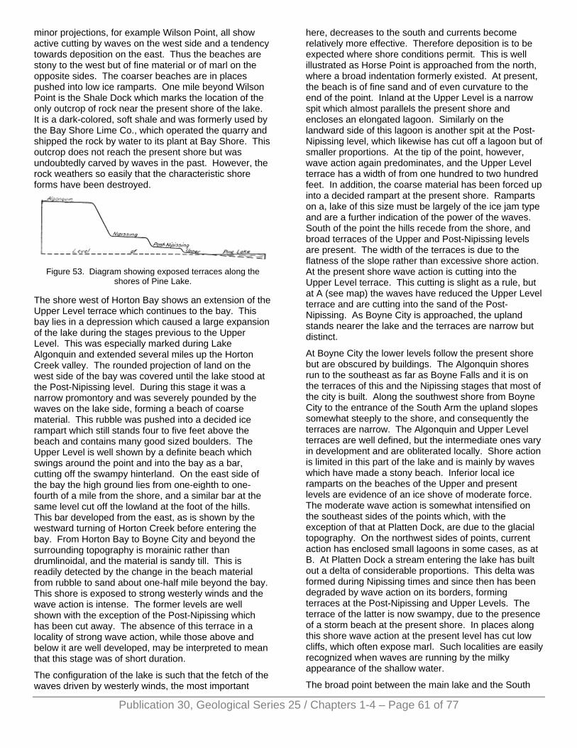
minor projections, for example Wilson Point, all show active cutting by waves on the west side and a tendency towards deposition on the east. Thus the beaches are stony to the west but of fine material or of marl on the opposite sides. The coarser beaches are in places pushed into low ice ramparts. One mile beyond Wilson Point is the Shale Dock which marks the location of the only outcrop of rock near the present shore of the lake. It is a dark-colored, soft shale and was formerly used by the Bay Shore Lime Co., which operated the quarry and shipped the rock by water to its plant at Bay Shore. This outcrop does not reach the present shore but was undoubtedly carved by waves in the past. However, the rock weathers so easily that the characteristic shore forms have been destroyed.
Figure 53. Diagram showing exposed terraces along the
shores of Pine Lake.
The shore west of Horton Bay shows an extension of the Upper Level terrace which continues to the bay. This bay lies in a depression which caused a large expansion of the lake during the stages previous to the Upper Level. This was especially marked during Lake Algonquin and extended several miles up the Horton Creek valley. The rounded projection of land on the west side of the bay was covered until the lake stood at the Post-Nipissing level. During this stage it was a narrow promontory and was severely pounded by the waves on the lake side, forming a beach of coarse material. This rubble was pushed into a decided ice rampart which still stands four to five feet above the beach and contains many good sized boulders. The Upper Level is well shown by a definite beach which swings around the point and into the bay as a bar, cutting off the swampy hinterland. On the east side of the bay the high ground lies from one-eighth to one-fourth of a mile from the shore, and a similar bar at the same level cut off the lowland at the foot of the hills. This bar developed from the east, as is shown by the westward turning of Horton Creek before entering the bay. From Horton Bay to Boyne City and beyond the surrounding topography is morainic rather than drumlinoidal, and the material is sandy till. This is readily detected by the change in the beach material from rubble to sand about one-half mile beyond the bay. This shore is exposed to strong westerly winds and the wave action is intense. The former levels are well shown with the exception of the Post-Nipissing which has been cut away. The absence of this terrace in a locality of strong wave action, while those above and below it are well developed, may be interpreted to mean that this stage was of short duration.
The configuration of the lake is such that the fetch of the waves driven by westerly winds, the most important
here, decreases to the south and currents become relatively more effective. Therefore deposition is to be expected where shore conditions permit. This is well illustrated as Horse Point is approached from the north, where a broad indentation formerly existed. At present, the beach is of fine sand and of even curvature to the end of the point. Inland at the Upper Level is a narrow spit which almost parallels the present shore and encloses an elongated lagoon. Similarly on the landward side of this lagoon is another spit at the Post-Nipissing level, which likewise has cut off a lagoon but of smaller proportions. At the tip of the point, however, wave action again predominates, and the Upper Level terrace has a width of from one hundred to two hundred feet. In addition, the coarse material has been forced up into a decided rampart at the present shore. Ramparts on a, lake of this size must be largely of the ice jam type and are a further indication of the power of the waves. South of the point the hills recede from the shore, and broad terraces of the Upper and Post-Nipissing levels are present. The width of the terraces is due to the flatness of the slope rather than excessive shore action. At the present shore wave action is cutting into the Upper Level terrace. This cutting is slight as a rule, but at A (see map) the waves have reduced the Upper Level terrace and are cutting into the sand of the Post-Nipissing. As Boyne City is approached, the upland stands nearer the lake and the terraces are narrow but distinct.
At Boyne City the lower levels follow the present shore but are obscured by buildings. The Algonquin shores run to the southeast as far as Boyne Falls and it is on the terraces of this and the Nipissing stages that most of the city is built. Along the southwest shore from Boyne City to the entrance of the South Arm the upland slopes somewhat steeply to the shore, and consequently the terraces are narrow. The Algonquin and Upper Level terraces are well defined, but the intermediate ones vary in development and are obliterated locally. Shore action is limited in this part of the lake and is mainly by waves which have made a stony beach. Inferior local ice ramparts on the beaches of the Upper and present levels are evidence of an ice shove of moderate force. The moderate wave action is somewhat intensified on the southeast sides of the points which, with the exception of that at Platten Dock, are due to the glacial topography. On the northwest sides of points, current action has enclosed small lagoons in some cases, as at B. At Platten Dock a stream entering the lake has built out a delta of considerable proportions. This delta was formed during Nipissing times and since then has been degraded by wave action on its borders, forming terraces at the Post-Nipissing and Upper Levels. The terrace of the latter is now swampy, due to the presence of a storm beach at the present shore. In places along this shore wave action at the present level has cut low cliffs, which often expose marl. Such localities are easily recognized when waves are running by the milky appearance of the shallow water.
The broad point between the main lake and the South
Publication 30, Geological Series 25 / Chapters 1-4 – Page 61 of 77
Publication 30, Geological Series 25 / Chapters 1-4 – Page 62 of 77
Arm is exposed to the heavy seas of the northeasterly winds and wave action is powerful. In addition, the original slopes were low, consequently all the terraces are well developed and wide. Ice has also been active in this locality, having formed distinct ramparts on the beaches of the present and Upper levels on the west side of the point. The intensive work of the waves on this point may be appreciated by a trip of somewhat over one-fourth mile eastward from the narrows of the South Arm to a drumlin, the top of which was completely bevelled during Algonquin time. The drumlins are, perhaps, best developed along the South Arm but as a rule lie beyond the borders of Lake Algonquin.
The entrance to the South Arm is almost closed by an abrupt projection of the shore from the east side. The south end of this projection makes a sharp re-entrant and affords at its tip an excellent index of current action through the narrows. An incipient spit shows that weak southward moving currents pass through. It will be seen from the map that waves of considerable size may be formed from the north. The drive of these waves tends to pile up the water on this shore and the only outlet is through this narrowing channel, even though it is tortuous.
The South Arm nowhere reaches a mile in width and the adjoining slopes are consistently steep. Consequently, wave action is moderate and shore adjustments are much less striking than along the shores of the main lake. However, the Algonquin and Nipissing terraces, shown in Plate VII, are well developed and encircle this arm of the lake. This is to be expected since the lake was larger during these stages and also received some of the swells of the main lake. For the most part, the lower beaches are distinct but only locally are they well developed. The best development is found on the numerous small headlands, illustrated by point C. All four terraces are found here, and, in addition, a small spit is growing to the north at the present level. The only winds effective on this shore are those from northerly or southerly quadrants, and the latter are the more important on account of their long-reach. Farther south, point D shows a wide Nipissing terrace into which the waves have cut a low cliff. The lower terraces seem to have been poorly developed here and were quickly obliterated. South of this blunt point the slopes are flatter and all the terraces are present. The effects of ice action are seen in the fragmentary ramparts at the Post-Nipissing and Upper levels, caused probably by expansion here.
With slight variations, the conditions just described continue to East Jordan where the narrow, lower terraces encircle the end of the lake with some extension up the valley of the Jordan river. This stream has deposited large quantities of material and filled in a considerable area at the head of the lake during the lower levels. It enters from the west and has constricted the end of the lake by deposition from this side. The development of the higher terraces is almost identical with that at Boyne City, except that the Algonquin was
even more extended.
On the west side of the South Arm the features are so similar to those opposite that a detailed description seems unnecessary. The shore from point E northward to the next prominent projection is worthy of mention on account of the prominence of the Post-Nipissing terrace, which is usually poorly developed. The adjustments at present are mainly due to cutting and this on the north sides of the points. Again, at Holy Island the terraces are well developed. This island first stood above water during the Post-Nipissing stage, and this and succeeding levels are distinctly shown. On the sides, the levels are indicated by notches and low cliffs, and at the ends terraces thirty or more feet in width are present. At the north end a bar has nearly bridged the shallow water between the island and the mainland, and artificial filling with brush has sufficed for a rude roadway to the island.
The west side of the narrows is flanked by narrow terraces which broaden somewhat as the main lake is reached, and on these terraces Sequanota is built. Beyond Sequanota the terraces are again narrow and the lower ones are indistinct in places, as at F, the Upper Level having been entirely removed. The broad embayment west of F is a depression between drumlins and was formerly much more extensive. When the water dropped to the Upper Level, this was reduced to a shallow bay, and during this time a bar and lagoon were formed. The bar stands near the present shore and the lagoon is now a swampy lowland. At Two Mile Point, a drumlin, the Post-Nipissing and Upper Level terraces are again well developed with a low ice rampart of rock on the shore of the latter. This rampart runs around the point into Newman Bay where it changes from coarse material to sand and has the characteristics of a storm beach. It is readily recognized by a row of pines growing on its surface. Back of it stands the sandy terrace of the Post-Nipissing level, and in front the broad, sandy terrace of the Upper Level extends to the present shore. The loose sands on this terrace are being blown into small/ irregular dunes. Beyond the bay to Charlevoix the upland stands near the shore and the terraces are very distinct.
As may be inferred from the description above, the adjustments of the shores of Pine Lake, although moderate in effects, have been numerous and were made at the higher levels. Probably the greatest changes took place at the Upper Level, and the most noticeable of these was the development of bars across the more prominent embayments. This level was abandoned less than fifty years ago and only minor adjustments have occurred since that time. The main work at present is the cutting by waves and this has seldom advanced to the limits of the Upper Level. Incipient current forms are present in a few localities but are almost negligible when compared with those formed at the previous levels. A well-developed, but narrow, submerged terrace is continuous around the lake and varies in depth at its outer edge from three feet off sheltered shores to ten feet, the latter being more nearly
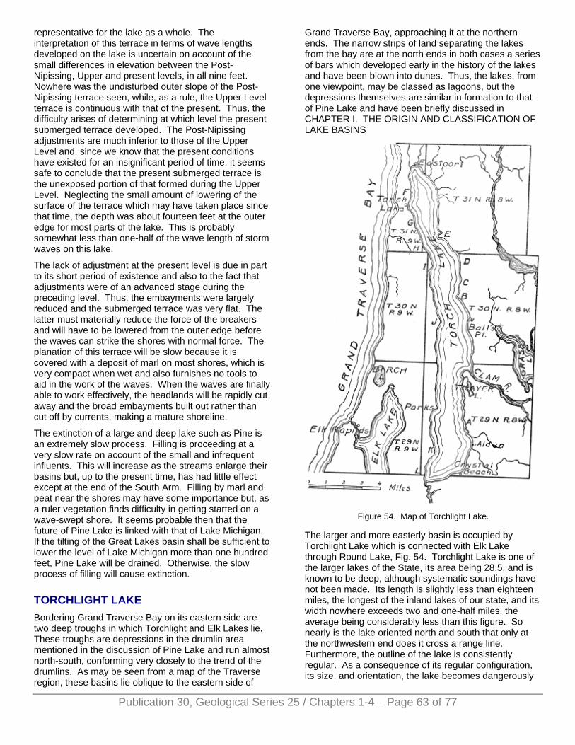
representative for the lake as a whole. The interpretation of this terrace in terms of wave lengths developed on the lake is uncertain on account of the small differences in elevation between the Post-Nipissing, Upper and present levels, in all nine feet. Nowhere was the undisturbed outer slope of the Post-Nipissing terrace seen, while, as a rule, the Upper Level terrace is continuous with that of the present. Thus, the difficulty arises of determining at which level the present submerged terrace developed. The Post-Nipissing adjustments are much inferior to those of the Upper Level and, since we know that the present conditions have existed for an insignificant period of time, it seems safe to conclude that the present submerged terrace is the unexposed portion of that formed during the Upper Level. Neglecting the small amount of lowering of the surface of the terrace which may have taken place since that time, the depth was about fourteen feet at the outer edge for most parts of the lake. This is probably somewhat less than one-half of the wave length of storm waves on this lake.
The lack of adjustment at the present level is due in part to its short period of existence and also to the fact that adjustments were of an advanced stage during the preceding level. Thus, the embayments were largely reduced and the submerged terrace was very flat. The latter must materially reduce the force of the breakers and will have to be lowered from the outer edge before the waves can strike the shores with normal force. The planation of this terrace will be slow because it is covered with a deposit of marl on most shores, which is very compact when wet and also furnishes no tools to aid in the work of the waves. When the waves are finally able to work effectively, the headlands will be rapidly cut away and the broad embayments built out rather than cut off by currents, making a mature shoreline.
The extinction of a large and deep lake such as Pine is an extremely slow process. Filling is proceeding at a very slow rate on account of the small and infrequent influents. This will increase as the streams enlarge their basins but, up to the present time, has had little effect except at the end of the South Arm. Filling by marl and peat near the shores may have some importance but, as a ruler vegetation finds difficulty in getting started on a wave-swept shore. It seems probable then that the future of Pine Lake is linked with that of Lake Michigan. If the tilting of the Great Lakes basin shall be sufficient to lower the level of Lake Michigan more than one hundred feet, Pine Lake will be drained. Otherwise, the slow process of filling will cause extinction.
TORCHLIGHT LAKE Bordering Grand Traverse Bay on its eastern side are two deep troughs in which Torchlight and Elk Lakes lie. These troughs are depressions in the drumlin area mentioned in the discussion of Pine Lake and run almost north-south, conforming very closely to the trend of the drumlins. As may be seen from a map of the Traverse region, these basins lie oblique to the eastern side of
Grand Traverse Bay, approaching it at the northern ends. The narrow strips of land separating the lakes from the bay are at the north ends in both cases a series of bars which developed early in the history of the lakes and have been blown into dunes. Thus, the lakes, from one viewpoint, may be classed as lagoons, but the depressions themselves are similar in formation to that of Pine Lake and have been briefly discussed in CHAPTER I. THE ORIGIN AND CLASSIFICATION OF LAKE BASINS
Figure 54. Map of Torchlight Lake.
The larger and more easterly basin is occupied by Torchlight Lake which is connected with Elk Lake through Round Lake, Fig. 54. Torchlight Lake is one of the larger lakes of the State, its area being 28.5, and is known to be deep, although systematic soundings have not been made. Its length is slightly less than eighteen miles, the longest of the inland lakes of our state, and its width nowhere exceeds two and one-half miles, the average being considerably less than this figure. So nearly is the lake oriented north and south that only at the northwestern end does it cross a range line. Furthermore, the outline of the lake is consistently regular. As a consequence of its regular configuration, its size, and orientation, the lake becomes dangerously
Publication 30, Geological Series 25 / Chapters 1-4 – Page 63 of 77
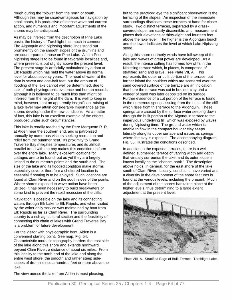
rough during the "blows" from the north or south. Although this may be disadvantageous for navigation by small boats, it is productive of intense wave and current action, and numerous and important adjustments of the shores may be anticipated.
As may be inferred from the description of Pine Lake basin, the history of Torchlight has much in common. The Algonquin and Nipissing shore lines stand out prominently on the smooth slopes of the drumlins and are counterparts of those on Pine Lake. Also a Post-Nipissing stage is to be found in favorable localities and, where present, is but slightly above the present level. The present stage is artificially maintained by a dam at Elk Rapids which has held the water above its normal level for about seventy years. The head of water at the dam is seven and one-half feet, but the amount of flooding of the lake cannot well be determined, due to lack of both physiographic evidence and human records, although it is believed to be much less than might be inferred from the height of the dam. It is well to keep in mind, however, that an apparently insignificant raising of a lake level may attain considerable importance as the shores develop under the new conditions. As a matter of fact, this lake is an excellent example of the effects produced under such circumstances.
This lake is readily reached by the Pere Marquette R. R. at Alden near the southern end, and is patronized annually by numerous visitors seeking recreation and relief from the summer heat. Its proximity to Grand Traverse Bay mitigates temperatures and its almost parallel trend with the bay makes this condition uniform over the entire lake. Many excellent locations for cottages are to be found, but as yet they are largely limited to the numerous points and the south end. The size of the lake and its flooded condition make storms especially severe, therefore a sheltered location is essential if boating is to be enjoyed. Such locations are found at Clam River and on the south sides of the points. Where shores exposed to wave action have been utilized, it has been necessary to build breakwaters of some kind to prevent the rapid recession of the cliffs.
Navigation is possible on the lake and its connecting waters through Elk Lake to Elk Rapids, and when visited by the writer daily service was maintained by boat from Elk Rapids as far as Clam River. The surrounding country is a rich agricultural section and the feasibility of connecting this chain of lakes with Grand Traverse Bay is a problem for future development.
For the visitor with physiographic bent, Alden is a convenient starting point. See map, Fig. 54. Characteristic morainic topography borders the east side of the lake along this shore and extends northward beyond Clam River, a distance of about six miles. From this locality to the north end of the lake and along the entire west shore, the smooth and rather steep side-slopes of drumlins rise a hundred feet or more above the lake.
The view across the lake from Alden is most pleasing,
but to the practiced eye the significant observation is the terracing of the slopes. An inspection of the immediate surroundings discloses these terraces at hand for closer study. Two distinct terraces, separated by a grass-covered slope, are easily discernible, and measurement places their elevations at thirty-eight and fourteen feet above the lake level. The higher is the Algonquin beach and the lower indicates the level at which Lake Nipissing stood.
Along this shore northerly winds have full sweep of the lake and waves of great power are developed. As a result, the intense cutting has formed low cliffs in the Nipissing terrace which, in places, is composed of stratified sand and gravel, see Plate VII, A. This represents the outer or built portion of the terrace, but farther inland the boulders which are scattered over the sand covered surface of the terrace are an indication that here the terrace was cut in boulder clay and a veneer of sand was later deposited on its surface. Further evidence of a cut portion of the terrace is found in the numerous springs issuing from the base of the cliff which rises from this terrace to the Algonquin. These springs .are caused by the surface water seeping down through the built portion of the Algonquin terrace to the impervious underlying till, which was exposed by waves during Nipissing time. The ground water which is, unable to flow in the compact boulder clay seeps laterally along its upper surface and issues as springs where the clay is exposed. The accompanying diagram, Fig. 55, illustrates the conditions described.
In addition to the exposed terraces, there is a well defined submerged terrace of varying width and depth that virtually surrounds the lake, and its outer slope is known locally as the "channel bank." The description above holds, in general, for the east shore of the lake south of Clam River. Locally, conditions have varied and a diversity in the development of the shore features is found at the various levels, including the present. Much of the adjustment of the shores has taken place at the higher levels, thus determining to a large extent adjustment at the present level.
Plate VIII. A. Stratified Edge of Built-Terrace, Torchlight Lake.
Publication 30, Geological Series 25 / Chapters 1-4 – Page 64 of 77
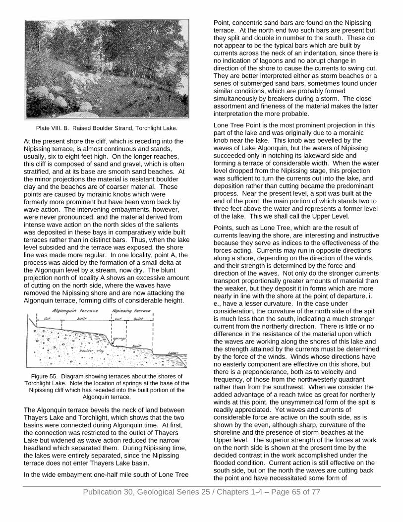
Plate VIII. B. Raised Boulder Strand, Torchlight Lake.
At the present shore the cliff, which is receding into the Nipissing terrace, is almost continuous and stands, usually, six to eight feet high. On the longer reaches, this cliff is composed of sand and gravel, which is often stratified, and at its base are smooth sand beaches. At the minor projections the material is resistant boulder clay and the beaches are of coarser material. These points are caused by morainic knobs which were formerly more prominent but have been worn back by wave action. The intervening embayments, however, were never pronounced, and the material derived from intense wave action on the north sides of the salients was deposited in these bays in comparatively wide built terraces rather than in distinct bars. Thus, when the lake level subsided and the terrace was exposed, the shore line was made more regular. In one locality, point A, the process was aided by the formation of a small delta at the Algonquin level by a stream, now dry. The blunt projection north of locality A shows an excessive amount of cutting on the north side, where the waves have removed the Nipissing shore and are now attacking the Algonquin terrace, forming cliffs of considerable height.
Figure 55. Diagram showing terraces about the shores of
Torchlight Lake. Note the location of springs at the base of the Nipissing cliff which has receded into the built portion of the
Algonquin terrace.
The Algonquin terrace bevels the neck of land between Thayers Lake and Torchlight, which shows that the two basins were connected during Algonquin time. At first, the connection was restricted to the outlet of Thayers Lake but widened as wave action reduced the narrow headland which separated them. During Nipissing time, the lakes were entirely separated, since the Nipissing terrace does not enter Thayers Lake basin.
In the wide embayment one-half mile south of Lone Tree
Point, concentric sand bars are found on the Nipissing terrace. At the north end two such bars are present but they split and double in number to the south. These do not appear to be the typical bars which are built by currents across the neck of an indentation, since there is no indication of lagoons and no abrupt change in direction of the shore to cause the currents to swing cut. They are better interpreted either as storm beaches or a series of submerged sand bars, sometimes found under similar conditions, which are probably formed simultaneously by breakers during a storm. The close assortment and fineness of the material makes the latter interpretation the more probable.
Lone Tree Point is the most prominent projection in this part of the lake and was originally due to a morainic knob near the lake. This knob was bevelled by the waves of Lake Algonquin, but the waters of Nipissing succeeded only in notching its lakeward side and forming a terrace of considerable width. When the water level dropped from the Nipissing stage, this projection was sufficient to turn the currents out into the lake, and deposition rather than cutting became the predominant process. Near the present level, a spit was built at the end of the point, the main portion of which stands two to three feet above the water and represents a former level of the lake. This we shall call the Upper Level.
Points, such as Lone Tree, which are the result of currents leaving the shore, are interesting and instructive because they serve as indices to the effectiveness of the forces acting. Currents may run in opposite directions along a shore, depending on the direction of the winds, and their strength is determined by the force and direction of the waves. Not only do the stronger currents transport proportionally greater amounts of material than the weaker, but they deposit it in forms which are more nearly in line with the shore at the point of departure, i. e., have a lesser curvature. In the case under consideration, the curvature of the north side of the spit is much less than the south, indicating a much stronger current from the northerly direction. There is little or no difference in the resistance of the material upon which the waves are working along the shores of this lake and the strength attained by the currents must be determined by the force of the winds. Winds whose directions have no easterly component are effective on this shore, but there is a preponderance, both as to velocity and frequency, of those from the northwesterly quadrant rather than from the southwest. When we consider the added advantage of a reach twice as great for northerly winds at this point, the unsymmetrical form of the spit is readily appreciated. Yet waves and currents of considerable force are active on the south side, as is shown by the even, although sharp, curvature of the shoreline and the presence of storm beaches at the Upper level. The superior strength of the forces at work on the north side is shown at the present time by the decided contrast in the work accomplished under the flooded condition. Current action is still effective on the south side, but on the north the waves are cutting back the point and have necessitated some form of
Publication 30, Geological Series 25 / Chapters 1-4 – Page 65 of 77
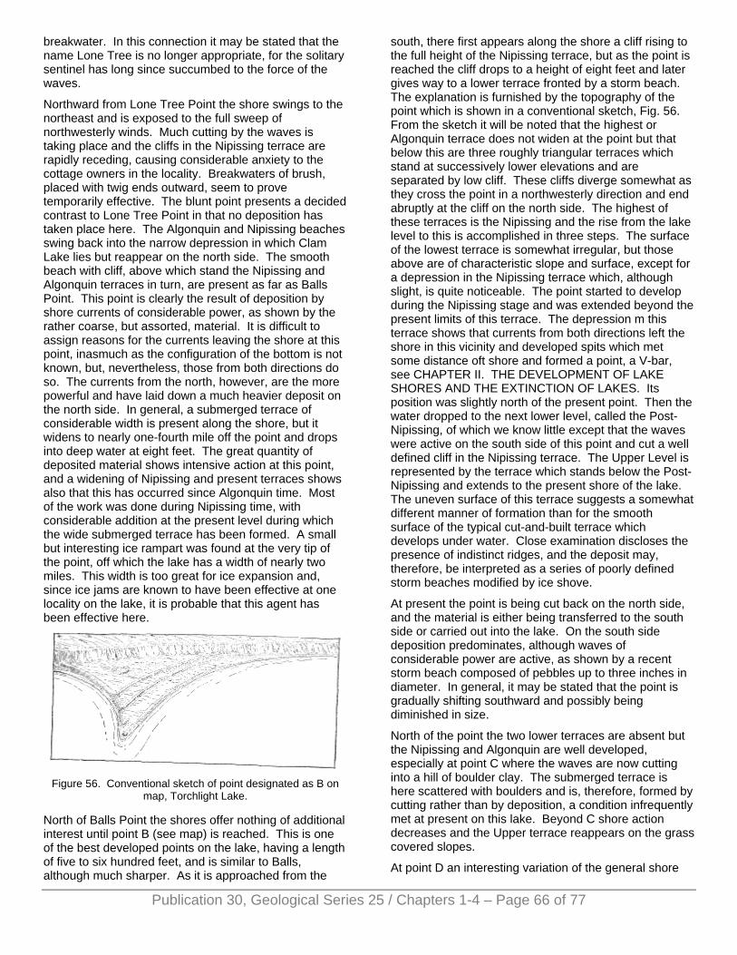
breakwater. In this connection it may be stated that the name Lone Tree is no longer appropriate, for the solitary sentinel has long since succumbed to the force of the waves.
Northward from Lone Tree Point the shore swings to the northeast and is exposed to the full sweep of northwesterly winds. Much cutting by the waves is taking place and the cliffs in the Nipissing terrace are rapidly receding, causing considerable anxiety to the cottage owners in the locality. Breakwaters of brush, placed with twig ends outward, seem to prove temporarily effective. The blunt point presents a decided contrast to Lone Tree Point in that no deposition has taken place here. The Algonquin and Nipissing beaches swing back into the narrow depression in which Clam Lake lies but reappear on the north side. The smooth beach with cliff, above which stand the Nipissing and Algonquin terraces in turn, are present as far as Balls Point. This point is clearly the result of deposition by shore currents of considerable power, as shown by the rather coarse, but assorted, material. It is difficult to assign reasons for the currents leaving the shore at this point, inasmuch as the configuration of the bottom is not known, but, nevertheless, those from both directions do so. The currents from the north, however, are the more powerful and have laid down a much heavier deposit on the north side. In general, a submerged terrace of considerable width is present along the shore, but it widens to nearly one-fourth mile off the point and drops into deep water at eight feet. The great quantity of deposited material shows intensive action at this point, and a widening of Nipissing and present terraces shows also that this has occurred since Algonquin time. Most of the work was done during Nipissing time, with considerable addition at the present level during which the wide submerged terrace has been formed. A small but interesting ice rampart was found at the very tip of the point, off which the lake has a width of nearly two miles. This width is too great for ice expansion and, since ice jams are known to have been effective at one locality on the lake, it is probable that this agent has been effective here.
Figure 56. Conventional sketch of point designated as B on
map, Torchlight Lake.
North of Balls Point the shores offer nothing of additional interest until point B (see map) is reached. This is one of the best developed points on the lake, having a length of five to six hundred feet, and is similar to Balls, although much sharper. As it is approached from the
south, there first appears along the shore a cliff rising to the full height of the Nipissing terrace, but as the point is reached the cliff drops to a height of eight feet and later gives way to a lower terrace fronted by a storm beach. The explanation is furnished by the topography of the point which is shown in a conventional sketch, Fig. 56. From the sketch it will be noted that the highest or Algonquin terrace does not widen at the point but that below this are three roughly triangular terraces which stand at successively lower elevations and are separated by low cliff. These cliffs diverge somewhat as they cross the point in a northwesterly direction and end abruptly at the cliff on the north side. The highest of these terraces is the Nipissing and the rise from the lake level to this is accomplished in three steps. The surface of the lowest terrace is somewhat irregular, but those above are of characteristic slope and surface, except for a depression in the Nipissing terrace which, although slight, is quite noticeable. The point started to develop during the Nipissing stage and was extended beyond the present limits of this terrace. The depression m this terrace shows that currents from both directions left the shore in this vicinity and developed spits which met some distance oft shore and formed a point, a V-bar, see CHAPTER II. THE DEVELOPMENT OF LAKE SHORES AND THE EXTINCTION OF LAKES. Its position was slightly north of the present point. Then the water dropped to the next lower level, called the Post-Nipissing, of which we know little except that the waves were active on the south side of this point and cut a well defined cliff in the Nipissing terrace. The Upper Level is represented by the terrace which stands below the Post-Nipissing and extends to the present shore of the lake. The uneven surface of this terrace suggests a somewhat different manner of formation than for the smooth surface of the typical cut-and-built terrace which develops under water. Close examination discloses the presence of indistinct ridges, and the deposit may, therefore, be interpreted as a series of poorly defined storm beaches modified by ice shove.
At present the point is being cut back on the north side, and the material is either being transferred to the south side or carried out into the lake. On the south side deposition predominates, although waves of considerable power are active, as shown by a recent storm beach composed of pebbles up to three inches in diameter. In general, it may be stated that the point is gradually shifting southward and possibly being diminished in size.
North of the point the two lower terraces are absent but the Nipissing and Algonquin are well developed, especially at point C where the waves are now cutting into a hill of boulder clay. The submerged terrace is here scattered with boulders and is, therefore, formed by cutting rather than by deposition, a condition infrequently met at present on this lake. Beyond C shore action decreases and the Upper terrace reappears on the grass covered slopes.
At point D an interesting variation of the general shore
Publication 30, Geological Series 25 / Chapters 1-4 – Page 66 of 77
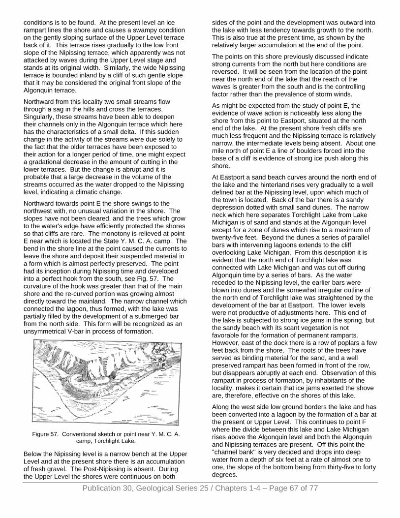
conditions is to be found. At the present level an ice rampart lines the shore and causes a swampy condition on the gently sloping surface of the Upper Level terrace back of it. This terrace rises gradually to the low front slope of the Nipissing terrace, which apparently was not attacked by waves during the Upper Level stage and stands at its original width. Similarly, the wide Nipissing terrace is bounded inland by a cliff of such gentle slope that it may be considered the original front slope of the Algonquin terrace.
Northward from this locality two small streams flow through a sag in the hills and cross the terraces. Singularly, these streams have been able to deepen their channels only in the Algonquin terrace which here has the characteristics of a small delta. If this sudden change in the activity of the streams were due solely to the fact that the older terraces have been exposed to their action for a longer period of time, one might expect a gradational decrease in the amount of cutting in the lower terraces. But the change is abrupt and it is probable that a large decrease in the volume of the streams occurred as the water dropped to the Nipissing level, indicating a climatic change.
Northward towards point E the shore swings to the northwest with, no unusual variation in the shore. The slopes have not been cleared, and the trees which grow to the water's edge have efficiently protected the shores so that cliffs are rare. The monotony is relieved at point E near which is located the State Y. M. C. A. camp. The bend in the shore line at the point caused the currents to leave the shore and deposit their suspended material in a form which is almost perfectly preserved. The point had its inception during Nipissing time and developed into a perfect hook from the south, see Fig. 57. The curvature of the hook was greater than that of the main shore and the re-curved portion was growing almost directly toward the mainland. The narrow channel which connected the lagoon, thus formed, with the lake was partially filled by the development of a submerged bar from the north side. This form will be recognized as an unsymmetrical V-bar in process of formation.
Figure 57. Conventional sketch or point near Y. M. C. A.
camp, Torchlight Lake.
Below the Nipissing level is a narrow bench at the Upper Level and at the present shore there is an accumulation of fresh gravel. The Post-Nipissing is absent. During the Upper Level the shores were continuous on both
sides of the point and the development was outward into the lake with less tendency towards growth to the north. This is also true at the present time, as shown by the relatively larger accumulation at the end of the point.
The points on this shore previously discussed indicate strong currents from the north but here conditions are reversed. It will be seen from the location of the point near the north end of the lake that the reach of the waves is greater from the south and is the controlling factor rather than the prevalence of storm winds.
As might be expected from the study of point E, the evidence of wave action is noticeably less along the shore from this point to Eastport, situated at the north end of the lake. At the present shore fresh cliffs are much less frequent and the Nipissing terrace is relatively narrow, the intermediate levels being absent. About one mile north of point E a line of boulders forced into the base of a cliff is evidence of strong ice push along this shore.
At Eastport a sand beach curves around the north end of the lake and the hinterland rises very gradually to a well defined bar at the Nipissing level, upon which much of the town is located. Back of the bar there is a sandy depression dotted with small sand dunes. The narrow neck which here separates Torchlight Lake from Lake Michigan is of sand and stands at the Algonquin level except for a zone of dunes which rise to a maximum of twenty-five feet. Beyond the dunes a series of parallel bars with intervening lagoons extends to the cliff overlooking Lake Michigan. From this description it is evident that the north end of Torchlight lake was connected with Lake Michigan and was cut off during Algonquin time by a series of bars. As the water receded to the Nipissing level, the earlier bars were blown into dunes and the somewhat irregular outline of the north end of Torchlight lake was straightened by the development of the bar at Eastport. The lower levels were not productive of adjustments here. This end of the lake is subjected to strong ice jams in the spring, but the sandy beach with its scant vegetation is not favorable for the formation of permanent ramparts. However, east of the dock there is a row of poplars a few feet back from the shore. The roots of the trees have served as binding material for the sand, and a well preserved rampart has been formed in front of the row, but disappears abruptly at each end. Observation of this rampart in process of formation, by inhabitants of the locality, makes it certain that ice jams exerted the shove are, therefore, effective on the shores of this lake.
Along the west side low ground borders the lake and has been converted into a lagoon by the formation of a bar at the present or Upper Level. This continues to point F where the divide between this lake and Lake Michigan rises above the Algonquin level and both the Algonquin and Nipissing terraces are present. Off this point the "channel bank" is very decided and drops into deep water from a depth of six feet at a rate of almost one to one, the slope of the bottom being from thirty-five to forty degrees.
Publication 30, Geological Series 25 / Chapters 1-4 – Page 67 of 77
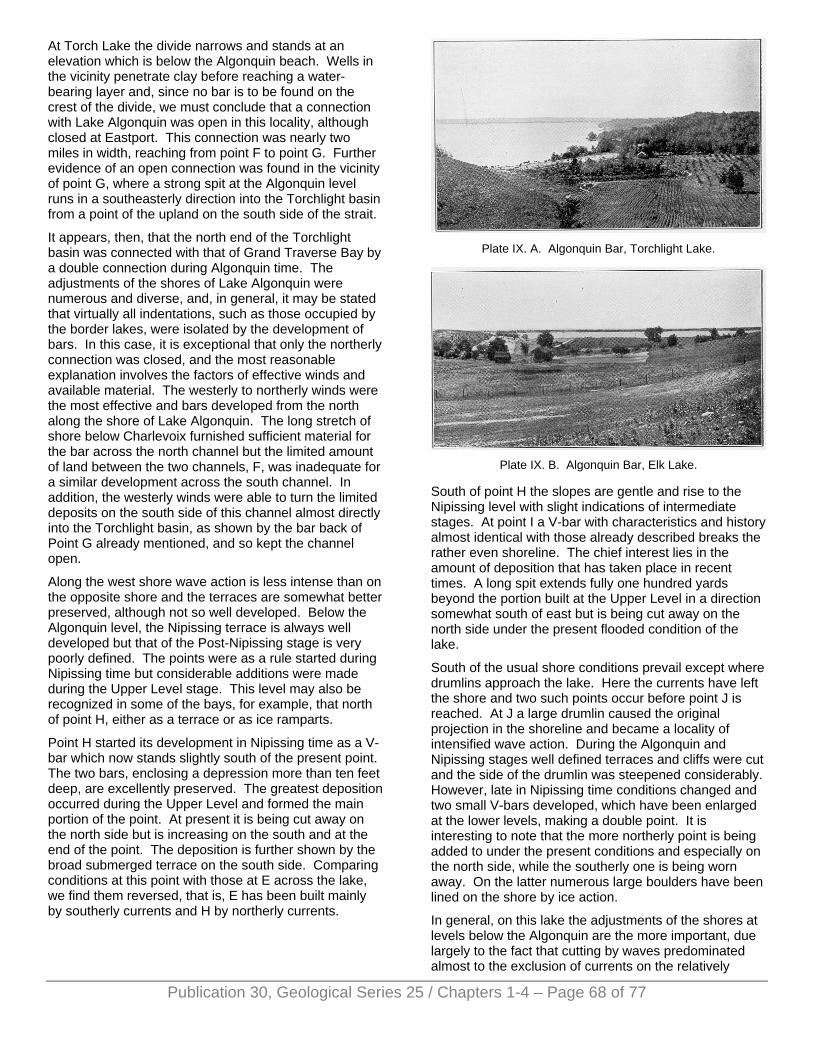
At Torch Lake the divide narrows and stands at an elevation which is below the Algonquin beach. Wells in the vicinity penetrate clay before reaching a water-bearing layer and, since no bar is to be found on the crest of the divide, we must conclude that a connection with Lake Algonquin was open in this locality, although closed at Eastport. This connection was nearly two miles in width, reaching from point F to point G. Further evidence of an open connection was found in the vicinity of point G, where a strong spit at the Algonquin level runs in a southeasterly direction into the Torchlight basin from a point of the upland on the south side of the strait.
It appears, then, that the north end of the Torchlight basin was connected with that of Grand Traverse Bay by a double connection during Algonquin time. The adjustments of the shores of Lake Algonquin were numerous and diverse, and, in general, it may be stated that virtually all indentations, such as those occupied by the border lakes, were isolated by the development of bars. In this case, it is exceptional that only the northerly connection was closed, and the most reasonable explanation involves the factors of effective winds and available material. The westerly to northerly winds were the most effective and bars developed from the north along the shore of Lake Algonquin. The long stretch of shore below Charlevoix furnished sufficient material for the bar across the north channel but the limited amount of land between the two channels, F, was inadequate for a similar development across the south channel. In addition, the westerly winds were able to turn the limited deposits on the south side of this channel almost directly into the Torchlight basin, as shown by the bar back of Point G already mentioned, and so kept the channel open.
Along the west shore wave action is less intense than on the opposite shore and the terraces are somewhat better preserved, although not so well developed. Below the Algonquin level, the Nipissing terrace is always well developed but that of the Post-Nipissing stage is very poorly defined. The points were as a rule started during Nipissing time but considerable additions were made during the Upper Level stage. This level may also be recognized in some of the bays, for example, that north of point H, either as a terrace or as ice ramparts.
Point H started its development in Nipissing time as a V-bar which now stands slightly south of the present point. The two bars, enclosing a depression more than ten feet deep, are excellently preserved. The greatest deposition occurred during the Upper Level and formed the main portion of the point. At present it is being cut away on the north side but is increasing on the south and at the end of the point. The deposition is further shown by the broad submerged terrace on the south side. Comparing conditions at this point with those at E across the lake, we find them reversed, that is, E has been built mainly by southerly currents and H by northerly currents.
Plate IX. A. Algonquin Bar, Torchlight Lake.
Plate IX. B. Algonquin Bar, Elk Lake.
South of point H the slopes are gentle and rise to the Nipissing level with slight indications of intermediate stages. At point I a V-bar with characteristics and history almost identical with those already described breaks the rather even shoreline. The chief interest lies in the amount of deposition that has taken place in recent times. A long spit extends fully one hundred yards beyond the portion built at the Upper Level in a direction somewhat south of east but is being cut away on the north side under the present flooded condition of the lake.
South of the usual shore conditions prevail except where drumlins approach the lake. Here the currents have left the shore and two such points occur before point J is reached. At J a large drumlin caused the original projection in the shoreline and became a locality of intensified wave action. During the Algonquin and Nipissing stages well defined terraces and cliffs were cut and the side of the drumlin was steepened considerably. However, late in Nipissing time conditions changed and two small V-bars developed, which have been enlarged at the lower levels, making a double point. It is interesting to note that the more northerly point is being added to under the present conditions and especially on the north side, while the southerly one is being worn away. On the latter numerous large boulders have been lined on the shore by ice action.
In general, on this lake the adjustments of the shores at levels below the Algonquin are the more important, due largely to the fact that cutting by waves predominated almost to the exclusion of currents on the relatively
Publication 30, Geological Series 25 / Chapters 1-4 – Page 68 of 77
Publication 30, Geological Series 25 / Chapters 1-4 – Page 69 of 77
smooth shores in this embayment of Lake Algonquin. Thus the rather monotonous description of the terrace and cliffs of this shore has not been dwelt upon. On the west side of the lake the topography is less regular, and several small indentations were encountered at this level within a distance of six miles south of point J. The result was a straightening of the shore by the development of completed bars across the mouths of these bays, Plate IX, A. After the drop to the Nipissing level, the waves worked back towards the bars and replaced the gentle front slopes by a steep cliff. In no case was the bar entirely removed and the remnants, with their flat tops and steep side slopes, now resemble railroad embankments. Ice also was active during the Nipissing stage but shore conditions were such that the most noticeable result was the lining of boulders on the beach, illustrated in Plate VIII, B.
Immediately south of point J the first of the bars is encountered, but here the Nipissing shore did not advance far inland and the embankment effect is not so pronounced. Between this point and Parks five similar features are to be found. The indentations were all small and at present furnish limited drainage basins, so that the bars are, with one exception, intact and the low ground adjacent to the bars is swampy. In the south part of section 7, T. 29 N., R. 8 W, such an indentation of larger size furnished sufficient surface water to cut a drainage channel through the bar. The intervening stretches are marked by. relatively narrow terraces of the Algonquin and Nipissing levels which widen at the well developed points indicated on the map as K and L. The higher terraces are complete, except for a short stretch south of Parks where the Nipissing shore has been removed. The waves are working into the front slope of the Algonquin terrace but have not as yet extended the cliff to its full height.
The feebleness of the shores of the exposed levels and the presence of a narrow submerged terrace at the present level mark this shore as one subjected to relatively light wave action. Winds from the northeasterly quadrant are the most effective, having an excessive reach which, embraces the whole length of the lake. This is clearly shown by the points K and L which are being built to the south. Also the "channel bank" in each case is wide on the north side (the side of stronger wave action) but becomes much narrower on the lee, or south, side. Although this shore has been subjected to light wave action, on the average, it must not be inferred that the waves are of meager development. On the contrary, as study of points K and L shows, the waves during occasional severe storms beat with great power against this shore. Both points started their growth during Lake Nipissing and developed into small V-bars. These bars have since been added to mainly at the present level, and in each case the deposit is in the form of storm beaches. Thus, at K are found two well developed storm beaches on the north side of the point, which merge into a single one on the south side and enclose a triangular cedar swamp. At L the storm beaches are not so pronounced and are
confined to a series of southward extending loops at the tip of the point. The activity seems to be less on the more southerly point L, an observation readily confirmed at M, the last point on the lake. The latter is a simple broad point trending southward with no indication of storm beaches.
The southward extension of the lake basin is a swampy flat but slightly above the lake level, leading directly to Round Lake. This was formerly a part of the much larger Algonquin and Nipissing lakes, which included Round and Elk in addition to Torchlight Lake. Torch River leaves the lake at the extreme southwest corner, a fact readily explained if the south shore is traversed. Starting at the river one soon notices a low sand ridge which gradually increases in strength and elevation and swings with even curvature to the east side of the lake. This is unmistakably a bar, although its profile is somewhat obscured by an ice rampart on the front slope, and may be easily traced to the Nipissing shore. Thus, during Nipissing time a bar was developing which would have eventually isolated this lake basin, but a drop in the water level accomplished this result before its completion. The submerged terrace is very wide at this end, due to the exceptionally strong undertow developed. This wide terrace together with the clean sand beach fronting the bar, affords excellent bathing facilities and makes the location, Crystal Beach, a favorite with summer visitors. The presence of two sand bars on the submerged terrace, parallel to each other and the shore, is an interesting development. These bars shift during storms and may vary in number and height but, as far as is known, never reach above the water level. Since they are formed by breakers, their growth into true barriers is a possibility but it seems more probable that a depression of the water level sufficient to expose a portion of them is necessary for further development. Many examples of such forms, composed of a series of parallel bars, are to be found in the Great Lakes and on their former shores now exposed, e. g., at the north end of Torchlight Lake, but this is the only inland lake in which more than a single bar was found and is therefore noteworthy.
Having traversed the shores of the lake, we may now attempt a resume of its history and conditions. During Algonquin time the basin was part of an archipelago which included Elk, Round and Torchlight Lakes and extended into the depression now occupied by Clam, Grass and Intermediate Lakes, which in turn was connected with the South Arm of Pine Lake. The connection between the basin of this lake and Grand Traverse Bay was a double one at the north end but was partially closed at this time. The development of the shores was largely by waves and the terraces are now continuous on both sides of the lake. Currents were effective locally on the west side and succeeded in throwing bars across some minor embayments and in forming a large spit on the south side of the open connection with the main lake at the north end.
With the recession of the water to the Nipissing level the
Publication 30, Geological Series 25 / Chapters 1-4 – Page 70 of 77
basin was definitely separated from the main lake at the north end and, later, partially so at the south by the growth of a bar which was largely submerged. The Nipissing Level was such that wave action during this time encroached on the Algonquin Terrace, forming a steep cliff and terrace somewhat inferior in development to that of the Algonquin stage. However, currents assumed a more important role and started the development of the present points. With one or two exceptions, the deposits were V-bars which varied in symmetry according to their position on the lake shore. Also in some of the broader embayments they aided in increasing the width of the submerged terrace, thus straightening the shore line when the water receded from this level. The most pronounced adjustment of the shores was accomplished at this time by the development of bars at both the north and south ends of the lake.
The Post-Nipissing level was of short duration and the forms were of inferior development. In fact, were it not for the distinct terrace at point B, its recognition would be difficult.
The Upper Level was of considerable duration and is recognizable largely by the depositional forms existing. Nearly all of the points show considerable growth at this level and these forms gradually merge into those being formed at present. In addition to the growth of the points, considerable low ground was cut off by the development of a bar at the northeast end.
As has already been stated, the lake is now in a flooded condition. Wave action is very active on all parts of the shore exposed to strong winds, and cliffs are common. These cliffs are receding rapidly and in a few places have removed the Nipissing terrace. The points also show the effect of the increased activity and are being eroded on one side at least. Erosion will continue until equilibrium is established and will result in continued cliff recession and in a reduction or shifting of the positions of the points. Also the abundant wave-worked material will add greatly to the submerged terrace. As the activity of the waves decreases somewhat, currents may be more effective, causing a greater growth of the points.
The final limit of point expansion would divide the lake into several smaller bodies but wave action can hardly be expected to furnish enough material on such a deep lake. Tributary streams are few and short and the only large one, Clam River, drains a nearby lake. Therefore little sediment can be supplied in this way. Little reduction in size by the formation of bars is to be expected since this was accomplished at the higher levels in the few localities where conditions were favorable.
Vegetation has hardly made a beginning and cannot take hold as long as the waves continue to actively erode. This lake shows a revival of activity and presents problems of shore development rather than of extinction.
ELK LAKE Elk Lake is another member of the series of lakes which occupy similar basins east of Grand Traverse Bay. These basins were briefly discussed in Chapter I and need no further discussion here. Elk Lake is slightly over nine miles in length and averages less than one and one-half miles in width, the maximum width nowhere exceeding two miles. See Fig. 58. Its surface covers thirteen square miles and is, thus, less than half the size of its neighbor, Torchlight. We compare it with Torchlight Lake purposely because of the very striking similarity between these two bodies of water. They occupy similar narrow, regular basins which follow the trend of the flanking drumlins, are oriented nearly north-south, are deep, have many features in common in the adjustment of their shores, and have passed through the same succession of events in their past. In fact, it would be difficult to find two lakes in such close proximity so nearly alike. The same winds and storms have whipped the waters into waves and developed the currents which have adjusted the shores during the same period of time. The variable factor is, then, the size. Differences in shore adjustments, both as to kind and amount, are attributable to this cause.
Elk Lake is reached by a spur of the Pere Marquette Railroad, which terminated at Elk Rapids, situated on Grand Traverse Bay at the outlet of the lake. As the name indicates the drop in level from Elk Lake to Michigan occurs rather suddenly near the latter lake, causing a rapids in the outlet. Advantage has been taken of the steeper gradient and the river has been dammed at this point. The history of these operations could not be traced back by the writer, but it is known that a dam on the present site was built prior to 1856 and has been maintained since that time with a fall of seven or seven and one-half feet.
Beginning our study at Elk Rapids, we find the flooding of the outlet above the dam very noticeable. The current is very slack and tree trunks stand in the water. As the lake is approached, the outlet widens and some wave action is evident in the low cliffs. Above the cliffs at an elevation of fiften feet stands the Nipissing terrace which terminates landward in a cliff reaching up to the Algonquin terrace forty feet above the water. Meguzee Point is caused by a low drumlin which is placed slightly oblique to the lake and runs to the shore about a mile to the north. On the west side of the point a low terrace skirts the shore, marking a former level which probably is the equivalent of the Upper Level on Torchlight and may be so designated. The end of this blunt point is bounded by cliffs, showing strong wave action, and is fronted by a well-defined submerged terrace which "drops off" at seven feet about one-hundred yards from the shore.
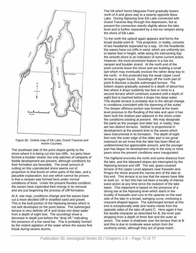
Figure 58. Outline map of Elk Lake, Grand Traverse and
Antrim Counties.
The southeast side of the point slopes gently to the shore where it is being cut into low cliffs. Ice jams have formed a boulder strand, but only patches of ramparts of feeble development are present, although conditions for their formation are favorable. The small amount of cutting on this unprotected shore seems out of proportion to that found on other parts of the lake, and a plausible explanation, but one which cannot be proven, is that a rampart was formed here under normal conditions of level. Under the present flooded condition, the waves have expended their energy in its removal and are just beginning the process of cliff formation.
At A, see map, conditions change and the waves have cut a more decided cliff in stratified sand and gravel. This is the built portion of the Nipissing terrace which is not well developed on the point below. The submerged terrace is very definite off A and drops into deep water from a depth of eight feet. The soundings show a decrease in depth just before the "drop off," indicating the presence of a low sand bar. This is probably formed by the violent agitation of the water where the waves first break during severe storms.
The hill which forms Meguzee Point gradually lowers north of A and gives way to a swamp opposite Bass Lake. During Nipissing time Elk Lake connected with Grand Traverse Bay through this depression, but at present the connection stands slightly above the lake level and is further separated by a low ice rampart along the shore of Elk Lake.
To the north the upland again appears and forms the broad double point B. This projection, in reality, consists of two headlands separated by a sag. On the headlands the waves have cut cliffs in sand, which are uniformly ten to twelve feet in height, while along the intervening bay the smooth shore is an indication of some current action. However, the most prominent feature is a low ice rampart and boulder strand. At the north end of the point currents leave the shore and are building a small spit which may eventually enclose the rather deep bay to the north. In this protected bay the weak Upper Level terrace is again found. Soundings off the north part of point B disclose a double submerged terrace. The bottom slopes gradually outward to a depth of about four feet where it drops suddenly two feet or more to a second terrace which continues outward until a depth of eight feet is reached before it drops into deep water. This double terrace is probably due to the abrupt change in conditions coincident with the damming of the outlet. The deeper offshore portion was formed at the lower level previous to the flooding of the lake and upon it has been built the shallow part adjacent to the shore under the conditions existing at present. We may designate the parts as the younger and older but, in reality, they are two distinct terraces. Neither is proportional in development at the present time to the waves which were instrumental in its formation. The depth of eight feet over the outer edge of the older part is too great inasmuch as we know that the lake has been lifted an undetermined but appreciable amount, and the younger part has begun its development only in the sixty or more years since the present conditions were inaugurated.
The highland encircles the north end some distance from the lake, and the lakeward slopes are interrupted by the Nipissing terrace and cliff. The wet, grass-covered terrace of the Upper Level appears near Kewadin and. fringes the shore around the narrow arm of the lake at this end. This terrace is so low that the waves have little to work on. In fact this has not been a locality of intense wave action at any time since the isolation of the lake basin. This statement is based on the presence of a strong bar at the Nipissing level which starts in the locality of Kewadin and runs to the uplands on the east side of the lake in a broad, swinging curve, enclosing a crescent-shaped lagoon. The submerged terrace at this end is exceptionally wide and nearly meets from the opposite sides of the lake off point C. Here again it has the double character as described for B, the inner part dropping from a depth of three feet and the outer at seven. The water is shallower over the terrace than at B and this is due to moderate wave action from the southerly winds, although they are of great reach.
Publication 30, Geological Series 25 / Chapters 1-4 – Page 71 of 77
Publication 30, Geological Series 25 / Chapters 1-4 – Page 72 of 77
Continuing southward along the east shore, conditions at locality C first attract attention. A narrow knoll not over eight feet in height caused the broad projection of the shore line. Back of this knoll, i. e., east, a strip of swamp runs from the northeastern extremity of the lake south to the eastward bend of the shore and separates the knoll from the upland. During the Upper Level this knoll at first stool as a low island but later was connected to the mainland by a bar which developed at the south end.
Along this shore the Algonquin and Nipissing shores are much more distinct than on the west side and are well developed in the broad embayment south of C. The Nipissing consists of a cliff and narrow terrace which does not reach the present shore. The front slope of this terrace is somewhat confusing but should not be interpreted as the cliff of a former level of the lake. At D the Nipissing shore is poorly defined but the Algonquin is very strong. A climb up the forty foot rise to the Algonquin level is well worth the effort, for in this vicinity two excellent examples of the straightening of the shoreline by the development of bars across the mouth of an indentation may be seen. The first to be encountered is shown in Plate IX, B. From the slight sag of the top of the bar it may be inferred that spits developed from both sides of the embayment and that the bar was not quite completed before the subsidence of the lake to the Nipissing level. A similar bar is located about one-half mile to the south.
Along the present shore to locality E the waves are cutting actively and low cliffs are being formed. The material is largely boulder clay, and the line of boulders on the shore shows that a moderate ice-shove occurs. The "drop off" is very distinct at eight to nine feet, and the submerged terrace has a width of more than one hundred yards in places. Similar conditions extend to the inlet from Round Lake, except that the Nipissing terrace is being cut away by the wavers, and cliffs which reach a maximum height of twelve feet are prevalent along the shore. At F the south side of a drumlin forms the point, upon which the Upper Level is shown by a terrace. Most of the re-curved portion of the point was probably formed by current action but is now being worn away, due to the revived activity of the waves.
Bound Lake is well protected by highland on all but the west side and the Torchlight depression on the northeast, and shows relatively little shore activity. It supports a heavy growth of water-loving vegetation which is, without doubt, rapidly filling this basin. Skegemog point, on the south side of the inlet, shows very clearly the contrast in the activity along the shores of the two lakes. On the Round Lake side the shores are low and the Upper Level terrace is well preserved. In addition, the beginning of a spit runs into Bound Lake from the end of the point. The material for this spit is derived from the low cliffs along the Elk Lake shore, where no evidence of the Upper Level is to be found.
Below G the high ground recedes, this recession forming an identation during the Upper Level. The curvature of the shore was sufficient to cause the currents to leave
the shore, and a submerged bar was formed across the embayment about one hundred feet back from the present shore. At Many Pines Point a hill causes the projection and the Algonquin and Nipissing terraces again appear. The south side of the point is protected from the strong winds and the Upper Level terrace has been preserved locally.
The submerged terrace reaches its maximum development at the south end of the lake where its width exceeds one-half mile. This shore is exposed to the strongest storm winds which often blow the full length of the lake, and under this condition the undertow attains its strongest development. Similar conditions may confidently be assumed during the former lake levels, and a wide compound terrace was formed in this locality, which is now the wide swamp extending from the south end of the lake to the hills a half mile away. This should consist of a series of three steps but it is difficult to determine on account of the mask of vegetation. At the present shore the low sand bar which skirts the entire swamp is being thrown back by the renewed wave activity and is somewhat irregular in outline. The writer is inclined to consider this a storm beach which developed under the conditions previous to the present flooded stage but realizes that it may well be a bar built at the Upper Level. Conclusive evidence, however, is lacking since the form is being rapidly remodeled.
The west shore south of the outlet rises with much gentler slopes on the average than the east side but has similar forms. In general, however, wave action is weaker on this shore. The Algonquin and Nipissing terraces are present but are less decided. This is due largely to the protection of this shore from the storm winds which usually blow from a westerly quarter. The Upper Level terrace is found only in embayments and usually on the north side. A submerged terrace is present but is relatively narrow and drops into deep water at seven to eight feet on the average. The exposed terraces are poorly drained in many places and support a growth of swamp trees. Such a condition is found near the mouth of the stream which enters the lake on the west side near the south end. During the Upper Level this stream built a small delta which is now being removed. The low swamp bordering this stream extends northward and around a narrow hill which must have been an island at the Nipissing stage, if not at the Upper Level.
Northward, Cam's Hill causes a projection in the lake which is accentuated by a depression on the south side, forming a muddy bay. Currents from the north left the shore at this point during the Upper Level stage but were too weak to carry across the indentation and a hook was formed. At present this is being forced back into the bay by the waves, leaving tree trunks standing in the water. North of this hook, cliffs are working back into the Nipissing terrace which developed here at the expense of the Algonquin. In fact, the latter was entirely removed and a steep cliff rises from the Nipissing shore to the top of the hill, a height of sixty to eighty feet. North of Carn's
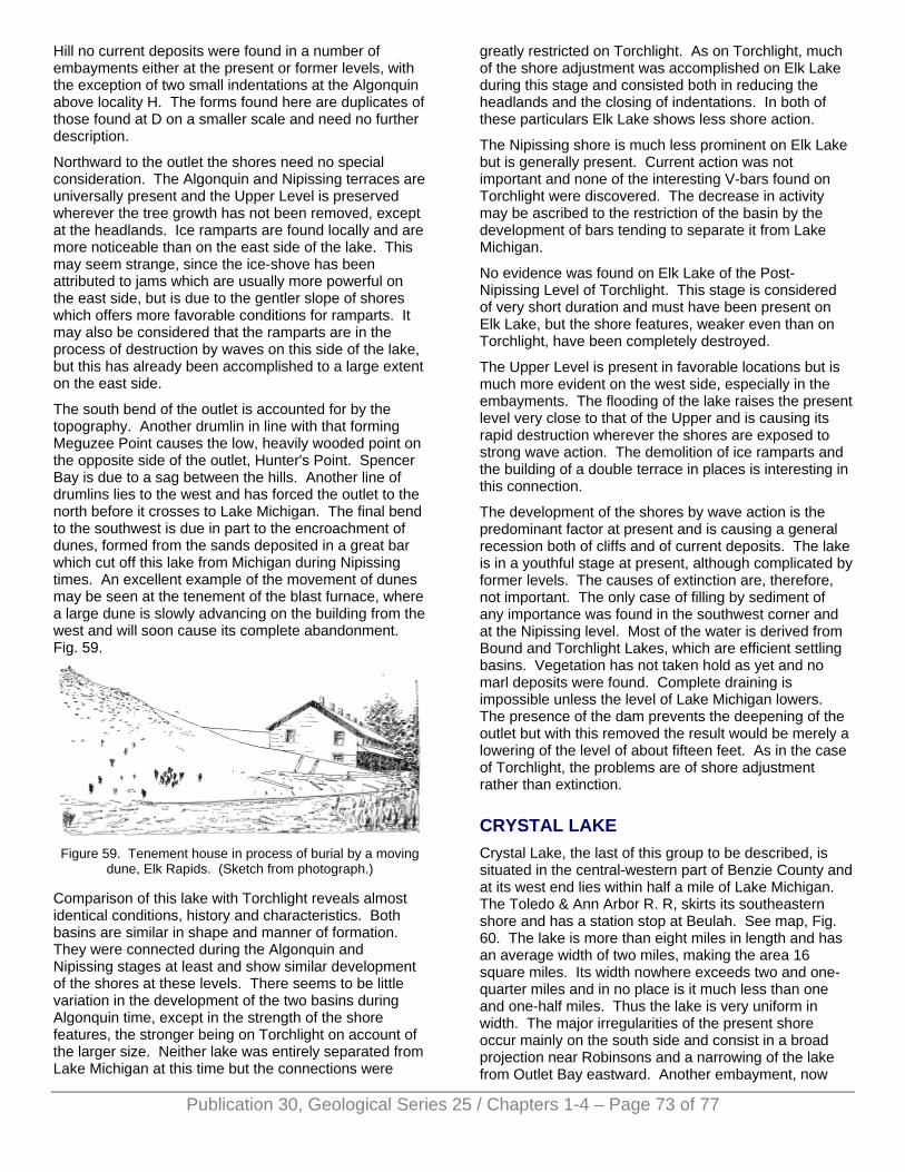
Hill no current deposits were found in a number of embayments either at the present or former levels, with the exception of two small indentations at the Algonquin above locality H. The forms found here are duplicates of those found at D on a smaller scale and need no further description.
Northward to the outlet the shores need no special consideration. The Algonquin and Nipissing terraces are universally present and the Upper Level is preserved wherever the tree growth has not been removed, except at the headlands. Ice ramparts are found locally and are more noticeable than on the east side of the lake. This may seem strange, since the ice-shove has been attributed to jams which are usually more powerful on the east side, but is due to the gentler slope of shores which offers more favorable conditions for ramparts. It may also be considered that the ramparts are in the process of destruction by waves on this side of the lake, but this has already been accomplished to a large extent on the east side.
The south bend of the outlet is accounted for by the topography. Another drumlin in line with that forming Meguzee Point causes the low, heavily wooded point on the opposite side of the outlet, Hunter's Point. Spencer Bay is due to a sag between the hills. Another line of drumlins lies to the west and has forced the outlet to the north before it crosses to Lake Michigan. The final bend to the southwest is due in part to the encroachment of dunes, formed from the sands deposited in a great bar which cut off this lake from Michigan during Nipissing times. An excellent example of the movement of dunes may be seen at the tenement of the blast furnace, where a large dune is slowly advancing on the building from the west and will soon cause its complete abandonment. Fig. 59.
Figure 59. Tenement house in process of burial by a moving
dune, Elk Rapids. (Sketch from photograph.)
Comparison of this lake with Torchlight reveals almost identical conditions, history and characteristics. Both basins are similar in shape and manner of formation. They were connected during the Algonquin and Nipissing stages at least and show similar development of the shores at these levels. There seems to be little variation in the development of the two basins during Algonquin time, except in the strength of the shore features, the stronger being on Torchlight on account of the larger size. Neither lake was entirely separated from Lake Michigan at this time but the connections were
greatly restricted on Torchlight. As on Torchlight, much of the shore adjustment was accomplished on Elk Lake during this stage and consisted both in reducing the headlands and the closing of indentations. In both of these particulars Elk Lake shows less shore action.
The Nipissing shore is much less prominent on Elk Lake but is generally present. Current action was not important and none of the interesting V-bars found on Torchlight were discovered. The decrease in activity may be ascribed to the restriction of the basin by the development of bars tending to separate it from Lake Michigan.
No evidence was found on Elk Lake of the Post-Nipissing Level of Torchlight. This stage is considered of very short duration and must have been present on Elk Lake, but the shore features, weaker even than on Torchlight, have been completely destroyed.
The Upper Level is present in favorable locations but is much more evident on the west side, especially in the embayments. The flooding of the lake raises the present level very close to that of the Upper and is causing its rapid destruction wherever the shores are exposed to strong wave action. The demolition of ice ramparts and the building of a double terrace in places is interesting in this connection.
The development of the shores by wave action is the predominant factor at present and is causing a general recession both of cliffs and of current deposits. The lake is in a youthful stage at present, although complicated by former levels. The causes of extinction are, therefore, not important. The only case of filling by sediment of any importance was found in the southwest corner and at the Nipissing level. Most of the water is derived from Bound and Torchlight Lakes, which are efficient settling basins. Vegetation has not taken hold as yet and no marl deposits were found. Complete draining is impossible unless the level of Lake Michigan lowers. The presence of the dam prevents the deepening of the outlet but with this removed the result would be merely a lowering of the level of about fifteen feet. As in the case of Torchlight, the problems are of shore adjustment rather than extinction.
CRYSTAL LAKE Crystal Lake, the last of this group to be described, is situated in the central-western part of Benzie County and at its west end lies within half a mile of Lake Michigan. The Toledo & Ann Arbor R. R, skirts its southeastern shore and has a station stop at Beulah. See map, Fig. 60. The lake is more than eight miles in length and has an average width of two miles, making the area 16 square miles. Its width nowhere exceeds two and one-quarter miles and in no place is it much less than one and one-half miles. Thus the lake is very uniform in width. The major irregularities of the present shore occur mainly on the south side and consist in a broad projection near Robinsons and a narrowing of the lake from Outlet Bay eastward. Another embayment, now
Publication 30, Geological Series 25 / Chapters 1-4 – Page 73 of 77
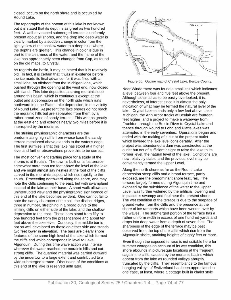
closed, occurs on the north shore and is occupied by Round Lake.
The topography of the bottom of this lake is not known but it is stated that its depth is as great as two hundred feet. A well-developed submerged terrace is uniformly present about all shores, and the drop into deep water is clearly marked by a sudden change in color from the light yellow of the shallow water to a deep blue where the depths are greater. This change in color is due in part to the clearness of the water, and the name of the lake has appropriately been changed from Cap, as found on the old maps, to Crystal.
As regards the basin, it may be stated that it is relatively old. In fact, it is certain that it was in existence before the ice made its final advance, for it was filled with a small lobe, an offshoot from the Michigan lobe, which pushed through the opening at the west end, now closed with sand. This lobe deposited a strong morainic loop around this basin, which is continuous except at the outlet and a depression on the north side which runs northward into the Platte Lake depression, in the vicinity of Round Lake. At present the lake shores do not reach the morainic hills but are separated from them by a rather broad zone of sandy terrace. This widens greatly at the east end and extends nearly two miles before it is interrupted by the moraine.
The striking physiographic characters are the predominating high cliffs from whose base the sandy terrace mentioned above extends to the water's edge. The first surmise is that this lake has stood at a higher level and further observations prove this to be correct.
The most convenient starting place for a study of the shores is at Beulah. The town is built on a fiat terrace somewhat more than ten feet above the level of the lake and we might almost say nestles at the foot of the cliffs carved in the morainic slopes which rise rapidly to the south. Proceeding northward along the shore, one may note the cliffs continuing to the east, but with swampland instead of the lake at their base. A short walk allows an uninterrupted view and the physiographic significance of this end of the lake becomes evident. One cannot fail to note the sandy character of the soil, the distinct ridges, three in number, stretching in a broad curve to the limiting cliffs on either side of the lake, and the shallow depression to the east. These bars stand from fifty to one hundred feet from the present shore and about ten feet above the lake level. Curiously, the middle bar is not so well developed as those on either side and stands two feet lower in elevation. The bars are clearly shore features of the same high level of the lake which formed the cliffs and which corresponds in level to Lake Algonquin. During this time wave action was intense wherever the water reached the morainic hills and cut strong cliffs. The quarried material was carried outward by the undertow to a large extent and contributed to a wide submerged terrace. Discussion of the conditions at this end of the lake is reserved until later.
Figure 60. Outline map of Crystal Lake, Benzie County.
Near Windermere was found a small spit which indicates a level between four and five feet above the present. Although so small as to be easily overlooked, it is, nevertheless, of interest since it is almost the only indication of what may be termed the natural level of the lake. Crystal Lake stands only a few feet above Lake Michigan, the Ann Arbor tracks at Beulah are fourteen feet higher, and a project to make a waterway from Frankfort through the Betsie River to Crystal Lake and thence through Round to Long and Platte lakes was attempted in the early seventies. Operations began and ended with the making of a cut at the present outlet which lowered the lake level considerably. After the project was abandoned a dam was constructed at the outlet but not of sufficient height to raise the lake to its former level, the natural level of the lake. Conditions are now relatively stable and the previous level may be conveniently termed the Upper Level.
Along the north shore as far as the Round Lake depression steep cliffs and a broad terrace, partly exposed, are the predominant shore features. The terrace, largely formed during Algonquin time and exposed by the subsidence of the water to the Upper Level, was further widened by the artificial lowering and in places is swampy and foul near the present shore. The wet condition of the terrace is due to the seepage of ground water from the cliffs and the presence at the shore of ice ramparts which have been worked over by the waves. The submerged portion of the terrace has a rather uniform width in excess of one hundred yards and drops into deep water from a depth of seven feet. The sharpness of the edge of the terrace may be best observed from the top of the cliffs which rise from the Algonquin shore, attaining heights of eighty feet or more.
Even though the exposed terrace is not suitable here for summer cottages on account of its wet condition, this shore abounds in picturesque locations at the frequent sags in the cliffs, caused by the morainic basins which appear from the lake as rounded valleys abruptly truncated by the cliffs. Their resemblance to the famous hanging valleys of Switzerland has been appreciated in one case, at least, where a cottage built in chalet style
Publication 30, Geological Series 25 / Chapters 1-4 – Page 74 of 77
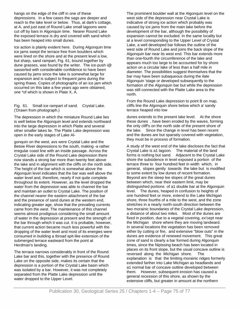
Publication 30, Geological Series 25 / Chapters 1-4 – Page 75 of 77
hangs on the edge of the cliff in one of these depressions. In a few cases the sags are deeper and reach to the lake level or below. Thus, at dark's cottage, at A, and just east of Round Lake small lagoons were cut off by bars in Algonquin time. Nearer Round Lake the exposed terrace is dry and covered with sand which has been heaped into small dunes.
Ice action is plainly evident here. During Algonquin time ice jams swept the terrace free from boulders which were lined on the shore and at the present level a low, but sharp, sand rampart, Fig. 61, bound together by dune grasses, was found by the writer. The ice-push i@ sasserted with considerable confidence to have been caused by jams since the lake is somewhat large for expansion and is subject to frequent jams during the spring thaws. Copies of photographs of an ice jam which occurred on this lake a few years ago were obtained, one *of which is shown in Plate X, A.
Fig. 61. Small ice rampart of sand. Crystal Lake. ('Drawn from photograph.)
The depression in which the miniature Round Lake lies is well below the Algonquin level and extends northward into the large depression in which Platte and several other smaller lakes lie. The Platte Lake depression was open in the early stages of Lake Al-
gonquin on the west, avs were Crystal Lake and the Betsie River depressions to the south, making -a rather irregular coast line with an inside passage. Across the Crystal Lake side of the Round Lake depression there now stands a strong bar more than twenty feet above the lake and in alignment with the cliffs on the north side. The height of the bar which is somewhat above the Algonquin level indicates that the bar was well above the water level and, therefore, nearly if not quite complete throughout its extent. However, as the level dropped the water from the depression was able to channel the bar and maintain an outlet to Crystal Lake. The position of the channel nearer the eastern attachment of the bar and the presence of sand dunes at the western end, indicating greater age, show that the prevailing currents came from the west. The maintenance of this channel seems almost prodigious considering the small amount of water in the depression at present and the strength of the bar through which it was cut. It is probable, however, that current action became much less powerful with the dropping of the water level and most of its energies were consumed in building a Ibroad spit-like extension of the submerged terrace eastward from the point at Herdman's landing.
The terrace narrows considerably in front of the Round Lake bar and this, together with the presence of Round Lake on the opposite side, makes its certain that the depression is a portion of the Crystal Lake basin which was isolated by a bar. However, it was not completely separated from the Platte Lake depression until the water dropped to the Upper Level.
The prominent boulder wall at the Algonquin level on the west side of the depression near Crystal Lake is indicative of strong ice action which probably was caused by ice jams from the main lake before the development of the bar, although the possibility of expansion cannot be excluded. In the same locality but at a level corresponding to the Upper Level of Crystal Lake, a well developed bar follows the outline of the west side of Round Lake and joins the back slope of the Algonquin bar near its west end. This bar extends more than one-fourth the circumference of the lake and appears much too large to be accounted for by shore action on a circular lake of less than a half mile in diameter. The possibilities suggest themselves that the bar may have been subaqueous during the ilate Algonquin 'stage or developed subsequently to the formation of the Algonquin bar but while the depression was still connected with the Platte Lake area to the north.
From the Round Lake depression to point B on map, cliffs line the Algonquin shore below which a' sandy terrace heaped into low
dunes extends to the present lake level. At the shore these dunes , have been eroded by the waves, forming the only cliff's on the north side of the present shore of the lake. Since the change in level has been recent and the dunes are but sparsely covered with vegetation, they must be in process of formation.
A study of the west end of the lake discloses the fact that Crystal Lake is a1 lagoon. The material of the land forms is nothing but sand. Adjacent to the Crystal Lake shore the subsidence in level exposed a portion of the terrace three to four hundred feet in width which, in general, slopes gently towards the lake but is modified to some extent by low dunes of recent formation. Beyond are the steep lee slopes of the great dunes between which, near their eastern limit, may be distinguished portions of a1 double bar at the Algonquin level. The dunes, heaped in confusion to heights of one hundred feet or more, extend to the Lake Michigan shore, three fourths of a mile to the west, and the zone stretches in a nearly north-south direction between the two morainic boundaries of the Crystal Lake depression, a distance of about two miles. Most of the dunes are fixed in position, due to a vegetal covering, ex'cept near the Michigan shore where they are moving landward. In several locations the vegetation has been removed either by cutting or fire, and extensive "blow outs" in the dunes are evidence of renewed movement. This great zone of sand is clearly a bar formed during Algonquin times, since the Nipissing beach has been located in places on its front slope, but the usual concave outline is reversed along the Michigan shore. The explanation is that the limiting morainic ridges formerly extended farther into Lake Michigan as headlands and a1 normal bar of concave outline developed between them. However, subsequent erosion has caused a general recession of this shore, as shown by the extensive cliffs, but greater in amount at the northern
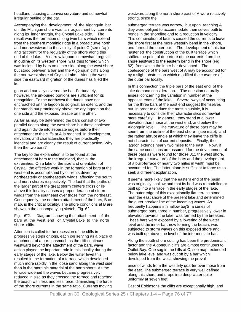
Publication 30, Geological Series 25 / Chapters 1-4 – Page 76 of 77
headland, causing a convex curvature and somewhat irregular outline of the bar.
Accompanying the development of the Algonquin bar on the Michigan shore was an adjustment by currents along its inner margin, the Crystal Lake side. The result was the formation of long twin bars which extend from the southern morainic ridge in a broad curve north and northwestward to the vicinity of point C (see ni'ap) and 'account for the regularity of the shore along this end of the lake. A narrow lagoon, somewhat irregular in outline on its western shore, was thus formed which was inclosed by bars on either side along the west shore but stood between a bar and the Algonquin cliffs along the northwest shore of Crystal Lake. Along the west side the eastward migration of the dunes has filled the la-
goon and partially covered the bar. Fortunately, however, the un-buried portions are sufficient for its recognition. To the northwest the dunes have not encroached on the lagoon to so great an extent, and the bar stands out prominently above the dry lagoon on the one side and the exposed terrace on the other.
As far as may be determined the bars consist of two parallel ridges along the west shore but these coalesce and again divide into separate ridges before their attachment to the cliffs at A is reached. In development, elevation, and characteristics they are practically identical and are clearly the result of current action. Why then the two bars?
The key to the explanation is to be found at the attachment of bars to the mainland, that is, the extremities. On a lake of the size and orientation of Crystal, the effective work in the formation of bars at the west end is accomplished by currents driven by northeasterly or southeasterly winds, affecting the south and north shores respectively. The fact that the paths of the larger part of the great storm centers cross or lie above this locality causes a preponderance of storm winds from the southeast over those from the northeast. Consequently, the northern attachment of the bars, B on map, is the critical locality. The shore conditions at B are shown in the accompanying sketch, Fig. 62.
Fig. 6"2. Diagram showing the attachment of the bars at the west end of Crystal Lake to the north shore cliffs.
Attention is called to the recession of the cliffs in progressive steps or jogs, each jog serving as a place of attachment of a bar. Inasmuch as the cliff continues westward beyond the attachment of the bars, wave action played the important role in this locality during the early stages of the lake. Below the water level this resulted in the formation of a terrace which developed much more rapidly in the loose sand along the west side than in the morainic material of the north shore. As the terrace widened the waves became progressively reduced in size as they crossed the terrace and reached the beach with less and less force, diminishing the force of the shore currents in the same ratio. Currents moving
westward along the north shore east of A were relatively strong, since the
submerged terrace was narrow, but upon reaching A tliey were obliged to accommodate themselves botli to bends in the shoreline and to a reduction in velocity. This combination of factors caused the currents to leave the shore first at the more westerly bend in the -shore, and formed the outer bar. The development of this bar hastened the construction of the built terrace which shifted the point of departure of the currents from the shore eastward to the eastern bend in the shore (Fig. 62), from which the inner bar developed. The coalescence of the bars west of A may be accounted for by a slight obstruction which modified the curvature of the outer bar locally.
In this connection the triple bars of the east end of the lake demand consideration. The question naturally arises concerning the variation in number at the opposite ends of the lake. Several ways of accounting for the three bars at the east end suggest themselves but, in order to deduce the most plausible, it is necessary to consider their characteristics somewhat more carefully. In general, they stand at a lower elevation than those at the west end, and below the Algonquin level. The curvature of these bars may be seen from the outline of the east shore (see map), and the rather abrupt angle at which they leave the cliffs is not characteristic of current deposits. Finally, the lagoon extends nearly two miles to the east. Now, if the same conditions are assumed for the development of these bars as were found for those 011 the west shore, the irregular curvature of the bars and the development of a buiit-terrace of nearly two miles in width must be accounted for. The latter alone is sufficient to force us to seek a different explanation.
It seems more likely that the eastern end of the basin was originally shallow and that its bed was remodelled or built up into a terrace in the early stages of the lake. The outer edge of this exceptionally flat terrace stood near the east shore of the present lake and determined the outer breaker line of the incoming waves. As frequently happens in shallow baj'S, a series of submerged bars, three in number, progressively lower in elevation towards the lake, was formed by the breakers. These bars were exposed by a lowering of the water level and the inner bar, now forming the beach, was subjected to storm waves on this exposed shore and was built up above the level of the intermediate bar.
Along the south shore cutting has been the predominant factor and the Algonquin cliffs are almost continuous to Outlet Bay. One sag in the hills at C, see map, extended below lake level and was cut off by a bar which developed from the west, showing the preval-
ence of winds from the westerly quarter over those from the east. The submerged terrace is very well defined along this shore and drops into deep water quite uniformly at seven feet.
East of Eobinsons the cliffs are exceptionally high, and

the exposed terrace is heaped with low dunes which extend to the present shore of the lake and are cut into low cliffs by the waves. Along the west side of Outlet Bay the most distinct development of the submerged terrace on the lake is seen but this may be due to the shal-lowness of the water which drops at three feet instead of seven, making the effect more pronounced. The depression which caused the bay was one of the channels of the inside passage after Crystal Lake basin was cut off from the main lake. Currents were active here and not only cut off small indentations on the west side but built a great bar in the vicinity of the outlet which connected with the cliffs on the east side. From its elevation it is apparent that the bar was not exposed for its entire length but was sufficient to hold back the water after the subsidence to the Upper Level. From the bay to Beulali the Algonquin cliffs are again the prominent feature and are interrupted only by two minor embayments which were cut off by bars at the Algonquin level.
In conclusion we may summarize as follows: Crystal Lake existed as a fjord-like bay of early Lake Algonquin. This depression was crossed by a much smaller one which connected the bay with the depressions to the north and south, which in turn were open to the main lake. The development of bars isolated all three of these basins but left the inside passages free. Wave and current action were excessive in the Crystal Lake depression, after its separation from the main lake, and resulted in the carving of prominent cliffs in the niorainic borders, the formation of a broad terrace, and the development of strong bars in front of the depressions and at the west end. At this time the passage to the north was closed and that to the south partially so. The formation of triple barrier ridges at the east end caused a great reduction in size by cutting off a large lagoon when the level was lowered. In fact, it may be stated that virtually all of the adjustments took place and the outline of the lake was fixed.at this time. The waters receded from the Algonquin level to the Upper, a drop of twelve to fifteen feet, and left a broad exposed terrace, the sands of which have been heaped into low dunes. This level persisted until about forty-five years ago when the lake was lowered artificially. At present the shore action consists mainly in removing portions of sand dunes and the formation of low ice ramparts of sand which are remodeled and obliterated by waves.
BOARD OF GEOLOGICAL AND BIOLOGICAL SURVEY,
1920.
EX OFFICIO:
THE GOVERNOR OF THE STATE, HON. ALBERT E. SLEEPER.
THE SUPERINTENDENT OF PUBLIC INSTRUCTION, HON. THOMAS E. JOHNSON.
THE PRESIDENT OF THE STATE BOARD OF .EDUCATION, HON. FRED JEFFERS.
DIRECTOR, R. A. SMITH.
SCIENTIFIC ADVISORS.
Geologists. -- Dr. L. L. Hubbard, Houghton; Prof. W. H. Hobbs, Ann Arbor; Prof. W. H. Sherzer, Ypsilanti; Prof. E. C. Case, Ann Arbor.
Botanists. -- Prof. E. A. Bessey, East Lansing; Prof. F. C. Newcomb, Ann Arbor.
Zoologists. -- Prof, W. B. Barrows, East Lansing; Prof. J. Reighard, Ann Arbor; Dr. Bryant Walker, Detroit.
Publication 30, Geological Series 25 / Chapters 1-4 – Page 77 of 77


![Great Lakes. The Five Great Lakes Lake Michigan [ touches Michigan] Lake Michigan [ touches Michigan] Lake Erie [touches Michigan] Lake Erie [touches](https://img.pdfslide.us/doc/110x75/56649dca5503460f94ac1371/great-lakes-the-five-great-lakes-lake-michigan-touches-michigan-lake-michigan.jpg)