Embed Size (px)
Citation preview

Initial Study Page 1 of 94 Joshua Tree Solar Farm January 2016
SAN BERNARDINO COUNTY
INITIAL STUDY ENVIRONMENTAL CHECKLIST FORM
This form and the descriptive information in the application package constitute the contents of Initial Study pursuant to County Guidelines under Ordinance 3040 and Section 15063 of the State CEQA Guidelines.
PROJECT LABEL:
APN: 060723119 and 060736406 USGS Quad: Joshua Tree North & Sunfair
APPLICANT: Joshua Tree Solar Farm, LLC T, R, Section: T1N, R7E, Section 21
COMMUNITY: Joshua Tree/ 3rd
Supervisorial District Planning Area: Joshua Tree Community Plan
LOCATION: 5500 Sunfair Road, Joshua Tree Land Use Zoning: JT/IN, JT/IC, JT/RL
PROJECT NO.: P201400482/CUP Overlays: Biological Resources
STAFF: John Oquendo
REP(S): Jess Melin
PROPOSAL: Conditional Use Permit to establish a 20 megawatt photovoltaic solar energy generating facility on approximately 115 acres at the former Hi Desert (Roy Williams) Airport
PROJECT CONTACT INFORMATION:
Applicant: Joshua Tree Solar Farm, LLC 700 Universe Boulevard, FBD/JB Juno Beach, Florida 33408
Lead agency: County of San Bernardino Land Use Services Department 385 N. Arrowhead Avenue, 1st Floor San Bernardino, CA 92415
Contact person: John Oquendo, Senior Planner Phone: 760-995-8153 Fax: 760-995-8167 E-mail: John [email protected]

Initial Study Page 2 of 94 Joshua Tree Solar Farm January 2016
PROJECT DESCRIPTION:
Joshua Tree Solar Farm
1.0 INTRODUCTION
Joshua Tree Solar Farm, LLC (JTSF or applicant) proposes to construct, own, and operate a 20 megawatt (MW) alternating current (AC) solar photovoltaic (PV) generating facility located on approximately 115 acres of disturbed land (the Project), 3.5 miles east of the unincorporated community of Joshua Tree and 1.3 miles north of Twentynine Palms Highway (State Route 62) in unincorporated San Bernardino County. The generated power will be delivered to the electrical grid via a 33 kilovolt (kV) interconnection to the Southern California Edison (SCE) distribution system at a point near Sunfair Road, just south of State Route 62.
The project location has been specifically chosen to repurpose a previously developed site, the deactivated, privately owned Hi Desert (or Roy Williams) Airport (airport). The project site consists of highly disturbed land as a result of the remaining airport infrastructure including runways, an ideal scenario for repurposing the land with a solar facility. Initially, a larger parcel of vacant land (approximately 160 acres) to the south of the airport was being considered for the project. Concerns about surface hydrology and undisturbed desert vegetation led JTSF to evaluate the currently proposed project site (located to the north), when it became known that the deactivated airport was available for sale. Land option agreements were entered into with the owner of the airport, and environmental studies of the airport site commenced. It was soon determined that the 115 acres constituting the airport site were not sufficient in quantity to produce 20 MWAC of power using a tracking PV system.
JTSF then began negotiations to purchase an additional 40 acres adjacent to the airport to the east. Additional environmental studies analyzing cultural resources, biology, and waters of the State were conducted to assess the existing environmental condition of these 40 acres. After hearing community concerns about the use of undisturbed desert land for solar project, JTSF decided to revert back to only using the 115 acres on the disturbed airport site. By doing so, and in order to still meet the objective of producing 20 MWAC of power, the configuration was changed from tracking to fixed tilt. A fixed tilt layout is able to accommodate more PV panels in a smaller space.
The following factors contributed to the decisions in the site selection:
The project site is a deactivated airport which has already been disturbed. The project site is also outside the two-mile radius of Joshua Tree National Park. Development of this site would lower the environmental impact to vegetation and wildlife habitat as compared to developing on undisturbed land.
The land is fairly level, reducing the need for grading.
There is existing access to the site off of Twentynine Palms Highway and Sunfair Road, eliminating the need for new roads or new right of way.
The project site is in an area with an excellent solar energy resource with high irradiance and is of sufficient size to produce up to 20 MWAC of electricity from PV solar panels.

Initial Study Page 3 of 94 Joshua Tree Solar Farm January 2016
The project site is adjacent to an existing SCE electrical distribution line which will take energy produced by the project into the grid. Distribution line improvements will be made and will likely include replacing the existing poles with new poles over a length of one mile.
1.1 Project Objectives
The primary objective of the project is to assist in achieving or exceeding the State’s Renewable Portfolio Standards (RPS) and greenhouse gas emissions reduction objectives. This will be achieved by developing and constructing California RPS-qualified solar generation. The RPS program requires investor-owned utilities, electric service providers, and community choice aggregators to increase procurement from eligible renewable energy resources to 33% of total procurement by 2020. Recently, in October 2015, the California governor passed Senate Bill 350, which demands an increase in the RPS of the state from 33% to 50% by 2030. Increasing renewable resources to 50 percent of the state’s electricity consumption by 2030 sets California on path to meet its 2050 climate change goals. The JTSF will help meet this goal.
The project specific objectives are as follows:
1. Develop approximately 20 MWAC of renewable solar energy that can operate during on-peak power periods, indirectly reducing the need to emit greenhouse gases caused by the generation of similar quantities of electricity from either existing or future non-renewable sources to meet existing and future electricity demands.
2. Develop approximately 20 MWAC of renewable solar energy that satisfies the terms of the Project’s Interconnection Agreement, while minimizing environmental impacts by using previously disturbed land.
3. Develop a renewable project that is consistent with the County of San Bernardino General Plan (San Bernardino 2014a), and the Solar Ordinance developed by San Bernardino County (San Bernardino 2014b), as well as the principles in the draft Desert Renewable Energy Conservation Plan (DRECP 2015), to the extent applicable. See Attachment A.
4. Invest approximately 50 million dollars in total expenditures, which will help to support the economy in San Bernardino County through the creation of jobs and capital expenditures.
5. Maximize the potential for creation of local construction jobs for a variety of trades, thereby supporting unemployment reduction goals in the area for the duration of construction.
2.0 PROJECT DESCRIPTION
The following sections provide further detail on the design, construction, operation, maintenance, and decommissioning of the project. Preliminary design is underway, with project size, typical equipment, and array configurations determined. A final selection of solar modules, inverters, mounting system, and precise dimensions will be decided during detailed design and equipment procurement. A project overview is provided in Table 1 below. Specifics of the project are detailed in the following subsections.
Initial Study Page 4 of 94 Joshua Tree Solar Farm January 2016
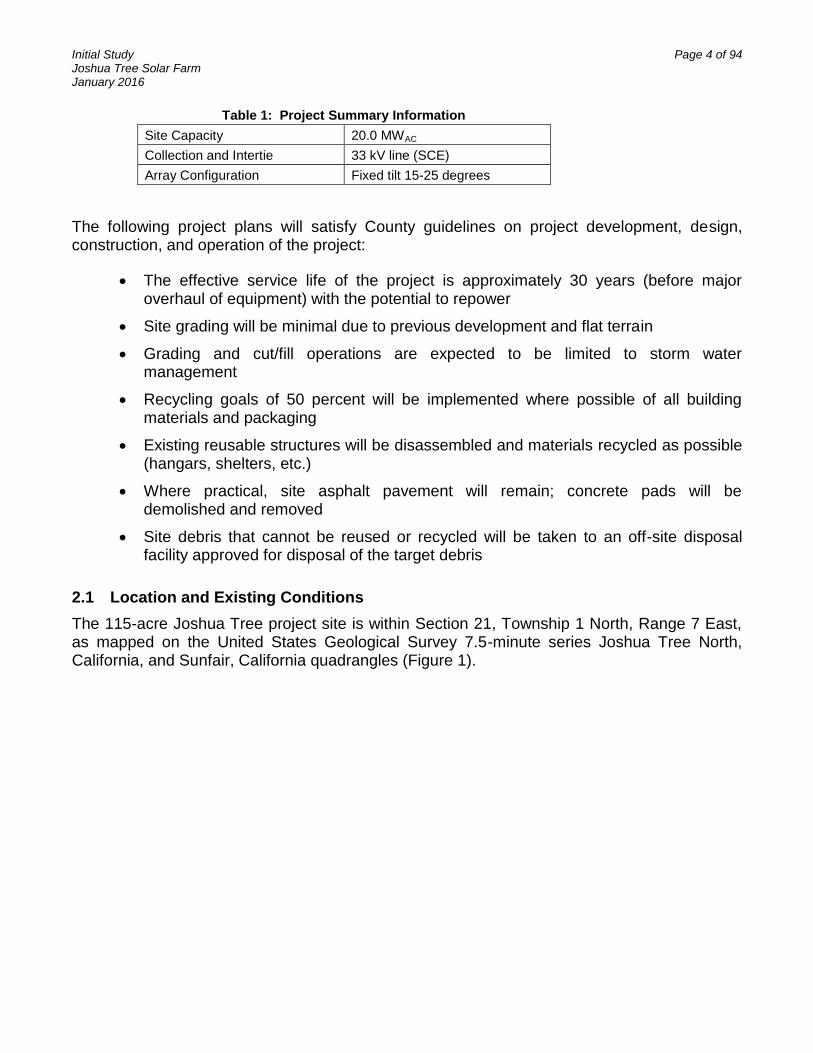
Table 1: Project Summary Information
Site Capacity 20.0 MWAC
Collection and Intertie 33 kV line (SCE)
Array Configuration Fixed tilt 15-25 degrees
The following project plans will satisfy County guidelines on project development, design, construction, and operation of the project:
The effective service life of the project is approximately 30 years (before major overhaul of equipment) with the potential to repower
Site grading will be minimal due to previous development and flat terrain
Grading and cut/fill operations are expected to be limited to storm water management
Recycling goals of 50 percent will be implemented where possible of all building materials and packaging
Existing reusable structures will be disassembled and materials recycled as possible (hangars, shelters, etc.)
Where practical, site asphalt pavement will remain; concrete pads will be demolished and removed
Site debris that cannot be reused or recycled will be taken to an off-site disposal facility approved for disposal of the target debris
2.1 Location and Existing Conditions
The 115-acre Joshua Tree project site is within Section 21, Township 1 North, Range 7 East, as mapped on the United States Geological Survey 7.5-minute series Joshua Tree North, California, and Sunfair, California quadrangles (Figure 1).

Initial Study Page 5 of 94 Joshua Tree Solar Farm January 2016
FIGURE 1: PROJECT SITE
The topography of the project site is relatively flat and ranges in elevation from approximately 2,470 feet above mean sea level on the western boundary of the site to 2,430 feet above mean sea level on the northeast corner of the site. The project site is previously developed and is accessed through Sunfair Road, a paved County road that runs along the eastern border of the site. The project site is bordered by Two Mile Road to the south, unpaved Fourth Street to the north, and vacant land to the south and west. Hi-Grade Materials Company occupies the parcel adjacent to the southwest border of the project site. The current composition of the existing land is best described as vacant land of dirt and sand with a sparse vegetative community consisting of native grasses and shrubs.
The decommissioned airport site previously consisted of several parcels totaling 115 acres as listed in Table 2 and shown on Figure 2. In the summer of 2015, nine of the parcels listed in Table 2 (excluding APN 0607-364-06-0-000) were merged together through the San Bernardino County Lot Merger process. Lot Merger P201500345 was signed on September 11, 2015 by John Oquendo, San Bernardino County, and the new APN is 060723119. Although not included in the Lot Merger, APN 0607-364-06-0-000 is still part of the JTSF project site.
Initial Study Page 6 of 94 Joshua Tree Solar Farm January 2016
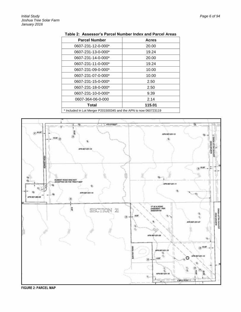
Table 2: Assessor’s Parcel Number Index and Parcel Areas
Parcel Number Acres
0607-231-12-0-000* 20.00
0607-231-13-0-000* 19.24
0607-231-14-0-000* 20.00
0607-231-11-0-000* 19.24
0607-231-09-0-000* 10.00
0607-231-07-0-000* 10.00
0607-231-15-0-000* 2.50
0607-231-18-0-000* 2.50
0607-231-10-0-000* 9.39
0607-364-06-0-000 2.14
Total 115.01
* Included in Lot Merger P201500345 and the APN is now 060723119
FIGURE 2: PARCEL MAP

Initial Study Page 7 of 94 Joshua Tree Solar Farm January 2016
2.2 Project Limits
The project footprint is defined by the property boundaries of the airport. The site-produced electrical energy will be collected and routed to the switchgear adjacent to the entry gate. The combined output of the plant will be routed from the switchgear through underground conductors to the southeast corner of the property where the conductors transition from underground to overhead and interconnect with SCE (grey circle, above in Figure 2). The distribution line, provided by SCE, runs due south along the west side of Sunfair Road on existing or to-be-replaced distribution structures in an existing utility easement to the main tie-in on the south side of Twentynine Palms Highway (also referred to as Hwy 62). The upgraded distribution line will be on SCE property and is outside the property boundary containing the solar arrays.
2.3 Facilities Overview
The overall project will have a maximum capacity of 20 MWAC using fixed tilt configuration. The preliminary Site Plan is shown below as Figure 3.
The project employs solar PV modules for energy generation, power conversion stations, and typical electrical equipment to collect the produced energy and deliver it to the point of interconnection with SCE’s distribution system. The PV modules produce low-voltage Direct Current (DC) electrical power which is collected and delivered to the utility-scale inverter stations distributed throughout the site. The power conversion stations convert DC electricity to AC electricity and step it up to medium voltage of 33 kV. The power is collected at medium voltage, fed through the appropriate protective equipment, and delivered to the utility at the point of interconnection.

Initial Study Page 8 of 94 Joshua Tree Solar Farm January 2016
FIGURE 3 - CURRENT SITE LAN

Initial Study Page 9 of 94 Joshua Tree Solar Farm January 2016
2.4 Modules
The PV modules convert incoming sunlight to DC electrical energy. Modules are arranged in series to effectively increase output voltage. These series chains of modules are called “strings” in industry terms. The “string” is the basic building block of power conversion in the solar array. The chosen PV technology type will either be crystalline silicon or thin film (copper indium gallium selenide or cadmium telluride).
2.5 Array Mounting System
The modules will be mounted on a steel and aluminum structural system (“racking” system) which will be supported, when practical, by driven piers (piles) directly embedded in the ground. The front (south, lower) side of the arrays with fixed tilt racking will maintain a 2 foot clearance from ground level. The array height will be approximately 7-10 feet from ground level. The highest maximum height of an array (from the ground to the north, upper side) will be approximately 10.5 feet, and no higher than 12 feet.
2.6 Power Inverter Stations
The Inverter Stations convert the DC electrical energy from the PV arrays into AC. These stations perform three critical functions for the plant: (1) collect DC power in a central location, (2) convert the DC power into AC power, and, (3) convert low-voltage AC power to medium-voltage AC power at the appropriate grid potential.
Each inverter station consists of DC collection equipment (junction boxes and overcurrent protective devices, etc.), utility-scale inverters, and a low-to-medium-voltage transformer. The output power from the inverter stations is then fed to the AC collection system, an underground network of medium-voltage conductors and collection switchgear, discussed next. While the preliminary design is based on 750 kWAC utility-scale inverters and 1.6 MVA (megavolt amps) transformers (Figure 4), the final rating will be determined during detailed design and equipment procurement. The typical height of an inverter station is approximately 9 feet, with a maximum possible height of approximately 10.5 feet, and no higher than 12 feet.
FIGURE 4: EXAMPLE MEDIUM-VOLTAGE INVERTER STATION

Initial Study Page 10 of 94 Joshua Tree Solar Farm January 2016
FIGURE 5: TYPICAL POLE STRUCTURE
2.7 AC Collection System
The AC collection system is 33 kV, and all related equipment will be 35 kV class. The collection system is a network of either buried or aboveground cables appropriately sized to minimize energy loss. The system will effectively collect energy from the solar panels and transfer energy to the main collection switchgear, which will allow the energy to be transmitted to the electric grid. The project’s current design is an underground collection system which will terminate at the switchgear, which will be separately enclosed with a security fence and lockable access gates.
2.8 Distribution line improvements
The distribution line improvements are a part of this project; however, the improvements will be constructed, owned, and operated by SCE. Approval for the changes to the distribution line will come from the California Public Utilities Commission. SCE will refer to the Initial Study and CEQA process for the overall Joshua Tree Solar Project. SCE will also follow the conditions of approval for this Project.
For the section of Sunfair Road between Twentynine Palms Highway and Two Mile Road, SCE will be replacing approximately one mile of existing distribution line poles with approximately 25 new poles. The existing poles are approximately 60 feet in height. For SCE to co-locate two existing distribution lines, an estimated maximum pole height of 65 feet will be required to get adequate conductor clearances.
The system will be designed and built by SCE, so all final design and engineering decisions will be made by SCE and fully supported by the project. A photograph of a typical upgraded pole structure is shown in Figure 5.
2.9 Access Paths and Fencing
Fencing will be installed around the perimeter of the site. The fencing is currently planned to be 8 feet tall and will be built in accordance with the County standards. Access roads will be constructed along the interior perimeter of the site and between the 1 MW block solar arrays. Primary access to the project will be via a gate on Sunfair Road.
2.10 Safety Lighting
Safety lighting will be installed at the entry gates and the switchgear location. A limited amount of lighting will be installed and will be designed to prevent spillover into neighboring properties. There will be operable lighting at each conversion station, but these units will be used as needed and will not typically operate at night. The entry will have fixtures to provide minimal lighting and will have additional on-demand (e.g. timer) lighting as needed or required.
3.0 PROJECT CONSTRUCTION
Project construction work is expected to last for approximately six months and will consist of site preparation, demolition of buildings, site improvements, system installation, and system

Initial Study Page 11 of 94 Joshua Tree Solar Farm January 2016
acceptance. The various phases of the construction cycle are outlined in the following sections.
3.1 Site Preparation
Site preparation will involve the erection of a perimeter security fence, deconstruction or demolition of existing buildings, remediation of a few specific site conditions if applicable, and establishment of temporary utilities. The utility connections are already established to the site, making power and water connections readily available. Demolition of existing buildings will be the majority of site preparation. Where possible and feasible, materials from existing structures will be reused or recycled. A Construction and Demolition Waste Management Plan will be put into place prior to any demolition, with a goal of recycling 50% of total weight or volume. All concrete structures (hangar aprons, foundations, and slabs) are expected to be demolished and removed. All other paved areas, including the existing runways, are expected to be left in place.
Grubbing and grading activities will be limited due to the previous development activities and inherently sparse vegetation. Prior to or concurrently with installing the security fencing, the site may include a desert tortoise exclusionary fence or similar measures if required by the U.S. Fish and Wildlife Service or California Department of Fish and Wildlife.
3.2 Construction Access
Construction vehicles will access the site via Sunfair Road on the eastern boundary of the site. The staging area and the laydown area will most likely be located just inside of the gate on the previously paved airport parking and taxi area. The main temporary logistics area of the site includes construction trailers, a first aid station, worker parking, truck loading and unloading areas, and areas for site assembly tasks. Portable toilet facilities will be installed for use by construction workers during the construction phase and will be serviced by a private company on a regular basis.
3.3 Storm Water and Erosion Control
A Storm Water Pollution Prevention Plan incorporating best management practices for erosion control will be prepared prior to the start of construction. During site preparation the Storm Water Pollution Prevention Plan will be implemented and initial erosion and sedimentation controls will be installed. In addition, water truck reloading stations will be established for dust control. The project will also comply with applicable water quality requirements adopted by the Regional Water Quality Control Board and the State Water Resources Control Board.
3.4 Site Grading
The previous airport development significantly reduces the need for site leveling, cut and fill, and other site modifications. Limited grading will be required for erosion or stormwater control to comply with permit conditions.

Initial Study Page 12 of 94 Joshua Tree Solar Farm January 2016
3.5 Facility installation
The bulk of the project activities involve installation of major equipment, including array foundations (driven piers when practical), power stations, cable installation, and switchgear placement. Rack piers are usually driven into the ground at depths of 6 to 12 feet as dictated by the soils and the array structural design. The module racking assembly is connected to the piers. The modules are fastened to the racking assembly and electrically connected together in series strings. The strings will be routed to DC combiners at the ends of each array row and subsequently routed to the power conversion stations where the electricity is converted from DC to AC.
The AC collection system will be a series of cables, sized to minimize energy losses and to effectively collect and transfer energy to the project switchgear. The switchgear will be separately enclosed with a security fence and lockable access gates.
3.6 Distribution Line Improvement Construction
SCE will be responsible for any distribution line necessary to serve the project. The distribution line improvement construction will include replacement of the utility poles along Sunfair Road along with stringing of new overhead electrical cable and a tap to the distribution line on the south side of Twentynine Palms Highway. It is anticipated that the work areas needed for replacement of this line and the stringing of the new overhead electrical cable will be entirely included within the existing SCE easement.
3.7 Construction Waste
Most construction waste is expected to be non-hazardous and to consist primarily of cardboard, wood pallets, copper and aluminum wire cut-offs, scrap steel, common trash, and wooden wire spools. Construction waste will be recycled wherever possible. A Construction and Demolition Waste Management Plan will be put into place prior to construction, with a goal of recycling 50% of total weight or volume. Non-recyclable construction waste will be disposed of by a licensed contractor at an approved facility.
3.8 Potentially Hazardous Materials Used During Project Construction
Construction equipment will utilize various hazardous materials such as hydraulic oil, diesel fuel, grease, lubricants, solvents, adhesives, paints, and other petroleum-based products contained in construction vehicles. All potentially hazardous materials will be contained, stored, and used in accordance with the manufacturers’ instructions and handled in compliance with the applicable standards and regulations, such as those administered by the San Bernardino County Fire Department, Occupational Safety and Health Administration, and the California Occupational Safety and Health Administration.
3.9 Fugitive Dust Control
Short-Term Dust Generation. Construction activities including clearing, grading, excavating, and moving of heavy equipment will create fugitive dust at the site at various rates throughout the construction cycle. Any substantial fugitive dust is expected to be short-term and limited to the time period of early construction during the limited clearing and grading activities. The

Initial Study Page 13 of 94 Joshua Tree Solar Farm January 2016
contractors will be required to comply with applicable Mojave Desert Air Quality Management District rules and policies, which includes the development of a Dust Control Plan. Dust may be controlled by covering stockpiles with tarps and water application which consists of trucks canvassing the site to apply water for dust suppression and soil conditioning. Water truck reloading stations may be established. Additionally, dust may be controlled through the use of non-hazardous soil palliatives. Palliatives are products that are mixed with water and applied directly to the soil during construction to stabilize the soil and suppress the dust. Use of a palliative would be approved by San Bernardino County. After construction and during the operations period there is expected to be a minimal amount of fugitive dust.
Long-Term Dust Generation. The long-term operations associated with the project are not anticipated to generate a significant amount of dust.
3.10 Construction Water Requirements
Potable water for drinking and domestic needs will be either brought to the project site or provided by existing facilities serving the airport.
During construction, the project would use approximately 30 acre feet of water for soil conditioning and dust suppression. Pre-construction activities such as fence building and removal of structures would use approximately 4 acre feet of water. The water will likely be supplied by the Joshua Basin Water District (JBWD) through an agreement with the applicant. Under this scenario, water truck reloading stations will be established on site and will be fed by an existing waterline co-located within the western bounds of Sunfair Road.
If construction water cannot be supplied by JBWD, the applicant proposes to construct an onsite water well. Additional consideration of the proposed water supply is discussed in further detail in the Hydrology and Utilities section of the Initial Study.
3.11 Construction Workers, Hours, and Equipment
The construction workers will consist of laborers, electricians, supervisory personnel, support personnel, and construction management personnel. It is expected that most workers will commute to the site from nearby communities including Joshua Tree, Yucca Valley, Twentynine Palms, and Palm Springs. It is anticipated that there will be an average of 125 workers on site during the construction period with approximately 150 workers during the peak phase. Ride sharing will be encouraged.
Construction work will generally be done during daylight hours, Monday through Saturday, 7 AM to 7 PM. Construction activities will be conducted consistent with San Bernardino County Ordinance Section 83.01.080 and 83.01.090 regarding acceptable decibel levels.
Construction activities, duration, equipment, and workers are estimated below in Table 3.

Initial Study Page 14 of 94 Joshua Tree Solar Farm January 2016
Table 3: Estimated Construction Duration, Equipment and Workers by Activity
Activity Duration Equipment Pieces Workers
Fencing 2 Months Bobcat 1 2
Trencher 1
Pick Up Truck 1
Demolition – existing structures and related infrastructure
1 Month Backhoe 2 4
Bulldozer 1
5 cubic yard dump truck 2
Site Preparation and Clearing/Grading
1 Month Water Truck – 3 axles 3 Maximum – 150
Average – 125 Grader 2
Bulldozer 1
25-Cubic Yard Paddle Scraper 1 (optional)
10-Ton Roller 2
Utility Upgrades Intermittent, up to 6 Months
Line truck (with spool trailer) 1 2
Boom truck (with bucket) 2
Underground Work 2 Months Small Backhoe 2 6
Small Sheepsfoot Roller 2
Trencher 2
5-Cubic Yard Dump Truck 2
5kW Generator 2
System Installation 3 Months 4x4 Forklift 4 8
Small Crane 1
ATV Vehicle 4
Pick-Up Truck 5
Pile Driver 2
5-kW Generator 4
Testing/Commissioning 1 Month Pick-Up Truck 2 2
Clean Up/Restoration 1 Months Grader 2 2
The construction activities shown above in Table 3 will be overlapping in certain phases with a total construction time of approximately six months.
Truck activity will be regularly required only during the project’s construction. The types of trucks, number of trucks estimated to be on site daily, and their approximate gross weight are presented below. Information on equivalent single axle loads was provided to the San Bernardino County Department of Public Works, Traffic Division. The Traffic Planning Engineer issued an approval for the project, subject to a maintenance agreement with the applicant prior to grading.

Initial Study Page 15 of 94 Joshua Tree Solar Farm January 2016
Truck Type Average on Site Daily
Gross Weight
8,000 Gallon Water Truck 3 25 tons empty/50 tons full
5 CY Dump Truck 3 15,000 lbs
Pick-up Trucks 5 5,000 lbs
Pile Driver 2 7,500 lbs
Grader 2 40,000 lbs
Boom truck with bucket 2 16,000 lbs
Utility line service truck 1 35,000 lbs
3.12 Testing, Commissioning, and Acceptance
Testing will happen throughout the PV facility installation at all stages. As each 1 MW block is completed, the electrical components of the system will be tested as a subsystem at the functional level. Once all blocks are completed, the system will be interconnected to the SCE distribution system and each block will be commissioned again to test performance. This commissioning and testing period is expected to last approximately one month after interconnection to the SCE system.
3.13 Site Cleanup
There will be ongoing cleanup and recycling of materials during the construction phase. Industrial trash receptacles will be established in the temporary laydown area and will be emptied or interchanged throughout the construction of the project. Once the project is completed the site will be cleared of any remaining debris or materials and each will be recycled or disposed of appropriately.
4.0 PROJECT OPERATIONS, MAINTENANCE, AND DECOMMISSIONING
During operations, the Project facility will be primarily managed, monitored, and controlled remotely. Therefore it is assumed that the Project will have 1 to 2 employees 1 to 2 times per month on site for system inspections and 2 to 6 employees on site 1 to 2 times per month for troubleshooting and maintenance requirements.
Brief weekly inspections are planned. Ongoing maintenance is expected to occur on a monthly basis and will be scheduled to avoid peak power demand periods, and unplanned maintenance will typically be responded to as needed depending on the event. Preventative maintenance kits and certain critical spares will be stored on-site in a control enclosure, approximately 20 feet by 15 feet in size, while all other components will be readily available from a remote warehouse facility.
4.1 Module Cleaning
Periodic array module washings will be scheduled and completed depending on the soiling conditions that will exist at the site, which could be up to 4 times per year. It is expected that less than 2 acre feet of water will be used annually for 4 washings, which is approximately ½ acre foot for each washing. This water is expected to be supplied by the JBWD and treated
Initial Study Page 16 of 94 Joshua Tree Solar Farm January 2016
on-site to the required water quality. If a new well is installed as the water supply alternative, water for panel washing will come from the onsite well as opposed to being supplied by the JBWD.
Any necessary treatment of the groundwater would consist of a deionization process to remove minerals and other particulate matter. No chemicals or detergents are used during the module washings. All treatment equipment will be mobile. No permanent infrastructure will be required. Due to evaporation and onsite ground percolation, it is expected that no water from the washings will run offsite.
4.2 Potentially Hazardous Materials Used During Project Operations
The only potentially hazardous material within the fully operational site would be the insulating oil in the step-up transformers. The transformer oil has low toxicity and is a fully bio-neutral, biodegradable fluid. In the case of a major transformer breach, clean-up protocol would be implemented. Any seeped fluid would be removed by a certified vehicle and recapture system and the entire transformer would be replaced.
4.3 Project Decommissioning
A PV solar plant has a typical life of about 30-40 years. Once the useful life of the plant is exhausted, the plant could be refurbished to continue operating as a power plant or decommissioned and removed. If the system is to be removed, most of the materials (steel, aluminum, copper, and glass) would be recycled at nearby facilities. The materials that cannot be recycled, and those materials which contain any oil or lubricants, would be disposed of according to San Bernardino County Development Code Section 84.29.060 or other applicable development standards at the time of decommissioning. The amount of water used during decommissioning will be half of the amount used during construction, and will primarily be used for dust control. At this time, it is anticipated that the water would be provided by the JBWD, but it is difficult to anticipate who would provide water in the year 2055. The site could then be converted to other uses in accordance with applicable land use regulations.

Initial Study Page 17 of 94 Joshua Tree Solar Farm January 2016
Initial Study – Joshua Tree Solar Farm
ENVIRONMENTAL FACTORS POTENTIALLY AFFECTED:
The environmental factors checked below will be potentially affected by this proposed project, involving at least one impact that is a “Potentially Significant Impact” as indicated by the checklist on the following pages.
Aesthetics Agriculture & Forestry Resources Air Quality
Biological Resources Cultural Resources Geology / Soils
Greenhouse Gas Emissions Hazards & Hazardous Materials Hydrology / Water Quality
Land Use / Planning Mineral Resources Noise
Population / Housing Public Services Recreation
Transportation / Traffic Utilities / Service Systems Mandatory Findings of Significance
DETERMINATION: (To be completed by the Lead Agency)
On the basis of this initial evaluation, the following finding is made:
I find that the proposed project COULD NOT have a significant effect on the environment, and a NEGATIVE DECLARATION will be prepared
I find that although the proposed project could have a significant effect on the environment, there will not be a significant effect in this case because revisions in the project have been made by or agreed to by the project proponent. A MITIGATED NEGATIVE DECLARATION will be prepared.
I find that the proposed project MAY have a significant effect on the environment, and an ENVIRONMENTAL IMPACT REPORT is required.
I find that the proposed project MAY have a “potentially significant impact” or “potentially significant unless mitigated” impact on the environment, but at least one effect 1) has been adequately analyzed in an earlier document pursuant to applicable legal standards, and 2) has been addressed by mitigation measures based on the earlier analysis as described on attached sheets. An ENVIRONMENTAL IMPACT REPORT is required, but it must analyze only the effects that remain to be addressed.
I find that although the proposed project could have a significant effect on the environment, because all potentially significant effects (a) have been analyzed adequately in an earlier EIR or NEGATIVE DECLARATION pursuant to applicable standards, and (b) have been avoided or mitigated pursuant to that earlier EIR or NEGATIVE DECLARATION, including revisions or mitigation measures that are imposed upon the project, nothing further is required.

Initial Study Page 18 of 94 Joshua Tree Solar Farm January 2016
EVALUATION OF ENVIRONMENTAL IMPACTS
1) A brief explanation is required for all answers except “No Impact” answers that are adequately supported by the information sources a lead agency cites in the parentheses following each question. A “No Impact” answer is adequately supported if the referenced information sources show that the impact simply does not apply to projects like the one involved (e.g., the project falls outside a fault rupture zone). A “No Impact” answer should be explained where it is based on project-specific factors as well as general standards (e.g., the project will not expose sensitive receptors to pollutants, based on a project-specific screening analysis).
2) All answers must take account of the whole action involved, including off-site as well as on-site, cumulative as well as project-level, indirect as well as direct, and construction as well as operational impacts.
3) Once the lead agency has determined that a particular physical impact may occur, then the checklist answers must indicate whether the impact is potentially significant, less than significant with mitigation, or less than significant. “Potentially Significant Impact” is appropriate if there is substantial evidence that an effect may be significant. If there are one or more “Potentially Significant Impact” entries when the determination is made, an EIR is required.
4) “Negative Declaration: Less Than Significant With Mitigation Incorporated” applies where the incorporation of mitigation measures has reduced an effect from “Potentially Significant Impact” to a “Less Than Significant Impact.” The lead agency must describe the mitigation measures, and briefly explain how they reduce the effect to a less than significant level (mitigation measures from “Earlier Analyses,” as described in (5) below, may be cross-referenced).
5) Earlier analyses may be used where, pursuant to the tiering, program EIR, or other CEQA process, an effect has been adequately analyzed in an earlier EIR or negative declaration. Section 15063(c)(3)(D). In this case, a brief discussion should identify the following:
a) Earlier Analysis Used. Identify and state where they are available for review.
b) Impacts Adequately Addressed. Identify which effects from the above checklist were within the scope of and adequately analyzed in an earlier document pursuant to applicable legal standards, and state whether such effects were addressed by mitigation measures based on the earlier analysis.
c) Mitigation Measures. For effects that are “Less than Significant with Mitigation Measures Incorporated,” describe the mitigation measures which were incorporated or refined from the earlier document and the extent to which they address site-specific conditions for the project.
6) Lead agencies are encouraged to incorporate into the checklist references to information sources for potential impacts (e.g., general plans, zoning ordinances). Reference to a previously prepared or outside document should, where appropriate, include a reference to the page or pages where the statement is substantiated.
7) Supporting Information Sources: A source list should be attached, and other sources used or individuals contacted should be cited in the discussion.

Initial Study Page 19 of 94 Joshua Tree Solar Farm January 2016
8) This is only a suggested form, and lead agencies are free to use different formats; however, lead agencies should normally address the questions from this checklist that are relevant to a project’s environmental effects in whatever format is selected.
9) The explanation of each issue should identify:
a) the significance criteria or threshold, if any, used to evaluate each question; and
b) the mitigation measure identified, if any, to reduce the impact to less than significance.
Initial Study Page 20 of 94 Joshua Tree Solar Farm January 2016
Issues Potentially Significant
Impact
Less than Significant
with Mitigation Incorporated
Less than Significant
Impact No Impact
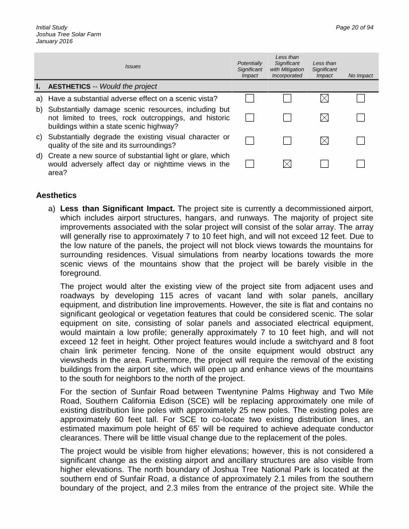
I. AESTHETICS -- Would the project
a) Have a substantial adverse effect on a scenic vista?
b) Substantially damage scenic resources, including but not limited to trees, rock outcroppings, and historic buildings within a state scenic highway?
c) Substantially degrade the existing visual character or quality of the site and its surroundings?
d) Create a new source of substantial light or glare, which would adversely affect day or nighttime views in the area?
Aesthetics
a) Less than Significant Impact. The project site is currently a decommissioned airport, which includes airport structures, hangars, and runways. The majority of project site improvements associated with the solar project will consist of the solar array. The array will generally rise to approximately 7 to 10 feet high, and will not exceed 12 feet. Due to the low nature of the panels, the project will not block views towards the mountains for surrounding residences. Visual simulations from nearby locations towards the more scenic views of the mountains show that the project will be barely visible in the foreground.
The project would alter the existing view of the project site from adjacent uses and roadways by developing 115 acres of vacant land with solar panels, ancillary equipment, and distribution line improvements. However, the site is flat and contains no significant geological or vegetation features that could be considered scenic. The solar equipment on site, consisting of solar panels and associated electrical equipment, would maintain a low profile; generally approximately 7 to 10 feet high, and will not exceed 12 feet in height. Other project features would include a switchyard and 8 foot chain link perimeter fencing. None of the onsite equipment would obstruct any viewsheds in the area. Furthermore, the project will require the removal of the existing buildings from the airport site, which will open up and enhance views of the mountains to the south for neighbors to the north of the project.
For the section of Sunfair Road between Twentynine Palms Highway and Two Mile Road, Southern California Edison (SCE) will be replacing approximately one mile of existing distribution line poles with approximately 25 new poles. The existing poles are approximately 60 feet tall. For SCE to co-locate two existing distribution lines, an estimated maximum pole height of 65’ will be required to achieve adequate conductor clearances. There will be little visual change due to the replacement of the poles.
The project would be visible from higher elevations; however, this is not considered a significant change as the existing airport and ancillary structures are also visible from higher elevations. The north boundary of Joshua Tree National Park is located at the southern end of Sunfair Road, a distance of approximately 2.1 miles from the southern boundary of the project, and 2.3 miles from the entrance of the project site. While the

Initial Study Page 21 of 94 Joshua Tree Solar Farm January 2016
project will be visible from that location, there is no public access to Joshua Tree National Park from this location. The project cannot be seen from the park visitor center on the west side, nor from the Indian Cove Campground to the southeast of the project. Most of the publically accessible and popular areas within Joshua Tree National Park are located further to the south, and the topography is such that the project cannot be seen from any of the public campgrounds, designated public trails, or rock climbing areas.
b) Less than Significant Impact. The project would not damage scenic resources, including those within a designated scenic highway. There are no scenic or historic resources onsite. There are no large trees or natural rock outcroppings onsite. The vegetation on the site and along the perimeter is sparse and is not unique to the immediate area and therefore is not a scenic resource.
SR-62 is depicted on the General Plan's Open Space Element Map as a County-designated scenic route. The project facilities would be virtually imperceptible from SR-62 approximately one mile south. The lack of visual impacts is due to several factors:
The low height of project facilities, with solar panels and switchyard structures being generally approximately 7 to 10 feet in height up to a maximum of 12 feet in height. Existing distribution lines along Sunfair Road would be improved and poles may be replaced, but there is no change in the baseline viewshed.
The presence of vegetation between the highway and project site. The presence of brush and other desert vegetation along SR-62 shields the project site from highway users and provides a visual distraction and impediment which makes the site less visible to highway travelers.
Therefore, the project would not have a substantial adverse effect on scenic resources within a scenic highway. Impacts would be less than significant and no mitigation measures are required.
c) Less than Significant Impact Implementation of the project would alter the existing visual character of the project site, however, the project site is a decommissioned airport, and has little to no scenic value under the existing conditions. Project facilities have heights which are similar to or lower than those of the decommissioned airport structures and existing development in the Sunfair area, which includes features such as single-family residences, a concrete batch plant, paved roads, and transmission lines. The project would have a low profile (with a maximum height of approximately 12 feet for solar panels and switchyard equipment, and distribution lines with a height and design that is consistent with similar lines in the vicinity). The project would also have minimal lighting and, therefore, would not substantially degrade the existing visual character or quality of the site and its surroundings.
Project setbacks from the roadway will substantially reduce visual impacts. Due to the relatively low height of project facilities, vegetation beyond the project boundary would screen site features and substantially limit views. In addition, views of mountains in the background remain unimpeded.
Overall, the project would be similar in scale to existing development, and does not limit or substantially modify views of mountains. The project would be consistent with the

Initial Study Page 22 of 94 Joshua Tree Solar Farm January 2016
County's zoning requirements and development standards relative to the setbacks and height of the project. Much of the project site is already paved or disturbed as a result of the remaining airport infrastructure including runways.
The project would not have a substantial adverse effect on the visual character or quality of the site or its surroundings; impacts would be less than significant with implementation of the project setbacks.
d) Less than Significant Impact with Mitigation Incorporated. The project would not create a new source of substantial light or glare which would adversely affect day or nighttime views in the area. The project proposes to use dark photovoltaic solar cells.
Any impacts resulting from lighting would be minimized through compliance with all development standards, Zoning Ordinance standards, and the goals, policies, and implementation measures of the General Plan. San Bernardino County Ordinance No. 3900 regulates glare, outdoor lighting, and night sky protection. Nighttime lighting associated with the project would be subject to County approval and compliance with San Bernardino County requirements and the provisions of Chapter 83.07 of the County Development Code.
Impacts from new sources of light or glare are expected to be less than significant. The project will not create a significant source of light. Light sources associated with the project will be minimal, and will be restricted to that required for nighttime safety and security according to county requirements. Lighting will be installed and directed downward and shielded to avoid light trespass. Additionally, lighting will be minimized via use of motion sensors or other lighting management controls.
Project components will introduce minimal amounts of glare to the existing landscape. The project PV panels are designed to absorb sunlight, and the glass panels that protect the PV surface are typically coated glass designed to allow sunlight to pass with minimal reflection.
SIGNIFICANCE: Possible adverse impacts have been identified or are anticipated and the following mitigation measures are required as conditions of project approval to reduce these impacts to a level below significant:
AESTHETICS MITIGATION MEASURES:
AES-1 Building Materials. As appropriate, on-site switchyard buildings shall use non-reflective materials and neutral colors as approved by the Land Use Services Department, Planning Division.
Initial Study Page 23 of 94 Joshua Tree Solar Farm January 2016
Issues Potentially Significant
Impact
Less than Significant
with Mitigation Incorporated
Less than Significant
Impact No Impact
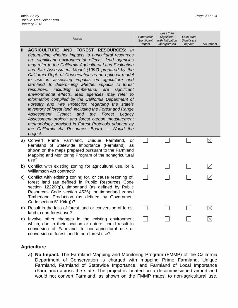
II. AGRICULTURE AND FOREST RESOURCES: In determining whether impacts to agricultural resources are significant environmental effects, lead agencies may refer to the California Agricultural Land Evaluation and Site Assessment Model (1997) prepared by the California Dept. of Conservation as an optional model to use in assessing impacts on agriculture and farmland. In determining whether impacts to forest resources, including timberland, are significant environmental effects, lead agencies may refer to information compiled by the California Department of Forestry and Fire Protection regarding the state’s inventory of forest land, including the Forest and Range Assessment Project and the Forest Legacy Assessment project; and forest carbon measurement methodology provided in Forest Protocols adopted by the California Air Resources Board. -- Would the project:
a) Convert Prime Farmland, Unique Farmland, or Farmland of Statewide Importance (Farmland), as shown on the maps prepared pursuant to the Farmland Mapping and Monitoring Program of the nonagricultural use?
b) Conflict with existing zoning for agricultural use, or a Williamson Act contract?
c) Conflict with existing zoning for, or cause rezoning of, forest land (as defined in Public Resources Code section 12220(g)), timberland (as defined by Public Resources Code section 4526), or timberland zoned Timberland Production (as defined by Government Code section 51104(g))?
d) Result in the loss of forest land or conversion of forest land to non-forest use?
e) Involve other changes in the existing environment which, due to their location or nature, could result in conversion of Farmland, to non-agricultural use or conversion of forest land to non-forest use?
Agriculture
a) No Impact. The Farmland Mapping and Monitoring Program (FMMP) of the California Department of Conservation is charged with mapping Prime Farmland, Unique Farmland, Farmland of Statewide Importance, and Farmland of Local Importance (Farmland) across the state. The project is located on a decommissioned airport and would not convert Farmland, as shown on the FMMP maps, to non-agricultural use,

Initial Study Page 24 of 94 Joshua Tree Solar Farm January 2016
since the project is not designated as such. There is no impact and no further analysis is warranted.
b) No Impact. The project would not conflict with existing zoning for agricultural use, and the project area is not under a Williamson Act contract. There is no impact and no further analysis is warranted.
c) No Impact. The project would not conflict with existing zoning for, or cause rezoning of, forest land, timberland, or timberland zoned Timberland Production. The project area is a decommissioned airport, which has never been designated as forest land or timberland. No rezoning of the project site would be required as the energy facility is compatible with the current zoning designations of community industrial, institutional and rural living. There is no impact and no further analysis is warranted.
d) No Impact. The project would not result in the loss of forest land or conversion of forest land to non-forest use. The project site is a decommissioned airport and has sparse desert vegetation. There is no impact and no further analysis is warranted.
e) No Impact. The project would not involve other changes in the existing environment which, due to their location or nature, could result in conversion of Farmland to non-agricultural use or forest land to non-forest land. There is no impact and no further analysis is warranted.
SIGNIFICANCE: No significant adverse impacts are identified or anticipated and no mitigation measures are required.
Initial Study Page 25 of 94 Joshua Tree Solar Farm January 2016
Issues Potentially Significant
Impact
Less than Significant
with Mitigation Incorporated
Less than Significant
Impact No Impact
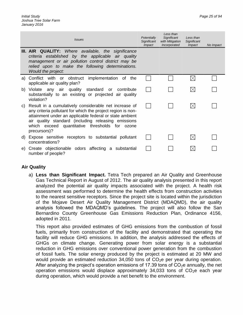
III. AIR QUALITY: Where available, the significance criteria established by the applicable air quality management or air pollution control district may be relied upon to make the following determinations. Would the project:
a) Conflict with or obstruct implementation of the applicable air quality plan?
b) Violate any air quality standard or contribute substantially to an existing or projected air quality violation?
c) Result in a cumulatively considerable net increase of any criteria pollutant for which the project region is non-attainment under an applicable federal or state ambient air quality standard (including releasing emissions which exceed quantitative thresholds for ozone precursors)?
d) Expose sensitive receptors to substantial pollutant concentrations?
e) Create objectionable odors affecting a substantial number of people?
Air Quality
a) Less than Significant Impact. Tetra Tech prepared an Air Quality and Greenhouse Gas Technical Report in August of 2012. The air quality analysis presented in this report analyzed the potential air quality impacts associated with the project. A health risk assessment was performed to determine the health effects from construction activities to the nearest sensitive receptors. Since the project site is located within the jurisdiction of the Mojave Desert Air Quality Management District (MDAQMD), the air quality analysis followed the MDAQMD’s guidelines. The project will also follow the San Bernardino County Greenhouse Gas Emissions Reduction Plan, Ordinance 4156, adopted in 2011.
This report also provided estimates of GHG emissions from the combustion of fossil fuels, primarily from construction of the facility and demonstrated that operating the facility will reduce GHG emissions. In addition, the analysis addressed the effects of GHGs on climate change. Generating power from solar energy is a substantial reduction in GHG emissions over conventional power generation from the combustion of fossil fuels. The solar energy produced by the project is estimated at 20 MW and would provide an estimated reduction 34,050 tons of CO2e per year during operation. After analyzing the project’s operation emissions of 17.39 tons of CO2e annually, the net operation emissions would displace approximately 34,033 tons of CO2e each year during operation, which would provide a net benefit to the environment.

Initial Study Page 26 of 94 Joshua Tree Solar Farm January 2016
The air quality and GHG analysis concludes that emissions during short-term construction and during long-term operation of the project do not exceed the significant thresholds established by the MDAQMD.
The health risk assessment concludes that the construction activities would result in a less-than-significant impact. The project does not pose significant adverse impacts on local air quality or global climate change.
Over its lifetime, the project would not violate the regulations set forth by the MDAQMD Rule Book or CEQA and Federal Conformity Guidelines. Electricity generation via the use of photovoltaic systems does not generate chemical emissions that would negatively contribute to air quality.
Given that the project would not alter the population or employment projections and considering the minor emissions attributable to the project during operation, impacts associated with the air quality management plan consistency would be less than significant.
b) Less than Significant Impact. The project would not violate any air quality standard or contribute substantially to an existing or projected air quality violation. Air quality impacts would include construction exhaust emissions generated from diesel- and gasoline-powered equipment construction equipment, vegetation clearing, grading, construction worker commuting, and construction material deliveries (including the delivery of solar panels from out-of-state locations). Fugitive dust emissions include PM10 and are a potential concern because the project is in a nonattainment area for ozone and PM10. PM2.5 is also non-attainment and needs to be considered. A dust control plan will be developed prior to construction.
On an annual basis, none of the criteria pollutants would exceed the MDAQMD thresholds when enhanced dust control mitigation measures are used. The project would generate negligible air emissions during operations because the facility would be automated and would require minimal onsite personnel. Periodic repairs, equipment cleaning, and site monitoring would be conducted, but no permanent staff would be onsite. Solar panels and associated equipment would have an operating life of several decades; therefore, replacement of panels would be very infrequent. The solar panels would be cleaned up to four times per year, with each cleaning expected to take a couple of days with minimal staff. Maintenance and security personnel would visit the site weekly with maintenance visits on a monthly basis. Based on these factors, operational traffic associated with the project would be minimal.
c) Less than Significant Impact. The project would not result in a cumulatively considerable net increase of any criteria pollutant for which the project region is in nonattainment under an applicable federal or state ambient air quality standard (including releasing emissions which exceed quantitative thresholds for ozone precursors). As previously discussed the project's contribution to criteria pollutants during the temporary construction period would be localized and maintained below a level of significance. As also indicated, operational activities would generate insubstantial quantities of air pollutants that are not deemed cumulatively considerable. Since no other sources of potential long-term air emissions would result, impacts would be less than significant.

Initial Study Page 27 of 94 Joshua Tree Solar Farm January 2016
d) Less than Significant Impact. The project would not expose sensitive receptors to substantial pollutant concentrations. There are a limited number of sensitive uses in the project vicinity. Single family residences are located to the north of the project site, and one to the east.
With regard to potentially hazardous air emissions, electricity generation via the use of photovoltaic systems does not generate chemical emissions that would negatively affect air quality. Further, the project would not emit hazardous emissions or handle hazardous or acutely hazardous materials, substances, or waste within one-quarter mile of an existing or proposed school. There are no schools within the general vicinity of the facilities. For those reasons, impacts are less than significant and an assessment of potential human health risks attributable to emissions of hazardous air pollutants is not required.
e) Less than Significant Impact. The project would not create objectionable odors that would affect a substantial number of people. Electricity generation via the use of photovoltaic systems does not generate emissions that would negatively contribute to air quality or produce objectionable odors. Potential odor generation associated with the project would be limited to short-term construction sources such as diesel exhaust; however, no significant odor impacts are anticipated due to the short-term duration of such emissions, as well as the intervening distance to sensitive receptors. Odor generation impacts would be less than significant and no further analysis is warranted.
SIGNIFICANCE: Possible adverse impacts are related to PM10 and the following best management practices are required as conditions of project approval to reduce these impacts to a level below significant:
AIR QUALITY BEST MANAGEMENT PRACTICES:
AQ-1 AQ Operational Mitigation. Operation of all off-road and on-road diesel vehicles/equipment shall comply with the County Diesel Exhaust Control Measures [SBCC §83.01.040 (c)], including but not limited to:
a) Equipment/vehicles shall not be left idling for periods in excess of five minutes.
b) Engines shall be maintained in good working order to reduce emissions.
c) Onsite electrical power connections shall be made available where feasible.
d) Ultra low-sulfur diesel fuel shall be utilized.
e) Electric and gasoline powered equipment shall substituted for diesel powered equipment where feasible.
f) Signs shall be posted requiring all vehicle drivers and equipment operators to tum off engines when not in use.
g) All transportation refrigeration units (TRUs) shall be provided electric connections.

Initial Study Page 28 of 94 Joshua Tree Solar Farm January 2016
AQ-2 AQ Dust Control Plan. The developer shall prepare, submit and obtain approval from County Planning of a Dust Control Plan (DCP) consistent with MDAQMD guidelines and a letter agreeing to include in any construction contracts/subcontracts a requirement that project contractors adhere to the requirements of the DCP. The DCP shall include the following elements to reduce dust production:
a) Exposed soils and haul roads shall be watered up to three (3) times per day to reduce fugitive dust during grading/construction activities. Inactive areas shall be treated with soil stabilizers such as hay bales or aggregate cover.
b) Street sweeping shall be conducted when visible soil accumulations occur along site access roadways to remove dirt dropped by construction vehicles.
c) Site access driveways and adjacent streets shall be washed daily, if there are visible signs of any dirt track-out at the conclusion of any workday.
d) Construction vehicle tires shall be cleaned prior to leaving the project site.
e) All trucks hauling dirt away from the site shall be covered, and speeds on unpaved roads shall be reduced below 15 miles per hour.
f) During high wind conditions (i.e., sustained wind speeds exceeding 20 mph), areas with disturbed soil shall be watered hourly and activities on unpaved surfaces shall cease until wind speeds no longer exceed 20 mph.
g) Storage piles that are to be left in place for more than three working days shall either be sprayed with a non-toxic soil binder, covered with plastic or revegetated.
AQ-3 AQ Installation. The developer shall submit for review and obtain approval from County Planning of evidence that all air quality mitigation measures have been installed properly and that specified performance objectives are being met to the satisfaction of County Planning and County Building and Safety.
AQ-4 AQ Signage. The developer shall agree to erect a sign for fugitive dust issues. The MDAQMD requires a sign to be erected not later than the commencement of construction at the project site entrance. This sign will include a phone number and contact information for anyone who wants to report dust issues resulting from the project construction.

Initial Study Page 29 of 94 Joshua Tree Solar Farm January 2016
Issues Potentially Significant
Impact
Less than Significant
with Mitigation Incorporated
Less than Significant
Impact No Impact
IV. BIOLOGICAL RESOURCES -- Would the project:
a) Have a substantial adverse effect, either directly or through habitat modifications, on any species identified as a candidate, sensitive, or special status species in local or regional plans, policies, or regulations, or by the California Department of Fish and Game or U.S. Fish and Wildlife Service?
b) Have a substantial adverse effect on any riparian habitat or other sensitive natural community identified in local or regional plans, policies, regulations or by the California Department of Fish and Game or US Fish and Wildlife Service?
c) Have a substantial adverse effect on federally protected wetlands as defined by Section 404 of the Clean Water Act (including, but not limited to, marsh, vernal pool, coastal, etc.) through direct removal, filling, hydrological interruption, or other means?
d) Interfere substantially with the movement of any native resident or migratory fish or wildlife species or with established native resident or migratory wildlife corridors, or impede the use of native wildlife nursery sites?
e) Conflict with any local policies or ordinances protecting biological resources, such as a tree preservation policy or ordinance?
f) Conflict with the provisions of an adopted Habitat Conservation Plan, Natural Community Conservation Plan, or other approved local, regional, or state habitat conservation plan?
Biological Resources
a) Less Than Significant with Mitigation Incorporated. Tetra Tech, Inc. conducted comprehensive field surveys for biological resources in Spring 2012 to determine the potential presence or absence of special-status species and their habitat. To update the survey data and confirm current site conditions, additional surveys for desert tortoise (Gopherus agassizii), burrowing owl (Athene cunicularia), rare plants, and other special-status wildlife were conducted in Spring 2015. The detailed methods and results of the 2012 and 2015 surveys can be found in the 2015 Desert Tortoise Survey and General Biological Resources Assessment for the Joshua Tree Solar Farm (Airport Site) (BRA, Tetra Tech and Karl 2015). Prior to Spring 2012 and 2015 field surveys, a target list of special-status species that might be affected by the project was developed based on available literature and databases (e.g., California Native Plant Society [CNPS], California Natural Diversity Data Base [CNDDB, see BRA Appendix B]), and consultation with local experts.
Initial Study Page 30 of 94 Joshua Tree Solar Farm January 2016
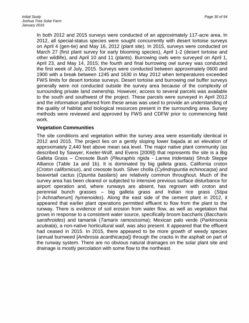
In both 2012 and 2015 surveys were conducted of an approximately 117-acre area. In 2012, all special-status species were sought concurrently with desert tortoise surveys on April 4 (gen-tie) and May 16, 2012 (plant site). In 2015, surveys were conducted on March 27 (first plant survey for early blooming species), April 1-2 (desert tortoise and other wildlife), and April 10 and 11 (plants). Burrowing owls were surveyed on April 1, April 23, and May 14, 2015; the fourth and final burrowing owl survey was conducted the first week of July, 2015. Surveys were conducted between approximately 0600 and 1900 with a break between 1245 and 1630 in May 2012 when temperatures exceeded FWS limits for desert tortoise surveys. Desert tortoise and burrowing owl buffer surveys generally were not conducted outside the survey area because of the complexity of surrounding private land ownership. However, access to several parcels was available to the south and southwest of the project. These parcels were surveyed in April 2012 and the information gathered from these areas was used to provide an understanding of the quality of habitat and biological resources present in the surrounding area. Survey methods were reviewed and approved by FWS and CDFW prior to commencing field work.
Vegetation Communities
The site conditions and vegetation within the survey area were essentially identical in 2012 and 2015. The project lies on a gently sloping lower bajada at an elevation of approximately 2,440 feet above mean sea level. The major native plant community (as described by Sawyer, Keeler-Wolf, and Evens [2009]) that represents the site is a Big Galleta Grass – Creosote Bush (Pleuraphis rigida - Larrea tridentata) Shrub Steppe Alliance (Table 1a and 1b). It is dominated by big galleta grass, California croton (Croton californicus), and creosote bush. Silver cholla (Cylindropuntia echinocarpa) and beavertail cactus (Opuntia basilaris) are relatively common throughout. Much of the survey area has been cleared or subjected to intensive previous surface disturbance for airport operation and, where runways are absent, has regrown with croton and perennial bunch grasses – big galleta grass and Indian rice grass (Stipa [= Achnatherum] hymenoides). Along the east side of the cement plant in 2012, it appeared that earlier plant operations permitted effluent to flow from the plant to the runway. There is evidence of soil erosion from water flow, as well as vegetation that grows in response to a consistent water source, specifically broom baccharis (Baccharis sarothroides) and tamarisk (Tamarix ramosissima); Mexican palo verde (Parkinsonia aculeata), a non-native horticultural waif, was also present. It appeared that the effluent had ceased in 2015. In 2015, there appeared to be more growth of weedy species (annual burrweed [Ambrosia acanthicarpa]) through the cracks in the asphalt on part of the runway system. There are no obvious natural drainages on the solar plant site and drainage is mostly percolation with some flow to the northeast.

Initial Study Page 31 of 94 Joshua Tree Solar Farm January 2016
Table 1a. Vegetation and Land Cover Acreage – Solar Plant Site
Vegetation and Other Cover - Solar Plant Site Acres
Previously cleared, regrowth of big galleta grass, Indian rice grass, and croton 31
Moderately intact Big Galleta Grass-Creosote Bush Scrub Steppe Alliance 19
Bladed (barren), developed, or recently bladed (early regrowth) 40
Loose – sandy soils due to adjacent disturbance 4
Big Galleta – Creosote Bush Shrub Steppe Alliance disturbed by adjacent industry 21
Table 1b. Vegetation and Land Cover Acreage – Distribution Line Improvement
Vegetation and Other Cover – Distribution Line Improvement Acres
Aeolian Sand Sheets 0.4
Big Galleta – Creosote Bush Shrub Steppe Alliance 5
Big Galleta Shrub Steppe Alliance 1
Wash (includes Main Wash Channel and Bench of Channel) 1
The area surveyed for the distribution line improvement crosses several vegetation and cover types not found on the main project site. At its north end, the distribution line improvement area crosses aeolian sand sheets adjacent to both banks of a major wash. The wash extends east-west across the distribution line improvement area and Sunfair Road. The wash is generally poorly vegetated, with plant cover increasing on the benches and upslope; soils are sandy, with silty surface layers. It would be loosely considered a poor quality Big Galleta Grass – Creosote Bush Shrub Steppe Alliance. Farther south, the distribution line improvement area crosses Big Galleta Shrub Steppe Alliance dominated by big galleta grass, which transitions to Big Galleta-Creosote Bush Shrub Steppe Alliance as it nears Hwy 62. The area surveyed for the distribution line improvements was generally degraded due to its proximity to Sunfair Road.
Rare Plants
Surveyors did not find any federally or state-threatened, endangered, or candidate plant species during 2012 or 2015 surveys. One CNPS-ranked plant was observed within the survey area in both survey years: Utah vine milkweed (Funastrum utahense) – CRPR 4. As a CRPR 4, this plant does not meet the requirements to trigger consideration under CEQA; therefore, no species-specific mitigation measures are required.
In 2012, below-average precipitation fell in Winter 2011-2012, resulting in well below-average germination and low biomass of annual forbs; virtually no native annuals germinated in 2012 at the Project. Precipitation in February 2012 was closer to average, which prompted several perennial species and a few individuals of exotic annuals to leaf out and/or bloom. Precipitation was again below average in Winter 2014/2015, especially during the most important germination period in late fall, but was average in March, which was sufficient for germination of several annual species (although fewer individuals of all species) in Spring 2015.
Regulated Plant Species
Desert native plants are regulated under Division 23, California Desert Native Plants of the California Food and Agricultural Code (Section 80000 et seq.), which includes
Initial Study Page 32 of 94 Joshua Tree Solar Farm January 2016
protection for several native plant species. In addition, the San Bernardino County Development Code, Title 8, Chapter 88.01, Plant Protection and Management, augments and implements provisions of the California Desert Native Plants Act. Biologists observed and tallied four species protected by the CDNPA and County code during Spring 2012 surveys, three cacti species, and one yucca species (Table 2). The most numerous was beavertail cactus. One Joshua tree grew naturally within the survey area, although 19 were planted against the on-site houses and structures, but were not inventoried to respect the privacy of the tenant/caretaker of the property. As these species are perennial, surveyors did not conduct another count in 2015, with the exception of naturally occurring Joshua trees.
Table 2. CDNPA Species found within the Survey Area
Species Total in
Survey Area
Beavertail cactus (Opuntia basilaris)
42
Buckhorn cholla (Cylindropuntia acanthocarpa)
1
Joshua Tree* (Yucca brevifolia)
1
Silver cholla (Cylindropuntia echinocarpa)
51
Total 95
*Landscaped Joshua trees are excluded
Non-native Plants
Invasive plants are defined as any non-native plant species that are injurious to the public health, agriculture, recreation, wildlife habitat, or the biodiversity of native habitats. To determine which invasive species are currently present and their approximate abundance, surveyors inventoried all invasive plant species and recorded the location of concentrations. Surveyors detected six non-native noxious species during Spring 2012 and Spring 2015 surveys: Russian thistle (Salsola tragus) Sahara mustard (Brassica tounefourtii), tamarisk (Tamarix sp.), Mexican palo verde (Parkinsonia aculeata, one individual), filaree (Erodium cicutarium), and Mediterranean grass (Schismus sp.). Russian thistle and Sahara mustard were present but not abundant near the roads surrounding the survey area and adjacent to the dirt runway and cement plant in the southeastern portion of the survey area. Tamarisk and Mexican palo verde were rare and only occurred east of the cement plant, either in an area that received runoff from the cement plant or adjacent to the on-site infrastructure (tamarisk only). Mediterranean grass and filaree were common throughout the survey area and region.
Listed Wildlife Species
Desert Tortoise: No live tortoises or their sign were observed during Spring 2012 and Spring 2015 surveys of the project site, and the entirety of the survey area is either poor quality desert tortoise habitat or developed and not habitat. The lack of recent or past

Initial Study Page 33 of 94 Joshua Tree Solar Farm January 2016
sign indicates that tortoises do not currently use the project site and have not used it in recent years. Most of the project site is highly disturbed by the development and/or operation of the airport and the cement plant. The introduction of non-native plant species and the proximity to a well-traveled paved road (Sunfair Road) further contribute to the lowered quality of the habitat. There are only small patches of relatively undisturbed Big Galleta Grass-Creosote Bush Scrub Steppe Alliance (see Figure 4 of the BRA). The version of this community that occurs at the project site is inherently poor tortoise habitat and is further compromised by the surrounding disturbance.
Desert tortoise habitat quality declines as topography flattens toward Coyote Dry Lake east of the project site due to lower coversite potential and reduced foraging opportunities. Accordingly, areas lower on the bajada likely support lower tortoise densities. Studies in the area have found tortoise sign higher on the bajada, while one study east of the airport found no sign (E. LaRue, Circle Mountain Biological Consultants, Inc., pers. comm. to A. Karl). Surveys of the Cascade Solar Project, approximately one mile northeast of the project near Coyote Dry Lake, did not detect any tortoise or tortoise sign in April 2011 (PCR 2011a). The project site is located on the lower bajada, approximately one mile from Coyote Dry Lake, and the lack of tortoise sign and poor habitat quality is consistent with these observations. Although the project site contains no tortoises and poor habitat to non-habitat, there are no barriers to prevent tortoise movement onto the project site from adjacent parcels that contain better habitat. The CNDDB (2012) records show tortoise occurrences in the valley surrounding the project site (Appendix B), and one tortoise was observed in the vicinity of the project site approximately 0.5 mile to the southwest in an area of higher quality tortoise habitat. The possibility of transient tortoise should be considered.
The survey area is not within FWS critical habitat. FWS designated critical habitat areas for the desert tortoise in 1994 (FWS 1994) and prescribed management actions to aid recovery, with critical habitat providing legal protection. The closest critical habitat unit to the survey area is the Pinto Mountain Critical Habitat Unit, approximately 12 miles to the southeast.
Non-listed, Special-status Species
Burrowing Owl: A FWS Bird of Conservation Concern and CDFW Species of Special Concern, burrowing owls occupy a wide range of habitats such as open, treeless areas within grassland, steppe, and desert biomes with low, sparse vegetation (Poulin et al. 2011). Three of the four surveys recommended by CDFW (CDFG 2012) were conducted in Spring 2015 and the fourth survey was conducted the first week of July 2015. Although the majority of the survey area and immediately adjacent parcels are considered potential habitat, surveyors did not observe any burrowing owls or sign during 2012 or 2015 surveys. Because there is suitable habitat within the survey area and immediate vicinity, and there are recorded observations approximately four miles northwest of the survey area (CNDDB 2012, see Appendix B of BRA), it is possible that burrowing owls might inhabit the survey area in the future, even though it is currently unoccupied.
Prairie Falcon: Surveyors observed one prairie falcon (Falco mexicanus; Bird of Conservation Concern) perched on a tamarisk within the survey area during Spring 2012 surveys (see Table 8 and Figure 6 of BRA). No prairie falcons were observed in

Initial Study Page 34 of 94 Joshua Tree Solar Farm January 2016
2015. Prairie falcons are year-round residents of the region within which the project lies. The prairie falcon is found in a variety of habitats, but is associated primarily with desert scrub and similar open habitats where it utilizes open ledges and cliffs for perching and nesting and forages over the open terrain (Steenhof 2013). The project does not provide suitable nesting habitat, although it could provide suitable foraging habitat.
Mojave Fringe-toed Lizard: Mojave fringe-toed lizards (CDFW Species of Special Concern) are loose-sand specialists, found only in aeolian sand dunes, sand fields, hummocks, and other areas with loose sand deposits between 300 and 3,000 feet in elevation (Stebbins 2003). No Mojave fringe-toed lizards were observed during 2012 and 2015 surveys, and although sandy soils are present within the survey area, there are no loose sand deposits within the survey area that would be considered suitable Mojave fringe-toed lizard habitat. There are no documented CNDDB occurrences within the survey area; the closest record is over 10 miles to the northeast.
Desert Kit Fox: Desert kit fox are regulated by CDFW as a protected furbearer. Suitable denning and foraging habitat for the desert kit fox occurs throughout the undeveloped portions of the survey area and kit fox sign was observed in Spring 2012 and Spring 2015. In 2012, surveyors detected one active and two inactive kit fox natal dens within the survey area (Table 8A, Figure 6A) and scat throughout. In 2015, there was no evidence of recent occupation of the Project, but four inactive natal dens were observed within the survey area (Table 8B, Figure 6B). Despite the absence of recent sign during the 2015 surveys, there is suitable habitat present and kit fox are highly mobile species; therefore, it is possible that kit fox will reinhabit the Project.
Nesting and Migratory Birds
The project area could support nesting birds. Disturbing or destroying active nests would be a violation of the Migratory Bird Treaty Act (MBTA). In addition, nests and eggs are protected under Fish and Game Code Section 3503. Thus, the removal of vegetation during the breeding season is considered a potentially significant impact. The breeding season is typically considered to be from February 15 to August 31.
Golden eagles (Aquila chrysaetos; MBTA and Bald and Golden Eagle Protection Act; CDFW: Fully Protected) were not observed during general biology surveys and are not expected to occur on the project site but are of particular concern to FWS and CDFW and are therefore discussed in more detail. Golden eagles are found in variety of habitats but generally prefer open spaces for hunting and cliffs, trees, or other tall structures (e.g., transmission line structures) for nesting (Kochert et al. 2002). No eagles were observed during surveys and the survey area does not contain suitable nesting habitat for eagles. The nearest CNDDB occurrence of nesting eagles is approximately eight miles southeast of the project, from 1980. The closest mountain range to the project with suitable nesting habitat is the Little San Bernardino Mountains, approximately 2.5 miles to the south-southwest. Therefore, it is possible that eagles nest in the Little San Bernardino Mountains and may hunt in the valley surrounding the project. However, it is not expected that eagles will use the project site due to the high level of existing disturbance and the nearby residential and industrial development.
Most birds are protected under the MBTA; however, significant impacts are not expected and no focused migratory bird surveys (e.g., fixed point counts) are planned because of (1) the degraded quality of the natural habitat on the project site (i.e.

Initial Study Page 35 of 94 Joshua Tree Solar Farm January 2016
previously disturbed and surrounded by roads), (2) the relatively small size of the project, and (3) the lack of nearby attractive site features such as wetlands, agricultural areas, or cliffs that are known to attract birds. The closest perennial waterbodies are the Salton Sea, which is approximately 45 miles south of the project site and the Colorado River, which is approximately 100 miles to the east. Although there have been reported avian fatalities at some of the solar facilities in the desert, it has only been hypothesized that the facilities appear as water bodies to migrating birds; there have been no empirical studies conducted on the effects of PV solar installations have on birds. Additionally, this project is substantially smaller and is located in a more disturbed and developed area than the solar projects that are reporting avian fatalities. Although any structure can pose a collision risk to birds, the project does not contain tall structures that would extend into the airspace of birds migrating at high elevations. The project also does not contain thermal components or evaporation ponds, two design features that have been found to adversely affect birds at other solar projects. For the above reasons, the project is expected to have a minimal contribution to cumulative impacts on birds. Mitigation measures BIO-1, -3, -4, -7, and -8 will help offset direct, indirect, and cumulative impacts on birds.
Summary
The project may adversely affect special-status plants and special-status wildlife species, specifically desert tortoise, burrowing owl, and desert kit fox, although the potential for effects to these species is considered low. In addition, the project could result in adverse effects to protected nesting birds if implemented during the nesting season. Therefore, mitigation measures BIO-1 through BIO-8 are recommended to ensure potential project effects to special-status plants and wildlife species are avoided and/or minimized.
b) Less Than Significant Impact:
Sensitive Vegetation Communities: Big Galleta Shrub Steppe Alliance (G3S2) and Big Galleta-Creosote Bush Shrub Steppe Alliance (the latter is a subset of the former) are the only CNDDB globally and state-ranked communities of special concern (G or S rank 1-3) in the survey area. The global rank is G3, the state rank is S2. CNDDB guidelines direct project proponents to determine if project-affected stands of certain vegetation types represent high-quality occurrences of the given community to determine if there would be significant impacts to the vegetation type1. Essentially the entire survey area is within the Big Galleta-Creosote Bush Shrub Steppe Alliance (see Table 2 and Figure 4 of the BRA), with Big Galleta Shrub Steppe Alliance present only along the distribution line improvement route. Both have been substantially degraded by previous clearing, and are bordered by several anthropogenic features that directly impact the project site community through dust and trash, and the introduction of non-native noxious plant species. Because of this, and the relative commonness of these communities in the region, they are not considered high quality representations or rare in the area.
Jurisdictional Waters: Based on a review of aerial images of the site and field verification, no on-site jurisdictional drainage features were noted (see Jurisdictional
1 http://www.dfg.ca.gov/biogeodata/vegcamp/natural_comm_background.asp#codes
Initial Study Page 36 of 94 Joshua Tree Solar Farm January 2016
Delineation of Wetlands/Waters Subject to Regulatory Authority [JD Report], Tetra Tech, Inc. 2012). Although the Hydrology Study completed for the site confirms that storm water has the potential to flow across the site generally from the southwest to the northeast, no definable channels or drainage features were observed during the survey conducted in May, 2012. A minor degree of erosion isolated to the southern portion of the earthen runway was observed (see Photograph 4 in JD Report). This erosion may have been a result of sheet flow originating on-site or from the cement plant located up gradient on the southwestern corner of the airport property, but is not considered to be subject to regulatory jurisdiction.
The Army Corps of Engineers (ACOE) asserts jurisdiction over all waters that are in use or were used in the past or may be susceptible to use in interstate or foreign commerce, including all waters which may be subject to the ebb and flow of the tide and are defined as Traditional Navigable Waters (U.S. ACOE and Environmental Protection Agency 2007). Field observations and review of relevant aerial photographs and topographic maps confirm that there are no jurisdictional features on the site subject to regulatory authority by the ACOE.
Under Section 401 of the Clean Water Act and the Porter-Cologne Water Quality Act, the RWQCB Colorado River Basin asserts jurisdiction over jurisdictional wetlands and those non-isolated waters associated with Traditional Navigable Waters. Based on the absence of definable channels or drainages on the site, there are no jurisdictional features subject to regulatory authority by the RWQCB-Colorado River Basin.
Under Section 1600 et. seq. of the California Department of Fish and Game Code, the CDFW regulates all diversions, obstructions, or changes to the natural flow or bed, channel, or bank of any river, stream or lake, which support fish or wildlife. No definable bed and bank drainage features subject to regulatory authority by the CDFW were found on the site. Based on the absence of definable drainages within the project site, there are no jurisdictional streambeds subject to regulatory authority by the CDFW.
Summary
The project will have a less than significant impact on sensitive vegetation communities and jurisdictional waters. Mitigation Measures BIO-1, -6, and -7 will help minimize potential impacts.
c) No Impact: Based on a review of aerial images of the site and field verification, no federally protected wetlands as defined by Section 404 of the Clean Water Act (including, but not limited to, marsh, vernal pool, coastal, etc.) are present within the project area. (See Jurisdictional Delineation of Wetlands/Waters Subject to Regulatory Jurisdiction [JD Report], Tetra Tech 2012). Therefore, there would be no impacts to federally protected wetlands and no mitigation measures are necessary.
d) Less Than Significant: There are no established wildlife corridors within the project area that would be impeded by project development. Some native wildlife species, especially those tolerant of human disturbances, may breed on the site, but no native wildlife have established nursery or breeding colonies on the site. There are no perennial water sources within the project area; therefore, there are no fish populations present.
Initial Study Page 37 of 94 Joshua Tree Solar Farm January 2016
Bighorn Sheep (CDFW Managed Game Species): CNDDB records indicate that the Little San Bernardino Mountains, approximately 2.5 miles south of the project, are occupied by bighorn sheep. Nelson’s bighorn sheep require steep, rocky terrain to escape predators and raise lambs, and movement corridors among mountain ranges are important to maintaining healthy populations. However, the project site does not contain suitable bighorn sheep lambing or foraging habitat; nor is it situated in a movement corridor between important mountain ranges. Residential and industrial development in the valley, lack of steep, rocky habitat on or near the project site, and the absence of occupied mountain ranges north of the project site preclude the use of this site by bighorn sheep. The project site is not within a known bighorn sheep corridor as identified in A Linkage Design for the Joshua Tree-Twentynine Palms Connection (Penrod et al. 2008). No evidence of Nelson’s bighorn sheep was found during field surveys.
Summary
The project will have a less than significant impact on wildlife corridors, nursery sites, or breeding colonies. The project may inhibit, but not obstruct general movement of ground-dwelling species, but impacts will be kept to less than significant levels with the implementation of Mitigation Measures BIO-1 – BIO-8.
e) Less Than Significant with Mitigation Incorporated: The San Bernardino County General Plan (Conservation Element and Open Space Element) sets forth policies relevant to the protection of natural resources. The Conservation Element provides direction regarding the conservation, development, and utilization of the County of San Bernardino’s natural resources. Its objective is to prevent the wasteful exploitation, destruction and neglect of resources. The Open Space Element is interconnected, in varying degrees, to other elements of the General Plan (e.g., open space for the preservation of natural resources is directly related to the Conservation Element). The project is located in the Desert Region designated by the General Plan. In addition, San Bernardino County is in the process of writing a new section for the General Plan that addresses Renewable Energy and Conservation.
The San Bernardino County Development Code recently amended chapter 84.29 to address renewable energy generation facilities, and chapter 810.01, definitions of the San Bernardino County Development Code, relating to the regulation of commercial solar energy generation facilities. The project will respect and abide by the policies and regulations set forth in the General Plan and the Development Code.
Summary
By abiding by the policies within the General Plan and County Code and implementing mitigation measures BIO-1 – BIO-8, impacts on natural resources will be less than significant.
f) No Impact: The project and distribution line improvement area are not located within an adopted Habitat Conservation Plan, Natural Community Conservation Plan, or other approved local, regional, or State habitat conservation plan and will therefore have no impact on these areas. The project is within the Western Mohave Plan boundary; however, that plan applies only to the Federal Bureau of Land Management (BLM)-administered lands and does not apply to the project because it is on private land. The
Initial Study Page 38 of 94 Joshua Tree Solar Farm January 2016
project is not located within USFWS-designated critical habitat; therefore, there would be no impact on critical habitat. There will be no impacts to these areas; therefore, no mitigation measures are necessary
SIGNIFICANCE: Possible significant adverse impacts have been identified or anticipated and the following mitigation measures are required as conditions of project approval to reduce these impacts to a level below significant:
BIOLOGICAL RESOURCES MITIGATION MEASURES:
BIO-1 General Avoidance and Minimization Measures
Implement a worker environmental awareness training for all project personnel.
Limit areas of disturbance to the minimum necessary for development.
Salvage the topsoil containing the native seed bank and redistribute over temporarily disturbed areas to facilitate passive revegetation.
The project has been designed to minimize night lighting. All outdoor lighting, including street lighting, will be provided in accordance with the County Night Sky Protection Ordinance and will only be provided as necessary to meet safety standards. Outdoor lighting will be shielded or directed away from adjacent native habitat to protect species from direct night lighting.
The projected increases in noise will be reduced to the maximum extent practicable during construction activities. During all grading on-site, the construction contractors will equip all construction equipment, fixed or mobile, with properly operating and maintained mufflers, consistent with manufacturers' standards to reduce construction equipment noise to the maximum extent possible. Enforce a 15 mph speed limit on project roads.
Vehicles and equipment to remain on designated roadways
Standard dust control procedures will be implemented to minimize dust. If water is used as a dust suppressant, it will be administered such that pooling or ponding of water is minimized so that it does not provide a wildlife attractant.
Trash will be kept in raven and coyote-proof containers and removed regularly from the project so that it does not provide a wildlife attractant.
BIO-2 Desert Tortoise
There is no evidence that tortoises are using the project site or have used it in the recent past. Therefore, potential impacts to tortoises are expected to be limited to tortoises that may wander on site. If tortoises walk onto the project site, they could be injured or killed (e.g., collision with vehicles or equipment). Because of these reasons, the following mitigation measures are designed to avoid impacts to tortoises.
Initial Study Page 39 of 94 Joshua Tree Solar Farm January 2016
Install permanent tortoise exclusion fencing around the perimeter of the main project site to exclude tortoise during construction and operation. Clearance surveys of the fenced site will be conducted by qualified biologists to ensure that no tortoises are inside the site. Clearance surveys will be conducted as soon as feasible after tortoise exclusion fencing is installed. Any newly installed fence will be monitored appropriately during and after fence installation to ensure that no tortoises exhibit fence walking behavior that could result in injury or death to the tortoise.
Monitor and maintain the fence at appropriate intervals throughout construction and operations. This includes monitoring during storm events or other circumstances that could damage the fence.
Enforce speed limits of 15 miles per hour on roads within the project site.
Ensure that a biological monitor is on site during all initial surface grubbing and grading in the event that a tortoise is encountered. Biological monitors must be present during construction of the perimeter fence, during ground disturbance in unfenced areas, and during active construction in unfenced areas to properly implement mitigation measures. A biologist must be available (not onsite) during construction activities in fenced areas that have been surveyed for and cleared of tortoises and other biological resources to promptly implement protection measures for biological resources in the unlikely event that a tortoise or other biological resource is detected onsite.
BIO-3 Burrowing Owl
Owls could move onto the site prior to project development, so focused burrowing owl take avoidance surveys will be completed according to CDFW (CDFG 2012) guidelines within 14 days of site grading. If owls are found on site prior to construction, a passive relocation plan may be developed to minimize impacts to onsite owls, and avoidance will adhere to CDFW guidance for avoidance buffers (CDFG 2012). Other standard measures such as speed limits, limiting the area of disturbance, and having a biological monitor present for construction outside of the fenced site will contribute toward avoiding and minimizing any potential impacts to this species and their habitat.
BIO-4 Nesting Birds
Vegetation removal during construction, and construction noise and activity, could potentially adversely impact nesting birds. Therefore, to the extent feasible, vegetation removal should take place outside of the breeding season, which is typically February 15 to August 31. If construction will take place during the breeding season, pre-construction clearance surveys to locate nesting birds should be conducted immediately prior to construction. If active nests are present within the construction area, they must be avoided by establishing a non-disturbance buffer until the young fledge or the nest fails (as determined by a qualified biologist familiar with bird breeding and behavior). Nesting birds that are adjacent to active construction will also be avoided by this approved buffer. The buffer areas will be delineated and flagged to ensure avoidance.

Initial Study Page 40 of 94 Joshua Tree Solar Farm January 2016
BIO-5 Desert Kit Fox
Kit fox could move onto the site prior to project development, so surveys will be completed within 30 days of site grading and may be conducted concurrently with desert tortoise surveys. Depending on the results of those surveys, a plan may be developed to address individuals that are denning within the project site. Other standard measures such as speed limits, limiting area of disturbance, and having biological monitors present will contribute toward minimizing any potential impacts to this species and their habitat.
BIO-6 Protected Plants
Species protected by the California Desert Native Plant Protection Act and the San Bernardino County Code (beavertail cactus, buckhorn cholla, Joshua tree, and silver cholla) are present on the project site and will be directly impacted by development. Where feasible, individuals of these species will be avoided. For those that cannot be avoided, removal will comply with the California Desert Native Plant Protection Act and the San Bernardino County Code and plants will be transplanted into the perimeter landscape buffer.
BIO-7 Weed Management
Due to the disturbed nature of the site, there are several established non-native species (i.e., weeds) present within the project. Although eradication of these existing weeds is not considered feasible, the following best management practices will be implemented during construction and operations of the project to help control the spread of existing weeds and the introduction of new weed species:
Limit the size of any vegetation/ground disturbance to a minimum and limit ingress and egress to defined routes;
Passively reestablish vegetation on temporarily disturbed sites;
Prevent spread of weeds via vehicular sources by implementing methods for cleaning construction vehicles;
Use only certified weed-free straw, hay bales, and seed if used for erosion control and sediment barrier installations;
Invasive, non-native species shall not be used in landscaping plans;
Monitor weed invasions and rapidly implement control measures to eradicate new weed invasions.
BIO-8 Contribute to the USFWS Regional Raven Management Program to reduce raven impacts to desert tortoises. A one-time payment will be submitted the USFWS Regional Raven Management Program. The amount shall be a one-time payment of $105 per acre for the 115-acre project site. Payment will be to the National Fish and Wildlife Foundation (NFWF).

Initial Study Page 41 of 94 Joshua Tree Solar Farm January 2016
Issues Potentially Significant
Impact
Less than Significant
with Mitigation Incorporated
Less than Significant
Impact No Impact
V. CULTURAL RESOURCES -- Would the project:
a) Cause a substantial adverse change in the significance of a historical resource as defined in § 15064.5?
b) Cause a substantial adverse change in the significance of an archaeological resource pursuant to § 15064.5?
c) Directly or indirectly destroy a unique paleontological resource or site or unique geologic feature?
d) Disturb any human remains, including those interred outside of formal cemeteries?
e) Cause a substantial change in the significance of a Tribal Cultural Resources as defined in §21074?
Cultural Resources
a) Less than Significant Impact with Mitigation Incorporated. AECOM (formerly URS) prepared a Phase I Cultural Resources Assessment (Cultural Assessment) for the 115-acre project site in May and June 2012 (URS 2012). The purpose was to identify and document any cultural resources that might be located in the project's area of potential effect (APE) and to evaluate such resources pursuant to CEQA and the County's General Plan. The Cultural Assessment identified historic or archaeological properties by means of pedestrian survey and research in appropriate historical and archaeological archives.
Phase I Literature Review and Records Search
The Cultural Assessment relied on a cultural resources records search and literature review conducted by Tetra Tech through the California Historical Resources Information System (CHRIS) San Bernardino Archaeological Information Center (SBAIC) at the San Bernardino County Museum in Redlands, California in November 2011 (Tetra Tech 2012a, 2012b, 2013). The records search also included a review of the California Points of Historical Interest (CPHI), the California Historical Landmarks (CHL), the National Register of Historic Places (NRHP), the California Register of Historical Resources (CRHR), and the California State Historic Resources Inventory (HRI) listings.
The records search revealed that no previous cultural resources studies had been conducted and no cultural resources have been recorded within the project site. One linear survey had been conducted along the northern and eastern boundaries, but outside of the project site. Tetra Tech (2012a, 2012b, and 2013) describe the archaeological resources in the site vicinity. Per the CPHI, CHL, CRHR, NRHP, and HRI listings, one known archaeological site, a sparse prehistoric lithic scatter, was recorded adjacent to the northern boundary of the project site. Subsequent to the records search, Tetra Tech conducted cultural resource surveys on properties adjacent to the project site (Tetra Tech 2012a and 2013). These surveys identified several additional resources including 10 prehistoric isolated artifacts (isolates), 13 historic isolates, 10 prehistoric archaeological sites, and 8 historic-era archaeological sites. The prehistoric isolates include debitage and pottery, while the historic isolates are limited to

Initial Study Page 42 of 94 Joshua Tree Solar Farm January 2016
refuse. The prehistoric sites include lithic and artifact scatters and the historic sites include refuse scatters, a homestead, and a road. These resources confirm the presence of past prehistoric and historic occupation in the immediate vicinity. However, the project would not impact any of those resources due to their distance from the site.
Phase I NAHC Records Search and Consultation
Tetra Tech (2012a, 2012b, and 2013) provide summary accounts of the several ethnographic groups claiming affiliation to the project study area. These Native American groups include the Serrano, Chemehuevi, and Cahuilla. Accordingly, Tetra Tech commissioned a Sacred Lands File (SLF) records search in November 2011 through the California Native American Heritage Commission (NAHC), which is the State's trustee agency for the protection and preservation of Native American cultural resources. The SLF search did not indicate the presence of Native American or prehistoric cultural resources (including properties, places, or archaeological sites) within or near the project site.
The absence of listings in the SLF is not evidence that sacred resources do not exist in the area. Thus, NAHC provided Tetra Tech a list of culturally affiliated tribes and individuals that may have knowledge of the religious and cultural significance of historic properties in and near the APE. NextEra made initial contact with several area Tribes prior to 2014, in order to determine whether sensitive cultural resources were in close proximity to the site. Those prior contacts made NextEra aware of regional Tribes concerns about impacts on the Oasis of Mara, located near the entrance to Joshua Tree National Park. NextEra formally contacted representatives from seven tribes in November 2014: Chemehuevi Indian Tribe, Colorado River Indian Tribes, Fort Mojave Indian Tribe, Morongo Band of Mission Indians, Ramona Band of Cahuilla Mission Indians, San Manuel Band of Mission Indians, and Twenty-Nine Palms Band of Mission Indians. To date, NextEra has received three responses. Twenty-Nine Palms Band of Mission Indians responded verbally, and expressed interest in updates on project status. The San Manuel Band of Mission Indians provided verbal and written responses in January and February 2015. The tribe recommended that the project be monitored by a cultural team consisting of a qualified Archaeologist and Native American Cultural Resources Specialist. In addition, the tribe noted that if no cultural resources are identified during initial grading of the project site the need for a cultural crew could be suspended. San Bernardino County has been consulting with the San Manuel Tribe under the AB 52 process. Additionally, San Bernardino County has engaged in consultation with the Soboba and Morongo Tribes.
In addition to this tribal response, NextEra became aware that the Oasis of Mara is currently being evaluated for a possible nomination to the National Register of Historic Places as a Traditional Cultural Property, following up on prior efforts begun by the National Park Service. However, the Oasis of Mara is located approximately 13 miles away from the project site and is not visible from the project site.
Phase I Pedestrian Field Survey
To identify any previously unrecorded archaeological resources and to determine the potential for buried archaeological deposits, AECOM performed pedestrian field surveys of the project site on May 18 and June 14-15, 2012. Results of the survey are documented in URS (2012). AECOM identified two prehistoric archaeological resources

Initial Study Page 43 of 94 Joshua Tree Solar Farm January 2016
(lithic scatters), two historic-era archaeological resources (refuse scatters), and two isolates (one piece of prehistoric debitage and one piece of historic refuse) on-site during these studies. In addition, AECOM identified Roy Williams Airport itself as a historic built environment resource. Each resource has been evaluated for CRHR-eligibility based upon surface findings; subsurface testing was not conducted. None of the resources were recommended as CRHR-eligible (“historical resources”) by AECOM, nor do the archaeological resources appear to be “unique archaeological resources.” Therefore, impacts to the resources as a result of the project are not considered a significant effect on the environment. It should be noted, however, that the CRHR-eligibility recommendations have not yet been concurred with by the SHPO or other local agency.
Historic-era isolate JT-ISO-022 includes two church key opened beverage cans and one rotary opened sanitary. This isolate provides evidence of historic-period use of the area, but offers no further data potential. Additionally, isolated finds are considered “historically not significant” and ineligible for nomination to the CRHR. As a rule, such remains do not require further consideration within the resource management process.
Prehistoric-era isolate JT-ISO-04 consists of one black cryptocrystalline silicate secondary flake (type of debitage). This isolate provides evidence of prehistoric use of the area, but offers no further data potential. Additionally, as explained above isolated finds are considered “historically not significant,” ineligible for nomination to the CRHR, and do not require further consideration within the resource management process.
Site JT-01 is a historic refuse scatter near the northeast corner of the project site. The primary cultural constituents of the site consist of historic cans, including a church key opened sanitary can (post 1935), solder dot cans (post 1840s), oil cans, crushed sanitary cans (post 1920), a paint can, glass bottle bases with various maker’s marks (1896 – 1965), and metal and glass fragments (post 1930). The surface assemblage contains a total of 145 artifacts distributed throughout the site. The overall artifact density at the site is considered low. The condition of this site is fair with only slight disturbances due to activity associated with the Roy Williams Airport. Based upon the cultural constituents, the physical context, and the results of additional archival research, AECOM interpreted the site as representative of in-situ refuse disposal. Dates of manufacture can be determined for some of the artifacts present at JT-01, primarily dating to the post 1920 period. Nevertheless, the time between the initial use/consumption of the artifacts and their ultimate disposal cannot be known so the specific date of their disposal cannot be reliably determined. The historical significance of JT-01 within the project area was evaluated by AECOM, who recommended the site as not eligible for listing on the CRHR.
Site JT-03 consists of a historic refuse scatter near the middle of the northern project boundary. The primary cultural constituents of the site consist of historic cans and bottle glass, including vent hole cans, a metal bodied oil filter, fragments of bottle glass (post 1930), a glass ink bottle base (post 1930), a paint can, an oil can, a church-key opened
2 AECOM has not submitted URS (2012) to the SBAIC to record the resources with the SHPO and obtain Smithsonian trinomials and State Primary numbers. The temporary field numbers assigned by AECOM to each resource are therefore used here.
Initial Study Page 44 of 94 Joshua Tree Solar Farm January 2016
juice can (post 1935), a coffee tin, sanitary cans with rotary and P-38 openings (post 1920), church-key opened beverage cans (post 1935), pulltab beverage cans (post 1963), and glass bottle bases with various maker’s marks (ca. 1955). The surface assemblage contains three discrete loci of artifacts and a total of 194 artifacts throughout. The condition of this site is fair with only slight alterations due to activity associated with the nearby Roy Williams Airport. AECOM has interpreted the site representative of in-situ refuse disposal. Dates of manufacture can be determined for some of the artifacts present at JT-03, primarily dating to the post 1920 period. Nevertheless, the time between the initial use/consumption of the artifacts and their ultimate disposal cannot be known so the specific date of their disposal cannot be reliably determined. The historical significance of JT-03 within the project area was evaluated by AECOM, who recommended the site as not eligible for listing on the CRHR.
Site JT-05 is a sparse prehistoric lithic scatter in the northwest quadrant of the project site. The cultural constituents observed within this site include eight pieces of cryptocrystalline silicate debitage from various stages of tool production. The overall artifact density at the site is low. The condition of this site is fair with only slight alterations due to activity associated with the nearby Roy Williams Airport. AECOM has interpreted the site as a lithic reduction locality, based upon the cultural constituents and the physical context. Based on the singular lithic material found within this site and the sparse distribution, the site appears to represent one episode or locality of lithic reduction. AECOM has recommended the site as not eligible for listing on the CRHR.
Site JT-06 is also a prehistoric lithic scatter site in the northwest quadrant of the project site. The cultural constituents observed within this site include 103 pieces of cryptocrystalline silicate debitage from various stages of tool production. The overall artifact density at the site is low. The condition of this site is fair with only slight alterations due to activity associated with the nearby Roy Williams Airport. AECOM has interpreted the site as a lithic reduction locality, based upon the cultural constituents and the physical context. Based on the varied cryptocrystalline silicate materials represented in the assemblage and the sparse distribution, the site appears to represent several episodes or localities of lithic reduction. AECOM has recommended the site as not eligible for listing on the CRHR.
The historic-era Roy Williams Airport, once known as the Hi-Desert Airport, is encompassed by the project. The site includes two runways (1928-1929, altered pre-1955 and 1973-1975), a self-service fueling area, and approximately 10 buildings (Kiosk – c. 1973-1975; Main Building – c. 1973-1975; Pool House – c. 1973-1975; Water Tower – c. 1973-1975; Guesthouse – c. 1955-1975; Open Hangars – c. 1973-1975; Enclosed Hangars – c. 1973-1975; Sheds – c. 1973-1975; and Miscellaneous Structures – c. 1973-1974). The airport was originally established as a private landing strip in 1928-29, and is still privately-owned, previously serving small aircraft as a fly-in airport to the Morongo Basin and the communities of Twentynine Palms, Sunfair, and Joshua Tree. The property footprint has a large additive rectangular form, with most of the buildings and structures clustered in the southern portion of the property. The buildings and structures do not appear to be arranged in a visual hierarchy or have a specific datum; rather, buildings were sited near one another based primarily on their functions. While the airport was first developed in the 1920s, there are no buildings or

Initial Study Page 45 of 94 Joshua Tree Solar Farm January 2016
structures at the property which convey this period of development. Therefore, the property no longer appears to be associated with early aviation events in the area. The buildings were primarily constructed less than 45 years ago (1973-1975) and are not representative of any earlier period of the property’s history. They are very common examples of eclectic architecture, and do not possess high artistic value. The property as a whole has had substantial alterations and no longer is reflective of an aviation-related property from the 1920s. The Roy Williams Airport also does not appear to be associated with any significant people. Although the airport is named after Mickey Mouse Club and Disney artist Roy Williams, he does not appear to be directly associated with the airport. Rather, the airport is merely named after him, and appears to have been named only within the past 35 years. AECOM has therefore recommended the airport as not eligible for listing on the CRHR.
Despite the lack of impacts to known resources, the active depositional environment of the project site along with the distribution of archaeological resources in the surrounding area suggests there is a potential to encounter unknown archaeological resources at depth across the project site during construction-related excavation activities. To identify, evaluate, and recover buried archaeological resources that may be accidentally encountered during excavation activities, Tetra Tech has provided mitigation measures that, when implemented, would reduce impacts to potential historical resources to a level that is less than significant. See mitigation measure CR-1 below.
b) Less than Significant Impact with Mitigation Incorporated. The project would not cause a substantial adverse change in the significance of a known archaeological resource pursuant to §15064.5 (see Item V.a above). The Cultural Assessment (URS 2012) has recommended that the known archaeological resources in the project area are not unique archaeological or historical resources; therefore, pending concurrence on those eligibility recommendations, the effects of the project on those resources are not considered a significant effect on the environment (CEQA Guidelines §15064.5(c)(4)). However, mitigation measures provide that the applicant shall retain a qualified archaeologist to monitor all ground-disturbing activities and excavations on the project site. In the event of the discovery of buried cultural resources, the project Archaeologist would temporarily redirect activities from the vicinity of the find in order to evaluate the significance of the resource and to provide proper management recommendations. See mitigation measure CR-1 below.
c) Less than Significant Impact with Mitigation Incorporated. A paleontological study has not been conducted specifically for this project. However, such a study was conducted for the nearby Cascade Solar Project (PCR 2011b). Paleontological sensitivity of the Joshua Tree Solar project site can be inferred from that assessment, which did not identify any unique geologic features or surficial paleontological resources on or adjacent to the Cascade Solar site. Both the Cascade Solar and Joshua Tree Solar project sites are within the Mojave geomorphic province, which is characterized by eroded mountains separated by wide alluvial valleys and an abundance of playas associated with numerous drainage basins, including the Twentynine Palms Basin. This basin, which includes the project sites, dips to the east and is composed of alluvial depositional valleys separated by eroding hills. PCR (2011b) concluded the surface sediments in the area to be recent Quaternary alluvium with older Pleistocene (ca. 10,000 – 2.6 million years ago) alluvial deposits underneath. Many scientifically

Initial Study Page 46 of 94 Joshua Tree Solar Farm January 2016
important vertebrate fossils have been reported from Pleistocene sediments in the area, including ground sloths, saber-tooth cats, pumas, mammoths, badgers, horses, bison, big horn sheep, camels, llamas, deer, pronghorn, and gophers (PCR 2011b).
The documented older alluvium in the area, numerous scientifically important Pleistocene fossils recovered from the region, and presence of a modern ephemeral dry lake (Coyote Dry Lake) east of the project site suggests a high potential to retain buried paleontological resources at depth. The close proximity of Coyote Dry Lake increases the likelihood for the recovery of Pleistocene fossils. Lacustrine (lake) environments have a high potential for fossil preservation if deposition is significant enough and during times of increased precipitation, dry lakes are considered oases, attracting animals that live in an otherwise harsh environment. During the last glacial maximum (approximately 21,000 years before present), the size of Coyote Lake was presumably larger and more attractive to animals because of increased precipitation and overall cooler climatic conditions in California. Furthermore, the general trend toward finer-grained sands, silts, and clays at depths greater than two meters (5.5 to 6 feet) in this area indicates the possible presence of older (fossiliferous) alluvial sediments and lacustrine (lake) sediments at these depths.
The project-related ground-disturbing activities, such as grading and trenching, have the potential to impact buried paleontological resources. Therefore, if grading or excavation activities reach depths of two meters or more (5.5 to 6 feet), then mitigation measure PR-1 would be implemented to evaluate and recover paleontological resources. The mitigation measure would reduce impacts on non-renewable paleontological resources to a level that is less than significant.
d) Less than Significant Impact with Mitigation Incorporated. The Cultural Assessment did not encounter any human remains (URS 2012). The project site is not located on or near a known cemetery, and no human remains are anticipated to be disturbed during the construction phase.
e) Less than Significant Impact with Mitigation Incorporated. Tribal cultural resources will not be impacted as a result of this project being constructed with implementation of mitigation measures proposed below. There are no known cultural resources of concern to any of the Tribes who have expressed an interest in the project. An Unanticipated Discoveries Plan will be reviewed and approved by the Tribes who are consulting with the County through the AB 52 process. Tribal and Archeological monitors will be onsite during initial ground disturbing activities. Mitigation measures will be implemented as listed in the Cultural Resources Mitigation Measures listed below.
SIGNIFICANCE: Possible significant adverse impacts have been identified or anticipated and the following mitigation measures are required as conditions of project approval to reduce these impacts to a level below significant:

Initial Study Page 47 of 94 Joshua Tree Solar Farm January 2016
CULTURAL RESOURCES MITIGATION MEASURES:
CR-1 A Tribal Cultural Resources Monitoring, Discovery, Treatment and Disposition Plan will be established prior to commencing construction. The Plan will address Tribal monitoring and evaluation/disposition of new discoveries including human remains. The Plan will allow for one or more Native American cultural resources specialists to monitor all ground-disturbing activities and excavations on the project site. If any Cultural Resources are encountered, ground-disturbing activities in the area shall be temporarily redirected from the vicinity of the find. All cultural resources encountered will be documented on the California Department of Parks and Recreation Site Forms to be filed with the CHRIS SBAIC. If any human remains are encountered unexpectedly during construction or grading activities, the Applicant will comply with State Health and Safety Code Section 7050.5 such that no further disturbance in the area of such discovery occurs until the County Coroner has made necessary findings as to origin and disposition pursuant to Public Resources Code Section 5097.98. If any such remains are determined to be of Native American descent, the County Coroner will notify the NAHC, which is required to identify the person(s) thought to be the Most Likely Descendent of the deceased Native American, who then, in consultation with the landowner, will take additional steps, as necessary, in accordance with CEQA Guidelines Section 15064.5(e) and Public Resources Code Section 5097.98.
PALEONTOLOGICAL RESOURCES MITIGATION MEASURES:
PR-1 Prior to the approval of the project plans and specifications by San Bernardino County, the project shall confirm that the plans and specifications stipulate that if evidence of subsurface paleontological resources are found during construction, excavation and other construction activity in that area shall cease and the contractor shall contact a certified Paleontologist to determine the extent of the find and take proper actions.

Initial Study Page 48 of 94 Joshua Tree Solar Farm January 2016
Issues Potentially Significant
Impact
Less than Significant
with Mitigation Incorporated
Less than Significant
Impact No Impact
VI. GEOLOGY AND SOILS -- Would the project:
a) Expose people or structures to potential substantial adverse effects, including the risk of loss, injury, or death involving:
i) Rupture of a known earthquake fault, as delineated on the most recent Alquist-Priolo Earthquake Fault Zoning Map issued by the State Geologist for the area or based on other substantial evidence of a known fault? Refer to Division of Mines and Geology Special Publication 42.
ii) Strong seismic ground shaking?
iii) Seismic-related ground failure, including liquefaction?
iv) Landslides?
b) Result in substantial soil erosion or the loss of topsoil?
c) Be located on a geologic unit or soil that is unstable, or that would become unstable as a result of the project, and potentially result in on- or off-site landslide, lateral spreading, subsidence, liquefaction or collapse?
d) Be located on expansive soil, as defined in Table 18-1-B of the Uniform Building Code (1994), creating substantial risks to life or property?
e) Have soils incapable of adequately supporting the use of septic tanks or alternative waste water disposal systems where sewers are not available for the disposal of waste water?
Geology
a)
i) Less than Significant Impact.
The western and eastern portions of the site are mapped on the Joshua Tree North and Sunfair Quadrangles, respectively. Based on information presented in the Alquist-Priolo Earthquake Fault Zoning (AP) maps, the site is not located on a potentially active fault or within the boundaries of a fault zone requiring special studies. The nearest mapped fault zone is located approximately 2,000 feet southeast and southwest of the site. While the potential for onsite ground rupture cannot be totally discounted (e.g., unmapped faults could conceivably underlie the project corridor), the likelihood of such an occurrence is considered low due to the absence of known faults within the site.
The site is approximately 0.7 mile north of the Pinto Mountain fault zone and 1.6 miles southwest of the Coyote Mountains fault zone. The project would not include any habitable structures. Nonetheless, the design of any structures onsite would

Initial Study Page 49 of 94 Joshua Tree Solar Farm January 2016
incorporate measures to accommodate projected seismic loading, pursuant to existing California Building Code (CBC) and local building regulations. Specific measures that may be used for the project include proper fill composition and compaction; anchoring (or other means of for securing applicable structures); and the use of appropriate pipeline materials, dimensions and flexible joints. Based on the incorporation of applicable measures into project design and construction, potential project impacts associated with strong seismic ground shaking would be less than significant.
ii) Less than Significant Impact. The project site is within a seismically active region and is potentially subject to strong ground acceleration from earthquake events along major regional faults. The San Andreas Fault (located 23 miles southwest of the site) as a whole is capable of generating significant seismic activity but it has not been particularly active along its southern segment. The Coyote Mountains and Pinto Mountain faults are closer to the project site, but are capable of producing much smaller earthquakes than the San Andreas fault. With the application of the California Building Code and local building requirements, potential project impacts associated with strong seismic ground shaking would be less than significant.
iii) Less than Significant Impact. Liquefaction is the phenomenon whereby soils lose shear strength and exhibit fluid-like flow behavior. Other types of seismic-related ground failure include ground rupture landslides, dynamic ground subsidence (or settlement), and lateral spreading.
Loose granular soils are most susceptible to liquefaction, and the phenomenon is generally restricted to saturated or near-saturated soils at depths of less than 50 feet. The soils underlying the site include Quaternary alluvial deposits, which are composed of loose to medium-dense sands underlain by complex interbeds of fine sand, silt, and clay. A review of groundwater level measurements from well logs indicates that the groundwater level in the area is approximately 200 feet in depth. Due to the depth of groundwater below the site, the site is not considered to be susceptible to liquefaction. The potential project impacts associated with liquefaction would be less than significant and no further analysis is warranted.
iv) No Impact. The project would not have any risks associated with landslides. Landslides are the downslope movement of geologic materials. The stability of slopes is related to a variety of factors, including the slope’s steepness, the strength of geologic materials, and the characteristics of bedding planes, joints, faults, vegetation, surface water, and groundwater conditions. The project area is relatively flat terrain where landslides have not historically been an issue; therefore, no significant impacts are anticipated with respect to seismic-related (or other) landslide hazards, and no further analysis is warranted.
b) Less than Significant Impact. Construction activities could result in soil erosion if the site is not properly designed. The potential impacts of soil erosion would be minimized through implementation of Development Code requirements. Specifically, the applicant would prepare a Stormwater Pollution Prevention Plan that would prescribe temporary Best Management Practices (BMPs) to control wind and water erosion during and shortly after construction of the project. The impact on soil erosion is less than significant and no further analysis is warranted.

Initial Study Page 50 of 94 Joshua Tree Solar Farm January 2016
c) Less than Significant Impact. The Geotechnical Evaluation (February 13, 2015) described the soil conditions encountered at the boring and test pit locations at the project site as generally consisting of sand with varying amounts of silt and gravel. The sand was generally loose to medium dense. Cobbles were present in the majority of the test pits to the maximum depth explored. From a geotechnical standpoint, the site is well-suited for standard spread foundations or pier foundations to support the structures associated with the solar array. During construction, the project structural engineer would provide on-site observation of site preparation and grading, fill placement and foundation installation, thus ensuring that geotechnical conditions are as anticipated and that the contractor’s work meets with the criteria in the approved plans and specifications.
Overall, adherence to the Geotechnical Investigation recommendations and implementation of San Bernardino County Development Code grading standards, as applicable, would minimize the potential impact of on- or off-site landslide, lateral spreading, subsidence, liquefaction, or collapse. General Plan Geologic Hazards Overlay mapping (FI23 C, Sunfair) for the project area indicates that the area is not subject to landslide or liquefaction risks. The impact of geologic instability is therefore less than significant and no further analysis is warranted.
d) Less than Significant Impact. Expansive (or shrink-swell) behavior is attributable to the waterholding capacity of clay minerals and can adversely affect the structural integrity of facilities. In general, compliance with Building Code requirements would minimize potential impacts to project facilities. The surface soils are typically granular blends of sand and silt and considered non-critically expansive. Prior to placing any fills or constructing any overlying improvements, exposed soils would be scarified, moisture conditioned, and compacted according to the Geotechnical Investigation specifications. The investigation also notes that the surface soils are typically loose to medium dense, and that a potential exists for increased subsidence in site grades due to compaction efforts.
The lack of housing or permanent employees on the site ensures that risks to human safety would be minimal. Therefore, impacts would be less than significant and no further analysis is warranted.
e) No Impact. The project does not propose to use septic tanks or alternative wastewater disposal systems; therefore, no impacts are would occur. No further analysis is warranted.
SIGNIFICANCE: No significant adverse impacts are identified or anticipated and no mitigation measures are required.

Initial Study Page 51 of 94 Joshua Tree Solar Farm January 2016
Issues Potentially Significant
Impact
Less than Significant
with Mitigation Incorporated
Less than Significant
Impact No Impact
VII. GREENHOUSE GAS EMISSIONS -- Would the project:
a) Generate greenhouse gas emissions, either directly or indirectly, that may have a significant impact on the environment?
b) Conflict with an applicable plan, policy or regulation adopted for the purpose of reducing the emissions of greenhouse gases?
Greenhouse Gas
a) Less than Significant Impact. The project would not generate GHG emissions, either directly or indirectly, that may have a significant impact on the environment. The project would comply with the San Bernardino County Greenhouse Gas Emissions Reduction Plan. In September 2006, the State enacted the Global Warming Solutions Act (Assembly Bill 32), which was created to address greenhouse gases emitted by human activity and implicated in global climate change. The Act requires that the GHG emissions in California be reduced to 1990 levels by 2020. This is part of a larger plan in which California hopes to reduce its emissions to 80 percent below 1990 levels by 2050. This reduction shall be accomplished through an enforceable statewide cap on GHG emissions that shall be phased in starting in 2012 and regulated by the California Air Resources Board (CARB). With this Act in place, CARB is in charge of setting specific standards for different source emissions, as well as monitoring whether they are being met.
Additionally, through the California Climate Action Registry (CCAR, now called the Climate Action Reserve), general and industry-specific protocols for assessing and reporting GHG emissions have been developed. GHG sources are categorized into direct sources (i.e., from the project site itself and from activities directly associated with operations) and indirect sources (i.e., not directly associated with the project, but impacted by its operations). Direct sources include combustion emissions from on-and off-road mobile sources, and fugitive emissions. Indirect sources include off-site electricity generation and non-company owned mobile sources.
As discussed in the Air Quality section of this document, the project’s primary contribution to air emissions is attributable to construction activities, including the delivery of PV panels, support structures and other project equipment to the site. Project construction would result in GHG emissions from construction equipment, panel and project equipment deliveries, and construction workers’ personal vehicles traveling to and from the site. Construction-related GHG emissions vary depending on the level of activity, length of the construction period, specific construction operations, types of equipment, and number of personnel.
The primary emissions that would result from the project occur as carbon dioxide (CO2) from gasoline and diesel combustion, with more limited vehicle tailpipe emissions of nitrous oxide (N2O) and methane (CH4), as well as other GHG emissions related to

Initial Study Page 52 of 94 Joshua Tree Solar Farm January 2016
vehicle cooling systems. During its operational life, the project would offset its operational GHG emissions since development of renewable energy resources is an integral component of the California AB 32 implementation strategy.
Generating power from solar energy is a substantial reduction in GHG emissions over conventional power generation from the combustion of fossil fuels. The solar energy produced by the project is estimated at 20 MW and would provide an estimated reduction of 34,050 tons of CO2e per year during operation. After analyzing the project’s operation emissions of 17.39 tons of CO2e annually, the net operation emissions would displace approximately 34,033 tons of CO2e each year during operation, which would provide a net benefit to the environment. Therefore, project operational GHG impacts are considered beneficial.
b) Less than Significant Impact. The project would not conflict with any applicable plan, policy or regulation of an agency adopted for the purpose of reducing the emissions of greenhouse gases. The project would also comply with the San Bernardino County Greenhouse Gas Emissions Reduction Plan.
SIGNIFICANCE: No significant adverse impacts are identified or anticipated and no mitigation measures are required.

Initial Study Page 53 of 94 Joshua Tree Solar Farm January 2016
Issues Potentially Significant
Impact
Less than Significant
with Mitigation Incorporated
Less than Significant
Impact No Impact
VIII. HAZARDS AND HAZARDOUS MATERIALS -- Would the project:
a) Create a significant hazard to the public or the environment through the routine transport, use, or disposal of hazardous materials?
b) Create a significant hazard to the public or the environment through reasonably foreseeable upset and accident conditions involving the release of hazardous materials into the environment?
c) Emit hazardous emissions or handle hazardous or acutely hazardous materials, substances, or waste within one-quarter mile of an existing or school?
d) Be located on a site which is included on a list of hazardous materials sites compiled pursuant to Government Code Section 65962.5 and, as a result, would it create a significant hazard to the public or the environment?
e) For a project located within an airport land use plan or, where such a plan has not been adopted, within two miles of a public airport or public use airport, would the project result in a safety hazard for people residing or working in the project area?
f) For a project within the vicinity of a private airstrip, would the project result in a safety hazard for people residing or working in the project area?
g) Impair implementation of or physically interfere with an adopted emergency response plan or emergency evacuation plan?
h) Expose people or structures to a significant risk of loss, injury or death involving wildland fires, including where wildlands are adjacent to urbanized areas or where residences are intermixed with wildlands?
Hazards
a) Less than Significant Impact. The project is not expected to result in impacts from hazards and hazardous materials with respect to creating a significant hazard to the public or the environment through the routine transport, use, or disposal of hazardous materials. This is because the project would not involve the routine transport, use, or disposal of hazardous materials as defined by the Hazardous Materials Transportation Uniform Safety Act. During construction, the project would involve the transport of general construction materials (i.e., concrete, wood, metal, fuel, etc.) as well as the materials necessary to construct the PV arrays. Construction activities would involve the use of hazardous materials such as fuels and greases for the fueling and servicing of construction equipment. Such substances may be stored in temporary storage

Initial Study Page 54 of 94 Joshua Tree Solar Farm January 2016
tanks/sheds that would be located on the project site. Although these types of materials are not acutely hazardous, they are classified as hazardous materials and create the potential for accidental spillage, which could expose workers. The use, storage, transport, and disposal of hazardous materials used in construction of the facility would be carried out in accordance with federal, state, and County regulations. No extremely hazardous substances (i.e., governed under Title 40, Part 335 of the Code of Federal Regulations) are anticipated to be produced, used, stored, transported, or disposed of as a result of project construction. As needed, Material Safety Data Sheets for all applicable materials present on-site would be made readily available to on-site personnel as required by the San Bernardino County Fire Department Hazardous Materials Division. During construction of the facility, non-hazardous construction debris would be generated and disposed of in local landfills. Sanitary waste would be managed using portable toilets, with waste being disposed of at approved sites.
The PV panels and inverters would produce no waste during operation. PV panels are in a solid and non-leachable state; broken PV panels would not be a source of pollution to stormwater. The only potentially hazardous material within the fully operational site would be the mineral insulating oil in the step-up transformers. The transformer oil has low toxicity and is a fully bio-neutral, biodegradable fluid. In the case of a major transformer breach, oil would be captured in a built-in oil containment system suitably sized to accommodate the maximum possible spillage. Upon leakage / failure, the seeped fluid would be removed by a certified vehicle and recapture system and the entire transformer would be replaced.
There are no designated truck routes on or immediately adjacent to the project site. The closest route is SR-62, located approximately 1.3 miles to the south of the project entrance and accessible via Sunfair Road.
The project would be required to comply with federal, state, and county laws, ordinances, and regulations including the San Bernardino Construction Waste Management Plan and the Construction and Demolition Waste Recycling Guide and Directory. Therefore, the project would result in less-than-significant impacts related to the creation of significant hazards through the routine transport, use, or disposal of hazardous materials.
b) Less than Significant Impact. The project would not create a significant hazard to the public or the environment through reasonably foreseeable upset and accident conditions involving the release of hazardous materials into the environment. With the exception of construction-related materials such as fuels, lubricants, adhesives, and solvents, the project would not generate or require the use or storage of significant quantities of hazardous substances. The toxicity and potential release of these materials would depend on the quantity of material, type of storage container, safety protocols used on the site, location and/or proximity to residences, frequency and duration of spills or storage leaks, and the reactivity of hazardous substances with other materials. Therefore, a complete list of all materials used on-site, how the materials would be transported, and in what form they would be used would be recorded to maintain safety and prevent possible environmental contamination or worker exposure. Compliance with regulations and standard protocols during the storage, transportation, and usage of any hazardous materials would ensure no substantial impacts would occur. The PV panels used in the project are environmentally sealed collections of PV

Initial Study Page 55 of 94 Joshua Tree Solar Farm January 2016
cells that require no chemicals and produce no waste materials. As such, there is a less-than significant impact associated with creating a significant hazard to the public or the environment.
An empty 10,000 gallon underground storage tank previously used for airport fueling was removed from the project site in October 2015. The tank removal and closure was overseen by the San Bernardino County Fire Department. No hydrocarbon contamination exists at the project site.
c) No Impact. There are no existing or planned schools within one-quarter mile of the project site. The nearest schools are Copper Mountain Head Start, approximately 2 miles to the southeast, and Joshua Tree Elementary School, approximately four miles to the southwest. Additionally, operations and maintenance of the project would not produce hazardous emissions. No significant adverse impacts related to hazardous emissions or the handling of hazardous materials near schools would result from implementation of the project.
d) No Impact. The project site is not located on a known site that is included on a list of hazardous materials sites compiled pursuant to Government Code Section 65962.5. The project would not create a significant hazard to the public or the environment. Therefore, the project would result in a less than significant impact associated with hazardous materials sites.
e) Less than Significant Impact. The project area is the decommissioned Roy Williams Airport (Hi Desert Airport). No other airport is within 2 miles.
The project site lies under Military Special Use Airspace associated with the Marine Corps Air Ground Combat Center. The project is required to strictly adhere to San Bernardino County’s Glare and Outdoor Lighting Ordinance to ensure that lighting from the project does not interfere with Marine Corps Air Ground Combat Center nighttime training activities.
f) No Impact. The project area is not located within the vicinity of a private airstrip; therefore, it would not result in a safety hazard for people residing or working in the project area. The nearest private airstrip is the Cones Field, located approximately 11 miles to the east of the project site. There is no impact and no further analysis is warranted.
g) No Impact. Activities associated with the project would not impede existing emergency response plans for the project site and/or other land uses in the project vicinity. The project would not result in any closures of existing roadways that might have an effect on emergency response or evacuation plans in the vicinity of the project site. In addition, all vehicles and stationary equipment would be staged off public roads and would not block emergency access routes. Accordingly, implementation of the project would not impair implementation of, or physically interfere with, an adopted emergency response plan or emergency evacuation plan. There is no impact and no further analysis is warranted.
h) Less than Significant Impact. The project site is not within an area of high or very high fire hazard, as determined by San Bernardino County Fire. However, any development, along with the associated human activity, in previously undeveloped areas increases the potential of the occurrence of wildfires in the region. Although vegetation on the

Initial Study Page 56 of 94 Joshua Tree Solar Farm January 2016
project site consists of native grasses and shrubs, species of non-native plants (noxious weeds) included on the weed list of the California Department of Food and Agriculture (CDFA 2010) occur in the project area. In addition to posing a major threat to biological resources, the spread of noxious weeds can result in increased fire frequency by providing sufficient fuel to carry fires. As a condition of project approval, the developer shall comply with San Bernardino County weed abatement regulations [SBCC§ 23.031-23.043] and periodically clear the site of all non-complying vegetation, including weeds such as Russian thistle (tumbleweed, Sa/sola tragus), London rocket (Sisymbrium itio), redstem filaree (Erodium cicutarium), foxtail chess (Bromus madritensis) and cheatgrass (Bromus tectorum). The project shall also conform to the requirements of the Safety Element of the General Plan and the applicable portions of the San Bernardino County Code (primarily Title 2, Division 3, “Fire Protection and Explosives and Hazardous Materials”). Through compliance with these standards, the risks associated with wildfires on the project site are reduced to below a level of significance. No further analysis is warranted.
SIGNIFICANCE: No significant adverse impacts are identified or anticipated and no mitigation measures are required.

Initial Study Page 57 of 94 Joshua Tree Solar Farm January 2016
Issues Potentially Significant
Impact
Less than Significant
with Mitigation Incorporated
Less than Significant
Impact No Impact
IX. HYDROLOGY AND WATER QUALITY -- Would the project:
a) Violate any water quality standards or waste discharge requirements?
b) Substantially deplete groundwater supplies or interfere substantially with groundwater recharge such that there would be a net deficit in aquifer volume or a lowering of the local groundwater table level (e.g., the production rate of preexisting nearby wells would drop to a level which would not support existing land uses or planned uses for which permits have been granted)?
c) Substantially alter the existing drainage pattern of the site or area, including through the alteration of the course of a stream or river, in a manner which would result in substantial erosion or siltation on- or off-site?
d) Substantially alter the existing drainage pattern of the site or area, including through the alteration of the course of a stream or river, or substantially increase the rate or amount of surface runoff in a manner which would result in flooding on- or off-site?
e) Create or contribute runoff water which would exceed the capacity of existing or planned stormwater drainage systems or provide substantial additional sources of polluted runoff?
f) Otherwise substantially degrade water quality?
g) Place housing within a 100-year flood hazard area as mapped on a federal Flood Hazard Boundary or Flood Insurance Rate Map or other flood hazard delineation map?
h) Place within a 100-year flood hazard area structures which would impede or redirect flood flows?
i) Expose people or structures to a significant risk of loss, injury or death involving flooding, including flooding as a result of the failure of a levee or dam?
j) Inundation by seiche, tsunami, or mudflow?
Hydrology and Water Quality
a) Less than Significant Impact. The Wallace Group prepared a Preliminary Hydrology Study (Hydrology Study) for the project site in January 2015. The purpose was to analyze off-site and on-site hydrology and drainage for the pre- and post-development scenarios. The Hydrology Study was prepared using the San Bernardino County Hydrology Manual and data available through the Federal Emergency Management Agency (FEMA).

Initial Study Page 58 of 94 Joshua Tree Solar Farm January 2016
The project would not violate any water quality standards or waste discharge requirements. During the construction period, potential erosion/sedimentation and hazardous materials impacts would be avoided or reduced below a level of significance through conformance with a Stormwater Pollution Prevention Plan that would describe the various structural and nonstructural water quality management measures to be used. Measures may include installation of straw bale barriers, silt fences, stockpile coverings, sediment basins, and other similar measures.
Site Design BMPs are used to reduce stormwater runoff by minimizing the project's impervious footprint. The site design allows off-site runoff to flow through the site to preserve the existing flow patterns in the area. Impervious areas on the project site are limited to equipment pads and solar panel pier foundations, totaling less than one percent of the total project footprint. In addition, existing impervious surfaces such as concrete pads and structures are to be removed as a part of the project. The combination of minimizing impervious area and removing existing impervious surfaces minimizes offsite stormwater runoff and is consistent with Site Design BMP goals.
Source Control BMPs, both during and post-construction, are used to reduce the potential for stormwater runoff and pollutants from coming into contact with one another. Construction equipment will utilize various potential pollutants such as hydraulic oil, diesel fuel, grease, lubricants, solvents, adhesives, paints, and other petroleum-based products contained in construction vehicles. All potentially hazardous materials would be contained, stored, and used in accordance with the manufacturers’ instructions and handled in compliance with the applicable standards and regulations, such as those administered by the San Bernardino County Fire Department, Occupational Safety and Health Administration, and the California Occupational Safety and Health Administration.
The only potentially hazardous material within the fully operation site would be the mineral insulating oil in the step-up transformers. The transformer oil has low toxicity and is a fully bio-neutral, biodegradable fluid. In the case of a major transformer breach, oil would be captured in a built-in oil containment system suitably sized to accommodate the maximum possible spillage. Upon leakage failure, the seeped fluid would be removed by a certified vehicle and recapture system and the entire transformer would be replaced.
Implementation of the site design BMPs, and construction and post-construction BMPs, would ensure that water quality impacts are less than significant. Please also see Items IX.c and IX.d below.
b) Less than Significant Impact.
The project would not substantially deplete groundwater supplies or interfere with groundwater recharge. Water demand is further described in the Utilities section of this Initial Study. At peak demand, approximately 30 acre feet of water will be needed during the six months of project construction. The water will likely be provided by the JBWD, and represents less than 2% of the average annual water provided to the region through the JBWD (approximately 1,700 acre feet per year).
On October 23, 2015, JBWD issued a “Conditional Will Serve Letter” for the project in response to its inquiry for future water service. This letter states that due to the current

Initial Study Page 59 of 94 Joshua Tree Solar Farm January 2016
Declared State of Emergency in California, the JBWD must implement water service conservation measures and restrictions. Thus, future water service for the project could not be guaranteed at that time, and would be subject to meeting a number of specific conditions.
The JBWD has a recharge program in place whereby surface water is transferred through the Morongo pipeline, to a recharge pond owned by JBWD, and allowed to recharge back into the underlying aquifer, essentially offsetting future groundwater withdrawals. The applicant is willing to work with the JBWD to purchase water to be placed into the recharge pond, which will enhance groundwater recharge and thus ensure that the project will not cause groundwater depletions in excess of the basin’s safe yield. There are ongoing discussions with JBWD to issue a standard Will Serve letter or execute a water supply agreement that will guarantee water for the project without condition.
New Groundwater Well
In the event that water still cannot be obtained from the JBWD, an alternative would be to establish a new groundwater supply well on the project site, likely on the two acre parcel of land on the west portion of the site. The site at one time was served by an on-site private well.
In this scenario, San Bernardino County would issue a permit for the new well and the cost of the new well would be assumed by the applicant. Additional desktop information below shows that there is adequate groundwater supply for the project needs.
Basin Overview
The project is located within the Copper Mountain Valley groundwater subbasin, one of 17 subbasins within the approximately 1,000-square mile Morongo Groundwater Basin. The regional aquifer in the Morongo basin consists of continental deposits of Quaternary and Tertiary age that extend to as much as 10,000 feet deep.3 The Copper Mountain Valley subbasin is entirely within San Bernardino County and covers about 47.4 square miles (30,341 acres) directly north of the Joshua Tree subbasin. Average annual precipitation is 4 inches for the lower elevation, eastern part of the subbasin where the Project is located. The water-bearing materials consist of unconsolidated to partly consolidated Miocene to Quaternary continental deposits. The general regional groundwater flow pattern is from west to east, with local variations. Wells in the subbasin are known to reach as much as 1,000 feet depth without encountering bedrock. Yields from wells in the subbasin range from 10 to 2,450 gallons per minute (approximately 16 to 3,955 acre feet per year [af/yr]).4
In the larger Morongo basin, demands on local water supplies have created overdraft conditions in some areas of the desert.5 However, in the Copper Mountain Valley
3 USGS. 2015. Mojave Water Resources. U.S. Geological Survey, Scientific Investigations Reports 2007-5097 and 2011-5234. Accessed online December 12, 2015 at http://ca.water.usgs.gov/mojave/.
4 California Department of Water Resources (DWR). 2004. Hydrologic Region Colorado River, Copper Mountain Valley Groundwater Basin. California’s Groundwater Bulletin 118. Last updated February 27, 2004. Available online at: http://www.water.ca.gov/groundwater/bulletin118/basindescriptions/7-11.pdf
5 See Footnote 1.

Initial Study Page 60 of 94 Joshua Tree Solar Farm January 2016
groundwater subbasin, as of the late 1990s, water levels had generally remained unchanged for more than 50 years.6 Groundwater in storage is estimated to be a minimum of 940,000 af. Recharge from precipitation ranges from an estimated 728 to 1,300 af/yr. Withdrawals are predominantly from urban use and were estimated at 1,010 af for the year 2000.7 Overall, in 2014 the Copper Mountain Valley subbasin was ranked “very low” priority by the California Statewide Groundwater Elevation Monitoring program, indicating that it is not an area critical for groundwater management coordination.8
Project Area Water Levels and Wells
According to the California Department of Water Resources (DWR) Groundwater Information Center Interactive Map Application, the estimated water depths below ground for Fall 2015 in the general Project region ranged from approximately 169.9 feet below ground surface (bgs) to 352.1 feet bgs (Figure 6).9
In the immediate Project vicinity, the DWR Water Data Library shows one well (likely the non-functioning on-site well) within the Project boundary, and four adjacent wells (Figure 7).10 In this database, the well and water depth information is listed as confidential.
The SWRCB also provides data through its GeoTracker GAMA system created in response to the Groundwater Quality Monitoring Act of 2001.11 In the SWRCB database, four wells in the Project vicinity appear in results for the 10-year median depth-to-water level, ranging from approximately 203.4 feet bgs to 378 feet bgs (Figure 8).
6 See Footnote 2.
7 Ibid.
8 DWR. 2014. CASGEM Basin Summary – Copper Mountain Valley. Available online at: http://www.water.ca.gov/groundwater/casgem/pdfs/basin_prioritization/SRO%20135.pdf
9 DWR. 2015. Groundwater Information Center Interactive Map Application. Accessed online December 1, 2015 at: https://gis.water.ca.gov/app/gicima/
10 DWR. 2015. Water Data Library. Accessed online December 1, 2015 at http://www.water.ca.gov/waterdatalibrary/index.cfm
11 SWRCB (State Water Resources Control Board). 2015. GeoTracker GAMA Factsheet. Office of Public Affairs. State Water Resources Control Board. October. Available online at: http://www.waterboards.ca.gov/publications_forms/publications/factsheets/docs/geotrkgama_fs_2015oct.pdf
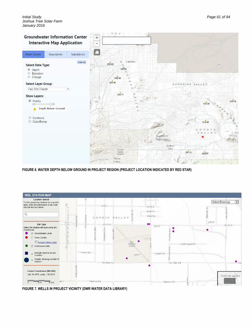
Initial Study Page 61 of 94 Joshua Tree Solar Farm January 2016
FIGURE 6. WATER DEPTH BELOW GROUND IN PROJECT REGION (PROJECT LOCATION INDICATED BY RED STAR)
FIGURE 7. WELLS IN PROJECT VICINITY (DWR WATER DATA LIBRARY)

Initial Study Page 62 of 94 Joshua Tree Solar Farm January 2016
FIGURE 8. 10-YEAR MEDIAN DEPTH-TO-WATER AT FOUR WELLS IN PROJECT VICINITY
The U.S. Geological Survey (USGS) has further data about the well outside the northeast edge of the Project boundary (circled in red on Figure 8), which indicate that the depth of the well is 860 feet bgs, and the depth of the hole is 1,013 feet bgs.12 Figure 9 presents the depth to water level and corresponding groundwater elevation from 2002 to 2011 for this well, which is near constant (approximately 252 to 254.5 feet bgs).
12
USGS. 2015. National Water Information System. Groundwater Levels for California. USGS 340926116144901 001N007E21H001S. http://nwis.waterdata.usgs.gov/ca/nwis/gwlevels/?site_no=340926116144901

Initial Study Page 63 of 94 Joshua Tree Solar Farm January 2016
FIGURE 9. WATER DATA 2002 TO 2011 FOR WELL 001N007E21H001S (INDICATED WITH RED CIRCLE/ARROW ON FIGURE 8)
The record shows that there is adequate groundwater volume beneath the project site to serve the water demand for the project without significantly impacting water supplies. The project would not deplete groundwater in excess of the basin’s safe yield or lower the local groundwater table level. Groundwater aquifer volume and recharge would not be significantly impacted by the implementation of the project
c) Less than Significant Impact. The Hydrology Study serves as the basis for the analysis of potential erosion and siltation impacts.
The project site and surrounding land is relatively flat, with average ground slopes between 1 and 2 percent from west to east. Site drainage is characterized by shallow sheet flow conditions, with no significant drainage channels on the site. The site is mostly vacant land of dirt and sand and is sparsely vegetated with widely spaced desert shrubs and grasses. As described in Item IX.d below, the off-site watersheds to the west/southwest have soils and groundcover similar to those on-site. In a storm event, off-site runoff sheet flows and enters the site along the western border. The flat slopes both on- and off-site, combined with broad sheet flow and a lack of defined drainage channels, generally results in low potential for erosion and debris flows. The Hydrology Study found little evidence of erosion due to flows approaching the site, even though channels, culverts, or other drainage improvements are absent in the upstream, off-site watersheds. This supports the Study's statement that sheet flow on the site is typical and non-erosive during storm events.
Runoff originating on- and off-site would be allowed to sheet flow across the site as it does in existing conditions. The previous onsite development significantly reduces the need for site leveling, cut and fill, and other invasive site modifications. For the vast majority of the array area, no site grading will be employed. The limited site grading would spread areas of existing deeper sheet flow to a shallower sheet flow condition, to decrease both depth and velocity of flow across the site. This strategy reduces potential
Initial Study Page 64 of 94 Joshua Tree Solar Farm January 2016
for erosion compared to existing conditions, while maintaining the existing sheet flow drainage patterns across the site.
When the project is implemented, most of the existing on-site ground cover would be removed as a result of construction. Despite this, surface runoff and infiltration conditions would not change significantly since existing vegetation cover is relatively sparse, native site soils would be used to create the site surface, and impervious surface construction would be minimized.
Solar panels would be constructed atop piles driven between 6 and 12 feet underground. The piles are not expected to be significantly impacted by scour from water flows; however, occasional maintenance may be necessary after large storm events to repair any erosion damage and to clear fencing of windborne and waterborne debris. If deemed necessary by project engineers during the design phase, additional scour protection methods may be included, such as additional embedment depth for piles or strategic placement of rip rap to protect the ground surface.
During operation, rainwater would drain freely from the panels to the ground. The lower front side of the panels would maintain a 2 foot clearance from ground level. Based on the limited volume of water falling from each panel, and the short height of the fall, it is not expected that erosion beyond an immediate micro level would occur. It is expected that water would fall from the panels and pond at the drip point before infiltrating or gradually migrating into the existing drainage patterns. If, over time, minor erosion is noted at the drip points, a surface treatment such as aggregate base could be added along the drip line to protect the surface and help spread the water back to sheet flow conditions.
Based on these factors, the project would have a less than significant impact on existing drainage patterns, and site development would not result in substantial erosion or siltation on- or off-site.
d) Less than Significant Impact. The Hydrology Study serves as the basis for analysis of drainage patterns and potential flooding impacts.
The site is mostly vacant land of dirt and sand and is sparsely vegetated with widely spaced desert shrubs and grasses. The project site and surrounding land is relatively flat, with average ground slopes between 1 and 2 percent from west to east. Site drainage is characterized by shallow sheet flow conditions, with no significant drainage channels on the site. Offsite stormwater approaches the site as sheet flow from the southwest. Some of this stormwater originates from Coyote Wash, which drains to the dry Coyote Lake. The regional Coyote Wash watershed extends west from Coyote Lake across the majority of the town of Yucca Valley, and south into the mountains between Yucca Valley and Palm Springs.
The project site has gone through significant development, so the site can be classified as “previously disturbed” and “previously developed.” The previous development significantly reduces the need for site leveling, cut and fill, and other invasive site modifications. For the vast majority of the array area, no site grading would be employed. The limited area of grading would spread existing sheet flow into a shallower sheet flow condition. The flood model prepared as a part of the Hydrology Study

Initial Study Page 65 of 94 Joshua Tree Solar Farm January 2016
demonstrates that the grading has minimal to no impact on downstream drainage patterns.
Since an increase in impervious surface area could change drainage patterns and flow volumes, the project is designed to minimize impervious coverage in several ways. Site roadways would be constructed using pervious materials, and to minimum widths necessary to meet access and fire requirements. New impervious areas on the project site would be limited to equipment pads and solar panel pier foundations, totaling less than one percent of the total project footprint. In addition, some of the existing impervious surfaces such as concrete pads and structures are to be removed as a part of the project. New impervious areas within the switchyard would be limited to small footings or pads for equipment; most of the switchyard ground would consist of native or pervious materials. Finally, the solar panels would not create a contiguous impermeable surface. While the solar panels are impervious, the panels are separated and elevated from the ground surface. Any precipitation that falls onto a solar panel would run off on the soil and either infiltrate or run off the site as it has done historically.
It is anticipated that stormwater runoff would not increase compared to existing conditions, as construction of new impervious surfaces would be minimal. Because flow and volume increases are not anticipated, the County Department of Public Works has determined that detention of post-development flows is not necessary.
The project would not substantially increase the rate or amount of surface runoff in a manner that would result in on- or offsite flooding, and project-related impacts on existing drainage patterns would be less than significant (also see discussion in Item IX.c).
e&f) Less than Significant Impact. The Hydrology Study serves as the basis for the analysis of the storm drain system capacity and the Project Description serves as the basis of analysis of pollutant sources.
There are no existing or planned stormwater drainage systems in the project vicinity. Regionally, stormwater flows through unimproved desert washes to the dry Coyote Lake.
The Hydrology Study determined that stormwater storage and infiltration characteristics would not change substantially with the project development, due primarily to the project’s minimal impervious footprint, removal of existing impervious surfaces, and perpetuation of existing flow paths through the site. The Hydrology Study calculations are based on the design approach that no storm drain pipes or imperviously lined swales are necessary and that all impervious surfaces would drain to native soils for infiltration. The Hydrology Study demonstrates that post-development drainage patterns and flow discharges would be substantially similar to pre-development conditions (see Item IX.d).
The only potentially hazardous material within the fully operational site would be the mineral insulating oil in the step-up transformers. The transformer oil has low toxicity and is a fully bio-neutral, biodegradable fluid. In the case of a major transformer breach, oil would be captured in a built-in oil containment system suitably sized to accommodate the maximum possible spillage. Upon leakage / failure, the seeped fluid would be

Initial Study Page 66 of 94 Joshua Tree Solar Farm January 2016
removed by a certified vehicle and recapture system and the entire transformer would be replaced.
Since the project would not exceed storm drain capacities or provide substantial sources of polluted runoff, impacts would be less than significant.
g) No Impact. The project is a solar energy generation facility and would not include any housing. Therefore, there would be no impact related to the placement of housing within a FEMA delineated 100-year flood zone. No further analysis is warranted.
h) Less than Significant Impact. The project is in FEMA Zone X per map numbers 06071C8145H and 06071C8175H, defined as areas determined to be outside the 0.2% annual chance (500-year) flood zone. The closest FEMA defined 100-year flood zone is approximately ¼ mile south of the site, and encompasses Coyote Wash and Coyote Dry Lake. There would be no impact related to impedance or redirection of flood flows within that 100-year flood zone, and therefore no special consideration was included in the site design to meet FEMA flood mitigation requirements.
The flood model prepared as a part of the Hydrology Study indicates that portions of the site would experience shallow sheet flow conditions during a 100-year storm event. The site structures, including the solar panel piles and equipment pads, would cover less than one percent of the site, and have a very low potential for redirecting flows due to their small footprint. In addition, existing structures are to be removed, reducing the risk of redirected flows from existing structures.
The potential impacts are less than significant, because the project is not located within a FEMA defined flood zone and the structures result in minimal risk for redirecting or impeding flows.
i) Less than Significant Impact. The project would not expose people or structures to a significant risk of loss, injury, or death involving flooding, including flooding as a result of the failure of a levee or dam, because the project site is not within any identified path of a potential inundation flow that might result in the event of a dam or levee failure or that might occur from a river, stream, lake, or sheet flow situation. No further analysis is warranted.
j) No Impact. The project site would not be subject to inundation by seiche, tsunami, or mudflow. A tsunami is a series of ocean waves generated in the ocean by an impulsive disturbance. Due to the inland location of the project, tsunamis are not considered a threat. A seiche is an oscillating surface wave in a restricted or enclosed body of water generated by ground motion, usually during an earthquake. Inundation from a seiche can occur if the wave overflows a containment wall or the banks of a water body. No impacts are expected to occur because the project is not adjacent to any marine or inland water bodies. The soils in the project area are moderately well drained, the terrain is relatively flat, and mudflows have not historically been an issue in the project area. No further analysis is warranted.
SIGNIFICANCE: No significant adverse impacts are identified or anticipated and no mitigation measures are required.

Initial Study Page 67 of 94 Joshua Tree Solar Farm January 2016
Issues Potentially Significant
Impact
Less than Significant
with Mitigation Incorporated
Less than Significant
Impact No Impact
X. LAND USE AND PLANNING -- Would the project:
a) Physically divide an established community?
b) Conflict with any applicable land use plan, policy, or regulation of an agency with jurisdiction over the project (including, but not limited to the general plan, specific plan, local coastal program, or zoning ordinance) adopted for the purpose of avoiding or mitigating an environmental effect?
c) Conflict with any applicable habitat conservation plan or natural community conservation plan?
Land Use
a) No Impact. The project would not physically divide an established community, because the project is located in an unincorporated part of the County that has sparse residential development and would occupy an area that is a decommissioned airport. The project would not require the abandonment or relocation of any public rights-of-way, nor would it create an impediment for residents in the project area. Therefore, there would be no impact related to the dividing of an established community. No further analysis is warranted.
b) No Impact. The current General Plan land use zoning designations for the project area are Community Industrial, Institutional, and Rural Living which allow development of electrical power generation with a CUP; therefore, there is no impact associated with a conflict with the General Plan land use zoning designation for the site. The project complies with the principles and priorities of the Joshua Tree Community Plan. There is no impact and no further analysis is warranted.
c) No Impact. The project area is within the boundaries of the West Mojave Plan. The West Mojave Plan is a federal land use plan amendment to the Bureau of Land Management’s California Desert Conservation Area (CDCA) Plan that presents a comprehensive strategy to conserve and protect sensitive plants and animals and the natural communities of which they are a part. The West Mojave Plan is applicable only to BLM-administered public lands within the West Mojave Plan area. Although the study area is within the West Mojave Plan area, it is not encompassed within BLM lands; therefore, future development would not be subject to the requirements of the West Mojave Plan.
The Desert Renewable Energy Conservation Plan (DRECP), currently in draft form, is an ongoing effort and process by CEC, CDFW, BLM, and USFWS that the County is increasingly involved with. The project is not located in an area that is in conflict with the DRECP. The project conforms with the ideals in the plan pertaining to developing projects on previously disturbed land, as is being done with this project on the decommissioned airport. Much of the project site is already paved or disturbed as a result of the remaining airport infrastructure including runways.

Initial Study Page 68 of 94 Joshua Tree Solar Farm January 2016
SIGNIFICANCE: No significant adverse impacts are identified or anticipated and no mitigation measures are required.

Initial Study Page 69 of 94 Joshua Tree Solar Farm January 2016
Issues Potentially Significant
Impact
Less than Significant
with Mitigation Incorporated
Less than Significant
Impact No Impact
XI. MINERAL RESOURCES -- Would the project:
a) Result in the loss of availability of a known mineral resource that would be of value to the region and the residents of the state?
b) Result in the loss of availability of a locally-important mineral resource recovery site delineated on a local general plan, specific plan or other land use plan?
Mineral Resources
a) No Impact. The USGS Mineral Resources Spatial Data Mapper indicates that no metallic or nonmetallic mineral resources have been mapped on the project area. In addition, no active mines or mining claims are located on or in the immediate vicinity of the project site. Implementation of the project would not result in the loss of any known mineral resources on the site. No further analysis is warranted.
b) No Impact. The project would not result in the loss of availability of a locally important mineral resource recovery site delineated on a local general plan, specific plan, or other land use plan. There is no impact and no further analysis is warranted.
SIGNIFICANCE: No significant adverse impacts are identified or anticipated and no mitigation measures are required.

Initial Study Page 70 of 94 Joshua Tree Solar Farm January 2016
Issues Potentially Significant
Impact
Less than Significant
with Mitigation Incorporated
Less than Significant
Impact No Impact
XII. NOISE -- Would the project result in:
a) Exposure of persons to or generation of noise levels in excess of standards established in the local general plan or noise ordinance, or applicable standards of other agencies?
b) Exposure of persons to or generation of excessive groundborne vibration or groundborne noise levels?
c) A substantial permanent increase in ambient noise levels in the project vicinity above levels existing without the project?
d) A substantial temporary or periodic increase in ambient noise levels in the project vicinity above levels existing without the project?
e) For a project located within an airport land use plan or, where such a plan has not been adopted, within two miles of a public airport or public use airport, would the project expose people residing or working in the project area to excessive noise levels?
f) For a project within the vicinity of a private airstrip, would the project expose people residing or working in the project area to excessive noise levels?
Noise
a) Less than Significant Impact. Operation of the project would not generate noise in excess of the applicable regulations. Construction would generally occur between dawn and dusk, Monday through Saturday, 7 AM to 7 PM.
Sensitive noise receptors in the vicinity of the project site include residents to the north of the project site and one directly to the east. With implementation of the standard requirements, no significant impacts are anticipated. The requirements ensure that noise generation from construction equipment/vehicle operation would occur during daytime hours and would be localized, temporary, and transitory in nature.
b) Less than Significant Impact. Groundborne vibration and groundborne noise could originate from earth movement during the construction phase of the project. The project will comply with all applicable requirements for long-term operation, as well as with measures to reduce excessive groundborne vibration and noise, to ensure that the project would not expose persons or structures to excessive groundborne vibration. Impacts would be less than significant.

Initial Study Page 71 of 94 Joshua Tree Solar Farm January 2016
c) Less than Significant Impact. The project would not create a substantial permanent increase in ambient noise levels in the project vicinity above levels existing without the project. The project would result in temporary noise increases during construction but would not create any substantial permanent increase in the ambient noise levels. Operational-period activities would include the occasional use of vehicles and the use of equipment that produce minimal noise levels at site boundaries.
Inverters would be distributed throughout the solar field. The final inverter design has not yet been determined; however, uncontrolled inverter noise is expected to be up to 75 dBA immediately adjacent (3 - 5 feet away) to the inverters. Noise would only be produced by inverters during daytime hours, when the PV panels are producing electricity. The PV panels are fixed-tilt and thus have no motors to generate noise.
Therefore, the project would not have a substantial adverse effect related to a substantial permanent increase in ambient noise levels and no mitigation measures are required.
d) Less than Significant Impact. The project is adjacent to mostly undeveloped and/or vacant lands; therefore, noise generated during construction of the project could potentially result in some temporary or periodic increase in ambient noise levels in the project vicinity above levels existing without the project. Specifically, construction of the project may potentially create some elevated short-term construction noise impacts from construction equipment. Compliance with the standard requirements would ensure that impacts are below a level of significance by requiring the muffling of construction equipment where feasible, and requiring that stationary construction equipment be placed in a manner so that emitted noise is directed away from sensitive receptors.
During operations, noise from the facility would occur periodically due to occasional maintenance activities, four annual panel washings, and periodic visits by security staff. These activities would produce limited amounts of noise from pickup trucks and other light vehicles; such impacts would be temporary. Additionally, operating vehicles would only be located at any single point on the site for a very limited duration. Maintenance, repair, and washing activities would occur exclusively during daylight hours.
Therefore, temporary or periodic noise impacts would be less-than-significant.
e) No Impact. The project area is located on the decommissioned Roy Williams Airport (Hi Desert Airport). No other airport is nearby.
f) No Impact. The project area is not located within the vicinity of an active private airstrip. The nearest private airstrip is Cones Field, located approximately 11 miles to the east of the project area. Due to the distance of the airstrip from the project site, there would be no noise impacts from the airstrip on workers in the area.
SIGNIFICANCE: Adherence with the standard requirements will keep noise at less than significant levels.

Initial Study Page 72 of 94 Joshua Tree Solar Farm January 2016
NOISE STANDARD REQUIREMENT/CONDITION OF APPROVAL:
N-1 The developer shall submit for review and obtain approval of an agreement letter that stipulates that all construction contracts/subcontracts contain as a requirement that the following noise attenuation measures be implemented:
a) Noise levels of any project use or activity shall be maintained at or below adopted County noise standards (SBCC 83.01.080). The use of noise-producing signals, including horns, whistles, alarms, and bells, shall be for safety warning purposes only.
b) Construction equipment shall be muffled per manufacturer’s specifications. Electrically powered equipment shall be used instead of pneumatic or internal combustion powered equipment, where feasible.
c) All stationary construction equipment shall be placed in a manner so that emitted noise is directed away from sensitive receptors nearest the project site.

Initial Study Page 73 of 94 Joshua Tree Solar Farm January 2016
Issues Potentially Significant
Impact
Less than Significant
with Mitigation Incorporated
Less than Significant
Impact No Impact
XIII. POPULATION AND HOUSING -- Would the project:
a) Induce substantial population growth in an area, either directly (for example, by proposing new homes and businesses) or indirectly (for example, through extension of roads or other infrastructure)?
b) Displace substantial numbers of existing housing, necessitating the construction of replacement housing elsewhere?
c) Displace substantial numbers of people, necessitating the construction of replacement housing elsewhere?
Population and Housing
a) No Impact. The project will not induce substantial population growth in the area, either directly (for example, by proposing new homes and businesses) or indirectly (for example, through extension of roads or other infrastructure). Construction is anticipated to take approximately 7 months, an estimated peak workforce of 125 to 150 construction workers on the site. These workers would commute to the site from nearby communities such as Joshua Tree, Twentynine Palms, and Yucca Valley, as well as from larger population centers a greater distance away, such as Palm Springs and Banning. Ride sharing will be encouraged. There would be no permanent staffing onsite during operations. Accordingly, the project would not result in any impacts to housing or related infrastructure, nor would it require construction of additional housing. The project would not result in a substantial adverse effect related to substantial population growth in the area, and no mitigation measures are required.
b) No Impact. The project would not displace existing housing. The project site is a decommissioned airport with no housing or people. There would be no impact related to displacement of housing.
c) No Impact. The project would not displace local residents. The project site is a decommissioned airport with no housing or people. There would be no impact related to the displacement of people.
SIGNIFICANCE: No significant adverse impacts are identified or anticipated and no mitigation measures are required.

Initial Study Page 74 of 94 Joshua Tree Solar Farm January 2016
Issues Potentially Significant
Impact
Less than Significant
with Mitigation Incorporated
Less than Significant
Impact No Impact
XIV. PUBLIC SERVICES
a) Would the project result in substantial adverse physical impacts associated with the provision of new or physically altered governmental facilities, need for new or physically altered governmental facilities, the construction of which could cause significant environmental impacts, in order to maintain acceptable service ratios, response times or other performance objectives for any of the public services:
Fire protection?
Police protection?
Schools?
Parks?
Other public facilities?
Public Services
a) Fire – Less than Significant Impact. The project area is serviced by the San Bernardino County Fire Department.
The nearest fire station is Panorama Heights Station 35, located 1.9 miles southeast of the project site. This station houses one Type I Engine Company and one Water Tender. Joshua Tree Station 36 is located 4.5 miles southwest of the project site, in Joshua Tree. This station houses one Type I Engine Company, one Squad vehicle, and one reserve engine. The project would not substantially impact service ratios, response times, or other performance objectives related to fire protection. However, during construction, some public services including fire protection may be required; these would be short-term requirements and would not require increases in the level of public service offered or affect the agency’s response time. The project would incorporate perimeter and internal access driveway systems that are accessible to emergency equipment. Entry gates would include Knox® locks or similar devices to allow 24-hour access for emergency responders.
Comprehensive safety measures that comply with federal, state, and local worker safety and fire protection codes and regulations would be implemented for the project that would minimize the potential for fires to occur during project construction and operations. Because of the low probability and short-term nature of potential fire protection needs during construction, the project would not result in significant impacts associated with fire protection.
Police Protection – Less than Significant Impact. The project area and other unincorporated portions of the County are served by the San Bernardino County Sherriff’s Department. The project would not impact service ratios, response times, or other performance objectives related to police protection. However, during construction, some public services including police protection may be required. These would be

Initial Study Page 75 of 94 Joshua Tree Solar Farm January 2016
short-term requirements and would not require increases in the level of public service offered or affect the agency’s response times. In order to protect against theft and vandalism, the project would employ its own security patrol crews to survey the project site during construction and operation of the project. Additionally, the project would incorporate security fencing, entry lighting, and security camera systems.
Schools – No Impact. Long-term operation of the facilities would place no demand on school services because it would not involve the construction of facilities that require such services and would not involve the introduction of a temporary or permanent human population into this area. There would be no impact on schools and no further analysis is warranted.
Parks – No Impact. Long-term operation of the facilities would place no demand on parks because it would not involve the construction of housing and would not involve the introduction of a temporary or permanent human population into this area. There would be no impact on parks and no further analysis is warranted.
Other Public Facilities – No Impact. The project would not result in an increased resident population or a significant increase in the local workforce. Based on these factors, the project would not result in any long-term impacts to other public facilities and no further analysis is warranted.
SIGNIFICANCE: No significant adverse impacts are identified or anticipated and no mitigation measures are required. As required by the County Development Code, payment of the Public Safety Services Impact Fees will be a condition of approval.

Initial Study Page 76 of 94 Joshua Tree Solar Farm January 2016
Issues Potentially Significant
Impact
Less than Significant
with Mitigation Incorporated
Less than Significant
Impact No Impact
XV. RECREATION --
a) Would the project increase the use of existing neighborhood and regional parks or other recreational facilities such that substantial physical deterioration of the facility would occur or be accelerated?
b) Does the project include recreational facilities or require the construction or expansion of recreational facilities which might have an adverse physical effect on the environment?
Recreation
a) No Impact. The project would not increase the use of existing neighborhood and regional parks or other recreational facilities such that substantial physical deterioration of the facility would occur or be accelerated. No new residences or recreational facilities would be constructed as part of the project and the project would not induce population growth in adjacent areas. No significant adverse impacts on recreation would result from implementation of the project and no further analysis is warranted.
b) No Impact. The project does not include recreational facilities or require the construction or expansion of recreational facilities, which might have an adverse physical effect on the environment. No new residences or recreational facilities would be constructed as part of the project. The project would not induce population growth in adjacent areas and would not increase the use of recreational facilities in surrounding neighborhoods. No significant adverse impacts on recreation would result from implementation of the project and no further analysis is warranted.
SIGNIFICANCE: No significant adverse impacts are identified or anticipated and no mitigation measures are required.

Initial Study Page 77 of 94 Joshua Tree Solar Farm January 2016
Issues Potentially Significant
Impact
Less than Significant
with Mitigation Incorporated
Less than Significant
Impact No Impact
XVI. TRANSPORTATION/TRAFFIC -- Would the project:
a) Conflict with an applicable plan, ordinance or policy establishing measures of effectiveness for the performance of the circulation system, taking into account all modes of transportation including mass transit and non-motorized travel and relevant components of the circulation system, including but not limited to intersections, streets, highways and freeways, pedestrian and bicycle paths, and mass transit?
b) Conflict with an applicable congestion management program, including, but not limited to level of service standards and travel demand measures, or other standards established by the county congestion management agency for designated roads or highways?
c) Result in a change in air traffic patterns, including either an increase in traffic levels or a change in location that results in substantial safety risks?
d) Substantially increase hazards due to a design feature (e.g., sharp curves or dangerous intersections) or incompatible uses (e.g., farm equipment)?
e) Result in inadequate emergency access?
f) Conflict with adopted policies, plans, or programs regarding public transit, bicycle, or pedestrian facilities, or otherwise decrease the performance or safety of such facilities?
Transportation/Traffic
a) Less than Significant Impact. A Trip Generation Analysis was prepared for the project by Tetra Tech (July 2012). The Trip Generation Analysis reveals that the project would not result in any decline in the performance of the area’s circulation system.
At its peak, approximately 150 construction workers are expected to be on-site. Assuming an average of 1.25 workers per vehicle (carpooling factor), the anticipated passenger car equivalent (PCE) trips generated by the Project will be 120 one-way trips during both the AM and PM peak hours. Additionally, 80 one-way trips are anticipated for equipment vehicles.
During operations, the project facility will be primarily managed, monitored, and controlled remotely. Therefore it is assumed that the project will have 1 to 2 employees 1 to 2 times per month on site for system inspections and 2 to 6 employees on site 1 to 2 times per month for troubleshooting and maintenance requirements. Additionally, the panels will be washed approximately four times per year with 2 to 4 employees on site at that time.

Initial Study Page 78 of 94 Joshua Tree Solar Farm January 2016
This number of trips would have a minimal impact on access routes to the project site, including SR-62 and Sunfair Road.
Due to the rural nature of the project area, alternative means of transportation, including mass transit and pedestrian and bicycle routes, are generally sparse, and would therefore not be negatively impacted by the project. The Morongo Basin Transit Authority does have a bus route, Route #1 that traverses Twentynine Palms Highway in both an east and west direction. Currently, the nearest bus stops to the project would be the Hi-Desert Hospital and Copper Mountain College. Construction workers may be able to request a stop at the intersection of Twentynine Palms Highway and Sunfair Road. From that point, they would either walk or share rides with other construction workers north to the project site.
During operations, because the site would be unmanned, there would be no increase in demand for alternative means of transportation. Therefore, the project would not conflict with any applicable plan, ordinance or policy establishing measures of effectiveness for the performance of the circulation system. No significant adverse impacts on transportation or traffic would result from implementation of the project and no further analysis is warranted.
b) Less than Significant Impact. As noted under impact. a), above, the Trip Generation Analysis prepared for the project reveals that the project would not result in any decline in the performance of the area’s circulation system during either the construction or operational periods. The project would therefore not conflict with an applicable congestion management program, including but not limited to level of service standards and travel demand measures, or other standards established by the county congestion management agency for designated roads or highways. The project would result in a less-than-significant increase in traffic in relation to the existing traffic load and capacity of the street system.
At the initiation of project construction, equipment that may include water trucks, backhoes, and loaders would be mobilized to the project site using Sunfair Road as shown in the table below
Estimated Construction Duration, Equipment and Workers by Activity
Activity Duration Equipment Pieces Workers
Fencing 2 Months Bobcat 1 2
Trencher 1
Pick Up Truck 1
Demolition – existing structures and related infrastructure
1 Month Backhoe 2 4
Bulldozer 1
5 cubic yard dump truck 2
Site Preparation and Clearing/Grading
1 Month Water Truck – 3 axles 3 Maximum – 150
Average – 125 Grader 2
Bulldozer 1
25-Cubic Yard Paddle Scraper 1 (optional)
10-Ton Roller 2
Utility Upgrades Intermittent, up to 6 Months
Line truck (with spool trailer) 1 2
Boom truck (with bucket) 2

Initial Study Page 79 of 94 Joshua Tree Solar Farm January 2016
Estimated Construction Duration, Equipment and Workers by Activity
Activity Duration Equipment Pieces Workers
Underground Work 2 Months Small Backhoe 2 6
Small Sheepsfoot Roller 2
Trencher 2
5-Cubic Yard Dump Truck 2
5kW Generator 2
System Installation 3 Months 4x4 Forklift 4 8
Small Crane 1
ATV Vehicle 4
Pick-Up Truck 5
Pile Driver 2
5-kW Generator 4
Testing/Commissioning 1 Month Pick-Up Truck 2 2
Clean Up/Restoration 1 Months Grader 2 2
This equipment would then be stored onsite for the duration of construction and used as construction progresses. Regular deliveries of materials (including solar panels) and commuting trips by workers would also use Sunfair Road; the construction-period would have a minimal impact on area roadways. During operations, the project would be unmanned and would generate very few trips per week for security and maintenance purposes. Based on these facts, no significant adverse impacts on transportation or traffic would result from implementation of the project and no further analysis is warranted.
c) No Impact. The project would not affect air traffic patterns. The project site is itself located on the decommissioned Roy Williams Airport. There are military aircraft to the east at Twentynine Palms, but no impacts are expected from this project.
Potential impacts associated with reflectivity and glare are discussed above. Based on the analysis the project would result in less-than-significant impacts related to glare. Therefore, no significant adverse impacts on air traffic patterns would result from implementation of the project and no further analysis is warranted.
d) No Impact. The project would not include design features that could affect traffic safety, nor would it cause incompatible uses to be present on local roads. Project gates would be inset in accordance with County design standards to prevent vehicle stacking into public roads. No new roads are proposed as part of this project, and no significant increase in traffic is projected during project construction or operations. Therefore, no significant adverse impacts related to roadway design features or incompatible uses would result from implementation of the project and no further analysis is warranted.
e) Less than Significant Impact. The project would not result in inadequate emergency access to the project area. During project construction, public roads would remain open and available for use by emergency vehicles and other traffic. The project would not result in any roadway closures in the vicinity of the project site.

Initial Study Page 80 of 94 Joshua Tree Solar Farm January 2016
Access points into the project site would be equipped with Knox® locks or similar devices to permit emergency responders to enter the site 24 hours per day. Perimeter and internal drives would be included to allow access to all points within the project site.
f) No Impact. Due to the rural nature of the project area, no bicycle, or pedestrian facilities presently exist or are planned for implementation in the vicinity of the project site. The Morongo Basin Transit Authority services this area by bus with the nearest stop at Twentynine Palms Highway and the Hi-Desert Medical Center. Services on SR-62 would not be impacted by the project. No alternative transportation policies, plans, or programs have been designated for the project area. Because the project would be unmanned during operations, project implementation would not result in an increase in demand or decline in performance for public transit, bicycle, or pedestrian facilities in the region. Therefore, the project would not conflict with adopted policies, plans, or programs regarding public transit, bicycle, or pedestrian facilities, or otherwise decrease the performance of safety of such facilities. No significant adverse impacts would result from implementation of the project and no further analysis is warranted.
SIGNIFICANCE: No significant adverse impacts are identified or anticipated and no mitigation measures are required.
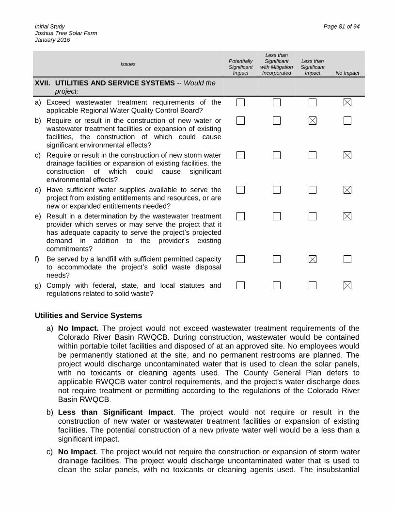
Initial Study Page 81 of 94 Joshua Tree Solar Farm January 2016
Issues Potentially Significant
Impact
Less than Significant
with Mitigation Incorporated
Less than Significant
Impact No Impact
XVII. UTILITIES AND SERVICE SYSTEMS -- Would the project:
a) Exceed wastewater treatment requirements of the applicable Regional Water Quality Control Board?
b) Require or result in the construction of new water or wastewater treatment facilities or expansion of existing facilities, the construction of which could cause significant environmental effects?
c) Require or result in the construction of new storm water drainage facilities or expansion of existing facilities, the construction of which could cause significant environmental effects?
d) Have sufficient water supplies available to serve the project from existing entitlements and resources, or are new or expanded entitlements needed?
e) Result in a determination by the wastewater treatment provider which serves or may serve the project that it has adequate capacity to serve the project’s projected demand in addition to the provider’s existing commitments?
f) Be served by a landfill with sufficient permitted capacity to accommodate the project’s solid waste disposal needs?
g) Comply with federal, state, and local statutes and regulations related to solid waste?
Utilities and Service Systems
a) No Impact. The project would not exceed wastewater treatment requirements of the Colorado River Basin RWQCB. During construction, wastewater would be contained within portable toilet facilities and disposed of at an approved site. No employees would be permanently stationed at the site, and no permanent restrooms are planned. The project would discharge uncontaminated water that is used to clean the solar panels, with no toxicants or cleaning agents used. The County General Plan defers to applicable RWQCB water control requirements, and the project's water discharge does not require treatment or permitting according to the regulations of the Colorado River Basin RWQCB.
b) Less than Significant Impact. The project would not require or result in the construction of new water or wastewater treatment facilities or expansion of existing facilities. The potential construction of a new private water well would be a less than a significant impact.
c) No Impact. The project would not require the construction or expansion of storm water drainage facilities. The project would discharge uncontaminated water that is used to clean the solar panels, with no toxicants or cleaning agents used. The insubstantial

Initial Study Page 82 of 94 Joshua Tree Solar Farm January 2016
quantity of discharged water generated by cleaning would be absorbed into the soils onsite. Only a small percentage of the project site would be covered in impervious surfaces with implementation of the project.
d) No Impact. A detailed discussion of water demand and water supply is provided below and in the Hydrology section of the Initial Study.
Water Demand
Water is expected to be supplied by the JBWD. At peak demand, approximately 30 acre feet of water would be needed over the course of six months of project construction. This amount of water represents less than 2% of the average annual water provided to the region through the JBWD (approximately 1,700 acre feet per year).
The project would require minimal water use during operations, consisting of approximately 2 acre feet of water per year to conduct four washings (1/2 acre foot per washing). Because the project would not have a permanent workforce, no toilet facilities would be required and there would be no demand for wastewater service or other onsite water. Potable water for drinking either during construction or operation, would be brought onsite by workers for their individual needs. Decommissioning, which would likely occur in the year 2055, would require approximately 12 acre feet.
Allocation of water for 30 acre-ft of usage during construction
Clearing 1,200,000 gal Demo 200,000 gal Process Access Roads 1,290,000 gal Trenching 300,000 gal Access Roads & Class II Base 1,200,000 gal Dust Control 5,280,000 gal Total 9,470,000 gal - approximately 30 acre-feet
Allocation of water for 2 acre-ft of usage during operations (panel washing)
Panel washing – 1.9 gallons per panel, 4 washings per year 86,130 panels x 4 washings per year x 1.9 gallons per washing = 654,588 gals per year for washing 654,588 gal = 2.009 acre feet per year for operations
Water Supply
On October 23, 2015, JBWD issued a “Conditional Will Serve Letter” for the project in response to its inquiry for future water service. This letter states that due to the current Declared State of Emergency in California, the JBWD must implement water service conservation measures and restrictions. Thus, future water service for the project could not be guaranteed at that time, and would be subject to meeting a number of specific conditions.
The JBWD has a recharge program in place whereby surface water is transferred to a recharge pond through the Morongo pipeline. The applicant is willing to work with the JBWD to purchase water to be placed into the recharge pond, thus assuring that the project will not cause groundwater depletions in excess of the basin’s safe yield. There
Initial Study Page 83 of 94 Joshua Tree Solar Farm January 2016
are ongoing discussions with JBWD to issue a standard Will Serve letter or execute a water supply agreement that will guarantee water for the project without condition. In the event that water still cannot be obtained from the JBWD, the applicant proposes to establish a new groundwater supply well on the project site.
New Groundwater Well
If water cannot be supplied to the project by the JBWD, the applicant proposes to install a new groundwater well on the project property, likely on the 2 acre parcel of land on the west side of the project site. The site at one time was served by an on-site private well. In this scenario, San Bernardino County would issue a permit for the new well and the cost of the new well would be assumed by the applicant.
The Hydrology section of this IS describes the groundwater baseline conditions. The record shows that there is adequate groundwater volume beneath the project site to serve the water demand for the project without significantly impacting water supplies. The project would not deplete groundwater in excess of the basin’s safe yield or lower the local groundwater table level. Groundwater aquifer volume and recharge would not be significantly impacted by the implementation of the project.
e) No Impact. The project would not require or result in the construction of new wastewater treatment facilities or the expansion of existing wastewater treatment facilities. Accordingly, no impacts are anticipated from implementation of the project.
f) Less than Significant Impact. Less than significant impacts related to landfill capacity are anticipated from the project. The project largely consists of short-term construction activities (with short-term waste generation limited to minor quantities of construction debris) and would not result in long-term solid waste generation. Solid wastes associated with the project would be disposed as appropriate in a local landfill or at a recycling facility. The nearest active landfill is the Landers Sanitary Landfill, located approximately 8 miles northwest of the project site. The estimated closure of the landfill is August 2018, with a current remaining capacity of 765,098 cubic yards (source http://www.calrecycle.ca.gov/SWFacilities/Directory/). A Construction/Demolition Waste Management Plan will also be prepared.
The panels would eventually need to be disposed (decommissioned). Most parts of the PV system are recyclable. Panels typically consist of silicon, glass, and a metal frame. Concrete from deconstruction would be recycled through local recyclers. Metal and scrap equipment and parts that do not have free flowing oil would be sent for salvage. Equipment containing any free flowing oil would be managed as hazardous waste and be evaluated before disposal at a properly-permitted disposal facility. Oil and lubricants removed from equipment would be managed as used oil and disposed in accordance with applicable State hazardous waste disposal requirements. A Decommissioning Plan and Surety Bond will be developed to ensure that decommissioning will be performed in accordance with County and State requirements.
Initial Study Page 84 of 94 Joshua Tree Solar Farm January 2016
g) Less than Significant Impact. The project would comply with all federal, state, and local statutes and regulation related to solid waste. The project would consist of short term construction and demolition activities (with short-term waste generation limited to minor quantities of construction debris) and thus would not result in long-term solid waste generation. Solid wastes produced during the demolition and construction phases of this project, or during future decommission activity would be disposed of in accordance with all applicable statutes and regulations. Accordingly, anticipated impacts from the project related to landfill capacity are less than significant.
SIGNIFICANCE: No significant adverse impacts are identified or anticipated and no mitigation measures are required.

Initial Study Page 85 of 94 Joshua Tree Solar Farm January 2016
Issues Potentially Significant
Impact
Less than Significant
with Mitigation Incorporated
Less than Significant
Impact No Impact
XVIII. MANDATORY FINDINGS OF SIGNIFICANCE --
a) Does the project have the potential to degrade the quality of the environment, substantially reduce the habitat of a fish or wildlife species, cause a fish or wildlife population to drop below self-sustaining levels, threaten to eliminate a plant or animal community, reduce the number or restrict the range of a rare or endangered plant or animal or eliminate important examples of the major periods of California history or prehistory?
b) Does the project have impacts that are individually limited, but cumulatively considerable? (“Cumulatively considerable” means that the incremental effects of a project are considerable when viewed in connection with the effects of past projects, the effects of other current projects, and the effects of probable future projects)?
c) Does the project have environmental effects which will cause substantial adverse effects on human beings, either directly or indirectly?
Mandatory Findings of Significance
a) Less than Significant Impact with Mitigation Incorporated. The project would have less than significant impacts, after mitigation is applied, with respect to the potential for substantially degrading the quality of the environment; substantially reducing the habitat of a fish or wildlife species; causing a fish or wildlife population to drop below self-sustaining levels; threatening to eliminate a plant or animal community; reducing the number or restricting the range of an endangered, rare, or threatened species; or eliminating important examples of the major periods of California history or prehistory.
Potential to Degrade Quality of Environment. The project would not have the potential to degrade the quality of the environment. As indicated in the foregoing analysis, with respect to all of the environmental issues analyzed, there would be less than significant impact with incorporation of the mitigation measures.
Substantial Impacts on Biological Resources. The project would not:
Substantially reduce the habitat of a fish or wildlife species;
Cause a fish or wildlife population to drop below self-sustaining levels;
Threaten to eliminate a plant or animal community; or
Reduce the number or restrict the range of an endangered, rare or threatened species.
It is presumed that developments near the project site were constructed after completing an environmental review and that all environmental impacts were mitigated to levels that were less than significant.

Initial Study Page 86 of 94 Joshua Tree Solar Farm January 2016
Adherence with mitigation measures will reduce impacts for loss of potential habitat to less than significant. There are no known wildlife corridors and migratory routes associated with the project. Wildlife corridors provide linkages between isolated populations and allow for genetic flow between populations. Typically, these would be associated with a drainage feature, mountain pass, or optimum habitat conditions. Due to the absence of these features within the site, or within close proximity, the project is not expected to impinge upon any migratory corridors.
Avian mortalities have been a recent topic of discussion at solar facilities in southern California. However, this project is substantially smaller and is located in a more disturbed and developed area than other solar projects. Although any structure can pose a collision risk to birds, the project does not contain tall structures that would extend into the airspace of birds migrating at high elevations. Additionally, the panels that will be used for this project are coated with a non-reflective material. The material is designed to enhance light absorption and reduce light reflection (glare), thereby reducing the likelihood that birds would identify the project site as a water body.
The solar facility would have a maximum height of 12 feet, so there is a low likelihood birds would use the panels for nesting or perching. Additionally, the panels are flat and are not a trough, which would make it difficult to build a nest in or on the panels. Therefore, it is not anticipated there would be impacts associated with perching or nesting of avian species. For the above reasons, the project is expected to have a minimal contribution to cumulative impacts on birds. Mitigation measures BIO-1, -3, -4, -7, and -8 will help offset direct, indirect, and cumulative impacts on birds.
b) Less than Significant Impact. Cumulative impacts are defined as two or more individual effects that, when considered together, are considerable or that compound or increase other environmental impacts. The cumulative impact from several projects is the change in the environment that results from the incremental impact of the development when added to the impacts of other closely related past, present, and reasonably foreseeable or probable future developments. Cumulative impacts can result from individually minor, but collectively significant, developments taking place over a period. The CEQA Guidelines, Section 15130 (a) and (b), states:
(a) Cumulative impacts shall be discussed when the project’s incremental effect is cumulatively considerable.
(b) The discussion of cumulative impacts shall reflect the severity of the impacts and their likelihood of occurrence, but the discussion need not provide as great detail as is provided of the effects attributable to the project. The discussion should be guided by the standards of practicality and reasonableness.
While there are several other photovoltaic projects recently approved or currently planned within San Bernardino County, only one is within one mile of the proposed project. The cumulative impact from the operation of these projects would be negligible since the projects are not concentrated in one area. Furthermore, the proposed project is located on already disturbed land. In addition, the construction period for this project is not expected to overlap with other planned projects. Therefore, the project’s less than significant impacts related to construction (e.g., Air Quality, Noise) will not cumulate with impacts from other projects to become potentially significant.

Initial Study Page 87 of 94 Joshua Tree Solar Farm January 2016
c) Less than Significant Impact with Mitigation Incorporated. The incorporation of design measures, County policies, standards, guidelines, Air Quality standard requirements to reduce particulate matter during construction, and biological mitigation measures to reduce impacts to species and habitat would ensure that there would be no substantial adverse effects on human beings, either directly or indirectly. Impacts of the project would be less than significant with the following mitigation and standard requirements that will be considered conditions of approval for the project.
AESTHETICS MITIGATION MEASURES:
AES-1 Building Materials. As appropriate, on-site switchyard buildings shall use non-reflective materials and neutral colors as approved by the Land Use Services Department, Planning Division.
AIR QUALITY STANDARD REQUIREMENTS/BEST MANAGEMENT PRACTICES:
AQ-1 AQ Operational Mitigation. Operation of all off-road and on-road diesel vehicles/equipment shall comply with the County Diesel Exhaust Control Measures [SBCC §83.01.040 (c)], including but not limited to:
a) Equipment/vehicles shall not be left idling for periods in excess of five minutes.
b) Engines shall be maintained in good working order to reduce emissions.
c) Onsite electrical power connections shall be made available where feasible.
d) Ultra low-sulfur diesel fuel shall be utilized.
e) Electric and gasoline powered equipment shall substituted for diesel powered equipment where feasible.
f) Signs shall be posted requiring all vehicle drivers and equipment operators to tum off engines when not in use.
g) All transportation refrigeration units (TRUs) shall be provided electric connections.
AQ-2 AQ Dust Control Plan. The developer shall prepare, submit and obtain approval from County Planning of a Dust Control Plan (DCP) consistent with MDAQMD guidelines and a letter agreeing to include in any construction contracts/subcontracts a requirement that project contractors adhere to the requirements of the DCP. The DCP shall include the following elements to reduce dust production:
a) Exposed soils and haul roads shall be watered up to three (3) times per day to reduce fugitive dust during grading/construction activities. Inactive areas shall be treated with soil stabilizers such as hay bales or aggregate cover.
b) Street sweeping shall be conducted when visible soil accumulations occur along site access roadways to remove dirt dropped by construction vehicles.
c) Site access driveways and adjacent streets shall be washed daily, if there are visible signs of any dirt track-out at the conclusion of any workday.
Initial Study Page 88 of 94 Joshua Tree Solar Farm January 2016
d) Construction vehicle tires shall be cleaned prior to leaving the project site.
e) All trucks hauling dirt away from the site shall be covered, and speeds on unpaved roads shall be reduced below 15 miles per hour.
f) During high wind conditions (i.e., sustained wind speeds exceeding 20 mph), areas with disturbed soil shall be watered hourly and activities on unpaved surfaces shall cease until wind speeds no longer exceed 20 mph.
g) Storage piles that are to be left in place for more than three working days shall either be sprayed with a non-toxic soil binder, covered with plastic or revegetated.
AQ-3 AQ Installation. The developer shall submit for review and obtain approval from County Planning of evidence that all air quality mitigation measures have been installed properly and that specified performance objectives are being met to the satisfaction of County Planning and County Building and Safety.
AQ-4 AQ Signage. The developer shall agree to erect a sign for fugitive dust issues. The MDAQMD requires a sign to be erected not later than the commencement of construction at the project site entrance. This sign will include a phone number and contact information for anyone who wants to report dust issues resulting from the project construction.
BIOLOGICAL RESOURCES MITIGATION MEASURES:
BIO-1 General Avoidance and Minimization Measures
Implement a worker environmental awareness training for all project personnel.
Limit areas of disturbance to the minimum necessary for development.
Salvage the topsoil containing the native seed bank and redistribute over temporarily disturbed areas to facilitate passive revegetation.
The project has been designed to minimize night lighting. All outdoor lighting, including street lighting, will be provided in accordance with the County Night Sky Protection Ordinance and will only be provided as necessary to meet safety standards. Outdoor lighting will be shielded or directed away from adjacent native habitat to protect species from direct night lighting.
The projected increases in noise will be reduced to the maximum extent practicable during construction activities. During all grading on-site, the construction contractors will equip all construction equipment, fixed or mobile, with properly operating and maintained mufflers, consistent with manufacturers' standards to reduce construction equipment noise to the maximum extent possible. Enforce a 15 mph speed limit on project roads.
Vehicles and equipment to remain on designated roadways
Standard dust control procedures will be implemented to minimize dust. If water is used as a dust suppressant, it will be administered such that pooling
Initial Study Page 89 of 94 Joshua Tree Solar Farm January 2016
or ponding of water is minimized so that it does not provide a wildlife attractant.
Trash will be kept in raven and coyote-proof containers and removed regularly from the project so that it does not provide a wildlife attractant.
BIO-2 Desert Tortoise
There is no evidence that tortoises are using the project site or have used it in the recent past. Therefore, potential impacts to tortoises are expected to be limited to tortoises that may wander on site. If tortoises walk onto the project site, they could be injured or killed (e.g., collision with vehicles or equipment). Because of these reasons, the following mitigation measures are designed to avoid impacts to tortoises.
Install permanent tortoise exclusion fencing around the perimeter of the main project site to exclude tortoise during construction and operation. Clearance surveys of the fenced site will be conducted by qualified biologists to ensure that no tortoises are inside the site. Clearance surveys will be conducted as soon as feasible after tortoise exclusion fencing is installed. Any newly installed fence will be monitored appropriately during and after fence installation to ensure that no tortoises exhibit fence walking behavior that could result in injury or death to the tortoise.
Monitor and maintain the fence at appropriate intervals throughout construction and operations. This includes monitoring during storm events or other circumstances that could damage the fence.
Enforce speed limits of 15 miles per hour on roads within the project site.
Ensure that a biological monitor is on site during all initial surface grubbing and grading in the event that a tortoise is encountered. Biological monitors must be present during construction of the perimeter fence, during ground disturbance in unfenced areas, and during active construction in unfenced areas to properly implement mitigation measures. A biologist must be available (not onsite) during construction activities in fenced areas that have been surveyed for and cleared of tortoises and other biological resources to promptly implement protection measures for biological resources in the unlikely event that a tortoise or other biological resource is detected onsite.
BIO-3 Burrowing Owl
Owls could move onto the site prior to project development, so focused burrowing owl take avoidance surveys will be completed according to CDFW (CDFG 2012) guidelines within 14 days of site grading. If owls are found on site prior to construction, a passive relocation plan may be developed to minimize impacts to onsite owls, and avoidance will adhere to CDFW guidance for avoidance buffers (CDFG 2012). Other standard measures such as speed limits, limiting the area of disturbance, and having a biological monitor present for construction outside of the fenced site will contribute toward avoiding and minimizing any potential impacts to this species and their habitat.
Initial Study Page 90 of 94 Joshua Tree Solar Farm January 2016
BIO-4 Nesting Birds
Vegetation removal during construction, and construction noise and activity, could potentially adversely impact nesting birds. Therefore, to the extent feasible, vegetation removal should take place outside of the breeding season, which is typically February 15 to August 31. If construction will take place during the breeding season, pre-construction clearance surveys to locate nesting birds should be conducted immediately prior to construction. If active nests are present within the construction area, they must be avoided by establishing a non-disturbance buffer until the young fledge or the nest fails (as determined by a qualified biologist familiar with bird breeding and behavior). Nesting birds that are adjacent to active construction will also be avoided by this approved buffer. The buffer areas will be delineated and flagged to ensure avoidance.
BIO-5 Desert Kit Fox
Kit fox could move onto the site prior to project development, so surveys will be completed within 30 days of site grading and may be conducted concurrently with desert tortoise surveys. Depending on the results of those surveys, a plan may be developed to address individuals that are denning within the project site. Other standard measures such as speed limits, limiting area of disturbance, and having biological monitors present will contribute toward minimizing any potential impacts to this species and their habitat.
BIO-6 Protected Plants
Species protected by the California Desert Native Plant Protection Act and the San Bernardino County Code (beavertail cactus, buckhorn cholla, Joshua tree, and silver cholla) are present on the project site and will directly impacted by development. Where feasible, individuals of these species will be avoided. For those that cannot be avoided, removal will comply with the California Desert Native Plant Protection Act and the San Bernardino County Code and be transplanted into the perimeter landscape buffer.
BIO-7 Weed Management
Due to the disturbed nature of the site, there are several established non-native species (i.e., weeds) present within the project. Although eradication of these existing weeds is not considered feasible, the following best management practices will be implemented during construction and operations of the project to help control the spread of existing weeds and the introduction of new weed species:
Limit the size of any vegetation/ground disturbance to a minimum and limit ingress and egress to defined routes;
Passively reestablish vegetation on temporarily disturbed sites;
Prevent spread of weeds via vehicular sources by implementing methods for cleaning construction vehicles;

Initial Study Page 91 of 94 Joshua Tree Solar Farm January 2016
Use only certified weed-free straw, hay bales, and seed if used for erosion control and sediment barrier installations;
Invasive, non-native species shall not be used in landscaping plans;
Monitor weed invasions and rapidly implement control measures to eradicate new weed invasions.
BIO-8 Contribute to the USFWS Regional Raven Management Program to reduce raven impacts to desert tortoises. A one-time payment will be submitted the USFWS Regional Raven Management Program. The amount shall be a one-time payment of $105 per acre for the 115-acre project site. Payment will be to the National Fish and Wildlife Foundation (NFWF)
CULTURAL RESOURCES MITIGATION MEASURES:
CR-1 A Tribal Cultural Resources Monitoring, Discovery, Treatment and Disposition Plan will be established prior to commencing construction. The Plan will address Tribal monitoring and evaluation/disposition of new discoveries including human remains. The Plan will allow for one or more Native American cultural resources specialists to monitor all ground-disturbing activities and excavations on the project site. If any Cultural Resources are encountered, ground-disturbing activities in the area shall be temporarily redirected from the vicinity of the find. All cultural resources encountered will be documented on the California Department of Parks and Recreation Site Forms to be filed with the CHRIS SBAIC. If any human remains are encountered unexpectedly during construction or grading activities, the Applicant will comply with State Health and Safety Code Section 7050.5 such that no further disturbance in the area of such discovery occurs until the County Coroner has made necessary findings as to origin and disposition pursuant to Public Resources Code Section 5097.98. If any such remains are determined to be of Native American descent, the County Coroner will notify the NAHC, which is required to identify the person(s) thought to be the Most Likely Descendent of the deceased Native American, who then, in consultation with the landowner, will take additional steps, as necessary, in accordance with CEQA Guidelines Section 15064.5(e) and Public Resources Code Section 5097.98.
PALEONTOLOGICAL RESOURCES MITIGATION MEASURES:
PR-1 Prior to the approval of the project plans and specifications by San Bernardino County, the project shall confirm that the plans and specifications stipulate that if evidence of subsurface paleontological resources are found during construction, excavation and other construction activity in that area shall cease and the contractor shall a county certified Paleontologist to determine the extent of the find and take proper actions.
NOISE STANDARD REQUIREMENTS:
N-1 The developer shall submit for review and obtain approval of an agreement letter that stipulates that all construction contracts/subcontracts contain as a requirement that the following noise attenuation measures be implemented:

Initial Study Page 92 of 94 Joshua Tree Solar Farm January 2016
a) Noise levels of any project use or activity shall be maintained at or below adopted County noise standards (SBCC 83.01.080). The use of noise-producing signals, including horns, whistles, alarms, and bells, shall be for safety warning purposes only.
b) Construction equipment shall be muffled per manufacturer’s specifications. Electrically powered equipment shall be used instead of pneumatic or internal combustion powered equipment, where feasible.
c) All stationary construction equipment shall be placed in a manner so that emitted noise is directed away from sensitive receptors nearest the project site.

Initial Study Page 93 of 94 Joshua Tree Solar Farm January 2016
GENERAL REFERENCES
California Department of Fish and Game (CDFG). 2012. Staff Report on Burrowing Owl Mitigation. State of California Natural Resources Agency. 34 pp.
California Natural Diversity Database (CNDDB). 2012. RareFind. Commercial Version 3.1.0. California Department of Fish and Game (CDFG), Registered to Biogeographic Data Branch. January 1, 2012; data will expire July 1, 2012
Desert Renewable Energy Conservation Plan (DRECP), draft. 2015. Desert Renewable Energy Conservation Plan Preliminary Conservation Strategy. Available at http://www.drecp.org.
Kochert, M. N., K. Steenhof, C. L. Mcintyre and E. H. Craig. 2002. Golden Eagle (Aquila chrysaetos), The Birds of North America Online (A. Poole, Ed.). Ithaca: Cornell Lab of Ornithology; Retrieved from the Birds of North America Online: http://bna.birds.cornell.edu/bna/species/684doi:10.2173/bna.684
LaRue, E. 2012. Circle Mountain Biological Consultants, Inc. Personal Communication with Dr. Alice Karl.
PCR Services Corporation (PCR). 2011a. General Biological Resources Assessment and Jurisdictional Determination. Cascade Solar Project, Unincorporated San Bernardino County. As submitted with the Application for CUP P201100142. May.
PCR Services Corporation. 2011b. Paleontological Resources Assessment of the Cascade Solar Project, San Bernardino County, California.
Penrod, K., C. Cabanero, P. Beier, C. Luke. W. Spencer, E. Rubin, and C. Paulman. 2008. A Linkage Design of the Joshua Tree-Twentynine Palms Connection. South Coast Wildlands, Fair Oaks, CA www.scwildlands.org.
Poulin, Ray, L. Danielle Todd, E. A. Haug, B. A. Millsap and M. S. Martell. 2011. Burrowing Owl (Athene cunicularia), The Birds of North America Online (A. Poole, Ed.). Ithaca: Cornell Lab of Ornithology; Retrieved from the Birds of North America Online: http://bna.birds.cornell.edu/bna/species/061doi:10.2173/bna.61
San Bernardino County. 2014a. County of San Bernardino General Plan. Amended 2014. Available at http://cms.sbcounty.gov/lus/Planning/GeneralPlan.aspx including all amendment pages.
San Bernardino County, 2014b. “Solar Ordinance” amending Chapter 84.29, Renewable Energy Generation Facilities, Adopted December 17, 2013, effective January 16, 2014.
Sawyer, T., T. Keeler-Wolf, and J.M. Evens. 2009. A Manual Of California Vegetation. Second Edition. California Native Plant Society Press. Sacramento, CA.
Stebbins, R.C. 2003. Peterson Field Guide to Western Reptiles and Amphibians. Houghton Mifflin Company. New York.
Steenhof, Karen. 2013. Prairie Falcon (Falco mexicanus), The Birds of North America Online (A. Poole, Ed.). Ithaca: Cornell Lab of Ornithology; Retrieved from the Birds of North America Online: http://bna.birds.cornell.edu/bna/species/346doi:10.2173/bna.346
Initial Study Page 94 of 94 Joshua Tree Solar Farm January 2016
Tetra Tech, Inc. 2012. Jurisdictional Delineation of Wetlands/Waters Subject to Regulatory Authority. Prepared For: Joshua Tree Solar Farm, LLC. 21pp.
Tetra Tech, Inc. 2012a. Cultural Resources Survey for a Confidential Project along Two Mile Road and Coyote Valley Road, Joshua Tree, Unincorporated San Bernardino County, California. Erin King and Stephen Anderson, Tetra Tech, Inc. Lakewood, CO. Submitted to Confidential Client, Houston, TX.
Tetra Tech, Inc. 2012b. Joshua Tree Solar Farm Cultural Resources Desktop Study. Tetra Tech, EC, Inc., Irvine, CA. Submitted to Joshua Tree Solar Farm, LLC.
Tetra Tech, Inc. 2013. Cultural Resources Survey of a 40-acre Parcel for the Joshua Tree Solar Farm Project, Joshua Tree, Unincorporated San Bernardino County, California. Erin King and Sydni Kitchel, Tetra Tech, Inc., Lakewood, CO. Submitted to NextEra Energy Resources, Juno Beach, FL.
Tetra Tech, Inc. and Karl, Alice E. 2012. Desert Tortoise Survey and General Biological Resources Assessment for the Joshua Tree Solar Farm (Airport Site), San Bernardino County, CA. Prepared for Joshua Tree Solar Farm, LLC.
Tetra Tech, Inc. and Karl, Alice E. 2015. 2015 Desert Tortoise Survey and General Biological Resources Assessment for the Joshua Tree Solar Farm (Airport Site), San Bernardino County, CA. Prepared for NextEra Energy Resources, LLC.
U.S. Fish and Wildlife Service (FWS). 1994. Federal Register, Department of the Interior, Fish and Wildlife Services. Rules and Regulations. Determination of Critical Habitat for the Mojave Population of the Desert Tortoise; Final Rule. 50 CFR Part 17. 59 FR 5820-5866. February 8.
U.S. Fish and Wildlife Service (FWS). 2010. Preparing for any action that may occur within the range of the Mojave desert tortoise (Gopherus agassizii). 2010 Field Season. Available at: http://www.fws.gov/ventura/speciesinfo/protocols_guidelines/. 18 pp
URS. 2012. Cultural Resources Investigation for the Joshua Tree Solar Farm Project Located in Joshua Tree, Unincorporated San Bernardino County, California. (Letter Report) Arleen Garcia-Herbst, URS Corporation (now AECOM), La Jolla, California. Submitted to BP Solar Energy North America LLC, Houston, TX.