Embed Size (px)
Citation preview
Initial Environmental Examination
April 2013
Upgradation Badli-Gurgaon Road in Jhajjar/Gurgaon District (Km. 18.100 to 39.000)
Section Km. 18.100 to Km. 28.200 in Jhajjar District
Section Km. 28.200 to Km. 39.000 in Gurgaon District
Prepared by: Marc Technocrats Private Limited Client : Haryana State Road Development Corporation
ABBREVIATIONS
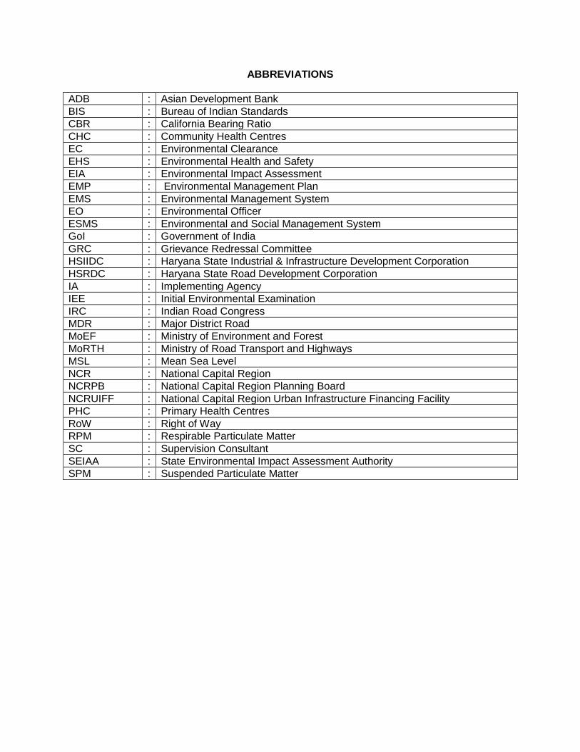
ADB : Asian Development Bank
BIS : Bureau of Indian Standards
CBR : California Bearing Ratio
CHC : Community Health Centres
EC : Environmental Clearance
EHS : Environmental Health and Safety
EIA : Environmental Impact Assessment
EMP : Environmental Management Plan
EMS : Environmental Management System
EO : Environmental Officer
ESMS : Environmental and Social Management System
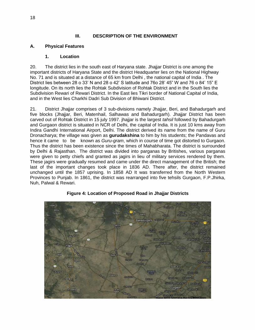
GoI : Government of India
GRC : Grievance Redressal Committee
HSIIDC : Haryana State Industrial & Infrastructure Development Corporation
HSRDC : Haryana State Road Development Corporation
IA : Implementing Agency
IEE : Initial Environmental Examination
IRC : Indian Road Congress
MDR : Major District Road
MoEF : Ministry of Environment and Forest
MoRTH : Ministry of Road Transport and Highways
MSL : Mean Sea Level
NCR : National Capital Region
NCRPB : National Capital Region Planning Board
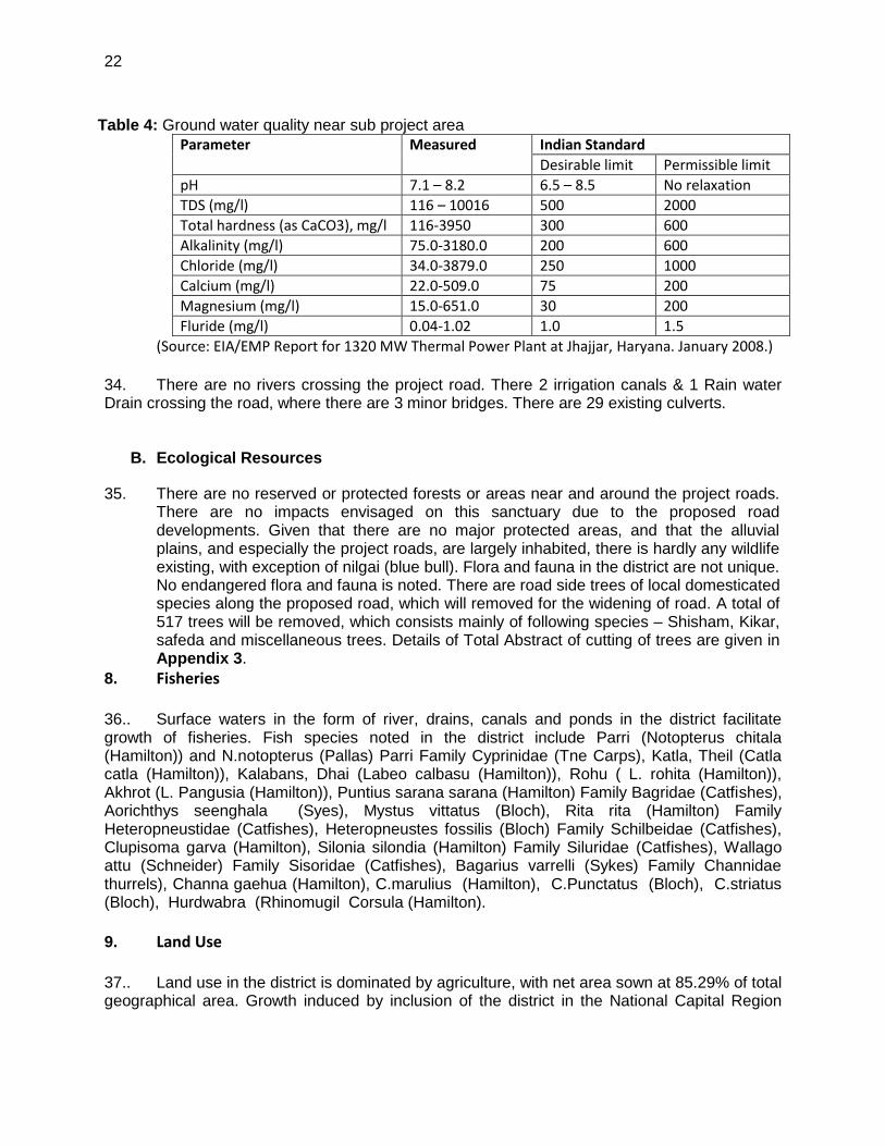
NCRUIFF : National Capital Region Urban Infrastructure Financing Facility
PHC : Primary Health Centres
RoW : Right of Way
RPM : Respirable Particulate Matter
SC : Supervision Consultant
SEIAA : State Environmental Impact Assessment Authority
SPM : Suspended Particulate Matter
3
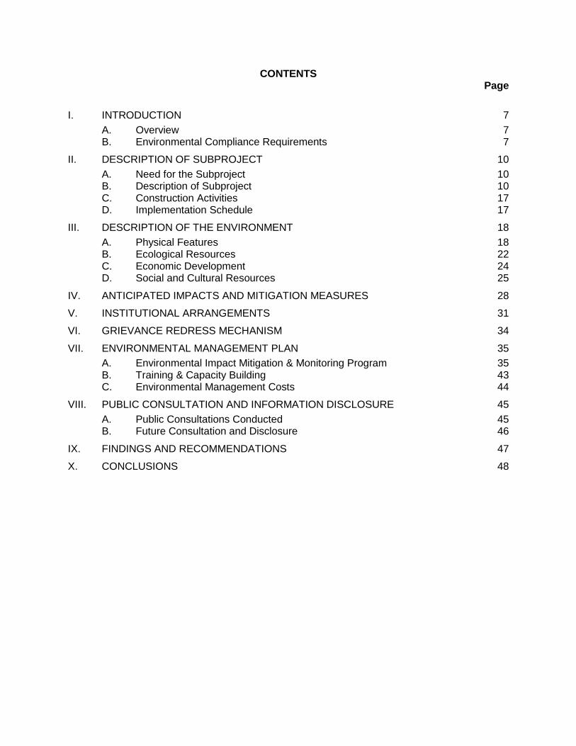
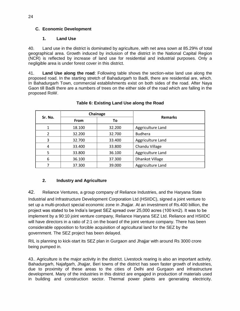
CONTENTS Page
I. INTRODUCTION 7
A. Overview 7 B. Environmental Compliance Requirements 7
II. DESCRIPTION OF SUBPROJECT 10
A. Need for the Subproject 10 B. Description of Subproject 10 C. Construction Activities 17 D. Implementation Schedule 17
III. DESCRIPTION OF THE ENVIRONMENT 18
A. Physical Features 18 B. Ecological Resources 22 C. Economic Development 24 D. Social and Cultural Resources 25
IV. ANTICIPATED IMPACTS AND MITIGATION MEASURES 28
V. INSTITUTIONAL ARRANGEMENTS 31
VI. GRIEVANCE REDRESS MECHANISM 34
VII. ENVIRONMENTAL MANAGEMENT PLAN 35
A. Environmental Impact Mitigation & Monitoring Program 35 B. Training & Capacity Building 43 C. Environmental Management Costs 44
VIII. PUBLIC CONSULTATION AND INFORMATION DISCLOSURE 45
A. Public Consultations Conducted 45 B. Future Consultation and Disclosure 46
IX. FINDINGS AND RECOMMENDATIONS 47
X. CONCLUSIONS 48
Executive Summary of Initial Environmental Examination Report of Upgradation of Badli-Gurgaon road in Jhajjar /Gurgaon District (Km. 18.100 to Km. 39.000) Proposal The Initial Environmental Examination (IEE) Report has been prepared for the Upgradation of Badli-Gurgaon road in Jhajjar /Gurgaon District (Km. 18.100 to Km. 39.000). The HSRDC is the implementing agency at the district level under PWD and proponent of the Initial Environmental Examination study for this Badli-Gurgaon road project. Background HSRDC has approached NCRPB for financing the project. It is proposed to fund the project under the National Capital Region Urban Infrastructure Financing Facility (NCRUIFF) supported by Asian Development Bank (ADB). This project covers widening & strengthening of an existing road, including geometric improvements, removing deficiencies and reconstruction of cross drainage structure with new structures Objective The main objective of the IEE study is to identify the impacts of physical, biological, socio-economic and cultural environment of the sub-project area. The specific objectives of the proposed IEE study include:
i) Identify the major impacts that may arise as a result of proposed works on biophysical, socio-economic and cultural environment of the project area.
ii) recommend practical and site specific environmental mitigation and enhancement measures, prepare and implement environmental monitoring plan for the Subproject, and
iii) provide information on the general environmental setting of the sub-project area as baseline data and make sure that IEE is sufficient for the proposed road Subproject
Relevancy of the proposal Upgradation of road has several benefits from the project to the people living in the vicinity of project area in terms of easy access, saving of time on travel, easy transportation facilities for people. The widening and strengthening of the proposed road may uplift social and economical status of the local people. Project Description The project road proposed for improvement is a Major District Road, and is an important road of Jhajjar/Gurgaon District. The existing road consists of carriageway width of 10m and 1m to 1.5 wide earthen shoulders on both sides. The present traffic is 17235 pcu at Km. 31/00 the current traffic in the entire stretch of the project road exceeds the DSV. This indicates the immediate requirement of capacity augmentation in form of upgrading carriageway. Sections of the road pass through a few built-up areas with not only inadequate road geometry, but also with various deficiencies such as riding surface distress, weak and unsafe cross drainage structures and safety procedures etc.
5
The project road passes through plain terrain with mild gradients. There are one major drain crossing the existing road, however, there are 19 culverts and 1 Minor Bridges. Beneficial Impacts The development efforts particularly the development of transportation network will have multifold beneficial impacts. The immediate beneficial impacts from road development are apparent in the construction phase like there will be various employment opportunities for the local population, supports for the transfer of construction work skills and technical know-how to the local workers. During operation stage, an improved road access will bring an improvement of food security situation and overall economic and social stability. The road will also provide cheap, safe and fast transport of goods and services from rural areas to urban centers and vice versa. The farmers will be more interested to increase agricultural production due to market accessibility. This will contribute significantly to increase the productivity in rural areas and eventually improve the overall socio-economic condition of the people. There is a possibility of increased economic opportunities and significant growth and extension of the local markets along the road alignment. In addition, construction of road will lead to appreciation of land values particularly near the market and settlement areas. Adverse Impacts The physical adverse impacts during construction will be due to change in land use, slope instability and air, dust and water pollution, quarry sites and spoil disposal. The adverse physical impacts during road operation are slope instability and management, air and noise pollution, and road safety. Likewise, biological impacts are depletion of forest resources. Socio-economic impacts are due to new settlement and market center development, change in social behavior during road operation. Benefit Augmentation and Mitigation Measures Impacts from the proposed road projects can be both beneficial as well as adverse. An effective implementation of benefit maximization measures and adverse impacts mitigation measures would optimize the benefits expected from the project and avoid/minimize the adverse impact from the project. Based on the impact assessment and identification, beneficial augmentation and adverse impact mitigation measures are presented in both constructions as well as in operation stage of the road. Mitigation Measures Spoils should be safely disposed and managed with minimum environmental damage using LEP approach which includes balanced cut and fill volume, re-use of excavated materials and minimum quantity of earth works and adoption of bio-engineering techniques. Adequate slope stabilization measures will be provisioned in design for the stabilization of slopes. Unstable sites, erosion prone area, dense forest area, settlements, fertile farm land will be avoided for quarrying operation. The workers will be provided with helmets, masks, muffles depending on the nature of the construction work. Drinking water facility and temporary pit latrine will be established and disposal of excavated materials in the water bodies will be avoided. Workers will be provided with medicines and group accidental insurance facility. During operation stage,
minor landslide and mass wasting will be immediately cleared and slope restored with appropriate technology. Environmental Management Plan Environmental management plan is an important tool to ensure the implementation and monitoring of mitigation measures for minimizing adverse impacts and maximizing the beneficial impacts. Similarly, environmental monitoring generates useful information and improves the quality of implementation of mitigation measures. Conclusion and Recommendation The main objective of the proposed Upgradation of Gurgaon-Chandu-Badli-Bahadurgarh in Jhajjar/Gurgaon District (Section Badli to Gurgaon Km 18.100 To Km 39.000 in Jhajjar/Gurgaon district) is to :-
o Reduce time taken to travel on the road with reduced traffic congestion. o Reduce road accidents o Improve ride quality, reduce air pollution
Thus ultimately this subproject aims to improve overall socio-economic conditions. This initial environmental examination has been conducted to identify and assess negative impacts. The project involves straightforward construction. Not many environmental issues were noticed during this initial environmental examination. In most cases, environmental issues identified are typical for the type of construction components, and a range of proven mitigation strategies exist to address them. This IEE has assessed all potential environmental impacts associated with the project. There are no impacts, which are significant or complex or which needs an in-depth study to assess the impact or to develop the mitigation measures. The environmental impacts identified are manageable, and HSRDC will implement the mitigation measures as stated in IEE. The project therefore does not warrant environmental impact assessment (EIA). The project does not fall under the ambit of the EIA Notification, 2006 of Government of India, and therefore do not require Environmental Clearance from Ministry of Environment and Forest. However, the project requires permission and approval of Forest Department for diversion and use of forest land for road widening, and for cutting of trees, and this will be obtained before award of the Contract. Also, the Contractor requires consent of pollution control board for facilities like hot mix plants and crushers. It will be ensured that the consent is in place before start of the work.
7
I. INTRODUCTION
A. Overview
1. The Haryana State Road Development Corporation (HSRDC) of Government Haryana, is proposed to improve the existing Road i.e. Gurgaon-Chandu-Badli-Bahadurgarh Road in Jhajjar/Gurgaon District which starts State Highway -22 i.e. Km. 0.000 at Bahadurgarh and ends at Km. 39.000 Gurgaon to facilitate free and easy movement of traffic and improve road safety. This report is of section Badli to Gurgaon from Km.18.100 to Km. 39.000 in Jhajjar/Gurgaon district. The proposed project includes reconstruction/widening strengthening of Section Badli to Gurgaon from Km. 18.100 to Km. 39.000 km. 2. HSRDC has approached NCRPB for financing the project. It is proposed to fund the project under the National Capital Region Urban Infrastructure Financing Facility (NCRUIFF) supported by Asian Development Bank (ADB). 3. As per the NCRPB Environmental and Social Management System (ESMS), the project is classified as ADB as environment Category E2 (equivalent to ADB category B) and accordingly requires preparation of initial environmental examination (IEE) Report. This IEE Report has been prepared for the project of widening and strengthening of Badli to Gurgaon, (Km 18.100 to Km 39.000) –in Haryana State. This project covers widening & strengthening of an existing road, including geometric improvements, removing deficiencies and reconstruction of cross drainage structure with new structures.
B. Environmental Compliance Requirements
1. NCRPB Environmental Policy and ESMS
4. Recognizing the importance of environmental and social issues that can arise in infrastructure projects, NCRPB has established Environmental and Social Management Systems (ESMS) in line with Government and other multilateral agencies like ADB safeguard requirements for Financial Intermediaries (FIs). The ESMS provides an overall management system to NCRPB to identify, assess, and mitigate environmental and social issues that are likely to arise in projects funded by NCRPB. The ESMS outlines the policies, methods of assessments and procedures that will enable NCRPB to ensure that a project that it funds is developed in accordance with ESMS. Implementing Agencies (IAs) will have to comply with the ESMS and Policy. 5. Screening and Categorization. According to NCRPB ESMS, the projects are screened for their expected environmental impacts and are assigned to one of the following categories: E1, E2 or E3.
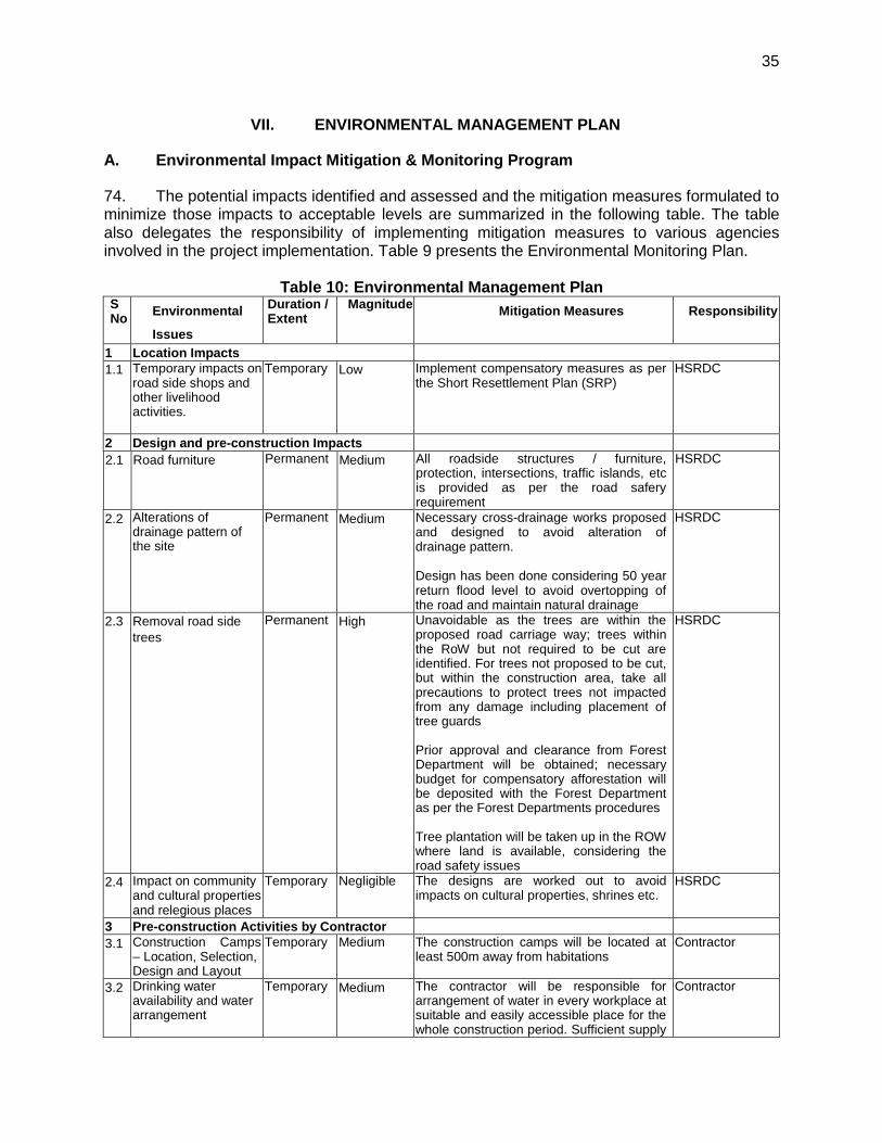
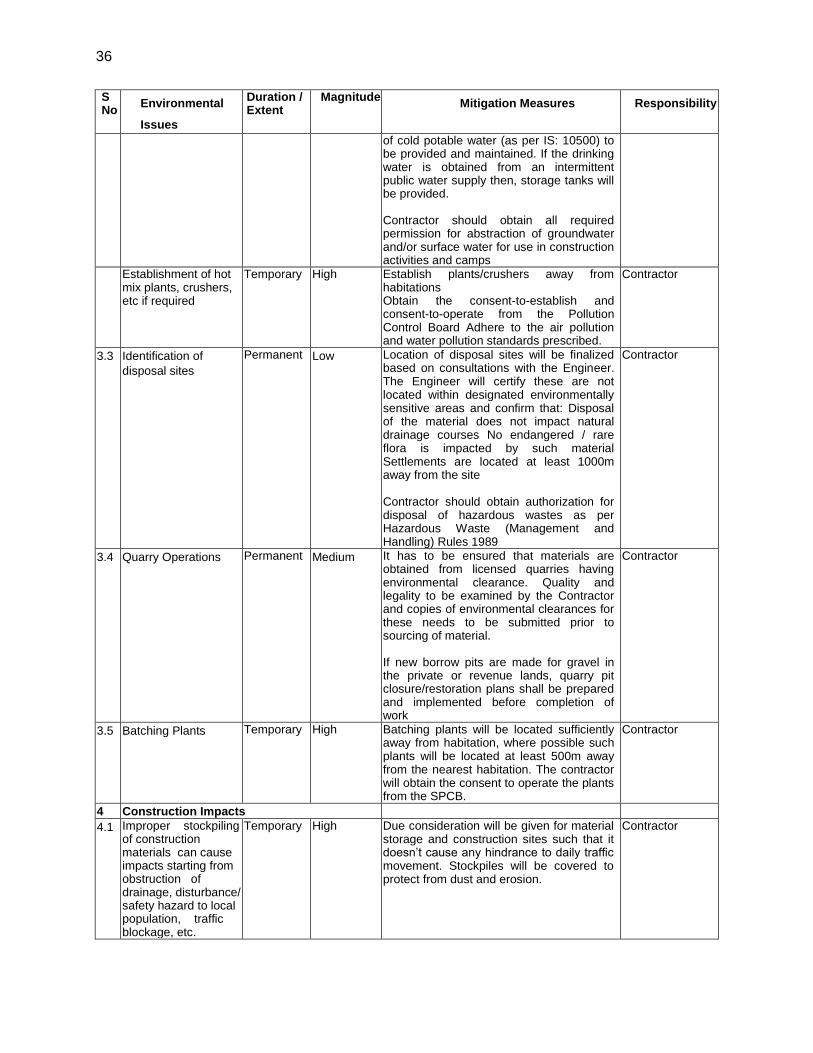
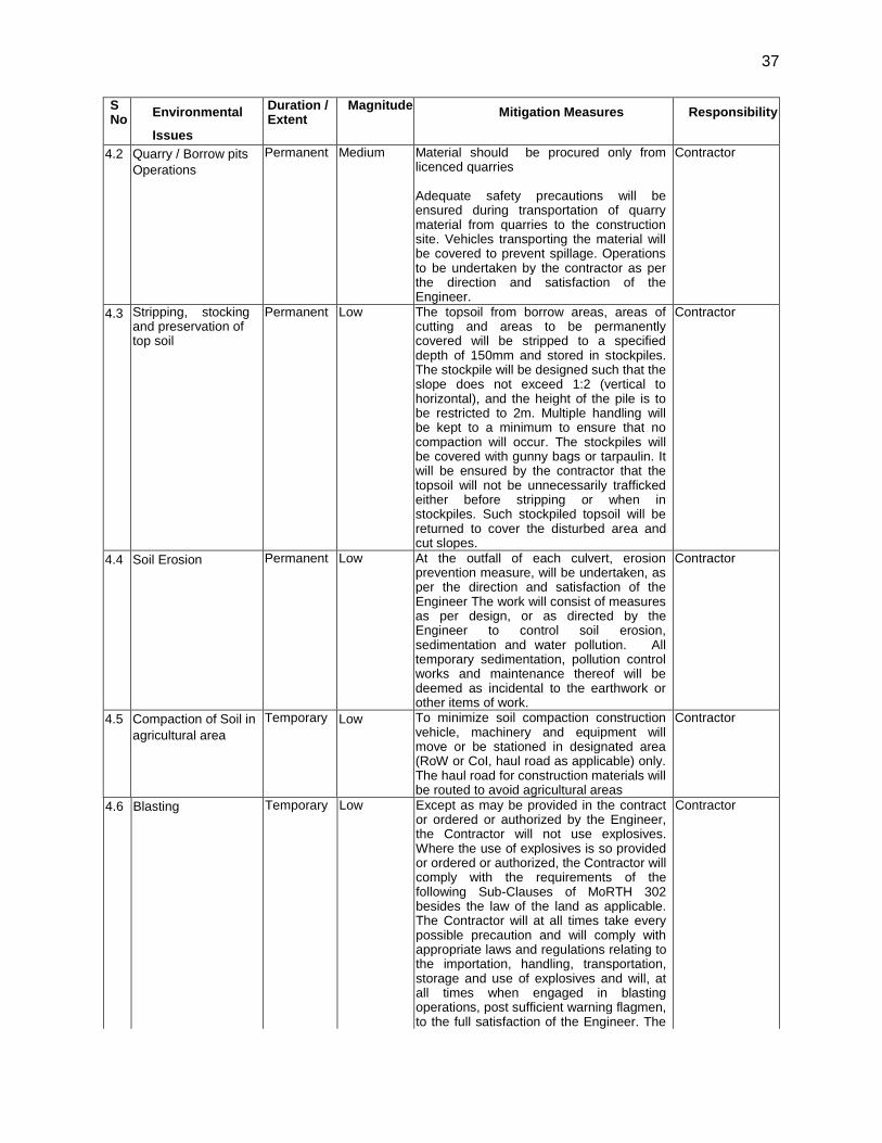
(i) Category E1 (Significant impacts or in eco-sensitive areas): If the project has
significant adverse environmental impacts that are irreversible, diverse, or unprecedented, then it is regarded to have environmental scenario. These impacts may affect an area larger than the sites or facilities subject to physical works. These impacts will be considered significant if these are in eco-sensitive areas.
(ii) Category E2 (Limited environmental impacts): If the project has impacts that are site-specific, few if any of them are irreversible, and in most cases mitigation measures can be designed.
8
(iii) Category E3 (No environmental impacts): If the project is likely to have minimal or no adverse environmental impacts
6. The proposed project of widening and strengthening of Badli to Gurgaon Road is unlikely to have significant impacts. The project road neither passes through nor is located within 10 km from any wildlife sanctuary, national park, or any other environmentally sensitive or protected area. It traverses predominantly through agricultural land and follow existing alignment. The majority of the activities have short-term minor, negligible or no residual impacts. The subproject is however likely to have typical impacts associated with the construction activity and therefore classified as Category E2. 7.. According to ESMS, E2 projects require carrying out Initial Environmental Examination (IEE) and preparation of IEE Report. This IEE report is prepared accordingly.
2. Applicable Legislations
8. The implementation of the subprojects will be governed by the national government and state of Haryana environmental acts, rules, regulations, and standards. These regulations impose restrictions on the activities to minimize and/or mitigate likely impacts on the environment. It is the responsibility of the project executing and implementing agencies to ensure subprojects are consistent with the legal framework, whether national, state or municipal and/or local.
9. Environmental Assessment Requirements. The GoI EIA Notification of 2006 (replacing the EIA Notification of 1994), sets out the requirement for Environmental Assessment in India. This states that Environmental Clearance (EC) is required for specified activities/projects, and this must be obtained before any construction work or land preparation (except land acquisition) may commence. Projects are categorized as A or B depending on the scale of the project and the nature of its impacts. Category A projects require EC from the national Ministry of Environment and Forests (MoEF). Category B projects require environmental clearance from the State Environment Impact Assessment Authority (SEIAA). The Notification also provides that any project or activity classified as category B will be treated as category A if it is located in whole or in part within 10 km from the boundary of protected areas, notified areas or inter-state or international boundaries. Owing to its scale and nature, this project does not falls under the ambit of the EIA Notification, and, therefore EC is thus not required. 10. Tree cutting permission:- Cutting of trees require permission of Forest Department The project requires following environmental related approvals/clearances from regulatory agencies:
Table 1: Clearances and Approvals Component Clearance Responsibility Status
1 Tree cutting Approval from forest department Forest department will take up afforestation program at a rate of 10 trees per each tree cut at the cost of HSRDC.
HSRDC Application submitted to Forest Department (Appendix 3).
2
Hot mix plant, crusher etc
Consent for Establishment and Consent for Operation from Haryana Pollution Control Board
Contractor -
3 Disposal of Hazardous Waste
Authorization for Disposal of Hazardous Waste as per Hazardous Waste (Management and
Contractor -

9
Component Clearance Responsibility Status
Handling) Rules 1989
4 Employing Labor/Workers
Employing Labor/Workers as per The Building and Other Construction Workers (Regulation of Employment and Conditions of Service) Act, 1996
Contractor
10
II. DESCRIPTION OF SUBPROJECT
A. Need for the Subproject
11. The project road proposed for improvement is a Major District Road, and is an important road of Jhajjar/Gurgaon District. The existing road consists of carriageway width of 10m and 1m to 1.5 wide earthen shoulders on both sides. The present traffic is 17235 pcu at Km. 31/00 the current traffic in the entire stretch of the project road exceeds the DSV. This indicates the immediate requirement of capacity augmentation in form of upgrading carriageway. Sections of the road pass through a few built-up areas with not only inadequate road geometry, but also with various deficiencies such as riding surface distress, weak and unsafe cross drainage structures and safety procedures etc. B. Description of Subproject
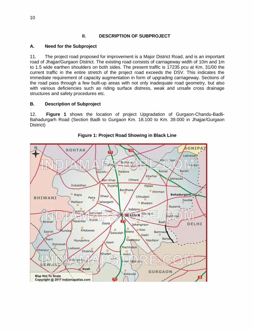
12. Figure 1 shows the location of project Upgradation of Gurgaon-Chandu-Badli-Bahadurgarh Road (Section Badli to Gurgaon Km. 18.100 to Km. 39.000 in Jhajjar/Gurgaon District)
Figure 1: Project Road Showing in Black Line
11
13. Under the project, it is proposed to widen and strengthen existing road stretch of total 18.100 km from current status to higher status with removing various road engineering deficiencies. The widening proposal in road corridor is not within the existing right-of-way additional land (19.275 acre in Jhajjar District and 13.260 acre in Gurgaon District i.e. Total = 32.535 acre) to be acquired for the project road. The improvement work extends to all components of the road, namely, pavements, drains, structures within proposed Right-of-Way (Row), improvement of the road geometry etc. The widening of this road stretch will facilitate smooth flow of traffic thereby reducing travel time and cost. Further, the poor pavement condition, bad geometry and the heavy traffic growth combined together warrant for an immediate protection and capacity augmentation of the project road. The project road passes through plain terrain with mild gradients. There are one major drain crossing the existing road, however, there are 19 culverts and 1 Minor Bridges. 14. The following are the proposed components of the project:.
Road Widening: The present traffic requires developing the existing two lane carriageway to Four lane paved shoulder (Km. 18.100 to Km. 39.000) carriageway to ensure good riding quality with reasonable riding comfort and speed. No major constraint in widening of the carriageway as 32.535 acre Land is required to be acquired. Horizontal alignment is achieved by improving the existing at various locations on the project roads.
Design speed :
o 60 kph for the built-up areas.
o 80 kph for rest of the alignment.
Smoothening of kinks with high radii within the ROW
Introduction of proper transition curve for design speed assigned
Realignment of curves with deflection angle < 5 degrees for minimum required
length
Vertical profile has been taken care of by rising the formation wherever requires. Carriage way:
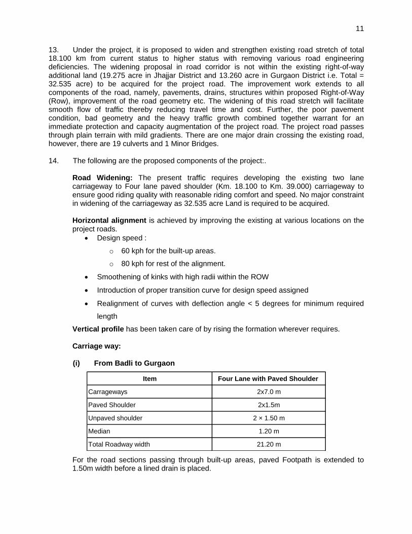
(i) From Badli to Gurgaon
Item Four Lane with Paved Shoulder
Carrageways 2x7.0 m
Paved Shoulder 2x1.5m
Unpaved shoulder 2 × 1.50 m
Median 1.20 m
Total Roadway width 21.20 m
For the road sections passing through built-up areas, paved Footpath is extended to 1.50m width before a lined drain is placed.
12
Proposed Road Pavement Composition: New pavement for widening and reconstruction is proposed to be constructed with following composition. (i) Section -1 Badli to Gurgaon (Km 18.100 – Km 39.000)
Pavement Layers Widenning New / Reconstructions
Surfacing Layer 40mm BC + 120mm DBM 40mm BC + 120mm DBM
Base Course 250mm Wet Mix Macadam
(WMM)250mm Wet Mix Macadam
Sub-base230mm granular drainage quality,
CBR>30%
230mm granular, drainage
quality, CBR>30%
Sub-grade 500 mm, in Tibba Sand, CBR> =
7%
500mm, Tibba Sand,
CBR >= 7%
Shoulder: Hard shoulder is proposed with the composition of adjoining pavement. For earthen shoulder, selected earth fill is proposed over granular sub-base layer. For built-up areas, earthen shoulder/ margin of 1.00 - 1.50m between paved shoulder and lined drain is proposed with paver blocks which will be utilized for non-motorised vehicles: Granualr sub-base material + 50 mm sand fill + 100 mm Thick Interlocking Block (M-40) Drains. Roadside drains are proposed in all villages for disposal of surface run-off away with covered slab of 1.5m width which will be served as pedestrian footpath.. Culverts: Out of the 19 existing culverts, all are replaced with new ones along with the construction of 33 new culverts. Bridges: 1 no. Of major bridge is proposed in side of existing two lane bridge in the project stretch both are in good condition. Junctions: All the existing 7 junctions are proposed to be improved with separation of directional movement and channelization of turning traffic. Road Safety: Traffic Control and safety measures have been taken care by adequate road signs and pavement marking as per IRC Standards. 16 pairs of bus stops by way of lay-by / widening the carriage way are proposed. Environmental up gradation: Following are included in the project as enhancement measures:
Turfing of side slopes to avoid erosion, and also to arrest dust and improve aesthetics
Plastic Reuse: Use of waste plastic in bituminous surface for builtup areas
Interception drains to collect storm water drain
Installation operation of ambient air quality monitoring station along the project road
Solar lighting and rain water harvesting
13
Required provisions for site clearance, earthwork, sub base & base course, Bituminous course, cement concrete pavement, drainage and cross drainage works, traffic safety, road appurtenances, forest clearance, environmental upgradation and shifting utilities have provided for making a reasonably accurate cost estimation. Amount required for have also been provided.
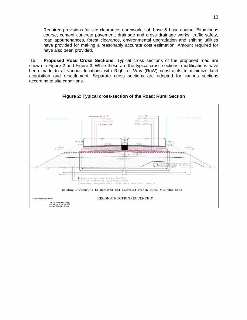
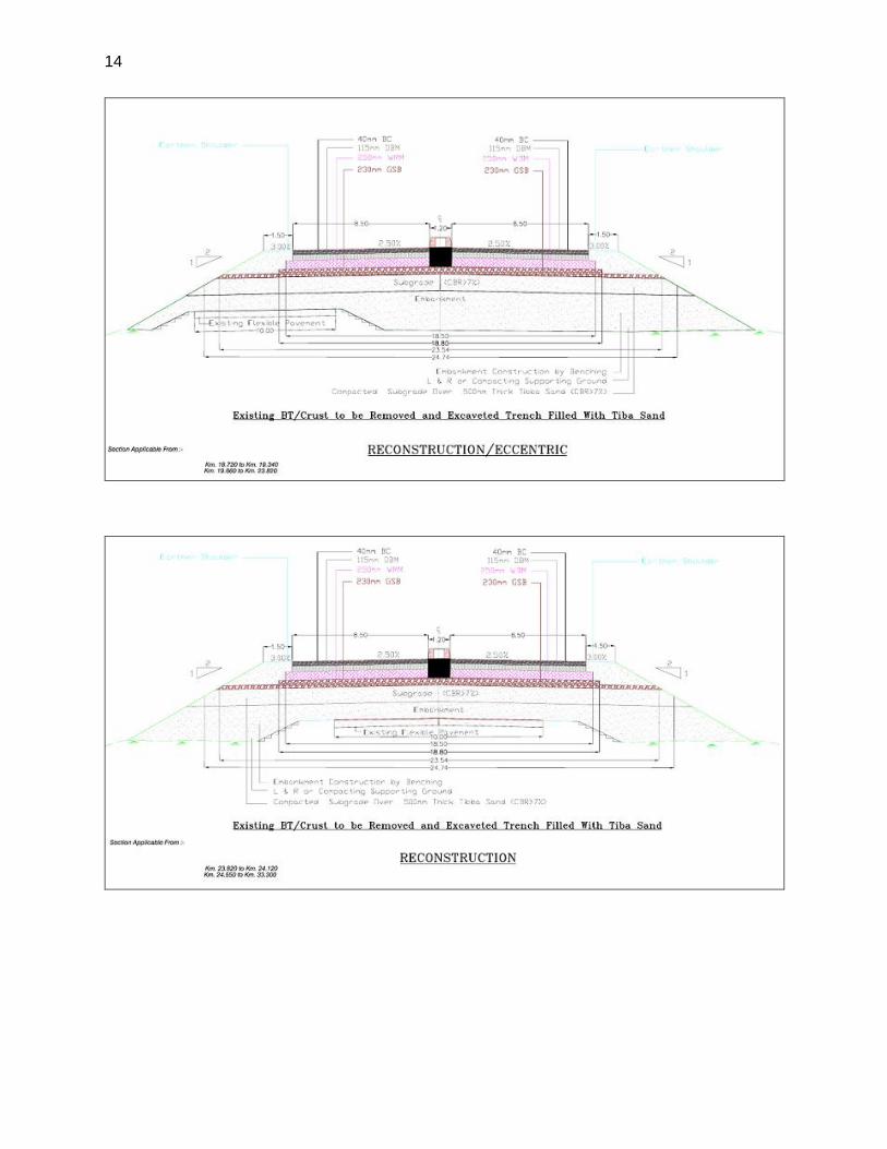
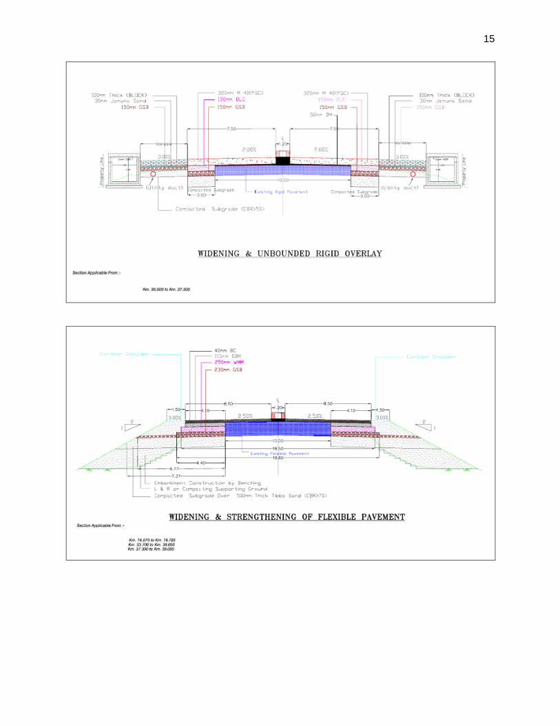
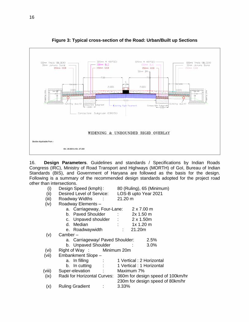
15. Proposed Road Cross Sections: Typical cross sections of the proposed road are shown in Figure 2 and Figure 3. While these are the typical cross-sections, modifications have been made to at various locations with Right of Way (RoW) constraints to minimize land acquisition and resettlement. Separate cross sections are adopted for various sections according to site conditions.
Figure 2: Typical cross-section of the Road: Rural Section
14
15
16
Figure 3: Typical cross-section of the Road: Urban/Built up Sections
16. Design Parameters. Guidelines and standards / Specifications by Indian Roads Congress (IRC), Ministry of Road Transport and Highways (MORTH) of GoI, Bureau of Indian Standards (BIS), and Government of Haryana are followed as the basis for the design. Following is a summary of the recommended design standards adopted for the project road other than intersections.
(i) Design Speed (kmph) : 80 (Ruling), 65 (Minimum) (ii) Desired Level of Service: LOS-B upto Year 2021 (iii) Roadway Widths : 21.20 m (iv) Roadway Elements –
a. Carriageway, Four-Lane: 2 x 7.00 m b. Paved Shoulder : 2x 1.50 m c. Unpaved shoulder : 2 x 1.50m d. Median : 1x 1.20 m e. Roadwaywidth : 21.20m
(v) Camber – a. Carriageway/ Paved Shoulder: 2.5% b. Unpaved Shoulder : 3.0%
(vi) Right of Way : Minimum 20m (vii) Embankment Slope –
a. In filling : 1 Vertical : 2 Horizontal b. In cutting : 1 Vertical : 1 Horizontal
(viii) Super-elevation : Maximum 7% (ix) Radii for Horizontal Curves: 360m for design speed of 100km/hr
230m for design speed of 80km/hr (x) Ruling Gradient : 3.33%
17
C. Construction Activities
17. Following provides the details of construction activities, requirement of quarry material, construction equipment and workers.
Table 2: Construction Activities & Requirement
Component Description Remarks
Construction process
Tree cutting
Utility shifting
Site clearance
Earthwork,
Sub base & base course,
Bituminous course,
Cement concrete pavement (at 1 locations of 300 m length)
Drainage and cross drainage works
Traffic safety, road appurtenances
Rain water harvesting & turfing
Yes, Yes Yes Yes Yes Yes No Yes Yes No & Yes turfing included with earth work.
Material required Gravel
Quantity: Nil m3
Likely Source: N.A. Road metal (stone aggregate
Quantity: 160000 cum
Likely Source: Any approved source by Engineer
Quantity: 68000 cum (Stone Dust From Khanak Quarry)
Likely Source: Approved by the Engineer.
----------- Nil --------------
Waste generation Road strip debris: (Qty) 153000 Sqm Reuse : Yes in Bituminous work & in Granular Sub Base Disposal location : Any low lying area finalized by the Engineer
-------------- Nil --------------
Plant & machinery to be established
Hot mix plant : Yes
Crusher : Yes
Construction workers
Number of workers: Variable (Approximately) Likely source of labour: Locally or outside (Both) Construction camps: 01 nos.
18. Water for construction of the project road will be taken from ground water and surface water resources after obtaining necessary permissions. No public water source will be used for road construction. D. Implementation Schedule
19. Detailed design work has been completed, and Detailed Project Report has been approved. The project is proposed to be implemented over a period of 21 months and as a single construction package. Bids will be invited in May 2013, and construction work will commence in November 2013 and will be completed by July 2015. .
18
III. DESCRIPTION OF THE ENVIRONMENT
A. Physical Features
1. Location
20. The district lies in the south east of Haryana state. Jhajjar District is one among the important districts of Haryana State and the district Headquarter lies on the National Highway No. 71 and is situated at a distance of 65 km from Delhi , the national capital of India . The District lies between 28 o 33’ N and 28 o 42’ S latitude and 76o 28’ 45” W and 76 o 84’ 15” E longitude. On its north lies the Rohtak Subdivision of Rohtak District and in the South lies the Subdivision Rewari of Rewari District. In the East lies Tikri border of National Capital of India, and in the West lies Charkhi Dadri Sub Division of Bhiwani District. 21. District Jhajjar comprises of 3 sub-divisions namely Jhajjar, Beri, and Bahadurgarh and five blocks (Jhajjar, Beri, Matenhail, Salhawas and Bahadurgarh). Jhajjar District has been carved out of Rohtak District in 15 july 1997. jhajjar is the largest tahsil followed by Bahadurgarh and Gurgaon district is situated in NCR of Delhi, the capital of India. It is just 10 kms away from Indira Gandhi International Airport, Delhi. The district derived its name from the name of Guru Dronacharya; the village was given as gurudakshina to him by his students; the Pandavas and hence it came to be known as Guru-gram, which in course of time got distorted to Gurgaon. Thus the district has been existence since the times of Mahabharata. The district is surrounded by Delhi & Rajasthan. The district was divided into parganas by Britishes, various parganas were given to petty chiefs and granted as jagirs in lieu of military services rendered by them. These jagirs were gradually resumed and came under the direct management of the British; the last of the important changes took place in 1836 AD. There after, the district remained unchanged until the 1857 uprising. In 1858 AD It was transferred from the North Western Provinces to Punjab. In 1861, the district was rearranged into five tehsils Gurgaon, F.P.Jhirka, Nuh, Palwal & Rewari.
Figure 4: Location of Proposed Road in Jhajjar Districts
19
2. Topography, Geology, and Soils
22. The Jajjar district forms a part of Indo-Gangatic alluvial plain, with undulating dunes in some parts and small isolated hill in south-western part. Altitude of the district is ranges from 212 m to 276 m above mean sea level (MSL). It slopes from north-east to south-west, with southern part sloping towards north causing saucer like depression in the flat eastern part. Uneven areas suffer from inundation and water logging during monsoon season. In absence of natural drainage, the area is drained by Main Drain No.8 of the district. The canal system of the district drains rain water during rainy season.
23. In Jhajjar district most of the area is covered by Quaternary alluvium. The adjoining areas around the project roads mainly consist of flat agricultural fields and brick kilns. In addition to the few scattered water bodies and village ponds existing along the roads, borrowing of earth for brick kilns has resulted in depressions adjoining the identified roads. 24. The entire project road passes through plain terrain with mild gradients. The Jhajjar district is part of the alluvial plain formed by the Yamuna and the Ganga rivers that occupies a major portion of NCR. In Jhajjar district most of the area is covered by Quaternary alluvium. The adjoining areas around the project road mainly consist of flat agricultural fields and brick kilns. In addition to the few scattered water bodies and village ponds existing along the road, borrowing of earth for brick kilns has resulted in depressions adjoining the identified road. 25. The soils of the district are fine to medium textured, comprising of sand to sandy loam of yellowish and brown colour in north-eastern part covering Bahadurgarh and Jhajjar blocks, massive beds of pale reddish brown coloured clay in the southern eastern parts. Soil types are Arid Brown (Solonized) and Sierozem. The nitrogen contents are low in the soils of the area. Potassium and phosphorous is medium in Salahwas block whereas high potassium, medium phosphorus occur in the soils of the district. There are sediments consisting of sand, silt, gravel and kankar. The organic Carbon, Nitrogen and Phosphorous are low with medium to high Potash. The sandy to sandy loam soil of Sahlawas and Mattanhail Block are light in colour, deficient in organic carbon, low in Nitrogen and Phosphorous withmedium to high available potash. Poor drainage brackish water and compact kankar layer below root zone in few areas cause more alkalinity and salinity. Soil parameters observed in the district show pH varying from 7.0 to 7.6 (neutral to slightly alkaline), Electrical conductivity (µS/cm) from 832 to 2,154, Organic Carbon – 0.20% (low) to 0.55% (medium), Nitrogen (kg/ha) – 193 to 688 (low to high), available phosphorus was medium to high, while available potassium was low to medium. The micronutrients copper, zinc, and iron were in the range of 0.32 to 0.43 mg/kg, 0.51 to 0.65 mg/kg, and 4.62 to 5.55 mg/kg, respectively, indicating fertile soil. (Source: ADB EIA 42933-IND-SEIA Jhajjar, Jan. 2009)
26. Geology. The area forms a part of in Dugan ethic plain ranging from Pleistocene to recent in age Aeolian deposits of sub-recent age cap the plains. The sediments comprise of clay, sand and Kankar mixed in different proportions. No exposure of hard rock farming the basement is seen in the area. With the exception of few small outliers of Alwar quartzite belonging to the Delhi system, there is nothing of geological interest in the district which is almost entirely covered by alluvium 27. There are a number of faults and other tectonic features that trigger earthquakes in the NCR. The major ones are, Sohna fault, Aravalli fault, hidden Moradabad fault in the Indo-Gangetic basin, Sonepat-Delhi-Sohna fault, Junction of Aravalli and Sohna fault, and the Delhi-
20
Haridwar ridge. Earthquakes of intensity lower than four on the Richter scale have originated from 14 epicentres located in the NCR. Two major lineaments, namely Delhi-Hardwar ridge and Delhi- Moradabad fault, pass through the NCR, both having potential of generating earthquakes of magnitude up to 6.5 to 6.7 and normal depth of 30 kms. The NCR lies in the earthquake zone IV, the second highest vulnerable zones with respect to seismic impacts. The proposed design integrates the risks of seismic activities on the project road, through adoption of the IRC codes and standards. 28. Soil Profile. The district falls within the classified arid and semi-arid zones. Broadly four types of soil are available in the District viz. clay, loamy clay, loamy sandy and sandy. It is alluvial in nature and fertile. However, the soil is deficient in Nitrogen. Hot summer, cold winter and meager rain fall are the main climatic characteristics of Jhajjar District.
3. Climate
29. The climate is characterized by an intensely hot summer and a cold winter. November to March is winter; summer season prevails during May and June. Rainy season is from July to September.
(i) Temperature. The winter starts in December when day and night temperatures fall rapidly. January is the coldest month when the mean daily minimum temperature is 6 to 7 Degree C. During cold waves, the minimum temperature may go down to the freezing point of water, and frosts can occur. During the summer months of May and June, the maximum temperature sometimes reaches 47 Degree Centigrade. Temperature drops considerably with the advancement of monsoon in June. However, the night temperature during this period continues to be high.
(ii) Humidity. Humidity is considerably low during the greater part of the year. The district experiences high humidity only during the monsoon period. The period of minimum humidity (less than 20%) is between April and May.
(iii) Rainfall. The annual rainfall varies considerably from year to year. However, the maximum rainfall is experienced during the monsoon season, which reaches its peak in the month of July. In fact, the monsoon period accounts for 75% of the annual rainfall in the district. On an average there are 24 days in a year with rainfall of 2.5 mm (or more) per day in district Jhajjar. Annual average rainfall in the district is 511.4 mm.
(iv) Wind. During the monsoon, the sky is heavily clouded, and winds are strong in this period. Winds are generally light during the post-monsoon and winter months. Similarly, in the monsoon periods winds are strong, and in post-monsoon and winter months it is light. Thunder storm and dust storm, often accompanied with squalls (andhis) experienced during the period April to June.
(v) Region Specific Weather Phenomena. The climate of the district can be classified as tropical steppe,semi-arid and hot which is mainly characterized by the extreme dryness of the air except during monsoon months, intensely hot summers and cold winters. During three months of south west monsoon from last week of June to September, the moist air of oceanic origin penetrate into the district and causes high humidity, cloudiness and monsoon rainfall.
4. Air Quality
30. Air quality values for suspended particulate matter (SPM) and respirable particulate matter (RPM) observed in Jhajjar block exceeded the standards for residential, rural, and other
21
areas. High SPM and RPM levels occurred due to strong winds that generated dust storms in summer. Levels of sulfur dioxide (SO2) and NOx were well within the permissible standards for residential, rural, and other areas. Table 3: Details of Air Quality in Jhajjar block
Parameter Observed in Jhajjar in April-June 2007.
Standards
SPM (μg/m3) 105.0 – 385.0 50 – 100
RPM (μg/m3) 58.0 – 153.0 --
SO2 1.0 – 9.3 30 – 120
NOx 4.0 – 38.0 30 – 120 Source: EIA/EMP Report for 1,320 MW Thermal Power Plant at Jhajjar, Haryana. MECON Limited, 2008.
5. Noise
31. Average noise levels monitored in the Jhajjar block of the district on rural and residential areas varied from 46.8 to 54.4 dB(A) during the day and 40.1 to 43.6 dB(A) at night, and are within the prescribed limits. Day time noise levels near the Jharli Railway station averaged 60 dB(A), exceeding the limit of 55 dB(A); while night time noise levels averaged 46.1 dB(A), exceeding the limit of 45 dB(A). The noise levels at the beginning of the road, between the stretches 0.000 to 0.950 Bahadurgarh (near Rohtak Road) and KM 1.300 to KM 2.400 are very high as compared to prescribed limits due to vehicular/ traffic movement. The monitored noise levels for residential areas were within the prescribed limits.
6. Surface Water
32. Surface water is contributed by canals, tanks and ponds. The district is in Yamuna sub-basin of Ganga basin; and it is drained by artificial Drain No.8 flowing from north to south. Jawahar Lal Nehru feeder and Bhalaut sub-branch are main canals of the district. Jhajjar and Bahadurgarh blocks form part of Sahibi river basin. Area under canal irrigation is about 690 sqkm, out of 1780 sqkm of the total irrigated area.
7. Groundwater
33.. In the district ground water occurs under semi confined to unconfined aquifer conditions. The unconfined aquifers are tapped by dug wells whereas the semi confined aquifers are tapped by shallow tube wells. The groundwater gradient is towards the east. The Hydraulic gradient of ground water is very gentle. Ground water movement in the north-western part is from south-east to north-west; in the south-western part it is from south-west to north-east. Depth of water level in the district varies from 0.98 m to 14.37 m below ground level (bgl) during pre-monsoon period and 1.17 m to 14.37 m bgl during post-monsoon period. About 90% of the area fetches ground water at less than 10 m bgl. Ground water near the water bodies yields fresh water. More than 40% of cropped area is irrigated by tube wells. In Salhawas and Jhajjar blocks ground water is in over exploited category, while Bahadurgarh under critical. Ground water of the district is alkaline in nature with pH ranging from 7.56 to 8.09. Chemical constituents in the ground water are more than the permissible limit, EC (µmho/cm at 25oC) – 1025 to 7520; F (mg/l) – 0.13 to 5.94; Fe – 2.9 mg/l. High chloride content in ground waters of eastern and western parts of the district shows high specific conductivity. The shallow ground water around Nayagaon Barkatabad, Saraiaurangabad and Majragaon in Bahadurgarh block is highly mineralized. The ground water of Nanglegaon, Kamel Garh and Jhajjar is also having similar quality. (Source: Ground water information Booklet, Jhajjar district, Central Ground Water Board, Chandigarh). Ground water quality monitoring in some of the villages of Jhajjar block are given in table.
22
Table 4: Ground water quality near sub project area
Parameter Measured Indian Standard
Desirable limit Permissible limit
pH 7.1 – 8.2 6.5 – 8.5 No relaxation
TDS (mg/l) 116 – 10016 500 2000
Total hardness (as CaCO3), mg/l 116-3950 300 600
Alkalinity (mg/l) 75.0-3180.0 200 600
Chloride (mg/l) 34.0-3879.0 250 1000
Calcium (mg/l) 22.0-509.0 75 200
Magnesium (mg/l) 15.0-651.0 30 200
Fluride (mg/l) 0.04-1.02 1.0 1.5
(Source: EIA/EMP Report for 1320 MW Thermal Power Plant at Jhajjar, Haryana. January 2008.)
34. There are no rivers crossing the project road. There 2 irrigation canals & 1 Rain water Drain crossing the road, where there are 3 minor bridges. There are 29 existing culverts.
B. Ecological Resources
35. There are no reserved or protected forests or areas near and around the project roads. There are no impacts envisaged on this sanctuary due to the proposed road developments. Given that there are no major protected areas, and that the alluvial plains, and especially the project roads, are largely inhabited, there is hardly any wildlife existing, with exception of nilgai (blue bull). Flora and fauna in the district are not unique. No endangered flora and fauna is noted. There are road side trees of local domesticated species along the proposed road, which will removed for the widening of road. A total of 517 trees will be removed, which consists mainly of following species – Shisham, Kikar, safeda and miscellaneous trees. Details of Total Abstract of cutting of trees are given in Appendix 3.
8. Fisheries 36.. Surface waters in the form of river, drains, canals and ponds in the district facilitate growth of fisheries. Fish species noted in the district include Parri (Notopterus chitala (Hamilton)) and N.notopterus (Pallas) Parri Family Cyprinidae (Tne Carps), Katla, Theil (Catla catla (Hamilton)), Kalabans, Dhai (Labeo calbasu (Hamilton)), Rohu ( L. rohita (Hamilton)), Akhrot (L. Pangusia (Hamilton)), Puntius sarana sarana (Hamilton) Family Bagridae (Catfishes), Aorichthys seenghala (Syes), Mystus vittatus (Bloch), Rita rita (Hamilton) Family Heteropneustidae (Catfishes), Heteropneustes fossilis (Bloch) Family Schilbeidae (Catfishes), Clupisoma garva (Hamilton), Silonia silondia (Hamilton) Family Siluridae (Catfishes), Wallago attu (Schneider) Family Sisoridae (Catfishes), Bagarius varrelli (Sykes) Family Channidae thurrels), Channa gaehua (Hamilton), C.marulius (Hamilton), C.Punctatus (Bloch), C.striatus (Bloch), Hurdwabra (Rhinomugil Corsula (Hamilton).
9. Land Use 37.. Land use in the district is dominated by agriculture, with net area sown at 85.29% of total geographical area. Growth induced by inclusion of the district in the National Capital Region
23
(NCR) is reflected by increase of land use for residential and industrial purposes. Only a negligible area is under forest cover in this district.
38.. According to the Vulnerability Atlas of India the NCR falls in the,
High damage risk zone (MSK VIII) for earthquakes
Very high damage risk zone B (Vb = 50m/s) for wind and cyclone hazards
Areas liable to floods, which are more site specific and consist of low-lying areas and the flood plain.
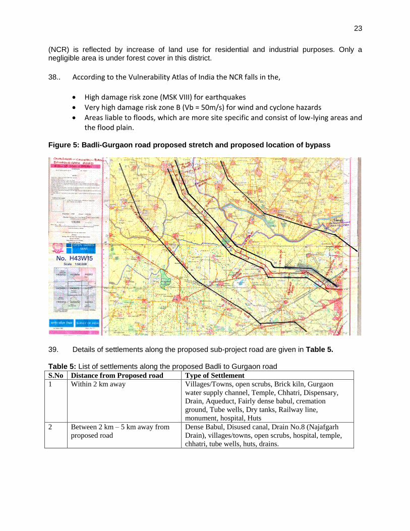
Figure 5: Badli-Gurgaon road proposed stretch and proposed location of bypass
39. Details of settlements along the proposed sub-project road are given in Table 5. Table 5: List of settlements along the proposed Badli to Gurgaon road
S.No Distance from Proposed road Type of Settlement
1 Within 2 km away Villages/Towns, open scrubs, Brick kiln, Gurgaon
water supply channel, Temple, Chhatri, Dispensary,
Drain, Aqueduct, Fairly dense babul, cremation
ground, Tube wells, Dry tanks, Railway line,
monument, hospital, Huts
2 Between 2 km – 5 km away from
proposed road
Dense Babul, Disused canal, Drain No.8 (Najafgarh
Drain), villages/towns, open scrubs, hospital, temple,
chhatri, tube wells, huts, drains.
24
C. Economic Development
1. Land Use
40. Land use in the district is dominated by agriculture, with net area sown at 85.29% of total geographical area. Growth induced by inclusion of the district in the National Capital Region (NCR) is reflected by increase of land use for residential and industrial purposes. Only a negligible area is under forest cover in this district. 41. Land Use along the road: Following table shows the section-wise land use along the proposed road. In the starting stretch of Bahadurgarh to Badli, there are residential are, which. In Bahadurgarh Town, commercial establishments exist on both sides of the road. After Naya Gaon till Badli there are a numbers of trees on the either side of the road which are falling in the proposed RoW.
Table 6: Existing Land Use along the Road
Sr. No. Chainage
Remarks From To
1 18.100 32.200 Aggriculture Land
2 32.200 32.700 Budhera
3 32.700 33.400 Aggriculture Land
4 33.400 33.800 Chandu Village
5 33.800 36.100 Aggriculture Land
6 36.100 37.300 Dhankot Village
7 37.300 39.000 Aggriculture Land
2. Industry and Agriculture
42. Reliance Ventures, a group company of Reliance Industries, and the Haryana State
Industrial and Infrastructure Development Corporation Ltd (HSIIDC), signed a joint venture to
set up a multi-product special economic zone in Jhajjar. At an investment of Rs.400 billion, the
project was stated to be India’s largest SEZ spread over 25,000 acres (100 km2). It was to be
implement by a 90:10 joint venture company, Reliance Haryana SEZ Ltd. Reliance and HSIIDC
will have directors in a ratio of 2:1 on the board of the joint venture company. There has been
considerable opposition to forcible acquisition of agricultural land for the SEZ by the
government. The SEZ project has been delayed.
RIL is planning to kick-start its SEZ plan in Gurgaon and Jhajjar with around Rs 3000 crore
being pumped in.
43.. Agriculture is the major activity in the district. Livestock rearing is also an important activity. Bahadurgarh, Najafgarh, Jhajjar, Beri towns of the district has seen faster growth of industries, due to proximity of these areas to the cities of Delhi and Gurgaon and infrastructure development. Many of the industries in this district are engaged in production of materials used in building and construction sector. Thermal power plants are generating electricity.
25
Infrastructure development fosters growth of tertiary sector industry. Special Economic Zone has been proposed along the National Highway passing through this district for industrial development. D. Social and Cultural Resources
44. Demography. As of 2001 India census, Jhajjar had a population of 39,004. Males
constitute 54% of the population and females 46%. Jhajjar has an average literacy rate of 69%,
higher than the national average of 59.5%: male literacy is 76%, and female literacy is 61%. In
Jhajjar, 14% of the population is under 6 years of age.
Jhajjar is predominantly inhabited by people from the Yaduvanshi Ahirs and Jats who belong to
the Hindu faith. Their social customs are heavily influenced by Arya Samaj, as propagated
by Swami Dayanand.Ahirs mainly came from Delhi and Rewari and claim that they are
descended from a great grandson of Phrithviraj. They are skilled agriculturists and have many
gotras. Jats consists of many clans and most of the villages have one of these clans forming the
core along with people from other castes. Social customs are heavily influenced by clannish
loyalties. Jhajjar has a Gurukul of the Arya Samaj. There is also a museum.
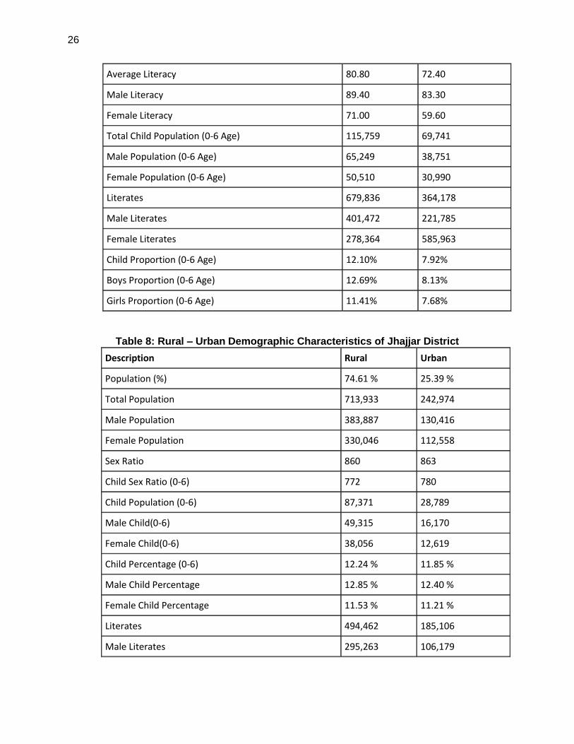
45. There was change of 8.73 percent in the population compared to population as per 2001. In the previous census of India 2001, Jhajjar District recorded increase of 23.06 percent to its population compared to 1991. The initial provisional data released by census India 2011, shows that density of Jhajjar district for 2011 is 522 people per sq. km. In 2001, Jhajjar district density was at 480 people per sq. km. Jhajjar district administers 1,834 square kilometers of areas. Average literacy rate of Jhajjar in 2011 were 80.80 compared to 72.40 of 2001. If things are looked out at gender wise, male and female literacy were 89.40 and 71.00 respectively. For 2001 census, same figures stood at 83.30 and 59.60 in Jhajjar District. Total literate in Jhajjar District were 679,836 of which male and female were 401,472 and 278,364 respectively. In 2001, Jhajjar District had 364,178 in its district.
Table 7: Demographic Characteristics – Jhajjar District
Description 2011 2001
Actual Population 956,907 880,072
Male 514,303 476,475
Female 442,604 403,597
Population Growth 8.73% 23.06%
Area Sq. Km 1,834 1,834
Density/km2 522 480
Proportion to Haryana Population 3.77% 4.16%
Sex Ratio (Per 1000) 861 847
Child Sex Ratio (0-6 Age) 774 800
26
Average Literacy 80.80 72.40
Male Literacy 89.40 83.30
Female Literacy 71.00 59.60
Total Child Population (0-6 Age) 115,759 69,741
Male Population (0-6 Age) 65,249 38,751
Female Population (0-6 Age) 50,510 30,990
Literates 679,836 364,178
Male Literates 401,472 221,785
Female Literates 278,364 585,963
Child Proportion (0-6 Age) 12.10% 7.92%
Boys Proportion (0-6 Age) 12.69% 8.13%
Girls Proportion (0-6 Age) 11.41% 7.68%
Table 8: Rural – Urban Demographic Characteristics of Jhajjar District
Description Rural Urban
Population (%) 74.61 % 25.39 %
Total Population 713,933 242,974
Male Population 383,887 130,416
Female Population 330,046 112,558
Sex Ratio 860 863
Child Sex Ratio (0-6) 772 780
Child Population (0-6) 87,371 28,789
Male Child(0-6) 49,315 16,170
Female Child(0-6) 38,056 12,619
Child Percentage (0-6) 12.24 % 11.85 %
Male Child Percentage 12.85 % 12.40 %
Female Child Percentage 11.53 % 11.21 %
Literates 494,462 185,106
Male Literates 295,263 106,179
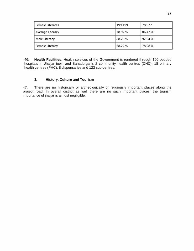
27
Female Literates 199,199 78,927
Average Literacy 78.92 % 86.42 %
Male Literacy 88.25 % 92.94 %
Female Literacy 68.22 % 78.98 %
46. Health Facilities. Health services of the Government is rendered through 100 bedded hospitals in Jhajjar town and Bahadurgarh, 2 community health centres (CHC), 18 primary health centres (PHC), 8 dispensaries and 123 sub-centres.
3. History, Culture and Tourism
47. There are no historically or archeologically or religiously important places along the project road. In overall district as well there are no such important places; the tourism importance of jhajjar is almost negligible.
28
IV. ANTICIPATED IMPACTS AND MITIGATION MEASURES
48. This section of the IEE reviews possible subproject-related impacts, in order to identify issues requiring further attention and screen out issues of no relevance. The assessment for each physical component proposed for this project has been carried out with respect to the potential impacts during the following stages of the project planning and implementation:
Location impacts: Impacts associated with site selection, including impacts on environment and resettlement or livelihood related impacts on communities.
Design impacts: Impacts arising from project design, including the type of designs, design standards etc
Construction impacts: Impacts resulting from construction activities including site clearance, earthworks, civil works, etc.
O&M impacts: Impacts associated with the operation and maintenance of the infrastructure built in the project.
49. Location impacts are not likely to be significant as there are no major environmentally sensitive areas along the road proposed for improvement. However, there are a number of trees (517 nos Tree ) in the right of way which will be removed for the project. Trees will be cut with prior permission of Forest Department and necessary cost of afforestation, at a rate of 10 trees per each tree removed, will be provided to Forest Department. The project does not require diversion of protected forest land for road widening. As indicated earlier, the strip of land along the roads with tree cover are notified as protected forested, and therefore the widening of road requires permission of Forest Department. Application is already submitted to the Forest Department and approval is under process. The impacts pertaining to road safety, especially for stretches in urban areas have been addressed through incorporation of appropriate safety measures in designs. 50. Construction impacts. The impacts during the construction stage shall be typical of road construction and can be addressed through adoption of good engineering practices and undertaking specific mitigation measures towards minimization of construction impacts on the sensitive receptors and communities in the vicinity of the project road. The mitigation measures for the various impacts are outlined in the Table 8, and are summarized in the following sub-sections. 51. Traffic Movement. The road construction work will affect the traffic movement on the road. Work will be conducted one side, leaving the other side open for traffic. It is proposed to construct 68 culvers in the proposed road stretch of 39 km, 2 to 3 culverts for every km of road. These require traffic diversions and have to be notified sufficiently in advance for safe passage of the traffic. Traffic guides with red flags, and security persons shall be employed to guide the traffic. A traffic management plan shall be prepare prior to start of construction at every stretch. 52. Dust and Air Emissions: Since the work is conducted mostly in dry season, there is lot of potential to generate dust from various activities like site clearance, material transport, material loading and unloading, spreading on site etc. Crushers are one of the main sources of dust. Emission from vehicles, equipment and machinery used for excavation and construction would induce impacts on the air pollution in the construction site as well as on the surrounding settlements. Hot-mix plants installed for road construction will lead to generation of fugitive dust and exhaust emissions. Adequate sitting criteria for the hot mix plants to be adopted based on
29
the environmental sensitivity of surrounding land uses. Dust and emission control measures should be followed during construction. 53. Public and workers safety during construction: Since the work is conducted on existing road passing through inhabited areas, the general public an traffic will come in close contact with the construction areas, and there is potential risk to public and as well as workers. Appropriate measures during construction shall be worked out to address safety issues during construction. Prolonged exposure of workers to consistently high decibel noise levels above 90 dB(A) also induces hearing losses. Similarly, prolonged exposure of the workers to dusty environment of the construction site induces respiratory problems and loss of man days. 54. Noise and Vibration Impacts: Generation of noise from construction equipments is a major concern during construction stage. Use of heavy construction machinery in the construction site would generate vibrations and affect the adjacent structures in the settlements. Noise generated during construction is however intermittent and would be of limited duration but would affect the construction workers in case of unprotected prolonged exposure. 55. Sourcing of materials: While material such as bitumen may be acquired from local hot-mix plants and aggregate from already identified & licensed quarries, procurement of soil will still need to be carried out. Considering that the brick kilns have already used the top soil in many areas, sites for the procurement of soil may have to be carefully identified. 56. Material Handling: Storage of Bitumen and other hazardous material if stored near drainage channels would induce hazardous situations to the environment from possibility of leaching into ground and flow as runoff. Spillage of debris and construction material to surface water bodies may lead to surface water quality deterioration. Stockpiling of materials along the edge of the road will obstruct the drainage and restrict the free movement of vehicles. 57. Drainage: Construction activities in the vicinity of natural drainage channels and water bodies, if drainage is not adequately provided, would cause change in the drainage character of the site and lead to water logging. 58. Water Bodies: Stockpiles of construction debris if left unattended will be washed off as runoff into nearby areas causing siltation. Spillage of oil, lubricants and other chemicals also mix with the runoff and contaminate the land. 59. Soil: Proposed Upgradation of Badli-Gurgaon road in Jhajjar/Gurgaon District (Km 18.100 to Km 39.000) increases the paved surface and permanent loss of top soil under these civil construction activities. Excavation for forming the drains and borrowing also involves loss of top soil as well as scarifying the surface with construction machinery and equipment. Spillage of fuel, lubricants, other oils and chemicals will contaminate the soil in the area. Storage of hazardous material will also have a considerable impact on the top soil if not handled as per norms. 60. Tree cutting: Proposed widening and strengthening of Badli-Gurgaon road involves tree cutting along the proposed road. However there will be negligible impact on slope instability, soil erosion due to tree cutting as topography is almost flat throughout the project area. Prior clearance will be obtained before commencing of construction work.
30
61. Site clearance and Restoration of Construction Camps: Post construction clearance if not adequate, would create unsightly conditions and affect aesthetics of the area. Campsites if not removed usually become a refuge for unscrupulous activities and sometimes develop as another settlement putting strain on the resources. Sanitary pits may cause contamination of surface and ground water. 62. Operational impacts. Impacts on environmental conditions associated with the operation stage of the project are mainly due to increase of air and noise pollution from the increased vehicular traffic along the route. 63. The proposed improvements and safety provisions, in area would reduce accidents and congestion and result in more public and private transport vehicles also plying in the area. Improved drainage provision within the settlements shall ensure avoidance of water logging and poor drainage conditions along the project road.
31
V. INSTITUTIONAL ARRANGEMENTS
64. Following agencies are involved in execution of this sub project of upgradation of Badli-Gurgaon road.
i. NCRPB: National Capital Region Planning Board is the funding agency for the
project. ii. Implementing Agency (IA): Implementing Agency of the project will be Public
Works Department (PWD)Haryana State Roads & Bridges Development Corporation (HSRDC)
iii. Design and Supervision Consultants: Implementing Agency will be assisted by Design and Supervision Consultants (DSC) in tendering, and reviewing and revising designs during the construction, if required, and supervising the construction to ensure quality.
iv. Construction Contractors: IA will appoint Construction Contractors (CC) to construct the infrastructure elements.
65. Haryana State Roads Development Corporation (HSRDC) is the Implementing Agency (IA) of this project. IA will undertake all actions for the implementation of the project. Implementing the project according to and incompliance with the policies, the funding agency, NCRPB will be the responsibility of the Implementing Agency. The Environmental and Social Management Cell (ESMC) of NCRPB will deal with environmental and social safeguard issues. ESMC would guide and monitor IA in complying with its ESMS policy. An Environmental Officer (EO) shall be inducted within the HSRDC to address the environmental impacts and implement EMP during the project life cycle. During construction, the construction supervision is conducted by HSRDC with the assistance of Supervision Consultant (SC). The Supervision Consultant Team shall include an Environmental Management Specialist (EMS), who will assist EO in implementation of EMP. 66. The ESMC will be housed inside the appraisal function of NCRPB and will have two distinct sub-functions, i.e. managing environmental safeguards and social safeguards. ESMC will be provided with one full-time staff-safeguard officer, who will look after the day-to-day activities related to the safeguard compliance. Safeguard Officer will be responsible for both environmental and social safeguard functions. Based on the necessity, the Safeguards Officer will source expertise from outside/external consultants on a case-to-case basis. 67. ESMC will review and approve IEE, oversee disclosure and consultations, and will monitor the implementation of environmental monitoring plan and environmental management plan wherever required. The Construction Contractor (CC) will implement mitigation measures in construction. IA or DSC will monitor the implementation of mitigation measures by the CC. ESMC will oversee the implementation of EMP. Implementation of mitigation and monitoring measures during the Operation and Maintenance (O&M) stage will be the responsibility of the implementing agency. 68. Roles and Responsibilities of EO with assistance of EMS of Supervision consultant are as follows:
o Review of IEE and other environment documents based upon ADB’s Environmental Assessment Guidelines, or other multilateral or bilateral agency guidelines, as required.
32
o Liaise and obtain clearances from with required state and central departments for clearances and compliance to regulations.
o Monitor and oversee the implementation of the Environmental Management Plan
o Ensure inclusion of EMP in contractor’s bid and contract.
o Oversee implementation and monitor compliance to the EMP
o Undertaken required interactions with civil society groups and community for projects
under implementation
o Ensure inclusion of public concerns and grievances in EMP and project implementation. Undertake dialogue with affected communities, as required.
o Review environmental performance of project through periodical environmental
monitoring reviews. Where additional environmental safeguards are identified incorporate them in project design, construction or implementation or other follow-up actions, as required.
o Provide required support for the management of environmental concerns in the
implementation of the project
o Develop, review and plan and implement training and capacity building for contractors and consultants involved in the project
o A consultant shall be hired for supervising construction activities. This agency will need an officer identified for overseeing the implementation of EMP. The roles and responsibilities of this individual will be-
o Work closely with corporations environment specialist for the implementation of EMP and ensure compliance to environmental safeguards, support its implementation
o Work with corporations environmental specialist for getting environmental clearances for the project
o Review of EMP implementation and advice the corporations environmental specialist on the implementation status
o Review any changes in project design, identify environmental safeguards if required and work with the corporations environmental specialist to reflect identified safeguards in EMP
o Ensure all identified systems – safety, accident management and control, waste are in place, functioning and implementing personnel have adequate training to implement actions
33
o Consultation with stakeholders and inclusion of their concerns in project implementation
o Incorporate additional environmental safeguards as required during project implementation.
69. The Contractor should employ an Environmental, health and safety (EHS) expert with experience in road construction projects, for implementation of EMP on site.
34
VI. GRIEVANCE REDRESS MECHANISM
70. As the work is being done along inhabited areas and areas with various human activities, and most of the impacts are construction-related, and therefore it is anticipated that improper or inadequate implementation of EMP may lead to disturbance and inconvenience to local people and traffic. In order to provide a direct channel to the affected persons for approaching project authorities and have their grievance recorded and redressed in an appropriate time frame, HSRDC will establish a Grievance Redress Mechanism, which will be functioned throughout the construction period. 71. A Complaint receiving system will be put in place at the project office of HSRDC in Jhajjar/Gurgaon. A complaint register and complaint forms will be made available at the site office of each contractor, with a display board indicating availability of such facility. This will accept complaints regarding the environment safeguard issues in implementation of the project. The grievances received and actions taken will be included into the environmental monitoring reports submitted to NCRB. 72. HSRDC will constitute a three-member Grievance Redressal Committee (GRC) comprising of the DGM, HSRDC, (jurisdictional DGM), the elected member of the project area and one member from the public who is known to be persons of integrity, good judgment and commands respect among the community. The existence of the GRC will be disseminated to the villagers through printed handouts providing details of the structure and process in redressing grievances. Any aggrieved person (whose complaint to the complaint cell is not redressed to his/her satisfaction) can approach GRC, chaired by the DGM, HSRDC and if the grievance is not addressed, the aggrieved person will be directed to approach the District Collector. The aggrieved person will have the right to approach the court of law, if he/she is still unsatisfied with the decisions taken by the GRC and the Collector. 73. The GRC will meet every month, determine the merit of each grievance, and resolve grievances within a month of receiving the complaint; failing which the grievance will be addressed by the District Collector. If not satisfied, the affected households will have the option of approaching the appropriate courts of law. Records will be kept of all grievances received including: contact details of complainant, date that the complaint was received, nature of grievance, agreed corrective actions and the date these were affected, and final outcome.
35
VII. ENVIRONMENTAL MANAGEMENT PLAN
A. Environmental Impact Mitigation & Monitoring Program
74. The potential impacts identified and assessed and the mitigation measures formulated to minimize those impacts to acceptable levels are summarized in the following table. The table also delegates the responsibility of implementing mitigation measures to various agencies involved in the project implementation. Table 9 presents the Environmental Monitoring Plan.
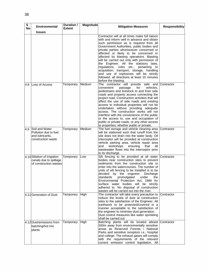
Table 10: Environmental Management Plan S No
Environmental
Issues
Duration / Extent
Magnitude Mitigation Measures Responsibility
1 Location Impacts
1.1 Temporary impacts on road side shops and other livelihood activities.
Temporary Low Implement compensatory measures as per the Short Resettlement Plan (SRP)
HSRDC
2 Design and pre-construction Impacts
2.1 Road furniture Permanent Medium All roadside structures / furniture, protection, intersections, traffic islands, etc is provided as per the road safery requirement
HSRDC
2.2 Alterations of drainage pattern of the site
Permanent Medium Necessary cross-drainage works proposed and designed to avoid alteration of drainage pattern. Design has been done considering 50 year return flood level to avoid overtopping of the road and maintain natural drainage
HSRDC
2.3 Removal road side
trees
Permanent High Unavoidable as the trees are within the proposed road carriage way; trees within the RoW but not required to be cut are identified. For trees not proposed to be cut, but within the construction area, take all precautions to protect trees not impacted from any damage including placement of tree guards Prior approval and clearance from Forest Department will be obtained; necessary budget for compensatory afforestation will be deposited with the Forest Department as per the Forest Departments procedures Tree plantation will be taken up in the ROW where land is available, considering the road safety issues
HSRDC
2.4 Impact on community and cultural properties and relegious places
Temporary Negligible The designs are worked out to avoid impacts on cultural properties, shrines etc.
HSRDC
3 Pre-construction Activities by Contractor
3.1 Construction Camps – Location, Selection, Design and Layout
Temporary Medium The construction camps will be located at least 500m away from habitations
Contractor
3.2 Drinking water availability and water arrangement
Temporary Medium The contractor will be responsible for arrangement of water in every workplace at suitable and easily accessible place for the whole construction period. Sufficient supply
Contractor
36
S No
Environmental
Issues
Duration / Extent
Magnitude Mitigation Measures Responsibility
of cold potable water (as per IS: 10500) to be provided and maintained. If the drinking water is obtained from an intermittent public water supply then, storage tanks will be provided. Contractor should obtain all required permission for abstraction of groundwater and/or surface water for use in construction activities and camps
Establishment of hot mix plants, crushers, etc if required
Temporary High Establish plants/crushers away from habitations Obtain the consent-to-establish and consent-to-operate from the Pollution Control Board Adhere to the air pollution and water pollution standards prescribed.
Contractor
3.3 Identification of
disposal sites
Permanent Low Location of disposal sites will be finalized based on consultations with the Engineer. The Engineer will certify these are not located within designated environmentally sensitive areas and confirm that: Disposal of the material does not impact natural drainage courses No endangered / rare flora is impacted by such material Settlements are located at least 1000m away from the site Contractor should obtain authorization for disposal of hazardous wastes as per Hazardous Waste (Management and Handling) Rules 1989
Contractor
3.4 Quarry Operations Permanent Medium It has to be ensured that materials are obtained from licensed quarries having environmental clearance. Quality and legality to be examined by the Contractor and copies of environmental clearances for these needs to be submitted prior to sourcing of material. If new borrow pits are made for gravel in the private or revenue lands, quarry pit closure/restoration plans shall be prepared and implemented before completion of work
Contractor
3.5 Batching Plants Temporary High Batching plants will be located sufficiently away from habitation, where possible such plants will be located at least 500m away from the nearest habitation. The contractor will obtain the consent to operate the plants from the SPCB.
Contractor
4 Construction Impacts
4.1 Improper stockpiling of construction materials can cause impacts starting from obstruction of drainage, disturbance/ safety hazard to local population, traffic blockage, etc.
Temporary High Due consideration will be given for material storage and construction sites such that it doesn’t cause any hindrance to daily traffic movement. Stockpiles will be covered to protect from dust and erosion.
Contractor
37
S No
Environmental
Issues
Duration / Extent
Magnitude Mitigation Measures Responsibility
4.2 Quarry / Borrow pits
Operations
Permanent Medium Material should be procured only from licenced quarries Adequate safety precautions will be ensured during transportation of quarry material from quarries to the construction site. Vehicles transporting the material will be covered to prevent spillage. Operations to be undertaken by the contractor as per the direction and satisfaction of the Engineer.
Contractor
4.3 Stripping, stocking and preservation of top soil
Permanent Low The topsoil from borrow areas, areas of cutting and areas to be permanently covered will be stripped to a specified depth of 150mm and stored in stockpiles. The stockpile will be designed such that the slope does not exceed 1:2 (vertical to horizontal), and the height of the pile is to be restricted to 2m. Multiple handling will be kept to a minimum to ensure that no compaction will occur. The stockpiles will be covered with gunny bags or tarpaulin. It will be ensured by the contractor that the topsoil will not be unnecessarily trafficked either before stripping or when in stockpiles. Such stockpiled topsoil will be returned to cover the disturbed area and cut slopes.
Contractor
4.4 Soil Erosion Permanent Low At the outfall of each culvert, erosion prevention measure, will be undertaken, as per the direction and satisfaction of the Engineer The work will consist of measures as per design, or as directed by the Engineer to control soil erosion, sedimentation and water pollution. All temporary sedimentation, pollution control works and maintenance thereof will be deemed as incidental to the earthwork or other items of work.
Contractor
4.5 Compaction of Soil in
agricultural area
Temporary Low To minimize soil compaction construction vehicle, machinery and equipment will move or be stationed in designated area (RoW or CoI, haul road as applicable) only. The haul road for construction materials will be routed to avoid agricultural areas
Contractor
4.6 Blasting Temporary Low Except as may be provided in the contract or ordered or authorized by the Engineer, the Contractor will not use explosives. Where the use of explosives is so provided or ordered or authorized, the Contractor will comply with the requirements of the following Sub-Clauses of MoRTH 302 besides the law of the land as applicable. The Contractor will at all times take every possible precaution and will comply with appropriate laws and regulations relating to the importation, handling, transportation, storage and use of explosives and will, at all times when engaged in blasting operations, post sufficient warning flagmen, to the full satisfaction of the Engineer. The
Contractor
38
S No
Environmental
Issues
Duration / Extent
Magnitude Mitigation Measures Responsibility
Contractor will at all times make full liaison with and inform well in advance and obtain such permission as is required from all Government Authorities, public bodies and private parties whomsoever concerned or affected or likely to be concerned or affected by blasting operations. Blasting will be carried out only with permission of the Engineer. All the statutory laws, regulations, rules etc., pertaining to acquisition, transport, storage, handling and use of explosives will be strictly followed. all directions at least 10 minutes before the blasting.
4.8 Loss of Access Temporary Medium The contractor will provide safe and convenient passage for vehicles, pedestrians and livestock to and from side roads and property access connecting the project road. Construction activities that will affect the use of side roads and existing access to individual properties will not be undertaken without providing adequate access. The construction works will not interfere with the convenience of the public or the access to, use and occupation of public or private roads, or any other access to properties, whether public or private.
Contractor
4.9 Soil and Water Pollution due to fuel and lubricants, construction waste
Temporary Medium The fuel storage and vehicle cleaning area will be stationed such that runoff from the site does not drain into the water body. Oil interceptor will be provided at construction vehicle parking area, vehicle repair area and workshops ensuring that all wastewater flows into the interceptor prior to its discharge.
Contractor
4.10 Siltation of irrigation canals due to spillage of construction wastes
Temporary Low Silt fencing to be provided at all water bodies near construction sites to prevent sediments from the construction site to enter into the watercourses. The number of units of silt fencing to be installed is to be decided by the engineer. Discharge standards promulgated under the Environmental Protection Act, 1986 for surface water bodies will be strictly adhered to. No disposal of construction wastes will be carried out into the river.
Contractor
4.11 Generation of Dust Temporary High The contractor will take every precaution to reduce the levels of dust at construction sites to the satisfaction of the Engineer. All earthwork to be protected/covered in a manner acceptable to the satisfaction of the engineer to minimise dust generation. Dust control measures like water sprinkling shall be carried out
Contractor
4.12 Dust/emissions from
batching/hot mix
plants
Temporary High Batching plants will be located atleast 500m away from environmentally sensitive areas as Reserved Forests / National Parks and sensitive receptors i.e., hospital and college. The exhaust gases will comply with the requirements of the relevant current emission control legislation. All
Contractor
39
S No
Environmental
Issues
Duration / Extent
Magnitude Mitigation Measures Responsibility
operations at plants will be parameters will be as per monitoring plan undertaken in accordance with all current rules and regulations protecting the environment. Monitoring of air and noise
4.13 Emission from Construction Vehicles, Equipment and Machinery
Temporary Low The discharge standards promulgated under the Environmental Protection Act, 1986 will be strictly adhered to. All vehicles, equipment and machinery used for construction will conform to the relevant Bureau of Indian Standard (BIS) norms. All vehicles, equipments and machinery used for construction will be regularly maintained to ensure that pollution emission levels comply with the relevant requirements of SPCB and the Engineer. ‘PUC’ certificates will be obtained regularly for all vehicles used for the project. Copies will be submitted regularly to the Engineer.
Contractor
4.14 Dust Pollution from
Crushers
Temporary High All crushers will obtain siting clearance from SPCB or only those crushers that have already have obtained license from SPCB will be used.
Contractor
4.15 Noise from construction Equipments
Temporary Medium Maintenance of vehicles, equipment and machinery will be regular and to the satisfaction of the Engineer, to keep noise from these at a minimum. All vehicles and equipment used for construction will be fitted with exhaust silencers. During routine servicing operations, the effectiveness of exhaust silencers will be checked and if found to be defective will be replaced. Noise limits for construction equipment used in this project (measured at one metre from the edge of the equipment in free field) such as compactors, rollers, front loaders, concrete mixers, cranes (moveable), vibrators and saws will not exceed 75 dB (A), as specified in the Environment (Protection) Rules, 1986 Notwithstanding any other conditions of contract, noise level from any item of plant(s) must comply with the relevant legislation for levels of noise emission.
Contractor
4.16 Traffic Control and
Safety
Temporary High The contractor will take all necessary measures for the safety of traffic during construction and provide, erect and maintain such barricades, including signs, marking flags, lights and flagmen as per Engineer’s direction and satisfaction, for the information and protection of traffic approaching or passing through the section under improvement. Before taking up any construction, detailed Traffic Management Plans will be prepared and submitted to the Engineer for approval, 5 days prior to commencement of work on any section of road. The traffic control plans shall contain details of arrangements for construction under traffic and details of traffic arrangement after cessation of work each
Contractor
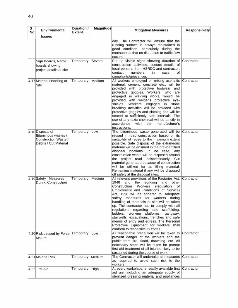
40
S No
Environmental
Issues
Duration / Extent
Magnitude Mitigation Measures Responsibility
day. The Contractor will ensure that the running surface is always maintained in good condition, particularly during the monsoon so that no disruption to traffic flow occurs.
Sign Boards, Name
boards showing
project details at site
Temporary Severe Put up visible signs showing duration of construction activities, contact details of focal persons from HSRDC and contractor, contact numbers in case of complaints/grievances
Contractor
4.17 Material Handling at
Site
Temporary Medium All workers employed on mixing asphaltic material, cement, concrete etc., will be provided with protective footwear and protective goggles. Workers, who are engaged in welding works, would be provided with welder’s protective eye-shields. Workers engaged in stone breaking activities will be provided with protective goggles and clothing and will be seated at sufficiently safe intervals. The use of any toxic chemical will be strictly in accordance with the manufacturer’s instructions.
Contractor
4.18 Disposal of Bituminous wastes / Construction Waste / Debris / Cut Material
Temporary Low The bituminous waste generated will be reused in road construction based on its suitability of reuse to the maximum extent possible. Safe disposal of the extraneous material will be ensured in the pre-identified disposal locations. In no case, any construction waste will be disposed around the project road indiscriminately. Cut material generated because of construction will be utilized for as filling material. Remaining material if any will be disposed off safely at the disposal sites.
Contractor
4.19 Safety Measures During Construction
Temporary Medium All relevant provisions of the Factories Act, 1948 and the Building and other Construction Workers (regulation of Employment and Conditions of Service) Act, 1996 will be adhered to. Adequate safety measures for workers during handling of materials at site will be taken up. The contractor has to comply with all regulations regarding safe scaffolding, ladders, working platforms, gangway, stairwells, excavations, trenches and safe means of entry and egress. The Personal Protective Equipment for workers shall conform to respective IS codes.
Contractor
4.20 Risk caused by Force
Majure
Temporary Low All reasonable precaution will be taken to prevent danger of the workers and the public from fire, flood, drowning, etc. All necessary steps will be taken for prompt first aid treatment of all injuries likely to be sustained during the course of work.
Contractor
4.21 Malaria Risk Temporary Medium The Contractor will undertake all measures as required to avoid such risk to the workers
Contractor
4.22 First Aid Temporary High At every workplace, a readily available first aid unit including an adequate supply of sterilized dressing material and appliances
Contractor
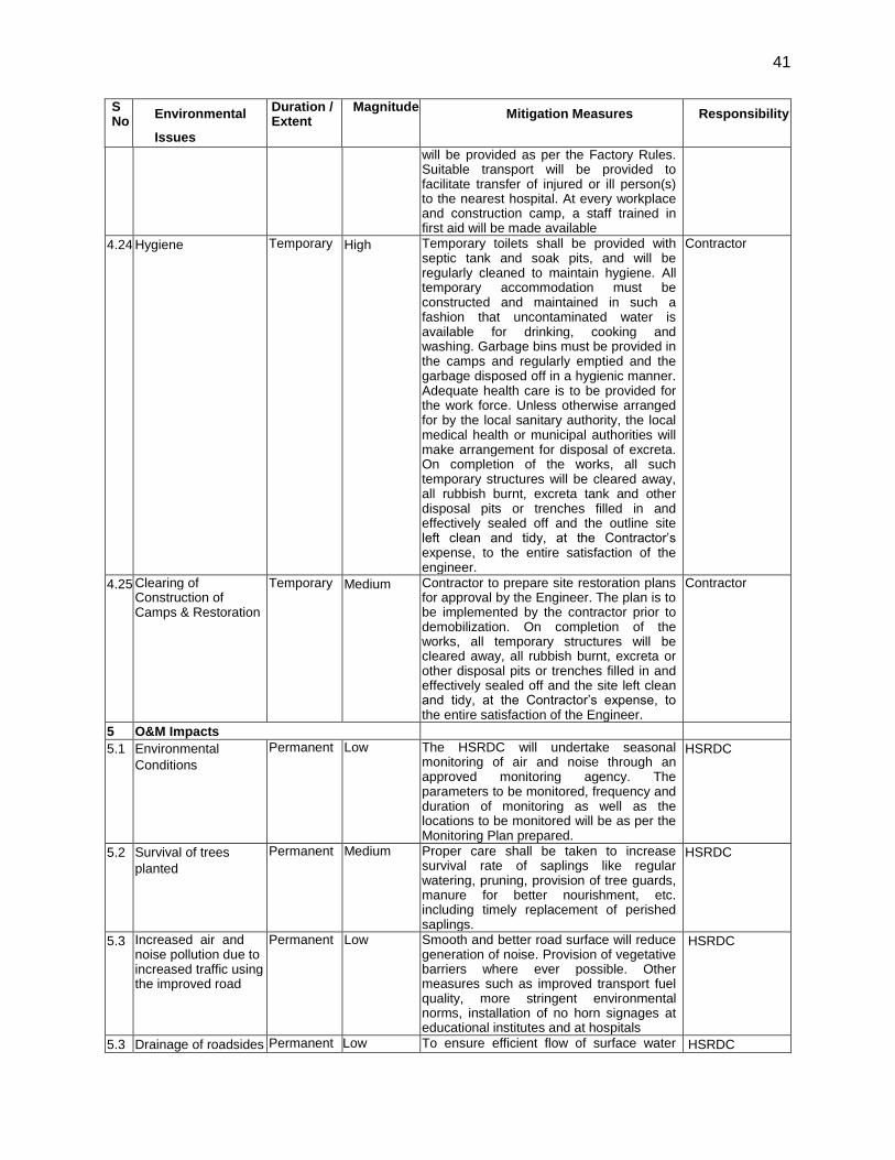
41
S No
Environmental
Issues
Duration / Extent
Magnitude Mitigation Measures Responsibility
will be provided as per the Factory Rules. Suitable transport will be provided to facilitate transfer of injured or ill person(s) to the nearest hospital. At every workplace and construction camp, a staff trained in first aid will be made available
4.24 Hygiene Temporary High Temporary toilets shall be provided with septic tank and soak pits, and will be regularly cleaned to maintain hygiene. All temporary accommodation must be constructed and maintained in such a fashion that uncontaminated water is available for drinking, cooking and washing. Garbage bins must be provided in the camps and regularly emptied and the garbage disposed off in a hygienic manner. Adequate health care is to be provided for the work force. Unless otherwise arranged for by the local sanitary authority, the local medical health or municipal authorities will make arrangement for disposal of excreta. On completion of the works, all such temporary structures will be cleared away, all rubbish burnt, excreta tank and other disposal pits or trenches filled in and effectively sealed off and the outline site left clean and tidy, at the Contractor’s expense, to the entire satisfaction of the engineer.
Contractor
4.25 Clearing of Construction of Camps & Restoration
Temporary Medium Contractor to prepare site restoration plans for approval by the Engineer. The plan is to be implemented by the contractor prior to demobilization. On completion of the works, all temporary structures will be cleared away, all rubbish burnt, excreta or other disposal pits or trenches filled in and effectively sealed off and the site left clean and tidy, at the Contractor’s expense, to the entire satisfaction of the Engineer.
Contractor
5 O&M Impacts
5.1 Environmental
Conditions
Permanent Low The HSRDC will undertake seasonal monitoring of air and noise through an approved monitoring agency. The parameters to be monitored, frequency and duration of monitoring as well as the locations to be monitored will be as per the Monitoring Plan prepared.
HSRDC
5.2 Survival of trees
planted
Permanent Medium Proper care shall be taken to increase survival rate of saplings like regular watering, pruning, provision of tree guards, manure for better nourishment, etc. including timely replacement of perished saplings.
HSRDC
5.3 Increased air and noise pollution due to increased traffic using the improved road
Permanent Low Smooth and better road surface will reduce generation of noise. Provision of vegetative barriers where ever possible. Other measures such as improved transport fuel quality, more stringent environmental norms, installation of no horn signages at educational institutes and at hospitals
HSRDC
5.3 Drainage of roadsides Permanent Low To ensure efficient flow of surface water HSRDC
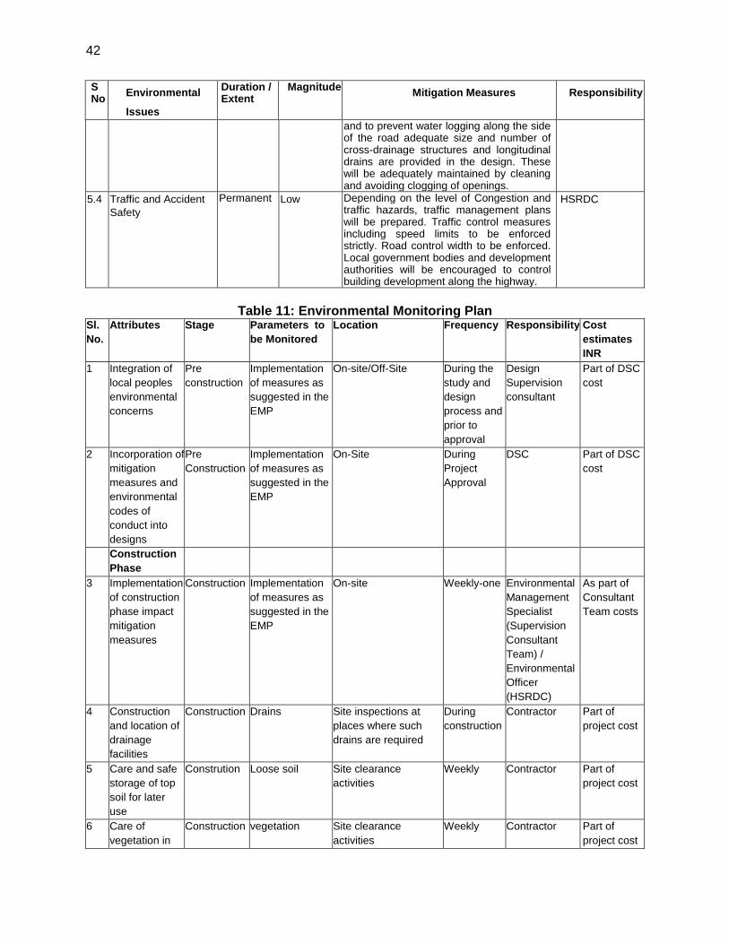
42
S No
Environmental
Issues
Duration / Extent
Magnitude Mitigation Measures Responsibility
and to prevent water logging along the side of the road adequate size and number of cross-drainage structures and longitudinal drains are provided in the design. These will be adequately maintained by cleaning and avoiding clogging of openings.
5.4 Traffic and Accident
Safety
Permanent Low Depending on the level of Congestion and traffic hazards, traffic management plans will be prepared. Traffic control measures including speed limits to be enforced strictly. Road control width to be enforced. Local government bodies and development authorities will be encouraged to control building development along the highway.
HSRDC
Table 11: Environmental Monitoring Plan
Sl.
No.
Attributes Stage Parameters to
be Monitored
Location Frequency Responsibility Cost
estimates
INR
1 Integration of
local peoples
environmental
concerns
Pre
construction
Implementation
of measures as
suggested in the
EMP
On-site/Off-Site During the
study and
design
process and
prior to
approval
Design
Supervision
consultant
Part of DSC
cost
2 Incorporation of
mitigation
measures and
environmental
codes of
conduct into
designs
Pre
Construction
Implementation
of measures as
suggested in the
EMP
On-Site During
Project
Approval
DSC Part of DSC
cost
Construction
Phase
3 Implementation
of construction
phase impact
mitigation
measures
Construction Implementation
of measures as
suggested in the
EMP
On-site Weekly-one Environmental
Management
Specialist
(Supervision
Consultant
Team) /
Environmental
Officer
(HSRDC)
As part of
Consultant
Team costs
4 Construction
and location of
drainage
facilities
Construction Drains Site inspections at
places where such
drains are required
During
construction
Contractor Part of
project cost
5 Care and safe
storage of top
soil for later
use
Constrution Loose soil Site clearance
activities
Weekly Contractor Part of
project cost
6 Care of
vegetation in
Construction vegetation Site clearance
activities
Weekly Contractor Part of
project cost
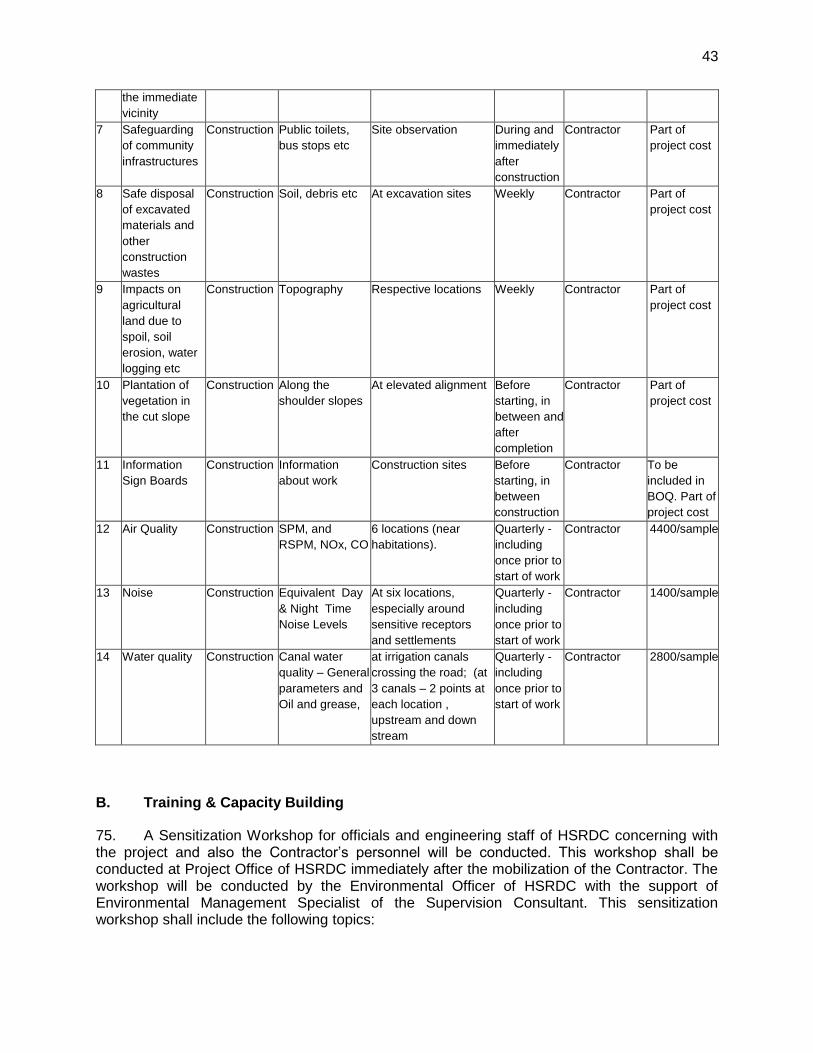
43
the immediate
vicinity
7 Safeguarding
of community
infrastructures
Construction Public toilets,
bus stops etc
Site observation During and
immediately
after
construction
Contractor Part of
project cost
8 Safe disposal
of excavated
materials and
other
construction
wastes
Construction Soil, debris etc At excavation sites Weekly Contractor Part of
project cost
9 Impacts on
agricultural
land due to
spoil, soil
erosion, water
logging etc
Construction Topography Respective locations Weekly Contractor Part of
project cost
10 Plantation of
vegetation in
the cut slope
Construction Along the
shoulder slopes
At elevated alignment Before
starting, in
between and
after
completion
Contractor Part of
project cost
11 Information
Sign Boards
Construction Information
about work
Construction sites Before
starting, in
between
construction
Contractor To be
included in
BOQ. Part of
project cost
12 Air Quality Construction SPM, and
RSPM, NOx, CO
6 locations (near
habitations).
Quarterly -
including
once prior to
start of work
Contractor 4400/sample
13 Noise Construction Equivalent Day
& Night Time
Noise Levels
At six locations,
especially around
sensitive receptors
and settlements
Quarterly -
including
once prior to
start of work
Contractor 1400/sample
14 Water quality Construction Canal water
quality – General
parameters and
Oil and grease,
at irrigation canals
crossing the road; (at
3 canals – 2 points at
each location ,
upstream and down
stream
Quarterly -
including
once prior to
start of work
Contractor 2800/sample
B. Training & Capacity Building
75. A Sensitization Workshop for officials and engineering staff of HSRDC concerning with the project and also the Contractor’s personnel will be conducted. This workshop shall be conducted at Project Office of HSRDC immediately after the mobilization of the Contractor. The workshop will be conducted by the Environmental Officer of HSRDC with the support of Environmental Management Specialist of the Supervision Consultant. This sensitization workshop shall include the following topics:
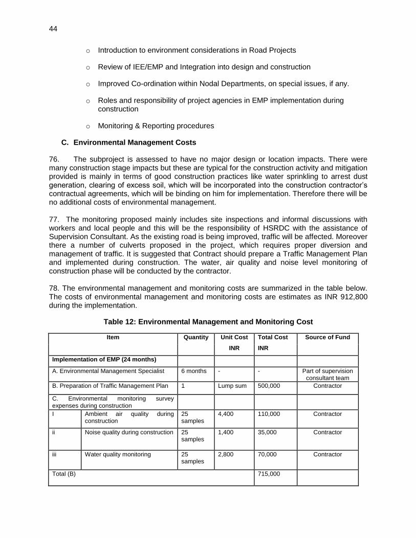
44
o Introduction to environment considerations in Road Projects
o Review of IEE/EMP and Integration into design and construction
o Improved Co-ordination within Nodal Departments, on special issues, if any.
o Roles and responsibility of project agencies in EMP implementation during construction
o Monitoring & Reporting procedures
C. Environmental Management Costs
76. The subproject is assessed to have no major design or location impacts. There were many construction stage impacts but these are typical for the construction activity and mitigation provided is mainly in terms of good construction practices like water sprinkling to arrest dust generation, clearing of excess soil, which will be incorporated into the construction contractor’s contractual agreements, which will be binding on him for implementation. Therefore there will be no additional costs of environmental management. 77. The monitoring proposed mainly includes site inspections and informal discussions with workers and local people and this will be the responsibility of HSRDC with the assistance of Supervision Consultant. As the existing road is being improved, traffic will be affected. Moreover there a number of culverts proposed in the project, which requires proper diversion and management of traffic. It is suggested that Contract should prepare a Traffic Management Plan and implemented during construction. The water, air quality and noise level monitoring of construction phase will be conducted by the contractor. 78. The environmental management and monitoring costs are summarized in the table below. The costs of environmental management and monitoring costs are estimates as INR 912,800 during the implementation.
Table 12: Environmental Management and Monitoring Cost
Item Quantity Unit Cost Total Cost Source of Fund
INR INR
Implementation of EMP (24 months)
A. Environmental Management Specialist 6 months - - Part of supervision consultant team
B. Preparation of Traffic Management Plan 1 Lump sum 500,000 Contractor
C. Environmental monitoring survey expenses during construction
I Ambient air quality during construction
25 samples
4,400 110,000 Contractor
ii Noise quality during construction 25 samples
1,400 35,000 Contractor
iii Water quality monitoring 25 samples
2,800 70,000 Contractor
Total (B) 715,000
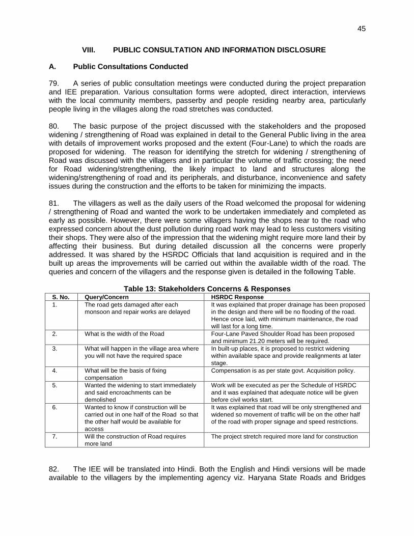
45
VIII. PUBLIC CONSULTATION AND INFORMATION DISCLOSURE
A. Public Consultations Conducted
79. A series of public consultation meetings were conducted during the project preparation and IEE preparation. Various consultation forms were adopted, direct interaction, interviews with the local community members, passerby and people residing nearby area, particularly people living in the villages along the road stretches was conducted. 80. The basic purpose of the project discussed with the stakeholders and the proposed widening / strengthening of Road was explained in detail to the General Public living in the area with details of improvement works proposed and the extent (Four-Lane) to which the roads are proposed for widening. The reason for identifying the stretch for widening / strengthening of Road was discussed with the villagers and in particular the volume of traffic crossing; the need for Road widening/strengthening, the likely impact to land and structures along the widening/strengthening of road and its peripherals, and disturbance, inconvenience and safety issues during the construction and the efforts to be taken for minimizing the impacts. 81. The villagers as well as the daily users of the Road welcomed the proposal for widening / strengthening of Road and wanted the work to be undertaken immediately and completed as early as possible. However, there were some villagers having the shops near to the road who expressed concern about the dust pollution during road work may lead to less customers visiting their shops. They were also of the impression that the widening might require more land their by affecting their business. But during detailed discussion all the concerns were properly addressed. It was shared by the HSRDC Officials that land acquisition is required and in the built up areas the improvements will be carried out within the available width of the road. The queries and concern of the villagers and the response given is detailed in the following Table.
Table 13: Stakeholders Concerns & Responses S. No. Query/Concern HSRDC Response
1. The road gets damaged after each
monsoon and repair works are delayed
It was explained that proper drainage has been proposed
in the design and there will be no flooding of the road.
Hence once laid, with minimum maintenance, the road
will last for a long time.
2. What is the width of the Road Four-Lane Paved Shoulder Road has been proposed
and minimum 21.20 meters will be required.
3. What will happen in the village area where
you will not have the required space
In built-up places, it is proposed to restrict widening
within available space and provide realignments at later
stage.
4. What will be the basis of fixing
compensation
Compensation is as per state govt. Acquisition policy.
5. Wanted the widening to start immediately
and said encroachments can be
demolished
Work will be executed as per the Schedule of HSRDC
and it was explained that adequate notice will be given
before civil works start.
6. Wanted to know if construction will be
carried out in one half of the Road so that
the other half would be available for
access
It was explained that road will be only strengthened and
widened so movement of traffic will be on the other half
of the road with proper signage and speed restrictions.
7. Will the construction of Road requires
more land
The project stretch required more land for construction
82. The IEE will be translated into Hindi. Both the English and Hindi versions will be made available to the villagers by the implementing agency viz. Haryana State Roads and Bridges
46
Development Corporation Limited (HSRDC). Copies of the IEE will be available at the office of the Executive Engineer, Jhajjar & Gurgaon Division and its availability as part of public disclosure will be widely publicized through the village Panchayats. HSRDC will continue consultations, information dissemination, and disclosure. Final IEE Report will also be disclosed in websites of ADB, HSRDC and NCRPB
B. Future Consultation and Disclosure
83. The public consultation shall be a continuous process and will continue in the future. The HSRDC will extend and expand the consultation and disclosure process during implementation.
1. Consultation during construction:
(i) Public meetings with affected communities to discuss and plan work programmes and allow issues to be raised and addressed once construction has started; and
(ii) Smaller-scale meetings to discuss and plan construction work with individual communities to reduce disturbance and other impacts, and provide a mechanism through which stakeholders can participate in subproject monitoring and evaluation.
2. Project disclosure
(i) Public information campaigns (via newspaper, TV and radio) to explain the project to the wider population and prepare them for disruption they may experience once the construction programme is underway;
(ii) Public disclosure meetings at key project stages to inform the public of progress and future plans, and to provide copies of summary documents in Hindi and;
(iii) Providing a mechanism through which comments can be made.
47
IX. FINDINGS AND RECOMMENDATIONS
84. The initial environmental examination process described in the earlier sections of this report assessed the environmental impacts of the proposed widening and strengthening of Bahadurgarh to Badli Road Project. Potential negative impacts were identified related to design, location, construction and operation of the project. Negative impacts due to the design and location are assessed to be minimal, and due to minimal operational and maintenance activities, there are no major negative impacts of operation. 85. The potential adverse environmental impacts of the proposed project are mainly related to the construction phase and which can be minimized by the proposed mitigating measures and environmentally sound engineering and construction practices. Mitigation measures have been developed to reduce all negative impacts to acceptable levels. 86. As stated above, most impacts are due to construction, this is because construction work is to be carried out on existing road carrying traffic and passing through habitation areas. The important impacts identified are: generation of dust and noise from construction activities; impacts due to disposal of large quantities of construction waste soil; disturbance and inconvenience to local people; affect on road side hawkers and vendors and public safety. 87. The potential impacts will be mitigated through provision of proven mitigation measures in the design and can further be offset by adoption of good engineering practices during construction and implementation. EMP prepared to this affect addresses these potential impacts through appropriate mitigation, management and monitoring measures. The effective implementation of the measures proposed will be ensured through the building up of capacity towards environmental management within the HSRDC supplemented with the technical expertise of an Environmental Management Specialist as part of the Supervision Consultant Team. Further, the environmental monitoring plans prepared as part of the EMP provide adequate opportunities towards course correction to address residual impacts during construction stages. 88. Preparation of a Traffic Management Plan is also recommended for ensuring site specific management measures to ensure road safety, and smooth traffic flow. An environmental monitoring plan has been developed to assess the environmental performance of subproject implementation. The EMP will be incorporated into the construction bid/contract. 89. The important recommendation of this IEE is that this Road Improvement Project can proceed for implementation provided all impacts are addressed through suggested mitigation measures. The other important recommendation is that the involuntary resettlement issues, which are identified through a parallel process of resettlement planning, need to be addressed by RP implementation prior to award of contract for civil works.
48
X. CONCLUSIONS
90. The main objective of the proposed Upgradation of Gurgaon-Chandu-Badli-Bahadurgarh in Jhajjar/Gurgaon District (Section Badli to Gurgaon Km 18.100 To Km 39.000 in Jhajjar/Gurgaon district) is to :-
o Reduce time taken to travel on the road with reduced traffic congestion. o Reduce road accidents o Improve ride quality, reduce air pollution
91. Thus ultimately this subproject aims to improve overall socio-economic conditions. This initial environmental examination has been conducted to identify and assess negative impacts. The project involves straightforward construction. Not many environmental issues were noticed during this initial environmental examination. In most cases, environmental issues identified are typical for the type of construction components, and a range of proven mitigation strategies exist to address them. 146. This IEE has assessed all potential environmental impacts associated with the project. There are no impacts, which are significant or complex or which needs an in-depth study to assess the impact or to develop the mitigation measures. The environmental impacts identified are manageable, and HSRDC will implement the mitigation measures as stated in IEE. The project therefore does not warrant environmental impact assessment (EIA). The project does not fall under the ambit of the EIA Notification, 2006 of Government of India, and therefore do not require Environmental Clearance from Ministry of Environment and Forest. However, the project requires permission and approval of Forest Department for diversion and use of forest land for road widening, and for cutting of trees, and this will be obtained before award of the Contract. Also, the Contractor requires consent of pollution control board for facilities like hot mix plants and crushers. It will be ensured that the consent is in place before start of the work.
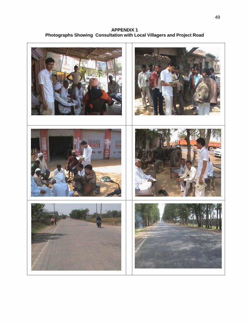
49
APPENDIX 1 Photographs Showing Consultation with Local Villagers and Project Road
50
APPENDIX 2 General Environmental Measures
A. Dust Control
o Barricade the work area which will also act as a dust and noise barrier o Apply water and maintain soils in a visible damp or crusted condition for temporary stabilization o Apply water prior to levelling or any other earth moving activity to keep the soil moist throughout
the process; o Use tarpaulins to cover loose material/soil that is transported to and from the site by truck o Control dust generation while unloading the loose material (particularly aggregate) at the site by
sprinkling water and unloading inside the barricaded area o Clean wheels and undercarriage of haul trucks prior to leaving construction site o Stabilize surface soils where loaders, support equipment and vehicles will operate by using water
and maintain surface soils in a stabilized condition where loaders, support equipment and vehicles will operate
o Don't allow access in the work area except workers to limit soil disturbance and prevent access by fencing/barricading
B. Safety o Follow standard, safe and quality construction practices; o Display Contractor Safety Policy on-site prominently o Prohibit public entry – unauthorized / accidental and enforce strictly – enclose/barricade the
construction area; provide warning boards and sign boards and posting of security guards throughout the day and night
o Ensure that all workers are provided with and use appropriate Personal Protective Equipment (helmet, hand gloves, boots, masks, safety hoists when working at height, etc);
o Barricade the entire area that may come under influence in case of accidents – this may particularly critical if heavy duty cranes are used;
o Follow standard practices of safety checks as prescribed before use of equipments such as cranes, hoists, etc.
o Provide on -site Health and Safety Training for all site personnel; o Report accidents to the authorities promptly, and maintain records o Conduct 15 minute safety briefing session every day prior to start of work
C. Traffic Management
o Prepare a Traffic Management Plan o Provide alternative traffic arrangement/detours so that traffic can be distributed and move on
different roads and ensure that public is informed about such traffic diversions; o Allow smooth traffic movement by confining and barricading the construction area; ideal vehicles
and equipment shall be parked within the confined area; o Provide necessary personnel to guide and control the traffic; o Provide information to the public through media – daily news papers and local cable television
(TV) services, about the need and schedule of work, and alternative routes; o At work site, public information/caution boards shall be provided - information shall inter-alia
include: project name, cost and schedule; executing agency and contractor details; nature and schedule of work at that road/locality; traffic diversion details, if any; entry restriction information; competent official’s name and contact for public complaints;
o Barricade the site properly; avoid accidental entry of traffic (pedestrian/vehicular) into site.
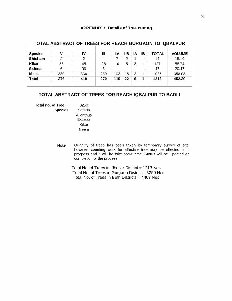
51
APPENDIX 3: Details of Tree cutting
TOTAL ABSTRACT OF TREES FOR REACH GURGAON TO IQBALPUR
Species V IV III IIA IIB IA IB TOTAL VOLUME
Shisham 2 2 -- 7 2 1 -- 14 15.10
Kikar 38 45 26 10 5 3 -- 127 58.74
Safeda 6 36 5 -- -- -- -- 47 20.47
Misc. 330 336 239 102 15 2 1 1025 358.08
Total 376 419 270 119 22 6 1 1213 452.39
TOTAL ABSTRACT OF TREES FOR REACH IQBALPUR TO BADLI
Total no. of Tree 3250
Species Safeda
Ailanthus Excelsa
Kikar
Neem
Note Quantity of trees has been taken by temporary survey of site, however counting work for affective tree may be effected is in progress and it will be take some time. Status will be Updated on completion of the process.
Total No. of Trees in Jhajjar District = 1213 Nos Total No. of Trees in Gurgaon District = 3250 Nos
Total No. of Trees in Both Districts = 4463 Nos
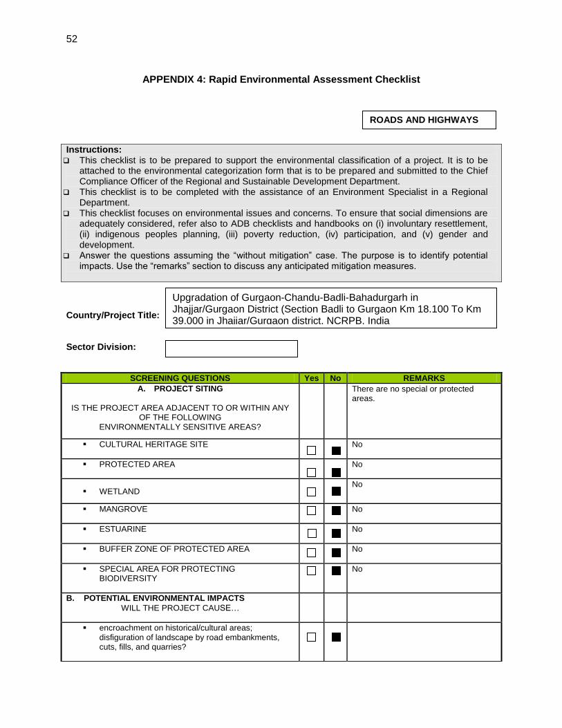
52
APPENDIX 4: Rapid Environmental Assessment Checklist
Instructions: This checklist is to be prepared to support the environmental classification of a project. It is to be
attached to the environmental categorization form that is to be prepared and submitted to the Chief Compliance Officer of the Regional and Sustainable Development Department.
This checklist is to be completed with the assistance of an Environment Specialist in a Regional Department.
This checklist focuses on environmental issues and concerns. To ensure that social dimensions are adequately considered, refer also to ADB checklists and handbooks on (i) involuntary resettlement, (ii) indigenous peoples planning, (iii) poverty reduction, (iv) participation, and (v) gender and development.
Answer the questions assuming the “without mitigation” case. The purpose is to identify potential impacts. Use the “remarks” section to discuss any anticipated mitigation measures.
Country/Project Title: Sector Division:
SCREENING QUESTIONS Yes No REMARKS
A. PROJECT SITING
IS THE PROJECT AREA ADJACENT TO OR WITHIN ANY
OF THE FOLLOWING ENVIRONMENTALLY SENSITIVE AREAS?
There are no special or protected areas.
CULTURAL HERITAGE SITE
No
PROTECTED AREA
No
WETLAND No
MANGROVE
No
ESTUARINE
No
BUFFER ZONE OF PROTECTED AREA
No
SPECIAL AREA FOR PROTECTING BIODIVERSITY
No
B. POTENTIAL ENVIRONMENTAL IMPACTS
WILL THE PROJECT CAUSE…
encroachment on historical/cultural areas; disfiguration of landscape by road embankments, cuts, fills, and quarries?
ROADS AND HIGHWAYS
Upgradation of Gurgaon-Chandu-Badli-Bahadurgarh in Jhajjar/Gurgaon District (Section Badli to Gurgaon Km 18.100 To Km 39.000 in Jhajjar/Gurgaon district, NCRPB, India
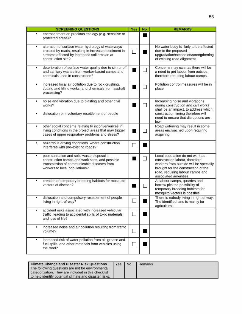
53
SCREENING QUESTIONS Yes No REMARKS
encroachment on precious ecology (e.g. sensitive or protected areas)?
alteration of surface water hydrology of waterways crossed by roads, resulting in increased sediment in streams affected by increased soil erosion at construction site?
No water body is likely to be affected due to the proposed upgradation/expansion/strengthening of existing road alignment
deterioration of surface water quality due to silt runoff and sanitary wastes from worker-based camps and chemicals used in construction?
Concerns may exist as there will be a need to get labour from outside, therefore requiring labour camps.
increased local air pollution due to rock crushing, cutting and filling works, and chemicals from asphalt processing?
Pollution control measures will be in place
noise and vibration due to blasting and other civil works?
dislocation or involuntary resettlement of people
Increasing noise and vibrations during construction and civil works shall be an impact, to address which, construction timing therefore will need to ensure that disruptions are low.
other social concerns relating to inconveniences in living conditions in the project areas that may trigger cases of upper respiratory problems and stress?
Road widening may result in some areas encroached upon requiring acquiring.
hazardous driving conditions where construction interferes with pre-existing roads?
poor sanitation and solid waste disposal in construction camps and work sites, and possible transmission of communicable diseases from workers to local populations?
Local population do not work as construction labour, therefore workers from outside will be specially brought for the construction of the road, requiring labour camps and associated amenities.
creation of temporary breeding habitats for mosquito vectors of disease?
At labour camps, quarries and borrow pits the possibility of temporary breeding habitats for mosquito vectors is possible.
dislocation and compulsory resettlement of people living in right-of-way?
There is nobody living in right of way. The identified land is mainly for agricultural
accident risks associated with increased vehicular traffic, leading to accidental spills of toxic materials and loss of life?
increased noise and air pollution resulting from traffic volume?
increased risk of water pollution from oil, grease and fuel spills, and other materials from vehicles using the road?
Climate Change and Disaster Risk Questions
The following questions are not for environmental categorization. They are included in this checklist to help identify potential climate and disaster risks.
Yes No Remarks
`

54
Is the Project area subject to hazards such as earthquakes, floods, landslides, tropical cyclone winds, storm surges, tsunami or volcanic eruptions and climate changes (see Appendix I)?
√
No
Could changes in temperature, precipitation, or extreme events patterns over the Project lifespan affect technical or financial sustainability ?
√ No.
Are there any demographic or socio-economic aspects of the Project area that are already vulnerable (e.g.,high incidence of marginalized populations, rural-urban migrants, illegal settlements, ethnic minorities, women or children)?
√ No
Could the Project potentially increase the climate or disaster vulnerability of the surrounding area ?
√ No