Embed Size (px)
Citation preview
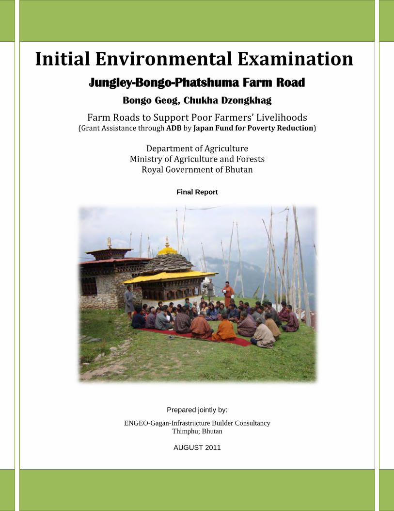
Initial Environmental Examination Jungley-Bongo-Phatshuma Farm Road
Bongo Geog, Chukha Dzongkhag
Farm Roads to Support Poor Farmers’ Livelihoods (Grant Assistance through ADB by Japan Fund for Poverty Reduction)
Department of Agriculture
Ministry of Agriculture and Forests Royal Government of Bhutan
Final Report
Prepared jointly by:
ENGEO-Gagan-Infrastructure Builder Consultancy Thimphu; Bhutan
AUGUST 2011

1
Abbreviations and Acronyms
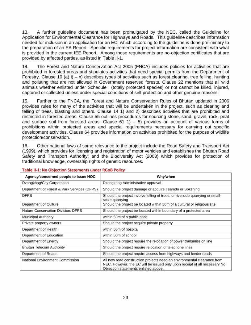
ADB Asian Development Bank BHU Basic Health Unit BPC Bhutan Power Corporation CA Competent Authority CC Construction Contractor CSC Construction Supervision Consultant CPS Community Primary School DA Dzongkhag Administration DC Design Consultant DE District Engineer DEC District Environmental Committee DGM Department of Geology and Mining DES Dzongkhag Engineering Section DFPS Department of Forest and Park Services DOA Department of Agriculture DOR Department of Roads EA Environmental Assessment EC Environmental Clearance EFRC Environmental Friendly Road Construction EIA Environmental Impact Assessment EMO Environmental Management Officer EMP Environment Management Plan ES Environmental Specialist FAO Food and Agriculture Organization FMU Forest Management Unit FNCA Forest and Nature Conservation Act GA Geog Administration GIU Grant Implementation Unit IEE Initial Environmental Examination JFPR Japan Fund for Poverty Reduction m a s l Meters above sea level MOAF Ministry of Agriculture and Forests MOHCA Ministry of Home Cultural Affairs MOWHS Ministry of Works and Human Settlement NCB National Contract Bidding NCD Nature Conservation Division NEC National Environmental Commission NGO Non-government organization NOC No Objection Certificate NSB National Statistical Bureau NTFPS Non-Timber Forest Products ORC Out Reach Clinic PAPs Project Affected Persons PHCB Population and Housing Census of Bhutan REA Rapid Environmental Assessment RGoB Royal Government of Bhutan RNP Road Network Project
2
RNR Renewable Natural Resources ROW Right-of-way RUG Road User Group RWSS Rural Water Supply Scheme SPS Safeguard Policy Statement TOR Terms of Reference
Weights and Measures Ha hectare km kilometer km2 square kilometer m mm
Meter Millimeter
Mt metric tons
3
Executive Summary
I. INTRODUCTION
1. This report summarizes the findings and results of the Initial Environmental Examination (IEE) for the ADB assisted Japan Fund for Poverty Reduction (JFPR) for development of Farm Roads to Support Poor Farmers’ Livelihoods. The IEE briefly describes the Project, existing environmental conditions in the project area, anticipated environmental impacts and corresponding mitigation measures, public consultation process, the environmental management plan (EMP) and its monitoring plan.
2. The Project develops 10.650 km farm road and its auxiliary drainage features for the Department of Agriculture, Royal Government of Bhutan (RGoB). The project is located in Chukha Dzongkhag. The objective of the RNP is to improve transport efficiency on the trunk road network and expand accessibility in rural areas, which will contribute to expanding economic opportunity and reducing poverty. This objective will be achieved by (i) improving and shortening a major north–south road, (ii) constructing feeder roads, (iii) enhancing capacity in the Department of Roads for managing road assets, and (iv) facilitating private sector participation in the domestic contracting industry. The proposed JFPR project will further improve access for remote rural communities by providing farm roads to connect to these feeder roads. Improved road access will allow poor rural households, which depend on agriculture, to grow larger marketable surpluses and increase their incomes. Farm roads will enable better access to economic and social services, which usually do not reach these remote and sparsely populated areas.
3. The IEE was prepared over a period of two months from April to June 2011 on behalf of the Department of Agriculture of RGoB. Field data were collected jointly with the engineering team survey and preparing road design. Mapping information was shared and field trips were conducted jointly with the engineering team. The environmental assessment process was incorporated in project design and contributed to recommendations for improving project construction and operation.
4. The IEE was prepared in accordance with relevant laws and regulations of RGoB, including the Environmental Assessment Act (2000), the Regulation for the Environmental Clearance of Projects (2001) and the Guideline for Application for Environmental Clearance for Highways and Roads (2004); and with the ADB Environment Policy, 2002, and Environmental Impact Assessment Guidelines, 2003; and the Safeguard Policy Statement currently under review are ADB framework documents.
5. After completing the detailed design of the project road, the DOA will seek forestry clearances from the Department of Forest and Park Services (DFPS). When these have been obtained, DOA will seek environmental clearance from National Environmental Committee (NEC). The civil works will begin only when this has been received for relevant sections.
II. DESCRIPTION OF PROJECT
6. The project involves construction of a Jungley-Bongo-Phatshuma farm road within Chukha Dzongkhag. The new farm road is 10.65 km in length and it is a continuation of the Mirchim – Bongo (Jungley) Feeder Road constructed under Road Network Project (RNP) financed by ADB. The combined Mirchim – Jungley – Bongo - Phatshuma route will connect Gedu and Bongo to Phuentsholing and Thimphu with major reductions in travel distances. The route starts from a flat agricultural land and orange orchard at Jungley with approximate elevation of 973 m.a.s.l and gradually ascends with four hairpin bends towards Ochelumchhu crossing at an elevation of 1178 m.a.s.l. After this stream crossing, the road passes through forest area and makes four zigs to reach Bongo village. Near Bongo village, the road passes mostly through paddy fields. From Bongo (1388 m.a.s.l) till the
4
termination point at Phatshuma (1280 m.a.s.l) village road passes through more or less uniform gradient with slight descent nearing termination point. Side slopes are relatively flat, 15 – 50 degrees, and earthwork quantities should be moderate to high.
7. Farm road will be constructed to a standard section consisting of a 5.10 m formation and 3.5 m carriage width and longitudinal drainage structures. The design of the roadway cross-section will still depends on conditions at a given location, which differ somewhat in that ground slopes are greater in some areas, some alignments traverse catchments, others maintain grade along the slope of an escarpment.
8. Hydraulic structures will constitute substantial part of project cost. The project will require at two major RCC culverts (12 m span over Ochelumchhu and 10 m span over Chomchelumchhu streams). Overall, at least 15 cross drainage structures mainly Hume piper culverts are required which will be adapted to pass excess debris passing down the drainage channel by flaring wing walls. Longitudinal drains are placed on upslope of roadways and, in some locations, curb and pipe drains may be installed in areas where the roadway width is confined by the slope of the mountain side.
9. Associated facilities consist of quarries, construction and worker camps, equipment and material storage areas, fuel depots and work staging areas. Quarries are expected to be small, localized operations since there are good quarry materials available from excavation of the roadways. Proper spoil disposal sites will be needed for most segments where side hill materials have been removed and require disposal. Construction camps to house 50-100 workers will be needed on roadway segment. These camps will consist of sleeping quarters, washing and bathing facilities, latrines and waste disposal facilities, a food service facility or canteen, and other auxiliary features. Aggregate crushing and grading plants, concrete batch plants and other associated facilities are also required on each contract. Locations for these facilities will be determined by the construction contractor in accordance with the stipulations of the EMP and other imposed constraints.
10. The IEE was undertaken during the feasibility study of project roads. Detailed engineering study is being carried out and followed by the procurement. Construction will be commenced in September 2011, targeting completion in 2013.
III. DESCRIPTION OF THE ENVIRONMENT
A. Physical Resources
1. Rainfall and Temperature
11. Information on rainfall and temperature has been taken from the Tala weather station (1745 meters above sea level or (masl) in Chukha close to project as a representation of the rainfall and temperature of the project area. Average total annual rainfall in the area varies, but can reach 3,000 mm. Maximum rainfall occurs in the months of June – August, which are also the warmest months when temperatures touch 28°C. The coolest months are from November to February when the temperatures are as low as 3°C.
2. Geology and Seismology
12. The area is quite stable geologically. The project area falls basically within the Thimphu Formation of the Higher Himalayan Belt. This formation is made up of pre-Cambrian metamorphic garnets and schist and granite gneiss, and is a prominent geological formation in Bhutan. Phyllite, Quartzite, Limestone and dolomite are the main rock types. The soil is mostly loamy and residual. Clay loam is common on higher altitudes.
5
3. Hydrology
13. The Wang Chhu is the main river system within project area which originates in the high Himalayas and flow through narrow defiles, emerging into the flat plains of the Duar in India, and eventually draining into the Brahmaputra River. Flooding is rare in mountain regions where rivers may rise by only 2-3 m in flood stage, but serious floods occur once the rivers enter the Duar. Base flow is provided by snowmelt and springs at lower elevations. Heavy rainfall during the monsoon provides peak flow to these rivers.
14. Two perennial streams drain mountain slopes in the project area. Flow lines of these upland streams are steep, often 40% or more. As streams converge into rivers and the size of the upstream catchment increases, flow lines flatten with overall gradients in the range of 0.5%.
B. Biological Resources
1. Protected Areas
15. The project road does not fall in any of the sensitive or critical wildlife habitat, protected areas and its’ biological corridors. Refer figure on Bhutan Conservation Areas and Project Road Segment.
2. Forests
16. Overall forest cover is nearly 85% for the Chukha Dzongkhag within the project area. Forest types that are likely to be found within the project area are generally classified as warm broadleaf forest, depending on location in enclosed valleys or on exposed slopes. These forests are multi-storied and exhibit high floral diversity. At least 50 different types of tree species were recorded during the field visit.
17. Forests are managed according to four types: government owned national forest, community forest, sokshing (registered to an individual person or household) and private tree plantations. Government forests are managed by the Department of Forests while community forest is managed by the village or a community. The sokshing (woodlots) and private forests are owned and managed by individuals, households and local communities. No forest management units (FMUs) are within the project’s area of influence. No endangered or protected plant species is observed or reported within the project area.
3. Wildlife
18. The project road does not fall inside important wildlife habitat. However, the warm broadleaf forests are rich habitats of bird species among the forest types. Hence, the project road comprises many bird species including the globally endangered Rufous necked hornbill (Aceros nipalensis).
C. Socioeconomic Resources
19. As per Population and Housing Census (PHCB 2005), Chukha Dzongkhag has second highest population in Bhutan, 74,387 people. There are 11 Gewog namely Sampheling, Darla, Lokchina, Phuentsholing, Bongo, Bjachho, Chapcha, Dungna, Getena, Geling, Metakha and one Drungkhag under the Dzongkhag. The current proposed farm road falls entirely under Bongo Geog. PHCB 2005 record shows that Bongo geog has six chiwogs with 1326 households and a population of 6,870 people. The Small Area Estimation of Poverty in Rural Bhutan, 2010, jointly carried out by World Bank & National Statistical Bureau (NSB), confirms the number of poor in the geog to be 1072. The poverty rate for geog is estimated to be 16%.
20. The principal crops grown in the project area include paddy, maize, millet, pulses, oranges, and cardamom. Delivering products to markets is difficult due to the lack of roads. The sale of livestock and
6
livestock products is another important source of income for farmers who rear all types of domestic animals available in Bhutan.
21. Community and rural infrastructure constructed by RGoB include primary schools, basic health unit, outreach clinics, and irrigation and rural water supply schemes. Most of the villages are now electrified through the Rural Electrification Project supported by ADB and other donors.
22. As per the 2005 census, Chukha has received net in-migration of 15,480 of its total population. However, in-migrations are mostly to the towns and urban centers. But findings study on Rural-urban migration in Bhutan by PPD, MOAF shows that the rural areas of Chukha have seen out-migrations 15% of the total population (which is about 45% of households). The rural-urban migration is primarily due to lack access to education facilities, off-farm jobs and inadequate or non existence of service facilities.
D. Physical Cultural Resources
23. There are few religious, historical and cultural sites in the project area. There are no known archeological sites in the project affected area. The area contains visual and aesthetic resources that are typical of the lower Himalayan foothills, but recreational opportunities are limited due to lack of access.
IV. ANALYSIS OF ALTERNATIVES
A. The No-Project Alternative
24. The Project provides benefits that stem from improved transport links in rural parts of the Country. Without the project there is little means for improving public services or utilizing resources produced in the area to contribute to the national economy. Some 6,870 persons inhabit the Geog served by the Project, which is 9% of the Dzongkhag population, and for the most part this segment of the population is weakly linked to the national economy. Many young people currently leave the area because opportunities are few for participation in the national economy. Public services and economic opportunities will increase for these people as a result of improved transport connectivity. Trade and production links can be enhanced by improved transportation.
25. Benefits stemming from the project in terms access, and poverty alleviation are far greater than the potential and expected negative environmental impacts such as direct forest loss and poaching. Hence, the IEE addresses environmental impacts in conjunction with economic and social impacts and concludes there is no potential for severe, long term or irreversible impact, which would give rise to justification for the no project alternative.
B. Location and Alignment Alternatives
26. The alignment for Jungley-Bongo-Phastshuma has been determined on the basis of slope stability; settlement, land use conditions and socio-economic aspects, and preferred locations for stream crossings. The alignment has been fixed jointly by Road Engineer, Surveyor, Environmentalist, and the Tshogpas of Junglay, Bongo and Phatshuma villages.
27. The alignment option at the takeoff (Jungley village) is limited to a specific corridor to avoid prime agriculture land. Other determining factors of alignment location were the stream crossings. RCC Culverts or small bridges over Ochelumchhu and Chomchelumchhu Streams were selected on the basis of stability and length of the culverts. Other smaller or dry gully crossings have been chosen to avoid unstable geological conditions. The alignment was fixed to avoid rocky areas or cliffs between Junglay and Bongo, and before Phastshuma after Bongo village. The alignment terminates at Phatshuma village.
7
C. Technology and Roadway Standards
28. IEE recommends the adoption of practices set out in the Guidelines for environmentally sound roadway construction, but with a degree of flexibility that insures that costs are not compounded excessively. In short, guidelines should be applied with an attitude toward practicality that allows the Project to be implemented efficiently yet with minimal environmental impact. Application of bioengineering principles will need to be determined by the Grant Implementation Unit (GIU) during detailed design in conjunction with the construction contractor.
V. ANTICIPATED ENVIRONMENTAL IMPACTS AND MITIGATION MEASURES
A. Physical Environment
1. Air Quality
a. During Construction
29. Air emissions during construction arise from the operation of construction machinery, vehicles, blasting and clearing of rubble, operation of quarry pits and hauling of materials. Emissions from rock crushing operations, aggregate drying and hot mix plants also degrade air quality. The problem is present wherever construction is taking place in varying degrees, but is generally not so great as to affect regional air quality; however impacts are most severe where there are communities, homes, businesses and institutional buildings in the vicinity of construction that causes local ground level air quality to deteriorate.
30. To minimize issues of dust the contractor will be required to regularly water roadway surfaces particularly where there are community areas (such as Jungley, Bongo & Phatshuma villages). Spraying may be done twice daily or at such frequency as is needed to minimize impacts. Since the actual lengths involved are relatively short, the contractor should be able to provide near complete coverage of critical sections. All vehicles transporting materials should be covered properly.
31. Rock crushing, cement preparation, aggregate drying and surface treatment preparation operations (whether bituminous asphalt or spray seal mixes) should be removed a sufficient distance (two km) from habitations and community environments to assure there are no community impacts.
All equipments, machinery and vehicles used for the project must be well maintained in order for proper functioning as well as reduction in air pollution.
b. During Operations
32. During operations, air emissions from vehicles can affect air quality, with consequent impacts on human health and the living environment. Since these roadways will not bear a heavy traffic load, it is expected that vehicular air emissions during operation will not pose a particular problem.
2. Noise
33. Noise emissions during construction and operation may affect wildlife and community values.
a. During Construction
34. Noise impacts originate from the operation of construction equipment in the vicinity of homes, institutional buildings, stores and wildlife habitat areas, and from rock blasting at Ochelumchhu stream stretch. This is an unavoidable consequence of construction that should be mitigated by limiting the times of construction to daylight hours in the vicinity of sensitive receptors.
8
35. The contractor will prepare a blasting procedure requiring area restrictions; prior warning of workers, nearby residents and those passing through the area; restrictions on the timing of blasts; and worker safety procedures. Controlled blasting should be carried out during the daytime to prevent disturbance to wildlife during the night, dawn and dusk.
36. Road segment near takeoff (Jungley), at Bongo and Phatshuma are the principal areas where construction will be conducted in the near vicinity of communities; however all routes will enter settled areas either at their starting points or termini; and noise will result in some exposure along short stretches on these routes.
b. Operations
37. During operations, noise emissions disturb community life and the living environment. Noise impacts from vehicles traveling along these roadways are not expected to be significant due to the light traffic loads and low density of settlements.
3. Geology, Soils and Tectonics
38. Impacts on the soil environment occur from a number of causes during the detailed design, construction and operation stages of the roadways.
a. During Detailed Design
39. The project road falls inside high rainfall. As a result the likelihood of landslides and erosion are high both during construction and operation stages. Hence, EFRC’s technique of benched slope cutting with balanced cut and fill approach is recommended for incorporation into the detailed design. Technical Specification and Standard Drawing for the construction of farm roads of DoA, May 2009, shall be referred during the detailed designed of the farm road.
b. During Construction
40. The roads will mostly be cut into the side slopes of mountains ranging from 45 to 80 degrees; hence the zone of construction is constricted in terms of access and disposal of spoil material. Impacts in the form of landslides and erosion may occur due to cutting and excavation of the roadbed. Though erosion, rock falls, are unavoidable during cutting works, appropriate methods of excavation and benching recommended during the detailed design must be followed to minimize these impacts. All borrow areas must be properly restored after use.
41. Use of borrow areas where necessary will result in formation of open pits. This can lead to issues of erosion. Hence, after use all borrow areas must be properly restored by filling with unwanted material generated from the construction works. The top soil of the borrow area must be kept aside and reused to seal the borrow areas at the end of its use.
42. The need for quarries should be minimized by use of materials cut from the roadway alignment. A road side quarry has been identified in at chainage km 5+840. Failure to properly grade and contour a quarry location at closure leads to potential hazard from personal accident or slope failure. This can also result in adverse impacts on the drainage in quarry areas. A development plan should be prepared by the contractor that estimates approximate quantities and final contours. Blasting procedures should be put into place for the development of quarries. Necessary government clearances for land and resource use should be obtained by the contractor prior to commencement of work in the area.
c. During Operations
43. Though recommendations have been provided in the detailed design and construction stage for adoption of proper methods and techniques for excavation and earth works and provision of adequate
9
support and drainage structures, there may still be problems of erosion and landslides during operation. This is often unavoidable due to the steep slopes and unstable soils. Under such circumstances, necessary engineering and bio engineering measures will need to be taken to help stabilize slopes. In addition maintenance engineers should develop and apply means for predicting slope failures in advance and buttress slopes where necessary.
44. Bioengineering techniques applied during the construction will become effective over the operations period of the project. It is likely that some of the techniques proposed may not work or the plants used may not regenerate as expected. To avoid this, the freshly planted seedlings and other plant material will need to be monitored and necessary steps will need to be taken to maximize plant growth. Immediately replacement of plants that do not survive will need to be made.
4. Water Resources and Water Quality
45. Effects on local drainage, river flow and water quality can occur during detailed design, construction and during the operation of roadways. A complex relationship exists between the road and the water environment that must be mutually accommodated to guarantee the integrity of the road structure and avoid impact on the water resource.
a. During Detailed Design
46. Roadside drainage in community areas should receive particular attention by the detailed design team to assure that the roadway surface does not concentrate rainfall and cause damage to local properties such as agricultural fields and irrigation channels.
47. Engineering and hydrological criteria should be applied to the design of drainage structures (RCC culverts over Ochelumchhu and Chomchulumchhu streams). Specific attention must be given to longitudinal road side drains, culverts and bridges.
48. Roadway embankments that run parallel to river or streams should be placed at an adequate elevation above maximum high water level and embankments should be protected with gabions. Gabions needed for river training have already been identified for some locations. Other locations need to be identified by the detailed design engineering group.
49. Extreme meteorological conditions and other environmental factors can exceed the capacity of drainage structures, erode slopes and destroy pavement structures. The preliminary and detailed design engineers should take into account cost and historical rainfall data for catchments in determining the preliminary sizing of structures, stability of slopes and height of roadway embankments along rivers and streams. The criteria applied to the sizing of structures should conform to class for roadway being constructed. Later these same factors should be verified by the detailed design engineer.
b. During Construction
50. Recommended designs and structures proposed by the detailed design consultant must be implemented during the construction stage to mitigate potential impacts on water resources during construction.
51. Construction activities increase loss of soil from surfaces exposed to rain and flowing water, increasing sediment loss to rivers and streams. Slope erosion occurs during rainy periods in vulnerable areas. Land clearing and excavation should be stopped in rainy periods.
52. Temporary measures to reduce erosion involve placement of log barriers or stone barriers at the base of slopes in accordance with recommended EFRC construction methods. Long term mitigation involves application of bioengineering techniques such as seeding and stabilizing slopes, in order to reduce sediment loss.
10
53. Disposal of construction rubble over the hill side and into the streams or rivers below are prohibited. This will on one hand prevent disruptions and formation of temporary dams in the streams and rivers and on the other hand reduce resultant visual scars on the topography. Proper housekeeping in equipment and supply yards must be maintained to avoid soil and water pollution.
c. Operations
54. It is imperative to implement the mitigation measures proposed during the detailed design stage while constructing the road. This will help to minimize negative impacts on the water resources during operation of the road segments.
55. However, given the high rainfall, existence of numerous streams in the project area as well as existence of local water supply facilities, problems may arise during operation of the road. Necessary mitigation measures will need to be taken by the respective Geog or Dzongkhag Administration.
56. Upstream check dams may be installed to arrest the flow of debris down the channel. Also, maintenance of culverts over the operating life of the roadway is important. Beneficiaries should remove debris that interferes with the flow in culverts.
B. Biological Environment
1. Forests
57. The Geog encompassing the roadway alignment are mostly forested. Hence, it is unavoidable that forests will be displaced in order to provide locations for the roadways, and as a result natural habitats will be lost.
a. During Detailed Design and Pre-Construction
58. Specific forestry rules exist for removal of trees. Hence, all necessary paperwork and tree marking procedures must be followed in accordance with the requirements of the Forest and Nature Conservation Rules. It must be ensured that all paperwork and approvals are obtained well ahead in time to prevent delays in construction.
59. To prevent disposal of spoil materials on the lower slope below the roadway grade and hence destruction of forests and vegetation preliminary locations for deposit of spoil materials must be identified by the detailed design team to be confirmed by the Project Management Office.
b. During Construction
60. A total of about 13.60 acres of forest will be displaced for the project roads out of a total land area of about 34.75 acres of cleared area. FAO data (1999) indicates forest coverage (dense and open forest combined) averages 85% in Chukha dzongkhag. Placement of the roadways results in small percent of reduction in existing forest cover.
61. The magnitude of impact is judged to be minimal, and Government rules do not require any offset measures involving planting of trees elsewhere. The official procedure for assuring that the Government obtains economic value from the timber and other usable wood products should be enforced.
62. Clearing of forested right-of-ways in anticipation of road construction may extend into adjacent forests causing loss of habitat, which adds to the total amount of forests lost due to the project. Hence, only necessary vegetation and trees falling with the ROW must be removed through clear markings. Appropriate revegetation of the fresh cut slopes and road shoulders must be carried out immediately after construction works in each road segment. In addition compensatory tree plantations can be
11
carried out in suitable spaces particularly the empty camp sites that are left behind after the completion of construction works. Any organized removal of trees from public lands outside the boundary of the construction area should be punishable as a criminal offense.
63. Disposal of spoil materials and any other forms of construction debris over the edge of the hillside is prohibited, and spoil materials are to be disposed off at designated locations.
64. During construction, workers can cause further destruction of forests for collecting fuel wood. The construction contractor will prohibit firewood gathering among the worker population, and is required to provide construction camps with proper food supplies, fuel and housing facilities.
65. Stone crushing unit can be installed at 5+840 km nearer to proposed roadside quarry. Stone crushing will generate a lot of dust and noise. As a result the areas and forests surrounding rock crushing sites are covered in a layer of dust. This will negatively impact the natural growth of the trees and shrubs as well as health of the workers themselves. Regular water spraying in and around the stone crushing machinery will be necessary. Water can be collected from nearby Chomchulumchhu stream some 300 meter away from the crushing plant.
c. During Operation
66. Since the traffic volumes anticipated in the project road segments, impacts of pollution on the forests will be negligible.
67. Bioengineering and revegetation activities carried out during construction may result in problems such as poor regeneration and survival. Necessary replantation and other remedial actions will need to be taken by the respective RUG responsible for maintenance of the roads.
2. Wildlife
a. Detailed Design and Pre-construction
68. Roadway may form a barrier that blocks the daily and seasonal movement of wildlife during the operational life of the project. Except for the small patch of forest before Phatshuma village, the current farm road alignment does not pass through the sensitive or critical wildlife habitat areas. The design consultant should incorporate benched slope cutting into the detailed design to facilitate the movement of wildlife along the forest section before Phatshuma village.
b. Construction
69. Most of the project road falls inside the degraded forest or habitat area. However, it is still important that the construction contractor follow the recommendations provided in the detailed design for various structures and measures to facilitate animal movement and conservation.
70. Conduction of construction activities during early morning or late evening hours will result in disturbances to wildlife. Working time must be limited to day light hours only. Special precautions must be taken during conduction of noisy activities such as blasting, drilling and operation of stone crushing machinery. Controlled blasting must be carried out as far as possible if blasting works are necessary.
71. Construction workers may hunt, fish or carry out other activities that will negatively impact wildlife. All activities of such kind must clearly be prohibited by the contractor. To remove all possible reasons that may encourage workers to take up these activities, the contractor must ensure that necessary food items, cooking fuel and proper housing is provided
12
c. Operation
72. Access to conservation areas could lead to increased poaching of wildlife and illegal harvesting of forest products on one hand and facilitate monitoring activities for forestry officials on the other hand.
73. Benefits from the roads for conservation should outweigh impacts so long as the roads are integrated into the management plans for the respective areas.
74. Operation of motor vehicles may cause collisions with wildlife. However, it is expected that direct collisions between vehicles and wildlife will not be frequent because these are not high speed roads; drivers are generally intent on observing road conditions, vehicle traffic volumes are not high and appropriate signs indicating wildlife presence will be posted.
C. Socioeconomic Environment
75. The employment of labor and importation of workers into an area may have adverse effects on the socioeconomic environment. Contractors are required to provide adequate living and working conditions for workers, including lodging in a camp setting outside of any danger zone, food service facilities, safe drinking water, adequate washing and bathing facilities for maintaining personal hygiene, and access to health care. The contractor should establish and maintain a safety and accident prevention program involving provision of adequate protective gear and clothing, well maintained construction equipment, training for workers to assure they are adequately skilled in their jobs, and recordkeeping related to accident frequency combined with measures to correct deficiencies that have shown to be the cause of accidents. The contractor should provide sanitary facilities (dry pit or pour flush latrines) for workers and arrange for disposal of solid waste in accordance with local practice, which at a minimum should provide for collection, burning and burial of rubbish at controlled sites away from human habitation. Workers hired by roadway contractor should be screened in advance for HIV/AIDS. The Multi-sector Taskforce in Dzongkhag undertakes periodic HIV/AIDS and human trafficking awareness programs.
76. The contractor is responsible for preventing any public liability by assuring that slopes are stable at the end of construction in a given work area and for avoiding hazard to workers, adjacent property and people. Flagmen should be posted to regulate passage of people where slopes are temporarily unstable as a result of blasting and excavation, and the movement of people restricted in those areas until they are rendered safe. Property damage or injury should be adjudicated and compensated under the resettlement plan.
77. The specific locations where these impacts have been noted during the field reconnaissance, along with proposed mitigation measures, are tabulated in the EMP. In the event any archeological remains are uncovered, the contractor should halt construction upon their discovery and notify the GIU, who will contact the relevant government authority to investigate and undertake recovery.
VIII. CONSULTATION, DISCLOSURE AND GRIEVANCE MECHANISM
A. Stakeholder Analysis
78. Stakeholders include institutions and cohorts of individuals affected either beneficially or adversely, directly or indirectly, by the Project. Those adversely affected by environmental impact include those directly exposed to construction impacts due to their proximity to the roadway, those entitled to compensation for structures and land for widening of the right-of-way, those along haul routes of construction materials, and those who may be affected by long term impacts stemming from the roadway during its operation. Stakeholders benefiting from the Project include groups which are engaged in economic pursuits in the area, whether it be transport of agricultural, manufactured and handicraft products to market, sourcing of resources and raw materials, sale of products in an
13
expanded market or the purchase of those goods. Local administrators benefit through closer ties with parent national agencies. Regional and national stakeholders include groups making up the citizenry of the Nation and the various groups within RGoB. International stakeholder groups are found in the tourism and conservation sectors.
B. Process for Involvement of Public
79. To initiate the first stage of public consultation, the DOA on behalf of the Consultant wrote official letters to the Dzongkhag (district) and Dungkhag (sub-district) administrations instructing them to inform the public living in the study area of the proposed road development projects, working through geog administrations. Affected dzongkhag of Chukha was informed of the impending road feasibility studies through this process. The feasibility study team inclusive of staff of the environmental and social components conducted field surveys of the alignments to obtain primary data, and visited each affected village along the proposed routes. Environmental staff conducted public consultation according to a prescribed format and in accordance with specific objectives.
80. Participants were specifically asked their views on issues related to the road condition, beneficiary and affected groups, impacts of the road due to existing conditions and expected impacts from proposed rehabilitation measures, priorities for transport, environmental issues, community participation and women’s issues. Attendance and detailed response forms for the first stage public consultation have been well recorded in the course of carrying out the IEE.
81. National public consultation to be held in Thimphu to provide an opportunity for government and NGO stakeholders along with interested citizens to provide comment and ask questions concerning the project, potential environmental impacts and mitigation measures.
C. Further Milestones in Public Involvement and Grievance Mechanism
82. Public consultation is to be carried forward through implementation by both environmental and social components of the project. Event milestones include formal public consultation over environmental issues at local level prior to start of construction contracts and at midpoint during construction contract implementation; and formal public consultation regarding social impact.
D. Compliance with Regulatory Requirements
83. The RGoB requires that the public be heard at all levels concerning environmental and social impacts of projects: the issuance and enforcement of environmental clearances is meant “to provide meaningful opportunities for public review of potential environmental impacts of projects” (Environmental Assessment Act, 2000) and that the environmental report shall contain “public comments received by the Competent Authority for each project.” Section 31 of the Law clearly states the minimum procedures that apply to significant projects, which have been met by the public consultation effort of social and environmental components of the project.
E. Summary of Public Acceptance and Opinion
84. Most comments concerned social issues, compensation and status of land claims. Some comments related to environmental impact, specifically location of cross drainage to avoid damage to fields, maintaining an acceptable distance from villages and homes, adjusting the alignment to avoid taking storefront property, avoiding damage to homes and land from debris generated during construction, and maintaining and preserving small water supplies, irrigation canals, orchards, stupas and natural features that are abodes of local deities.
85. Alignment issue is the major concern of the People of Jungley, Bongo and Phatshuma. People expressed deep appreciation for the ongoing RNP road (Meritsemo – Jungley) and for the proposed
14
farm road from Jungley to Phatshuma via Bongo. One important comment from the public was to design road in such a way to avoid damage of orange orchard and paddy field at the takeoff inside Jungley. Orange production and sale is the major source of income of the rural households of Jungley and Phatshuma village. People of Bongo village expressed concern to minimize the damage of paddy fields. The connection or access to BHU and School at Bongo village is of great importance to people of all three villages. All participants agreed to provide their land voluntarily, if required for the road construction. Public involvement and response form and the No objection certificate (NOC) from the communities of Jungley, Bongo and Phatshuma are attached as Appendix B and C of this report.
VII. ENVIRONMENTAL MANAGEMENT PLAN
A. Environmental Management Plan and Responsible Authorities
86. The Environmental Management Plan (EMP) provided as appendix A in the main report will serve as a guideline for incorporating environmental measures to be carried out by DOA, the project manager, contractor and other parties to mitigate possible impacts of the Project. The EMP needs to be updated at the beginning of implementation, especially once the detailed design is completed so that details of locations and the frequency of monitoring can be defined in a more practical way.
87. DOA through the project manager is responsible for ensuring that (i) all required mitigation measures that need to be incorporated into the project design are passed onto the engineering consultants, (ii) the bidding document for contractor contains all required mitigation measures to be implemented during the construction period and contractors' obligations to implement the EMP during construction, (iii) the environmental clearance is obtained before commencement of civil work in the relevant section of project road, (iv) implementation of EMP is monitored regularly as required and the annual report on implementation of the EMP is well documented, (v) other parties and government agencies implement the EMP at all stages of the Project, (vi) remedial actions are undertaken in response to unpredicted environment impacts, and (vii) additional environmental assessment is undertaken if any change is alignment or project design takes place.
88. To ensure that contractors comply with the provisions of the EMP, the following specifications should be incorporated in all construction bidding documents: (i) the environmental mitigation measures and environmental monitoring works that need to be implemented by the contractor; (ii) environmental clauses for contract conditions and specifications; and (iii) the IEE report.
B. Environmental Monitoring and Reporting, and Institutional Capacity
89. Monitoring the implementation of mitigation measures will be the responsibility of various parties but primarily of Grant Implementation Unit (GIU) under DOA over the duration of the Project. These parties will in turn be responsible for reporting the results of their monitoring activities. Reporting is a tiered operation that provides summary information at higher levels of accountability, generally in conjunction with reporting done for the overall progress of the Project. Monitoring and reporting refers to the period of grant implementation. Monitoring activities during operations are also addressed herein; however the accountability for implementation of mitigation measures during the operations phase is the responsibility of the RGoB rather than ADB.
90. Government agencies and staff may also be involved in monitoring environmental performance on the Project, including the Nature Conservation Division (NCD) under Department of Forest and Park Services and the Environmental officers working for NEC at Dzongkhag administration. Dzongkhag administration will have the authority to monitor and enforce construction impact mitigation measures alongside other responsible agents, specifically where impacts have a direct effect on the local community.
15
IX. CONCLUSIONS AND RECOMMENDATIONS
A. Minimized Adverse Effects
91. Adverse effects are related to construction and to operational phases of the project and effects are noted on physical, biological and socioeconomic domains of the environment.
92. Potential adverse effects from construction have been identified in all three domains of the environment and have been minimized by prevention and mitigation measures, as well as by a monitoring presence during the construction activity. These have been set out in the EMP.
93. EMP implementation especially with the use of EFRC will reduce significantly any potential environmental impact. Impacts remaining on the physical environment (air and water pollution) are temporary and often occur away from the presence of people. The biological environment will reconstitute itself following any residual or remaining impacts on it. Short term impacts on communities and households have been minimized by maintaining facilities, such as water supply systems, in service and by reducing construction interference with everyday life.
94. Potential adverse effects during operations of the roadways have been minimized through the process of preliminary design that fixes the alignments in optimal locations in relation to roadway safety and community impact, through provision of designs and budgets for superior roadway drainage structures, and by accommodating the presence of wildlife in design.
B. Use of Irreplaceable Resources
95. There is minor use of irreplaceable resources in the form of biological losses, including forests, ecosystems and members of biological species. These losses are minor, since the amount represents only a small fraction of the total range of ecosystem available to a given species. As noted, ecosystem replacement in the form of compensatory planning is proposed under the Project. No other use of irreplaceable resources has been noted by the assessment.
C. Provisions for Follow-Up Surveillance and Monitoring
96. A systematic approach for surveillance and monitoring is provided by means of a management framework, and monitoring and reporting protocol. Follow-up public consultation is intended to provide future input to the identification of environmental impact during the construction phase as well as a grievance redress mechanism for project affected persons.
16
Table of Contents
Abbreviations and Acronyms ................................................................................................................. 1
Weights and Measures .......................................................................................................................... 2
Executive Summary ............................................................................................................................... 3
I. Introduction ................................................................................................................................... 20
A. Purpose of the Report ............................................................................................................... 20
B. Project Environmental and Social Objectives ............................................................................ 20
C. Area of Influence ................................................................................................................... 20
D. Data Sources ......................................................................................................................... 21
E. Status of IEE and Further Additions .......................................................................................... 21
II. Policy, Legal and Administrative Framework ................................................................................. 22
III. Description of the Project .......................................................................................................... 24
A. Development Context ................................................................................................................ 24
B. Major Features .......................................................................................................................... 24
C. Description of Roadway Alignment ........................................................................................ 27
1. Jungley-Bongo-Phatshuma Farm Road ................................................................................. 27
2. Cost, Size, Magnitude and Extent .......................................................................................... 28
3. Schedule for Implementation ................................................................................................. 28
4. Methods and Timing of Construction ..................................................................................... 28
D. Associated Facilities .............................................................................................................. 28
IV. Description of the Environment ................................................................................................. 30
A. Physical Resources ................................................................................................................... 30
1. Meteorology and Climate ....................................................................................................... 30
2. Geology, Soil and Ground Water ........................................................................................... 31
3. Hydrology, Water Quality and Sediment ................................................................................ 31
B. Biological Resources ................................................................................................................. 32
1. Protected Area ....................................................................................................................... 32
2. Forest Resources and Land Cover ........................................................................................ 32
3. Mammal and Bird Life ............................................................................................................ 35
C. Socioeconomic Resources .................................................................................................... 38
1. Population and poverty .......................................................................................................... 38
2. Agriculture ............................................................................................................................. 38
3. Community Infrastructure....................................................................................................... 38
4. Migration ................................................................................................................................ 39
17
5. Labour and Employment ........................................................................................................ 39
D. Physical Cultural Resources .................................................................................................. 39
1. Religious, Historical, Cultural and Archeological Sites ........................................................... 39
2. Visual Aesthetic and Recreational Resources and Scenic Qualities ...................................... 39
V. Analysis of Alternatives ................................................................................................................. 40
A. The No-Project Alternative ........................................................................................................ 40
B. Location and Alignment Alternatives ......................................................................................... 40
1. Suitability in terms of Project Objectives ................................................................................ 40
2. Alignment Alternatives ........................................................................................................... 40
C. Technology and Roadway Standards .................................................................................... 41
D. Design ................................................................................................................................... 41
E. Operation .................................................................................................................................. 41
F. Cleaner Technology and Environmental Management Plan ...................................................... 41
VI. Anticipated Environmental Impacts and Mitigation Measures .................................................... 43
A. Physical Environment ................................................................................................................ 43
1. Air Quality .............................................................................................................................. 43
2. Noise ..................................................................................................................................... 44
3. Soil ........................................................................................................................................ 45
4. Water Resources and Water Quality ...................................................................................... 46
B. Biological Environment .............................................................................................................. 48
1. Forests .................................................................................................................................. 48
2. Wildlife ................................................................................................................................... 50
3. Summary of Impacts on Forest and Biodiversity .................................................................... 51
C. Socioeconomic Environment ................................................................................................. 52
1. Land Tenure .......................................................................................................................... 52
2. Labour Rights during Construction ......................................................................................... 53
3. Public Liability of Contractor and Damage to Local Infrastructure .......................................... 53
4. Archeological Remains .......................................................................................................... 55
5. Long Term Use of Roadway .................................................................................................. 55
VII. Consultation, Disclosure and Grievance Mechanism ................................................................. 56
A. Stakeholder Analysis ................................................................................................................. 56
B. Process of Involvement of Public .............................................................................................. 56
1. Early Screening ..................................................................................................................... 56
2. First Stage of Public Consultation .......................................................................................... 57
3. Second Stage of Public Consultation ..................................................................................... 57
C. Further Milestone in Public Involvement and Grievance Mechanism ..................................... 57
18
D. Compliance Regularity Regulatory Requirement ................................................................... 58
E. Summary of Information Disclosed ............................................................................................ 58
F. Summary of Public Acceptance and Opinion ............................................................................. 59
VIII. Environmental Management Plan.............................................................................................. 60
A. Acquisition of Prior Clearances and No-objection Certificates ................................................... 60
B. Mitigation Measures .................................................................................................................. 60
1. Summary of Specific Impacts and Mitigation Measures ......................................................... 60
C. Environmental Monitoring and Reporting ............................................................................... 69
D. Implementation ...................................................................................................................... 73
1. Periods of Applicability ........................................................................................................... 73
2. Management Framework ....................................................................................................... 74
IX. Conclusions and Recommendations ......................................................................................... 75
A. Compliance with Relevant Sector Guidelines of the RGOB ....................................................... 75
B. Gain that Justify Project Implementation ................................................................................... 75
C. Adverse Effects ..................................................................................................................... 75
1. Adverse Effects Minimized ..................................................................................................... 75
2. Adverse Effects Offset ........................................................................................................... 76
3. Adverse Effects Compensated .............................................................................................. 76
D. Use of Irreplaceable Resources ............................................................................................. 76
E. Provision for Follow-up Surveillance and Monitoring ................................................................. 76
X. References ................................................................................................................................... 77
Appendices .......................................................................................................................................... 78
A. Terms of Reference .................................................................................................................. 78
B. Public Involvement and Responses Forms ................................................................................ 86
C. No Objection Letter (NOC) of Jungley, Bongo and Phatshuma communities ......................... 88
D. Translation of No Objection Letter of Jungley, Bongo and Phatshuma communities .............. 94
E. ADB Rapid Environmental Assessment Checklist for Highways and Roads .............................. 97
F. List of Officials Met .................................................................................................................. 101
List of Figures Figure III-1: Project Location Map ........................................................................................................ 26Figure IV-1: : Temperature and Precipitation at Tala, Chhukha ............................................................ 30Figure IV-2: Geological formation and project location ......................................................................... 31Figure IV-3: Hydrology of Jungley – Bongo – Phatshuma Farm Road ................................................. 32Figure IV-4: Bhutan Conservation Areas and Location Jungley-Bongo-Phatshuma Farm Road .......... 33Figure IV-5: Land Cover Classification (Jungley – Bongo – Phatshuma Farm Road) ........................... 36Figure VII-1: Photo of Public Consultation at Bongo ............................................................................ 59Figure VII-2: Photo of consultation for fixing alignment ........................................................................ 59
19
List of Tables Table II-1: No Objection Statements under RGoB Policy ..................................................................... 23Table III-1: Proposed Road Related Technical Information .................................................................. 27Table IV-1: Natural Forest in the Project Area (FAO 1999) .................................................................. 32Table IV-2: Non Timber Forest Products in use along Roadway Alignments ........................................ 34Table IV-3: Land use change and forest loss ....................................................................................... 35Table IV-4: IUCN and National Status of Mammals ............................................................................. 35Table IV-5: Avifauna in Project Area .................................................................................................... 37Table IV-6: Community Infrastructure in Project Affected Geog ........................................................... 39Table IV-7: Cultural, Religious and Spiritual Sites or Structures ........................................................... 39Table VI-1: Land use and forest cover loss .......................................................................................... 49Table VII-1: Minimum Procedures that Apply to Significant Projects .................................................... 58Table VIII-1: Status of Clearances and No-objection Certificates ......................................................... 60Table VIII-2: Summary of the environmental impacts and proposed mitigation measures .................... 61Table VIII-3: Inspection, Monitoring and Verification Activities ............................................................. 69
20
I. Introduction
A. Purpose of the Report 1. This report presents the findings and results of the Initial Environment Examination (IEE) for the ADB assisted Japan Fund for Poverty Reduction (JFPR) for the development of Farm Roads to Support Poor Farmers’ Livelihoods. The investigative process involves characterizing activities related to development of the proposed roadways and predicting impacts on environmental resources. The investigation encompasses the affected area of the Project in respect to the roadway segments being proposed, the various phases of project development from preconstruction through operations, and the types of environmental resources potentially affected. This report is a presentation of the findings resulting from this process. Mitigation measures are proposed for potential impacts and impacts that cannot be avoided, and within the context of the Environmental Management Plan (EMP), monitoring indicators are specified. The environmental assessment is done under the guidance of the policies of the Asian Development Bank (ADB) and the Royal Government of Bhutan (RGoB) and includes chapters on description of the project, environmental resources, alternatives considered, environmental impacts and mitigation measures, mitigation and monitoring plan, economic assessment and public consultation procedures. Appendix A contains the terms of reference for the IEE approved by the National Environment Commission.
B. Project Environmental and Social Objectives 2. The Road Network Project (RNP) implemented by the Department of Road with the assistance of the ADB was aimed at improving transport efficiency on the trunk road network and expand accessibility in rural areas, which will contribute to expanding economic opportunity and reducing poverty. This objective was to be achieved by (i) improving and shortening a major north–south road, (ii) constructing feeder roads, (iii) enhancing capacity in the Department of Roads for managing road assets, and (iv) facilitating private sector participation in the domestic contracting industry. The proposed ADB assisted JFPR farm project is aimed to further improve access that has been developed through RNP for remote rural communities by providing farm roads to connect to these feeder roads. Improved road access will allow poor rural households, which depend on agriculture, to grow larger marketable surpluses and increase their incomes. Farm roads will enable better access to economic and social services, which usually do not reach these remote and sparsely populated areas.
C. Area of Influence 3. The Project is located within Bongo Geog under Chukha Dzongkhag. The area of influence is made up of the roadway formation width and a broad area housing the environmental resources affected by construction and operation of the roadways. Direct impacts from the project are mostly confined to the areas of the roadway alignments and adjacent land. The formation width is perhaps 100 m wide in steeply sloping conditions, but related geophysical features that parallel or encompass road segments may vary in size and orientation, and areas of influence extend beyond areas directly disturbed by construction. Effects in hilly areas along steep grades and winding ascents may extend some distance up- and down-slope from the roadway. Equipment staging, repair and refueling yards, labor camps, and access roads located outside the prescribed right-of-way, quarries, borrow pits and spoil disposal sites are areas within the direct influence of construction activities. During operations, noise and air pollution carry over some distance and may be considered adverse impacts in some settings, depending on their magnitudes and the presence of receptors. Roadways and related development interfere with migration pathways of animals that range over large areas causing effects on the biological environment.
21
4. The area of influence also includes biological and human communities potentially affected by cumulative impacts from project related developments. Impacts on forests and wildlife stem from a variety of causes during construction and operations, exerting a cumulative impact. Effects on the socioeconomic environment may occur in communities served by the roadways and are not constrained by physical and biological transport processes.
D. Data Sources 5. Prior to the field visit, the consultant collected and critically reviewed the secondary information related to the project, and local environment. This information included feasibility study of the proposed project, topographic maps and other thematic maps, prevailing environmental related legislations, policies and guidelines such as Environmental Assessment Act 2000, Regulation of Environmental Clearance of Project, 2002, Environmental Assessment Guidelines for Highway and Roads, Environmental Code of Practice for Highway and Roads, Guidelines for Preparation of Environmental Management Plan, Documents related to Environmental Friendly Road Constructions, etc. In addition, the consultant also collected information related to the environment in terms of forest resources, geology, topography, drainage patterns, protected areas, and socio-economic data along the project area.
6. Primary observations and data collection was jointly carried out by Environmental specialist, Road Engineer and Surveyor along with the local people and authorities (Gup, Mangmi and Tshogpas). The main information collected during the field work is environmental baseline in terms of physical, biological and socio-economic and cultural environment. The field work covered the entire road corridor.
E. Status of IEE and Further Additions 7. The IEE was prepared during the Feasibility Study over a two month period from 15 April – 15 June 2011 by environmental consultant under Joint venture firm – Engeo-Gagan-Infrastructure Builder Consultancy, engaged directly by the Department of Agriculture for feasibility study and subsequently survey and design.
8. The environmental assessment process was used to influence changes in project design, and can be further applied in an adaptive management sense to improve project construction and operation based on results of monitoring undertaken during implementation. The IEE should be reviewed at the time of grant implementation by the Department of Agriculture. Mitigation measures, monitoring requirements and costs contained in the EMP should be reviewed and adjusted based on updated information. Also, public consultation on social and environmental issues, and enactment of a grievance procedure for those affected by degradation of the living environment should be undertaken during project execution.
22
II. Policy, Legal and Administrative Framework 9. The Project is being developed within a framework based on the policies and guidelines of the ADB and the laws, regulations and guidelines of the RGoB. In regard to ADB, the Environment Policy of the Asian Development Bank (2002), the ADB Environmental Impact Assessment Guidelines (2002) and the Safeguard Policy Statement (SPS) 2009 are the framework documents. The RGoB framework documents are the Environmental Assessment Act (2000), Regulation for the Environmental Clearance of Projects (2001) and Guideline for Application for Environmental Clearance for Highways and Roads (2004). Other regulations of the RGoB require prior clearance for project activities.
10. ADB policy requires that an environmental assessment (IEE) be prepared by the borrower in accordance with ADB EA requirements and that loans are classified according to their potential impact on the environment. The current farm road project has been classified as Environmental Category B because of the potentially for less adverse environmental impacts. According to RGoB criteria, the Project requires preparation of an EIA which is equivalent to ADB’s IEE level study as project does not fall in any biologically or culturally sensitive areas. The ADB Rapid Environmental Assessment (REA) Checklist for Roads and Highways has been completed for the project (Appendix C), which, for similar reasons, indicates that the project should be classified as Category B.
11. The Royal Government of Bhutan has in place detailed policies regarding environmental assessment that are founded in the Environmental Assessment Act (2000). The National Environmental Commission (NEC) through its Secretariat is empowered to implement the EA Act, which sets out the guidelines for obtaining an environmental clearance (EC) for a project. Article 9 states that if the activity is going to be implemented by a Competent Authority (CA), the Application for Environmental Clearance is to be forwarded to the NEC for approval. The application for an EC must include a description of potential environmental effects. The Secretariat of the NEC determines if the information provided is sufficient to identify effects, and if not the Secretariat can request that environmental assessment documents be prepared, following approved terms of reference. Additional information may be required by the NEC Secretariat if the EIA/IEE is considered incomplete. The EC is issued when the Secretariat is satisfied that a) effects are foreseeable and acceptable, b) the applicant is capable of carrying out the terms of the EC, c) the Project is seen to contribute to sustainable development of the country, d) the interests of concerned people have been taken into account, and e) the project is consistent with the Nation’s environmental commitments. Once a decision is made, the environmental terms, description of mitigation measures and non-technical summary of the EC are made available to the public. The Secretariat also controls and monitors compliance with the terms of the EC (Art. 34.2). The EA Act provides right of access to work sites for monitoring and penalty provisions in cases of offense under the Act, including providing false information, denying access and other infractions.(Art. 49). The EA Act contains rules for appeals, dispute resolution, and other provisions.
12. The Regulation for the Environmental Clearance of Projects (February 2001) provides further information to supplement the EA Act. Upon receipt of the application for the EC a total period of 1- 3 months will be taken by NEC for issuing the EC. Official clearance from other concerned agencies is required for Projects within sensitive areas (Art. 17). Only upon receipt of all other clearances and No Objection Statements as given in table 2-1 will the EC be issued. The EC is valid for a period of five years or less, but may be renewed in cases where the Project is in compliance with the EC. Minimum requirements for public consultation are set forth in Section 31 of the Regulation. These include written notice to local communities, newspaper notices, facilitation of consultation, and provision of a minimum period of time for the public to comment on the EIA/IEE. The Regulation specifies that the EC will contain binding mitigation and compliance measures and appropriate means for monitoring, recordkeeping and reporting. The EC Regulation sets out requirements and formats that are similar to those of ADB.
23
13. A further guideline document has been promulgated by the NEC, called the Guideline for Application for Environmental Clearance for Highways and Roads. This guideline describes information needed for inclusion in an application for an EC, which according to the guideline is done preliminary to the preparation of an EA Report. Specific requirements for project information are consistent with what is provided in the current IEE Report. Among those requirements are no-objection certificates that are provided by affected parties, as listed in Table II-1.
14. The Forest and Nature Conservation Act 2005 (FNCA) includes policies for activities that are prohibited in forested areas and stipulates activities that need special permits from the Department of Forestry. Clause 10 (a) i) – x) describes types of activities such as forest clearing, tree felling, hunting and polluting that are not allowed in Government reserved forests. Clause 22 mentions that all wild animals whether enlisted under Schedule I (totally protected species) or not cannot be killed, injured, captured or collected unless under special conditions of self protection and other genuine reasons.
15. Further to the FNCA, the Forest and Nature Conservation Rules of Bhutan updated in 2006 provides rules for many of the activities that will be undertaken in the project, such as clearing and felling of trees, blasting and others. Clause 14 1) and 2) describes activities that are prohibited and restricted in forested areas. Clause 55 outlines procedures for sourcing stone, sand, gravel, rock, peat and surface soil from forested areas. Clause 61 1) – 5) provides an account of various forms of prohibitions within protected areas and special requirements necessary for carrying out specific development activities. Clause 64 provides information on activities prohibited for the purpose of wildlife protection/conservation.
16. Other national laws of some relevance to the project include the Road Safety and Transport Act (1999), which provides for licensing and registration of motor vehicles and establishes the Bhutan Road Safety and Transport Authority; and the Biodiversity Act (2003) which provides for protection of traditional knowledge, ownership rights of genetic resources.
Table II-1: No Objection Statements under RGoB Policy Agency/concerned people to issue NOC Why/when
Dzongkhag/City Corporation Dzongkhag Administrative approval
Department of Forest & Park Services (DFPS) Should the project damage or acquire Tsamdo or Sokshing
DFPS Should the project involve felling of trees, or riverside quarrying or small-scale quarrying
Department of Culture Should the project be located within 50m of a cultural or religious site
Nature Conservation Division, DFPS Should the project be located within boundary of a protected area
Municipal Authority within 50m of a public park Private property owners Should the project acquire private property
Department of Health within 50m of hospital Department of Education within 50m of school Department of Energy Should the project require the relocation of power transmission line Bhutan Telecom Authority Should the project require relocation of telephone lines
Department of Roads Should the project require access from highways and feeder roads
National Environment Commission All new road construction projects need an environmental clearance from NEC. However, the EC will be issued only upon receipt of all necessary No Objection statements enlisted above.
24
III. Description of the Project
A. Development Context 17. Bhutan is a mountainous and landlocked country where most live in remote villages without roads and therefore have limited access to health and educational facilities, markets, financial institutions, and other development benefits. In some parts of the country, particularly in the eastern region, people walk several hours to reach the nearest road head or market. Farm produce has to be carried on horseback or as head loads. This is a disincentive for farmers to grow more food, as it is not possible to market farm produce. This reduces income-earning opportunities for the rural poor, exacerbating their poverty. The government recognizes that access to roads is key to poverty reduction. At present 60 geogs out of 200 have no road connectivity at all, and these are considered as highest priority areas.
18. The overall goal of the government’s Tenth Five-Year Plan, 2008-2013 is poverty reduction. Almost 80% of the population lives on subsistence farming in far-flung and isolated villages. Improving rural access, with a particular focus on farm roads, is therefore a priority of the Tenth Plan. It has the ambitious target of constructing about 3,000 kilometers (km) of roads, compared with about 900 km during the Ninth Plan, of which 600 km was farm road. Limited access to markets contributes to high marketing costs and deters the commercialization of agriculture. Half of farmers in Bhutan have agriculture landholdings of 1 hectare or less, and these households are characterized as low income and resource poor. In the absence of farm access roads, commercial crops such as potatoes, apples, and oranges have to be carried long distance on foot. In many remote areas, fruit is left to rot on the trees as there is no way to get it to market. An access road allows farmers to use small vehicles to carry their produce more efficiently and quickly to collection centers.
19. The Road Network Project (RNP), financed by the Asian Development Bank (ADB), was approved in 2005. Its objective is to improve transport efficiency on the trunk road network and expand accessibility in rural areas, which will contribute to expanding economic opportunities and reducing poverty. The government requested ADB for assistance for farm roads to support poor farmers’ livelihoods in the geogs in which these feeder roads are being constructed under the RNP. Improved road access will allow poor rural households that depend upon agriculture to grow larger marketable surpluses and increase their incomes. Farm roads will also enable better access to economic and social services, which usually do not reach these remote and sparsely populated areas.
B. Major Features 20. The Project will involve construction of two new farm roads – one each in Chukha and Trashigang Dzongkhag respectively. However, this report concerns only about the construction of farm road under Chukha Dzongkhag. The road falls under Bongo geog which passes through its three chiwogs of Jungley, Bongo and Patshuma. A general project location map is shown in Figure III-1.
21. The general roadway specification of the road is found in Table III-1. Farm road will be constructed to a standard section consisting of a 5.10 m roadway width, 0.5 m wide shoulders on each side and longitudinal drainage structures. The design of the roadway cross-section will still depend on conditions at a given location. As a general principal, roads will be benched on the side of slopes, with the centerline shifted slightly outward, rather than cut entirely into the slope, thus minimizing the amount of cut and the amount of disturbed slope. Where necessary, retaining walls of masonry stone or gabion will be installed on the down slope to support the roadway surface. Conditions for construction of roadway segments differ somewhat in that ground slopes are greater in some areas, some alignments traverse catchments, others follow the alignment of rivers and still others maintain

25
grade along the slope of an escarpment. Further information regarding the specification is found in the engineering design reports.
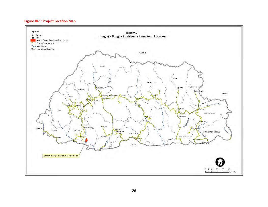
26
Figure III-1: Project Location Map

27
Table III-1: Proposed Road Related Technical Information ITEM UNIT SPECIFICATION/QUANTITY Formation Width m 5.10 Carriage Width m 3.50 Shoulder Width m 0.50 Side Drains width (V-shaped) m 0.60 Cross fall % 2.3 – 3.5% Type of Pavement Graveled Surface Minimum Gradient % 1% Ruling Gradient % 6% Limiting Gradient % 7% Exceptional Gradient (length restricted to 150 m) % 10% Hairpin bend gradient (including 15 m each for approaches) % 5%
Normal Radius m 10.00 Minimum Hairpin Bend Radius m 8.50
Source: Technical Guidelines for the construction of Farm Roads, May 2009, DOA, MOAF 22. Slope stability and erosion control are important aspects of the design that need to be determined in the detailed design phase. Various types of bio-engineering applications will be applied depending on the appropriate conditions for their use, including slope benching, flow routing, flow dispersal for sheet runoff, fabric or straw mulch, seeding, planting of grass or tree seedlings and brush barriers. It will be the responsibility of the Grant Implementation Unit (GIU) to apply these techniques as they see fit, either by specifying the application in the detailed design for the road, or in the field during construction.
23. Hydraulic structures will constitute major of project cost. The project will require two major RCC culverts (12 m span over Ochelumchhu and 10 m span over Chomchelumchhu streams). Overall, at least 15 cross drainage structures mainly Hume piper culverts are required which will be adapted to pass excess debris passing down the drainage channel by flaring wing walls. Longitudinal drains are placed on upslope of roadways and, in some locations, curb and pipe drains may be installed in areas where the roadway width is confined by the slope of the mountain side.
C. Description of Roadway Alignment
1. Jungley-Bongo-Phatshuma Farm Road 24. The proposed Jungley-Bongo-Phatshuma farm road is 10.650 km with mostly earthen surface. It is a continuation of the Mirchim – Bongo (Jungley) Feeder Road constructed under Road Network Project (RNP) financed by ADB. The combined Mirchim – Jungley – Bongo - Phatshuma route will connect Gedu and Bongo to Phuentsholing and Thimphu with major reductions in travel distances. The route starts from a flat agricultural land and orange orchard at Jungley with approximate elevation of 973 m.a.s.l and gradually ascends with four hairpin bends towards Ochelumchhu crossing at an elevation of 1178 m.a.s.l. After this stream crossing, the road passes through forest area and makes four zigs to reach Bongo village. Near Bongo village, the road passes mostly through paddy fields. From Bongo (1388 m.a.s.l) till the termination point at Phatshuma (1280 m.a.s.l) village road passes through more or less uniform gradient with slight descent nearing termination point. Side slopes are relatively flat, 15 – 50 degrees, and earthwork quantities should be moderate to high.
28
2. Cost, Size, Magnitude and Extent 25. As per the Grant Assistance Report (June 2010), the preliminary estimate for the total project cost is about $3,328,893 with ADB/JFPR contribution of $ 3 million, RGOB $256,314 and Beneficiaries $72,579 for the total project.
3. Schedule for Implementation 26. The estimated duration of the construction of the project (the Project) is two years. Construction will commence by September 2011 and target completion year by 2013. The Design Consultant (DC) has been recruited and detailed survey of the road is being carried out which will be followed by Detailed Design. The road will be constructed under one contract depending on the circumstances regarding access to the construction work.
4. Methods and Timing of Construction 27. Work will be awarded to as National Contract Bidding (NCB). Mobilizing the construction work consists of setting up construction camps, equipment yards and service facilities, and importation of equipment to the site. Aggregate crushing and grading, concrete batch plants and other associated facilities need to be set up according to the schedule of implementation for the work. Access roads may be cut to some locations, but generally construction will proceed from an existing point of access at the head of the roadway.
28. Survey of the right-of-way and clearing of harvestable timber is required prior to award of the construction contract, overseen by DFPS and the DOA, as described in the EMP and stipulated by DOFPS regulations.
29. Construction zones extend over 10.65 km stretches in which a progressive sequence of activities takes place, depending on location and terrain, roughly as follows:
30. Clearing of remaining brush and grubbing of below ground vegetation; removal of vegetation down slope to form a log/brush soil-retention barrier; rough grade and cut; blasting of rock and excavation of cuts; baring of foundation rock down-grade for support of gabions and retaining walls; grade up- and down-slope; fill and bench; stabilize slopes; compact and grade sub- and base materials; and application of road surfacing. Parallel to this sequence is the construction of hydraulic structures.
D. Associated Facilities 31. Quarries are expected to be small and localized in operations at chainage Km 5+840. The majority of the construction boulders will be extracted from the road side during construction. There are good quarry materials along the Jungley-Bongo-Phatshuma farm Road for use in masonry construction and fill.
32. Spoil sites will be needed for most segments where side hill materials have been removed and require disposal. Locations for spoil piles have been identified for most of the roadway segment at chainage 0+880, 1+910, 2+100, and 5+140 km. Where not already identified, it will be the responsibility of GIU to identify appropriate locations during construction. The spoil disposal must be carried out in a location away from streams, floodplains, wetlands, cultivated and inhabited land, and also away from the spiritually and culturally sensitive areas.
33. Construction camps to house 50 workers will be needed on this road segment. These camps will consist of sleeping quarters, washing and bathing facilities, latrines and waste disposal, a food service facility or canteen, and other auxiliary features. A typical camp may cover around one ha of land. Locations for construction camps have been identified for the roadway segments.

29
34. At least two equipments and material storage area, fuel depot and work staging area will be needed at the roadway segment. The suitable locations for these facilities have been found at away from the takeoff point along Meritsemo-Jungley road and at chainage 5+100 km (relatively flat land away from the settlement) and additional area if required during construction will be determined by the contractor in accordance with the stipulations of the EMP and other imposed constraints.
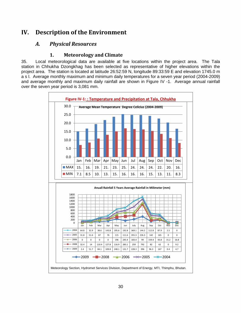
30
IV. Description of the Environment
A. Physical Resources
1. Meteorology and Climate 35. Local meteorological data are available at five locations within the project area. The Tala station in Chhukha Dzongkhag has been selected as representative of higher elevations within the project area. The station is located at latitude 26:52:59 N, longitude 89:33:59 E and elevation 1745.0 m a s l. Average monthly maximum and minimum daily temperatures for a seven year period (2004-2009) and average monthly and maximum daily rainfall are shown in Figure IV -1. Average annual rainfall over the seven year period is 3,081 mm.
Figure IV-1: : Temperature and Precipitation at Tala, Chhukha
Meteorology Section, Hydromet Services Division, Department of Energy, MTI, Thimphu, Bhutan.
Jan Feb Mar Apr May Jun Jul Aug Sep Oct Nov Dec
MAX 15. 16. 19. 21. 23. 25. 24. 24. 24. 22. 20. 16.
MIN 7.1 8.5 10. 13. 15. 16. 16. 16. 15. 13. 11. 8.3
0.0
5.0
10.0
15.0
20.0
25.0
30.0 Average Mean Temperature Degree Celicius (2004-2009)
Jan Feb Mar Apr May Jun July Aug Sep Oct Nov Dec
2004 64.8 32.9 38.6 143.8 195.6 192.8 369.1 144.2 112.8 87.9 2.5 0
2005 31.8 51.6 87 76 115 111.6 355.3 226.3 142 165 0 0
2006 0 0 0 0 196 245.4 183.4 99 159.4 43.8 15.2 16.8
2008 32.4 14 110.4 127.8 116.9 283.1 259 792 82 62 0 9.2
2009 2.4 51.7 84.1 109.8 248.1 131.7 228.3 396 96.3 167 0.4 4.7
0200400600800
10001200140016001800
Anuall Rainfall 5 Years Average Rainfall in Milimeter (mm)
2009 2008 2006 2005 2004
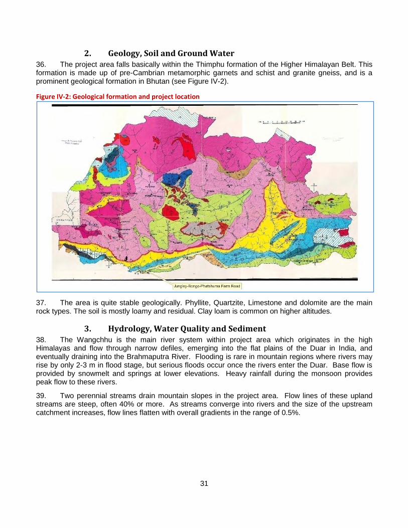
31
2. Geology, Soil and Ground Water 36. The project area falls basically within the Thimphu formation of the Higher Himalayan Belt. This formation is made up of pre-Cambrian metamorphic garnets and schist and granite gneiss, and is a prominent geological formation in Bhutan (see Figure IV-2).
Figure IV-2: Geological formation and project location
37. The area is quite stable geologically. Phyllite, Quartzite, Limestone and dolomite are the main rock types. The soil is mostly loamy and residual. Clay loam is common on higher altitudes.
3. Hydrology, Water Quality and Sediment 38. The Wangchhu is the main river system within project area which originates in the high Himalayas and flow through narrow defiles, emerging into the flat plains of the Duar in India, and eventually draining into the Brahmaputra River. Flooding is rare in mountain regions where rivers may rise by only 2-3 m in flood stage, but serious floods occur once the rivers enter the Duar. Base flow is provided by snowmelt and springs at lower elevations. Heavy rainfall during the monsoon provides peak flow to these rivers.
39. Two perennial streams drain mountain slopes in the project area. Flow lines of these upland streams are steep, often 40% or more. As streams converge into rivers and the size of the upstream catchment increases, flow lines flatten with overall gradients in the range of 0.5%.
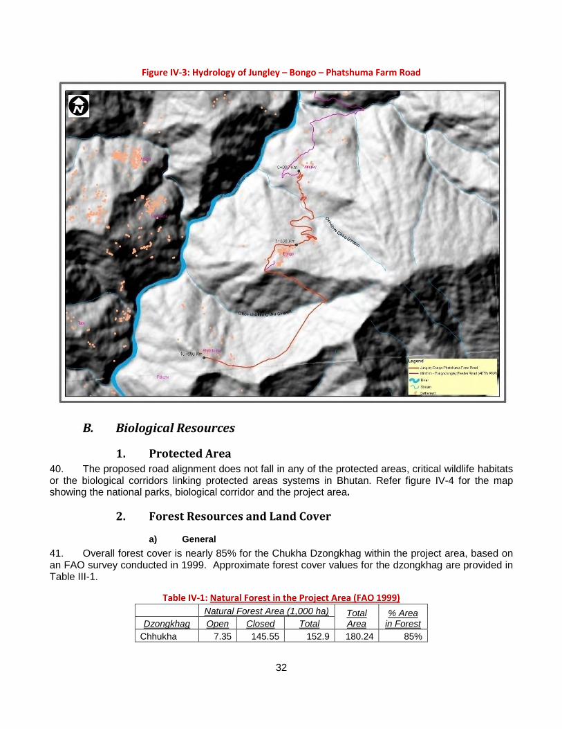
32
Figure IV-3: Hydrology of Jungley – Bongo – Phatshuma Farm Road
B. Biological Resources
1. Protected Area 40. The proposed road alignment does not fall in any of the protected areas, critical wildlife habitats or the biological corridors linking protected areas systems in Bhutan. Refer figure IV-4 for the map showing the national parks, biological corridor and the project area.
2. Forest Resources and Land Cover
a) General 41. Overall forest cover is nearly 85% for the Chukha Dzongkhag within the project area, based on an FAO survey conducted in 1999. Approximate forest cover values for the dzongkhag are provided in Table III-1.
Table IV-1:
Natural Forest in the Project Area (FAO 1999) Natural Forest Area (1,000 ha) Total
Area % Area
in Forest Dzongkhag Open Closed Total Chhukha 7.35 145.55 152.9 180.24 85%
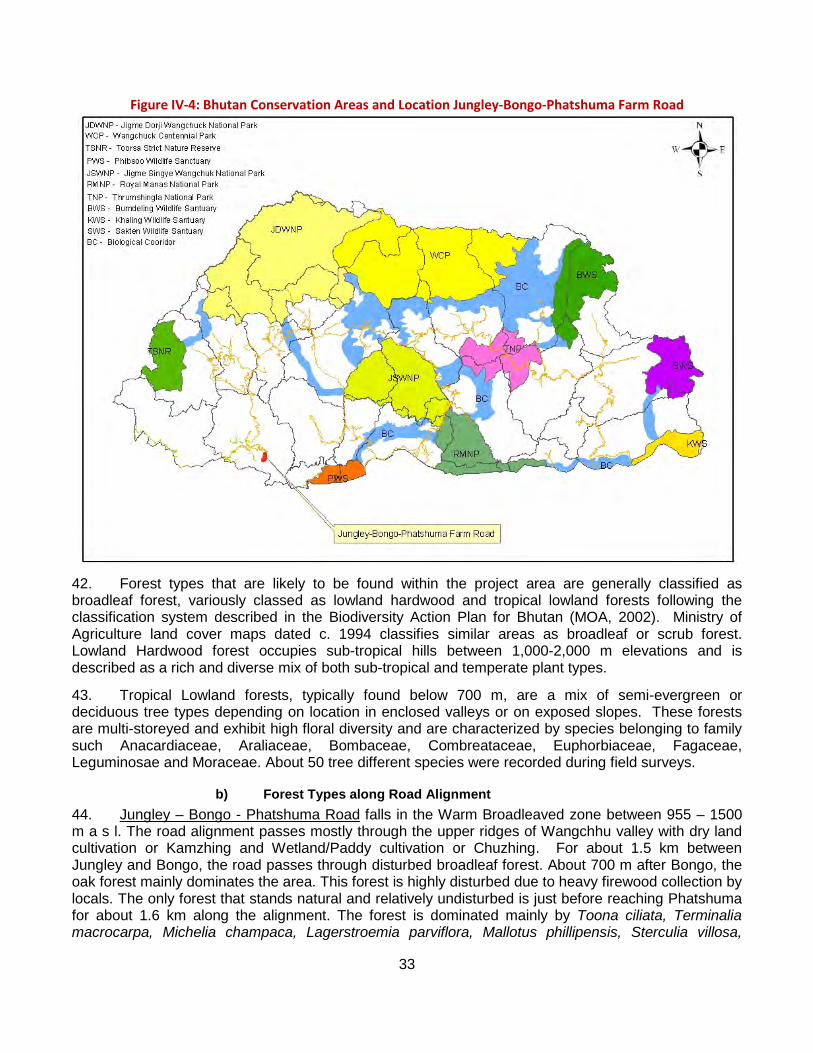
33
Figure IV-4: Bhutan Conservation Areas and Location Jungley-Bongo-Phatshuma Farm Road
42. Forest types that are likely to be found within the project area are generally classified as broadleaf forest, variously classed as lowland hardwood and tropical lowland forests following the classification system described in the Biodiversity Action Plan for Bhutan (MOA, 2002). Ministry of Agriculture land cover maps dated c. 1994 classifies similar areas as broadleaf or scrub forest. Lowland Hardwood forest occupies sub-tropical hills between 1,000-2,000 m elevations and is described as a rich and diverse mix of both sub-tropical and temperate plant types.
43. Tropical Lowland forests, typically found below 700 m, are a mix of semi-evergreen or deciduous tree types depending on location in enclosed valleys or on exposed slopes. These forests are multi-storeyed and exhibit high floral diversity and are characterized by species belonging to family such Anacardiaceae, Araliaceae, Bombaceae, Combreataceae, Euphorbiaceae, Fagaceae, Leguminosae and Moraceae. About 50 tree different species were recorded during field surveys.
b) Forest Types along Road Alignment 44. Jungley – Bongo - Phatshuma Road falls in the Warm Broadleaved zone between 955 – 1500 m a s l. The road alignment passes mostly through the upper ridges of Wangchhu valley with dry land cultivation or Kamzhing and Wetland/Paddy cultivation or Chuzhing. For about 1.5 km between Jungley and Bongo, the road passes through disturbed broadleaf forest. About 700 m after Bongo, the oak forest mainly dominates the area. This forest is highly disturbed due to heavy firewood collection by locals. The only forest that stands natural and relatively undisturbed is just before reaching Phatshuma for about 1.6 km along the alignment. The forest is dominated mainly by Toona ciliata, Terminalia macrocarpa, Michelia champaca, Lagerstroemia parviflora, Mallotus phillipensis, Sterculia villosa,
34
Engelhardia spicata, Albizzia procera, Albizzia lebbeck, Syzigium cumini, Erythrina arborescens, Persea clarkeana, Cinnamomum tamala, Ailanthus integrifolia, Nellia thrysifolia, Bombax ceiba, Maesa indica, Daubanga grandiflora Elaeocarpus lanceifolus, Macaranga denticulata, Macaranga peltata, Bauhinia purpurea, Bhogtom (Drukpa Chilauni), Trema politoria, Rhus spp., Ficus spp., Alnus nepalensis, Symplocos paniculata, etc.
c) Forest Management 45. There are basically three types of forest – government owned national forest including Forest Management Units 1
d) Non-Timber Forest Products
(FMU), community forest, sokshing (registered to an individual person or household) and private tree plantations. The government forest is being conserved by the Department of Forest while community forest is managed by the village or a community. The Sokshing and private tree plantation the private forest is owned and managed by an individual or the household.
46. According to the DOF Forestry Management Unit (FMU) location map, there are no FMUs in the project area.
47. The people within project areas collect a variety of non timber forest products (NTFPs) for vegetables, fruits, fodder, medicine, fibers, dyes, and raw materials for baskets, houses, brooms, mats, and number of other items. Extraction and use of NTFPs involves traditional or indigenous techniques and is one of the vital elements in the livelihood of the local people. NTFPs identified during the project field work are listed in Table 3-2.
Table IV-2:Botanical Name
Non Timber Forest Products in use along Roadway Alignments Common/Local Name Parts used Use of NTFPs
Sterculia villosa Odal (Lh) , Phrangshing (Sh) Bark Fibers or floss for making ropes/mats Girardiana spp Sisnu(Lh) Bark Fibers or floss for making ropes Thysanolaena maxima Tsakusha(Dz) Whole plant Brooms Rubia cordifolia Tsey (Dz), Laniru (Sh), Whole plant Dye
Oroxylum indica Tsampaka (Dz), Flower, Fruits Religious, vegetables
Amomum subutatum Ailanchi(Sh) Fruits Medicine Phyllanthus emblica Amla(Lh) Fruits Food Bauhinia purpurea Tanki (Lh) Fresh flower Medicine for Diarrhoea, fever, & digestion Diplazium spp. Dawai (Sh) Shoot Vegetable Colocasia spp. Bozong (Sh) tuber Vegetable Dioscorea hamiltonii Borang jogtang (Sh) tuber Food or Vegetable Dioscorea pentaphylla Phantang (Sh) Blub Food or Vegetable Piper hamiltonii Pan (Sh) Leaves Leaves edible with betel nut Auricularia auricular Jilinamcho (Dz) Entire plant Vegetable Acanthocystis geogenius Jitsishamu (Dz) Entire plant Vegetable Pieurotus cornucopiae Selishamu (Dz) Entire plant Vegetable KEY: Lh – Lhotshampa Name Sh – Sharchop Name Dz – Dzongkhag Name
e) Endangered and Protected Flora 48. No endangered or protected plant species as listed in Schedule I – Forest and Nature Conservation Rules of Bhutan, 2000 is observed or reported within the project area.
1 FMUs are geographic areas of government reserved forests that are scientifically managed for purposes of logging and conservation.
35
f) Land Use Change and Forest Loss 49. Land use/cover classification for the road segment is shown in Figures III-5. Specific types of land use (kamzhing, chuzhing) and forest cover affected by the construction of the road segment is shown in Table III-3. These values are based on a 15 m wide strip of land affected by project development.
Table IV-3: Land use change and forest loss S.No Land Cover Chainage (km) Area in Acre
(considering 15m impact width) From To 1 Kamzhing (Dry land) & Orange orchard 0+000 1+210 4.48 2 Broadleaf Forest 1+210 3+000 6.63 3 Kamzhing (Dry land) & Orange orchard 3+000 3+860 3.19 4 Chuzhing (Paddy Field) 3+860 4+310 1.67 5 Kamzhing (Dry land) 4+310 5+450 4.23 6 Broadleaf forest 5+450 7+330 6.97 7 Kamzhing (Dry land) 7+330 8+900 5.82 8 Kamzhing (Dry land) 8+900 9+375 1.76
Total Land to Occupied 34.75
3. Mammal and Bird Life
a) Mammals 50. There are a number of wild animals that are known to inhabit the study area particularly the broadleaf forest. During the field survey, common wild animals were spotted in the study areas, including barking deer (Muntiacus mutjak), Assamese macaque (Macaca assamensis), Sambar (Cervus unicolor), Malayan giant squirrel (Ratufa bicolor), Himalayan Yellow Marten (Martes flavigula), Pallas Squirrel (Callosciurus erythraeus), wild boar (Sus scrofra). The Himalayan Black Bear (Selenarctos thibetanus) are known to inhabit the higher mountain ridges of the project area,
Table IV-4: Species
IUCN and National Status of Mammals Common Name IUCN Status FNCA Status
Selenarctos thibetanus Himalayan black bear Endangered Protected Panthera pardus Leopard Least concern Protected Macaca assamensis Macaque Vulnerable - Muntiacus muntjak barking deer - - Sus scrofra wild boar - - Hystrix indica Porcupine - - Cuon alpines primaevus wild dog Endangered - Martes flavigula Himalayan yellow-throated marten Least Concern - Callosciurus erythraeus Pallas squirrel - - Ratufa bicolor Malayan giant squirrel - - Hystrix indica Porcupine - - Manis pentadactyla Chinese pangolin Lower Risk - Cervus unicolor Sambar Lower Risk - Nemorhaedus goral Goral Lower Risk - Felis chaus jungle cat Lower Risk - Dremomys lokriah orange bellied squirrel - - Callosciurus pygerythrus hoary-bellied squirrel - - Paradoxurus hermaphroditus common palm civet - - Viverricula indica small indian civet Vulnerable - Viverra zibetha large indian civet Vulnerable - Lutra lutra Otter Vulnerable - Source: Field Survey March 2009, IUCN 2007 (Red List of Threatened Species) and FNCA 1995
Key: MR – Manitar – Raidak Road IUCN – International Union for Conservation of Nature RL – Raidak – Lhamoizingkha Road FNCA – Forest & Nature Conservation Act of Bhutan, 1995 TM – Tsebar – Mikuri Road PN – Panbang – Nganglam Road SS – Samdrupcholing – Samrang Road
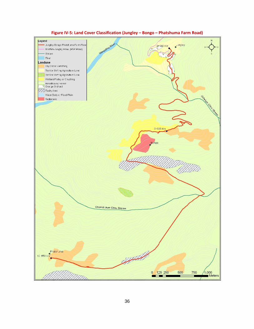
36
Figure IV-5: Land Cover Classification (Jungley – Bongo – Phatshuma Farm Road)
37
b) Birds 51. Warm broadleaf forests are one of the richest habitats of bird species among the forest types. During the field survey nearly 50 different bird species were recorded. The important birds either spotted or reported by local people during the field survey include the mountain imperial pigeon (Ducula badia), great barbet (Megalaima virens), blue-throated barbet (Megalaima asiatica), Himalayan swiftlet (Collacalia brevirostris), oriental turtle dove (Streptopelia orientalis), spotted dove (Streptopelia chinensis), black eagle (Ictinaetus malayensis), crested serpent eagle (Spilornis cheela), grey treepie (Dendrocitta formosae), scarlet minivet (Pericrocotus flammeus), ashy drongo (Dicrurus leucophaeus), white-capped water redstart (Copsychus saularis), slaty-backed forktail (Enicurus schistaceus), spotted forktail (Enicurus maculates), Grey bushchat (Saxicola ferrea), red-vented bulbul (Pcynonotus cafér), black bulbul (Hypsipetes leucocephalus), striated prinia (Prinia criniger), oriental white-eye (Zosterops palpebrosus), white-crested laughing thrush (Garrulax leucolophus), great hornbill (Buceros bicornis) and Rufous-necked hornbill (Aceros nipalensis). Among these the Rufous-necked hornbill (Aceros nipalensis) is listed as vulnerable by IUCN and it is also totally protected species under FNCA 1995. A detail list of birds identified in the project area is provided in Table III-5.
Table IV-5:Scientific name
Avifauna in Project Area Common Name FNCA Status IUCN Status
Aceros nipalensis rufous-necked hornbill Protected Vulnerable Dendrocitta Formosa grey treepie - - Dendrocitta vagabunda rofous treepie - - Dicrurus leucophaeus ashy drongo - - Dicrurus macrocercus black drongo - - Streptopelia chinenisis spotted dove - - Steptopelia orentalis oriental turtle dove - - Chalcophaps indica emerald dove - - Ducula badia mountain imperial pigeon - - Myophonus caeruleus blue whistling thrush - - Hypsipetes leucocephalus black bulbul - - Pycnonotus cafer red-vented bulbul - - Acridotheres tristis common myna - - Ictinaetus malayensis black eagle - - Spilornis cheela crested serpent eagle - - Blythipicus pyrrhotis bay woodpecker - - Celeus brachyurus rufous woodpecker - - Picus flavinucha greater yellownape - - Dendrocopos atratus stripe-breasted woodpecker - - Lanius cristatus brown shrike - - Megalaima australis blue-eared barbet - - Magalaima Virens great barbet - - Megalaima asistica blue -throated barbet - - Pericrocotus flammeus scarlet minivet - - Halycyon smyrnensis white-throated kingfisher - - Megaceryle lugubris crested kingfisher - - Alcedo Hercules blyth’s kingfisher - - Dicrurus paradiseus greater racket-tailed drongo - - Dicrurus leucophaeus ashy drongo - - Melanochlora sultanea sultan tit - - Chaimarrornis leucocephalus white-capped water redstart - - Enicurus schistaceus slaty –backed forktail - - Copsychus saularis oriental magpie robin - - Motacilla alba white wagtail - - Yuhina nigrimenta black-chinned yuhina - - Yuhina Zantholeuca white-bellied yuhina - - Garrulax leucolophus white-crested laughingthrush - - Hirundo rustica barn swallow - - Corvas macrohynchos large billed crow - - Corvus splendens house crow - - Abroscopus superciliaris yellow-billied warbler - - Seicercus affinis white-spectacled warbler - -
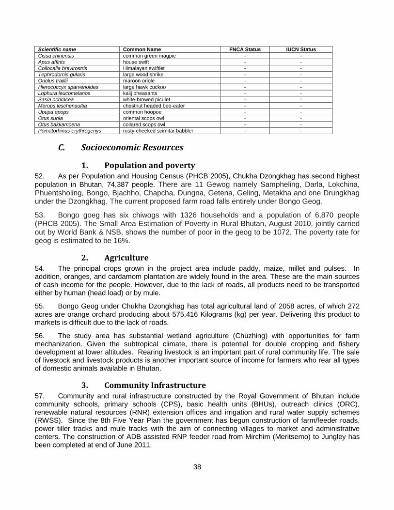
38
Scientific name Common Name FNCA Status IUCN Status Cissa chinensis common green magpie - - Apus affinis house swift - - Collocalia brevirostris Himalayan swiftlet - - Tephrodornis gularis large wood shrike - - Oriolus traillii maroon oriole - - Hierococcyx sparverioides large hawk cuckoo - - Lophura leucomelanos kalij pheasants - - Sasia ochracea white-browed piculet - - Merops leschenaultia chestnut headed bee-eater - - Upupa epops common hoopoe - - Otus sunia oriental scops owl - - Otus bakkamoena collared scops owl - - Pomatorhinus erythrogenys rusty-cheeked scimitar babbler - -
C. Socioeconomic Resources
1. Population and poverty 52. As per Population and Housing Census (PHCB 2005), Chukha Dzongkhag has second highest population in Bhutan, 74,387 people. There are 11 Gewog namely Sampheling, Darla, Lokchina, Phuentsholing, Bongo, Bjachho, Chapcha, Dungna, Getena, Geling, Metakha and one Drungkhag under the Dzongkhag. The current proposed farm road falls entirely under Bongo Geog.
53. Bongo goeg has six chiwogs with 1326 households and a population of 6,870 people (PHCB 2005). The Small Area Estimation of Poverty in Rural Bhutan, August 2010, jointly carried out by World Bank & NSB, shows the number of poor in the geog to be 1072. The poverty rate for geog is estimated to be 16%.
2. Agriculture 54. The principal crops grown in the project area include paddy, maize, millet and pulses. In addition, oranges, and cardamom plantation are widely found in the area. These are the main sources of cash income for the people. However, due to the lack of roads, all products need to be transported either by human (head load) or by mule.
55. Bongo Geog under Chukha Dzongkhag has total agricultural land of 2058 acres, of which 272 acres are orange orchard producing about 575,416 Kilograms (kg) per year. Delivering this product to markets is difficult due to the lack of roads.
56. The study area has substantial wetland agriculture (Chuzhing) with opportunities for farm mechanization. Given the subtropical climate, there is potential for double cropping and fishery development at lower altitudes. Rearing livestock is an important part of rural community life. The sale of livestock and livestock products is another important source of income for farmers who rear all types of domestic animals available in Bhutan.
3. Community Infrastructure 57. Community and rural infrastructure constructed by the Royal Government of Bhutan include community schools, primary schools (CPS), basic health units (BHUs), outreach clinics (ORC), renewable natural resources (RNR) extension offices and irrigation and rural water supply schemes (RWSS). Since the 8th Five Year Plan the government has begun construction of farm/feeder roads, power tiller tracks and mule tracks with the aim of connecting villages to market and administrative centers. The construction of ADB assisted RNP feeder road from Mirchim (Meritsemo) to Jungley has been completed at end of June 2011.
39
58. Most of the villages under the geogs are now electrified through the Rural Electrification Project supported by ADB and other donors. Details concerning community infrastructure within the project area are shown in Table IV-6.
Table IV-6:
Road Segment/ Dzongkhag / Geog
Community Infrastructure in Project Affected Geog Community Infrastructure
Chiwogs/ Villages BHU CPS LSS/
MSS ORC RNR RWSS Irrigation Scheme
Junglay-Bongo-Phatshum farm road, Bongo geog of Chukha Dzongkhag 15 1 3 3 11 1 15 16.5 km
4. Migration 59. As per the 2005 census, Chukha has received net in-migration of 15,480 of its total population. However, in-migrations are mostly to the towns and urban centers. But findings study on Rural-urban migration in Bhutan by PPD, MOAF shows that the rural areas of Chukha have seen out-migrations 15% of the total population (which is about 45% of households). The rural-urban migration is primarily due to lack access to education facilities, off-farm jobs and inadequate or non existence of service facilities.
5. Labour and Employment 60. Unemployment is reported uniformly low across all locations, for both urban and rural populations. The national norm (male and female, urban and rural) is 3.1%. Rural unemployment is reported lower (2.6 and 2.1% for male and female, respectively). Little remaining data contained in the 2005 census regarding labor and employment is readily disaggregated for the project area.
D. Physical Cultural Resources
1. Religious, Historical, Cultural and Archeological Sites 61. Religious, historical and cultural sites in the vicinity (2 km on either side) of Jungley-Bongo-Phatshuma farm road were identified and enumerated during the field reconnaissance work. A list of such landmarks is found in Table IV-7. There are no known archeological sites in the project affected area.
Table IV-7: Cultural, Religious and Spiritual Sites or Structures
Road Segment/ Dzongkhag/ Geog
Cultural, Religious and Spiritual Sites or Structures Chiwogs / Villages
Lhakhang (Temple) Chorten (Stupa) Sacred Sites (Nye/Tsen/Luu)
Bongo Geog 15 8 9 2 Junglay-Bongo-Phatshuma farm road Bong geog, Chukha Dzongkhag 3 1 2 1
2. Visual Aesthetic and Recreational Resources and Scenic Qualities 62. The area contains visual and aesthetic resources that are typical of the lower Himalayan foothills. The area provides a diversity of potential recreational resources that stem from its current isolation, natural beauty and scenic qualities, including hiking, trekking, river rafting, appreciation of nature, wild animals and forests, and access to secluded areas. There is no information on current tourism usage in the area. Recreational opportunities are limited due to lack of access.
40
V. Analysis of Alternatives
A. The No-Project Alternative 63. Construction of roads in Bhutan poses immense challenges. In line with the technical challenge, the Government has become increasingly aware of environmental damages associated with road development, including impacts on forests due to construction of the roadway, potential impacts on the seasonal and daily movement of animals, erosion and landslides that obstruct the road and cause a hazard for travelers, and potential land use changes. A guideline is now in use by the Department of Roads related to environmentally sound road construction practices (DOR 2004), which provides the means for minimizing impacts
64. Benefits stem from improved transport links for the geog. Without the project there is little means for improving public services. Many young people currently leave the area because opportunities are few for participation in the national economy. Public services and economic opportunities will increase for these people as a result of improved transport connectivity.
65. Benefits stemming from the project in terms of poverty alleviation are far greater than the potential and expected negative environmental impacts. Hence, the IEE addresses environmental impacts in conjunction with economic and social impacts and concludes there is no potential for severe, long term or irreversible impact, which would give rise to justification for the no project alternative.
B. Location and Alignment Alternatives
1. Suitability in terms of Project Objectives 66. The objective of the RNP is to improve transport efficiency on the trunk road network and expand accessibility in rural areas, which will contribute to expanding economic opportunity and reducing poverty. This objective will be achieved by (i) improving and shortening a major north–south road, (ii) constructing feeder roads, (iii) enhancing capacity in the Department of Roads for managing road assets, and (iv) facilitating private sector participation in the domestic contracting industry. The proposed JFPR project will further improve access for remote rural communities by providing farm roads to connect to these feeder roads. Improved road access will allow poor rural households, which depend on agriculture, to grow larger marketable surpluses and increase their incomes. Farm roads will enable better access to economic and social services, which usually do not reach these remote and sparsely populated areas.
2. Alignment Alternatives 67. The alignment for Jungley-Bongo-Phastshuma has been determined on the basis of slope stability; settlement, land use conditions and socio-economic aspects, and preferred locations for stream crossings. The alignment has been fixed jointly by Road Engineer, Surveyor, Environmentalist, and the Tshogpas of Junglay, Bongo and Phatshuma villages.
68. The alignment option at the takeoff (Jungley village) is limited to a specific corridor to avoid prime agriculture land. Other determining factors for fixation of alignment were the stream crossings. RCC Culverts or small bridges over Ochelumchhu and Chomchelumchhu Streams were selected on the basis of stability and length of the culverts. Other smaller or dry gully crossings have been chosen to avoid unstable geological conditions. At least at three locations, one between Junglay and Bongo, and other two before Phastshuma village after Bongo, the alignment was fixed to avoid rocky areas. The alignment terminates at Phatshuma village.
41
C. Technology and Roadway Standards 69. The construction technology for the proposed road project is primarily of environmental friendly road construction (EFRC) techniques, which has been tested through Rural Access Project supported by World Bank and Road Network Project supported by Asian Development Bank (ADB). This technology mainly focuses on the optimal balance between prevention of environmental damages and investment cost for road during construction as well as subsequent operation. The EFRC technology stresses on minimizing cutting of mountain slopes (wherever possible), making part of road within filling supported retaining walls, avoiding box cutting as much as possible to minimize the volume of excavated materials, limiting cutting of trees within road corridors, using tripper and other suitable equipment for transportation of excavated materials for disposing in safe locations, construction of barriers of logs or boulders at about 10-15 meter below to prevent falling of excavated materials, etc. In addition, EFRC construction technology also include use of controlled blasting to minimize the damage to local environment, construction of adequate drainage/water management structures, adoption of bioengineering works for slope protection.
70. Application of occupational health and safety guidelines among workers is also a matter of technological choice for which there are associated costs. In general the IEE recommends the adoption of these (and other) principles for environmentally sound roadway construction, but with a degree of flexibility that insures that costs are not compounded excessively. In short, guidelines should be applied with an attitude toward practicality that allows the Project to be implemented efficiently yet with minimal environmental impact. This proposal is similar to cost-effective analysis, in which benefits gained need to be proportional to cost, and where the cost becomes disproportional (e.g. little benefit is gained in the escalation of costs expended); some flexibility in the application of guidelines is allowed. Practical implementation of this provision is the responsibility of the DOA accompanied by the design consultant.
D. Design 71. Design considerations are many on the Project, and most are related to technical issues that are addressed by the engineering team. Design issues that relate to environmental considerations fall into a few categories: location, where the location may impact environmental resources; safety, where the design of the roadway may affect safe use (and hence an aspect of the social environment); durability due to environmental effects on the roadway from geotechnical and hydrological variables; and design features that might minimize effects on wildlife. Design issues related to location have been considered elsewhere in this section. Safety features include sight distance (always poor on mountain passages) in relation to roadway width and turn-outs, use of guard rails and signage to protect drivers. Recommendations are made for installation of safety features. Likewise long term use of the pavement structure is considered in the type of surface treatment to be used on the roadway, with an eye for ease of maintenance.
E. Operation 72. Maintenance is a major factor in operations and ongoing requirements are reduced by sound design that takes into account the geotechnical conditions of the roadway, provides correct placement and adequate capacity for cross drainage, assures that slopes are stabilized and prevents the occurrence of scouring in areas subject to contact with flowing water. In general the project has been designed to minimize maintenance requirements during the operation of the roadways.
F. Cleaner Technology and Environmental Management Plan 73. Cleaner technology during the project can be achieved through the use of proper equipments that are in well maintained and hence generate less pollution of air, noise and water.
42
74. Roadway operations provide opportunity for introduction of cleaner technology through policies enacted nationally. These have to do with vehicle performance and emissions. The government has taken steps towards improving air quality by requiring better quality fuel, conducting emission tests, and banning import of reconditioned vehicles (Kuensel 2004). Sulfur content of diesel at 500 PPM is the lowest in the region, and Euro 2 Vehicle emission standards came into force in March 2008. Import licenses are only given for vehicles that meet the Euro 2 standards or above. Euro 2 is a light duty vehicle standard that came into effect in Europe in 1996 (1.0, 0.7 and 0.08 gm/km for CO, NOx and PM respectively). Other cleaner technology introduced in the automotive sector includes banning the import of two wheelers with two-stroke engines, importation of unleaded petrol, waiving of import taxes/duties for motor vehicle spare parts and import ultra-low sulfur diesel.
43
VI. Anticipated Environmental Impacts and Mitigation Measures 75. This chapter reviews potential environmental impacts on specific environmental resources, provides an analysis and assessment of the extent of those impacts, and proposes mitigation measures that are in keeping with good design practice and environmentally sound road construction as currently being practiced in Bhutan. Three resource domains – physical, biological and socioeconomic – are considered via the relevant subdivisions in which impacts may be expected to occur. Physical cultural resources, because they are few in number within the project area, are considered within the socioeconomic environmental resource domain. Impacts can occur during preconstruction, construction and operations, and distinctions are made in the text concerning when a particular impact may be expected.
76. Mitigation measures are incorporated during preliminary and detailed design phases, during the construction of a particular road segment, and over the operations period. The preliminary design phase incorporates important considerations regarding the location of roadway and choice among different alignment alternatives, as well as the introduction of roadway design standards. These aspects of the project are reviewed in Chapters III and V of the present document. Detailed design of the roadway is an effective means for mitigating environmental impacts, to the extent that the design represents good engineering practice by incorporating sufficient design safety factors for slopes and for hydraulic structures, and other means. Recommendations are made throughout the following sections for introduction of practical mitigation measures by means of the detailed design process. Construction impacts are by and large the most numerous, but are relatively short-lived, being confined generally to the period of construction only. Mitigation of impacts occurring during the operation of the roadway is generally accounted for by design features that sustain the life of the roadway and increase its usefulness. Maintenance during operations may also play a role in mitigating impacts, along with use of the roadway to improve management of forest and biodiversity resources.
A. Physical Environment
1. Air Quality 77. Air quality is affected during construction and operations of roadways.
Construction
78. Air emissions during construction arise from the operation of construction vehicles, blasting and clearing of rubble, operation of quarry pits and hauling of materials. Emissions from rock crushing operations, aggregate drying and hot mix plants also degrade air quality The problem is present wherever construction is taking place in varying degrees, but is generally not so great as to affect regional air quality; however impacts are most severe where there are communities, homes, businesses and institutional buildings in the vicinity of construction that causes local ground level air quality to deteriorate.
79. Mitigation measures are aimed at dampening dust emissions from disturbed soil and roadway construction surfaces and removing operations that contribute to point source emissions from the vicinity of communities. The contractor will be required to regularly water roadway surfaces wherever there are communities (homes, businesses, schools) nearby. The Road segment at takeoff within Jungley village, near Bongo and Phatshuma settlement will need spraying of water to lessen the dust pollution during construction. Spraying may be done twice daily or at such frequency as is needed to minimize impacts. Since the actual lengths involved are relatively short, the contractor should be able to provide near complete coverage of critical sections. The water can be collected from the nearby streams.
44
80. Dust and fumes can be further reduced in community areas by regular removal of construction debris and spoil piles, and clean-up after completion of a section; and traffic controls to reduce contact between the public and construction activity. All vehicles transporting materials should be covered properly.
81. Rock crushing plant should be placed at sufficient distance (500 m) from habitations and community environments to assure there are no community impacts. It can be located at chainage km 5+480 near to the quarry. Areas where dust accumulates should be watered regularly from nearby Chomcholumchhu stream. Any changes in location of crushing plant must be approved by the GIU.
82. All equipments, machinery and vehicles used for the project must be well maintained in order for proper functioning as well as reduction in air pollution.
2. Noise
Operations
83. During operations, air emissions from vehicles can affect air quality, with consequent impacts on human health and the living environment. Since these roadways will not bear a heavy traffic load, it is expected that vehicular air emissions during operation will not pose a particular problem. However, it is possible to evaluate the impact based on an assumed traffic volume and worst case meteorological conditions.
84. Noise emissions during construction and operation may affect wildlife and community values.
Construction
85. Noise impacts originate from the operation of construction equipment in the vicinity of homes, institutional buildings, and stores, and from rock blasting to clear roadbed in hillside areas.
86. Road segments at the takeoff (Jungley), in the middle (Bongo) and at the termination point (Phatshuma) are the main areas where construction will be conducted in the near vicinity of communities which will result in some exposure to noise pollutions.
87. Construction noise is not normally regulated, though still may cause concern among local villagers. Noise impacts are an unavoidable consequence of construction that should be mitigated by limiting the times of construction to daylight hours in the vicinity of sensitive receptors.
88. Rock blasting to clear right-of-way is also a noise and safety hazard. However, not much blasting will be required for Jungley – Bongo- Phatshuma road except for the cliff near Ochelumchhu stream quite far off from the human settlement (Jungley and Bongo). Therefore impact on human settlement as a result of blasting would be minimal. Nevertheless, the contractor will prepare a blasting procedure requiring area restrictions; prior warning of workers, and the cattle herders and others passing through the area; restrictions on the timing of blasts; and worker safety procedures. The blasting activities should be carried out during the daytime to prevent disturbance to wildlife during the night, dawn and dusk. The contractor shall employ blasters experienced in controlled blasting recognized by MoA. The purchase, transport, storage and use of explosive shall be carried out in accordance with Blasting Manual (Reini Schramli, 1999), which is available at Ministry of Works and Human Settlement (MoWHS) and the Explosives Rules issued by the Ministry of Home and Cultural Affairs (MoHCA).
45
3. Soil
Operations
89. During operations, noise emissions disturb community life and the living environment. Noise impacts from vehicles traveling along these roadways are not expected to be significant due to the light traffic loads and low density of settlements.
90. Impacts on the soil environment occur from a number of causes during the detailed design, construction and operation stages of the roadways.
Detailed Design
91. Jungley-Bongo-Phatshuma farm road falls inside high rainfall but in a stable soil and geological zone. As a result the likelihood of landslides and erosion are low both during construction and operation stages. However, identification of appropriate methods of excavation or cutting to minimize landslides and enable slope stability is imperative during the detailed design stage. The balance of cut and fill concept or principles of EFRC must be incorporated into road design.
92. A number of bioengineering techniques can be used to stabilize soils both during construction and for finishing slopes for long range operational integrity. These techniques consist of benching, grading and seeding slopes, and tree planting, and their use is applicable throughout the project area in varying degrees. Further the Field Handbook of Bioengineering produced by DOR maybe referred to while proposing bioengineering methods for the project.
93. For areas that are particularly wet or marshy increasing the likelihood of erosion and problems of slope failure both during construction and operation, appropriate drainage structures and mechanisms such as horizontal drains must be recommended during the detailed design works.
Construction
94. The roads will mostly be cut into the side slopes of mountains ranging from 35 to 80 degrees; hence the zone of construction is constricted in terms of access and disposal of spoil material. Impacts in the form of landslides and erosion may occur due to cutting and excavation of the roadbed, on the upslope from barren rock or loosely held conglomerate materials that are variably stable during construction and must be removed sufficiently to provide clear space for the roadbed and working shoulders and to assure stability over the long term period of use. Down slopes must also be stabilized but to a lesser extent; here the greater problem is with rubble loosed from above that is lost down the mountainside and may be mobilized by rainfall or from earth movements.
95. Though erosion, rock falls, are unavoidable during cutting works, appropriate methods of excavation and benching recommended during the detailed design must be followed to minimize these impacts.
96. Use of borrow areas where necessary will result in formation of open pits. This can lead to issues of erosion. Hence, after use all borrow areas must be properly restored by filling with unwanted material generated from the construction works. The top soil of the borrow area must be kept aside and reused to seal the borrow areas at the end of its use.
97. Quarries located at too great a distance from the work zone involve hauling that creates air pollution impacts and degrades existing roadway surfaces. Failure to properly grade and contour a quarry location at closure leads to potential hazard from personal accident or slope failure. This can also result in adverse impacts on the drainage in quarry areas.
46
98. The need for quarries should be minimized by use of materials cut from the roadway alignment. In the event that quarries are required in a particular area, following locations 0+760 and between 5+410 to 5+840 Km has to be used in consultation with GIU and upon approval of Department of Geology and Mines (DGM). A development plan should be prepared by the contractor that estimates approximate quantities and final contours. Blasting procedures should be put into place for the development of quarries. Necessary government clearances for land and resource use should be obtained by the contractor prior to commencement of work in the area.
4. Water Resources and Water Quality
Operations
99. Though landslides are not a major concern along Jungley-Bongo-Phatshum farm road, the road section passing through the paddy fields (Chainage 3+860 to 4+310 km) within Bongo settlements will see the road side slope failures which will damage the paddy lands located on the upslope as well as siltation of paddy land on the downhill side. Therefore, as a mitigation measures, the gabion retaining walls shall be designed and constructed all along the road section that passes through paddy fields to avoid future slope failures of the upslope and ultimate siltation of paddy fields located on down slope. In addition to this, it is also recommendation that the detailed design and subsequent construction need to adopt proper methods and techniques for excavation and earth works and provision of adequate support and drainage structures, as there may be problems of erosion and landslides during operation. Under such circumstances, necessary engineering and bio engineering measures will need to be taken to help stabilize slopes. During operations, maintenance engineers should develop and apply means for predicting slope failures in advance and buttress slopes where necessary.
100. Bioengineering techniques applied during the construction will become effective over the operations period of the project. It is likely that some of the techniques proposed may not work or the plants used may not regenerate as expected. To avoid this, the freshly planted seedlings and other plant material will need to be monitored and necessary steps will need to be taken to maximize plant growth. Immediately replacement of plants that do not survive will need to be made.
101. Effects on local drainage, river flow and water quality can occur during construction and during the operation of roadways. Inadequate drainage may undermine the performance and long term durability of road surfaces and foundations. In turn, construction activities may interfere with access to water supplies and roadway hydraulic structures may be inadequate to assure serviceability and supply of water for household and irrigation. Flow of water mobilizes sediment that can degrade water quality and potentially damage adjacent land. A complex relationship exists between the road and the water environment that must be mutually accommodated to guarantee the integrity of the road structure and avoid impact on the water resource.
Detailed Design
102. Roadside drainage in community areas should receive particular attention by the detailed design team to assure that the roadway surface does not concentrate rainfall and cause damage to local properties. Engineering and hydrological criteria should be applied to the design of drainage structures.
103. Where longitudinal roadside drainage is undersized, water is diverted insufficiently, and flooding undercuts the roadway surface over time, causing breakup of the pavement and edge fraying, a safety hazard and eventual failure of the road surface. In order to avoid this condition, the roadway design engineer should incorporate appropriate roadside drainage structures into the design construction drawings and project cost estimates.
47
104. Insufficient roadside drainage, particularly inside the paddy fields at Bongo (Chainage 3+860 to 4+310 km) may lead to flooding and damage to adjacent paddy fields (located on downslopes) and to road itself. All along the road section that passes through paddy fields, the fully lined U-drains with intermittent Hume pipe Cross drains (locations to be determined in consultation with locals during construction) shall be carefully designed to avoid flooding of road surface, damage of paddy fields and to provide uninterrupted irrigation water supply to the paddy fields located on the downhill sides. Similarly, Gabion retaining walls have to be designed all along the section that passes through paddy fields to avoid damage of fields on up-slopes by scouring and landslides. While in other areas, the cross drainages should be planned and designed so as to drain the water to the natural gullies and streams to avoid damages of down slopes natural habitat as well as agriculture lands.
105. Extreme meteorological conditions and other environmental factors can exceed the capacity of drainage structures, erode slopes and destroy pavement structures. The preliminary and detailed design engineers should take into account cost and historical rainfall data for catchments in determining the preliminary sizing of structures, stability of slopes and height of roadway embankments along rivers and streams. The criteria applied to the sizing of structures should conform to class for roadway being constructed. Later these same factors should be verified by the detailed design engineer.
110. Operation of equipment storage and repair facilities and fuel depots can lead to improper disposal of oily waste and fuel spills. Poor housekeeping in equipment and supply yards causes soil and water pollution. The contractor is responsible for installing secondary containment around fuel tanks and at fueling stations, and for prevention of oil and fuel spills from equipment repair and refueling operations.
Construction
106. Recommended designs and structures proposed by the detailed design consultant must be implemented during the construction stage to mitigate potential impacts on water resources during construction. Specifically, the contractor should implement water and slope management (construction of lined U-Drain and laying of Hume-pipes for uninterrupted irrigation water supply and the construction of gabion walls prevent paddy fields) particularly for the road section that passes through paddy fields at Bongo.
107. Construction activities increase loss of soil from surfaces exposed to rain and flowing water, increasing sediment loss to rivers and streams. Slope erosion occurs during rainy periods in vulnerable areas. Land clearing and excavation should be stopped in rainy days.
108. Temporary measures to reduce erosion involve placement of log barriers or stone barriers at the base of slopes in accordance with recommended EFRC construction methods provided by DOR. This will on one hand prevent disruptions and formation of temporary dams in the streams and rivers and on the other hand reduce resultant visual scars on the topography.
109. Long term mitigation involves application of bioengineering techniques such as seeding and stabilizing slopes, in order to reduce sediment loss. Costs for sediment control during construction should be incorporated into the preliminary budget estimate and incorporated into the contract bid.
112. However, given the high rainfall, existence of number streams in the project area, problems may arise during operation of the road such as plugging of culverts due to debris swept down from mountain
Operations
111. It is imperative to implement the mitigation measures proposed during the detailed design stage while constructing the respective road segments. This will help to minimize negative impacts on the water resources during operation of the road segments.
48
side during heavy downpours, resulting in unwanted canalization and damage to the roadway. The beneficiaries shall install check dams, upstream wherever critical, to arrest the flow of debris down the channel as well as removal of debris regularly that interferes with the flow in culverts over the operating life of the roadway.
113. Scouring of roadway embankments that run parallel to streams can undermine and destroy sections of the roadway, and release of sediment from scouring affects water quality.
B. Biological Environment
1. Forests 114. The Geog encompassing the roadway alignment are mostly forested. Hence, it is unavoidable that forests will be displaced in order to provide locations for the roadways, and as a result natural habitats will be lost. Road Act specifies a right-of-way width of 100 ft (30.48 m) for feeder or farm roads; however it is estimated that clearance of a 15m width for roadway construction will be sufficient at many locations. Vegetation cover along the roadway alignments is derived from the land use maps shown in Figures III-4.
Detailed Design and Pre-Construction
115. Necessary actions such as tree marking must be carried out in accordance with the forestry rules before felling of trees for the project roads. All paperwork and approvals must be obtained well ahead in time to prevent delays in construction.
116. Clearing marketable timber prior to construction should be done to assure the process is kept transparent and revenues are used for legitimate purposes. Where there is a potential for a net gain from harvesting trees in the right of way, the DFPS should prepare a survey and inventory of the commercial timber present on public lands prior to construction of any given road segment, in accordance with the official procedures of the DFPS as contained in the Forest and Nature Conservation Rules of Bhutan (DFPS 2006). In locations where there is financial justification, DOR should clear marketable timber under a separate memorandum of understanding with DFPS, prior to mobilizing construction in a given area.
117. Right-of-ways should be clearly marked to avoid removal of vegetation unnecessarily.
118. To prevent disposal of spoil materials on the lower slope below the roadway grade and hence destruction of forests and vegetation preliminary locations for deposit of spoil materials must be identified by the detailed design team to be confirmed by the construction supervision consultant.
Construction
119. A total of about 13.60 acres of forest will be displaced for the project roads out of a total land area of about 34.75 acres of cleared area (see Table VI-1). FAO data (1999) indicates forest coverage (dense and open forest combined) averages 85% in Chukha dzongkhag. Placement of the roadways results in small percent of reduction in existing forest cover.
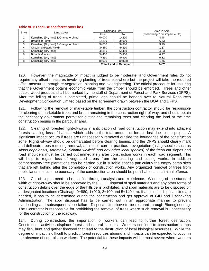
49
Table VI-1: Land use and forest cover loss S.No Land Cover Chainage (km) Area in Acre
(considering 15m impact width) From To 1 Kamzhing (Dry land) & Orange orchard 0+000 1+210 4.48 2 Broadleaf Forest 1+210 3+000 6.63 3 Kamzhing (Dry land) & Orange orchard 3+000 3+860 3.19 4 Chuzhing (Paddy Field) 3+860 4+310 1.67 5 Kamzhing (Dry land) 4+310 5+450 4.23 6 Broadleaf forest 5+450 7+330 6.97 7 Kamzhing (Dry land) 7+330 8+900 5.82 8 Kamzhing (Dry land) 8+900 10+650 1.76
Total Land to Occupied 34.75
120. However, the magnitude of impact is judged to be moderate, and Government rules do not require any offset measures involving planting of trees elsewhere but the project will take the required offset measures through re-vegetation, planting and bioengineering. The official procedure for assuring that the Government obtains economic value from the timber should be enforced. Trees and other usable wood products shall be marked by the staff of Department of Forest and Park Services (DFPS). After the felling of trees is completed, prime logs should be handed over to Natural Resources Development Corporation Limited based on the agreement drawn between the DOA and DFPS.
121. Following the removal of marketable timber, the construction contractor should be responsible for clearing unmarketable trees and brush remaining in the construction right-of-way, and should obtain the necessary government permit for cutting the remaining trees and clearing the land at the time construction begins in the particular area.
122. Clearing of forested right-of-ways in anticipation of road construction may extend into adjacent forests causing loss of habitat, which adds to the total amount of forests lost due to the project. A significant impact occurs if trees are unnecessarily removed outside the boundaries of the construction zone. Rights-of-way should be demarcated before clearing begins, and the DFPS should clearly mark and delineate trees requiring removal, as is their current practice. revegetation (using species such as Alnus nepalensis, Artemesia, Schima wallichii and any other local species) of the fresh cut slopes and road shoulders must be carried out immediately after construction works in each road segment. This will help to regain loss of vegetated areas from the clearing and cutting works. In addition compensatory tree plantations can be carried out in suitable spaces particularly the empty camp sites that are left behind after the completion of construction works. Any organized removal of trees from public lands outside the boundary of the construction area should be punishable as a criminal offense.
123. Cut of slopes need to be justified through analysis and experience. Widening of the standard width of right-of-way should be approved by the GIU. Disposal of spoil materials and any other forms of construction debris over the edge of the hillside is prohibited, and spoil materials are to be disposed off at designated locations (Chainage 0+880, 1+910, 2+100 and 5+140 km). If additional disposal sites are needed, it has to be determined during the construction and get approval of GIU and Dzongkhag Administration. The spoil disposal has to be carried out in an appropriate manner to prevent overloading and subsequent slope failure. Disposal sites have to be restored through Bioengineering. The Contractor is responsible for prohibiting the removal of trees where such removal is unnecessary for the construction of the roadway.
124. During construction, the importation of workers can lead to further forest destruction. Construction activities displace forest and natural habitats. Workers confined to construction camps may fish, hunt and gather firewood that lead to the destruction of local biological resources. While the degree of impact is difficult to predict, forest resources abound and impacts can be expected to occur in the absence of controls on workers. The potential for these impacts will be most severe where workers
50
are located in remote settings far from public facilities and markets, especially if food and other necessitates are not available. The construction contractor will prohibit hunting, fishing and firewood gathering among the worker population, and is required to provide construction camps with food supplies from purchased stores, and to maintain a canteen for workers. Firewood for cooking and warmth should be provided from legitimate sources or otherwise stockpiled from materials cleared from the roadway alignment according to other rules set out in the contract specifications.
125. Burning plant matter in the construction zone is also prohibited since clearing of new right-of-way in forested areas by burning can lead to conflagrations, habitat destruction and regional air pollution. The contractor should avoid burning plant residue by placement of materials into stockpiles outside the line of construction, preferably in contours along slopes below the roadway grade, thus contributing to soil retention and re-growth.
126. Cutting and clearing side hill slopes by blasting and removal of rubble by wasting material down the slope must be prohibited. Disposal of spoil materials on the lower slope below the roadway grade destroys forests and contributes to sediment loss. The contractor should dispose of all spoil materials in designated spoil disposal locations identified by the detail design consultant and verified by the GIU.
127. Stone crushing operations required for road construction generate a lot of dust and noise. As a result the areas and forests surrounding rock crushing sites are covered in a layer of dust. This will negatively impact the natural growth of the trees and shrubs and shrubs as well as to the human health if installed near to the community areas. Crushing plant has to be located away from settlements at chainage km 5+840 near to the quarry. Regular water spraying in and around the stone crushing machinery will be necessary. Water can be collected from the nearby Chomchulumchhu streams.
2. Wildlife
Operation
128. Since the traffic volumes anticipated in the project road segments, impacts of pollution on the forests will be negligible.
129. Bioengineering and revegetation activities carried out during construction may result in problems such as poor regeneration and survival. Necessary replantation and other remedial actions will need to be taken as part of the maintenance of the roads.
-
Detailed Design and Pre-construction
130. Roadway may form a barrier that blocks the daily and seasonal movement of wildlife during the operational life of the project. Except for the forest before Phatshuma village, the current farm road alignment does not pass through the sensitive or critical wildlife habitat areas. However, the design consultant should incorporate measures into the detailed design that facilitate the movement of wildlife. Some possible measures for consideration during detailed design and construction include:
Variable terrain conditions:
-
to the extent possible, a variety of conditions should be present in order to provide opportunities for passage that wildlife can take advantage of in their movements; conversely, disadvantageous conditions (such as steep slopes or cliff faces above or below the road grade) that run for long distances should be avoided.
Unobstructed drainage channels:
-
wherever possible, drainage structures should provide clear passage to allow their movement along intersecting stream beds.
Ramps to traverse slopes: Steep, high, unstable slopes, up- or down-gradient from the road bed may be installed with ramps that provide a gentler slope running obliquely to the face,
51
which provide a means for transition down and up the slope. This mitigation is possible where migration paths are identified.
- Other means should be considered during detailed design for facilitating the movement of animals.
Construction
131. Most of the project road falls inside the degraded forest or habitat area. However, it is still important that the construction contractor follow the recommendations provided in the detailed design for various structures and measures to facilitate animal movement and conservation.
132. Conduction of construction activities during early morning or late evening hours will result in disturbances to wildlife. Working time must be limited to day light hours only. Special precautions must be taken during conduction of noisy activities such as blasting, drilling and operation of stone crushing machinery. Controlled blasting must be carried out as far as possible if blasting works are necessary.
133. Construction workers may hunt, fish or carry out other activities that will negatively impact wildlife. All activities of such kind must clearly be prohibited by the contractor. To remove all possible reasons that may encourage workers to take up these activities, the contractor must ensure that necessary food items, cooking fuel and proper housing is provided.
3. Summary of Impacts on Forest and Biodiversity
Operation
134. Operation of motor vehicles may cause collisions with wildlife. However it is expected that direct collisions between vehicles and wildlife will not be frequent because these are not high speed roads, drivers are generally intent on observing road conditions, and vehicle traffic loading is not great. Nevertheless, there should be signs warning motorists in areas where there is wildlife crossing the roadways.
135. Actions and potential effects on the biological resource include the following:
• Direct forest loss from clearing for roadways and improper placement of spoil materials.
The loss of forest due to clearing of roadway alignments is estimated to be 5.5ha, or about 0.003% of the forested area in the Chukhar dzongkhag. The loss of land is forest land is negligible.
• Depletion of forest resources by workers during construction
Small amounts of land will be used for placement of worker and construction camps. Only quarry locations are potentially forested areas, as the mitigation measures prohibit use of forested areas for other construction-related purposes. Other forest resource losses associated with workers during construction include harvesting of firewood and animal products from forests, which is restricted under terms of the construction contract. Enforcement of this restriction and assurance that sufficient food supplies are provided to workers should be enough to limit the impact to a negligible amount.
• Improved access to forest areas result in illegal logging and animal poaching
Both impacts and benefits stem from the roadways in respect to this impact. Logging and animal poaching that already occur may be reduced through better access for policing operations by local authorities. On the other hand, if enforcement is lax, then there is likely to be an increase in illegal

52
logging and animal poaching as a result of improved access. It is not possible to quantify these effects; however the need for adequate enforcement of conservation laws at the local level seems necessary to prevent serious impacts of these types. The overall impact is expected to be neutral, e.g. while there is better access for poaching and illegal logging, there is also improved surveillance as a result of new road links that pass through forested areas.
• Roads interfere with animal movements and vehicle collisions with animals increase mortality.
These impacts have been assessed elsewhere and are judged to be significant but of a minor order of magnitude in respect to the amount of resource being affected. Vehicle collision with animals is judged to be insignificant overall. Interference with animal movements, while significant, is judged to be minor, given mitigation measures that have been proposed and in respect to the absolute amount of the resource affected.
• Accelerated land use changes in areas near roadways lead to further forest clearing and habitat
Road of course bring about land use change during their operational lives. Once easements are opened into forest areas, there is little likelihood of a reversal of the effect. Due to stringent RGOB policies and regulations, the change in land use during operational face of road will be negligible.
136. The overall impact of the above factors on forests and biodiversity is as follows:
Direct displacement of forests by roads: minor
Depletion of forest by workers during construction: nil
Improved access contributing to illegal logging and poaching: nil
Interference with animal movements and vehicle collisions: minor
C. Socioeconomic Environment
Accelerated land use changes near roadways: minor
Overall impact: minor
1. Land Tenure
Pre-construction
137. Due to outmigration and lack of accessibility, much of the land in the project area has gone fallow. Clearing of land for new right-of-ways improves access, increases value of land, and leads to conflicting land claims amongst the kin and the kiths. Land titles and boundaries may be challenged within local power hierarchies, with particular impacts on vulnerable groups and livelihoods. A significant impact can result from the placement of the roadway that requires specific mitigation actions.
138. Titles to land should be provided to households within the framework of the RGoB land ownership policy. Parallel grievance mechanisms under environment and resettlement components of the project should provide opportunities for affected people to bring cases before the appropriate local government authority.
139. Land surveys in the area of roadways should be reviewed to assure they are complete. Types of land ownership adjacent to or accessible from roadways should be loosely classified as public or private before or during initial ROW surveys.
53
2. Labour Rights during Construction
Operation
140. With the opening of new roads and easier access public lands can be encroached upon for private use. Changes in pricing structure of land occur in the wake of new roads, irrigation and other services, providing renewed incentive to encroach on public lands, especially in areas where cadastral surveys are incomplete, or where the action might be overlooked or ignored by local authorities.
3. Public Liability of Contractor and Damage to Local Infrastructure
Construction
141. In the employment of labor to construct the roadways, rigorous living and working conditions can affect worker health. While health impacts are difficult to predict or quantify, the contractors are required to provide adequate living and working conditions (with sufficiently ventilated living quarters) for workers. Occupational health and safety are priority concerns for the ADB. Borrowers are expected to ensure that contractors working under the loan provide workers with a safe and healthy working and living environment.
142. The contractor should provide laborers and others resident at the site lodging in a camp setting outside of any danger zone, food service facilities, safe drinking water, adequate washing and bathing facilities for maintaining personal hygiene, and access to health care. Guidance for disposition of worker camps can be found in the Government's Rules and Regulations Governing Employment Agencies in Bhutan, 2006, and Rules and Regulations on Occupational Health and Safety in Construction, Manufacturing, Mining and Service Industries, 2006.
143. Work site accident and injury to workers may also occur, since roadway construction is a high risk occupation in which injury is common. While impacts are difficult to predict, experience shows that attention to appropriate safety measures in the work place by the construction contractor can eliminate most accidents. Preventive measures include training and appropriate incentives to comply with health and safety standards. The contractor should establish and maintain a safety and accident prevention program involving provision of adequate protective gear and clothing, well maintained construction equipment, training for workers to assure they are adequately skilled in their jobs, and recordkeeping related to accident frequency combined with measures to correct deficiencies that have shown to be the cause of accidents. Guidance for the program can be found in the previously referenced Government Rules and Regulations.
144. The location and maintenance of construction camps may interfere with the normal life of nearby communities. Sanitary waste and litter can degrade the local environment in the vicinity of construction camps. Wherever possible the camp facilities should be located away 500 m from communities. No forested areas should be used for locations of construction and worker camps. The contractor should provide sanitary facilities (dry pit or pour flush latrines) for workers and arrange for disposal of solid waste in accordance with local practice, which at a minimum should provide for collection, burning and burial of rubbish at controlled sites away from human habitation.
145. Construction workers introduce the threat of HIV/AIDS and other sexually transmitted diseases (STDs). The contractor and GIU should undertake an awareness program among workers to avoid the risk of transmitting STDs.
146. Slopes may become unstable during construction and cause a hazard for workers and nearby people. The contractor is responsible for preventing any public liability by assuring that slopes are stable at the end of construction in a given work area and for avoiding hazard to workers, adjacent property and people. Flagmen should be posted to regulate passage of people where slopes are
54
temporarily unstable as a result of blasting and excavation, and the movement of people restricted in those areas until they are rendered safe. Construction activities that undermine slopes or cause landslides in inhabited areas and lead to property damage or injury should be adjudicated and compensated under the grievance redressal procedures.
147. Construction activity where it occurs near businesses and in community areas blocks access, disturbs the daily life of the community and produces noise, dust and congestion. The contractor should select haul routes for materials and equipment to bypass community areas, and regularly water construction zones and haul roads where these pass through or are located in communities, or are in use by the public. The contractor should operate vehicles during restricted hours in village limits, and rapidly clean up roadway debris during construction. Segments passing through populated areas should be completed over short stretches before opening up new lengths to construction. Contractor will be responsible to rectify any damages including to road and other infrastructures along the haulage routes as a result of movement of haulage vehicles.
148. Various types of private property infrastructure have been noted in the field surveys that are in the alignment of roadway. This infrastructure will need to be relocated and compensated as per ADB’s safeguard policy if damaged, or maintained without damage during construction. There are other locations where similar impacts may occur, and the mitigation measures proposed there should be applied universally. Descriptions of the types of impact are provided in the following paragraphs.
149. Community water supply systems at locations along specific roadways can be put out of commission during construction, disadvantaging local people. Small diameter pipelines and spring water at the takeoff (Jungley), and at Chainage 8+370 km inside Phatshuma settlements that are used for local water supply may be disabled or disturbed during construction leaving households with no alternative water supply. Water supplies need to be maintained during the rehabilitation of roadways. The design and construction supervision consultant should devise a plan with necessary design features to assure these water sources are maintained and left in as good or better condition after construction is complete.
150. Electricity supply lines and power poles that are close to alignments may be disturbed leading to disruption of local electricity supply. Electricity poles at various locations along the Jungley (near takeoff point, Chainage 0+460 km) and Bongo village road section (Chainage 3+420, 3+450, 3+590, 3+720, 3+800 km) will need to avoid rural electricity supply poles during construction in order to avoid impairment of supply. If relocations are required, it has to be carried out done in consultation with Bhutan Power Corporation (BPC) and the affected communities.
151. Passage (foot and mule trails) may be impaired for people with no alternative path of access to homes, schools and public facilities. Along road sections from Jungley – Bongo and Bongo – Phastshuma will occupy existing footpaths and enter villages and communities, foot/mule trails are the only access available for local people currently. In such cases the contractor will need to maintain a safe and accessible pathway for both children and adults that need to pass through the area during the period of construction.
152. Small scale irrigation systems will be put out of commission temporarily due to construction of the roadway. Existing irrigation systems along the Bongo village road section (Chainage 3+600 to 3+620 km) are used to irrigate crops in the paddy fields adjacent to Bongo settlement. The impact of disruption of irrigation system will minimal as construction work is set to carryon during the dry season. Further the contractor will have to construct temporary alternative channel for uninterrupted irrigation water supply during construction. However, as a permanent solution, the project along will need to adopt side drain (construct lined U-Drain) as irrigation channel with adequate cross drainages wherever required in consultation with the local farmers of Bongo village.
55
4. Archeological Remains
5. Long Term Use of Roadway
Construction
153. In the process of construction, damage can occur to archeological monuments and unearthed evidence. There has been no indication that any archeological remains exist in the project area, still, in the event any are uncovered, the contractor should halt construction upon their discovery and notify the GIU Supervisor, who will contact the relevant government authority to investigate and undertake recovery. Work must remain halted at the specific location until recovery is complete.
Detailed Design
154. Accidents involving fuel and hazardous materials along roadways pose a community risk and damage the environment of rivers and streams. The preliminary and detailed design engineers should incorporate safety features into the design of the roadway that help to prevent such accidents. The roadway should be equipped with signage related to hazardous driving conditions and pullouts for passage of vehicles around tight curves and in areas where sight distance is less than the roadway standard.
Operation
155. Litter may accumulate along roadways near communities and markets, causing an aesthetic nuisance and environmental health hazard. DOA should institute an anti-littering campaign along roadway stretches significantly affected by the problem. Rubbish bins should be placed at strategic locations in community surroundings to reduce roadway litter.
156. There is a possibility that agricultural land will be converted to other land uses. But this is unlikely to occur. As mentioned earlier much agricultural land has been allowed to go fallow in areas along the proposed road. Horticultural cropping thrives in other areas but with severe market impediments due to lack of access. Finally the government has a policy that limits the development of settlements in areas with agricultural potential. The likely scenario in the wake of roadway development through agricultural areas is for fallow lands to be brought back into cultivation, followed by crop intensification. Conversion of agricultural land to different land uses is unlikely because there is little economic incentive for it and because there is government restrictions prohibiting land conversion. Agriculture will remain the most viable form of income earning activity in the area, and the presence of roads will support the activity.
157. The majority of impacts on social infrastructure is positive and come about through improved markets, increase in employment opportunity and household income, better public services such as education and health care and increased access to consumable goods. Negative long term trends of out-migration from rural to urban locations may be reversed by improved roadway access. There are no significant negative impacts on social infrastructure expected as a result of the Project.
56
VII. Consultation, Disclosure and Grievance Mechanism
A. Stakeholder Analysis 158. Stakeholders include institutions and cohorts of individuals affected either beneficially or adversely, directly or indirectly, by the Project. Those affected adversely are commonly referred to as Project Affected Persons (PAPs). PAPs may experience environmental impact or be entitled to compensation due to land taken or property lost. Their number is certainly less than that comprising the group of beneficially affected given the nature of the project and the project proponent, a national agency following a national transport development plan.
159. Local stakeholders are cohorts of individuals inhabiting the directly linked villages, some 3 in all under Bongo Geog. Those adversely affected by environmental impact include those directly exposed to construction impacts due to their proximity to the roadway, those entitled to compensation for structures and land for widening of the right-of-way, those along haul routes of construction materials, and those who may be affected by long term impacts stemming from the roadway during its operation. Stakeholders benefiting from the Project include virtually all groups which are engaged in economic pursuits in the area, whether it be transport of agricultural, manufactured and handicraft products to market, sourcing of resources and raw materials, sale of products in an expanded market or the purchase of those goods. Local government benefits through closer ties with national agencies.
160. The list of local stakeholder groups thus is comprised of a) those directly affected by adverse environmental impact during construction, b) those entitled to compensation due to relocation of buildings and taking of land, c) those indirectly affected over the long term due to various forms of cumulative impact, d) a variety of identifiable groups (farmers, suppliers, etc.) that benefit from the economy associated with roads, and e) local government administrators. Women also form an identifiable stakeholder group in that given specific circumstances, women may be adversely affected during construction, and in general benefit from improved access provided by the roadways.
161. Regional and national stakeholders include groups making up the citizenry of the Nation and the various groups within the Royal Government of Bhutan. Adversely affected groups at this scale may be those with a stake in natural resource conservation that perceive negative effects during construction and cumulative impact during operation. The IEE aims to address these concerns. Benefits for groups at regional and national levels stem from increasing connectivity for transfer of goods and services in both private and public sectors and improved governance including better resource management.
162. International stakeholder groups are found in the tourism and conservation sectors; however goods including primary commodities (metals, electricity) may eventually play an important role in Bhutan’s international exchange in consequence of an improved national road system. Whether effects are adverse or beneficial on these groups depends on future management initiatives: access for tourism and conservation management is critical, whereas a low level of management results in degradation of the resource.
B. Process of Involvement of Public
1. Early Screening 163. The Project conforms to the10th Five-Year Plan (2008–2013) that prioritizes construction of farm roads. Both these documents were reviewed and approved by government stakeholders, indicating broad consensus in the RGoB for the proposed roadway. The structure of government assures that local community representatives are aware of master plans that include the proposed roadways.
57
2. First Stage of Public Consultation 164. The Department of Agriculture (DOA) on behalf of the Consultant wrote official letters to the Dzongkhag (District) and Dungkhag (sub-District) administrations to inform the public living in the study area of the proposed road development projects. The Dzongkhag in turn informed the public through Geog administration. Affected Dzongkhag of Chukha was informed of the impending road feasibility studies through this process. The feasibility team inclusive of staff of the environmental conducted field surveys of the alignments to obtain primary data, and visited each affected village along the proposed routes. Environmental staff conducted public consultation according to a prescribed format and in accordance with the following objectives:
• To inform the public and present details regarding the proposed road, its design and anticipated function (the reason it is being built), steps to implement the road and timeframe
• To ask local residents about their transport needs (both short term and long term)
• To ask local residents about problems with existing roads and improvements they feel are needed
• To explore whether or not the proposed road is consistent with their needs and goals
• To ask local residents about problems with current or past road construction and any issues or conflicts that need to be resolved
165. Participants were specifically asked their views on issues related to the road condition, beneficiary and affected groups, impacts of the road due to existing conditions and expected impacts from proposed rehabilitation measures, priorities for transport, environmental issues, community participation and women’s issues. Attendance and detailed response forms for the first stage public consultation are provided in Appendices B.
3. Second Stage of Public Consultation 166. National public consultation held in Thimphu provided an opportunity for government and NGO stakeholders along with interested citizens to provide comment and ask questions concerning the project, potential environmental impacts and mitigation measures.
C. Further Milestone in Public Involvement and Grievance Mechanism 167. Public consultation plays into the process of adaptive management that is essential for meaningful environmental assessment. It is carried forward through implementation by both environmental and social components of the project which become decreasingly differentiated as the process moves forward. The following event milestones provide a guarantee that public concerns will continue to be heard, which may involve environmental impact, long term conservation objectives, or resettlement and compensation if there are any under the project.
• Formal public consultation over environmental issues at local level prior to start of individual construction contracts and at midpoint during contract implementation.
Purpose is to review environmental safeguards related to construction initially, then to provide a forum for voicing environmental concerns. Requires that at least two meetings be held at a central location for the road project.
• Formal public consultation regarding social impact, resettlement and compensation. This is the central element in the grievance mechanism that allows project-affected people to voice concerns and complaints, or raise legal, land or property compensation issues with the DOA. The broad structure of the grievance mechanism provides a means by which complaints and grievances
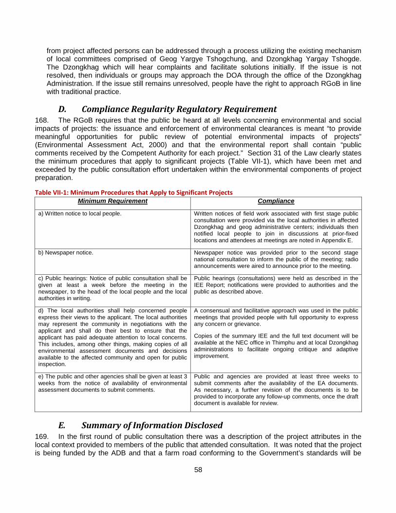
58
from project affected persons can be addressed through a process utilizing the existing mechanism of local committees comprised of Geog Yargye Tshogchung, and Dzongkhag Yargay Tshogde. The Dzongkhag which will hear complaints and facilitate solutions initially. If the issue is not resolved, then individuals or groups may approach the DOA through the office of the Dzongkhag Administration. If the issue still remains unresolved, people have the right to approach RGoB in line with traditional practice.
D. Compliance Regularity Regulatory Requirement 168. The RGoB requires that the public be heard at all levels concerning environmental and social impacts of projects: the issuance and enforcement of environmental clearances is meant “to provide meaningful opportunities for public review of potential environmental impacts of projects” (Environmental Assessment Act, 2000) and that the environmental report shall contain “public comments received by the Competent Authority for each project.” Section 31 of the Law clearly states the minimum procedures that apply to significant projects (Table VII-1), which have been met and exceeded by the public consultation effort undertaken within the environmental components of project preparation.
Table VII-1: Minimum Procedures that Apply to Significant Projects Minimum Requirement Compliance
a) Written notice to local people. Written notices of field work associated with first stage public consultation were provided via the local authorities in affected Dzongkhag and geog administrative centers; individuals then notified local people to join in discussions at prior-fixed locations and attendees at meetings are noted in Appendix E.
b) Newspaper notice. Newspaper notice was provided prior to the second stage national consultation to inform the public of the meeting; radio announcements were aired to announce prior to the meeting.
c) Public hearings: Notice of public consultation shall be given at least a week before the meeting in the newspaper, to the head of the local people and the local authorities in writing.
Public hearings (consultations) were held as described in the IEE Report; notifications were provided to authorities and the public as described above.
d) The local authorities shall help concerned people express their views to the applicant. The local authorities may represent the community in negotiations with the applicant and shall do their best to ensure that the applicant has paid adequate attention to local concerns. This includes, among other things, making copies of all environmental assessment documents and decisions available to the affected community and open for public inspection.
A consensual and facilitative approach was used in the public meetings that provided people with full opportunity to express any concern or grievance.
Copies of the summary IEE and the full text document will be available at the NEC office in Thimphu and at local Dzongkhag administrations to facilitate ongoing critique and adaptive improvement.
e) The public and other agencies shall be given at least 3 weeks from the notice of availability of environmental assessment documents to submit comments.
Public and agencies are provided at least three weeks to submit comments after the availability of the EA documents. As necessary, a further revision of the documents is to be provided to incorporate any follow-up comments, once the draft document is available for review.
E. Summary of Information Disclosed 169. In the first round of public consultation there was a description of the project attributes in the local context provided to members of the public that attended consultation. It was noted that the project is being funded by the ADB and that a farm road conforming to the Government’s standards will be
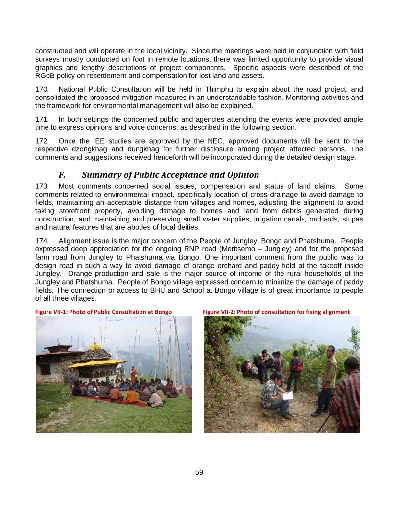
59
constructed and will operate in the local vicinity. Since the meetings were held in conjunction with field surveys mostly conducted on foot in remote locations, there was limited opportunity to provide visual graphics and lengthy descriptions of project components. Specific aspects were described of the RGoB policy on resettlement and compensation for lost land and assets.
170. National Public Consultation will be held in Thimphu to explain about the road project, and consolidated the proposed mitigation measures in an understandable fashion. Monitoring activities and the framework for environmental management will also be explained.
171. In both settings the concerned public and agencies attending the events were provided ample time to express opinions and voice concerns, as described in the following section.
172. Once the IEE studies are approved by the NEC, approved documents will be sent to the respective dzongkhag and dungkhag for further disclosure among project affected persons. The comments and suggestions received henceforth will be incorporated during the detailed design stage.
F. Summary of Public Acceptance and Opinion 173. Most comments concerned social issues, compensation and status of land claims. Some comments related to environmental impact, specifically location of cross drainage to avoid damage to fields, maintaining an acceptable distance from villages and homes, adjusting the alignment to avoid taking storefront property, avoiding damage to homes and land from debris generated during construction, and maintaining and preserving small water supplies, irrigation canals, orchards, stupas and natural features that are abodes of local deities.
174. Alignment issue is the major concern of the People of Jungley, Bongo and Phatshuma. People expressed deep appreciation for the ongoing RNP road (Meritsemo – Jungley) and for the proposed farm road from Jungley to Phatshuma via Bongo. One important comment from the public was to design road in such a way to avoid damage of orange orchard and paddy field at the takeoff inside Jungley. Orange production and sale is the major source of income of the rural households of the Jungley and Phatshuma. People of Bongo village expressed concern to minimize the damage of paddy fields. The connection or access to BHU and School at Bongo village is of great importance to people of all three villages.
Figure VII-1: Photo of Public Consultation at Bongo
Figure VII-2: Photo of consultation for fixing alignment
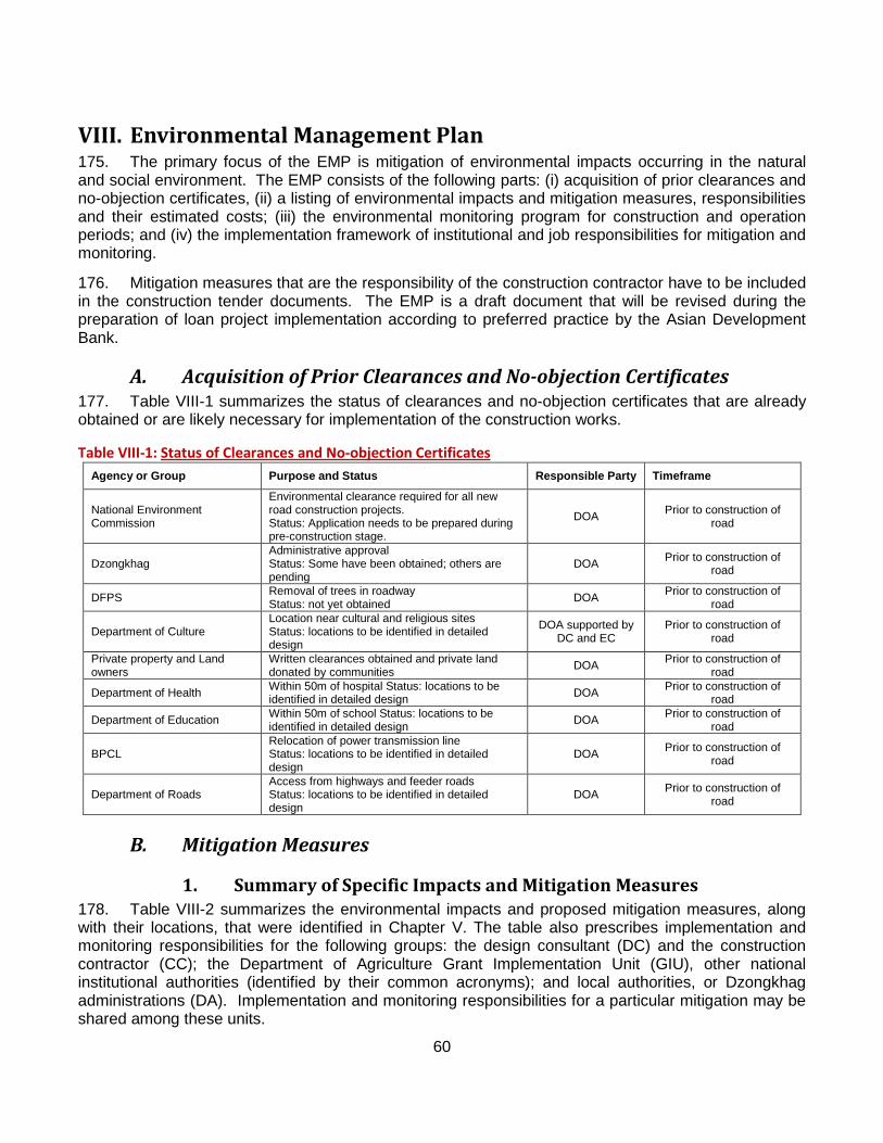
60
VIII. Environmental Management Plan 175. The primary focus of the EMP is mitigation of environmental impacts occurring in the natural and social environment. The EMP consists of the following parts: (i) acquisition of prior clearances and no-objection certificates, (ii) a listing of environmental impacts and mitigation measures, responsibilities and their estimated costs; (iii) the environmental monitoring program for construction and operation periods; and (iv) the implementation framework of institutional and job responsibilities for mitigation and monitoring.
176. Mitigation measures that are the responsibility of the construction contractor have to be included in the construction tender documents. The EMP is a draft document that will be revised during the preparation of loan project implementation according to preferred practice by the Asian Development Bank.
A. Acquisition of Prior Clearances and No-objection Certificates 177. Table VIII-1 summarizes the status of clearances and no-objection certificates that are already obtained or are likely necessary for implementation of the construction works.
Table VIII-1: Agency or Group
Status of Clearances and No-objection Certificates Purpose and Status Responsible Party Timeframe
National Environment Commission
Environmental clearance required for all new road construction projects. Status: Application needs to be prepared during pre-construction stage.
DOA Prior to construction of road
Dzongkhag Administrative approval Status: Some have been obtained; others are pending
DOA Prior to construction of road
DFPS Removal of trees in roadway Status: not yet obtained DOA Prior to construction of
road
Department of Culture Location near cultural and religious sites Status: locations to be identified in detailed design
DOA supported by DC and EC
Prior to construction of road
Private property and Land owners
Written clearances obtained and private land donated by communities DOA Prior to construction of
road
Department of Health Within 50m of hospital Status: locations to be identified in detailed design DOA Prior to construction of
road
Department of Education Within 50m of school Status: locations to be identified in detailed design DOA Prior to construction of
road
BPCL Relocation of power transmission line Status: locations to be identified in detailed design
DOA Prior to construction of road
Department of Roads Access from highways and feeder roads Status: locations to be identified in detailed design
DOA Prior to construction of road
B. Mitigation Measures
1. Summary of Specific Impacts and Mitigation Measures 178. Table VIII-2 summarizes the environmental impacts and proposed mitigation measures, along with their locations, that were identified in Chapter V. The table also prescribes implementation and monitoring responsibilities for the following groups: the design consultant (DC) and the construction contractor (CC); the Department of Agriculture Grant Implementation Unit (GIU), other national institutional authorities (identified by their common acronyms); and local authorities, or Dzongkhag administrations (DA). Implementation and monitoring responsibilities for a particular mitigation may be shared among these units.
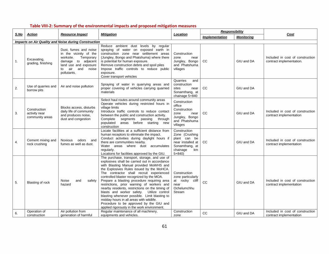
61
Table VIII-2: Summary of the environmental impacts and proposed mitigation measures
S.No Action Resource Impact Mitigation Location Responsibility
Cost Implementation Monitoring
Impacts on Air Quality and Noise during Construction
1. Excavating, grading, finishing
Dust, fumes and noise in the vicinity of the worksite. Temporary damage to adjacent land use and exposure to air and noise pollutants.
Reduce ambient dust levels by regular spraying of water on exposed earth in construction zone near settlement areas (Jungley, Bongo and Phatshuma) where there is potential for human exposure. Remove construction debris and spoil piles Impose traffic controls to reduce public exposure. Cover transport vehicles
Construction zone near Jungley, Bongo and Phatshuma villages
CC GIU and DA Included in cost of construction contract implementation.
2. Use of quarries and borrow pits
Air and noise pollution
Spraying of water in quarrying areas and proper covering of vehicles carrying quarried materials
Quarries and construction sites near Sonamthang, at chainage 5+840
CC GIU and DA
3. Construction activity near community areas
Blocks access, disturbs daily life of community and produces noise, dust and congestion
Select haul routes around community areas Operate vehicles during restricted hours in village limits Introduce traffic controls to reduce contact between the public and construction activity. Complete segments passing through populated areas before starting new construction
Construction office Construction zone near Jungley, Bongo and Phatshuma villages
CC GIU and DA Included in cost of construction contract implementation
4. Cement mixing and rock crushing
Noxious odors and fumes as well as dust.
Locate facilities at a sufficient distance from human receptors to eliminate the impact. Conduct activities during daylight hours if there are communities nearby. Water areas where dust accumulates regularly. Locations for facilities approved by the GIU.
Construction Zone (Crushing plant can be near installed at Sonamthang, at chainage km 5+840)
CC GIU and DA Included in cost of construction contract implementation
5. Blasting of rock Noise and safety hazard
The purchase, transport, storage, and use of explosives shall be carried out in accordance with Blasting Manual provided MoWHS and the Explosives Rules issued by the MoHCA. The contractor shall recruit experienced controlled blaster recognized by the MOA. Prepare a blasting procedure requiring area restrictions, prior warning of workers and nearby residents, restrictions on the timing of blasts and worker safety. Utilize control blasting whenever possible. Limit blasting to midday hours in all areas with wildlife. Procedure to be approved by the GIU and applied rigorously in the work environment.
Construction zone particularly at rocky cliff near Ochelumchhu Stream
CC GIU and DA Included in cost of construction contract implementation
6. Operation of construction
Air pollution from generation of harmful
Regular maintenance of all machinery, equipments and vehicles.
Construction zone CC GIU and DA Included in cost of construction
contract implementation
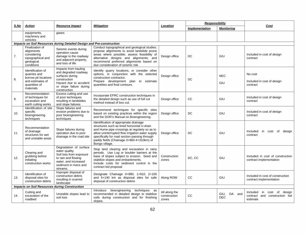
62
S.No Action Resource Impact Mitigation Location Responsibility
Cost Implementation Monitoring
equipments, machinery and vehicles
gases
Impacts on Soil Resources during Detailed Design and Pre-construction
7.
Finalization of alignments considering topographical and geological conditions
Seismic events during operation cause damage to the roadway and adjacent property, and loss of life
Conduct topographical and geological studies; propose alignments to avoid landslide prone areas where possible; assess feasibility of alternative designs and alignments; and recommend preferred alignments based on due consideration of seismic risk
Design office DC GIU Included in cost of design contract
8.
Identification of quarries and borrow pit locations and estimates of quantities of materials
Impacts from hauling and degraded roadway surfaces during construction Hazard due to accident or slope failure during construction
Identify quarry locations, or consider other options, in conjunction with the selected construction contractor. Prepare development plan to estimate quantities and final contours.
Design office
DC NEC GIU
No cost Included in cost of design contract
9.
Recommendation of techniques for excavation and earth cutting works
Excess cutting and use of poor techniques resulting in landslides and slope failures
Incorporate EFRC construction techniques in the detailed design such as use of full cut method instead of box cut.
Design office CC GIU Included in cost of design contract
10.
Identification of site specific bioengineering techniques
Slope failures and erosion problems due to poor bioengineering techniques
Recommend techniques for specific sites based on existing practices within the region and the DOR’s Manual on Bioengineering.
Design office DC GIU Included in cost of design contract
11.
Recommendation of drainage structures for wet and unstable areas
Slope failures during operation due to poor drainage in the road site
Identification of appropriate drainage structures such as lined horizontal U-drain and Hume pipe crossings at regularly so as to allow uninterrupted flow irrigation water supply specifically for road section passing through paddy fields (Chainage 3+860-4+310km) of Bongo village.
Design office DC GIU Included in cost of design contract
12.
Clearing and grubbing before initiating construction works
Degradation of surface water quality. Soil loss from exposure to rain and flowing water, and increased sediment in rivers and streams.
Stop land clearing and excavation in rainy periods. Use Log or boulder barriers at the base of slopes subject to erosion. Seed and stabilize slopes and embankments. Include costs for sediment control in the contract bid proposal
Construction zones DC, CC GIU Included in cost of construction
contract implementation
13. Identification of disposal sites for construction debris
Improper disposal of construction debris resulting in scarred landscape
Designate Chainage 0+880, 1+910, 2+100 and 5+140 km as disposal sites for safe disposal of construction debris
Along ROW CC GIU Included in cost of construction contract implementation
Impacts on Soil Resources during Construction
14. Cutting and excavation of the roadbed
Unstable slopes lead to soil loss
Introduce bioengineering techniques as recommended in detailed design to stabilize soils during construction and for finishing slopes.
All along the construction zones
CC GIU, DA and DEC
Included in cost of design contract and construction bid estimate
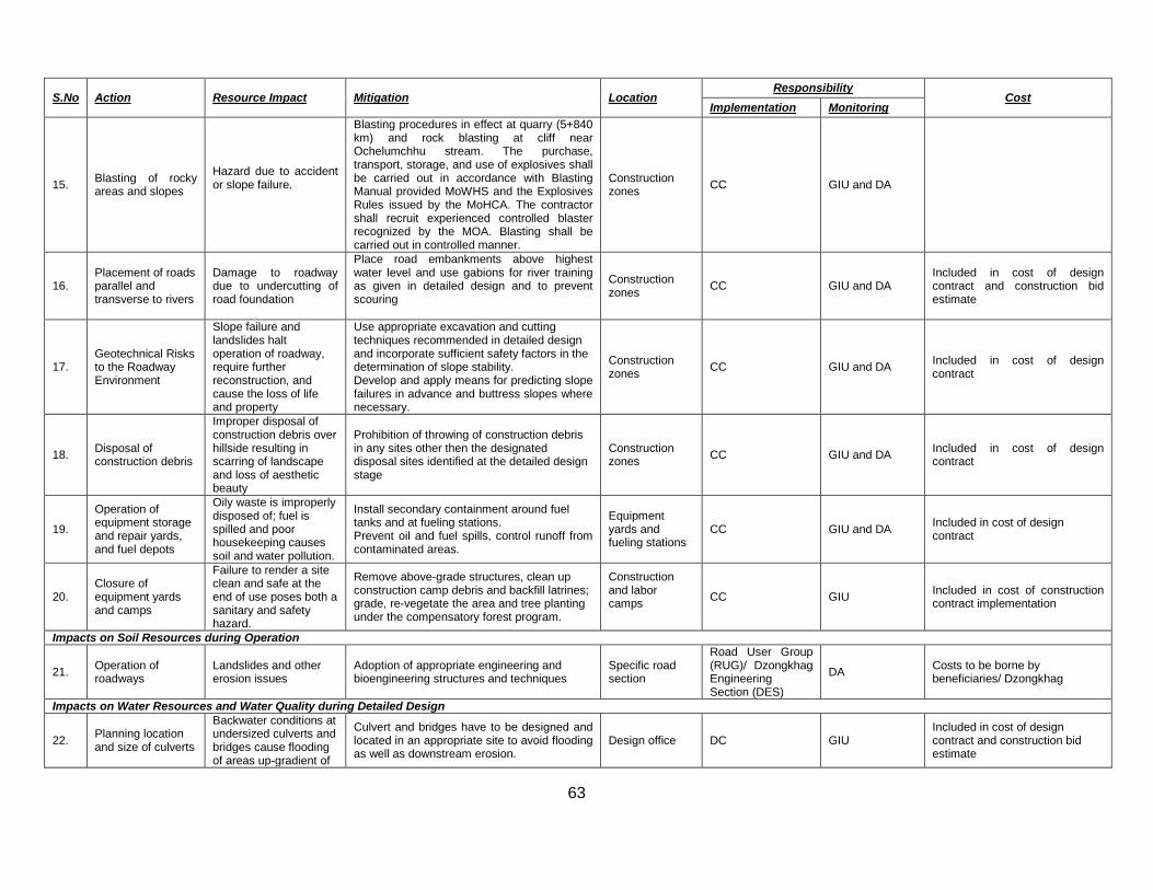
63
S.No Action Resource Impact Mitigation Location Responsibility
Cost Implementation Monitoring
15. Blasting of rocky areas and slopes
Hazard due to accident or slope failure.
Blasting procedures in effect at quarry (5+840 km) and rock blasting at cliff near Ochelumchhu stream. The purchase, transport, storage, and use of explosives shall be carried out in accordance with Blasting Manual provided MoWHS and the Explosives Rules issued by the MoHCA. The contractor shall recruit experienced controlled blaster recognized by the MOA. Blasting shall be carried out in controlled manner.
Construction zones CC GIU and DA
16. Placement of roads parallel and transverse to rivers
Damage to roadway due to undercutting of road foundation
Place road embankments above highest water level and use gabions for river training as given in detailed design and to prevent scouring
Construction zones CC GIU and DA
Included in cost of design contract and construction bid estimate
17. Geotechnical Risks to the Roadway Environment
Slope failure and landslides halt operation of roadway, require further reconstruction, and cause the loss of life and property
Use appropriate excavation and cutting techniques recommended in detailed design and incorporate sufficient safety factors in the determination of slope stability. Develop and apply means for predicting slope failures in advance and buttress slopes where necessary.
Construction zones CC GIU and DA Included in cost of design
contract
18. Disposal of construction debris
Improper disposal of construction debris over hillside resulting in scarring of landscape and loss of aesthetic beauty
Prohibition of throwing of construction debris in any sites other then the designated disposal sites identified at the detailed design stage
Construction zones CC GIU and DA Included in cost of design
contract
19.
Operation of equipment storage and repair yards, and fuel depots
Oily waste is improperly disposed of; fuel is spilled and poor housekeeping causes soil and water pollution.
Install secondary containment around fuel tanks and at fueling stations. Prevent oil and fuel spills, control runoff from contaminated areas.
Equipment yards and fueling stations
CC GIU and DA Included in cost of design contract
20. Closure of equipment yards and camps
Failure to render a site clean and safe at the end of use poses both a sanitary and safety hazard.
Remove above-grade structures, clean up construction camp debris and backfill latrines; grade, re-vegetate the area and tree planting under the compensatory forest program.
Construction and labor camps
CC GIU Included in cost of construction contract implementation
Impacts on Soil Resources during Operation
21. Operation of roadways
Landslides and other erosion issues
Adoption of appropriate engineering and bioengineering structures and techniques
Specific road section
Road User Group (RUG)/ Dzongkhag Engineering Section (DES)
DA Costs to be borne by beneficiaries/ Dzongkhag
Impacts on Water Resources and Water Quality during Detailed Design
22. Planning location and size of culverts
Backwater conditions at undersized culverts and bridges cause flooding of areas up-gradient of
Culvert and bridges have to be designed and located in an appropriate site to avoid flooding as well as downstream erosion.
Design office DC GIU Included in cost of design contract and construction bid estimate
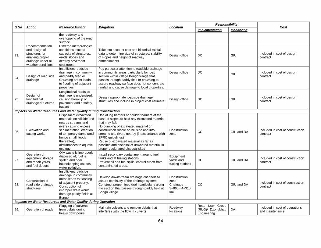
64
S.No Action Resource Impact Mitigation Location Responsibility
Cost Implementation Monitoring
the roadway and overtopping of the road surface
23.
Recommendation and design of structures for enabling proper drainage under all weather conditions
Extreme meteorological conditions exceed capacity of structures, erode slopes and destroy pavement structures.
Take into account cost and historical rainfall data to determine size of structures, stability of slopes and height of roadway embankments.
Design office DC GIU Included in cost of design contract
24. Design of road side drainage
Insufficient roadside drainage in community and paddy filed or Chuzhing areas leads to flooding of adjacent properties
Pay particular attention to roadside drainage in community areas particularly for road section within village Bongo village that passes through paddy field or chuzhing to assure roadway surface does not concentrate rainfall and cause damage to local properties.
Design office
DC
GIU
Included in cost of design contract
25. Design of longitudinal drainage structures
Longitudinal roadside drainage is undersized, causing breakup of pavement and a safety hazard
Design appropriate roadside drainage structures and include in project cost estimate Design office DC GIU Included in cost of design
contract
Impacts on Water Resources and Water Quality during Construction
26. Excavation and cutting works
Disposal of excavated materials on hillside and nearby streams and rivers causing excess sedimentation, creation of temporary dams (and hence small floods thereafter), disturbances to aquatic ecology
Use of log barriers or boulder barriers at the base of slopes to hold any excavated material that may fall. No dumping of excavated material or construction rubble on hill side and into streams and rivers nearby (in accordance with EFRC guidelines) Reuse of excavated material as far as possible and disposal of unwanted material in proper designated disposal sites
Construction zone CC GIU and DA Included in cost of construction
contract
27.
Operation of equipment storage and repair yards, and fuel depots
Oily waste is improperly disposed of; fuel is spilled and poor housekeeping causes water pollution.
Install secondary containment around fuel tanks and at fueling stations. Prevent oil and fuel spills, control runoff from contaminated areas.
Equipment yards and fueling stations
CC GIU and DA Included in cost of construction contract
28. Construction of road side drainage structures
Insufficient roadside drainage in community areas leads to flooding of adjacent property. Construction of improper drain would damage paddy fields at Bongo
Develop downstream drainage channels to assure continuity of the drainage system Construct proper lined drain particularly along the section that passes through paddy field at Bongo village.
Construction zone Chainage 3+860 - 4+310 km
CC GIU and DA Included in cost of construction contract
Impacts on Water Resources and Water Quality during Operation
29. Operation of roads Plugging of culverts from debris during heavy downpours;
Maintain culverts and remove debris that interferes with the flow in culverts
Roadway locations
Road User Group (RUG)/ Dzongkhag Engineering
DA Included in cost of operations and maintenance
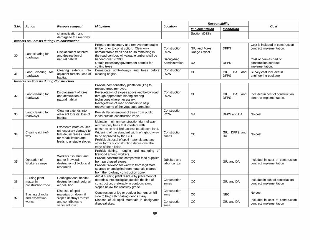
65
S.No Action Resource Impact Mitigation Location Responsibility
Cost Implementation Monitoring
channelization and damage to the roadway
Section (DES)
Impacts on Forests during Pre-construction
30. Land clearing for roadways
Displacement of forest and destruction of natural habitat
Prepare an inventory and remove marketable timber prior to construction. Clear only unmarketable trees and brush remaining in the road corridor. All valuable timber shall be handed over NRDCL. Obtain necessary government permits for cutting trees
Construction ROW Dzongkhag Administration
GIU and Forest Range Officer DA
DFPS DFPS
Cost is included in construction contract implementation. Cost of permits part of construction contract implementation.
31. Land clearing for roadways
Clearing extends into adjacent forests: loss of habitat
Demarcate right-of-ways and trees before clearing begins.
Construction ROW
CC
GIU, DA and DFPS
Survey cost included in engineering package
Impacts on Forests during Construction
32. Land clearing for roadways
Displacement of forest and destruction of natural habitat
Provide compensatory plantation (1:5) to replace trees removed. Revegetation of slopes above and below road through appropriate bioengineering techniques where necessary. Revegetation of road shoulders to help recover some of the vegetated area lost
Construction ROW
CC
GIU, DA and DFPS
Included in cost of construction contract implementation.
33. Land clearing for roadways
Clearing extends into adjacent forests: loss of habitat
Punish illegal removal of trees from public lands outside construction zone.
Construction ROW
GA DFPS and DA No cost
34. Clearing right-of-way
Excessive width causes unnecessary damage to hillside, increases need for rehabilitation and leads to unstable slopes
Maintain minimum construction right-of-way, remove only trees that interfere with construction and limit access to adjacent land. Widening of the standard width of right-of-way to be approved by the GIU. Prohibit disposal of spoil materials and any other forms of construction debris over the edge of the hillside.
Construction zones CC GIU, DFPS and
DA No cost
35. Operation of Workers camps
Workers fish, hunt and gather firewood; destruction of biological resources.
Prohibit fishing, hunting and gathering of firewood among workers. Provide construction camps with food supplies from purchased stores. Provide firewood for warmth from legitimate sources or stockpiled from materials cleared from the roadway construction zone.
Jobsites and labor camps CC GIU and DA Included in cost of construction
contract implementation
36. Burning plant matter in construction zone.
Conflagrations, habitat destruction and regional air pollution.
Avoid burning plant residue by placement of materials into stockpiles outside the line of construction, preferably in contours along slopes below the roadway grade.
Construction zones CC GIU and DA Included in cost of construction
contract implementation
37. Blasting of rocks and excavation works
Disposal of spoil materials on downhill slopes destroys forests and contributes to sediment loss
Construction of log or boulder barriers on hill side to help catch falling debris if any. Dispose of all spoil materials in designated disposal sites.
Construction zone Construction zone
CC CC
NEC GIU and DA
No cost Included in cost of construction contract implementation
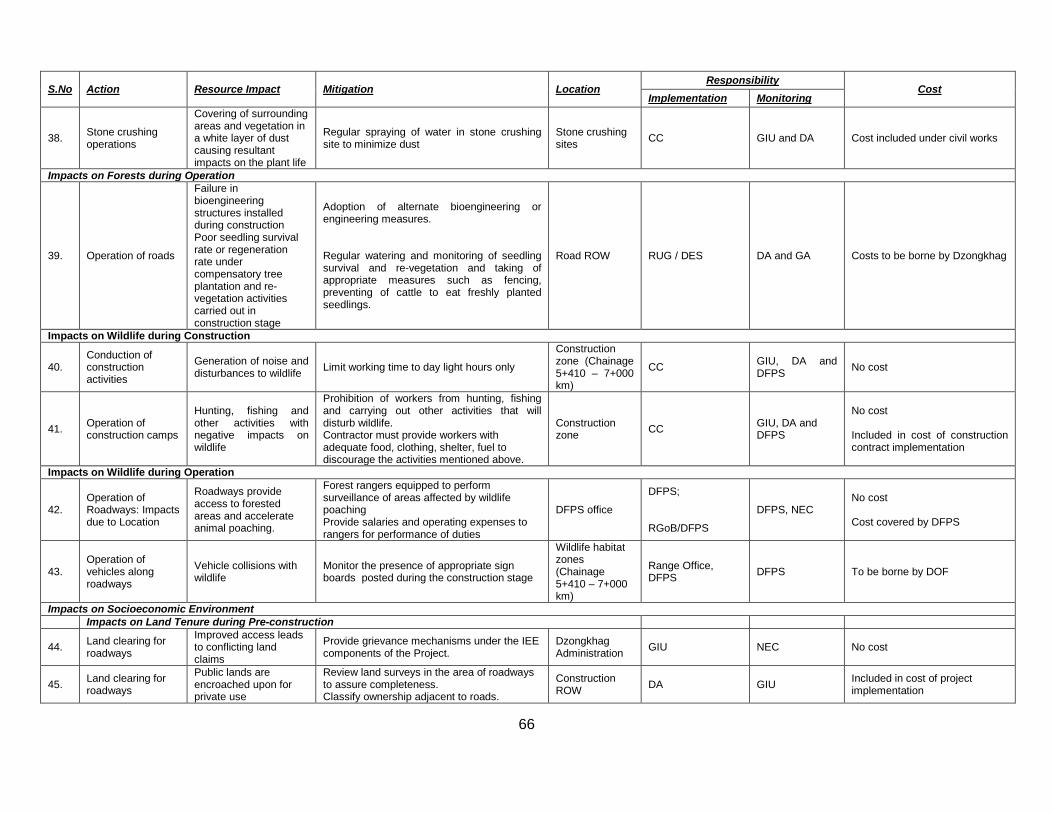
66
S.No Action Resource Impact Mitigation Location Responsibility
Cost Implementation Monitoring
38. Stone crushing operations
Covering of surrounding areas and vegetation in a white layer of dust causing resultant impacts on the plant life
Regular spraying of water in stone crushing site to minimize dust
Stone crushing sites CC GIU and DA Cost included under civil works
Impacts on Forests during Operation
39. Operation of roads
Failure in bioengineering structures installed during construction Poor seedling survival rate or regeneration rate under compensatory tree plantation and re-vegetation activities carried out in construction stage
Adoption of alternate bioengineering or engineering measures. Regular watering and monitoring of seedling survival and re-vegetation and taking of appropriate measures such as fencing, preventing of cattle to eat freshly planted seedlings.
Road ROW RUG / DES DA and GA Costs to be borne by Dzongkhag
Impacts on Wildlife during Construction
40. Conduction of construction activities
Generation of noise and disturbances to wildlife Limit working time to day light hours only
Construction zone (Chainage 5+410 – 7+000 km)
CC GIU, DA and DFPS No cost
41. Operation of construction camps
Hunting, fishing and other activities with negative impacts on wildlife
Prohibition of workers from hunting, fishing and carrying out other activities that will disturb wildlife. Contractor must provide workers with adequate food, clothing, shelter, fuel to discourage the activities mentioned above.
Construction zone CC GIU, DA and
DFPS
No cost Included in cost of construction contract implementation
Impacts on Wildlife during Operation
42. Operation of Roadways: Impacts due to Location
Roadways provide access to forested areas and accelerate animal poaching.
Forest rangers equipped to perform surveillance of areas affected by wildlife poaching Provide salaries and operating expenses to rangers for performance of duties
DFPS office
DFPS; RGoB/DFPS
DFPS, NEC No cost Cost covered by DFPS
43. Operation of vehicles along roadways
Vehicle collisions with wildlife
Monitor the presence of appropriate sign boards posted during the construction stage
Wildlife habitat zones (Chainage 5+410 – 7+000 km)
Range Office, DFPS DFPS To be borne by DOF
Impacts on Socioeconomic Environment Impacts on Land Tenure during Pre-construction
44. Land clearing for roadways
Improved access leads to conflicting land claims
Provide grievance mechanisms under the IEE components of the Project.
Dzongkhag Administration GIU NEC No cost
45. Land clearing for roadways
Public lands are encroached upon for private use
Review land surveys in the area of roadways to assure completeness. Classify ownership adjacent to roads.
Construction ROW DA GIU Included in cost of project
implementation
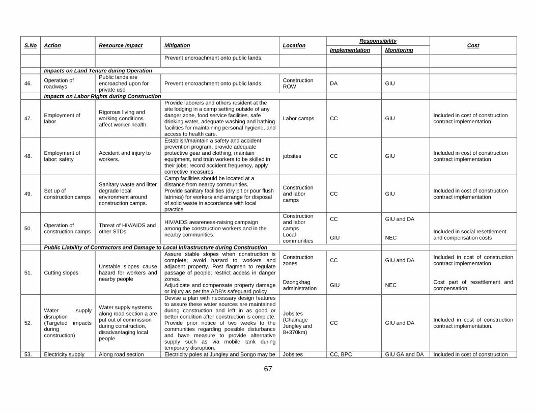
67
S.No Action Resource Impact Mitigation Location Responsibility
Cost Implementation Monitoring
Prevent encroachment onto public lands.
Impacts on Land Tenure during Operation
46. Operation of roadways
Public lands are encroached upon for private use
Prevent encroachment onto public lands. Construction ROW DA GIU
Impacts on Labor Rights during Construction
47. Employment of labor
Rigorous living and working conditions affect worker health.
Provide laborers and others resident at the site lodging in a camp setting outside of any danger zone, food service facilities, safe drinking water, adequate washing and bathing facilities for maintaining personal hygiene, and access to health care.
Labor camps CC GIU Included in cost of construction contract implementation
48. Employment of labor: safety
Accident and injury to workers.
Establish/maintain a safety and accident prevention program, provide adequate protective gear and clothing, maintain equipment, and train workers to be skilled in their jobs; record accident frequency, apply corrective measures.
jobsites CC GIU Included in cost of construction contract implementation
49. Set up of construction camps
Sanitary waste and litter degrade local environment around construction camps.
Camp facilities should be located at a distance from nearby communities. Provide sanitary facilities (dry pit or pour flush latrines) for workers and arrange for disposal of solid waste in accordance with local practice
Construction and labor camps
CC GIU Included in cost of construction contract implementation
50. Operation of construction camps
Threat of HIV/AIDS and other STDs
HIV/AIDS awareness-raising campaign among the construction workers and in the nearby communities.
Construction and labor camps Local communities
CC GIU
GIU and DA NEC
Included in social resettlement and compensation costs
Public Liability of Contractors and Damage to Local Infrastructure during Construction
51. Cutting slopes Unstable slopes cause hazard for workers and nearby people
Assure stable slopes when construction is complete; avoid hazard to workers and adjacent property. Post flagmen to regulate passage of people; restrict access in danger zones. Adjudicate and compensate property damage or injury as per the ADB’s safeguard policy
Construction zones Dzongkhag administration
CC GIU
GIU and DA NEC
Included in cost of construction contract implementation Cost part of resettlement and compensation
52.
Water supply disruption (Targeted impacts during construction)
Water supply systems along road section a are put out of commission during construction, disadvantaging local people
Devise a plan with necessary design features to assure these water sources are maintained during construction and left in as good or better condition after construction is complete. Provide prior notice of two weeks to the communities regarding possible disturbance and have measure to provide alternative supply such as via mobile tank during temporary disruption.
Jobsites (Chainage Jungley and 8+370km)
CC GIU and DA Included in cost of construction contract implementation.
53. Electricity supply Along road section Electricity poles at Jungley and Bongo may be Jobsites CC, BPC GIU GA and DA Included in cost of construction
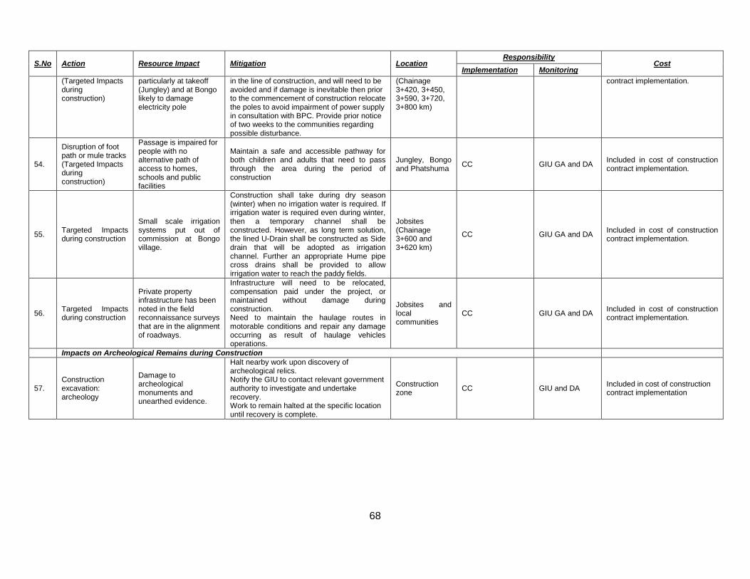
68
S.No Action Resource Impact Mitigation Location Responsibility
Cost Implementation Monitoring
(Targeted Impacts during construction)
particularly at takeoff (Jungley) and at Bongo likely to damage electricity pole
in the line of construction, and will need to be avoided and if damage is inevitable then prior to the commencement of construction relocate the poles to avoid impairment of power supply in consultation with BPC. Provide prior notice of two weeks to the communities regarding possible disturbance.
(Chainage 3+420, 3+450, 3+590, 3+720, 3+800 km)
contract implementation.
54.
Disruption of foot path or mule tracks (Targeted Impacts during construction)
Passage is impaired for people with no alternative path of access to homes, schools and public facilities
Maintain a safe and accessible pathway for both children and adults that need to pass through the area during the period of construction
Jungley, Bongo and Phatshuma CC GIU GA and DA Included in cost of construction
contract implementation.
55. Targeted Impacts during construction
Small scale irrigation systems put out of commission at Bongo village.
Construction shall take during dry season (winter) when no irrigation water is required. If irrigation water is required even during winter, then a temporary channel shall be constructed. However, as long term solution, the lined U-Drain shall be constructed as Side drain that will be adopted as irrigation channel. Further an appropriate Hume pipe cross drains shall be provided to allow irrigation water to reach the paddy fields.
Jobsites (Chainage 3+600 and 3+620 km)
CC GIU GA and DA Included in cost of construction contract implementation.
56. Targeted Impacts during construction
Private property infrastructure has been noted in the field reconnaissance surveys that are in the alignment of roadways.
Infrastructure will need to be relocated, compensation paid under the project, or maintained without damage during construction. Need to maintain the haulage routes in motorable conditions and repair any damage occurring as result of haulage vehicles operations.
Jobsites and local communities
CC GIU GA and DA Included in cost of construction contract implementation.
Impacts on Archeological Remains during Construction
57. Construction excavation: archeology
Damage to archeological monuments and unearthed evidence.
Halt nearby work upon discovery of archeological relics. Notify the GIU to contact relevant government authority to investigate and undertake recovery. Work to remain halted at the specific location until recovery is complete.
Construction zone CC GIU and DA Included in cost of construction
contract implementation
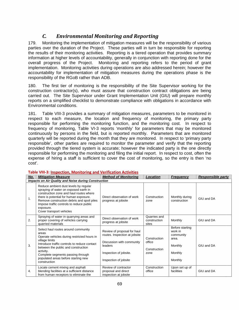
69
C. Environmental Monitoring and Reporting 179. Monitoring the implementation of mitigation measures will be the responsibility of various parties over the duration of the Project. These parties will in turn be responsible for reporting the results of their monitoring activities. Reporting is a tiered operation that provides summary information at higher levels of accountability, generally in conjunction with reporting done for the overall progress of the Project. Monitoring and reporting refers to the period of grant implementation. Monitoring activities during operations are also addressed herein; however the accountability for implementation of mitigation measures during the operations phase is the responsibility of the RGoB rather than ADB.
180. The first tier of monitoring is the responsibility of the Site Supervisor working for the construction contractor(s), who must assure that construction contract obligations are being carried out. The Site Supervisor under Grant Implementation Unit (GIU) will prepare monthly reports on a simplified checklist to demonstrate compliance with obligations in accordance with Environmental conditions.
181. Table VIII-3 provides a summary of mitigation measures, parameters to be monitored in respect to each measure, the location and frequency of monitoring, the primary party responsible for performing the monitoring function, and the monitoring cost. In respect to frequency of monitoring, Table VI-3 reports ‘monthly’ for parameters that may be monitored continuously by persons in the field, but is reported monthly. Parameters that are monitored quarterly will be reported during the month that they are monitored. In respect to ‘primary party responsible’, other parties are required to monitor the parameter and verify that the reporting provided through the tiered system is accurate; however the indicated party is the one directly responsible for performing the monitoring and filing the initial report. In respect to cost, often the expense of hiring a staff is sufficient to cover the cost of monitoring, so the entry is then ‘no cost’.
Table VIII-3: Inspection, Monitoring and Verification Activities No. Mitigation Measure Method of Monitoring Location Frequency Responsible party Impacts on Air Quality and Noise during Construction
1.
Reduce ambient dust levels by regular spraying of water on exposed earth in construction zone and haul routes where there is potential for human exposure. Remove construction debris and spoil piles Impose traffic controls to reduce public exposure. Cover transport vehicles
Direct observation of work progress at jobsite
Construction zone
Monthly during construction GIU and DA
2. Spraying of water in quarrying areas and proper covering of vehicles carrying quarried materials
Direct observation of work progress at jobsite
Quarries and construction sites
Monthly GIU and DA
3.
Select haul routes around community areas Operate vehicles during restricted hours in village limits Introduce traffic controls to reduce contact between the public and construction activity. Complete segments passing through populated areas before starting new construction
Review of proposal for haul routes. Inspection at jobsite Discussion with community leaders Inspection of jobsite. Inspection of jobsite
Construction office Construction zone
Before starting work in community area. Monthly Monthly Monthly
GIU and DA
4. Locate cement mixing and asphalt blending facilities at a sufficient distance from human receptors to eliminate the
Review of contractor proposal and direct inspection at jobsite
Construction office
Upon set up of facilities
GIU and DA
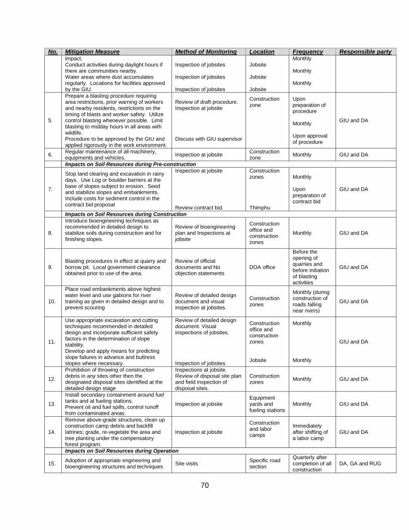
70
No. Mitigation Measure Method of Monitoring Location Frequency Responsible party impact. Conduct activities during daylight hours if there are communities nearby. Water areas where dust accumulates regularly. Locations for facilities approved by the GIU.
Inspection of jobsites Inspection of jobsites Inspection of jobsites
Jobsite Jobsite Jobsite
Monthly Monthly Monthly
5.
Prepare a blasting procedure requiring area restrictions, prior warning of workers and nearby residents, restrictions on the timing of blasts and worker safety. Utilize control blasting whenever possible. Limit blasting to midday hours in all areas with wildlife. Procedure to be approved by the GIU and applied rigorously in the work environment.
Review of draft procedure. Inspection at jobsite Discuss with GIU supervisor
Construction zone
Upon preparation of procedure Monthly Upon approval of procedure
GIU and DA
6. Regular maintenance of all machinery, equipments and vehicles. Inspection at jobsite Construction
zone Monthly GIU and DA
Impacts on Soil Resources during Pre-construction
7.
Stop land clearing and excavation in rainy days. Use Log or boulder barriers at the base of slopes subject to erosion. Seed and stabilize slopes and embankments. Include costs for sediment control in the contract bid proposal
Inspection at jobsite Review contract bid.
Construction zones Thimphu
Monthly Upon preparation of contract bid
GIU and DA
Impacts on Soil Resources during Construction
8.
Introduce bioengineering techniques as recommended in detailed design to stabilize soils during construction and for finishing slopes.
Review of bioengineering plan and Inspections at jobsite
Construction office and construction zones
Monthly GIU and DA
9. Blasting procedures in effect at quarry and borrow pit. Local government clearance obtained prior to use of the area.
Review of official documents and No objection statements
DOA office
Before the opening of quarries and before initiation of blasting activities
GIU and DA
10.
Place road embankments above highest water level and use gabions for river training as given in detailed design and to prevent scouring
Review of detailed design document and visual inspection at jobsites.
Construction zones
Monthly (during construction of roads falling near rivers)
GIU and DA
11.
Use appropriate excavation and cutting techniques recommended in detailed design and incorporate sufficient safety factors in the determination of slope stability. Develop and apply means for predicting slope failures in advance and buttress slopes where necessary.
Review of detailed design document. Visual inspections of jobsites. Inspection of jobsites.
Construction office and construction zones Jobsite
Monthly Monthly
GIU and DA
12.
Prohibition of throwing of construction debris in any sites other then the designated disposal sites identified at the detailed design stage
Inspections at jobsite. Review of disposal site plan and field inspection of disposal sites.
Construction zones Monthly GIU and DA
13.
Install secondary containment around fuel tanks and at fueling stations. Prevent oil and fuel spills, control runoff from contaminated areas.
Inspection at jobsite Equipment yards and fueling stations
Monthly GIU and DA
14.
Remove above-grade structures, clean up construction camp debris and backfill latrines; grade, re-vegetate the area and tree planting under the compensatory forest program.
Inspection at jobsite
Construction and labor camps
Immediately after shifting of a labor camp
GIU and DA
Impacts on Soil Resources during Operation
15. Adoption of appropriate engineering and bioengineering structures and techniques Site visits Specific road
section
Quarterly after completion of all construction
DA, GA and RUG
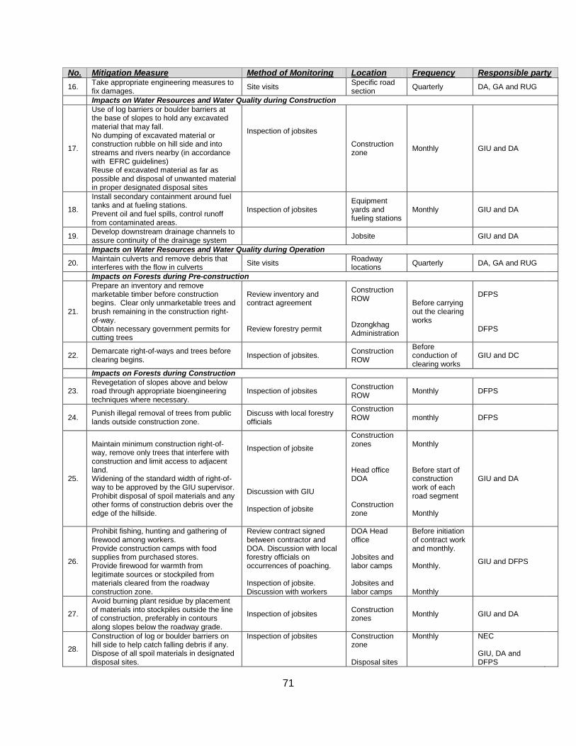
71
No. Mitigation Measure Method of Monitoring Location Frequency Responsible party 16. Take appropriate engineering measures to
fix damages. Site visits Specific road section Quarterly DA, GA and RUG
Impacts on Water Resources and Water Quality during Construction
17.
Use of log barriers or boulder barriers at the base of slopes to hold any excavated material that may fall. No dumping of excavated material or construction rubble on hill side and into streams and rivers nearby (in accordance with EFRC guidelines) Reuse of excavated material as far as possible and disposal of unwanted material in proper designated disposal sites
Inspection of jobsites
Construction zone Monthly GIU and DA
18.
Install secondary containment around fuel tanks and at fueling stations. Prevent oil and fuel spills, control runoff from contaminated areas.
Inspection of jobsites Equipment yards and fueling stations
Monthly GIU and DA
19. Develop downstream drainage channels to assure continuity of the drainage system Jobsite GIU and DA
Impacts on Water Resources and Water Quality during Operation
20. Maintain culverts and remove debris that interferes with the flow in culverts Site visits Roadway
locations Quarterly DA, GA and RUG
Impacts on Forests during Pre-construction
21.
Prepare an inventory and remove marketable timber before construction begins. Clear only unmarketable trees and brush remaining in the construction right-of-way. Obtain necessary government permits for cutting trees
Review inventory and contract agreement Review forestry permit
Construction ROW Dzongkhag Administration
Before carrying out the clearing works
DFPS DFPS
22. Demarcate right-of-ways and trees before clearing begins. Inspection of jobsites. Construction
ROW
Before conduction of clearing works
GIU and DC
Impacts on Forests during Construction
23. Revegetation of slopes above and below road through appropriate bioengineering techniques where necessary.
Inspection of jobsites Construction ROW Monthly DFPS
24. Punish illegal removal of trees from public lands outside construction zone.
Discuss with local forestry officials
Construction ROW
monthly DFPS
25.
Maintain minimum construction right-of-way, remove only trees that interfere with construction and limit access to adjacent land. Widening of the standard width of right-of-way to be approved by the GIU supervisor. Prohibit disposal of spoil materials and any other forms of construction debris over the edge of the hillside.
Inspection of jobsite Discussion with GIU Inspection of jobsite
Construction zones Head office DOA Construction zone
Monthly Before start of construction work of each road segment Monthly
GIU and DA
26.
Prohibit fishing, hunting and gathering of firewood among workers. Provide construction camps with food supplies from purchased stores. Provide firewood for warmth from legitimate sources or stockpiled from materials cleared from the roadway construction zone.
Review contract signed between contractor and DOA. Discussion with local forestry officials on occurrences of poaching. Inspection of jobsite. Discussion with workers
DOA Head office Jobsites and labor camps Jobsites and labor camps
Before initiation of contract work and monthly. Monthly. Monthly
GIU and DFPS
27.
Avoid burning plant residue by placement of materials into stockpiles outside the line of construction, preferably in contours along slopes below the roadway grade.
Inspection of jobsites Construction zones Monthly GIU and DA
28.
Construction of log or boulder barriers on hill side to help catch falling debris if any. Dispose of all spoil materials in designated disposal sites.
Inspection of jobsites
Construction zone Disposal sites
Monthly
NEC GIU, DA and DFPS
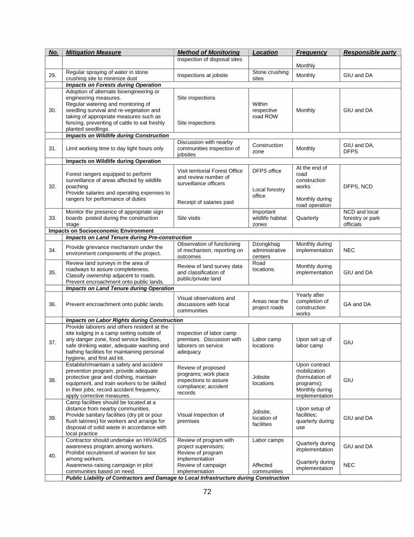
72
No. Mitigation Measure Method of Monitoring Location Frequency Responsible party Inspection of disposal sites
Monthly
29. Regular spraying of water in stone crushing site to minimize dust Inspections at jobsite Stone crushing
sites Monthly GIU and DA
Impacts on Forests during Operation
30.
Adoption of alternate bioengineering or engineering measures. Regular watering and monitoring of seedling survival and re-vegetation and taking of appropriate measures such as fencing, preventing of cattle to eat freshly planted seedlings.
Site inspections Site inspections
Within respective road ROW
Monthly GIU and DA
Impacts on Wildlife during Construction
31. Limit working time to day light hours only Discussion with nearby communities inspection of jobsites
Construction zone Monthly GIU and DA,
DFPS
Impacts on Wildlife during Operation
32.
Forest rangers equipped to perform surveillance of areas affected by wildlife poaching Provide salaries and operating expenses to rangers for performance of duties
Visit territorial Forest Office and review number of surveillance officers Receipt of salaries paid
DFPS office Local forestry office
At the end of road construction works Monthly during road operation
DFPS, NCD
33. Monitor the presence of appropriate sign boards posted during the construction stage
Site visits Important wildlife habitat zones
Quarterly NCD and local forestry or park officials
Impacts on Socioeconomic Environment Impacts on Land Tenure during Pre-construction
34. Provide grievance mechanism under the environment components of the project.
Observation of functioning of mechanism; reporting on outcomes
Dzongkhag administrative centers
Monthly during implementation
NEC
35.
Review land surveys in the area of roadways to assure completeness. Classify ownership adjacent to roads. Prevent encroachment onto public lands.
Review of land survey data and classification of public/private land
Road locations.
Monthly during implementation
GIU and DA
Impacts on Land Tenure during Operation
36. Prevent encroachment onto public lands. Visual observations and discussions with local communities
Areas near the project roads
Yearly after completion of construction works
GA and DA
Impacts on Labor Rights during Construction
37.
Provide laborers and others resident at the site lodging in a camp setting outside of any danger zone, food service facilities, safe drinking water, adequate washing and bathing facilities for maintaining personal hygiene, and first aid kit.
Inspection of labor camp premises. Discussion with laborers on service adequacy
Labor camp locations
Upon set up of labor camp GIU
38.
Establish/maintain a safety and accident prevention program, provide adequate protective gear and clothing, maintain equipment, and train workers to be skilled in their jobs; record accident frequency, apply corrective measures.
Review of proposed programs; work place inspections to assure compliance; accident records
Jobsite locations
Upon contract mobilization (formulation of programs); Monthly during implementation
GIU
39.
Camp facilities should be located at a distance from nearby communities. Provide sanitary facilities (dry pit or pour flush latrines) for workers and arrange for disposal of solid waste in accordance with local practice
Visual inspection of premises
Jobsite, location of facilities
Upon setup of facilities; quarterly during use
GIU and DA
40.
Contractor should undertake an HIV/AIDS awareness program among workers. Prohibit recruitment of women for sex among workers. Awareness-raising campaign in pilot communities based on need.
Review of program with project supervisors; Review of program implementation Review of campaign implementation
Labor camps Affected communities
Quarterly during implementation Quarterly during implementation
GIU and DA NEC
Public Liability of Contractors and Damage to Local Infrastructure during Construction
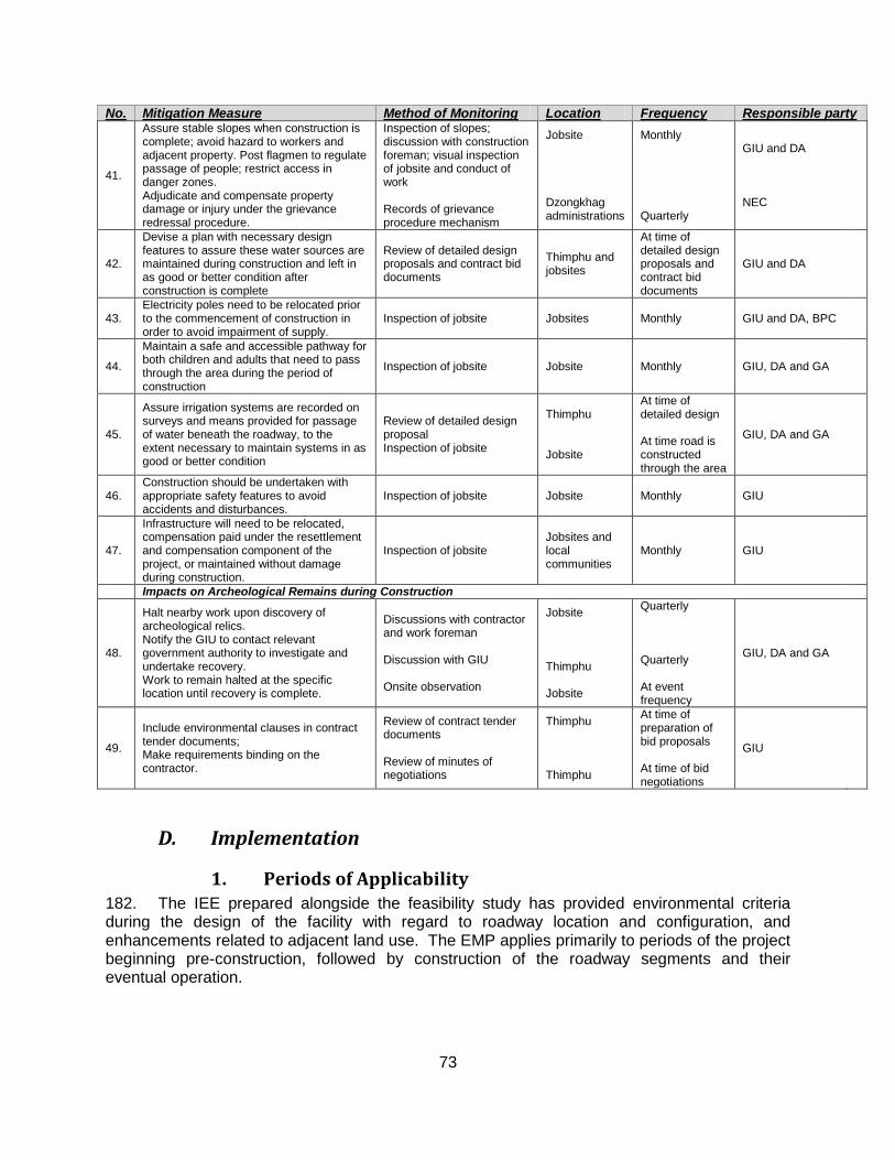
73
No. Mitigation Measure Method of Monitoring Location Frequency Responsible party
41.
Assure stable slopes when construction is complete; avoid hazard to workers and adjacent property. Post flagmen to regulate passage of people; restrict access in danger zones. Adjudicate and compensate property damage or injury under the grievance redressal procedure.
Inspection of slopes; discussion with construction foreman; visual inspection of jobsite and conduct of work Records of grievance procedure mechanism
Jobsite Dzongkhag administrations
Monthly Quarterly
GIU and DA NEC
42.
Devise a plan with necessary design features to assure these water sources are maintained during construction and left in as good or better condition after construction is complete
Review of detailed design proposals and contract bid documents
Thimphu and jobsites
At time of detailed design proposals and contract bid documents
GIU and DA
43. Electricity poles need to be relocated prior to the commencement of construction in order to avoid impairment of supply.
Inspection of jobsite Jobsites Monthly GIU and DA, BPC
44.
Maintain a safe and accessible pathway for both children and adults that need to pass through the area during the period of construction
Inspection of jobsite Jobsite Monthly GIU, DA and GA
45.
Assure irrigation systems are recorded on surveys and means provided for passage of water beneath the roadway, to the extent necessary to maintain systems in as good or better condition
Review of detailed design proposal Inspection of jobsite
Thimphu Jobsite
At time of detailed design At time road is constructed through the area
GIU, DA and GA
46. Construction should be undertaken with appropriate safety features to avoid accidents and disturbances.
Inspection of jobsite Jobsite Monthly GIU
47.
Infrastructure will need to be relocated, compensation paid under the resettlement and compensation component of the project, or maintained without damage during construction.
Inspection of jobsite Jobsites and local communities
Monthly GIU
Impacts on Archeological Remains during Construction
48.
Halt nearby work upon discovery of archeological relics. Notify the GIU to contact relevant government authority to investigate and undertake recovery. Work to remain halted at the specific location until recovery is complete.
Discussions with contractor and work foreman Discussion with GIU Onsite observation
Jobsite Thimphu Jobsite
Quarterly Quarterly At event frequency
GIU, DA and GA
49.
Include environmental clauses in contract tender documents; Make requirements binding on the contractor.
Review of contract tender documents Review of minutes of negotiations
Thimphu Thimphu
At time of preparation of bid proposals At time of bid negotiations
GIU
D. Implementation
1. Periods of Applicability 182. The IEE prepared alongside the feasibility study has provided environmental criteria during the design of the facility with regard to roadway location and configuration, and enhancements related to adjacent land use. The EMP applies primarily to periods of the project beginning pre-construction, followed by construction of the roadway segments and their eventual operation.
74
2. Management Framework a) Preconstruction and Construction
183. The environmental management framework during construction is based on and integral with the overall project management framework. The Project will be implemented by a Grant Implementation Unit (GIU) within the Department of Agriculture (DOA). The Project Managers, along with supervisors, inspectors and other support staff, make up the GIU. The Feasibility and Design Consultant (DC) are hired under a same contract, are part of the GIU.
184. Government agencies such as DFPS, NEC (District Environmental Officer represents NEC at District level) etc., may also be involved in monitoring environmental performance on the Project. District Administration and District Engineers have similar experience of construction supervision and monitoring farm roads constructions. Further, the District Environmental Committee (DEC) is also mandated to carryout environmental monitoring of the farm road construction works within the District. No funds are proposed to be allocated under the Project to these groups, since these agencies are already mandated to carry out monitoring activities.
185. The construction contractor through the construction project manager will be responsible for implementing mitigation requirements in the construction specifications. Line monitoring functions as well as reporting shall be carried out.
186. Dzongkhag administrations (DA) will have the authority to monitor and enforce construction impact mitigation measures alongside other responsible agents, specifically where impacts have a direct effect on the local community.
187. The purpose of the organizational arrangement is to assure there are responsible parties for implementation of mitigation measures, for monitoring and for general oversight during the construction of the project.
a) Reporting 188. Contractor will prepare quarterly reports summarizing the implementation of Environmental management plans as part of the progress report and submit to GIU. The GIU will summarize the reports every quarter for inclusion in the Project Quarterly report forwarded to ADB.
75
IX. Conclusions and Recommendations
A. Compliance with Relevant Sector Guidelines of the RGOB 189. The Project is compliant with RGoB guidelines concerning environment, social impact, resettlement and compensation, and local administration. Sector guidelines related to the environment, road construction and traffic safety are complied with by the project feasibility study and the project overall as it has progressed to the present stage. The documentation for compliance is the project documents; the IEE Report and the effort gone into its compilation provide a vehicle for improved compliance and for documenting incorporation of safeguards.
B. Gain that Justify Project Implementation 190. The primary benefits stem from the farm road connecting to isolated communities of Bongo geog, benefits that include better transport connectivity for movement of people and goods, improved access to social services and to income and livelihood opportunities, a significant infrastructure contribution into the economic and social vitality of the region, and improved security presence for both social and environmental conservation objectives.
C. Adverse Effects 191. Adverse effects are related to construction and to operational phases of the project and effects are noted on physical, biological and socioeconomic domains of the environment.
1. Adverse Effects Minimized 192. Potential adverse effects from construction have been identified in all three domains of the environment and have been minimized by prevention and mitigation measures, as well as by a monitoring presence during the construction activity. A series of mitigation measures have been proposed that are described in the IEE Report and addressed comprehensively in the environmental measures for incorporation into the construction contract tender documents. These include provision of bioengineering applications for stabilizing slopes, use of spoil disposal areas to minimize destruction of forests down-slope of the alignment, proper sizing of hydraulic structures to assure adequate capacity and prevent destruction of adjacent land, identification of vulnerable community infrastructure that must be preserved or replaced under construction contracts, limits on location and access of workers and other provisions regarding construction to assure minimum impact, and other basic provisions found in the EMP.
193. Application of these measures in parallel with RGoB environmentally friendly road construction (EFRC) guidelines (which mitigation measures reiterate) will reduce significantly any potential environmental impact. Impacts remaining on the physical environment (air and water pollution) are temporary and often occur away from the presence of people. The biological environment will reconstitute itself following any residual or remaining impacts on it. Short term impacts on communities and households have been minimized by maintaining facilities, such as water supply systems, in service and by reducing construction interference with everyday life.
194. Potential adverse effects during operations of the roadways have been minimized through the process of preliminary design that fixes the alignments in optimal locations in relation to roadway safety and community impact, through provision of designs and budgets for superior roadway drainage structures, and by accommodating the presence of wildlife in design.
76
2. Adverse Effects Offset 195. Almost half of the road passes through disturbed forests displacing about 13.6 acres of forest land. The magnitude of impact is judged to be moderate, and the government rules do not require any offset measures of planting of trees. However, project shall carry out compensatory plantation (1:5), and re-vegetation through bioengineering program using local plant species to stabilize unstable cut slopes which will to some extent compensate the loss of vegetation as a result of road construction. The farm road is the lowest standard road in Bhutan with minimal budget per kilometer.
3. Adverse Effects Compensated 196. Adverse effects in the social environment – on people’s land and property will be addressed through consultation and appropriate design. No compensation or land substitution is admissible under farm road construction category. The beneficiaries have agreed to provide to land for the road construction.
D. Use of Irreplaceable Resources 197. There is minor use of irreplaceable resources in the form of biological losses, including forests, ecosystems and members of biological species. These losses are minor, since the amount represents only a small fraction of the total range of ecosystem available to a given species. As noted, ecosystem replacement in the form of compensatory planning is proposed under the Project. No other use of irreplaceable resources has been noted by the assessment.
E. Provision for Follow-up Surveillance and Monitoring 198. A systematic approach for surveillance and monitoring is provided by means of a management framework, and monitoring and reporting protocol. Follow-up public consultation is intended to provide future input to the identification of environmental impact during the construction phase as well as a grievance redress mechanism for project affected persons. The EMP will be reviewed during the early stage of project implementation, at which time environmental impacts and mitigation measures will be reassessed, specific mitigation measures incorporated into detailed design, and a revision of associated costs prepared.
77
X. References Chhetri, M. (2005). EFRC Field Handbook. Thimphu: SNV Bhutan - Netherlands Development Organisation.
Election Commission of Bhutan. (2011). Delimitation. Retrieved May 05, 2011, from Election Commission of Bhutan: http://www.election-bhutan.org.bt/index.php?option=com_content&id=132&Itemid=84
NEC. (2004). Application for Environmental Clearance Guidelines for Highways and Roads. Thimphu: National Environmental Commission Secretariat.
NEC. (2000). Environmental Assessment Act. Thimphu: National Environmental Commission Secretariat.
NEC. (2002). Regulation for the Environmental Clearance of Projects and Regulation on Strategic Environmental Assessment. Thimphu: National Environmental Commission Secretariat.
NSB. (2010). Annual Dzonkhag Statistics. Thimphu: National Statistics Bureau.
Office of the Census Commissioner. (2005). Population and Housing Census of Bhutan. Office of the Census Commissioner. Thimphu: Kuensel Corporation Ltd. 2006.
Pradhan, R., & Wangdi, T. (1999). Threatened Birds in Bhutan (IInd ed.). Thimphu: RSPN.
RGOB. (1998). Bio-Diversity Action Plan for Bhutan. Thimphu: Ministry of Agriculture.
RGOB. (2004). The Road Act of the Kingdom of Bhutan. Thimphu: Department of Road.
South Asia Region Economic Policy and Poverty, The World Bank. (2010). Small Area Estimation of Poverty in Rural Bhutan. Thimphu: National Statistical Bureau.
Urs Schaffner, K. J. (1999). Environmental Codes of Practice Highways and Roads. Thimphu: Division of Roads, Ministry of Communications.
78
Appendices
A. Terms of Reference
79
80
81
82
83
84
85
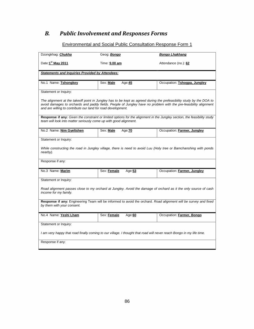
86
B. Public Involvement and Responses Forms
Environmental and Social Public Consultation Response Form 1
Dzongkhag: Geog: Chukha Bongo Bongo Lhakhang
Date: Time: 1st May 2011 Attendance (no.): 9.00 am 62
Statements and Inquiries Provided by Attendees:
No.1 Name: Sex: Tshongkey Male Age: Occupation: 45 Tshogpa, Jungley
Statement or Inquiry:
The alignment at the takeoff point in Jungley has to be kept as agreed during the prefeasibility study by the DOA to avoid damages to orchards and paddy fields. People of Jungley have no problem with the pre-feasibility alignment and are willing to contribute our land for road development.
Response if any: Given the constraint or limited options for the alignment in the Jungley section, the feasibility study team will look into matter seriously come up with good alignment.
No.2 Name: Sex: Nim Gyeltshen Male Age: Occupation: 70 Farmer, Jungley
Statement or Inquiry:
While constructing the road in Jungley village, there is need to avoid Luu (Holy tree or Bamchanshing with ponds nearby).
Response if any:
No.3 Name: Sex: Marim Female Age: Occupation: 53 Farmer, Jungley
Statement or Inquiry:
Road alignment passes close to my orchard at Jungley. Avoid the damage of orchard as it the only source of cash income for my family.
Response if any: Engineering Team will be informed to avoid the orchard. Road alignment will be survey and fixed by them with your consent.
No.4 Name: Sex: Yeshi Lham Female Age: Occupation: 60 Farmer, Bongo
Statement or Inquiry:
I am very happy that road finally coming to our village. I thought that road will never reach Bongo in my life time.
Response if any:
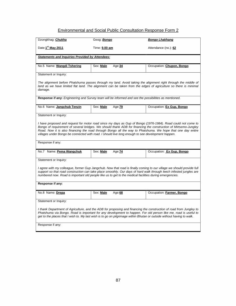
87
Environmental and Social Public Consultation Response Form 2
Dzongkhag: Geog: Chukha Bongo Bongo Lhakhang
Date: Time: 1st May 2011 Attendance (no.): 9.00 am 62
Statements and Inquiries Provided by Attendees:
No.5 Name: Sex: Wangdi Tshering Male Age: Occupation: 34 Chupon, Bongo
Statement or Inquiry:
The alignment before Phatshuma passes through my land. Avoid taking the alignment right through the middle of land as we have limited flat land. The alignment can be taken from the edges of agriculture so there is minimal damage.
Response if any: Engineering and Survey team will be informed and see the possibilities as mentioned.
No.6 Name: Sex: Jangchub Tenzin Male Age: Occupation: 79 Ex Gup, Bongo
Statement or Inquiry:
I have proposed and request for motor road since my days as Gup of Bongo (1976-1984). Road could not come to Bongo of requirement of several bridges. We should thank ADB for financing the construction of Mirtsemo-Jungley Road. Now it is also financing the road through Bongo all the way to Phatshuma. We hope that one day entire villages under Bongo be connected with road. I should live long enough to see development happen.
Response if any:
No.7 Name: Sex: Pema Wangchuk Male Age: Occupation: 74 Ex Gup, Bongo
Statement or Inquiry:
I agree with my colleague, former Gup Jangchub. Now that road is finally coming to our village we should provide full support so that road construction can take place smoothly. Our days of hard walk through leech infested jungles are numbered now. Road is important old people like us to get to the medical facilities during emergencies.
Response if any:
No.8 Name: Sex: Drepa Male Age: Occupation: 68 Farmer, Bongo
Statement or Inquiry:
I thank Department of Agriculture, and the ADB for proposing and financing the construction of road from Jungley to Phatshuma via Bongo. Road is important for any development to happen. For old person like me, road is useful to get to the places that I wish to. My last wish is to go on pilgrimage within Bhutan or outside without having to walk.
Response if any:
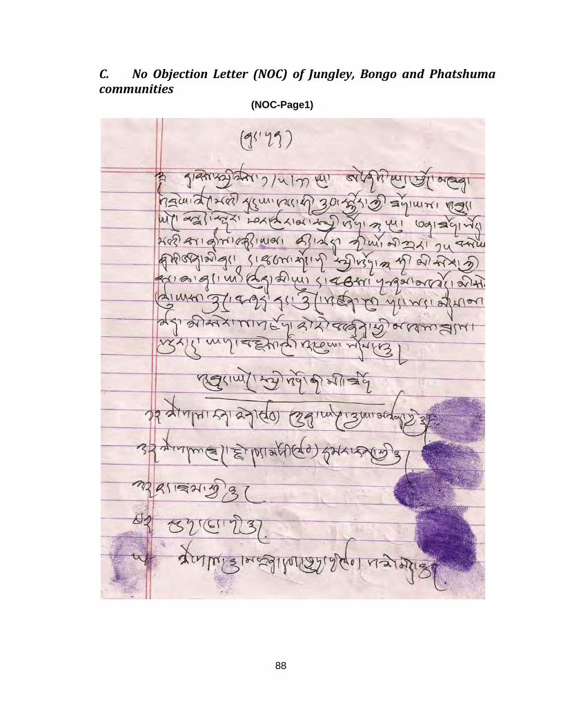
88
C. No Objection Letter (NOC) of Jungley, Bongo and Phatshuma communities
(NOC-Page1)

89
(NOC-Page 2)

90
(NOC-Page 3)

91
(NOC-Page 4)

92
(NOC-Page 5)

93
(NOC-Page 6)

94
D. Translation of No Objection Letter of Jungley, Bongo and Phatshuma communities
(Jungley Page-1)
Today, on 1st May 2011, for the proposed 15 km farm road construction from Jungley-Bongo-Phatshuma supported by ADB, we the people of three villages (or chiwogs) of Jungley, Bongo and Phatshuma are happy, and offer our full support without any objection for the project even if it passes through our private land. As a testimony to our support, we have signed or provided thump impression against our names:
1. Late Rinchen’s representative Kinlay Gyaltshen 2. Late Thujay Wangmo’s representative Marim 3. Rangtham 4. Tauchung 5. Late Tandin Wangchuk’s representative Chimi 6. Late Thujay Wangmo’s representative Dawa 7. Tshongkey (Jungley Tshogpa)

95
(Phatshuma Page-1)
1. Lhabu 2. Karma Wangmo 3. Sangay Zangmo 4. Lhawang Zangmo 5. Lhabchung 6. Dorji Khandu 7. Thinley Pelmo 8. Zeytra 9. Gunpa 10. Pema 11. Wang Dorji 12. Dema 13. Khazermo 14. Thinley (Phatshuma Tshogpa) 15. Sonam
96
(Bongo Page-1)
1. Jangchub Tenzin 2. Pema Wangchuk 3. Pema Wangzom 4. Rinchen Zangmo 5. Phub Dema 6. Rinchen Bida 7. Tashi Lham 8. Yishey Lham 9. Dreyphag 10. Jamtsho 11. Jochung 12. Yishey Gyeltshen 13. Shacha 14. Tshering Bida 15. Kartu 16. Phub Dorji 17. Tenzin 18. Sonam Dorji 19. Singye Peljor 20. Rinchen Bida 21. Rinzin 22. Nidup 23. Namgyel Wangmo 24. Jamchu 25. Rinchen Gyeltshen 26. Sangay Zangmo 27. Sacha 28. Yishey Wangmo 29. Kelzang Dema 30. Lobzang Dendup 31. Dorji Dema 32. Tshewang Zangmo 33. Choni Dema 34. Kinzang Thinley 35. Thujey 36. Badung 37. Ugyen Lhamo 38. Phuntsho Lhamo 39. Migmar Tshering 40. Kinlay Wangmo
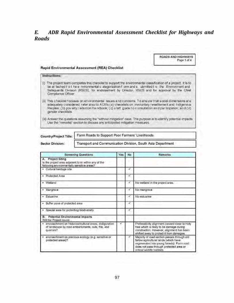
97
E. ADB Rapid Environmental Assessment Checklist for Highways and Roads
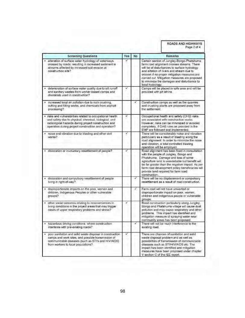
98
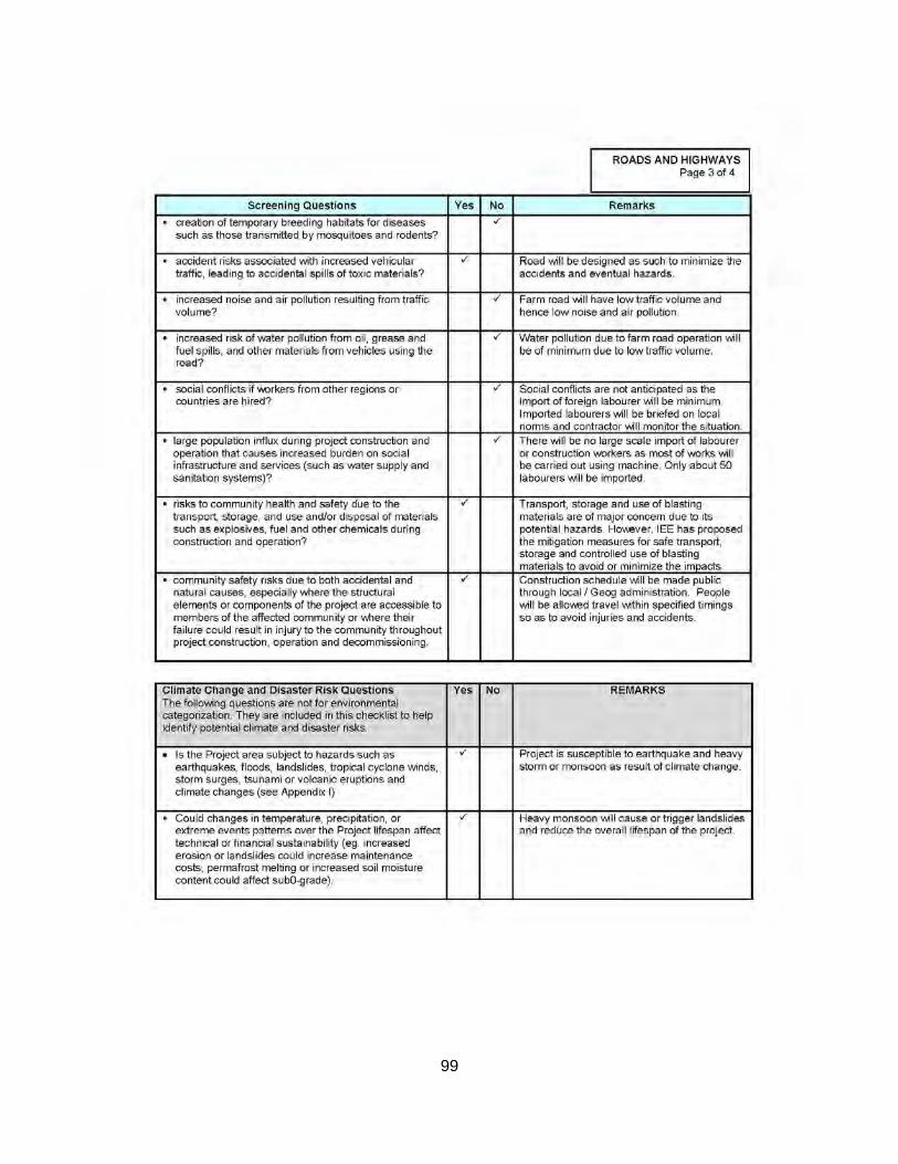
99
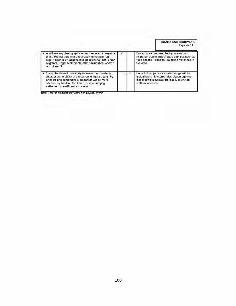
100
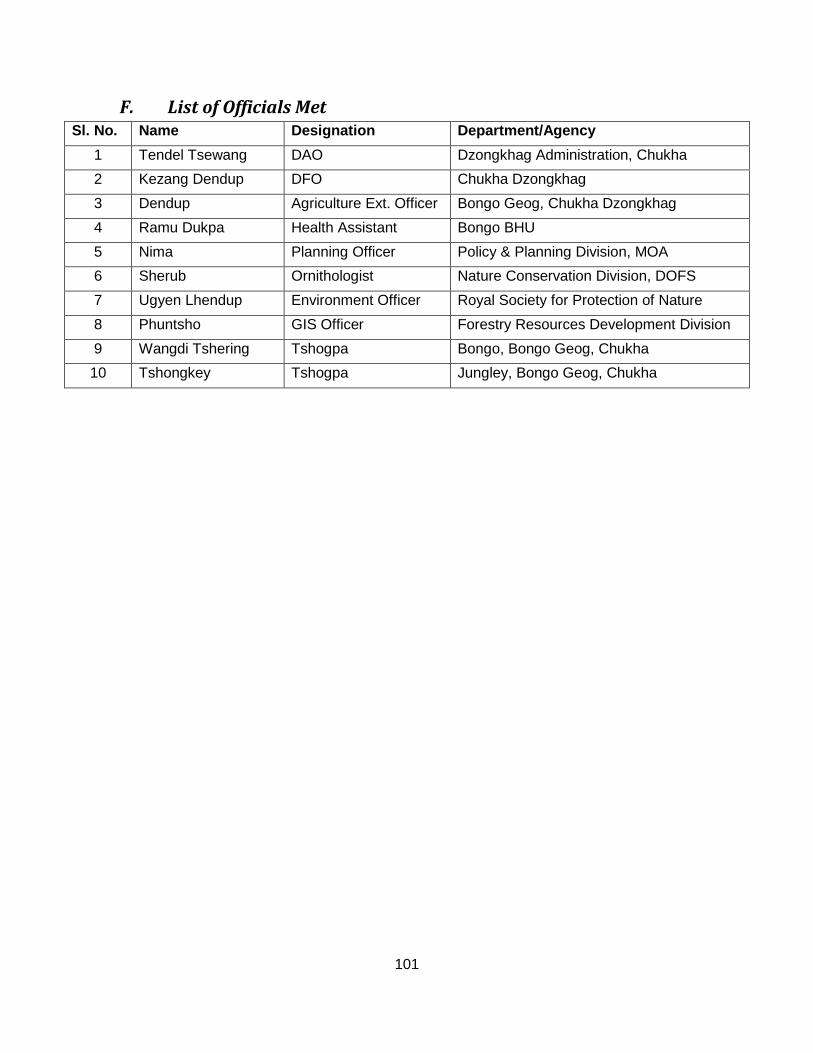
101
F. List of Officials Met Sl. No. Name Designation Department/Agency
1 Tendel Tsewang DAO Dzongkhag Administration, Chukha 2 Kezang Dendup DFO Chukha Dzongkhag 3 Dendup Agriculture Ext. Officer Bongo Geog, Chukha Dzongkhag 4 Ramu Dukpa Health Assistant Bongo BHU 5 Nima Planning Officer Policy & Planning Division, MOA 6 Sherub Ornithologist Nature Conservation Division, DOFS 7 Ugyen Lhendup Environment Officer Royal Society for Protection of Nature 8 Phuntsho GIS Officer Forestry Resources Development Division 9 Wangdi Tshering Tshogpa Bongo, Bongo Geog, Chukha 10 Tshongkey Tshogpa Jungley, Bongo Geog, Chukha