Embed Size (px)
Citation preview
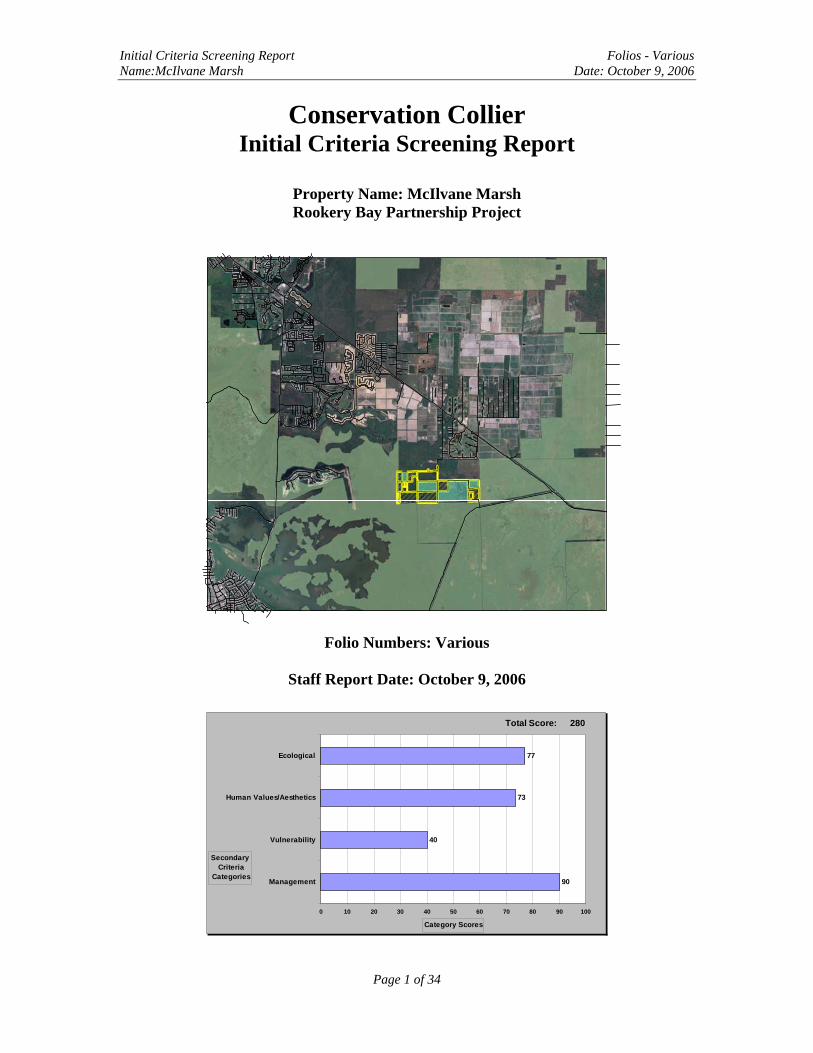
Initial Criteria Screening Report Folios - Various Name:McIlvane Marsh Date: October 9, 2006
Conservation Collier Initial Criteria Screening Report
Property Name: McIlvane Marsh Rookery Bay Partnership Project
Folio Numbers: Various
Staff Report Date: October 9, 2006
90
40
73
77
0 10 20 30 40 50 60 70 80 90 100
Management
Vulnerability
Human Values/Aesthetics
Ecological
Secondary Criteria
Categories
Category Scores
280Total Score:
Page 1 of 34
Initial Criteria Screening Report Folios - Various Name:McIlvane Marsh Date: October 9, 2006
Table of Contents I. Summary of Property Information 3
Estimated Market Value 8
II. Statement for Satisfying Initial Screening Criteria, including Biological and
Hydrological Characteristics 9
III. Potential for Land Use and Recommended Site Improvements 13
IV. Assessment of Management Needs and Costs 14
V. Potential for Matching Funds 17
VI. Summary of Secondary Screening Criteria 18
Tables
Table 1. Summary of Property Information 3
Table 2. McIlvane Marsh properties currently offered to Conservation Collier 4 Table 3. Parcels Assessed and Estimated Market Values 8
Table 4. Summary of Estimated Management Needs and Costs 16
Table 5. Tabulation of Secondary Screening Criteria 20
Table 6. Rookery Bay National Estuarine Research Reserve Wildlife List 35
Figures
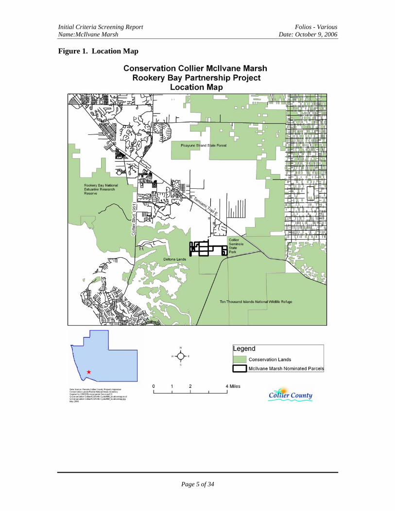
Figure 1. Location Map 5
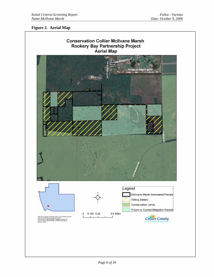
Figure 2. Aerial Map 6
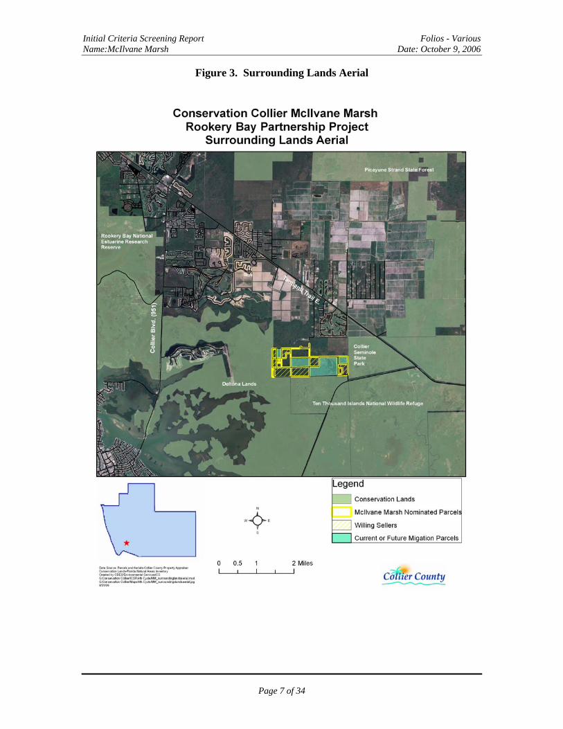
Figure 3 Surrounding Lands Aerial 7
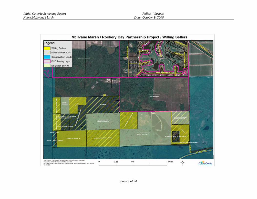
Figure 4. Project Area and Willing Sellers 9
Figure 5. Secondary Screening Criteria Scoring 18
Exhibits A. FLUCCs Map 20
B. Soils Map 21
C. Species Richness Map 22
D. Wellfield Protection and Aquifer Recharge Map 23-24
E. Completed and Scored Secondary Criteria Screening Form 25-27
F. Photographs 28
Page 2 of 34

Initial Criteria Screening Report Folios - Various Name:McIlvane Marsh Date: October 9, 2006
I. Summary of Property Information
The purpose of this section is to provide information concerning the subject property describing its various physical characteristics and other general information. Table 1. Summary of Property Information
Characteristic Value Comments
Name Parcels in McIlvane Marsh Area
16 Parcels nominated in entire project area located in Sections 29 and 30, Township 51 and
Range 27 Folio Number Various See next page for complete listing
Target Protection
Area
None Area not located in a TPA. Inside area designated as Conservation on Future Land Use
Map Size 2.02 to 80 acres Current applications 222.58 acres – 8 parcels
Entire Project is 404 acres – 16 parcels STR S 29 & 30, T 51 and R 27 n/a
Zoning Category/TDRs
Agriculture No TDRs are associated with this project area. Development – 1 unit per 5 acres or Ag uses
consistent with Right To Farm Act. Parcels are within Conservation designated area on Future
Land Use Map FEMA Flood
Map Category Zone AE Area located within Special Flood Hazard Area
– requires building foundation 6 feet above ground level.
Existing structures
None n/a
Adjoining properties and
their Uses
Conservation, Park, Agriculture and PUD
Collier Seminole State Park borders the E side of the project, The 10,000 Islands National
Wildlife Refuge borders to the SW & Deltona Mitigation Lands border to the W. Parcels to the
N are owned by Fiddler’s creek - zoned PUD. Others are owned by private property owners & zoned Ag. Three parcels within the project area,
comprising 310.4 acres, are being deeded to Rookery Bay for mitigation.
Development Plans
None submitted n/a
Known Property
Irregularities
FDOT & CCMPO road study
Florida Dept. of Transportation and Collier County Metropolitan Planning Organization
study to occur on road construction between US 41 and SR 92
Other County Dept Interest
Utilities/Trans No interest stated
Page 3 of 34
Initial Criteria Screening Report Folios - Various Name:McIlvane Marsh Date: October 9, 2006
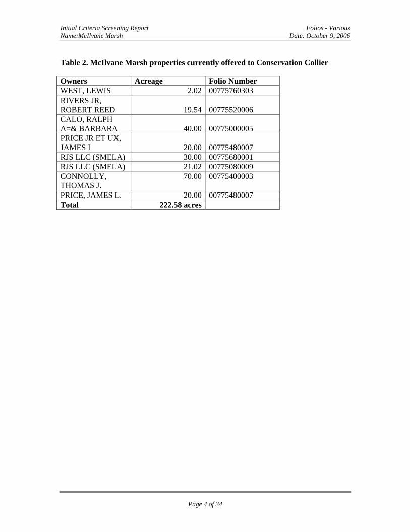
Table 2. McIlvane Marsh properties currently offered to Conservation Collier Owners Acreage Folio Number WEST, LEWIS 2.02 00775760303 RIVERS JR, ROBERT REED 19.54 00775520006 CALO, RALPH A=& BARBARA 40.00 00775000005 PRICE JR ET UX, JAMES L 20.00 00775480007 RJS LLC (SMELA) 30.00 00775680001 RJS LLC (SMELA) 21.02 00775080009 CONNOLLY, THOMAS J.
70.00 00775400003
PRICE, JAMES L. 20.00 00775480007 Total 222.58 acres
Page 4 of 34
Initial Criteria Screening Report Folios - Various Name:McIlvane Marsh Date: October 9, 2006
Figure 1. Location Map
Page 5 of 34
Initial Criteria Screening Report Folios - Various Name:McIlvane Marsh Date: October 9, 2006
Figure 2. Aerial Map
Page 6 of 34
Initial Criteria Screening Report Folios - Various Name:McIlvane Marsh Date: October 9, 2006
Figure 3. Surrounding Lands Aerial
Page 7 of 34
InitiaName
l Criteria Screening Report Folios - Various :McIlvane Marsh Date: October 9, 2006
Page 8 of 34
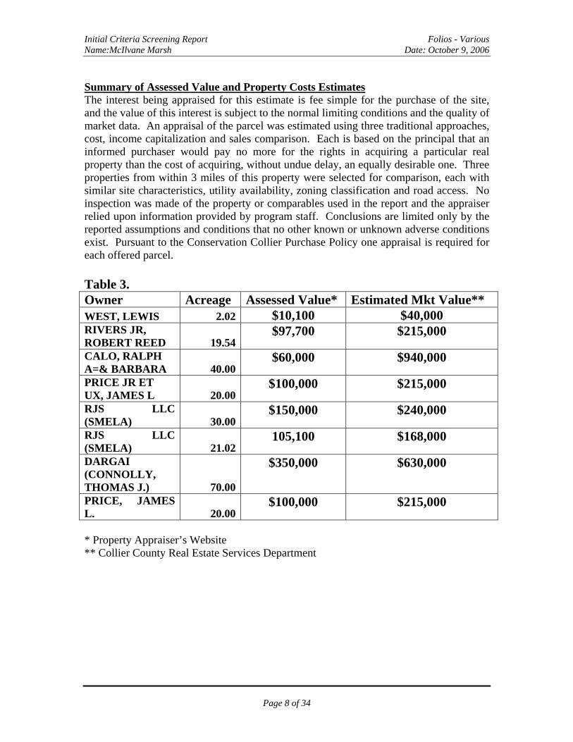
Summary of Assessed Value and Property Costs Estimates The interest being appraised for this estimate is fee simple for the purchase of the site, and the value of this interest is subject to the normal limiting conditions and the quality of market data. An appraisal of the parcel was estimated using three traditional approaches, cost, income capitalization and sales comparison. Each is based on the principal that an informed purchaser would pay no more for the rights in acquiring a particular real property than the cost of acquiring, without undue delay, an equally desirable one. Three properties from within 3 miles of this property were selected for comparison, each with similar site characteristics, utility availability, zoning classification and road access. No inspection was made of the property or comparables used in the report and the appraiser relied upon information provided by program staff. Conclusions are limited only by the reported assumptions and conditions that no other known or unknown adverse conditions exist. Pursuant to the Conservation Collier Purchase Policy one appraisal is required for each offered parcel. Table 3. Owner Acreage Assessed Value* Estimated Mkt Value** WEST, LEWIS 2.02 $10,100 $40,000 RIVERS JR, ROBERT REED 19.54
$97,700 $215,000
CALO, RALPH A=& BARBARA 40.00
$60,000 $940,000
PRICE JR ET UX, JAMES L 20.00
$100,000 $215,000
RJS LLC (SMELA) 30.00
$150,000 $240,000
RJS LLC (SMELA) 21.02
105,100 $168,000
DARGAI (CONNOLLY, THOMAS J.) 70.00
$350,000 $630,000
PRICE, JAMES L. 20.00
$100,000 $215,000
* Property Appraiser’s Website ** Collier County Real Estate Services Department
itial Criteria Screening Report Folios - Various :McIlvane Marsh Date: October 9, 2006
Page 9 of 34
InName
Initial Criteria Screening Report Folios - Various Name:McIlvane Marsh Date: October 9, 2006
II. Statement for satisfying Initial Screening Criteria, Including Biological and Hydrological Characteristics
Collier County Environmental Services Department staff conducted an aerial flyover site visit on May 2, 2006 and a ground site visit to Curcie Road on May 30, 2006.
MEETS INITIAL SCREENING CRITERIA Yes 1. Are any of the following unique and endangered plant communities found on the
property? Order of preference as follows: Ord. 2002-63, Sec. 10 (1)(a)
i. Hardwood hammocks No ii. Xeric oak scrub No
iii. Coastal strand No iv. Native beach No v. Xeric pine No
vi. Riverine Oak No vii. High marsh (saline) YES
viii. Tidal freshwater marsh No ix. Other native habitats YES
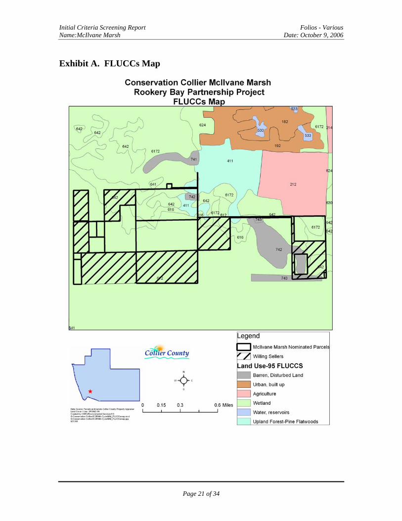
Vegetative Communities: Staff used two methods to determine native plant communities present; review of South Florida Water Management District (SFWMD) electronic databases for Department of Transportation’s Florida Land Use, Cover and Forms (FLUCCS) (1994/1995) and field verification of same. FLUCCS: The electronic database identified:
• FLUCCS 612- Mangrove Swamps • FLUCCS 616- Inland Ponds or Sloughs • FLUCCS 642- Saltwater Marshes • FLUCCS 617- Wetland hardwood forest, mixed wetland • FLUCCS-411- Pine Flatwoods
The following native plant communities were observed: • FLUCCS 642- Saltwater Marshes • FLUCCS 612- Mangrove swamps • FLUCCS 411- Pine Flatwoods • FLUCCS 616- Inland Ponds or Sloughs
Characterization of Plant Communities present: Ground Cover: Mangrove areas do not appear to have ground cover. Scattered upland areas may contain ground cover similar to that observed on parcels located off Curcie Road along eastern side of project area. Plants observed include: beakrush (Rhynchospora sp.), leather fern (Arostichum spp.), swamp fern (Blechnum serrulatum), and white beggar-ticks (Bidens alba).
Page 10 of 34
Initial Criteria Screening Report Folios - Various Name:McIlvane Marsh Date: October 9, 2006
Midstory: red mangroves (Rhizophora mangle), black mangroves (Avicennia germinans), buttonwood (Conocarpus erectus), winged sumac (Rhus copallina), myrsine (Myrsine floridana), saltbush (Baccharis angustifolia and B. halimifolia), wax myrtle (Myrica cerifera) and scattered small cabbage palms (Sabal palmetto). Canopy: An approximate 15-acre area of slash pine and several acres of wetland hardwoods are identified in the electronic FLUCCS record. Observation along the north side of the project area looking eastward, off Curcie Road, showed a small patch of slash pine and scattered individual pines in the distance. Inland ponds were observed from the air. Statement for satisfaction of criteria: This data indicates that native plant communities do exist on the parcels. Not all mapped vegetative communities were directly observed due to problems accessing all areas.
2. Does land offer significant human social values, such as equitable geographic distribution,
appropriate access for nature-based recreation, and enhancement of the aesthetic setting of Collier County? Ord. 2002-63, Sec. 10 (1)(b) YES
Statement for satisfaction of criteria: Conservation Collier does not own lands in this area, so a purchase here would constitute a wider geographic distribution in relation to other acquired preserves. Much of the project area is inaccessible by land; however, a small dock or ramp could easily provide canoe and kayak access. Acquisition of the parcel along the eastern edge of the project area, which is owned by RJS LLC, is critical to providing public access. This parcel would provide access to the area from Curcie road, a paved public right-of-way. 3. Does the property offer opportunities for protection of water resource values, including
aquifer recharge, water quality enhancement, protection of wetland dependant species habitat, and flood control? Ord. 2002-63, Sec. 10 (1)(c) YES
General Hydrologic Characteristics observed and description of adjacent upland /wetland buffers: The entire area appeared to be mangrove and salt flats with small ponds scattered throughout. Wetland dependent plant species (OBL/ FACW) observed:
OBL FACW black mangrove (Avicennia germinans) beakrush (Rhynchospora sp.) (some species
are OBL) red mangrove (Rhizophora mangle) buttonwood (Conocarpus erectus) leatherfern (Acrostichum sp.) swamp fern (Blechnum serrulatum) willow (Salix sp.)
Page 11 of 34
Initial Criteria Screening Report Folios - Various Name:McIlvane Marsh Date: October 9, 2006
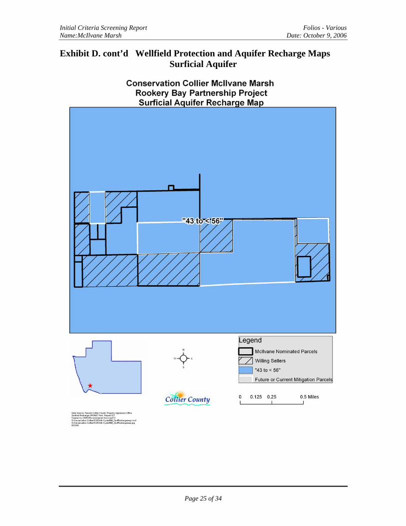
Wetland dependent wildlife species observed: Large white birds were observed throughout the area during aerial flyover. Other Hydrologic indicators observed: Pond water level drawdown was observed during the aerial flyover. High water marks were observed on red mangrove prop roots on the ground. Soils: Soils data is based on the Soil Survey of Collier County Area, Florida (USDA/NRCS, 1990). The following soil types were identified: 40-Durbin and Wulfert Mucks (70%)-Frequently Flooded- typically found in poorly drained tidal mangrove swamps 53-Estero and Peckish soils, (25%) Frequently Flooded- typically found in poorly drained tidal marshes 56-Basinger FS, (5%) Occasionally flooded- a nearly level, poorly drained soil is on occasionally flooded low ridges that are surrounded by tidal marshes Lower Tamiami recharge Capacity: Insignificant to below levels “-16 to 1” - indicating a wetland or discharge area. Surficial Aquifer Recharge Capacity: Moderate to substantial - “43 to < 56 “annually. FEMA Flood map designation: The property is within Flood Zone AE - 5, identified as a Special Flood Hazard Area. The base flood elevation is 5 feet. Statement for satisfaction of criteria: This site contains coastal wetlands that provide habitat for wetland dependent species and protects developed properties to the north from hurricane storm surge. The plants, animals and soils in coastal salt marshes also absorb, filter and neutralize many pollutants before they can reach nearby marine and estuarine communities. These parcels also provide moderate to substantial surficial aquifer recharge.
4. Does the property offer significant biological values, including biodiversity, listed species habitat, connectivity, restoration potential and ecological quality?
Ord. 2002-63, Sec. 10 (1)(d) Yes Listed Plant Species: Listed plant species include those found in Florida Administrative Code (F.A.C.) Section 5B-40.0055 Regulated Plant Index and in the Endangered and Threatened Wildlife and Plants 50 CFR 17.11 and 17.12, December 1999, 50 CFR17.11 and 17.12. No listed plant species were observed during the aerial flyover or ground site visit. Listed Wildlife Species: Listed wildlife species include those found on the Endangered and Threatened Wildlife and Plants 50 CFR 17.11 and 17.12, December 1999 (FWS) or the Florida Fish and Wildlife Conservation Commission (FWCC) Florida’s Endangered Species, Threatened Species, and Species of Special Concern, 29 January, 2004. The
Page 12 of 34
Initial Criteria Screening Report Folios - Various Name:McIlvane Marsh Date: October 9, 2006
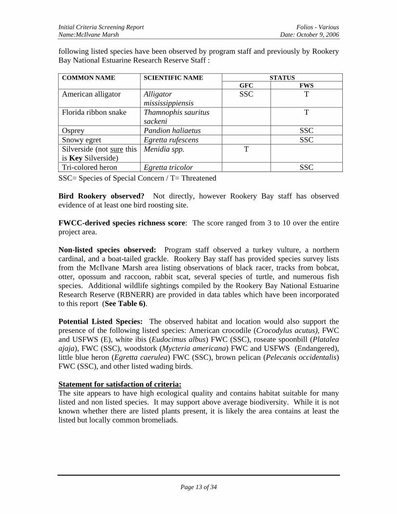
following listed species have been observed by program staff and previously by Rookery Bay National Estuarine Research Reserve Staff :
STATUS COMMON NAME SCIENTIFIC NAME GFC FWS
American alligator Alligator mississippiensis
SSC T
Florida ribbon snake Thamnophis sauritus sackeni
T
Osprey Pandion haliaetus SSC Snowy egret Egretta rufescens SSC Silverside (not sure this is Key Silverside)
Menidia spp. T
Tri-colored heron Egretta tricolor SSC
SSC= Species of Special Concern / T= Threatened Bird Rookery observed? Not directly, however Rookery Bay staff has observed evidence of at least one bird roosting site. FWCC-derived species richness score: The score ranged from 3 to 10 over the entire project area. Non-listed species observed: Program staff observed a turkey vulture, a northern cardinal, and a boat-tailed grackle. Rookery Bay staff has provided species survey lists from the McIlvane Marsh area listing observations of black racer, tracks from bobcat, otter, opossum and raccoon, rabbit scat, several species of turtle, and numerous fish species. Additional wildlife sightings compiled by the Rookery Bay National Estuarine Research Reserve (RBNERR) are provided in data tables which have been incorporated to this report (See Table 6). Potential Listed Species: The observed habitat and location would also support the presence of the following listed species: American crocodile (Crocodylus acutus), FWC and USFWS (E), white ibis (Eudocimus albus) FWC (SSC), roseate spoonbill (Platalea ajaja), FWC (SSC), woodstork (Mycteria americana) FWC and USFWS (Endangered), little blue heron (Egretta caerulea) FWC (SSC), brown pelican (Pelecanis occidentalis) FWC (SSC), and other listed wading birds. Statement for satisfaction of criteria: The site appears to have high ecological quality and contains habitat suitable for many listed and non listed species. It may support above average biodiversity. While it is not known whether there are listed plants present, it is likely the area contains at least the listed but locally common bromeliads.
Page 13 of 34
Initial Criteria Screening Report Folios - Various Name:McIlvane Marsh Date: October 9, 2006
5. Does the property enhance and/or protect the environmental value of current conservation lands through function as a buffer, ecological link or habitat corridor?
Ord. 2002-63, Sec. 10 (1)(e) YES Statement for satisfaction of criteria: The McIlvane Marsh is directly connected to Collier Seminole State Park, 10,000 Islands National Wildlife Refuge (NWR), Deltona settlement lands and through them to the Rookery Bay National Estuarine Research Reserve (RBNERR). Acquisition of these lands will buffer, connect and protect the environmental value of current conservation lands surrounding. Is the property within the boundary of another agency’s acquisition project? NO, however, the US Fish and Wildlife Service, 10,000 Islands NWR, is interested in a possible boundary adjustment to include these parcels through a post acquisition partnership or purchase. RBNERR is also interested in pursuing a boundary adjustment for purposes of a management partnership. If yes, will use of Conservation Collier funds leverage a significantly higher rank or funding priority for the parcel? n/a; However, a purchase by Conservation Collier while willing sellers are identified may provide the time necessary for potential federal funding partners to gain approval for a post acquisition partnership or outright re-purchase from Conservation Collier. Without such funding circumstances, Conservation Collier funds shall not be available for purchase of these lands. Ord. 2002-63, Sec. 10 (1)(f)
Page 14 of 34
Initial Criteria Screening Report Folios - Various Name:McIlvane Marsh Date: October 9, 2006
III. Potential for Appropriate Use and Recommended Site
Improvements
Potential Uses as Defined in Ordinance 2002-63, section 5.9: Hiking: There are limited opportunities for hiking due to wet conditions. Future management could include construction of a boardwalk. Nature Photography: Current lack of access would limit opportunities for nature photography; however, future developed access could provide opportunities. Bird-watching: While there is utilization of this area by wading birds, current lack of access would limit opportunities for bird watching. Future developed access could provide opportunities. Kayaking/Canoeing: Possibly during wet season only. A direct water route from Curcie Road to the Gulf may not exist during dry season. Swimming: Swimming is not an appropriate use. Hunting: Hunting is not a considered use for these parcels. Fishing: Fishing opportunities in the marsh itself would be limited due to the shallow nature of the wetlands; however, there are man-made ponds on the eastern side that could be utilized for fishing. Curcie Rd. provides access to this area. Recommended Site Improvements: Future recommended site improvements would include removal of any observed exotic vegetation, possible improvement of an existing unpaved access road (extending from Curcie Rd. into the project area), a parking area and a wildlife observation boardwalk.
Page 15 of 34
Initial Criteria Screening Report Folios - Various Name:McIlvane Marsh Date: October 9, 2006
IV. Assessment of Management Needs and Costs Management of this property will address the cost and partnership potential for exotics removal and control and site security via fencing of unpaved access roads. The following assessment addresses both the initial and recurring costs of management. These are very preliminary estimates; Ordinance 2002-63 requires a formal land management plan be developed for each property acquired by Conservation Collier.
Exotic, Invasive Plants Present: Scattered Australian pines (Casuarina sp.) and Brazilian pepper (Schinus terebinthifolius) in disturbed areas along unpaved road. Exotic Vegetation Removal and Control: The initial cost of exotic removal is yet to be determined as the full extent of exotic infestation is unknown but appears limited to disturbed uplands and roadways. Total initial removal costs would be approximately $600 per acre and involve approximately 222 acres, for a total potential cost of approximately $133,000. this could be less if exotics are localized to a few areas or more if exotics are difficult to access. Costs for follow-up maintenance, done anywhere from quarterly to annually have been estimated at $450 per acre, per year for a total of $10,000 for 222 acres. These costs would likely decrease over time as the soil seed bank is depleted. RBNERR has indicated an interest in pursuing a management partnership, which could reduce costs for exotic removal through economies of scale. Public Parking Facility: The property would require an area for visitor parking. The cost of construction of a shell or gravel parking lot to accommodate approximately 10 cars would be approximately $15,000. Associated costs could include
• Land clearing • Design • Permitting costs
Public Access Trails: There are limited opportunities for hiking due to wet conditions. Future management could include construction of a boardwalk or observation platform. Security and General Maintenance: Based on aerial observations, there appeared to be some minimal ATV activity. Dumping of solid waste was observed during flyover and ground site visit. Cleanup and fencing of access roads may be appropriate.
Page 16 of 34

Initial Criteria Screening Report Folios - Various Name:McIlvane Marsh Date: October 9, 2006
Table 4. Summary of Estimated Management Needs and Costs Management Element Initial Cost Annual Recurring
Costs Comments
Exotics Control $133,000 $10,000 Few exotics observed from the air; These costs are estimations only
Parking Facility $15,000. t.b.d. Future determination Access Trails n/a n/a No access at this time
and trails are not appropriate due to wetland nature of parcels
Fencing $2,000 t.b.d. 2 Gates for access from Curcie Road
Trash Removal t.b.d. n/a Dumping of solid waste was observed.
Signs $2,000 $750
t.b.d. Main gate sign off Curcie Road $2,000; Interpretive signs 3 @ $250 each
Total $152,075 $10,000+ Estimated values t.b.d. To be determined; cost estimates have not been finalized.
Page 17 of 34

Initial Criteria Screening Report Folios - Various Name:McIlvane Marsh Date: October 9, 2006
V. Potential for Matching Funds
The primary partnering agencies for conservation acquisitions, and those identified in the ordinance are the Florida Communities Trust (FCT), The Florida Forever Program and the Save Our Rivers Program. The following highlights potential for partnering funds, as communicated by agency staff: Florida Communities Trust: Potential does exist for a grant; however, these grants are offered on a yearly cycle and are rarely coordinated with purchases to provide up-front partner funding. Application is typically made for pre-acquired sites. Each recipient is limited to a maximum of ten percent (10%) of the available bond proceeds. For the 2006 funding cycle the award limit per recipient, per cycle, was $6.6 million. Multiple applications may be made, as long as the total amount requested does not exceed the 10% award maximum. If only one application is submitted from Collier County as a whole, a $9.9 million award is possible. The next funding cycle closes in June of 2007. Collier County, with a population exceeding 75,000, is required to provide a minimum match of twenty-five percent (25%) of the total for each project cost. A cursory test scoring of this parcel with FCT criteria by staff gives this parcel a score of 100 out of a possible 320 points. Staff was verbally advised that if a score is under 125, chances of it being selected for funding are not likely. This parcel appears to be below the minimum mark to hold at least some hope for possibility of selection for FCT post-acquisition funding. Florida Forever Program: Staff was verbally advised that the Florida Forever Program is concentrating on larger, more rural parcels, unless those parcels are inside an existing acquisition boundary. These parcels are not inside a Florida Forever project boundary. Save Our Rivers Program / South Florida Water Management District: SFWMD staff has advised that none of these parcels are within a SFWMD project boundary and funding partnerships are unlikely unless that is the case. Other Potential Partner Funding Sources Rookery Bay National Estuarine Research Reserve (RBNERR) currently has a grant from U.S. Fish and Wildlife Service (USFWS) for land acquisition and willing to partner for acquisition with these funds. The grant funding expires in November, however, and RBNERR is requesting an extension of the funding. Staff has advised, however, that an extension is not likely. RBNERR has agreed to partner for management purposes. USFWS is interested in partnering by providing law enforcement support for public access. In order to do this, however, the area must be placed within a federal holding boundary.
Page 18 of 34

Initial Criteria Screening Report Folios - Various Name:McIlvane Marsh Date: October 9, 2006
VI. Summary of Secondary Screening Criteria
Staff has scored property on the Secondary Criteria Screening Form and attached the scoring form as Exhibit E. A total score of 280 out of a possible 400 was achieved. The chart and graph below show a breakdown of the specific components of the score. Table 5. Tabulation of Secondary Screening Criteria
Secondary Screening CriteriaPossible Points
Scored Points
Percent of Possible
ScoreEcological 100 77 77%
Human Values/Aesthetics 100 73 73%Vulnerability 100 40 40%Management 100 90 90%
Total Score: 400 280 70%Percent of Maximum Score: 70%
Figure 4. Secondary Screening Criteria Scoring
90
40
73
77
0 10 20 30 40 50 60 70 80 90 100
Management
Vulnerability
Human Values/Aesthetics
Ecological
Secondary Criteria
Categories
Category Scores
Total Score:
Page 19 of 34
Initial Criteria Screening Report Folios - Various Name:McIlvane Marsh Date: October 9, 2006
Summary of factors contributing to score Total Score – 280 out of 400 Ecological: 77 out of 100 The parcels scored above average in this category. At least 4 FLUCCS native plant communities are present, and perhaps 5. One of the communities is among the targeted types – High Saline Marsh. The area contributes to surficial aquifer recharge, connects hydrologically with the Gulf of Mexico, contains wetlands and mapped soils are 100% depressional or tidal. Listed species utilize the area and minimal alteration, besides removal of exotics is needed to restore high ecological function. Human Values/Aesthetics: 73 out of 100 A high score in this category is due to having access from a paved public road to at least a portion of the area, the potential for multiple opportunities for natural resource-based recreation , including photography, bird watching, kayaking, canoeing and fishing. It lost some points because only a small portion is visible from a public thoroughfare. Vulnerability: 40 out of 100 This area is zoned agricultural and is within an area designated as Conservation on the Future Land Use map of Collier County. That means it is vulnerable to development of 1 single family home per 5 acres, or a total of 44 homes or could be used for bona fide farm operations as allowed by the Florida Right To Farm Act. Realistically, lack of access and presence of coastal wetlands would make this area very difficult and expensive to develop. Management: 90 out of 100 The parcels scored very high in this category because there are no known hydrologic changes necessary to sustain site qualities, an aerial examination and site visit to one area showed that the infestation is not severe, the area requires minimal maintenance and management and Rookery Bay is willing to provide day-to-day management under a shared cost agreement. This would allow for economies of scale in management costs. Parcel Size: Parcels range from 2 to 80 acres with the entire project area reaching 400 acres. While parcel size was not scored, the ordinance advises that based on comparative size, the larger of similar parcels is preferred. These parcels are similar to but slightly exceed the size of the Hamilton property, which is 194 acres. In the McIlvane Marsh area, 222 acres have been offered. Both properties are surrounded by state and federal lands.
Page 20 of 34
Initial Criteria Screening Report Folios - Various Name:McIlvane Marsh Date: October 9, 2006
Exhibit A. FLUCCs Map
Page 21 of 34

Initial Criteria Screening Report Folios - Various Name:McIlvane Marsh Date: October 9, 2006
Exhibit B. Soils Map
Page 22 of 34

Initial Criteria Screening Report Folios - Various Name:McIlvane Marsh Date: October 9, 2006
Exhibit C. Species Richness Map
Page 23 of 34

Initial Criteria Screening Report Folios - Various Name:McIlvane Marsh Date: October 9, 2006
Exhibit D. Wellfield Protection and Aquifer Recharge Maps Lower Tamiami Aquifer
Page 24 of 34
Initial Criteria Screening Report Folios - Various Name:McIlvane Marsh Date: October 9, 2006
Exhibit D. cont’d Wellfield Protection and Aquifer Recharge Maps Surficial Aquifer
Page 25 of 34
Initial Criteria Screening Report Folios - Various Name:McIlvane Marsh Date: October 9, 2006
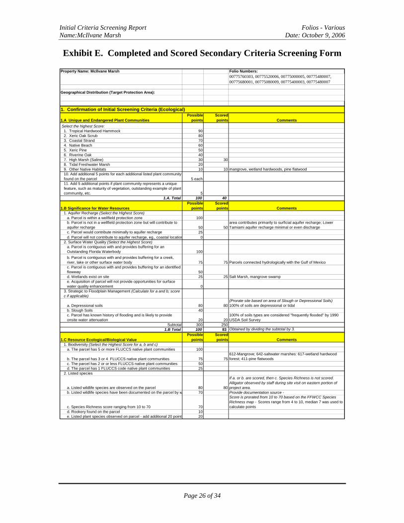
Exhibit E. Completed and Scored Secondary Criteria Screening Form
Property Name: McIlvane Marsh Folio Numbers:00775760303, 00775520006, 00775000005, 00775480007, 00775680001, 00775080009, 00775400003, 00775480007
Geographical Distribution (Target Protection Area):
1. Confirmation of Initial Screening Criteria (Ecological)
1.A Unique and Endangered Plant CommunitiesPossible
pointsScored points Comments
Select the highest Score:1. Tropical Hardwood Hammock 902. Xeric Oak Scrub 803. Coastal Strand 704. Native Beach 605. Xeric Pine 506. Riverine Oak 407. High Marsh (Saline) 30 308. Tidal Freshwater Marsh 209. Other Native Habitats 10 10 mangrove, wetland hardwoods, pine flatwood10. Add additional 5 points for each additional listed plant community found on the parcel 5 each11. Add 5 additional points if plant community represents a unique feature, such as maturity of vegetation, outstanding example of plant community, etc. 5
1.A. Total 100 40
1.B Significance for Water ResourcesPossible
pointsScored points Comments
1. Aquifer Recharge (Select the Highest Score)a. Parcel is within a wellfield protection zone 100b. Parcel is not in a wellfield protection zone but will contribute to aquifer recharge 50 50
area contributes primarily to surficial aquifer recharge; Lower Tamiami aquifer recharge minimal or even discharge
c. Parcel would contribute minimally to aquifer recharge 25d. Parcel will not contribute to aquifer recharge, eg., coastal location 0
2. Surface Water Quality (Select the Highest Score)a. Parcel is contiguous with and provides buffering for an Outstanding Florida Waterbody 100b. Parcel is contiguous with and provides buffering for a creek, river, lake or other surface water body 75 75 Parcels connected hydrologically with the Gulf of Mexicoc. Parcel is contiguous with and provides buffering for an identified flowway 50d. Wetlands exist on site 25 25 Salt Marsh, mangrove swampe. Acquisition of parcel will not provide opportunities for surface water quality enhancement 0
3. Strategic to Floodplain Management (Calculate for a and b; score c if applicable)
a. Depressional soils 80 80(Prorate site based on area of Slough or Depressional Soils) 100% of soils are depressional or tidal
b. Slough Soils 40c. Parcel has known history of flooding and is likely to provide onsite water attenuation 20 20
100% of soils types are considered "frequently flooded" by 1990 USDA Soil Survey
Subtotal 300 2501.B Total 100 83 Obtained by dividing the subtotal by 3.
1.C Resource Ecological/Biological ValuePossible
pointsScored points Comments
1. Biodiversity (Select the Highest Score for a, b and c)a. The parcel has 5 or more FLUCCS native plant communities 100
b. The parcel has 3 or 4 FLUCCS native plant communities 75 75612-Mangrove; 642-saltwater marshes: 617-wetland hardwood forest; 411-pine flatwoods
c. The parcel has 2 or or less FLUCCS native plant communities 50d. The parcel has 1 FLUCCS code native plant communities 25
2. Listed species
a. Listed wildlife species are observed on the parcel 80 80
If a. or b. are scored, then c. Species Richness is not scored. Alligator observed by staff during site visit on eastern portion of project area.
b. Listed wildlife species have been documented on the parcel by w 70 Provide documentation source -
c. Species Richness score ranging from 10 to 70 70
Score is prorated from 10 to 70 based on the FFWCC Species Richness map - Scores range from 4 to 10, median 7 was used to calculate points
d. Rookery found on the parcel 10e. Listed plant species observed on parcel - add additional 20 points 20
Page 26 of 34

Initial Criteria Screening Report Folios - Various Name:McIlvane Marsh Date: October 9, 2006
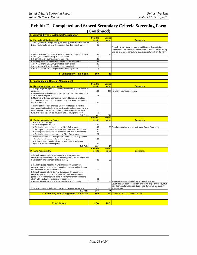
Exhibit E. Completed and Scored Secondary Criteria Screening Form (Continued)
3. Restoration Potentiala. Parcel can be restored to high ecological function with minimal alteration 100 100
Removal of exotics, solid waste and gating. No alterations in topography envisioned.
b. Parcel can be restored to high ecological function but will require moderate work, including but not limited to removal of exotics and alterations in topography. 50c. Parcel will require major alterations to be restored to high ecological function. 15d. Conditions are such that parcel cannot be restored to high ecological function 0 explain limiting conditions
Subtotal 300 2551.C Total 100 85 Divide the subtotal by 3
1.D Protection and Enhancement of Current Conservation LandsPossible
pointsScored points Comments
1. Proximity and Connectivitya. Property immediately contiguous with conservation land or conservation easement. 100 100
10,000 NWR, Deltona lands/Rookery Bay NERR, Collier Seminole Park
b. Property not immediately contiguous, parcels in between it and the conservation land are undeveloped. 50c. Property not immediately contiguous, parcels in-between it and conservation land are developed 0d. If not contiguous and developed, add 20 points if an intact ecological link exists between the parcel and nearest conservation land 20
1.D Total 100 100
1. Ecological Total Score 100 77 Sum of 1A, 1B, 1C, 1D then divided by 4
2. Human Values/Aesthetics
2.A Human Social Values/AestheticsPossible
pointsScored points Comments
1. Access (Select the Highest Score)
a. Parcel has access from a paved road 100 100
Curcie Road is paved until it reaches parcel then becomes unpaved. This road accesses RJS LLC lands and these lands have been offered to the program.
b. Parcel has access from an unpaved road 75c. Parcel has seasonal access only or unimproved access easemen 50d. Parcel does not have physical or known legal access 0
2. Recreational Potential (Select the Highest Score)a. Parcel offers multiple opportunities for natural resource-based recreation consistent with the goals of this program, including but not limited to, environmental education, hiking, nature photography, bird watching, kayaking, canoeing, swimming, hunting (based on size?) and fishing. 100 100 photography, bird watching, kayaking, canoeing, fishingb. Parcel offers only land-based opportunities for natural resource-based recreation consistent with the goals of this program, including but not limited to, environmental education, hiking, and nature photography. 75c. Parcel offers limited opportunities for natural-resource based recreation beyond simply accessing and walking on it 50d. Parcel does not offer opportunities for natural-resource based recreation 0
3. Enhancement of Aesthetic Setting
a. Percent of perimeter that can be seen by public. Score based on percentage of frontage of parcel on public thoroughfare 80
Score between 0 and 80 based on the percentage of the parcel perimeter that can be seen by the public from a public thoroughfare.
b. Add up to 20 points if the site contains outstanding aesthetic characteristic(s), such as but not limited to water view, mature trees, native flowering plants, or archeological site 20 20
Provide a description and photo documentation of the outstanding characteristic - Water views
Subtotal 300 220
2. Human Social Values/Aesthetics Total Score 100 73 Obtained by dividing the subtotal by 3.
Page 27 of 34
Initial Criteria Screening Report Folios - Various Name:McIlvane Marsh Date: October 9, 2006
Exhibit E. Completed and Scored Secondary Criteria Screening Form (Continued)
3. Vulnerability to Development/Degradation
3.A Zoning/Land Use DesignationPossible
pointsScored points Comments
1. Zoning allows for Single Family, Multifamily, industrial or commerci 502. Zoning allows for density of no greater than 1 unit per 5 acres 45
3. Zoning allows for agricultural use /density of no greater than 1 unit 40 40
Agricultural (A) zoning designation within area designated as Conservation on the future Land Use Map. Allows 1 Single Family Unit per 5 acres or agricultural use consistent with Right To Farm Act.
4. Zoning favors stewardship or conservation 05. If parcel has ST overlay, remove 20 points -206. Property has been rezoned and/or there is SDP approval 257. SFWMD and/or USACOE permit has been issued 258. A rezone or SDP application has been submitted 159. SFWMD and/or USACOE permit has been applied for 15
3. Vulnerability Total Score 100 40
4. Feasibility and Costs of Management
4.A Hydrologic Management NeedsPossible
pointsScored points Comments
1. No hydrologic changes are necessary to sustain qualities of site in perpetuity 100 100 No known changes necessary.2. Minimal hydrologic changes are required to restore function, such a cut in an existing berm 753. Moderate hydrologic changes are required to restore function, such as removal of existing berms or minor re-grading that require use of machinery 504. Significant hydologic changes are required to restore function, such as re-grading of substantial portions of the site, placement of a berm, removal of a road bed, culvert or the elevation of the water table by installing a physical structure and/or changes unlikley 0
5.A Total 100 100
4.B Exotics Management NeedsPossible
pointsScored points Comments
1. Exotic Plant Coveragea. No exotic plants present 100b. Exotic plants constitute less than 25% of plant cover 80 80 Aerial examination and site visit along Curcie Road only.c. Exotic plants constitute between 25% and 50% of plant cover 60d. Exotic plants constitute between 50% and 75% of plant cover 40e. Exotic plants constitute more than 75% of plant cover 20maintenance effort and management will be needed (e.g., heavy infestation by air potato or downy rosemytle) -20g. Adjacent lands contain substantial seed source and exotic removal is not presently required -20
5.B Total 100 80
4.C Land ManageabilityPossible
pointsScored points Comments
1. Parcel requires minimal maintenance and management, examples: cypress slough, parcel requiring prescribed fire where fuel loads are low and neighbor conflicts unlikely 80 80
2. Parcel requires moderate maintenance and management, examples: parcel contains trails, parcel requires prescribed fire and circumstances do not favor burning 603. Parcel requires substantial maintenance and management, examples: parcel contains structures that must be maintained, parcel requires management using machinery or chemical means which will be difficult or expensive to accomplish 404. Add 20 points if the mainenance by another entity is likely 20 20 Rookery Bay would provide day to day management
5. Subtract 10 points if chronic dumping or trespass issues exist -10 -10
Squatters have been reported by one of the property owners, staff noted some solid waste and it appeared that ATVs are used in upland areas.
5.C Total 100 904. Feasibility and Management Total Score 100 90 Sum of 5A, 5B, 5C, then divided by 3
Total Score 400 280
Page 28 of 34
Initial Criteria Screening Report Folios - Various Name:McIlvane Marsh Date: October 9, 2006
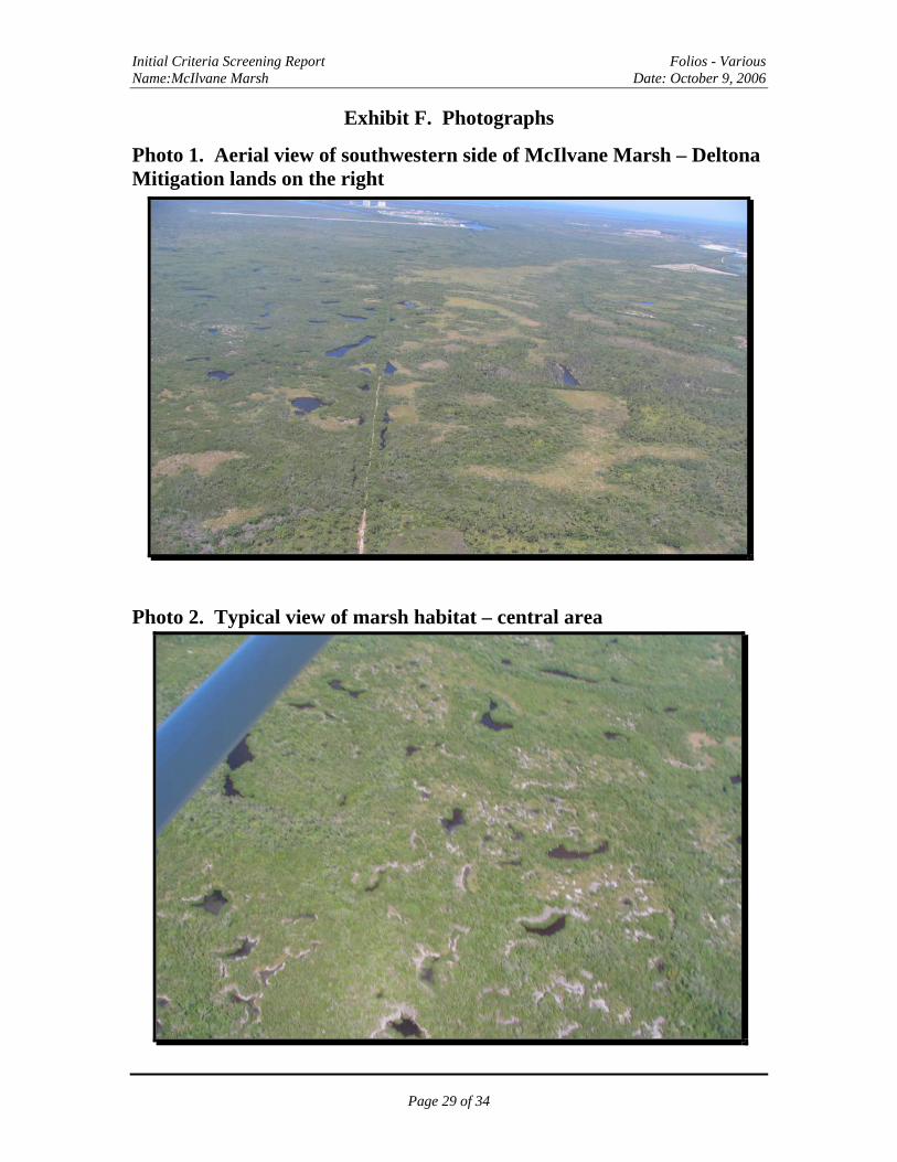
Exhibit F. Photographs
Photo 1. Aerial view of southwestern side of McIlvane Marsh – Deltona Mitigation lands on the right
Photo 2. Typical view of marsh habitat – central area
Page 29 of 34
Initial Criteria Screening Report Folios - Various Name:McIlvane Marsh Date: October 9, 2006
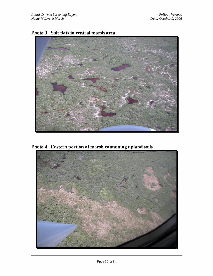
Photo 3. Salt flats in central marsh area
Photo 4. Eastern portion of marsh containing upland soils
Page 30 of 34

Initial Criteria Screening Report Folios - Various Name:McIlvane Marsh Date: October 9, 2006
Photo 5. Brackish pond in center of marsh area
Photo 6. Solid waste on or near West property at north edge of marsh
Page 31 of 34

Initial Criteria Screening Report Folios - Various Name:McIlvane Marsh Date: October 9, 2006
Photo 7. Mangroves and brackish pond
Photo 7. View from north to south with Marco Island in background
Page 32 of 34
Initial Criteria Screening Report Folios - Various Name:McIlvane Marsh Date: October 9, 2006
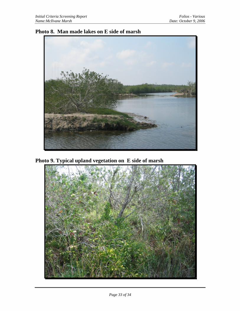
Photo 8. Man made lakes on E side of marsh
Photo 9. Typical upland vegetation on E side of marsh
Page 33 of 34
Initial Criteria Screening Report Folios - Various Name:McIlvane Marsh Date: October 9, 2006
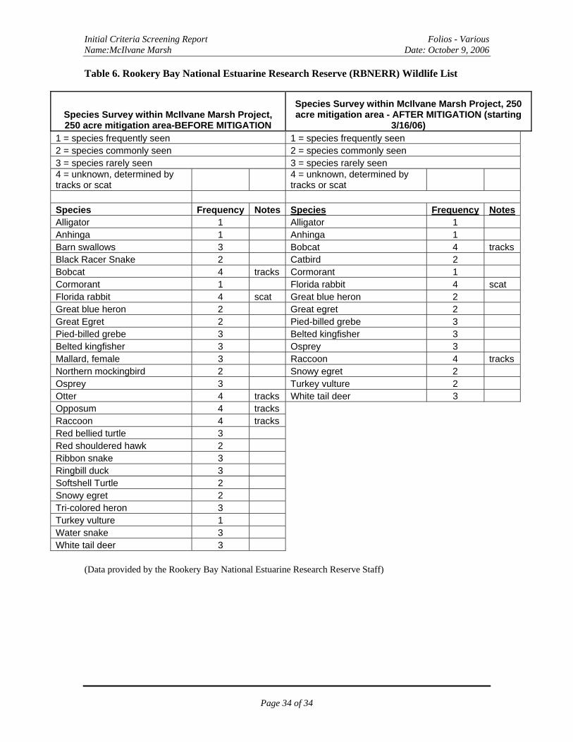
Table 6. Rookery Bay National Estuarine Research Reserve (RBNERR) Wildlife List
Species Survey within McIlvane Marsh Project, 250 acre mitigation area-BEFORE MITIGATION
Species Survey within McIlvane Marsh Project, 250 acre mitigation area - AFTER MITIGATION (starting
3/16/06) 1 = species frequently seen 1 = species frequently seen 2 = species commonly seen 2 = species commonly seen 3 = species rarely seen 3 = species rarely seen 4 = unknown, determined by tracks or scat
4 = unknown, determined by tracks or scat
Species Frequency Notes Species Frequency Notes Alligator 1 Alligator 1 Anhinga 1 Anhinga 1 Barn swallows 3 Bobcat 4 tracks Black Racer Snake 2 Catbird 2 Bobcat 4 tracks Cormorant 1 Cormorant 1 Florida rabbit 4 scat Florida rabbit 4 scat Great blue heron 2 Great blue heron 2 Great egret 2 Great Egret 2 Pied-billed grebe 3 Pied-billed grebe 3 Belted kingfisher 3 Belted kingfisher 3 Osprey 3 Mallard, female 3 Raccoon 4 tracks Northern mockingbird 2 Snowy egret 2 Osprey 3 Turkey vulture 2 Otter 4 tracks White tail deer 3 Opposum 4 tracks Raccoon 4 tracks Red bellied turtle 3 Red shouldered hawk 2 Ribbon snake 3 Ringbill duck 3 Softshell Turtle 2 Snowy egret 2 Tri-colored heron 3 Turkey vulture 1 Water snake 3 White tail deer 3
(Data provided by the Rookery Bay National Estuarine Research Reserve Staff)
Page 34 of 34