Embed Size (px)
Citation preview

P a g e | 0

P a g e | 1
Disclaimer
This document summarises the Council’s current high level views on the provision of
infrastructure (water, wastewater, transport and stormwater) necessary to service the
future urban zoned areas targeted to be development ready in the period 2018-2032.
Funding for Council provided infrastructure is managed through the long term and
annual plan processes undertaken in accordance with the Local Government Act 2002
and the funding priorities alluded to in this document are subject to change as those
processes are worked through.
The timing of infrastructure project delivery indicated in the document is based on
information and priorities as they stood at the time when the document was
written. They are subject to change including, but not limited to, the potential
cancellation or deferment of indicative projects.
The Council views outlined in this document are subject to change without notice.
If you rely upon any of the information contained in this document you do so at your
own risk and the Council does not accept any responsibility for any reliance you may
place on the accuracy, completeness, or currency of the information.
If you want up-to-date information on the Council’s approach to the provision of bulk
infrastructure with respect to any particular future urban zoned land you should contact
the Council.

P a g e | 2
Contents
1.0 Overview ........................................................................................................................... 5
2.0 Study Areas .................................................................................................................... 17
3.0 Warkworth ....................................................................................................................... 18
4.0 Wainui East, Silverdale, Dairy Flat ................................................................................. 26
5.0 Redhills, Whenuapai, Kumeu/Huapai and Riverhead .................................................... 36
6.0 Drury ............................................................................................................................... 45
7.0 Pukekohe and Paerata ................................................................................................... 53

P a g e | 3
Figures
Figure 1: Planning and Infrastructure Processes ........................................................................ 5
Figure 2: Future Urban Land Supply Strategy sequencing within the Auckland Region ............ 6
Figure 3: Roles in the delivery of infrastructure ......................................................................... 12
Figure 4: Zoning under the Auckland Unitary Plan .................................................................... 16
Figure 5: Future urban growth areas in Warkworth ................................................................... 18
Figure 6: Future Urban Area Sequencing – Warkworth ............................................................ 19
Figure 7: Supporting Growth – Transport Networks in the Warkworth area ............................. 24
Figure 8: Unitary Plan zonings in Wainui, Silverdale and Dairy Flat ......................................... 26
Figure 9: Future urban growth sequencing in Wainui East, Silverdale and Dairy Flat .............. 27
Figure 10: The Wainui Precinct within the Auckland Unitary Plan ............................................ 28
Figure 11: Supporting Growth – Transport Networks in the Wainui, Silverdale and Dairy Flat
area .................................................................................................................................. 33
Figure 12: Future Urban Area Sequencing in the North West .................................................. 36
Figure 13: Future urban growth in Redhills, Whenuapai and Kumeu, including the SHA areas
outlined in red. .................................................................................................................. 37
Figure 14: Future urban growth in Redhills ............................................................................... 37
Figure 15: Future urban growth in Whenuapai .......................................................................... 38
Figure 16: Future urban growth in Kumeu, Huapai and Riverhead, including the location of the
two SHAs within the Kumeu-Huapai area ........................................................................ 39
Figure 17: Northern Interceptor Wastewater Pipeline Project ................................................... 40
Figure 18: Supporting Growth – Transport Networks in the North West ................................... 43
Figure 19: Opaheke – Drury and Drury West, showing zoning under the Auckland Unitary Plan
and the Special Housing Areas ........................................................................................ 45
Figure 20: Future Urban Area sequencing - Opaheke-Drury and Drury West .......................... 46
Figure 21: Catchments and flood plains within the Opaheke-Drury and Drury West area ....... 49
Figure 22: Supporting Growth – Transport Networks in the South ........................................... 51
Figure 23: Future urban growth in Pukekohe and Paerata ....................................................... 53
Figure 24: Future Urban Area Sequencing – Paerata and Pukekohe ...................................... 54

P a g e | 4
Tables
Table 1: Future Urban Land Supply timeframes.......................................................................... 5
Table 2: Comparison of local and bulk infrastructure .................................................................. 7
Table 3: Proposed dwelling capacity and anticipated business land in Warkworth .................. 19
Table 4: Potential wastewater projects, timeframes and costs – Warkworth ............................ 20
Table 5: Potential water supply projects, timeframes and costs - Warkworth ........................... 21
Table 6: Potential stormwater projects, timings and costs - Warkworth ................................... 22
Table 7: Key transport infrastructure identified through Supporting Growth – Delivering
Transport Networks. ......................................................................................................... 25
Table 8: Proposed dwelling capacity and anticipated business land in Wainui East, Silverdale
and Dairy Flat ................................................................................................................... 28
Table 9: Potential wastewater supply projects, timeframes and costs – Wainui/Silverdale ..... 29
Table 10: Potential water supply projects, timeframes and costs – Wainui/Silverdale ............. 30
Table 11: Potential stormwater supply projects, timeframes and costs – Wainui/Silverdale .... 32
Table 12: Key transport infrastructure for Wainui identified through Supporting Growth –
Delivering Transport Networks. ........................................................................................ 34
Table 13: Key transport infrastructure for Silverdale and Dairy Flat identified through
Supporting Growth – Delivering Transport Networks. ..................................................... 35
Table 14: Proposed dwelling capacity and anticipated business land in the North West ......... 36
Table 15: Potential wastewater supply projects, timeframes and costs – North-West ............. 41
Table 16: Key Transport Infrastructure for the North West identified through Supporting Growth
– Delivering Transport Networks ...................................................................................... 44
Table 17: Proposed dwelling capacity and anticipated business land in Opaheke and Drury . 47
Table 18: Potential wastewater supply projects, timeframes and costs – Drury ....................... 48
Table 19: Key transport infrastructure identified through Supporting Growth - Delivering
Transport Networks .......................................................................................................... 52
Table 20: Proposed dwelling capacity and anticipated business land in Pukekohe and Paerata
.......................................................................................................................................... 55
Table 21: Potential wastewater supply projects, timeframes and costs – Pukekohe/Paerata .. 55
Table 22: Potential water supply projects, timeframes and costs – Pukekohe/Paerata ........... 55
Table 23: Key transport infrastructure identified through Supporting Growth – Delivering
Transport Networks .......................................................................................................... 57

P a g e | 5
1.0 Overview
Auckland is projected to grow by between 700,000 and one million people over the next
30 years. This means around 400,000 new dwellings and 277,000 additional jobs will be
needed.
The Auckland Unitary Plan (Unitary Plan) identifies approximately 15,000 hectares of rural land for future urbanisation with the potential to accommodate approximately 135,000 dwellings
1.
This represents around one third of the new dwellings needed and as such forms an important component of the overall strategy for enabling Auckland’s growth. The future urban land identified also includes approximately 1,800 hectares for new business land. Auckland Council’s Future Urban Land Supply Strategy
2 (FULSS) identifies a programme to
sequence when future urban land will be “development ready” over 30 years (see Figure 2) for map of sequencing). Development ready means the land has both zoning and bulk infrastructure serving to allow for urbanisation to begin (see Figure 1 below).
Figure 1: Planning and Infrastructure Processes
The FULSS identifies the timeframe for when future urban areas are expected to be
development ready by half-decades as identified in Table 1 below.
Table 1: Future Urban Land Supply timeframes
Decade Years
Actuals, contracted or planned 2012-2017
Decade One (first half) 2018-2022
Decade One (second half) 2023-2027
Decade Two (first half) 2028-2032
Decade Two (second half) 2033-2037
Decade Three (first half) 2038-2042
Decade Three (second half) 2043-2047
1 These figures refer to the land within the scope of the Future Urban Land Supply Strategy which includes
Future Urban zoned land and urban zoned greenfield land. 2
Auckland Council is currently reviewing and updating the Future Urban Land Supply Strategy as a result of the decisions on the Auckland Unitary Plan. This document reflects the draft updates to the FULSS, which are subject to public consultation and are not adopted council policy. The update FULSS is expected to be completed in mid-2017.

P a g e | 6
Figure 2: Future Urban Land Supply Strategy sequencing within the Auckland Region

P a g e | 7
1.1 Purpose of this document
This document summarises the current thinking on what infrastructure (water, wastewater,
transport and stormwater) may be needed to service the future urban areas identified to be
development ready in Decade One (2017-2027).
Infrastructure identified in this document is not necessarily funded or committed to and
approaches to servicing these areas may change when more detailed structure planning
confirms the land uses, expected dwelling and employment capacities and staging.
Infrastructure investment in these areas is subject to prioritisation against other council and
government objectives through the long-term plan process, or budgeting process of other
providers (e.g. NZ Transport Agency).
It is intended that this document will assist preliminary discussions between landowners,
developers, the council and infrastructure providers in forming development proposals to
deliver housing and employment in future urban areas.
1.2 What is bulk infrastructure?
Auckland Council, Watercare, Auckland Transport, NZ Transport Agency and KiwiRail are
responsible for the planning, funding and delivery of bulk infrastructure. The following table
indicates each asset owner’s responsibilities, in contrast to the delivery of local infrastructure.
Table 2: Comparison of local and bulk infrastructure
Service Local infrastructure (provided by the developer)
Bulk infrastructure (provided by the asset owner)
Asset owner
Water Water supply pipes and connections – sized to serve streets and neighbourhoods
Watermains - sized to serve suburbs and towns, bulk water supply points, reservoirs, water treatment plants
Watercare
Wastewater
Wastewater transmission lines – sized to serve streets and neighbourhoods, local pump stations
Wastewater transmission lines - sized to serve suburbs and towns, wastewater treatment plants, wastewater pump stations,
Watercare Veolia
3 manages local
infrastructure in the south from Papakura to Drury
Transport
Ro
ad
s
Local roads and collector roads and walking and cycling infrastructure
Arterial roads Auckland Transport
State highway networks and roads of national significance.
NZ Transport Agency
Pu
bli
c
Tra
ns
po
rt
Local bus stops, bus lanes
Rapid Transit networks e.g. bus ways, bus station interchange, train stations, Park and Ride facilities
Auckland Transport/NZ Transport Agency
Rail lines KiwiRail
Auckland Transport (AT), NZ Transport Agency and KiwiRail all work closely together to deliver
an efficient and effective transportation network. A number of transport projects are jointly
funded.
The provision of parks and open space is a key factor that is considered in the development of
new greenfield areas. While council may secure some open space prior to an area being
3 Veolia manages local infrastructure in the south from Papakura to Drury. Watercare manages local
infrastructure throughout the rest of the Auckland region.

P a g e | 8
development ready, most of the open space network is identified once structure planning
commences, and is therefore not discussed further in the subsequent sections on each future
urban area.
1.3 How is bulk infrastructure planned?
Auckland is New Zealand’s largest city, and it faces significant growth pressures. Infrastructure
enables growth to be optimised across the city. Auckland Council sets out the strategic
direction for Auckland’s Growth. The Auckland Plan, the Unitary Plan and the FULSS together
identify where and how growth should take place. The FULSS sets out in more detail the
sequencing of this growth. Asset owners such as AT and Watercare develop their plans,
strategies and policy documents based on the strategic direction that Auckland Council has set
out.
The bulk infrastructure identified by the different asset owners as necessary for growth
becomes incorporated into the Long Term Plan, and in the case of transport, the Regional
Land Transport Plan.
Some of the relevant infrastructure plans, strategies and policies include:
Watercare Services Limited Water and Wastewater Asset Strategies
Auckland Transport Alignment Project
Roads and Streets framework and the Transport Design Manual
Supporting Growth (formerly known as Transport for Future Urban Growth (TFUG))
Regional Land Transport Plan (RLTP)
Parks and Open Spaces Strategic Action Plan
Open Space Provision Policy
Healthy Water’s Water Sensitive Design Manual
Auckland Design Manual
Transport Design Manual
Relevant engineering Codes of Practice
Asset Management Plans
Bulk infrastructure needs careful sequencing in order to keep up with growth. Ad-hoc or out of
sequence development will have major funding implications for all providers and affect the
ability to coordinate delivery.
Ongoing operational costs are another factor that is considered when planning new
infrastructure. This is particularly relevant to planning new parks and open space.
Planning for bulk transport infrastructure
In the case of transport, KiwiRail, NZ Transport Agency and AT work together to manage
transport as a single network in order to optimise investment and support land use aspirations
set out in the Auckland Plan and the Unitary Plan. Transport projects are prioritised according
to a standard methodology and business case development. The 10-year prioritised delivery
programme of transport services and activities for Auckland are put together in the Regional
Land Transport Plan (RLTP). The RLTP sets out how transport delivery agencies intend to
respond to growth and other challenges facing Auckland such as reducing congestion, moving

P a g e | 9
freight and improving public transport and walking/cycling networks. More details on the
planning and design of transport can be found near the end of this section (1.6).
Planning for bulk wastewater and water supply infrastructure
Watercare develop their asset management plans and strategies for wastewater and water
supply delivery in accordance with the direction set out in the Auckland Plan, the Unitary Plan,
and the FULSS.
Planning for stormwater infrastructure
Stormwater is largely managed on-site and is not part of a reticulated network throughout
Auckland. There is now a reduced reliance on traditional “pipe and pond” solutions for
stormwater, thus enabling more cost-effective on-site treatment. In greenfield areas where little
to no stormwater infrastructure exists, the planning and design of future stormwater
infrastructure is largely the responsibility of the individual developer. More details on the design
of stormwater infrastructure can be found at the end of this section (1.7).
Planning for open space infrastructure
In terms of open space infrastructure, the Parks and Open Spaces Strategic Action Plan sets
out the council’s aspirations and objectives for its park and open space network over the next
10 years in order to meet Auckland’s recreational needs.
Two key documents sit beneath the Strategic Action Plan to help deliver its objectives – the
Parks and Open Space Acquisition Policy and the Open Space Provision Policy.
The Parks and Open Space Acquisition Policy sets out the process and criteria Auckland
Council will use to assess and prioritise potential park and open space acquisitions. The Open
Space Provision Policy establishes network planning principles and provision metrics that
guide the quantity, configuration and function of open space that council expects in new
developments.
Structure plans
Structure plans provide the next level of planning that is required to plan for bulk infrastructure.
Structure plans are an important method for establishing the pattern of land use and
infrastructure networks with a greenfield area. The development of a structure plan requires
the preparation of high level infrastructure plans for specific areas. An Integrated Transport
Assessment identifies the effects of the proposed development on existing transport
infrastructure, and identifies new transport infrastructure that is required by growth, as well as
required upgrades to existing infrastructure. A Stormwater Management Plan identifies the
location and extent of existing watercourses and flood risk and identifies ways to manage
effects of stormwater following development. A Water and Wastewater Servicing Plan is
required to identify the location for proposed water and wastewater infrastructure, how this will
connect to existing bulk infrastructure, and any upgrades required. All infrastructure plans
developed as part of the structure planning process are incorporated by asset owners as a part
of their planning process.

P a g e | 10
1.4 How is infrastructure funded?
After adjusting for external funding sources (such as transport subsidies from the New Zealand
Transport Agency) Auckland Council currently funds growth infrastructure primarily through
rates, development contributions and infrastructure growth charges. These are lump sum
charges that are payable when a new dwelling is consented or when a dwelling connects to
the water and wastewater networks. Together, these charges currently average about $30,000
per dwelling.
Where these charges are not adequate to cover the cost of providing infrastructure to service a
particular development that creates a funding challenge for the council.
With such large areas of greenfield land being released for development, the council has been
investigating a range of alternatives for funding the significant bulk infrastructure costs
associated with new developments. For instance, as a part of the Annual Budget which is
currently out for consultation, the public is being asked to share their views on the use of
targeted rates for the development of greenfield areas.
These targeted rates would be used alongside the existing development contribution and
infrastructure charges. This approach would effectively spread a lump sum charge out over
time as an annual payment, and can be triggered ahead of development occurring4.
4 Introducing a Growth Infrastructure Targeted Rate would require amendments to Council’s Revenue and
Financing Policy
What is a Structure plan?
A structure plan is a high level plan for a large area that shows the arrangement of
various land uses (e.g. centres, housing, employment and parks) and infrastructure
(e.g. transport and stormwater) and how this area connects to adjacent urban areas
and wider infrastructure networks. It identifies public infrastructure such as streets,
rail, stormwater, natural features, schools and community facilities. Structure plans
show the integration of multiple transport modes i.e. roads, walking and cycling,
freight and public transport routes. Structure plans guide the future development of
an area by co-ordinating and defining these land use patterns and the location,
distribution and integration of bulk infrastructure.
The FULSS anticipates that council led structure planning of future urban areas will
generally begin approximately three years prior to the areas being ready for
development. Structure Plans are given effect to in the Unitary Plan through plan
changes. The transport upgrades that are required in plan changes go “hand in
hand” with water and wastewater, as subdivision occurs. Council may decide to only
release portions of structure planned areas where enabling infrastructure will be
delivered within 10 years of the re-zoning.

P a g e | 11
Funding for bulk transport infrastructure
Roughly a quarter of Auckland Transport’s (AT) funding comes from the National Land
Transport Fund (NLTF). The NLTF is predominantly sourced from fuel excise duties, road user
charges, registration and licensing fees. Auckland Council contributes over half of AT’s total
funding generated from rates and debt.
The RLTP transport programme is funded from the following sources:
The NZ Transport Agency funds State Highway improvements.
KiwiRail funds improvements to the rail lines.
Funding from Auckland Council.
The NZ Transport Agency investment (through the National Land Transport Fund) in
local road, public transport and other transport activities delivered by AT. The NZ
Transport Agency can only contribute towards activities that include a local contribution
from Auckland Council.
AT revenue including public transport fares, advertising, income from land held for
future transport needs, parking charges and enforcement.
Funding for bulk water supply and wastewater infrastructure
Just under 50% of Watercare’s projects are funded from revenue including service charges,
about one third is funded from borrowing and around 20% is funded from infrastructure growth
charges. Over the next nine years Watercare will invest $2.8 billion in wastewater assets and
$1.9 billion in water assets. Almost half of Watercare’s budget is dedicated to increasing
capacity to support future growth, 44% of their budget goes on renewals and 10% of their
budget relates to improving the level of service for its customers. This means that over the
next 10 years it will expand bulk infrastructure to provide capacity for a further 195,000 homes.
Funding for open space infrastructure
Council acquires parks and open space of the type and quantity set out in the open space
provision policy. The council seeks to recover from those undertaking development a fair,
equitable, and proportionate portion of the total cost of investment in the open space network
that is required to service growth over the long term. This primarily occurs through the use of
development contribution charges. The parks and open space acquisition budget is identified
in the council’s Long-term Plan. The budget varies between financial years and is capped for
each year, so there are constraints on the quantity of parks and open space acquisition that
can occur within a specific financial year.
Acquisitions of park and open space types discussed in the Open Space Provision Policy with
no associated provision metric - such as non-esplanade riparian open space, or quantities in
excess of the target provisions levels - are not funded. Such land will only be acquired in
exceptional circumstances, even if vested at no capital cost to the council.

P a g e | 12
Infrastructure Funding Agreements
In addition to other more formal funding and financing techniques, Council or its CCOs can
enter into Infrastructure Funding Agreements5 with developers, to share costs where
infrastructure can be designed and developed collaboratively to achieve wider benefits. For
example, a key bridge may be required to service several developments. The cost of the
bridge could be distributed across all the landowners and AT to enable the growth. An
alternative situation could also occur where a there is a reliance on infrastructure which may
be identified and conceptually planned, but not yet in place. In this case, a developer may
need to provide a local road to service their greenfield development, however due to future
anticipated growth an arterial road (bulk infrastructure) will be required in the future. In this
case the developer would construct and vest the local road, and Auckland Transport may
purchase a wider road corridor to enable future works. Likewise, the developer will pay for the
construction of new wastewater pipes (for a local network size) and Watercare may pay for the
marginal cost of upgrading it to bulk supply dimensions where this is required.
Figure 3: Roles in the delivery of infrastructure
5 In addition to cost share arrangements with developers, infrastructure agreements may also be for the
delivery of works funded by Council, or funded entirely by the developer/s

P a g e | 13
1.5 How is infrastructure delivered?
Auckland Transport, Watercare6, Healthy Waters/Auckland Council, NZ Transport Agency and
KiwiRail as the asset owners of all public infrastructure are responsible for the delivery of bulk
services. Asset owners build bulk infrastructure in accordance with their asset management
plans, strategies and policy documents. The delivery of bulk infrastructure is critical to ensuring
that Auckland can continue to grow and develop in a timely manner.
In greenfield developments, individual developers provide for all local infrastructure and are
required to connect new local infrastructure to existing local or bulk infrastructure. Where bulk
infrastructure does not yet exist, or is not yet planned, developers may be required to fund and
deliver all or part of it (as indicated by the grey area in Figure 3). Infrastructure Funding
Agreement and other commercial arrangements are used where a cost share is proposed.
Local infrastructure (and bulk infrastructure delivered by the developer) is designed in
agreement with the future asset owners (AT or Watercare).
Delivery of open space infrastructure
The provision of parks is indicated at a broad level at the structure planning stage, in
accordance with the Open Space Provision Policy and in consideration of expected land uses
and the values of the area. It is expected that developments will give effect to the open space
network identified in a structure plan.
All parks and open space acquisitions require approval from the relevant local board or the
governing body, even if proposed to be vested in the council at no capital cost. Where parks or
open spaces are proposed to be vested in the council at no capital cost the ongoing
maintenance costs will be considered by the relevant political decision-makers when deciding
whether Auckland Council will accept ownership of the land.
Where open space land is vested at no capital cost, the council expects that the developer will
still pay their full development contributions for parks and open spaces.
The council will consider land exchanges between existing parks and open spaces and other
land where there are demonstrable benefits to the council’s parks and open space network.
The Resource Management Act 1991 provides that esplanade reserve or strips of 20m in width
will be taken adjacent to qualifying water bodies at the time of subdivision when lots smaller
than 4 hectares are created. Auckland Council will expect the provision of a 20m-wide
esplanade reserve or strip adjacent to all qualifying water bodies upon applicable subdivision
unless there is a valid argument for reducing or waiving the requirement.
6 Veolia are responsible for managing local water and wastewater networks in the south from Papakura to
Drury. Watercare are responsible for the delivery of bulk services for the entire region, and for managing local water and waste networks everywhere except for Papakura to Drury.

P a g e | 14
1.6 Transport
Road and Streets Framework and Transport Design Manual
In Future Urban areas it is essential to get the designs of the roads and streets right, as they
have a long expected lifetime. Street designs are proposed by developers and their
consultants, and they are assessed through the Plan Change, Resource Consent and
Engineering Plan approval processes.
Auckland Transport strategies and guidance (such as the Draft Street Design Guide and the
Draft Transport Design Manual) provide a greater degree of direction around the outcomes
expected for these new streets to ensure they are fit for purpose for all users.
Neighbourhood design provides a wider consideration and scale of street design. It considers
how a collection of streets forms a network that supports land use activity, local connectivity,
connections to the strategic network and the wider public transport access.
Auckland Transport Alignment Project
Planning, funding and developing Auckland’s transport system is one of central and local
government’s biggest transport challenges. It is essential that transport solutions are tackled
head on, in order to secure the success of the region, and of New Zealand as a whole.
Through the Auckland Transport Alignment Project, the Government and Auckland Council
agreed to work together to identify an aligned strategic approach for the development of
Auckland’s transport system that delivers the best possible outcomes for Auckland and New
Zealand.
The Government and Council are committed to ensuring Auckland’s transport system is able to
meet the region’s needs, and recognise that Auckland will need significant investment in its
transport system in the coming decades to provide for its forecast growth. The Government
and Auckland Council have sought to ensure that investment in Auckland’s transport system
will address the region’s transport challenges and provide value for money. The project also
looked at how best to provide for the essential transport links both to Northland, and to the high
volume freight routes between Auckland, Hamilton and Tauranga.
Through the Auckland Transport Alignment Project, the Ministry of Transport, Auckland
Council, Auckland Transport, the NZ Transport Agency, Treasury and the State Services
Commission have worked together to test alternative options for how Auckland’s transport
system could develop.
Supporting Growth: Delivering Transportation Networks
(previously called the Transport for Future Urban Growth - TFUG)
The Supporting Growth programme business case identifies a strategic transport network that
outlines roading and public transport projects that will be required over the next 30 or so years.
This programme was developed by Auckland Transport, the NZ Transport Agency, and
Auckland Council working in partnership, in what was then called Transport for Future Urban
Growth (TFUG). TFUG was also heavily consulted on throughout 2016.The preferred network
for the future urban areas has been developed by considering many options, taking into
account technical assessments and feedback from local boards, mana whenua, key
stakeholders and communities.

P a g e | 15
The next step is to “make the most of what we already have” which is in line with the Auckland
Transport Alignment Project recommended strategic approach. At the same time, Auckland
Transport will also look at protecting land for longer term ‘new’ routes. This will help to provide
certainty to communities and developers on where new routes will go. It also means
organisations such as utility providers and government agencies like the Ministry of Education
can better plan their infrastructure, and property owners and developers have the information
they need for their own decisions.
1.7 Stormwater Management
The appropriate management of stormwater and freshwater is integral to a liveable city.
The issues Auckland faces with respect to stormwater and freshwater are grouped into three
primary outcomes:
Safe communities – flooding, health and safety risks to our communities, including
people, property and infrastructure are managed and reduced.
Supporting growth – growth through water sensitive development and provision of
quality stormwater infrastructure is enabled.
Healthy and connected waterways – stream, groundwater and coastal water values are
maintained and enhanced and communities are connected with them.
The Water Sensitive Design (WSD) approach aspires to ensure multiple public benefits from
stormwater management and to develop a unique sense of place for the community.
Where pre-existing major stormwater constraints exist, such as extensive flooding or
undersized culverts/ bridges, Council may undertake early works to enable development to
occur and mitigate hazardous flood risks.
In response to a number of regulatory documents including Auckland Plan, the Unitary Plan
and National Policy Statement for Freshwater Management, existing waterways are required to
be protected and enhanced. Due to the size of the contributing catchments within the Future
Urban zones, a number of the main watercourses will also provide for flood conveyance
channels and may be extended to incorporate a cycling and walking network. In a number of
Future Urban zones the optimal outcome from an urban design perspective involves forming
linear parks along the main watercourse. By incorporating walking and cycling, play and
educational design components, a spine to the urban framework can be created. These design
principals will form foundational elements of Structure Plans in Future Urban zones.
The infrastructure requirements identified within this report are based on the Healthy Waters
best understanding of the constraints, however, it should be noted that the actual stormwater
requirements may only become apparent when a structure plan is developed, and where road
layouts, land-use and open space designs are refined.
Developments that occur within the Future Urban zone beyond 2018 are likely to be covered
by the Regional Network Discharge Consent that is being prepared presently. Under that
framework a Stormwater Management Plan will be prepared that will detail how the stormwater
effects are to be managed.

P a g e | 16
Figure 4: Zoning under the Auckland Unitary Plan

P a g e | 17
2.0 Study Areas
The map below identifies the location and development ready sequencing of the Future Urban
Areas. This document focuses on the areas identified to be development ready in the first
decade of the Future Urban Land Supply Strategy. These areas are:
Warkworth North and Warkworth South
Upper Orewa (Resource Consent area)
Wainui East
Silverdale West / Dairy Flat (business land only)
Whenuapai Stage 1
Redhills
Bellfield Rd (Opaheke)
Drury South
Bremner Rd Special Housing Area (Drury West)
Drury West Stage 1
Wesley (Paerata)
Paerata (remainder)
Belmont (Pukekohe)
Pukekohe (remainder)
Bulk infrastructure needs for areas beyond the first decade of the FULSS are not covered in
detail in this document, but may be summarised where high level planning has occurred.

P a g e | 18
3.0 Warkworth
Warkworth has a population of around 4,000 residents and around 2,300 jobs. As the largest
settlement in the rural north of Auckland, it is a sub-regional centre servicing a wide rural
catchment and many smaller towns and villages.
The Auckland Plan anticipates that Warkworth will grow to a substantial satellite town of over
20,000 people. To meet the expected growth in the Warkworth area, the Auckland Unitary Plan
(Operative in part) has rezoned around 1,000 hectares in the north, west and south of the
existing urban area to allow for future urban development. Extensions and upgrades to the
network will be required within the next decade in order to service this anticipated growth.
Figure 5: Future urban growth areas in Warkworth
Employment is a key consideration for Warkworth given its distance from Auckland. The
Auckland Unitary Plan (Operative in Part) has rezoned around 69 hectares of rural land in the
north-west to the Light Industry and General Business zones. Small local and neighbourhood
centres will also be required in the future urban areas. It is anticipated that Warkworth will need
around a further 180 hectares of additional business land to provide for local employment
opportunities.
Based on the timing of required upgrades to key infrastructure, Warkworth North is expected to
be development ready by 2022 (see Figure 6 and Table 3). This timeframe aligns with
completion of the Puhoi to Warkworth section of the Road of National Significance (see section
3.4), the expected completion of the Matakana Link Road and upgrades to the wastewater
network needed to accommodate future growth. Warkworth South and North-East are
expected to be development ready between 2028-2032, and 2033 -2037 respectively.

P a g e | 19
Figure 6: Future Urban Area Sequencing – Warkworth
Table 3: Proposed dwelling capacity and anticipated business land in Warkworth
Proposed timing – development ready
Area Proposed dwelling capacity
for each area (approx.) Gross Business
Area (ha.)7
Actuals, contracted or planned 2012 - 2017
Warkworth North N/A (Business land) 69
1st half Decade One 2018 – 2022
Warkworth North (development ready 2022)*
2,300 55
1st half Decade Two 2028 - 2032
Warkworth South 3,700 125
2nd half Decade Two 2033 – 2037
Warkworth North East 1,500 0
7 Business land referred to in this table is restricted to land extensive business activities such as
manufacturing, transport and storage, construction, wholesale trade (e.g. light industrial and general business
zones); Business land within neighbourhood, local or town centres is not included.
P a g e | 20
3.1 Wastewater
The Warkworth and Snells Beach/Algies Bay wastewater treatment plants treat and dispose of
wastewater from approximately 8,000 people. This population is split relatively evenly between
the two plants. The Warkworth Wastewater Treatment Plant discharges to the Mahurangi
River, while the Snells Beach Wastewater Treatment Plant discharges into the inner channel of
the Hauraki Gulf south of Martins Bay. The Mahurangi Harbour is a sensitive environment and
the harbour is classified as a Significant Ecological Area downstream from the point of
discharge. With the large population growth anticipated for the area, the sensitivity of the
environment may make the issuing of further discharge consents difficult.
The nearby wastewater treatment plant at Snells Beach has an existing capacity for 18,000
people. However, the condition of the pumped outfall pipe is poor and to minimise the risk of
breakage the pumped flow is currently restricted, limiting the capacity to the existing serviced
population of 4,000 people. Watercare currently propose to address wastewater issues in the
Warkworth area by directing waste to the Snells Beach wastewater treatment plant. This will
require upgrades to the treatment plant, an upgrade to the existing outfall pipe and the
construction of a bulk sewer connecting Warkworth to Snells Beach.
Watercare has recently lodged a resource consent for upgrades to the wastewater treatment
plant at Snells Beach to take the Warkworth flow. The new consent would allow some
development to occur in Warkworth to be connected to the existing treatment plant prior to the
connecting infrastructure being constructed. This will require upgrades to the treatment plant
processes to accommodate additional flow and loads. If granted, it is anticipated that the works
can be completed by 2022. The construction of a new branch sewer will also be required to
service the remainder of the Future Urban zoned land. Development of the Future Urban
zoned land will be staged in accordance with the delivery of the bulk wastewater infrastructure.
This will entail the construction of a pump station in the vicinity of the Warkworth
Showgrounds, linking the proposed new trunk sewer running from Warkworth South to
Warkworth North to the proposed transmission line from the showgrounds to the Snells Beach
Wastewater Treatment Plant.
The Warkworth and Snells Beach/Algies Bay wastewater treatment plants treat and dispose of
wastewater from approximately 8,000 people. This population is split relatively evenly between
the two plants.
Resource consents for a new North East Sub-regional Wastewater Treatment Plant to service
both communities have been lodged with Auckland Council. The scheme includes a new
treatment plant at the current Snells site, a new larger diameter outfall pipe discharging to the
current location and conveyance of Warkworth’s wastewater to the new plant. The existing
Snells and Warkworth plants will then be decommissioned.
The construction of a new branch sewer will also be required to service the Future Urban
zoned land.
Table 4: Potential wastewater projects, timeframes and costs – Warkworth
Project / Programme Start Finish Indicative Cost
(2018)
North East Sub-regional WWTP and Conveyance 2018 2027 140 million
Wastewater Branch Sewer and Pump Station Not in Asset Management Plan 60 million

P a g e | 21
3.2 Water Supply
The Warkworth water treatment plant treats water drawn from the Mahurangi River for supply
to Warkworth. The supply of water from the Mahurangi River is limited and a new source will
be required to meet long term growth.
A new groundwater source has been consented at the Sanderson Road water bore.
Construction for the new water treatment plant is planned to start in 2018. The groundwater
source will replace the current Mahurangi River source which is constrained by minimum flow
requirements, particularly during summer. However, to meet the full planned growth for
Warkworth a new water source will be required within the wider Snells/Warkworth system.
Table 5: Potential water supply projects, timeframes and costs - Warkworth
Project / Programme Start Finish Indicative Cost
(2018)
Warkworth Water Treatment Plant and Conveyance 2018 2027 15 million
Additional Water source (consent and construction) Not in Asset Management Plan
70 million Security of supply line to Snells/ Algies Bay Not in Asset Management Plan
New Warkworth reservoir storage Not in Asset Management Plan
3.3 Stormwater
Warkworth Township is located within the Mahurangi River Catchment which discharges into
the Mahurangi Harbour. Rainfall intensities at Warkworth are equal to the highest experienced
in the Auckland Region.
The Mahurangi River has numerous flood plains and can rise over 5 metres vertically during
major storm events. Any upstream river channel “improvement” works to decrease upstream
flood levels would lead to an increase in flooding downstream. Any potential flood
management works proposed in these areas would require rigorous analysis of upstream and
downstream effects to ensure the overall effects are acceptable.
The river becomes abruptly tidal below the man-made weir at the Elizabeth Street Bridge. The
catchment area upstream of the bridge is some 60km2.
Apart from some broad plains in Warkworth South area the Future Urban zoned areas are
characterised by mild to steep sloping countryside with a network of well-defined permanent
and intermittent streams and gullies which can be retained to form the basis of the stormwater
network for the area. The permanent and intermittent streams have high ecological value but
are very sensitive to impacts arising from local development and changes to the hydrological
environment.
Stream bank erosion is prevalent in many areas.
Current State of Planning Work
A draft comprehensive computer model of the Mahurangi River is currently being reviewed.
The model-build process included detailed ground survey of the Mahurangi River and its
associated bridges and culverts.

P a g e | 22
System performance modelling shows that over 30 bridges and culverts within the greater
Mahurangi River catchment do not meet Auckland Council level of service, and are too small
to pass the 10-year design storm flow without surcharging at the inlet. Within the Future Urban
area and downstream receiving environment there are three locations that need to be
upgraded and these are presented in Table 6 below.
All proposed development adjacent to the Mahurangi River (including the Northern branch up
to Sheep World) will need to be assessed for flooding from the main river channel. The
computer model will provide indicative flood levels once the quality assurance checks are
complete.
The Warkworth North future development area on the north side of State Highway 1 contains
steep slopes and gullies which discharge into existing downstream flood areas. Issues to be
addressed include erosion control measures and possible peak flow mitigation requirements to
reduce downstream flooding impacts. The culvert on Matakana Road is likely to require
upgrade or replacement. Due to the traffic volumes that currently use this road the construction
effects are likely to be unacceptably high. It is likely that the Matakana Link Road will need to
be constructed first to provide an alternative route before any upgrade works could be
undertaken at this location.
A broad potential flood plain in the Warkworth South Future Urban area north of Valerie Close
may impact on the options for future urban development. This area needs closer study to
assess how stormwater flooding can be addressed without adversely impacting on the local
stream ecology.
Much of the Warkworth Future Urban zoned area is characterised by mild to moderate sloping
countryside with a network of well-defined permanent and intermittent streams and gullies
draining into major waterways. These features lead to great opportunities to apply the
principles of Water Sensitive Design to development in these areas including:
1. Retaining and enhancing the existing drainage system of streams and natural gullies
2. Avoiding development within flood plain areas by using appropriate set-backs from
riparian margins as opposed to carrying out major flood control works.
3. At source management of stormwater quantity and quality outcomes
A Storm Water Management Plan will be prepared in due course to address the above issues
and will support the Structure Planning process.
Table 6: Potential stormwater projects, timings and costs - Warkworth
Project / Programme Start Finish Indicative
Cost (2018)
Falls Rd one lane Bridge widening. (Conveyance cross section should be increased when bridge is upgraded to a two lane bridge)
2031 2041
TBC
Falls Rd Ford – currently a tourist attraction but unsafe in high flows. Will be permanently closed to traffic when alternative Mansel Rd bridge is installed.
2031 2041
1 Matakana Rd Culvert Upgrade. 2021
126 Sandspit Rd Culvert Upgrade 2031 2041

P a g e | 23
3.4 Transport
With a lot more people living in the Warkworth, significant new transport infrastructure will be
needed with the aim to make the future communities well connected and great places to live.
The focus in Warkworth is to provide the community with easy access to a vibrant town centre
and a range of new travel choices.
Short term strategies for managing network demands and improving safety, such as
introducing smart technologies or improving the efficiency of intersections along the existing
State Highway 1, will continue to be implemented while new roading infrastructure is
developed in the medium to long term.
Increased public transport services are planned between Auckland and Warkworth, with a
frequent express bus service along the Ara Tūhono Pūhoi to Warkworth Road of National
Significance supported by local connecting bus services. Easy access to this service would be
supported by a park and ride bus station being located near the Road of National Significance,
Matakana Link Road and the Western Collector.
The opening of the Ara Tūhono Pūhoi to Warkworth Road of National Significance will
separate regional through traffic and freight movements from the urban area. Highway traffic
will move away to the west of the township and immediately reduce pressure on the urban
section of State Highway 1.
The proposed Matakana Link Road will help reduce congestion at the Hill Street intersection,
providing an alternative route from State Highway 1 and better connections to the wider
network. In the future an extension of this route to Sandspit Road will also provide further
relief, and improve access to the new growth area. Realignment of the current Matakana Road
and Sandspit Road will also be investigated to improve safety and efficiency of the Hill Street
intersection.
Stage One of the Western Collector route, connecting Mansel Drive to Falls Road, is the first of
many transport infrastructure improvements planned for Warkworth over the next 30 years.
This stage is due for completion in mid-2017. The new road will help alleviate pressure within
the township by providing a strong north-south alternative route to the existing State Highway
1. It will also improve access to nearby employment areas and the new residential growth
areas in the west and south.
The timing and exact route of the remaining two stages have yet to be determined but is likely
to connect to the State Highway in the south and in the vicinity of the new Matakana Link Road
intersection which will be built in the north.
A new road network will also be investigated in the wider southern growth area when this
begins to develop, providing more local road options for north-south travel and east-west
movements connecting back into the existing State Highway 1.
A cycle network will be developed to provide access to the Warkworth town centre and
surrounding residential and business areas.

P a g e | 24
Figure 7: Supporting Growth – Transport Networks in the Warkworth area

P a g e | 25
Table 7: Key transport infrastructure identified through Supporting Growth – Delivering Transport Networks.
Transport Infrastructure
Timing (where known)
Indicative costs
8
Interrelationships Comments
Western Collector Current N/A
Stage 1 is currently under construction and is due to open in mid-2017
Western Collector – Stage 2 and 3
Investigation and design with view route protect by 2022
$45m - $60m
Western Collector Stage 1 Matakana Link Road
Not an AT prioritised project through the RLTP and ATAP – could be delivered in conjunction with developer
Connections within township
Investigation and design with view route protect by 2022
$12m - $15m Existing local roads Land development
Developer delivered
Park and Ride and frequent transit network
Investigation and design with view route protect by 2022
$12 - $15m
Ara Tuhono-Puhoi Western Collector Stage 2/3 Matakana Link
Not an AT prioritised project through the RLTP and ATAP – could be delivered in conjunction with developer
Additional southern arterial network
Investigation and design with view route protect by 2022
TBC Existing local roads Land development
Developer delivered
Matakana Link Complete 2021 N/A Western Collector Ara Tuhono-Puhoi
Currently at detailed design
Sandspit link and realignment
Investigation and design with view route protect by 2022
$60m - $75m Matakana Link
Not an AT prioritised project through the RLTP and ATAP – could be delivered in conjunction with developer
8 Costs shown are based on strategic level assessments as part of the Auckland Transport Alignment Project.
Cost will be accordingly updated as investigations designs are progressed

P a g e | 26
4.0 Wainui East, Silverdale, Dairy Flat
The Wainui East, Silverdale and Dairy Flat area contains approximately 3,575 hectares of
Future Urban zone and live zoned greenfield land, predominately located to the west of the
State Highway 1. This area has an anticipated capacity of approximately 33,000 dwellings.
The following areas are expected to be development ready by 2022:
Upper Orewa (Resource Consent Area) – pending outcome of the resource consent
process)
Wainui East (live zoned area only)
Silverdale West / Dairy Flat (business land only)
These areas will collectively provide round 5,000 dwellings and 617 hectares of business land
Figure 8: Unitary Plan zonings in Wainui, Silverdale and Dairy Flat
The remaining areas of Wainui, Dairy Flat and Silverdale are expected to be development ready in 2033-2037.
The Upper Orewa Resource Consent area is an 85 hectare area that is subject to a notified
resource consent process for the creation of 575 residential lots. The resource consent hearing
will be later this year.
Within the central Wainui East area, immediately to the west of Millwater, the Unitary Plan has
recently rezoned nearly 300 hectares of Future Urban zoned land to urban zones and
established a new precinct (Refer to Figure 10). The Wainui Precinct includes the Wainui East
(Argent Lane) Special Housing Area which was established by Order in Council dated January
2016, together with the surrounding land that has been purchased since the Special Housing
Area was established. The single ownership of the land within the precinct enables the
integrated development of the land within the precinct. Zonings within the precinct include a
mix of Single House, Mixed Housing Suburban, Mixed Housing Urban, Terrace Housing and

P a g e | 27
Apartment Buildings, Neighbourhood Centre, Local Centre and Open Space. 4500 dwelling
are proposed to be developed within this precinct.
Figure 9: Future urban growth sequencing in Wainui East, Silverdale and Dairy Flat
Existing infrastructure can support 2,000 new houses within Wainui East. With targeted
upgrades, initial indications suggest that sufficient water and wastewater capacity can be made
available to service up to another 5,500 houses in this area.

P a g e | 28
Further south, just over 600 hectares of Silverdale West / Dairy Flat has been identified for
future business land uses to provide employment opportunities in this area. While this land is
proposed to be development ready in the first half of Decade One (2018 - 2022) as shown in
Figure 9 above, it is anticipated that structure planning will determine the staging in
accordance with available capacity in existing infrastructure networks and market demand.
Later stages will be serviced once new bulk water and wastewater solutions are implemented
for the wider Silverdale-Dairy Flat area9.
Figure 10: The Wainui Precinct within the Auckland Unitary Plan
Table 8: Proposed dwelling capacity and anticipated business land in Wainui East, Silverdale and Dairy Flat
Proposed timing – development ready
Area Proposed dwelling capacity
for each area (approx.) Gross Business
Area (ha.)10
Actuals, contracted or planned 2012 - 2017
Wainui East 4,500
1st half Decade One
2018 – 2022
Silverdale – Dairy Flat business land only
Upper Orewa (RC area)
Business
575 dwellings (subject to outcome of consenting process)
617
2nd half Decade Two
2033 – 2037
Silverdale Dairy Flat (remainder)
Wainui East (remainder)
20,400
7,400
9 Such as construction of the North Harbour 2 Watermain.
10Business land referred to in this table is restricted to land extensive business activities such as
manufacturing, transport and storage, construction, wholesale trade (e.g. light industrial and general business zones); Business land within neighbourhood, local or town centres is not included.

P a g e | 29
4.1 Wastewater
The Wainui Silverdale and Dairy Flat area will be serviced by the Army Bay Wastewater
Treatment Plant. The Army Bay Wastewater Treatment Plant treats and disposes of
wastewater from 45,000 people.
The treatment plant outfall pipe has flow limitations and is being upgraded to meet long-term
growth in the catchment. The treatment plant has capacity for around 60,000 people.
Treatment process upgrades will be timed to accommodate growth and the renewal of the
discharge consent which is valid until 2021.
Watercare’s global network discharge consent applies to those Future Urban zoned areas that
were identified in the Proposed Unitary Plan as notified in 2013. Extensions to the Future
Urban zone in the Unitary Plan (Operative in part) in November 2016 are not covered by the
global network discharge consent. Discharge consents will need to be applied for as part of
any development outside of the notified (2013 version of the Unitary Plan) Future Urban zoned
land.
Wainui East
Stage 1 of the Wainui Precinct will involve the construction of a local pump station that will
convey wastewater via a rising main over State Highway 1 and connect to the existing
pressure main located along the Millwater Parkway. Later stages of the precinct will require the
construction of another pump station will also convey wastewater via a rising main along
Sidwell Road and over State Highway 1.
A new gravity main will be constructed along Millwater Parkway, from the Wainui Road
overbridge area, to connect to the existing Orewa West wastewater tunnel, at the intersection
of Millwater Parkway and Arran Drive. Flows from both pump stations will discharge into this
gravity line at full build out.
Upper Orewa Resource Consent Area
Subject to the resource consent process, wastewater from the proposed development will
drain to three new pumping stations to be located adjacent to State Highway 1 which will then
convey wastewater to the existing network. Augmentation of the transmission system will be
carried out to convey wastewater to the treatment plant.
Table 9: Potential wastewater supply projects, timeframes and costs – Wainui/Silverdale
Project / Programme Start Finish Indicative Cost (2018)
Army Bay Wastewater Treatment Plant Upgrade 2018 2037
210 million Army Bay Wastewater Transmission 2018 2037
Wainui Branch Sewer and Pump Station 2018 2022

P a g e | 30
4.2 Water
The Hibiscus Coast and East Coast Bays areas are currently supplied by the Orewa 1
watermain and the Orewa 2 watermain which feed directly from the Glenvar Reservoir in
Albany and supply the northern most sections of the Watercare Transmission Network.
The existing local water supply network services areas to the east of State Highway 1 through
Silverdale, Orewa, Red Beach, and the Whangaparaoa Peninsula.
There is currently no water supply infrastructure to the west of State Highway 1, and limited
capacity in the existing water network to service the future urban areas west of State Highway
1. Plans to increase the capacity of water supply to areas north of Albany include the
construction of the North Harbour 2 Watermain, which will convey potable water from the Huia
Wastewater Treatment Plant in the Waitakere region to the Albany Reservoir, and the Orewa 3
Watermain which will transport water from the Albany Reservoir to the Hibiscus Coast
reservoirs.
Additional boost pumping from the proposed East Coast Bays Booster Pump in Albany to the
Hibiscus Coast is proposed in the interim to improve water supply until the Orewa 3 Watermain
becomes available.
Wainui East
The initial stages of the Wainui East development will be serviced with water supply directly
from the existing Millwater water network.
A replacement section of the Orewa transmission watermain is proposed to be constructed
from the existing bulk supply point on Tavern Road in Silverdale, along Wainui Road to the
existing Maire Road reservoir in Orewa.
Table 10: Potential water supply projects, timeframes and costs – Wainui/Silverdale
Project / Programme Start Finish Indicative Cost (2018)
Hibiscus Coast Boost Pump 2018 2027
$410 million North Harbour 2 Watermain 2018 2027
Orewa 3 Watermain 2028 2037
North West Storage 2028 2037
4.3 Stormwater
Wainui East
The Wainui East to Upper Orewa growth area currently has no existing public stormwater
network and predominantly relies on overland flow and surface drainage channels into natural
gullies and streams.
The topography divides the proposed development sites into two natural drainage areas:
The 18.4 km2 Orewa River West catchment which drains to the Orewa River Estuary,
and
The 10.3 km2 Pine Valley catchment which drains into the Weiti River and Estuary.

P a g e | 31
The topography varies from moderately steep to gently sloping countryside and includes areas
of swampy land. There are considerable areas of weathered clays and many of the streams
have been classified as “Intermittent” because of the lack of base-flow available during dry
periods. Further work is required to classify streams across the full Future Urban zoned area.
Key Stormwater Issues
Culverts and bridges under State Highway 1 Motorway embankment will need careful
attention to prevent blockage as in some catchments there will be no alternative outfall.
Downstream effects on flood plain extents and stream bank erosion will need to be
addressed as part of any future plan change process.
Current State of Planning Work
No detailed computer modelling has been undertaken, however an updated Rapid Flood
Hazard Analysis has been carried out for the 18.35km2 Orewa River West Catchment west of
State Highway 1. The results of this modelling have been published on GeoMaps. Further
development within this catchment would require detailed hydraulic modelling to be undertaken
in a similar manner to the Wainui East Special Housing Area.
Silverdale – Dairy Flat (Business) Future Urban Zone
The 6.5 km2 Silverdale Future Urban zone is predominantly located across the natural
boundary between the Dairy Flat catchment to the south and Silverdale South catchment to
the North. The Future Urban zone to the north of Dairy Flat Highway is contained within the
Pine Valley catchment. The area has a significant number of permanent and intermittent
watercourses throughout and also has existing natural wetland features. Large flood plains up
to 100m wide are predicted to occur in the low lying areas and downstream flooding issues are
also predicted.
Approximately 1 km2 drains into the Dairy Stream catchment and ultimately into the Upper
Waitemata Harbour at Riverhead via the Rangitopuni Stream. The balance of the Future Urban
zone drains to the Weiti River Estuary.
Current State of Planning Work
No detailed computer modelling has been undertaken, however an updated Rapid Flood
Hazard Analysis has been carried out to define approximately where the flood plains will exist.
Further detailed modelling will be necessary to support any future plan changes.
Key Stormwater Issues
Potential flood plain issues along Johns Creek between Wilks Road and the Motorway
Silverdale off-ramp.
Potential capacity issues at Motorway and State Highway 1 culverts.
Downstream effects on flood plain extents and stream bank erosion will need to be
addressed as part of any future plan change processes.

P a g e | 32
Capital Works
Using the principles of Water Sensitive Design most stormwater issues will be addressed on
site and be the responsibility of the private developers. However an allowance of $4M for
potential capital works should be made for possible flood mitigation works in the section of
Johns Creek upstream of the State Highway 1 Motorway.
Table 11: Potential stormwater supply projects, timeframes and costs – Wainui/Silverdale
Project / Programme Start Finish Indicative Cost
(2018)
Possibly flood mitigation works adjacent to Johns Creek, upstream of the SHW1 Motorway
2018 2022 $4 million
4.4 Transport
About 27,00011
new homes and businesses employing 13,000 people will be built on new
future urban areas in Silverdale, Dairy Flat and Wainui. The increased number of people living
in the area requires significant new transport infrastructure. The preferred transport network
has been developed following technical workshops and public feedback. The aim is to make
the future communities well connected and great places to live.
A key component of the future transport network in the Silverdale area will be an extension of
the Rapid Transit Network linking Albany to Dairy Flat, Silverdale, Wainui and Grand Drive.
Additional stations along the Rapid Transit Network will become hubs for extended public
transport services into the growth areas and Orewa, providing fast and efficient access to
employment, town centres and residential areas. A high-frequency bus route connecting
Orewa and Silverdale with Wainui and the Rapid Transit Network will also be developed.
Dedicated walking and cycling networks linked to public transport hubs will provide a range of
options for getting around.
A range of transport options around a potential new town centre in Dairy Flat will ensure a
good mix of travel choice. New and upgraded arterial roads in the growth area, including a new
north-south road, will provide connections and improve safety for existing communities. An
interchange incorporating both Dairy Flat and Penlink will provide good access to the area and
a strong east-west connection. Capacity will be increased on State Highway 1 in a balanced
way to avoid creating bottlenecks elsewhere.
Wainui
For the Wainui area, there are a series of local roads that serve the rural community but there
is a lack of strategic transport links given the forecast growth in households. The existing
network has limited arterials and the key connection to SH1 at Wainui was only designed to
accommodate a significantly reduced growth scenario than what is now proposed.
The current assessments undertaken to inform the Future Urban Land Supply Strategy and
the Supporting Growth Delivering Transport Networks project have identified a number of
improvements to existing roads or construction of new roads to support this growth.
11
This is in addition to the 5,900 or so dwellings proposed in the live zoned Wainui East area, and the Upper Orewa resource consent area.

P a g e | 33
Figure 11: Supporting Growth – Transport Networks in the Wainui, Silverdale and Dairy Flat area
P a g e | 34
Table 12: Key transport infrastructure for Wainui identified through Supporting Growth – Delivering Transport Networks.
Transport Infrastructure
Timing (where known)
Indicative costs
12
Interrelationships Comments
Wainui North South Arterials
Investigation and design with view route protect by 2022
$575m - $700m
Wider North South Arterial Land Development Town Centre location Frequent Transit Network
Not an AT prioritised project through the RLTP and ATAP – could be delivered in conjunction with developer
Rapid Transport Network including Park and Ride and Stations
Investigation and design with view route protect by 2022
$1,160m - $1,525
Capacity on SH1 Local Connections Existing Road Transit Network to the south Frequent Transit Network
Not an AT/NZTA prioritised project through the RLTP and ATAP
Increased Capacity on SH1
Investigation and design with view route protect by 2022
TBC Rapid Transport Network
Not an NZTA prioritised project through the RLTP and ATAP
East West Connections
Curley Avenue extension
New Connections to Grand Drive
Investigation and design with view route protect by 2022
$400m - $510m
Wider North South Arterial Increased Capacity on SH1
Not an AT prioritised project through the RLTP and ATAP – could be delivered in conjunction with developer
Silverdale and Dairy Flat
Central to the transport network development is the extension of the Rapid Transport Network
and development of stations and Park and Rides. This will be supplemented with local public
transport services and priority measures as well as bus stops and other public transport
infrastructure required in an urbanised context.
In terms of the road network some elements of the strategic network are in place in Dairy Flat
however many are not connected or will require significant upgrades to operate as urbanised
arterials to accommodate the forecast growth. There are a lack of connections between land
uses and key origins and destinations and a lack of a grid like network. The operation of the
network will also need to consider access to the Whangaparaoa Peninsula and the Penlink
project which will redistribute traffic in this area.
The main arterial route in this area is, Dairy Flat Highway which runs from Albany in the south
to the Silverdale Interchange. This route is currently a rural road and will need to be upgraded
as there are existing capacity issues near the Lucas Creek Bridge in Albany Village. To the
east of the motorway East Coast Road is also a key route that will need to have both safety
and capacity upgrades over time in response to the forecast growth.
12
Costs shown are based on strategic level assessments as part of the Auckland Transport Alignment Project. Cost will be accordingly updated as investigations designs are progressed. Cost for transport infrastructure in the Northern area are total costs for the proposed network. Further cost segmentation to occur as part of future business cases.

P a g e | 35
Table 13: Key transport infrastructure for Silverdale and Dairy Flat identified through Supporting Growth – Delivering Transport Networks.
Transport Infrastructure
Timing (where known)
Indicative costs
13
Interrelationships Comments
North South Arterial
Postmans Road
Dairy Flat Highway
East Coast Road
Investigation and design with view route protect by 2022
$670m -$800m Wider North South Arterial East West Links
Not an AT prioritised project through the RLTP and ATAP – could be delivered in conjunction with developer
Rapid Transport Network including Park and Ride and Stations
Investigation and design with view route protect by 2022
$1,160m - $1,525m
Not an AT/NZTA prioritised project through the RLTP and ATAP
Increased Capacity on SH1
Investigation and design with view route protect by 2022
TBC Rapid Transport Network
Not an NZTA prioritised project through the RLTP and ATAP –
East West Connections
Pine Valley Road
Wilks Road,
Kahikatea Road
Drury/Awanohi
Investigation and design with view route protect by 2022
$400m - $510m
Wider North South Arterial Increased Capacity on SH1 Penlink
Not an AT prioritised project through the RLTP and ATAP – could be delivered in conjunction with developer
13
Costs shown are based on strategic level assessments as part of the Auckland Transport Alignment Project. Cost will be accordingly updated as investigations designs are progressed. Cost for transport infrastructure in the Northern area are total costs for the proposed network. Further cost segmentation to occur as part of future business cases.

P a g e | 36
5.0 Redhills, Whenuapai, Kumeu/Huapai and Riverhead
The North West growth areas are expected to supply new neighbourhoods with an additional
40,000 houses over the next 30 years, and employment areas with more than 13,000 new
jobs. The development areas identified for the next 30 years include Whenuapai, Redhills,
Kumeu, Huapai and Riverhead as shown in Figure 12.
Figure 12: Future Urban Area Sequencing in the North West
Table 14: Proposed dwelling capacity and anticipated business land in the North West
Proposed timing – development ready
Area Proposed dwelling capacity
for each area (approx.) Gross Business
Area (ha.)14
Actuals, contracted or planned 2012 - 2017
Whenuapai 1,150 0
Scott Point 2,600 0
Red Hills 3,600 (SHA) + 7,050 (live
zone) 0
Kumeu Huapai 1,450 0
1st half Decade One 2018 – 2022 Whenuapai Stage 1 6,000 93
1st half Decade Two 2028 - 2032
Kumeu Huapai and Riverhead
6,600 100
Whenuapai (Stage 2) 11,600 189
Red Hills North 1,400 44
14
Business land referred to in this table is restricted to land extensive business activities such as manufacturing, transport and storage, construction, wholesale trade (e.g. light industrial and general business zones); Business land within neighbourhood, local or town centres is not included.

P a g e | 37
Figure 13: Future urban growth in Redhills, Whenuapai and Kumeu, including the SHA areas outlined in red.
Redhills
The Redhills area is located adjacent to the emerging metropolitan centre at Westgate, and is
approximately 18km northwest of Auckland’s CBD.
In addition to the establishment of the Redhills Special Housing Area (shown in Figure 13
above), the Unitary Plan process rezoned the entire southern part of the Redhills Future Urban
zone creating a new suburb. The Redhills Precinct has an area of some 600 hectares. Zoning
in the Redhills precinct includes the following; Terraced Housing and Apartment Building,
Mixed Housing Urban, Mixed Housing Suburban, Single House and Local Centre zone. The
local centre in Redhills will have a support role to the main metro centre on the Eastern side of
Fred Taylor Drive. Redhills north is expected to be development ready in 2028-2032.
Figure 14: Future urban growth in Redhills

P a g e | 38
Whenuapai
Covering approximately 1500 hectares, Whenuapai is located 23km northwest of Auckland’s
central business district, at the fork of State Highway 16 (SH16) and State Highway 18 (SH18).
SH16 connects Auckland to Whenuapai, Kumeu, Huapai and northwest Auckland. SH18
connects Whenuapai to Albany, the North Shore and State Highway 1. In the centre of
Whenuapai peninsula is the Whenuapai Village Special Housing Area, where development is
well underway.
In September 2016 a Council led Structure Plan for Whenuapai was developed which looked
at servicing constraints and what actions are required to enable this area to be developed,
along with the appropriate zoning open space and roading network. Council is seeking to carry
out a statutory process to enable a plan change in this area to be notified later in 2017. Stage
1 of development is focused along the south boundary adjacent to the Upper Harbour
Highway, and is programmed to be development ready in the first half of decade 1 (2018 –
2022). Stage 2 is expected to be development ready in 2028-2032.
Figure 15: Future urban growth in Whenuapai
Kumeu - Huapai and Riverhead
Kumeu-Huapai and Riverhead are rural towns right on the edge of Auckland, just a 10 minute
drive (8km) to the emerging metropolitan centre of Westgate.
Kumeu-Huapai is anticipated to grow from around 1,400 residents at the last census to around
25,000 residents over the next 30 years. Around 825 hectares has been rezoned in the
Auckland Unitary Plan (Operative in part) to allow for future urban development. Riverhead is
anticipated to have a smaller amount of growth and around 80 hectares has been rezoned for
future urban development.
There are currently two Special Housing Areas in Kumeu-Huapai; the Huapai Triangle and
Oraha Road as shown in Figure 16. The ‘Huapai Triangle’ is planned as a residential
development to provide around 1,200 additional homes in a mixed housing development,

P a g e | 39
offering a range of dwelling types and sizes. The Oraha Road SHA is anticipated to
accommodate 250 dwellings. Both SHAs are adding to the supply of land for housing and have
consents issued for their subdivision, bulk earthworks and development. The rest of Kumeu -
Huapai is expected to be development ready in 2028-2032.
Figure 16: Future urban growth in Kumeu, Huapai and Riverhead, including the location of the two SHAs within the Kumeu-Huapai area
5.1 Waste Water
The Massey North, Whenuapai, Hobsonville, Kumeu, Huapai and Riverhead areas are
currently serviced by the Mangere Wastewater Treatment Plant via the Western Interceptor.
To maintain compliance at Mangere Wastewater Treatment Plant and allow for growth within
metropolitan Auckland as the population increases, the Northern Interceptor will be
constructed to divert wastewater flow from the north west of Auckland to the Rosedale
Wastewater Treatment Plant to fully utilise its discharge capacity.
The Northern Interceptor will eventually run from the Concourse wastewater storage tank in
Henderson, up to the Rosedale wastewater treatment plant in Albany, as shown in Figure 17.
The new wastewater pipeline will be constructed in stages, depending on the rate of population
growth and the uptake of capacity in the existing network. The first stage of the Northern
Interceptor will take flow from the existing Hobsonville Pump Station to Rosedale. Construction
will commence in 2017 and is due to be completed in 2020. Statutory approvals for Stage 1 of
the project (shown in orange in Figure 17 below) have been granted.
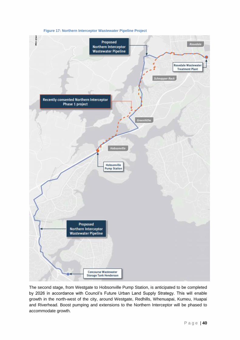
P a g e | 40
Figure 17: Northern Interceptor Wastewater Pipeline Project
The second stage, from Westgate to Hobsonville Pump Station, is anticipated to be completed
by 2026 in accordance with Council’s Future Urban Land Supply Strategy. This will enable
growth in the north-west of the city, around Westgate, Redhills, Whenuapai, Kumeu, Huapai
and Riverhead. Boost pumping and extensions to the Northern Interceptor will be phased to
accommodate growth.

P a g e | 41
Table 15: Potential wastewater supply projects, timeframes and costs – North-West
Project / Programme Start Finish Indicative Cost (2018)
Northern Interceptor – Westgate to Rosedale
2017 2027 $180 million
New Redhills Wastewater Pump Station and Branch Sewer
2018 2027
$100 million New Westgate Wastewater Pump Stations and Branch Sewer
2018 2027
New Whenuapai Wastewater Pump Stations and Branch Sewer
Not in Asset Management Plan
5.2 Water
Currently the North Harbour 1 watermain is the only transmission watermain conveying water
from the west to the north via the Greenhithe Bridge.
The proposed North Harbour No. 2 Watermain project involves the installation of a new
watermain that will convey potable drinking water from Auckland’s western water sources in
the Waitakere Ranges to west-Auckland, North Shore and the Future Urban zoned land north
of Albany. The proposed pipeline will provide sufficient water supply capacity to meet long-
term demands in the western and northern parts of Auckland, ensuring security of supply.
Watercare’s current programme is to begin construction of the North Harbour No. 2 Watermain
from around 2018. Stage 1 of the project involves construction of a new watermain adjacent to
the State Highway 18 motorway and under the Greenhithe Bridge. The entire North Harbour 2
watermain construction is anticipated to be completed in 2026.
5.3 Stormwater
Redhills
A Network Discharge Consent for the Redhills Precinct is currently in the process of being
obtained. The developer of the Redhills Special Housing Area has prepared a Stormwater
Management Plan (which has been accepted by Healthy Waters) to support the Network
Discharge Consent application.
The culvert under SH16 has been modelled and shown to have sufficient capacity for
maximum probable development flood flows and will not need to be upgraded. There are some
existing upstream properties that will need to be connected to the new piped stormwater
network when constructed.
Whenuapai
The Whenuapai Future Urban zoned area sits primarily within the Whenuapai stormwater
catchment. The area has a significant number of permanent and intermittent watercourses
throughout and also has existing natural wetland features. The Whenuapai Stormwater
Management Plan was prepared to support and promote the sustainable long-term urban
development of Whenuapai based on Water Sensitive Design principles. This was a
supporting document to the Whenuapai Structure Plan.

P a g e | 42
A rapid flood hazard model has indicated that there is minimal risk associated with flooding in
the catchment. Therefore it is not proposed that flood flows will be detained but rather passed
forward along the network of protected streams and associated riparian management reserves
which will form the trunk stormwater system.
The culvert under Totara Rd in the vicinity of No. 90 – 92 will need upgrading when the
catchment develops. Other enhancement opportunities include a perched culvert which
prevents inanga spawning. These specific projects will become evident as the Network
Discharge Consent is developed. Until that stage an allocation of funding has been set aside
for the catchment in the order of $12 million.
5.4 Transport
With an extra 75,000 people living in the north-west area, significant new transport
infrastructure will be needed. The preferred transport network has been developed following
technical workshops and public feedback. The aim is to make the future communities well
connected and great places to live.
At the heart of the North West network is a well-connected Rapid Transit Network. It will
provide links between Kumeu and the main employment centres in the city and Albany. New
park and ride facilities will provide greater access and connect into local services, including
higher frequency ferry services to and from the city, Hobsonville and West Harbour.
Another key focus is improving the safety and efficiency of State Highway 16 north of
Westgate. Safety improvements underway and planned between Brigham Creek Road and
Waimauku will help reduce serious crashes and improve efficiency, ahead of other major
infrastructure build projects being progressed in the longer term.
In the Kumeu area new and upgraded roads will better connect growth areas. This includes
improvements to connections between housing north and south of the main highway as well as
between Coatesville, Riverhead and the North Shore. A new route is proposed to the south of
Kumeu and Huapai. It will reduce pressure on the existing State Highway 16, providing an
alternative through route and keep the current Kumeu and Huapai town centres as safe, local
community-focused environments.
A direct motorway to motorway connection between State Highway 16 and State Highway 18
will provide a more efficient connection between Kumeu/Huapai and the North Shore. New
motorway ramps will also be investigated at Squadron Drive and Northside Drive.
In the Whenuapai and Red Hills areas, new roads and improvements to existing roads, such
as Brigham Creek Road and the Coatesville-Riverhead Highway, will develop a strong local
road network with safe and efficient connections between communities and to the strategic
motorway network.
The cycling and walking network will be expanded to connect local centres and link to public
transport hubs improving travel choice and accessibility.

P a g e | 43
Figure 18: Supporting Growth – Transport Networks in the North West

P a g e | 44
Table 16: Key Transport Infrastructure for the North West identified through Supporting Growth – Delivering Transport Networks
Transport Infrastructure
Timing (where known)
Indicative costs
15
Interrelationships Comments
State Highway 16 safety improvements
Currently underway
N/A Currently underway and funded through the RLTP/NLTP
Rapid transit network route (including park and rides)
Huapai/Kumeu to Westgate
Westgate to Albany
Investigation and design underway to Brigham Creek
$745m – $925m North West Rapid Transit Network
Not an AT/NZTA prioritised project through the RLTP and ATAP
Alternative corridor parallel to State Highway 16
Investigation and design with view route protect by 2022
$425m - $545m
North West Rapid Transit Network State highway safety improvements
Not an AT/NZTA prioritised project through the RLTP– could be delivered in conjunction with developer
State Highway 16 and State Highway 18 improvements
Investigation and design with view route protect by 2022
$340m- $455m
Rapid Transit Network State Highway 16 safety improvements
Decade 1 ATAP priority
Local arterial connections in Kumeu
Investigation and design with view route protect by 2022
$90m - $115m State Highway 16 improvements Local connections
Not an AT prioritised project through the RLTP– could be delivered in conjunction with developer
Improved Connections to Coatesville, Riverhead and North Shore
Investigation and design with view route protect by 2022
$95m - $120m State Highway 16 safety improvements
Not an AT prioritised project through the RLTP and ATAP– could be delivered in conjunction with developer
New Red Hills connections
Investigation and design with view route protect by 2022
$310m – $380m Local connections
Not an AT prioritised project through the RLTP– could be delivered in conjunction with developer
Improved connections in Whenuapai
Investigation and design with view route protect by 2022
$180m - $230m Local connections
Not an AT prioritised project through the RLTP– could be delivered in conjunction with developer
15
Costs shown are based on strategic level assessments as part of the Auckland Transport Alignment Project. Cost will be accordingly updated as investigations designs are progressed Cost for transport infrastructure in the North Western area are total costs for the proposed network. Further cost segmentation to occur as part of future business cases.

P a g e | 45
6.0 Drury
The Drury growth area, including Opaheke, Drury, Drury South, Drury West and parts of
Karaka consists of 2,154 hectares of predominantly rural land, which is the largest greenfield
area to be developed in the Auckland Region. It is located 35 km from Auckland’s CBD, 14 km
from Manukau and 6km away from Papakura. Including planned development in Hingaia, the
area has the capacity for approximately 23,500 dwellings, or nearly 60,000 people.
Figure 19: Opaheke – Drury and Drury West, showing zoning under the Auckland Unitary Plan and the Special Housing Areas
The area is bisected by State Highway One, the southern rail line and in the west State
Highway 22 as shown in Figure 19. The area provides for significant opportunities for
employment, with the existing Papakura industrial area to the north of Opaheke, the existing
Drury industrial area adjacent to SH1 at the centre of the growth area, and the recently

P a g e | 46
rezoned industrial area (owned by Stevenson’s) to the south. It is anticipated that the Drury
area could provide around 422 hectares of business land to provide for local employment
opportunities which could yield as many as 12,500 jobs.
Development is already occurring within the Special Housing Areas (SHA) established there
(as shown in Figure 19 above). Plan Changes have occurred in each of the SHA’s and
consents have been lodged. In each case the plan change has rezoned the area within the
SHA from Future Urban to a range of residential zones. As a result, planning for water and
waste servicing and transport infrastructure has commenced. While relatively detailed planning
has been undertaken within the SHA’s as part of the plan changes and consenting, some
infrastructure planning has also occurred to understand the connections between the areas of
development.
Figure 20: Future Urban Area sequencing - Opaheke-Drury and Drury West
The Bremner Road SHA is located at the north-eastern corner of the Drury West area (see
Figure 19). The recent plan variation in the SHA has rezoned 84.6 hectares of land from
Future Urban Zone to a combination of Terrace Housing and Apartment Building, Mixed

P a g e | 47
Housing Urban, Mixed Housing Suburban, and Local Centre zones and the Drury 1 Precinct
was established. This SHA will ultimately provide a yield of approximately 1,350 dwellings.
The Quarry Road SHA was established within the Drury South Structure Plan area. The
Unitary Plan rezoned 361 hectares of rural land to industrial land use. A subsequent SHA
variation recently rezoned 73 hectares of the Drury South area to residential use; including
Mixed Housing Urban, Mixed Housing Suburban and Terrace Housing and Apartment Building
zones. This SHA will ultimately provide for around 900 – 1,200 dwellings.
The Bellfield SHA sits at the interface between Papakura and Opaheke. The recent plan
change created the Opaheke 1 precinct and rezoned the 26.875 hectares area from Future
Urban to Mixed Housing Urban, Mixed Housing Suburban, Neighbourhood Centre and Open
Space: Conservation zones. This SHA will ultimately provide for around 500 dwellings.
The majority of the Hingaia Peninsula which sits north of Drury West was also established as a
SHA. Recent plan changes have rezoned over 500 hectares of rural land to mostly residential
use. It is anticipated that the Hingaia SHA will ultimately provide for 4,500 – 5,000 dwellings.
As shown in Figure 20 under the Future Urban Land Supply Strategy, Stage 1 of the Drury
West area (north of SH 22) is expected to be development ready by 2022. Stage 2 of the Drury
West area (south of SH 22), and the Opaheke - Drury area is scheduled to be development
ready between 2028 and 2032. The following description of infrastructure requirements
focuses on what need to be delivered within the next ten years.
Table 17: Proposed dwelling capacity and anticipated business land in Opaheke and Drury
Proposed timing – development ready
Area Proposed dwelling capacity for each
area (approx.)
Gross Business Area (ha.)
16
Actuals, contracted or planned 2012 - 2017
Hingaia 3,070 0
Drury South 1,000 223
Bremner Rd (Drury West) 1,350 0
Bellfield Rd (Opaheke) 300 0
1st half Decade One 2018 – 2022 Drury West Stage 1* 4,200 0
1st half Decade Two 2028 - 2032 Drury West (Stage 2) 5,700 74
Opaheke - Drury 7,900 125
6.1 Wastewater
Watercare are in the process of developing a long term strategy that will service Drury West,
Opaheke, Drury South and Paerata. These plans rely on the proposed short term and long
term wastewater connections for the Bremner Road Special Housing Area.
Stage 1 requires the construction of a pump station to be located at 160 Bremner Road.
Wastewater from the Bremner Road development will gravitate to the proposed Bremner Road
16
Business land referred to in this table is restricted to land extensive business activities such as manufacturing, transport and storage, construction, wholesale trade (e.g. light industrial and general business zones); Business land within neighbourhood, local or town centres is not included.

P a g e | 48
pump station, which will then convey flows to the existing Hingaia pump station via a single
rising main. The pipe will cross under Drury Creek in order to get to the Hingaia pump station
which is on the opposite side of the creek at the bottom of the Hingaia peninsula. The Hingaia
pump station will convey flows to the Southern Interceptor, and ultimately to the Mangere
Wastewater Treatment Plant. The Hingaia pump station has spare capacity for a total of
approximately 1,400 dwellings (which will be met by both the Hingaia and Bremner Road SHA
developments). Upgrades will be needed to service the medium and long term growth
requirements. A new bulk wastewater sewer pipe is also required between the Hingaia pump
station and existing bulk assets with capacity in Manurewa. Due to the topography between
Hingaia and Manurewa, this will need to be a rising main. Watercare is currently investigating
and assessing the feasibility of the options for this infrastructure.
Two options are being considered as outlined in the Southern Growth Area Wastewater
Servicing Strategy dated November 2016. The first relies on the rising main eventually
bypassing the Hingaia pump station; the second relies on gravity, eventually removing the
Bremner Road pump station.
Table 18: Potential wastewater supply projects, timeframes and costs – Drury
Project / Programme Start Finish Indicative Cost
(2018)
Hingaia Wastewater pump station and rising main 2018 2022 $60 million
Opaheke wastewater trunk extension Not in Asset Management Plan
Southern Interceptor Augmentation 2018 2027 $115 million
6.2 Water
A new bulk supply point on the Waikato Watermain will be constructed to supply the Bremner
Road development, Hingaia and Drury West areas.
6.3 Stormwater
The Drury growth area, including Opaheke, Drury, Drury South, Drury west and parts of
Karaka fall within four different stormwater catchments. Figure 21 shows the Future Urban
zones in the context of the catchments they fall within. Generally the southern future growth
areas are located in the lower areas of very large stormwater catchment which presents
challenges for flood management.
Drury West
The Drury West area currently has no existing public stormwater network or an existing
stormwater catchment plan. The topography naturally divides the proposed development area
into two natural drainage areas – the Ngakoroa Stream and the Oira Creek catchments. The
Future Urban area programmed for the first decade has very little flooding issues. Flooding
within the Ngakoroa Stream catchment is located within Drury West Stage 2 (south of State
Highway 22) and is subject to further planning work which is not underway at this stage. Flood
plains and overland flow paths associated with permanent and intermittent streams will be
required to be protected and enhanced during development.

P a g e | 49
The Ngakoroa and the Oira catchments are predominantly rural, with the Bremner Road
Special Housing Area has been approved at the extreme downstream end. The floodplains are
generally confined and Ngakoroa in particular is incised at the downstream extent.
Figure 21: Catchments and flood plains within the Opaheke-Drury and Drury West area
Auckland Council holds no detailed modelling for either catchment and the published
floodplains are from a coarse regional scale Rapid Flood Hazard Assessment. A more up to
date, fine resolution Rapid Flood Hazard Assessment is recommended for these catchments.
A Network Discharge Consent for the Bremner Road Special Housing Area was granted in
December 2016. A Stormwater Management Plan has also been submitted as a part of the
plan variation and is supported by the Healthy Waters Department.
The Stormwater Management Plan seeks to implement Water Sensitive Design approach to
stormwater management, combining both detention and retention, and both quantity and
quality stormwater treatment. The proposed treatment varies depending on whether the
stormwater discharges to a stream or to the estuary.

P a g e | 50
In particular the developer proposes to manage floodplains within green corridors and locate
residential development outside of the floodplains. A number of stormwater devices are
proposed including rain gardens, rain water tanks, permeable paving communal
retention/detention devices, green outfalls, proprietary devices, the alignment of overland
flowpaths in road corridors and swales.
A similar approach is envisaged for the rest of the Future Urban zoned areas. Generally all
infrastructure required within this catchment will be provided by the developer.
6.4 Transport
The south is the largest future urban growth area in Auckland with around 5,300 hectares of
land identified for urban development. This could result in 42,000 homes and 19,000 jobs over
30 years. The decision version of the Unitary Plan provides for greater capacity should this be
required. With a lot more people living in the area, significant new transport infrastructure will
be needed.
At the heart of the proposed network for the south is a well-connected Rapid Transport
Network with electric trains extended to Pukekohe and extra rail capacity. New stations at
Tironui, Drury, Drury West and Paerata will improve access to trains.
Rapid transit links between the airport, Manukau, Flat Bush and Botany, along with high
frequency buses between Manukau and Drury West will be provided via a high frequency bus
corridor. Future improvements to park and ride facilities, along with implementation of the
Southern New Network in October 2016, will provide a strong public transport network.
Another key focus is the upgrade of the Mill Road corridor from Manukau and Flat Bush to
Papakura and an extension to Drury. This will help improve safety, provide greater access to
new growth areas and provide an additional north-south route. It will likely link to State
Highway 1 and to a new expressway between Drury, Paerata and Pukekohe. The widening of
State Highway 1 between Manukau and Papakura may be extended to Drury.
NZTA is currently implementing the Southern Corridor (SH1) Improvements Project which is
anticipated to be completed by October 2018. This project covers the stretch of Southern
Motorway from the SH20/SH1 connection at Manukau down to Papakura. The Project includes
additional lanes in both directions, an upgrade to the Takanini Interchange and a 4.5km shared
use pedestrian/cycle path.
As the Future Urban zoned area urbanises, the role of State Highway 22 (Paerata Road and
Karaka Road) will change. There will be an interrelationship between State Highway 22 and
the provision of additional arterials around Pukekohe. The role that each of these routes play
will be assessed in coordination as part of the next stages of investigation. Safety
improvements on State Highway 22 will also improve travel between Drury and Pukekohe
Opaheke - Drury and Drury West is one of the key areas identified for growth and transport
upgrades in the Supporting Growth – Delivering Transport Networks project, as seen below in
Figure 22. Key actions relevant to the Opaheke – Drury and Drury West area are summarised
in Table 19.

P a g e | 51
Figure 22: Supporting Growth – Transport Networks in the South

P a g e | 52
Table 19: Key transport infrastructure identified through Supporting Growth - Delivering Transport Networks
Transport Infrastructure
Timing (where known)
Indicative costs
17
Interrelationships Comments
Improved rail corridor
including electrification
between Papakura to
Pukekohe including
additional Stations at
Drury, Drury West and
Paerata
Investigation and
design with view
route protect by
2022
$705m – $820m
ATAP Decade 1 priority Additional stations are not an AT prioritised project through the RLTP– could be delivered in conjunction with developer
High Frequency bus
corridor connecting
Drury West, Drury,
Hingaia, Papakura,
Takanini and Manukau
Investigation and
design with view
route protect by
2022
$195m - $245m
Town centre locations Existing local and arterial infrastructure
Not an AT prioritised project through the RLTP– could be delivered in conjunction with developer
Safety Improvements
on State Highway 22 Current n/a
Improved arterial road connections
Funded through the current RLTP/NLTP
Capacity improvements on State Highway 1
Investigation and
design with view
route protect by
2022
$330m - $440m Mill Road corridor First decade priority
Improved arterial road connections
Investigation and
design with view
route protect by
2022
$153m - $200m SH22 Safety Improvements
Not an AT prioritised project through the RLTP– could be delivered in conjunction with developer
Other transport infrastructure in proximity
Mill Road Corridor
Investigation and
design with view
route protect by
2022
$520m - $675m SH1 capacity improvements Pukekohe corridors
Stage 1 included in the current RLTP
Wider rail network
improvements –
including grade
separation and road
closures
Investigation and
design with view
route protect by
2022
$180m - $240m
Improved rail corridor including electrification between Papakura to Pukekohe
Not an AT prioritised project through the RLTP– could be delivered in conjunction with developer
17
Costs shown are based on strategic level assessments as part of the Auckland Transport Alignment Project. Cost will be accordingly updated as investigations designs are progressed. Cost for transport infrastructure in the Southern area are total costs for the proposed network. Further cost segmentation to occur as part of future business cases.

P a g e | 53
7.0 Pukekohe and Paerata
Pukekohe is situated approximately 50 km from Auckland and 25 km from Manukau.
Pukekohe is located on the North Island Main Trunk Line and is connected to Auckland by
State Highway 22 (SH22) and the Pukekohe East Road which connects to State Highway 1
(southern motorway) at the Drury and Bombay interchanges respectively.
Pukekohe is identified in the Auckland Plan as a priority satellite town, anticipated to grow to a
population of 50,000 people by 2040 – more than doubling Pukekohe’s 2013 population of
21,000 people.
Figure 23: Future urban growth in Pukekohe and Paerata
Paerata is a relatively narrow band of land which straddles SH22 at the north of Pukekohe.
Long identified for the development of additional business land, Paerata has been zoned under
the Auckland Unitary Plan for future urban development. A recent Unitary Plan variation north

P a g e | 54
of Paerata, within the Wesley SHA, rezoned a significant portion of the Future Urban zone
(about 300ha) to Mixed Housing Urban and Local Centre. The Wesley SHA is intended to be
built out over the next 30 years or so. Site works are well underway for Stage 1, which will
provide for about 1000 dwellings and make use of the existing infrastructure. Once Stage 1
has been completed, after about ten years, Stage 2 (providing an additional 4,000 dwellings)
will commence after the construction of new wastewater infrastructure is in place.
Under the Future Urban Land Supply Strategy, the rest of Paerata is planned to be
development ready in the period between 2018–2022.
On the western periphery of Pukekohe, the Belmont Special Housing Area covers an area of
approximately 72 hectares and is proposed to provide 720 dwellings. Consents have been
granted and development is well underway. In addition, the Auckland Unitary Plan has zoned
approximately 1,700 hectares of land for future urban development around Paerata -
Pukekohe. This is expected to provide capacity for an additional 3,500 dwellings.
Under the Future Urban Land Supply Strategy, which is currently under review, the rest of
Pukekohe is planned to be development ready in the second half of the first decade (2023-
2027).
Figure 24: Future Urban Area Sequencing – Paerata and Pukekohe

P a g e | 55
Table 20: Proposed dwelling capacity and anticipated business land in Pukekohe and Paerata
Proposed timing – development ready
Area Proposed dwelling
capacity for each area (approx.)
Gross Business Area (ha.)
18
Actuals, contracted or planned 2012 - 2017
Wesley (Paerata) 4,550 0
Belmont (Pukekohe) 720 0
1st half Decade One 2018 – 2022 Paerata (remainder) 1,800 17
2nd half Decade One 2023 – 2027 Pukekohe 7,200 195
7.1 Waste Water
The Pukekohe urban area is serviced by a reticulated network which conveys waste to the
Pukekohe Wastewater Plant. The Waikato Regional Council is the regulator for this treatment
plant. The discharge consent has expired and a 35-year resource consent application has
been lodged with the Waikato Regional Council to increase the capacity of the plant. The
upgrade and expansion of the plant cannot progress until the resource consent has been
granted.
A new trunk sewer main between Pukekohe and the treatment plant is currently under
construction to allow development to occur.
Table 21: Potential wastewater supply projects, timeframes and costs – Pukekohe/Paerata
Project / Programme Start Finish Indicative Cost
(2018)
Pukekohe Trunk Sewer upgrade 2018 2027 $80 million
Pukekohe Wastewater Treatment Plant update 2018 2027
Paerata Branch Sewer and Pump Station 2018 2027 $70 million
Takanini Branch Sewer Extension Not in Asset Management Plan
7.2 Water
Pukekohe is connected to the metropolitan water supply.
There is sufficient capacity in the bulk water supply transmission system to enable
development through the existing Pukekohe watermain. A new watermain will be required to
service Wesley from the point of connection to the transmission system.
Table 22: Potential water supply projects, timeframes and costs – Pukekohe/Paerata
Project / Programme Start Finish Indicative Cost (2018)
Paerata Watermain 2018 2022 $30 million
18
Business land referred to in this table is restricted to land extensive business activities such as manufacturing, transport and storage, construction, wholesale trade (e.g. light industrial and general business zones); Business land within neighbourhood, local or town centres is not included.

P a g e | 56
7.3 Stormwater
The Pukekohe-Paerata Future Urban zoned area of 1750 hectares falls under three
hydrological catchments; Whangapouri and Oira catchments in the North which discharge to
the sensitive receiving environment of the Pahurehure Inlet and the Manukau Harbour while
Pukekohe South is in the Tutaenui catchment and discharges to the Waikato River to the south
of the township.
Hydraulic modelling for the various catchments is underway and is at different stages of
development. However, optioneering processes are underway for Whangapouri catchment and
will start soon for the Oira Creek catchment. The results from this work will determine any
projects required to release the Future Urban land for development.
Pukekohe North sub-catchment, is identified as being affected by the 100yr flood event. The
critical areas of flooding are located to the west of Helvetia road and both east and west of the
railway line upstream of the SH22 triple barrel culvert. Importantly, in terms of stormwater
issues, Paerata is presently development ready with little or no development constraints other
than those normally expected for developments in greenfield areas.
Pukekohe’s existing urban area has been affected by extreme flood events in the past and
there is a need to address the flooding as part of a comprehensive stormwater management
approach.
A Stormwater Management Plan will be prepared for the remaining areas of Pukekohe and
surrounding Future Urban land. This will be developed as part of the upcoming Structure Plan
process.
A programme of works will be available for publication mid to late 2017. Currently $27M is
allocated in the LTP for capital works projects required to enable the Future Urban land to be
ready for development.
7.4 Transport
As detailed above, the south is the largest future urban growth area in Auckland and significant
transport infrastructure will be needed.
The current road network in Pukekohe has insufficient arterial roads to accommodate the
forecast growth in traffic volumes. It is expected that a number of existing roads will need to
be upgraded to arterial road standard and some new arterial road links constructed to provide
access to the wider road network and land use. The number and location of at-grade rail
crossings in Pukekohe limit the full utilisation of these roads as arterials and could be
considered safety concerns as the volume of traffic crossing them increases. As a result some
may be closed or upgraded to full grade separated rail crossings.
The key transport infrastructure that will support growth in Pukekohe includes a well-connected
Rapid Transport Network (with electric trains extended to Pukekohe and extra rail capacity),
and the upgrade of the Mill Road corridor from Manukau and Flat Bush to Papakura and an
extension to Drury.
Connecting into the Mill Road corridor will be a proposed new expressway between Drury,
Paerata and Pukekohe as shown in Item 7 in Figure 22. In addition, the widening of State
Highway 1 between Manukau and Papakura will likely be extended to Drury.

P a g e | 57
Working together with Waikato local authorities, improved public transport, local road, and
state highway connections will be investigated.
Table 23: Key transport infrastructure identified through Supporting Growth – Delivering Transport Networks
Transport Infrastructure
Timing (where known)
Indicative costs19
Interrelationships Comments
Improved connections around Pukekohe
Investigation and design with view route protect by 2022
$45m - $60m New link between Pukekohe and Drury
Not an AT prioritised project through the RLTP – could be delivered in conjunction with developer
New corridor between Pukekohe and Drury
Investigation and design with view route protect by 2022
$475m - $630m
Mill Road Corridor State Highway capacity improvements
Not an AT/NZTA prioritised project through the RLTP or ATAP – could be delivered in conjunction with developer
Improved connections to Waikato
Discussion with Waikato local authorities underway
Unknown Working with the Waikato
Very high level planning stage Not an AT/NZTA prioritised project through the RLTP or ATAP
19
Costs shown are based on strategic level assessments as part of the Auckland Transport Alignment Project. Cost will be accordingly updated as investigations designs are progressed Cost for transport infrastructure in the Southern area are total costs for the proposed network. Further cost segmentation to occur as part of future business cases.


![Snapshot Noun [c] (UNDERSTANDING)€¦ · This Snapshot summarises themes and issues relating to physical health and healthcare provision for the Armed Forces Community, including](https://img.pdfslide.us/doc/110x75/5eabb0762b33cd6718604cef/snapshot-noun-c-understanding-this-snapshot-summarises-themes-and-issues-relating.jpg)