Embed Size (px)
Citation preview

PARADISE VALLEYCorridor Planning Study
1
Informational Meeting No. 1GardinerWednesday, July 24th, 2013Gardiner Community Center6:00 p.m. – 8:00 p.m.
LivingstonThursday, July 25th, 2013Community Room6:00 p.m. – 8:00 p.m.
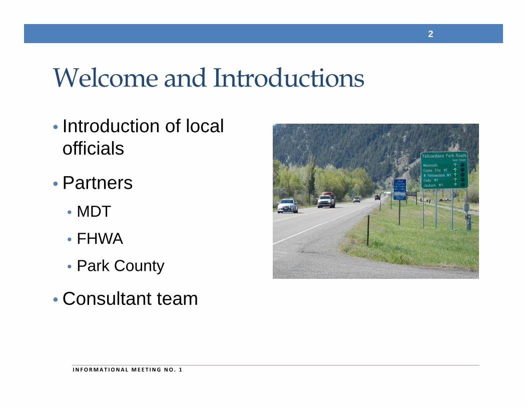
Welcome and Introductions
• Introduction of local officials
• Partners• MDT
• FHWA
• Park County
• Consultant team
2
I N FORMAT I ONA L MEE T I NG NO . 1
Outline of this Evening’s Meeting• Title VI considerations
• What is a corridor planning study?
• Study area boundary
• Study schedule
• Identified stakeholder groups
• Existing conditions in the corridor
• Next steps & conclusion
3
I N FORMAT I ONA L MEE T I NG NO . 1
Title VI ConsiderationsThis meeting is held pursuant to Title VI of the 1964 Civil Rights Act which ensures that no person shall, as provided by Federal and State Civil Rights law, be excluded from participation in, denied the benefits of, or otherwise be subjected to discrimination on the basis of a protected status during any MDT project.
Further information is available in Title VI pamphlets available at the sign-in table.
4
I N FORMAT I ONA L MEE T I NG NO . 1
What is a Corridor Planning Study?• Corridor planning studies:
• Are a “high level scan”
• Define transportation issues/areas of concern
• Consider social, economic and environmental effects at an early stage
• Identify and prioritize cost-effective and feasible strategies
• Provide a level of analysis that can support informed and sustainable decisions
• Provide opportunities for early and continuous involvement
5
I N FORMAT I ONA L MEE T I NG NO . 1
What a Corridor Planning Study is Not• Corridor planning studies are not:
• Environmental compliance document
• Preliminary or final design project
• Construction or maintenance project
• Right-of-way acquisition project
6
I N FORMAT I ONA L MEE T I NG NO . 1
Goals and Purpose of Study• Engage constituents early!
• Identify potential impacts and constraints
• Identify needs and objectives
• Identify short-range and long-range improvements
• Develop planning level cost estimates
• Develop information and data to be forwarded into the environmental process if a project moves forward from the study (dependent on available funds)
7
I N FORMAT I ONA L MEE T I NG NO . 1

Study Area Boundary
• US Highway 89 (US 89)
• Between Gardiner and Livingston
• 52.5 miles in length
8
I N FORMAT I ONA L MEE T I NG NO . 1
90
191
191
191 89
89
86
571
572
345
295
540
89
BeginRP 0.0
EndRP 52.5
Bozeman
Livingston
Gardiner
Pray
Chico
CorwinSprings
Emigrant
Jardine
Miner
Pine Creek
0
5
10
15
20
25
30
35
40
45
50
G A L L A T I N C O U N T Y
P A R K C O U N T Y
M O N T A N A
W Y O M I N G
Yellow
ston
eR
iver
Yellowston e River
GallatinNational Forest
GallatinNational Forest
Montana Fish,Wildlife and
Parks
Montana Fish,Wildlife
and Parks
YellowstoneNational Park
Absaroka-BeartoothWilderness Area
Absaroka-BeartoothWilderness Area
Paradise ValleyCorridor
0 2 4 61Miles
Map LegendParadise Valley Corridor
Study Area
Local Road
On System Route
State Boundary
County Boundary
City Boundary
National Park
Wilderness Area
US Forest Service
Bureau of Land Management
Montana State Trust Land
Montana Fish, Wildlife and Parks
ENDUS 89 south of Livingston (RP 52.5)
BEGINUS 89 @ YNP Boundary in Gardiner(RP 0.0)
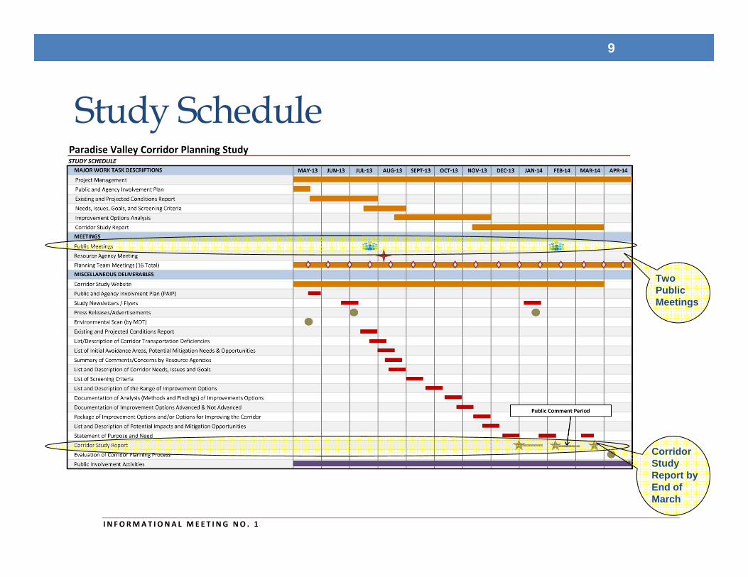
Study Schedule
9
I N FORMAT I ONA L MEE T I NG NO . 1
Two Public Meetings
Corridor Study Report by End of March
Public Involvement Activities• Two sets of informational meetings
• Presentations and outreach to interested parties, stakeholders, resource agencies and land owners as warranted
• Study newsletters
• Website
• Informal meetings
10
I N FORMAT I ONA L MEE T I NG NO . 1
Identified Stakeholder Groups• City of Livingston
• Gardiner Chamber of Commerce
• Greater Gardiner Community Council
• Northern Rocky Mountain Economic Development District
• MSU Extension
• Yellowstone River Task Force
• Montana State Highway Patrol
• Gallatin Valley Land Trust
• Montana Land Reliance
• Rocky Mountain Elk Foundation
• The Nature Conservancy
• Montana Wild Sheep Foundation
• Montanan’s for Safe Wildlife Passage
• Northern Plains Resource Council
• Trout Unlimited – Joe Brooks Chapter
• Landowners in the Corridor
11
I N FORMAT I ONA L MEE T I NG NO . 1
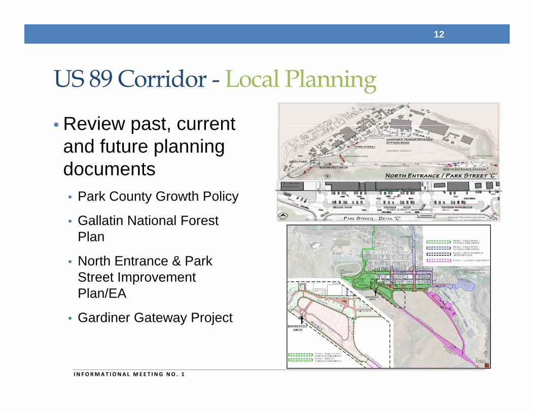
US 89 Corridor - Local Planning
• Review past, current and future planning documents• Park County Growth Policy
• Gallatin National Forest Plan
• North Entrance & Park Street Improvement Plan/EA
• Gardiner Gateway Project
12
I N FORMAT I ONA L MEE T I NG NO . 1
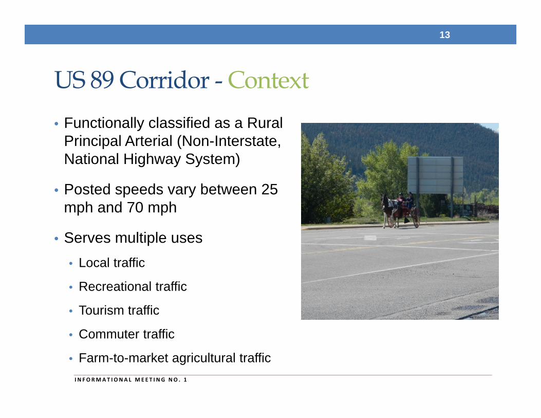
US 89 Corridor - Context• Functionally classified as a Rural
Principal Arterial (Non-Interstate, National Highway System)
• Posted speeds vary between 25 mph and 70 mph
• Serves multiple uses• Local traffic
• Recreational traffic
• Tourism traffic
• Commuter traffic
• Farm-to-market agricultural traffic
13
I N FORMAT I ONA L MEE T I NG NO . 1
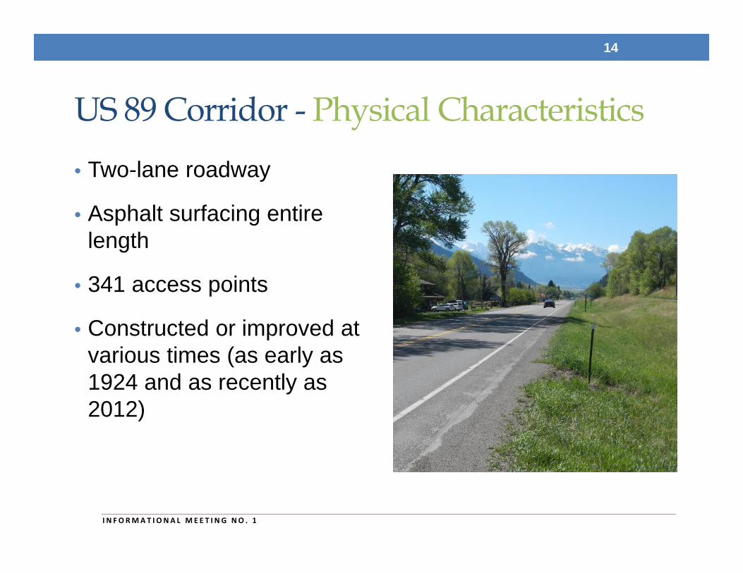
US 89 Corridor - Physical Characteristics• Two-lane roadway
• Asphalt surfacing entire length
• 341 access points
• Constructed or improved at various times (as early as 1924 and as recently as 2012)
14
I N FORMAT I ONA L MEE T I NG NO . 1
US 89 Corridor - Planned Projects• SF 110-Rumble Strips N-11
• Shoulder rumble strips (RP 1.2 to RP 49.5)
• Gardiner - North• Mill and fill, ADA upgrades at intersections, bridge deck repair, and full
width seal and cover treatment (RP 0.0 to RP 1.0)
• North of Gardiner• Mill and fill and full width seal and cover treatment (RP 1.1 to RP 13.1)
• Yankee Jim Canyon - North• Mill and fill and full width seal and cover treatment (RP 13.1 to RP 24)
• Cedar Cr – 16 km N of Gardiner• Cedar Creek culvert to be replaced (RP 10.02)
• SF 129 – Left Turn Ln Emigrant RA• Southbound left-turn lane at the Emigrant Rest Area (RP 23.5)
15
I N FORMAT I ONA L MEE T I NG NO . 1
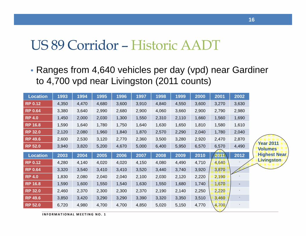
Location 1993 1994 1995 1996 1997 1998 1999 2000 2001 2002RP 0.12 4,350 4,470 4,680 3,600 3,910 4,840 4,550 3,600 3,270 3,630
RP 0.64 3,380 3,640 2,990 2,680 2,900 4,060 3,660 2,900 2,790 2,980
RP 4.0 1,450 2,000 2,030 1,300 1,550 2,310 2,110 1,660 1,560 1,690
RP 16.8 1,590 1,640 1,780 1,750 1,640 1,630 1,650 1,810 1,580 1,610
RP 32.0 2,120 2,080 1,960 1,840 1,870 2,570 2,290 2,040 1,780 2,040
RP 49.6 2,600 2,530 3,120 2,770 2,360 3,500 3,280 2,920 2,470 2,870
RP 52.0 3,940 3,820 5,200 4,670 5,000 6,400 5,950 6,570 6,570 4,490
Location 2003 2004 2005 2006 2007 2008 2009 2010 2011 2012RP 0.12 4,280 4,140 4,020 4,020 4,150 4,080 4,490 4,710 4,640 -
RP 0.64 3,320 3,540 3,410 3,410 3,520 3,440 3,740 3,920 3,870 -
RP 4.0 1,830 2,080 2,040 2,040 2,100 2,030 2,120 2,220 2,190 -
RP 16.8 1,590 1,600 1,550 1,540 1,630 1,550 1,680 1,740 1,670 -
RP 32.0 2,460 2,370 2,300 2,300 2,370 2,190 2,140 2,250 2,220 -
RP 49.6 3,850 3,420 3,290 3,290 3,390 3,320 3,350 3,510 3,460 -
RP 52.0 6,720 4,980 4,700 4,700 4,850 5,020 5,150 4,770 4,700 -
US 89 Corridor – Historic AADT • Ranges from 4,640 vehicles per day (vpd) near Gardiner
to 4,700 vpd near Livingston (2011 counts)
16
I N FORMAT I ONA L MEE T I NG NO . 1
Year 2011 Volumes Highest Near Livingston
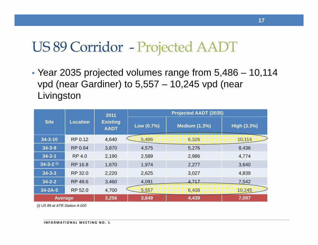
US 89 Corridor - Projected AADT• Year 2035 projected volumes range from 5,486 – 10,114
vpd (near Gardiner) to 5,557 – 10,245 vpd (near Livingston
17
I N FORMAT I ONA L MEE T I NG NO . 1
Site Location2011
Existing AADT
Projected AADT (2035)
Low (0.7%) Medium (1.3%) High (3.3%)
34-3-10 RP 0.12 4,640 5,486 6,326 10,114
34-3-9 RP 0.64 3,870 4,575 5,276 8,436
34-3-1 RP 4.0 2,190 2,589 2,986 4,774
34-3-2 (i) RP 16.8 1,670 1,974 2,277 3,640
34-3-3 RP 32.0 2,220 2,625 3,027 4,839
34-2-2 RP 49.6 3,460 4,091 4,717 7,542
34-2A-5 RP 52.0 4,700 5,557 6,408 10,245Average 3,256 3,849 4,439 7,097
(i) US 89 at ATR Station A-020
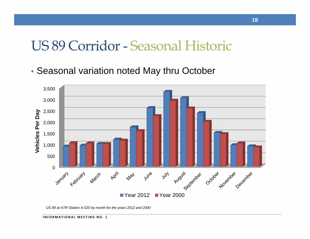
US 89 Corridor - Seasonal Historic• Seasonal variation noted May thru October
18
I N FORMAT I ONA L MEE T I NG NO . 1
0
500
1,000
1,500
2,000
2,500
3,000
3,500
Vehi
cles
Per
Day
Year 2012 Year 2000
US 89 at ATR Station A-020 by month for the years 2012 and 2000
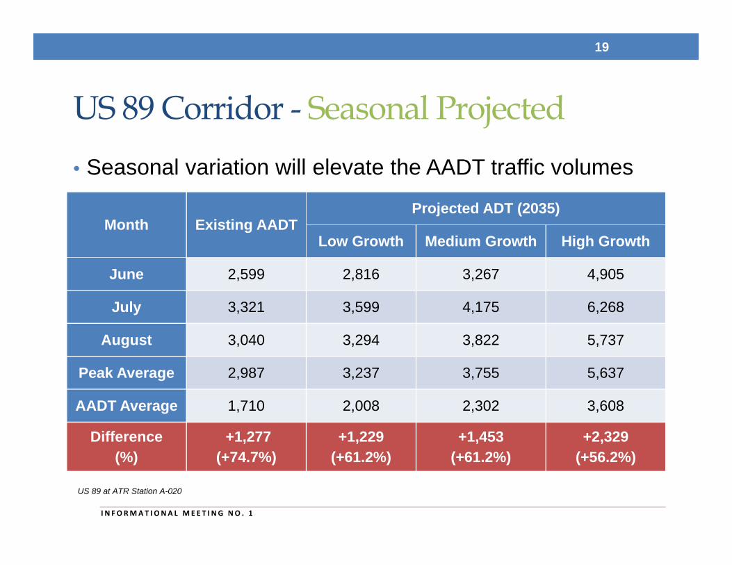
US 89 Corridor - Seasonal Projected• Seasonal variation will elevate the AADT traffic volumes
19
I N FORMAT I ONA L MEE T I NG NO . 1
US 89 at ATR Station A-020
Month Existing AADTProjected ADT (2035)
Low Growth Medium Growth High Growth
June 2,599 2,816 3,267 4,905
July 3,321 3,599 4,175 6,268
August 3,040 3,294 3,822 5,737
Peak Average 2,987 3,237 3,755 5,637
AADT Average 1,710 2,008 2,302 3,608
Difference(%)
+1,277(+74.7%)
+1,229(+61.2%)
+1,453(+61.2%)
+2,329(+56.2%)
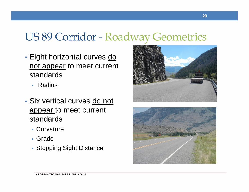
US 89 Corridor - Roadway Geometrics• Eight horizontal curves do
not appear to meet current standards• Radius
• Six vertical curves do not appear to meet current standards • Curvature• Grade• Stopping Sight Distance
20
I N FORMAT I ONA L MEE T I NG NO . 1
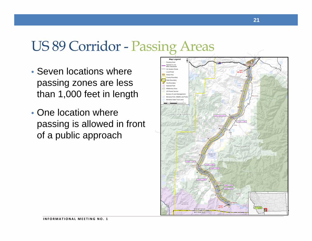
US 89 Corridor - Passing Areas• Seven locations where
passing zones are less than 1,000 feet in length
• One location where passing is allowed in front of a public approach
21
I N FORMAT I ONA L MEE T I NG NO . 1
90
191
191
191 89
89
86
571
572
345
295
540
89
BeginRP 0.0
EndRP 52.5
Bozeman
Livingston
Gardiner
Pray
Chico
CorwinSprings
Emigrant
Jardine
Miner
Pine Creek
0
5
10
15
20
25
30
35
40
45
50
G A L L A T I N C O U N T Y
P A R K C O U N T Y
M O N T A N A
W Y O M I N G
Yellow
ston
eR
iver
Yellowston e River
GallatinNational Forest
GallatinNational Forest
Montana Fish,Wildlife and
Parks
Montana Fish,Wildlife
and Parks
YellowstoneNational Park
Absaroka-BeartoothWilderness Area
Absaroka-BeartoothWilderness Area
Length < 1,000'
Length < 1,000'
Length < 1,000'
Length < 1,000'
Length < 1,000'
Length < 1,000'
Public Approaches
Length < 1,000'
Paradise ValleyCorridor
0 2 4 61Miles
Map Legend
Study Area
Local Road
On System Route
State Boundary
County Boundary
City Boundary
National Park
Wilderness Area
US Forest Service
Bureau of Land Management
Montana State Trust Land
Montana Fish, Wildlife and Parks
Passing Zone
Appears to notMeet Standards
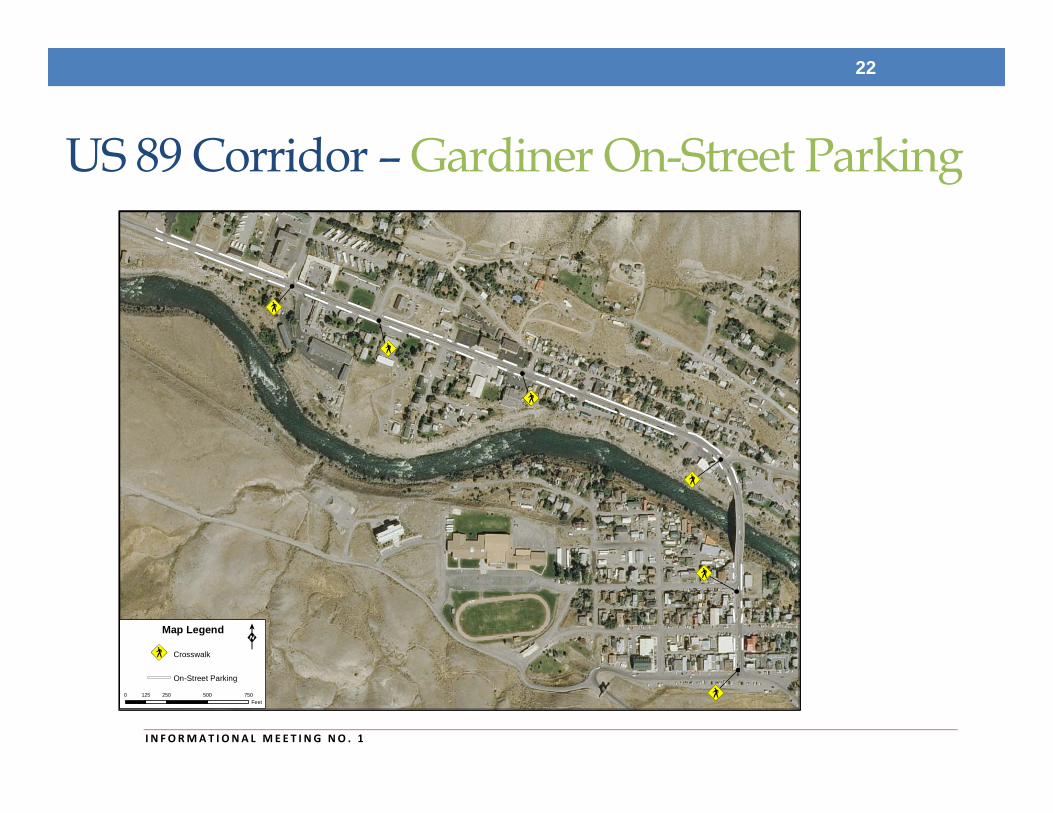
US 89 Corridor – Gardiner On-Street Parking
22
I N FORMAT I ONA L MEE T I NG NO . 1
0 250 500 750125Feet
Map Legend
Crosswalk
On-Street Parking
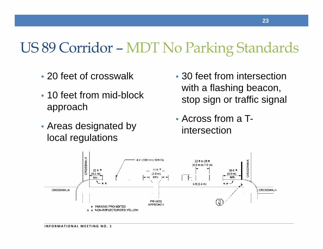
US 89 Corridor – MDT No Parking Standards
• 20 feet of crosswalk
• 10 feet from mid-block approach
• Areas designated by local regulations
• 30 feet from intersection with a flashing beacon, stop sign or traffic signal
• Across from a T-intersection
23
I N FORMAT I ONA L MEE T I NG NO . 1
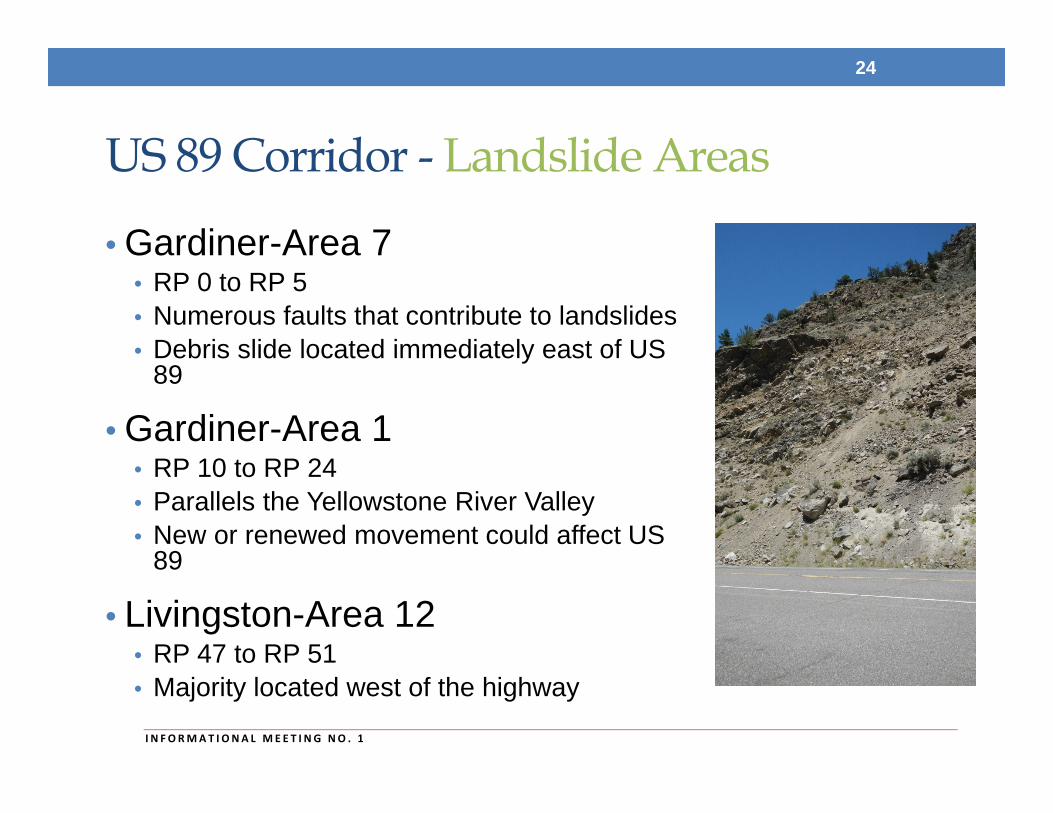
US 89 Corridor - Landslide Areas
• Gardiner-Area 7 • RP 0 to RP 5• Numerous faults that contribute to landslides • Debris slide located immediately east of US
89
• Gardiner-Area 1• RP 10 to RP 24 • Parallels the Yellowstone River Valley• New or renewed movement could affect US
89
• Livingston-Area 12• RP 47 to RP 51• Majority located west of the highway
24
I N FORMAT I ONA L MEE T I NG NO . 1
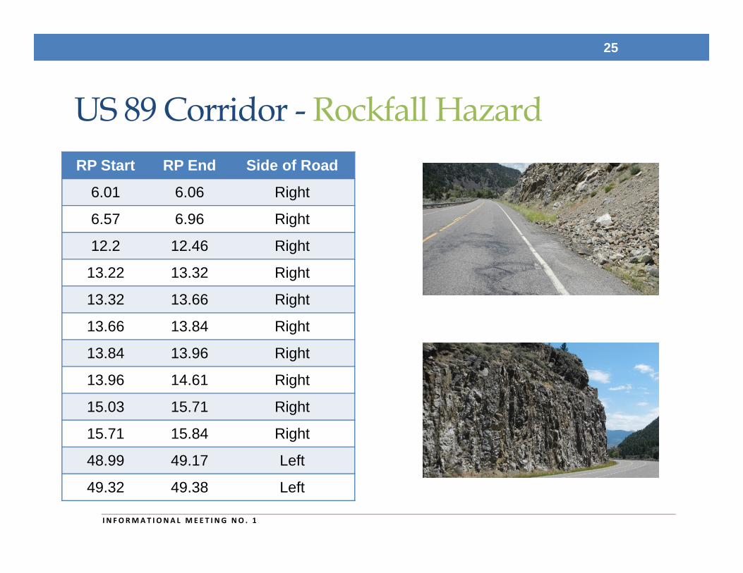
US 89 Corridor - Rockfall Hazard
25
I N FORMAT I ONA L MEE T I NG NO . 1
RP Start RP End Side of Road
6.01 6.06 Right
6.57 6.96 Right
12.2 12.46 Right
13.22 13.32 Right
13.32 13.66 Right
13.66 13.84 Right
13.84 13.96 Right
13.96 14.61 Right
15.03 15.71 Right
15.71 15.84 Right
48.99 49.17 Left
49.32 49.38 Left
US 89 Corridor – Road Width
• Determined from MDT’s 2011 Montana Road Log • Surface width, lane width, shoulder width, surfacing
thickness, and base thickness
• RP 0.0 to RP 1.1 – 44’ Width• 12’ Lanes, 8’ Shoulders
• RP 1.1 to RP 52.5 – 32’ Width• 32’ Surface – 12’ Lanes, 4’ Shoulders
26
I N FORMAT I ONA L MEE T I NG NO . 1
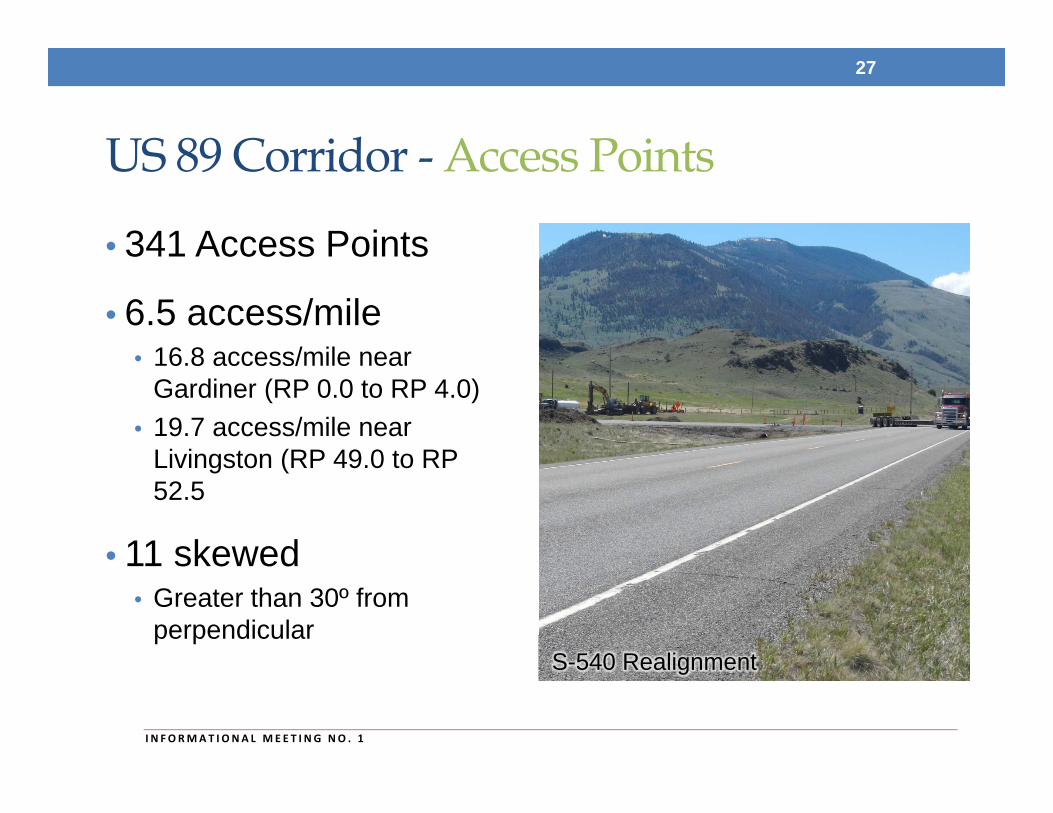
US 89 Corridor - Access Points
• 341 Access Points
• 6.5 access/mile• 16.8 access/mile near
Gardiner (RP 0.0 to RP 4.0)• 19.7 access/mile near
Livingston (RP 49.0 to RP 52.5
• 11 skewed• Greater than 30º from
perpendicular
27
I N FORMAT I ONA L MEE T I NG NO . 1
S-540 Realignment
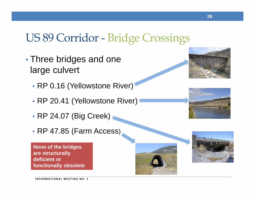
US 89 Corridor - Bridge Crossings
• Three bridges and one large culvert
• RP 0.16 (Yellowstone River)
• RP 20.41 (Yellowstone River)
• RP 24.07 (Big Creek)
• RP 47.85 (Farm Access)
28
None of the bridges are structurally deficient or functionally obsolete
I N FORMAT I ONA L MEE T I NG NO . 1
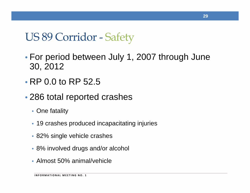
US 89 Corridor - Safety
• For period between July 1, 2007 through June 30, 2012
• RP 0.0 to RP 52.5
• 286 total reported crashes • One fatality
• 19 crashes produced incapacitating injuries
• 82% single vehicle crashes
• 8% involved drugs and/or alcohol
• Almost 50% animal/vehicle
29
I N FORMAT I ONA L MEE T I NG NO . 1
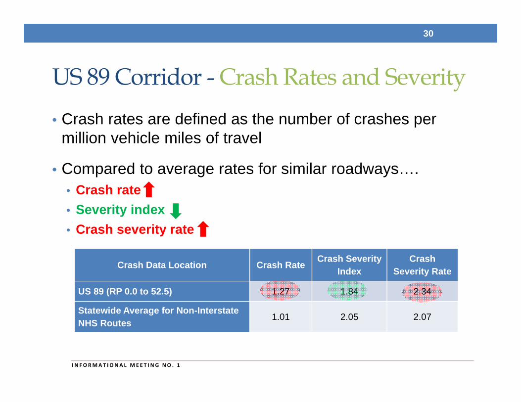
US 89 Corridor - Crash Rates and Severity• Crash rates are defined as the number of crashes per
million vehicle miles of travel
• Compared to average rates for similar roadways….• Crash rate • Severity index • Crash severity rate
30
I N FORMAT I ONA L MEE T I NG NO . 1
Crash Data Location Crash Rate Crash Severity Index
Crash Severity Rate
US 89 (RP 0.0 to 52.5) 1.27 1.84 2.34
Statewide Average for Non-Interstate NHS Routes 1.01 2.05 2.07
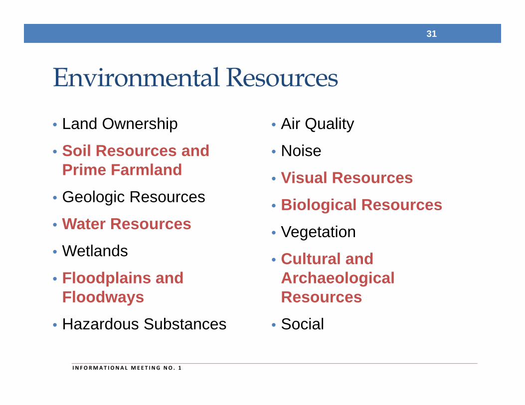
Environmental Resources• Land Ownership
• Soil Resources and Prime Farmland
• Geologic Resources
• Water Resources• Wetlands
• Floodplains and Floodways
• Hazardous Substances
• Air Quality
• Noise
• Visual Resources• Biological Resources• Vegetation
• Cultural and Archaeological Resources
• Social
31
I N FORMAT I ONA L MEE T I NG NO . 1
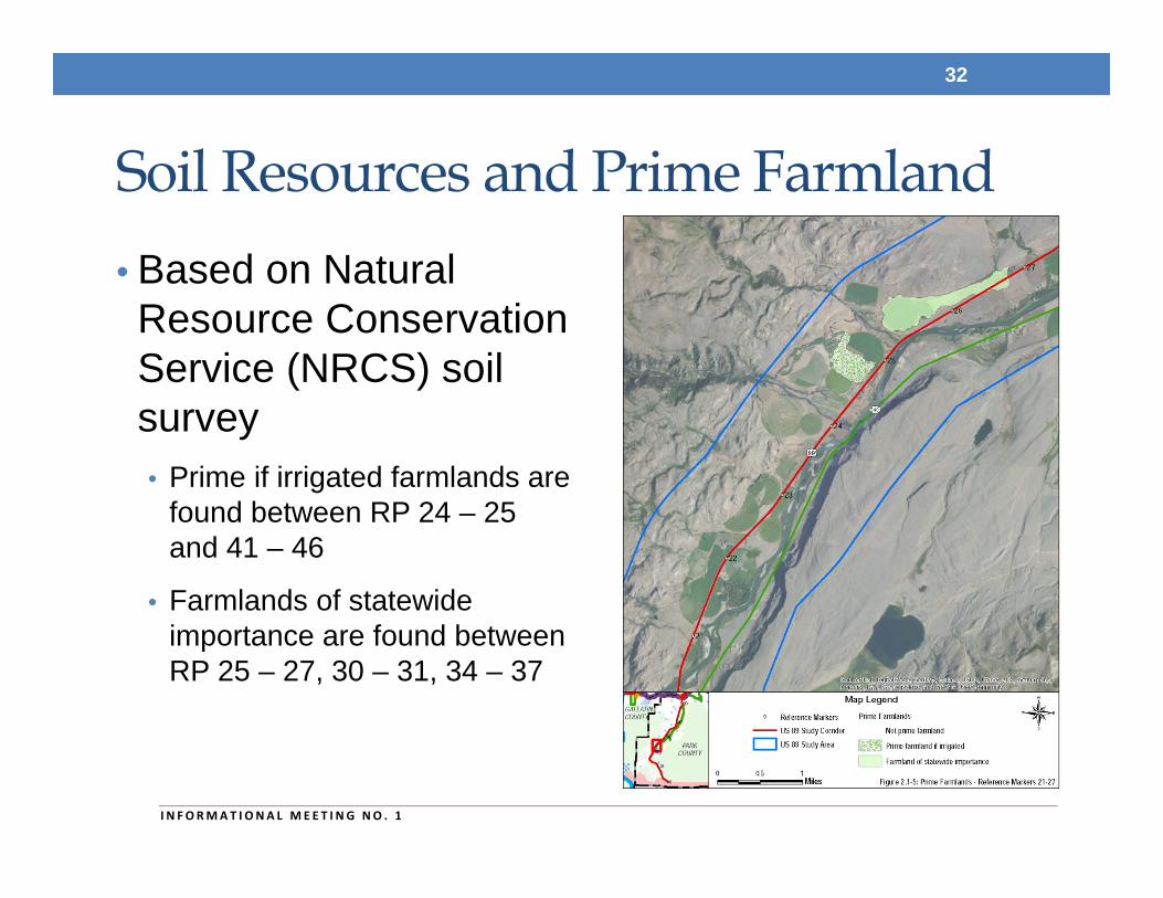
Soil Resources and Prime Farmland• Based on Natural Resource Conservation Service (NRCS) soil survey• Prime if irrigated farmlands are
found between RP 24 – 25 and 41 – 46
• Farmlands of statewide importance are found between RP 25 – 27, 30 – 31, 34 – 37
32
I N FORMAT I ONA L MEE T I NG NO . 1
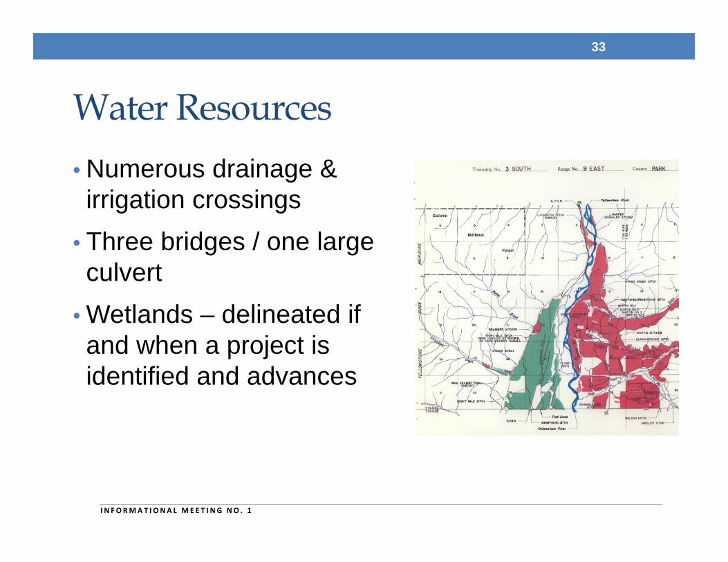
Water Resources• Numerous drainage & irrigation crossings
• Three bridges / one large culvert
• Wetlands – delineated if and when a project is identified and advances
33
I N FORMAT I ONA L MEE T I NG NO . 1
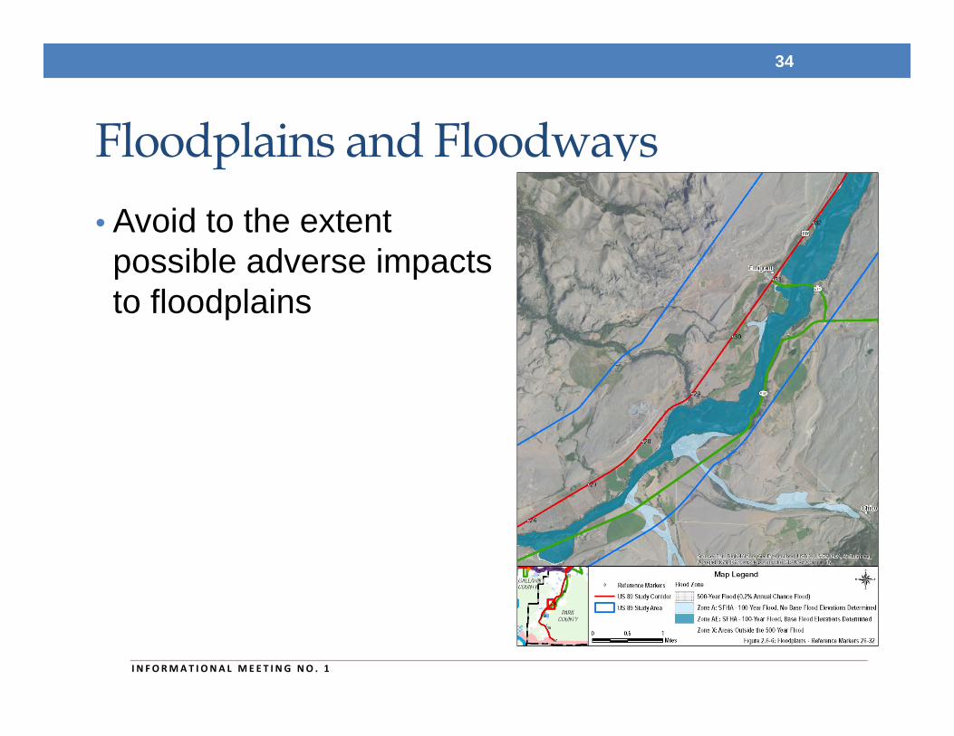
Floodplains and Floodways• Avoid to the extent possible adverse impacts to floodplains
34
I N FORMAT I ONA L MEE T I NG NO . 1
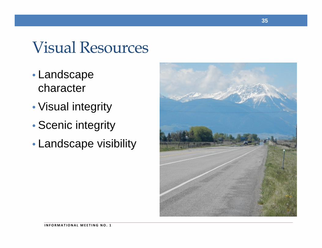
Visual Resources• Landscape character
• Visual integrity• Scenic integrity• Landscape visibility
35
I N FORMAT I ONA L MEE T I NG NO . 1
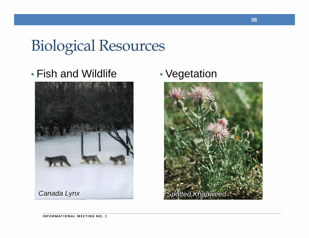
Biological Resources
• Fish and Wildlife • Vegetation
36
I N FORMAT I ONA L MEE T I NG NO . 1
Canada Lynx Spotted Knapweed
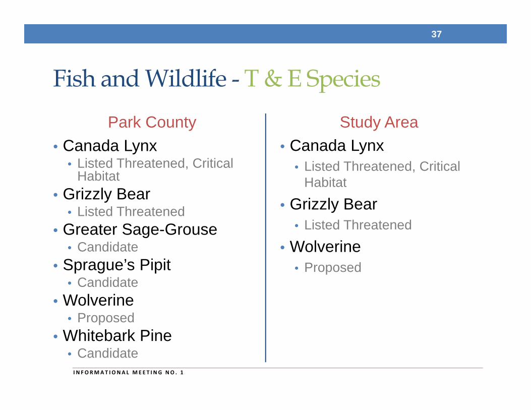
Fish and Wildlife - T & E Species
Park County• Canada Lynx
• Listed Threatened, Critical Habitat
• Grizzly Bear• Listed Threatened
• Greater Sage-Grouse• Candidate
• Sprague’s Pipit• Candidate
• Wolverine• Proposed
• Whitebark Pine• Candidate
Study Area• Canada Lynx
• Listed Threatened, Critical Habitat
• Grizzly Bear• Listed Threatened
• Wolverine• Proposed
37
I N FORMAT I ONA L MEE T I NG NO . 1
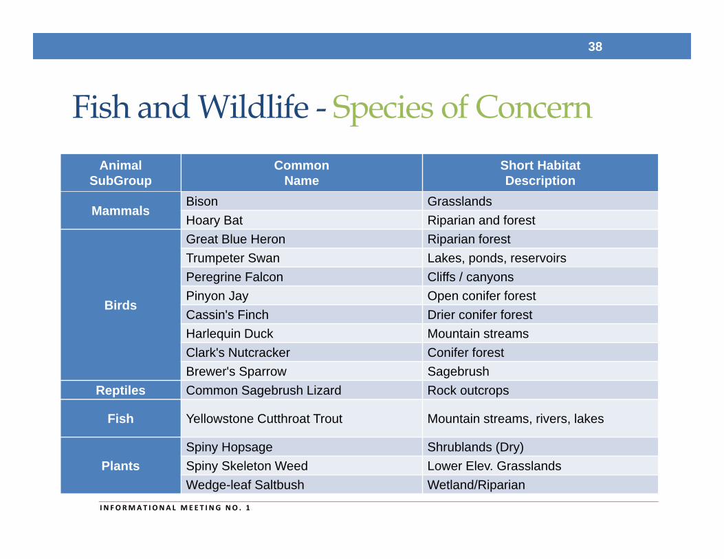
Fish and Wildlife - Species of Concern
38
I N FORMAT I ONA L MEE T I NG NO . 1
AnimalSubGroup
CommonName
Short HabitatDescription
MammalsBison GrasslandsHoary Bat Riparian and forest
Birds
Great Blue Heron Riparian forestTrumpeter Swan Lakes, ponds, reservoirsPeregrine Falcon Cliffs / canyonsPinyon Jay Open conifer forestCassin's Finch Drier conifer forestHarlequin Duck Mountain streamsClark's Nutcracker Conifer forestBrewer's Sparrow Sagebrush
Reptiles Common Sagebrush Lizard Rock outcrops
Fish Yellowstone Cutthroat Trout Mountain streams, rivers, lakes
PlantsSpiny Hopsage Shrublands (Dry)Spiny Skeleton Weed Lower Elev. GrasslandsWedge-leaf Saltbush Wetland/Riparian
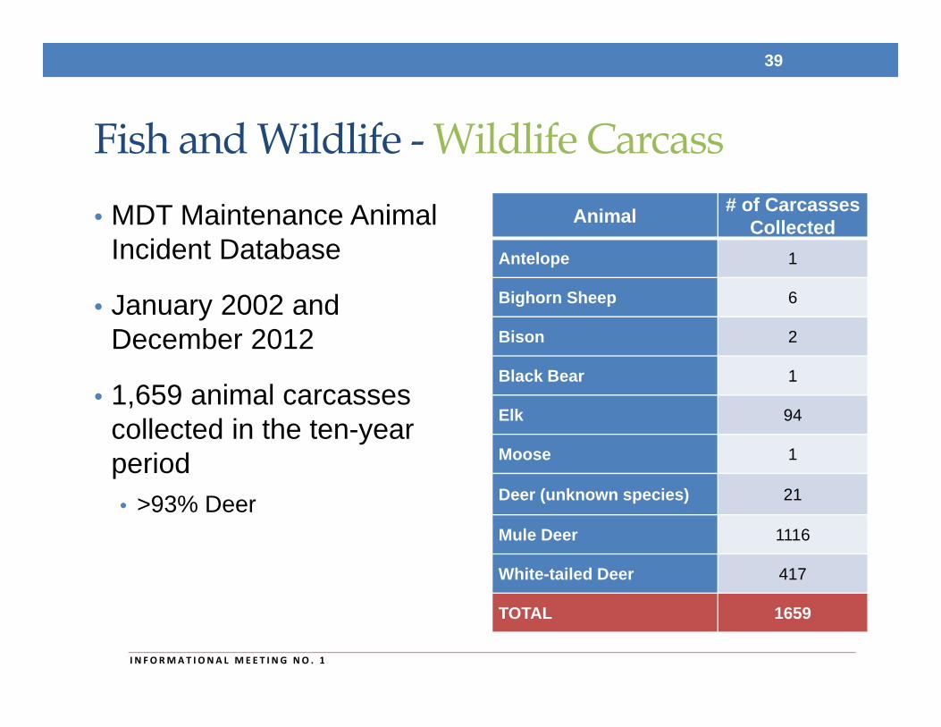
Fish and Wildlife - Wildlife Carcass• MDT Maintenance Animal
Incident Database
• January 2002 and December 2012
• 1,659 animal carcasses collected in the ten-year period• >93% Deer
39
I N FORMAT I ONA L MEE T I NG NO . 1
Animal # of Carcasses Collected
Antelope 1
Bighorn Sheep 6
Bison 2
Black Bear 1
Elk 94
Moose 1
Deer (unknown species) 21
Mule Deer 1116
White-tailed Deer 417
TOTAL 1659
Cultural and Archaeological Resources
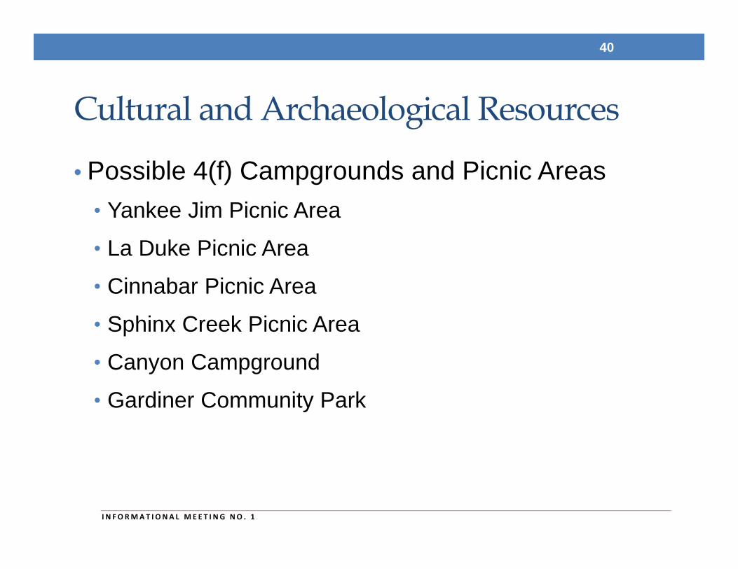
• Possible 4(f) Campgrounds and Picnic Areas• Yankee Jim Picnic Area• La Duke Picnic Area• Cinnabar Picnic Area• Sphinx Creek Picnic Area• Canyon Campground• Gardiner Community Park
40
I N FORMAT I ONA L MEE T I NG NO . 1
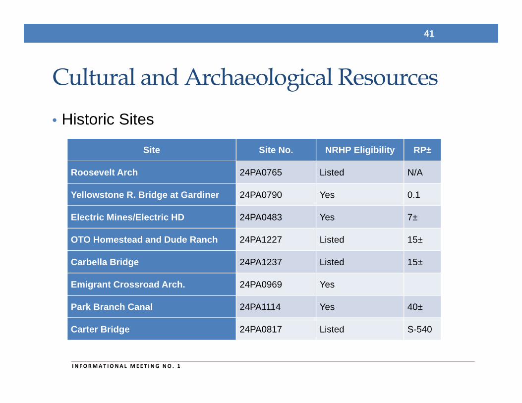
Cultural and Archaeological Resources• Historic Sites
41
I N FORMAT I ONA L MEE T I NG NO . 1
Site Site No. NRHP Eligibility RP±
Roosevelt Arch 24PA0765 Listed N/A
Yellowstone R. Bridge at Gardiner 24PA0790 Yes 0.1
Electric Mines/Electric HD 24PA0483 Yes 7±
OTO Homestead and Dude Ranch 24PA1227 Listed 15±
Carbella Bridge 24PA1237 Listed 15±
Emigrant Crossroad Arch. 24PA0969 Yes
Park Branch Canal 24PA1114 Yes 40±
Carter Bridge 24PA0817 Listed S-540
Next Steps• Continue study coordination and outreach
• Finalize environmental scan
• Finalize existing and projected conditions report
• Continue analysis of transportation needs
• Identify potential improvement options (if any)
• Draft corridor study report
42
I N FORMAT I ONA L MEE T I NG NO . 1
Conclusion• Questions, answers and/or comments?
• Study website: http://www.mdt.mt.gov/pubinvolve/paradisevalley/
• Study newsletters:
• Study contact:Sheila LudlowMT Department of Transportation2701 Prospect AvenueP.O. Box 201001Helena, Montana 59620-1001Email: [email protected]: (406) 444-9193
43
I N FORMAT I ONA L MEE T I NG NO . 1
![INDEX [] · 2017-03-28 · confi guration, sandboxing, 466–468 creating, 122–126 , 190–191 hosting services and, 88–89 integrated pipeline mode, 25.NET Framework version,](https://img.pdfslide.us/doc/110x75/5fa307bb5a58406a79630dc8/index-2017-03-28-coni-guration-sandboxing-466a468-creating-122a126.jpg)