Embed Size (px)
Citation preview

Information management, needs assessment, mapping
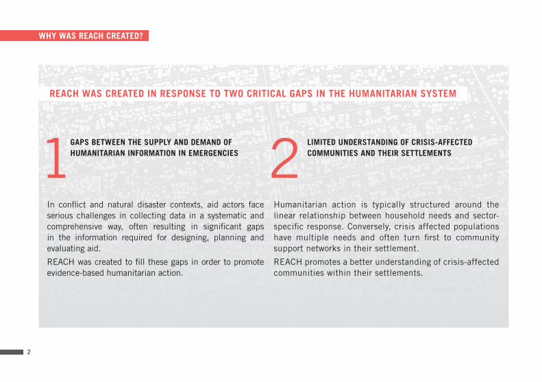
GAPS BETWEEN THE SUPPLY AND DEMAND OF HUMANITARIAN INFORMATION IN EMERGENCIES
In conflict and natural disaster contexts, aid actors face serious challenges in collecting data in a systematic and comprehensive way, often resulting in significant gaps in the information required for designing, planning and evaluating aid.
REACH was created to fill these gaps in order to promote evidence-based humanitarian action.
LIMITED UNDERSTANDING OF CRISIS-AFFECTED COMMUNITIES AND THEIR SETTLEMENTS
Humanitarian action is typically structured around the linear relationship between household needs and sector-specific response. Conversely, crisis affected populations have multiple needs and often turn first to community support networks in their settlement.
REACH promotes a better understanding of crisis-affected communities within their settlements.
1 2
WHY WAS REACH CREATED?
REACH WAS CREATED IN RESPONSE TO TWO CRITICAL GAPS IN THE HUMANITARIAN SYSTEM
2
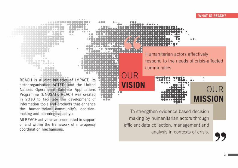
OURMISSION
REACH is a joint initiative of IMPACT, its sister-organisation ACTED, and the United Nations Operational Satellite Applications Programme (UNOSAT). REACH was created in 2010 to facilitate the development of information tools and products that enhance the humanitarian community’s decision-making and planning capacity.
All REACH activities are conducted in support of and within the framework of interagency coordination mechanisms.
WHAT IS REACH?
Humanitarian actors effectively
respond to the needs of crisis-affected
communities
To strengthen evidence based decision
making by humanitarian actors through
efficient data collection, management and
analysis in contexts of crisis.
OURVISION
3

REACH STRATEGIC FRAMEWORK
2
3
1All REACH activities are grounded in a Strategic Framework and organised around three pillars:
4
Planning in Emergencies: Access to information is critical for effective aid delivery in situations of conflict or natural disaster. REACH supports the timely and systematic provision of information to facilitate better planning and coordination among humanitarian actors.
Displacement: Characterized by fluid population movement over wide affected areas, displacement contexts pose specific challenges for humanitarian response. REACH supports humanitarian planning in camp and non-camp settings, and informs planning around return and durable solutions.
Building Community Resilience: An understanding of community dynamics enables more effective humanitarian planning and response, and facilitates the transition towards reconstruction and long term recovery. REACH supports humanitarian actors to build community resilience.

Displacement in camps
Out of camp displacement
Returns and durable solutions
STRATEGIC PILLAR 1
PLANNING IN EMERGENCIES
Rapid Needs and Vulnerability Assessments
Situation Monitoring in Protracted Crisis
Response Monitoring and Evaluation
Support to Decentralised Humanitarian Hubs
STRATEGIC PILLAR 3
BUILDING COMMUNITY RESILIENCE
Community Dynamics Mapping
Access to Social Services
Economic and Market Analysis
Hazard and vulnerability mapping
STRATEGIC PILLAR 2
DISPLACEMENT
PILLAR 2
DISPLACEMENT
PILLAR 3
COMMUNITY
RESILIENCE
PILLAR 1PLANNING IN EMERGENCIES
5

PREPAREDNESS STATIC MAP WEB MAP SECONDARY DATAREVIEW
INFORMATIONMANAGEMENT
DATE AND TIMEREPORTS
REMOTE SENSINGRESSOURCEMOBILIZATION
COORDINATIONOPERATIONAL REVIEW& EVALUATION
IMPLEMENTATION& MONITORING
DEPLOYMENT INTER AGENCYASSESMENT
1 - SURVEY2 - CLIPBOARD
PREPAREDNESS STATIC MAP WEB MAP SECONDARY DATAREVIEW
INFORMATIONMANAGEMENT
DATE AND TIMEREPORTS
REMOTE SENSINGRESSOURCEMOBILIZATION
COORDINATIONOPERATIONAL REVIEW& EVALUATION
IMPLEMENTATION& MONITORING
1 - ANALYSIS2 - DATA BASE
INTER AGENCYASSESMENT
1 - SURVEY2 - CLIPBOARD
WHAT WE DO
NEEDS ASSESMENTS SECONDARY DATAREVIEW
WEB MAPINFORMATIONMANAGEMENT
RESEARCH & REPORTS
COORDINATIONEMPLOYEE EVALUATIONIMPLEMENTATION& MONITORING
DATA ANALYSIS INTER AGENCYASSESMENT
MAP NETWORK LOCATIONREMOTE SENSING DEPLOYMENT
PREPAREDNESS STATIC MAP WEB MAP SECONDARY DATAREVIEW
INFORMATIONMANAGEMENT
DATE AND TIMEREPORTS
REMOTE SENSINGRESSOURCEMOBILIZATION
COORDINATIONOPERATIONAL REVIEW& EVALUATION
IMPLEMENTATION& MONITORING
1 - ANALYSIS2 - DATA BASE
INTER AGENCYASSESMENT
1 - SURVEY2 - CLIPBOARD
PREPAREDNESS STATIC MAP WEB MAP SECONDARY DATAREVIEW
INFORMATIONMANAGEMENT
DATE AND TIMEREPORTS
REMOTE SENSINGRESSOURCEMOBILIZATION
COORDINATIONOPERATIONAL REVIEW& EVALUATION
IMPLEMENTATION& MONITORING
1 - ANALYSIS2 - DATA BASE
INTER AGENCYASSESMENT
1 - SURVEY2 - CLIPBOARD
REACH combines modern information technology with tailored assessment methodologies, tools and processes, which are adapted to each emergency context and to the requirements of aid actors and coordination mechanisms.
INTER-AGENCY ASSESSMENTS
REACH conducts and facilitates field based assessments through dedicated teams of data collectors, encoders and analysers.
REMOTE SENSING
REACH uses remote-sensing and satellite imagery analysis as complementary tools for rapid primary data collection.
SECONDARY DATA REVIEWS
REACH reviews secondary data in order to inform primary data collection methodologies and context analyses.
NEEDS ASSESMENTS SECONDARY DATAREVIEW
WEB MAPINFORMATIONMANAGEMENT
RESEARCH & REPORTS
COORDINATIONEMPLOYEE EVALUATIONIMPLEMENTATION& MONITORING
DATA ANALYSIS INTER AGENCYASSESMENT
MAP LOCATIONREMOTE SENSING DEPLOYMENTNETWORK
NEEDS ASSESMENTS SECONDARY DATAREVIEW
WEB MAPINFORMATIONMANAGEMENT
RESEARCH & REPORTS
COORDINATIONEMPLOYEE EVALUATIONIMPLEMENTATION& MONITORING
DATA ANALYSIS INTER AGENCYASSESMENT
MAP LOCATIONREMOTE SENSING DEPLOYMENTNETWORK
NEEDS ASSESMENTS SECONDARY DATAREVIEW
WEB MAPINFORMATIONMANAGEMENT
RESEARCH & REPORTS
COORDINATIONEMPLOYEE EVALUATIONIMPLEMENTATION& MONITORING
DATA ANALYSIS INTER AGENCYASSESMENT
MAP LOCATIONREMOTE SENSING DEPLOYMENTNETWORK
Dat
a co
llect
ion
6

NEEDS ASSESMENTS SECONDARY DATAREVIEW
WEB MAPINFORMATIONMANAGEMENT
RESEARCH & REPORTS
COORDINATIONEMPLOYEE EVALUATIONIMPLEMENTATION& MONITORING
DATA ANALYSIS INTER AGENCYASSESMENT
MAP NETWORK LOCATIONREMOTE SENSING DEPLOYMENT
REACH maintains a Resource Centre as a platform for publishing and sharing REACH maps, reports and tools. The Resource Centre can be accessed at www.reachresourcecentre.info
REPORTS
REACH teams analyse and disseminate information to aid actors through a range of tailor-made products such as reports, profiles, situation overviews and factsheets.
MAPS
REACH produces and disseminates static maps to display information in a user-friendly format. Where relevant, REACH sets up field-based mapping centres to facilitate access to spatial data by a wide range of actors.
WEB-MAPS & ONLINE DASHBOARDS
REACH develops interactive web-maps and online dashboards to allow aid actors to access and manipulate key information themselves. Open and transparent, the information can be used by all actors to support their programs.
REACHResource
Centre
Dat
a an
alys
is&
dis
sem
inat
ion
7
NEEDS ASSESMENTS SECONDARY DATAREVIEW
WEB MAPINFORMATIONMANAGEMENT
RESEARCH & REPORTS
COORDINATIONEMPLOYEE EVALUATIONIMPLEMENTATION& MONITORING
DATA ANALYSIS INTER AGENCYASSESMENT
MAP LOCATIONREMOTE SENSING DEPLOYMENTNETWORK
NEEDS ASSESMENTS SECONDARY DATAREVIEW
WEB MAPINFORMATIONMANAGEMENT
RESEARCH & REPORTS
COORDINATIONEMPLOYEE EVALUATIONIMPLEMENTATION& MONITORING
DATA ANALYSIS INTER AGENCYASSESMENT
MAP LOCATIONREMOTE SENSING DEPLOYMENTNETWORK
NEEDS ASSESMENTS SECONDARY DATAREVIEW
WEB MAPINFORMATIONMANAGEMENT
RESEARCH & REPORTS
COORDINATIONEMPLOYEE EVALUATIONIMPLEMENTATION& MONITORING
DATA ANALYSIS INTER AGENCYASSESMENT
MAP LOCATIONREMOTE SENSING DEPLOYMENTNETWORK

Geneva
ONGOING FIELD PRESENCE
PREVIOUS OPERATIONS
REACH maintains a continuous presence of assessment and information management specialists in protracted emergencies.
Upon request from global partners, REACH teams are also deployed to other emergencies to conduct rapid field support missions.
OUR TEAM
The REACH global team is based in Geneva, Switzerland, and includes specialists in data collection, data management and analysis.
The REACH global team also provides backstopping and guidance to the REACH field teams at country level.
8

The REACH consortium comprises IMPACT, its sister organisation ACTED,
and UNOSAT. REACH brings together and builds upon the complementary expertise and capacities of the three consortium partners at the global and country level. 9
Provides remote sensing expertise & technical
support
Hosts and facilitates REACH field operations
REACH CONSORTIUM
Manages REACH Global & Country Teams and oversees
global strategy & programming

OUR PARTNERS
REACH promotes a collaborative approach among aid actors and supports established inter-agency coordination mechanisms at the global and country levels. REACH is an active member of the global humanitarian system, notably through its participation in several bodies of the Inter-Agency Standing Committee, as well as through its active engagement in global clusters.
GLOBAL CLUSTERS
UN AGENCIES AND INTERNATIONAL ORGANIZATIONS
GLOBAL FUNDING AGENCIES
Protection Cluster
10
11
Assessments Somalia Information Management WASH Partnership Mobile Data Collection Analysis Jordan Databases Maps Niger Emergency response Iraq Remote Sensing
Food Security Satellite Imagery Philippines Recovery Shelter Clusters Preparedness Mali Web-mapping Lebanon Resilience Humanitarian Program Cycle South Sudan
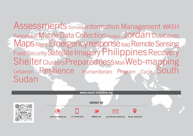
www.reach-initiative.org
CONTACT US
www.reach-initative.org +41 22 566 29 63 @REACH_info Geneva, [email protected]