Embed Size (px)
Citation preview

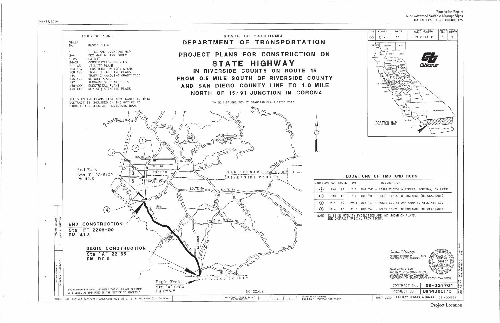
INFORMATION HANDOUT For Contract No. 08-0G7704
At 08-Riv-15-0.00 / 41.80
Identified by
Project ID 0814000175
Contract number, Road and Project ID.
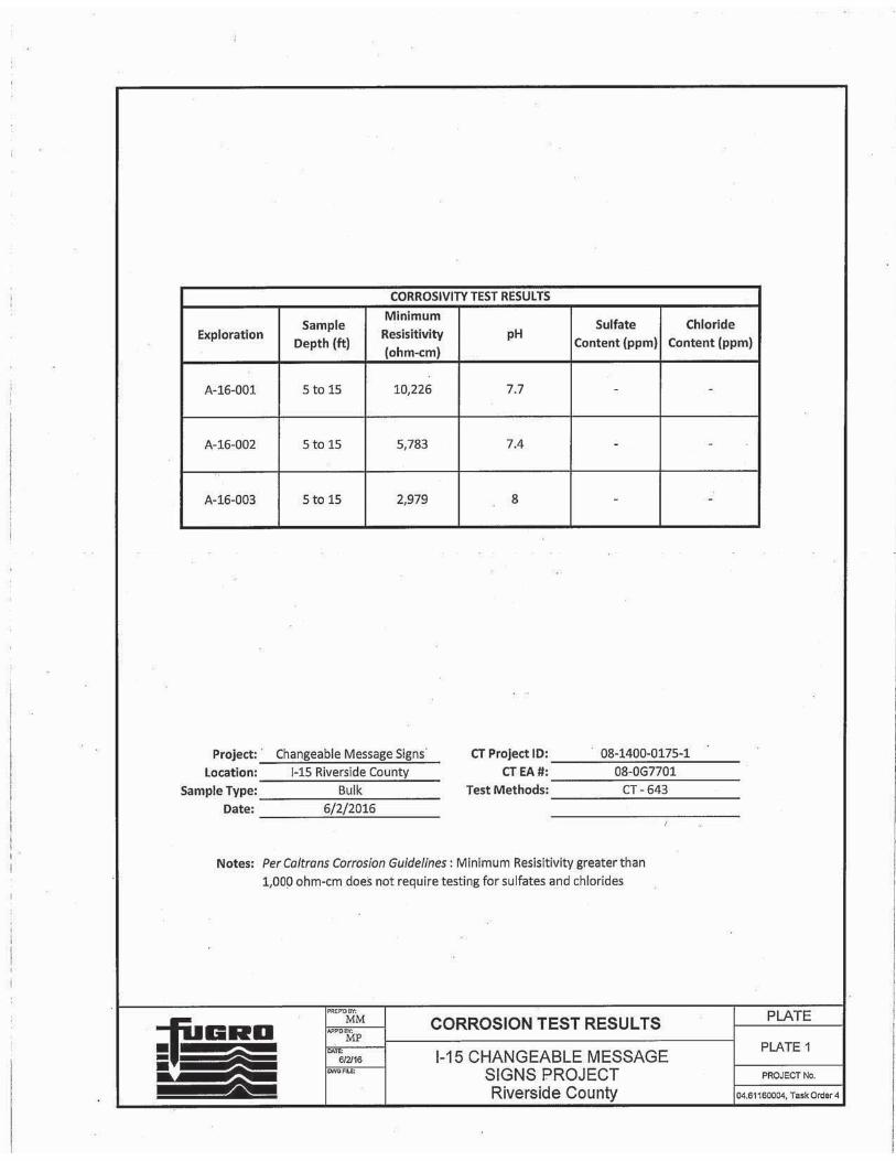
08-0G7704 08-Riv-15-0.00 / 41.80 Project ID 0814000175
MATERIALS INFORMATION Summary of Foundation Recommendation Reports for three Changeable Message Signs on Interstate 15.
Maintaining Existing Traffic Management System Elements during Construction
Additional information and measures to NESMI
REPLACED PER ADDENDUM NO. 2 DATED JUNE 5, 2017


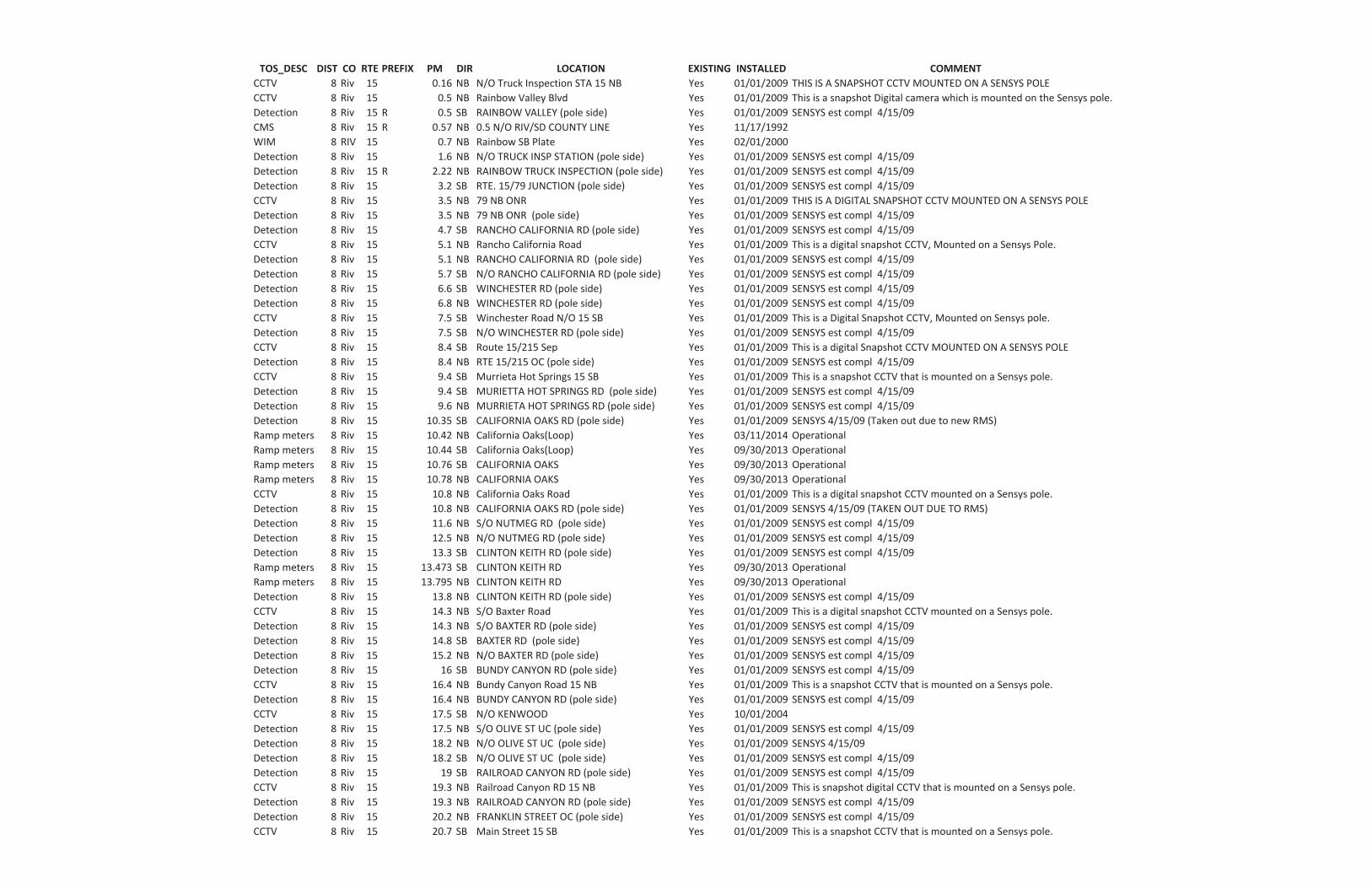
TOS_DESC DIST CO RTE PREFIX PM DIR LOCATION EXISTING INSTALLED COMMENTCCTV 8 Riv 15 0.16 NB N/O Truck Inspection STA 15 NB Yes 01/01/2009 THIS IS A SNAPSHOT CCTV MOUNTED ON A SENSYS POLECCTV 8 Riv 15 0.5 NB Rainbow Valley Blvd Yes 01/01/2009 This is a snapshot Digital camera which is mounted on the Sensys pole.Detection 8 Riv 15 R 0.5 SB RAINBOW VALLEY (pole side) Yes 01/01/2009 SENSYS est compl 4/15/09CMS 8 Riv 15 R 0.57 NB 0.5 N/O RIV/SD COUNTY LINE Yes 11/17/1992WIM 8 RIV 15 0.7 NB Rainbow SB Plate Yes 02/01/2000Detection 8 Riv 15 1.6 NB N/O TRUCK INSP STATION (pole side) Yes 01/01/2009 SENSYS est compl 4/15/09Detection 8 Riv 15 R 2.22 NB RAINBOW TRUCK INSPECTION (pole side) Yes 01/01/2009 SENSYS est compl 4/15/09Detection 8 Riv 15 3.2 SB RTE. 15/79 JUNCTION (pole side) Yes 01/01/2009 SENSYS est compl 4/15/09CCTV 8 Riv 15 3.5 NB 79 NB ONR Yes 01/01/2009 THIS IS A DIGITAL SNAPSHOT CCTV MOUNTED ON A SENSYS POLEDetection 8 Riv 15 3.5 NB 79 NB ONR (pole side) Yes 01/01/2009 SENSYS est compl 4/15/09Detection 8 Riv 15 4.7 SB RANCHO CALIFORNIA RD (pole side) Yes 01/01/2009 SENSYS est compl 4/15/09CCTV 8 Riv 15 5.1 NB Rancho California Road Yes 01/01/2009 This is a digital snapshot CCTV, Mounted on a Sensys Pole.Detection 8 Riv 15 5.1 NB RANCHO CALIFORNIA RD (pole side) Yes 01/01/2009 SENSYS est compl 4/15/09Detection 8 Riv 15 5.7 SB N/O RANCHO CALIFORNIA RD (pole side) Yes 01/01/2009 SENSYS est compl 4/15/09Detection 8 Riv 15 6.6 SB WINCHESTER RD (pole side) Yes 01/01/2009 SENSYS est compl 4/15/09Detection 8 Riv 15 6.8 NB WINCHESTER RD (pole side) Yes 01/01/2009 SENSYS est compl 4/15/09CCTV 8 Riv 15 7.5 SB Winchester Road N/O 15 SB Yes 01/01/2009 This is a Digital Snapshot CCTV, Mounted on Sensys pole.Detection 8 Riv 15 7.5 SB N/O WINCHESTER RD (pole side) Yes 01/01/2009 SENSYS est compl 4/15/09CCTV 8 Riv 15 8.4 SB Route 15/215 Sep Yes 01/01/2009 This is a digital Snapshot CCTV MOUNTED ON A SENSYS POLEDetection 8 Riv 15 8.4 NB RTE 15/215 OC (pole side) Yes 01/01/2009 SENSYS est compl 4/15/09CCTV 8 Riv 15 9.4 SB Murrieta Hot Springs 15 SB Yes 01/01/2009 This is a snapshot CCTV that is mounted on a Sensys pole.Detection 8 Riv 15 9.4 SB MURIETTA HOT SPRINGS RD (pole side) Yes 01/01/2009 SENSYS est compl 4/15/09Detection 8 Riv 15 9.6 NB MURRIETA HOT SPRINGS RD (pole side) Yes 01/01/2009 SENSYS est compl 4/15/09Detection 8 Riv 15 10.35 SB CALIFORNIA OAKS RD (pole side) Yes 01/01/2009 SENSYS 4/15/09 (Taken out due to new RMS)Ramp meters 8 Riv 15 10.42 NB California Oaks(Loop) Yes 03/11/2014 OperationalRamp meters 8 Riv 15 10.44 SB California Oaks(Loop) Yes 09/30/2013 OperationalRamp meters 8 Riv 15 10.76 SB CALIFORNIA OAKS Yes 09/30/2013 OperationalRamp meters 8 Riv 15 10.78 NB CALIFORNIA OAKS Yes 09/30/2013 OperationalCCTV 8 Riv 15 10.8 NB California Oaks Road Yes 01/01/2009 This is a digital snapshot CCTV mounted on a Sensys pole.Detection 8 Riv 15 10.8 NB CALIFORNIA OAKS RD (pole side) Yes 01/01/2009 SENSYS 4/15/09 (TAKEN OUT DUE TO RMS)Detection 8 Riv 15 11.6 NB S/O NUTMEG RD (pole side) Yes 01/01/2009 SENSYS est compl 4/15/09Detection 8 Riv 15 12.5 NB N/O NUTMEG RD (pole side) Yes 01/01/2009 SENSYS est compl 4/15/09Detection 8 Riv 15 13.3 SB CLINTON KEITH RD (pole side) Yes 01/01/2009 SENSYS est compl 4/15/09Ramp meters 8 Riv 15 13.473 SB CLINTON KEITH RD Yes 09/30/2013 OperationalRamp meters 8 Riv 15 13.795 NB CLINTON KEITH RD Yes 09/30/2013 OperationalDetection 8 Riv 15 13.8 NB CLINTON KEITH RD (pole side) Yes 01/01/2009 SENSYS est compl 4/15/09CCTV 8 Riv 15 14.3 NB S/O Baxter Road Yes 01/01/2009 This is a digital snapshot CCTV mounted on a Sensys pole.Detection 8 Riv 15 14.3 NB S/O BAXTER RD (pole side) Yes 01/01/2009 SENSYS est compl 4/15/09Detection 8 Riv 15 14.8 SB BAXTER RD (pole side) Yes 01/01/2009 SENSYS est compl 4/15/09Detection 8 Riv 15 15.2 NB N/O BAXTER RD (pole side) Yes 01/01/2009 SENSYS est compl 4/15/09Detection 8 Riv 15 16 SB BUNDY CANYON RD (pole side) Yes 01/01/2009 SENSYS est compl 4/15/09CCTV 8 Riv 15 16.4 NB Bundy Canyon Road 15 NB Yes 01/01/2009 This is a snapshot CCTV that is mounted on a Sensys pole.Detection 8 Riv 15 16.4 NB BUNDY CANYON RD (pole side) Yes 01/01/2009 SENSYS est compl 4/15/09CCTV 8 Riv 15 17.5 SB N/O KENWOOD Yes 10/01/2004Detection 8 Riv 15 17.5 NB S/O OLIVE ST UC (pole side) Yes 01/01/2009 SENSYS est compl 4/15/09Detection 8 Riv 15 18.2 NB N/O OLIVE ST UC (pole side) Yes 01/01/2009 SENSYS 4/15/09Detection 8 Riv 15 18.2 SB N/O OLIVE ST UC (pole side) Yes 01/01/2009 SENSYS est compl 4/15/09Detection 8 Riv 15 19 SB RAILROAD CANYON RD (pole side) Yes 01/01/2009 SENSYS est compl 4/15/09CCTV 8 Riv 15 19.3 NB Railroad Canyon RD 15 NB Yes 01/01/2009 This is snapshot digital CCTV that is mounted on a Sensys pole.Detection 8 Riv 15 19.3 NB RAILROAD CANYON RD (pole side) Yes 01/01/2009 SENSYS est compl 4/15/09Detection 8 Riv 15 20.2 NB FRANKLIN STREET OC (pole side) Yes 01/01/2009 SENSYS est compl 4/15/09CCTV 8 Riv 15 20.7 SB Main Street 15 SB Yes 01/01/2009 This is a snapshot CCTV that is mounted on a Sensys pole.
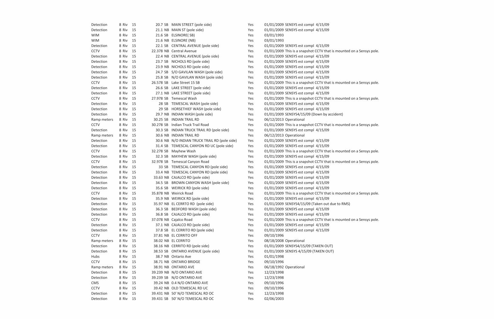
Detection 8 Riv 15 20.7 SB MAIN STREET (pole side) Yes 01/01/2009 SENSYS est compl 4/15/09Detection 8 Riv 15 21.1 NB MAIN ST (pole side) Yes 01/01/2009 SENSYS est compl 4/15/09WIM 8 Riv 15 21.6 SB ELSINORE( SB) Yes 03/01/1993WIM 8 Riv 15 21.6 NB ELSINORE (NB) Yes 03/01/1993Detection 8 Riv 15 22.1 SB CENTRAL AVENUE (pole side) Yes 01/01/2009 SENSYS est compl 4/15/09CCTV 8 Riv 15 22.378 NB Central Avenue Yes 01/01/2009 This is a snapshot CCTV that is mounted on a Sensys pole.Detection 8 Riv 15 22.4 NB CENTRAL AVENUE (pole side) Yes 01/01/2009 SENSYS est compl 4/15/09Detection 8 Riv 15 23.7 SB NICHOLS RD (pole side) Yes 01/01/2009 SENSYS est compl 4/15/09Detection 8 Riv 15 23.9 NB NICHOLS RD (pole side) Yes 01/01/2009 SENSYS est compl 4/15/09Detection 8 Riv 15 24.7 SB S/O GAVILAN WASH (pole side) Yes 01/01/2009 SENSYS est compl 4/15/09Detection 8 Riv 15 25.8 SB N/O GAVILAN WASH (pole side) Yes 01/01/2009 SENSYS est compl 4/15/09CCTV 8 Riv 15 26.578 SB Lake Street 15 SB Yes 01/01/2009 This is a snapshot CCTV that is mounted on a Sensys pole.Detection 8 Riv 15 26.6 SB LAKE STREET (pole side) Yes 01/01/2009 SENSYS est compl 4/15/09Detection 8 Riv 15 27.1 NB LAKE STREET (pole side) Yes 01/01/2009 SENSYS est compl 4/15/09CCTV 8 Riv 15 27.978 SB Temescal Wash Yes 01/01/2009 This is a snapshot CCTV that is mounted on a Sensys pole.Detection 8 Riv 15 28 SB TEMESCAL WASH (pole side) Yes 01/01/2009 SENSYS est compl 4/15/09Detection 8 Riv 15 29 SB HORSETHIEF WASH (pole side) Yes 01/01/2009 SENSYS est compl 4/15/09Detection 8 Riv 15 29.7 NB INDIAN WASH (pole side) Yes 01/01/2009 SENSYS4/15/09 (Down by accident)Ramp meters 8 Riv 15 30.25 SB INDIAN TRAIL RD Yes 06/12/2013 OperationalCCTV 8 Riv 15 30.278 SB Indian Truck Trail Road Yes 01/01/2009 This is a snapshot CCTV that is mounted on a Sensys pole.Detection 8 Riv 15 30.3 SB INDIAN TRUCK TRAIL RD (pole side) Yes 01/01/2009 SENSYS est compl 4/15/09Ramp meters 8 Riv 15 30.6 NB INDIAN TRAIL RD Yes 06/12/2013 OperationalDetection 8 Riv 15 30.6 NB N/O INDIAN TRUCK TRAIL RD (pole side) Yes 01/01/2009 SENSYS est compl 4/15/09Detection 8 Riv 15 31.4 SB TEMESCAL CANYON RD UC (pole side) Yes 01/01/2009 SENSYS est compl 4/15/09CCTV 8 Riv 15 32.278 SB Mayhew Wash Yes 01/01/2009 This is a snapshot CCTV that is mounted on a Sensys pole.Detection 8 Riv 15 32.3 SB MAYHEWWASH (pole side) Yes 01/01/2009 SENSYS est compl 4/15/09CCTV 8 Riv 15 32.978 SB Temescal Canyon Road Yes 01/01/2009 This is a snapshot CCTV that is mounted on a Sensys pole.Detection 8 Riv 15 33 SB TEMESCAL CANYON RD (pole side) Yes 01/01/2009 SENSYS est compl 4/15/09Detection 8 Riv 15 33.4 NB TEMESCAL CANYON RD (pole side) Yes 01/01/2009 SENSYS est compl 4/15/09Detection 8 Riv 15 33.63 NB CAJALCO RD (pole side) Yes 01/01/2009 SENSYS est compl 4/15/09Detection 8 Riv 15 34.5 SB BROWN CANYONWASH (pole side) Yes 01/01/2009 SENSYS est compl 4/15/09Detection 8 Riv 15 35.6 SB WEIRICK RD (pole side) Yes 01/01/2009 SENSYS est compl 4/15/09CCTV 8 Riv 15 35.878 NB Weirick Road Yes 01/01/2009 This is a snapshot CCTV that is mounted on a Sensys pole.Detection 8 Riv 15 35.9 NB WEIRICK RD (pole side) Yes 01/01/2009 SENSYS est compl 4/15/09Detection 8 Riv 15 35.97 NB EL CERRTO RD (pole side) Yes 01/01/2009 SENSYS4/15/09 (Taken out due to RMS)Detection 8 Riv 15 36.3 SB BEDFORD WASH (pole side) Yes 01/01/2009 SENSYS est compl 4/15/09Detection 8 Riv 15 36.8 SB CAJALCO RD (pole side) Yes 01/01/2009 SENSYS est compl 4/15/09CCTV 8 Riv 15 37.078 NB Cajalco Road Yes 01/01/2009 This is a snapshot CCTV that is mounted on a Sensys pole.Detection 8 Riv 15 37.1 NB CAJALCO RD (pole side) Yes 01/01/2009 SENSYS est compl 4/15/09Detection 8 Riv 15 37.8 SB EL CERRITO RD (pole side) Yes 01/01/2009 SENSYS est compl 4/15/09CCTV 8 Riv 15 37.81 NB EL CERRITO OFF Yes 09/10/1996Ramp meters 8 Riv 15 38.02 NB EL CERRITO Yes 08/18/2008 OperationalDetection 8 Riv 15 38.16 NB CERRITO RD (pole side) Yes 01/01/2009 SENSYS4/15/09 (TAKEN OUT)Detection 8 Riv 15 38.53 SB ONTARIO AVENUE (pole side) Yes 01/01/2009 SENSYS 4/15/09 (TAKEN OUT)Hubs 8 Riv 15 38.7 NB Ontario Ave Yes 01/01/1998CCTV 8 Riv 15 38.71 NB ONTARIO BRIDGE Yes 09/10/1996Ramp meters 8 Riv 15 38.91 NB ONTARIO AVE Yes 06/18/1992 OperationalDetection 8 Riv 15 39.239 NB N/O ONTARIO AVE Yes 12/23/1998Detection 8 Riv 15 39.239 SB N/O ONTARIO AVE Yes 12/23/1998CMS 8 Riv 15 39.24 NB 0.4 N/O ONTARIO AVE Yes 09/10/1996CCTV 8 Riv 15 39.42 NB OLD TEMESCAL RD UC Yes 09/10/1996Detection 8 Riv 15 39.431 NB 50' N/O TEMESCAL RD OC Yes 12/23/1998Detection 8 Riv 15 39.431 SB 50' N/O TEMESCAL RD OC Yes 02/06/2003

Detection 8 Riv 15 39.693 NB .25 N/O TEMESCAL RD OC Yes 09/07/2000Detection 8 Riv 15 39.693 SB .25 N/O TEMESCAL RD OC Yes 02/06/2003CCTV 8 Riv 15 40.33 NB AT MAGNOLIA SW QUAD Yes 09/10/1996Ramp meters 8 Riv 15 40.38 NB MAGNOLIA AVE Yes 06/18/1992 OperationalRamp meters 8 Riv 15 40.476 NB MAGNOLIA AVE Yes 06/18/1992 OperationalHAR 8 Riv 15 40.86 SB Corona Maintenance Yard (JCT I 15 /HWY 91 ) Yes 01/01/1994Detection 8 Riv 15 41 NB N/O MAGNOLIA AVE Yes 04/09/2002CCTV 8 Riv 15 41.41 SB 15/91 CONN SW QUAD Yes 09/10/1996Detection 8 Riv 15 41.48 NB S/O JCT 15/91 Yes 02/05/2003Detection 8 Riv 15 41.48 SB S/O JCT 15/91 Yes 09/12/2000CCTV 8 Riv 15 41.59 NB 15/91 CONN NE QUAD Yes 09/10/1996Hubs 8 Riv 15 41.6 SB HUB "A" Route 15/91 IC, Northeast Quadrant Yes 01/01/1994Detection 8 Riv 15 41.813 NB S/O PARKRIDGE OC Yes 02/05/2003Detection 8 Riv 15 41.813 SB S/O PARKRIDGE OC Yes 02/05/2003Detection 8 Riv 15 42.2 NB S/O CORONA OC Yes 09/12/2000
State of California California State Transportation Agency DEPARTMENT OF TRANSPORTATION
“Caltrans improves mobility across California”
M e m o r a n d u m Serious drought. Help save water!
To: File, Addendum to the NESMI Date May 3, 2016
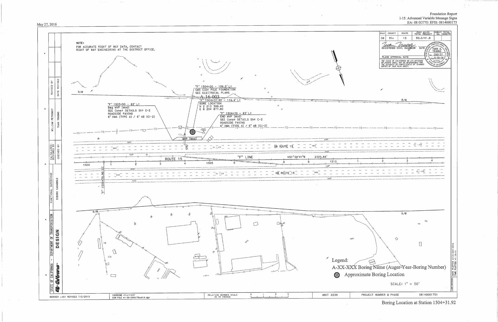
From: CRAIG WENTWORTH, Senior Environmental Planner File 08-0G7704 Branch Chief, Biological Studies and Permits Subject: 08-0G7704: Additional information and measures to NESMI The California Department of Transportation- District 8 (Caltrans) is proposing additional conservation measures and providing additional information to be included in the Natural Environment Study- minimal impact document for project EA 08-0G7704 in Riverside County. Project Description. Trenching. The contractor will trench, install the innerduct, backfill the trench and cleanup on a day to day basis. An estimate of about 500 feet of 8” x 30” trenching will be done a day. A 6-foot buffer is needed for construction equipment to trench. Boring. For the majority of the project, the fiber optic cable will be horizontally bored underground. There will no digging or soil disturbance except for where vault boxes are installed. On average, there will be a break every 800 feet to install a permanent vault box. The vault boxes are 60” x 36’ and 60” deep. A 6-foot buffer is needed for construction to bore (Figure 1). Borings can be moved to the other side of the road if sensitive habitat is found and needs to be avoided.
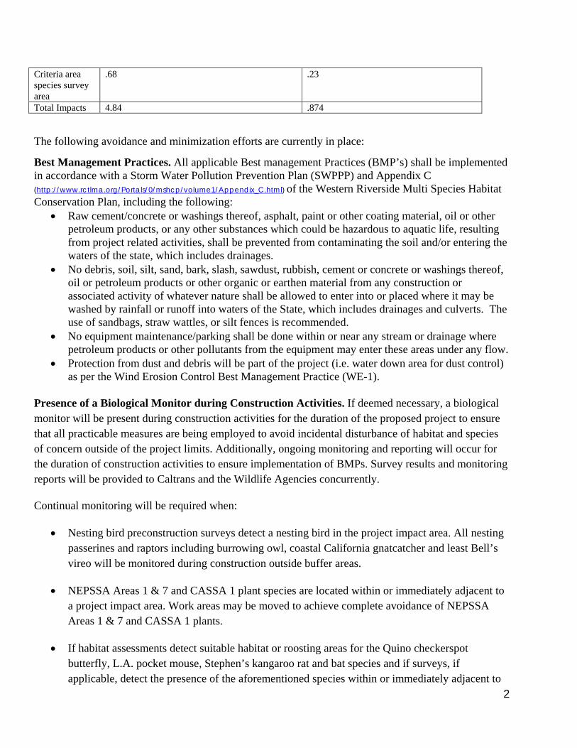
Table 1 Table of Impacts and Impacts to Survey Areas
Impacts Temporary impacts (acres) Permanent impact (acres)
Calculation Notes
Temporary impact was measured by allowing six feet radius on each side of the planned trenching and installation of vault boxes, pull boxes, and cameras for construction access. Note that not all temporary impacts are within survey areas.
Permanent impact was measured by areas were soil disturbance would occur including the trenching and backfilling during installation of cable and installation of vault boxes, pull boxes, and cameras. This does not include areas where the fiber optic cable will be bored horizontally through the ground.
Staging areas .034 (approximately 50’ x 50’) N/A Burrowing owl .99 .33 Gnatcatcher critical habitat
.93 .31
NEPSSA .11 .037 Small Mammal Survey Area
.0026 .00087
2
Criteria area species survey area
.68 .23
Total Impacts 4.84 .874
The following avoidance and minimization efforts are currently in place:
Best Management Practices. All applicable Best management Practices (BMP’s) shall be implemented in accordance with a Storm Water Pollution Prevention Plan (SWPPP) and Appendix C (http://www.rctlma.org/Portals/0/mshcp/volume1/Appendix_C.html) of the Western Riverside Multi Species Habitat Conservation Plan, including the following:
Raw cement/concrete or washings thereof, asphalt, paint or other coating material, oil or other petroleum products, or any other substances which could be hazardous to aquatic life, resulting from project related activities, shall be prevented from contaminating the soil and/or entering the waters of the state, which includes drainages.
No debris, soil, silt, sand, bark, slash, sawdust, rubbish, cement or concrete or washings thereof, oil or petroleum products or other organic or earthen material from any construction or associated activity of whatever nature shall be allowed to enter into or placed where it may be washed by rainfall or runoff into waters of the State, which includes drainages and culverts. The use of sandbags, straw wattles, or silt fences is recommended.
No equipment maintenance/parking shall be done within or near any stream or drainage where petroleum products or other pollutants from the equipment may enter these areas under any flow.
Protection from dust and debris will be part of the project (i.e. water down area for dust control) as per the Wind Erosion Control Best Management Practice (WE-1).
Presence of a Biological Monitor during Construction Activities. If deemed necessary, a biological monitor will be present during construction activities for the duration of the proposed project to ensure that all practicable measures are being employed to avoid incidental disturbance of habitat and species of concern outside of the project limits. Additionally, ongoing monitoring and reporting will occur for the duration of construction activities to ensure implementation of BMPs. Survey results and monitoring reports will be provided to Caltrans and the Wildlife Agencies concurrently.
Continual monitoring will be required when:
Nesting bird preconstruction surveys detect a nesting bird in the project impact area. All nesting passerines and raptors including burrowing owl, coastal California gnatcatcher and least Bell’s vireo will be monitored during construction outside buffer areas.
NEPSSA Areas 1 & 7 and CASSA 1 plant species are located within or immediately adjacent to a project impact area. Work areas may be moved to achieve complete avoidance of NEPSSA Areas 1 & 7 and CASSA 1 plants.
If habitat assessments detect suitable habitat or roosting areas for the Quino checkerspot butterfly, L.A. pocket mouse, Stephen’s kangaroo rat and bat species and if surveys, if applicable, detect the presence of the aforementioned species within or immediately adjacent to
3
the project impact area, continual biological monitoring will occur until the work is complete. Work areas may be moved to achieve complete avoidance of species or habitat impacts.
Nesting Season. If vegetation is required to be trimmed or removed, vegetation removal will be outside of the bird nesting season (February 1 - August 31st). If vegetation removal will occur during the nesting season, preconstruction surveys for nesting birds will be conducted. No-work buffer. If nesting CCG or any migratory birds are detected within the project impact area, a Nesting Bird Plan will be developed to establish no-work buffers and monitoring requirements. If nesting birds are detected in the project impact area, a 350-foot no-work buffer will be implemented until the young have fledged or the nest is determined to be no longer active. In addition, a 500 foot no-work buffer will be established for nesting raptor species. A qualified avian biologist will be onsite to monitor project activities within the vicinity of any active nest(s) within or adjacent to the project impact/action area to ensure that impacts to nesting birds do not occur, including monitoring for signs of stress that may result in nest abandonment. ESA Fencing. Contractor supplied biologist will supervise the installation of ESA fencing if deemed necessary.
In addition to the existing avoidance and minimization measure, the following measures will be included in the NESMI:
4.1.2 Western Riverside Multiple Species Habitat Conservation Plan (WRMSCP) Species Survey Requirements (Section 6.1.3 and 6.3.2) DISCUSSION OF NARROW ENDEMIC PLANT SPECIES SURVEY AREA (SECTION 6.1.3)
Survey results The project is within narrow endemic plants survey Area (NEPSSA) 1 and Area 7 at PM 24.2–26.5 and 36.3-36.7. Surveys for rare plants, including NEPSSA 1 and 7 plants not been conducted for this Project to date. Preconstruction focused surveys for rare plants, including NEPSSA 1 and 7 plants will be conducted within the work areas during the species blooming period to determine the species status onsite and ensure compliance.
Survey area 1: California Orcutt Grass (Orcuttia californica), Hammitt’s clay-cress (Sibaropsis hammittii), many-stemmed dudleya (Dudleya multicaulis), Munz’s onion (Allium munzii), San Miguel savory (Clinopodium chandleri[Satureja c.]), slender-horned spine flower (Dodecahema leptoceras), spreading navarretia (Navarretia fossalis), Wright’s trichocoronis (Trichocoronis wrightii var. wrightii)
Survey area 7: Brand’s Phacelia (Phacelia stellaris), San Diego ambrosia (Ambrosia pumila), San Miguel savory (Satureja chandleri)
4
Project Impacts
Potential project impacts to the NEPSSA 1 and 7 plants, if present, would include permanent and temporary removal of vegetation and topsoil within the Project permanent and temporary disturbance footprints respectively.
Avoidance and Minimization Efforts
Vegetation Removal. Vegetation removal would be limited to the Project footprint, and would be minimized to the maximum extent practicable. If NEPSSA 1 and 7 plants are found within the Project footprint during the focused preconstruction surveys, the locations of the plant(s) will be GPS’d and mapped at that time. Prior to construction, a qualified biologist shall flag the onsite locations of NEPSSA 1 and 7 plants (if any) to avoid and/or minimize impacts to the greatest extent possible. Work impact locations may be moved to avoid impact to plants. In areas where impacts to this species are unavoidable, Caltrans will notify the regulatory agencies at least 10 days prior to the date of the anticipated impact in order to salvage the plants/seeds for transplantation/reseeding. Revised DBESP. If CASSA 1 plant species are observed within the project impact area and Caltrans cannot demonstrate 90 percent avoidance, a revised DBESP will be submitted to United States fish and Wildlife Service (USFWS) and California Department of Fish and Wildlife (CDFW) after preconstruction plant surveys within the work area have been completed. The revised DBESP will include quantifications of impacts as well as project design features and avoidance and minimization measures that will reduce effects as well as a finding of biologically equivalent or superior to the avoidance alternative. The revised DBESP will also include a Plant Salvage Plan which addresses items such as methods for collection, retainment, and replacement of topsoil, methods for salvage of plants and/or seed and preconstruction surveys by a qualified biologist. Pre-construction Exclusion Plant Survey. A pre-construction survey for CASSA 1 plants and NEPSAA 1 and 7 plants will be performed within the work areas in the appropriate season. Surveys will be performed by a qualified biologist(s). DISCUSSION OF BURROWING OWL (ATHENE CUNICULARIA)
Burrowing owls can be found in grasslands, rangelands, agricultural areas, deserts, or any other open dry area with low vegetation.
Survey Results
The project is within burrowing owl (Athene cunicularia) survey area from PM 13.2-15.6, 19.4-20.5, 23.9-26, and 36.2-36.8. Focused surveys for the burrowing owl have not been conducted for this Project to date. No burrowing owls or sign thereof were incidentally detected during walking and driving surveys. A burrowing owl habitat assessment surveys, if applicable, will be conducted prior to construction activities in permanent and temporary project impact areas including a 100-foot buffer. If
5
suitable habitat is identified, focused burrowing owl surveys during the breeding season will be conducted. Surveys will be conducted using WRMSCHP protocol. Project Impacts
Potential impacts to the burrowing owl include permanent and temporary loss of nesting burrows, satellite burrows, foraging habitat, dispersal and migration habitat, winter habitat, habitat linkages, habitat supporting prey, habitat supporting host burrowers as well as potential mortalities during construction, as well as indirect impacts such as territory abandonment or nest failure due to human presence and noise. Burrowing owl is a covered species under the MSHCP. Avoidance and Minimization Efforts
A preconstruction habitat assessment for burrowing owl will occur within the work areas. If burrowing owls are found on site, a Burrowing Owl Management Plan will be developed in coordination with the Wildlife Agencies to determine the appropriate avoidance, minimization and mitigation measures required for the Project. The following avoidance, minimization, and mitigation measures are those recommended in the 2012 Staff Report on Burrowing Owl Mitigation. Any and/or all of these measures are subject to change based on the results of forthcoming focused surveys and at the request of Wildlife Agencies.
1. Avoid direct destruction of unoccupied burrows to the greatest extent possible.
2. A “Worker Environmental Awareness Program (WEAP)” will be developed and provided by a qualified biologist to all involved Project personnel. A description of the burrowing owl, its ecology and its onsite status will be summarized. Measures developed for burrowing owl protection and reporting will be outlined. A record of all personnel attending this training will be kept by Caltrans and updated as staff changes necessitate additional training.
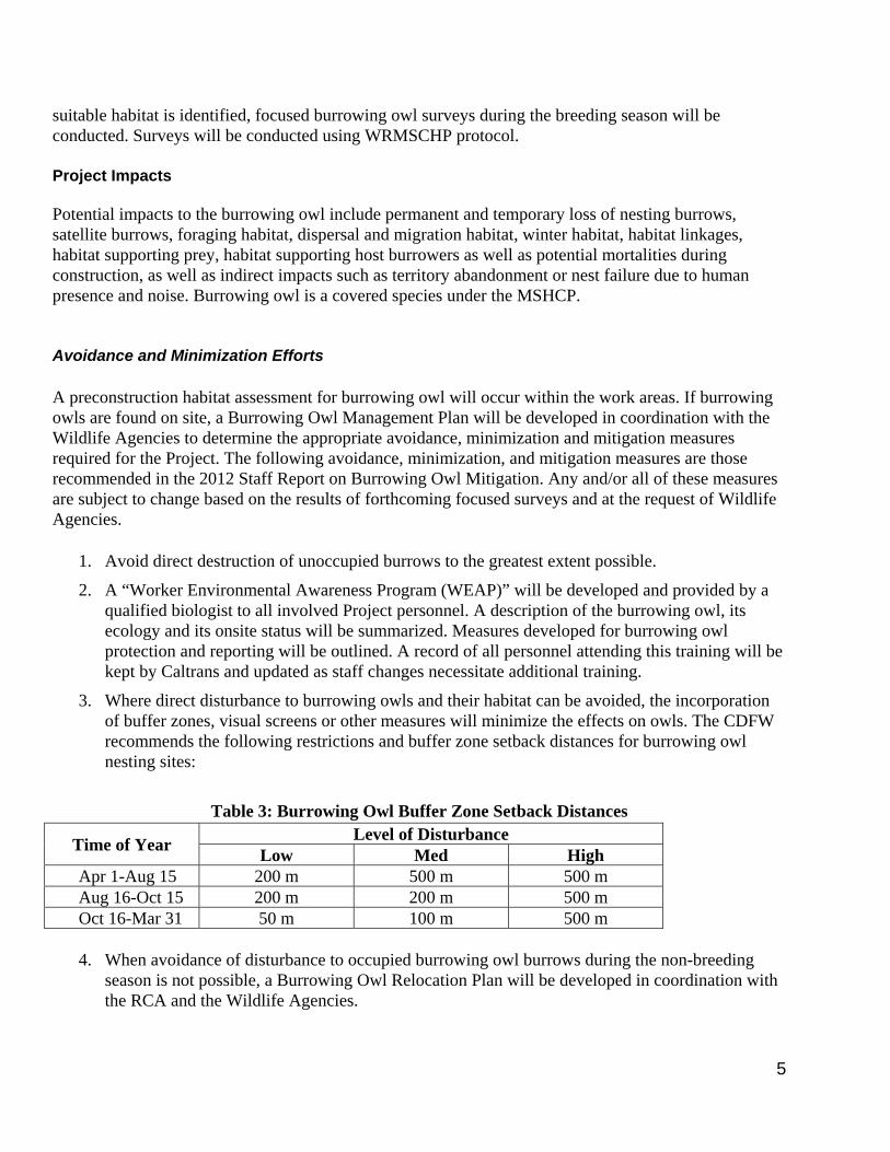
3. Where direct disturbance to burrowing owls and their habitat can be avoided, the incorporation of buffer zones, visual screens or other measures will minimize the effects on owls. The CDFW recommends the following restrictions and buffer zone setback distances for burrowing owl nesting sites:
Table 3: Burrowing Owl Buffer Zone Setback Distances
Time of Year Level of Disturbance
Low Med High Apr 1-Aug 15 200 m 500 m 500 m Aug 16-Oct 15 200 m 200 m 500 m Oct 16-Mar 31 50 m 100 m 500 m
4. When avoidance of disturbance to occupied burrowing owl burrows during the non-breeding
season is not possible, a Burrowing Owl Relocation Plan will be developed in coordination with the RCA and the Wildlife Agencies.
6
5. A copy of burrowing owl habitat assessment and, if applicable, protocol survey reports will be submitted the Western Riverside County MSHCP Biological Monitoring Program and the California Department of Fish and Wildlife.
DISCUSSION OF CRITERIA AREAS SPECIES SURVEY AREA (CASSA) 1
Survey Results
The project is within Criteria Area Species Survey Area 1 at PM 23.0-35.0 cells but all work is expected to be contained within Caltrans’ previously disturbed ROW.
Survey Area 1: Coulter’s goldfields (Lasthenia glabrata ssp. coulteri), Davidson’s saltscale (Atriplex serenana var. davidsonii), little mousetail (Myosurus minimus), Parish’s brittlescale (Atriplex parishii), round-leaved filaree (California macrophyllum [Erodium m.]), smooth tarplant (Centromadia pungens ssp. laevis [Hemizonia p. ssp. l.]), thread-leaved brodiaea (Brodiaea filifolia)
Surveys for rare plants, including Criteria Area Species Survey Area (CASSA) 1 plants have not been conducted for this Project to date. Preconstruction focused surveys for rare plants, including CASSA 1 plants will be conducted by a qualified plant biologist during the species blooming period within the work area to determine the species status onsite and ensure compliance. Project Impacts
Project impacts to CASSA 1 plants, if present, would include permanent and temporary removal of vegetation and topsoil within the Project permanent and temporary disturbance footprints respectively. Avoidance and Minimization Efforts
Vegetation removal would be limited to the Project footprint, and would be minimized to the maximum extent practicable. If CASSA 1 plants are found within the Project footprint during the focused surveys, the locations of the plant(s) will be GPS’d and mapped at that time. Prior to construction, a qualified biologist shall flag the onsite locations of CASSA 1 plants (if any) to avoid and/or minimize impacts to the greatest extent possible. Work impact areas may be moved to avoid plants. Revised DBESP. If CASSA 1 plant species are observed within the project impact area and Caltrans cannot demonstrate 90 percent avoidance, a revised DBESP will be submitted to United States Fish and Wildlife Service (USFWS) and California Department of Fish and Wildlife (CDFW) after preconstruction plant surveys within the work area have been completed. The revised DBESP will include quantifications of impacts as well as project design features and avoidance and minimization measures that will reduce effects as well as a finding of biologically equivalent or superior to the avoidance alternative. The revised DBESP will also include a Plant Salvage Plan which addresses items such as methods for collection, retainment, and replacement of topsoil, methods for salvage of plants and/or seed and preconstruction surveys by a qualified biologist. Presence of a Biological Monitor during Construction Activities. A qualified biological monitor will be present during construction activities for the duration of the proposed project to ensure that all
7
practicable measures are being employed to avoid incidental disturbance of habitat and species of concern outside of the project limits. Additionally, ongoing monitoring and reporting will occur for the duration of construction activities to ensure implementation of BMPs.
Pre-construction Exclusion Plant Survey. A pre-construction survey for CASSA 1 plants and NEPSAA 1 and 7 plants will be performed within the work areas in the appropriate season. Surveys will be performed by a plant qualified biologist(s).
DISCUSSION OF COASTAL CALIFORNIA GNATCATCHER (POLIOPTILA CALIFORNIA CALIFORNIA)
Coastal California Gnatcatcher (CCG) habitat consists of low, coastal sage scrub in arid washes, on mesas & slopes. Reproduction: The breeding season of the gnatcatcher extends from mid-February through mid-August, with the peak of nesting activity occurring from mid-March through mid-May. The coastal California gnatcatcher is a year-round resident. Nest building begins during the mid part of March with the earliest recorded egg date approximately March 20 (Mock et al., 1990). Post-breeding dispersal of fledglings occurs between late May and late November.
Survey Results
Surveys for CCG have not yet been conducted. The project is within CCG critical habitat in multiple places throughout the project. PM 0-3 at West Rainbow Valley Blvd, PM 23.8-28 at Lake St., PM 23.8 at Nichols Road, Temescal Canyon Road at PM 30.0 to PM 32.2 at Indian Truck Trail and Temescal Canyon Road, PM 32.4 at 33.9 Temescal Canyon Road, and PM 35.2-36.3 at Dos Lagos Drive. Surveys for nesting CCG and other nesting birds will be performed during CCG nesting season before construction. Project Impacts
There is a lack of dense low shrubs for nesting along shoulder. Coastal sage scrub is absent between ROW and paved shoulder. Work will be done on top of bridges. During preconstruction surveys, project permanent and temporary impact areas within designated critical habitat will be evaluated to determine whether or not the primary constituent elements of critical habitat are present. Noise levels during construction will not be louder than normal ambient traffic noise levels. Direct effects to CCG are not expected. Indirect impacts are possible for CCG but will be greatly reduced due to the avoidance and minimization measures. CCG is a covered species under the WRMSHP. Preconstruction surveys will determine presence of occupied habitat. Caltrans will request concurrence for a determination of may effect not likely to adversely affect (NLAA) through the WRMSCHP for potential indirect effect to CCG and minimal impacts to low quality CCG critical habitat. Avoidance and Minimization Efforts
Nesting Season. If vegetation is required to be trimmed or removed, vegetation removal will be outside of the CCG nesting season. If vegetation removal will occur during the nesting season,
8
preconstruction surveys for nesting birds will be conducted. No removal of vegetation in CCG occupied habitat will occur in PQP lands in criteria areas from March 1st to August 15th. No-work buffer. If nesting CCG or any migratory birds are detected nesting within the project’s temporary and permanent impact area, a 350-foot no-work buffer will be implemented around the nest until the young have fledged or the nest is determined to be no longer active. Presence of a Biological Monitor during Construction Activities. A biological monitor will be present during construction activities for the duration of the proposed project to ensure that all practicable measures are being employed to avoid incidental disturbance of habitat and species of concern outside of the project limits. Additionally, ongoing monitoring and reporting will occur for the duration of construction activities to ensure implementation of BMPs.
Pre-construction Exclusion Animal Survey. A pre-construction survey for nesting birds, CCG, least Bell’s vireo, Quino checkerspot butterfly, and Stephens’ kangaroo rat will be performed within the work areas in the appropriate season. If species will be impacted by project activities, Caltrans will reinitiate and coordinate with regulatory agencies. If habitat for CCG is found, the habitat may not be disturbed between March 1st- August 15th within PQP lands in criteria areas per agreement of the MSHCP. A no-work buffer zone will be implemented around the CCG habitat.
DISCUSSION OF LEAST BELL’S VIREO (VIREO BELLII PUSILUS)
Least Bell’s vireo habitat consists riparian habitat of bushes along pathways, usually including willows, baccharis, and mesquite. The breeding season for least Bell's vireo is typically mid-March to September (USFWS 1986). During this period least Bell's vireo are known to breed almost exclusively within riparian habitats (USFWS 1998). Nesting sites are typically selected within structurally heterogeneous woodlands, forests and scrubs that support dense vegetation near the ground, and dense horizontally separated vegetation higher up in the canopy (Goldwasser 1981; Gray and Greaves 1984; Salata 1983; RECON 1989). Nests are typically suspended in forked branches of many different riparian species with no clear preference for any particular species (Nolan 1960; Barlow 1962; Goldwasser 1981). Survey Results
Surveys for least Bell’s vireo have not yet been conducted. Least Bell’s vireo have historically been found 100 feet south of PM 30-35 and at PM 20-25. Surveys will be performed during nesting season before construction. This project is not within least Bell’s vireo critical habitat. Project Impacts
There is a lack of dense low riparian shrubs for nesting along shoulder. Riparian habitat is absent between ROW and paved shoulder. Riparian areas will not be impacted during construction. Work will be done on top of bridges. Preconstruction surveys will determine whether suitable habitat is occupied adjacent to the project. Noise levels during construction will not be louder than normal traffic noise level. Direct effects to least Bell’s vireo are not expected. Least Bell’s vireo is a covered species under the WRMSHCP.

9
Avoidance and Minimization Efforts
Nesting Season. If vegetation is required to be trimmed or removed, vegetation removal will be outside of the least Bell’s vireo nesting season. If vegetation removal will occur during the nesting season, preconstruction surveys for nesting birds will be conducted. No-work buffer. If nesting least Bell’s vireo are detected adjacent to or within the project footprint, work will be completed outside the nesting season and a 350-foot no-work buffer around the nest will be implemented until the young have fledged or the nest is determined to be no longer active. Regulatory agencies will be contacted immediately for consultation if least Bell’s vireo is found within the project footprint. Presence of a Biological Monitor during Construction Activities. A biological monitor will be present during construction activities for the duration of the proposed project to ensure that all practicable measures are being employed to avoid incidental disturbance of habitat and species of concern outside of the project limits. Additionally, ongoing monitoring and reporting will occur for the duration of construction activities to ensure implementation of BMPs.
Pre-construction Exclusion Animal Survey. A pre-construction survey for nesting birds, CCG, least Bell’s vireo, Quino checkerspot butterfly, and Stephens’ kangaroo rat will be performed within the work areas in the appropriate season. If species will be impacted by project activities, Caltrans will reinitiate and coordinate with regulatory agencies.
DISCUSSION OF QUINO CHECKERSPOT BUTTERFLY (EUPHYDRYAS EDITHA QUINO)
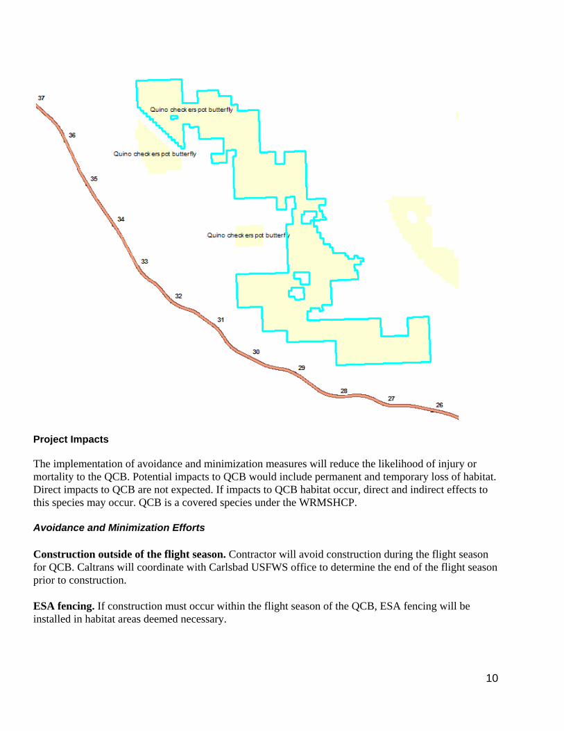
The Quinto checkerspot butterfly (QCB) has two distinctive phases in its life history: early stages (eggs, larva or caterpillar, and the pupa or chrysalis) and adult. Each phase has distinct habitat requirements. Larvae feed immediately upon Plantago erecta, Plantago Patagonia, Antirrhinum coulerianum, Cordylanthus rigidus, and Castillerja exserta. After metamorphose, the adults nectar mostly on small annuals. Adult QCB often occur on open or sparsely vegetated rounded hilltops, ridgelines, and occasionally rocky outcrops. Adults are known to sun themselves at the bases of hills and fly through disturbed areas. Topographically diverse sites, including areas with ridges and rounded hilltops are very important for the long-term persistence of populations. Survey Results
Surveys for QCB butterfly have not yet been conducted. The project is within one mile of QCB critical habitat from PM 26 to PM 31.
10
Project Impacts
The implementation of avoidance and minimization measures will reduce the likelihood of injury or mortality to the QCB. Potential impacts to QCB would include permanent and temporary loss of habitat. Direct impacts to QCB are not expected. If impacts to QCB habitat occur, direct and indirect effects to this species may occur. QCB is a covered species under the WRMSHCP. Avoidance and Minimization Efforts
Construction outside of the flight season. Contractor will avoid construction during the flight season for QCB. Caltrans will coordinate with Carlsbad USFWS office to determine the end of the flight season prior to construction. ESA fencing. If construction must occur within the flight season of the QCB, ESA fencing will be installed in habitat areas deemed necessary.

11
Preconstruction habitat assessment. A preconstruction habitat assessment and survey from PM 26-31 will be will be performed outside within the work areas within the appropriate season. If QCB is impacted, Caltrans will reinitiate consultation with regulatory agencies.
DISCUSSION OF L.A. POCKET MOUSE (PEROGNATHUS LONGIMEMBRIS BREVINASUS)
L.A. pocket mouse habitat consist of sparsely vegetated habitat areas in patches of fine sandy soils associated with washes or of windblown origin, such as dunes, sage scrub, and grassland habitats on sandy soils. It prefers sparsely vegetated habitats and avoids dense grass cover. Survey Results
The project is within the mammal survey area for L.A. pocket mouse at PM 7.7 but suitable habitat is not present. There is a sandy area that could support LA pocket mouse habitat but it is in the dry wash that occurs under the bridge at PM 7.7 which is outside of the project limits. Work for this project will not go underneath the bridge or into the wash. A preconstruction habitat assessment will be conducted at PM 7.7 to determine if further surveys are required. Project Impacts
Direct effects to L.A. pocket mouse are not expected. Indirect effects are possible but will be greatly reduced due to the avoidance and minimization measures. Avoidance and Minimization Efforts
Preconstruction survey. A preconstruction habitat assessment will be performed at PM 7.7 and within
the work areas within the appropriate season to determine if further surveys are required. The Wildlife
Agencies will be contacted for direction if suitable habitat is present.
No nightwork. No nightwork will be allowed for this project.
DISCUSSION OF STEPHENS’ KANGAROO RAT (DIPODOMYS STEPHENSI)
Stephens’ kangaroo rat habitat consist of primarily annual & perennial grasslands, but also occurs in coastal scrub & sagebrush with sparse canopy cover. Survey Results
Stevens’ kangaroo rat surveys have not yet been conducted. Stevens’ kangaroo rat have historically been found 100 feet north of PM 30-35 and south of PM 18-28 and PM 4. A habitat assessment will be conducted at PM 30-35 to determine if further surveys are needed.
12
Project Impacts
Direct effects to Stephens’ kangaroo rat are not expected. Indirect effects are possible but will be greatly reduced due to the avoidance and minimization measures. Stephen’s kangaroo rat is a covered species under the WRMSHP. Avoidance and Minimization Efforts
Preconstruction surveys. A preconstruction habitat assessment will be conducted at PM 30-35 and
within the work areas to determine if further surveys are needed. If Stephen’s kangaroo rat habitat is
found, the Wildlife Agencies will be contacted immediately for consultation.
No nightwork. No nightwork will be allowed for this project.
DISCUSSION OF BATS
Survey Results
Surveys for nesting bats have not been conducted. Bat surveys will be done preconstruction. Project Impacts
If bats are roosting in bridges, there is a possibility that bats may be impacted by the work done on the side of the bridges. If bats are found during preconstruction surveys, Caltrans will contact regulatory agencies for consultation and implementation of avoidance and minimization measures. Avoidance and Minimization Efforts
Preconstruction surveys. This project will have preconstruction surveys for bats within the work areas.
If bats are found, CDFW will be contacted immediately for consultation and implementation of
avoidance and minimzation measures.
Additional avoidance and minimzation measures will includ:
Removal of Exotic Plant Species. Any exotic species that are removed during construction will be properly handled to prevent sprouting or regrowth.
Clean Construction Equipment of Mud and Debris. Construction equipment will be cleaned of mud or other debris that may contain invasive plants and/or seeds and inspected to reduce the potential of spreading noxious weeds before mobilizing to the site and before leaving the site during the course of construction. Cleaning of equipment will occur at least 300 feet from construction.
Post-Construction Restoration/Revegetation of Temporary Impacts. Once construction is complete, any area identified as a temporary impact area will be restored to pre-project conditions, as they pertain

13
to vegetation community (including species cover/composition), topographic contours, soil compaction, and hydrology. Any revegetation activities that will occur from impacts to native vegetation communities only will include Caltrans-approved plantings/seed mix, based on pre-project vegetation communities, or as approved by CDFW and USFWS. Disturbed ruderal areas will be restored to original contours. Should you have any questions regarding this matter, please contact Chun-Sheng Wang of my staff, at (909) 388-7049.

14
Figure 1. Vault Box