Embed Size (px)
Citation preview

Gap Analysis Report_Croc West and Marico_final_29 Mar l12
CLASSIFICATION OF SIGNIFICANT WATER RESOURCES IN THE MOKOLO CATCHMENT: LIMPOPO WATER
MANAGEMENT AREA (WMA) AND CROCODILE (WEST) AND MARICO WMA: WP 10506
INFORMATION ANALYSIS REPORT: CROCODILE (WEST) AND MARICO WMA
FINAL
REPORT NO: RDM/WMA1,3/00/CON/CLA/0112A
Directorate: Water Resource Classification
MARCH 2012

Gap Analysis Report_Croc West and Marico_final_29 Mar l12
Published by
Department of Water Affairs Private Bag X313
Pretoria, 0001 Republic of South Africa
Tel: (012) 336 7500/ +27 12 336 7500 Fax: (012) 336 6731/ +27 12 336 6731
Copyright reserved
No part of this publication may be reproduced in any manner without full acknowledgement of the source.
This report is to be cited as:
Directorate Water Resource Classification. Department of Water Affairs, South Africa, March 2012. CLASSIFICATION OF SIGNIFICANT WATER RESOURCES IN THE MOKOLO AND MATLABAS CATCHMENTS: LIMPOPO WATER MANAGEMENT AREA (WMA) AND CROCODILE (WEST) AND MARICO WMA WP 10506: Information Analysis Report: Crocodile West and Marico WMA. Report No: RDM/WMA1,3/00/CON/CLA/0112A
Prepared by:
Golder Associates Africa, Zitholele Consulting, Wetland Consulting Services, RJ Stassen, Prime Africa and Department of Water Affairs.

Gap Analysis Report_Croc West and Marico_final_29 Mar l12

Classification of significant water resources in the Crocodile West and Marico Water Management Area (WMA 3): WP 10506
Information Analysis Report
Gap Analysis Report_Croc West and Marico_final_29 Mar l12
EXECUTIVE SUMMARY Thorough preparatory work, understanding of the status quo and information availability of the Crocodile West-Marico WMA is needed to effectively classify the significant water resources of the study area. The information analysis task was designed, as part of the study, to provide an analysis of the available water resource related data and information for the Crocodile West-Marico WMA in terms of water resource quality, ecological water requirements, hydrology, water quality and socio-economics. This information analysis task has been undertaken in compliance with the requirements of the study terms of reference that specify that the classification process is required to build from existing and current initiatives undertaken in support of integrated water resource management (IWRM). As this study is solely reliant on existing and parallel studies for its information requirements, it is critical to determine if all the data components of the classification process are met, and if not, what the gaps are.
For successful implementation of the Water Resource Classification System (WRCS) in the Crocodile West-Marico WMA it is critical at the outset of the project to determine whether there is any key information that is outstanding. An information review has been undertaken and the outcomes of this are captured in this report. Previous studies undertaken for the Crocodile West-Marico WMA have been sourced and reviewed. For parallel studies communication mechanisms will be established with other study teams to ensure ongoing liaison. These will be maintained to ensure that the transfer of information, data and reports takes place.
At this stage the information analysis is not considered exhaustive and the review will continue as new information and data come to light. The information analysis task was undertaken as follows and is detailed in the sub sections of this report:
• Previous Studies • Parallel Studies • Data Sources • Models • Other

Classification of significant water resources in the Crocodile West and Marico Water Management Area (WMA 3): WP 10506
Information Analysis Report
Gap Analysis Report_Croc West and Marico_final_29 Mar l12
DOCUMENT INDEX
Reports as part of this study: Bold type indicates this report.
Report Index Report number Report title
1 RDM/WMA1,3/00/CON/CLA/0111 Inception Report
2 RDM/WMA1,3/00/CON/CLA/0112A Information Analysis Report : Crocodile (West) Marico WMA
3 RDM/WMA1,3/00/CON/CLA/0112B Information Analysis Report : Mokolo and Matlabas catchments: Limpopo WMA

Classification of significant water resources in the Crocodile West and Marico Water Management Area (WMA 3): WP 10506
Information Analysis Report
Gap Analysis Report_Croc West and Marico_final_29 Mar l12
LIST OF ABBREVIATIONS AND ACRONYMS
CD: RDM Chief Directorate: Resource Directed Measures
DAFF Department of Agriculture, Forestry and Fisheries
DWA Department of Water Affairs
DWAF Department of Water Affairs and Forestry
DBSA Development Bank of South Africa
EC Electrical Conductivity
EIS Ecological importance and sensitivity
EMC Ecological Management Class
EMF Environmental Management Framework
ESBC Ecologically Sustainable Base Configuration
EWR Ecological Water Requirements
IUA Integrated Unit of analysis
IWRM Integrated Water Resource Management
IWRMP Integrated Water Resources Management Plan
MC Management Class
NFEPA National Freshwater Ecosystem priority areas
NWA National Water Act
PES Presentation Ecological State
RDM Resource Directed Measures
RHP River Health Programme
RO Regional Office
RQOs Resource Quality Objectives
RQS Resource Quality Services
RWQOs Resource Water Quality Objectives
SAM Social Accounting Matrix
STATS SA Statistics South Africa
TDS Total Dissolved Salts
WMA Water Management Area
WRC Water Research Commission
WRCS Water Resource Classification System
WRYM Water Resources Yield model
WRPM Water Resources Planning Model
Classification of significant water resources in the Crocodile West and Marico Water Management Area (WMA 3): WP 10506
Information Analysis Report
Gap Analysis Report_Croc West and Marico_final_29 Mar l12
TABLE OF CONTENTS EXECUTIVE SUMMARY ................................................................................................................................................... III
1 INTRODUCTION ........................................................................................................................................................ 1
2 CLASSIFICATION OF SIGNIFICANT WATER RESOURCES IN THE CROCODILE (WEST) AND MARICO WMA .......................................................................................................................................................................... 3
2.1 THE INFORMATION ANALYSIS TASK ........................................................................................................ 4
2.2 SPATIAL EXTENT OF STUDY ..................................................................................................................... 5
2.3 OBJECTIVES OF THE INFORMATION ANALYSIS TASK .......................................................................... 5
2.4 PURPOSE OF THE REPORT ...................................................................................................................... 7
3 INFORMATION ANALYSIS ....................................................................................................................................... 7
3.1 THE APPROACH ADOPTED TO CONDUCT THE INFORMATION ANALYSIS TASK ............................... 7
3.2 IDENTIFICATION AND REVIEW OF KEY STUDIES ................................................................................. 10
3.3 INFORMATION REQUIRED FROM PARALLEL STUDIES ........................................................................ 16
3.4 RELEVANT/INFORMATION DATA SOURCES ......................................................................................... 18
3.4.1 Hydrology .............................................................................................................................................. 19
3.4.2 Water Quality ........................................................................................................................................ 20
3.4.3 Ecological .............................................................................................................................................. 21
3.4.4 Socio-economics ................................................................................................................................... 29
3.4.5 Supporting information .......................................................................................................................... 30
3.5 MODELS .................................................................................................................................................... 31
3.6 OTHER ....................................................................................................................................................... 31
4 IDENTIFICATION OF POTENTIAL INFORMATION GAPS .................................................................................... 31
4.1 Ecological Water Requirements: ........................................................................................................... 31
4.2 Socio-Economic: ................................................................................................................................... 32
4.3 Water quality: ........................................................................................................................................ 32
5 MITIGATION MEASURES FOR RISKS IDENTIFIED ............................................................................................. 33
6 CONCLUSIONS ON INFORMATION APPLICABILITY AND ADEQUACY FOR CLASSIFICATION STUDY ....... 33
7 REFERENCES ......................................................................................................................................................... 34
LIST OF FIGURES Figure 1: Map showing Crocodile (West) and Marico WMA (Intermediate Reserve Determination Study, June
2010) .................................................................................................................................................................. 2
Figure 2: The study tasks .................................................................................................................................................... 4
Figure 3: Spatial extent of the Crocodile (West) and Marico WMA ..................................................................................... 6
LIST OF TABLES Table 1: Information requirements of each of the 7 steps of WRCS ................................................................................... 8
Table 2: Review of identified key studies undertaken in the Crocodile West-Marico WMA of relevance to the Classification study ........................................................................................................................................... 11

Classification of significant water resources in the Crocodile West and Marico Water Management Area (WMA 3): WP 10506
Information Analysis Report
Gap Analysis Report_Croc West and Marico_final_29 Mar l12
Table 3: Parallel studies underway in the Crocodile West-Marico WMA that support the information needs of the Classification study ........................................................................................................................................... 17
Table 4: Data sources supporting information needs of study ........................................................................................... 18
Table 5: DWA water quality sites related to the Crocodile (West) and Marico EWR sites ................................................. 20
Table 6: Summary of PES, EIS and REC per resource unit .............................................................................................. 21
Table 7: Summary of EWR site information ...................................................................................................................... 22
Table 8: Categorisation of Groundwater Resource Units (2010) in the Crocodile (West) River Catchment ...................... 23
Table 9: Extrapolation recommendations for Crocodile West catchment .......................................................................... 25
Table 10: Extrapolation recommendations for Groot Marico catchment ............................................................................ 29
Table 11: List of possible identified risks and limitations with proposed mitigation ............................................................ 33

Classification of significant water resources in the Crocodile West and Marico Water Management Area (WMA 3): WP 10506 Information Analysis Report
Gap Analysis Report_Croc West and Marico_final_29 Mar l12 1 March 2012
1 INTRODUCTION
The Crocodile (West) and Marico Water Management Area (WMA) is defined by the following Catchments: Crocodile River, Marico River, South African portion of Ngotwane River and the Upper Molopo River. The area forms part of the Limpopo River basin, which spans the four countries of Botswana, Zimbabwe, South Africa and Mozambique. The area covers approximately 48 000 km2
with the largest being the Crocodile River catchment (29 349 km2) followed by the Marico River catchment (12 049 km2). The remainder is covered by the Ngotwane River and Upper Molopo River catchments at approximately 5 000 km2 and 1 800 km2 respectively. The WMA includes the tertiary drainage regions: A10, A21 to A24, A31, A32 and quaternary drainage region D41A.
The Crocodile West and Marico WMA is one of the many water stressed catchments in South Africa. Surface water resources are used extensively, particularly in the Crocodile River catchment, with the main water users being agriculture, industry, mining and urban. Agriculture accounts for about 33.5% of total use and largely utilises privately owned dams and Government water schemes. Rand Water, Magalies Water and the North West Water Authority supply most of the mining, industrial and domestic sectors with water from sources within the catchment as well as from transfers from the Upper Vaal River system, which receives a significant amount of return flow from Tshwane. Approximately 70% of the population within the WMA lives in urban areas. The main economic activities revolve around mining, agriculture and light industry.
As the water resources in the Crocodile West & Marico Water Management Area are becoming more stressed due to an accelerated rate of development and changing weather patterns resulting in the scarcity of water resources, there is an urgency to ensure that water resources are able to sustain their level of use and be maintained at their desired states. The determination of the Management Classes (MC) of the significant water resources in the study area will ensure that the desired condition of the water resources, and conversely, the degree to which they can be utilised is maintained and adequately managed within the economic, social and ecological goals of the water users. The MC of the water resource will therefore set the boundaries for the volume, distribution and quality of the Reserve and RQOs, and thus the potential allocable portion of a water resource for use.

Classification of significant water resources in the Crocodile West and Marico Water Management Area (WMA 3): WP 10506 Information Analysis Report
Gap Analysis Report_Croc West and Marico_final_29 Mar l12
2 March 2012
Figure 1: Map showing Crocodile (West) and Marico WMA (Intermediate Reserve Determination Study, June 2010)

Classification of significant water resources in the Crocodile West and Marico Water Management Area (WMA 3): WP 10506 Information Analysis Report
Gap Analysis Report_Croc West and Marico_final_29 Mar l12
3 March 2012
2 CLASSIFICATION OF SIGNIFICANT WATER RESOURCES IN THE CROCODILE (WEST) AND MARICO WMA
The National Water Act (Act No. 36 of 1998) (NWA) is founded on the principle that National Government has overall responsibility for, and authority over, water resource management for the benefit of the public without, seriously affecting the functioning of the water resource systems. In order to achieve this objective, Chapter 3 of the NWA provides for the protection of water resources through the implementation of resource directed measures (RDM). As part of the RDM, a management class (MC) has to be determined for a significant water resource, as the means to ensure a desired level of protection. The purpose of the MC is to establish clear goals relating to the quantity and quality of the relevant water resource.
The classification system, the Reserve and RQOs together are intended to ensure comprehensive protection of all water resources. An important consideration in the determination of RDM is that they should be technically sound, scientifically credible, practical and affordable.
The Chief Directorate: Resource Directed Measures (CD: RDM) of the Department of Water Affairs (DWA) is tasked with the responsibility of ensuring that the water resources are classified in terms of the Water Resource Classification System (WRCS) to ensure that a balance is sought between the need to protect and sustain water resources on one hand and the need to develop and use them on the other. The CD: RDM has identified the need to undertake the classification of significant water resources (rivers, wetlands, groundwater and lakes) in the Crocodile (West) and Marico WMA in accordance with the WRCS.
The MC and associated resource quality objectives (RQOs) will assist the DWA make more informed decisions regarding the authorisation of future water uses, operation and management of the system and the evaluation of the magnitude of the impacts of the present and proposed developments.
The purpose of this study is to coordinate the implementation of the 7 step process of the WRCS to classify all significant water resources in the Crocodile (West) and Marico WMA in order to determine a suitable MC for the relevant water resources and in so doing deliver the IWRM template with recommendations for presentation to the delegated authority.
The determination of the MC is necessary to facilitate a balance between protection and use of water resources. In determining the class, it is important to recognise that different water resources will require different levels of protection. In addition to achieving ecological sustainability of the significant water resources through classification, the process will allow consideration of the social and economic needs of competing interests by all who rely on the water resources. The WRCS will be applied taking account of the local conditions, socio-economic imperatives and system dynamics within the context of the South African situation. The process will also require a wide range of complex trade-offs to be assessed and evaluated at a number of scales.
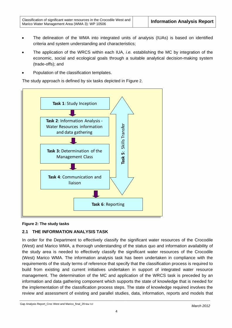
There study approach for the determination of the MC includes:
• An assessment of the Crocodile (West) and Marico WMA to understand the status quo in regard to water resource issues such as water resource quality, existing monitoring programmes, infrastructure, institutional environment, socio-economics and sectoral water uses and users.
Classification of significant water resources in the Crocodile West and Marico Water Management Area (WMA 3): WP 10506 Information Analysis Report
Gap Analysis Report_Croc West and Marico_final_29 Mar l12
4 March 2012
Task 1: Study Inception
Task 2: Information Analysis -Water Resources information
and data gathering
Task 3: Determination of the Management Class
Task 4: Communication and liaison
Task 6: Reporting
Task
5:
Skill
s Tra
nsfe
r
• The delineation of the WMA into integrated units of analysis (IUAs) is based on identified criteria and system understanding and characteristics;
• The application of the WRCS within each IUA, i.e. establishing the MC by integration of the economic, social and ecological goals through a suitable analytical decision-making system (trade-offs); and
• Population of the classification templates.
The study approach is defined by six tasks depicted in Figure 2.
Figure 2: The study tasks
2.1 THE INFORMATION ANALYSIS TASK
In order for the Department to effectively classify the significant water resources of the Crocodile (West) and Marico WMA, a thorough understanding of the status quo and information availability of the study area is needed to effectively classify the significant water resources of the Crocodile (West) Marico WMA. The information analysis task has been undertaken in compliance with the requirements of the study terms of reference that specify that the classification process is required to build from existing and current initiatives undertaken in support of integrated water resource management. The determination of the MC and application of the WRCS task is preceded by an information and data gathering component which supports the state of knowledge that is needed for the implementation of the classification process steps. The state of knowledge required involves the review and assessment of existing and parallel studies, data, information, reports and models that

Classification of significant water resources in the Crocodile West and Marico Water Management Area (WMA 3): WP 10506 Information Analysis Report
Gap Analysis Report_Croc West and Marico_final_29 Mar l12
5 March 2012
form the departure point from where further analysis can proceed.
2.2 SPATIAL EXTENT OF STUDY
The spatial extent for the classification study includes secondary drainage regions A1, A2, A3, quaternary drainage region D41A of the Crocodile West-Marico WMA as well as tertiary drainage regions A41 and A42 of the Matlabas and Mokolo catchments, respectively, however, this report concentrates only on the Crocodile (West) Marico WMA and the Matlabas and Mokolo catchments are covered in a separate report. This report therefore includes the Crocodile River, Marico River, South African portion of Ngotwane River and the Upper Molopo River (Figure 3).
2.3 OBJECTIVES OF THE INFORMATION ANALYSIS TASK
The information analysis task was designed as part of the study to provide an analysis of the available water resource related data and information for the Crocodile (West) and Marico WMA in terms of water resource quality, ecological water requirements, hydrology, water quality and socio-economics. The specific objectives of the task are:
• To review previous studies and related reports and assess information availability and applicability;
• To assess available data and data sources such as water quality, hydrology, hydraulics, economics data and water use information;
• To assess the status of parallel studies to determine the information availability and timing as it relates to the Crocodile (West) and Marico study classification process;
• To assess the relevant gaps and how they may be addressed, and
• To confirm that the information available is applicable, adequate and reliable to undertake the classification of significant water resources in the Crocodile (West) and Marico WMA.

Classification of significant water resources in the Crocodile West and Marico Water Management Area (WMA 3): WP 10506 Information Analysis Report
11616378_Gap Analysis Report_Croc West and Marico_fina 6 March 2012
Figure 3: Spatial extent of the Crocodile (West) and Marico WMA

Classification of significant water resources in the Crocodile West and Marico Water Management Area (WMA 3): WP 10506 Information Analysis Report
Gap Analysis Report_Croc West and Marico_final_29 Mar l12
7 March 2012
2.4 PURPOSE OF THE REPORT
The purpose of this report is to assess and review whether the information requirements of the study are met based on the information and data that is currently available through previous and parallel studies and to identify gaps that may be present which could influence the study process and progress.
3 INFORMATION ANALYSIS
The classification of water resources in the study area is almost entirely reliant on existing results and information from previous studies or soon to be made available information and results from parallel studies. Information analysis was therefore focused on understanding the availability, accessibility and usefulness of the information and data sources applicable to the Crocodile (West) and Marico that are required for the implementation of the WRCS. It is critical to determine if any key information is outstanding or absent.
Previous studies undertaken for the Crocodile (West) and Marico, including water resource planning, Reserve determination, water quality, socio-economic, augmentation and reconciliation strategies and other relevant studies for the study area have been sourced and reviewed. The above have been used to identify any gaps and outstanding information. The analysis of information will continue as new information and data come to light.
3.1 THE APPROACH ADOPTED TO CONDUCT THE INFORMATION ANALYSIS TASK
To achieve the objective of the information analysis, the following was considered in the assessment and evaluation of the related data and information for the Crocodile (West) and Marico WMA:
• Identification and review of key studies
• Information requirements from parallel studies
• Determination of the applicability and usefulness of the information/data
• Gap analysis to identify information/data that is not available and how the gaps will be addressed.
• Grouping of relevant information sources
• Mitigation measures in terms of identified risks.
In terms of the analysis, the assessment criteria applied to the study/information/data review comprised of the information requirements of each of the seven steps of the WRCS (as per the classification Guidelines); as applicable/relevant to the Crocodile (West) and Marico WMA, summarised in Table 1.

Classification of significant water resources in the Crocodile West and Marico Water Management Area (WMA 3): WP 10506 Information Analysis Report
Gap Analysis Report_Croc West and Marico_final_29 Mar l12
8 March 2012
Table 1: Information requirements of each of the 7 steps of WRCS
Information Requirements WRCS Component Supported WRCS Step
Water quality, water quantity, ecological status, resource quality baseline information. Water use allocation data. Status of infrastructure. Spatial data. Ecological Water Requirement (EWR) sites
• Status of the catchment significant water resources; • Delineation of IUAs; • Establishment of the network of significant water resources
Step 1
Socio –economic data for the WMA (per IUA defined):Macro-economic data; microeconomic data; population information; land use information; social data
• Socio-economic status/socioeconomic framework; • Social well-being; • Decision analysis framework; • Linking of the value and condition of the water resources.
Steps 1, 2 and 5
Information/ data on ecological condition of water resources • Significant water resource network establishment; • Establishment of nodes;
Step 1, 2 and 3
Ecosystem Goods, Services and Attributes (EGSAs) information/data; social data; water use data per sector per
Socio-economic zone.
• Valuation of the use of the water; • Social well-being; • Linking of the value and condition of the water resources
Step 2, 3 and 5
Biological and eco-regional information; hydrology data; water quality data; Ecological Importance and Sensitivity (EIS); Present Ecological Status (PES); Resource Directed Measures data; Ecological Water Requirements; Conservation data and information
• Status of the catchment significant water resources; • Delineation of IUAs; • Establishment of the network of significant water resources; • Quantification of the EWR changes in non-water quality
EGSAs; • Establishment of nodes; • Establishment of the Ecologically Sustainable Base
Configuration Scenario (ESBC); • Establishment of RDM configuration scenarios; • Evaluation of scenarios
Steps 1 to 5
Planning information (water requirements/needs) Establishment of the Ecologically Sustainable Base
Configuration Scenario (ESBC)
Step 4

Classification of significant water resources in the Crocodile West and Marico Water Management Area (WMA 3): WP 10506 Information Analysis Report
Gap Analysis Report_Croc West and Marico_final_29 Mar l12
9 March 2012
Information Requirements WRCS Component Supported WRCS Step
Water Resource Yield Model
(water yield data)
• Quantification of the EWR changes in non-water quality EGSAs
• Establishment of the Ecologically Sustainable Base • Configuration Scenario (ESBC) • Evaluation of scenarios
Step 3, 4 and 5

Classification of significant water resources in the Crocodile West and Marico Water Management Area (WMA 3): WP 10506 Information Analysis Report
Gap Analysis Report_Croc West and Marico_final_29 Mar l12
10 March 2012
3.2 IDENTIFICATION AND REVIEW OF KEY STUDIES
Table 2 lists the relevant key studies that have been identified and reviewed as part of various previous studies undertaken in the Crocodile (West) and Marico WMA. Where identified the details of the reports/studies are to be consulted and used during the course of the study to support the information needs.

Classification of significant water resources in the Crocodile West and Marico Water Management Area (WMA 3): WP 10506 Information Analysis Report
Gap Analysis Report_Croc West and Marico_final_29 Mar l12
11 March 2012
Table 2: Review of identified key studies undertaken in the Crocodile West-Marico WMA of relevance to the Classification study
No. Report Title Report Details/Reference Brief Summary Usefulness/Applicability to Classification Study
Possible Limitations
1 Internal Strategic Perspective: Crocodile West Marico Water Management Area
DWAF, Directorate National Water Resource Planning. 2004
The ISP for the Crocodile River (West) Catchment provides a framework for management of water resources. It details the strategies for water resource management and related water resource issues and concerns.
The report provides good perspective of the water resources situation and the key water resource management issues facing the WMA. It includes good background and water related information on the WMA for the status quo assessment. The strategies highlight the focus areas that need to be considered
The report is primarily a DWA internal perspective
2 Institutional Roles and Linkages. Situational Assessment: WMA3: Crocodile West and Marico
IWRM Strategies, Guidelines and Pilot implementation in Three Water Management Areas, South Africa. March 2004
This report reflects, characteristics of available institutions in the Crocodile West & Marico WMA, their geographic locations, policies governing them, and their functions and relationships with other institutions. Information on land use and demographics is also covered.
Description of the water management area. Information on institutions will assist with the identification of stakeholders.
Information might be outdated
3 State-of-Rivers Report: Monitoring and Managing the
River Health Programme. March 2005
Provides information on habitat integrity and the biological response
Provides an overview of the study area including the physical characteristics, land use as well as social and economic characteristics;
No bio-monitoring took place in the Upper Molopo sub-management area in

Classification of significant water resources in the Crocodile West and Marico Water Management Area (WMA 3): WP 10506 Information Analysis Report
Gap Analysis Report_Croc West and Marico_final_29 Mar l12
12 March 2012
No. Report Title Report Details/Reference Brief Summary Usefulness/Applicability to Classification Study
Possible Limitations
Ecological State of Rivers in the Crocodile (West) Marico WMA
indicators Information on eco-status and the state of rivers.
this 2004 survey. The information presented in the report for Upper Molopo is based on previous, unrelated surveys.
4 The development of the Reconciliation Strategy for the Crocodile West water supply system
DWAF, Directorate National Water Resource Planning. July 2008. P WMA 03/000/00/3608
Strategy for reconciling the requirements for water in the Crocodile River catchment with the availability thereof; projections and water infrastructure information; Updated hydrology; Water Resources Planning Model
Information emanating from this study will be utilized during the incorporation of planning scenarios as a requirement when establishing ESBC and starter scenarios
At the time of the latest update of this report it was already evident that Scenario 2 is not applicable any longer, whilst it is doubtful whether the time scales of some of the other scenarios are still achievable.
5 North West Province, Environment Outlook
A Report on the State of the Environment. 2008. http://www.nwpg.gov.za/Agriculture/NW_ENVIRONMENTAL_OUTLOOK/chapter.asp?CHAPTER=11&PAGE=3&TITLE=Part%203
Overview of the people, economy, culture and sustainable development in the North West Province
Provides information on land use, state of water resources and aquatic ecosystems, demand for water resources in the North West Province.
An overall assessment of the water resources quality in accordance with the selected outlook indicators was not possible due to the lack of or limited data of the following indicators:
• Surface water toxicity;
• Faecal coliforms;
• Surface water;

Classification of significant water resources in the Crocodile West and Marico Water Management Area (WMA 3): WP 10506 Information Analysis Report
Gap Analysis Report_Croc West and Marico_final_29 Mar l12
13 March 2012
No. Report Title Report Details/Reference Brief Summary Usefulness/Applicability to Classification Study
Possible Limitations
• radioactivity;
• Groundwater toxicity, and
• Groundwater radioactivity.
6 Adopt-A- River Programme Phase II: Development of an Implementation Plan
Water Resource Quality Situation Assessment,
DWA RQS, 2009
A brief description of the Crocodile West River catchment, summary tables of water resource quality issues and concerns summarised for water resources issues, water quality issues and aquatic ecosystem health issues.
Information on water balance in the catchment.
Concerns about salinity, nutrient enrichment, bacteriological quality, trace metals, pH, and other concerns.
Ecosystem health issues (related to overall eco-status, instream and riparian zone habitat, fish, macro-invertebrates, and ecosystem water quality.
Only published information that was readily available was used for the assessment.
7 Framework and Manual for the evaluation of aquatic ecosystems services.
Water Research
Commission. 2010.
This document provides a framework and manual to guide socio-economic practitioners on evaluation of aquatic ecosystem services in any Water Management Area (WMA).
This framework will be used in the assessment of scenarios and in the evaluation of trade-offs.
The lack of data in terms of application.
8 Investigating the behavioural drivers of Stakeholder Engagement and
WRC Report No KV 264/10, March 2011
The study investigated several possible factors that influence an individual or community’s
The classification process is a consultative process therefore one needs to understand the reasons behind low levels of stakeholder engagement in the study area.
The study is limited to the Hartebeespoort community.

Classification of significant water resources in the Crocodile West and Marico Water Management Area (WMA 3): WP 10506 Information Analysis Report
Gap Analysis Report_Croc West and Marico_final_29 Mar l12
14 March 2012
No. Report Title Report Details/Reference Brief Summary Usefulness/Applicability to Classification Study
Possible Limitations
Volunteerism in the South African Water Arena
drive towards engagement and volunteerism in the Crocodile (West) Marico catchment around the Hartbeespoort dam. The study has also compiled a list of key issues for consideration should a community facing an IWRM challenge wishes to increase engagement and volunteerism levels.
9 A comparison of the response of diversity and aut-ecological diatom indices to water quality variables in the Marico-Molopo River catchment
On the use of diatom-based biological monitoring Part 1.
Available on website http://www.wrc.org.za
ISSN 0378-4738 = Water SA Vol. 34 No. 1 January 2008
The study compared diversity indices and aut-ecological indices as measures of aquatic ecosystem health by comparing their response to water quality variables.
The study also compared the performance of diatom-based indices with that of a macro-invertebrate index (SASS 5) in terms of their ability to indicate changes in water quality
Due to the highly significant relationship of aut-ecological diatom indices with water quality, these indices are deemed more relevant and reliable for use in rivers and streams to inform decision making in integrated water resource management.
It has not been investigated whether diatoms such as these are in fact true endemics or if their distribution is simply gov-erned by the factors such as local geology and climate, which may not be found elsewhere.

Classification of significant water resources in the Crocodile West and Marico Water Management Area (WMA 3): WP 10506 Information Analysis Report
Gap Analysis Report_Croc West and Marico_final_29 Mar l12
15 March 2012
No. Report Title Report Details/Reference Brief Summary Usefulness/Applicability to Classification Study
Possible Limitations
variables.
10 A Systematic Conservation Plan for the Freshwater Biodiversity of the Crocodile West Marico WMA
Conservation planning in the Crocodile (West) and Marico WMA.
The report presents a systematic conservation plan for the freshwater ecosystems of the Crocodile (West) and Marico WMA.
Provides systematic and strategic guidance regarding the trade-offs between conservation and development, and provides a strategic perspective to decision makers at the scale of a WMA.
Conservation targets need to be taken into account when assigning IUA class for catchment configuration.
The setting and adoption of biodiversity targets reflects scientific best judgement only and, hence, should be subject to review over time.
11 Development of an automated desktop procedure for defining macro-reaches for river longitudinal profiles
Available on website http://www.wrc.org.za ISSN 0378-4738 = Water SA Vol. 32 No. 3 July 2006
The paper presents an automated desktop procedure for delineating river longitudinal profiles into macro-reaches for use in EWR assessments and to aid freshwater ecosystem conservation planning.
The paper provides an alternative approach that can be used with a reasonable degree of certainty where there are insufficient data and/or where a regional assessment is required that is repeatable and statistically defensible.
Desktop methods provide low confidence results and do not obviate the need for primary data collection, field work and a detailed expert-driven approach.

Classification of significant water resources in the Crocodile West and Marico Water Management Area (WMA 3): WP 10506 Information Analysis Report
Gap Analysis Report_Croc West and Marico_final_29 Mar l12
16 March 2012
3.3 INFORMATION REQUIRED FROM PARALLEL STUDIES
Table 3 lists the relevant information and reports from parallel studies that will support the information needs for the classification study in the Crocodile West-Marico WMA.

Classification of significant water resources in the Crocodile West and Marico Water Management Area (WMA 3): WP 10506 Information Analysis Report
Gap Analysis Report_Croc West and Marico_final_29 Mar l12
17 March 2012
Table 3: Parallel studies underway in the Crocodile West-Marico WMA that support the information needs of the Classification study
No. Study underway Information Source Information needs supported Information Status Possible Risk
1 Review and update of the 1999 EIS and PES of South African Rivers including expansion to priority tributaries and wetlands according to quaternary catchments
DWA Chief Directorate: RDM
Updated PES/EIS for all sub-quaternary catchments in Croc West Marico.
Identification of nodes.
Report still under review and is due in May 2012
Delay in the WRC study.
2 National Freshwater Ecosystems Priority Areas (NFEPA) Project
(CSIR, DWA, Department of Environment Affairs, south African National Biodiversity Institute, World Wildlife Fund, 2010)
Identification of National Freshwater Ecosystems Priority Areas - to support delineation of sub-nodes/priority tributary sub-catchments
2011 Report available
Discrepancy between NFEPAs and priority sub-catchments may occur
3 Crocodile West and Marico Intermediate Reserve Determination study
DWA Chief Directorate:
RDM
Ecological Water Requirements determined during this study will be used in step 3 of the classification process i.e quantification of EWRs
Report still under review
The Apies Pienaars River together with the Pienaars River wetland were not adequately represented with just two EWR sites one on the Pienaars River below Klipvoor/Borakala Dam and the other site below Roodeplaat Dam.
4 Support to the Implementation and Maintenance of the Reconciliation Strategy of the Crocodile West Water Supply System
DWA: National Water Resource Planning
Revised Strategy Information will be utilized during the incorporation of planning scenarios as a requirement when establishing ESBC and starter scenarios
The first draft of the revised and updated Strategy will be available in September 2011
Delay in the WRC study

Classification of significant water resources in the Crocodile West and Marico Water Management Area (WMA 3): WP 10506 Information Analysis Report
Gap Analysis Report_Croc West and Marico_final_29 Mar l12
18 March 2012
3.4 RELEVANT/INFORMATION DATA SOURCES
Data and information available from various sources is required to undertake the classification of significant water resources in the study area. These sources will form data inputs or base information to various steps in the classification process. The data/information required is at various stages of collation. Table 4 outlines the data and information sources, the status of collation and their applicability to the classification process. Sections 3.4.1 to 0 describe the requirements further.
Table 4: Data sources supporting information needs of study
Information/Data required Status of Collation Applicability to process
Key previous studies applicable to the Crocodile (West) and Marico WMA
Obtained (see Table 1)
Status quo description; IUA delineation; Establishment of network of significant water resources
NFEPA maps , shapefiles and metadata
Obtained Status quo description; IUA delineation; Establishment of network of significant water resources
Updated hydrology for the Crocodile (West) and Marico WMA
Obtained by PSP during Reserve determination
Required for node establishment.
Required for the WRPM/WRYM
- to be used in determining flows at the node, for the EBSC and the scenario assessment (socio-economic)
Yield Model
Obtainable from PSP who undertook the Reserve studies (BKS, Arcus Gibb and WRP)
Required for the quantification of the EWR
changes in non-water quality EGSAs; establishment of the ESBC and evaluation of Scenarios
Water Resources Planning Model (which includes water demands, future requirements)
Obtainable from PSP who undertook the Reserve studies (BKS, Arcus Gibb and WRP)
Required for the WRPM/WRYM
- to be used in determining flows at the node, for the EBSC and the scenario assessment (socio-economic)
Updated water quality data and information from the Water Management System of the Department.
Obtainable from WMS
Required for the EBSC and scenario assessment
Ecological Water Requirements (Information, data, models, indices)
Obtained by PSP during Reserve determination
Required for ecological water requirements determination, for the ESBC and the assessment

Classification of significant water resources in the Crocodile West and Marico Water Management Area (WMA 3): WP 10506 Information Analysis Report
Gap Analysis Report_Croc West and Marico_final_29 Mar l12
19 March 2012
Information/Data required Status of Collation Applicability to process
of scenarios
PES/EIS 2010 Update – Excel database for the Crocodile West Marico WMA
Obtainable from D: RR (still under review)
Required for delineating IUAs and significant water resources and determination of nodes and sub-nodes
Land use, population data, socioeconomic data; macro and micro economic data and related information from Stats SA; water users; Governments Departments; Chamber of Mines, etc.
Land use data obtained To be used in socio-economic decision-analysis framework development and in the scenario assessment
Statistics SA’s Water Resource Accounts
To be sourced To be used in socio-economic decision-analysis framework development and in scenario assessment
The Millennium Ecosystems Assessment framework of ecosystem services
Obtained (national framework) To be used in determination/identification of ecosystem system services of value
Best practice resource economics To be sourced To support socio-economic decision-analysis framework and methodology development and in assessment of scenarios
Social accounting analyses Available for the provinces To be used in socio-economic decision-analysis framework and methodology development
The Social Accounting Matrix (SAM) models of the Development Bank of South Africa (DBSA)
Available for the provinces To be used in socio-economic decision-analysis framework and methodology development
River Health Programme Studies: Crocodile West and Marico Rivers
Obtained by PSP during Reserve determination
To enhance data collected for the Reserve determination and PES/EIS
The study team will liaise with the responsible persons/organisations to obtain the required data sources. However if necessary, the assistance of the Department may be required to facilitate the acquisition of some of the above data sources.
3.4.1 Hydrology
The simulated flow data for the Crocodile (West) River Catchment (A2-region) was obtained during the Reserve determination from the 2007 DWA study executed by BKS and Arcus Gibb, namely “The assessment of water availability in the Crocodile (West) River Catchment by means of water resource related models in support of the planned future licensing process”. The simulated flow data, for the Crocodile (West) River Catchment, covers the hydrological years 1920 to 2003. The

Classification of significant water resources in the Crocodile West and Marico Water Management Area (WMA 3): WP 10506 Information Analysis Report
Gap Analysis Report_Croc West and Marico_final_29 Mar l12
20 March 2012
updated hydrology (WRP-Nov 2009) for Marico was finalised in November 2009.
3.4.2 Water Quality
The Department of Water Affairs conducts an ongoing water quality monitoring programme on the Crocodile River however not all sites are currently being monitored, but there are long term monitoring sites for the preliminary resource units and ecological water requirements (EWR) sites identified during the Reserve determination. The monitoring sites are listed in Table 5 below.
All the DWA long term monitoring sites include the monitoring of electrical conductivity (EC), pH, the major ions (Mg+, Na+, Ca+, K+, SO4- and Cl-), total alkalinity and nutrients (PO4-P, NH3, NO2, NO3).
Table 5: DWA water quality sites related to the Crocodile (West) and Marico EWR sites
WQ SITE QUARTENARY CATCHMENT OTHER INFO
CR
OC
OD
ILE
WES
T
A2H012 – Crocodile River at Kalkheuwel
A21H Downstream of the confluences of the Jukskei, Hennops and Rietspruit Rivers with the Crocodile River, and upstream of Hartebeespoort Dam.
A2H023 – Jukskei River at Nietgedacht A21C
Situated at the confluence of the Jukskei River with the Upper Crocodile River, and upstream of Hartebeespoort Dam.
A2H083 – Hartebeespoort Dam: downstream weir
A21J Crocodile River immediately downstream of Hartebeespoort Dam
A2H006 – Pienaars River at Klipdrift
A23B Weir is downstream of EWR site
A2H021 – Pienaars River at Buffelspoort
A23L Weir is 21 km downstream of EWR site
A2H094 – Bospoort Dam: downstream weir
A22J Weir is situated at Tweedepoort, 4 km downstream of EWR site
A2H060 - Crocodile River at Nooitgedacht
A24C WQ site is 23 km upstream of the EWR
A2H116 – Paul Hugo Dam: downstream weir
A24F/H/J Weir is situated at Haakdoorndrift
MA
RIC
O
A3KAAL-Riets Rietspruit at Bridge on Kaaloog Se Loop A31A
There are no weirs in the vicinity. This is a River Health Programme site situated at Rietspruit bridge.
A3GMAR-Koedo Koedoesfontein on Groot-Marico River
A31B There are no weirs in the vicinity. This is a River Health Programme site situated at Koedoesfontein.
A3H028 – canal d/s Marico-Bosveld Dam A31F
This is a River Health Programme site situated downstream of Marico-Bosveld Dam.
A3H040 – Mooiplaats/ Tswasa Weir A32D Weir is downstream of EWR site

Classification of significant water resources in the Crocodile West and Marico Water Management Area (WMA 3): WP 10506 Information Analysis Report
Gap Analysis Report_Croc West and Marico_final_29 Mar l12
21 March 2012
3.4.3 Ecological
The following sources were considered to determine the availability of data and/or information for the ecological component of the classification of the water resources of the Crocodile (West) Marico WMA. This information together with other data to be gathered will form the basis of the ecological assessment.
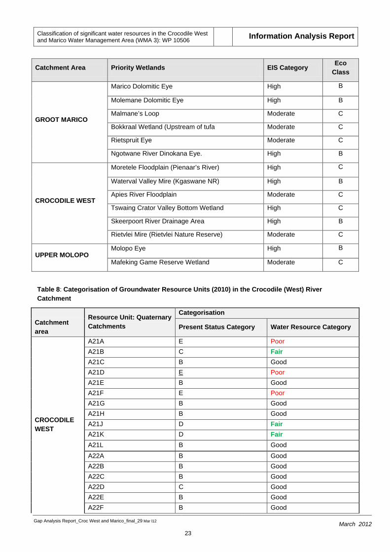
(a) Reserve determination study
The results from this study will form the basis of the ecological information and data to be used during the classification process. Table 6 shows the PES, EIS and REC associated with each EWR site. Table 7 and 8 show the EIS ratings for Priority Wetlands identified and the present status categories of Groundwater Resource Units in the Crocodile (West) River Catchment, respectively.
Table 6: Summary of PES, EIS and REC per resource unit
EWR Site number
EWR site name River RU Quaternary
catchment
PES REC EIS
CR
OC
OD
ILE
WES
T
EWR 1
Upstream of the Hartbeespoort Dam
Crocodile MRU Crocodile 3
A21H D D Moderate
EWR 2 Heron Bridge School
Juskei MRU Crocodile 1
A21C E D Moderate
EWR 3
Downstream of Hartbeespoort Dam in Mount Amanzi
Crocodile MRU Crocodile 5
A21J C/D C/D High
EWR 4
Downstream of Roodeplaat Dam
Pienaars MRU Pienaars 5
A23B C C High
EWR 5
Downstream of the Klipvoor Dam in Borakalalo National Park
Pienaars MRU Pienaars 8
A23J D D High
EWR 6 Upstream of Vaalkop Dam
Hex MRU Hex 5 A22J D D Moderate
EWR 7
Upstream of the confluence with the Bierspruit
Crocodile MRU Crocodile 10
A24C D D Moderate

Classification of significant water resources in the Crocodile West and Marico Water Management Area (WMA 3): WP 10506 Information Analysis Report
Gap Analysis Report_Croc West and Marico_final_29 Mar l12
22 March 2012
EWR Site number
EWR site name River RU Quaternary
catchment
PES REC EIS
EWR 8
Downstream of the confluence with the Bierspruit in Ben Alberts Nature Reserve
Crocodile MRU Crocodile 11
A24H C C Moderate
Rapid EWR
Upstream of Malony’s Eye
Magalies MRU Magalies 1
A21F
Rapid EWR
Highveld Elands MRU Elands 1
A22A
Rapid EWR
Upstream Buffelspoort Dam
Sterkstroom MRU Sterkstroom 1
A21K
MA
RIC
O
EWR 1
Site below the gorge area (before confluence with Marico)
Kaaloog se loop
Kaaloog se loop
A31A B B Very high
EWR 2
Upstream confluence of the Sterkstroom
Groot Marico Groot Marico 1
A31B B B Very high
EWR 3 Downstream of Marico Bosveld dam
Groot Marico Groot Marico 3
A31F C/D C/D High
EWR 4
Downstream of the Tswasa Weir, in the Madikwe Game Reserve.
Groot Marico Groot Marico 6
A32D C C High
Rapid EWR
Downstream Klein Maricopoort Dam
Klein Marico Klein Marico 3
A31E
Table 7: Summary of EWR site information
Classification of significant water resources in the Crocodile West and Marico Water Management Area (WMA 3): WP 10506 Information Analysis Report
Gap Analysis Report_Croc West and Marico_final_29 Mar l12
23 March 2012
Catchment Area Priority Wetlands EIS Category Eco Class
GROOT MARICO
Marico Dolomitic Eye High B
Molemane Dolomitic Eye High B
Malmane’s Loop Moderate C
Bokkraal Wetland (Upstream of tufa Moderate C
Rietspruit Eye Moderate C
Ngotwane River Dinokana Eye. High B
CROCODILE WEST
Moretele Floodplain (Pienaar’s River) High C
Waterval Valley Mire (Kgaswane NR) High B
Apies River Floodplain Moderate C
Tswaing Crator Valley Bottom Wetland High C
Skeerpoort River Drainage Area High B
Rietvlei Mire (Rietvlei Nature Reserve) Moderate C
UPPER MOLOPO Molopo Eye High B
Mafeking Game Reserve Wetland Moderate C
Table 8: Categorisation of Groundwater Resource Units (2010) in the Crocodile (West) River Catchment
Resource Unit: Quaternary Catchments
Categorisation Catchment area Present Status Category Water Resource Category
CROCODILE WEST
A21A E Poor A21B C Fair A21C B Good A21D E Poor A21E B Good A21F E Poor A21G B Good A21H B Good A21J D Fair A21K D Fair A21L B Good A22A B Good A22B B Good A22C B Good A22D C Good A22E B Good A22F B Good

Classification of significant water resources in the Crocodile West and Marico Water Management Area (WMA 3): WP 10506 Information Analysis Report
Gap Analysis Report_Croc West and Marico_final_29 Mar l12
24 March 2012
Resource Unit: Quaternary Catchments
Categorisation Catchment area Present Status Category Water Resource Category
A22G B Good A22H C Fair A22J C Good A23A B Good A23B B Good A23C B Good A23D Pretoria Fountains Incl.
E Poor
A23E D Fair A23F C Good A23G D Fair A23H B Good A23J B Good A23K A Natural A23L B Good A24A D Fair A24B C Good A24C D Fair A24D B Good A24E A Natural A24F D Fair A24G A Natural A24H B Good A24J F Poor
MARICO
A31A C Good A31B B Good A31C C Good A31D B Good A31E A Good A31F B Natural A31G A Natural A31H A Natural A31J A Natural A32A A Natural A32B A Natural A32C A Natural A32D A Natural A32E A Good
This information will be utilized to identify the final set of rivers where additional field work needs to be undertaken if estimation and/or extrapolations can’t be undertaken using existing EWR site
Classification of significant water resources in the Crocodile West and Marico Water Management Area (WMA 3): WP 10506 Information Analysis Report
Gap Analysis Report_Croc West and Marico_final_29 Mar l12
25 March 2012
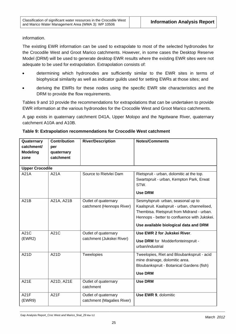
information.
The existing EWR information can be used to extrapolate to most of the selected hydronodes for the Crocodile West and Groot Marico catchments. However, in some cases the Desktop Reserve Model (DRM) will be used to generate desktop EWR results where the existing EWR sites were not adequate to be used for extrapolation. Extrapolation consists of:
• determining which hydronodes are sufficiently similar to the EWR sites in terms of biophysical similarity as well as indicator guilds used for setting EWRs at those sites; and
• deriving the EWRs for these nodes using the specific EWR site characteristics and the DRM to provide the flow requirements.
Tables 9 and 10 provide the recommendations for extrapolations that can be undertaken to provide EWR information at the various hydronodes for the Crocodile West and Groot Marico catchments.
A gap exists in quaternary catchment D41A, Upper Molopo and the Ngotwane River, quaternary catchment A10A and A10B.
Table 9: Extrapolation recommendations for Crocodile West catchment
Quaternary catchment/ Modeling zone
Contribution per quaternary catchment
River/Description Notes/Comments
Upper Crocodile A21A A21A Source to Rietvlei Dam Rietspruit - urban, dolomitic at the top.
Swartspruit - urban, Kempton Park, Erwat STW.
Use DRM
A21B A21A, A21B Outlet of quaternary catchment (Hennops River)
Sesmylspruit- urban, seasonal up to Kaalspruit. Kaalspruit - urban, channelised, Thembisa. Rietspruit from Midrand - urban. Hennops - better to confluence with Jukskei.
Use available biological data and DRM
A21C (EWR2)
A21C Outlet of quaternary catchment (Jukskei River)
Use EWR 2 for Jukskei River.
Use DRM for Modderfonteinspruit - urban/industrial
A21D A21D Tweelopies Tweelopies, Riet and Bloubankspruit - acid mine drainage, dolomitic area. Bloubankspruit - Botanical Gardens (fish)
Use DRM
A21E A21D, A21E Outlet of quaternary catchment
Use DRM
A21F (EWR9)
A21F Outlet of quaternary catchment (Magalies River)
Use EWR 9, dolomitic

Classification of significant water resources in the Crocodile West and Marico Water Management Area (WMA 3): WP 10506 Information Analysis Report
Gap Analysis Report_Croc West and Marico_final_29 Mar l12
26 March 2012
Quaternary catchment/ Modeling zone
Contribution per quaternary catchment
River/Description Notes/Comments
A21G A21G Outlet of quaternary catchment (Skeerpoort River)
Use EWR 9, dolomitic
A21H1 (EWR1)
A21A-E, A21H1
Jukskei River from EWR 2 to Hartbeespoort Dam
Use EWR 1
A21H_1 A21F, A21G Tributaries to Hartbeespoort Dam
Swartspruit, Mogarwe - wetland areas in bottom. Leeuspruit - low flowing river
Use DRM
A21H (EWR3)
A21A-H Hartbeespoort Dam Use EWR 3
A21J A21A-J Crocodile River to Roodekopjes Dam
Use EWR3 for main stem.
Rosespruit, Kareespruit – Use DRM
A21K2 (EWR11)
A21K1, A21K2 Source to Buffelspoort Dam (Sterkstroom)
Unique system, upstream of dam.
Use EWR 11
A21K3 A21K1, A21K2, A21K3
Sterkstroom to Roodekoppies Dam
Potential developments - housing.
Use EWR 11
A21K A21A-K Outlet of Roodekopjes Dam Use EWR 3 for main stem
A21L A21A-L Crocodile River to Elands confluence
Use EWR 3 for main stem
Elands River A22A1 (EWR10)
A22A1 Elands to Swartruggens Dam
Use EWR 10
A22A A22A Elands to Lindleyspoort Dam
Use EWR 10
A22B A22B Outlet of Kosterrivier Dam Use EWR 10, biological data give similar results as Upper Elands
A22C A22C Outlet of quaternary catchment (Selons River)
Use EWR 10
A22D A22B, A22C, A22D
Koster/Selonsspruit Use EWR 10
A22E A22A, A22E Outlet of quaternary catchment
Biological data available
Use DRM
A22F A22A-F Elands River to Vaalkop Dam
Use EWR 6, biological data available - Elands characterised by pools.
Tributaries- Leragane, Mankwe - Use DRM

Classification of significant water resources in the Crocodile West and Marico Water Management Area (WMA 3): WP 10506 Information Analysis Report
Gap Analysis Report_Croc West and Marico_final_29 Mar l12
27 March 2012
Quaternary catchment/ Modeling zone
Contribution per quaternary catchment
River/Description Notes/Comments
with available biological data
A22G A22G Hex to Olifantsnek Dam Use EWR 11 in Sterkstroom. Biological data available.
A22H A22G, A22H Hex to Bospoort Dam Use EWR 6
A22H2 A22H2 Waterkloofspruit Special case - nature reserve. If any applications, need to consider at least a rapid depending of impacts
A22J1 (EWR6)
A22G, A22H, A22J1
Hex River to Vaalkop Dam Use EWR 6
A22J A22A-J Elands River to Upper Crocodile confluence
Use EWR 6
Apies/Pienaars A23A A23A Source to Roodeplaat Dam Urban, storm water, WWTWs, canalised.
Use the PES with DRM. Maintain riparian vegetation
A23B4 A23B4 Boekenhoutspruit Main constraint sand mining, use rapid results from previous Tolwane River with updated hydrology
A23B (EWR4)
A23A, A23B Outlet of quaternary catchment
Use EWR 4 for main stem from Roodeplaat Dam to Boekenhoutspruit confluence
A23C A23A-C Pienaars River to confluence with Tshwanespruit
Floodplain (valley bottom)
A23D A23D Outlet of quaternary catchment
Urban, storm water, WWTWs, canalised. Use the PES with DRM. Maintain riparian vegetation
A23E1 A23D, A23E1 Source to Bon Accord Dam Urban, storm water, WWTWs, canalised. Use the PES with DRM. Maintain riparian vegetation
A23E A23D, A23E Main stem to outlet of quaternary catchment
Semi-urban, storm water, WWWTs, canalised. Use the PES with DRM. Maintain riparian vegetation
A23F2 A23F2 Tshwanespruit Small wetlands
A23F A23D, A23E, A23F
Apies River to confluence with Pienaars River
Floodplain (valley bottom)
A23G A23G Platspruit Use results from previous rapid study

Classification of significant water resources in the Crocodile West and Marico Water Management Area (WMA 3): WP 10506 Information Analysis Report
Gap Analysis Report_Croc West and Marico_final_29 Mar l12
28 March 2012
Quaternary catchment/ Modeling zone
Contribution per quaternary catchment
River/Description Notes/Comments
with updated hydrology for the upper reaches.
A23H A23H Karee/Rietspruit/Toitspruit Use DRM
A23J1 A23J1 Kutswane Urban up to Tswaing Crater. Below Crater very sandy - use previous Tolwane rapid results with updated hydrology
A23J A23A-J Pienaars and Apies Rivers to Klipvoor Dam
Floodplain (valley bottom)
A23K A23K Tolwane River Use previous Tolwane rapid results with updated hydrology
A23L (EWR5) A23A-L Pienaars River to Crocodile confluence
Use EWR 5 for main stem
Lower Crocodile
A24A A21, A22, A23, A24A
Outlet of quaternary catchment
Use DRM with biological data available from Atlanta
A24B A21, A22, A23, A24A-B
Outlet of quaternary catchment
Use EWR 7 for main stem
Tributaries – seasonal, use DRM
A24C (EWR7)
A21, A22, A23, A24A-C
Vaalkop, Roodekoppies & Klipvoor Dams to confluence with Sand River
Use EWR 7 for main stem
Tributaries - Sand River seasonal, use biological data available with DRM
A24D A24D Source to Bierspruit Dam Mostly wetland systems, groundwater
A24E A24E Outlet of quaternary catchment
Tributaries - seasonal. Groundwater system in upper reaches. Use DRM
A24F A24D-F Bierspruit to confluence to Crocodile River
Use DRM with biological data available
A24G A24G Outlet of quaternary catchment (Sand River)
Sand and Vingerkraal-se-Loop. Biological data available. Use with DRM
A24H (EWR8)
A21,A22, A23, A24A-C, A24G, A24H
Crocodile River to confluence with Bierspruit
Use EWR 8
A24J A21, A22, A23, A24A-J
Crocodile River Use EWR 8, rest mainly groundwater
Classification of significant water resources in the Crocodile West and Marico Water Management Area (WMA 3): WP 10506 Information Analysis Report
Gap Analysis Report_Croc West and Marico_final_29 Mar l12
29 March 2012
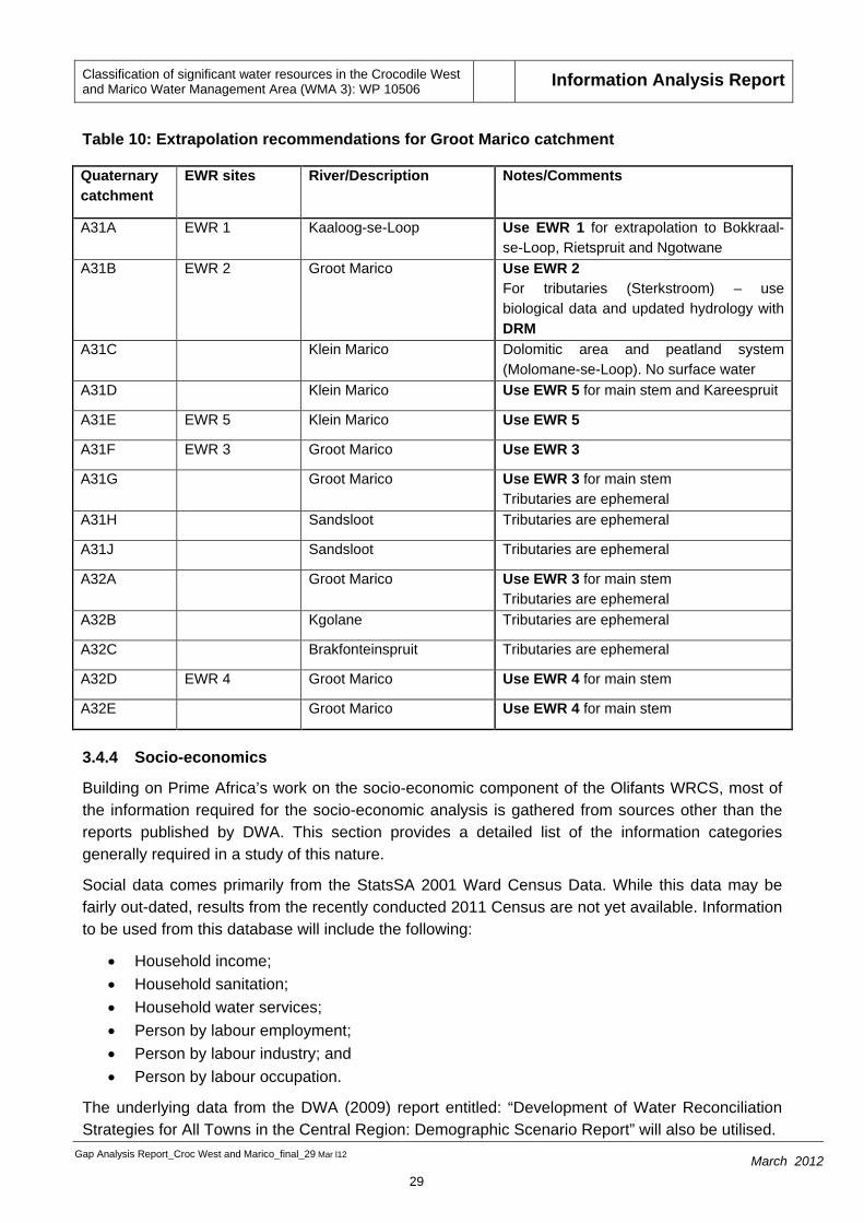
Table 10: Extrapolation recommendations for Groot Marico catchment
Quaternary catchment
EWR sites River/Description Notes/Comments
A31A EWR 1 Kaaloog-se-Loop Use EWR 1 for extrapolation to Bokkraal-se-Loop, Rietspruit and Ngotwane
A31B EWR 2 Groot Marico Use EWR 2 For tributaries (Sterkstroom) – use biological data and updated hydrology with DRM
A31C Klein Marico Dolomitic area and peatland system (Molomane-se-Loop). No surface water
A31D Klein Marico Use EWR 5 for main stem and Kareespruit
A31E EWR 5 Klein Marico Use EWR 5
A31F EWR 3 Groot Marico Use EWR 3
A31G Groot Marico Use EWR 3 for main stem Tributaries are ephemeral
A31H Sandsloot Tributaries are ephemeral
A31J Sandsloot Tributaries are ephemeral
A32A Groot Marico Use EWR 3 for main stem Tributaries are ephemeral
A32B Kgolane Tributaries are ephemeral
A32C Brakfonteinspruit Tributaries are ephemeral
A32D EWR 4 Groot Marico Use EWR 4 for main stem
A32E Groot Marico Use EWR 4 for main stem
3.4.4 Socio-economics
Building on Prime Africa’s work on the socio-economic component of the Olifants WRCS, most of the information required for the socio-economic analysis is gathered from sources other than the reports published by DWA. This section provides a detailed list of the information categories generally required in a study of this nature.
Social data comes primarily from the StatsSA 2001 Ward Census Data. While this data may be fairly out-dated, results from the recently conducted 2011 Census are not yet available. Information to be used from this database will include the following:
• Household income; • Household sanitation; • Household water services; • Person by labour employment; • Person by labour industry; and • Person by labour occupation.
The underlying data from the DWA (2009) report entitled: “Development of Water Reconciliation Strategies for All Towns in the Central Region: Demographic Scenario Report” will also be utilised.

Classification of significant water resources in the Crocodile West and Marico Water Management Area (WMA 3): WP 10506 Information Analysis Report
Gap Analysis Report_Croc West and Marico_final_29 Mar l12
30 March 2012
Water quality data
A large component of the socio-economic study would be to quantify the water quality impacts on the economic sectors directly dependent on water resources in the WMA. The main activities within the WMA and the Molopo Catchment are mining, agriculture, light industries, urban development, rural settlements and tourism. These activities will impact on the water quality of receiving water bodies as point and non-point sources of pollution.
In order to estimate the cost of the decline in water quality due to these activities the following data and information is required:
• Physical data: the flow (expressed as MAR) of the river system at EWR sites; • Physical data: the loading of specifically identified water quality indicators at EWR sites; • Spatial data: in order to identify specific activities downstream of EWR sites; • Other data: volumes of effluents and concentrations of water quality indicators in effluents
of waste water treatment works within the study area; • Economic data: using the load model and the marginal cost of abatement model as
developed for the Olifants WMA.
Mining Data
Data will be collected from the Chamber of Mines, The Department of Mineral Resources (DMR), Statistics SA and the Council for Geoscience. Published annual reports of mining companies in the WMA will be sourced. Information on mining will be sourced from various DWA published reports, including:
• Scoping level assessment of how water quality and quantity will be affected by mining method and mining of the shallow Waterberg coal reserves west of the Daarby Fault. 2011. WRC.
A meeting will be held with the Chamber of Mines in order to gather information regarding possible mining expansions and trajectories.
Data Gaps
Data for mining production is aggregated on a National and Provincial level, so it is difficult to make assumptions on a WMA scale. The Council of Geosciences has spatial data that may be of use to the study, but there is a cost associated with the data, which may be prohibitive. A quote is available on request.
Agricultural Data
Output for the agricultural sector will be calculated from several sources:
• Total area of dryland, irrigated and subsistence for each integrated unit of analysis (IUA) will be calculated using the Land Cover Database developed by the CSIR (2001). Although the database is a decade old, it is reliable source of data and has been used as a baseline for several studies;
• Further area estimates will be calculated from the Stats SA Agricultural Census of 2002. Results from the Stats SA Agricultural Census of 2010 will be utilised if completed by Stats SA; and
• Discussions with Department of Agriculture, Forestry and Fisheries (DAFF).

Classification of significant water resources in the Crocodile West and Marico Water Management Area (WMA 3): WP 10506 Information Analysis Report
Gap Analysis Report_Croc West and Marico_final_29 Mar l12
31 March 2012
3.4.5 Supporting information
Other supporting information such as water user sector information, water users in the catchment (and water quality requirements), land use, water infrastructure and water allocation information, environmental information, biodiversity and conversation data are in the process of being sourced from various previous and parallel studies (discussed in the previous sections) and from DWA. As primary data collection is not part of this study a synthesis of available will be prepared for use in this study. Where data is not available conservative assumptions will be made.
3.5 MODELS
The Water Resource Planning Model (WRPM) and the Water Resources Yield Model (WRYM) for the Crocodile (West) and Marico catchments of the DWA, Directorate National Water Resource Planning will be relied upon to determine an ESBC. A gap exists in quaternary catchment D41A, Upper Molopo and the Ngotwane River, quaternary catchment A10A and A10B where no yield models exist.
3.6 OTHER
Data available from the River Health Programme (RHP), the NFEPA project, WMS, water quality assessments and the updated PES, EI and ES (current study) will be used to populate the models during the specialist workshop to evaluate the ESBC scenarios.
This information will enhance the data collected for the comprehensive Reserve determination study and will assist the specialist to make recommendations on more current data.
4 IDENTIFICATION OF POTENTIAL INFORMATION GAPS
In terms of the information analysis undertaken key information gaps that have been identified for the study relate to three aspects, viz:
• The ecological water requirements component;
• The socio-economic component; and
• To some extent to the water quality information.
The gaps in information that are present are detailed below.
4.1 Ecological Water Requirements
• The approach followed during the Intermediate Reserve study was to identify Ecological Water Requirement (EWR) sites on the main stem and major tributaries;
• Only eight sites were assessed on an intermediate level and three on the rapid level for the Crocodile West Catchment; gaps identified are:
o Rietspruit, quaternary catchment A21A;
o Waterkloofspruit, sub-quaternary catchment A22H2; and
o Bierspruit, quaternary catchments A24D, A24E and A24F.
• The Apies Pienaars River together with the Pienaars River wetland were not adequately represented with just two EWR sites one on the Pienaars River below Klipvoor/Borakala Dam and the other site below Roodeplaat Dam;

Classification of significant water resources in the Crocodile West and Marico Water Management Area (WMA 3): WP 10506 Information Analysis Report
Gap Analysis Report_Croc West and Marico_final_29 Mar l12
32 March 2012
• There are no EWR sites in quaternary catchment D41A, Upper Molopo and the Ngotwane River, quaternary catchment A10A and A10B;
• Rapid site on the Lower Elands;
• Rapid site on one of the tributaries in the Bela Bela area; and • Confidence in the hydrology of the lower Groot Marco is low and while this was used during the
Intermediate Reserve study, it was with very low confidence in the actual EWRs. Guidance from DWA will therefore be needed on how to proceed.
In terms of addressing the gaps identified the team will be able to fill these based on running of the Reserve models, specialist workshops, supporting information from studies such as River Health, the PES/EIS 2010 update, the NFEPA project and several Rapid III Reserve assessments.
4.2 Socio-Economic
• Gaps in information related to the mining and power station data available for the mines in the WMA may exist. Gaps identified need to be addressed, through accessing all available literature, published and unpublished databases, and expert involvement:
• The study, “The Development of a Reconciliation Strategy for the Crocodile (West) Water Supply System” may be used to deduce approximate water usages and expected growth patterns; and
• Specific assumptions will need to be made where data is absent however these will be clearly defined and explained.
4.3 Water quality
In terms of water quality data assessment the WQ monitoring stations and related information are mainly concentrated on main stem rivers and tributaries. Data gaps could potentially exist for the sub-nodes (still to be identified) in smaller tributary catchments which are identified as high PES and ecological importance and sensitivity. The option available to address this potential gap is to use water quality neural networks. Water quality specialists within the Department need to be approached to assist the classification team in this regard.

Classification of significant water resources in the Crocodile West and Marico Water Management Area (WMA 3): WP 10506 Information Analysis Report
Gap Analysis Report_Croc West and Marico_final_29 Mar l12
33 March 2012
5 MITIGATION MEASURES FOR RISKS IDENTIFIED
Potential risks/limitations identified are set out in Table 11.
Table 11: List of possible identified risks and limitations with proposed mitigation
Risk/Limitation Mitigation Measure
Existing ecological/EWR and economic data available may be found to be inadequate to support all modelling processes
Best available information needs to be used and where possible modelling, extrapolation, estimations be used.
Every effort needs to be taken to ensure that the end results and outputs are technically sound, scientifically supported and defendable.
Where possible meetings/liaison must be undertaken with the water use sector (e.g. mining data – Chamber of Mines).
Rapid III Reserve studies to be undertaken if possible, where necessary.
Water quality data may not be available for smaller tributary catchments
Potential gap to be addressed by water quality neural network analysis
Gaps in information related to future mining and power station development
Gaps identified need to be addressed, through accessing all available literature, published and unpublished databases, and expert involvement:
The study, “The Development of a Reconciliation Strategy for the Crocodile (West) Water Supply System” may be used to deduce approximate water usages and expected growth patterns; and
Specific assumptions will need to be made where data is absent however these will be clearly defined and explained.
6 CONCLUSIONS ON INFORMATION APPLICABILITY AND ADEQUACY FOR CLASSIFICATION STUDY
From the information analysis that has been undertaken on understanding the availability, accessibility and usefulness of the information and data sources applicable to the Crocodile (West) and Marico WMA required for the implementation of the WRCS, it is evident that considerable data exists for the significant water resources within the Crocodile (West) and Marico WMA to enable an evaluation of changes in their ecological condition in response to changes in water related issues. The Crocodile (West) and Marico WMA is well studied, thorough preparations have been made and it can be concluded that adequate, useful information as well as experts, with firsthand knowledge of the system for the implementation of the WRCS in the WMA, are available.

Classification of significant water resources in the Crocodile West and Marico Water Management Area (WMA 3): WP 10506 Information Analysis Report
Gap Analysis Report_Croc West and Marico_final_29 Mar l12
34 March 2012
7 REFERENCES
1. Department of Environmental Affairs and Tourism (2005). State-of-Rivers Report: Monitoring and Managing the Ecological State of Rivers in the Crocodile (West) Marico Water Management Area.
2. Department of Water Affairs (DWA), 2009. Adopt-a-River Programme Phase II: Development of an Implementation Plan. Water Resource Quality Situation Assessment. Prepared by H. Hendriks and J.N. Rossouw for Department of Water Affairs, Pretoria, South Africa.
3. Department of Water Affairs (DWA). 2010. Resource Directed Measures: Intermediate Reserve determination study for selected water resources in the Crocodile (West) and Marico Management Area. Main Integration Report. Report no: RDM/ A000WMA3/01/CON/1008. Pretoria, South Africa. (draft)
4. Department of Water Affairs and Forestry (2004). Institutional Roles and Linkages Situational Assessment: Crocodile West and Marico WMA 3.
5. Department of Water Affairs and Forestry (2004). Crocodile River (West) and Marico Water Management Area: Internal Strategic Perspective of the Crocodile River (West) catchment: Prepared by Goba Moahloli Keeve Steyn (Pty) Ltd, Tlou & Matji (Pty) Ltd and Golder Associates (Pty) Ltd, on behalf of the Directorate: National Water Resource Planning. DWAF Report No. 03/000/00/0303.
6. Department of Water Affairs and Forestry (2006). A Systematic Conservation Plan for the Freshwater Biodiversity of the Crocodile (West) & Marico WMA. CSIR Report no. CSIR/NRE/ECO/ER/2006/0133/C.
7. Department of Water Affairs and Forestry (2006). Development of an automated desktop procedure for defining macro-reaches for river longitudinal profiles. Water SA Vol. 32 No. 3.
8. Department of Water Affairs and Forestry (2007). The Development of the Water Resource Classification System (WRCS). First Edition. Volume 1. Overview and 7–step classification procedure. Chief Directorate: Resource Directed Measures.
9. Department of Water Affairs and Forestry (2007). The Development of the Water Resource Classification System (WRCS). First Edition. Volume 2. Ecological, hydrological and water quality guidelines for the 7-step classification procedure. Chief Directorate: Resource Directed Measures.
10. Department of Water Affairs and Forestry (2007). The Development of the Water Resource Classification System (WRCS). First Edition. Volume 3. Socio-economic guidelines for the 7-step classification procedure. Chief Directorate: Resource Directed Measures.
11. Department of Water Affairs and Forestry (2007). The Development of the Water Resource Classification System (WRCS). First Edition. Volume 4. Decision analysis (including the stakeholder engagement process for 7–step Classification Procedure. Chief Directorate: Resource Directed Measures.

Classification of significant water resources in the Crocodile West and Marico Water Management Area (WMA 3): WP 10506 Information Analysis Report
Gap Analysis Report_Croc West and Marico_final_29 Mar l12
35 March 2012
12. Department of Water Affairs and Forestry (2008). Crocodile (West) River Reconciliation Strategy: Version 1. P WMA 03/000/00/3608
13. Department of Water Affairs and Forestry (2010). Framework and Manual for the evaluation of aquatic ecosystems services for the Resource Directed Measures. WRC Report No. TT 462/10
14. Department of Water Affairs and Forestry, South Africa. 2004. Crocodile (West) and Marico Water Management Area: Internal Strategic Perspective of the Marico-Upper Molopo & Upper Ngotwane catchments. Prepared by Goba Moahloli Keeve Steyn in association with Golder and Associates and Tlou and Matji (Pty) Ltd. DWAF Report No. P WMA 03/000/00/0404
15. http://www.nwpg.gov.za/Agriculture/NW_ENVIRONMENTAL_OUTLOOK/chapter.asp?CHAPTER=11&PAGE=3&TITLE=Part%203 (2008). State of the Environment Report.
16. Water Research Commission (2011). Investigating the behavioural drivers of Stakeholder Engagement and Volunteerism in the South African Water Arena. WRC Report No KV 264/10