Embed Size (px)
Citation preview
International Symposium on Outfall Systems, May 15-18, 2011, Mar del Plata, Argentina
Influence of Projected Outfalls in the Plata River on Limited
Water Use Zones
A. N. Menéndez, M. F. Lopolito, N. D. Badano and M. Re
Hydraulics Laboratory, INA (National Institute for Water), AU Ezeiza-Cañuelas, Tramo J.Newbery, km 1.600,
Prov. of Buenos Aires, Argentina
National Technical University (UTN), Regional Avellaneda, Av. Mitre 750, Prov. Buenos Aires, Argentina
(E-mail: [email protected])
Abstract
A numerical simulation study is presented, which provides a diagnosis about the present limited
use zones on the coastal waters of the Plata River. The model is later applied to a future scenario,
in which a combination of master plans by the Water Company and by the authority of the most
contaminated urban watershed, which includes building a new outfall and extending the present
one, is implemented. The increase of the security margin for the water intakes, and the
recuperation of significant parts of the coastal zone for recreational uses are highlighted.
Keywords
Numerical modeling; water quality modelling; limited water use zones
INTRODUCTION
The coastal waters of the Plata “River” – a freshwater, wide, shallow estuary – adjacent to the
Metropolitan Region of Buenos Aires (MRBA), Argentina (Figure 1), are polluted enough to
prevent any recreational use, according to international water quality standards. Even the present
outfall – which discharges only part of the sewage, at about 2.5 km from the coast – generates
intermittent pollution effects on the coast. The two water intakes for human consumption are
located in zones where the quality is good enough to comply with national regulations, after
conventional treatment, but the security margin is relatively low. Preservation of biota cannot be
guaranteed in the coastal zone.
Figure 1. Location of the Metropolitan Region of Buenos Aires by the Plata River.
A Master Plan of the Water Company, in combination with a Master Plan for the decontamination
of the most significant urban watershed – the Matanza-Riachuelo Basin –, includes building a new
outfall (total length about 11.5 km, mean discharge about 22 m3/s), and extending the present one
(total length about 7.5 km, mean discharge about 28 m3/s), together with the construction of
physical-treatment plants, and a coastal dry-weather interceptor conduit (Figure 2). The
implementation of these plans will redefine the location and extension of the limited use zones.

Figure 2. Scheme of wastewater disposal project.
A numerical simulation study was undertaken in order to establish the present limited use zones,
and predict the situation for the project scenario.
NUMERICAL MODEL
In the first place, a 2D hydrodynamics model was built in order to simulate the water level and
velocity distributions within the whole Inner Plata River (about 200 km long, and between 50 and
100 km wide), driven by the oceanic tidal wave, the fluvial discharges from the main tributaries –
the Paraná and Uruguay rivers –, and the wind (Figure 3). Software MIKE 21 FM was used. A
finite element mesh with higher resolution in the problem zone was built. The last available
bathymetric data was used to build the Digital Elevation Model of the river bed. Roughness was
parameterized with Manning coefficient, which was set to a value arising from previous studies
(Jaime & Menendez 1999, Re & Menendez 2003). The time step was small enough to adequately
represent the surface waves (3.5 seconds).
Figure 3. Driving forces.
The hydrodynamic model was validated by comparing its results with time series and statistics of
tidal level data at various stations, records of water current velocity at three stations, and a buoy
trajectory (Menendez et al. 2009, 2011).
A pollutant transport model was implemented, driven by the hydrodynamic model. Software
ECOLAB, from DHI, was used. Ten different water quality parameters were considered: DO, BOD,
E. Coli (or Fecal Coliforms, which correlate strongly), Ammonia, Nitrate, Total Phosphorous,
Phenols, Detergents, Cr, and Pb. Transformation (first order) reactions were defined for the former
five of them; the remaining ones were considered as conservative. The pollutant loads from the
MRBA (see Figure 3) were estimated based on a series of eventual measurements on each
discharge, including the present outfall at Berazategui. Additionally, the pollutant loads from the
Paraná River were imposed and adjusted in order to represent the background concentrations,
especially significant for Cr and Pb.
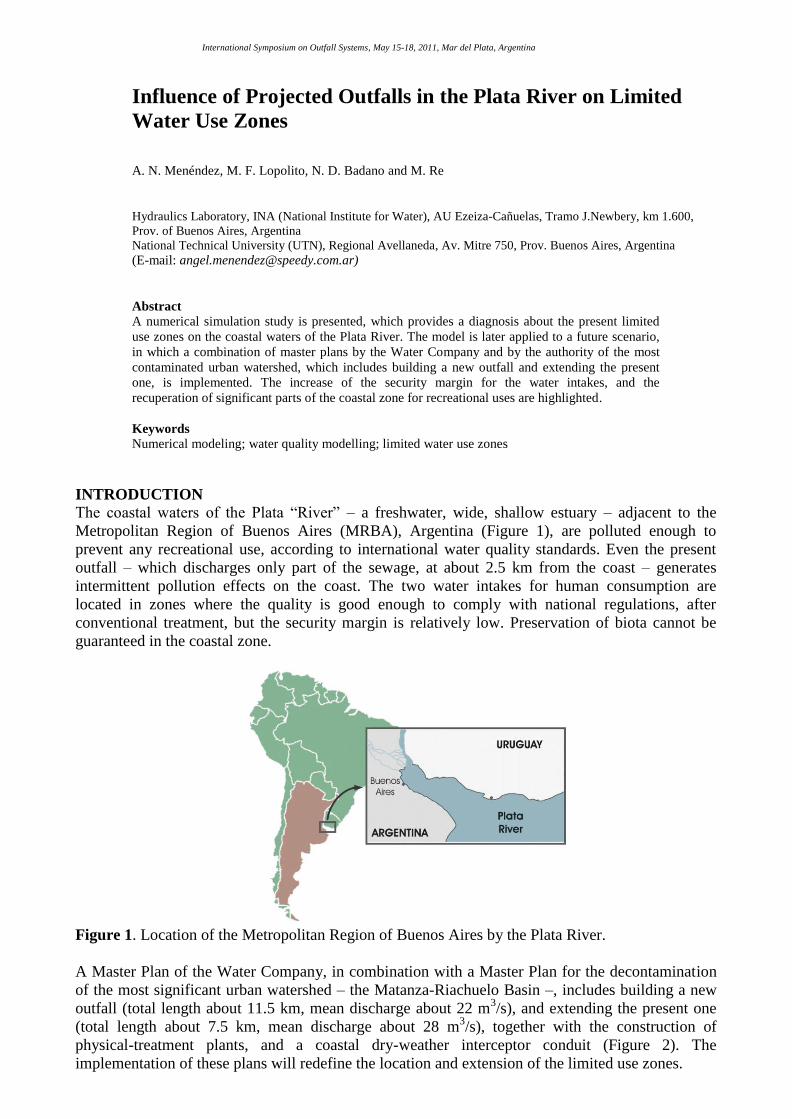
The calibration of this water quality model (through adjustment of the reaction constants within
their practical ranges) was undertaken using the monitoring data obtained during all the surveys
performed for the coastal zone, since 1992. Comparisons were made for time mean spatial
distributions, statistical distributions at stations along cuts parallel to the coast, and detailed and
nearly instantaneous values around the outfall discharge (Figure 4) (Menendez et al. 2009, 2011).
Figure 4. Distribution of instantaneous concentrations of Fecal Coliforms around the present
Berazategui outfall mouth.
LIMITED USE ZONES
Eight different water uses were identified: (I) Drinking Water after Conventional Treatment; (II)
Primary Contact Recreation; (III) Secondary Contact Recreation; (IV) Passive Recreation; (V)
Preservation of Aquatic Life under Long Exposure; (VI) Preservation of Aquatic Life under Short
Exposure; (VII) Preservation of Fish without Sub-Lethal Effects; (VIII) Preservation of Fish
without Lethal Effects. They were defined by establishing a set of criteria on limiting
concentrations for the 10 modeled water quality parameters, mainly based on regulations for
different countries. These criteria are presented in Table 1.

Table 1. Aptitude Criteria for Water Use.
Water Use
Type (I) (II) (III) (IV) (V) (VI) (VII) (VIII)
DO
(mg/l) 4 5 4 2 5 3 NS Ns
BOD
(mg/l) 5 3 10 15 3 10 NS NS
E. Coli
(MPN/100ml) 2 x 10
3 2 x 10
2 2 x 10
4 2 x 10
5 NR NR NS NS
Ammonia
(mg N/l) NR NR NR NR 0.6 6 1 1.8
Nitrate
(mg N/l) 10 10 10 NR NR NR 108 1080
P
(µg/l) NR 100 1000 1000 10 100 NS NS
Phenols
(µg/l) 10 50 100 1000 4 50 5000 50,000
Detergents
(mg/l) 0.5 0.5 5 5 NR NR NS NS
Cr
(µg/l) 50 50 NR NR 2 20 15,000 93,600
Pb
(µg/l) 50 10 NR NR 2 20 800 8000
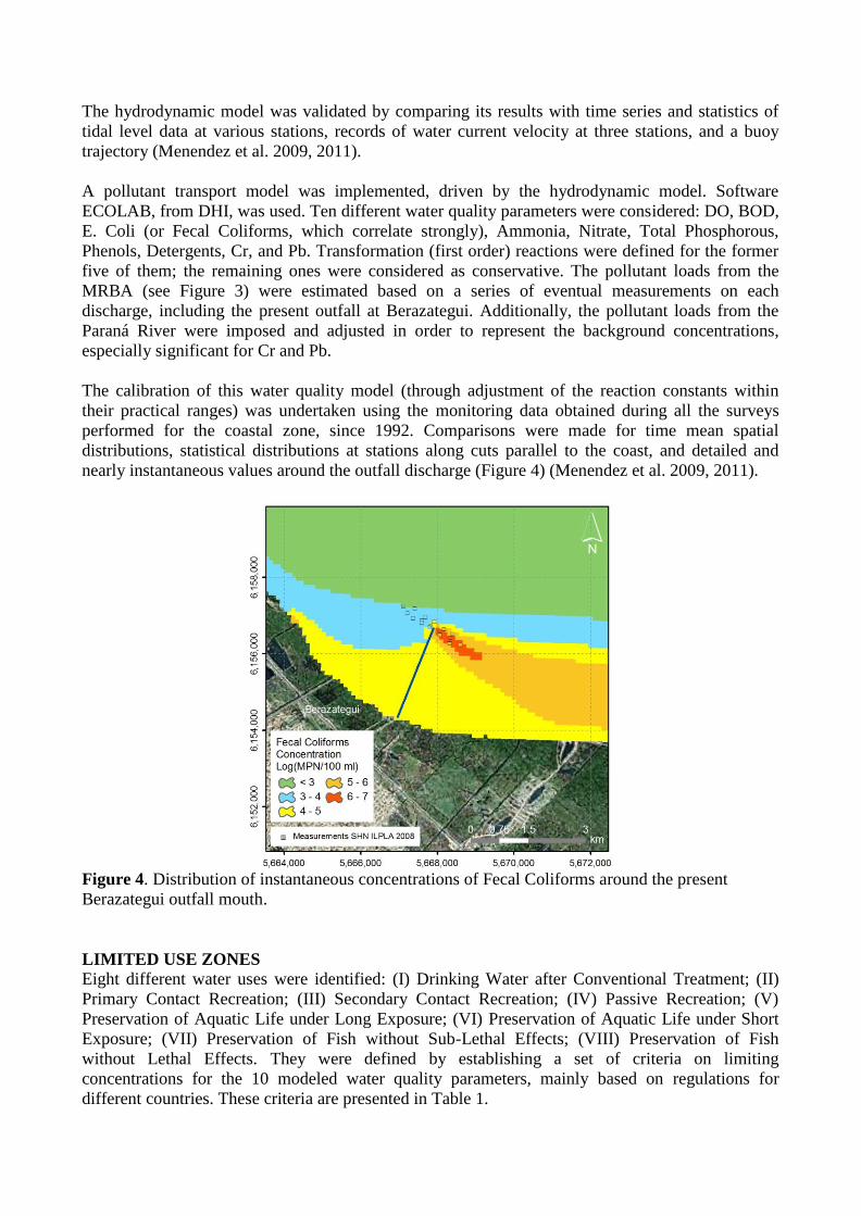
Applying the criteria of Table 1 to the results obtained with the model for the present situation, the
location of the limited use zones were determined, identifying in each case the influence zone of
each limiting parameter. The following results arose: (i) Use I is limited along the whole coastline;
the water intakes for human consumption lie beyond the limited use zone; the limiting parameter is,
basically, E.Coli (Figure 5); (ii) Use II is also limited along the whole coastline, with E.Coli being
the limiting parameter; (iii) Use III is not limited in a few patches along the coastline; E.Coli is
again the limiting parameter (Figure 6); (iv) Use IV is only limited (basically due to BOD) around
the discharge from the Matanza-Riachuelo Basin; (v) Use V is limited throughout the “Paraná River
lane”, with (background) Phosporous being the limiting parameter; (vi) Use VI is limited over a
major part of the “Paraná River lane”, with Phosphorous being the limiting parameter (Figure 7);
(vii) A few patches on the coastline are apt for Use VII; the limiting parameter is Ammonia; (viii)
Use VIII is mainly limited around the discharge of the Matanza-Riachuelo Basin, and the present
Berazategui outfall mouth, with Ammonia being the limiting parameter. In particular, the present
Berazategui outfall only have beneficial effects, regarding the coastline, for uses IV and VIII, but it
is not able to avoid inability of the coastline to support the remaining water uses.
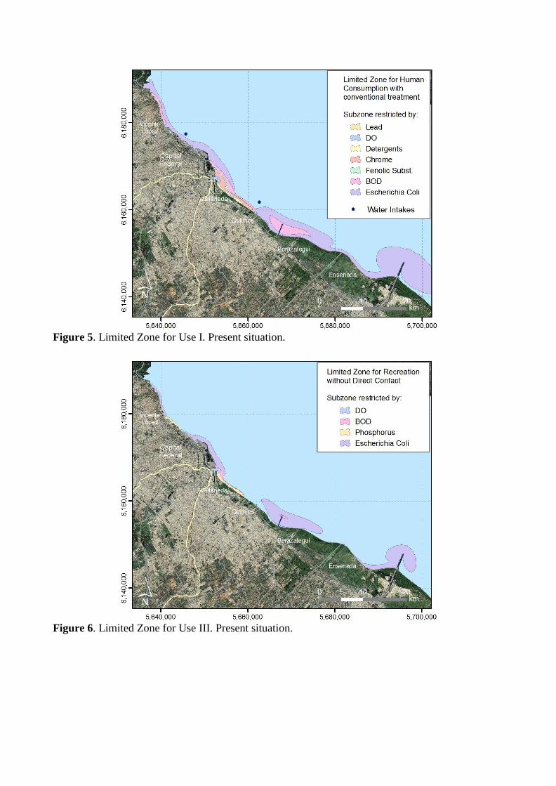
Figure 5. Limited Zone for Use I. Present situation.
Figure 6. Limited Zone for Use III. Present situation.

Figure 7. Limited Zone for Use VI. Present situation.
PROJECT SCENARIO
The water quality model was later applied to establish the limited use zones for the project scenario,
in which coastal loads are intercepted, the pollutant loads from the Matanza-Riachuelo River are
drastically reduced, and the two outfalls are built. The model shows that: (i) there is a significant
increase of the security margin for the water intakes (Figure 8); (ii) the width of the coastal limiting
zone for Use II diminishes significantly, even disappearing at a few patches; (iii) recuperation of
significant parts of the coastal zone for Use IiI is attained, due to the nearly disappearance of the
restrictive effect from E.Coli (Figure 9); (iv) the limited use zone for Use IV reduces slightly; (v) no
change occurs for Use V, as it is limited by the background concentration; (vi) the limited use zone
for Use VI increases slightly (Figure 10). The benefits produced by the presence of the outfalls have
an environmental „cost‟: the appearance of extended limited used zones around the outfalls outlet.
In particular, E.Coli and BDO are the parameters which impose those restrictions for Uses I to III.
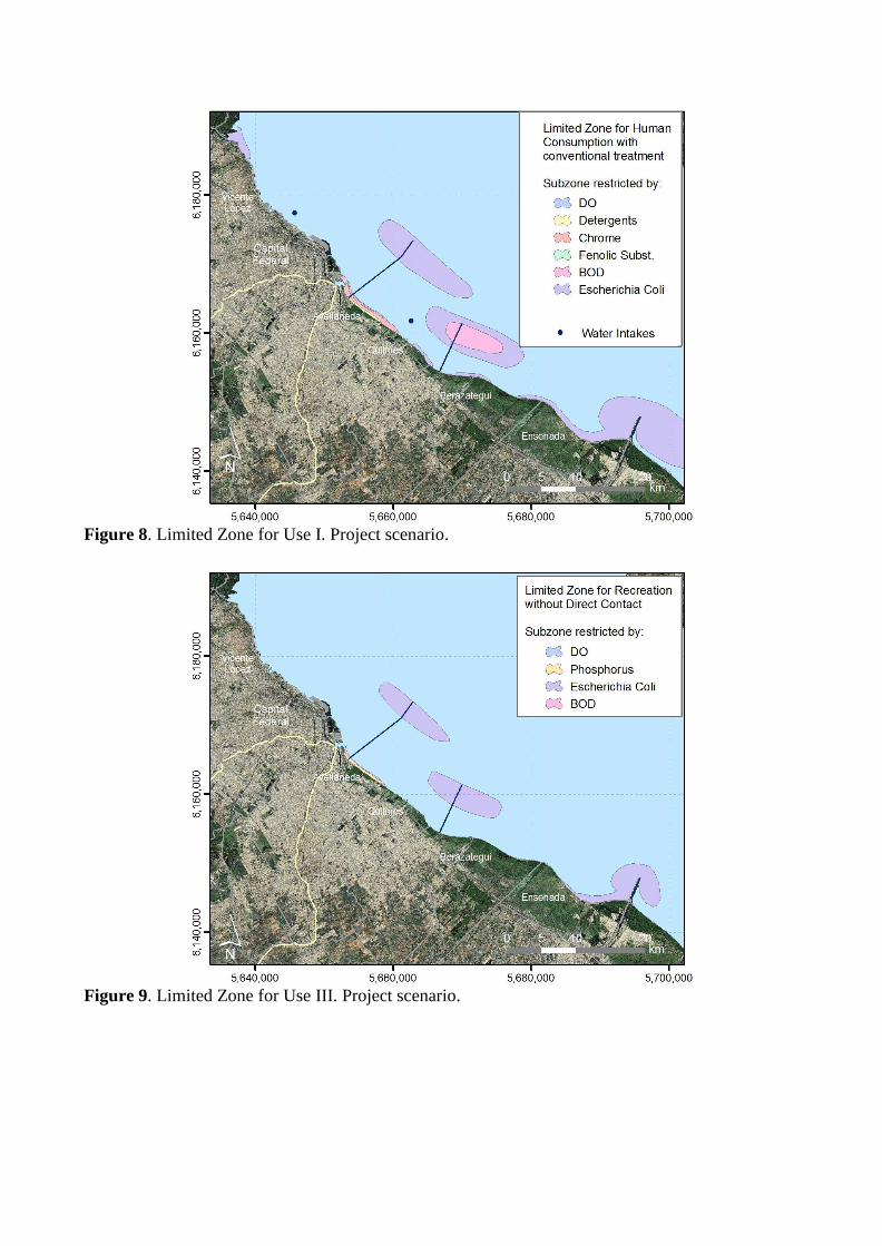
Figure 8. Limited Zone for Use I. Project scenario.
Figure 9. Limited Zone for Use III. Project scenario.
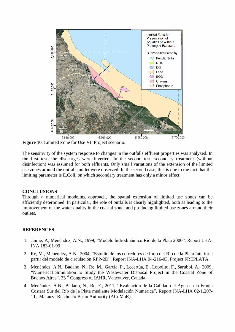
Figure 10. Limited Zone for Use VI. Project scenario.
The sensitivity of the system response to changes in the outfalls effluent properties was analyzed. In
the first test, the discharges were inverted. In the second test, secondary treatment (without
disinfection) was assumed for both effluents. Only small variations of the extension of the limited
use zones around the outfalls outlet were observed. In the second case, this is due to the fact that the
limiting parameter is E.Coli, on which secondary treatment has only a minor effect.
CONCLUSIONS
Through a numerical modeling approach, the spatial extension of limited use zones can be
efficiently determined. In particular, the role of outfalls is clearly highlighted, both as leading to the
improvement of the water quality in the coastal zone, and producing limited use zones around their
outlets.
REFERENCES
1. Jaime, P., Menéndez, A.N., 1999, “Modelo hidrodinámico Río de la Plata 2000”, Report LHA-
INA 183-01-99.
2. Re, M., Menéndez, A.N., 2004, “Estudio de los corredores de flujo del Río de la Plata Interior a
partir del modelo de circulación RPP-2D”, Report INA-LHA 04-216-03, Project FREPLATA.
3. Menéndez, A.N., Badano, N., Re, M., García, P., Lecertúa, E., Lopolito, F., Sarubbi, A., 2009,
“Numerical Simulation to Study the Wastewater Disposal Project in the Coastal Zone of
Buenos Aires”, 33nd
Congress of IAHR, Vancouver, Canada.
4. Menéndez, A.N., Badano, N., Re, F., 2011, “Evaluación de la Calidad del Agua en la Franja
Costera Sur del Río de la Plata mediante Modelación Numérica”, Report INA-LHA 02-1.207-
11, Matanza-Riachuelo Basin Authority (ACuMaR).