Embed Size (px)
Citation preview
Natural Subregion of Alberta
R e c o v e r y R e c o v e r y S t r a t e g i e s f o r S t r a t e g i e s f o r
I n d u s t r i a l I n d u s t r i a l D e v e l o p m e n t i n D e v e l o p m e n t i n N a t i v e P r a i r i e N a t i v e P r a i r i e
February 2013
First Approximation
for the
Dry Dry
MixedgrassMixedgrass
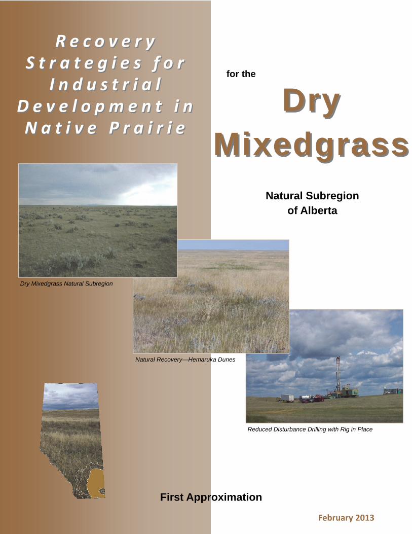
Dry Mixedgrass Natural Subregion
Natural Recovery—Hemaruka Dunes
Reduced Disturbance Drilling with Rig in Place

RECOVERY STRATEGIES FOR INDUSTRIAL DEVELOPMENT IN NATIVE PRAIRIE
THE DRY MIXEDGRASS NATURAL SUBREGION OF ALBERTA
FEBRUARY 2013
First Approximation
Prepared for: RANGE RESOURCE MANAGEMENT PROGRAM LANDS DIVISION ALBERTA ENVIRONMENT AND SUSTAINABLE RESOURCE DEVELOPMENT
Prepared by: GRAMINEAE SERVICES LTD.
In In PartnershipPartnership With:With:
Special Areas Board Foothills Restoration Forum ERCB

Page i
Recovery Strategies for Industrial Development in Native Prairie Dry Mixedgrass Natural Subregion
AcknowledgementsAcknowledgements
A project such as this cannot be completed in isolation. The partnerships established during the evolution of this project captured
and incorporated the knowledge of Albertans who share a common goal of minimizing the impact of industrial disturbance in
native prairie landscapes.
The project has been developed in two phases:
an initial information gathering and field verification component; jointly funded by Kinder Morgan Canada Inc.,
TransCanada Pipelines, ConocoPhillips Canada and Alberta Sustainable Resource Development, Rangeland
Management Branch, and;
a series of peer review workshops with reclamation practitioners, reclamation contractors and environmental
planners from industry, landowners, lease holders, rangeland agrologists, land use managers and not‐for‐profit
organizations with an interest in prairie restoration. Funding for the second phase of the project has been provided
by Alberta Environment and Sustainable Resource Development (ESRD) Range Resource Management Program.
The authors would like to acknowledge the following individuals for their guidance and contributions to the final document:
Participants of the Ranchers workshop: Archie Sabin, Bull Springs Ranch, Hargrave Ranching Company, Bruce Reiger, President
Drowning Ford Grazing Association, Ian Mitchell, RH Ranch Ltd., Neil and Rochelle Mitchell, Mitchell Ranching, Tyrel Pahl, rancher
and land agent, Vernon Pancoast, rancher, Wayne Syverson, Badlands Ranching Ltd., Lee Finstad, Finstad Ranching Ltd., and
Raymond Pearson, rancher. Thanks for taking time out of your busy schedules to provide valuable experience with what works and
doesn’t work and what could be done better regarding industrial development in native prairie.
Barry Adams, Kevin France, Varge Craig, Jane Lancaster, Gerry Ehlert and Harvey Martens for peer review of the first draft and
ongoing technical review. Your encouragement and technical support was greatly appreciated. Thanks to Donna Watt for her
documentation of comments during the workshops and formatting skills. Thanks to Ross Adams for his skills with data compilation
and analysis. It was a great team effort!
Bruce Cairns, Jennifer Richmond, Tracey Kupchenko, Nancy Boutilier, Terry Hood, ESRD Public Lands Agrologists and Joel Hesse,
Cenovus Energy, Jody Spady and Meridith Ball of Husky Energy, Brent Smith, Ivan Barbero and Karen Guenther of Canadian Forces
Base Suffield for participation in the Medicine Hat workshop and peer review of the second draft.
Barry Cole, Lorne Cole, Kevin Redden, Simon Brookes, Geoff Smith, Darrin Britton, ESRD Land Management Specialists for
participation in the Lethbridge workshop and peer review of the third draft.
And finally, peer review by members of the Technical Advisory Committee of the Foothills Restoration Forum: Cheryl Bradley,
Varge Craig, Lowell Calder, Larry Frith, Nigel Douglas, Ken Perl, Jordon Christianson and Bruce Greenfield. Thank you all.
Barry Adams and Marilyn Neville
February 2013
Page ii
Recovery Strategies for Industrial Development in Native Prairie
PrefacePreface
Reclamation practices following industrial disturbance in native prairie landscapes have been
steadily evolving since the early 1980s. Industrial activity in native prairie has also been steadily
increasing. The Dry Mixedgrass Natural Subregion of Alberta is rich in petroleum resources with a
large and diverse development infrastructure in native prairie. Recently, the development of
renewable resources such as wind energy is also taking place, requiring a similar development
infrastructure in native prairie as well. As the demand for development has increased, so has public
pressure to reduce the impact of industrial disturbance and the cumulative effects of multiple
activities on native prairie ecosystems.
Over time the focus of reclamation practices in native prairie has shifted from controlling soil
erosion and establishing sustainable grass cover to development planning with pre‐disturbance
assessment and implementation procedures designed to enable the restoration of ecosystem
structure, health and function. This need for a shift in focus from reclamation to restoration was
acknowledged in the 2010 Reclamation Criteria for Wellsites and Associated Facilities in Native
Grasslands (Alberta Environment 2011). The recovery strategies presented here have been
developed to support the intent of the 2010 Criteria for Grasslands and to provide guidance for
reclamation practitioners, contractors, landowners and Government of Alberta regulatory
authorities. The strategies are not intended to be prescriptive, but rather strive to present options
and pathways to enable selection of the most appropriate recovery strategy for the type of
industrial disturbance on a site specific basis. The purpose is to provide the tactical expectations of
what is required to reach the outcome of restoration over time.
This manual builds on existing guidelines and information sources such as Restoring Canada’s
Native Prairies, A Practical Manual (Morgan et al. 1995), A Guide to Using Native Plants on
Disturbed Lands (Sinton Gerling et al. 1996), Native Plant Revegetation Guidelines for Alberta
(Native Plant Working Group 2000), Prairie Oil and Gas, A Lighter Footprint (Sinton 2001) and
Establishing Native Plant Communities (Smreciu et al. 2003).
While these guides continue to be excellent information
sources, this manual incorporates new knowledge sources
and technical innovations that have been developed since
2003. The upstream oil and gas industry has made major
changes to the way wellsites and associated
infrastructure are developed in native prairie. Minimal
disturbance best management practices are now the
norm in native prairie. Realizing the reclamation
challenges faced for development in native prairie and
the benefits gained from minimizing the footprint of
disturbance, other industries are modifying their
construction practices.
Partners with new tools build
the pathway to restoration
February 2013
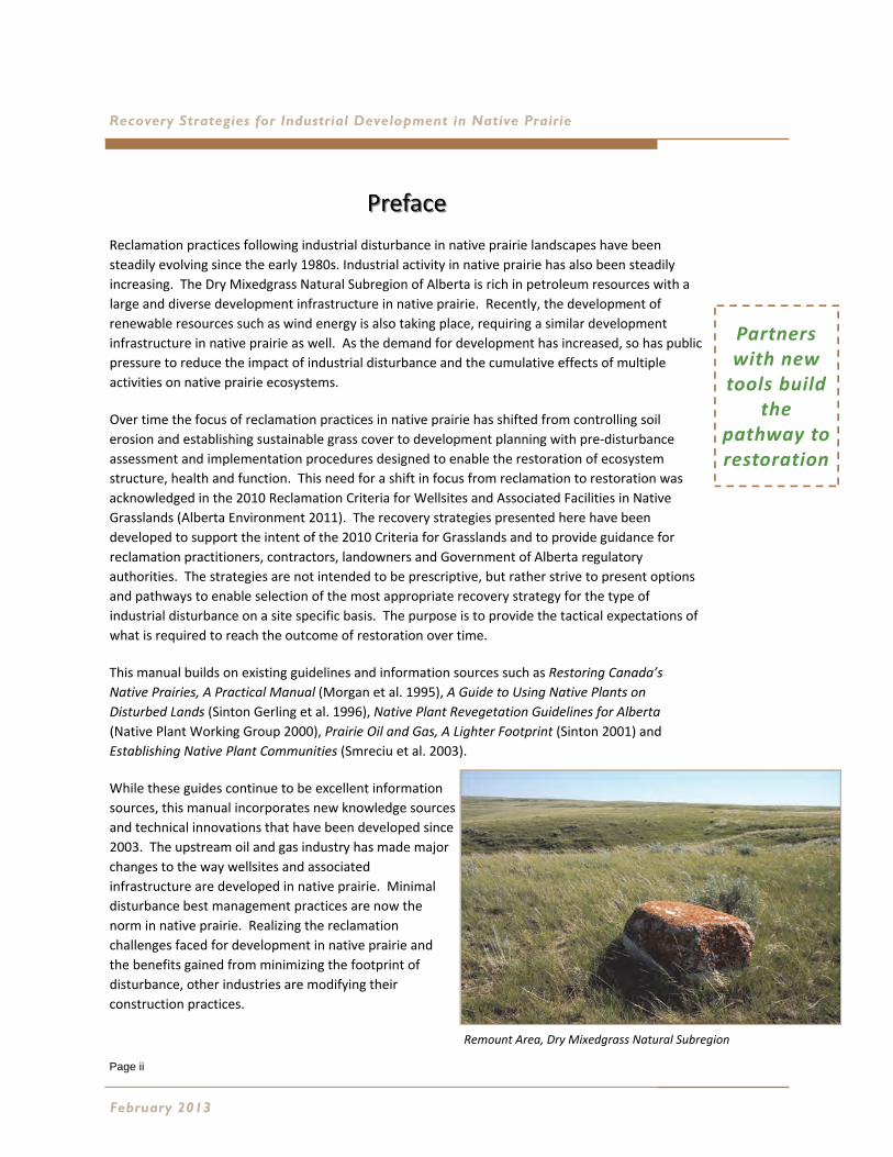
Remount Area, Dry Mixedgrass Natural Subregion
Page iii
Dry Mixedgrass Natural Subregion
The development of the Natural Regions and Subregions of Alberta (Natural Regions Committee 2006)
dichotomy as the first level of ecological classification in Alberta assists practitioners with the understanding of
restoration opportunities and limitations within the subregion context. The development of the Grassland
Vegetation Inventory, Range Plant Community Guides and Range Health Assessment protocol by the ESRD Range
Resource Management Program (RRMP) has greatly increased our understanding of native grassland
ecosystems. These tools were developed to facilitate a more complete understanding of the ability of native
plant communities to respond and adapt to natural disturbance regimes such as fire, grazing, drought, and
predation. These tools are now being applied to assess and manage man‐made disturbances. The tools are
incorporated into pre‐disturbance site assessment, development planning and reclamation certification for
native grasslands, creating the need for a tool which provides guidance on appropriate recovery strategies for
each natural subregion. These guidelines focus on recovery strategies for the Dry Mixedgrass Natural Subregion.
This document is the first in a series of new guideline documents that will eventually address all natural
subregions within the Grassland Natural Region. Projects are underway through the partnership established
with the Petroleum Technology Alliance Canada (PTAC) to capture the key experience and learnings that have
accumulated over the past 10 to 20 year period since minimum disturbance practice was first established. A
literature search for research projects and related information on restoration of grassland plant communities has
been initiated for this project and is ongoing for future projects. A bibliography, links, and abstracts will be
compiled by Natural Subregion and posted in the information portal on the Foothills Restoration Forum website
at: http://www.foothillsrestorationforum.ca/
This manual is presented as a first approximation recognizing that revision will be required as our knowledge of
native prairie plant communities and their response to recovery to industrial disturbance increases. Revision will
also be required as reclamation practitioners use this approximation and industry responds to the challenges of
native plant community restoration with new technology designed to reduce the industrial footprint in native
prairie landscapes.
The Dry Mixedgrass Natural Subregion is unique in the challenges it offers to industrial development. The semi‐
arid climate supports native plant communities uniquely adapted to drought and often adverse soil growing
conditions. Minimizing the soil disturbance and natural recovery are the most effective strategies for restoring
native plant communities in the Dry Mixedgrass. Alternate strategies for large disturbances not suited to natural
recovery and severely degraded sites are defined and discussed in the context of the restoration tools and recent
publications.
Preface
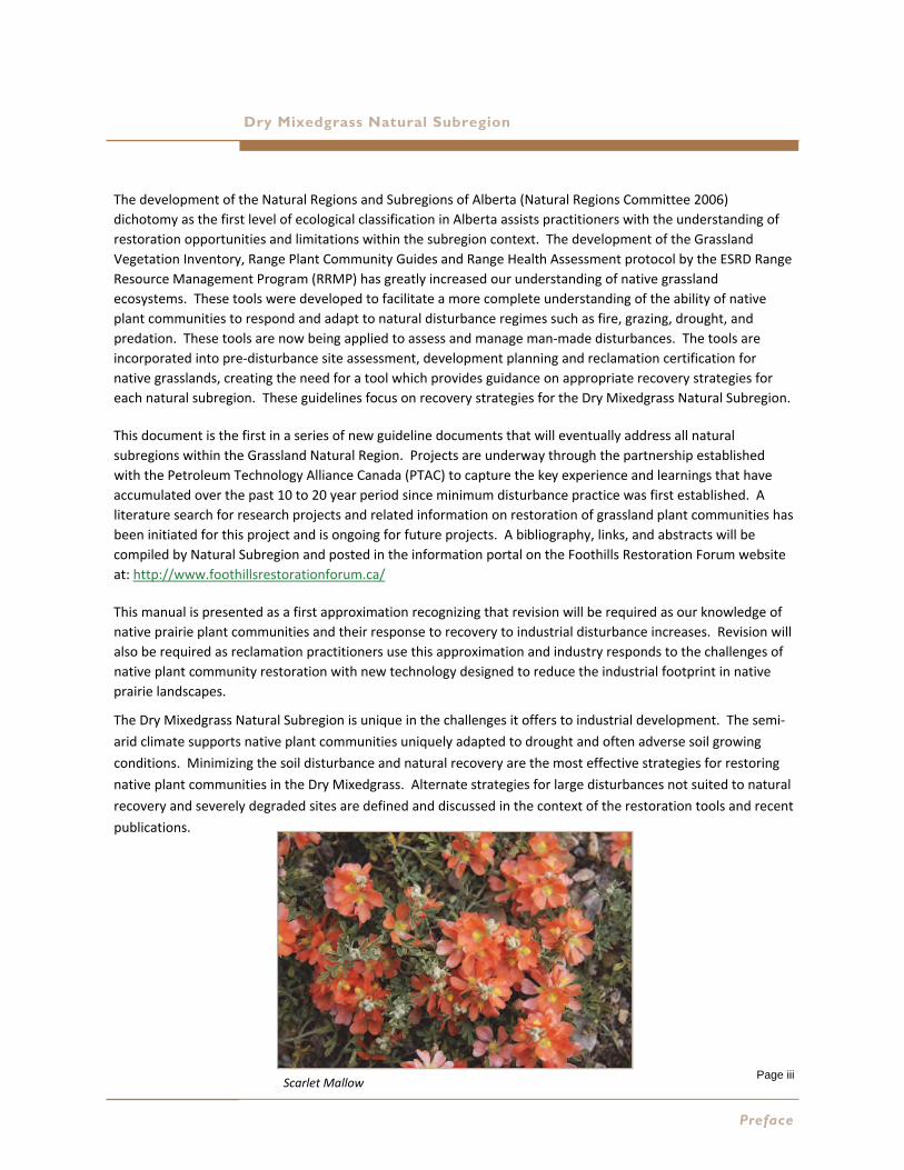
Scarlet Mallow
Page iv
Recovery Strategies for Industrial Development in Native Prairie
Table of ContentsTable of Contents 1 A SHIFT IN FOCUS TO RESTORATION………………………………………………………………………………….11
2 OVERVIEW OF DRY MIXEDGRASS NATURAL SUBREGION…………………………………………….….……..13
Physiography, Climate, Soils and Vegetation of the DMG Natural Subregion……………..13
Types of Industrial Activity………………………………………………………………………………………...15
Managing Surface Disturbance………………………………………………………………………………….15
3 TOOLS FOR THE RESTORATION TOOLBOX…………………………………………………………………….……..21
Grassland Vegetation Inventory………………………………………………………………………………...21
Range Plant Community Guides………………………………………………………………………………...21
Range Health Assessment………………………………………………………………………………………….22
Ecological Site Restoration Risk Analysis…………………………………………………………………….24
4 PROMOTING NATIVE PLANT COMMUNITY SUCCESSION…………………………………………………………27
Reflecting on Past History…………………………………………………………………………………………..27
Understanding the Process of Succession…………………………………………………………………..30
Industrial Disturbance and the Process of Plant Community Succession……………………..32
5 PREPARING THE PATHWAY………………………………………………………………………………………………33
Planning to Reduce Disturbance………………………………………………………………………………...33
Pre‐Disturbance Site Assessment……………………………………………………………………33
Incorporating Local Knowledge…………………….……………………………………………..…37
Selecting the Recovery Strategy……………………………………………………………...………………...40
Natural Recovery……………………………………………………………………………………………43
Assisted Natural Recovery……………………………………………………………………………...46
Use of Native Seed Mixes……………………………………………………………………………….48
Special Consideration for Lentic and Lotic Sites………………………………………………………….50
6 IMPLEMENTING THE STRATEGY………………………………………………………………………………………...51
Salvaging Native Plant Material Resources………………………………………………………….…....51
Site Preparation and Micro‐Contouring………………………………………………………………….….52
Recommended Timing of Restoration Activities…………………………………………………………53
Selecting Equipment to Suit the Strategy…………………………………………………………………..53
Guidelines for the Procurement of Native Seed……………………………………………..54
Guidelines for Wild Harvested Native Plant Material……………………………………..55
February 2013
Page v
Dry Mixedgrass Natural Subregion
7 MAINTAINING THE PATHWAY………………………………………………...………………………….…………….59
Colonizers, Weeds and Invasive Species Management………………….……………………………59
Grazing Management…………………………………………………………………..……………………………60
Monitoring Progress…………………………………………………………………………………………………..62
8 THE IMPORTANCE OF LONG‐TERM MONITORING…………………………………………………………………63
9 FUTURE RESEARCH REQUIRED…………………………………………………………………………………………..65
Recovery Strategies Feedback…….……………………………………….…………………………………….66
10 REFERENCES………………………………………………………………………………………………………………….67
Literature Cited………………………………………………………………………………………………………….67
Recent & Relevant Publications………..……………………………………………………………….……….69
APPENDIX A GLOSSARY OF TERMS………………………………………………………………………………………….71
APPENDIX B CASE STUDY OF EXPRESS PIPELINE ………………………………………………………………………..75
Why is Express Important?.............................................................................................75
Analysis of Long Term Recovery Using the Cumulative Dataset………………………………….76
Results – Dry Mixedgrass Seed Mixes …………………………………………………………….76
Results – Natural Recovery…………………………………………………………………………….80
Results – Plant Community Succession…………………………………………………………..80
Summary of Succession on Seeded Disturbed Topsoils…………………………………..85
Results – Range Health…………………………………………………………………………………..86
Results – Diversity After Disturbance……………………………………………………………..88
Management Recommendations……………………………………………………………………………….89
APPENDIX C TARGET RECOVERING PLANT COMMUNITIES……………………………………………………………91
Target Recovering Plant Community for Loamy, Shallow to Gravel and Gravel………....92
Target Recovering Plant Community for Blowout and Clayey Range Sites……………….…94
Target Recovering Plant Community for Sands, Sandy and Choppy Sandhill………………96
Target Recovering Plant Community for Thin Breaks and Limey Range Sites…………...100
Target Recovering Plant Community for Non‐saline Overflow Range Sites……………….102
Ecological Range Sites that are Unique in Species Composition…….…………….……………106
Final Step………………………………………………………………………………………………….….………….106
APPENDIX D SEEDING PATHWAYS…………………………………………………………………………………………107
Sourcing Native Plant Material………………………………………….……………………………….……107
Calculating Seeding Rates……………………………………………………………………………………..…109
Interpreting Reports of Seed Analysis ………………………………………………………………………127
Table of Contents
Page vi
Recovery Strategies for Industrial Development in Native Prairie
List of FiguresList of Figures Figure 1 ‐ Natural Subregions of Alberta……………………………………………………………………………………………………….18 Figure 2 ‐ Ecodistricts in the Dry Mixedgrass Natural Subregion…………………………………………………………………...19 Figure 3 ‐ Standardized Grassland Assessment Tools…………………………………………………………………………………….23 Figure 4 ‐ Drier is Better………………………………………………………………………………………………………………………………..25 Figure 5 ‐ Guidelines for Scoring Ecological Status………………………………………………………………………………………..31 Figure 6 ‐ Pre‐Disturbance Site Assessment Flowchart for Native Grassland Ecosystems………………………………34 Figure 7 ‐ Recovery Flow Chart for Non‐Linear Disturbances………………………………………………………………..……….41 Figure 8 ‐ Recovery Flow Chart for Linear Disturbances………………………………………………………………………………...42 Figure B1 ‐ Dry Mixedgrass Solonetzic Soil Seed Mix 4 – Species Cover Over Time………………………………………...78 Figure B2 ‐ Dry Mixedgrass Sandy Soil Seed Mix 3 ‐ Species Cover Over Time………………………………………………..79 Figure B3 ‐ Plant Community Succession on Disturbed Topsoil on DMG Solonetzic Ecological Range Sites…….82 Figure B4 ‐ Plant Community Succession on Dry Mixedgrass Loamy Ecological Range Sites ………………………….83 Figure B5 ‐ Plant Community Succession on Unseeded Topsoil on DMG Sandy Ecological Range Sites……..…..84 Figure B6 ‐ Ecological Status and Seral Stage of Reclaiming Sites on Disturbed Soils…………………………………....87 Figure C1 ‐ Target Recovering Plant Community for Loamy, Shallow to Gravel and Gravel Range Sites….…....93 Figure C2 ‐ Target Recovering Plant Community for Blowout and Clayey Range Sites……………………..………..….95 Figure C3 ‐ Target Recovering Plant Community for Sands, Sandy and Choppy Sandhill Range Sites…………....97 Figure C4 ‐ Target Recovering Plant Community for Important Sandy Range Site Outlier……………………………..99 Figure C5 ‐ Target Recovering Plant Community for Thin Breaks and Limey Range Sites……………………………..101 Figure C6 ‐ Target Recovering Plant Community for Non‐saline Overflow Range Sites………….…………………....103 Figure C7 ‐ Target Recovering Plant Community for Overflow Outlier Range Sites………………………………..…….105
List of TablesList of Tables Table 1 ‐ Functions of Healthy Rangelands……………………………………………………………………………………………….…..22 Table 2 ‐ Definitions of Successional Phases of Recovering Plant Communities……………………………………………..32 Table B1 ‐ Express Seed Mix 4 Dry Mixedgrass Prairie Solonetzic Soils…………………………………………………………..78 Table B2 ‐ Express Seed Mix 3 Dry Mixedgrass Prairie Sandy Soils……………………………………………………………..….79 Table B3 ‐ Definitions for Plant Community Seral Stages on Disturbed Topsoils…………………………………………….81 Table B4 ‐ Seral Stage on Unstripped Spoil and Travel Lane Sites after 14 Years…………………………………………...86 Table C1 ‐ Target Recovering Plant Community for Loamy, Shallow to Gravel and Gravel Range Sites….……...92 Table C2 ‐ Example Native Seed Mix for Loamy, Shallow to Gravel and Gravel Range Sites…………….…………....93 Table C3 ‐ Target Recovering Plant Community Table for Blowout and Clayey Range Sites…..……………….….….94 Table C4 ‐ Example Native Seed Mix for Blowout and Clayey Range Sites..………………………………………….……....95 Table C5 ‐ Target Recovering Plant Community for Sands, Sandy and Choppy Sandhill Range Sites……………...96 Table C6 ‐ Example Native Seed Mix for Sands, Sandy and Choppy Sandhill Range Sites………………………….…...97 Table C7 ‐ Target Recovering Plant Community for Important Sandy Range Site Outlier…………………………...….98 Table C8 ‐ DMGA13 Example Seed Mix………………………………………………………………………………………………………...99 Table C9 ‐ Target Recovering Plant Community Table for Thin Breaks and Limey Range Sites……………………..100 Table C10 ‐ Example Native Seed Mix for Thin Breaks and Limey Range Sites……………………………………………..101 Table C11 ‐ Target Recovering Plant Community Table for Non‐saline Overflow Range Sites………………….....102 Table C12 ‐ Example Native Seed Mix for Non‐saline Overflow Range Sites……………………………………….……....103 Table C13 ‐ DMGA 1 Target Recovering Plant Community……………………………………………………………………….….104 Table C14 ‐ DMGA 1 Example Native Seed Mix…………………………………………………………………………………………...105 Table C15 ‐ Ecological Range Sites that are Unique in Species Composition…………………………………………..……106
Tables & Figures

Page vii
Dry Mixedgrass Natural Subregion
Photo CreditsPhoto Credits
Cover Photos
Dry Mixedgrass Natural Subregion, Barry Adams, Rangeland Management Branch
Natural Recovery‐Hemaruka Dunes, Marilyn Neville, Gramineae Services Ltd.
Reduced Drilling Disturbance, Geoff Smith, ESRD, Public Lands, Medicine Hat
Preface
Remount, Dry Mixedgrass Natural Subregion, Jane Lancaster, Kestrel Research Inc.
Scarlet Mallow, Jane Lancaster, Kestrel Research Inc.
1‐A Shift in Focus to Restoration
Sage Flats, Sage Creek Grazing Reserve, Lorne Fitch
Sage Creek Grazing Reserve, Reduced Disturbance Avoids Riparian Zone with
Setback ; Located Next to Existing Disturbance, Lorne Fitch
2‐Overview of Dry Mixedgrass Natural Subregion
Milk River Canyon, Barry Adams, Rangeland Management Branch
Sage Grouse Habitat, Barry Adams, Rangeland Management Branch
Reduced Disturbance Wellsite, Geoff Smith, ESRD, Public Lands, Medicine Hat
4‐Promoting Native Plant Community Succession
Early Disturbance of Native Prairie, Dennis Milner, Medicine Hat
Glenbow Archives, Glenbow Museum, Calgary
Fragmentation of native plant communities; shadow effect from invasive crested
wheatgrass, Lorne Fitch
Pipeline with full RoW soil disturbance seeded to crested wheatgrass, Barry Adams,
Rangeland Management Branch
5‐Preparing the Pathway
Dry Mixedgrass Natural Subregion, Barry Adams, Rangeland Management Branch
Reduced Disturbance; Best Practices, Geoff Smith, ESRD, Public Lands, Medicine Hat
Manyberries Area; Pipeline Seeded with Native Plant Cultivars, Marilyn Neville,
Gramineae Services Ltd.
Reduced Disturbance Access Road, Natural Recovery, Manyberries Area; Reclaimed
Reduced Disturbance Wellsite, Natural Recovery, Pink Flag Indicates Well
Centre, Marilyn Neville, Gramineae Services Ltd.
Proposed Wellsite in Purple Springs Grazing Reserve, Marilyn Neville, Gramineae
Services Ltd.
Reclaimed Wellsite, Manyberries Area, Marilyn Neville, Gramineae Services Ltd.
Photo Credits
Page viii
Recovery Strategies for Industrial Development in Native Prairie
5‐Preparing the Pathway Continued...
Natural Recovery Wellsite; Disturbance Confined to Well Centre, Geoff Smith,
ESRD, Public Lands, Medicine Hat
Assisted Natural Recovery, Pipeline Seeded to Fall Rye & Flax; Koomati Area,
Marilyn Neville, Gramineae Services Ltd.
Wild Hay Harvester; mows and collects Native Hay; Wild Harvested Hay Spread on
Pipeline RoW; Minimal Disturbance to Ground Cover, Ron Johnson, Prairie
View Consulting
Pipeline Seeded with Wild Harvest Needle‐and‐Thread Grass, Gramineae Services Ltd.
Pipeline Avoids Lentic Seasonal; Cripple Creek Area, Lorne Fitch
6‐Implementing the Strategy
Sod Salvage, Jane Lancaster, Kestrel Research Inc.
Selaginella in Sod Replacement on Ditchline; A Roughened Surface Retains Moisture,
Marilyn Neville, Gramineae Services Ltd.
Wild Harvest of Native Grass Seed, Donna Watt, CorPirate Services
Wild Harvest Equipment; Alternating Rows; Separating Seeds; Drying Seeds; Bagged
and Ready for Storage, Marilyn Neville, Gramineae Services Ltd.
7‐Maintaining the Pathway
Lodged Native Grass Cultivars Seeded on Remote Sump; Cattle Grazing, Marilyn
Neville, Gramineae Services Ltd.
8‐The Importance of Long Term Monitoring
Jane Lancaster, Kestrel Research Inc., Marilyn Neville, Gramineae Services Ltd.
Dry Mixedgrass Monitoring, Hemaruka Dunes, Example from Express Pipeline
Monitoring, Jane Lancaster and Marilyn Neville
9‐Future Research Required
Marilyn Neville, Gramineae Services Ltd.
February 2013

Page ix
Dry Mixedgrass Natural Subregion
AbbreviationsAbbreviations ACIMS……………………………………………………………………………..Alberta Conservation Information Management System
AENV…………………………………………………………………………………………………………………………………….Alberta Environment
AGRASID……………………………………………………………………….Agricultural Region of Alberta Soil Information Database
AI……………………………………………………………………………………..Alberta Innovates (Formerly Alberta Research Council)
CFB……………………………………………………………………………………………………………………………………..Canadian Forces Base
cm………………………………………………………………………………………………………………………………………………………..centimetre
DMG……………………………………………………………………………………………………………………………………………...Dry Mixedgrass
EAP……………………………………………………………………………………………………………………………..Enhanced Approval Process
EPP………………………………………………………………………………………………………………………..Environmental Protection Plan
ERCB………………………………………………………………………………………………….……….Energy Resources Conservation Board
ERS………………………………………………………………………………………………………………………………………..Ecological Range Site
ESRD……………………………………………………………………...Alberta Environment and Sustainable Resource Development
ESRRA……………………………………………………………………………………………………...Ecological Site Restoration Risk Analysis
Express………………………………………………………………………………………………………………………………………...Express Pipeline
FRF……………………………………………………………………………………………………………………………..Foothills Restoration Forum
FWMIS…………………………………………..……………………………………...Fish and Wildlife Management Information System
g…………………………………………………………………………………………………………………………………………………………………….gram
GPS………………………………………………………………………………………………………………………………..global positioning system
GVI……………………………………………………………………………………………………………………….Grassland Vegetation Inventory
Ha……………………………………………………………………………………………………………………………………………………………...hectare
IL……………………………………………………………………………………………………………………………………………….Information Letter
Kg…………………………………………………………………………………………………………………………………………………………….kilogram
Km………………………………………………………………………………………………………………………………………………………….kilometre
LAT…………………………………………………………………………………………………………………………………..Landscape Analysis Tool
m………………………………………………………………………………………………………………………………………………………………….metre
NSR…………………………………………………………………………………………………………………………………………...Natural Subregion
PLS………………………………………………………………………………………………………………………………………………….Pure Live Seed
PNC………………………………………………………………………………………………………………………….Potential Natural Community
PNT…………………………………………………………………………………………………………………………………………Protective Notation
PTAC………………………………………………………………………………………………………...Petroleum Technology Alliance Canada
RoW…………………………………………………………………………………………………………………………………………………...right‐of‐way
RPC…………………………………………………………………………………………………………………………….Reference Plant Community
RRMP……………………………………………………………………………………………………….Range Resource Management Program
wt……………………………………………………………………………………………………………………………………………………………….weight
Abbreviations

Page x
Page 11
Recovery Strategies for Industrial Development in Native Prairie Dry Mixedgrass Natural Subregion
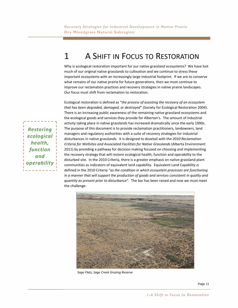
1 A SHIFT IN FOCUS TO RESTORATION Why is ecological restoration important for our native grassland ecosystems? We have lost
much of our original native grasslands to cultivation and we continue to stress these
important ecosystems with an increasingly large industrial footprint. If we are to conserve
what remains of our native prairie for future generations, then we must continue to
improve our reclamation practices and recovery strategies in native prairie landscapes.
Our focus must shift from reclamation to restoration.
Ecological restoration is defined as “the process of assisting the recovery of an ecosystem
that has been degraded, damaged, or destroyed” (Society for Ecological Restoration 2004).
There is an increasing public awareness of the remaining native grassland ecosystems and
the ecological goods and services they provide for Albertan’s. The amount of industrial
activity taking place in native grasslands has increased dramatically since the early 1990s.
The purpose of this document is to provide reclamation practitioners, landowners, land
managers and regulatory authorities with a suite of recovery strategies for industrial
disturbances in native grasslands. It is designed to dovetail with the 2010 Reclamation
Criteria for Wellsites and Associated Facilities for Native Grasslands (Alberta Environment
2011) by providing a pathway for decision making focused on choosing and implementing
the recovery strategy that will restore ecological health, function and operability to the
disturbed site. In the 2010 Criteria, there is a greater emphasis on native grassland plant
communities as indicators of equivalent land capability. Equivalent Land Capability is
defined in the 2010 Criteria “as the condition in which ecosystem processes are functioning
in a manner that will support the production of goods and services consistent in quality and
quantity as present prior to disturbance”. The bar has been raised and now we must meet
the challenge.
Restoring ecological health, function
and operability
1-A Shift in Focus to Restoration
Sage Flats, Sage Creek Grazing Reserve
Page 12
Recovery Strategies for Industrial Development in Native Prairie
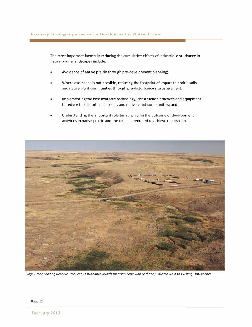
The most important factors in reducing the cumulative effects of industrial disturbance in
native prairie landscapes include:
Avoidance of native prairie through pre‐development planning;
Where avoidance is not possible, reducing the footprint of impact to prairie soils
and native plant communities through pre‐disturbance site assessment;
Implementing the best available technology, construction practices and equipment
to reduce the disturbance to soils and native plant communities; and
Understanding the important role timing plays in the outcome of development
activities in native prairie and the timeline required to achieve restoration.
February 2013
Sage Creek Grazing Reserve, Reduced Disturbance Avoids Riparian Zone with Setback ; Located Next to Existing Disturbance
Page 13
Recovery Strategies for Industrial Development in Native Prairie Dry Mixedgrass Natural Subregion
2 OVERVIEW OF DRY MIXEDGRASS
NATURAL SUBREGION The first step in restoration planning requires an understanding of Alberta’s regional
ecological land classification system. The Natural Regions and Subregions of Alberta have
provided the provincial ecological context within which resource management activities
have been planned and implemented since the 1970s. The current revision entitled
“Natural Regions and Subregions of Alberta” (Natural Regions Committee 2006) builds on
two previous classifications: Ecoregions of Alberta (Strong and Leggat 1992) and Natural
Regions and Subregions and Natural History Themes of Alberta (Achuff 1994). Copies of
the current revision are available at: http://www.tpr.alberta.ca/parks/heritageinfocentre/
docs/NRSRcomplete%20May_06.pdf
It is important to understand the ecological diversity of the Grassland Natural Region and
the unique restoration challenges offered in each Natural Subregion. The Natural
Subregion dichotomy is the first level of ecological classification in Alberta and assists
practitioners with the understanding of restoration opportunities and limitations within the
subregion context. This publication focuses on the Dry Mixedgrass Natural Subregion.
Physiography, Climate, Soils and Vegetation of the Dry
Mixedgrass Natural Subregion
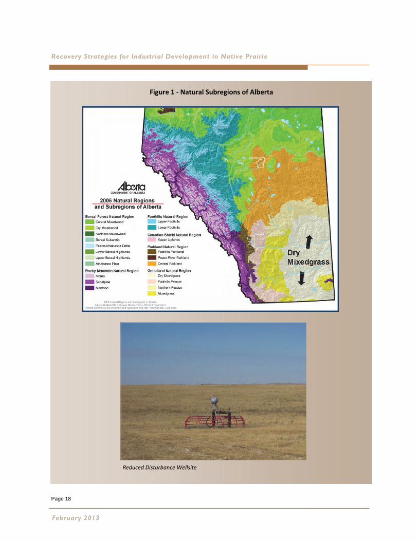
The Dry Mixedgrass Natural Subregion (Dry Mixedgrass) occupies a large area of the
southeastern corner of Alberta (Figure 1). It is an expanse of level to gently undulating
semi‐arid prairie, broken in places by coulees, valleys, badlands and dune fields. The native
grasslands and associated land forms support a rich biodiversity of species, including
habitat for multiple Species at Risk and their gene pool.
The Dry Mixedgrass has the warmest summers, longest growing season and lowest
precipitation of any Natural Subregion of Alberta. Drying winds, low summer precipitation,
high summer temperatures and intense sunshine contribute to significant soil moisture
deficits. Agricultural crop production is largely dependent on irrigation. Hard lessons were
learned by the early settlers who broke the prairie soils and tried to dryland farm.
Reclamation and revegetation of industrial disturbances is also difficult when the
protective prairie vegetation is destroyed and the soils disturbed. However, the semi‐arid
growing conditions of the Dry Mixedgrass provide a less favorable growing environment for
many invasive non‐native species permitting better restoration outcomes than in more
moist climates. So, in the Dry Mixedgrass, aridity can be viewed as assisting restoration
outcomes.
2-Overview of Dry Mixedgrass Natural Subregion
The Dry Mixedgrass has
the warmest summers,
longest growing season and
lowest precipitation of
any Natural Subregion of
Alberta
Page 14
Recovery Strategies for Industrial Development in Native Prairie
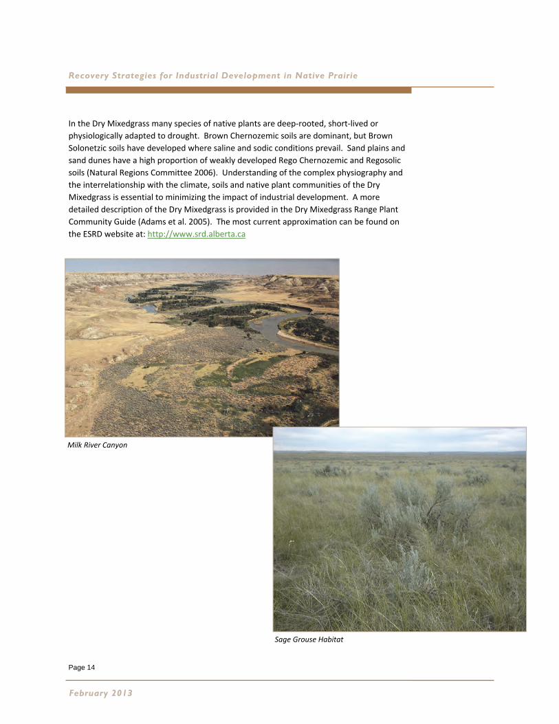
In the Dry Mixedgrass many species of native plants are deep‐rooted, short‐lived or
physiologically adapted to drought. Brown Chernozemic soils are dominant, but Brown
Solonetzic soils have developed where saline and sodic conditions prevail. Sand plains and
sand dunes have a high proportion of weakly developed Rego Chernozemic and Regosolic
soils (Natural Regions Committee 2006). Understanding of the complex physiography and
the interrelationship with the climate, soils and native plant communities of the Dry
Mixedgrass is essential to minimizing the impact of industrial development. A more
detailed description of the Dry Mixedgrass is provided in the Dry Mixedgrass Range Plant
Community Guide (Adams et al. 2005). The most current approximation can be found on
the ESRD website at: http://www.srd.alberta.ca
February 2013
Milk River Canyon
Sage Grouse Habitat

Page 15
Dry Mixedgrass Natural Subregion
Types of Industrial Activity
There are numerous types of industrial activities operating in the native grassland ecosystems of the Dry
Mixedgrass. Currently, the Dry Mixedgrass has the highest density of producing natural gas wells, oil wells
and the associated infrastructure in the province. There are also several large diameter pipeline corridors
crossing extensive tracts of native grassland. Coal is strip mined to create electricity and gravel is extracted to
construct and maintain transportation corridors. Agriculture was historically the dominant land use, and the
ranching industry continues to utilize native grasslands for livestock production.
Recently the quest to develop renewable forms of energy has seen the development of wind farms and the
upgrading of electrical transmission corridors. The cumulative effects of industrial activity in the Dry
Mixedgrass are significant and the long term impact of surface soil disturbance on the ecological integrity of
these grasslands is not well understood.
Managing Surface Disturbance
The importance of managing surface disturbance and maintaining the integrity of native plant communities
during industrial development in native prairie has been formally recognized since 1992. The following
information letters, principles and guidelines have been developed by collaborative stakeholder working
groups for the Energy Resources Conservation Board (ERCB) http://www.ercb.ca/
IL 92IL 92‐‐12 (ERCB IL9212 (ERCB IL92‐‐12) (Rescinded and replaced by ERCB IL200212) (Rescinded and replaced by ERCB IL2002‐‐1)1)
This information letter informed industry that agronomic grasses could not be used in reclamation seed mixes
in native prairie.
IL 96IL 96‐‐9 Revised Guidelines for Minimizing Disturbance in Native Prairie (ERCB IL 969 Revised Guidelines for Minimizing Disturbance in Native Prairie (ERCB IL 96‐‐9); and9); and
IL 2002IL 2002‐‐1 Principles for Minimizing Surface Disturbance in Native 1 Principles for Minimizing Surface Disturbance in Native
Prairie and Parkland Areas (ERCB IL 2002Prairie and Parkland Areas (ERCB IL 2002‐‐1)1)
These information letters informed industry of the importance of
native prairie and parkland areas and the need to minimize surface
disturbance through all phases of development activities when
undertaking development activities in these area. IL 2002‐1
recognizes the importance of the Parkland Natural Region.
2-Overview of Dry Mixedgrass Natural Subregion
Page 16
Recovery Strategies for Industrial Development in Native Prairie
Petroleum Industry Activity in Native Prairie and Parkland Areas, Guidelines for Minimizing Petroleum Industry Activity in Native Prairie and Parkland Areas, Guidelines for Minimizing
Surface Disturbance (Native Prairie Guidelines Working Group 2002)Surface Disturbance (Native Prairie Guidelines Working Group 2002)
This document was prepared by a working group comprised of representatives
from government agencies having jurisdiction over petroleum industry
activities in native prairie and parkland areas. It provides specific direction for
all phases of petroleum development activity including seismic and geophysical
programs. Key general guidelines include:
Avoidance of native prairie and parkland landscapes if at all possible;
The use of previously disturbed areas such as existing access roads and prairie trails; and
Indicates the requirement for special planning measures, field based
environmental assessments, minimal disturbance construction techniques
and the use of native plant materials or natural recovery during site
reclamation. The importance of weed control is emphasized and
environmental monitoring is recommended.
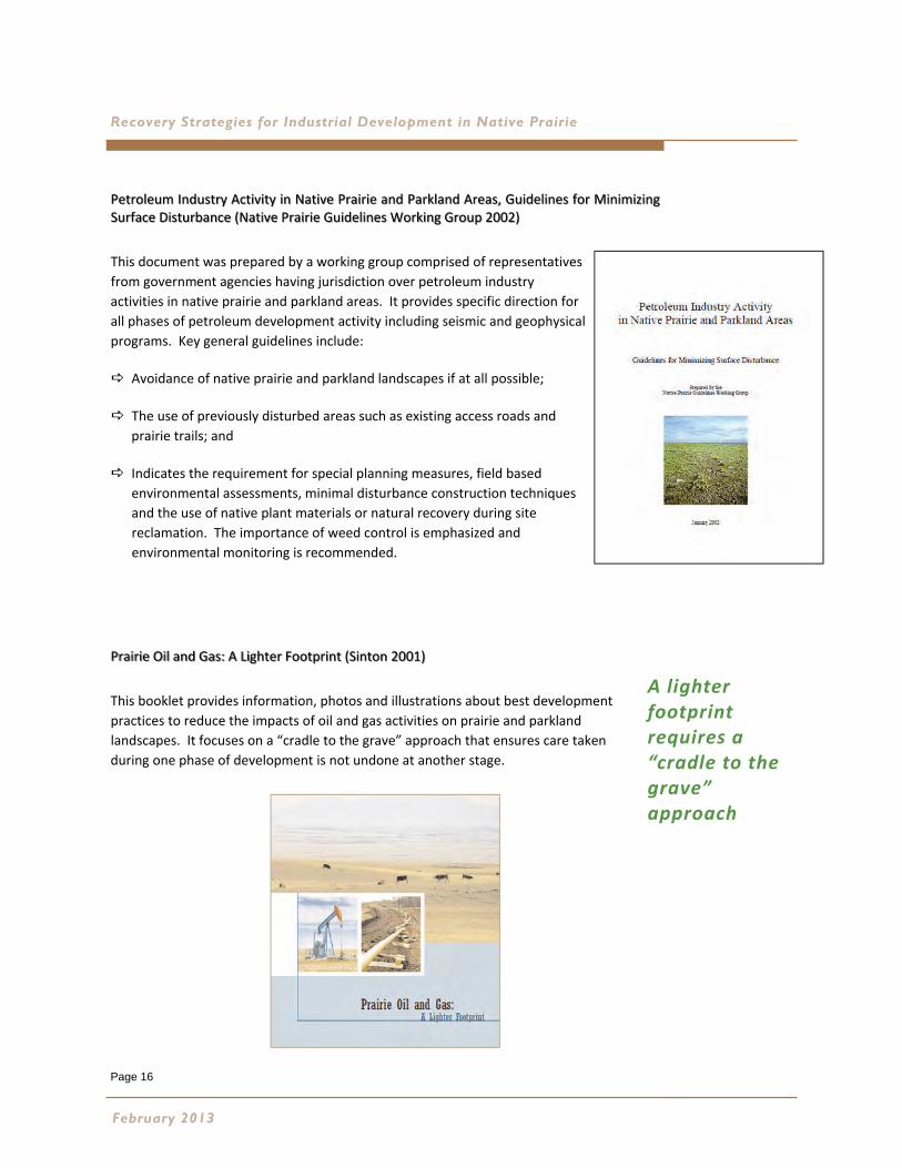
Prairie Oil and Gas: A Lighter Footprint (Sinton 2001)Prairie Oil and Gas: A Lighter Footprint (Sinton 2001)
This booklet provides information, photos and illustrations about best development
practices to reduce the impacts of oil and gas activities on prairie and parkland
landscapes. It focuses on a “cradle to the grave” approach that ensures care taken
during one phase of development is not undone at another stage.
February 2013
A lighter footprint requires a “cradle to the grave” approach
Page 17
Dry Mixedgrass Natural Subregion
2-Overview of Dry Mixedgrass Natural Subregion
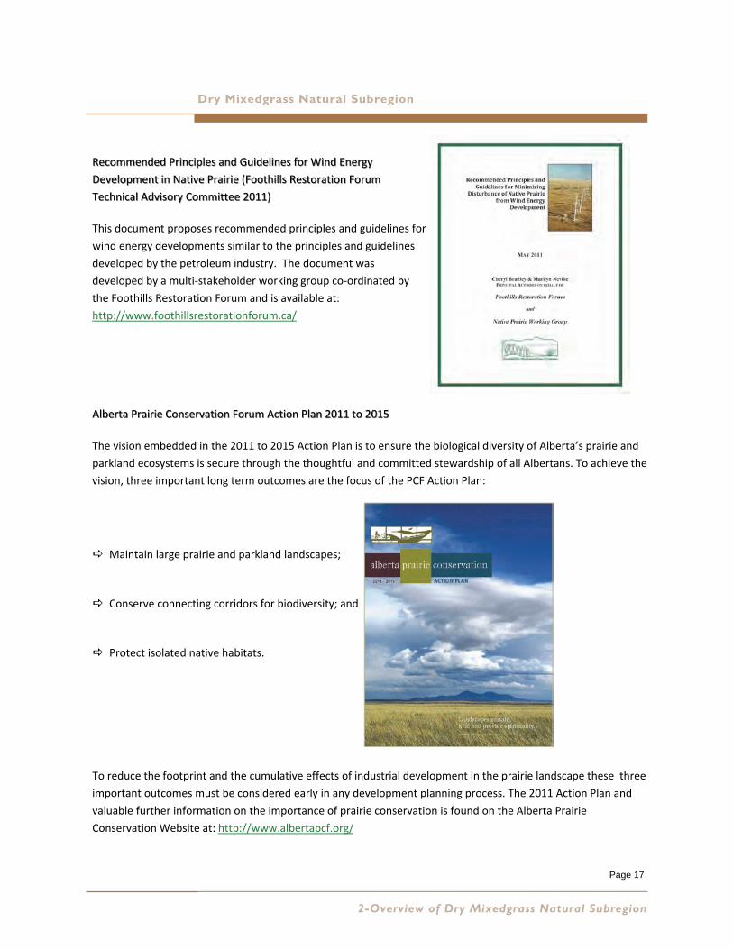
Recommended Principles and Guidelines for Wind Energy Recommended Principles and Guidelines for Wind Energy
Development in Native Prairie (Foothills Restoration Forum Development in Native Prairie (Foothills Restoration Forum
Technical Advisory Committee 2011)Technical Advisory Committee 2011)
This document proposes recommended principles and guidelines for
wind energy developments similar to the principles and guidelines
developed by the petroleum industry. The document was
developed by a multi‐stakeholder working group co‐ordinated by
the Foothills Restoration Forum and is available at:
http://www.foothillsrestorationforum.ca/
Alberta Prairie Conservation Forum Action Plan 2011 to 2015Alberta Prairie Conservation Forum Action Plan 2011 to 2015
The vision embedded in the 2011 to 2015 Action Plan is to ensure the biological diversity of Alberta’s prairie and
parkland ecosystems is secure through the thoughtful and committed stewardship of all Albertans. To achieve the
vision, three important long term outcomes are the focus of the PCF Action Plan:
Maintain large prairie and parkland landscapes;
Conserve connecting corridors for biodiversity; and
Protect isolated native habitats.
To reduce the footprint and the cumulative effects of industrial development in the prairie landscape these three
important outcomes must be considered early in any development planning process. The 2011 Action Plan and
valuable further information on the importance of prairie conservation is found on the Alberta Prairie
Conservation Website at: http://www.albertapcf.org/
Page 18
Recovery Strategies for Industrial Development in Native Prairie
February 2013
Reduced Disturbance Wellsite
Figure 1 ‐ Natural Subregions of Alberta
Page 19
Dry Mixedgrass Natural Subregion
2-Overview of Dry Mixedgrass Natural Subregion
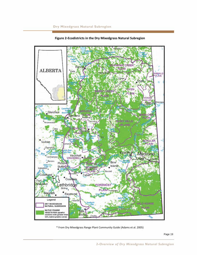
Figure 2‐Ecodistricts in the Dry Mixedgrass Natural Subregion
* From Dry Mixedgrass Range Plant Community Guide (Adams et al. 2005)

Page 20
Recovery Strategies for Industrial Development in Native Prairie
February 2013
Page 21
Recovery Strategies for Industrial Development in Native Prairie Dry Mixedgrass Natural Subregion
3 TOOLS FOR THE RESTORATION TOOLBOX Implementing improved recovery strategies involves not just practice change on the ground but also
utilizing many new tools designed to understand site characteristics and plant communities linked to
landforms and soils. These tools will improve reclamation best practices and restoration potential at all
stages of development, from pre‐development planning through long term monitoring to evaluating
reclamation and restoration success.
Grassland Vegetation Inventory
The Grassland Vegetation Inventory (GVI) represents the Government of Alberta’s first comprehensive
biophysical vegetation and anthropogenic inventory of the Grassland Natural Region. GVI provides
mapped information of landscape scale soil/landform features and vegetation cover for use in planning
and management of rangelands, fish and wildlife, wetlands, land use and reclamation. Developed by
ESRD, the Grassland Vegetation Inventory is comprised of ecological range sites based on soils and
vegetation information for areas of native vegetation and general land use for non‐native areas
(agricultural, industrial, and urban areas). It also includes a coarse hydrological layer or features. A user
manual entitled “Specifications for the Use and Capture of Grassland Vegetation Inventory (GVI) Data 5th
Edition” (Alberta Sustainable Resource Development and LandWise Inc. 2011) is available on the web.
GVI data is available either by contacting the Resource Information Management Branch Data
Distribution (ESRD) or obtaining website information from:
http://www.srd.alberta.ca/MapsPhotosPublications/Maps/ResourceDataProductCatalogue/
ForestVegetationInventories.aspx and http://www.albertapcf.org/
Range Plant Community Guides
The Dry Mixedgrass Range Plant Community Guide is an essential reference for conducting range health
assessments in the Dry Mixedgrass Natural Subregion of Alberta. The guide provides plant community
descriptions by ecological range site, which can be linked to the GVI site types. The plant community
that is an expression of site potential is referred to as the reference plant community (RPC) since it
represents the potential natural community for comparison in range health assessment. The plant
community guides have been compiled from data collected from detailed vegetation inventories and the
extensive system of reference areas established across the province by the ESRD Range Resource
Management Program. The guides are available on the ESRD website and are updated on a regular basis
as new data is gathered.
http://srd.alberta.ca/LandsForests/GrazingRangeManagement/documents/
DryMixedgrassSubregionAssessmentGuidelines.pdf
3-Tools for the Restoration Toolbox

Page 22
Recovery Strategies for Industrial Development in Native Prairie
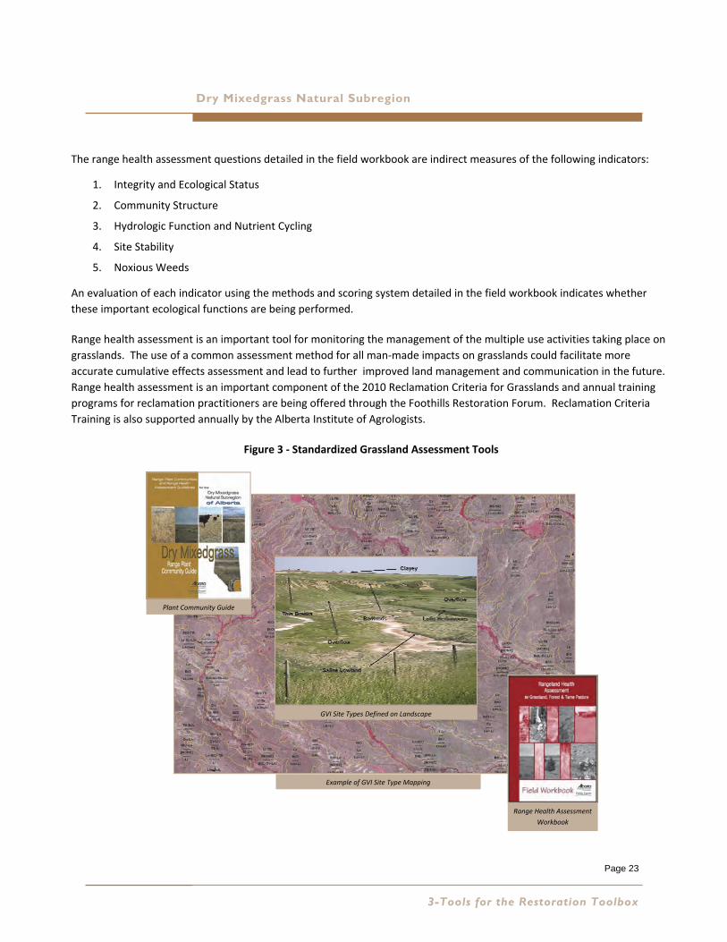
Range Health Assessment
The Range Health Assessment protocol and the Range Health Assessment Field Workbook developed by the ESRD –
RRMP have been used to assess, monitor and manage Alberta’s rangeland since 2003. The field workbook is
available on the web at:
http:////srd.alberta.ca/LandsForests/GrazingRangeManagement/documents/
RangelandHealthAssessmentforGrasslandForestTamePasture‐Revised‐Apr2009.pdf
The assessment approach builds on the traditional range condition concept that considers plant community type in
relation to site potential, but adds new and important indicators of natural processes and functions. The
methodology provides a visual system that allows users to readily see changes in range health and to provide early
warning when management changes are needed.
Range health is defined as the ability of rangeland to perform certain key functions. These functions include: net
primary production, maintenance of soil/site stability, capture and beneficial release of water, nutrient and energy
cycling, and functional diversity of plant species. Table 1 (reproduced below) from the Range Health Field Workbook
describes the functions of healthy rangelands and why they are important.
Table 1 – Functions of Healthy Rangelands
Rangeland Functions Why Is the Function Important?
Productivity Healthy range plant communities are very efficient in utilizing available
energy and water resources in the production of maximum biomass
Forage production for livestock and wildlife
Consumable products for all life forms (e.g. insects, decomposers etc.)
Site Stability Maintain the potential productivity of rangelands
Protect soils that have taken centuries to develop
Supports stable long‐term biomass production
Capture and Beneficial Release
of Water
Storage, retention and slow release of water
More moisture available for plant growth and other organisms
Less runoff and potential for soil erosion
More stable ecosystem during drought
Nutrient Cycling Conservation and recycling of nutrients available for plant growth
Rangelands are thrifty systems not requiring the input of fertilizer
Plant Species Diversity Maintains a diversity of grasses, forbs, shrubs and trees
Supports high quality forage plants for livestock and wildlife
Maintains biodiversity, the complex web of life
February 2013
Page 23
Dry Mixedgrass Natural Subregion
The range health assessment questions detailed in the field workbook are indirect measures of the following indicators:
1. Integrity and Ecological Status
2. Community Structure
3. Hydrologic Function and Nutrient Cycling
4. Site Stability
5. Noxious Weeds
An evaluation of each indicator using the methods and scoring system detailed in the field workbook indicates whether
these important ecological functions are being performed.
Range health assessment is an important tool for monitoring the management of the multiple use activities taking place on
grasslands. The use of a common assessment method for all man‐made impacts on grasslands could facilitate more
accurate cumulative effects assessment and lead to further improved land management and communication in the future.
Range health assessment is an important component of the 2010 Reclamation Criteria for Grasslands and annual training
programs for reclamation practitioners are being offered through the Foothills Restoration Forum. Reclamation Criteria
Training is also supported annually by the Alberta Institute of Agrologists.
Figure 3 ‐ Standardized Grassland Assessment Tools
3-Tools for the Restoration Toolbox
Plant Community Guide
Range Health Assessment
Workbook
GVI Site Types Defined on Landscape
Example of GVI Site Type Mapping
Page 24
Recovery Strategies for Industrial Development in Native Prairie
Ecological Site Restoration Risk Analysis
The Ecological Site Restoration Risk Analysis (ESRRA) is a pathway for determining the
ability of the components of an ecological range site to recover from the direct impact of
industrial activity. This involves an understanding of the characteristics of the site, soils,
landscape type, moisture regime and associated plant community. The ESRRA report,
prepared by ESRD –RRMP in consultation with ESRD Rangeland Agrologists and Land Use
Specialists can be found in the information portal on the Foothills Restoration Forum
website at http://ww.foothillsrestorationforum.ca/
In the Dry Mixedgrass the following factors affect restoration potential:
1. Climatic processes such as available moisture and temperature during the critical periods of germination and
emergence. In the Dry Mixedgrass available moisture is the limiting factor. There may be sufficient moisture in
the spring to facilitate germination, however seedling mortality can occur due to a lack of sufficient moisture
during the critical emergence stage.
2. The resistance the site can afford to non‐native species invasion. Non‐native species of concern include
Prohibited Noxious and Noxious Weeds listed under the Alberta Weed Control Act and aggressive agronomic
species such as crested wheatgrass and sweet clover. Aggressive non‐native grass species such as downy brome
and Japanese brome are of particular concern in the Dry Mixedgrass due to their adaptation to semi arid
conditions and disturbed soils. It has been observed that within the Grassland Natural Region the potential for
non‐native species invasion on disturbed upland soils decreases as soil fertility, topsoil depths and soil moisture
decreases. For example, the Black loamy soils of the Foothills Fescue Natural Subregion are much more prone to
non‐native species invasion than the more drought‐prone climatic conditions and Brown soils of the Dry
Mixedgrass Natural Subregion. The same characteristics of soils, landscape type, moisture regime and associated
plant community can be applied at the ecological range site level. For example within the Dry Mixedgrass,
Overflow range sites are more prone to non‐native species invasion than Sands or Blowout range sites.
3. The total area of the development footprint, the amount of development related soil disturbance and the extent
that the native plant communities are fragmented within the footprint are interrelated factors which affect the
restoration potential.
4. The potential for accelerated soil erosion beyond what would normally occur under undisturbed conditions varies
according to the soil and landscape characteristics of the ecological range site. Factors include soil texture,
landscape position, slope and the amount of bare soil present in the reference plant community.
February 2013
Restoration Risk will affect your potential Restoration Outcome
Page 25
Dry Mixedgrass Natural Subregion
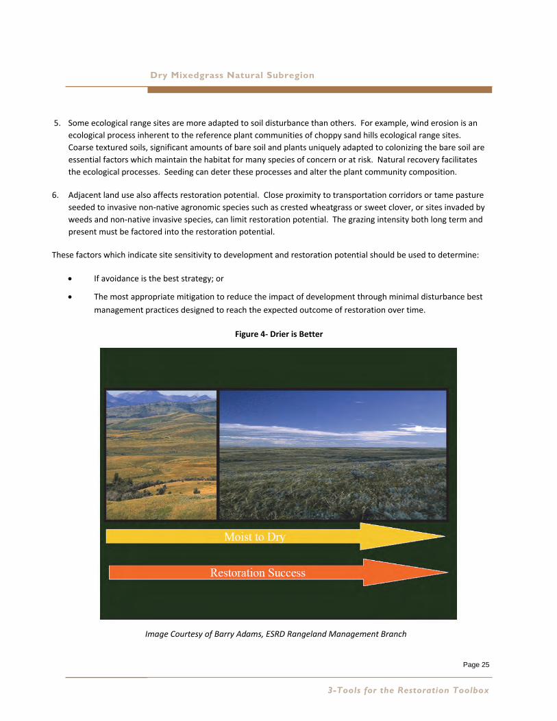
5. Some ecological range sites are more adapted to soil disturbance than others. For example, wind erosion is an
ecological process inherent to the reference plant communities of choppy sand hills ecological range sites.
Coarse textured soils, significant amounts of bare soil and plants uniquely adapted to colonizing the bare soil are
essential factors which maintain the habitat for many species of concern or at risk. Natural recovery facilitates
the ecological processes. Seeding can deter these processes and alter the plant community composition.
6. Adjacent land use also affects restoration potential. Close proximity to transportation corridors or tame pasture
seeded to invasive non‐native agronomic species such as crested wheatgrass or sweet clover, or sites invaded by
weeds and non‐native invasive species, can limit restoration potential. The grazing intensity both long term and
present must be factored into the restoration potential.
These factors which indicate site sensitivity to development and restoration potential should be used to determine:
If avoidance is the best strategy; or
The most appropriate mitigation to reduce the impact of development through minimal disturbance best
management practices designed to reach the expected outcome of restoration over time.
Figure 4‐ Drier is Better
Image Courtesy of Barry Adams, ESRD Rangeland Management Branch
3-Tools for the Restoration Toolbox

Page 26
February 2013
Page 27
Recovery Strategies for Industrial Development in Native Prairie Dry Mixedgrass Natural Subregion
4 PROMOTING NATIVE PLANT COMMUNITY
SUCCESSION
Reflecting on Past History
Prior to the European settlement of the Canadian prairies, a number of key ecosystem processes shaped the
native prairie landscape, (Bradley and Wallis 1996). Chief among these were recurring drought, grazing and fire.
These naturally occurring ecosystem processes were in balance, each providing a specific function that
maintained a cycle of adaptation and renewal within the system over time.
Human development activity since the early 1900’s has resulted in increased levels of surface soil disturbance
due to cultivation for agricultural crop production. Cultivation was not a feature of the natural system.
Following the extensive cultivation and abandonment of prairie landscapes, Canadian plant ecologist Robert
Coupland observed recovery of native plant communities in approximately 20 years depending on the size of the
cultivated area, distance to the supply of native seed stock, the degree of aridity of the years following, and
duration of tillage (Coupland 1961). However the recovery of the groundcover structural layer composed of
moss and lichen in the Dry Mixedgrass appears to take much longer. Large areas of south eastern Alberta,
especially in the Special Areas, have recovered to native grasslands, having once been abandoned cultivation
during the dustbowl conditions of the 1920s and 1930s.
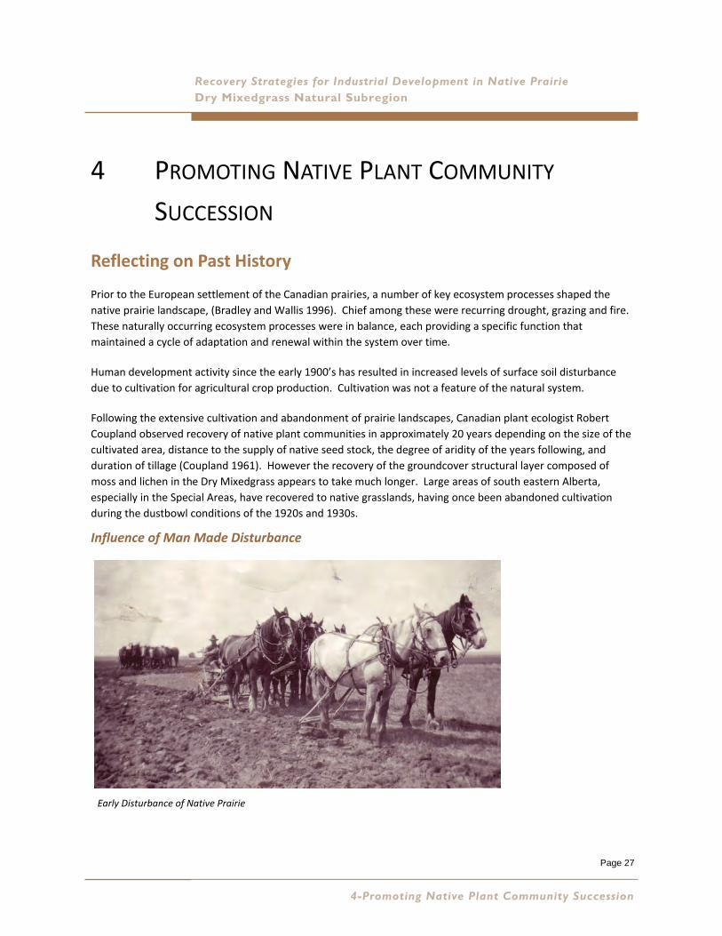
Influence of Man Made Disturbance
4-Promoting Native Plant Community Succession
Early Disturbance of Native Prairie
Page 28
Recovery Strategies for Industrial Development in Native Prairie
The history of reclamation in the grasslands of Alberta can be divided into four periods:
PrePre‐‐ 19721972
There was little in the way of policy and regulation. Soil handling was not
defined and most disturbances were allowed to recover naturally.
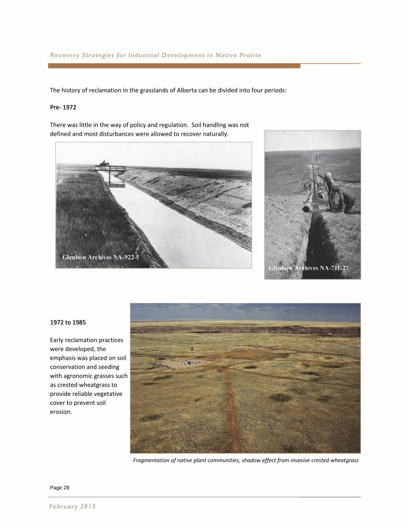
1972 to 19851972 to 1985
Early reclamation practices
were developed, the
emphasis was placed on soil
conservation and seeding
with agronomic grasses such
as crested wheatgrass to
provide reliable vegetative
cover to prevent soil
erosion.
February 2013
Fragmentation of native plant communities; shadow effect from invasive crested wheatgrass
Page 29
Dry Mixedgrass Natural Subregion
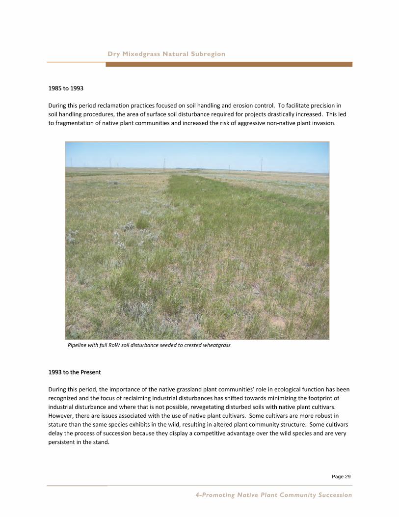
1985 to 19931985 to 1993
During this period reclamation practices focused on soil handling and erosion control. To facilitate precision in
soil handling procedures, the area of surface soil disturbance required for projects drastically increased. This led
to fragmentation of native plant communities and increased the risk of aggressive non‐native plant invasion.
1993 to the Present1993 to the Present
During this period, the importance of the native grassland plant communities’ role in ecological function has been
recognized and the focus of reclaiming industrial disturbances has shifted towards minimizing the footprint of
industrial disturbance and where that is not possible, revegetating disturbed soils with native plant cultivars.
However, there are issues associated with the use of native plant cultivars. Some cultivars are more robust in
stature than the same species exhibits in the wild, resulting in altered plant community structure. Some cultivars
delay the process of succession because they display a competitive advantage over the wild species and are very
persistent in the stand.
4-Promoting Native Plant Community Succession
Pipeline with full RoW soil disturbance seeded to crested wheatgrass

Page 30
Recovery Strategies for Industrial Development in Native Prairie
Understanding the Process of Succession
Native plant communities are not static, but rather constantly adapting to changes in the
local environment over time. The 2010 Grassland Reclamation Criteria recognizes the
importance of change over time. This process is referred to as succession. The Range
Health Assessment Field Workbook (Adams et al. 2009) provides an overview of the
process of succession. The workbook provides “Some Important Ecological Concepts”
found on page 14. These concepts include:
Plant communities are mixtures of plant species that interact with one another.
Succession is the gradual replacement of one plant community by another over
time.
Successional pathways describe the predictable pathway of change in the plant
community as it is subjected to different types and levels of disturbance over time.
Primary Succession is the process of plant community development from bare
soil, starting with pioneer species then progressing through the seral stages listed
below.
Secondary Succession is the process of plant community development after an
established plant community is subject to additional disturbances like fire and
grazing.
Seral stages are each step along a successional pathway.
Seral stages begin at the pioneer stage of early seral and progress upward in
succession to mid‐seral, then late seral and finally potential natural community
(PNC) since we use it as the “reference” for comparison.
Reference plant community (RPC) is the term we use for the potential natural
plant community since we use it as the “reference” for comparison.
An ecological site is a distinct kind of land with specific physical characteristics
that differs from other kinds of land in its ability to produce a distinctive kind and
amount of vegetation.
Ecological status is the degree of similarity between the present plant community
and the reference plant community. Plant communities are modified when the
disturbance has altered them to non‐native species (like smooth brome, timothy
or Kentucky bluegrass) with a composition of greater than 70% non‐native species.
February 2013
Page 31
Dry Mixedgrass Natural Subregion
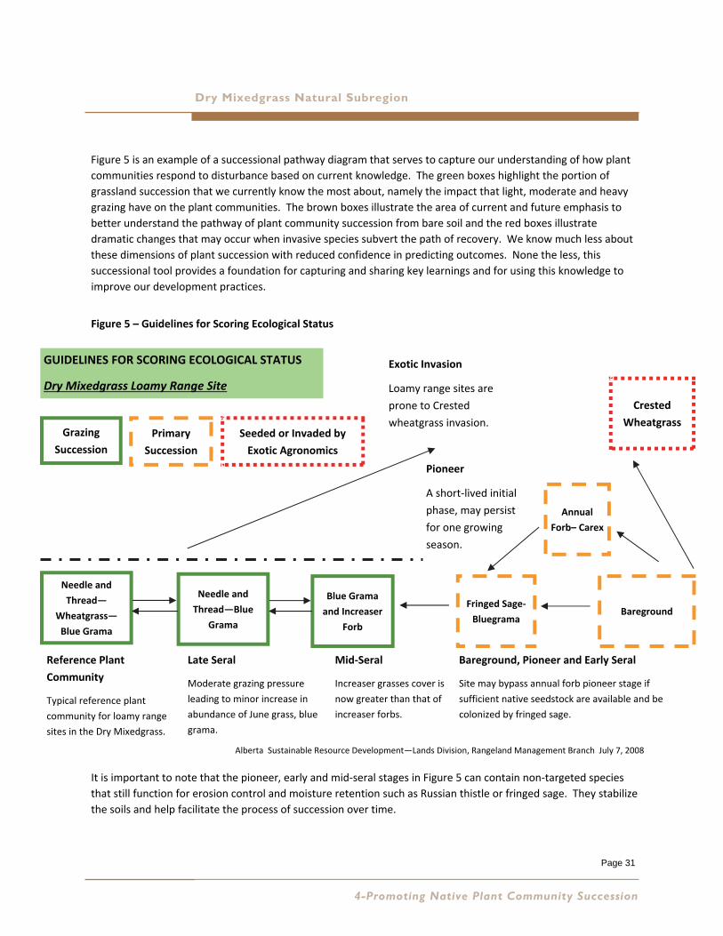
Figure 5 is an example of a successional pathway diagram that serves to capture our understanding of how plant
communities respond to disturbance based on current knowledge. The green boxes highlight the portion of
grassland succession that we currently know the most about, namely the impact that light, moderate and heavy
grazing have on the plant communities. The brown boxes illustrate the area of current and future emphasis to
better understand the pathway of plant community succession from bare soil and the red boxes illustrate
dramatic changes that may occur when invasive species subvert the path of recovery. We know much less about
these dimensions of plant succession with reduced confidence in predicting outcomes. None the less, this
successional tool provides a foundation for capturing and sharing key learnings and for using this knowledge to
improve our development practices.
Figure 5 – Guidelines for Scoring Ecological Status
It is important to note that the pioneer, early and mid‐seral stages in Figure 5 can contain non‐targeted species
that still function for erosion control and moisture retention such as Russian thistle or fringed sage. They stabilize
the soils and help facilitate the process of succession over time.
4-Promoting Native Plant Community Succession
Needle and
Thread—
Wheatgrass—
Blue Grama
Blue Grama
and Increaser
Forb
Annual
Forb– Carex
Crested
Wheatgrass
Fringed Sage‐
Bluegrama
Needle and
Thread—Blue
Grama
Bareground
GUIDELINES FOR SCORING ECOLOGICAL STATUS
Dry Mixedgrass Loamy Range Site
Grazing
Succession
Primary
Succession
Seeded or Invaded by
Exotic Agronomics
Bareground, Pioneer and Early Seral
Site may bypass annual forb pioneer stage if
sufficient native seedstock are available and be
colonized by fringed sage.
Pioneer
A short‐lived initial
phase, may persist
for one growing
season.
Mid‐Seral
Increaser grasses cover is
now greater than that of
increaser forbs.
Reference Plant
Community
Typical reference plant
community for loamy range
sites in the Dry Mixedgrass.
Late Seral
Moderate grazing pressure
leading to minor increase in
abundance of June grass, blue
grama.
Exotic Invasion
Loamy range sites are
prone to Crested
wheatgrass invasion.
Alberta Sustainable Resource Development—Lands Division, Rangeland Management Branch July 7, 2008
Page 32
Recovery Strategies for Industrial Development in Native Prairie
Industrial Disturbance and the Process of Plant Community Succession
Appendix B is a case study entitled “Long Term Recovery of Native Prairie from Industrial Disturbance, Express Pipeline
Revegetation Monitoring Project 2010”. The purpose of this study was to provide industry and the Government of Alberta with
much needed data on the long term revegetation success of reclamation techniques used on native prairie. The case study
presents data, discussion and recommendations relevant to the Dry Mixedgrass, only part of a larger study. The complete report
and an abridged edition are posted in the Information Portal on the Foothills Restoration Forum website at:
http://www.foothillsrestorationforum.ca/
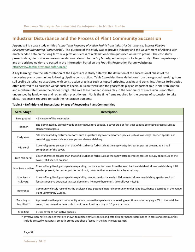
A key learning from the interpretation of the Express case study data was the definition of the successional phases of the
recovering plant communities following pipeline construction. Table 2 provides these definitions from bare ground resulting from
soil profile disturbance associated with construction practices such as topsoil stripping, grading and trenching. Annual forb species
often referred to as nuisance weeds such as kochia, Russian thistle and the goosefoots play an important role in site stabilization
and moisture retention in the pioneer stage. The role these pioneer species play in the continuum of succession is not often
understood by landowners and reclamation practitioners. Nor is the time frame required for the process of succession to take
place. Patience is required to reach the restoration outcome.
Table 2 – Definitions of Successional Phases of Recovering Plant Communities
* Invasive non‐native species that are known to replace native species and establish permanent dominance in grassland communities
include crested wheatgrass, smooth brome and sheep fescue in the Dry Mixedgrass NSR.
February 2013
Seral Stage Description
Bare ground < 5% cover of live vegetation.
Pioneer Site dominated by annual weeds and/or native forb species, a cover crop or first year seeded colonizing grasses such as
slender wheatgrass.
Early seral Site dominated by disturbance forbs such as pasture sagewort and other species such as low sedge. Seeded species and
colonizing grasses such as spear grasses also establishing.
Mid‐seral Cover of grasses greater than that of disturbance forbs such as the sageworts; decreaser grasses present as a small
component of the cover.
Late mid‐seral Cover of grasses greater than that of disturbance forbs such as the sageworts; decreaser grasses occupy about 50% of the
cover; infill species present.
Late Seral ‐ native Cover of long‐lived grass species expanding; native species cover from the seed bank established; slower establishing infill
species present; decreaser grasses dominant; no more than one structural layer missing.
Late Seral ‐
cultivars
Cover of long‐lived grass species expanding; seeded cultivars clearly still dominant; slower establishing species such as
fescues present; decreaser grasses dominant; no more than one structural layer missing.
Reference Community closely resembles the ecological site potential natural community under light disturbance described in the Range
Plant Community Guides.
Trending to
Modified *
A primarily native plant community where non‐native species are increasing over time and occupying > 5% of the total live
cover; the succession time scale is as little as 5 and as many as 20 years or more.
Modified > 70% cover of non‐native species.
Page 33
Recovery Strategies for Industrial Development in Native Prairie Dry Mixedgrass Natural Subregion
5 PREPARING THE PATHWAY
Planning to Reduce Disturbance
Pre‐disturbance planning is the first step in identifying the footprint of industrial
development in native grassland ecosystems. It provides the opportunity to avoid
disturbance to native grasslands by locating development on cultivation and previously
disturbed lands dominated by non‐native vegetative cover. Alberta Energy and Utilities
Board, Information Letter IL 2002‐1 (ERCB IL2002‐1); Principles for Minimizing Surface
Disturbance In Native Prairie and Parkland Areas alerts and directs industry regarding the
importance of avoiding disturbance in native prairie, and the need to minimize disturbance
should avoidance not be possible. The principles apply to all industrial activity in native
prairie. Guidelines have been developed for petroleum industry activity (Native Prairie
Guidelines Working Group 2002) and have been implemented widely and successfully by
the industry. Other industries are encouraged to develop industry specific guidelines.
Pre‐Disturbance Site Assessment
Pre‐disturbance site
assessment is the
decision‐making
process that enables
productive and cost
effective
development
planning. In the Dry
Mixedgrass this
sequential process is
key in determining
the location of the
proposed industrial
site and associated
facilities with the
least amount of
impact to native
grasslands.
5-Preparing the Pathway
Dry Mixedgrass Natural Subregion
Page 34
Recovery Strategies for Industrial Development in Native Prairie
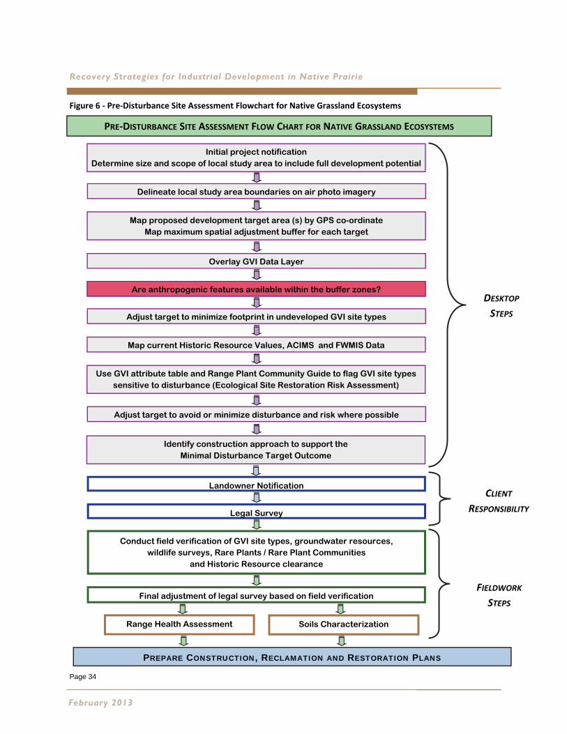
Figure 6 ‐ Pre‐Disturbance Site Assessment Flowchart for Native Grassland Ecosystems
February 2013
PRE‐DISTURBANCE SITE ASSESSMENT FLOW CHART FOR NATIVE GRASSLAND ECOSYSTEMS
PREPARE CONSTRUCTION, RECLAMATION AND RESTORATION PLANS
Range Health Assessment Soils Characterization
Initial project notification Determine size and scope of local study area to include full development potential
Delineate local study area boundaries on air photo imagery
Map proposed development target area (s) by GPS co-ordinate Map maximum spatial adjustment buffer for each target
Overlay GVI Data Layer
Are anthropogenic features available within the buffer zones?
Landowner Notification
Legal Survey
Conduct field verification of GVI site types, groundwater resources, wildlife surveys, Rare Plants / Rare Plant Communities
and Historic Resource clearance
Adjust target to minimize footprint in undeveloped GVI site types
Map current Historic Resource Values, ACIMS and FWMIS Data
Use GVI attribute table and Range Plant Community Guide to flag GVI site types sensitive to disturbance (Ecological Site Restoration Risk Assessment)
Adjust target to avoid or minimize disturbance and risk where possible
DESKTOP
STEPS
CLIENT
RESPONSIBILITY
FIELDWORK
STEPS
Identify construction approach to support the Minimal Disturbance Target Outcome
Final adjustment of legal survey based on field verification
Page 35
Dry Mixedgrass Natural Subregion
Guidelines for pre‐disturbance site assessment include:
Initial project notification: Engage qualified environmental professionals with experience in native grassland ecosystems and the
challenges faced for industrial development. Determine the size and scope of the project, including the infrastructure necessary
for full development.
Delineate local study area boundaries on the most recent air photo imagery available. This is the area surrounding the proposed
target(s) that will be directly affected by development activity. The area should be sufficiently large enough to include the
maximum allowable movement of the proposed target(s) on the landscape. Conduct land titles searches and Surface Land
Searches (available through Government of Alberta agencies) to determine if any instruments, protective notations, or
conservation easements are in place.
If public lands are involved, the ESRD Enhanced Approval Process (EAP) will apply. Consult the Enhanced Approval Manual
available online and use the Landscape Analysis Tool (LAT) to determine landscape sensitivities and base features associated with
the proposed project (http://www.srd.alberta.ca/FormsOnlineServices/EnhancedApprovalProcess/Default.aspx). LAT provides
linkage with the landscape sensitivities with the proposed location and activity to the applicable sensitivity section approval
standards and operating conditions. The search may indicate Protective Notations (PNT) which alert industry to specific
sensitivities where additional conditions and a non‐routine application will apply.
Consult regional and municipal planning documents. Conduct a search for Environmentally Significant Areas, using the Provincial
Update 2009 version available on the web. Map all possible constraints.
Map proposed development target area by GPS coordinate. Map a maximum spatial adjustment buffer around the target(s). The
buffer will provide the area on the landscape within which the target(s) can be moved and still remain effective.
Overlay the GVI data layer for the area on photographic imagery. The GVI attribute table which accompanies the data layer
provides a coarse filter of biophysical, anthropogenic and land use features mapped as a series of polygons, lines, and points. Map
existing anthropogenic features too small to be included in the GVI data layer, including well sites and flow lines.
Are anthropogenic features available within the target zones? If so, is shared use of the landscape feature possible? For example
is moving a well site to cultivated lands, or shared access agreements for roads and trails possible?
Adjust target(s) to minimize footprint in undeveloped GVI site types
Map current documented ACIMS, FWMIS data, and Historic Resource Values. Highlight areas
with potential habitat for Species at Risk. Implement desktop survey of groundwater resources.
Use GVI attribute table, and Range Plant Community Guide to flag GVI site types sensitive to
disturbance. Consult and incorporate soils information from AGRASID and regional soils maps
where available.
Identify potential construction issues and explore possible options. Contour or digital elevation
mapping is very useful at this stage.
Adjust target(s) to avoid or minimize disturbance where possible. Adjust to defined outcome
expectation of restoration that aligns with the 2010 Grassland Reclamation Criteria.
5-Preparing the Pathway
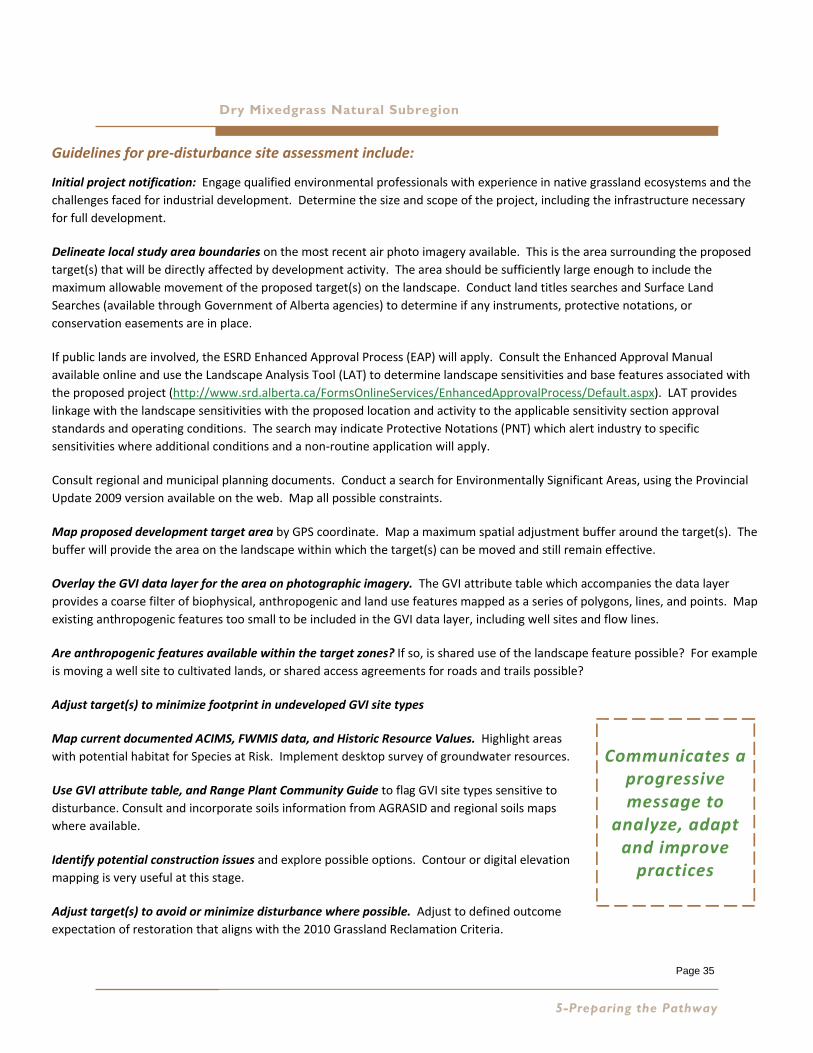
Communicates a progressive message to
analyze, adapt and improve practices

Recovery Strategies for Industrial Development in Native Prairie
Notify and consult landowners/lease holders: Local knowledge and experience can be very important at this point in the planning
process. Landowner/lease holder concerns can be addressed and incorporated into the development plan at this stage.
Legal survey: Implementing the legal survey at this point in the planning process reduces the potential cost of multiple surveys by
providing the opportunity to avoid sensitive environmental features through desktop analysis, and incorporating landowner
concerns through the consultation process.
Conduct field verification of GVI site types, wildlife surveys, rare plant and plant community surveys and Historic Resource
clearance. Determine the scope of the field verification to the size, type of development, landscape sensitivity and the timeframe
when development takes place. Specific timeframes for wildlife and vegetation assessments will apply. In the Dry Mixedgrass a
general timeframe for field work is May 15 to September 15. Document plant community type and dominant species to establish
restoration goals. Establish a baseline for ground water monitoring if required.
Final adjustment to the legal survey based on field verification, environmental studies, construction constraints and continued
landowner consultation.
Conduct Range Health Assessment and field characterization of soils within project footprint. Establish off site controls for
comparison. Document local area weed and invasive non‐native species concerns.
Reduce landscape impacts through reduced impact best management practices. Consider new development practices
technologies that reduce the impact to soils, landscape, vegetation, water and wildlife resources.
Prepare clearly defined reduced impact construction plans and reclamation practices, with expected restoration strategies and
outcomes. Prepare a detailed and site specific environmental protection plan (EPP).
Ensure the EPP, with construction, reclamation and restoration plans are incorporated into contract documents. Where
appropriate to the development type and construction plan include interim restoration planning to reduce the disturbance and
bridge the gap between the operations phase and decommissioning.
Engage informed and experienced contractors committed to meeting the expected outcome of restoration.
Monitor to ensure contractual compliance.
February 2013
Reduced Disturbance; Best Practices Page 36
Page 37
Dry Mixedgrass Natural Subregion
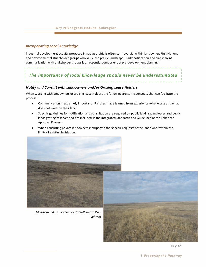
Incorporating Local Knowledge
Industrial development activity proposed in native prairie is often controversial within landowner, First Nations
and environmental stakeholder groups who value the prairie landscape. Early notification and transparent
communication with stakeholder groups is an essential component of pre‐development planning.
Notify and Consult with Landowners and/or Grazing Lease Holders
When working with landowners or grazing lease holders the following are some concepts that can facilitate the
process:
Communication is extremely important. Ranchers have learned from experience what works and what
does not work on their land.
Specific guidelines for notification and consultation are required on public land grazing leases and public
lands grazing reserves and are included in the Integrated Standards and Guidelines of the Enhanced
Approval Process.
When consulting private landowners incorporate the specific requests of the landowner within the
limits of existing legislation.
5-Preparing the Pathway
The importance of local knowledge should never be underestimated
Manyberries Area; Pipeline Seeded with Native Plant
Cultivars

Page 38
Recovery Strategies for Industrial Development in Native Prairie
Healthy native grasslands are an important asset to the ranching industry.
Depending on the type of industrial development and the extent of soil disturbance, the amount of
available forage on the ranch may be reduced for many years. The rancher will have to adjust their
management plan to compensate for the impact of the development. The developer needs to
understand this and work with the rancher to reduce the impact.
Confine disturbance to what is absolutely necessary.
Access control and weed management are two key issues of concern. These issues extend beyond the
initial development phase, to the operations phase and to decommissioning and abandonment.
Reclamation fencing is often left in place well beyond when it is needed for vegetation establishment.
The neglected fencing is often not maintained and becomes a liability for the rancher. Fencing must be
removed to ensure the site can withstand grazing and to promote the process of plant community
succession.
Once vegetation is established, grazing is an important management tool.
Maintain that vital communication link through the operations phase. Use respect!
February 2013
Reduced Disturbance Access Road, Natural Recovery,
Manyberries Area
Reclaimed Reduced Disturbance Wellsite, Natural Recovery,
Pink Flag Indicates Well Centre
Page 39
Dry Mixedgrass Natural Subregion
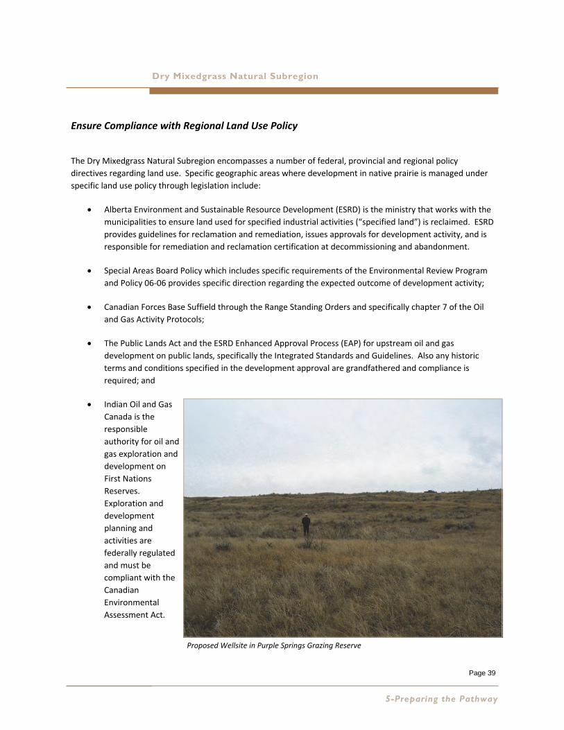
Ensure Compliance with Regional Land Use Policy
The Dry Mixedgrass Natural Subregion encompasses a number of federal, provincial and regional policy
directives regarding land use. Specific geographic areas where development in native prairie is managed under
specific land use policy through legislation include:
Alberta Environment and Sustainable Resource Development (ESRD) is the ministry that works with the
municipalities to ensure land used for specified industrial activities (“specified land”) is reclaimed. ESRD
provides guidelines for reclamation and remediation, issues approvals for development activity, and is
responsible for remediation and reclamation certification at decommissioning and abandonment.
Special Areas Board Policy which includes specific requirements of the Environmental Review Program
and Policy 06‐06 provides specific direction regarding the expected outcome of development activity;
Canadian Forces Base Suffield through the Range Standing Orders and specifically chapter 7 of the Oil
and Gas Activity Protocols;
The Public Lands Act and the ESRD Enhanced Approval Process (EAP) for upstream oil and gas
development on public lands, specifically the Integrated Standards and Guidelines. Also any historic
terms and conditions specified in the development approval are grandfathered and compliance is
required; and
Indian Oil and Gas
Canada is the
responsible
authority for oil and
gas exploration and
development on
First Nations
Reserves.
Exploration and
development
planning and
activities are
federally regulated
and must be
compliant with the
Canadian
Environmental
Assessment Act.
5-Preparing the Pathway
Proposed Wellsite in Purple Springs Grazing Reserve
Page 40
Recovery Strategies for Industrial Development in Native Prairie
Selecting the Recovery Strategy
Selecting the most appropriate recovery strategy for the size and type of disturbance is key to restoration success in the
Dry Mixedgrass. Industrial developments evolve in three phases:
1. Initial exploration and development activity required to access the resource. This can include the detailed
planning, consultation and approval process, followed by the construction of the infrastructure required for oil
and gas production, wind power development, mines, burrow pits or other related industrial activity.
Incorporating the principles for minimizing disturbance to the native prairie ecosystem through detailed project
planning with informed construction best practices and procedures are the most important recovery strategies
at this phase.
2. Production which includes the construction of further infrastructure required to bring the product to market.
This can include the construction of pipelines, pump stations, compressor stations, transmission lines, battery
sites, access and associated infrastructure required to service the production of the resource. Typically this
phase can last for many years. Interim reclamation planning for this phase should reduce the footprint of
disturbance to the soils and native plant communities by reclaiming infrastructure no longer required, stabilizing
and maintaining the integrity of the soils, and promoting the long term recovery of the native plant communities
that have been impacted by development activity. Think of it as a maintenance program that sets the pathway
to reach the final outcome of ecological site restoration over time.
3. Decommissioning and abandonment is the final phase when resource production is either not commercially
viable, or the development is at the “end of life”. It is the process that precedes reclamation and remediation
certification on “specified lands.”
Figure 7 provides guidance for selecting the appropriate strategy for non‐linear disturbances with reduced soil disturbance
(less than 25% of the lease area). Generally this refers to shallow gas wells and applicable access trails where much of the
development activity takes place on unstripped soils.
Sites with soil disturbance on more than 25% of the lease area refers to oil wells, oil production batteries,
decommissioned sour gas wells, contaminated wellsites where soil remediation has taken place or topsoil has been
imported, decommissioned compressor or pumping stations and reclaimed access roads. Other industrial sites such as
mines, burrow pits, and turbine sites on wind farms would fall into this category.
Figure 8 provides guidance for linear disturbances.
Interim reclamation refers to sites where the surface soil disturbance has been reduced and reclaimed following initial
development activity to stabilize the soils and facilitate the recovery of the native plant communities during the
operational phase.
Recovery strategies include: natural recovery, assisted natural recovery and the use of native seed mixes.
February 2013
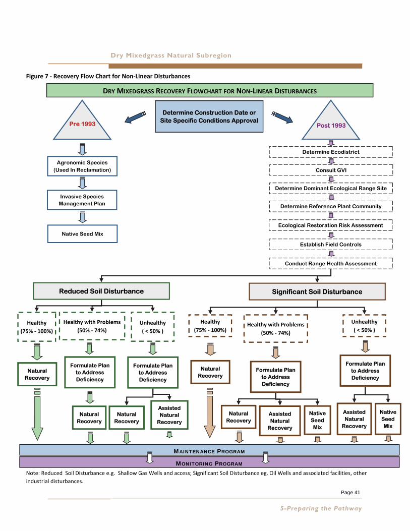
Dry Mixedgrass Natural Subregion
Figure 7 ‐ Recovery Flow Chart for Non‐Linear Disturbances
Note: Reduced Soil Disturbance e.g. Shallow Gas Wells and access; Significant Soil Disturbance eg. Oil Wells and associated facilities, other
industrial disturbances.
5-Preparing the Pathway
DRY MIXEDGRASS RECOVERY FLOWCHART FOR NON‐LINEAR DISTURBANCES
Determine Construction Date or Site Specific Conditions Approval
Post 1993 Pre 1993
Agronomic Species (Used In Reclamation)
Invasive Species Management Plan
Native Seed Mix
Determine Ecodistrict
Consult GVI
Determine Dominant Ecological Range Site
Determine Reference Plant Community
Ecological Restoration Risk Assessment
Establish Field Controls
Conduct Range Health Assessment
Reduced Soil Disturbance Significant Soil Disturbance
Healthy with Problems
(50% ‐ 74%)
Healthy
(75% ‐ 100%)
Unhealthy
( < 50% ) Healthy with Problems
(50% ‐ 74%)
Healthy
(75% ‐ 100%)
Unhealthy
( < 50% )
Natural Recovery
Formulate Plan to Address Deficiency
Natural Recovery
Formulate Plan to Address Deficiency
Native Seed Mix
Natural Recovery
Natural Recovery
Formulate Plan to Address Deficiency
Assisted Natural
Recovery
MONITORING PROGRAM
MAINTENANCE PROGRAM
Formulate Plan to Address Deficiency
Natural Recovery
Assisted Natural
Recovery
Native Seed Mix
Assisted Natural
Recovery
Page 41
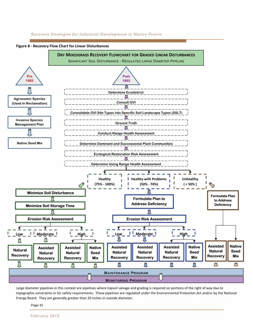
Page 42
Recovery Strategies for Industrial Development in Native Prairie
Figure 8 ‐ Recovery Flow Chart for Linear Disturbances
Large diameter pipelines in this context are pipelines where topsoil salvage and grading is required on portions of the right of way due to
topographic constraints or for safety requirements. These pipelines are regulated under the Environmental Protection Act and/or by the National
Energy Board. They are generally greater than 20 inches in outside diameter.
February 2013
Healthy with Problems
(50% ‐ 74%)
Healthy
(75% ‐ 100%)
Unhealthy
( < 50% )
Pre 1993
Agronomic Species (Used In Reclamation)
Invasive Species Management Plan
Native Seed Mix
DRY MIXEDGRASS RECOVERY FLOWCHART FOR GRADED LINEAR DISTURBANCES SIGNIFICANT SOIL DISTURBANCE - REGULATED LARGE DIAMETER PIPELINE
Determine Ecodistrict
Consult GVI
Consolidate GVI Site Types into Specific Soil Landscape Types (SSLT)
Ground Truth
Conduct Range Health Assessment
Determine Dominant and Successional Plant Communities
Ecological Restoration Risk Assessment
Post 1993
Determine Using Range Health Assessment
MONITORING PROGRAM
MAINTENANCE PROGRAM
Formulate Plan to Address Deficiency
Native Seed Mix
Assisted Natural
Recovery
Moderate Low High
Natural Recovery
Minimize Soil Disturbance
Native Seed Mix
Assisted Natural
Recovery
Minimize Soil Storage Time
Erosion Risk Assessment
Assisted Natural
Recovery
Formulate Plan to Address Deficiency
Erosion Risk Assessment
Moderate Low High
Assisted Natural
Recovery
Native Seed Mix
Assisted Natural
Recovery
Assisted Natural
Recovery
Page 43
Dry Mixedgrass Natural Subregion
Natural Recovery
Natural recovery is defined as the “long term re‐establishment of diverse native
ecosystems by the establishment in the short term of early successional species. This
involves revegetation from soil seedbank and/or natural encroachment” (Alberta
Environment 2010). Natural recovery is linked to minimal disturbance industrial
development procedures which minimize the disturbance to the soils and native
vegetation. Examples include: minimal disturbance shallow gas wells that are drilled and
operated with the native sod and soils intact except for a small area at well center, and
pipeline construction where the only soil disturbance is over the trenchline. The pre‐
disturbance native vegetation recovers from the procedure providing the impact is short
term, and development is conducted under dry or frozen ground conditions. This is the
most important mitigation principle when implementing minimal disturbance and relying
on natural recovery as the recovery strategy to promote restoration over time.
Natural recovery is a recovery strategy that relies on the native seed bank present in the
uppermost layer of the topsoil, seed rain from the surrounding undisturbed native plant
community, and native plant propogules (rhizomes and crowns) present in the disturbed
soil to revegetate areas where soil disturbance has occurred. Examples of soil disturbance
include: wellsites or access roads where topsoil stripping and grading has been necessary
and pipeline construction where topsoil stripping has occurred.
When considering natural recovery, it is important to determine the ecological status of
the native grassland surrounding the disturbance. Does the native plant community have
the resources to re‐establish on the disturbed soils? Are there species present with the
sufficient vigour and reproductive capability to colonize the site? Many species in the Dry
Mixedgrass are uniquely adapted to site conditions. Are the key indicator species present?
Also important is whether non‐native invasive species are present in the on‐site
community, or in the surrounding area near the site. In the Dry MIxedgrass, invasive
species such as downy brome, Japanese brome, crested wheat grass, leafy spurge and the
knapweed species are known to invade bare ground and are very difficult to eradicate.
The accompanying flow charts (Figures 7 and 8) for linear and non‐linear disturbances
provide a pathway for decision making when considering natural recovery.
Where soil disturbance is necessary, the timing of topsoil stripping and replacement can
have a dramatic effect on the success of this strategy. Soil handling in the fall after the
seed set of most species is more successful than at other times of the year. It is important
to reduce the timeframe between topsoil stripping and replacement. It is also important
not to re‐disturb an area left to recover naturally. Ideally topsoil stripping and replacement
should occur when the native vegetation is dormant (mid‐summer to early winter in the
Dry Mixedgrass) and within the same the year.
5-Preparing the Pathway
The pre‐disturbance
native vegetation
recovers from the procedure providing the
impact is short term, and
development is conducted under
dry or frozen ground
conditions
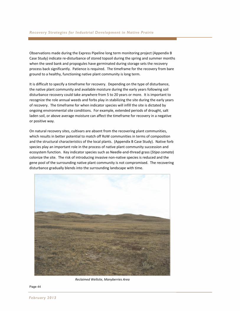
Page 44
Recovery Strategies for Industrial Development in Native Prairie
Observations made during the Express Pipeline long term monitoring project (Appendix B
Case Study) indicate re‐disturbance of stored topsoil during the spring and summer months
when the seed bank and propogules have germinated during storage sets the recovery
process back significantly. Patience is required. The timeframe for the recovery from bare
ground to a healthy, functioning native plant community is long term.
It is difficult to specify a timeframe for recovery. Depending on the type of disturbance,
the native plant community and available moisture during the early years following soil
disturbance recovery could take anywhere from 5 to 20 years or more. It is important to
recognize the role annual weeds and forbs play in stabilizing the site during the early years
of recovery. The timeframe for when indicator species will infill the site is dictated by
ongoing environmental site conditions. For example, extended periods of drought, salt
laden soil, or above average moisture can affect the timeframe for recovery in a negative
or positive way.
On natural recovery sites, cultivars are absent from the recovering plant communities,
which results in better potential to match off RoW communities in terms of composition
and the structural characteristics of the local plants. (Appendix B Case Study). Native forb
species play an important role in the process of native plant community succession and
ecosystem function. Key indicator species such as Needle‐and‐thread grass (Stipa comata)
colonize the site. The risk of introducing invasive non‐native species is reduced and the
gene pool of the surrounding native plant community is not compromised. The recovering
disturbance gradually blends into the surrounding landscape with time.
February 2013
Reclaimed Wellsite, Manyberries Area
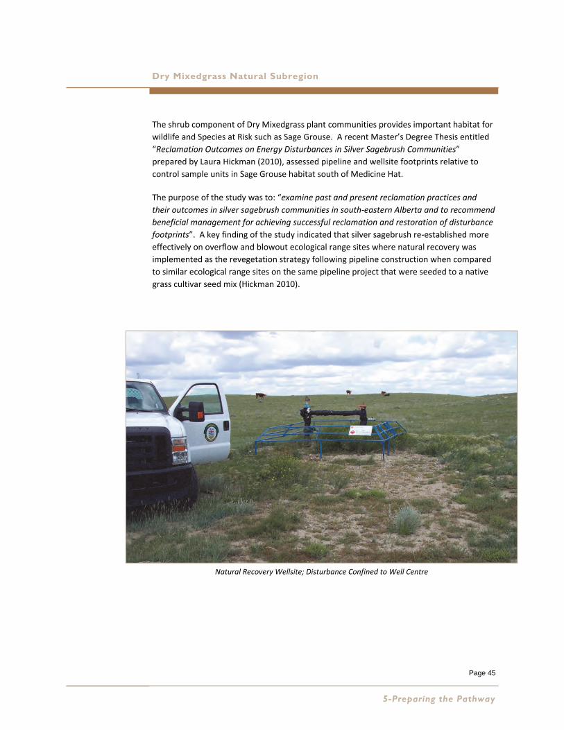
Page 45
Dry Mixedgrass Natural Subregion
The shrub component of Dry Mixedgrass plant communities provides important habitat for
wildlife and Species at Risk such as Sage Grouse. A recent Master’s Degree Thesis entitled
“Reclamation Outcomes on Energy Disturbances in Silver Sagebrush Communities”
prepared by Laura Hickman (2010), assessed pipeline and wellsite footprints relative to
control sample units in Sage Grouse habitat south of Medicine Hat.
The purpose of the study was to: “examine past and present reclamation practices and
their outcomes in silver sagebrush communities in south‐eastern Alberta and to recommend
beneficial management for achieving successful reclamation and restoration of disturbance
footprints”. A key finding of the study indicated that silver sagebrush re‐established more
effectively on overflow and blowout ecological range sites where natural recovery was
implemented as the revegetation strategy following pipeline construction when compared
to similar ecological range sites on the same pipeline project that were seeded to a native
grass cultivar seed mix (Hickman 2010).
5-Preparing the Pathway
Natural Recovery Wellsite; Disturbance Confined to Well Centre
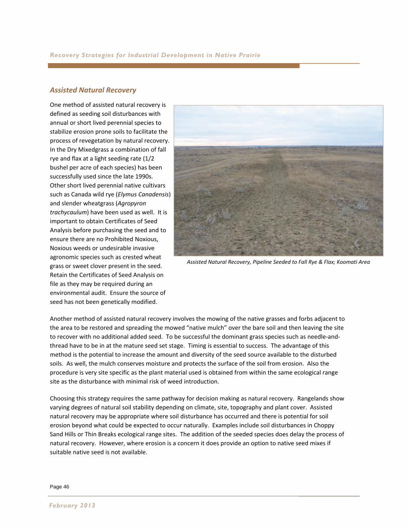
Page 46
Recovery Strategies for Industrial Development in Native Prairie
Assisted Natural Recovery
One method of assisted natural recovery is
defined as seeding soil disturbances with
annual or short lived perennial species to
stabilize erosion prone soils to facilitate the
process of revegetation by natural recovery.
In the Dry Mixedgrass a combination of fall
rye and flax at a light seeding rate (1/2
bushel per acre of each species) has been
successfully used since the late 1990s.
Other short lived perennial native cultivars
such as Canada wild rye (Elymus Canadensis)
and slender wheatgrass (Agropyron
trachycaulum) have been used as well. It is
important to obtain Certificates of Seed
Analysis before purchasing the seed and to
ensure there are no Prohibited Noxious,
Noxious weeds or undesirable invasive
agronomic species such as crested wheat
grass or sweet clover present in the seed.
Retain the Certificates of Seed Analysis on
file as they may be required during an
environmental audit. Ensure the source of
seed has not been genetically modified.
Another method of assisted natural recovery involves the mowing of the native grasses and forbs adjacent to
the area to be restored and spreading the mowed “native mulch” over the bare soil and then leaving the site
to recover with no additional added seed. To be successful the dominant grass species such as needle‐and‐
thread have to be in at the mature seed set stage. Timing is essential to success. The advantage of this
method is the potential to increase the amount and diversity of the seed source available to the disturbed
soils. As well, the mulch conserves moisture and protects the surface of the soil from erosion. Also the
procedure is very site specific as the plant material used is obtained from within the same ecological range
site as the disturbance with minimal risk of weed introduction.
Choosing this strategy requires the same pathway for decision making as natural recovery. Rangelands show
varying degrees of natural soil stability depending on climate, site, topography and plant cover. Assisted
natural recovery may be appropriate where soil disturbance has occurred and there is potential for soil
erosion beyond what could be expected to occur naturally. Examples include soil disturbances in Choppy
Sand Hills or Thin Breaks ecological range sites. The addition of the seeded species does delay the process of
natural recovery. However, where erosion is a concern it does provide an option to native seed mixes if
suitable native seed is not available.
February 2013
Assisted Natural Recovery, Pipeline Seeded to Fall Rye & Flax; Koomati Area
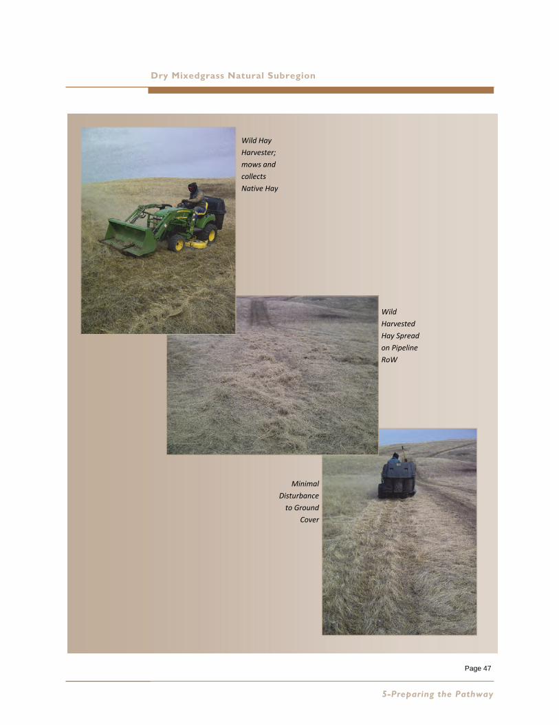
Page 47
Dry Mixedgrass Natural Subregion
5-Preparing the Pathway
Wild Hay
Harvester;
mows and
collects
Native Hay
Wild
Harvested
Hay Spread
on Pipeline
RoW
Minimal
Disturbance
to Ground
Cover
Page 48
Recovery Strategies for Industrial Development in Native Prairie
Use of Native Seed Mixes
The Express pipeline case study illustrated the need for change in the way we design seed
mixes for native prairie. We need to move the native seed industry forward if the expected
outcome is restoration. In the Dry Mixedgrass, several of the native grass cultivars we have
used in the past are too competitive to allow infill from the surrounding native plant
community to occur. Also we did not have access to a reliable supply of native seed of the
dominant species in the plant communities such as needle‐and‐thread grass and western
porcupine grass. We need to change the way we design native seed mixes and develop a
reliable supply of key indicator species if we are going to use native seed.
Industry has indicated a need for a standardized method of
designing native seed mixes for large industrial disturbances
not suited to natural recovery or assisted natural recovery in
the Dry Mixedgrass. These disturbances include:
decommissioned wellsites with significant soil disturbance due to
contaminated soils, decommissioned full build out oil or gas well
sites, reclaimed access roads, large diameter stripped and graded
pipelines, burrow pits and mines;
large areas of disturbance with erosion and site stability concerns;
and
large disturbances in rangeland where the surrounding native plant
communities have low scores for plant community integrity and
ecological status.
The native seed industry and supply chain has also requested direction to facilitate growth
within the industry in order to meet anticipated demand. The method used in this
publication is similar to the method used to design standardized seed mixes for Canadian
Forces Base Suffield, and encompass the species list, plant communities and ecological
range sites currently contained in the Dry Mixedgrass Range Plant Community Guide
(Adams et al. 2009). The goal of the guidelines provided for seed mix design is to
revegetate the disturbance with species that will establish a mid‐ to late‐seral plant
community.
February 2013
Large Disturbances
Erosion and/or Stability Concerns
Invasive Species
The appropriate use of native seed mixes as a recovery strategy for industrial disturbances in the Dry Mixedgrass is restricted to areas with large surface soil disturbances not suited to natural recovery or assisted natural recovery.
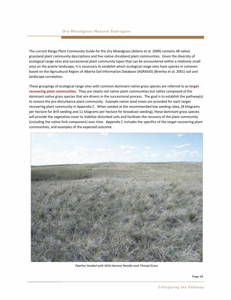
Page 49
Dry Mixedgrass Natural Subregion
The current Range Plant Community Guide for the Dry Mixedgrass (Adams et al. 2009) contains 48 native
grassland plant community descriptions and five native shrubland plant communities. Given the diversity of
ecological range sites and successional plant community types that can be encountered within a relatively small
area on the prairie landscape, it is necessary to establish which ecological range sites have species in common
based on the Agricultural Region of Alberta Soil Information Database (AGRASID) (Brierley et al. 2001) soil and
landscape correlation.
These groupings of ecological range sites with common dominant native grass species are referred to as target
recovering plant communities. They are clearly not native plant communities but rather composed of the
dominant native grass species that are drivers in the successional process. The goal is to establish the pathway(s)
to restore the pre‐disturbance plant community. Example native seed mixes are provided for each target
recovering plant community in Appendix C. When seeded at the recommended low seeding rates, (8 kilograms
per hectare for drill seeding and 11 kilograms per hectare for broadcast seeding), these dominant grass species
will provide the vegetative cover to stabilize disturbed soils and facilitate the recovery of the plant community
(including the native forb component) over time. Appendix C includes the specifics of the target recovering plant
communities, and examples of the expected outcome.
5-Preparing the Pathway
Pipeline Seeded with Wild Harvest Needle‐and‐Thread Grass
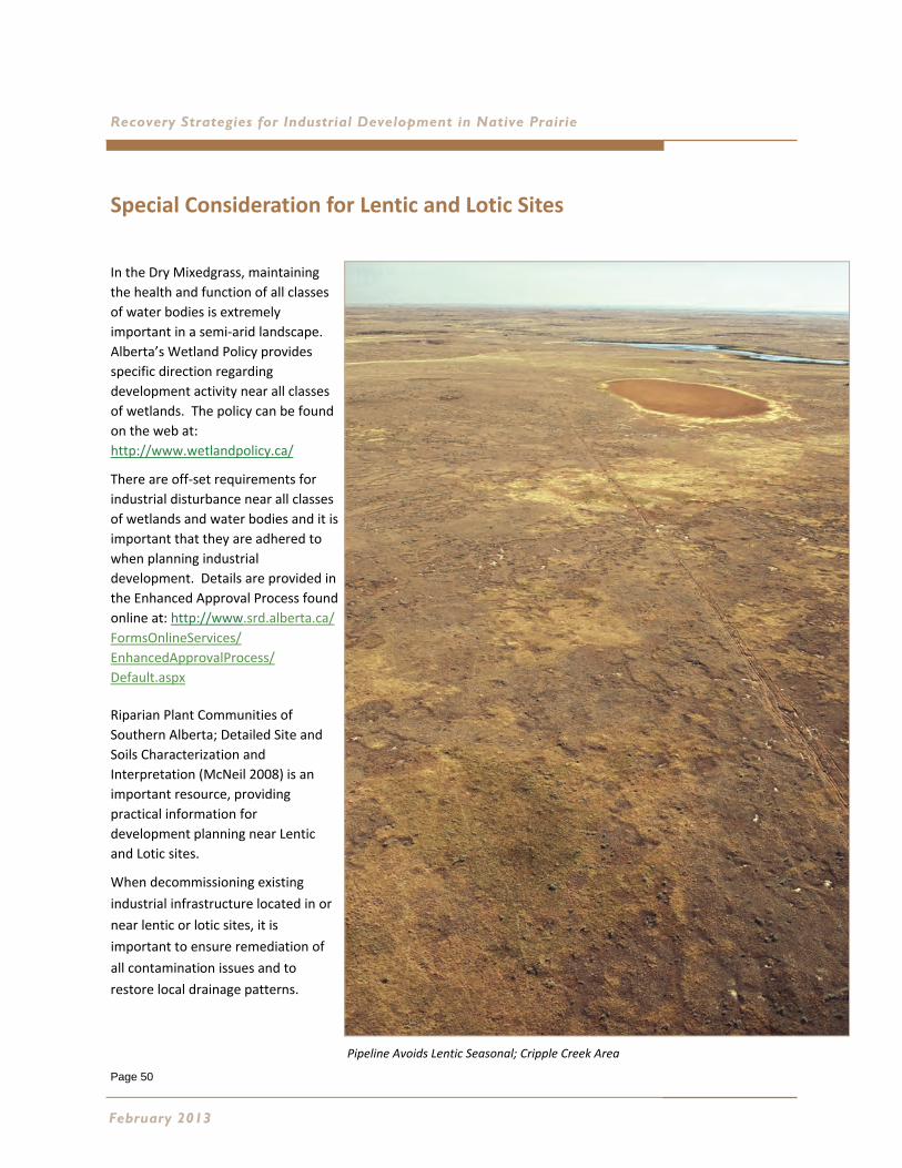
Page 50
Recovery Strategies for Industrial Development in Native Prairie
Special Consideration for Lentic and Lotic Sites
In the Dry Mixedgrass, maintaining
the health and function of all classes
of water bodies is extremely
important in a semi‐arid landscape.
Alberta’s Wetland Policy provides
specific direction regarding
development activity near all classes
of wetlands. The policy can be found
on the web at:
http://www.wetlandpolicy.ca/
There are off‐set requirements for
industrial disturbance near all classes
of wetlands and water bodies and it is
important that they are adhered to
when planning industrial
development. Details are provided in
the Enhanced Approval Process found
online at: http://www.srd.alberta.ca/
FormsOnlineServices/
EnhancedApprovalProcess/
Default.aspx
Riparian Plant Communities of
Southern Alberta; Detailed Site and
Soils Characterization and
Interpretation (McNeil 2008) is an
important resource, providing
practical information for
development planning near Lentic
and Lotic sites.
When decommissioning existing
industrial infrastructure located in or
near lentic or lotic sites, it is
important to ensure remediation of
all contamination issues and to
restore local drainage patterns.
February 2013
Pipeline Avoids Lentic Seasonal; Cripple Creek Area
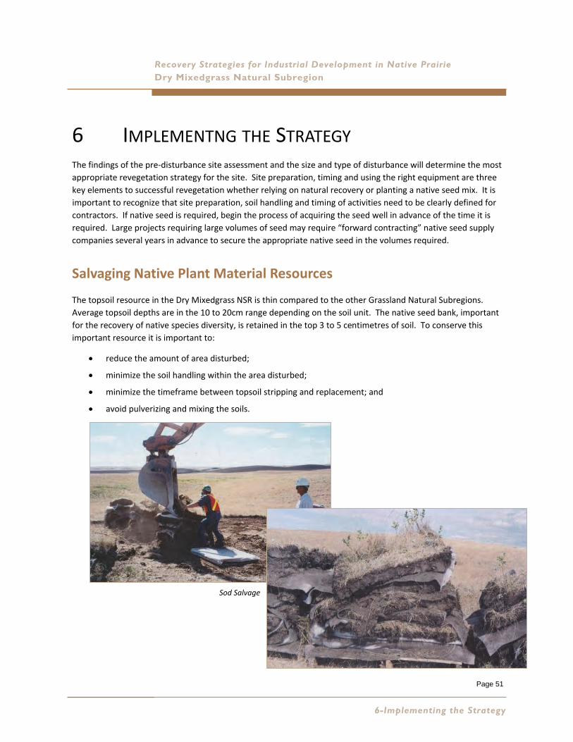
Page 51
Recovery Strategies for Industrial Development in Native Prairie Dry Mixedgrass Natural Subregion
6 IMPLEMENTNG THE STRATEGY The findings of the pre‐disturbance site assessment and the size and type of disturbance will determine the most
appropriate revegetation strategy for the site. Site preparation, timing and using the right equipment are three
key elements to successful revegetation whether relying on natural recovery or planting a native seed mix. It is
important to recognize that site preparation, soil handling and timing of activities need to be clearly defined for
contractors. If native seed is required, begin the process of acquiring the seed well in advance of the time it is
required. Large projects requiring large volumes of seed may require “forward contracting” native seed supply
companies several years in advance to secure the appropriate native seed in the volumes required.
Salvaging Native Plant Material Resources
The topsoil resource in the Dry Mixedgrass NSR is thin compared to the other Grassland Natural Subregions.
Average topsoil depths are in the 10 to 20cm range depending on the soil unit. The native seed bank, important
for the recovery of native species diversity, is retained in the top 3 to 5 centimetres of soil. To conserve this
important resource it is important to:
reduce the amount of area disturbed;
minimize the soil handling within the area disturbed;
minimize the timeframe between topsoil stripping and replacement; and
avoid pulverizing and mixing the soils.
6-Implementing the Strategy
Sod Salvage
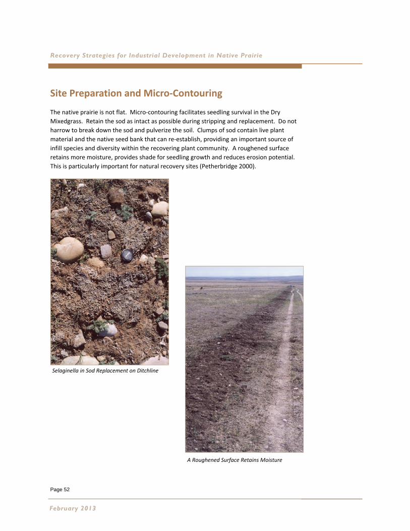
Page 52
Recovery Strategies for Industrial Development in Native Prairie
Site Preparation and Micro‐Contouring
The native prairie is not flat. Micro‐contouring facilitates seedling survival in the Dry
Mixedgrass. Retain the sod as intact as possible during stripping and replacement. Do not
harrow to break down the sod and pulverize the soil. Clumps of sod contain live plant
material and the native seed bank that can re‐establish, providing an important source of
infill species and diversity within the recovering plant community. A roughened surface
retains more moisture, provides shade for seedling growth and reduces erosion potential.
This is particularly important for natural recovery sites (Petherbridge 2000).
February 2013
Selaginella in Sod Replacement on Ditchline
A Roughened Surface Retains Moisture
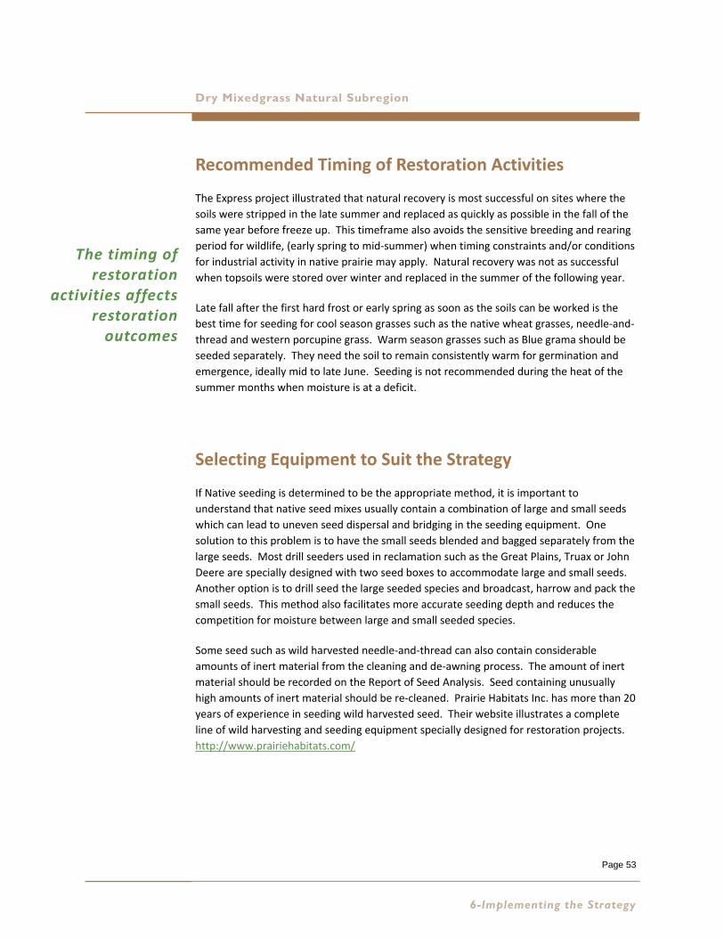
Page 53
Dry Mixedgrass Natural Subregion
Recommended Timing of Restoration Activities
The Express project illustrated that natural recovery is most successful on sites where the
soils were stripped in the late summer and replaced as quickly as possible in the fall of the
same year before freeze up. This timeframe also avoids the sensitive breeding and rearing
period for wildlife, (early spring to mid‐summer) when timing constraints and/or conditions
for industrial activity in native prairie may apply. Natural recovery was not as successful
when topsoils were stored over winter and replaced in the summer of the following year.
Late fall after the first hard frost or early spring as soon as the soils can be worked is the
best time for seeding for cool season grasses such as the native wheat grasses, needle‐and‐
thread and western porcupine grass. Warm season grasses such as Blue grama should be
seeded separately. They need the soil to remain consistently warm for germination and
emergence, ideally mid to late June. Seeding is not recommended during the heat of the
summer months when moisture is at a deficit.
Selecting Equipment to Suit the Strategy
If Native seeding is determined to be the appropriate method, it is important to
understand that native seed mixes usually contain a combination of large and small seeds
which can lead to uneven seed dispersal and bridging in the seeding equipment. One
solution to this problem is to have the small seeds blended and bagged separately from the
large seeds. Most drill seeders used in reclamation such as the Great Plains, Truax or John
Deere are specially designed with two seed boxes to accommodate large and small seeds.
Another option is to drill seed the large seeded species and broadcast, harrow and pack the
small seeds. This method also facilitates more accurate seeding depth and reduces the
competition for moisture between large and small seeded species.
Some seed such as wild harvested needle‐and‐thread can also contain considerable
amounts of inert material from the cleaning and de‐awning process. The amount of inert
material should be recorded on the Report of Seed Analysis. Seed containing unusually
high amounts of inert material should be re‐cleaned. Prairie Habitats Inc. has more than 20
years of experience in seeding wild harvested seed. Their website illustrates a complete
line of wild harvesting and seeding equipment specially designed for restoration projects.
http://www.prairiehabitats.com/
6-Implementing the Strategy
The timing of restoration
activities affects restoration outcomes
Page 54
Recovery Strategies for Industrial Development in Native Prairie
Guidelines for the Procurement of Native Seed
For projects that require the native seed in the Dry Mixedgrass NSR the following guidelines are recommended:
For large projects such as large diameter pipelines, wind energy projects, mines, burrow pits or large
plant sites it is important to plan at least two years in advance in order to ensure an adequate supply of
the key species required for the project.
Order plant material sourced from within the Dry Mixedgrass NSR.
Ensure the seed lots of each species proposed are tested for purity and germination at an accredited
laboratory prior to purchase from the vendor. Testing should be conducted within 12 months of the
proposed planting date. Purity testing of large seed species such as the native wheat grasses, needle‐
and‐thread or western porcupine grass requires a minimum of 50 gram sample size, small seed species
such as June grass or blue grama grass require a minimum sample size of 10 grams.
It may be necessary to contract a wild harvest of key species such as needle‐and‐thread, western
porcupine or blue grama grass to ensure an adequate supply for the project. Reputable and
experienced companies are listed on the Foothills Restoration Forum and the Alberta Native Plant
Council websites. Specify the ecological range sites from which the material should be harvested (i.e.
Blowouts vs Loamy vs Sands and/or Choppy Sandhills). Obtain, review, approve and retain on file
Certificates of Seed Analysis for each species harvested.
When ordering native plant cultivars, order varieties produced specifically for the Dry Mixedgrass NSR
by reputable research institutions such as the Alberta Research Council now referred to as Alberta
Innovates. Consider forward contracting to ensure an adequate supply of appropriate species.
Specify source identified seed grown within the Dry Mixedgrass NSR or the Mixedgrass ecoregion of
Saskatchewan. Purchase only from seed suppliers that can provide the necessary quality assurance.
Obtain, review, approve and retain on file Certificates of Seed Analysis for each species.
When ordering seed include the scientific nomenclature as well as the common name.
There is zero tolerance of seed lots containing Restricted Noxious Weeds, Noxious Weeds such as
downy brome (Bromus tectorum), Japanese brome (Bromus japonicus), and invasive agronomic species
such as crested wheatgrass (Agropyron cristatum) in the Dry Mixedgrass. Seed lots containing quack
grass (Agropyron repens) or foxtail barley (Hordeum jubatum) should also be rejected.
Be aware that some private landowners and specifically certified organic producers will have specific
requirements and specifications for seed mixes and weed control.
Examples of Report of Seed Analysis and an explanation of interpretation is found in Appendix D.3.
February 2013
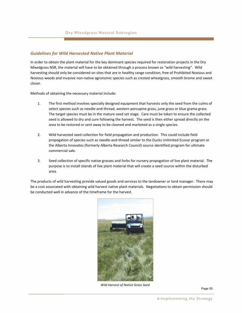
Page 55
Dry Mixedgrass Natural Subregion
Guidelines for Wild Harvested Native Plant Material
In order to obtain the plant material for the key dominant species required for restoration projects in the Dry
Mixedgrass NSR, the material will have to be obtained through a process known as “wild harvesting”. Wild
harvesting should only be considered on sites that are in healthy range condition, free of Prohibited Noxious and
Noxious weeds and invasive non‐native agronomic species such as crested wheatgrass, smooth brome and sweet
clover.
Methods of obtaining the necessary material include:
1. The first method involves specially designed equipment that harvests only the seed from the culms of
select species such as needle‐and‐thread, western porcupine grass, june grass or blue grama grass.
The target species must be in the mature seed set stage. Care must be taken to ensure the collected
seed is allowed to dry and cure following the harvest. The seed is then either spread directly on the
area to be restored or sent away to be cleaned and marketed as a single species.
2. Wild harvested seed collection for field propagation and production. This could include field
propogation of species such as needle‐and‐thread similar to the Ducks Unlimited Ecovar program or
the Alberta Innovates (formerly Alberta Research Council) source identified program for ultimate
commercial sale.
3. Seed collection of specific native grasses and forbs for nursery propogation of live plant material. The
purpose is to install islands of live plant material that will create a seed source within the disturbed
area.
The products of wild harvesting provide valued goods and services to the landowner or land manager. There may
be a cost associated with obtaining wild harvest native plant materials. Negotiations to obtain permission should
be conducted well in advance of the timeframe for the harvest.
6-Implementing the Strategy
Wild Harvest of Native Grass Seed
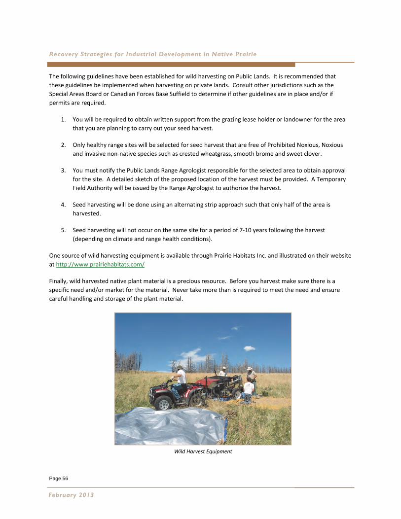
Page 56
Recovery Strategies for Industrial Development in Native Prairie
The following guidelines have been established for wild harvesting on Public Lands. It is recommended that
these guidelines be implemented when harvesting on private lands. Consult other jurisdictions such as the
Special Areas Board or Canadian Forces Base Suffield to determine if other guidelines are in place and/or if
permits are required.
1. You will be required to obtain written support from the grazing lease holder or landowner for the area
that you are planning to carry out your seed harvest.
2. Only healthy range sites will be selected for seed harvest that are free of Prohibited Noxious, Noxious
and invasive non‐native species such as crested wheatgrass, smooth brome and sweet clover.
3. You must notify the Public Lands Range Agrologist responsible for the selected area to obtain approval
for the site. A detailed sketch of the proposed location of the harvest must be provided. A Temporary
Field Authority will be issued by the Range Agrologist to authorize the harvest.
4. Seed harvesting will be done using an alternating strip approach such that only half of the area is
harvested.
5. Seed harvesting will not occur on the same site for a period of 7‐10 years following the harvest
(depending on climate and range health conditions).
One source of wild harvesting equipment is available through Prairie Habitats Inc. and illustrated on their website
at http://www.prairiehabitats.com/
Finally, wild harvested native plant material is a precious resource. Before you harvest make sure there is a
specific need and/or market for the material. Never take more than is required to meet the need and ensure
careful handling and storage of the plant material.
February 2013
Wild Harvest Equipment
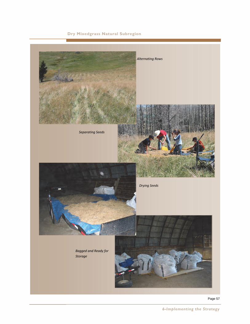
Page 57
Dry Mixedgrass Natural Subregion
Alternating Rows
Separating Seeds
Drying Seeds
Bagged and Ready for
Storage
6-Implementing the Strategy

Page 58
Page 59
Recovery Strategies for Industrial Development in Native Prairie Dry Mixedgrass Natural Subregion
7 MAINTAINING THE PATHWAY Most restoration projects will require a monitoring and maintenance program for the first five growing seasons.
Notice that funds will need to be secured for this program early in the planning phase. The program should
incorporate all of the relevant pre‐disturbance site assessment information, details of the restoration plan, and
documentation of specific issues encountered during the implementation of the plan. This information forms
the basis of the program and facilitates the preparation of a work plan and budget.
Colonizers, Weeds and Invasive Species Management
Quite often there will be a flush of annual weeds and native forb species during the first couple of growing
seasons following soil disturbance. This is a normal occurrence and should not cause concern. These species
provide the “scab” that promotes the healing process by stabilizing the soil and retaining moisture. Where
necessary, mowing annual weeds prior to seed set can reduce the competition for available soil moisture and
enhance seedling survival of desired species. Control of Restricted Noxious and Noxious weeds is required under
the Alberta Weed Control Act (Province of Alberta 2010a). Weed and invasive species management is a
specialized area of expertise and requires a Commercial Applicator’s licence. Contractors hired should be
familiar with the 2010 Reclamation Criteria‐Native Grasslands (Alberta Environment 2011), and the desired long
term outcome of native grassland restoration. Control of specific weed species at identified locations is
preferred over a wide spectrum or broad application of herbicides. This approach will improve the chances for
native forbs to establish and encourage the restoration of the plant community.
A coordinated, multi‐faceted approach to vegetation management is often the most successful and cost
effective. Maintaining a database of areas where vegetation management is required and evaluating the success
of the control methods implemented are important steps in a successful vegetation management program.
The Alberta Invasive Plant Council is an important source of information regarding new weeds of concern and
methods of control. Their website is located at: http://www.invasiveplants.ab.ca/. The Association of
Agricultural Fieldmen located at http://www1.agric.gov.ab.ca can direct you to the Fieldman responsible for your
project area. Incorporating their local knowledge of weeds of concern and effective methods of control is very
useful in vegetation management planning. Also look south of the border to our neighbours to the south. The
USDA Agricultural Research Service has conducted considerable research in the field of vegetation management.
A recent publication entitled Revegetation Guidelines for the Great Basin: Considering Invasive Weeds (Sheley et
al. 2008) is a valuable source of information relevant to the Dry Mixedgrass NSR of Alberta.
7-Maintaining the Pathway
On private lands discuss weed and invasive species management with the landowner. Be aware that certified organic producers will have
specific requirements and specifications for weed control.
Page 60
Recovery Strategies for Industrial Development in Native Prairie
Grazing Management
Native grasslands have evolved in association with grazing animals. Grazing is an ecological process. However,
today fences contain and restrict grazing animals and this factor must be considered in restoration planning.
Consider the following guidelines:
Early consultation with the landowner or lease holder is important. Grazing management plans
implemented to enhance recovery of industrial disturbances should incorporate local knowledge, be
designed in consensus with the rancher and be well documented regarding the responsibilities of both
parties.
Use Range Health Assessment protocol and consultation with land manager to determine when temporary
fencing might be appropriate. Restoration sites located in fields with unhealthy range health scores will
require temporary fencing.
Interim reclamation sites where topsoil resources have been stripped and stored may require fencing until
vegetation is re‐established. Once established the fencing should be removed .
Industrial soil disturbances located in pastures rated as “healthy with problems” may require temporary
fencing depending on which factors are affecting the range health scores. Also the timing and duration of
grazing will need to be factored into the decision.
The size and type of disturbance also determines the requirement for fencing. For example, reclaimed
wellsites with more than 25% disturbance may require fencing. Allow seeded areas at least one growing
season for seed to germinate and establish a root system before grazing is allowed. If possible allow the
newly established plants a second year to set seed (usually by mid summer) prior to removing the fence.
This recommendation will result in livestock trampling a portion of the seed into the upper soil surface to
further enhance infilling of native species.
Ensure temporary fencing is removed when the plant community has reached the target and litter is at
optimum rates for the Dry Mixedgrass (figure 7, page 36 of the Range Health Assessment Field Workbook);
(Adams et al. 2009). Fencing can have a negative effect on recovery if left in place too long. An excessive
buildup of litter on the soil alters moisture conditions which can negatively influence the process of plant
community succession. Make certain there are adequate funds allocated for fence removal.
Fencing can also restrict the movement and distribution of livestock and wildlife within the pasture
surrounding the industrial development. Ensuring access to water is a primary concern. The physical
presence of the fence may take quite a while for the animals to get used to particularly when used on large
diameter pipeline rights of way. Additional disturbance to the soils adjacent to the fencing has been
observed as the animals try and find a way around the fencing. Salt and minerals can be used to lure
animals away from the fencing and alter dispersal patterns.
Fencing can also restrict the movement of wildlife in the Dry Mixedgrass. Antelope are particularly sensitive
to fencing. Consult with the local ESRD Fish and Wildlife biologist for recommendations for wildlife friendly
fencing.
Ensure the temporary fencing is monitored and maintained. Maintenance is not the landowners
responsibility. Budget for maintenance.
February 2013
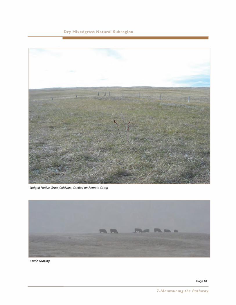
Page 61
Dry Mixedgrass Natural Subregion
7-Maintaining the Pathway
Lodged Native Grass Cultivars Seeded on Remote Sump
Cattle Grazing
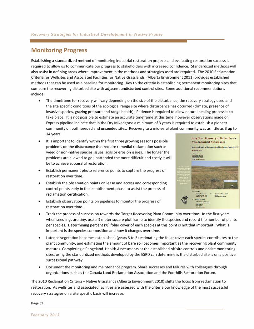
Page 62
Recovery Strategies for Industrial Development in Native Prairie
Monitoring Progress
Establishing a standardized method of monitoring industrial restoration projects and evaluating restoration success is
required to allow us to communicate our progress to stakeholders with increased confidence. Standardized methods will
also assist in defining areas where improvement in the methods and strategies used are required. The 2010 Reclamation
Criteria for Wellsites and Associated Facilities for Native Grasslands (Alberta Environment 2011) provides established
methods that can be used as a baseline for monitoring. Key to the criteria is establishing permanent monitoring sites that
compare the recovering disturbed site with adjacent undisturbed control sites. Some additional recommendations
include:
The timeframe for recovery will vary depending on the size of the disturbance, the recovery strategy used and
the site specific conditions of the ecological range site where disturbance has occurred (climate, presence of
invasive species, grazing pressure and range health). Patience is required to allow natural healing processes to
take place. It is not possible to estimate an accurate timeframe at this time, however observations made on
Express pipeline indicate that in the Dry Mixedgrass a minimum of 3 years is required to establish a pioneer
community on both seeded and unseeded sites. Recovery to a mid‐seral plant community was as little as 3 up to
14 years.
It is important to identify within the first three growing seasons possible
problems on the disturbance that require remedial reclamation such as
weed or non‐native species issues, soils or erosion issues. The longer the
problems are allowed to go unattended the more difficult and costly it will
be to achieve successful restoration.
Establish permanent photo reference points to capture the progress of
restoration over time.
Establish the observation points on lease and access and corresponding
control points early in the establishment phase to assist the process of
reclamation certification.
Establish observation points on pipelines to monitor the progress of
restoration over time.
Track the process of succession towards the Target Recovering Plant Community over time. In the first years
when seedlings are tiny, use a ¼ meter square plot frame to identify the species and record the number of plants
per species. Determining percent (%) foliar cover of each species at this point is not that important. What is
important is the species composition and how it changes over time.
Later as vegetation becomes established, (years 3 to 5) estimating the foliar cover each species contributes to the
plant community, and estimating the amount of bare soil becomes important as the recovering plant community
matures. Completing a Rangeland Health Assessments at the established off site controls and onsite monitoring
sites, using the standardized methods developed by the ESRD can determine is the disturbed site is on a positive
successional pathway.
Document the monitoring and maintenance program. Share successes and failures with colleagues through
organizations such as the Canada Land Reclamation Association and the Foothills Restoration Forum.
The 2010 Reclamation Criteria – Native Grasslands (Alberta Environment 2010) shifts the focus from reclamation to
restoration. As wellsites and associated facilities are assessed with the criteria our knowledge of the most successful
recovery strategies on a site specific basis will increase.
February 2013
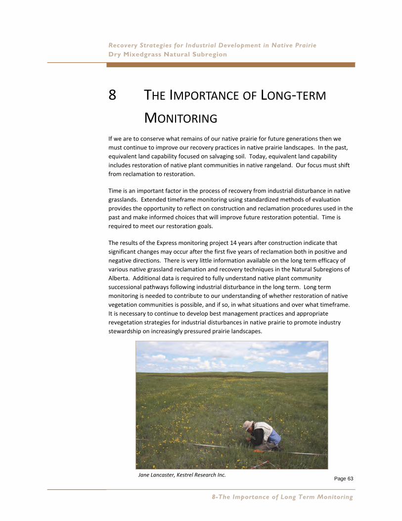
Page 63
Recovery Strategies for Industrial Development in Native Prairie Dry Mixedgrass Natural Subregion
8 THE IMPORTANCE OF LONG‐TERM
MONITORING If we are to conserve what remains of our native prairie for future generations then we
must continue to improve our recovery practices in native prairie landscapes. In the past,
equivalent land capability focused on salvaging soil. Today, equivalent land capability
includes restoration of native plant communities in native rangeland. Our focus must shift
from reclamation to restoration.
Time is an important factor in the process of recovery from industrial disturbance in native
grasslands. Extended timeframe monitoring using standardized methods of evaluation
provides the opportunity to reflect on construction and reclamation procedures used in the
past and make informed choices that will improve future restoration potential. Time is
required to meet our restoration goals.
The results of the Express monitoring project 14 years after construction indicate that
significant changes may occur after the first five years of reclamation both in positive and
negative directions. There is very little information available on the long term efficacy of
various native grassland reclamation and recovery techniques in the Natural Subregions of
Alberta. Additional data is required to fully understand native plant community
successional pathways following industrial disturbance in the long term. Long term
monitoring is needed to contribute to our understanding of whether restoration of native
vegetation communities is possible, and if so, in what situations and over what timeframe.
It is necessary to continue to develop best management practices and appropriate
revegetation strategies for industrial disturbances in native prairie to promote industry
stewardship on increasingly pressured prairie landscapes.
Jane Lancaster, Kestrel Research Inc.
8-The Importance of Long Term Monitoring
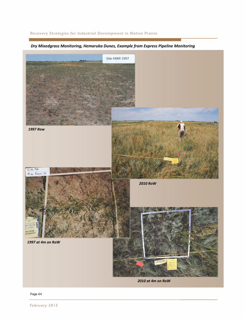
Page 64
Recovery Strategies for Industrial Development in Native Prairie
February 2013
1997 Row
2010 RoW
1997 at 4m on RoW
2010 at 4m on RoW
Dry Mixedgrass Monitoring, Hemaruka Dunes, Example from Express Pipeline Monitoring

Page 65
Recovery Strategies for Industrial Development in Native Prairie Dry Mixedgrass Natural Subregion
9 FUTURE RESEARCH REQUIRED The development of new native grass cultivars for the Dry Mixedgrass Natural Subregion is
a research priority. Collection for the foundation seed stock must come from within the
Dry Mixedgrass and should be renewed every three to five years. Species required include:
Slender, Northern and Western wheatgrass, Green needle grass, June grass and Sand grass.
These species are major components of the native seed required for restoration but are
not well suited to wild harvest. Further concepts for research projects include:
Research into grazing regimes that compliment recovery and restoration of native
plant communities is required.
Research is required to understand the role grazing plays in successful restoration
outcomes.
Research into the development of Type 1 and 2 forb and shrub plant material for
restoration projects. What are the best methods of propagation (seed or
transplants) for long term establishment?
Research to define the appropriate timing and frequency required to monitor the
successional pathways of recovering native plant communities.
Data collection and analysis to better understand the progress of a positive
successional trajectory regarding both cover values and the time required to reach
successful reclamation certification.
Research is required into the mechanisms and timeframe for recovery of the moss
and lichen layer following industrial disturbance.
Research regarding the roll excess litter accumulation plays in altering the moisture
regime and native plant community succession following industrial disturbance.
What are threshold values and are they easily measured?
A mechanism is required to pool industry collected vegetation data to support the
understanding of successional pathways following industrial disturbance.
Information sharing will facilitate advancement of reclamation science. Research
into information management systems that will facilitate information sharing is
required.
9-Future Research Required
Page 66
Recovery Strategies Feedback
The creative process in the evolution of this manual has been a collaborative effort since
the idea was conceived. We welcome comments and feedback as we continue with
Revegetation Strategies for all the Natural Subregions and look forward to future research
and technology that will yield a need for the Second Approximation of the Revegetation
Strategies for the Dry Mixedgrass Natural Subregion of Alberta.
If you have any questions, comments or require further information regarding the manual we can be contacted via the Foothills Restoration Forum website at: http://www.foothillsrestorationforum.ca/
February 2013
Page 67
Recovery Strategies for Industrial Development in Native Prairie Dry Mixedgrass Natural Subregion
10 REFERENCES Literature Cited
Achuff, P. 1994. Natural regions, subregions and natural history themes of Alberta (revised). Alberta
Environmental Protection, Parks Service. Edmonton, AB.
Adams, B.W., Ehlert, G., Stone, C., Lawrence, D., Alexander, M., Willoughby, M., Hincz, C., Moisey, D.,
Burkinshaw, A., Carlson, J. and France, K. 2009. Rangeland health assessment for grassland,
forest and tame pasture (Pub. No. T/044). Lands Division, Alberta Sustainable Resource
Development, Lethbridge, AB. Pp. 152.
Adams, B.W., Poulin‐Klein, L., Moisey, D. and McNeil, R.L. 2005. Range plant communities and range
health assessment guidelines for the Dry Mixedgrass natural subregion of Alberta (Pub. No.
T/040). Rangeland Management Branch, Public Lands Division, Alberta Sustainable
Development. Lethbridge, AB. 106 pp.
Adams, B.W., Poulin‐Klien, L., Moisey, D. and McNeil, R.L. 2004. Range plant communties and range
health assessment guidelines for the Mixedgrass natural subregion of Alberta (Pub. No.
T/039). Rangeland Management Branch, Public Lands Division, Alberta Sustainable
Development. Lethbridge, AB. 101 pp.
Alberta Environment. 2010. 2010 Reclamation criteria for wellsites and associated facilities for native
grassland. Alberta Environment. Edmonton, AB. 125 pp.
Alberta Environment. 2011. 2010 Reclamation criteria for wellsites and associated facilities for native
grasslands. http://www.environment.alberta.ca/documents/2010‐Reclamation‐Criteria‐for‐
Wellsites‐and‐Associated‐Facilities‐for‐Forested‐Lands.pdf. [Accessed January 16, 2013].
Alberta Government. 2000. Environmental Protection and Enhancement Act, E‐12 RSA 2000 Queen's
Printer. Edmonton, AB.
Alberta Sustainable Resource Development and LandWise Inc. 2011. Grassland vegetation inventory
(GVI) specifications. 5th edition. Government of Alberta. Edmonton, AB. 90 pp.
Bradley, C. and Wallis, C. 1996. Prairie ecosystem management: an Alberta perspective. Occasional
Paper No. 2. http://www.albertapcf.org/publications/occasional‐papers. [Accessed January
17, 2013].
Brierley, J.A., T. C. Martin, T.C. and Spiess, D.J. 2001. Agricultural Region of Alberta Soil Inventory
Database (AGRASID). Alberta Agriculture Food and Rural Development, URL http://
www1.agric.gov.ab.ca/$department/deptdocs.nsf/all/sag3249. [Accessed January 17,
2013].
Coupland, R.T. 1961. A reconsideration of grassland classification in the Northern Great Plains of
North America. Journal of Ecology 49: 135‐167.
Foothills Restoration Forum Technical Advisory Committee. 2011. Recommended principles and
guidelines for minimizing disturbance of native prairie from wind energy development.
http://www.foothillsrestorationforum.ca/. [Accessed January 16, 2013].
10-References

Page 68
Recovery Strategies for Industrial Development in Native Prairie
Hickman, L.K. 2010. Reclamation outcomes on energy disturbances in silver sagebrush communities.
Thesis. University of Calgary, Calgary, AB. 401 pp.
Kestrel Research Inc. Long Term Recovery of Native Prairie from Industrial Disturbance, Express
Pipeline Revegetation Monitoring Project 2010.
McCune, B. and Grace, J.B. 2002. Analysis of ecological communities. MJM Software. Gleneden
Beach, OR. 300 pp.
McNeil, R. 2008. Riparian plant communities of southern Alberta; detailed site and soils
characterization and interpretation. Landwise Inc. Lethbridge, AB.
Morgan, J.P., Collicutt, D.R. and Thompson, J.D. 1995. Restoring Canada's native prairies. A practical
manual. http://www.npss.sk.ca. [Accessed January 16, 2013].
Native Plant Workling Group. 2000. Native plant revegetation guidelines for Alberta. Alberta
Agriculture, Food and Rural Development and Alberta Environment. Edmonton, AB. 58 pp.
Native Prairie Guidelines Working Group. 2002. Petroleum industry activity in native prairie and
parkland areas: guidelines for minimizing surface disturbance. Government of Alberta.
Edmonton, AB. 44 pp.
Natural Regions Committee. 2006. Natural regions and subregions of Alberta (Pub. No. T/852).
Compiled by D.J. Downing and W.W. Pettapiece. Government of Alberta, Edmonton, AB.
Pp. 264.
Petherbridge, W.L. 2000. Sod salvage and minimal disturbance pipeline restoration techniques:
implications for native prairie restoration. Thesis. University of Alberta, Edmonton, AB.
Prairie Conservation Forum. January 2011. Alberta Prairie Conservation Action Plan: 2011‐2015.
Published by the Prairie Conservation Forum, Lethbridge, Alberta. 28 pages.
Sheley, R., Mangold, J., Goodwin, K. and Marks, J. 2008. Revegetation guidelines for the Great Basin:
considering invasive weeds. ARS–168. http://www.ebipm.org/content/4418. [Accessed
January 17, 2013].
Sinton Gerling, H., Willoughby, M.G., Schoepf, A., Tannas, C. and Tannas, K. 1996. A guide to using
native plants on disturbed lands. Alberta Agriculture, Food and Rural Development and
Alberta Environmental Protection. Edmonton, AB. 247 pp.
Sinton, H.M. 2001. Prairie oil and gas: A lighter footprint. Alberta Environment. Edmonton, AB. 67 pp.
Smreciu, E.A., Sinton, H.M., Walker, D.G. and Bietz, J.K. 2003. Establishing Native Plant Communities.
Alberta Agriculture, Food and Rural Development, Alberta Environment and Alberta
Sustainable Resource Development. Edmonton, AB.
Society For Ecological Restoration. 2004. SER International Primer on Ecological Restoration. http://
www.ser.org. [Accessed January 16, 2013].
Strong, W.L. and Leggat, K.R. 1992. Ecoregions of Alberta. Alberta Forestry, Lands and Wildlife.
Edmonton, AB.
February 2013
Page 69
Dry Mixedgrass Natural Subregion
Recent and Relevant Publications
Adams, Castelli, Tedder, Downing and Janz. 1996. Reclamation of Mixed Grass prairie disturbed by
pipeline construction. Prepared for Reclamation Research Technical Advisory Committee.
Alberta Sustainable Resource Development and LandWise Inc. 2010. Specifications for the use and
capture of grassland vegetation inventory (GVI) data. 5th edition.
Alberta Weed Control Act, Queen’s Printer, Alberta
AXYS Environmental Consulting Ltd. 2003. Express Pipeline Ltd. environmental monitoring final
report. Prepared for Terasen Pipelines (Formerly Express Pipeline, a division of Alberta
Energy Company Ltd. and TransCanada Pipelines Ltd.). Calgary, AB.
Canadian Energy Pipeline Association 2008. Field Observations on Express Pipeline 2008. Gramineae
Services Ltd. and Kestrel Research Inc.
James, J., Sheley, R.L., Vasquez, E.A. and Smith, B.S. 2010. Ecological principals for invasive plant
management. http://www.ebipm.org/content/5725. [Accessed January 17, 2013].
Majerus, M.E. 2009. Forage and reclamation grasses of the northern Great Plains and Rocky
Mountains. Valley Printers.
Stewart, N. Cultivating our roots . Growing authentic prairie wildflowers and grasses. http://
www.cultivatingourroots.com/index.html. [Accessed January 17, 2013].
Saunders, E., Quinlan, R., Jones, P., Adams, B. and Pearson, K. 2006. At home on the range. Living
with Alberta’s prairie species at risk. http://www.ab‐conservation.com/go/default/.
[Accessed January 16, 2013].
Sheley, R., Smith, B., Reever‐Morghan, K. and Svejcar, T. 2009. Adaptive management for invasive
annual grasses. A step‐by‐step user’s guide. http://www.ebipm.org/content/4418.
[Accessed January 17, 2013].
Sheley, R., Vasquez, E.A., James, J. and Smith, B. 2010. Applying ecologically‐based invasive plant
management. An introduction and overview. http://www.ebipm.org/content/5725.
[Accessed January 17, 2013].
Special Areas Board Policy 06‐03. Section: MSL, ROE, LOC, EASEMENTS Subject: Authorization for
access and development in areas of significant Historical or Cultural sites within the Special
Areas. Special Areas Board.
Special Areas Board Policy 06‐05. Section: MSL, ROE, LOC, EASEMENTS Subject: Minimum
Disturbance on Native Range. Special Areas Board.
Special Areas Board Policy 06‐06. Section: MSL, ROE, LOC, EASEMENTS Subject: Invasive Introduced
Forages on Reclamation Sites. Special Areas Board.
8-The Importance of Long Term Monitoring

Page 70
Page 71
Recovery Strateg ies for Industr ia l Development in Native Pra ir ie Dry Mixedgrass Natural Subreg ion
APPENDIX A GLOSSARY OF TERMS
Blowouts: refers to ecological range sites with eroded surface pits reflecting the presence
of abundant Solonetzic (hard pan) soils.
Chernozemic: Dominated by the accumulation of organic matter from the decomposition
of grasses and forbs, typically of Grassland plant communities. Chernozemic soils have
normal development of soil horizons (A, B, C) and the topsoil (Ah, Ap) is more than 10 cm
thick.
Choppy Sandhills: Refers to ecological range sites characterized by loamy sand and sand
soils with a duned land surface.
Clayey: refers to ecological range sites with clayey textured soils including: silty clay, sandy
clay, clay and heavy clay. Generally >40% clay.
Climax: the final or stable biotic community in a successional series; it is self perpetuating
and in equilibrium with the physical habitat.
Cultivar: is a plant variety which has undergone genetic restrictions through selection by
plant breeders, and which has been registered by a certifying agency. Native plant cultivars
in this report refer to cultivars produced from native grass species.
Decreaser: Highly productive, palatable plants that are dominant species in reference plant
communities. They decrease in relative abundance as grazing pressure or disturbance
related activity increases.
Ecological Range Site: A distinctive kind of land with specific physical characteristics that
differs from other kinds of land in its ability to produce a distinctive kind and amount of
vegetation. In a grassland environment, range site refers to a broader description of soil
and landscape (e.g. loamy, clayey, sandy, choppy sand hills etc.), that might be further
subdivided into ecological sites due to differences in plant community potential.
Ecological status: is the degree of similarity between the present plant community and the
reference plant community.
Forb: Primarily broad‐leaved flowering plants with net‐like veins. For the purpose of
simplifying identification, the category can be broadened to include those parallel‐veined
plants with brightly colored flowers such as orchids or lilies.
Appendix A-Glossary of Terms
Page 72
Recovery Strateg ies for Industr ia l Development in Native Pra ir ie
Graminoid: Refers to plants which have hollow, jointed stems and leaves in two rows (ranks). Flowers are
usually perfect with seeds borne between two scales (palea and lemma). Commonly referred to as grasses and
includes sedges.
Gravel: Ecological range sites dominated by gravels or cobbles (>50% coarse fragments). May be covered by a
mantle with few gravels, up to 20 cm thick.
Grazing response: how the various kinds of plants on the range react when they are grazed. This may vary with
soil and climate for any one species. Range plants are grouped as follows:
Grazing Response – Type 1 Species (Decreasers): Species that decrease in relative abundance as
disturbance increases. They tend to be palatable to grazing animals and are the dominant species in
the reference plant community (climax vegetation). Highly productive, palatable plants that grow in
the original climax vegetation stand. They are palatable to livestock, and will decrease on a range
when exposed to heavy grazing pressures.
Grazing Response – Type 2 Species (Increaser – Type 1): Species that normally increase in relative
abundance as the decreasers decline. They are commonly shorter, less productive species and more
resistant to grazing and other disturbances. Type 1 increaser species increase at first but may decrease
later as grazing or other disturbance pressures continue to increase. The increaser plants are normally
shorter, lower producing and less palatable to livestock.
Grazing Response – Type 3 Species (Invaders): Invaders are introduced, non‐native species and not
normally components of the reference plant community (climax vegetation). They invade a site as the
decreasers and increasers are reduced by grazing or other disturbances. Invaders may be annuals,
herbaceous perennials, or shrubs and have some (or no) grazing value. They are never considered
desirable or acceptable vegetation.
Grazing Response – Type 4 Species (Increaser – Type 2): Species that normally increase in relative
abundance as the decreasers decline. They are commonly shorter, less productive species and more
resistant to disturbance. Type 2 increaser species continue to increase in abundance with increasing
disturbance pressures. When increaser type 2 species occur on a disturbed well site, we limit the
amount of this cover that is considered desirable vegetation. The amount considered acceptable
would be equal to the cover of the species found in the control or 5% whichever is greatest.
Increaser: Plant species that normally increase in relative abundance as the decreasers decline. They are
commonly shorter , less productive species and more resistant to grazing and other disturbances.
Interim reclamation sites: refers to sites where the surface soil disturbance has been reduced and reclaimed
following initial development activity to stabilize the soils and facilitate the recovery of the native plant
communities during the operational phase.
February 2013
Page 73
Dry Mixedgrass Natural Subreg ion
Lentic: this term means standing or still water (i.e. lakes, wetands and sloughs).
Limy: refers to ecological range sites with eroded or immature soils with free lime (CaCO3) at the soil surface.
Soils pH generally 7.5.
Loamy: refers to ecological range sites with medium to moderately –fine textured soils.
Lotic: this term means flowing water (i.e. streams or rivers).
Minimum Disturbance: As defined in the 2010 Reclamation Criteria‐Native Grassland refers to minimum
disturbance sites that have been reclaimed where construction practices have minimized the level of
disturbance on the lease resulting in two different management zones (i.e. Undisturbed meaning the soils have
not been stripped and replaced and Disturbed where the soils have been stripped and replaced).
Natural Subregion (NSR): Natural Subregions are subdivisions of a Natural Region, generally characterized by
vegetation, climate, elevation, and latitudinal or physiographic differences within a given Region. There are 21
Natural Subregions in Alberta, four of which comprise the Grassland Natural Region.
Overflow: The ecological range site subject to water spreading and sheet flow. Typically on gentle inclines or
terraces prone to stream overflow.
Ordination: refers to methods which graphically summarize complex species relationships by aligning
observations in a pattern along multiple axes (dimensions)(McCune and Grace 2002).
Plant Community: refers to an assemblage of plants occurring together at any point in time, thus denoting no
particular successional status. A mixture of plant species that interact with one another.
Rangeland: is land supporting indigenous or introduced vegetation that is either grazed or has the potential to
be grazed and is managed as a natural ecosystem.
Rangeland Health: the ability of rangeland to perform certain key functions. Those key functions include:
productivity, site stability, capture and beneficial release of water, nutrient cycling, and plant species diversity.
Reduced Soil Disturbance: refers to construction procedures and practices designed to reduce the area of
impact to soil and native vegetation resources. It can refer to interim reclamation and recovery procedures
which reduce the area of stripped and stored soils during the operational phase of an industrial development.
Reference Plant Community: is the term used for the potential natural community or climax community. It is
the plant community that is the expression of the ecological site potential under light disturbance. It is used in
range health assessment as the basis for comparison, hence the term “reference”.
Appendix A-Glossary of Terms

Page 74
Recovery Strateg ies for Industr ia l Development in Native Pra ir ie
Riparian: is the term used to define the transitional area between the aquatic part of a lotic
or lentic system and the adjacent upland system.
Restoration: the process of assisting the recovery of an ecosystem that has been degraded,
damaged, or destroyed (Society for Ecological Restoration 2004).
Sands: refers to the ecological range site with very coarse textured soils and not on a
duned landscape.
Sandy: refers to the ecological range site with sandy loam, moderately coarse textured
soils.
Seral: refers to species or communities that are eventually replaced by other species or
communities.
Shallow to Gravel: refers to ecological range sites characterized by soil with 20 to 50 cm of
a sandy or loamy surface overlying a gravel or cobble‐rich substrate.
Solonetzic: Dominated by hard‐pan subsoil or B horizons that are hard when dry and a
sticky mass of low permeability when wet. Solonetzic soils are high in sodium and typically
have columnar or prismatic macro‐structure.
Specified land: for the purpose of the 2010 reclamation criteria , the term Specified Land ,
means land that is being or has been used or held for or in connection with the
construction, operation or reclamation of a well, battery or pipeline (excerpt from the
Conservation and Reclamation Regulation (115/93) of the Alberta Environmental
Protection and Enhancement Act (Alberta Government 2000).
Succession: the gradual replacement of one plant community by another, over time.
Successional pathways: describe the predictable pathway of change in the plant
community as it is subjected to types and levels of disturbance over time.
Seral stages: are each step along a sucessional pathway. Seral stages begin at the pioneer
stage of early seral , and progress upward in sucession to mid‐seral, then late seral and
finally the climax or reference plant community.
Thin Breaks: refers to ecological range sites with areas of bedrock at or near the surface;
largely vegetated. May include thin, eroded or immature soils on gentle to steep
landscapes.
February 2013
Page 75
Dry Mixedgrass Natural Subreg ion
APPENDIX B LONG TERM MONITORING: WHAT HAVE WE LEARNED? CASE STUDY OF EXPRESS PIPELINE
B.1 Why is Express Important?
The purpose of the Express Pipeline Long‐term Revegetation Monitoring Project (Express)
is to provide industry and the Government of Alberta regulatory agencies with a unique
opportunity to gather and process much needed data on the long term revegetation
success of reclamation techniques used on native prairie. To obtain a pdf version of the
entire document or an abridged edition highlighting the key learnings of the study, visit the
Foothills Restoration Forum website at http://www.foothillsrestorationforum.ca/.
This case study provides a summary of the findings associated with the assessment of
reclamation techniques implemented on Express in the Dry Mixedgrass Natural Subregion.
Express Pipeline (Express), owned and operated by Kinder Morgan Canada Inc., is a 24 inch
(610 mm) crude oil pipeline that extends from Kinder Morgan’s tank farm near Hardisty,
Alberta, south 434 kilometres to cross the United States border at Wildhorse, Alberta. The
permanent right‐of‐way (RoW) is 20m wide and an additional 10m of temporary workspace
was required for construction. At linear infrastructure crossings, on steep slopes and at
water crossings, extra temporary workspace was also required.
Express crosses large contiguous tracks of native prairie along its alignment. Portions of
the RoW cross native prairie in the Central Parkland, Northern Fescue, Mixedgrass and Dry
Mixedgrass Natural Subregions of Alberta. The long term impact of pipeline construction
and reclamation on native prairie ecosystems was an issue identified by stakeholders early
in the planning process in 1994. Express Pipeline’s regulatory commitment was to reclaim
the RoW in native prairie areas with the goal of establishing a positive successional trend
towards the native plant community present prior to construction. This was an early
opportunity to demonstrate minimum disturbance practices in the Grassland Natural
Region. To pursue this goal, native seed mixes were developed, specialized seeding
equipment was used, and erosion control procedures were implemented. Revegetation
trials such as natural recovery were implemented to test the response of unconventional
revegetation techniques.
Appendix B-Case Study of Express Pipe l ine
Page 76
Recovery Strateg ies for Industr ia l Development in Native Pra ir ie
A five year post‐construction monitoring program was conducted between 1997 and 2001.
Monitoring sites included; a diversity of soil types and native rangeland plant communities,
construction practices areas where spoil was stored directly on prairie vegetation and areas
where construction vehicles were driven on the grass, and areas where disturbed soils
were seeded or left to recover naturally. Each monitoring site includes a pair of
observations including an undisturbed control and a treatment area on the RoW.
Over the years stakeholders and regulatory agencies recognized that further monitoring of
Express could provide a valuable contribution to reclamation science regarding the long
term performance of the cultivars and wild harvested seed used in the seed mixes, and the
plant community succession of seeded sites and natural recovery trial sites. Further
monitoring could build on the initial five years monitoring results.
B.2 Analysis of Long Term Recovery Using the Cumulative Dataset
To assess whether succession towards pre‐disturbance native plant communities is
occurring, a time series of observations comprised of detailed vegetation transects from
each monitoring site collected one, two, three, five and 14 years post‐construction, were
analysed. Methods included cluster analysis and non‐metric multi‐dimensional scaling
analysis. The resulting groupings of species (communities) were described using indicator
species analysis. Variations in successional pathways and subsequent seral stages for the
reclaiming plant communities were observed as a result of the soil handling techniques and
various environmental conditions(i.e.,drought, grazing regimes). Parameters were
developed to identify the various seral stages of communities recovering from disturbance
and applied to each group resulting from the plant community ordination analysis.
In addition, range health assessments were conducted on the disturbances and adjoining
controls for comparison.
B.2.1 Results – Dry Mixedgrass Seed Mixes
The performance of each species in the seed mixes in terms of cover was tracked over time
and compared to undisturbed native plant communities on the adjacent controls.
February 2013

Page 77
Dry Mixedgrass Natural Subreg ion
Cultivars
The expression and percent cover of seeded species over time on ten sites seeded to
Solonetzic Soil Mix 4 is illustrated in Figure B1. The naturally occurring cover of these
species on control sites in 2010 is also shown. Components of the seed mix are presented
in Table B1.
The expression and percent cover of seeded species over time on five sites seeded to Sandy
Soil Mix 3 are illustrated in Figure B2. The naturally occurring cover of these species on
control sites is also shown. Components of the seed mix are presented in Table B2.
In the Dry Mixedgrass, slender wheatgrass and northern wheatgrass behaved as
transition species, establishing in the early years and providing initial cover to
stabilize soils, build litter and shelter other seedlings. Both species are diminishing
with time to near natural cover levels.
Western wheatgrass established early but cover has slowly increased over the 14
years. Western wheatgrass persists at greater cover than on the controls.
Seeded June grass developed a persistent but low cover in the earlier years which
has not changed much over time. This species is beneficial for rebuilding diversity,
the mid structural layer and is resilient to grazing.
Green needle grass cover increased steadily over five years in both the Sandy and
Solonetzic seed mixes. By year 14, cover levels have declined on Solonetzic sites.
However, on Sandy soils, green needle grass cultivars persist at cover levels that
are significantly higher than on control sites resulting in higher canopy structure
than found on the controls.
Sand grass (sand reed grass) cultivars developed average cover levels comparable
to controls, but their large size creates a persistent increase in canopy structure on
the reclaiming RoW relative to the controls.
Non‐native sheep fescue is invasive, increasing in cover on the RoW slowly but
steadily on both healthy and unhealthy rangeland. Sheep fescue may contribute
to plant community modification over time.
After 14 years, persistent cultivars that are still expanding or maintaining relative
cover beyond control levels are influencing the trajectory of plant community
succession.
Appendix B-Case Study of Express Pipe l ine
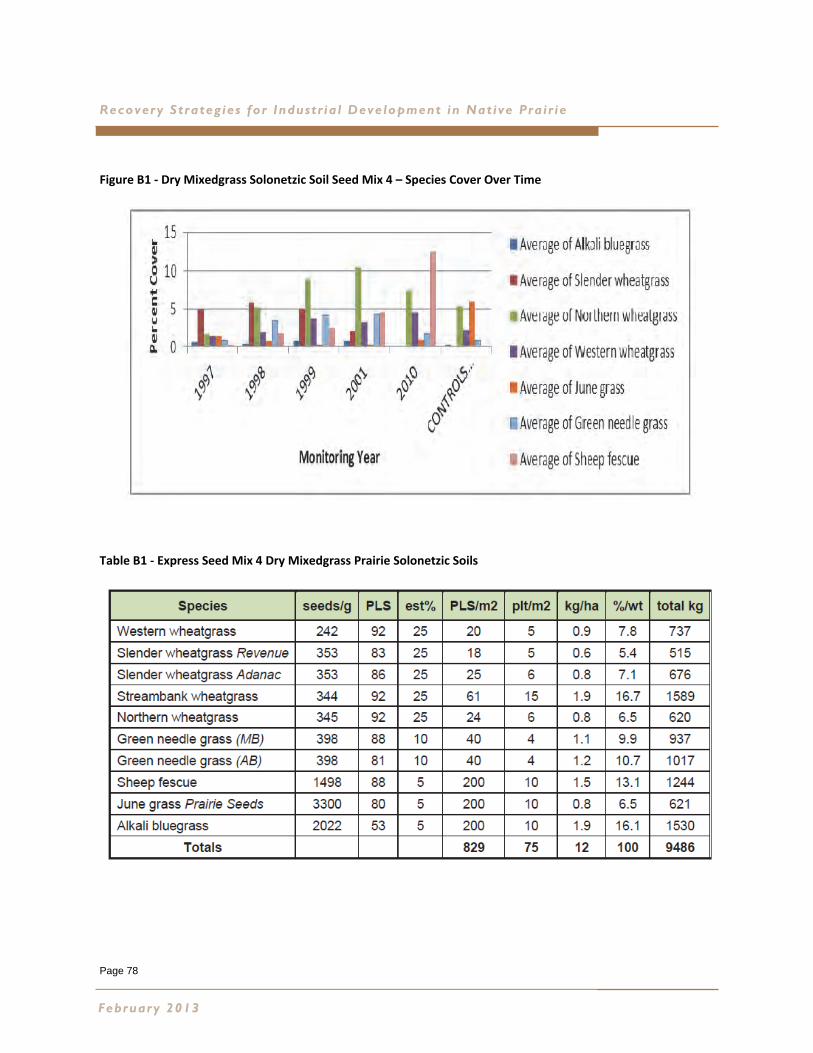
Page 78
Recovery Strateg ies for Industr ia l Development in Native Pra ir ie
Figure B1 ‐ Dry Mixedgrass Solonetzic Soil Seed Mix 4 – Species Cover Over Time
Table B1 ‐ Express Seed Mix 4 Dry Mixedgrass Prairie Solonetzic Soils
February 2013
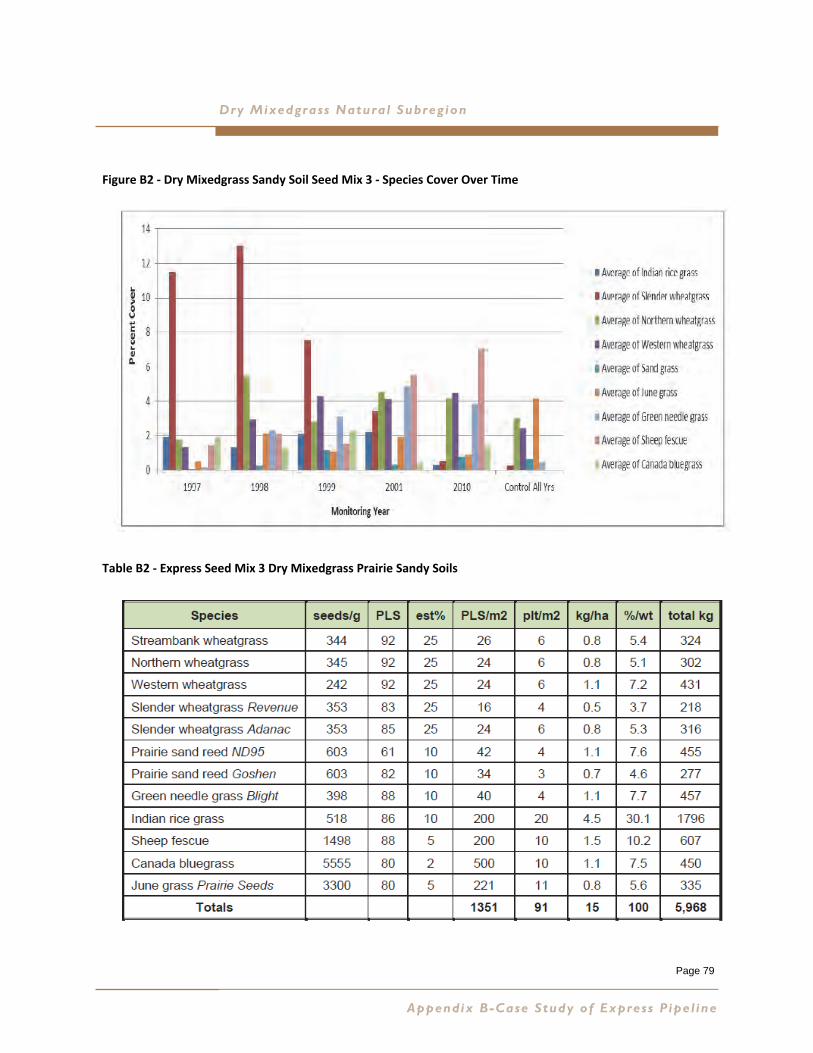
Page 79
Dry Mixedgrass Natural Subreg ion
Figure B2 ‐ Dry Mixedgrass Sandy Soil Seed Mix 3 ‐ Species Cover Over Time
Table B2 ‐ Express Seed Mix 3 Dry Mixedgrass Prairie Sandy Soils
Appendix B-Case Study of Express Pipe l ine
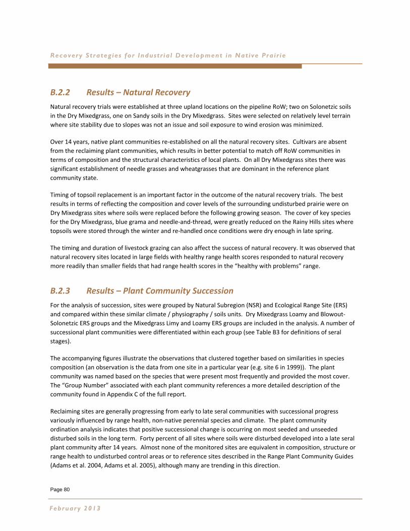
Page 80
Recovery Strateg ies for Industr ia l Development in Native Pra ir ie
B.2.2 Results – Natural Recovery
Natural recovery trials were established at three upland locations on the pipeline RoW; two on Solonetzic soils
in the Dry Mixedgrass, one on Sandy soils in the Dry Mixedgrass. Sites were selected on relatively level terrain
where site stability due to slopes was not an issue and soil exposure to wind erosion was minimized.
Over 14 years, native plant communities re‐established on all the natural recovery sites. Cultivars are absent
from the reclaiming plant communities, which results in better potential to match off RoW communities in
terms of composition and the structural characteristics of local plants. On all Dry Mixedgrass sites there was
significant establishment of needle grasses and wheatgrasses that are dominant in the reference plant
community state.
Timing of topsoil replacement is an important factor in the outcome of the natural recovery trials. The best
results in terms of reflecting the composition and cover levels of the surrounding undisturbed prairie were on
Dry Mixedgrass sites where soils were replaced before the following growing season. The cover of key species
for the Dry Mixedgrass, blue grama and needle‐and‐thread, were greatly reduced on the Rainy Hills sites where
topsoils were stored through the winter and re‐handled once conditions were dry enough in late spring.
The timing and duration of livestock grazing can also affect the success of natural recovery. It was observed that
natural recovery sites located in large fields with healthy range health scores responded to natural recovery
more readily than smaller fields that had range health scores in the “healthy with problems” range.
B.2.3 Results – Plant Community Succession
For the analysis of succession, sites were grouped by Natural Subregion (NSR) and Ecological Range Site (ERS)
and compared within these similar climate / physiography / soils units. Dry Mixedgrass Loamy and Blowout‐
Solonetzic ERS groups and the Mixedgrass Limy and Loamy ERS groups are included in the analysis. A number of
successional plant communities were differentiated within each group (see Table B3 for definitions of seral
stages).
The accompanying figures illustrate the observations that clustered together based on similarities in species
composition (an observation is the data from one site in a particular year (e.g. site 6 in 1999)). The plant
community was named based on the species that were present most frequently and provided the most cover.
The “Group Number” associated with each plant community references a more detailed description of the
community found in Appendix C of the full report.
Reclaiming sites are generally progressing from early to late seral communities with successional progress
variously influenced by range health, non‐native perennial species and climate. The plant community
ordination analysis indicates that positive successional change is occurring on most seeded and unseeded
disturbed soils in the long term. Forty percent of all sites where soils were disturbed developed into a late seral
plant community after 14 years. Almost none of the monitored sites are equivalent in composition, structure or
range health to undisturbed control areas or to reference sites described in the Range Plant Community Guides
(Adams et al. 2004, Adams et al. 2005), although many are trending in this direction.
February 2013
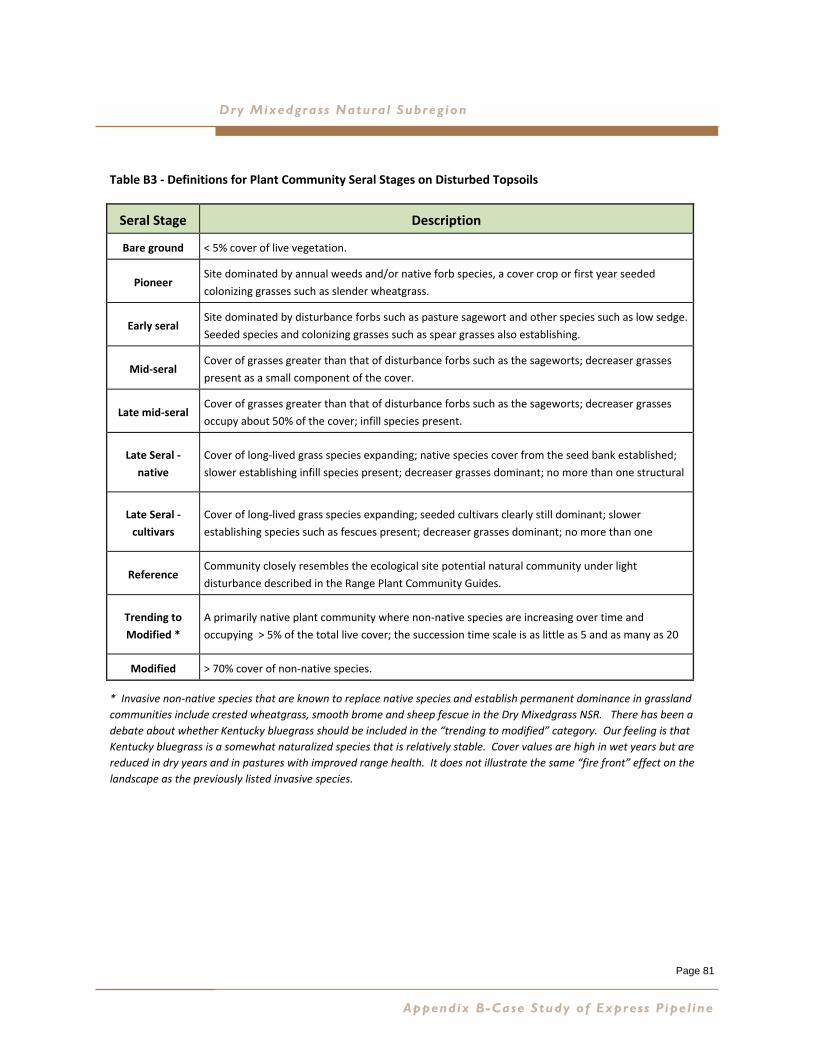
Page 81
Dry Mixedgrass Natural Subreg ion
Table B3 ‐ Definitions for Plant Community Seral Stages on Disturbed Topsoils
* Invasive non‐native species that are known to replace native species and establish permanent dominance in grassland
communities include crested wheatgrass, smooth brome and sheep fescue in the Dry Mixedgrass NSR. There has been a
debate about whether Kentucky bluegrass should be included in the “trending to modified” category. Our feeling is that
Kentucky bluegrass is a somewhat naturalized species that is relatively stable. Cover values are high in wet years but are
reduced in dry years and in pastures with improved range health. It does not illustrate the same “fire front” effect on the
landscape as the previously listed invasive species.
Appendix B-Case Study of Express Pipe l ine
Seral Stage Description
Bare ground < 5% cover of live vegetation.
Pioneer Site dominated by annual weeds and/or native forb species, a cover crop or first year seeded
colonizing grasses such as slender wheatgrass.
Early seral Site dominated by disturbance forbs such as pasture sagewort and other species such as low sedge.
Seeded species and colonizing grasses such as spear grasses also establishing.
Mid‐seral Cover of grasses greater than that of disturbance forbs such as the sageworts; decreaser grasses
present as a small component of the cover.
Late mid‐seral Cover of grasses greater than that of disturbance forbs such as the sageworts; decreaser grasses
occupy about 50% of the cover; infill species present.
Late Seral ‐
native
Cover of long‐lived grass species expanding; native species cover from the seed bank established;
slower establishing infill species present; decreaser grasses dominant; no more than one structural
Late Seral ‐
cultivars
Cover of long‐lived grass species expanding; seeded cultivars clearly still dominant; slower
establishing species such as fescues present; decreaser grasses dominant; no more than one
Reference Community closely resembles the ecological site potential natural community under light
disturbance described in the Range Plant Community Guides.
Trending to
Modified *
A primarily native plant community where non‐native species are increasing over time and
occupying > 5% of the total live cover; the succession time scale is as little as 5 and as many as 20
Modified > 70% cover of non‐native species.
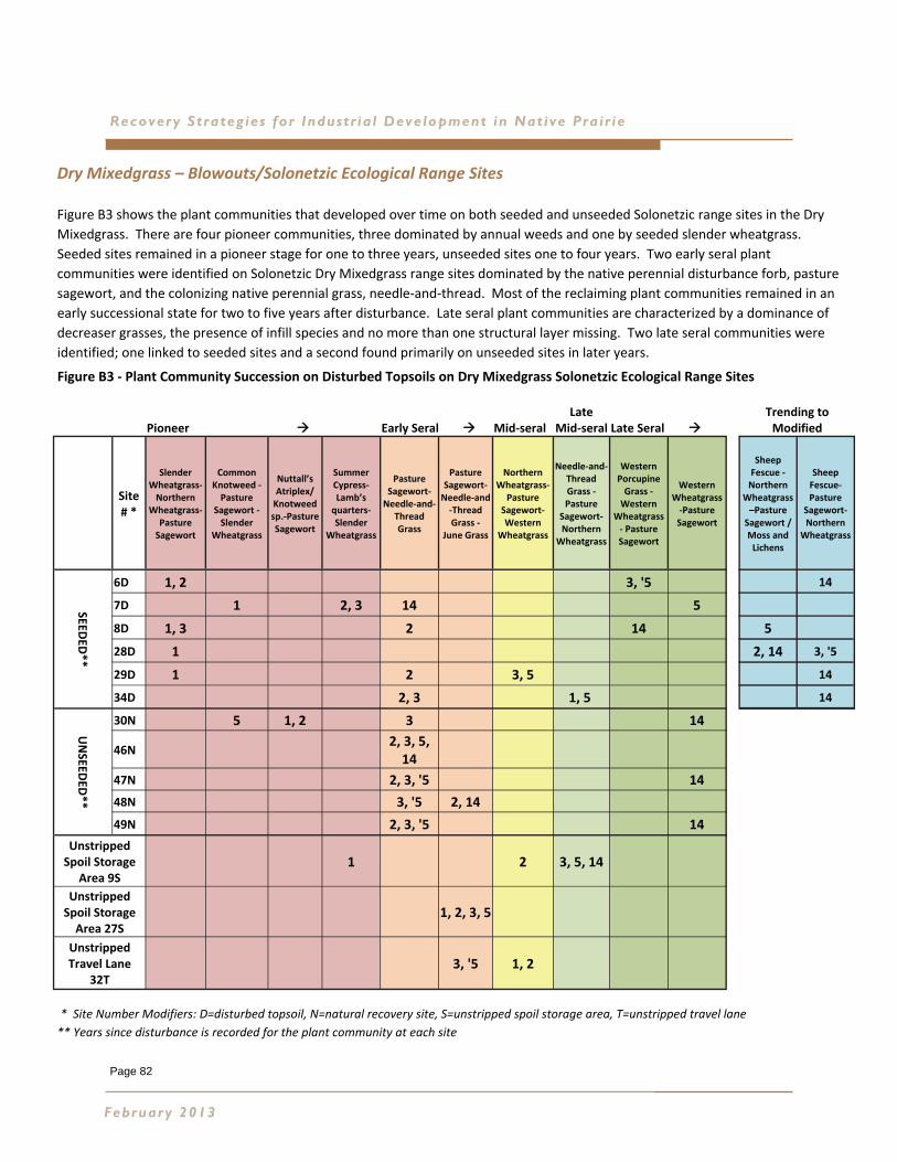
Page 82
Recovery Strateg ies for Industr ia l Development in Native Pra ir ie
Dry Mixedgrass – Blowouts/Solonetzic Ecological Range Sites
Figure B3 shows the plant communities that developed over time on both seeded and unseeded Solonetzic range sites in the Dry
Mixedgrass. There are four pioneer communities, three dominated by annual weeds and one by seeded slender wheatgrass.
Seeded sites remained in a pioneer stage for one to three years, unseeded sites one to four years. Two early seral plant
communities were identified on Solonetzic Dry Mixedgrass range sites dominated by the native perennial disturbance forb, pasture
sagewort, and the colonizing native perennial grass, needle‐and‐thread. Most of the reclaiming plant communities remained in an
early successional state for two to five years after disturbance. Late seral plant communities are characterized by a dominance of
decreaser grasses, the presence of infill species and no more than one structural layer missing. Two late seral communities were
identified; one linked to seeded sites and a second found primarily on unseeded sites in later years.
Figure B3 ‐ Plant Community Succession on Disturbed Topsoils on Dry Mixedgrass Solonetzic Ecological Range Sites
* Site Number Modifiers: D=disturbed topsoil, N=natural recovery site, S=unstripped spoil storage area, T=unstripped travel lane
** Years since disturbance is recorded for the plant community at each site
February 2013
Pioneer Early Seral Mid‐seral Late
Mid‐seral Late Seral
Trending to Modified
Site # *
Slender Wheatgrass‐Northern
Wheatgrass‐Pasture Sagewort
Common Knotweed ‐ Pasture
Sagewort ‐ Slender
Wheatgrass
Nuttall’s Atriplex/ Knotweed sp.‐Pasture Sagewort
Summer Cypress‐Lamb’s quarters‐Slender
Wheatgrass
Pasture Sagewort‐Needle‐and‐
Thread Grass
Pasture Sagewort‐Needle‐and‐Thread Grass ‐
June Grass
Northern Wheatgrass‐
Pasture Sagewort‐Western
Wheatgrass
Needle‐and‐Thread Grass ‐Pasture
Sagewort‐Northern
Wheatgrass
Western Porcupine Grass ‐Western
Wheatgrass ‐ Pasture Sagewort
Western Wheatgrass ‐Pasture Sagewort
Sheep Fescue ‐Northern
Wheatgrass –Pasture Sagewort /Moss and Lichens
Sheep Fescue‐Pasture
Sagewort‐Northern
Wheatgrass
SEEDED
**
6D 1, 2 3, '5 14
7D 1 2, 3 14 5
8D 1, 3 2 14 5
28D 1 2, 14 3, '5
29D 1 2 3, 5 14
34D 2, 3 1, 5 14
UNSEED
ED**
30N 5 1, 2 3 14
46N 2, 3, 5, 14
47N 2, 3, '5 14
48N 3, '5 2, 14
49N 2, 3, '5 14
Unstripped Spoil Storage
Area 9S 1 2 3, 5, 14
Unstripped Spoil Storage Area 27S
1, 2, 3, 5
Unstripped Travel Lane
32T 3, '5 1, 2
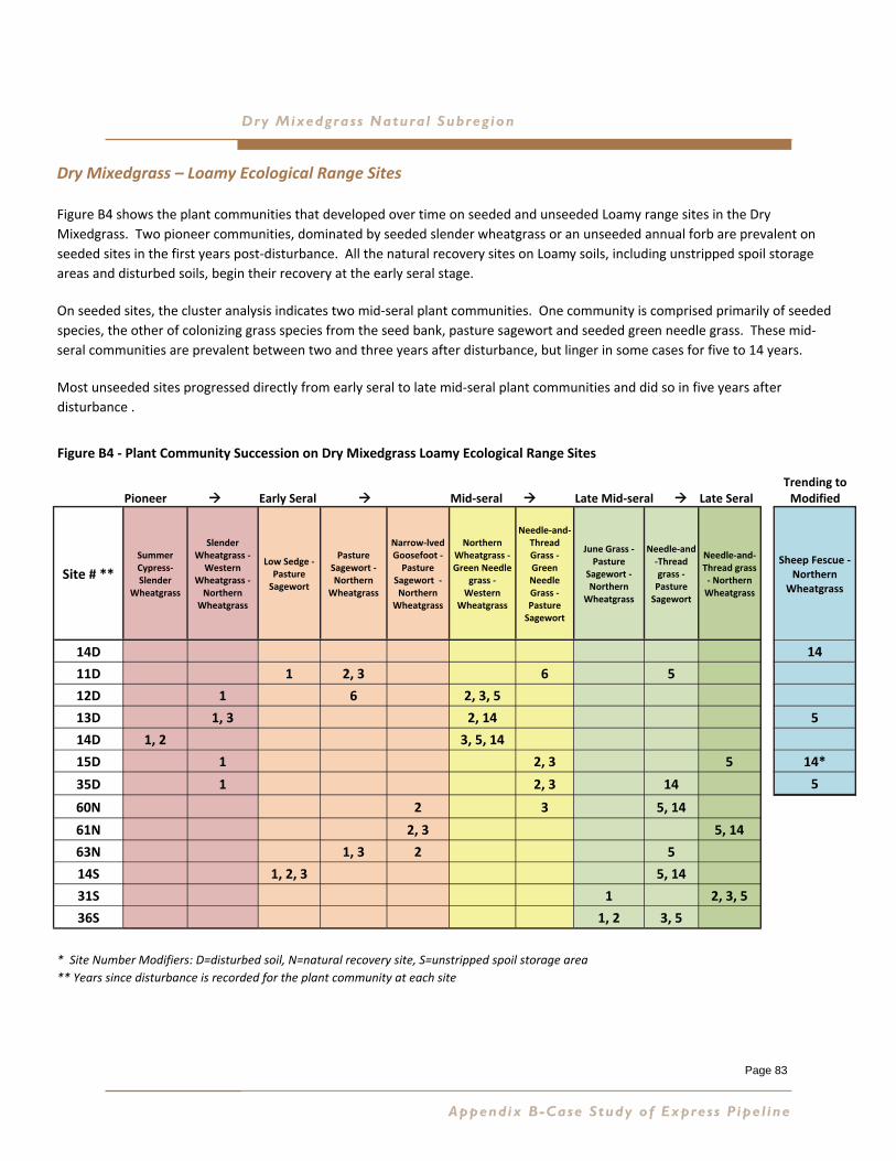
Page 83
Dry Mixedgrass Natural Subreg ion
Dry Mixedgrass – Loamy Ecological Range Sites
Figure B4 shows the plant communities that developed over time on seeded and unseeded Loamy range sites in the Dry
Mixedgrass. Two pioneer communities, dominated by seeded slender wheatgrass or an unseeded annual forb are prevalent on
seeded sites in the first years post‐disturbance. All the natural recovery sites on Loamy soils, including unstripped spoil storage
areas and disturbed soils, begin their recovery at the early seral stage.
On seeded sites, the cluster analysis indicates two mid‐seral plant communities. One community is comprised primarily of seeded
species, the other of colonizing grass species from the seed bank, pasture sagewort and seeded green needle grass. These mid‐
seral communities are prevalent between two and three years after disturbance, but linger in some cases for five to 14 years.
Most unseeded sites progressed directly from early seral to late mid‐seral plant communities and did so in five years after
disturbance .
Figure B4 ‐ Plant Community Succession on Dry Mixedgrass Loamy Ecological Range Sites
* Site Number Modifiers: D=disturbed soil, N=natural recovery site, S=unstripped spoil storage area
** Years since disturbance is recorded for the plant community at each site
Appendix B-Case Study of Express Pipe l ine
Early Seral Mid‐seral Late Mid‐seral Late Seral
Trending to Modified
Site # **
Summer Cypress‐Slender
Wheatgrass
Slender Wheatgrass ‐ Western
Wheatgrass ‐ Northern
Wheatgrass
Low Sedge ‐Pasture Sagewort
Pasture Sagewort ‐Northern
Wheatgrass
Narrow‐lved Goosefoot ‐ Pasture
Sagewort ‐ Northern
Wheatgrass
Northern Wheatgrass ‐Green Needle
grass ‐ Western
Wheatgrass
Needle‐and‐Thread Grass ‐ Green Needle Grass ‐ Pasture Sagewort
June Grass ‐ Pasture
Sagewort ‐ Northern
Wheatgrass
Needle‐and‐Thread grass ‐ Pasture Sagewort
Needle‐and‐Thread grass ‐ Northern Wheatgrass
Sheep Fescue ‐
Northern Wheatgrass
14D 14
11D 1 2, 3 6 5
12D 1 6 2, 3, 5
13D 1, 3 2, 14 5
14D 1, 2 3, 5, 14
15D 1 2, 3 5 14*
35D 1 2, 3 14 5
60N 2 3 5, 14
61N 2, 3 5, 14
63N 1, 3 2 5
14S 1, 2, 3 5, 14
31S 1 2, 3, 5
36S 1, 2 3, 5
Pioneer

Page 84
Recovery Strateg ies for Industr ia l Development in Native Pra ir ie
Dry Mixedgrass – Sandy Ecological Range Sites
Figure B5 shows the plant communities that developed over time on six unseeded natural recovery sites on
disturbed topsoils (sites 40N – 45N) and an unstripped travel lane (site 5T) in Sandy range sites as identified by
GVI. The first two years of data collection on four of the six natural recovery sites was not used.
The unstripped travel lane site is a heavily grazed pasture and the plant community (Buckbrush – Sun‐Loving Sedge
‐ Pasture Sagewort) remains as a mid‐seral plant community dominated by increaser species during all of the
monitoring years.
The six natural recovery sites of the Hemaruka Dunes progress from pioneer plant communities in the first year or
two to early seral and late seral communities in the third year.
The pioneer community is dominated by an exotic annual weed, lamb’s quarters, and rhizomatous native
perennials.
The early seral community is dominated by an introduced annual mustard. The native perennial grass western
porcupine grass and pasture sagewort are establishing on the RoW. The late seral plant communities are
characterized by the dominance of species that characterize the reference plant communities for Sandy ecological
range sites, including western porcupine grass, needle‐and‐thread, and sand grass.
By year five all of the sites have developed to late seral plant communities dominated by needle‐and‐thread or
western porcupine grass. One site (40) is clustering with a mid‐seral plant community, but this is likely due to the
high cover of buckbrush on this site.
Figure B5 ‐ Plant Community Succession on Unseeded Topsoil on Dry Mixedgrass Sandy Ecological Range Sites
* Site Number Modifiers: N=natural recovery site
** Years since disturbance is recorded for the plant community at each site
February 2013
Pioneer Early Seral Mid‐seral Late Seral
Site# * Prairie Rose ‐
Lamb’s Quarters ‐ Prairie Sagewort**
Tansy Mustard ‐ Western
Porcupine Grass ‐ Pasture
Sagewort**
Buckbrush ‐Sun‐Loving Sedge ‐
Pasture Sagewort**
Western Porcupine Grass ‐ Pasture Sagewort ‐ Sand Grass**
Needle‐and‐Thread ‐ Pasture
Sagewort ‐ Kentucky
Bluegrass**
Needle‐and‐Thread ‐ Blunt Sedge ‐ Sand Grass**
40N 14 2, 3, 5
41N 2, 3, 5 14
42N 5 2, 3, 14
43N 5 2, 3, 14
44N 1 3 5 2, 14
45N 1, 2 3 5 14
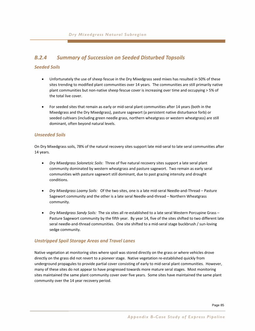
Page 85
Dry Mixedgrass Natural Subreg ion
B.2.4 Summary of Succession on Seeded Disturbed Topsoils
Seeded Soils
Unfortunately the use of sheep fescue in the Dry Mixedgrass seed mixes has resulted in 50% of these
sites trending to modified plant communities over 14 years. The communities are still primarily native
plant communities but non‐native sheep fescue cover is increasing over time and occupying > 5% of
the total live cover.
For seeded sites that remain as early or mid‐seral plant communities after 14 years (both in the
Mixedgrass and the Dry Mixedgrass), pasture sagewort (a persistent native disturbance forb) or
seeded cultivars (including green needle grass, northern wheatgrass or western wheatgrass) are still
dominant, often beyond natural levels.
Unseeded Soils
On Dry Mixedgrass soils, 78% of the natural recovery sites support late mid‐seral to late seral communities after
14 years.
Dry Mixedgrass Solonetzic Soils: Three of five natural recovery sites support a late seral plant
community dominated by western wheatgrass and pasture sagewort. Two remain as early seral
communities with pasture sagewort still dominant, due to past grazing intensity and drought
conditions.
Dry Mixedgrass Loamy Soils: Of the two sites, one is a late mid‐seral Needle‐and‐Thread – Pasture
Sagewort community and the other is a late seral Needle‐and‐thread – Northern Wheatgrass
community.
Dry Mixedgrass Sandy Soils: The six sites all re‐established to a late seral Western Porcupine Grass –
Pasture Sagewort community by the fifth year. By year 14, five of the sites shifted to two different late
seral needle‐and‐thread communities. One site shifted to a mid‐seral stage buckbrush / sun‐loving
sedge community.
Unstripped Spoil Storage Areas and Travel Lanes
Native vegetation at monitoring sites where spoil was stored directly on the grass or where vehicles drove
directly on the grass did not revert to a pioneer stage. Native vegetation re‐established quickly from
underground propagules to provide partial cover consisting of early to mid‐seral plant communities. However,
many of these sites do not appear to have progressed towards more mature seral stages. Most monitoring
sites maintained the same plant community cover over five years. Some sites have maintained the same plant
community over the 14 year recovery period.
Appendix B-Case Study of Express Pipe l ine
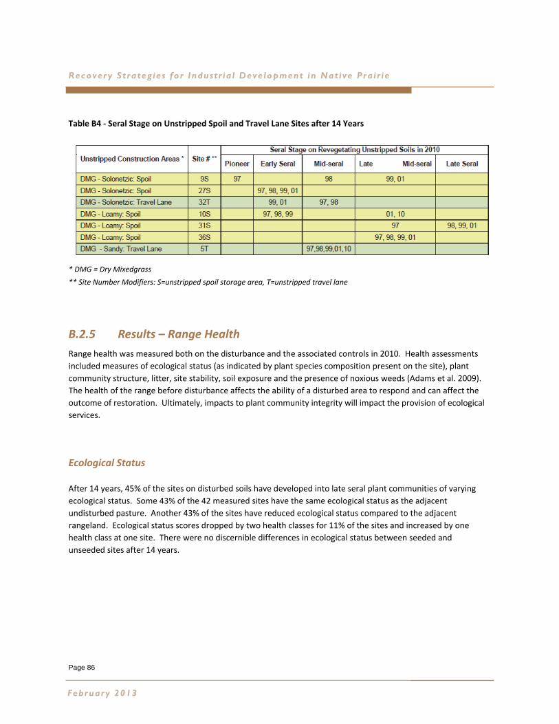
Page 86
Recovery Strateg ies for Industr ia l Development in Native Pra ir ie
Table B4 ‐ Seral Stage on Unstripped Spoil and Travel Lane Sites after 14 Years
* DMG = Dry Mixedgrass
** Site Number Modifiers: S=unstripped spoil storage area, T=unstripped travel lane
B.2.5 Results – Range Health
Range health was measured both on the disturbance and the associated controls in 2010. Health assessments
included measures of ecological status (as indicated by plant species composition present on the site), plant
community structure, litter, site stability, soil exposure and the presence of noxious weeds (Adams et al. 2009).
The health of the range before disturbance affects the ability of a disturbed area to respond and can affect the
outcome of restoration. Ultimately, impacts to plant community integrity will impact the provision of ecological
services.
Ecological Status
After 14 years, 45% of the sites on disturbed soils have developed into late seral plant communities of varying
ecological status. Some 43% of the 42 measured sites have the same ecological status as the adjacent
undisturbed pasture. Another 43% of the sites have reduced ecological status compared to the adjacent
rangeland. Ecological status scores dropped by two health classes for 11% of the sites and increased by one
health class at one site. There were no discernible differences in ecological status between seeded and
unseeded sites after 14 years.
February 2013
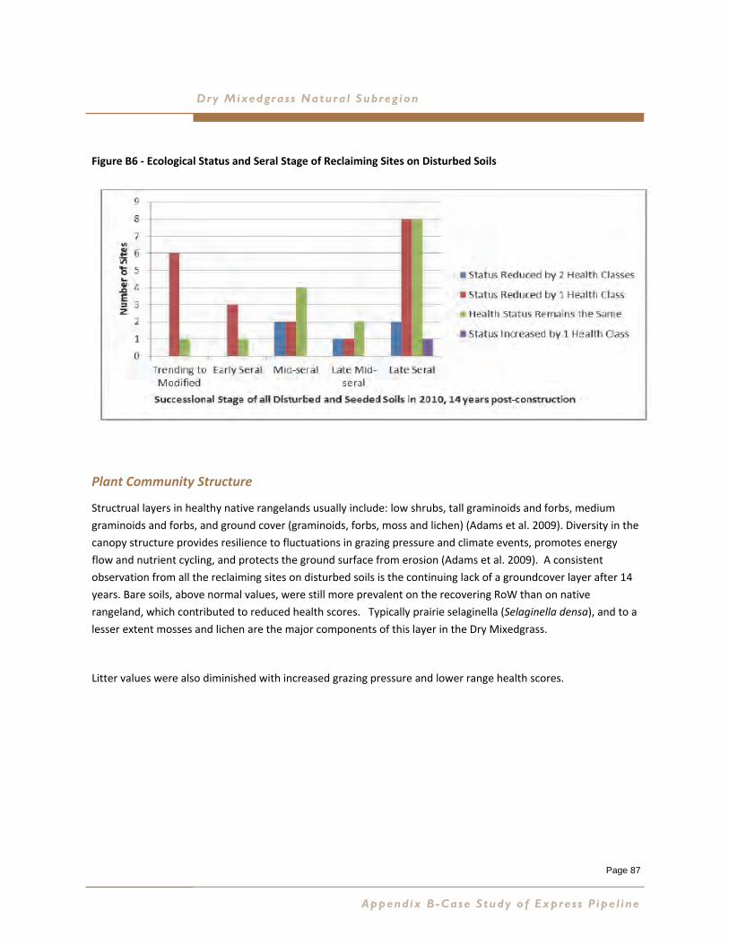
Page 87
Dry Mixedgrass Natural Subreg ion
Figure B6 ‐ Ecological Status and Seral Stage of Reclaiming Sites on Disturbed Soils
Plant Community Structure
Structrual layers in healthy native rangelands usually include: low shrubs, tall graminoids and forbs, medium
graminoids and forbs, and ground cover (graminoids, forbs, moss and lichen) (Adams et al. 2009). Diversity in the
canopy structure provides resilience to fluctuations in grazing pressure and climate events, promotes energy
flow and nutrient cycling, and protects the ground surface from erosion (Adams et al. 2009). A consistent
observation from all the reclaiming sites on disturbed soils is the continuing lack of a groundcover layer after 14
years. Bare soils, above normal values, were still more prevalent on the recovering RoW than on native
rangeland, which contributed to reduced health scores. Typically prairie selaginella (Selaginella densa), and to a
lesser extent mosses and lichen are the major components of this layer in the Dry Mixedgrass.
Litter values were also diminished with increased grazing pressure and lower range health scores.
Appendix B-Case Study of Express Pipe l ine
Page 88
Recovery Strateg ies for Industr ia l Development in Native Pra ir ie
Invasive Species
Establishment of invasive species from the seedbank or through infill has only been an
issue at a few monitoring sites. Crested wheatgrass is establishing on two southern sites in
the Dry Mixedgrass where it is present off RoW. The large pastures in the expansive areas
of native prairie in the southern portion of the Express Pipeline route are relatively free of
introduced species. Further north, where there is increased landscape fragmentation and
cultivation, introduced species are more common.
Interacting Variables
Range health was generally better in larger pastures and on Public Land. Smaller pastures
and private land, particularly on more northern portions of the RoW, tended to have
reduced range health scores. In smaller pastures the disturbed RoW takes up
proportionally more land temporarily reducing forage production and disrupting livestock
grazing patterns which can put further pressure on both the undisturbed and disturbed
portions of the area. Recovery can be delayed if livestock disproportionately select the re‐
establishing forage species on the RoW over established forage in the balance of the
pasture. The droughts experienced during recovery can also exacerbate grazing impacts on
the recovering RoW, particularly in smaller pastures.
B.2.6 Results – Diversity After Disturbance
An assessment was made of the proportion over time of three growth forms of interest
(annual forbs, perennial forbs, and graminoids) on reclaiming soils in the Dry Mixedgrass.
The assessment compares the relationship between the diversity of species on a site
(represented by Shannon’s Diversity Index) and the proportion of a site occupied by each
growth form. The biggest changes in proportion are the flush of annual forbs immediately
after disturbance, their gradual decline over time and the slow steady increase in the
diversity of graminoids (grasses and sedges) on natural recovery sites as opposed to the
high cover, low diversity seed mix graminoid cover in early years.
Over time the diversity of graminoids and the proportion of the naturally reclaiming sites
occupied by graminoids increases and are comparable to values on seeded areas and
undisturbed controls by 2010.
February 2013

Page 89
Dry Mixedgrass Natural Subreg ion
B.3 Management Recommendations
A number of recommendations based on key learning’s from Express are presented in Section 11 of the main
report. A few are highlighted here.
Restoration Planning
Sites where long‐lived seeded species matched those present naturally on the surrounding rangeland
had the best chance of establishing and persisting over time.
New tools for planning restoration of native prairie after disturbance will identify ecological site
characteristics and target plant communities for restoration planning.
There may be more options for restoration in healthy rangeland. Diminished range health or high
grazing intensity can hinder recovery.
Seed Mixes
Avoid seeding persistent species that are not present naturally on the same ecological range site (ERS).
Non‐native sheep fescue is invasive and should not be used for restoration. Sheep fescue may
contribute to plant community modification over time.
It is important to plan for different structural layers when designing a seed mix and include a variety of
species with tall, mid and low structural characteristics compatible for the range site and associated
plant community. Diverse structure improves range health and builds ecological resilience.
Persistent cultivars that developed taller structure on the RoW are green needle grass, sand grass
(sand reed grass), northern wheatgrass and western wheatgrass.
It is very important to use seed with genetic origin that is compatible with the area of the project.
Some cultivars are much taller and more robust than local plants, creating persistent increases in plant
community structure on the revegetating disturbance. The common aggressive cultivars on Express
were green needle grass, western wheatgrass and northern wheatgrass.
Slender wheatgrass is a useful short term cover crop, providing erosion control and shade for slower
establishing species and disappearing for the most part by year five, leaving space for infill by other
species.
Avoid using non‐native species for native prairie restoration unless they are annual cover crops that
are guaranteed not to persist more than one year or have the potential to increase in density over
time through seed set.
Appendix B-Case Study of Express Pipe l ine
Page 90
Recovery Strateg ies for Industr ia l Development in Native Pra ir ie
Natural Recovery
Natural recovery techniques were successful in establishing native plant
communities in the Dry Mixedgrass Natural Subregion. Cultivars are absent from
the reclaiming plant communities, which results in better potential to match off
RoW communities in terms of composition and the structural characteristics of
local plants. The result is a native plant community rather than a community of
native cultivars.
The timing of topsoil replacement is an important factor in the outcome of natural
recovery as a revegetation strategy. Topsoil replacement in the fall or during
dormant conditions before the first post‐construction growing season is
recommended.
The presence of undesirable non‐native species prior to disturbance can
negatively affect the outcome of natural recovery as a revegetation strategy.
Seeding may be a better option on invaded sites.
The timing and duration of livestock grazing can also affect the success of natural
recovery. Protecting sites from grazing during spring and summer in the first few
years can be beneficial.
Communication of Restoration Commitments and Strategies from
Construction to Operations
Remedial repairs and seeding may be required on projects up to 10 years after
construction. It is important to communicate restoration goals, commitments and
strategies agreed to for construction to the operations team.
Assessing Restoration Progress
Patience is required to restore native grassland communities. The 14 year post‐
construction monitoring on Express indicates that succession is still on‐going and range
health on the disturbances is improving, but is lower than the surrounding rangeland.
February 2013
Page 91
Dry Mixedgrass Natural Subreg ion
APPENDIX C TARGET RECOVERING PLANT COMMUNITIES
Introduction
Designing native seed mixes for industrial disturbances not suited to natural recovery in the
Dry Mixedgrass Natural Subregion is as much an art as it is a science. The purpose of the native
seed mix is to revegetate the disturbance with native grass species that will allow the process
of succession to take place and to establish a mid‐ to late‐seral plant community over time.
The current Range Plant Community Guide for the Dry Mixedgrass contains 48 native grassland
plant community descriptions and five native shrubland plant communities (Adams et al.
2005). Given the diversity of ecological range sites and successional plant community types
that can be encountered within a relatively small area on the prairie landscape, it is necessary
to establish which ecological range sites have species in common based on the Agricultural
Region of Alberta Soil Information Database (AGRASID) soil and landscape correlation (Brierley
et al. 2001). These groupings of ecological range sites with common dominant native grass
species are referred to as target recovering plant communities. They are clearly not mature
reference native plant communities, but rather composed of the dominant native grass species
that are drivers or principle species in the successional process.
The specifics of the target recovering plant communities for each grouping of ecological range
sites are presented in this appendix accompanied by recommendations for seed mix design.
The recommended native grass species can be seen as facilitating plant community succession
and will provide the initial vegetative cover to stabilize the disturbed soils and facilitate the
recovery of the plant community (including the native forb component) over time. Examples
of recommended native grass species, based on the target recovering plant community are
given as % Pure Live Seed by Weight. The value for each recommended species has been
computed through an iterative process that converts the % foliar cover anticipated in the
recovering plant community to the % by weight of pure live seed required for each species in
the seed mix. For example, how much northern wheatgrass pure live seed is required in the
seed mix to reach a target of 4 % foliar cover in the target recovering plant community?
It is important to note that this is only the first step in seed mix design. Further guidance for
calculating seeding rates is provided in Appendix D with the inclusion of “Seeding Rate
Conversion Charts for Using Native species in Reclamation Projects” (Hammermeister 1998).
Examples of Reports of Seed Analysis accompanied by an explanation of how to interpret the
reports have been provided by 20/20 Seed Labs Inc. It is recommended that qualified
professionals with experience in native prairie restoration be consulted for native seed mix
design.
Appendix C-Target Recover ing Plant Communit ies
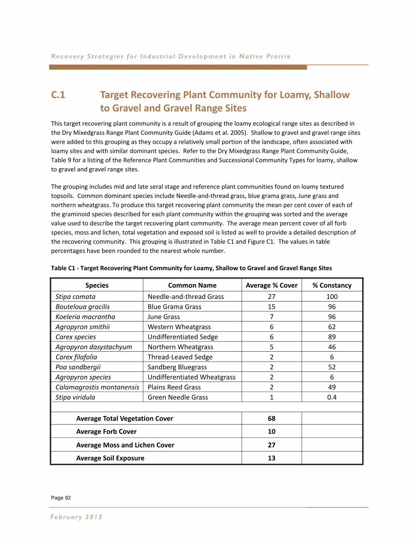
Page 92
Recovery Strateg ies for Industr ia l Development in Native Pra ir ie
C.1 Target Recovering Plant Community for Loamy, Shallow to Gravel and Gravel Range Sites
This target recovering plant community is a result of grouping the loamy ecological range sites as described in
the Dry Mixedgrass Range Plant Community Guide (Adams et al. 2005). Shallow to gravel and gravel range sites
were added to this grouping as they occupy a relatively small portion of the landscape, often associated with
loamy sites and with similar dominant species. Refer to the Dry Mixedgrass Range Plant Community Guide,
Table 9 for a listing of the Reference Plant Communities and Successional Community Types for loamy, shallow
to gravel and gravel range sites.
The grouping includes mid and late seral stage and reference plant communities found on loamy textured
topsoils. Common dominant species include Needle‐and‐thread grass, blue grama grass, June grass and
northern wheatgrass. To produce this target recovering plant community the mean per cent cover of each of
the graminoid species described for each plant community within the grouping was sorted and the average
value used to describe the target recovering plant community. The average mean percent cover of all forb
species, moss and lichen, total vegetation and exposed soil is listed as well to provide a detailed description of
the recovering community. This grouping is illustrated in Table C1 and Figure C1. The values in table
percentages have been rounded to the nearest whole number.
Table C1 ‐ Target Recovering Plant Community for Loamy, Shallow to Gravel and Gravel Range Sites
February 2013
Species Common Name Average % Cover % Constancy
Stipa comata Needle‐and‐thread Grass 27 100
Bouteloua gracilis Blue Grama Grass 15 96
Koeleria macrantha June Grass 7 96
Agropyron smithii Western Wheatgrass 6 62
Carex species Undifferentiated Sedge 6 89
Agropyron dasystachyum Northern Wheatgrass 5 46
Carex filafolia Thread‐Leaved Sedge 2 6
Poa sandbergii Sandberg Bluegrass 2 52
Agropyron species Undifferentiated Wheatgrass 2 6
Calamagrostis montanensis Plains Reed Grass 2 49
Stipa viridula Green Needle Grass 1 0.4
Average Total Vegetation Cover 68
Average Forb Cover 10
Average Moss and Lichen Cover 27
Average Soil Exposure 13
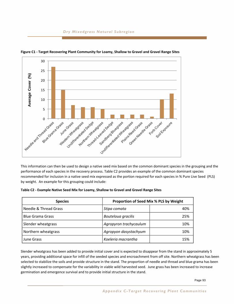
Page 93
Dry Mixedgrass Natural Subreg ion
Figure C1 ‐ Target Recovering Plant Community for Loamy, Shallow to Gravel and Gravel Range Sites
This information can then be used to design a native seed mix based on the common dominant species in the grouping and the
performance of each species in the recovery process. Table C2 provides an example of the common dominant species
recommended for inclusion in a native seed mix expressed as the portion required for each species in % Pure Live Seed (PLS)
by weight. An example for this grouping could include:
Table C2 ‐ Example Native Seed Mix for Loamy, Shallow to Gravel and Gravel Range Sites
Slender wheatgrass has been added to provide initial cover and is expected to disappear from the stand in approximately 5
years, providing additional space for infill of the seeded species and encroachment from off site. Northern wheatgrass has been
selected to stabilize the soils and provide structure in the stand. The proportion of needle and thread and blue grama has been
slightly increased to compensate for the variability in viable wild harvested seed. June grass has been increased to increase
germination and emergence survival and to provide initial structure in the stand.
Species
Needle & Thread Grass Stipa comata 40%
Blue Grama Grass Bouteloua gracilis 25%
Slender wheatgrass Agropyron trachycaulum 10%
Northern wheatgrass Agropyon dasystachyum 10%
June Grass Koeleria macrantha 15%
Proportion of Seed Mix % PLS by Weight
Appendix C-Target Recover ing Plant Communit ies
0
5
10
15
20
25
30
Ave
rag
e C
ove
r (%
)
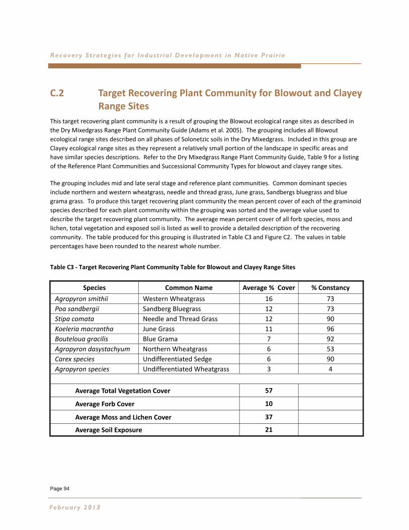
Page 94
Recovery Strateg ies for Industr ia l Development in Native Pra ir ie
C.2 Target Recovering Plant Community for Blowout and Clayey Range Sites
This target recovering plant community is a result of grouping the Blowout ecological range sites as described in
the Dry Mixedgrass Range Plant Community Guide (Adams et al. 2005). The grouping includes all Blowout
ecological range sites described on all phases of Solonetzic soils in the Dry Mixedgrass. Included in this group are
Clayey ecological range sites as they represent a relatively small portion of the landscape in specific areas and
have similar species descriptions. Refer to the Dry Mixedgrass Range Plant Community Guide, Table 9 for a listing
of the Reference Plant Communities and Successional Community Types for blowout and clayey range sites.
The grouping includes mid and late seral stage and reference plant communities. Common dominant species
include northern and western wheatgrass, needle and thread grass, June grass, Sandbergs bluegrass and blue
grama grass. To produce this target recovering plant community the mean percent cover of each of the graminoid
species described for each plant community within the grouping was sorted and the average value used to
describe the target recovering plant community. The average mean percent cover of all forb species, moss and
lichen, total vegetation and exposed soil is listed as well to provide a detailed description of the recovering
community. The table produced for this grouping is illustrated in Table C3 and Figure C2. The values in table
percentages have been rounded to the nearest whole number.
Table C3 ‐ Target Recovering Plant Community Table for Blowout and Clayey Range Sites
February 2013
Species Common Name Average % Cover % Constancy
Agropyron smithii Western Wheatgrass 16 73
Poa sandbergii Sandberg Bluegrass 12 73
Stipa comata Needle and Thread Grass 12 90
Koeleria macrantha June Grass 11 96
Bouteloua gracilis Blue Grama 7 92
Agropyron dasystachyum Northern Wheatgrass 6 53
Carex species Undifferentiated Sedge 6 90
Agropyron species Undifferentiated Wheatgrass 3 4
Average Total Vegetation Cover 57
Average Forb Cover 10
Average Moss and Lichen Cover 37
Average Soil Exposure 21
Dry Mixedgrass Natural Subreg ion
Figure C2 ‐ Target Recovering Plant Community for Blowout and Clayey Range Sites
This information can then be used to design a native seed mix based on the common dominant species in the grouping and the
performance of each species in the recovery process. Table C4 provides an example of the common dominant species
recommended for inclusion in a native seed mix expressed as the portion required for each species in % Pure Live Seed by weight.
An example for this grouping could include:
Table C4 ‐ Example Native Seed Mix for Blowout and Clayey Range Sites
Slender wheatgrass has been added to provide initial cover and is expected to disappear from the stand in approximately 5 years,
providing additional space for infill of the seeded species and encroachment from off site. Northern and western wheatgrasses
have been selected to stabilize the soils and provide structure in the stand. The portion of needle and thread and blue grama has
been slightly increased to compensate for the variability in viable wild harvested seed. June grass has been increased to increase
germination and emergence survival and to provide initial structure in the stand.
Species
Northern Wheatgrass Agropyron dasystachyum 10%
Slender Wheatgrass Agropyron trachycaulum 10%
Needle & Thread Grass Stipa comata 20%
Sandbergs Bluegrass Poa sandbergii 12%
June Grass Koeleria macrantha 20%
Western Wheatgrass Agropyron smithii 16%
Blue Grama Grass Bouteloua gracilis 12%
Proportion of Seed Mix % PLS by Weight
Appendix C-Target Recover ing Plant Communit ies
Page 95
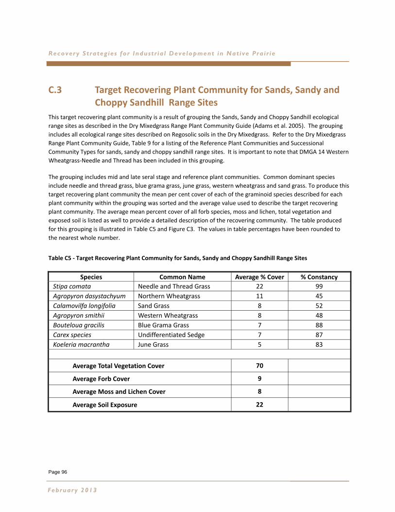
Page 96
Recovery Strateg ies for Industr ia l Development in Native Pra ir ie
C.3 Target Recovering Plant Community for Sands, Sandy and Choppy Sandhill Range Sites
This target recovering plant community is a result of grouping the Sands, Sandy and Choppy Sandhill ecological
range sites as described in the Dry Mixedgrass Range Plant Community Guide (Adams et al. 2005). The grouping
includes all ecological range sites described on Regosolic soils in the Dry Mixedgrass. Refer to the Dry Mixedgrass
Range Plant Community Guide, Table 9 for a listing of the Reference Plant Communities and Successional
Community Types for sands, sandy and choppy sandhill range sites. It is important to note that DMGA 14 Western
Wheatgrass‐Needle and Thread has been included in this grouping.
The grouping includes mid and late seral stage and reference plant communities. Common dominant species
include needle and thread grass, blue grama grass, june grass, western wheatgrass and sand grass. To produce this
target recovering plant community the mean per cent cover of each of the graminoid species described for each
plant community within the grouping was sorted and the average value used to describe the target recovering
plant community. The average mean percent cover of all forb species, moss and lichen, total vegetation and
exposed soil is listed as well to provide a detailed description of the recovering community. The table produced
for this grouping is illustrated in Table C5 and Figure C3. The values in table percentages have been rounded to
the nearest whole number.
Table C5 ‐ Target Recovering Plant Community for Sands, Sandy and Choppy Sandhill Range Sites
February 2013
Species Common Name Average % Cover % Constancy
Stipa comata Needle and Thread Grass 22 99
Agropyron dasystachyum Northern Wheatgrass 11 45
Calamovilfa longifolia Sand Grass 8 52
Agropyron smithii Western Wheatgrass 8 48
Bouteloua gracilis Blue Grama Grass 7 88
Carex species Undifferentiated Sedge 7 87
Koeleria macrantha June Grass 5 83
Average Total Vegetation Cover 70
Average Forb Cover 9
Average Moss and Lichen Cover 8
Average Soil Exposure 22
Page 97
Dry Mixedgrass Natural Subreg ion
Figure C3 ‐ Target Recovering Plant Community for Sands, Sandy and Choppy Sandhill Range Sites
This information can then be used to design a native seed mix based on the common dominant species in the
grouping and the performance of each species in the recovery process. Table C6 provides an example of the
common dominant species recommended for inclusion in a native seed mix expressed as the portion required for
each species in % Pure Live Seed by weight. An example for this grouping could include :
Table C6 ‐ Example Native Seed Mix for Sands, Sandy and Choppy Sandhill Range Sites
Slender wheatgrass has been added to provide initial cover and is expected to disappear from the stand in
approximately 5 years, providing additional space for infill of the seeded species and encroachment from off site.
Northern and western wheatgrasses have been selected to stabilize the soils and provide structure in the stand.
The portion of needle and thread and blue grama has been increased to compensate for the variability in viable
wild harvested seed. June grass has been increased to increase germination and emergence survival and to
provide initial structure in the stand.
Species
Needle & Thread Grass Stipa comata 35%
Western Wheatgrass Agropyron smithii 10%
Sand Grass Calamovilfa longifolia 8%
Northern Wheatgrass Agropyron dasystachyum 15%
Blue Grama Grass Bouteloua gracilis 12%
Slender wheatgrass Agropyron trachycaulum 10%
June Grass Koeleria macrantha 10%
Proportion of Seed Mix % PLS by Weight
Appendix C-Target Recover ing Plant Communit ies
Page 98
Recovery Strateg ies for Industr ia l Development in Native Pra ir ie
An Important Sandy Range Site Outlier in the Dry Mixedgrass
DMGA13 Western Porcupine Grass – Needle‐and‐Thread ‐ Sand Grass is a later seral plant community on sandy range sites
in the Dry Mixedgrass found on moderately coarse, sandy loam textured soils. An indicator species of this community is
western porcupine grass as the dominant species. The target recovering plant community includes:
Table C7 – Recovering Plant Community for Important Sandy Range Site Outlier
February 2013
Species Common Name Average % Cover % Constancy
Stipa curtiseta Western Porcupine Grass 25 100
Stipa comata Needle and Thread Grass 20 100
Bouteloua gracilis Blue Grama Grass 7 94
Koeleria macrantha June Grass 7 100
Agropyron smithii Western Wheatgrass 6 63
Calamovilfa longifolia Sand Grass 6 4
Carex species Undifferentiated Sedge 5 75
Calamagrostis montanensis Plains Reed Grass 2 63
Average Total Vegetation Cover 82
Average Forb Cover 2
Average Moss and Lichen Cover 35
Average Soil Exposure 6
Page 99
Dry Mixedgrass Natural Subreg ion
Figure C4 – Recovering Plant Community for Important Sandy Range Site Outlier
This information can then be used to design a native seed mix based on the common dominant species in the grouping
and the performance of each species in the recovery process. Table C8 provides an example of the dominant species
recommended for inclusion in a native seed mix expressed as the portion required for each species in % Pure Live Seed
by weight. An example for this community could include :
Table C8 – DMGA13 Example Seed Mix
Again Slender wheatgrass has been added to provide initial cover and the values for western porcupine, needle‐and‐
thread and blue grama increased to compensate for wild harvested seed.
Species
Western porcupine grass Stipa curtiseta 30%
Needle‐and‐thread grass Stipa comata 25%
June grass Koeleria macrantha 15%
Blue grama grass Bouteloua gracilis 10%
Sand grass Calamovilfa longifolia 5%
Western wheatgrass Agropyron smithii 5%
Slender wheatgrass Agropyron trachycaulum 10%
Proportion of Seed Mix % PLS by Weight
Appendix C-Target Recover ing Plant Communit ies
Page 100
Recovery Strateg ies for Industr ia l Development in Native Pra ir ie
C.4 Target Recovering Plant Community for Thin Breaks and Limey Range Sites
This target recovering plant community is a result of grouping thin breaks and limey range sites due to common
weakly developed soils and common dominant species of needle‐and‐thread, blue grama grass and june grass.
Refer to the Dry Mixedgrass Range Plant Community Guide, Table 9 for a listing of the Reference Plant
Communities and Successional Community Types for thin breaks and limey range sites (Adams et al. 2005).
To produce this target recovering plant community the mean percent cover of each of the graminoid species
described for each plant community within the grouping was sorted and the average value used to describe the
target recovering plant community. The average mean percent cover of all forb species, moss and lichen, total
vegetation and exposed soil is listed as well to provide a detailed description of the recovering community. The
table produced for this grouping is illustrated in Table C9 and Figure C5. The values in table percentages have
been rounded to the nearest whole number.
Table C9 ‐ Target Recovering Plant Community Table for Thin Breaks and Limey Range Sites
February 2013
Species Common Name Average % Cover % Constancy
Stipa comata Needle and Thread Grass 36 100
Bouteloua gracilis Blue Grama Grass 13 96
Carex species Undifferentiated Sedge 7 87
Agropyron smithii Western Wheatgrass 6 53
Koeleria macrantha June Grass 6 84
Agropryon dasystachyum Northern Wheatgrass 2 29
Carex filifolia Thread‐Leaved Sedge 2 18
Poa sandbergii Sandberg Bluegrass 1 24
Average Total Vegetation Cover 59
Average Forb Cover 7
Average Moss and Lichen Cover 23
Average Soil Exposure 22
Page 101
Dry Mixedgrass Natural Subreg ion
Figure C5 ‐ Target Recovering Plant Community for Thin Breaks and Limey Range Sites
This information can then be used to design a native seed mix based on the common dominant species in the
grouping and the performance of each species in the recovery process. Table C10 provides an example of the common
dominant species recommended for inclusion in a native seed mix expressed as the portion required for each species
in % Pure Live Seed by weight. An example for this grouping could include:
Table C10 ‐ Example Native Seed Mix for Thin Breaks and Limey Range Sites
In this case northern and western wheatgrass have been increased to provide cover and erosion control on steep
slopes, slender wheatgrass has been added to provide initial cover and is expected to disappear within 5 years. The
needle and thread and blue grama have been increased to compensate for wild harvested seed.
Species
Needle & Thread Grass Stipa comata 40%
Blue Grama Grass Bouteloua gracilis 15%
Slender wheatgrass Agropyron trachycaulum 10%
Northern Wheatgrass Agropyron dasystachyum 10%
June Grass Koeleria macrantha 15%
Western Wheatgrass Agropyron smithii 10%
Proportion of Seed Mix % PLS by Weight
Appendix C-Target Recover ing Plant Communit ies
Page 102
Recovery Strateg ies for Industr ia l Development in Native Pra ir ie
C.5 Target Recovering Plant Community for Non‐saline Overflow Range Sites
Overflow range sites represent a relatively small portion of the Dry Mixedgrass landscape. They are unique in that
they receive moisture from the surrounding upland range sites and as a result are more productive. Refer to the
Dry Mixedgrass Range Plant Community Guide, Table 9 for a listing of the Reference Plant Communities and
Successional Community Types for Non‐saline Overflow range sites (Adams et al. 2005).
An indicator species of non‐saline overflow range sites in the Dry Mixedgrass is western porcupine grass which
requires productive chernozemic soils. To produce this target recovering plant community the mean per cent
cover of each of the graminoid species described for each plant community within the grouping was sorted and the
average value used to describe the target recovering plant community. The average mean percent cover of all forb
species, moss and lichen, total vegetation and exposed soil is listed as well to provide a detailed description of the
recovering community. The table produced for this grouping is illustrated in Table C11 and Figure C6. The values in
table percentages have been rounded to the nearest whole number.
Table C11 ‐ Target Recovering Plant Community Table for Non‐saline Overflow Range Sites
Kentucky bluegrass (Poa pratensis) is present at a low average mean percent cover value in the reference plant
community DMGA40 for overflow range sites in the Suffield area. It is considered non‐native and can be invasive
following soil disturbance in overflow range sites. If detected in the pre‐disturbance site assessment, Invasive plant
management is recommended.
February 2013
Species Common Name Average % Cover % Constancy
Stipa curtiseta Western Porcupine Grass 22 29
Carex species Undifferentiated Sedge 18 89
Agropyron smithii Western Wheatgrass 17 82
Stipa viridula Green Needle Grass 11 36
Stipa comata Needle and Thread Grass 5 36
Agropyron dasystachyum Northern Wheatgrass 4 25
Koeleria macrantha June Grass 3 11
Bouteloua gracilis Blue Grama Grass 2 25
Poa pratensis Kentucky Bluegrass 1 14
Average Total Vegetation Cover 81
Average Forb Cover 4
Average Moss and Lichen Cover 11
Average Soil Exposure 5
Page 103
Dry Mixedgrass Natural Subreg ion
Figure C6 ‐ Target Recovering Plant Community for Non‐saline Overflow Range Sites
This information can then be used to design a native seed mix based on the common dominant species in the grouping and
the performance of each species in the recovery process. Table C12 provides an example of the common dominant species
recommended for inclusion in a native seed mix expressed as the portion required for each species in % Pure Live Seed by
weight. An example for this grouping could include:
Table C12 ‐ Example Native Seed Mix for Non‐saline Overflow Range Sites
Slender wheatgrass has been added to provide initial cover, and competition to invasive non‐native species such as
Kentucky bluegrass. It is expected to disappear, allowing space for infill of seeded species and encroachment of native forb
species. Green needlegrass has not been included in the mix due to the aggressive performance of the cultivar. Western
porcupine and needle and thread have been increased to compensate for wild harvested seed, and june grass increased for
seedling survival.
Species
Western Porcupine Grass Stipa curiseta 50%
Slender wheatgrass Agropyron trachycaulum 10%
Northern Wheatgrass Agropyron dasystachyum 10%
Western Wheatgrass Agropyron smithii 5%
June Grass Koeleria macrantha 10%
Needle & Thread Grass Stipa comata 15%
Proportion of Seed Mix % PLS by Weight
Appendix C-Target Recover ing Plant Communit ies
0
5
10
15
20
25
Avera
ge C
over
(%)
Page 104
Recovery Strateg ies for Industr ia l Development in Native Pra ir ie
Important Overflow Outlier
DMGA 1 is a reference plant community for overflow and very productive loamy range sites. This community is
very site specific and occupies a relatively small portion of the landscape in the Dry Mixedgrass. The presence of
western porcupine grass indicates likely a transition to the Mixedgrass NSR. The target recovering plant
community includes:
Table C13 – DMGA 1 Target Recovering Plant Community
February 2013
Species Common Name Average % Cover % Constancy
Stipa curtiseta Western Porcupine Grass 41 100
Stipa comata Needle and Thread Grass 12 85
Agropyron dasystachyum Northern Wheatgrass 10 100
Carex species Undifferentiated Sedge 7 75
Koeleria macrantha June Grass 4 65
Bouteloua gracilis Blue Grama Grass 2 45
Poa sandbergii Sandberg Bluegrass 1 45
Average Total Vegetation Cover 82
Average Forb Cover 3
Average Moss and Lichen Cover 12
Average Soil Exposure 4
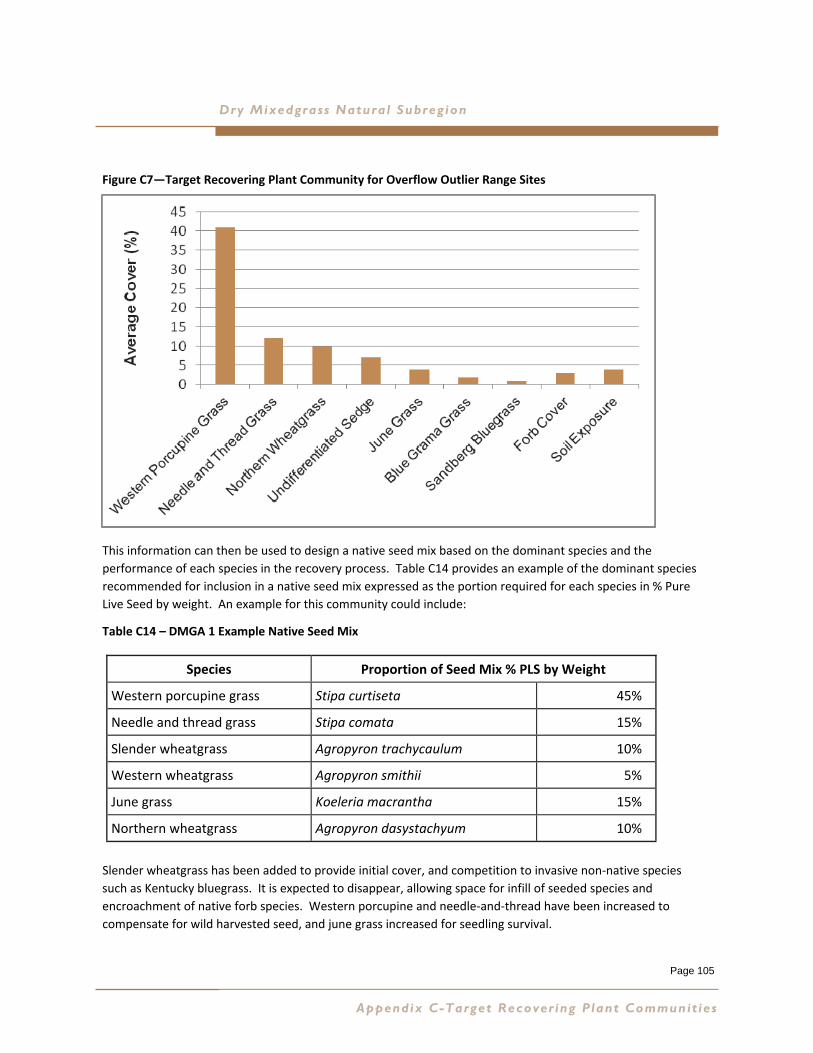
Page 105
Dry Mixedgrass Natural Subreg ion
Figure C7—Target Recovering Plant Community for Overflow Outlier Range Sites
This information can then be used to design a native seed mix based on the dominant species and the
performance of each species in the recovery process. Table C14 provides an example of the dominant species
recommended for inclusion in a native seed mix expressed as the portion required for each species in % Pure
Live Seed by weight. An example for this community could include:
Table C14 – DMGA 1 Example Native Seed Mix
Slender wheatgrass has been added to provide initial cover, and competition to invasive non‐native species
such as Kentucky bluegrass. It is expected to disappear, allowing space for infill of seeded species and
encroachment of native forb species. Western porcupine and needle‐and‐thread have been increased to
compensate for wild harvested seed, and june grass increased for seedling survival.
Species
Western porcupine grass Stipa curtiseta 45%
Needle and thread grass Stipa comata 15%
Slender wheatgrass Agropyron trachycaulum 10%
Western wheatgrass Agropyron smithii 5%
June grass Koeleria macrantha 15%
Northern wheatgrass Agropyron dasystachyum 10%
Proportion of Seed Mix % PLS by Weight
Appendix C-Target Recover ing Plant Communit ies

Page 106
Recovery Strateg ies for Industr ia l Development in Native Pra ir ie
C.6 Ecological Range Sites that are Unique in Species Composition
Saline overflow and saline lowland ecological range sites are very unique in species composition due to the
saline nature of the soils. These sites should be avoided if at all possible. If avoidance is not possible, then
natural recovery will likely be the most successful revegetation strategy over time. This group includes:
Table C15 ‐ Ecological Range Sites that are Unique in Species Composition
C.7 Final Step
Seed is ordered by computing the number of seeds per gram for each species, the percentage of pure live seed
for each species and the percentage by weight of each species included in the mix. Computer programs are
available for this task. Certificates of Seed Analysis for each species and the seed lot available are required to
make this final computation. Appendix D—Seeding Pathways provides detailed guidance for this step.
DMGA41 Low Sedge ‐ Western Wheat Grass ‐ Green Needle Grass Overflow 3
DMGC1 Silver Sagebrush/Western and Northern Wheat Grass Overflow 4
DMGA45 Western Wheat Grass ‐ Salt Grass ‐ Gumweed Overflow 4
DMGC7 Greasewood/Salt Grass ‐ Western Wheat Grass Overflow 5
DMGA20 Silver Sagebrush/Undifferentiated Wheat Grasses Saline Lowlands 1
DMGA44 Salt Grass ‐ Western Wheat Grass Saline Lowlands 2
DMGA21 Silver Sagebrush/Wheat Grasses ‐ Nuttall’s Atriplex Saline Lowlands 2
February 2013
Page 107
Dry Mixedgrass Natural Subreg ion
APPENDIX D SEEDING PATHWAYS
D.1 Calculating Seeding Rates........................Page 109
D.2 Example Reports of Seed Analysis...........Page 127
For more information on Sourcing Native Plant Material including source lists and availability, please visit:
The Alberta Native Plant Council
http://www.anpc.ab.ca/
and/or
The Native Plant Society of Saskatchewan
http://www.npss.sk.ca/
Appendix D-Seeding Pathways

Page 108
Recovery Strateg ies for Industr ia l Development in Native Pra ir ie Dry Mixedgrass Natural Subreg ion
February 2013
IJsingSeedingI,[ative
Rate Conversion Charts For
AGRICULTURE, FOOO ANDRURAL D€VELOruENT
Species In Reclarnation Projects
Alfurtq November 1998
Developed byAndrew M. Hammermeister
ForPublic Land Management Branch
Agriculture, Food and Rural DevelopmentI 998
Copies of this publication can be obtained from:Public Lands Management BranchAgriculture, Food and Rural Development200. J.G. O'Donoghue Bldg.7000-113st.Edmonton. AB T6H 5T6
Seeding Rate Conversion Charts For Using Native SpeciesIn Reclamation Projects
Introduction
Seeding rates for native species planted in reclamation or restoration projects vary. The ratechosen depends on the objectives for the project, the climate and soils in the area and thecharacteristics of the plant and its seed. This publication will help practitioners to plan seedingrates more accurately.
It's useful to know relative seed weight when deciding what seeding rate to use. The sameweight of large heavy seeds does not cover as big an area as small, light seeds. The mortality ofsmall light seed is generally very high.
When ordering seed, it's very important to know the percentage of live or viable seed that canpotentially germinate. This is known as pure live seed (PLS) and can be determined by getting aprofessional seed analysis report. PLS is calculated by multiplying the purity of a seed lot by thegermination and dividing by 100.
Many native seeds tend to have high levels of dormancy. When determining germination fbr aparticular seed lot, it is acceptable to combine the percent germination and percent dormant to getan idea of the total viable seed (Ducks Unlimited, 1995).
In Canada, seed is usually purchased on a bulk seed basis, not a PLS basis. In the United States,it is possible to order seed on a PLS basis. Potential buyers in Canada can ask to see seedcertificates for specific seed lots and determine the PLS for themselves. More information aboutseeding native species is available in the following publications: Morgan and Collicutt 1995;Ducks tlnlimited 1995; Kerret al.1993, Abouguendia,Z.1995, and Gerlingetal.1996.
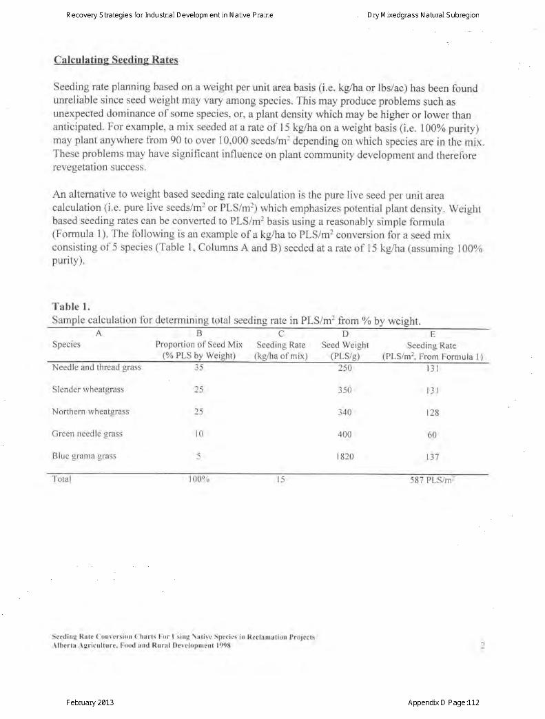
Calculating Seeding Rates
Seeding rate planning based on a weight per unit area basis (i.e. kgAra or lbs/ac) has been foundunreliable since seed weight may vary among species. This may produce problems such asunexpected dominance of some species, or, a plant density which may be higher or lower thananticipated. For example, a mix seeded at arate of 15 kg/ha on a weight basis (i.e. I00% purity)may plant anywhere from 90 to over 10,000 seeds/m2 depending on which species are in the mix.These problems may have significant influence on plant community development and thereforerevegetation success.
An alternative to weight based seeding rate calculation is the pure live seed per unit areacalculation (i.e. pure live seeds/m2 or PLS/m2; which emphasizes potential plant density. Weightbased seeding rates can be converted to PLS/m2 basis using a reasonably simple formula(Formula 1). The following is an example of a kglhato PLS/m2 conversion for a seed mixconsisting of 5 species (Table l, Columns A and B) seeded at a rate of 15 kg/ha (assuming 100%purity).
Table 1.Sample calculation for determining total seeding rate in PLS/m2 from%o by weight.
SpeciesBCDE
Proportion of Seed Mix Seeding Rate Seed Weight Seeding Rare(% PLS by Weight) (kg/ha of mix) (PLS/g) (PLS/mr, From Formuta l)
Needle and thread grass 35
Slender wheatgrass
Northern wheatgrass
Green needle grass
Blue grama grass
25
25
l0
250
350
340
400
I 820
lJ I
t3r
r28
60
IJ I
Total t00% l5 587 PLS/m']
Seeding Rate ( lonve rs ion ( 'harts l . 'or t s ing \at ive Spccics in Rcclamat ion ProjectsAlbcrta, \gr icul ture. Food and Rural Development 1998
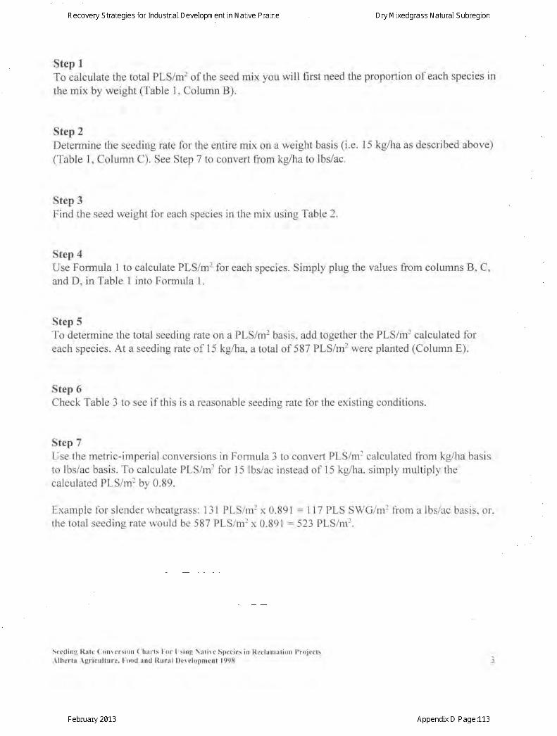
Step ITo calculate the total PLS/m2 of the seed mix you will first need the proportion of each species in
the mix by weight (Table 1, Column B).
Step 2Determine the seeding rate for the entire mix on a weight basis (i.e. l5 kgAra as described above)(Table 1, Column C). See Step 7 to convert from kg/ha to lbs/ac.
Step 3Find the seed weight for each species in the mix using Table 2.
Step 4Use Formula I to calculate PLS/m2 for each species. Simply plug the values from columns B, C,and D, in Table I into Formula l
Step 5To determine the total seeding rate on a PLS/m2 basis, add together the PLS/m2 calculated foreach species. At a seeding rate of l5 kg/ha, a total of 587 PLS/m2 were planted (Column E).
Step 6Check Table 3 to see if this is a reasonable seedins rate for the existine conditions.
Step 7Use the metric-imperial conversions in Formula 3 to convert PLS/mr calculated from kg/ha basisto lbs/ac basis. To calculate PLS/m2 for 15 lbs/ac instead of l5 kg/ha, simply multiply thecalculated PLS/m2 bv 0.89.
Example for slender wheatgrass: 131 PLS/m2 x 0.891 : ll7 PLS SWG/m2 from a lbs/ac basis. or.the total seeding rate would be 587 PLS/mr x 0.891 : 523 PLS/mr.
Sccding Rate ( lonvcrsi t )n ( lharts l .or I s ing \at ive Spccies iu l {cclanrat ion l ) ro jectsAlbcrta Agr icul ture. Food and Rural Developmcnt 1998
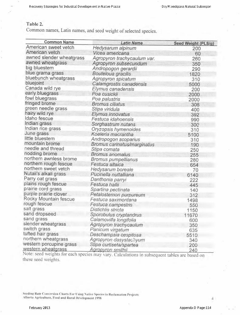
Table 2.common names, Latin names, and seed weight of selected species.
American sweet vetchAtfigtica.n":*Affi6:,. :",,,,, Hedvsarum alpinum
",,l;,ll.iegf,;.bgjbijo,ii.A,.,',',,,|r.,,',,' '.r ....;..,i ':.,',.'.,."'.. .,Ag ro py ro n tra c h yc-a u ! u m va r,
,:,.4Vf-opyron,,${Jb$Bounrt9y1,,,;,;:":",,Andropogon ge-pfli!
,:,,,,,8o t-, a giaelTts :::':r: -:'..:: 'Agropyron spicatum
,.,:;6a16^" l6sfrs:.oahafehsrs ,, . :Elvmus canadensis
.....Foa.:C1,1SlCkt]: ',,,,,,,,, ' , :',,,,,,..,..',, ,....,..., :Poa palustris
.. Ararn1s,'Sftba viridula
,lEWiS,irrhbi,i,a,tu,i',,;,,,,:,,,,,,, ;,"";:;:;;,;,,,,,Festuca idahoensis
rirrr:$.o,tgtia$Vffiffiln:ritan$......,,.,.,,,,....r.....'.....''''''...,.,.,l,,,.,',.,.,.,.,.Oryzopsis hymenoides
""Raeleriai,maii;iAh{ha""""i ',, ::Andppogon scopariusEromub caiina{uslmatgii'atiub,Sfipa comata,, , , ;ronus
anomaxu,s : : : . . : : . ' . , , , , , , : - , , , , ,
Bromus pumpellianusFesfuoa,iaprl tu"""""""" ' . , , , , . . , , , , , , , , , , ; , ; , , ,Hedvsarum borealepicih'etta,.-nutte'||iens",,,,,,,,,,,,, ',,:Danthonia parrviFesfuca gii11i1 i::,,, , , ',Spartina pectinataPe ta I o ste m o i f'u rp u re umFestuca saximontana
lllFe$ffi4.i.bAffipASffi . ,:,,...,...,....,... .., .,' .....,,. ,..:i..,...,,,, lDistichlis stricta
...SpOlobu/us,,E$ilahdtnS,,,,,,.,',,,.,,,.,,,,.,,C a I a m ov i lfa lo n q ifo I i a'Ag ro py ro n.,traCiyca ul u mPanicum virqatumD e s c h a m psi'a cesprtosaAg ro py ro n d a systac hy u m
200iiii::ij:60iiiii.:ij,:ili:i:i:l:i...ii:i.ijijil260awned slender wheatqrass
awned'.t,rdlttbafg'ra.SS. : ....,:'-r.'.,,,,,,,,biq bluestemblile grama,,g,iass, ,:"".' ""'bluebunch wheatorass..UtU$joiht' .....,,,':': , '.;.:... -.'""',...,.' ' ,Canada wild rveear l [ l , ,btuegfES's, , , , , , , . " , , , , , , , ]fowl blueqrass*ing.ed...b;furne,',,, ,' 'i :, ,,,,qreen needle qrassfr'qi,ry...wild rye..- ' ,... ..,........ :..'.'ldaho fescue::i:ndlelli]l:gflgssii:ii:::::ii:]iiiiiii:iii:'i.lii:::ii:i::,:,:,:,:,].],i,|,i,i,i,:':,:':,:Indian r ice orass;,911$,,grass- "::.,,.,.l i tt le bluestem::mOUn lin::iihll0mbiiiiiiii:ii:ii:,:,:,:'.,:.:,:::::,,l,:,.,l,t't:l::,needle and thread.,hffiE'i'ng..''bromgji'iiiii.i.i....i..i'iiii:,.,.'.,.,,,,.,.,.,.,.,.,.,',.,r,northern awnless brome:nUi*ftern::::rOUg;htl:ffi SeUei:.:.ilii.i,i:':ilnorthern sweet vetch.iN.tltelliis'...0lfa.Ii...gif aEs',.,.,,,.,.,.,.,,.,.,.,.,.,.,.,.,.,.Parry oat qrassplains,rou6,n tescue ,. Iprairie cord qrasspurple pl"aiii6 clover.:::: ::::Rocky Mountain fescuerough fescuesalt qrassSaha-..UiOpbeeA.. i,... ,...: . .i.:.:..:sand qrassslenO6r wheatgrass .::switch qrasstufted h"air grassnorthern wheatqrasswestern porcupTne grass Sfpa c u rt i set a/s p; a| rte a
,.......,,,1.;,,....,.t..,tr,:...,..,,..,,,..,,.,,350....,.,,,...,,,,,,
290, , , ' 1920.
310, '' ;..,gQSg ,,. ''
200.'.:...:',., :.: ,:::.,,'. ... f6$Q ..',,, ,,.,,
2000,,,,'i ' ...,,.,
t,,,,' ' ,,,,1 306',,,'
"'400,,,,,,,, t ,,,,,,t ,,:::,,,,,,,,3:92',,,,,i ':,,,,, '
990. ' , , , , , , : , ,Bgg, , , , ,
310' " , 5,100' , ,
310. . ' ' , , . ' . : , , t : , : : t . .1
U6 , : .250
'' , .r,... , :,;.;.;, 155.., ,,',280
,;,;:;, :: i : ;:,,:" $4 ',,,,,, ' ,,,
70: : : : : : : 6140' : r222
' ; ' " : , ,445,: .
140' . , . , , 312' , ,
1498550
1150"' 11670
600350635
551 0340200
al1\ote: seed welgnts tor each spectes may vary. Calculations in subsequent tables are based onthese seed weishts.
seeding Rate conversion charts l ;or l rs ing l -at i r .c Specics in Rcclamat ion I ' ro jcctsAlberta . \gr icul ture. Food and Rural Devclonmcnt l99g
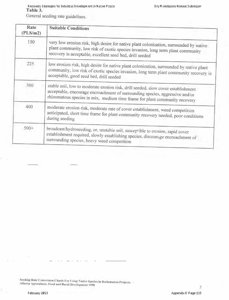
Table 3.General seeding rate guidelines.
Suitable Conditions
very low erosion risk, high desire for native plant colon ization,surrounded by native*T:.::iT:r]1Ilt:y
risk of exoric species invasion, long term plant communityrecovery is acceptable, excellent seed bed, drill seeded
acceptable, good seed bed, drill seeded
low erosion risk, high desire for native plant colon ization,surrounded by native plant
:::::lly,^t^":::f$elofig,snecies.invasion, long term plant communiry recovery is
stable soil' low to moderate erosion risk, drill seeded, slow cover establishmentacceptable, encourage encroachment of surrounding species, aggressive and/orrhizomatous species in mix, medium time frame rol ptunt community recovery
moderate erosion risk' moderate rate of cover establishment, weed competition
:::,:ttil.^1,:1on rime frame for plant community recovery needed, poor conditionsduring seeding
broadcast/hydroseeding, or, unstable soil, susceptible to erosion, rapid coverestablishment required, slowly estabrishing ,p".i.r, discourage encroachment ofsurrounding species, heavy weed competition
seeding Rate Conversion Charts For Using Nat ive Species in Recramat ion projectsAlberta Agr icul ture, Food anr l Rural Deveiopment l99g
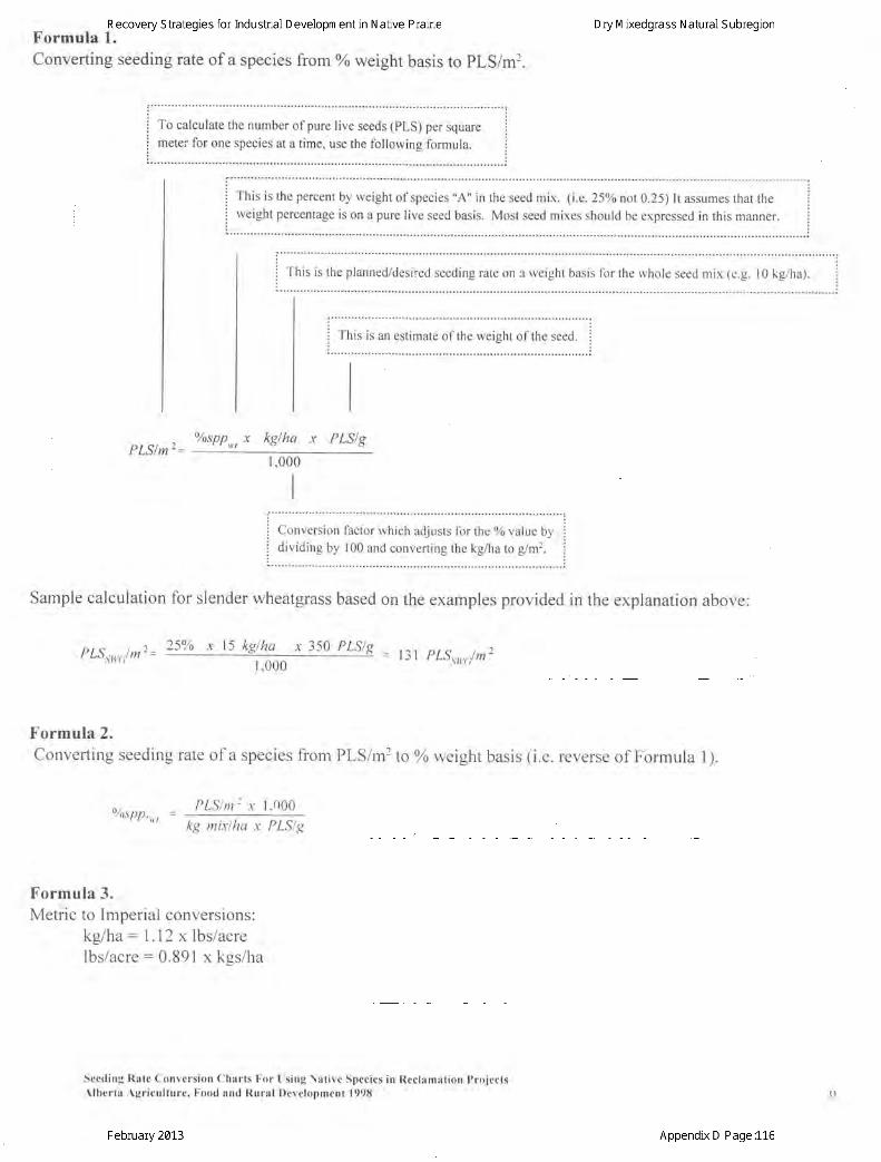
Formula L.Converting seeding rate of a species from % weight basis to pLS/m2.
r""""""""""": :i To calculate the number of pure live seeds (PLS) per square ii meter for one species at a time, use the following formula. i: : . . . . . . . . . . . . . :
: ' " . ' " . ' """" ' :: - , . . - :: I his is the percent by weight of species "A" in the seed mix. (i.e.25o/o not 0.25) It assumes that the i;i weight percentage is on a pure live seed basis. Most seed mixes should be expressed in this manner. i
:
i fnit it the planned/desired seeding rate on e rveight basis for the rvhole seed mix 1e.g. l0 kg/ha). i
i This is an estimate of the weieht of the seed. ii - i
. . . . . . . . . . . .
' ' . . . .
!
' . . . . . ' . . ' . . ;
pLSlmr- YosPP,,, x kglha x PLS/g
1,000
I
I
: ' - """""""""" """"""""" :j Conversion factor which adjusts for the % value by j
i :::t:t:::t T:::1:::::i::: ::: ::lli:::1il iSample calculation for slender wheatgrass based on the examples provided in the explanation above:
pLS"r,"/m2- 25% x 15 kg!4!L- x 350 PLSIT = 131 pLS,*,./m2
Formula 2.Converting seeding rate of a species from PLS/m2 too/o weight basis (i.e. reverse of Formula 1).
o,. . , - PLSIn-x 1,000"/ospp..kg mixlha x PLSIg
Formula 3.Metric to Imperial conversions:
kg/ha: l . l2 x lbs/acrelbs/acre: 0.891 x kes/ha
Seeding Rate Conversion ChNrts For Using Nat ive Species in Reclamat ion ProjectsAlberta Agr icul ture. Food and Rural Developmcnt 1998
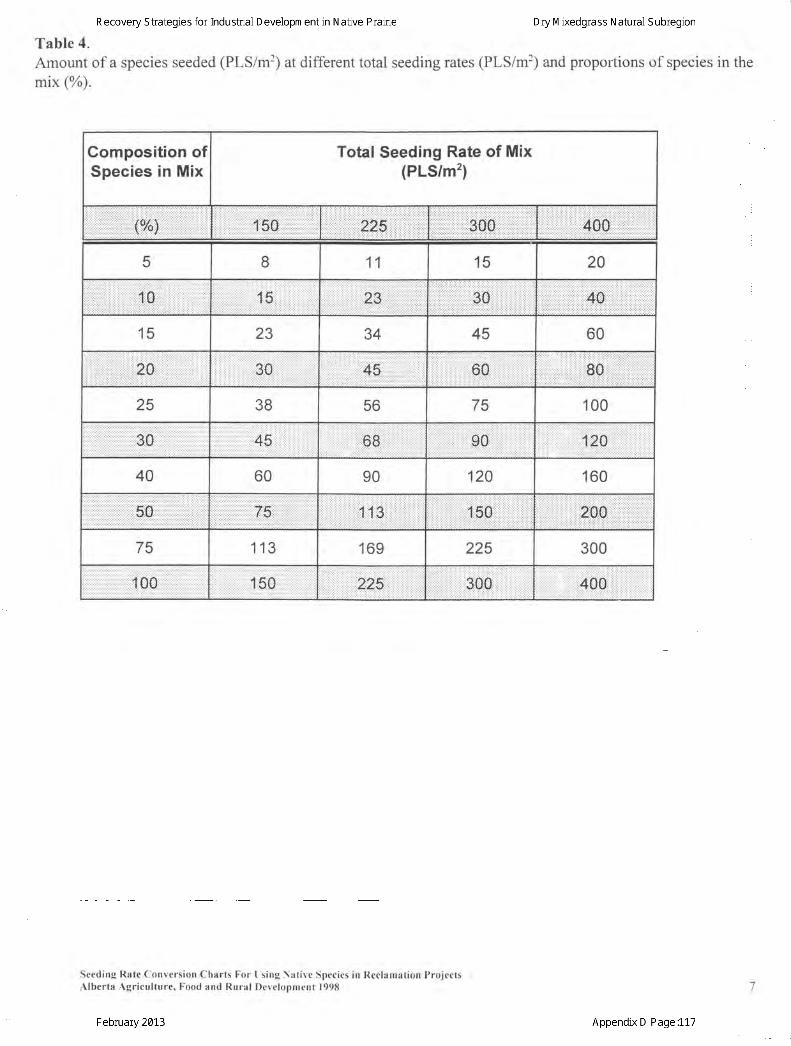
Table 4.Amount of a species seeded (PLS/m2) at different total seeding rates (PLS/m']) and proportions of species in themix (%).
Gomposition ofSpecies in Mix
Total Seeding Rate of Mix(PLS/m2)
: : : : : : : : r : i : : : : r t t : . i : t : , : . : . : . : . : . : . : I t . : . t . : . t t i t : ; i i t l i i i : : t :
.ii.jii..iiiii...iiiiiii::,22Siiiiiiiiiiiiiiii.i.i.ii:.iiiil.....lt:..'l.:t:,::'.,:ltlt,:40:Ei:l:l.:..':.:tl.l.:,:,:.:..,.llll.:
5 8 11 15 20
it,.[}.l...,,'.',.,,..ll,ljll:l:jli.i::fi :5:: l,,,,,,,ll,,,,,lliil,,llij,i',,,,,i11,,
15 23 34 45 60
:::i:i:i:::j:;:2CI 30::::: : a :a) :.r:a:4.:-::.:.: :.: : :. .:.: r:::::
:i::;llll:l:l]:|:l|i:l:.::lt4t$:l::::::::: ,;i,,,,,',,,',,,,,,,,,',,,,,,,,,,,,,,80,'iiiiiiiiliil liijijiiiliiiiiilll:il
25 38 56 75 100::::: i ::::::::::::::]:.::::::::::::::
.l.li.l..ii.l.l.l......4S 6iE: :: i i i i i : : : i i i : : : :
. : . : : ; : : : : : : i i i : : : : : i i j : :
.......,,....l.l.i'g0i'..l.....l.l.l.......l.ll.lt,zi0iril..',
40 60 90 120 160
' : : . r : . r t : . .* F._: : ._. .l : : . i : . :17:A.r :1r : . . . : l. ..::::: .t::*|: :
. . . . . . : . . i , : . : : : : : : i i : : : : : : : : : : . : : : : . : . :
. ' : . : . .1,1 3: : : : i : : 1,,50
75 113 169 225 300
.:....,.tl.l.l,..l...l.....l.lt.11'00.tl'........l , .,..'., ,,,ili:50 ,,i,22$;; , ,:,
Seeding l l l tc Convcrsion Charts For [ :s ing \at ive Spccies in Reclamat ion I ' ro jectsAlberta Agr icul ture. Food and Rural Devclopment 1998
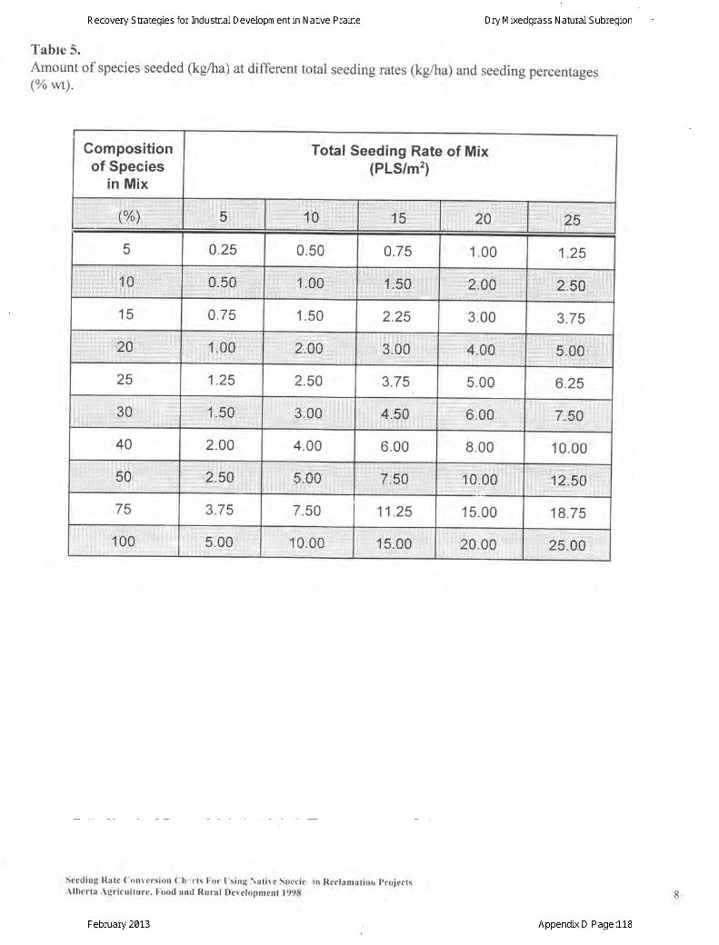
Tabte 5.Atnount of species seeded (kg/ha) at different total seeding rates (kg/ha) and seeding percentages(% wt).
Compositionof Species
in Mix
Total Seeding Rate of Mix(PLS/m2)
. ri.:::::: ' gCI.i.l
5 0.25 0.50 0.75 1.00 1.25
:l::i::illt:rl5:$:::;ll:l-=6.'........,.:
15 0.75 1.50 2.25 3.00 3.75
1.oCI.rrrrrrjirrlr) | rra.a.rir
iiilijigli:0Siii:::iiiiiii:i:
25 1.25 2.50 3.75 5.00 6.25
tl .t.tl::iiti:.i.:.tl1.!i:5:S]::::::::::::: :]:] ]:] ::::::::,,,l.l.6.;0S.....,
40 2.00 4.00 6.00 8.00 10.00
,'s,,oo. ,iij:lrfiidfi:::
j :::::::::]: i : i ::::::::: j :
fj21i5i0,
75 3.75 7.50 11.25 15.00 18.75
1..00,:r:r. 5.00 10,.00, 15.00 20ii.00
Secding Rate conversion ch:r ts For l rs ing ) iat ivr Specic. in Reclamat iorr projectsAlberta Agr icul ture. Food and Rural Development 1998
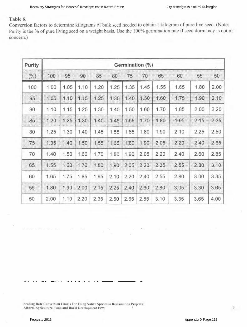
Table 6.Conversion factors to determine kilograms of bulk seed needed to obtain 1 kilogram of pure live seed. Q'Jote:Purity is the 0% of pure living seed on a weight basis. Use the 100% germination rate if seed dormancy is not of
concern.)
Purity Germination (%l
100 1.00 1.05 1.10 1.20 1.25 1.35 1.45 1.55 1.65 1.80 2.00
il..;0.5,,::::illi;ij:li:0t.,i..x''S'... tr.::.301:'r,Aioil,.i.5s,.,
90 1.10 1.15 1.25 1.30 1.40 1.50 1.60 1.70 1.85 2.00 2.20
iir:ii::.85:::::.::::il:i2S ili:riZ:$::r.:l1.,30 1,,40 lIi'a4s....:::::::::::::::::::::]: l ::::::
....il;:llS5i;tjjil..1fi0 ::::::::2:i::tr::&::::::::rDr:::{l{:4:t:Y4]st
80 1.25 1.30 1.40 1.45 1.55 1.65 1.80 1.90 2.10 2.25 2.50
..'''...ii.i..i75:r:Xi..i3:51i,AA11..i.50.''1,,i55 1,.:'65': j : ] : : : : : : : : : : : : : : : : : :
1,,1S0,1.90 ii2ii:05.' 2"2,4',.12,t,6-s
70 1.40 1.50 1.60 1.70 1.80 1.90 2.05 2.20 2.40 2.60 2.85
65.i.,''..l ...il...iS01..i.70...il..:'80.....'.t.:i,go2;CI5 2:,24 ...,.,,.8.i.5.5: : : ] j : : : : : : : : : : : : : : : : : : : .
,2,;,&A"3....1..0
60 1.65 1.75 1.85 1.95 2.10 2.20 2.40 2.55 2.80 3.00 3.35
55' 1:80,.,11.,.,, 0 2.i.00 2'i..1.,52.,.2S2r40.iii 2.;.60 2,9,0. 3i0,5 3,.30 gi1,6$
50 2.00 1 .10 2.20 2.35 2.50 2.65 2.85 3.10 3.35 3.65 4.00
Seeding Rate Convcrsion ( lharts For I rs ing \at ive Specics in Rcclanrat ion I ' ro jectsAlberta " \gr icul ture. Food and Rural Devclopment 1998
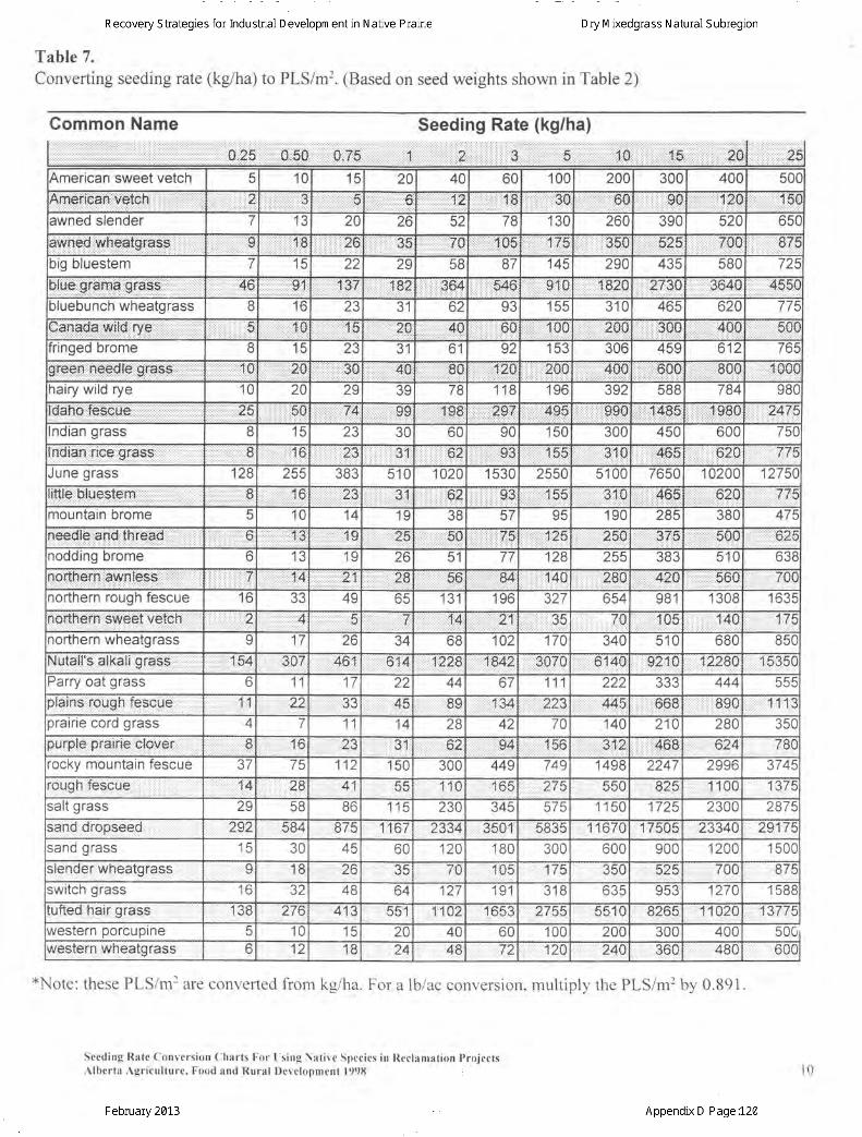
Table 7.Converting seeding rate (kg/ha) to PLS/m2. (Based on seed weights shown in Table 2)
American sweet vetch 5 10 '15 20 40 60 100 200 30c 400 6nr
ftmSnlqani;veton. :.r.i.:i:.r.:2 i3 f; :.:l . tt.;,;,t.:.:.:n.*?:::::::::::l;:::t::jtl:tErrr,30 ,;,,,,.'i,,,,,,:'.:(i{J..:i:l9F.l:,.,,.:l:ll:l:::.l.t.20'15(
awned slender 7 IJ 2C zo cz 78 130 260 390 520 65C
lvtrliled,. Whegt g:f ass: :::]:(l ,1€ ..26 .i.titSE riF l,,,,:....,,...tltlF'.:.1:i1:E
..... . .....,35u,,,,,,,,,,,,,S2S B7i)ig bluestem 7 15 22 29 AF 87 145 290 435 6Rn 72!
llue::gr?ma,grass.i .:::.:::4e' . . '9i l 1,37 1ff i : , ,364 54,6 911.0 'l'820 27$C .ii..sr$41 4e0i
) lueouncn wneatgrass 8 '16 23 ?t oz o? 155 3'10 465 62C 772
uana0s:::wllc::rye 5 rl,0 4.4 :iiiiii]] ii z:E .i.....4U ......160 1'0C asrJ 300 ' 40c 5€(fringed brome I I3 ZJ '2.4 61 92 153 306 459 612 764
10 7Q ,30 ,i,i40 l.i'l:ifiU lAt 20c 400 .iOUU UTJU :{:A{lf
1arry wrro rye '10 20 29 JY 78 118 196 JVZ 588 784 98CqanQ,' !eScue,: , , i : ' , , . . . . ^A 74 :::qq
i i i i : i ::::l:::::l:lt:1:9.8 49$ 99{ il.4HF 1 980 ?.47!
noran orass R 1EIJ ZJ 30 OL 90 16n 30c 450 600 75C
ndlan nce gfass ,.i fl :',1 G ,2$ .iirii,31 ,;;',,93 :l::55 31,C 468 ,,620 77t
June grass 128 255 5'1C 1024 1 530 2550 51 00 7650 10200 1275CInue Dlueslefn ., ':' U d,n 23 ,,,,:tl3'1
:::::: ' ' : : oq 155 itil,u 465 620 .77'
TOuntain brome 1C 14 4aIU 38 57 190 285 38C 474
1B€OlG',,8.IIO'lRrea0,, ll.l ztB s0 "':1,5 125 e50 375 bTJ{J 6.2!rodding brome o 1 zo 51 77 128 255 383 51n 63irbr,therh:aw-l- ,,'
::illl:ti'i:i,:,:,:,ij:fl 21 2t .EA u 140 ?80 4:2Q ,bo{J rv\
' lorthern rouoh fescue to 49 65 13'1 196 327 654 981 1 308 1 63:4 ,' ;,;,:,;,,,',1,.,:;:,,;,;t,: ;:;,,i;,4
:n tr4 :::::::27 35 rv 1ntr 140'rorthern wheatqrass q 17 2e 34 68 tuz 1-7 6 340 510 68C{ ntal{s;,at;karll:::g ress 347 441 6:11,4:12.-lEttt:::,:,:iL,8.423070 5140 92{0 1228C 4F.?4r
rarry oat grass 6 11 17 22 44 67 111 222 444 555rfain.S..,iou0.h feacue 11 1Z JJ 45 RC :,,:::::'+,U223 ,M 668 B9C I I t ;
crair ie cord qrass 4 7 11 14 28 42 70 140 210 28C 35C)urplg pfatrle CKiVer x 1 tai r: l 31 Dl. 94 rcg ?12 468 o24 78Crocky mountain fescue 37 7q 12 150 300 449 749 1498 2247 2996 A-7AE
'ough re.'scue 14 46 4n 110 fA4 2l 825 lUL 1374salt grass ZJ 58 B6 t t3 230 345 575 1 15C 1725 230C 2872sandr dropseed 292 584 I to1 2334 3501 5835 11670 1 75Q5 2334C 291 7tsano grass 15 30 4tr , 60 120 180 300 600 900 1200 1 50C:lender wheator€ss I 18 zc " lE 70 4nA 525 7nc 874
switch grass to 3Z 48 64 127 '191 318 635 q5? 127C 1 58i
iufted hair gress 138 ?76 4i3 6.R4 1102 1653 zv55 AA{f 6ZS5 1i102[ 414/-/ E
//estern porcuptne 5 10 15 20 40 60 100 200 300 40c6/estern, wheatgrass lz tc 24 48 72 rt Cn z4a 360 480 hl I
Common Name Seeding Rate (kg/ha)
*Note: these PLS/mr are converted fiom ks/ha. For a lb/ac conversion. mr.rltiolv the PLS/m2 bv 0.891.
Sceding Rate Conversion ( lharts For I s ing \at ive Spccies in Reclanrat ion ProjcctsAlberta Agr icul ture. Food ant l Rural Dcrr loDmrnt 1998 l0
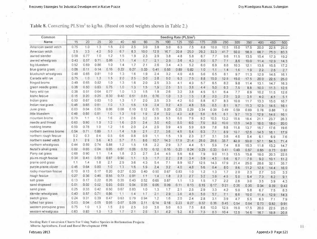
Tablc 8. Converting PLS/nir to kg/ha. (Based on seed weights shown in Table 2.)
Common
Nams
American sweet vetchAmerican vetchawned slenderawned wheatgrasshin hlr roctam
blue grama grass ' , , : : : : :
bluebunch wheatgrassCanada wild rye , :.,:fr inged bromegreen needle gra$s :
hairy wild ryeldaho fescue , ::,::Indian grasslndian rhe grass '
June grasslitue bluestem ,,:,
mountain bromeneedle and threadnodding bromenorthem awhless bromenorthern rough fescuenorthern sweet veiCh :;,;,,
northern wheatgrassNutalls blkati gfssiParry oat grassplains rough foscub | ,prair ie cord grasspurple pralrie clover ,,rocky mountain fescuernrrnh facrrro
salt grass
sanddropseed , , , ,sand grasssfender: ,wheatgrass, , , , , : ,switch grass
tufted haii grass :,:,
western porcupine grass
western wheatgrass
Seeding Rate
4500.75 1.025 ,33
0 58 0.77:0.43 0;570.52 0.690;08 ,,,.0.,1:10.48 0.65Q,7.5 :,, 1,,,.0049 0650.38 ' 0,500.38 0.510.15 . ,0:200.50 0.67o:48 , 0 650.03 0.040.48 , 0.65079 110.60 01Bo0.59 0 780.54 :::::: 0,71:02 0.32.t ,1,9
044 0590,02 0.030.68 0 900 34 0.45
11 1.40 48 0:6i0.10 0 130.r7 0.360.13 0 170.01 0.020.25 0.330.43 0.57024 0310.03 0.M0.75 1.00.63 0.83
1.3 1.5
^. . rd
l ' ] : : : : : : :
1 0 1.20.71 1; ; , ; 01860.86 1 00.1a ,1,0r{60.81 1 0
1,3 , , : , ,1 ,50.82 1 0u.oJ u, / 50.64 0 770.25 , ,0,300.83 1 00.81 , 1,00.05 0.060:81 1, . . ,1,0
13 16l .u .1,z
10 1.20.89' ' , , , , , , , .1' , ,1
04 0.5
13,;6; ; , ; , , 1,4,30.74 0 880,04, ,, 0,05
11 1.4u.00 u,o/
1B 2.1o80,: , ! , . j ,o0.17 0.20o:45 0t55022 0 260:02 0:030 42 0.500:71 0iB60.39 0.470.05 0,0513 15ln r?
z.v LJ
......,6,i.7 . ..i....,..,8.i,3'1 5 1.9
,4.1: :1. 1: . : ' | j : : : : : ' ' : : : : : : :
1.4 1.7
,'.,'.,,0;t7,',.'..,6,2i.t .J t .o
AAt .u t .3
t .J t .o
LU l ,C:
1.0 13
.,,:i0r40 ',.:.:.:.0t51:1.3 1.71 1 . . . tA
0.08 0.10' '1',.3 .'.,.,.'., i'i,6
2.1 2.6: ,,1,,,6,i,.,..,.,,t,.,2.10,1.6 2.0
,,,,,', 1,,,.4,,,',,,,,. ::.L,:,8106 0.8
.,,, . 5'7.,.,:.:.:.:rrr7:,.l:1.2 15
0i07 .:.:.' 0i0818 23
non t 1,
2.9 36
,,,,,,1!,:,3 , ,, ,,, i ,,,:6,0.27 0.330,73 ,,,,,,:1 0;9:1,,0.35 0 43
: :0,03::. t ,t0ro4,0.67 0.83
,,,, 1 .1 ,,, ' ' ,,L:,,4'063 0790.07 0.0s2.0 25
, 1 .7.,,,,, ,,2.1
3.0 3.8 5.0,r.:.:,.:l 0iror.,.:.:.r.:.:.1i2:':5:.:,, '.:.ir16r,:Ti rrri
2.3 2.9 3.81,1.,1,;,1:1,tri,.1:7,1',:,'.,,,,,.,",1,:',1',:12,,,irrrrrr:::::r::::rr::2:::gri::::::
2.1 2.6 3.4
.:.:':':0i33t.:.:.,.:.:.:0)4:1:.t.:. :,:,,,i0155 tttt:.l1.9 2.4 3.2
t...l.ll..3:.0,'.........i 3:.8...,........,.,.,5'.0,,.,.....2.0 2.5 3.3l ,O I ,V : : : : :Z.C
1.5 1.9 2.6
,),,,.:,i,67;,,,:,, j,, :.,..9 ;7i.,.,:,t,;,:: ;::: ;,,,1,,,10,1,,;;,,;,2.0 2.5 3.3
: :.:.: :i: 1:.:$ ... . .,', 2;,4i:' 1;111,1 13,1i,,,|,,,,,012 0.15 0.20
,'.,,,,,,a,,,1,,,,9,,,t,'t,,,,;t,ttt2,,4,t:titi:t1'3:it.2. .....
3.2 3.9 5.3
,:,,,,,, :,,2r:4,., :., rlt S:,0.r.:.:.:.:...:.:.:4.:.0.ri:.j.rl
2.4 2.9 3.9
:,',:,:1: :,121:tr,',,',::t' ;:1"2t:'7t: :.:.:.:.:.:.t.:.3:.6:.:.ttt:l0.9 1.1 1 5
......i.... ,B:6...,.........iI.0:.7...,,.......tti!*:.3 j..'....1 8 2.2 2.9
:.:...:0itI:0,'',.tt:.:,:0j:1:lrtt:.t.t.t.:0i1St .t.,.,2.7 3.4 4.5
.....,: ,11t.:.3t .: t,t,l, .t,'.:1:.:.7,,,,,.,.,.,.,,,t,,.?.,2 ,,,,,...4.3 5.4 7.1
.,.,. .,111$ . ,.. .,,1,.2,14i :,.::.i: I t3.lA ttttt::.:040 050 067,: i:'i ,t;,.4 1,60 52 0.65 0.87
,,.,1,.0,05,i,.,.,,,1,1, 0,06r::,r.:,,,::r U:Og::rrr:rrl1.0 1.3 1.7
. t . t -2, : .J
4.Y
0.94 1.2 1 6,.,,,10;:1.,! .,.,,,0,ttd,:.:.:.:.tUrl.4,,.:.,.:,
30 38 5.0,,, 2,,,5::,';', ".3'.';l .'",'4l'2':'."
6.3 7.52O',e ,,,,,',,,25,.O
4.8 5.8
.,' '3:€,............., .,14,:.3.4.3 5.2
0,$9i ::,.i:ttr0i8?:4.0 4.8
: : ; '^
4.1 4.9,, 3,;,11,,,,,,,,,,,,,,3,,,83.2 3.8
1;,;,lf ,,';X,t,;,1'1,;,1',,1 1,;1';.;;54.2 5.0
:1:1'4;,1c,1:.,,,1':,'11::::,,4',,,8:0.25 0.29.:.:{,i:0,ii.i.ti t:,:4i:8.
6.6 7.9;il,.5i 0i,.,.,.,.,,,,,,, 6;$
4.9 5.9
.i.:d:.,5.........:........5.:A.1.9 2.3
t!,7.:'i:9,t,:,..t,.t,,t:,1,.,i1,,,::4',3.7 4.4
0120,,,1.11,,0,2\5.6 6.8
rtr;*.:.8...........l., ii:3:418.9 10.7
l.l 4.l.0...''l.l,l. itlt?.i.e0.83 1.0
,..,?.3,,......,..,'...2.. 7.11 1.3
0,1| ..,,, 16:1321 2.5
.:.:3i6 ,:ii ::4iii32.0 2.4
.U.23.:'::, tt0:2?t
'5:,1 ,,,, ,"e',3
8.8 10.0
:,:.:.:.:2Si:?:.:.t.:it.:.:33tii3i6.7 7.7
' : : r ; : l : r r1: ; r ! :
: :::::]::] : : ]:::: :::::::::o.u o.Y
: ] : i : : i i: : : : t iv : i . l :: : l : : : : : : :1: : ] ] : : ] | ] i : : ] : : : :
5.6 6.5
l:.:.:.:.:.:.:A:.8,.t. .:.:.:.:.:1:0:.05.7 6.5l .n: . . . . 'E: .n. . : . " n: : : : Y 'Y:
4.5 5.1r ; . : : . . L A::^:1..q:: : : : : : : : : t . :u5.8 6.7
: : : ; : ;
0.34 0.39t r :^ :
: :::5:t' t'- b :'1 : : : , i : : : : : : : :
9.2 10.5
tt:t...:::.:.:Itf 0,:.:.:.t...,..it..S:,0.lb.Y t .6
.l......,l.,.6.: 3l,,,.,.......:..7'itl..,i2.7 3.1
.t.:tl R5,.O.:.t :t:.:.t,2B,6:.5.1 5.9
t.:t,t.t0l29: .tiitt.:.t::0i33:7.9 90
, ti::.iitl..:3:.g.:.:.t't,t.tij.:.,4:,$l12.5 14.3
ltl.l.iil, 5t$,'..ltlt.t.i,6ii.,1.2 1.3
. . . , i .4r : : : ^ ^ '.:::. J:l .10
1.5 1.7
....l.ltl0il.$:.:.:,:.t:tttt0il.f i
. . i ' rr . . . . q ?:: . . : . .Y. -, .1:, : ,2.8 3.1
I ,:.:.t..fft32::.:l:i t0t3S:l8.8 10 0a.a: o2:. r . r9 q, .9
15.0 17.5
:.:.r50;:0:.:.:.t.:.:.:5e;t3t.t.::1 1.5 13.5
.l.....:...g:€i...tl.l.l.lil..!,0:,0......10.3 12.1
. l . . i : : : . : to
9.7 11.3
......:l.S:.0.......,..i' ;!.7,:i5,l.....9.8 11 4
:::.:7 R. ..... . a:::n: : ' l ' tv ' : : : : v: :Y
7.7 8.9
....,,.,t$:.0...'.......',.'..,3:.5......10.0 11 .7"o', t . . . . . , i . ' i ? ' ,
0.59 0.69
...... i,,S.'?i:...:.it:':,t1.liii,3.,':.,.,15.8 18.4
.,.,.,1,2.'.O .,.,.,.,,. .l+|P,:.:':.11.8 13.7
....:1.di:Z.:rr::.:.:.iirl!.2:i:f,r.:.:,:4.6 5.4
1, 41,i,9'.,.,,.:.,.,.$Olq.,.,',,8.8 10.3
t. i0i4g:.:.,,.:.i.l0i5i:.:.:.13.5 15.8
.....'...S:li.. ..,...... ....if :,9....'.21 .4 25.O
..:t:tt.:.giS.t'ttt,,, .:.:.1tl.:i*.t.t,:,2.0 2.3
. ,,.,5,.$...,'....,.,',.$:4.,,,.,z.o J.u
..,'i0i26:...l:. .:.i.013CI:::t::5.0 5.8
,.i it,t,S:'6;...i.ii,.:.:1'0.:O:.:.:ilJ AA
.....0154,.. ........0i64......l15.0 17 .5
..,..,1.2,,5::] i: :.::..i14::S::::i:
:.: 1ee..;,7.,.,.,.,.,.'''75,',CI::i;::i.:.:::8$ir3:15.4 17.3 19.2
..il:..1.l!.lt{.:',:......:...iti2lr,q....t....,.,.11.4.t.3..13.8 15.5 17 .2
....t...i2iii2.t.:.t':.r.t.:.:.:ri:ii5:.t......i....:i,.2titi:l12.9 14.5 1 6. ' l
....,20:.0.:.:.:.r.:.:rZl::rs.,.'.,.,.;l'.25, $.13.1 14.7 16.3
.tr....li6i,0:i....:.:::.:.:!.l:ii3i.,.,,,,,.''1,2,i S,' t0.2 11.5 12.8
........i4:.0,jt:.:.:.:.:.:.:t{.:.S.:.:.,.:...,......$:,1...13.3 15.0 16.7
,',,1411,$,.,;.,,',1,,14,',5,' ;'1";':;111;'f'fll t1it ;:t,0.78 0.88 ' t .0
.,ir::l-tii.S...:.......i.il4ii5.,...'....,,,116., 1,,,zl . t z5. I 26.5
.r.r :1l6r q::.:,: :rrr:::llrsil0::,,,,,,,,,,t0i'0,15.7 17.6 19.6
....t:!*,',3,.,.,.,ti :.,16,.,.1,.,i:.:.:...i..1!,7.i.9.6.1 6.9 7 .6
.:.:.eZi.!.,.:::.:.:.:t:.g+r|g:,:.:.:.;.t.:.71.r4:.11.8 13.2 14.7
..i.:0iSs:.r.r.:.r.r.:0i73ri:.r.r ri:.:0i81:.l18.0 20.3 22.5
.:.:.r':.:Si,9.:.:.::i':.;.i:0:.1.:.:.tt:ti.t.,,.:!:11:.:2.28.6 32.1 35.7
.;i:rrt:2:irB::i:ir:::llr::14risi:rrr:r.i.i.: 1qi:0:2.7 3.0 3.3
.....l.l':ll:t.ll.....l:l...l.ll.al.A.:r....:r::iiri:r:.$i.1.r:3.5 3.9 4.3
.,...0134t.:.t.:.:ii.trUi3$::,:,:,::::t,0iAAt6.7 7.5 8.3
:..i,ll.1...4...........:.l!2:':9i...':.::...1{.i.3.6.3 7.1 7.9
. l 0if 3...........:ttglS2..l..:..tt...,Ii9!,,i20,0 22.5 25.0
,':.:16,;,f ,',',',',,',':t,8"& t::::::t::::20::E:
12.5,',,,4.1.,,1v
Y.O
l...l.....?.,.!.8.6
,,.,.,..ll....+al
.tl;.:11:?:::58.2
6.4,,,,,,*,,,5
8.3
..t tt..8::!1:l049
.',l... A.'.1 .13.2
t.l,ti!:0t:09.8
ll..l,.,.8...9
3.8
7.4',ta:41i
113
17.9
,,,.,.,d.,d1.7
ii.,,..'4tlS2.2
a:zt
4.2t . l
3.9
:trt!,+1,12.5
20.0 25.0
Secding Ratc ( lonrersion ( 'harts l . -or [ ;s ing Nat i rc Spccies in Rcclamat ion Projccts. \ lhcrta, \gr icul turc, l . 'ood and Rural l ) r : rc lopmcnt 199{ l l l
75,,, J00 ,125 -, '!50,,,,,, ,,1,75
,10,4

References Cited
Abouguendia,Z.1995. Seeded Native Range Plants. Grazing and pasture TechnologyProgram and Extension Service, Saskatchewan Agriculture and Food. ISBN 0-88656-629-0 GPS0595.32pp.
Ducks Unlimited Canada. 1995. Revegetatingwith Native Grasses. Native PlantMaterials Committee. Stonewall, Manitoba,R}C2Z0. 133 pp
Gerling, H.S., M.G. Willoughby, A. Schoepf, K.E. Tannas and C.A. Tannas. 1996. AGuide to Using Native Plants on Disturbed Lands. Alberta Agriculture, Food and RuralDevelopment and Alberta Environmental Protection. ISBN 0-7732-6125-7 247 pp
Kerr, D.S., L.J. Morrison and K.E. Wilkinson. 1993. Reclamation of Native Grasslandsin Alberta: A Review of the Literature. Alberta Land Conservation and Reclamation CouncilReport No. RRTAC 93-1. ISBN 0-7732-0881-X. 205 pp. plus Appendices
Morgan, J.P., D.R. Collicutt and J.D. Thompson. 1995. Restoring Canada's NativePrairie - A Practical Manual. Box 1, Argyle, Manitoba, Canada ROC 0B0 Phone: (204)467-9371.
Seeding Rate Conversion Clharts For I s ing \ r t ivc Species in l leclamat ion Projects.{ lberta Agr icul ture. Food and Rural Doeloomcnt 1998 l2

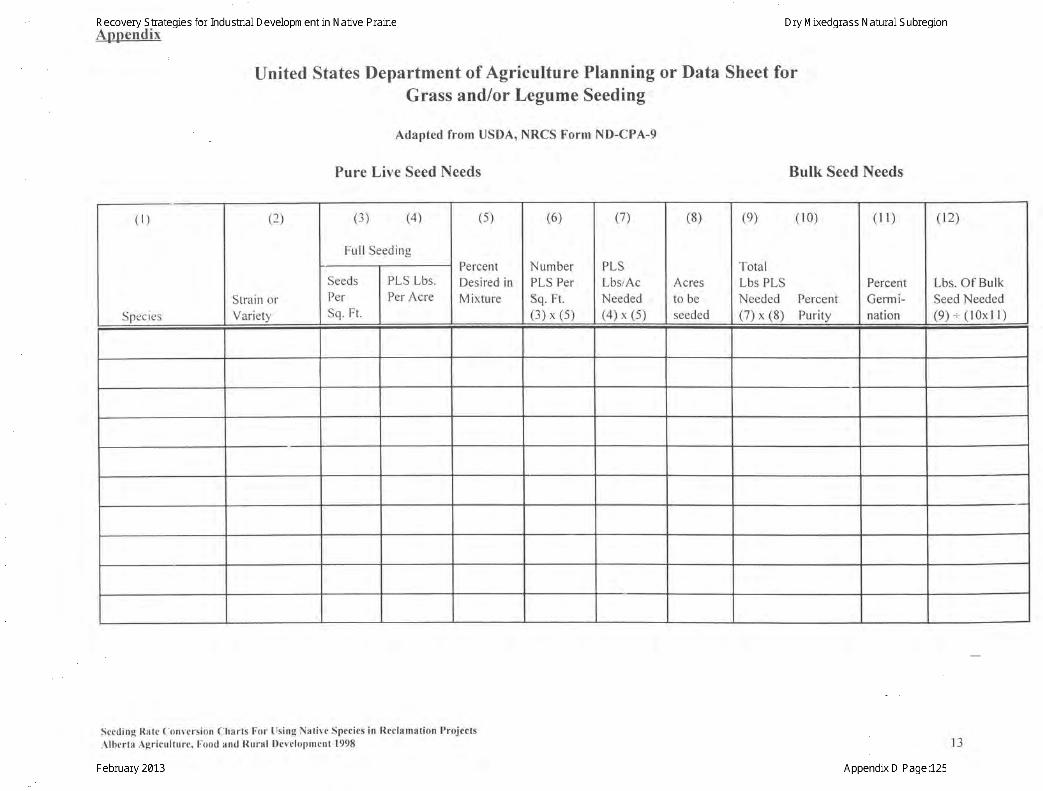
Annendix
United States Department of Agriculture Planning or Data Sheet forGrass and/or Legume Seeding
Adapted from USDA, NRCS Form ND-CPA-9
Pure Live Seed Needs Bulk Seed Needs
Lbs. Of BulkSeed Needed(9): ( l0xl l )
Strain orVariety
(3) (4)
Ful l Seeding
(5)
PercentDesired inMixture
(6)
NumberPLS PerSq. Ft.(3) x (5)
(1)
PLSLbslAcNeeded(a) x (5)
(8)
Acresto beseeded
TotalLbs PLSNeeded Percent(7) x (8) Purity
Seeding Ratc Convcrsion Charts For Using Nat ive Species in Reclamat ion Projects
Albcrta Agr icul ture, Food and Rural Developmcnt 1998 IJ

Interpreting your Report of Seed Analysis:
Important notes: • Your Report of Seed Analysis is based on the grade table that the crop type is found on. • The “Date” found in the upper right hand corner of the report is the date that the germination is
completed, not the date that the report is issued. • A “Senior Member” is a proven skilled seed analyst who has undergone 2-4 years of training in
an accredited Seed Laboratory and passed examination administered by CFIA. This seal represents a certification of skill and knowledge.
Purity tests
There are two tests that determine the quality of physical purity on a seed report: 1. % Pure Seed – this is component breakdown of classified contaminants (Pure Seed, Weeds,
Other Crops, Inert, Ergot), as expressed as a percentage. • This test is performed on sample sizes that are based on 2500 seeds. • Pure seed for each species follows specific rules for accurate determination. This
includes small, shriveled, or otherwise injured seeds, provided they are larger than one half the original size.
2. Purity test – this is an evaluation of any other species or disease body that is present in a seed lot, expressed as numbers or %, calculated to represent per 25 grams of seed.
• This test is performed on sample sizes that are based on 25,000 seeds. • Note that some contaminants are listed in number quantities and others in percentages.
For example, in the Northern Wheatgrass sample, the “Total Weed Seeds of All Kinds” equals 80. That means there were 80 species of weeds (all listed in the Noxious and Other Weed Categories and totaled here) present in 25 grams. However, the Other Crops are grouped together and reported as “Less Than” or “More Than” a percentage.
• When contaminants are expressed as percentages, they must be reported as “Less than” the grade maximum. If the “Total Other Crop Seeds” reads “Less than 1% by weight”, it means that there were less than the maximum allowable % found in the sample. This doesn’t mean that there was actually 1% other crops found. The exact % of other crops (or other contaminants) is found in the % Pure Seed evaluation. These two tests must be interpreted together to have an accurate idea of which contaminants were found and at what rate in any given sample
Pure Living Seed This is a calculation based on the % pure seed value multiplied by the germination value. This allows for a singular value when comparing seed lots that have high germination but varying % pure seed test results. For example, the two Northern wheatgrass samples provided both have relatively high pure seed % values, but differing germinations. This results in a very different Pure Living Seed calculation.
Germination Test
This test evaluates a seed lot’s maximum germination potential. It is based on each individual seed’s ability to produce healthy essential structures under optimal conditions.
• Abnormals are seedlings that have severe impairment to one or more of their essential structures. This means that the seedling does not have the genetic capability to carry itself to maturity. For example, seedlings with deep hypocotyl lesions that extend into the conducting tissue will not have the ability to become healthy and mature plants. They will be classified as “abnormal”.
• Dead seeds are incapable of growth. Their embryo tissues are damaged and will not exhibit any growth
• Fresh seeds have imbibed water but have not begun the germination process. These seeds are viable but may have a physiological issue that is blocking the germination process, such as dormancy.
• Hard seeds are present and evaluated in clovers and other member of the Fabaceae family. Hard seed do not imbibe water but may be capable of growth in the future.
Tetrazolium chloride (TZ) Test:
This test is a quick representation of seed viability. It is usually available within 24 hours of the lab receiving the sample and should reflect the seed’s germination capability. However, it is particularly useful in species where deep dormancy is often observed, such as in native species. When used in conjuction with the germination test, it can establish a level of dormancy and also the maximum germination potential. In the example of the Needle and Thread grass, the germination is only 62%. However, there are 33% fresh seeds reported. The TZ is reporting 95% viability. This means that the fresh seeds are dormant, and when added to the “normal” evaluation, the maximum potential of the seed lot is 95%. Not all seed testing companies will give their customers a profile of the dead or fresh seeds. If this was the case in this sample, and a TZ was not performed, the customer would think that the maximum potential of the seed lot was on 62%. However, through a more comprehensive germination profile and the utilization of a TZ test, we have a much more accurate picture of what this seed is capable of.
The Report of Seed Analysis is very complicated and represents many aspects of the Canadian Grading System. The correct interpretation, proper combination of seed tests, along with the knowledge and experience of a certified seed analyst can ensure that confident and informed decisions are made for each individual seed lot. Carey Matthiessen, 20/20 Seed Labs Inc. Senior Analyst Lab Manager