Embed Size (px)
Citation preview
ECE Senior Capstone Project 2017 Tech Notes
Finding Location with Time of Arrival and Time Difference of Arrival Techniques
By Brian O’Keefe, ECE ‘17 _____________________________________________________
Introduction “If you don’t know where you are, you can’t know where you’re going.” Terry Pratchett’s words may be good life advice, but they are also a truism for navigation systems. Accurately locating the user’s position is key for any navigation system, from Google Maps to our project, an Indoor Navigation system for the Visually Impaired. There are several methods to measure an object’s position, but the most common use ranging techniques. These techniques involve sending signals between one the target object and several fixed reference points. Most ranging systems use one of the two following methods: Time of Arrival (ToA) or Time Difference of Arrival (TDoA). Time of Arrival (ToA) Basics of ToA Time of Arrival is the simplest and most common ranging technique, most notable used in the Global Positioning System (GPS) [1]. This method is based on knowing the exact time that a signal was sent from the target, the exact time the signal arrives at a reference point, and the speed at which the signal
travels (usually the speed of light). Once these are known, the distance from the reference point can be calculated using the simple equation [2]:
𝑑 = 𝑐 ∗ 𝑡!""#$!% − 𝑡!"#! where c is the speed of light. Using this distance, the set of possible locations of the target can be determined. In two dimensions, this yields a circle with the equation [2]:
𝑑 = 𝑥!"# − 𝑥! + 𝑦!"# − 𝑦
!
where (xref, yref) is the known position of the reference point. Once this set is calculated for enough reference points (at least three for two-dimensional or at least four for three-dimensional), the exact position of the target can be calculated by finding the intersection.
IndoorNavigationfortheVisuallyImpaired
2
2-D ToA Example
Figure 1. Example Target and Beacon locations In this example, we have a Target (black) surrounded by three Beacons (red, green, and blue). At time t1, a signal is sent from Beacon 1 to the Target, which is received at t2. The distance (d1) between the Target and Beacon 1 is calculated, then the circle of possible locations is drawn, as shown in Figure 2.
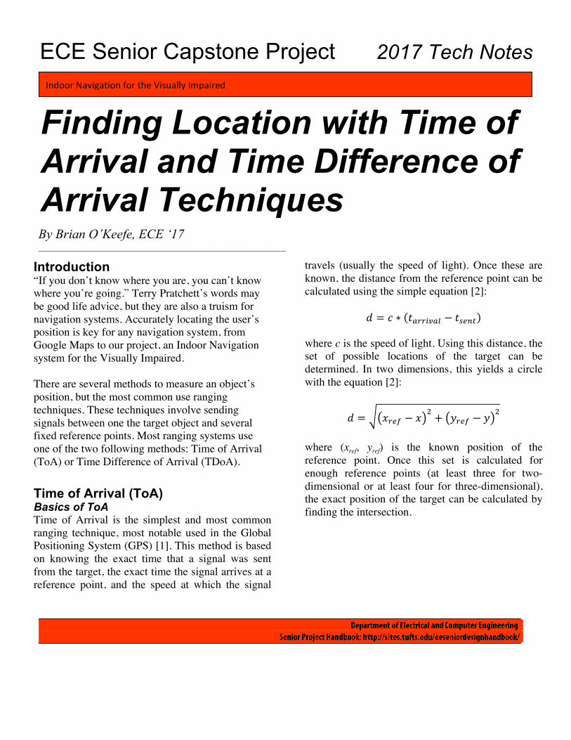
Figure 2. Possible locations in relation to Beacon 1 This process is repeated for Beacons 2 and 3, which yields two more circles, as shown in Figure 3.
Figure 3. Possible locations in relation to all Beacons
As Figure 3 clearly shows, the target lies at the intersection of the three circles. Time Difference of Arrival (TDoA) Time Difference of Arrival is the second-most popular ranging technique, and it is somewhat more versatile than ToA. This method does not require the time that the signal was sent from the target, only the time the signal was received and the speed that the signal travels. Once the signal is received at two reference points, the difference in arrival time can be used to calculate the difference in distances between the target and the two reference points. This difference can be calculated using the equation [3]:
∆𝑑 = 𝑐 ∗ (∆𝑡) where c is the speed of light and ∆𝑡 is the difference in arrival times at each reference point. In two dimensions, this leads to the following equation [2]:
∆𝑑 = 𝑥! − 𝑥 ! − 𝑦! − 𝑦 !
− 𝑥! − 𝑥 ! − 𝑦! − 𝑦 ! where (x1, y1) and (x2, y2) are the known positions of the beacons. Using nonlinear regression, this equation can be converted to the form of a hyperbola [2]. Once enough hyperbolas have been calculated, the position of the target can be calculated by finding the intersection. 2-D TDoA Example
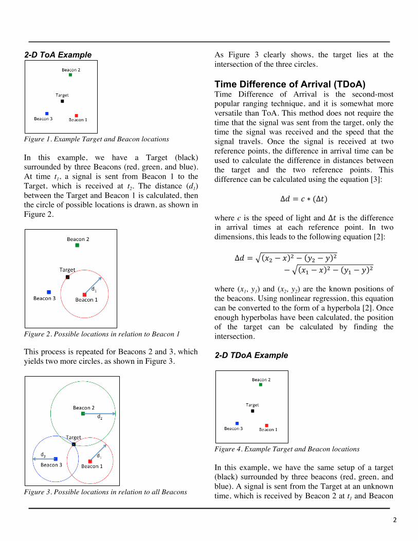
Figure 4. Example Target and Beacon locations In this example, we have the same setup of a target (black) surrounded by three beacons (red, green, and blue). A signal is sent from the Target at an unknown time, which is received by Beacon 2 at t1 and Beacon
3
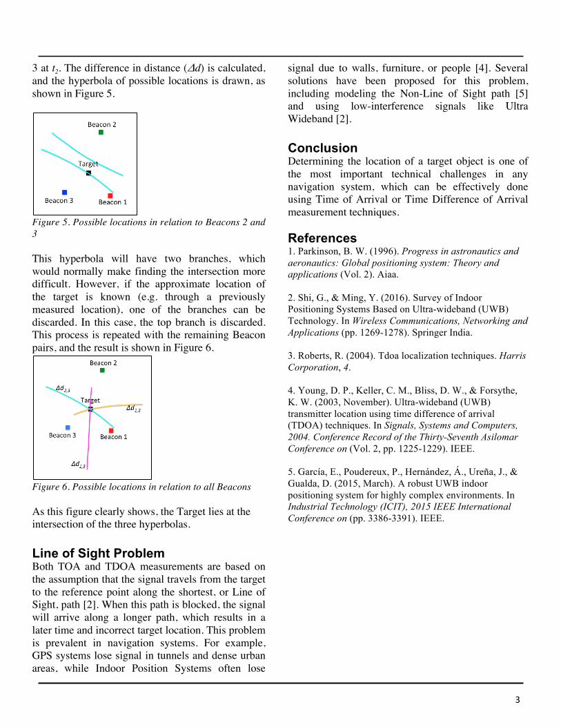
3 at t2. The difference in distance (Δd) is calculated, and the hyperbola of possible locations is drawn, as shown in Figure 5.
Figure 5. Possible locations in relation to Beacons 2 and 3 This hyperbola will have two branches, which would normally make finding the intersection more difficult. However, if the approximate location of the target is known (e.g. through a previously measured location), one of the branches can be discarded. In this case, the top branch is discarded. This process is repeated with the remaining Beacon pairs, and the result is shown in Figure 6.
Figure 6. Possible locations in relation to all Beacons As this figure clearly shows, the Target lies at the intersection of the three hyperbolas. Line of Sight Problem Both TOA and TDOA measurements are based on the assumption that the signal travels from the target to the reference point along the shortest, or Line of Sight, path [2]. When this path is blocked, the signal will arrive along a longer path, which results in a later time and incorrect target location. This problem is prevalent in navigation systems. For example, GPS systems lose signal in tunnels and dense urban areas, while Indoor Position Systems often lose
signal due to walls, furniture, or people [4]. Several solutions have been proposed for this problem, including modeling the Non-Line of Sight path [5] and using low-interference signals like Ultra Wideband [2]. Conclusion Determining the location of a target object is one of the most important technical challenges in any navigation system, which can be effectively done using Time of Arrival or Time Difference of Arrival measurement techniques. References 1. Parkinson, B. W. (1996). Progress in astronautics and aeronautics: Global positioning system: Theory and applications (Vol. 2). Aiaa. 2. Shi, G., & Ming, Y. (2016). Survey of Indoor Positioning Systems Based on Ultra-wideband (UWB) Technology. In Wireless Communications, Networking and Applications (pp. 1269-1278). Springer India. 3. Roberts, R. (2004). Tdoa localization techniques. Harris Corporation, 4. 4. Young, D. P., Keller, C. M., Bliss, D. W., & Forsythe, K. W. (2003, November). Ultra-wideband (UWB) transmitter location using time difference of arrival (TDOA) techniques. In Signals, Systems and Computers, 2004. Conference Record of the Thirty-Seventh Asilomar Conference on (Vol. 2, pp. 1225-1229). IEEE. 5. García, E., Poudereux, P., Hernández, Á., Ureña, J., & Gualda, D. (2015, March). A robust UWB indoor positioning system for highly complex environments. In Industrial Technology (ICIT), 2015 IEEE International Conference on (pp. 3386-3391). IEEE.
![ASSIST: Personalized indoor navigation via multimodal ...openaccess.thecvf.com/content_ECCVW_2018/papers/... · lion blind & visually impaired (BVI) individuals worldwide [22] and](https://img.pdfslide.us/doc/110x75/5ec470c187b6177b0d6860a0/assist-personalized-indoor-navigation-via-multimodal-lion-blind-visually.jpg)


![SMART CANE FOR VISUALLY IMPAIRED PEOPLEgreenskill.net/suhailan/fyp/report/037454.pdf · visually-impaired people. First, Smart Cane: Assistive Cane for Visually-impaired People [9]](https://img.pdfslide.us/doc/110x75/5fc7e53d210a4218aa7c699a/smart-cane-for-visually-impaired-visually-impaired-people-first-smart-cane-assistive.jpg)