Embed Size (px)
Citation preview
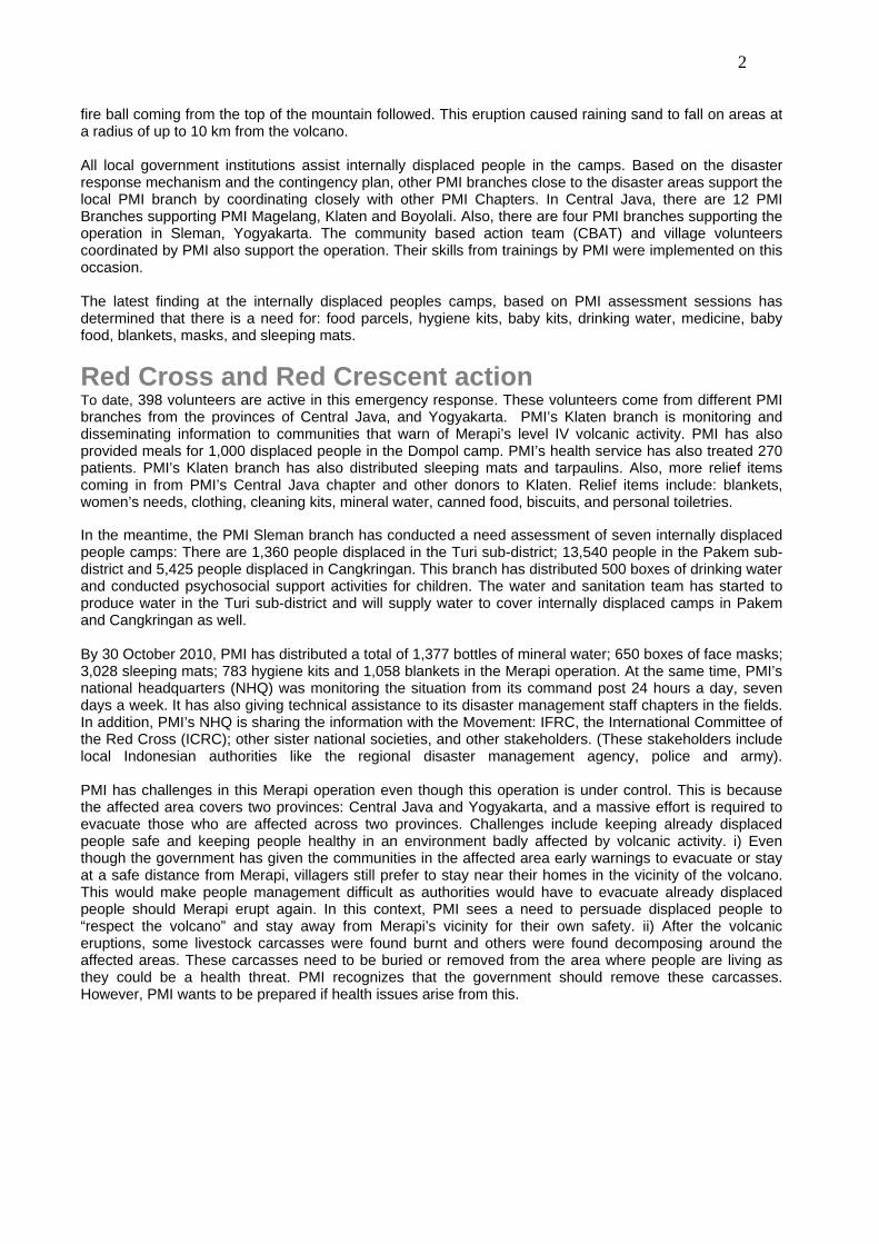
The field kitchen in the Dompol camp, at the Klaten sub-district set up by Palang Merah Indonesia in response to the eruption of Mount Merapi on 25 October 2010. This camp accommodated up to 1,823 displaced by 28 October 2010. Photo: Muhammad Nashir/ Palang Merah Indonesia (PMI) (in English, Indonesian Red Cross).
Indonesia: Mt. Merapi Volcanic Activity
Information bulletin n° 2 GLIDE no. VO-2010-000214-IDN
1 November 2010
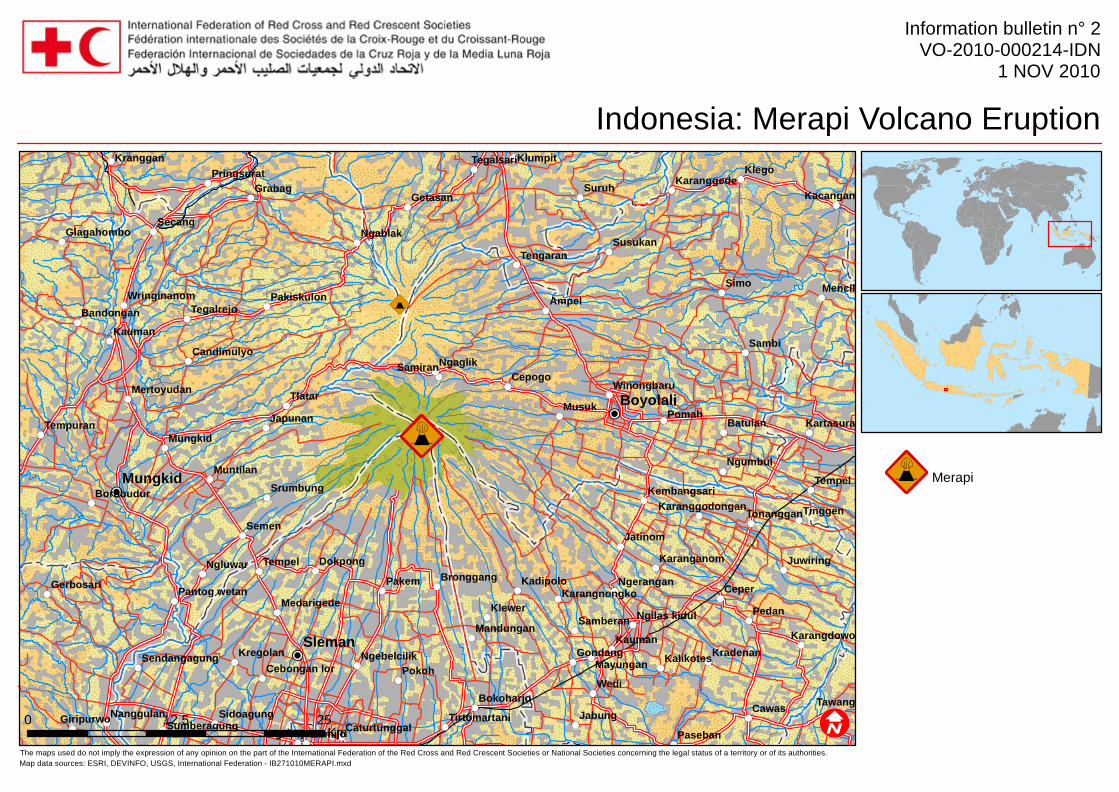
This bulletin is being issued for information only, and reflects the current situation and details available at this time. The International Federation of Red Cross and Red Crescent Societies (IFRC) is not seeking funding or other assistance from donors for this operation. The Indonesian Red Cross, is better known as Palang Merah Indonesia (PMI) in the native Bahasa Indonesia language. <click here to view the map of the affected area, or here for detailed contact information> To date, the impact from the Merapi eruption not only affected people but also livestock. 345 animals died because of pyroclastic flow. In addition, the number of deaths now includes 34 persons; and there are now 26,008 internally displaced people from four districts: Klaten, Magelang, Boyolali in Central Java and Sleman in Yogyakarta. PMI has been conducting a needs assessment in the displaced camps. PMI also set up the field kitchen to provide meals for the internally displaced people. In addition, PMI has been delivering health services and conducting psychosocial activities for children. Furthermore, the water and sanitation team has started to produce clean water for the two affected provinces of Central Java and Yogyakarta.
The Situation According to vulcanology, Merapi volcano is still on level IV (red alert) after the eruption on 26 October 2010. Residents from the affected districts are warned to stay in camps until Merapi’s condition is stable. A small eruption with pyroclastic flow happened at 16:10 local time on 27 October 2010. This caused ash rain from Merapi to fall on three villages in Magelang. The impact of the Merapi eruption not only effected people but also their livestock. Death and internal displacement has affected people from four districts namely Klaten, Magelang, Boyolali in Central Java and Sleman in Yogyakarta. On 29 October 2010, from 07:23 to 21:40, pyroclastic flow from Merapi struck Lamat River, Senowo River, and Krasak River. Then a bigger pyroclastic river flowed from Merapi again on 30 October 2010 at 00:35. On 30 October, Merapi’s pyroclastic flow headed toward Gendol River, Kuning River, Krasak River, and Boyong River. This was then followed by a big blow from Merapi; whereupon, a two kilometer vertical high
2
fire ball coming from the top of the mountain followed. This eruption caused raining sand to fall on areas at a radius of up to 10 km from the volcano. All local government institutions assist internally displaced people in the camps. Based on the disaster response mechanism and the contingency plan, other PMI branches close to the disaster areas support the local PMI branch by coordinating closely with other PMI Chapters. In Central Java, there are 12 PMI Branches supporting PMI Magelang, Klaten and Boyolali. Also, there are four PMI branches supporting the operation in Sleman, Yogyakarta. The community based action team (CBAT) and village volunteers coordinated by PMI also support the operation. Their skills from trainings by PMI were implemented on this occasion. The latest finding at the internally displaced peoples camps, based on PMI assessment sessions has determined that there is a need for: food parcels, hygiene kits, baby kits, drinking water, medicine, baby food, blankets, masks, and sleeping mats.
Red Cross and Red Crescent action To date, 398 volunteers are active in this emergency response. These volunteers come from different PMI branches from the provinces of Central Java, and Yogyakarta. PMI’s Klaten branch is monitoring and disseminating information to communities that warn of Merapi’s level IV volcanic activity. PMI has also provided meals for 1,000 displaced people in the Dompol camp. PMI’s health service has also treated 270 patients. PMI’s Klaten branch has also distributed sleeping mats and tarpaulins. Also, more relief items coming in from PMI’s Central Java chapter and other donors to Klaten. Relief items include: blankets, women’s needs, clothing, cleaning kits, mineral water, canned food, biscuits, and personal toiletries. In the meantime, the PMI Sleman branch has conducted a need assessment of seven internally displaced people camps: There are 1,360 people displaced in the Turi sub-district; 13,540 people in the Pakem sub-district and 5,425 people displaced in Cangkringan. This branch has distributed 500 boxes of drinking water and conducted psychosocial support activities for children. The water and sanitation team has started to produce water in the Turi sub-district and will supply water to cover internally displaced camps in Pakem and Cangkringan as well. By 30 October 2010, PMI has distributed a total of 1,377 bottles of mineral water; 650 boxes of face masks; 3,028 sleeping mats; 783 hygiene kits and 1,058 blankets in the Merapi operation. At the same time, PMI’s national headquarters (NHQ) was monitoring the situation from its command post 24 hours a day, seven days a week. It has also giving technical assistance to its disaster management staff chapters in the fields. In addition, PMI’s NHQ is sharing the information with the Movement: IFRC, the International Committee of the Red Cross (ICRC); other sister national societies, and other stakeholders. (These stakeholders include local Indonesian authorities like the regional disaster management agency, police and army). PMI has challenges in this Merapi operation even though this operation is under control. This is because the affected area covers two provinces: Central Java and Yogyakarta, and a massive effort is required to evacuate those who are affected across two provinces. Challenges include keeping already displaced people safe and keeping people healthy in an environment badly affected by volcanic activity. i) Even though the government has given the communities in the affected area early warnings to evacuate or stay at a safe distance from Merapi, villagers still prefer to stay near their homes in the vicinity of the volcano. This would make people management difficult as authorities would have to evacuate already displaced people should Merapi erupt again. In this context, PMI sees a need to persuade displaced people to “respect the volcano” and stay away from Merapi’s vicinity for their own safety. ii) After the volcanic eruptions, some livestock carcasses were found burnt and others were found decomposing around the affected areas. These carcasses need to be buried or removed from the area where people are living as they could be a health threat. PMI recognizes that the government should remove these carcasses. However, PMI wants to be prepared if health issues arise from this.
3
How we work All International Federation assistance seeks to adhere to the Code of Conduct for the International Red Cross and Red Crescent Movement and Non-Governmental Organizations (NGOs) in Disaster Relief and the Humanitarian Charter and Minimum Standards in Disaster Response (Sphere) in delivering assistance to the most vulnerable. The International Federation’s vision is to inspire, encourage, facilitate and promote at all times all forms of humanitarian activities by National Societies, with a view to preventing and alleviating human suffering, and thereby contributing to the maintenance and promotion of human dignity and peace in the world.
The International Federation’s work is guided by Strategy 2020 which puts forward three strategic aims: 1. Save lives, protect livelihoods, and strengthen
recovery from disaster and crises. 2. Enable healthy and safe living. 3. Promote social inclusion and a culture of non-
violence and peace.
Contact information For further information specifically related to this operation please contact:
Indonesia Palang Merah Indonesia (PMI) (in English, Indonesian Red Cross)
Mrs. Aswi R. Nugroho, Head of Communications; email: [email protected]; phone: +62 21 799 2325 ext. 221; fax: +62 21 799 5188 Federation Country Office in Indonesia: Phillip Charlesworth, Head of Country Office;
email: [email protected]; mobile: ++62 811 824 859, phone: +62 21 7279 3440; fax: +62 21 7279 3446
Southeast Asia Regional Office, Bangkok, Thailand
International Federation: Southeast Asia Regional Office, Bangkok; phone: +662 661 8201; fax: +662 661 9322:
Andy McElroy, Regional Programme Coordinator; email: [email protected] Asia Pacific Zone Office, Kuala Lumpur, Malaysia
International Federation Asia Pacific Zone Office, Kuala Lumpur; fax: +603 2161 0670: Jagan Chapagain, Deputy Head of Zone Office; email: [email protected]; phone: + 603 9207
5700 Alan Bradbury, Head of Resource Mobilization and PMER ; email [email protected]; phone +603
9207 5775 Patrick Fuller, Head of Communications, email : [email protected]; phone +603 9207 5705 Heikki Väätämöinen, Operations Coordinator, phone: +603 9207 5729, mobile: +60 12 2307895;
email: [email protected]
<map below; click here to return to the title page or contact information
Sleman
Mungkid
Boyolali
Wedi
Simo
Suruh
PomahMusuk
Pedan
Klego
Sambi
Ceper
Semen
Pokoh
Pakem
Cawas
Ampel
Tawang
Mencil
Tlatar
Kauman
Kauman
Secang
Tempel
Grabag
Tempel
Bumijo
Cepogo
Klewer
Jabung
Mungkid
Jatinom
Susukan
Paseban
Ngluwar
Japunan
Tinggen
Ngumbul
Batulan
Dokpong
Ngablak
Ngaglik
Getasan
Samiran
Klumpit
Gondang
Kacangan
Tempuran
Tengaran
Mayungan
Kranggan
Muntilan
Kregolan
Juwiring
Kradenan
Srumbung
Samberan
Kadipolo
Nanggulan
Borobudur
Ngerangan
Kalikotes
Gerbosari
Giripurwo
Bandongan
Sidoagung
Tegalrejo
Kartasura
Tegalrejo
Bronggang
Bokoharjo
Mandungan
Tegalsari
Tonanggan
Medarigede
Winongbaru
Karanganom
Karanggede
Glagahombo
Mertoyudan
Candimulyo
Pringsurat
Karangdowo
Pakiskulon
Sumberagung
Wringinanom
Ngebelcilik
Kembangsari
Pantog wetan
SendangagungCebongan lor
Tirtomartani
Ngilas kidul
Karangnongko
Karanggodongan
Caturtunggal
The maps used do not imply the expression of any opinion on the part of the International Federation of the Red Cross and Red Crescent Societies or National Societies concerning the legal status of a territory or of its authorities.Map data sources: ESRI, DEVINFO, USGS, International Federation - IB271010MERAPI.mxd
Indonesia: Merapi Volcano Eruption
Information bulletin n° 2VO-2010-000214-IDN
1 NOV 2010
Merapi
0 2512.5Km