Embed Size (px)
Citation preview
June , 2017
60th Session of UNCOPUS - Vienna
India’s International Cooperation in Earth Observation Missions
Dr M Annadurai ISRO Satellite Centre, ISRO
Bangalore, INDIA
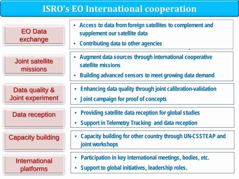
ISRO’s EO International cooperation
EO Data exchange
Joint satellite missions
Data quality & Joint experiment
Capacity building
International platforms
• Augment data sources through international cooperative satellite missions
• Building advanced sensors to meet growing data demand
• Access to data from foreign satellites to complement and supplement our satellite data
• Contributing data to other agencies
• Enhancing data quality through joint calibration-validation • Joint campaign for proof of concepts
• Providing satellite data reception for global studies • Support in Telemetry Tracking and data reception
• Participation in key international meetings, bodies, etc. • Support to global initiatives, leadership roles.
Data reception
• Capacity building for other country through UN-CSSTEAP and joint workshops
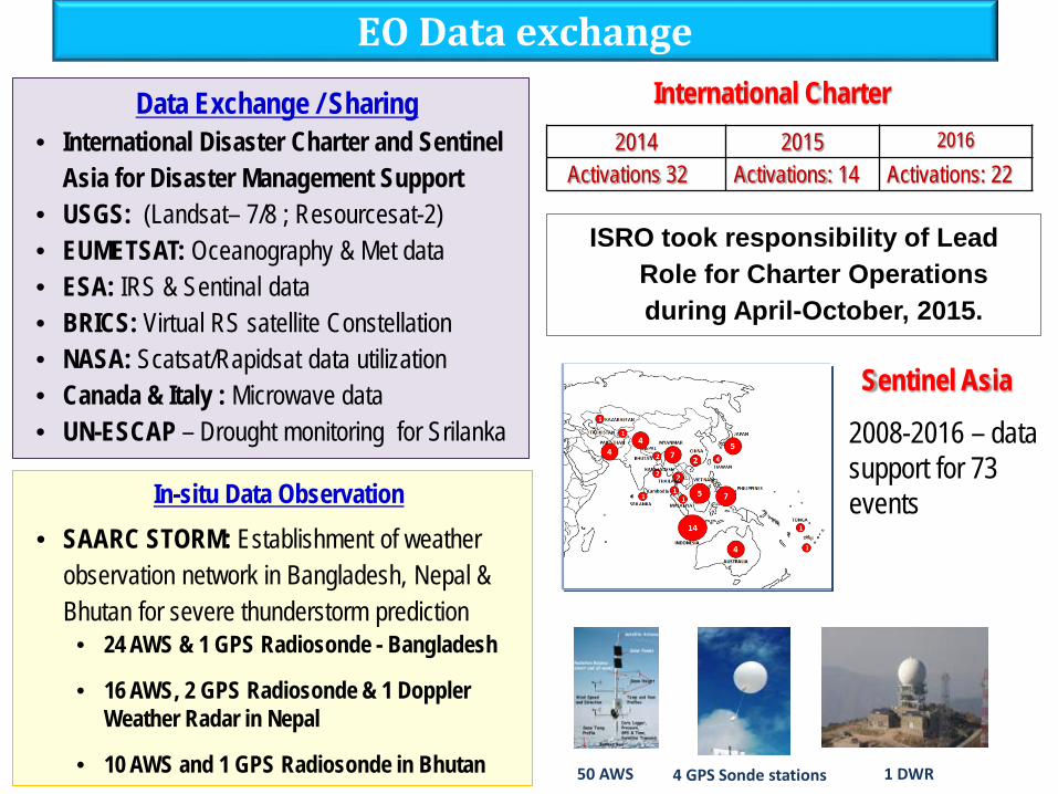
Data Exchange / Sharing • International Disaster Charter and Sentinel
Asia for Disaster Management Support • USGS: (Landsat– 7/8 ; Resourcesat-2) • EUMETSAT: Oceanography & Met data • ESA: IRS & Sentinal data • BRICS: Virtual RS satellite Constellation • NASA: Scatsat/Rapidsat data utilization • Canada & Italy : Microwave data • UN-ESCAP – Drought monitoring for Srilanka
In-situ Data Observation • SAARC STORM: Establishment of weather
observation network in Bangladesh, Nepal & Bhutan for severe thunderstorm prediction
• 24 AWS & 1 GPS Radiosonde - Bangladesh
• 16 AWS, 2 GPS Radiosonde & 1 Doppler Weather Radar in Nepal
• 10 AWS and 1 GPS Radiosonde in Bhutan
EO Data exchange
ISRO took responsibility of Lead Role for Charter Operations during April-October, 2015.
International Charter 2014 2015 2016
Activations 32 Activations: 14 Activations: 22
2008-2016 – data support for 73 events
Sentinel Asia
50 AWS 4 GPS Sonde stations 1 DWR
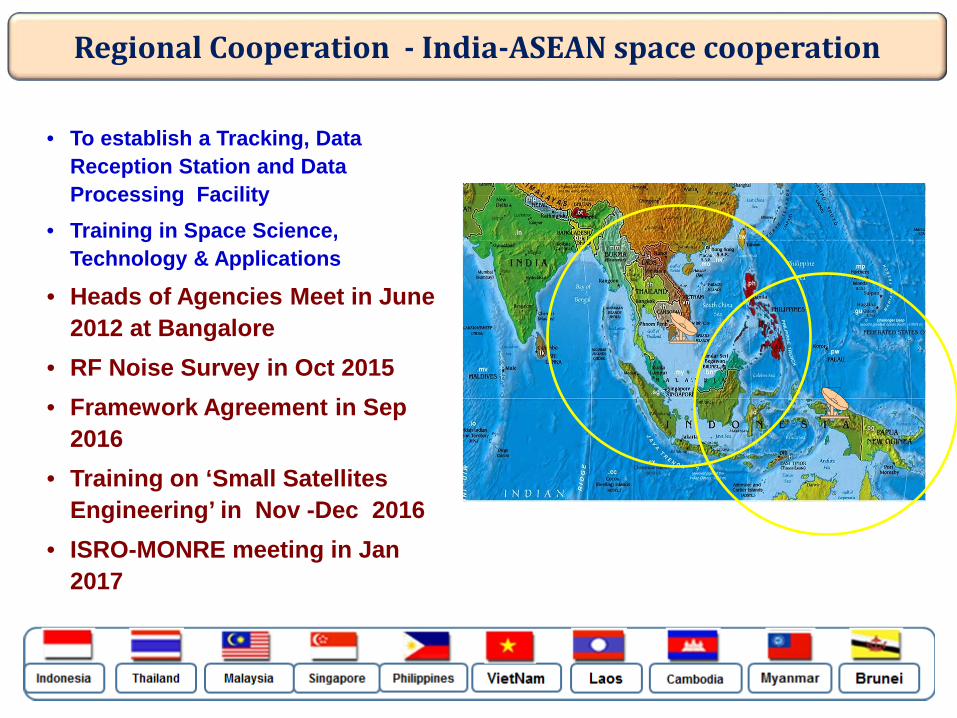
• To establish a Tracking, Data Reception Station and Data Processing Facility
• Training in Space Science, Technology & Applications
• Heads of Agencies Meet in June 2012 at Bangalore
• RF Noise Survey in Oct 2015 • Framework Agreement in Sep
2016 • Training on ‘Small Satellites
Engineering’ in Nov -Dec 2016 • ISRO-MONRE meeting in Jan
2017
Regional Cooperation - India-ASEAN space cooperation
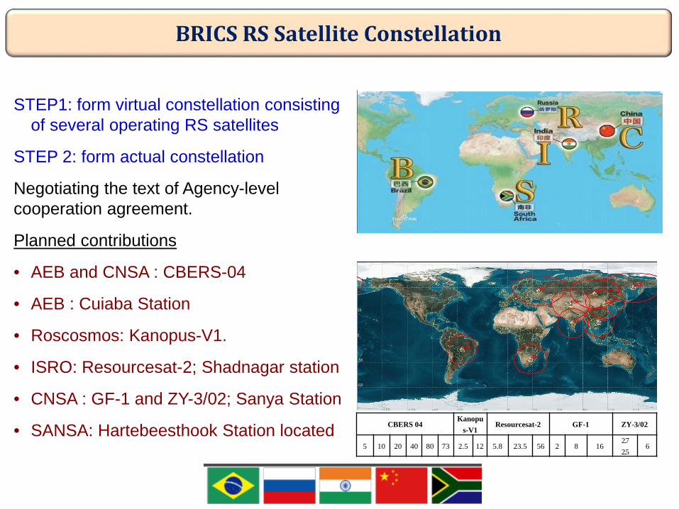
BRICS RS Satellite Constellation
STEP1: form virtual constellation consisting of several operating RS satellites
STEP 2: form actual constellation
Negotiating the text of Agency-level cooperation agreement.
Planned contributions
• AEB and CNSA : CBERS-04
• AEB : Cuiaba Station
• Roscosmos: Kanopus-V1.
• ISRO: Resourcesat-2; Shadnagar station
• CNSA : GF-1 and ZY-3/02; Sanya Station
• SANSA: Hartebeesthook Station located CBERS 04 Kanopu
s-V1 Resourcesat-2 GF-1 ZY-3/02
5 10 20 40 80 73 2.5 12 5.8 23.5 56 2 8 16 2.7 2.5
6
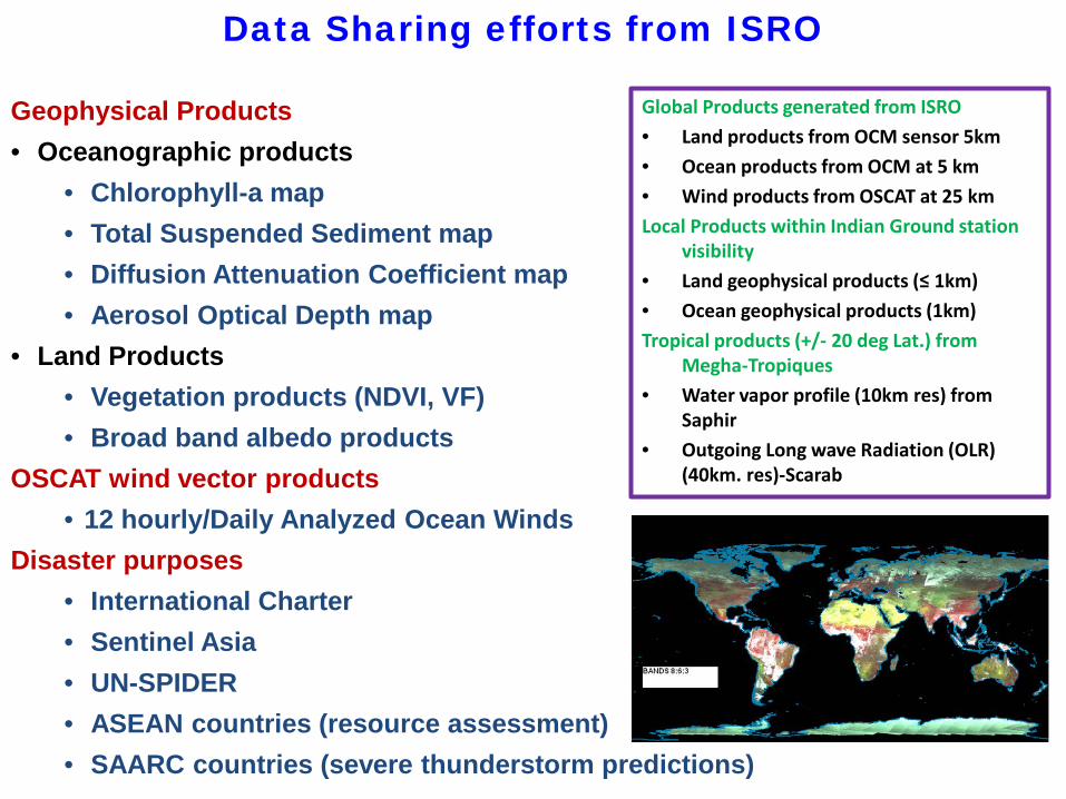
Global Products generated from ISRO • Land products from OCM sensor 5km • Ocean products from OCM at 5 km • Wind products from OSCAT at 25 km Local Products within Indian Ground station
visibility • Land geophysical products (≤ 1km) • Ocean geophysical products (1km) Tropical products (+/- 20 deg Lat.) from
Megha-Tropiques • Water vapor profile (10km res) from
Saphir • Outgoing Long wave Radiation (OLR)
(40km. res)-Scarab
Geophysical Products • Oceanographic products
• Chlorophyll-a map • Total Suspended Sediment map • Diffusion Attenuation Coefficient map • Aerosol Optical Depth map
• Land Products • Vegetation products (NDVI, VF) • Broad band albedo products
OSCAT wind vector products • 12 hourly/Daily Analyzed Ocean Winds
Disaster purposes • International Charter • Sentinel Asia • UN-SPIDER • ASEAN countries (resource assessment) • SAARC countries (severe thunderstorm predictions)
Data Sharing efforts from ISRO
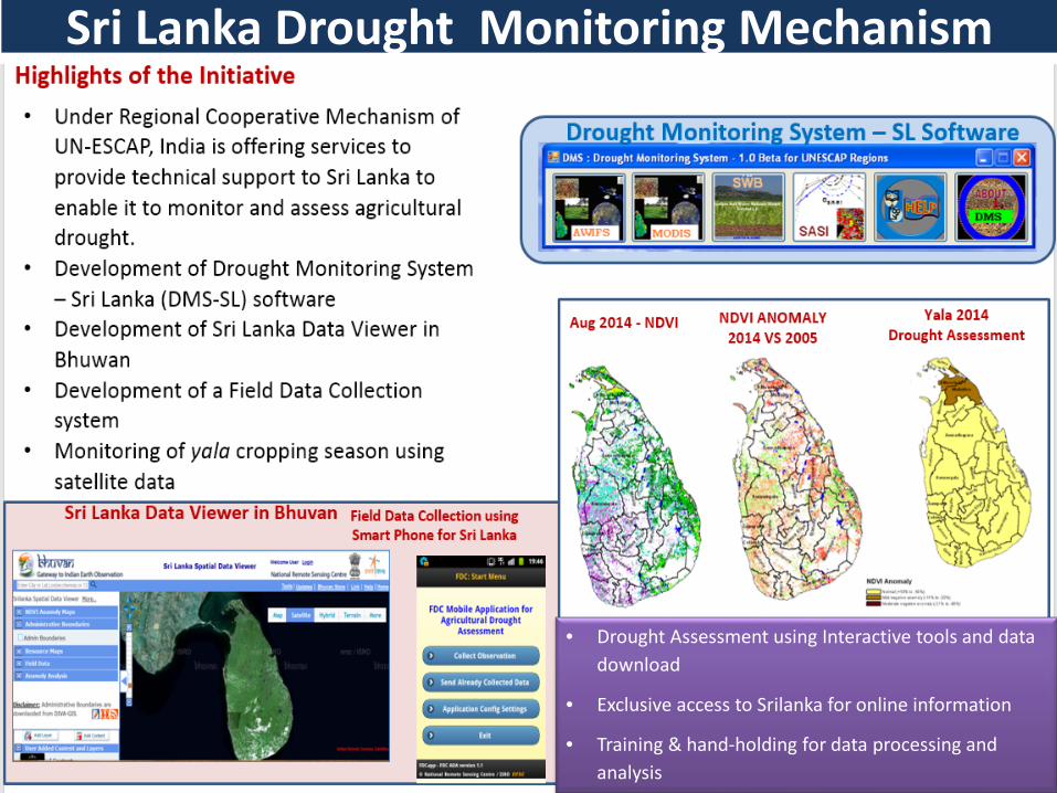
Sri Lanka Drought Monitoring Mechanism
• Drought Assessment using Interactive tools and data download
• Exclusive access to Srilanka for online information
• Training & hand-holding for data processing and analysis
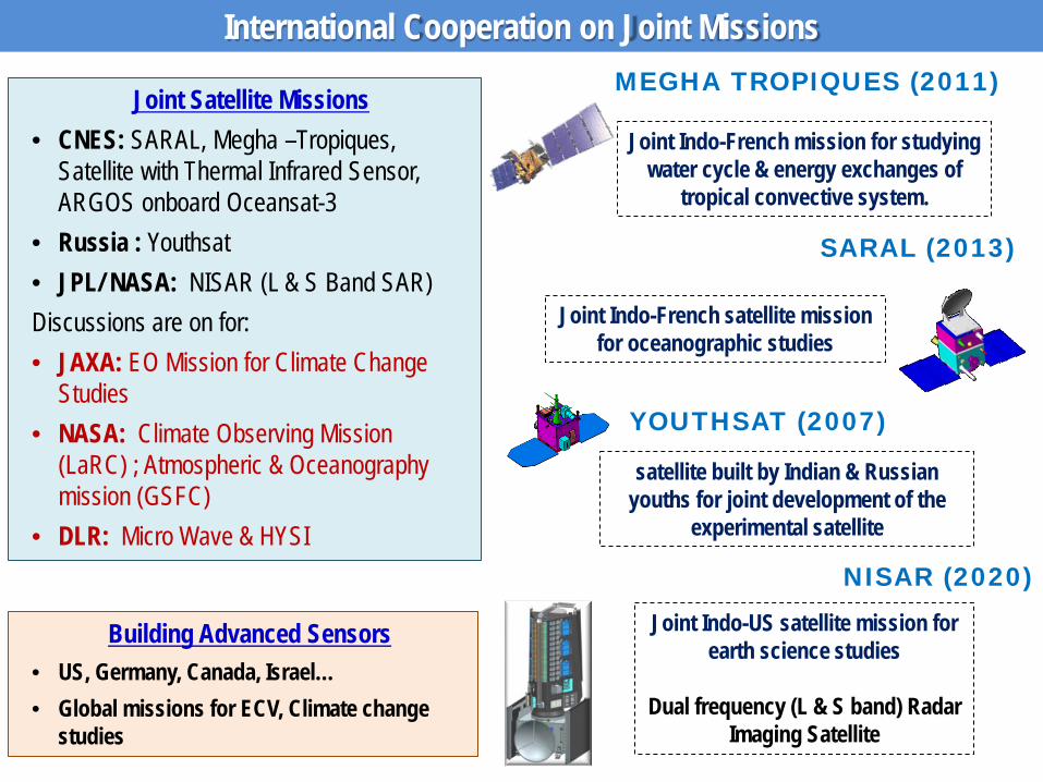
International Cooperation on Joint Missions
Joint Satellite Missions • CNES: SARAL, Megha –Tropiques,
Satellite with Thermal Infrared Sensor, ARGOS onboard Oceansat-3
• Russia : Youthsat • JPL/ NASA: NISAR (L & S Band SAR) Discussions are on for: • JAXA: EO Mission for Climate Change
Studies • NASA: Climate Observing Mission
(LaRC) ; Atmospheric & Oceanography mission (GSFC)
• DLR: Micro Wave & HYSI
Building Advanced Sensors • US, Germany, Canada, Israel… • Global missions for ECV, Climate change
studies
MEGHA TROPIQUES (2011)
Joint Indo-French mission for studying water cycle & energy exchanges of
tropical convective system.
Joint Indo-French satellite mission for oceanographic studies
SARAL (2013)
Joint Indo-US satellite mission for earth science studies
Dual frequency (L & S band) Radar
Imaging Satellite
NISAR (2020)
YOUTHSAT (2007)
satellite built by Indian & Russian youths for joint development of the
experimental satellite
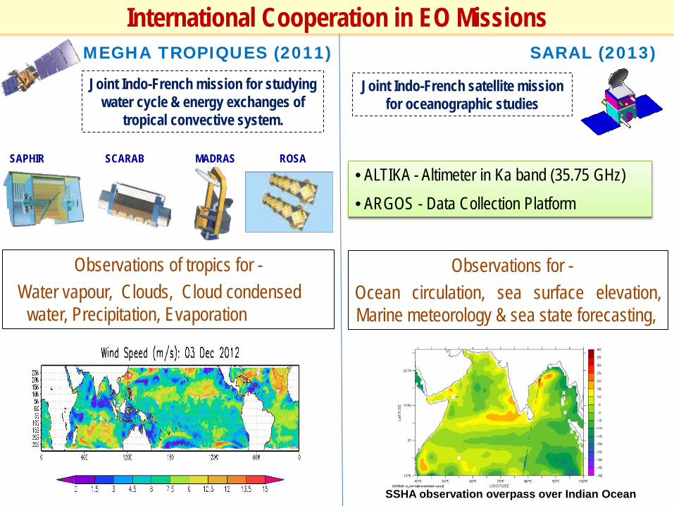
Joint Indo-French satellite mission for oceanographic studies
Observations for - Ocean circulation, sea surface elevation, Marine meteorology & sea state forecasting,
SARAL (2013)
• ALTIKA - Altimeter in Ka band (35.75 GHz) • ARGOS - Data Collection Platform
MEGHA TROPIQUES (2011)
Joint Indo-French mission for studying water cycle & energy exchanges of
tropical convective system.
International Cooperation in EO Missions
Observations of tropics for - Water vapour, Clouds, Cloud condensed
water, Precipitation, Evaporation
SAPHIR SCARAB MADRAS ROSA
SSHA observation overpass over Indian Ocean

LAUNCH 2020 – 2021
On board GSLV
SWEEP SAR SYSTEM
MAJOR SCIENCE APPLICATIONS • Natural resources mapping & monitoring • Agriculture Biomass over full duration of crop cycle • Soil Moisture • Monitoring of Floods, Oil slick, Forest fires • Coastal erosion & Coastline changes • Land Subsidence & Landslide • Surface deformation studies • Mountain / glacier snow; Mountain Glacier dynamics • Ice sheet dynamics; Sea Ice thickness & dynamics
NASA-ISRO Synthetic Aperature Radar (NISAR) Satellite
• 12 m unfurlable antenna • Ultra-precision GPS system • 4 Terabits capacity Solid State Recorder • Ka band data transmission system
• Indo-US Joint EO mission for earth science studies • Dual frequency (L & S band) Radar Imaging Satellite • SweepSAR technique to image wide swath at high resolution • Systematic global coverage over all the landmass including cryosphere • Launch by GSLV in 2020-21
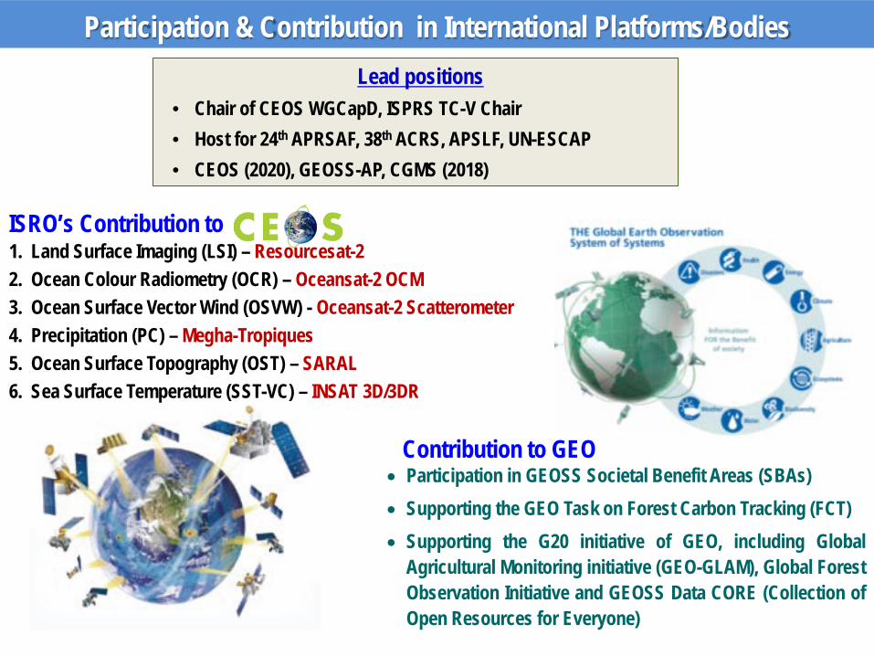
ISRO’s Contribution to 1. Land Surface Imaging (LSI) – Resourcesat-2 2. Ocean Colour Radiometry (OCR) – Oceansat-2 OCM 3. Ocean Surface Vector Wind (OSVW) - Oceansat-2 Scatterometer 4. Precipitation (PC) – Megha-Tropiques 5. Ocean Surface Topography (OST) – SARAL 6. Sea Surface Temperature (SST-VC) – INSAT 3D/3DR
Lead positions • Chair of CEOS WGCapD, ISPRS TC-V Chair • Host for 24th APRSAF, 38th ACRS, APSLF, UN-ESCAP • CEOS (2020), GEOSS-AP, CGMS (2018)
Participation & Contribution in International Platforms/Bodies
• Participation in GEOSS Societal Benefit Areas (SBAs) • Supporting the GEO Task on Forest Carbon Tracking (FCT) • Supporting the G20 initiative of GEO, including Global
Agricultural Monitoring initiative (GEO-GLAM), Global Forest Observation Initiative and GEOSS Data CORE (Collection of Open Resources for Everyone)
Contribution to GEO
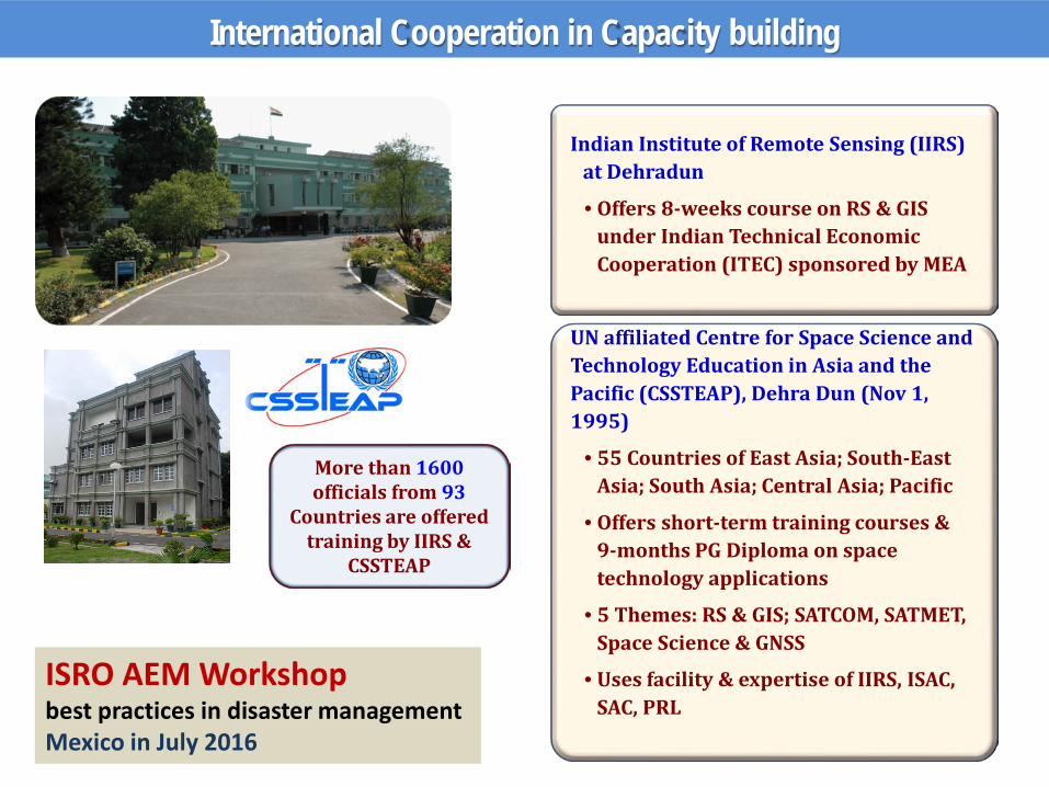
International Cooperation in Capacity building
Indian Institute of Remote Sensing (IIRS) at Dehradun
• Offers 8-weeks course on RS & GIS under Indian Technical Economic Cooperation (ITEC) sponsored by MEA
UN affiliated Centre for Space Science and Technology Education in Asia and the Pacific (CSSTEAP), Dehra Dun (Nov 1, 1995)
• 55 Countries of East Asia; South-East Asia; South Asia; Central Asia; Pacific
• Offers short-term training courses & 9-months PG Diploma on space technology applications
• 5 Themes: RS & GIS; SATCOM, SATMET, Space Science & GNSS
• Uses facility & expertise of IIRS, ISAC, SAC, PRL
More than 1600 officials from 93
Countries are offered training by IIRS &
CSSTEAP
ISRO AEM Workshop best practices in disaster management Mexico in July 2016
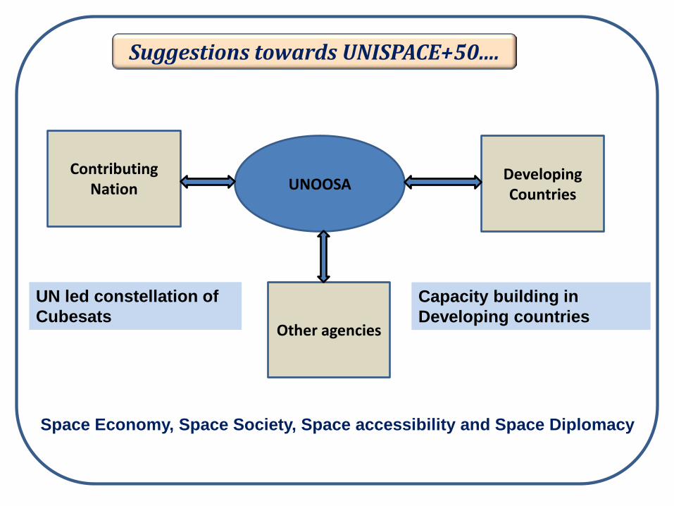
Suggestions towards UNISPACE+50....
UNOOSA Developing Countries
Other agencies
Contributing Nation
UN led constellation of Cubesats
Capacity building in Developing countries
Space Economy, Space Society, Space accessibility and Space Diplomacy
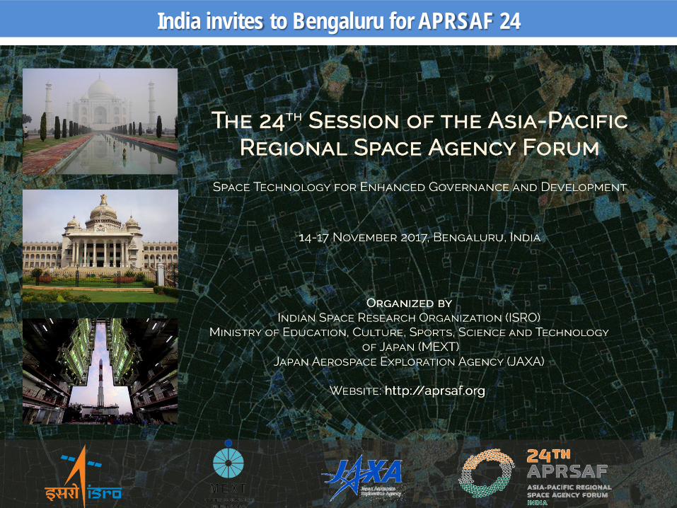
India invites to Bengaluru for APRSAF 24
Well developed Indian Remote Sensing Programme is open for international Cooperation for - - Advancing the technology - Protecting the Planet Earth & -Benefitting the humanity