Embed Size (px)
Citation preview

1
Indiana State Wetland Program Summary
Indiana Dunes National Lakeshore Wetland – Gary, Indiana Photo Credit: Visvisa
Section A. Quick View
Description of State’s Wetlands
The major concentration of wetlands is in the northeastern portion of Indiana, along river floodplains in southwestern Indiana, and in the Lake Michigan shoreline region in northwestern Indiana. Forested wetlands were the most common type of wetland in all 92 counties, making up 62% of all wetlands in the state. Other common types of wetland habitats include open water and small percentages of shallow marsh, wet meadow, scrub-shrub and deep marsh.
State Definition of Wetlands
The state defines wetlands as “areas that are inundated or saturated by surface or ground water at a frequency and duration sufficient to support, and that under normal circumstances do support, a prevalence of vegetation typically adapted for life in saturated soil conditions. Wetlands generally include: (1) swamps; (2) marshes; (3) bogs; and (4) similar areas.” A “state regulated wetland” is defined as “an isolated wetland located in Indiana that is not an exempt isolated wetland.”
Historic Wetland Loss/Gain
Original Wetland Acreage Remaining Wetland Acreage Acreage Lost % Lost 5,600,000 813,000 4,787,000 85%
Primary State Wetlands Webpage
http://www.in.gov/idem/wetlands/index.htm
State Wetland Program Plan Indiana does not currently have a state wetland program plan; however, the state is in the final stages of getting their new draft plan approved.
Click Here to Skip to
Indiana’s Information about Wetland:
Regulation
Monitoring & Assessment
Water Quality Standards
Voluntary Restoration
Education and Outreach
Integration with Other Programs

2
No Net Loss/Net Gain Goal
No net loss of wetlands and a net gain of wetlands is the adopted goal of the Department of Environmental Management’s regulatory programs. A similar goal appears in IC 13-18-22: The goals of the permitting program for wetland activities in state regulated wetlands is to: 1) promote a net gain in high quality isolated wetlands; and 2) assure that compensatory mitigation will offset the loss of isolated wetlands allowed by the permitting program.
State Resources for Wetland Work
Core element #1: Regulation
Core Element #2: Monitoring and Assessment
Core Element #3: Wetland Water Quality Standards
Core Element #4: Voluntary Wetland Restoration
Agency IDEM None None Coordination with NGOs
Source(s) Information unavailable Information unavailable
Information unavailable
Information unavailable
Amount Information unavailable Information unavailable
Information unavailable
Information unavailable
Staffing 6.5 FTE (6 full-time + 1 part-time)
State Permitting Fees
State Permitting Fee State Name Yes/No NO Amount (range) N/A Agency N/A
Innovative Features
• The adoption of state law to regulate isolated wetlands occurred in 2004 with the passage of IC 13-18-22. This is the first state law to specifically confer authority on a state agency to regulate wetlands; the law creates a definition of wetlands that is consistent with the basic definition used by federal regulatory agencies.
• A Regional General Permit that replaces many of the Corps of Engineers Nationwide Permits is in place.
• A well-developed In Lieu Fee Program • An Interagency Coordinated Agreement on Mitigation Banking is in place. • An interagency website (http://www.in.gov/wetlands/) devoted to wetland information, including
permitting, conservation, success stories, and links to organizations was created in cooperation by the Department of Environmental Management, the Department of Natural Resources, and the Office of the Commissioner of Agriculture.

3
Models and Templates Indiana has a state-run online “matchmaker” site for linking potential restoration sites and In Lieu Fee projects.
Section B. Regulation
How are Wetlands Regulated in Indiana?
For wetlands regulated under the Clean Water Act’s federal jurisdiction, the Department of Environmental Management (IDEM) implements Section 401 of the Clean Water Act, which regulates impacts to wetlands that involve the placement of dredged or fill materials into wetlands and other waters, as well as mechanical clearing of wetlands and some dredging activities. The state’s isolated wetlands, or those waters not subject to regulation under the Clean Water Act, are regulated under IC 13-18-22. This statute creates a category of waters of the state known as State Regulated Wetlands, which are defined as wetlands as delineated under the 1987 Corps of Engineers Wetlands Delineation Manual and are considered isolated and not subject to federal law. This law establishes a classification system for wetlands and a set of general permits, exemptions, and individual permitting authority.
The state’s wetlands are also regulated under the Flood Control Act, administered by the Indiana Department of Natural Resources (IDNR). Through this regulation, DNR can require mitigation for loss of wetland storage in a floodway (http://www.in.gov/legislative/ic/code/title14/ar28/ch1.html).
Wetland Delineation
Delineation Guidance Yes No Detail Use State’s Own Method X Use Corps’ 87 Manual and Regional Supplement
X Delineations for federal jurisdictional wetlands are conducted by the Corps. For projects impacting non-jurisdictional wetlands, applicants are required to submit their own delineations conducted by a consultant, using the Corps manual.
Other (Please describe) X
Evaluation Methodology
• No official methods adopted. However, an Indiana-specific Rapid Assessment of Wetlands (IRAM) was developed as a part of the Indiana Wetland Conservation Plan. See the following website: http://www2.taylor.edu/upland/departments/envscience/wetlands/iswamp/Manual.htm
• The Department of Environmental Management is developing a multivariate approach to wetlands assessment. For more information: http://www.in.gov/idem/water/planbr/401/fqaindianarprt.doc
• The use of remote sensing, aerial photography, and other landscape-focused methods of assessment will be the focus of the Department of Environmental Management over the next few years.
4
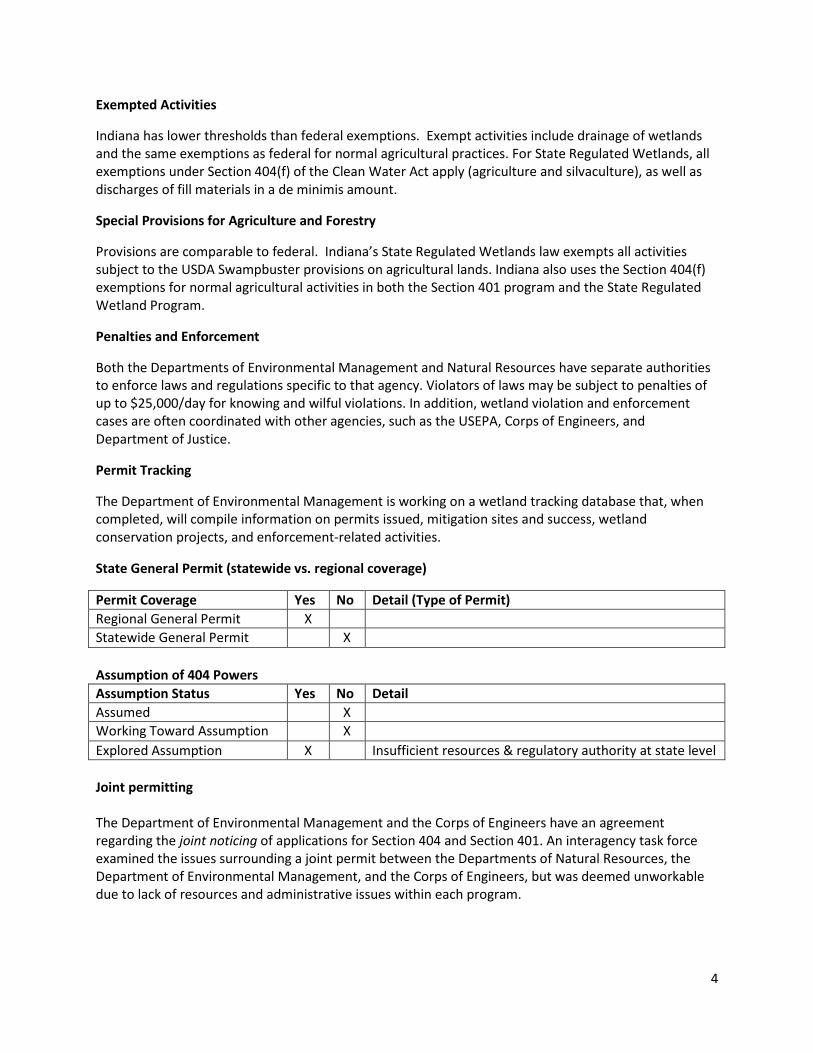
Exempted Activities
Indiana has lower thresholds than federal exemptions. Exempt activities include drainage of wetlands and the same exemptions as federal for normal agricultural practices. For State Regulated Wetlands, all exemptions under Section 404(f) of the Clean Water Act apply (agriculture and silvaculture), as well as discharges of fill materials in a de minimis amount.
Special Provisions for Agriculture and Forestry
Provisions are comparable to federal. Indiana’s State Regulated Wetlands law exempts all activities subject to the USDA Swampbuster provisions on agricultural lands. Indiana also uses the Section 404(f) exemptions for normal agricultural activities in both the Section 401 program and the State Regulated Wetland Program.
Penalties and Enforcement
Both the Departments of Environmental Management and Natural Resources have separate authorities to enforce laws and regulations specific to that agency. Violators of laws may be subject to penalties of up to $25,000/day for knowing and wilful violations. In addition, wetland violation and enforcement cases are often coordinated with other agencies, such as the USEPA, Corps of Engineers, and Department of Justice.
Permit Tracking
The Department of Environmental Management is working on a wetland tracking database that, when completed, will compile information on permits issued, mitigation sites and success, wetland conservation projects, and enforcement-related activities.
State General Permit (statewide vs. regional coverage)
Permit Coverage Yes No Detail (Type of Permit) Regional General Permit X Statewide General Permit X Assumption of 404 Powers Assumption Status Yes No Detail Assumed X Working Toward Assumption X Explored Assumption X Insufficient resources & regulatory authority at state level Joint permitting The Department of Environmental Management and the Corps of Engineers have an agreement regarding the joint noticing of applications for Section 404 and Section 401. An interagency task force examined the issues surrounding a joint permit between the Departments of Natural Resources, the Department of Environmental Management, and the Corps of Engineers, but was deemed unworkable due to lack of resources and administrative issues within each program.

5
Special Area Management Plans and Advanced Identification Plans An ADID of the Lake Michigan rim watersheds was completed by USEPA in 2002. The ADID covered portions of Lake, Porter, and Laporte Counties. There may be additional plans in the Lake Michigan area (contact the state for more information). Mitigation Policy
Mitigation for all federal jurisdictional wetlands is conducted by the Corps.
For the isolated wetlands (non-federal jurisdictional), all impacts to wetlands allowed by the regulatory process that are greater than one-tenth (0.1) acres in size require some form of compensatory mitigation. One goal of the isolated wetland permit program administered by IDEM is to ensure that “compensatory mitigation will offset the loss of isolated wetlands allowed by the permitting program.” Indiana Code outlines required standards and ratios for compensatory mitigation. Further guidance is provided by two “non-rule” policy documents published by the IDEM that provide information on determining when compensatory mitigation is complete and meets success criteria.
Compensatory mitigation also is required for wetland and stream impacts associated with permitted activities under the Lake Preservation Act (LPA) and the Flood Control Act (FCA). To provide guidance for the IDNR’s compensatory mitigation activities, the state’s Natural Resource Commission published Information Bulletin #1, a non-rule document establishing “a general framework for the assessment and determination of wetlands or habitat compensatory mitigation where a construction project is likely to reduce or degrade an existing wetland or habitat.” In addition, the IDNR began drafting mitigation guidelines in 2006. Agency staff intend to make the guidelines an enforceable “rule document” upon completion.
Mitigation Database
The IDEM is in the process of building a database for tracking permits or mitigation. IDNR operates a comprehensive database called Unity to track all activities and documents relating to the permitting process related to their floodway permitting program (floodways and streams within their jurisdiction), including inspection reports, images from site inspections, and electronic versions of issued permits. Mitigation requirements and review documents from periodic follow-up site inspections also are recorded in the Unity database, and IDNR is working to improve mitigation tracking.
Section C. Monitoring and Assessment
Agency Responsible for Wetland Monitoring and Assessment
Indiana has not adopted a wetland-specific monitoring or assessment program. However, IDNR does monitor wetland habitat as an auxiliary component to their fish and wildlife habitat monitoring program. These activities are funded by the federal Fish and Wildlife Act. IDNR also monitors all wetland mitigation projects for three years. In general, IDNR tracks biological criteria using a functional assessment methodology to determine whether the mitigation sites achieve performance criteria, which are defined on a project-by-project basis. Typically, however, the success of wetland habitat mitigation is measured and reported in terms of the percentage of surviving plantings and the hydrology of the site.

6
Mapping/Inventory
National Wetland Inventory (NWI) maps for the state were completed in the late 1980’s and updated in 2009. These maps are available in digital formats.
State Wetland Mapping Public Portal
No information available.
Wetland Classification and Assessment
Wetlands are classified using the Cowardin classification system. No formal assessment methodology has been adopted by the state at present, although exploration of assessment tools is identified as a future task in the currently being drafted state wetland program plan. While IDNR does not prescribe the use of a formal assessment methodology, in the past, the agency has employed the Chicago District’s assessment methodology. The Department of Environmental Management is currently developing a classification system for isolated wetlands as required by state law.
Statewide Wetland Monitoring Plan
IDEM currently uses best professional judgment to make certification and/or permit decisions. In 2000, IDEM revised their monitoring strategy to include a wetland assessment program that incorporates the following components: (1) inventory of the state’s wetlands using one-meter resolution aerial photography; (2) ground-truthing of the photographic inventory using a rapid bioassessment methodology; and (3) detailed, comprehensive assessments in a small sample of identified wetlands to determine quality, type, and composition, these changes were not implemented due to a lack of funding.
Overall Wetland Gain and Loss Tracking System
No comprehensive tracking system of wetland losses and gains exists in the state. IDEM has an internal website that shows impacts, however the database needs more QA/QC in order to be able to produce this kind of information.
Wetland Monitoring and Assessment Characteristics
Level None Level 1 Level 2 Level 3 Indiana X
Type None IBI Condition Functional
Indiana Currently none Working on developing I-RAM
Frequency None Project Specific Ongoing Indiana X

7
Participation in National Wetland Condition Assessment
NWCA Study Type Yes No National Study X State Intensification Study X
Detail: Federal contractors conducted 2011 NWCA sampling in Indiana.
Section D. Water Quality Standards
Wetland-Specific Water Quality Standards
Type None Use Existing WQ
Standards
In Process Adopted Future Direction
Wetland-specific Designated Uses
X
Narrative criteria X
Numeric criteria X
Anti-degradation policy includes wetlands
X
Description: Indiana’s water quality standards do not identify criteria, designated uses, or anti-degradation standards specific to wetlands. As such, designated uses for wetlands default to the open water designated uses. Draft wetland water quality standards were preliminarily adopted by the Indiana Water Pollution Control Board on February 13, 2002. However, with the passage of isolated wetland legislation, IDEM has decided not to pursue final adoption of these standards. Wetland functions that the state water quality standards and open water designated uses relate to include: sediment trapping, fish and wildlife habitat, water quality/pollution control, and minimum stream flows. All wetlands are protected under Indiana’s water quality standards, which establish narrative and numeric criteria, designated uses, and an anti-degradation policy that applies uniformly to all waters. No wetland-specific water quality standards exist at this time. See complete rules at: http://www.in.gov/legislative/iac/T03270/A00020.PDF

8
Section E. Voluntary Wetland Restoration
While Indiana has a number of programs that include voluntary wetland restoration, there is no formal state voluntary restoration program. IDNR administers state and federal restoration programs that include a wetland component. These include incentive programs that build partnerships between public agencies and private land owners. The Lake Michigan Coastal Program, also preserves and restores high quality wetland areas in the Lake Michigan basin. The program also provides funding and technical assistance.
The following information on voluntary wetland restoration activities still needs to be confirmed with IDNR staff.
Within Indiana Department of Natural Resources (IDNR): • Division of Fish and Wildlife acquires and manages Wetland Conservation Areas for fishing and
hunting and, through the Lake and River Enhancement Program, provides funding and technical assistance to lake associations and landowners for construction and maintenance of wetlands that treat nonpoint source pollution.
• Division of Forestry provides technical assistance and administers incentive programs for the stewardship of forested wetlands (the major wetland type in Indiana) and management of wetlands in state forests.
• Division of Reclamation advises landowners in development of wetlands for wildlife habitat over reclaimed mine lands.
• Division of State Parks and Reservoirs restores, enhances and creates wetlands for the purposes of watershed protection, recreational activities such as hunting and fishing, habitat enhancement, and ecosystem restoration.
• Division of Nature Preserves manages natural areas that contain rare wetland types and species
Types of Wetland Restoration Work Funded by the State:
Type of Work YES NO Description Fund Wetland Restoration (may include easement agreements)
X Division of Fish and Wildlife, Division of State Parks and Reservoirs
Private Land Restoration X Division of Fish and Wildlife Public Land Restoration X Division of State Parks, Division of Forestry Technical Assistance X Division of Forestry, Division of Reclamation Tax Incentives Unknown Possibly through Division of Forestry Other X Division of Nature Preserves - Management of natural
areas that contain rare wetland types

9
Voluntary Wetland Restoration Program Components Wetland Restoration Efforts Nothing in
the Works Planning In Progress Mature/
Complete Program has a set of restoration goals
N/A
Coordinate with relevant agencies that outline restoration/protection goals and strategies and timeframes
N/A
Developed multi-agency body to coordinate restoration/ protection efforts
N/A
Set restoration goals based on agency objectives and available information
N/A
Goals for Restoration Projects*
Goal Yes No Description No Net Loss X Reverse Loss/Net Gain X Nonpoint Source Pollution (NPS)/WQ X Total Maximum Daily Load (TMDLs) X Habitat X Coastal Protection X Lake Michigan projects Floodwater Protection Unknown Groundwater X Other (please describe) X Retention of forest land
Landowner Guides and Handbooks to Assist with Voluntary Wetland Restoration Efforts
Wetland Matchmaker – Captures information from private property owners who are interested in having their property restored for mitigation. This registration process works well, but is not used extensively.
Section F. Innovative and/or Highly Effective Education and Outreach
Indiana has included a range of education and outreach plans in its newly drafted (waiting for approval) state wetland program plan. Activities will include social media, development of partners, training for applicants and schools, and a broadening of how the state participates in National Wetland Month.
Section G. Climate Change and Wetlands
Indiana does not work on wetland work related to climate change at this time. Indiana has not developed a statewide adaptation plan or climate planning for wetlands.

10
Side note: In 2013, the Indiana State Department of Agriculture supported the development of a new system to restore Midwest wetlands to reduce massive floods and aid crops in a changing climate. The tool was developed at Oregon State University and Indiana University—Purdue University. The tool, called WRESTORE, is a web-based, user-friendly, interactive, transparent, and participatory decision support system for helping land owners, government agencies, policy makers, planners, and other stakeholders design a distributed system of conservation practices in their watersheds. It does not specifically address wetlands. To learn more about the WRESTORE tool here: http://wrestore.iupui.edu/
Section H. Integration
Entity/Program Area Yes/No Description of the Connection
Contact for Follow-up
NPDES/Stormwater YES Chief of both SW and WL; MS4s involved during plan review; If appear to be wetlands, contact 401 cert; plan review for regional stormwater plans – include general statements about wetlands; screen with stormwater staff; share information; compliance is connected. May combine violation letters if there is a discharge into a wetland (NPDES and 401)
303(d) NO 305(b) reporting on wetlands U/K Total Maximum Daily Load (TMDLs) YES Reference different SW
management practices, including some wetland-related
Climate Change/ Resiliency NO Land Use /Watershed planning YES Whole Section works on
watershed planning, which includes wetlands and restoration
Flood/Hazard Mitigation YES Through DNR Coastal Work YES Some coordination with the
Coastal Program
Wildlife Action Plan YES DNR Statewide Comprehensive Outdoor Recreation Plan (SCORP)
U/K DNR
Other (Specify) None

11
State Wetland Program Development Continuum
Section I. Contact Information
Randy Braun Section Chief Office of Water Quality, Wetlands and Storm Water Indiana Department of Environmental Management 100 North Senate Avenue, MC 65-42 Room IGCN 1255 Indianapolis, IN 46204-2251 [email protected] Indiana Department of Natural Resources 402 W Washington Indianapolis, IN 46204 (317) 232-4098
Section J. Useful State Websites
State Government Programs
1. Indiana Department of Environmental Management http://www.in.gov/idem/4138.htm
a) Section 401 Water Quality Certification Program http://www.in.gov/idem/4870.htm
b) Isolated Wetlands Program http://www.in.gov/idem/5849.htm
c) Wetland Conservation Plan
Continuum Stage Core Element 1: Regulation
Core Element 2: Monitoring & Assessment
Core Element 3: Wetland Water Quality Standards
Core Element 4: Voluntary Restoration
Mature Stage High X 401 Certification
Initial Implementation Stage
Program + State non-fed
jurisdictional wetlands permit
program
Development Stage Early Stage Low
X
X (No wetland-specific standards; no plans
to develop)
X
(Developing an interagency/interorg
collaboration)

12
http://www.in.gov/idem/4405.htm d) Wetland Mitigation Monitoring
http://www.in.gov/idem/4407.htm 2. Indiana Department of Natural Resources
a) Wetlands Reserve Program http://www.in.gov/dnr/healthyriver/6515.htm
b) Statutes & Rules http://www.in.gov/dnr/water/2453.htm
Federal Government Programs
1. USDA Natural Resources Conservation Service Wetlands Reserve Program http://www.nrcs.usda.gov/wps/portal/nrcs/main/in/programs/easements/wetlands/
Other Organization Wetland Programs
3. Wesselman Nature Society: Howell Wetlands http://www.wesselmannaturesociety.org/wetlands/