Embed Size (px)
Citation preview
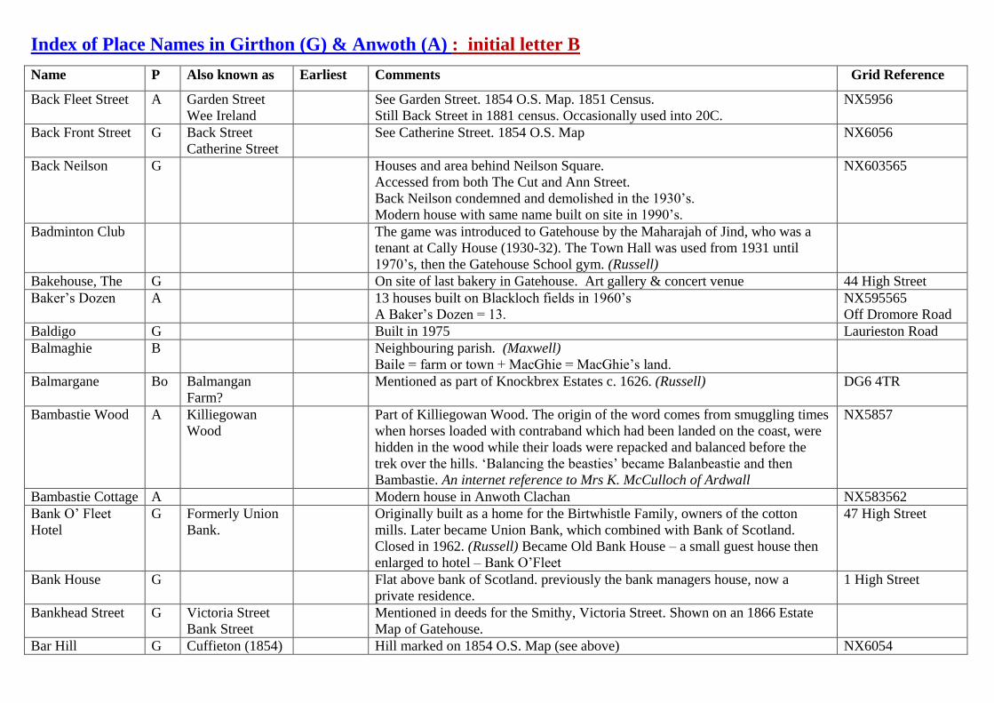
Index of Place Names in Girthon (G) & Anwoth (A) : initial letter B
Name P Also known as Earliest Comments Grid Reference
Back Fleet Street A Garden Street
Wee Ireland
See Garden Street. 1854 O.S. Map. 1851 Census.
Still Back Street in 1881 census. Occasionally used into 20C.
NX5956
Back Front Street G Back Street
Catherine Street
See Catherine Street. 1854 O.S. Map NX6056
Back Neilson G Houses and area behind Neilson Square.
Accessed from both The Cut and Ann Street.
Back Neilson condemned and demolished in the 1930’s.
Modern house with same name built on site in 1990’s.
NX603565
Badminton Club The game was introduced to Gatehouse by the Maharajah of Jind, who was a
tenant at Cally House (1930-32). The Town Hall was used from 1931 until
1970’s, then the Gatehouse School gym. (Russell)
Bakehouse, The G On site of last bakery in Gatehouse. Art gallery & concert venue 44 High Street
Baker’s Dozen A 13 houses built on Blackloch fields in 1960’s
A Baker’s Dozen = 13.
NX595565
Off Dromore Road
Baldigo G Built in 1975 Laurieston Road
Balmaghie B Neighbouring parish. (Maxwell)
Baile = farm or town + MacGhie = MacGhie’s land.
Balmargane Bo Balmangan
Farm?
Mentioned as part of Knockbrex Estates c. 1626. (Russell) DG6 4TR
Bambastie Wood A Killiegowan
Wood
Part of Killiegowan Wood. The origin of the word comes from smuggling times
when horses loaded with contraband which had been landed on the coast, were
hidden in the wood while their loads were repacked and balanced before the
trek over the hills. ‘Balancing the beasties’ became Balanbeastie and then
Bambastie. An internet reference to Mrs K. McCulloch of Ardwall
NX5857
Bambastie Cottage A Modern house in Anwoth Clachan NX583562
Bank O’ Fleet
Hotel
G Formerly Union
Bank.
Originally built as a home for the Birtwhistle Family, owners of the cotton
mills. Later became Union Bank, which combined with Bank of Scotland.
Closed in 1962. (Russell) Became Old Bank House – a small guest house then
enlarged to hotel – Bank O’Fleet
47 High Street
Bank House G Flat above bank of Scotland. previously the bank managers house, now a
private residence.
1 High Street
Bankhead Street G Victoria Street
Bank Street
Mentioned in deeds for the Smithy, Victoria Street. Shown on an 1866 Estate
Map of Gatehouse.
Bar Hill G Cuffieton (1854) Hill marked on 1854 O.S. Map (see above) NX6054

Name P Also known as Earliest Comments Grid Reference
Cuffie Cottage
(1881)
Mentioned in the 1851 Girthon Census (866) but no dwelling of that name there
now. May now be Cuffieton.
Bar Hill is now covered by forest.
Bar Hill G Celtic fort. Probably housed a farming community in ??? NX603540
Bar Hill Lodge G Gamekeeper’s
Lodge
Entrance to Cally Estates near Clauchan of Girthon. In 1881 census. NX605539
Bar Hill Plantation G 1854 O.S. Map NX602539
Bar of Girthon G Mentioned in James Murray’s will (1797) as part of Barony of Laik.(Russell)
Could possible be Bar Hill beside Rainton Farm.
NX6051
Bar of Laggan Baeu’s map 1654
Barchuill G House in Memory Lane. Not to be confused with Barwhill on Laurieston Road. NX599569
Barbara Pool Fishing poll on Big Water of Fleet NX589597
Bardristane House A Bardristan sits beside the old 'main' road along the coast west of Gatehouse.. NX529529
Bardristane Farm To the NE of Bardristane farmsteading there are at least five small cairns and to
the W there is evidence of rig cultivation.
NX530529
Bardristane
Smithy
K The boundary between Anwoth and Kirkmabreck runs through Bardristane
Smithy. Folklore says that the horse shoes were heated in one parish and put on
the horse in the other.
Barfadzeon G Near Benfadyeon? NX6160 ?
Barharrow Bo 1599
(P.R.)
Farm in Borgue but close to the boundary with Girthon Parish NX619527
Barharrow
Cottage
Bo Cottage on Barharrow Farm NX619532
Barholm Bridge K NX517533
Barholm Castle K Late 16th
century tower house of McCulloch family.Built c. 1500. (MacLeod).
Now converted into a house.
NX521529
Barholm Farm K NX521528
Barholm Cottage K NX5252
Barholm
Hermitage Cottage
K NX5252
Barholm, Heughs
of
K Area of wooded cliffs close to Barholm Castle NX5152
Barlay Bobbin
Mill
G Used water power from the Barlay Burn. Destroyed by fire in November 1867.
Pre-dated bobbin mill by the River Fleet. (Russell)
NX6057
Barlay Burn G Burn rising on Bengray and flowing south west to join the River Fleet north of
Roman Fort.
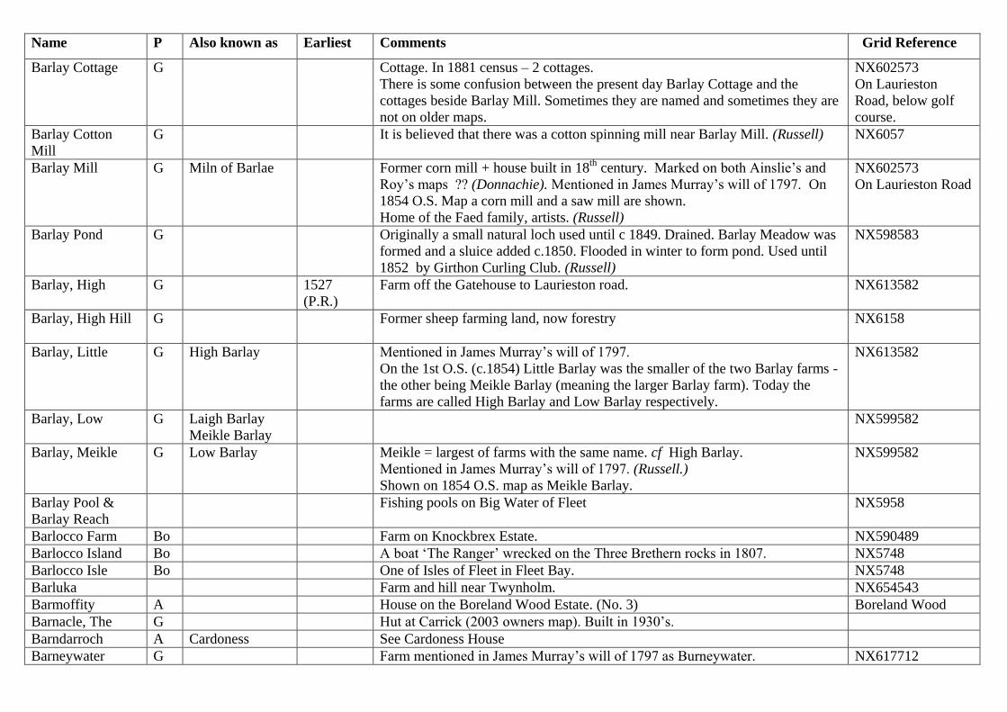
Name P Also known as Earliest Comments Grid Reference
Barlay Cottage G Cottage. In 1881 census – 2 cottages.
There is some confusion between the present day Barlay Cottage and the
cottages beside Barlay Mill. Sometimes they are named and sometimes they are
not on older maps.
NX602573
On Laurieston
Road, below golf
course.
Barlay Cotton
Mill
G It is believed that there was a cotton spinning mill near Barlay Mill. (Russell) NX6057
Barlay Mill G Miln of Barlae Former corn mill + house built in 18th
century. Marked on both Ainslie’s and
Roy’s maps ?? (Donnachie). Mentioned in James Murray’s will of 1797. On
1854 O.S. Map a corn mill and a saw mill are shown.
Home of the Faed family, artists. (Russell)
NX602573
On Laurieston Road
Barlay Pond G Originally a small natural loch used until c 1849. Drained. Barlay Meadow was
formed and a sluice added c.1850. Flooded in winter to form pond. Used until
1852 by Girthon Curling Club. (Russell)
NX598583
Barlay, High
G 1527
(P.R.)
Farm off the Gatehouse to Laurieston road. NX613582
Barlay, High Hill G Former sheep farming land, now forestry
NX6158
Barlay, Little G High Barlay Mentioned in James Murray’s will of 1797.
On the 1st O.S. (c.1854) Little Barlay was the smaller of the two Barlay farms -
the other being Meikle Barlay (meaning the larger Barlay farm). Today the
farms are called High Barlay and Low Barlay respectively.
NX613582
Barlay, Low G Laigh Barlay
Meikle Barlay
NX599582
Barlay, Meikle G Low Barlay Meikle = largest of farms with the same name. cf High Barlay.
Mentioned in James Murray’s will of 1797. (Russell.)
Shown on 1854 O.S. map as Meikle Barlay.
NX599582
Barlay Pool &
Barlay Reach
Fishing pools on Big Water of Fleet NX5958
Barlocco Farm Bo Farm on Knockbrex Estate. NX590489
Barlocco Island Bo A boat ‘The Ranger’ wrecked on the Three Brethern rocks in 1807. NX5748
Barlocco Isle Bo One of Isles of Fleet in Fleet Bay. NX5748
Barluka Farm and hill near Twynholm. NX654543
Barmoffity A House on the Boreland Wood Estate. (No. 3) Boreland Wood
Barnacle, The G Hut at Carrick (2003 owners map). Built in 1930’s.
Barndarroch A Cardoness See Cardoness House
Barneywater G Farm mentioned in James Murray’s will of 1797 as Burneywater. NX617712

Name P Also known as Earliest Comments Grid Reference
In 1881 census. Near Loch Skerrow
Barnkirky G NX6153
Barony A large freehold estate in Scotland owned by a baron. A baron in Scotland was
a landowner who held his lands in tenure directly from the crown, even if he
was a commoner. He had judicial and administrative powers over his land.
(Scottish Encyclopaedia)
Barony of Enrick G With Barony of Laik, it formed part of the Cally Estates.
Barony of Glen A Barony of
Glenskyreburn
Became part of Rusco estate. (Russell)
Barony of
Glenskyreburn
A Barony of Glen See Barony of Glen
Barony of Laik G Barony of Lake Joined with Barony of Enrick to form Cally Estates. Mentioned in James
Murray’s will (1797) with a list of the lands and properties included.(Russell)
Barview G House near Rainton Farm with a view of the Bar Hill. NX602522
Barwhill G 1586 In 1586 Charter as Barquhulle
In 1881 census. (but transcription in IGI says Barnhill)
Not to be confused with Barchuill on the other side of the hill on Memory Lane.
NX598572
On Laurieston
Road, opposite the
tennis court.
Barwhill Fort G A Celtic fort on the valley bottom near the High Ford over the River Fleet.
(Russell) Is this the same as Harper’s Hill Fort?
NX597572
Bathing House G The Flag? The Bathing House was close to the direct road from Cally House via Cally
Mains to Sandgreen.
Now converted into a private house.
NX617712
Sandgreen
Battery Reach &
Battery Pool
Fishing pools on Big Water of Fleet NX5957
Bay Horse, The G Pub on Ann Street, later - a wheelwright’s, a joiner’s workshop, an antique shop
and a Bed & Breakfast. Now a private house.
NX602564
Ann Street
Bayne’s G James Bayne, ironmonger, sold alcohol c. 1850 (Russell)
On site of Alexandria’s, 8-10 High Street.
Beechwood G Modern development in Cally Woods close to Double Lodges. NX6056
Belevedere
Plantation
G 1854 O.S. Map NX6054
Bell’s Monument A A flat table gravestone in the old Anwoth kirkyard commemorating the death of
the Covenanter John Bell. He was from Whiteside, in the Skyreburn valley, and
a supporter of the Presbyterian cause. For about seven years he was a fugitive
NX582562
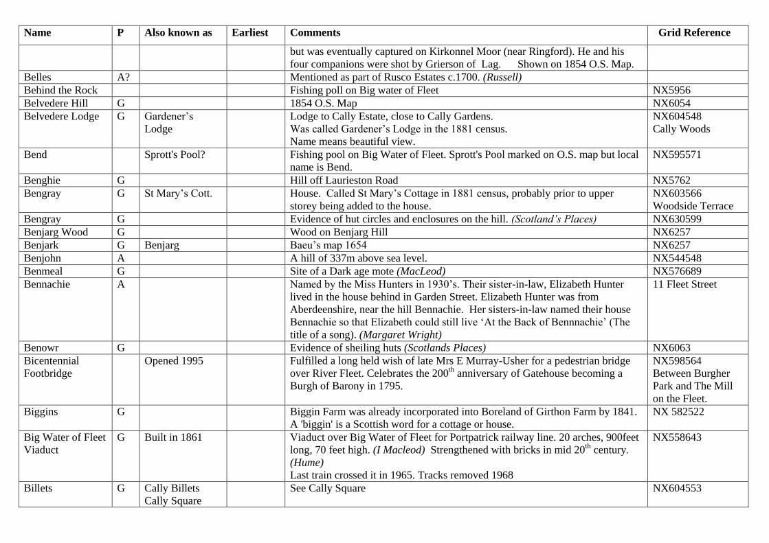
Name P Also known as Earliest Comments Grid Reference
but was eventually captured on Kirkonnel Moor (near Ringford). He and his
four companions were shot by Grierson of Lag. Shown on 1854 O.S. Map.
Belles A? Mentioned as part of Rusco Estates c.1700. (Russell)
Behind the Rock Fishing poll on Big water of Fleet NX5956
Belvedere Hill G 1854 O.S. Map NX6054
Belvedere Lodge G Gardener’s
Lodge
Lodge to Cally Estate, close to Cally Gardens.
Was called Gardener’s Lodge in the 1881 census.
Name means beautiful view.
NX604548
Cally Woods
Bend Sprott's Pool? Fishing pool on Big Water of Fleet. Sprott's Pool marked on O.S. map but local
name is Bend.
NX595571
Benghie G Hill off Laurieston Road NX5762
Bengray G St Mary’s Cott. House. Called St Mary’s Cottage in 1881 census, probably prior to upper
storey being added to the house.
NX603566
Woodside Terrace
Bengray G Evidence of hut circles and enclosures on the hill. (Scotland’s Places) NX630599
Benjarg Wood G Wood on Benjarg Hill NX6257
Benjark G Benjarg Baeu’s map 1654 NX6257
Benjohn A A hill of 337m above sea level. NX544548
Benmeal G Site of a Dark age mote (MacLeod) NX576689
Bennachie A Named by the Miss Hunters in 1930’s. Their sister-in-law, Elizabeth Hunter
lived in the house behind in Garden Street. Elizabeth Hunter was from
Aberdeenshire, near the hill Bennachie. Her sisters-in-law named their house
Bennachie so that Elizabeth could still live ‘At the Back of Bennnachie’ (The
title of a song). (Margaret Wright)
11 Fleet Street
Benowr G Evidence of sheiling huts (Scotlands Places) NX6063
Bicentennial
Footbridge
Opened 1995 Fulfilled a long held wish of late Mrs E Murray-Usher for a pedestrian bridge
over River Fleet. Celebrates the 200th
anniversary of Gatehouse becoming a
Burgh of Barony in 1795.
NX598564
Between Burgher
Park and The Mill
on the Fleet.
Biggins G Biggin Farm was already incorporated into Boreland of Girthon Farm by 1841.
A 'biggin' is a Scottish word for a cottage or house.
NX 582522
Big Water of Fleet
Viaduct
G Built in 1861 Viaduct over Big Water of Fleet for Portpatrick railway line. 20 arches, 900feet
long, 70 feet high. (I Macleod) Strengthened with bricks in mid 20th
century.
(Hume)
Last train crossed it in 1965. Tracks removed 1968
NX558643
Billets G Cally Billets
Cally Square
See Cally Square NX604553
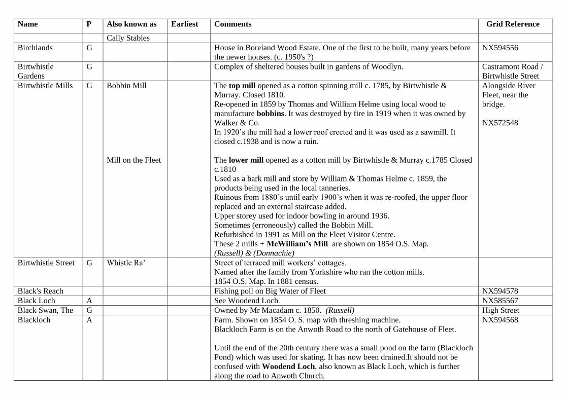
Name P Also known as Earliest Comments Grid Reference
Cally Stables
Birchlands G House in Boreland Wood Estate. One of the first to be built, many years before
the newer houses. (c. 1950's ?)
NX594556
Birtwhistle
Gardens
G Complex of sheltered houses built in gardens of Woodlyn. Castramont Road /
Birtwhistle Street
Birtwhistle Mills G Bobbin Mill
Mill on the Fleet
The top mill opened as a cotton spinning mill c. 1785, by Birtwhistle &
Murray. Closed 1810.
Re-opened in 1859 by Thomas and William Helme using local wood to
manufacture bobbins. It was destroyed by fire in 1919 when it was owned by
Walker & Co.
In 1920’s the mill had a lower roof erected and it was used as a sawmill. It
closed c.1938 and is now a ruin.
The lower mill opened as a cotton mill by Birtwhistle & Murray c.1785 Closed
c.1810
Used as a bark mill and store by William & Thomas Helme c. 1859, the
products being used in the local tanneries.
Ruinous from 1880’s until early 1900’s when it was re-roofed, the upper floor
replaced and an external staircase added.
Upper storey used for indoor bowling in around 1936.
Sometimes (erroneously) called the Bobbin Mill.
Refurbished in 1991 as Mill on the Fleet Visitor Centre.
These 2 mills + McWilliam’s Mill are shown on 1854 O.S. Map.
(Russell) & (Donnachie)
Alongside River
Fleet, near the
bridge.
NX572548
Birtwhistle Street G Whistle Ra’ Street of terraced mill workers’ cottages.
Named after the family from Yorkshire who ran the cotton mills.
1854 O.S. Map. In 1881 census.
Black's Reach Fishing poll on Big Water of Fleet NX594578
Black Loch A See Woodend Loch NX585567
Black Swan, The G Owned by Mr Macadam c. 1850. (Russell) High Street
Blackloch A Farm. Shown on 1854 O. S. map with threshing machine.
Blackloch Farm is on the Anwoth Road to the north of Gatehouse of Fleet.
Until the end of the 20th century there was a small pond on the farm (Blackloch
Pond) which was used for skating. It has now been drained.It should not be
confused with Woodend Loch, also known as Black Loch, which is further
along the road to Anwoth Church.
NX594568

Name P Also known as Earliest Comments Grid Reference
Until 1919, Anwoth Curling Club used another pond on Blackloch Farm
(NX588564) for outdoor curling matches. This was known as Blackloch
Curling Pond.
It was later used as one of the rubbish dumps for Gatehouse of Fleet and is now
covered in trees.
Blackloch Curling
Pond
A High on Blackloch Farm. Used by Anwoth Curling Club until c.1919. The
access from Pinnacle Road (Planetree Park) was good and at 45m above sea
level froze better than lower rinks.
Later used as a rubbish dump and planted with trees. (Russell)
NX5856
Blackloch Park A Football field roughly where new fire station is today. There was also another
football field further up the road closer to Blackloch farmhouse.
NX595566
Blackloch Pond A A flooded hollow north west of farm buildings which was used for skating.
Now drained.
NX592568
Blackthorn G Hut at Carrick (2003 owners map) Built in 1950’s. NX5750
Blaeberry Island G? Island in Loch Skerrow
A blaeberry is a Scottish word for a bilberry.
NX603679
Bland’s Female
School
A Plaque on wall by Community Centre. Originally on wall of Fleetside School.
Little is known of this school. May have been a Free Church School.
Dromore Road
Bleachfield G Saw Pit Field Town bleach field, later used as a saw pit. Field by the River
Fleet below Swan
Street
Bleachfield G Youth Hostel House on old bleachfields site. Birtwhistle Street
Blue Bell, The G Sold alcohol c.1850(Russell) 10a Catherine Street
Boat Draught A A place where boats were drawn up or dragged across a narrow neck of land.
Shown on first O.S. map on the shoreline near Auchenlarie
NX536518
Boat Green
Tannery
A 1 of 2 tanneries in town. Out of business by 1860s. Boat Green.
NX597561
Boat Green Wood A 1854 O.S. Map
Boatgreen A Formerly the town harbour but it could only take small boats due to shallow
water. Built during late 18th
century. Superseded by Port Macadam. Boat
building yard. (Russell & Donnachie) 1851 Census.
At the foot of
Hannay Street on a
bend in the River
Fleet.
Bobbin Mill G Also see Barlay
Bobbin Mill
Upper of the old Birtwhistle cotton mills. Opened in 1859 by Thomas and
William Helme using local wood to manufacture bobbins. In 1920’s the mill
NX599563

Name P Also known as Earliest Comments Grid Reference
had a lower roof erected and it was used as a saw mill. It closed inc.1938 and is
now a ruin. (Russell)
Bobbin Mill
Cottage
G House on edge of pathway to and overlooking mills.
Was at least 2 houses in the past.
14 Victoria Street
Bobbin Mill
Cottages
G In 1881 census these cottages seem to be near Barlay Mill, possibly near site of
old Barlay Bobbin Mill (roughly where the Laurieston Rd houses are today.)
Bobbin Mills G 2 in the area See Bobbin Mill & Barlay Bobbin MIll
Boggrie Moss G Soft boggy moss. NX5865
Boghall Wood A Boighall Wood Baeu’s map 1654 as Boighall. (Maxwell)
Mentioned in James Murray’s will(1797) as part of Burgh of Barony of
Fleet.(Russell)
NX5856
Boighall A See Boghall
Boirland
(of Girthon)
G Borland Baeu’s map 1654. Spelt Borland (1851 Census). NX585515
Bothy G In 1881 census, on Cally estate near to Cally Stables or Cally Gardens. Housed
gardeners.
NX605553
Boreland Bridge A Bridge on A75 where crosses over the Boreland Burn. NX586554
Boreland Burn A Burn near Boreland of Anwoth NX5855
Boreland Cottage A Little Boreland Shown on 1854 O.S. map. 1851 Census NX592557
Boreland Hills A Hilly area to west of Gatehouse where Rutherford’s Monument stands. NX5856
Boreland, Little A Wee Boreland At one time a small holding. The house is now a private dwelling.
Should not be confused with the modern day Boreland Cottages which are
across the A75 from Boreland of Anwoth farm.
NX586553
Boreland Moat A See Green Tower Mote. Shown as Boreland Moat on 1854 O.S. map.
Boreland of
Anwoth Cottages
A Boreland
Cottages
In 1851 census NX586554
Boreland of
Anwoth Farm
A Either a home-farm or Bereland = land where barley grows. (Maxwell)
In 1851 census.
NX585554
Boreland of
Cardoness
A Mentioned in James Murray’s will (1797) as part of Burgh of Barony of
Fleet.(Russell) Another name for Boreland of Anwoth?
Boreland of
Girthon
G Either a home-farm or Bereland = land where barley grows. (Maxwell)
Mentioned in James Murray’s will (1797) as part of Barony of
Laik.(Russell).Originally it was 3 farms – Carrick, Clean & Arras. (Airds??)
NX585515
Boreland Pond A Anwoth Curling Club moved to this pond c.1867 from Kirkbride Pond. Only 20
m above sea level but very easy access and large (6 sheets). Used until
NX581556
Boreland of Anwoth

Name P Also known as Earliest Comments Grid Reference
1960’s????? (Russell)
Boreland Wood A Quay Wood Name of woodland. Shown on 1854 O.S. Map.
Name of modern housing estate at same place.
First house built by Mr Colman in 1950’s.
NX5955
Off road to west of
Gatehouse.
Boreland, Little A Boreland Cottage Shown on 1854 O.S. map as Boreland Cottage. NX592557
Borgue B Borg Neighbouring parish and village.
May mean a fort, a town or a burgh. (Maxwell)
Borgue, Laigh Bo Low Borgue Part of Knockbrex estates c.1626 (Russell)
Bowling Green G The first bowling green was in what is now the garden of the Murray Arms
Hotel. It is shown on the 1840 & 1854 O.S. map.
In 1938 a new bowling green and putting green were created at the top of Ann
Street, beside the newly created Garries Park.
Boxing Hall See Town Hall
Bracken Bush G La Lavendau
The Chacara
Chalet on Carrick Shore. (from Memories of Carrick Shore booklet)
Bracken Wood A Modern development of houses next to Ramsey Wood. NX588566
Off Anwoth Road at
Luckies Brae.
Brackenrigg G Chalet at Sandgreen NX5752
Brackens G Hut at Carrick (2003 owners map) NX5750
Brae Cottage G Part of Brewery
complex.
On Brewery Brae 71 High Street
Braemar G Hut at Carrick (2003 map) NX577510
Braeside G House. In 1881 census. On the Cut. NX605565
Braid Port G May mean a broad landing place.
Branyea G A hill. NX553687
Brass Foundery G In Victoria Street. Used water power from lade system. (Russell)
Breoch Loch Used as a curling pond c 1700. Old stone found there??? (Russell) Kirkdale
Bruachmore G Part of Brewery
complex.
On Brewery Brae 73 High Street
Brugarat G Whimbrels Hut at Carrick (Carrick Shore Booklet). Name means ‘clearing on the hill’.
Built from a foresters hut from Dhoon, Kirkcudbright after WW II.
NX5750
Brewery G Brewery started c.1784. Working until at least 1870. (Russell)
Later became stores and garages. Now converted into flats.
NX599563
Brewery Brae G Part of the High Street. Hill leading down
from High Street to

Name P Also known as Earliest Comments Grid Reference
bridge and Fleet
Street.
Brick Field A Early 19th
century brick works.
On 1854 O.S. map it is shown with a pond, a shed and a brick kiln.
There was possibly another brickfield between Memory Lane and the River
Fleet, close to Girthon cemetery. Sometimes shown as Marl Pit
NX595562
Brickworks Field
Nature Reserve
A Brick Field On site of town brickworks. (Russell)
Brick Kiln shown on 1854 O.S. Map.
Off Planetree Park
NX595562
Bridge House A Crown & Thistle
Pub
First house on Fleet Street side of Fleet Bridge.
Soap works were behind this house. (Russell)
Bridge Terrace
Bridge Pool 1854 O.S. Map. Pool on River Fleet between Fleet Bridge and Boatgreen. NX599561
Bridge Terrace A Beside Fleet Bridge. Terrace of houses
between the Fleet
Bridge and Hannay
Street.
Bridgend A Mentioned in James Murray’s will (1797) as part of Burgh of Barony of
Fleet.(Russell)
Area of Gatehouse in Anwoth e.g. Fleet Street, Boatgreen & Garden Street.
NX596562
Bridge Pool Close to Rusko Bridge, a fishing pool on Big Water of Fleet NX585602
Broad Meadow G 1854 O.S. Map. Now part of Cally Golf Course. NX5955
Broch Included as part of Rusco Estate c. 1700
Brown Hill A 2 Semi-detached houses at Planetree Park. Planetree Park
Bruachmore G House in Brewery Complex. Brewery manager’s house? Brewery Brae
Bruar Cottage Home of the McMurray family and then the Fergusson family. 22 Birtwhistle
Street
Bungalow, The A Formerly the house built for the District Nurse. Riverbank
Bungalow, The G Cottage at Disdow NX6156
Burgh of Barony
of Fleet
G
A
Official name for Gatehouse mentioned in James Murray’s will (1797) with a
list of lands and properties included. Created in 1795.
Burgh Park Show Ground Used a allotments during World War1 (Russell) NX599567
On road to Girthon
Cemetery
Burgher Park Created in memory of Mrs E. Murray-Usher in 1990. (Russell) Off Riverbank
Burneywater G See Barneywater
Burnfoot
(Cottage)
A Skyreburn. Shown on 1854 O.S. map.
It was inhabited until the 1900’s became ruinous but now being renovated.
NX573546
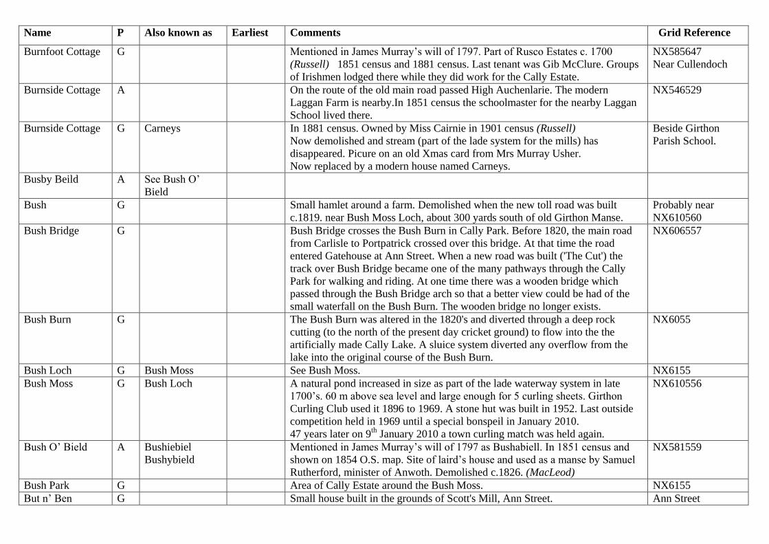
Name P Also known as Earliest Comments Grid Reference
Burnfoot Cottage G Mentioned in James Murray’s will of 1797. Part of Rusco Estates c. 1700
(Russell) 1851 census and 1881 census. Last tenant was Gib McClure. Groups
of Irishmen lodged there while they did work for the Cally Estate.
NX585647
Near Cullendoch
Burnside Cottage A On the route of the old main road passed High Auchenlarie. The modern
Laggan Farm is nearby.In 1851 census the schoolmaster for the nearby Laggan
School lived there.
NX546529
Burnside Cottage G Carneys In 1881 census. Owned by Miss Cairnie in 1901 census (Russell)
Now demolished and stream (part of the lade system for the mills) has
disappeared. Picure on an old Xmas card from Mrs Murray Usher.
Now replaced by a modern house named Carneys.
Beside Girthon
Parish School.
Busby Beild A See Bush O’
Bield
Bush G Small hamlet around a farm. Demolished when the new toll road was built
c.1819. near Bush Moss Loch, about 300 yards south of old Girthon Manse.
Probably near
NX610560
Bush Bridge G Bush Bridge crosses the Bush Burn in Cally Park. Before 1820, the main road
from Carlisle to Portpatrick crossed over this bridge. At that time the road
entered Gatehouse at Ann Street. When a new road was built ('The Cut') the
track over Bush Bridge became one of the many pathways through the Cally
Park for walking and riding. At one time there was a wooden bridge which
passed through the Bush Bridge arch so that a better view could be had of the
small waterfall on the Bush Burn. The wooden bridge no longer exists.
NX606557
Bush Burn G The Bush Burn was altered in the 1820's and diverted through a deep rock
cutting (to the north of the present day cricket ground) to flow into the the
artificially made Cally Lake. A sluice system diverted any overflow from the
lake into the original course of the Bush Burn.
NX6055
Bush Loch G Bush Moss See Bush Moss. NX6155
Bush Moss G Bush Loch A natural pond increased in size as part of the lade waterway system in late
1700’s. 60 m above sea level and large enough for 5 curling sheets. Girthon
Curling Club used it 1896 to 1969. A stone hut was built in 1952. Last outside
competition held in 1969 until a special bonspeil in January 2010.
47 years later on 9th
January 2010 a town curling match was held again.
NX610556
Bush O’ Bield A Bushiebiel
Bushybield
Mentioned in James Murray’s will of 1797 as Bushabiell. In 1851 census and
shown on 1854 O.S. map. Site of laird’s house and used as a manse by Samuel
Rutherford, minister of Anwoth. Demolished c.1826. (MacLeod)
NX581559
Bush Park G Area of Cally Estate around the Bush Moss. NX6155
But n’ Ben G Small house built in the grounds of Scott's Mill, Ann Street. Ann Street

Name P Also known as Earliest Comments Grid Reference
Butchers A Fleming’s In what is now the front of the Ship Inn (Anwoth Hotel) to left of front door. 5 Fleet Street
Butchers G Cochrane’s
(1948)
Co-op butcher
Had slaughter house at rear.
Now hairdressers/beauty parlour.
House section now Bobbin Guest House.
34 High Street
Well Entry
Butchers G Crosbie’s Later sold to Hendersons Butchers. Now a private house. 12 High Street