Embed Size (px)
Citation preview

26/4/2016
1
Page 1
Inclusive Resilience -
Learnings after typhoon Haiyan
Dipl.-Kfm. Matthias Niggel |
Senior Advisor
GIZ Philippines
Knowledge Partnership Day: From Recovery to Resilience
GFDRR, IFC, Washington, April 26, 2016
Page 2
Environment and Rural Development (EnRD) Program
Commission throughout Program Lifetime
Phase 1: 10.05 M
Phase 2: 23.53 M
(In Million EUR)
02
4
6
8
10
12
14
16
18
20
22
24
20152010 2012 20142011
Original Allocation = 7.95
BioDiv Reserve 1 (3.00) = 10.95
EFOS (2.6) = 13.56
RD/ LE (1.3) = 14.86
Biodiv Reserve 2 (3.00) +
DIPECHO (0.41) = 18.26
DW Integration (1.27) = 19.53
DIPECHO 8 (.80) + EEF (.20) = 20.53
Yolanda (3.00)
= 23.53
2013
26/4/2016
2
Page 3
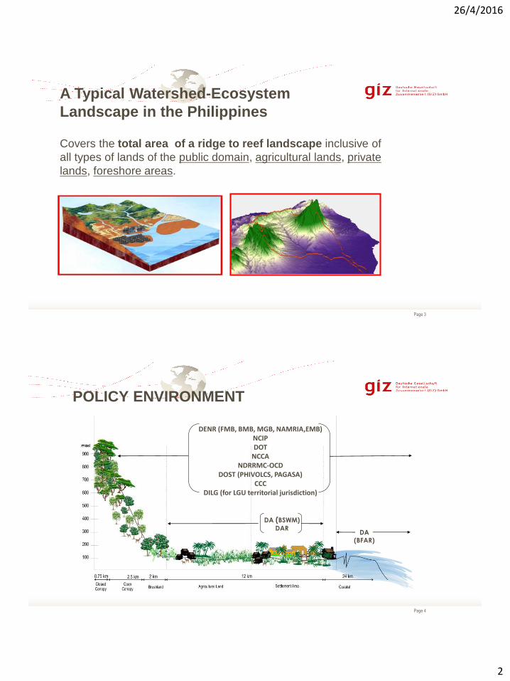
A Typical Watershed-Ecosystem
Landscape in the Philippines
Covers the total area of a ridge to reef landscape inclusive of
all types of lands of the public domain, agricultural lands, private
lands, foreshore areas.
Page 4
DA (BSWM)
DAR
DENR (FMB, BMB, MGB, NAMRIA,EMB)NCIPDOT
NCCANDRRMC-OCD
DOST (PHIVOLCS, PAGASA)CCC
DILG (for LGU territorial jurisdiction)
DA
(BFAR)
POLICY ENVIRONMENT
26/4/2016
3
Page 5
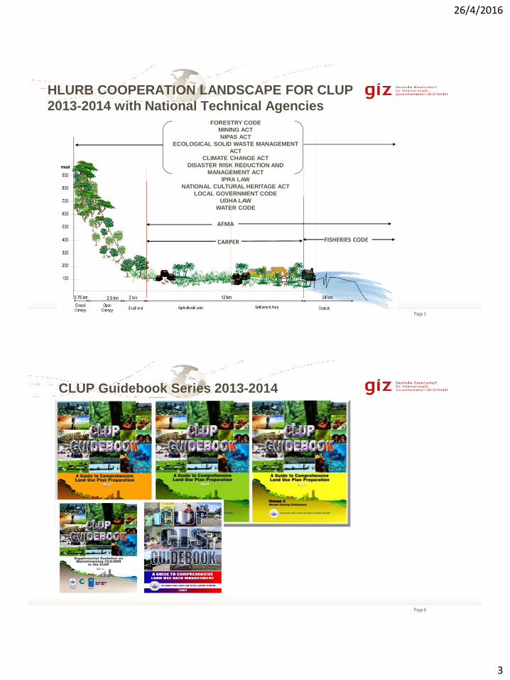
26/04/2016
AFMA
CARPER
FORESTRY CODE
MINING ACT
NIPAS ACT
ECOLOGICAL SOLID WASTE MANAGEMENT
ACT
CLIMATE CHANGE ACT
DISASTER RISK REDUCTION AND
MANAGEMENT ACT
IPRA LAW
NATIONAL CULTURAL HERITAGE ACT
LOCAL GOVERNMENT CODE
UDHA LAW
WATER CODE
FISHERIES CODE
HLURB COOPERATION LANDSCAPE FOR CLUP
2013-2014 with National Technical Agencies
Page 6
CLUP Guidebook Series 2013-2014

26/4/2016
4
Page 7
Evolving Adaptation & Resilience Program..
Climate change, forests and REDD+
26.04.2016
29.02 M (12.2015)
+14.1 M (2016/17(?))
Page 8
.
Graphic by the United Nations Office
for the Coordination of Humanitarian
Affairs
Building Back Better (BBB)
Learnings after Typhoon Haiyan
26/4/2016
5
Page 9
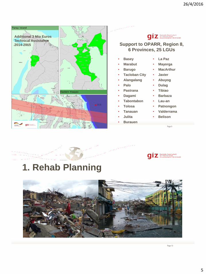
Support to OPARR, Region 8,
6 Provinces, 25 LGUs
26/04/2016
• Basey
• Marabut
• Barugo
• Tacloban City
• Alangalang
• Palo
• Pastrana
• Dagami
• Tabontabon
• Tolosa
• Tanauan
• Julita
• Burauen
• La Paz
• Mayorga
• MacArthur
• Javier
• Abuyog
• Dulag
• Tibiao
• Barbaza
• Lau-an
• Patnongon
• Valderrama
• Belison
Additional 3 Mio Euros
Technical Assistance
2014-2015
Page 10
1. Rehab Planning
26/4/2016
6
Page 11Donors Forum – Region 825-27 March 2013
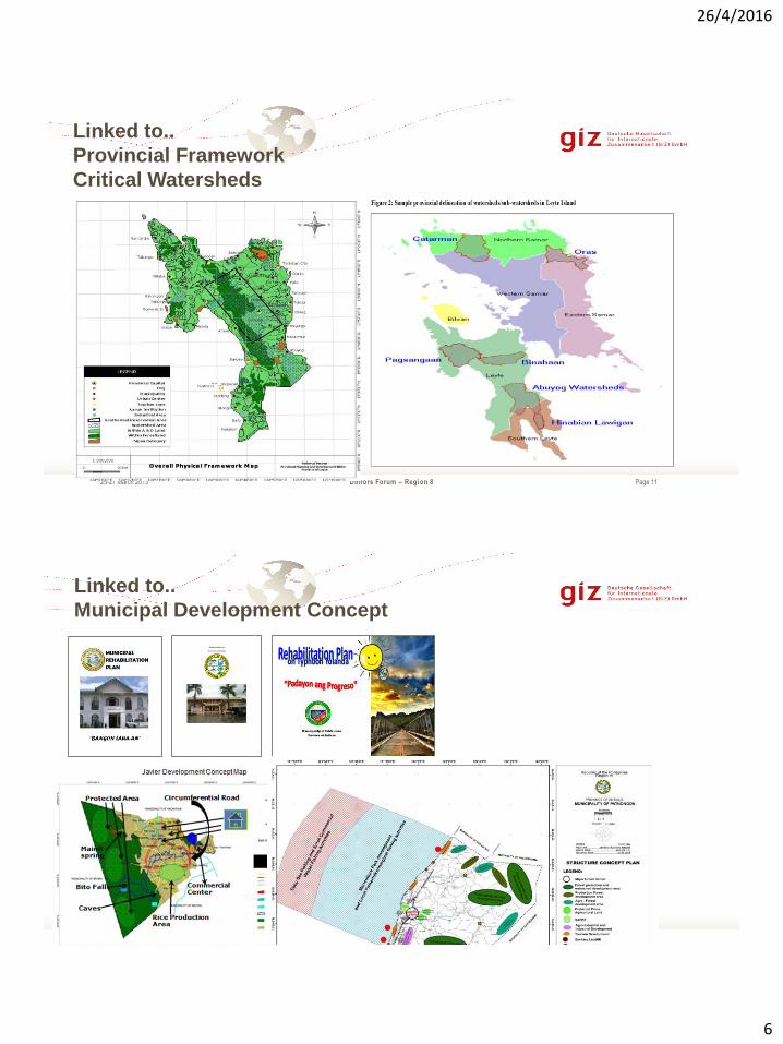
Linked to..
Provincial Framework
Critical Watersheds
Page 12
25-27 March 2013
Linked to..
Municipal Development Concept
25-27 March 2013

26/4/2016
7
Page 13
”(..) Different funding arrived
including DILG-Ray 1 plus other
projects (…).”
Engr. Rosalinda A. Alsonado, Mun. Engineer, Javier
“The Rehabilitation Plan became the
bases of support of other donors like
UNICEF, UNDP.”
Fortunato B. Serafina, MPDC, Mc Arthur
“Out of the programs identified,
around 80-90% in the PPAs were
funded for recovery.”
Cecilio Marilla, MPDC, Tolosa
LRRP Presentation: Leyte (April 26), Tacloban City (May
10), LRRP Approval President: Leyte, Tacloban City
(July 25), CRRP Approval President: (Oct 29, 2015)
Page 14
2. Getting Back to the Feet
From Rice Farming To (Rice) SEED Growing
418t Certified rice seeds
5,000 Vegetable Seed Packs
625t Urea fertilizer
2,300t Organic fertilizer
12,179 Beneficiaries
21 Municipalities
25 Irrigators Associations
20 t certified rice seeds
(Equivalent to 800t certified
rice seeds!)
54 Beneficiaries/Recipients
13 Municipalities
3 Seed Grower Associations
26/4/2016
8
Page 15
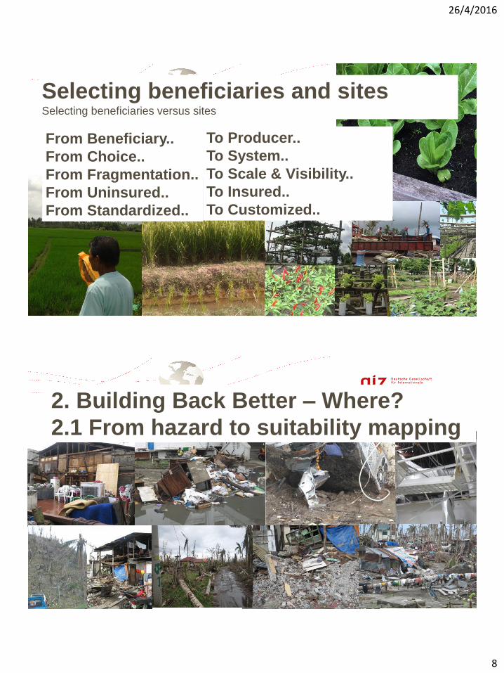
From Beneficiary..
From Choice..
From Fragmentation..
From Uninsured..
From Standardized..
To Producer..
To System..
To Scale & Visibility..
To Insured..
To Customized..
Selecting beneficiaries and sites Selecting beneficiaries versus sites
Page 16
2. Building Back Better – Where?
2.1 From hazard to suitability mapping
26/4/2016
9
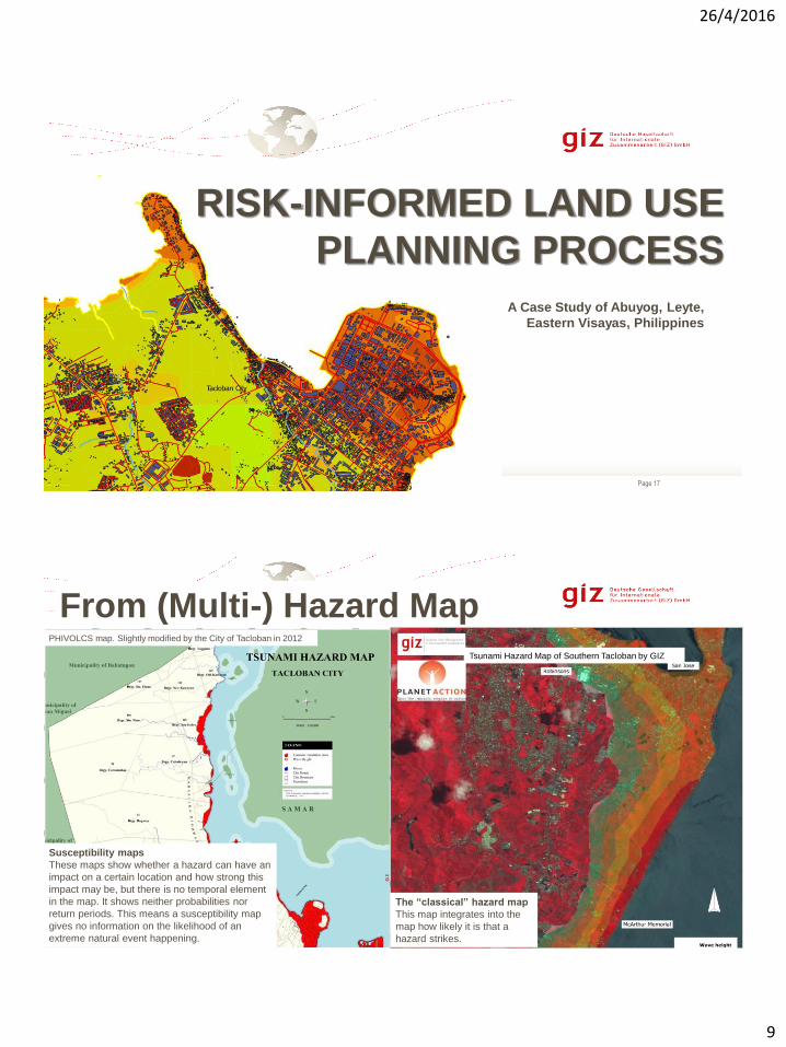
Page 17
RISK-INFORMED LAND USE
PLANNING PROCESS
A Case Study of Abuyog, Leyte,
Eastern Visayas, Philippines
Page 18
From (Multi-) Hazard MapPHIVOLCS map. Slightly modified by the City of Tacloban in 2012
Tsunami Hazard Map of Southern Tacloban by GIZ
Susceptibility maps
These maps show whether a hazard can have an
impact on a certain location and how strong this
impact may be, but there is no temporal element
in the map. It shows neither probabilities nor
return periods. This means a susceptibility map
gives no information on the likelihood of an
extreme natural event happening.
The “classical” hazard map
This map integrates into the
map how likely it is that a
hazard strikes.
26/4/2016
10
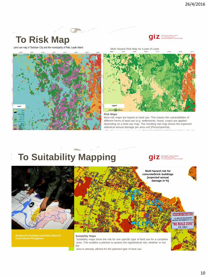
Page 19
To Risk MapMulti Hazard Risk Map for a part of Leyte
Risk Maps
Most risk maps are based on land use. This means the vulnerabilities of
different forms of land use (e.g. settlements, forest, crops) are applied
depending on a land use map. The resulting risk map shows the expected
statistical annual damage per area unit (Pesos/year/ha).
Page 20
Multi hazard risk for
concrete/brick buildings
[expected annual
damage in %]
Suitability Maps
Suitability maps show the risk for one specific type of land use for a complete
area. This enables a planner to assess the hypothetical risk, whether or not
the
area is already utilized for the planned type of land use.
To Suitability Mapping

26/4/2016
11
Page 21
Because of risk-informed CLUPS, the LGU, explore
the potential of their territorial jurisdiction with long
term disaster resiliency perspective
Open the mind set of local stakeholders to build LGU
alliances based watershed configuration
Page 22
What place is suitable for
buildings?
Multi hazard, but only one,
simple map for
normal residential buildings!
26/4/2016
12
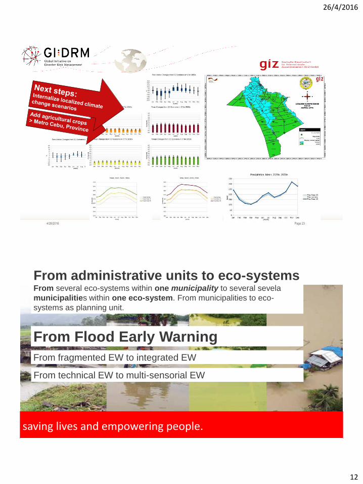
Page 234/26/2016
From Flood Early Warning
saving lives and empowering people.
From administrative units to eco-systemsFrom several eco-systems within one municipality to several sevela
municipalities within one eco-system. From municipalities to eco-
systems as planning unit.
From fragmented EW to integrated EW
From technical EW to multi-sensorial EW
26/4/2016
13
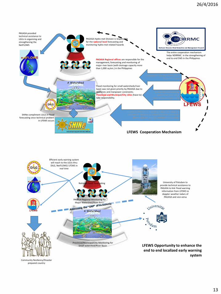
Complement the gap of PAGASA in small river basins
Extend PAGASA warning systems to more LGUs
(strengthen inclusiveness)
PAGASA Hydro-met Division is responsible for the national level forecasting and monitoring hydro-met related hazards
PAGASA Regional offices are responsible for the management, forecasting and monitoring of major river basin (with drainage capacity more than 1,000 sq.km.) in the Philippines
Flood monitoring for small watersheds/river basin was not given priority by PAGASA due to resources and manpower constraints. Provincial and Municipal/City LGUs (have to) take responsibility.
Support to PAGASA in upscaling School Hydrological information Network as school based risk informed
information for weather and flood forecastingSHINe compliment LGUs in flood
forecasting once technical problem in LFEWS occurs
PAGASA provided technical assistance to LGUs in organizing and strengthening the NetFLOWS
The entire cooperation mechanism helps NDRRMC in the strengthening of end to end EWS in the Philippines
LFEWS Cooperation Mechanism
LFEWS Opportunity to enhance the end to end localized early warning
system
University of Potsdam to provide technical assistance to PAGASA to link Flood warning
information from LFEWS to doppler weather radars of
PAGASA and vice versa
Efficient early warning system will reach to the LGUs thru DILG, NetFLOWS/ LFEWS in
real time
National Flood Forecasting
PAGASA Regional Monitoring for Major Watershed/River Basin
Provincial/Municipal/City Monitoring for Small watershed/River Basin
Community Resiliency/Disaster prepared country
26/4/2016
14
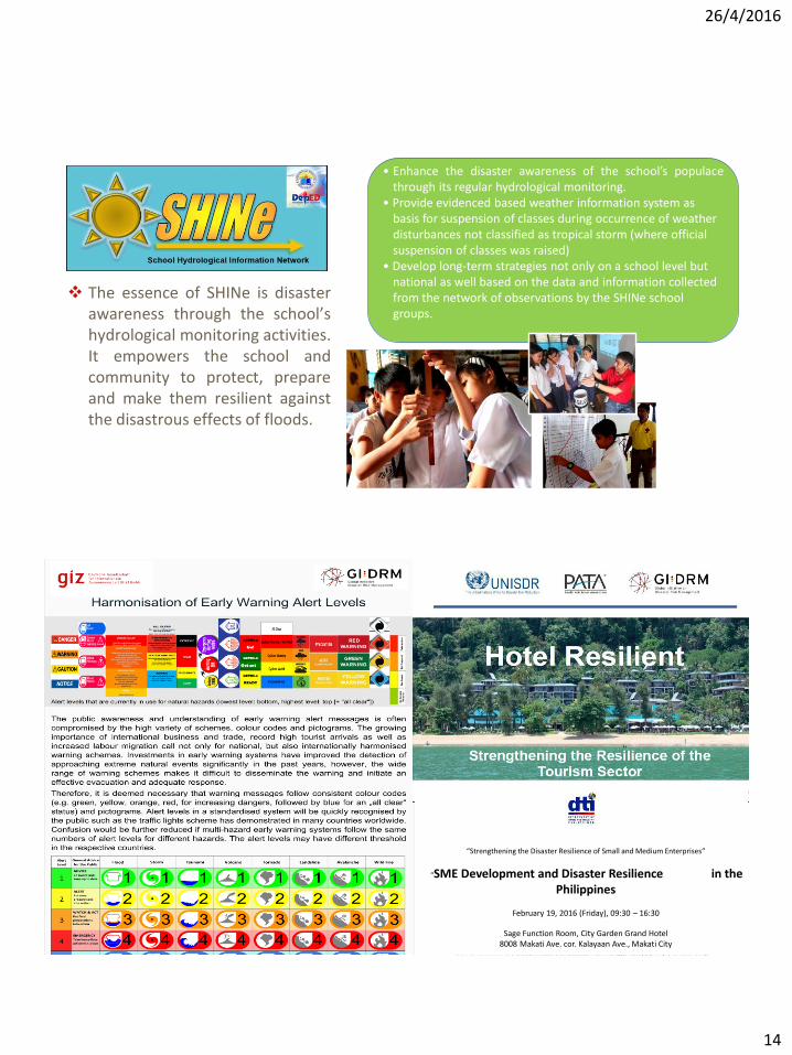
• Enhance the disaster awareness of the school’s populacethrough its regular hydrological monitoring.
• Provide evidenced based weather information system as basis for suspension of classes during occurrence of weather disturbances not classified as tropical storm (where official suspension of classes was raised)
• Develop long-term strategies not only on a school level but national as well based on the data and information collected from the network of observations by the SHINe school groups.
The essence of SHINe is disasterawareness through the school’shydrological monitoring activities.It empowers the school andcommunity to protect, prepareand make them resilient againstthe disastrous effects of floods.
“Strengthening the Disaster Resilience of Small and Medium Enterprises”
“SME Development and Disaster Resilience in the Philippines
February 19, 2016 (Friday), 09:30 – 16:30
Sage Function Room, City Garden Grand Hotel8008 Makati Ave. cor. Kalayaan Ave., Makati City
26/4/2016
15
Engr. Omar P. JayagVSU Phil-LiDAR 1
Visayas State University
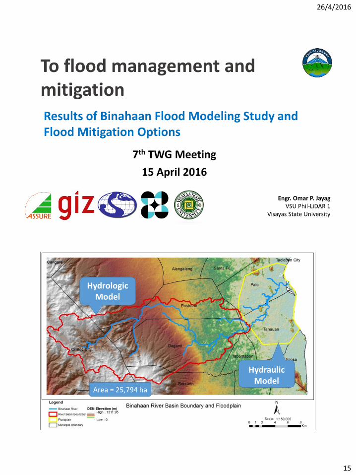
To flood management and mitigation
7th TWG Meeting
15 April 2016
Results of Binahaan Flood Modeling Study and Flood Mitigation Options
Study Site and Boundary Conditions
30
Hydrologic Model
Hydraulic Model
Area = 25,794 ha

26/4/2016
16
31
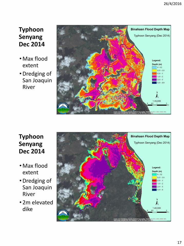
Validated Hydraulic Model
Typhoon SenyangDec 2014
•Max flood extent
32
26/4/2016
17
Typhoon SenyangDec 2014
•Max flood extent
•Dredging of San Joaquin River
33
Typhoon SenyangDec 2014
•Max flood extent
•Dredging of San Joaquin River
•2m elevated dike
34

26/4/2016
18
Page 35
2. Building Back Better – Where?
2.2 From ‘have to’ to ‘want to’
Page 36
Building Resilience
Analysis of
Microinsurance &
NatCat
Findings from MSMEs
insurance needs
assessment
Implementation of a
diagnostic toolkit for
insurance against
NatCat for SMEs
26/04/2016
Regulatory Framework Promotion of Pro-poor Insurance Markets in
Asia (RFPI Asia)

26/4/2016
19
Page 37
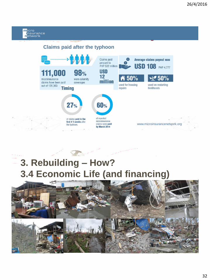
www.microinsurancenetwork.org
Claims paid after the typhoon
Page 38
3. Rebuilding – How?
3.1 Infrastructure
26/4/2016
20
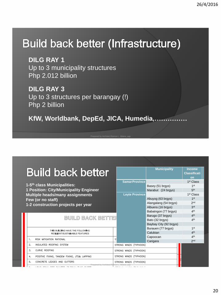
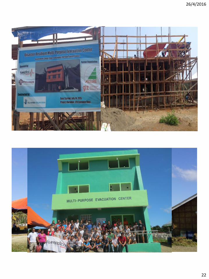
Prepared by Architect Ramon L. Abiera ,uap
DILG RAY 1
Up to 3 municipality structures
Php 2.012 billion
DILG RAY 3
Up to 3 structures per barangay (!)
Php 2 billion
KfW, Worldbank, DepEd, JICA, Humedia,……………
Prepared by Architect Ramon L. Abiera ,uap
1-5th class Municipalities:
1 Position: City/Municipality Engineer
Multiple heads/many assignments
Few (or no staff)
1-2 construction projects per year
Municipality Income
Classificati
on
SamarProvince 1st Class
Basey (51 brgys) 1st
Marabut (24 brgys) 5th
Leyte Province 1st Class
Abuyog (63 brgys) 1st
Alangalang (54 brgys) 2nd
Albuera (16 brgys) 3rd
Babatngon (77 brgys) 4th
Barugo (37 brgys) 4th
Bato (32 brgys) 4th
Baybay City (92 brgys)
Burauen (77 brgys) 1st
Calubian 4th
Capoocan 4th
Carigara 2nd
26/4/2016
21
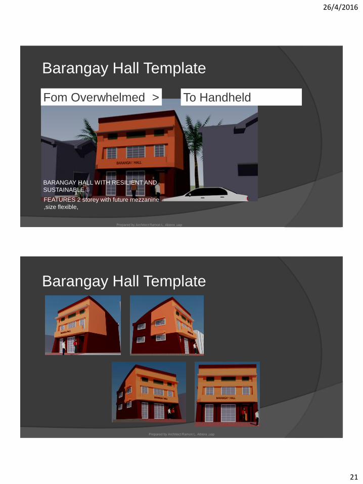
Barangay Hall Template
FEATURES 2 storey with future mezzanine
,size flexible,
BARANGAY HALL WITH RESILIENT AND
SUSTAINABLE
Prepared by Architect Ramon L. Abiera ,uap
Fom Overwhelmed > To Handheld
Barangay Hall Template
Prepared by Architect Ramon L. Abiera ,uap
26/4/2016
22
Page 4326/04/2016
Page 44
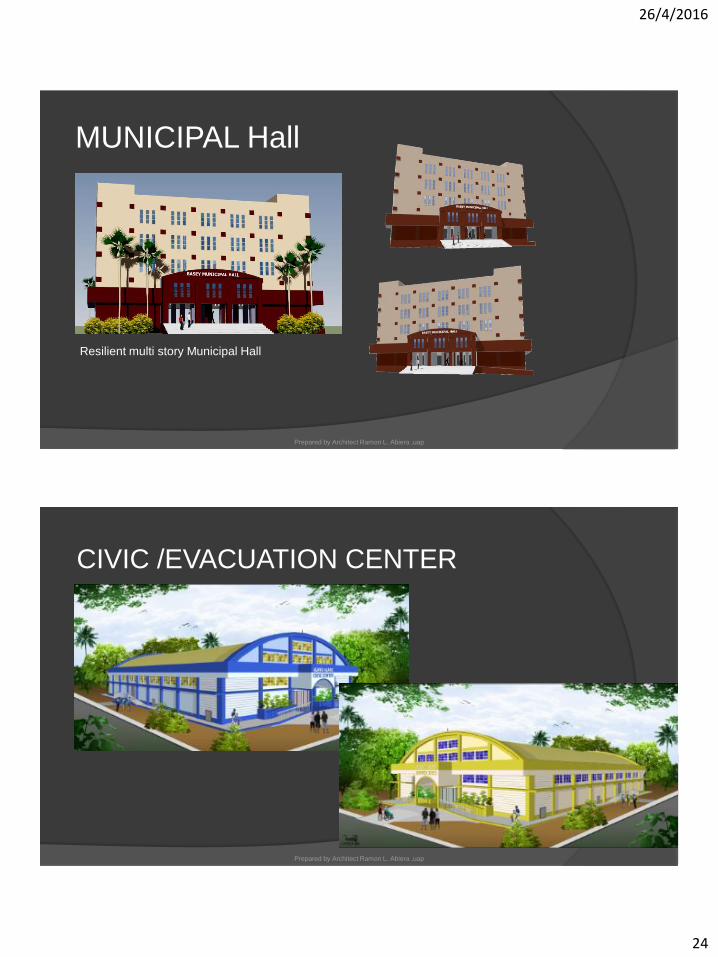
CIVIC /EVACUATION CENTER
Prepared by Architect Ramon L. Abiera ,uap

26/4/2016
23
Page 45
CIVIC /EVACUATION CENTER
Prepared by Architect Ramon L. Abiera ,uap
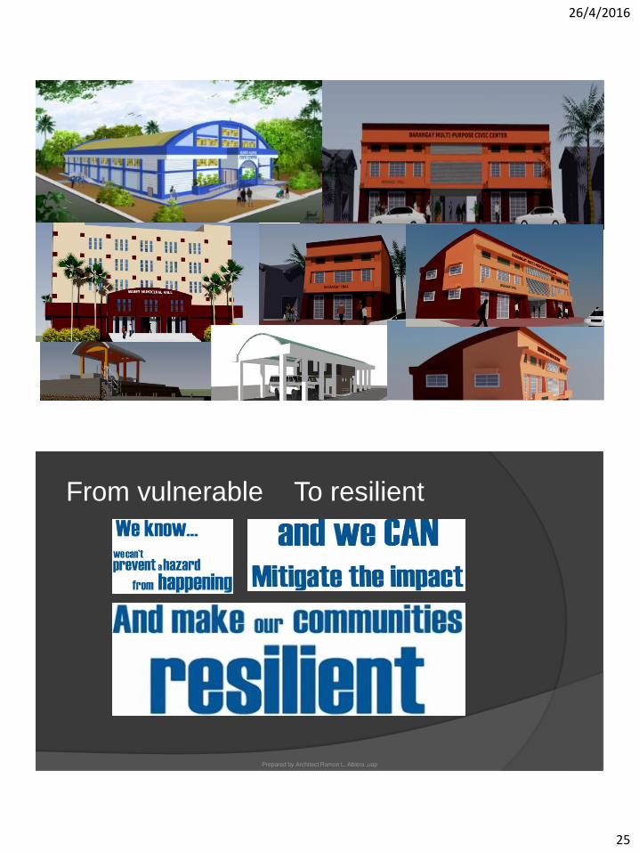
Barangay Multi purpose civic
center TemplateBARANGAY MULTI PURPOSE CIVIC
CENTER(features-character same with
barangay hall,2 storey with future
mezzanine ,size flexible,WITH RESILIENT
AND SUSTAINABLE FEATURES
Prepared by Architect Ramon L. Abiera ,uap
26/4/2016
24
MUNICIPAL Hall
Prepared by Architect Ramon L. Abiera ,uap
Resilient multi story Municipal Hall
CIVIC /EVACUATION CENTER
Prepared by Architect Ramon L. Abiera ,uap
26/4/2016
25
Page 49Prepared by Architect Ramon L. Abiera ,uap
From vulnerable
Prepared by Architect Ramon L. Abiera ,uap
To resilient
26/4/2016
26
Page 51
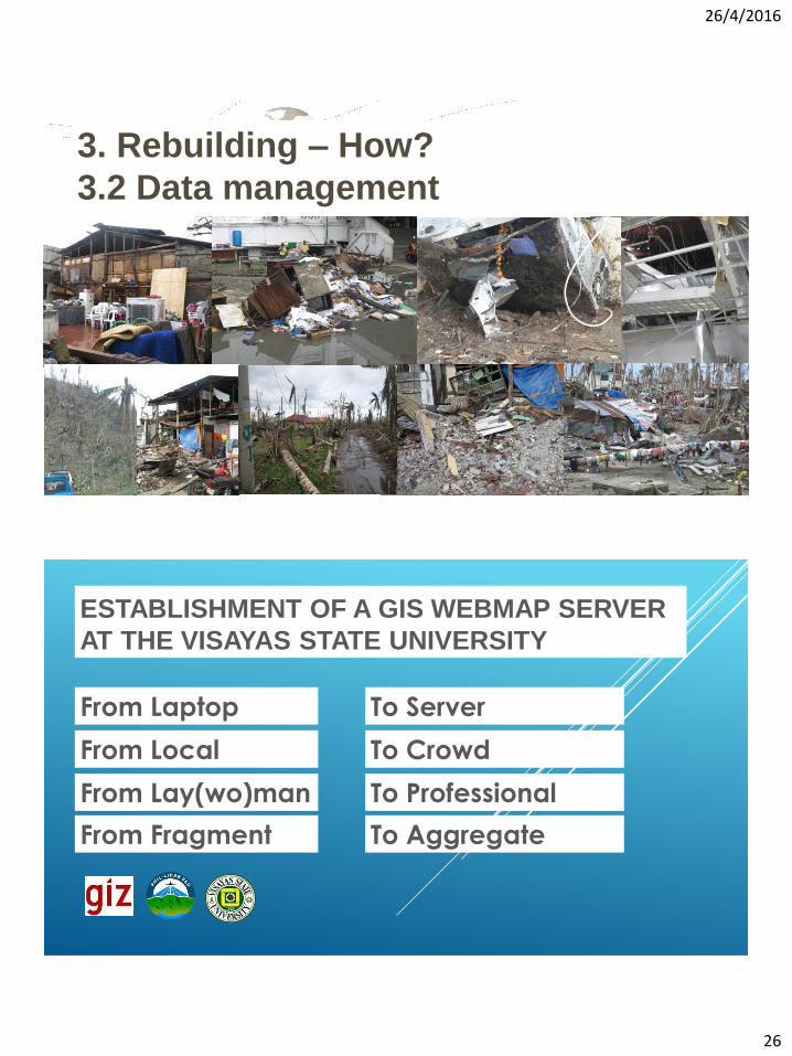
3. Rebuilding – How?
3.2 Data management
ESTABLISHMENT OF A GIS WEBMAP SERVER
AT THE VISAYAS STATE UNIVERSITY
From Laptop To Server
From Local To Crowd
From Lay(wo)man To Professional
From Fragment To Aggregate
26/4/2016
27
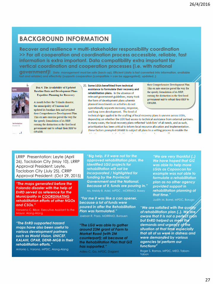
BACKGROUND INFORMATION
Recover and resilience = multi-stakeholder responsibility coordination
>> For all cooperation and coordination process accessible, reliable, fast
information is extra important. Data compatibility extra important for
vertical coordination and cooperation processes (i.e. with national
government)! Data management must be safe (back-up), Efficient (data is fast converted into information, available
fast and reliable) and effectivity (supports cooperation (compatible = can be aggregated), updated..)
LRRP Presentation: Leyte (April
26), Tacloban City (May 10), LRRP
Approval President: Leyte,
Tacloban City (July 25), CRRP
Approval President: (Oct 29, 2015)
“The maps generated before the
Yolanda disaster with the help of
EnRD served as reference for the
Municipality in COORDINATING
rehabilitation efforts of other NGOs
and CSOs.”
Verwena C. Bibar, Executive Assistant to the
Mayor, Alang-Alang
“The EnRD supported hazard
maps have also been useful to
various development partners
such as World Vision, UNICEF,
KALAHI, OPAR, DENR-MGB in their
rehabilitation efforts.”
Antonio L. Varona, MPDC, Alang-Alang
“Big help, if it were not for the
approved rehabilitation plan, the
identified LGU projects for
rehabilitation will not be
incorporated / highlighted for
funding by the Provincial
Government and the National.
Because of it, funds are pouring in.”
Ms. Meldy B. Adel, MPDC , MDRRMO, Basey
“For me it was like a can opener,
because a lot of funds were
poured in after the Rehabilitation
Plan was formulated.”
Joeban R. Paza, MDRRMO, Burauen
“The LGU was able to gather
around 23M grant of Farm to
Market Road (with 2M
counterpart); all because of
the Rehabilitation Plan that GIZ
has supported.”
Adleo C. Go, MPDC, Dagami
“We are very thankful (..)
We have hoped that GIZ
was able to help more
LGUs as Capoocan for
example was not able to
formulate a rehabilitation
plan as no other agency
provided support in
rehabilitation planning at
that time.”
Judith M. Borrel, MPDC, Barugo
“We are satisfied with the quality
of rehabilitation plan (..). We are
aware that it is not a perfect plan
but EnRD helped us meet the
demands and urgency of the
situation at that time especially
that all of us were in distress and
were demanded by various
agencies to perform our
functions”
Roger S. Ramos, MPDC, MEO, Tabon-
Tabon
26/4/2016
28
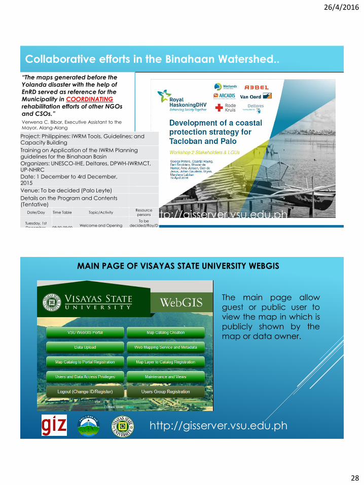
http://gisserver.vsu.edu.ph
“The maps generated before the
Yolanda disaster with the help of
EnRD served as reference for the
Municipality in COORDINATING
rehabilitation efforts of other NGOs
and CSOs.”
Verwena C. Bibar, Executive Assistant to the
Mayor, Alang-Alang
Project: Philippines: IWRM Tools, Guidelines; and Capacity Building
Training on Application of the IWRM Planning guidelines for the Binahaan Basin
Organizers: UNESCO-IHE, Deltares, DPWH-IWRMCT, UP-NHRC
Date: 1 December to 4rd December, 2015
Venue: To be decided (Palo Leyte)
Details on the Program and Contents (Tentative)
Date/Day Time Table Topic/ActivityResource persons
Tuesday, 1st December,
2015)08:30-09:00
Welcome and Opening
Remarks
To be decided/Roy/D
olores, please fill in the names
Collaborative efforts in the Binahaan Watershed..
MAIN PAGE OF VISAYAS STATE UNIVERSITY WEBGIS
The main page allow
guest or public user to
view the map in which is
publicly shown by the
map or data owner.
http://gisserver.vsu.edu.ph

26/4/2016
29
- High resolution maps
- Map analysis / data analysis
- LIDAR remote sensing data- LIDAR maps and data watersheds
- Hazard maps
- Cadastral maps
- Existing and proposed infra facilities
- Academic researches,
-Journals on LAM (local, international)
-Flood, Storm surge, Tsunami modelling
-Accessibility / availability to appstore /
android
WORKSHOP OUTPUT (FEBRUARY 28-29, 2015)
-Online-courses
-“Forum” section
-Good practices
-Maps should be HLURB compliant
-Muncipal profile of every LGU-Weather data localized, ???
-Climate data (past & projection)
-Accurate weather update
(intelligible to all)-Flood, Storm
surge, Tsunami modelling
-Accessibility / availability to
appstore / android
WHAT DATA/INFORMATION DO YOU WANT TO GET FROM THE WEB SERVER?
2. IF THE LGUs ARE TO SHARE DATA & INFORMATION, WHAT ARE
THESE DATA?
WORKSHOP OUTPUT (FEBRUARY 28-29, 2015)
-Spatial framework
-Strategy & investment thrusts
-Potential (existing & proposed)
-Tourism development
-Business investment sites
-Real estate development
-Development plans
-LGU proposals (project proposals)
-Pool of expert
-Agriculture & fishery data
-CBMS / LGPMS data (socio-economic
data)
-LGU proposals (project proposals)
-Pool of expert
-Agriculture & fishery data
-CBMS / LGPMS data (socioeconomic
data)

26/4/2016
30
WORKSHOP OUTPUT (FEBRUARY 28-29, 2015)
3. WHAT ARE THE PRE-CONDITIONS IN SHARING THESE DATA/INFORMATION?
- Account limit per LGU
- Individualized account
- Equal sharing of income
- Data security
- Copyright file system
- Training webserver management
Page 60
3. Rebuilding – How?
3.3 Insurance Protection
From insuring the past.. To insuring the future..!
What we have accumulated
in the past
What does it take to start
all-over again

26/4/2016
31
Page 61
Building Resilience
Analysis of
Microinsurance &
NatCat
Findings from MSMEs
insurance needs
assessment
Implementation of a
diagnostic toolkit for
insurance against
NatCat for SMEs
26/04/2016
Regulatory Framework Promotion of Pro-poor Insurance Markets in
Asia (RFPI Asia)
Page 62
Microinsurance62%
Traditional Insurance
28%
Insurance Coverage 2014
Microinsurance is growing!
Source: Insurance Commission Philippines
26/4/2016
32
Page 63
www.microinsurancenetwork.org
Claims paid after the typhoon
Page 64
3. Rebuilding – How?
3.4 Economic Life (and financing)
26/4/2016
33
Page 65
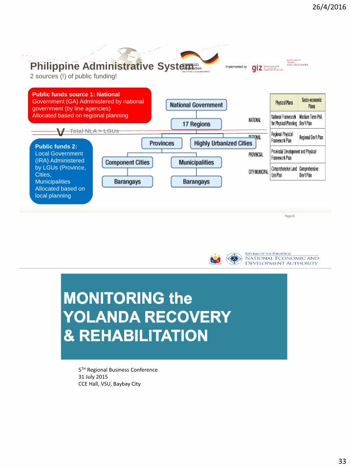
Philippine Administrative System2 sources (!) of public funding!
Public funds source 1: National
Government (GA) Administered by national
government (by line agencies)
Allocated based on regional planning
Public funds 2:
Local Government
(IRA) Administered
by LGUs (Province,
Cities,
Municipalities
Allocated based on
local planning
>
Total NLA > LGUs
5TH Regional Business Conference 31 July 2015CCE Hall, VSU, Baybay City
26/4/2016
34
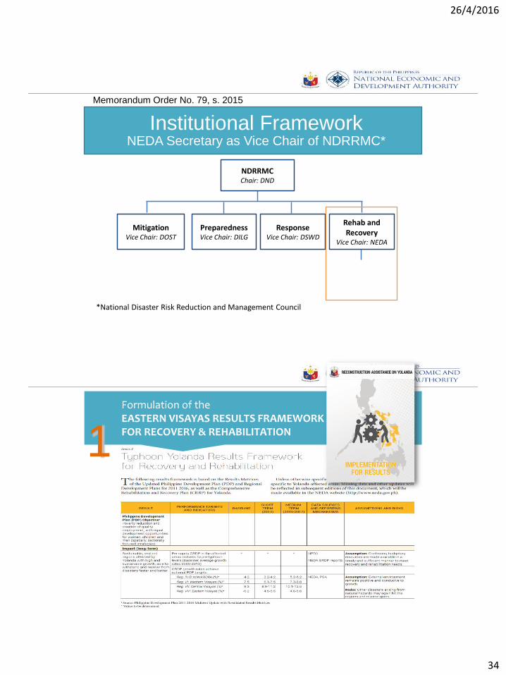
Institutional Framework
NDRRMCChair: DND
MitigationVice Chair: DOST
PreparednessVice Chair: DILG
ResponseVice Chair: DSWD
Rehab and Recovery
Vice Chair: NEDA
NEDA Secretary as Vice Chair of NDRRMC*
*National Disaster Risk Reduction and Management Council
Memorandum Order No. 79, s. 2015
Formulation of the EASTERN VISAYAS RESULTS FRAMEWORK FOR RECOVERY & REHABILITATION
1
26/4/2016
35
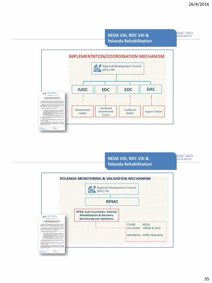
NEDA VIII, RDC VIII & Yolanda Rehabilitation
NEDA VIII, RDC VIII & Yolanda Rehabilitation
26/4/2016
36
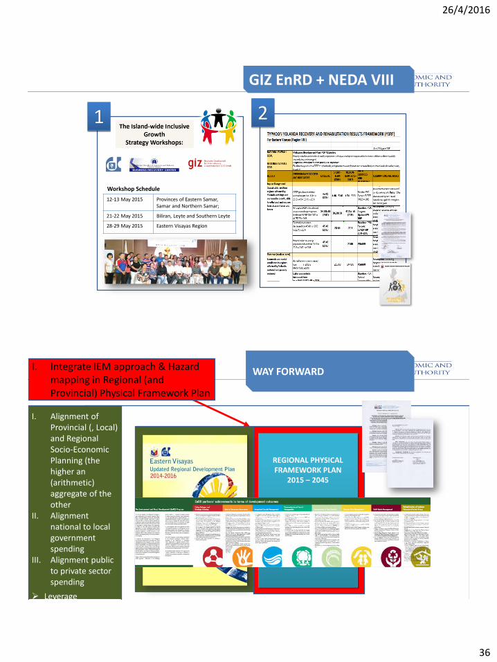
GIZ EnRD + NEDA VIII
1 2
12-13 May 2015 Provinces of Eastern Samar, Samar and Northern Samar;
21-22 May 2015 Biliran, Leyte and Southern Leyte
28-29 May 2015 Eastern Visayas Region
Workshop Schedule
REGIONAL PHYSICAL FRAMEWORK PLAN
2015 – 2045
WAY FORWARDI. Integrate IEM approach & Hazard mapping in Regional (and Provincial) Physical Framework Plan
I. Alignment of Provincial (, Local) and Regional Socio-Economic Planning (the higher an (arithmetic) aggregate of the other
II. Alignment national to local government spending
III. Alignment public to private sector spending
Leverage Economies of scale!

26/4/2016
37
INCLUSIVE GROWTH WORKSHOP TIMELINE
2014 Sept 18
• PCCI-EV Resolution on “INCLUSIVE GROWTH STRATEGY FORMULATION WORKSHOP” approved in mass motion by local chamber presidents
2014 Sept 29
• Submitted PCCI-EV Resolution to newly appointed RDC VIII Chair Gov. Dominic Petilla
2014 Oct 27
• Endorsement by RDC VIII of PCCI-EV Resolution on the conduct of the “INCLUSIVE GROWTH STRATEGY WORKSHOP”
2014 Nov 27 2014 Dec
• RDC VIII SECCOM Special Consultative Meeting
• Consultative Meeting with NEDA DG Sec. Balisacan
• Dec 6 meeting cancelled due to Super typhoon Ruby
• NEDA DG authorized engagement of PIDS
2015 Jan 8 2015 Feb 20
• Consultative Meeting with SUC’s in Region 8, PSA and their role in supporting Inclusive Growth
2015 Feb 17-18
• Consultative Meeting with Northern and Eastern Samar Governors
2015 Mar 12
• Consultative Meeting and briefing of all Members of the House of Representatives from Region 8
2015 Mar 25
• Consultative Meeting with selected MPDO’s, MAO’s, PPDO’s from Region 8
• RDC VIII Consultative Meeting with SECCOM Chairs, PSR’s, RDC Regular Members and PCCI-EV
INCLUSIVE GROWTH WORKSHOP TIMELINE
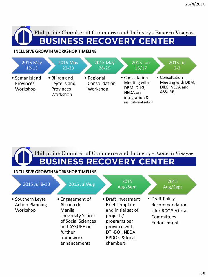
26/4/2016
38
2015 May 12-13
• Samar Island Provinces Workshop
2015 May 22-23
• Biliran and Leyte Island Provinces Workshop
2015 May 28-29
• Regional Consolidation Workshop
2015 Jun 15/17
2015 Jul 2-3
• Consultation Meeting with DBM, DILG, NEDA on integration &institutionalization
• Consultation Meeting with DBM, DILG, NEDA and ASSURE
INCLUSIVE GROWTH WORKSHOP TIMELINE
2015 Jul 8-10
• Southern Leyte Action Planning Workshop
2015 Jul/Aug
• Engagement of Ateneo de Manila University School of Social Sciences and ASSURE on further framework enhancements
2015 Aug/Sept
• Draft Investment Brief Template and initial set of projects/ programs per province with DTI-BOI, NEDA PPDO’s & local chambers
2015 Aug/Sept
INCLUSIVE GROWTH WORKSHOP TIMELINE
• Draft Policy Recommendations for RDC Sectoral Committees Endorsement
26/4/2016
39
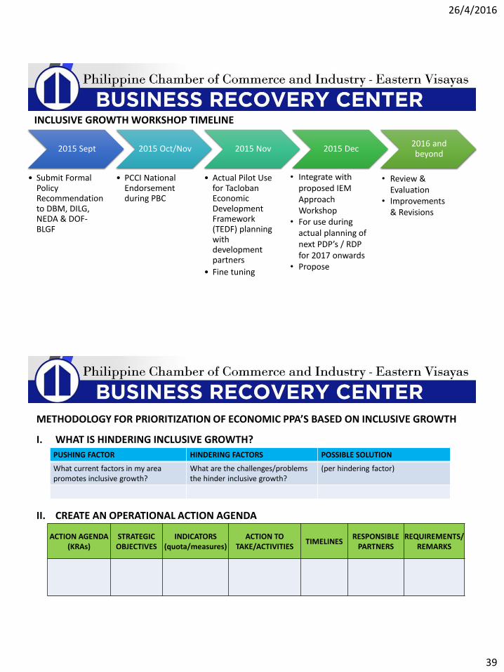
2015 Sept
• Submit Formal Policy Recommendation to DBM, DILG, NEDA & DOF-BLGF
2015 Oct/Nov
• PCCI National Endorsement during PBC
2015 Nov
• Actual Pilot Use for Tacloban Economic Development Framework (TEDF) planning with development partners
• Fine tuning
2015 Dec2016 and beyond
INCLUSIVE GROWTH WORKSHOP TIMELINE
• Integrate with proposed IEM Approach Workshop
• For use during actual planning of next PDP’s / RDP for 2017 onwards
• Propose
• Review & Evaluation
• Improvements & Revisions
I. WHAT IS HINDERING INCLUSIVE GROWTH?
PUSHING FACTOR HINDERING FACTORS POSSIBLE SOLUTION
What current factors in my area promotes inclusive growth?
What are the challenges/problems the hinder inclusive growth?
(per hindering factor)
II. CREATE AN OPERATIONAL ACTION AGENDA
ACTION AGENDA (KRAs)
STRATEGIC OBJECTIVES
INDICATORS (quota/measures)
ACTION TO TAKE/ACTIVITIES
TIMELINESRESPONSIBLE
PARTNERSREQUIREMENTS/
REMARKS
METHODOLOGY FOR PRIORITIZATION OF ECONOMIC PPA’S BASED ON INCLUSIVE GROWTH
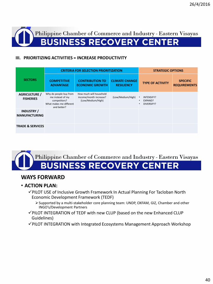
26/4/2016
40
SECTORS
CRITERIA FOR SELECTION PRIORITIZATION STRATEGIC OPTIONS
COMPETITIVE ADVANTAGE
CONTRIBUTION TO ECONOMIC GROWTH
CLIMATE CHANGE RESILIENCY
TYPE OF ACTIVITYSPECIFIC
REQUIREMENTS
AGRICULTURE / FISHERIES
Why do people buy from me instead of my
competitors?What makes me different
and better?
How much will household income/month increase?
(Low/Medium/High)(Low/Medium/High) • INTENSIFY?
• EXPAND?• DIVERSIFY?
INDUSTRY / MANUFACTURING
TRADE & SERVICES
III. PRIORITIZING ACTIVITIES = INCREASE PRODUCTIVITY
WAYS FORWARD
• ACTION PLAN:PILOT USE of Inclusive Growth Framework In Actual Planning For Tacloban North
Economic Development Framework (TEDF) Supported by a multi-stakeholder core planning team: UNDP, OXFAM, GIZ, Chamber and other
INGO’s/Development Partners
PILOT INTEGRATION of TEDF with new CLUP (based on the new Enhanced CLUP Guidelines)
PILOT INTEGRATION with Integrated Ecosystems Management Approach Workshop

26/4/2016
41
Page 81
ILLUSTRATING, MODERATING, INTEGRATING the
INTERPLAY IN A SPATIAL DIMENSION
Page 82
Thank you