Embed Size (px)
Citation preview
Red Sea – Dead Sea Water Conveyance Study Program: Feasibility Study
1 Inception Report
Progress Report No. 2 PRD/20 July 2008
RED SEA-DEAD SEA WATER CONVEYANCE STUDY PROGRAM
FEASIBILITY STUDY
INCEPTION REPORT
INCLUDING PROGRESS REPORT NO. 2
20 July 2008
(Amended on 19th October 2008 to take account of World Bank and SMU comments)
Red Sea – Dead Sea Water Conveyance Study Program: Feasibility Study
2 Inception Report
Progress Report No. 2 PRD/20 July 2008
TABLE OF CONTENTS
Table of Contents Abbreviations
1.0 INTRODUCTION .....................................................................................................6 2.0 PROGRESS REPORT No.2....................................................................................7 2.1 Activities during Report Period ................................................................... 7 2.2 Work Plan for Next Period............................................................................ 8 2.3 Updated Schedule of Deliverables .............................................................. 8 2.4 Key Events .................................................................................................... 8 2.5 Summary of Issues..................................................................................... 10 2.6 Issues for TSC............................................................................................. 10 2.7 Payments..................................................................................................... 11
3.0 DATA COLLECTION.............................................................................................12 3.1 Jordan.......................................................................................................... 12 3.2 Palestine Authority ..................................................................................... 12 3.3 Israel ............................................................................................................ 13 4.0 SUB-STUDY A: GULF OF AQABA/EILAT ...........................................................14 4.1 Intake ............................................................................................................ 14 4.1.1 Intake Sites......................................................................................... 14 4.1.2 North Beach Site................................................................................ 14 4.1.3 East Coast Site................................................................................... 15 4.1.4 Sources of Pollution.......................................................................... 15 4.1.5 Power Supply ..................................................................................... 16 4.1.6 Desalination Alternative .................................................................... 16
4.2 Oceanography.............................................................................................. 16 4.2.1 Issues.................................................................................................. 16 4.2.2 Present State of Knowledge ............................................................. 17 4.2.3 Questions to Resolve ........................................................................ 17
4.3 Work to be Undertaken by SIs .................................................................... 17 4.3.1 Activity Schedule for Sls................................................................... 17 4.3.2 Work Scope for SIs............................................................................. 18
Red Sea – Dead Sea Water Conveyance Study Program: Feasibility Study
3 Inception Report
Progress Report No. 2 PRD/20 July 2008
5.0 SUB-STUDY B: WATER CONVEYANCE .............................................................20 5.1 Conveyance System.................................................................................... 20 5.1.1 Geology and Seismology .................................................................. 20 5.1.2 Flash Floods....................................................................................... 20 5.1.3 Power Supply ..................................................................................... 20 5.1.4 Options Evaluation ............................................................................ 20
5.2 Work to be Undertaken by SIs .................................................................... 21 6.0 SUB-STUDY C: DEAD SEA..................................................................................21 6.1 Hydrology and Hydrogeology..................................................................... 21 6.2 Sinkholes...................................................................................................... 22 6.3 Water Balance .............................................................................................. 22 6.4 Dead Sea Outfall .......................................................................................... 24 6.5 Modelling of Dead Sea ................................................................................ 25 6.6 Work to be Undertaken by SIs .................................................................... 26 7.0 SUB STUDY D: HYDROPOWER FACILITIES AND DESALINATION PLANT.... 27 7.1 Water Conveyance to Amman .................................................................... 27
8.0 ECONOMIC AND FINANCIAL STUDY................................................................. 28 8.1 Approach to Economic and Financial Study............................................. 28 8.2 Water Demands............................................................................................ 28 8.2.1 Jordan................................................................................................. 28 8.2.2 Israel ................................................................................................... 29 8.2.3 Palestinian Authority.......................................................................... 29 Annex 1 DATA COLLECTION CAMPAIGN IN PHASE 1 - JORDAN........................ 30
Annex 2 RETURN FLOWS........................................................................................ 39
Red Sea – Dead Sea Water Conveyance Study Program: Feasibility Study
4 Inception Report
Progress Report No. 2 PRD/20 July 2008
List of Tables
Table 1 Payments Schedule................................................................................... 11 Table 2 Assumptions for Water Balance Model “Without Project” Case........... 24
List of Figures
Figure 1 Schedule of Deliverables ............................................................................ 9 Figure 2 Activity Schedule for Work of Sls ............................................................ 19 Figure 3 Decline in Dead Sea Level in “Without Project” Case............................ 23 Figure 4 Development of Dead Sea Model ............................................................. 25
Red Sea – Dead Sea Water Conveyance Study Program: Feasibility Study
5 Inception Report
Progress Report No. 2 PRD/20 July 2008
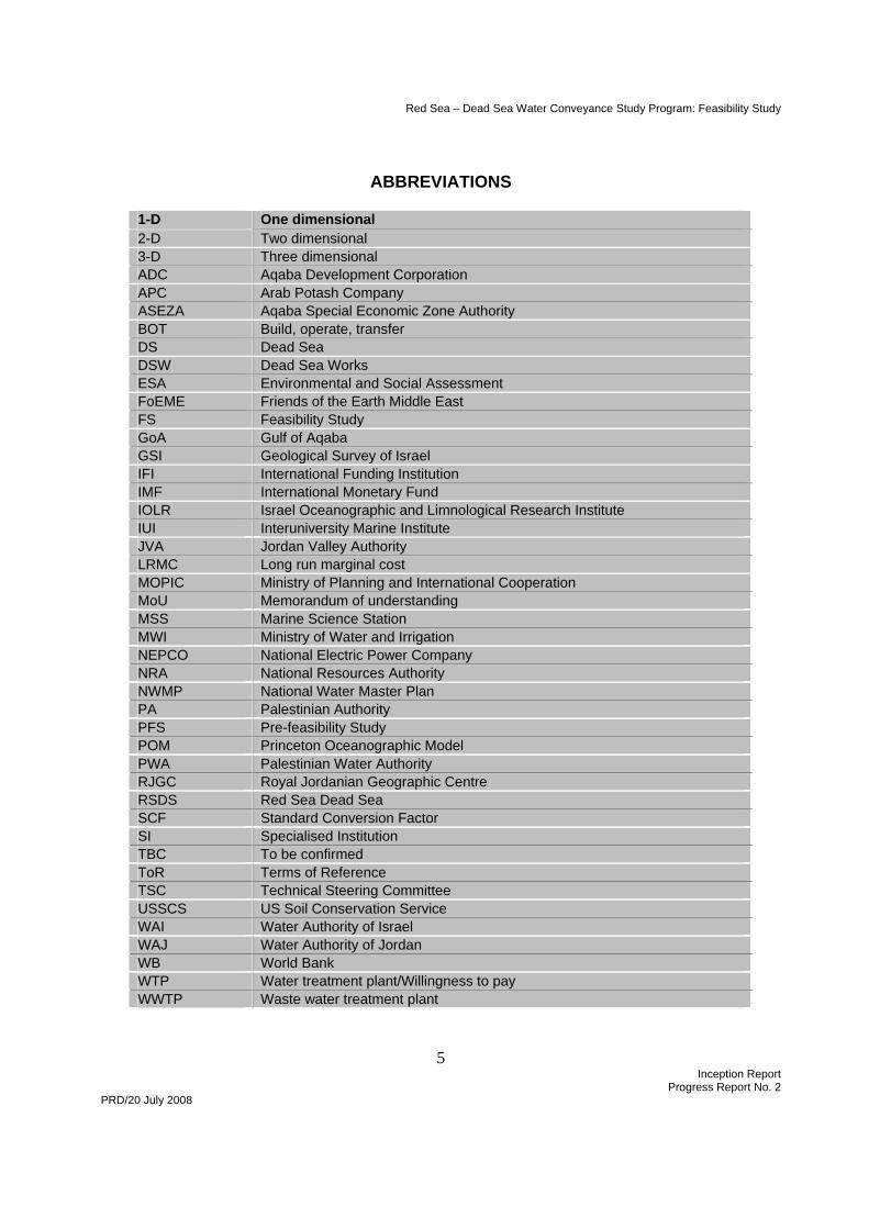
ABBREVIATIONS
1-D One dimensional 2-D Two dimensional 3-D Three dimensional ADC Aqaba Development Corporation APC Arab Potash Company ASEZA Aqaba Special Economic Zone Authority BOT Build, operate, transfer DS Dead Sea DSW Dead Sea Works ESA Environmental and Social Assessment FoEME Friends of the Earth Middle East FS Feasibility Study GoA Gulf of Aqaba GSI Geological Survey of Israel IFI International Funding Institution IMF International Monetary Fund IOLR Israel Oceanographic and Limnological Research Institute IUI Interuniversity Marine Institute JVA Jordan Valley Authority LRMC Long run marginal cost MOPIC Ministry of Planning and International Cooperation MoU Memorandum of understanding MSS Marine Science Station MWI Ministry of Water and Irrigation NEPCO National Electric Power Company NRA National Resources Authority NWMP National Water Master Plan PA Palestinian Authority PFS Pre-feasibility Study POM Princeton Oceanographic Model PWA Palestinian Water Authority RJGC Royal Jordanian Geographic Centre RSDS Red Sea Dead Sea SCF Standard Conversion Factor SI Specialised Institution TBC To be confirmed ToR Terms of Reference TSC Technical Steering Committee USSCS US Soil Conservation Service WAI Water Authority of Israel WAJ Water Authority of Jordan WB World Bank WTP Water treatment plant/Willingness to pay WWTP Waste water treatment plant
Red Sea – Dead Sea Water Conveyance Study Program: Feasibility Study
6 Inception Report
Progress Report No. 2 PRD/20 July 2008
1.0 INTRODUCTION
1.1 This report incorporates two deliverables: the Inception Report and Progress Report No. 2.
1.2 The Inception Report describes some of the work carried out under the Study Program from mobilization to date. It focuses attention on two main areas:
• Unresolved issues and issues where there is significant disagreement among experts that will affect the course of the Study Program
• Work that sets the direction or approach for further studies.
1.3 The Progress Report in Section 2.0 covers the period from 27 June to 20 July 2008, a period of just over three weeks. It presents a summary list of the issues raised by the studies carried out to date. These are further described in the Inception Report which follows in Sections 3.0 to 8.0.
2.0 PROGRESS REPORT No. 2
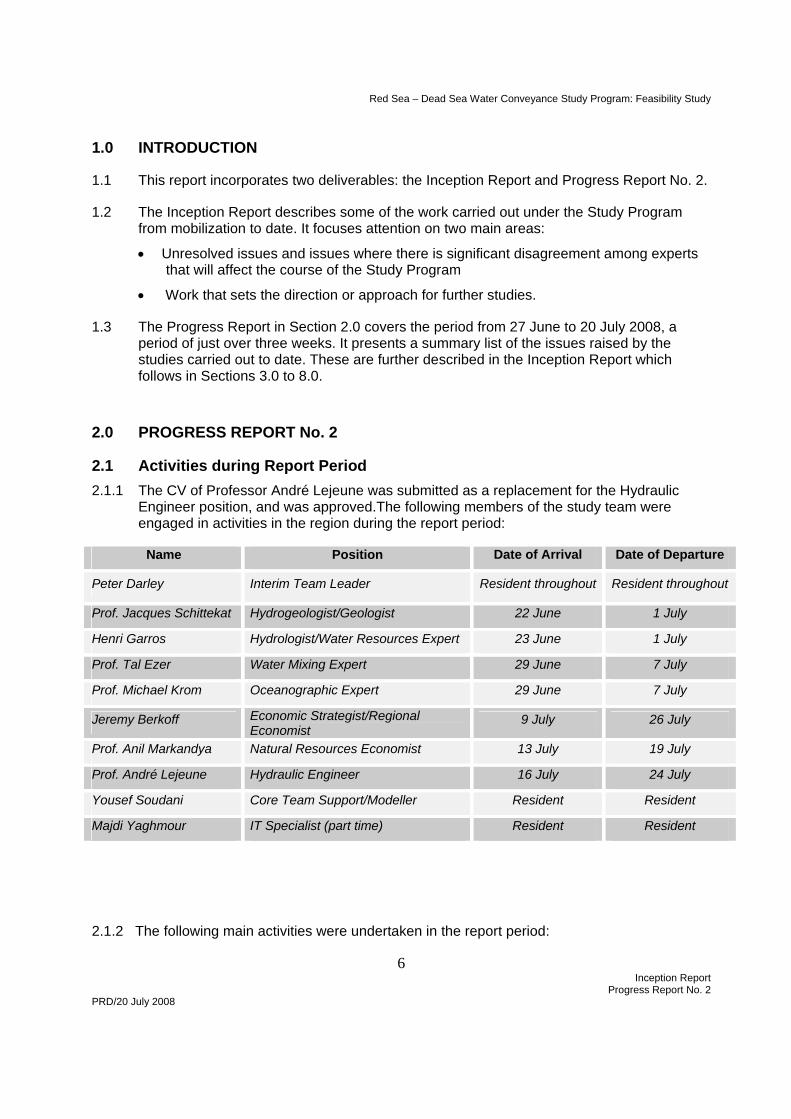
2.1 Activities during Report Period 2.1.1 The CV of Professor André Lejeune was submitted as a replacement for the Hydraulic
Engineer position, and was approved.The following members of the study team were engaged in activities in the region during the report period:
Name Position Date of Arrival Date of Departure
Peter Darley Interim Team Leader Resident throughout Resident throughout
Prof. Jacques Schittekat Hydrogeologist/Geologist 22 June 1 July
Henri Garros Hydrologist/Water Resources Expert 23 June 1 July
Prof. Tal Ezer Water Mixing Expert 29 June 7 July
Prof. Michael Krom Oceanographic Expert 29 June 7 July
Jeremy Berkoff Economic Strategist/Regional Economist
9 July 26 July
Prof. Anil Markandya Natural Resources Economist 13 July 19 July
Prof. André Lejeune Hydraulic Engineer 16 July 24 July
Yousef Soudani Core Team Support/Modeller Resident Resident
Majdi Yaghmour IT Specialist (part time) Resident Resident
2.1.2 The following main activities were undertaken in the report period:
Red Sea – Dead Sea Water Conveyance Study Program: Feasibility Study
7 Inception Report
Progress Report No. 2 PRD/20 July 2008
• Continued data collection campaign in Jordan, Israel and Palestinian Authority
(Section 2)
• Met with SIs concerned with Sub-Studies A and C, the Red Sea and the Dead Sea, with a view to understanding the task breakdown, time lines and relative importance of studies and research activities proposed by the SIs (Section 4.3 and 6.6)
• Reviewed inflow and outflow components of water balance for Dead Sea, determined where uncertainties lay, and started process of reducing uncertainties (Section 6.1)
• Developed water balance for “without Project” scenario and compared different approaches (Section 6.2)Reviewed approach to determining water demands and irrigation return flows (Sections 8.2 and Annex 2)
• Developed approach to the economic and financial study
2.2 Work Plan for Next Period 2.2.1 The next reporting period extends from 21 July to 28 August 2008.
2.2.2 The key deliverables during the period are:
• Draft Public Consultation and Communications Program on 23 July
• Progress Report No. 3 on 28 August
2.2.3 The only member of the Consultant’s team to arrive during the period will be the Team Leader on 16 August. During the following two weeks the Interim Team Leader will hand over to the Team Leader.
2.2.4 The next period coincides with the major holiday period in Europe. It will be used for the following main tasks:
• Public meetings in Jordan, Palestinian Authority and Israel (see Section 2.4)
• Meeting of the Technical Steering Committee
• Development of water balance for “with Project” situation
• Start to consider alternative intake sites, conveyance alignments, outfall sites and project configurations
• Meet Specialised Institutions to discuss work programs for Phases 1 and 2.
• Handover from Interim Team Leader to Team Leader
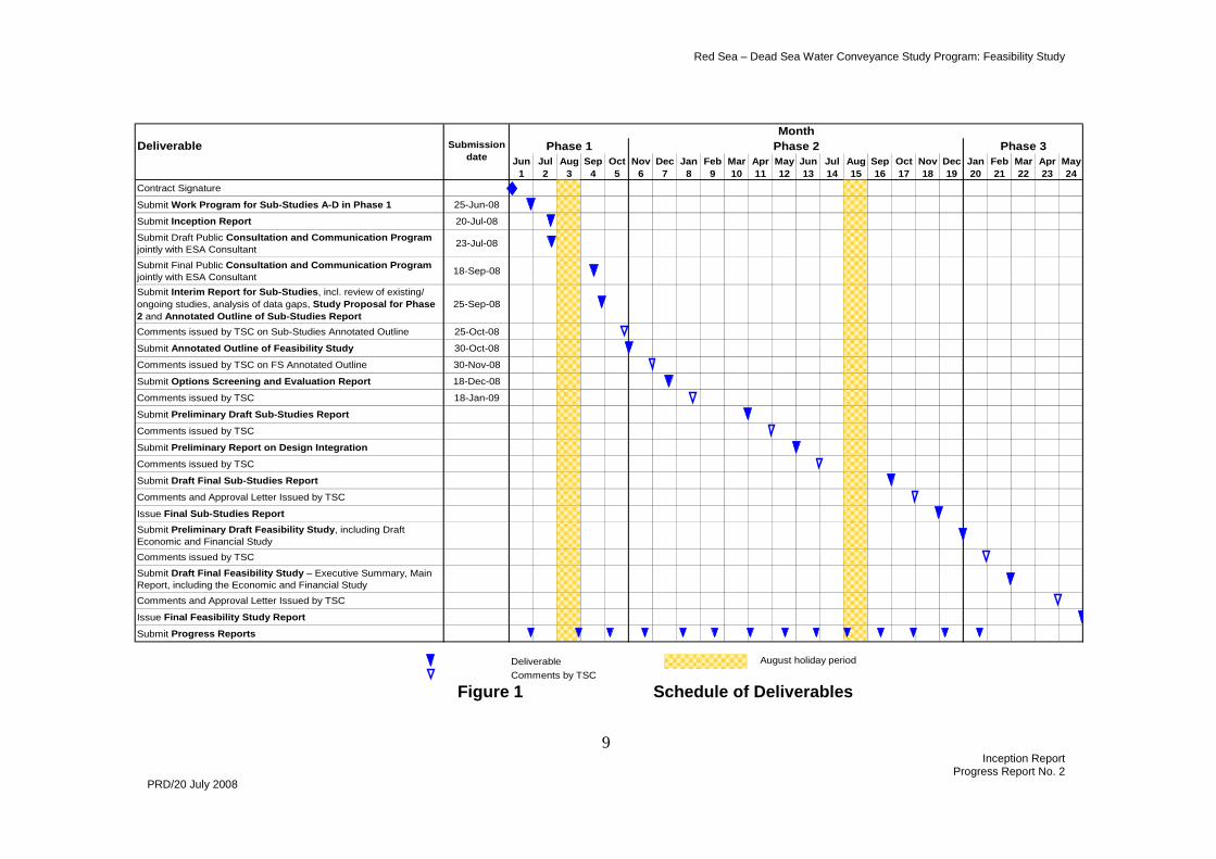
2.3 Updated Schedule of Deliverables 2.3.1 The updated schedule of deliverables is given in Figure 1.
2.4 Key Events 2.4.1 The key events over the next reporting period are:

Red Sea – Dead Sea Water Conveyance Study Program: Feasibility Study
8 Inception Report
Progress Report No. 2 PRD/20 July 2008
i. Public meeting in Jordan, at 09.00 on Sunday 27 July, held at Ministry of Water and Irrigation, Amman
ii. Public meeting in Palestinian Authority, at 09.00 on Tuesday 29 July, held at Best Eastern Hotel, Ramallah
iii. Public meeting in Israel, at 09.00 on Wednesday 30 July, held at Beit Heil Haavir (Air Force House), Hertzelia
iv. Technical Steering Committee Meeting, at 10.00 on Thursday 31 July, held at Intercontinental Hotel, Jericho
Red Sea – Dead Sea Water Conveyance Study Program: Feasibility Study
9 Inception Report
Progress Report No. 2 PRD/20 July 2008
Figure 1 Schedule of Deliverables
DeliverableJun Jul Aug Sep Oct Nov Dec Jan Feb Mar Apr May Jun Jul Aug Sep Oct Nov Dec Jan Feb Mar Apr May
1 2 3 4 5 6 7 8 9 10 11 12 13 14 15 16 17 18 19 20 21 22 23 24Contract Signature
Submit Work Program for Sub-Studies A-D in Phase 1 25-Jun-08
Submit Inception Report 20-Jul-08
Submit Draft Public Consultation and Communication Program jointly with ESA Consultant 23-Jul-08
Submit Final Public Consultation and Communication Program jointly with ESA Consultant 18-Sep-08
Submit Interim Report for Sub-Studies, incl. review of existing/ ongoing studies, analysis of data gaps, Study Proposal for Phase 2 and Annotated Outline of Sub-Studies Report
25-Sep-08
Comments issued by TSC on Sub-Studies Annotated Outline 25-Oct-08
Submit Annotated Outline of Feasibility Study 30-Oct-08
Comments issued by TSC on FS Annotated Outline 30-Nov-08
Submit Options Screening and Evaluation Report 18-Dec-08
Comments issued by TSC 18-Jan-09
Submit Preliminary Draft Sub-Studies Report
Comments issued by TSC
Submit Preliminary Report on Design Integration
Comments issued by TSC
Submit Draft Final Sub-Studies Report
Comments and Approval Letter Issued by TSC
Issue Final Sub-Studies ReportSubmit Preliminary Draft Feasibility Study, including Draft Economic and Financial StudyComments issued by TSC
Submit Draft Final Feasibility Study – Executive Summary, Main Report, including the Economic and Financial StudyComments and Approval Letter Issued by TSC
Issue Final Feasibility Study Report
Submit Progress Reports
DeliverableComments by TSC
August holiday period
MonthPhase 3Phase 2Phase 1Submission
date
Red Sea – Dead Sea Water Conveyance Study Program: Feasibility Study
10 Inception Report
Progress Report No. 2 PRD/20 July 2008
2.5 Summary of Issues
2.5.1 The Inception Report highlights a number of issues, principal among which are:
i. The large differences among experts over the evaporation rate of the Dead Sea hypersaline water body (Section 6.1)
ii. The subsurface groundwater regime, the formation of sinkholes, and the mass balance of the Dead Sea (Section 6.1 and Annex 2)
iii. The economic feasibility of potable water transmission from the RSDSP to Israel and the PA (Section 8.2)
iv. The municipal and industrial demands in Jordan that would be met by the proposed project (Section 8.2)
v. The importance of return flows not only for future agriculture in the Jordan Valley but also for inflows to the Dead Sea (Annex 3)
vi. The approach to the economic analysis and the selection of discount rates (Annex 4)
vii. The need to monitor pollution sources in the Gulf of Aqaba (Section 4.1)
viii. The constraints on corridor width and other master planning issues related to the North Beach intake on the Gulf of Aqaba/Eilat (Section 4.1)
ix. The impacts of the proposed 400 kV twin circuit transmission lines from Aqaba to Amman in the Wadi Araba / The Arava
2.6 Issues for TSC
2.6.1 Issues that we have identified for adding to the agenda for the Technical Steering Committee Meeting on 31 July 2008 in the Palestinian Authority include:
i. Water transmission to Palestinian Authority How will Palestinian Authority areas and Israel areas be served? Will this be one or more common pipelines? Separate pipelines? How will the amounts carried to each area be determined? What happens in crossing different security/control zones? There is an obvious advantage in a single consultant undertaking the design work. This would most naturally be an Israeli consultant, as the alternative transmission line from the Mediterranean coast will run through Israel. Is this OK? He could work with the assistance of our associate in Ramallah.
ii. Target Level and Target Year
We shall be starting to look at the relationship between the capacity of the conveyance system and the Target Level and Target Year. The higher the Target Level and the sooner this level is reached the larger the conveyance system required, and the more costly the Project. We would like to be advised if there are any constraints that the TSC would place on this analysis.
Red Sea – Dead Sea Water Conveyance Study Program: Feasibility Study
11 Inception Report
Progress Report No. 2 PRD/20 July 2008
iii. Desalinated water for municipal and industrial use
The ToR require us to prepare “….a layout and preliminary design for a brine disposal mechanism for approximately 800 MCM/year plant” (Section 7.3.2). We believe that this size of plant may be unjustifiable in terms of demand to 2050, and would seek approval to vary the size of plant in line with supply and demand, and the water master plans for the three beneficiary parties.
2.6.2 Questions for the TSC
i. Is it acceptable to provide for a single pipeline from the desalination plant to deliver water to the main demand centres in both Israel and the Palestine Authority or are two separate pipelines required.
ii. Are there any special requirements or restrictions where water transmission pipelines will cross boundaries between different security / control zones.
iii. Given that the higher the target level and the earlier the target year the more costly the project becomes are there any constraints on the Dead Sea target levels and target years to be examined in the Feasibility Study.
iv. Is the ultimate capacity of the desalination plant fixed as 800 Mm3/year or should this be determined based on water demand projections through to a design horizon date (say 2050).
2.7 Payments
2.7.1 The current payments position and the expected dates for submission of invoices are given in Table 1.
Table 1 Payments Schedule
Payment due on Percent of Contract
Price
Cumulative percent of Contract
Price
Date invoice submitted (actual or planned)
Date payment received
Effectiveness date 10% 10% 17 June 2008
Submission of i. Inception Report ii. Work Program for Sub-
Studies iii. Consultation and
Communications Program
10% 20% 25 September 2008
Submission of Options Screening and Evaluation Report
10% 30% 18 December 2008
Red Sea – Dead Sea Water Conveyance Study Program: Feasibility Study
12 Inception Report
Progress Report No. 2 PRD/20 July 2008
Submission of Preliminary Draft Sub-Studies Report
10% 40% 31 March 2009
Submission of Preliminary Report on Design Integration
10% 50% 31 May 2009
Submission of Draft Final Sub-Studies Report
5% 55% 30 September 2009
Approval of Final Sub-Studies Report
Approval of Preliminary Draft Feasibility Study Report
5% 60% 31 January 2010
Approval of Draft Final Feasibility Study Report
25% 85% 30 April 2010
Approval of Final Feasibility Study Report
15% 100% 31 July 2010
3.0 DATA COLLECTION
3.1 Jordan 3.1.1 Letters of authorization requesting government departments, and others such as Arab
Potash Company, to release information to the Consultant were issued by JVA on our request. These have facilitated collection of data.
3.1.2 To date meetings have been held with, and information provided by, the following:
• Aqaba Special Economic Zone Authority (ASEZA) • Aqaba Development Corporation (ADC) • Ayla Oasis Development Company • Arab Potash Company (APC) • Friends of the Earth Middle East (FoEME) • Ministry of Planning, Department of Statistics • Ministry of Planning and International Cooperation, Projects Department • Ministry of Tourism • Ministry of Water and Irrigation, National Water Management Plan • Ministry of Water and Irrigation, Project Management Unit • Ministry of Water and Irrigation, Jordan Valley Authority • National Electric Power Company (NEPCO) • Natural Resources Authority (NRA)
3.1.3 Further meetings have been arranged with:
• Arab Potash Company: site visit on 21 July • joint meeting of APC with Dead Sea Works in Project Office, Amman (date TBC)
Red Sea – Dead Sea Water Conveyance Study Program: Feasibility Study
13 Inception Report
Progress Report No. 2 PRD/20 July 2008
• NRA (26 July)
3.1.4 An example of the list of information that is required is given in Annex 1 for Jordan. This also shows the current status of data collection. Similar information schedules have been prepared for the Palestinian Authority and Israel.
3.1.5 A fortnightly meeting with JVA is held to facilitate and expedite the task of data collection.
3.2 Palestinian Authority 3.2.1 Letters of authorisation were requested from the Palestinian Water Authority (PWA), but
we were advised that these should be issued by the Ministry of Planning. The Ministry of Planning issued letters requesting government departments to release information to the Consultant in early July. We are currently following up on these letters with the departments concerned.
3.3 Israel
3.3.1 We have sent a general request for information, a schedule of data we are seeking and a list of departments from which we would like information to the WAI. This request was passed to the Israeli member of the SMU who has advised us that he is collecting such information as is in the public domain.
4.0 SUB-STUDY A: GULF OF AQABA/EILAT
4.1 Intake
4.1.1 Intake Sites
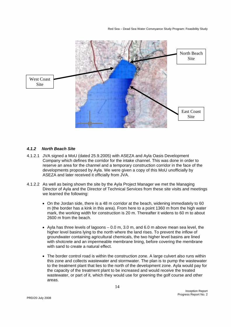
4.1.1.1 There are three intake sites under consideration:
• The site on the north beach, close to or along the international border • A site on the east coast, between Aqaba container port and the main port • A site on the west coast as considered in the PFS
4.1.1.2 We have visited the first two sites on two occasions, and these are further discussed below. The third site will be visited on 20 July. This site was not favoured in the PFS.
Red Sea – Dead Sea Water Conveyance Study Program: Feasibility Study
14 Inception Report
Progress Report No. 2 PRD/20 July 2008
4.1.2 North Beach Site 4.1.2.1 JVA signed a MoU (dated 25.9.2005) with ASEZA and Ayla Oasis Development
Company which defines the corridor for the intake channel. This was done in order to reserve an area for the channel and a temporary construction corridor in the face of the developments proposed by Ayla. We were given a copy of this MoU unofficially by ASEZA and later received it officially from JVA.
4.1.2.2 As well as being shown the site by the Ayla Project Manager we met the Managing Director of Ayla and the Director of Technical Services from these site visits and meetings we learned the following:
• On the Jordan side, there is a 48 m corridor at the beach, widening immediately to 60 m (the border has a kink in this area). From here to a point 1360 m from the high water mark, the working width for construction is 20 m. Thereafter it widens to 60 m to about 2600 m from the beach.
• Ayla has three levels of lagoons – 0.0 m, 3.0 m, and 6.0 m above mean sea level, the higher level basins lying to the north where the land rises. To prevent the inflow of groundwater containing agricultural chemicals, the two higher level basins are lined with shotcrete and an impermeable membrane lining, before covering the membrane with sand to create a natural effect.
• The border control road is within the construction zone. A large culvert also runs within this zone and collects wastewater and stormwater. The plan is to pump the wastewater to the treatment plant that lies to the north of the development zone. Ayla would pay for the capacity of the treatment plant to be increased and would receive the treated wastewater, or part of it, which they would use for greening the golf course and other areas.
West Coast Site
North Beach Site
East Coast Site
Red Sea – Dead Sea Water Conveyance Study Program: Feasibility Study
15 Inception Report
Progress Report No. 2 PRD/20 July 2008
4.1.2.3 When we raised the question of the narrow corridor on the Jordanian side, Ayla suggested that the construction corridor could encroach on the Israeli side without any problem. Ayla has managed such issues before in the case of flooding or other incident that required cooperation. There is at present a large buffer zone on the Israeli side between the international border and any permanent works – several hundred metres.
4.1.2.4 Subsequent to these meetings we requested further information from Ayla, and received the following documents:
• Surface Drainage Design and Site Protection Report, dated March 2007 • Sediment Transport Modelling Report, dated March 2007 • Construction Drawings
o 1214-00-MS201 Rev 1 Breakwaters – Plan o 1214-00-MS202 Rev 1 Breakwaters – Sections and Details o 1214-00-RD407 Surface Drainage Network Layout 7 of 9 o 1214-00-RD408 Surface Drainage Network Layout 8 of 9 o 1214-00-RD409 Surface Drainage Network Layout 9 of 9 o 1214-00-RD422 Drainage Details 1 of 2 o 1214-00-RD423 Drainage Details 2 of 2
4.1.2.5 The cooperation that Ayla has shown augurs well for the planning of the intake site, should this be selected on the North Beach.
4.1.3 East Coast Site 4.1.3.1 There is an obvious site on the east coast between the container port and the main port
area on the edge of Aqaba town – the site of the former power station. The site still has the disused water intake and pier, as well as the power station buildings which are located on the east side of the coast road, providing a level site quarried from the mountainside. This area could be enlarged if necessary and could include a pumping station.
4.1.3.2 The beach is narrow, with a shallow reef in poor condition.
4.1.4 Sources of Pollution 4.1.4.1 Possible pollution sources to the northern Gulf are:
• Flash floods through Aqaba and Eilat into the Gulf – occasional but can be bad
• Farmlands around the two cities can introduce both nutrients and agrichemicals into the groundwater and/or the Gulf directly
• Eilat has no operating oil terminal but Aqaba does, and so oil spills are a hazard – as are engine oil spills from the many cargo vessels using the ports
• There is a desalination plant on the Israeli side producing waste brine and power plants, particularly on the Jordan side, to fuel both cities.
• Jordan is building a chemical plant, and has plans for a desalination plant
Red Sea – Dead Sea Water Conveyance Study Program: Feasibility Study
16 Inception Report
Progress Report No. 2 PRD/20 July 2008
• The Ayla lagoon development in Aqaba is a potential source.
4.1.4.2 Although there have been no measurable changes in chlorophyll in the Gulf with time, there have been long-term changes in nutrients and dissolved oxygen. These have been blamed on the fish cages. The fish cages were removed from the Gulf at the end of June this year. The IOLR mariculture test facility is presently working as “a fish cage situated 1 km inland” with little treatment of the waste. The nitrification filter is barely working with half the excreted nitrogen remaining as ammonia. This is due to faulty operation of the system which is well known and simple technology. IOLR has admitted that only 20-40% of the nitrogen is being removed by the denitrification system and none of the phosphate. They are running 1000 m3 of water through the system daily. The outflow from Eilat desalination plant (withdrawing from coastal groundwater) is mixed with process water from the Mariculture Institute test facility in the bottom of the Gulf near the border to Jordan.The sampling port is after the merging of these two streams, making monitoring of pollution more difficult.
4.1.4.3 It has been suggested that there is leakage from the Aqaba WWTP, causing high nutrients in a borehole below the date palms.
4.1.4.4 We need to obtain data on the quality of releases to the Gulf so that the issue of polluted surface and groundwater being discharged into the head of the Gulf can be addressed, preferably jointly with the two beneficiary parties.
4.1.5 Power Supply 4.1.5.1 The power required at Aqaba or Eilat, for pumping to a higher elevation downstream of
the intake, has yet to be determined and will vary from one conveyance system option to another. Should the discharge and pumping lift be as proposed in the PFS, the power required will be of the order of 130 MW, but options up to 250 MW were included in the study.
4.1.5.2 NEPCO commissioned a feasibility study for the Jordan 400 kV double circuit overhead transmission line from Aqaba to Amman East and associated substations. The proposed 350 km long line is vital to Jordan’s power security and reliability as well as the economic power exchange between the neighbouring countries, through the 400 kV tie lines with Egypt and Syria. It would start at an extended Aqaba 400 kV substation and pass through Wadi Araba / The arava, the Dead Sea, then to the south of Madaba to reach the planned 400 kV substation in the north-east of Amman.
4.1.6 Desalination Alternative 4.1.6.1 The alternative potable water supply system to the RSDSP on the Jordan side requires
a desalination plant at Aqaba. In this respect it should be noted that Aqaba Water Company, which is unable to increase its supply from the Disi aquifer, is negotiating for a desalination plant of 10 Mm³ per year. This will supply the south Aqaba area comprising the port and the industrial zone, leaving the present Disi supply to meet the increase in demand from growth in Aqaba and the new housing and hotel developments.
Red Sea – Dead Sea Water Conveyance Study Program: Feasibility Study
17 Inception Report
Progress Report No. 2 PRD/20 July 2008
4.2 Oceanography
4.2.1 Issues 4.2.1.1 The longer term aspects of the effects of the intake need to be modelled. With the
discharge proposed in the PFS, the intake flux is 1/3 of the total evaporation rate in the Gulf. The evaporation rate drives the thermohaline circulation in the system. However the total water movement is 500 times the intake flux. Calculations are needed to determine whether the intake flux will have an important (25%) or irrelevant (0.2%) effect on circulation in the Gulf.
4.2.1.2 A major issue is the movement of coral larvae from Aqaba to Eilat. Nothing is known about larval recruitment of corals on either side of the Gulf. This is an issue because there has been a very marked deterioration in the coral reef in Eilat over the past several years. No study had been carried out to compare the reef ecology between Eilat and the nearby Egyptian coast.
4.2.1.3 The connectivity will need to be looked at via a genetic analysis of the same species on both sides of the Gulf to see how closely related they are genetically.
4.2.2 Present State of Knowledge 4.2.2.1 The existing model is a working model but at medium resolution. In order to model the
impact of the intake it will be necessary to nest a high resolution model with the general model of the Gulf. The existing model has only physical oceanography. No models have biogeochemistry included. There is no ecosystem model.
4.2.3 Questions to Resolve 4.2.3.1 We will need answers to a number of questions in order to proceed with selection of the
preferred intake location and design of the intake. The questions to be answered are:
• What is the area/volume of water affected by the intake? This is needed for perhaps two locations and two intake designs
• Is there a flux of coral larvae that are swept around the north of the GoA which might be affected by the siting of the intake? What fraction of the total coral larvae flux might be affected by the intake?
• What is the long term/large scale effects of the intakes on the circulation of the GoA? This can be done with one flux scenario and one inlet location and depth
• What are the pollution sources to the Gulf including Aqaba sewage works, IOLR, fertilizer loading and non-point sources? What are the groundwater nutrient fluxes into the Gulf?
• Once we know the final intake site, what is the nature of the sediment in that region – sampling and what might be the environmental affects of such construction.
4.3 Work to be Undertaken by SIs
Red Sea – Dead Sea Water Conveyance Study Program: Feasibility Study
18 Inception Report
Progress Report No. 2 PRD/20 July 2008
4.3.1 Activity Schedule for SIs 4.3.1.1 The timing of the answers to these questions is critical to the study program. We shall
be requiring these answers as follows:
• Preliminary answers to be provided in an Interim Report ahead of the Preliminary Draft Sub-Studies Report which we are required to submit by Month 10
• Final answers to be provided in a Final Report ahead of the Draft Final Sub-Studies Report which we are required to submit by Month 16
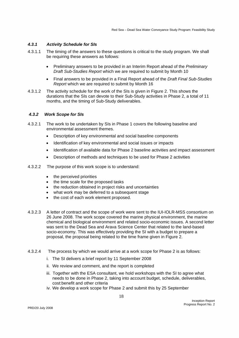
4.3.1.2 The activity schedule for the work of the SIs is given in Figure 2. This shows the durations that the SIs can devote to their Sub-Study activities in Phase 2, a total of 11 months, and the timing of Sub-Study deliverables.
4.3.2 Work Scope for SIs
4.3.2.1 The work to be undertaken by SIs in Phase 1 covers the following baseline and environmental assessment themes. • Description of key environmental and social baseline components • Identification of key environmental and social issues or impacts • Identification of available data for Phase 2 baseline activities and impact assessment • Description of methods and techniques to be used for Phase 2 activities
4.3.2.2 The purpose of this work scope is to understand:
• the perceived priorities • the time scale for the proposed tasks • the reduction obtained in project risks and uncertainties • what work may be deferred to a subsequent stage • the cost of each work element proposed.
4.3.2.3 A letter of contract and the scope of work were sent to the IUI-IOLR-MSS consortium on 26 June 2008. The work scope covered the marine physical environment, the marine chemical and biological environment and related socio-economic issues. A second letter was sent to the Dead Sea and Arava Science Center that related to the land-based socio-economy. This was effectively providing the SI with a budget to prepare a proposal, the proposal being related to the time frame given in Figure 2.
4.3.2.4 The process by which we would arrive at a work scope for Phase 2 is as follows:
i. The SI delivers a brief report by 11 September 2008
ii. We review and comment, and the report is completed
iii. Together with the ESA consultant, we hold workshops with the SI to agree what needs to be done in Phase 2, taking into account budget, schedule, deliverables, cost:benefit and other criteria iv. We develop a work scope for Phase 2 and submit this by 25 September
Red Sea – Dead Sea Water Conveyance Study Program: Feasibility Study
19 Inception Report
Progress Report No. 2 PRD/20 July 2008
v. We prepare contract documents for the Phase 2 contracts and send drafts to the SI
vi. Contracts are agreed and work can start on Phase 2 at end October 2008.
4.3.2.5 To date it has not been possible to reach agreement with the main SI’s on the scope of work necessary to provide a robust assessment of the feasibility of the proposed project, the budget for this work or the time needed by the SI’s to complete the work. Proposals received from the SI’s substantially exceed both the available project budget and the overall time frame of the Study Program. Until this matter is resolved contractual arrangements cannot be put in place with the SI’s and the work of the SI’s is delayed.
4.3.3 Way Forward for SI’s
4.3.1.1 There appears to be two alternative ways forward with respect to the appointment of SI’s as follows:-
1. Restructure the study program to provide more time for the Sub-Studies and provide additional funding for the SI’s and any resultant delays to the overall Study Program.
2. Remove the scope of the SI’s from the Feasibility Study and accept that the Final Feasibility Study Report will be qualified in respect of some important issues, in particular the question of impact on the aquatic environment of the Gulf of aqaba / Eilat and the chemical and physical impacts of mixing the Red Sea and Dead Sea waters. The work of the SI’s can then be arranged separately to clarify and verify any qualifications in the Feasibility Study report at a leter date.
Red Sea – Dead Sea Water Conveyance Study Program: Feasibility Study
20 Inception Report
Progress Report No. 2 PRD/20 July 2008
Figure 2 Activity Schedule for Work of SIs
ActivityJun Jul Aug Sep Oct Nov Dec Jan Feb Mar Apr May Jun Jul Aug Sep Oct Nov Dec
1 2 3 4 5 6 7 8 9 10 11 12 13 14 15 16 17 18 19Develop scopes of work for Phase 1
Phase 1 contracts issued
SIs undertake Phase 1 tasks
SIs submit Phase 1 report
Review and finalize reportConsultant submits Interim Report for Sub-Studies, incl. review of existing/ ongoing studies, analysis of data gaps, Study Proposal for Phase 2 and Annotated Outline of Sub-Studies ReportNegotiate and develop scopes of work for Phase 2
Phase 2 contracts issued
SIs undertake Phase 2 Part 1 tasks
SIs submit Interim Report on Sub-Studies
Consultant submits Preliminary Draft Sub-Studies Report
SIs undertake Phase 2 Part 2 tasks
SIs submit Draft Final Report on Sub-Studies
Consultant submits Draft Final Sub-Studies Report
Consultant issues Final Sub-Studies Report
August holiday period
Phase 2Phase 1
Red Sea – Dead Sea Water Conveyance Study Program: Feasibility Study
21 Inception Report
Progress Report No. 2 PRD/20 July 2008
5.0 SUB-STUDY B: WATER CONVEYANCE
5.1 Conveyance System
5.1.1 Geology and Seismology
5.1.1.1 Based on our preliminary consideration of seismicity and tectonics, it will probably not be possible to exclude the potential occurrence of a multimetric coseismic slip within the lifetime of the Red Sea - Dead Sea conveyance. This means that its crossing of the Arava Fault is a main issue. The accurate location of the Arava fault at the Dead Sea is also an issue. Recent seismic reflection studies show the Arava fault to be located below the Dead Sea instead of at its border, which could favour some conveyance alignments over others.
5.1.2 Flash Floods 5.1.2.1 We have reviewed the analysis presented in the PFS and obtained similar results for the
Rational Method. A statistical approach gave results about half of those of the rational method.
5.1.2.2 We propose to use several approaches such as: • The Rational method. • The USSCS unit-hydrograph approach. • The regional flood analysis.
5.1.2.3 In order to be able to use these methods, the following data will be needed: • Catchment description as given by available topographic maps. • Maximum daily rainfall at several locations within Dead Sea and Wadi Araba / The
Arava catchments. • Flood data at several locations in Jordan, Israel and Palestine, including long series of annual floods.
5.1.3 Power Supply 5.1.3.1 Section 4.1.5 describes the proposed 400 kV power transmission line that would be run
through Wadi Araba / The Arava and divert east at the Dead Sea to Madaba and Amman. This would be most conveniently placed to provide power, via a substation yet to be located, to the project facilities. As far as Wadi Araba / The Arava is concerned, which is the subject of Sub-Study B, the transmission lines would create a major visual intrusion, and have a variety of adverse impacts which could be linked in the public mind with the Project. Consideration should therefore be given to alternative routes.
5.1.4 Options Evaluation 5.1.4.1 We have obtained 1:25,000 scale topographic maps and propose to use these and the
1:50,000 series for the evaluation of alignment options. The areas of interest will be defined and we shall arrange for the contours to be digitised.
5.1.4.2 The options evaluation is expected to start in August.
Red Sea – Dead Sea Water Conveyance Study Program: Feasibility Study
22 Inception Report
Progress Report No. 2 PRD/20 July 2008
5.2 Work to be Undertaken by SIs
5.2.1 The approach to agreeing the work of the SI that will undertake the studies related to Wadi Araba / The Arava and the water conveyance is essentially the same as described in Section 4.3.
5.2.2 A letter of contract and scope of work was sent to the Dead Sea and Arava Science Center on 26 July 2008 covering the following elements of the scope:
• Hydrology, hydrogeology and climate
• Flora and fauna
• Socio-economic environment
5.2.3 A similar letter was sent to GSI covering geology, geomorphology and seismology.
6.0 SUB-STUDY C: DEAD SEA
6.1 Hydrology and Hydrogeology 6.1.1 The following elements of the water balance of the Dead Sea have been addressed in the
first mission of the Hydrologist/Water Resources Expert:
• Surface water inflows • Rainfall • Evaporation • Groundwater inflows (sustainable) • Subsurface groundwater inflows from regional groundwater storage
6.1.2 The two elements of the water balance that arouse the greatest controversy are Dead Sea
evaporation and subsurface groundwater inflows from regional storage. Several authors have studied the evaporation and the estimates are widely scattered between 1000 mm/yr and over 2000 mm/yr. GSI has developed a model with volume, mass and heat balances for which the equations require an evaporation rate of about 1150 mm/yr and subsurface groundwater flows not exceeding 60 Mm3/yr. By contrast, Elias Salameh and Hazem El-Naser estimate evaporation at 2000 mm/year and subsurface groundwater inflows at about 400 Mm3 per metre fall in Dead Sea level.
6.1.3 We propose to try to resolve these differences by a variety of approaches:
i. Discuss subsurface groundwater inflow with MWI and obtain regional groundwater data from MWI and WAI
ii. Review the GSI modeling approach including the determination of mass and heat balances
iii. Talk to Elias Salameh and/or Hazem El-Naser and hold discussions with experienced GSI hydrologist and hydrogeologist (and any other experts in this field) to try to resolve the differences iv. Talk to APC/DSW about evaporation and any measurements they may have made,
and discuss with APC/DSW (or GSI) the creation of a large scale evaporation basin to measure evaporation over a year from a hypersaline solution.
Red Sea – Dead Sea Water Conveyance Study Program: Feasibility Study
23 Inception Report
Progress Report No. 2 PRD/20 July 2008
6.1.4 In particular we wish to discuss with GSI the salt balance and the formation of sinkholes which we find hard to explain without a large volume of fresh water dissolving an evaporitic (halite) layer and thus causing sinkhole collapse
. 6.1.5 We have carried out our own preliminary determination of evaporation rates on the basis of
a heat balance. These again appear to support a significantly higher evaporation rate than has been determined by GSI, and emphasize once again the need for continuing dialogue with GSI and others.
6.2 Sinkholes 6.2.1 Sinkholes are a matter of concern in the Dead Sea area. We are reviewing the cause and
mechanism of this phenomenon and suggests that an understanding of their cause is not only of importance for the foundations of structures but also for the mass balance of the Dead Sea.
6.3 Water Balance 6.3.1 The Dead Sea water balance constitutes a crucial element of the planning of the RSDS
water conveyance system. The first objective of the water balance is to investigate the “without Project” case in order to predict and describe the future conditions without the Project. This forms a vital element in attracting the interest of the international community in supporting the restoration and rehabilitation of the area.
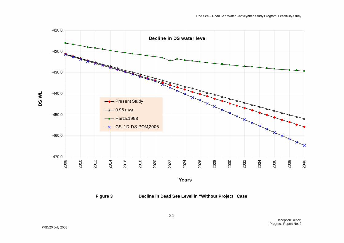
6.3.2 Figure 3 presents the predicted decline in Dead Sea levels under a variety of different models. These are:
• A constant decline of 0.96 m/yr in the level, representing the average decline over the period 1994-2007 • The prediction in the Harza PFS (1998)
• GSI’s projections according to its 1-D Dead Sea model
• Our projections
6.3.3 The Harza model has not predicted the actual decline in level well, and is therefore not a sound basis for future prediction. Our model and that of GSI show an increasing divergence with time. It is important that the differences between the two models are resolved, particularly if GSI are to be engaged in modelling work.
6.3.4 We are aware of the need to continually refine the data on which our model is based, and are working on this. The assumptions currently used in the model are given in Table 2:
Red Sea – Dead Sea Water Conveyance Study Program: Feasibility Study
24 Inception Report
Progress Report No. 2 PRD/20 July 2008
Decline in DS water level
-470.0
-460.0
-450.0
-440.0
-430.0
-420.0
-410.0
2008
2010
2012
2014
2016
2018
2020
2022
2024
2026
2028
2030
2032
2034
2036
2038
2040
Years
DS
WL
Present Study
0.96 m/yr
Harza.1998
GSI 1D-DS-POM,2006
Figure 3 Decline in Dead Sea Level in “Without Project” Case
Red Sea – Dead Sea Water Conveyance Study Program: Feasibility Study
25 Inception Report
Progress Report No. 2 PRD/20 July 2008
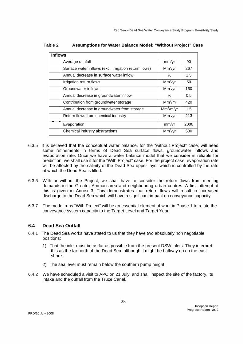
Table 2 Assumptions for Water Balance Model: “Without Project” Case
Inflows Average rainfall mm/yr 90
Surface water inflows (excl. irrigation return flows) Mm3/yr 267
Annual decrease in surface water inflow % 1.5
Irrigation return flows Mm3/yr 50
Groundwater inflows Mm3/yr 150
Annual decrease in groundwater inflow % 0.5
Contribution from groundwater storage Mm3/m 420
Annual decrease in groundwater from storage Mm3/m/yr 1.5
Return flows from chemical industry Mm3/yr 213
O tfl Evaporation mm/yr 2000
Chemical industry abstractions Mm3/yr 530
6.3.5 It is believed that the conceptual water balance, for the “without Project” case, will need some refinements in terms of Dead Sea surface flows, groundwater inflows and evaporation rate. Once we have a water balance model that we consider is reliable for prediction, we shall use it for the “With Project” case. For the project case, evaporation rate will be affected by the salinity of the Dead Sea upper layer which is controlled by the rate at which the Dead Sea is filled.
6.3.6 With or without the Project, we shall have to consider the return flows from meeting
demands in the Greater Amman area and neighbouring urban centres. A first attempt at this is given in Annex 3. This demonstrates that return flows will result in increased discharge to the Dead Sea which will have a significant impact on conveyance capacity.
6.3.7 The model runs “With Project” will be an essential element of work in Phase 1 to relate the
conveyance system capacity to the Target Level and Target Year.
6.4 Dead Sea Outfall 6.4.1 The Dead Sea works have stated to us that they have two absolutely non negotiable
positions:
1) That the inlet must be as far as possible from the present DSW inlets. They interpret this as the far north of the Dead Sea, although it might be halfway up on the east shore. 2) The sea level must remain below the southern pump height.
6.4.2 We have scheduled a visit to APC on 21 July, and shall inspect the site of the factory, its intake and the outfall from the Truce Canal.
Red Sea – Dead Sea Water Conveyance Study Program: Feasibility Study
26 Inception Report
Progress Report No. 2 PRD/20 July 2008
6.5 Modelling of Dead Sea 6.5.1 GSI is proposing using 1-D and 2-D models of the Dead Sea. The importance and focus
on the Dead Sea issue and problem would probably take state-of-the-art modelling tools, particularly full 3-D modelling. Several of the issues needing assessment are fully 3-D. These include:
• spreading of Red Sea water • chemical industry intake and return flows • Dead Sea seawater outfall • Dead Sea desalination reject brine outfall.
6.5.2 Such a model needs to be calibrated. This is problematic even for the current situation, and will be far more difficult for significant additions of Red Sea water. The model is unique because it requires chemical, thermodynamic and kinetic components which actually change the physical model. This makes it much more complicated than the usual ocean models.
6.5.3 Experiments have been carried out in tanks at Dead Sea Works both of the chemical and biological effects of adding Red Sea water to Dead Sea water.
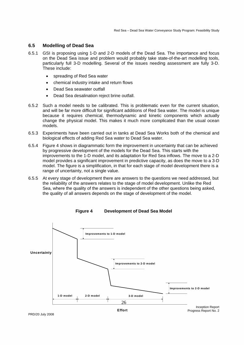
6.5.4 Figure 4 shows in diagrammatic form the improvement in uncertainty that can be achieved by progressive development of the models for the Dead Sea. This starts with the improvements to the 1-D model, and its adaptation for Red Sea inflows. The move to a 2-D model provides a significant improvement in predictive capacity, as does the move to a 3-D model. The figure is a simplification, in that for each stage of model development there is a range of uncertainty, not a single value.
6.5.5 At every stage of development there are answers to the questions we need addressed, but the reliability of the answers relates to the stage of model development. Unlike the Red Sea, where the quality of the answers is independent of the other questions being asked, the quality of all answers depends on the stage of development of the model.
Figure 4 Development of Dead Sea Model
Uncertainty
Effort
3-D model1-D model 2-D model
Improvements to 2-D model
Improvements to 2-D model
Improvements to 1-D model
Red Sea – Dead Sea Water Conveyance Study Program: Feasibility Study
27 Inception Report
Progress Report No. 2 PRD/20 July 2008
6.5.6 We will need answers to a number of questions in order to proceed with selection of the seawater outfall and reject brine locations and design of the two outfalls. The timing of the answers is critical to the study program, and we shall be requiring these answers as follows:
• Preliminary answers ahead of the Preliminary Draft Sub-Studies Report which we are required to submit by Month 10
• Final answers ahead of the Draft Final Sub-Studies Report which we are required to submit by Month 16.
6.5.7 The questions to be answered are:
• What is the impact of the present return flow discharge?
• What values of evaporation and groundwater inflow can we agree on?
• What is the area/volume of water affected by the outfall? This is needed for perhaps two locations and two outfall designs as well as for the brine reject outfall
• What will be the long term/large scale currents and water movements caused by the outfalls on the circulation of the Dead Sea? How will these affect the intakes of the chemical industry?
• What mixing will take place between the seawater and Dead Sea water? Will this cause stratification and, if so, what depths will be affected?
• How will evaporation be affected by the inflow of Red Sea water?
• What chemical and biological changes will the mixing of the two seas induce?
6.6 Work to be Undertaken by SIs 6.6.1 The approach to agreeing the work of the SIs that will undertake the studies related to the
Dead Sea and the immediate region is essentially the same as described in Section 4.3.
6.6.2 A letter of contract and scope of work was sent to GSI on 26 July 2008 covering the following elements of the scope:
• Hydrology, hydrogeology and climate
• Marine physical environment
• Marine biota
6.6.3 A similar letter was sent to the Dead Sea and Arava Science Center covering the socio-economic environment.
Red Sea – Dead Sea Water Conveyance Study Program: Feasibility Study
28 Inception Report
Progress Report No. 2 PRD/20 July 2008
7.0 SUB-STUDY D: HYDROPOWER FACILITIES AND DESALINATION PLANT
7.1 Water Conveyance to Amman 7.1.1 The water conveyance route selected in the PFS followed the road to Kerak. This route
presents considerable difficulties, notably in the ascent of the escarpment from the Dead Sea and in the bypassing of Kerak itself. The terrain is broken and the underlying formations appear very weak.
7.1.2 The actual conveyance route options will depend on the location of the desalination plant, but there may be advantages in finding a more southerly route up the escarpment.
7.1.3 Based on a very preliminary estimate of water demands, the size of pipeline can be significantly smaller than that proposed in the PFS, perhaps twin 2.25 m diameter. It may be possible to stage construction of at least part of the pipeline.
7.1.4 The power supply for the water transmission system conceived in the PFS requires about 350 MW. The proposed 400 kV double circuit overhead transmission line from Aqaba to
Amman (refer Section 3.1.6) could be
8.0 ECONOMIC AND FINANCIAL STUDY
8.1 Approach to Economic and Financial Study 8.1.1 The purpose of the first mission of the Natural Resources Economist, and leader of the
Economics and Finance Team, Professor Anil Markandya, was to develop the approach to the Economic and Financial Study. Because the method of evaluating costs and benefits is such an important aspect of the study, we have included his report in full in Annex 2.
8.1.2 The Economic Strategist/Regional Economist’s mission is not completed, and a report on the project context is in preparation. This will form another foundation block for the economic studies.
8.2 Water Demands
8.2.1 Jordan 8.2.1.1 The Harza PFS made the following assumptions in its overall water supply and demand
balance:
• high population growth (about 50% higher than World Bank figures) • all irrigation demands met throughout Jordan • all municipal and industrial demands met throughout Jordan
8.2.1.2 The PFS projected that demand would rise to fully absorb Jordan’s share of the
desalination plant output, about 565 Mm3/year, by about 2030.
8.2.1.3 We believe that the first statement concerning demands that needs to be made is:
• The Project will not meet irrigation demands
Red Sea – Dead Sea Water Conveyance Study Program: Feasibility Study
29 Inception Report
Progress Report No. 2 PRD/20 July 2008
8.2.1.4 No funding agency, and certainly no sources of private finance, will accept that any of the costly water supplied from the Project be used directly for irrigation, where the average price paid is 50 fils/m3 and economic returns to water are low. Nor do the ToR require that irrigation demands be met from RSDSP water.
8.2.1.5 However, there will be a significant increase in return flows (see Annex 2) that, after treatment, can be used for irrigation, and will represent a major benefit. Some 20-25% of the gross supply will return to the Jordan River as irrigation return flows. This will also be the case with Disi water, available from 2012.
8.2.1.6 With regard to municipal and industrial demands, we shall need to engage with the National Water Master Plan team and with WAJ to establish which centres can be supplied from about 2020 from the RSDSP. It is noted that the PFS simply terminated the water transmission pipeline at Amman, leaving the infrastructure needed for onward transmission to be determined.
8.2.1.7 If we plan for 150 lpcd (the National Water Master Plan assumption, which compares with the 2004 estimate of 86 lpcd), or 55 m3/cap/year, in Amman and near urban centres, and assume physical losses of 30%, then for a present population of, say, 3 million served we would have a demand of 235 Mm3/yr. In the future this demand would grow approximately as follows (population growth rates still to be confirmed):
2020 3% 366 Mm3/yr 2030 2% 446 Mm3/yr 2040 1.5% 518 Mm3/yr 2050 1% 572 Mm3/yr
8.2.1.8 The demands will first be met from existing sources. Disi (100 Mm3/yr) is a BOT scheme and this will continue to supply Amman under a “take or pay” arrangement. Deir Alla and other sources, including renewable groundwater, in 2007 supplied 124 Mm3/yr to the Amman area alone and could, following the commissioning of the RSDSP, continue to supply, say, 90 Mm3/yr. The municipal demands that the Project will meet are therefore approximately:
2020 176 Mm3/yr 2030 256 Mm3/yr 2040 328 Mm3/yr 2050 382 Mm3/yr
8.2.1.9 It is emphasized that these figures are only intended to be illustrative. We have assumed that all consumers outside the service area of the RSDSP will be supplied from other sources, and this assumption needs to be carefully checked. We shall be addressing demand more fully in October 2008, with the mission of the Water Economist.
8.2.1.10 The demand forecast is based on continuing physical losses of 30%, and one objective of national planning will be to reduce these losses significantly. Two other demand elements need to be taken into account:
• Industrial demand • Tourism demand
8.2.1.11 These could amount to, perhaps, a further 10%, approximately offsetting any improvement in physical losses (the NWMP project assumes that there will reduce from 30% to 15% by 2020). They have therefore not been accounted for. In any case few
Red Sea – Dead Sea Water Conveyance Study Program: Feasibility Study
30 Inception Report
Progress Report No. 2 PRD/20 July 2008
consumers are categorized as Industrial, and few of these can be supplied from the Project. The tourism developments and industry along the shores of the Dead Sea will, of course, be important consumers of the desalinated water.
8.2.2 Israel 8.2.2.1 We understand that the current expansion plans for the water system in Israel make no
provision for a RSDSP supply. National plans are going ahead for the supply of both Hebron and Jerusalem, and by the time that the Project comes on line, these will compete with the supplies from the Project. As the major infrastructure for such schemes will already be a sunk cost as far as Mekorot, the water utility that will act as bulk offtaker, is concerned the project supply will face the marginal cost of the competing supply in trying to sell to Mekorot. Even if this were not the case, it is hard to imagine how a supply at – 400m will be attractive to Israel.
8.2.3 Palestinian Authority 8.2.3.1 The Palestinians presently pay less than $1 per m³ to Mekorot. This is before desalination;
after desalinated water becomes the source of supply the value will rise to about $1.2 per m³. Of course, it is largely the international community that funds this consumption, as Israel will only provide the water at commercial rates. It presently supplies about 50 Mm³ and would only supply more at the marginal rate of about $1.2 per m³. Nevertheless, it is hard to see the international community funding a very costly water transmission system purely for the Palestinians and across parts of what is now the Palestinian Authority under Israeli control.
Red Sea – Dead Sea Water Conveyance Study Program: Feasibility Study
31 Inception Report
Progress Report No. 2 PRD/20 July 2008
ANNEX 1 DATA COLLECTION CAMPAIGN IN PHASE 1 - JORDAN
Data required Probable source
Current status
General Data from Harza Pre-feasibility study JVA JVA has provided a CD with Harza data
which is being reviewed Hydrology Flood flows in Wadi Araba/ Arava Valley and its tributary catchments JVA Requested by letter from JVA Flood flows in catchments along transmission line routes JVA Requested by letter from JVA Flood flows in Dead Sea side wadis JVA Requested by letter from JVA Flows in Jordan river – historic record JVA Requested by letter from JVA Flows in Jordan river – hydrochemical composition JVA Requested by letter from JVA Hydrogeology and Hydrochemistry Data on existing abstraction wells in Wadi Araba / The Arava and Dead
Sea region, including location, piezometric levels, annual abstraction, chloride and potassium content and hydrochemistry
JVA Requested by letter from JVA. Information will be provided on 20 July
Data on springs along Dead Sea east and west banks, incl. location, discharges, chloride content, hydrochemistry and uses
JVA Requested by letter from JVA
Characteristics of aquifers and springs in Wadi Araba/ Arava Valley, incl. location of wells, abstraction discharges, chloride content, hydrochemistry and hydrodynamic parameters (K, effective porosity, specific discharge, drawdown, etc)
JVA Requested by letter from JVA
Climate data for Dead Sea, Wadi Araba / The Arava and Aqaba/Eilat region
• Temperature (average monthly) • Humidity (average monthly) • Rainfall (average monthly, maximum hourly and daily events) and
IDF curves • Wind speed and direction • Solar radiation • Pan evaporation (average monthly) and other evaporation
estimates • Atmospheric pressure (average monthly
Meteorology Department
and JVA
Letter sent to Meteorology Department and other data for / The Arava and other areas requested from JVA. Some rainfall data received from JVA on 16.7.08. This is being reviewed.
Geology and seismology (both / The Arava and along transmission lines)
Reports of previous investigations (including Harza PFS and site NRA
Red Sea – Dead Sea Water Conveyance Study Program: Feasibility Study
32 Inception Report
Progress Report No. 2 PRD/20 July 2008
investigations at Aqaba) Geological data from other projects that could be of interest, particularly
lithographic and other data from boreholes in Wadi Araba / The Arava (water, oil or mineral prospection)
NRA Received information on boreholes in the Dead Sea region which is being reviewed
Geological maps covering / The Arava and areas east to Desert Road, up to Amman
NRA 1:50,000 geological maps with bulletins obtained from NRA library
Geophysical data incl. magnetic, gravimetric and seismic reflection surveys
NRA NRA preparing geophysical data for collection on 19 July
Records of earthquakes (including epicentres and hypocenters, focal depths, magnitudes, intensities, focal mechanism)
NRA Letter sent to NRA. Meet experts on 20 July
Available reports on the seismic context of the region NRA Letter sent to NRA. Meet experts on 20 July Topographic data and mapping covering intake, conveyance routes, desalination facilities and water transmission lines
1: 50,000 scale contour maps RJGC We have these scanned in our files 1: 25,000 scale contour maps RJGC Have been obtained. 1: 50,000 digitized contours RJGC May not be needed Aerial photo stereo pairs RJGC To be determined Other aerial photo (non stereo) RJGC To be determined More detailed maps for intake site, if available Ayla Check with Ayla Bathymetric data For Dead Sea, including areas previously submerged JVA/APC Requested from JVA and APC For Gulf of Aqaba/Eilat MSS or
ASEZA Only limited data found to date.
Other data for Dead Sea and surroundings, incl. chemical industry Records of Dead Sea levels APC Requested from APC. Meeting and site visit
arranged for 21 July Hydrochemical composition APC Requested from APC. Meeting and site visit
arranged for 21 July Records of abstractions by chemical industry and future planned
abstractions APC Obtained historic data from APC
Records of return flows by chemical industry APC Obtained historic data from APC Information on construction of evaporation ponds APC Requested from APC. Meeting and site visit
arranged for 21 July Estimate of evaporation from evaporation ponds APC Requested from APC. Meeting and site visit
arranged for 21 July Estimate of seepage from evaporation ponds APC Requested from APC. Meeting and site visit
arranged for 21 July Chemical composition of Dead Sea precipitate, especially chloride APC Requested from APC. Meeting and site visit
Red Sea – Dead Sea Water Conveyance Study Program: Feasibility Study
33 Inception Report
Progress Report No. 2 PRD/20 July 2008
content arranged for 21 July Chronological records of sinkholes with photos if available APC Requested from APC. Meeting and site visit
arranged for 21 July Other Red Sea data Sources of pollution and chemical analysis Various Request from MSS Tides in the Gulf of Aqaba MSS? Request from MSS Hydrochemical composition MSS? Request from MSS Water resources, supply and demand Policy Statements on Water Resources Management MWI Downloaded from MWI website Water supply policy statements MWI Downloaded from MWI website Water resource and water supply plans MWI Data on water distribution systems, terminal reservoirs and expansion
plans for Amman and along transmission routes MWI
Water production by source MWI Demand forecasts by region and consumer category – including
industry and agriculture MWI
Received CD with part of NWMP from JVA 2004 NWMP received from MWI. More recent data will be requested via JVA
Data on tariffs MWI Requested from MWI Recent reports on water resources and water supply MWI Water Supply Annual Report received Power market and electricity supply Current and future generation network (including location, type and
installed capacity of the power plants) Ministry of
Energy Requested from Ministry of Energy. Met NEPCO and received report
System expansion and interconnection plans, including new power generation
Ministry of Energy
Requested from Ministry of Energy. Met NEPCO and received report
Demand projections and load duration curves Ministry of Energy
Requested from Ministry of Energy
Current and future transmission networks (including main characteristics of the lines and substations)
Ministry of Energy
Requested from Ministry of Energy. Met NEPCO and received report
Bulk supply tariffs and seasonal/daily tariffs at different load factors Ministry of Energy
Requested from Ministry of Energy
Infrastructure, land use and development plans ASEZA master plan for Aqaba and similar plans for Eilat ASEZA A3 plan obtained. More detail needed.
Second meeting arranged on 20 July MoU between ASEZA, Ayla Oasis Dev. Co. and MWI/JRV for intake
corridor JVA Obtained and translated
Consultants reports to MWI/JRV in regard to intake corridor No reports commissioned. Tourism master plans for Dead Sea area Ministry of
Tourism Master Plan being prepared under USAID funded SADEQ program. Arrange to meet.
Development plans in Wadi Araba/Arava Valley JVA Requested from JVA (we need SIGMA
Red Sea – Dead Sea Water Conveyance Study Program: Feasibility Study
34 Inception Report
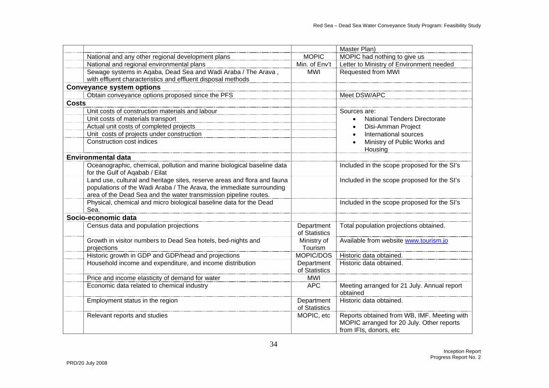
Progress Report No. 2 PRD/20 July 2008
Master Plan) National and any other regional development plans MOPIC MOPIC had nothing to give us National and regional environmental plans Min. of Env’t Letter to Ministry of Environment needed Sewage systems in Aqaba, Dead Sea and Wadi Araba / The Arava ,
with effluent characteristics and effluent disposal methods MWI Requested from MWI
Conveyance system options Obtain conveyance options proposed since the PFS Meet DSW/APC Costs Unit costs of construction materials and labour Unit costs of materials transport Actual unit costs of completed projects Unit costs of projects under construction Construction cost indices
Sources are: • National Tenders Directorate • Disi-Amman Project • International sources • Ministry of Public Works and
Housing Environmental data Oceanographic, chemical, pollution and marine biological baseline data
for the Gulf of Aqabab / Eilat Included in the scope proposed for the SI’s
Land use, cultural and heritage sites, reserve areas and flora and fauna populations of the Wadi Araba / The Arava, the immediate surrounding area of the Dead Sea and the water transmission pipeline routes.
Included in the scope proposed for the SI’s
Physical, chemical and micro biological baseline data for the Dead Sea.
Included in the scope proposed for the SI’s
Socio-economic data Census data and population projections Department
of Statistics Total population projections obtained.
Growth in visitor numbers to Dead Sea hotels, bed-nights and projections
Ministry of Tourism
Available from website www.tourism.jo
Historic growth in GDP and GDP/head and projections MOPIC/DOS Historic data obtained. Household income and expenditure, and income distribution Department
of Statistics Historic data obtained.
Price and income elasticity of demand for water MWI Economic data related to chemical industry APC Meeting arranged for 21 July. Annual report
obtained Employment status in the region Department
of Statistics Historic data obtained.
Relevant reports and studies MOPIC, etc Reports obtained from WB, IMF. Meeting with MOPIC arranged for 20 July. Other reports from IFIs, donors, etc
Red Sea – Dead Sea Water Conveyance Project Feasibility Study
35 Inception Report
Progress Report No. 2 PRD/20 July 2008
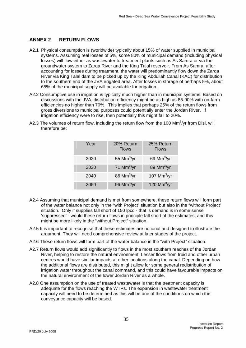
ANNEX 2 RETURN FLOWS
A2.1 Physical consumption is (worldwide) typically about 15% of water supplied in municipal systems. Assuming real losses of 5%, some 80% of municipal demand (including physical losses) will flow either as wastewater to treatment plants such as As Samra or via the groundwater system to Zarqa River and the King Talal reservoir. From As Samra, after accounting for losses during treatment, the water will predominantly flow down the Zarqa River via King Talal dam to be picked up by the King Abdullah Canal (KAC) for distribution to the southern end of the JVA irrigated area. After losses in storage of perhaps 5%, about 65% of the municipal supply will be available for irrigation.
A2.2 Consumptive use in irrigation is typically much higher than in municipal systems. Based on discussions with the JVA, distribution efficiency might be as high as 85-90% with on-farm efficiencies no higher than 70%. This implies that perhaps 25% of the return flows from gross diversions to municipal purposes could potentially enter the Jordan River. If irrigation efficiency were to rise, then potentially this might fall to 20%.
A2.3 The volumes of return flow, including the return flow from the 100 Mm3/yr from Disi, will therefore be:
Year 20% Return Flows
25% Return Flows
2020 55 Mm3/yr 69 Mm3/yr
2030 71 Mm3/yr 89 Mm3/yr
2040 86 Mm3/yr 107 Mm3/yr
2050 96 Mm3/yr 120 Mm3/yr
A2.4 Assuming that municipal demand is met from somewhere, these return flows will form part of the water balance not only in the “with Project” situation but also in the “without Project” situation. Only if supplies fall short of 150 lpcd - that is demand is in some sense ‘suppressed’ - would these return flows in principle fall short of the estimates, and this might be more likely in the “without Project” situation.
A2.5 It is important to recognise that these estimates are notional and designed to illustrate the argument. They will need comprehensive review at later stages of the project.
A2.6 These return flows will form part of the water balance in the “with Project” situation.
A2.7 Return flows would add significantly to flows in the most southern reaches of the Jordan River, helping to restore the natural environment. Lesser flows from Irbid and other urban centres would have similar impacts at other locations along the canal. Depending on how the additional flows are distributed, this might allow for some general redistribution of irrigation water throughout the canal command, and this could have favourable impacts on the natural environment of the lower Jordan River as a whole.
A2.8 One assumption on the use of treated wastewater is that the treatment capacity is adequate for the flows reaching the WTPs. The expansion in wastewater treatment capacity will need to be determined as this will be one of the conditions on which the conveyance capacity will be based.