Embed Size (px)
Citation preview
3Journal of Petroleum Geology, Vol. 28 (1), January 2005, pp 3 - 18
GEOCHEMICAL CHARACTERISTICS OF OIL SEEPAGESFROM DAM THI NAI, CENTRAL VIETNAM:IMPLICATIONS FOR HYDROCARBON EXPLORATIONIN THE OFFSHORE PHU KHANH BASIN
J. A. Bojesen-Koefoed*1, L. H. Nielsen1, H. P. Nytoft1, H. I. Petersen1,Nguyen Thi Dau2, Le Van Hien2, Nguyen Anh Duc2
and Nguyen Huy Quy2
Dam Thi Nai is a semi-enclosed embayment on the coast of central Vietnam, adjacent to thenorthern part of the offshore and largely unexplored Phu Khanh Basin. Seepages of oil have beenknown in Dam Thi Nai since the early part of the twentieth century. This paper presents organicgeochemical data on a number of samples of seepage oil collected from Dam Thi Nai and discussestheir implications for the prospectivity of the Phu Khanh Basin. The results indicate that thepetroleum was generated from a Tertiary marine marl source rock.
Seepage oils are found in varying degrees of biodegradation and modes of occurrence atdifferent locations in the embayment. Thus, oil was observed to fill fractures in freshly quarriedoutcrops of Cretaceous granite, and also occurs in shallow pits dug in the beach sand and inshallow basins used for shrimp farming. The oils indicate active seepage from kitchen areas orleaking accumulations in the Phu Khanh Basin. Seismic data suggest the existence of both sourcerocks and kitchens, and indicate a possible migration route from the deep basin to the surface atthe bay. A few samples show anomalous compositions, indicating the presence of two other oiltypes which have different sources. These occurrences cannot at present be explained. However,the results obtained are encouraging for future exploration in the Phu Khanh Basin.
1Geological Survey of Denmark and Greenland (GEUS),10 Øster Voldgade, DK-1350K Copenhagen, Denmark.2Vietnam Petroleum Institute (VPI), Trung Kinh Street,Yen Hoa, Cau Giay, Hanoi, Vietnam.
* author for correspondence, email [email protected]
INTRODUCTION
The Phu Khanh Basin, offshore central Vietnam, isthe only untested basin in Vietnamese waters. Thebasin comprises the typical elements of a rifted margin:rifted basement, a syn-rift unit, a break-upunconformity, and a thick post-rift unit (Lee andWatkins, 1998; Huyen, 2004; Huyen et al., 2004;Huong, 2004; Huong et al., 2004). The syn-riftsediments have been interpreted to consist oflacustrine and fluvial deposits, alluvial fans and fandeltas. The post-rift sedimentation is characterised bya gradual change from a transgressive ramp phase toa regressive shelf-slope phase.
Dam Thi Nai is a semi-enclosed embayment orlagoon on the coast of central Vietnam situatedimmediately to the west of the northern part of theoffshore Phu Khanh Basin (Fig. 1). Oil seepages inthe lagoon and adjacent beach have been known atleast since the early part of the twentieth century (VPI,unpublished information). In addition to these seepswhich are described in further detail below, shrimpfarmers in the northern part of the Dam Thi Nai areahave reported that the mud in the shallow basins theyuse for farming has a petroleum odour causing theshrimps to taste “strange”.
Between 1920 and 1930, Japanese geologistscarried out drilling in Dam Thi Nai (VPI, unpublishedinformation). In 1943–1944 a series of shallow wellswere drilled in the lagoon and surrounding area by aFrench company to test if the oil seeps wereindications of nearby commercial petroleumaccumulations. The wells penetrated a thin successionof lagoonal deposits and Neogene sediments, and
4 Oil seepages from Dam Thi Nai, Central Vietnam
terminated in granite basement without detectingsignificant amounts of oil (VPI, unpublishedinformation). No detailed record of the results appearsto have been preserved, but a bamboo structure in thebay, marking the submerged wellhead of one of theborings, is a remnant of this drilling activity. Since1977, a number of unpublished studies have beencarried out by VPI and by VPI in collaboration withseveral oil companies. However, with the exceptionof Traynor and Sladen (1997) who briefly discussedthe Dam Thi Nai seeps, and interpreted the likelysource rock to be a marine marl with mixed marineand terrestrial kerogen, few data on the nature of theseoccurrences are publicly available. These authorssuggested that the seepages result from lateralmigration of petroleum from the Phu Khanh Basin.
In this study, we report the results of detailedorganic geochemical analyses of oil seep samples fromDam Thi Nai, and discuss the origins of the oils, sourcerock ages and types, and maturity. The samples werecollected by a joint VPI-PetroVietnam-GEUS fieldteam in 2002 (Bojesen-Koefoed et al., 2003, 2004).Multi-channel seismic reflection profiles are alsopresented to show the overall stratigraphic architectureof the NW part of the Phu Khanh Basin.
GEOLOGICAL SETTING, POTENTIALSOURCE AND RESERVOIR ROCKS
The Cenozoic Phu Khanh Basin, located offshorecentral Vietnam (Lee and Watkins, 1998), is a narrownorth-south trending basin approximately 250km long
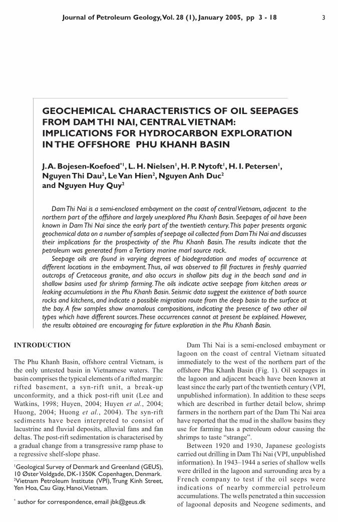
Fig. 1. Location map showing the study area on the coast of Central Vietnam together with the nearby PhuKhanh, Cuu Long and Nam Con Son Basins. Location of seismic profiles shown in Figs. 2 and 11 are indicated.
200 km105 110 115
15
20
CHINA
LAOS
GULF OF TONKIN
THAILAND
CAMBODIA
VIETNAM
BORNEO
HAINAN
(SOUTH CHINASEA)
EAST VIETNAM SEA
PEAL RIVER MOUTH BASIN
BEIBUWANBASIN
SONG HONG BASIN
RED RIVER FAULT
QUANG NGAIBASIN
DA NANG SHEAR ZONE
PHU KHANHBASIN
TUY HOASHEAR ZONE
NAM CON SON BASIN
CUU LONG BASIN
Fig.2Fig.11
StudyArea
QIONGDOGNANBASIN
MALAY BASIN
PATTANIBASIN
10
5 J. A. Bojesen-Koefoed et al.
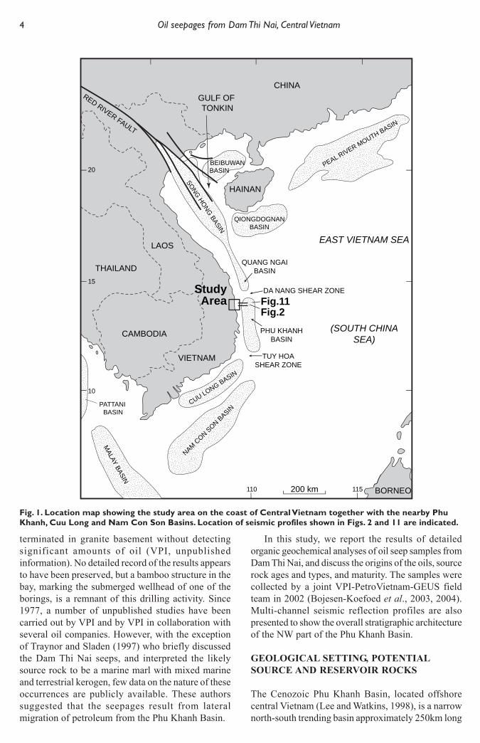
Fig. 2. West-east oriented seismic section across the northern part of the Phu Khanh Basin (profile location inFig.1), illustrating faulted basement overlain by eastward-dipping Cenozoic basin-fill with large basinward-prograding clinoforms (centre). The present-day coastline is located approximately 1.5 km to the west of thesection.
and 50-75km wide. It is bounded by a narrow shelftowards the west and is separated from the Quang Ngaiand Song Hong Basins to the north by the Da Nangshear zone. The Tuy Hoa shear zone separates it fromthe oil-bearing Cuu Long Basin to the south (Canh etal., 1994; Lee et al., 2001). In contrast to the otherCenozoic basins offshore Vietnam, the Phu KhanhBasin is almost unexplored, with only open seismiccoverage. The available multi-channel seismic datawere acquired over a period of 20 years (1974-1993).
Fig. 2 shows a seismic reflection profile from theNW part of the Phu Khanh Basin, immediately eastof the Dam Thi Nai area. The stratigraphicidentification of the key seismic horizons is based onthe correlation to wells in neighbouring basins.
The acoustic basement is cut by east-dipping faultsthat were probably formed during the main riftingphase of the basin, which is thought to have beeninitiated in Eocene-Oligocene times. A shallow, highamplitude eastward-dipping reflector has beenidentified in the western part of the basin; this reflectorhas been interpreted as marking the boundary betweenbasement granites and old sedimentary rocks, and theoverlying Cenozoic siliciclastic succession. Variousintrusive rocks and old sedimentary rocks outcropalong the present-day coastline and are in placesdraped by a thin cover of Neogene sediments.
The syn-rift sediments are characterised by variousreflectance patterns: continuous reflectors, transparentzones, and channel-like features. The continuous
reflectors probably represent lacustrine sediments,whereas the channel-like features suggest a fluvialenvironment, and the transparent zones may representpoorly stratified coarse clastic alluvial fans. The topof the syn-rift succession forms a prominent surfacewhich has been interpreted as the break-upunconformity that marks the beginning of seafloorspreading in the East Vietnam Sea (South China Sea)(Lee and Watkins, 1998).
The Middle Miocene to Recent post-rift successionshows a general pattern of large basinward-progradingclinoforms. It can be divided into eight seismicsequences. These sequences form a wedge-shapedsuccession characterised by a pronounced eastwardthickening from the narrow shelf to the shelf break. Thelower three sequences are relatively thin and theirdistribution is limited by local structural uplift. The upliftnot only caused local intra-basinal erosion but alsocreated localised sediment sinks. The upper fivesequences are more widely distributed and display astepwise upward change from strongly progradingclinoforms with limited aggradation to moderatelyprograding clinoforms with pronounced aggradation. Themarked basinward dip and thickening of the post-riftsuccession further suggests a significant basinward tectonictilting which probably continues at the present day.
The succession is truncated by an unconformitywhich indicates that minor uplift (up to about 300–400m) has occurred along some parts of thewesternmost edge of the basin.
10 km0
1
2
3
Two-
way
trav
el ti
me
(sec
.)
4
5
6
W E
Pliocene–RecentUpper MioceneMiddle MioceneLower MioceneOligocene – ?EoceneAcoustic basement
6 Oil seepages from Dam Thi Nai, Central Vietnam
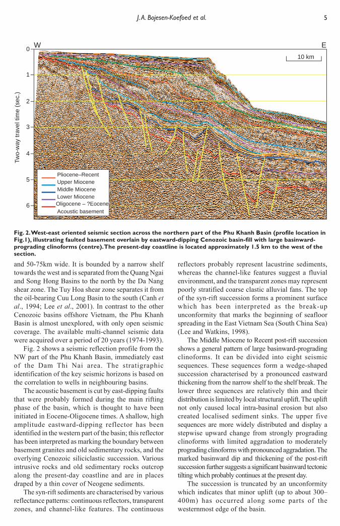
The compilation of the generalised stratigraphy(Fig. 3) of the Phu Khanh Basin, including potentialreservoir and source rocks, is based on an interpretationof seismic reflection data and published reports (Leeand Watkins, 1998; Lee et al., 2001; Houng, 2004;Houng et al., 2004; Huyen, 2004; Huyen et al., 2004;Tang et al., 2004).
Potential reservoirs include fractured and weatheredbasement, fluvial channel sands, coastal sands, slopefans and basin-floor fans. Miocene carbonatecomplexes, which developed on structural highs,probably also form reservoirs (Huong, 2004; Huonget al., 2004).
The most promising source rocks for petroleum inthe Phu Khanh Basin are believed to be Eocene(?)–Oligocene syn-rift deposits with highly oil-pronemudstones (e.g. Wang and Sun, 1994; Leo, 1997; Reid,
1997; Sladen, 1997; Todd et al., 1997; Nielsen etal., 1999; Zhu et al., 1999; Petersen et al., 2001;Petersen et al., 2004,2005). Seismic reflection dataindicate that the syn-rift successions in the Phu KhanhBasin occasionally contain high-amplitudecontinuous reflectors (Huyen, 2004; Huyen et al.,2004), which are known to represent oil-pronelacustrine deposits in other Asian basins (e.g. Leo,1997). Coals that form a significant part of the paralicdeposits constituting the transgressive systems tracts,and starved marine mudstones in the latetransgressive to early highstand systems tracts alsohave source potential.
The seepage oils in the Dam Thi Nai area are foundon the western side of an approximately 700 m wide,faulted and fractured basement horst, which forms thewestern margin of the northern part of the basin.
Fig. 3. Generalised stratigraphic column for the Phu Khan Basin, based on the interpretation of seismicprofiles and comparison with neighbouring basins (e.g. Lee and Watkins, 1998; Lee et al., 2001; Houng et al.,2004; Huyen et al., 2004; Thang et al., 2004). Potential source rocks and reservoirs are indicated.
5
10
West WestEast East
15
20
25
30
35
40
Pre-Cenozoic Acousticbasement
Eoc
ene
Mid
dle
Mid
dle
Late
Late
Late
Ear
lyE
arly
Olig
ocen
eM
ioce
ne
Reg
iona
l sub
side
nce
Mai
n rif
ting
phas
e
Intra
bas
in b
asem
ent h
ighs
Loca
l fau
lting
& u
plift
Plio-cene
Quat.
Age Lithology
Stratigraphy of the Phu Khanh Basin
Tectonicevents
Potentialreservoirs
Potentialsource
rock
Depositionalenvironment
Ma
Innershelf
Coastalplains/deltas/innershelf
Coastalplains/deltas
Outershelf
Alluvial fansand lakes
Alluvial sands
&conglo-merates
Coastal&
fluvialsands
Coastal,fluvial and
shelfsands
Marinemudstones
in distalportionsof latetrans-
gressiveandearly
highstanddeposits
Paralichumic
coals intrans-
gressivecoastalplain
deposits
Lacustrinemudstones
andcoals
Lacustrinemudstones
andcoals
Basinfloorfans
Carb.complexes
Fracturedweatheredbasement
Carbonatebuild ups
on basementhighs
Shelfslope
Base ofslope
Outershelf
Shelfslope
Base ofslope
Openmarine
Fluvialsystems
Fluvialsystems
Lakes, peat-forming-swampslake-deltasfluvial channels &flood plains
7 J. A. Bojesen-Koefoed et al.
SAMPLES AND METHODS
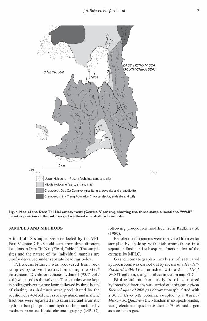
A total of 18 samples were collected by the VPI-PetroVietnam-GEUS field team from three differentlocations in Dam Thi Nai (Fig. 4, Table 1). The samplesites and the nature of the individual samples arebriefly described under separate headings below.
Petroleum/bitumen was recovered from rocksamples by solvent extraction using a soxtec®
instrument. Dichloromethane/methanol (93/7 vol./vol.) was used as the solvent. The samples were keptin boiling solvent for one hour, followed by three hoursof rinsing. Asphaltenes were precipitated by theaddition of a 40-fold excess of n-pentane, and maltenefractions were separated into saturated and aromatichydrocarbon plus polar non-hydrocarbon fractions bymedium pressure liquid chromatography (MPLC),
following procedures modified from Radke et al.(1980).
Petroleum components were recovered from watersamples by shaking with dichloromethane in aseparator flask, and subsequent fractionation of theextracts by MPLC.
Gas chromatographic analysis of saturatedhydrocarbons was carried out by means of a Hewlett-Packard 5890 GC, furnished with a 25 m HP-1WCOT column, using splitless injection and FID.
Biological marker analysis of saturatedhydrocarbon fractions was carried out using an AgilentTechnologies 6890N gas chromatograph, fitted witha 30 m HP-5 MS column, coupled to a Waters/Micromass Quattro-Micro tandem mass spectrometer,using electron impact ionisation at 70 eV and argonas a collision gas.
Fig. 4. Map of the Dam Thi Nai embayment (Central Vietnam), showing the three sample locations. “Well”denotes position of the submerged wellhead of a shallow borehole.
EAST VIETNAM SEA(SOUTH CHINA SEA)
DÂM THI NAI
2 km
10915' 10919'1345'
100
100
100
100
200
200
100
3
2
1 Well
Upper Holocene – Recent (pebbles, sand and silt)
Middle Holocene (sand, silt and clay)
Cretaceous Deo Ca Complex (granite, granosyenite and granodiorite)
Cretaceous Nha Trang Formation (rhyolite, dacite, andesite and tuff)
8 Oil seepages from Dam Thi Nai, Central Vietnam
Table 1. Sample list. Oil type 1: “Dam Thi Nai oil”; oil type 2: single sample lacustrine oil; oil type 3: oil onshoreline vegetation
SAMPLE SITES
The three sample sites in the Dam Thi Nai Embaymentare located in Fig. 4.
Sample site 1Two samples (8615 and 8616: Table 1) were collectedat sampling site 1, situated on the north-facing shorein the southern part of Dam Thi Nai near the mouth ofthe embayment. The material sampled consists of smallpatches of black material, presumed to be oil orbitumen, that occur on the surface of Cretaceousgranites which are exposed in the intertidal zone.
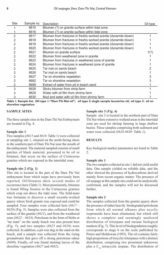
Sample site 2 (Fig. 5)This site is located in the part of the Dam Thi Naiembayment from which seeps have previously beenreported. Oil/bitumen show several modes ofoccurrence here (Table 1). Most prominently, bitumenis found filling fissures in the Cretaceous graniteswhich crop out above the tidal zone. The field-teamwas fortunate to discover a small recently-workedquarry where fresh granite was exposed and could besampled. Four samples were collected here (8617 –8620) (Fig. 5). Samples were also collected from thesurface of the granite (8621), and from the weatheredzone (8622 – 8624). Petroleum in the form of blobs or“tar mats” on the sandy beach was also present here(Fig. 5), and two samples (8625 and 8626) werecollected. In addition, a pit was dug in the sand on thebeach, and a sample was collected from the risinggroundwater that gave off a strong petroleum odour(8699). Finally, oil was found staining leaves of theshoreline vegetation (8627 and 8682).
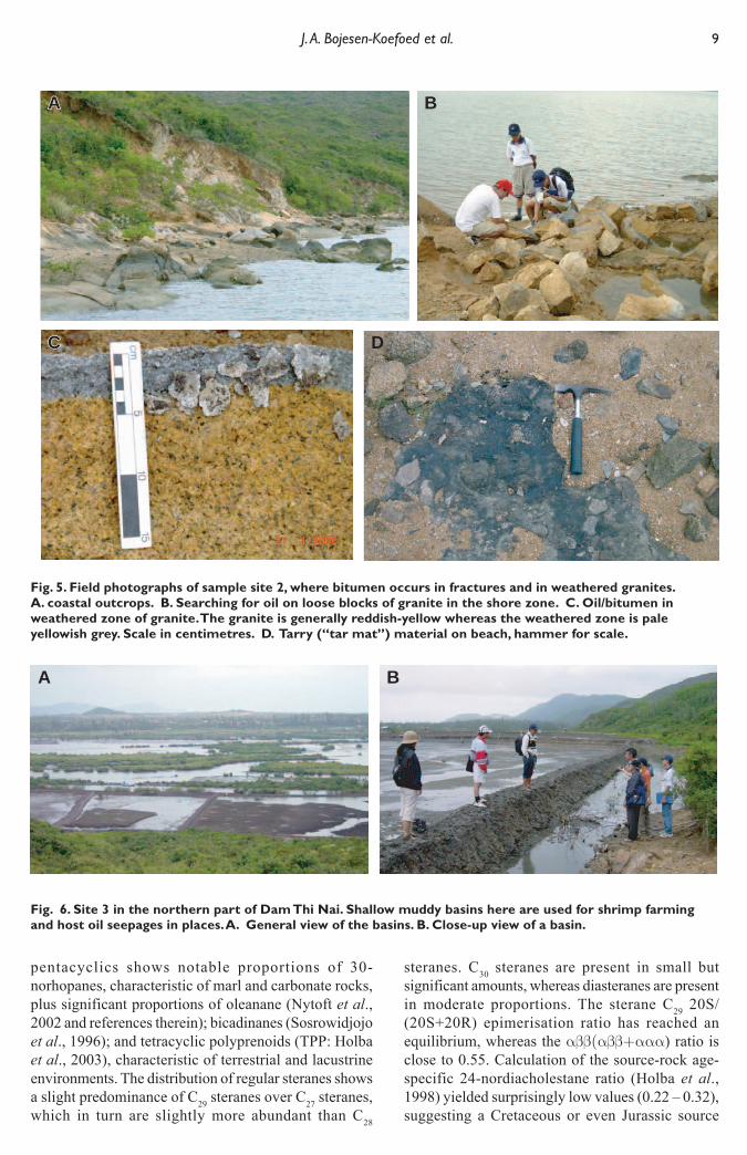
Sample site 3 (Fig. 6)Sample site 3 is located in the northern part of DamThi Nai where extensive wetland areas in the intertidalzone are used for shrimp farming in large shallowbasins. Three samples comprising both sediment andwater were collected (8628-8630: Table 1).
RESULTS
Key biological marker parameters are listed in Table2.
Sample site 1The two samples collected at site 1 did not yield usefuldata. One sample yielded no reliable data, and theother showed the presence of hydrocarbons derivedmainly from recent organic matter. The presence ofoil seepage at this sample site could not be analyticallyconfirmed, and the samples will not be discussedfurther.
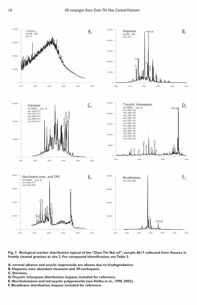
Sample site 2The samples collected from the granite quarry showthe presence of rather heavily biodegraded petroleumfrom which all normal alkanes plus acyclicisoprenoids have been eliminated, but which stillshows a complete and seemingly unaltereddistribution of triterpane and sterane biologicalmarkers (Fig. 7). This level of biodegradation roughlycorresponds to stage 6 on the scale published byPeters and Moldowan (1993). The oil contains fairlyhigh proportions of tricyclic triterpanes with a distinctdistribution, comprising two prominent unknownsplus a C24 tetracyclic terpane. The distribution of
9 J. A. Bojesen-Koefoed et al.
Fig. 5. Field photographs of sample site 2, where bitumen occurs in fractures and in weathered granites.A. coastal outcrops. B. Searching for oil on loose blocks of granite in the shore zone. C. Oil/bitumen inweathered zone of granite. The granite is generally reddish-yellow whereas the weathered zone is paleyellowish grey. Scale in centimetres. D. Tarry (“tar mat”) material on beach, hammer for scale.
pentacyclics shows notable proportions of 30-norhopanes, characteristic of marl and carbonate rocks,plus significant proportions of oleanane (Nytoft et al.,2002 and references therein); bicadinanes (Sosrowidjojoet al., 1996); and tetracyclic polyprenoids (TPP: Holbaet al., 2003), characteristic of terrestrial and lacustrineenvironments. The distribution of regular steranes showsa slight predominance of C29 steranes over C27 steranes,which in turn are slightly more abundant than C28
steranes. C30 steranes are present in small butsignificant amounts, whereas diasteranes are presentin moderate proportions. The sterane C29 20S/(20S+20R) epimerisation ratio has reached anequilibrium, whereas the αββ(αββ+ααα) ratio isclose to 0.55. Calculation of the source-rock age-specific 24-nordiacholestane ratio (Holba et al.,1998) yielded surprisingly low values (0.22 – 0.32),suggesting a Cretaceous or even Jurassic source
AA
C
A B
DC
Fig. 6. Site 3 in the northern part of Dam Thi Nai. Shallow muddy basins here are used for shrimp farmingand host oil seepages in places. A. General view of the basins. B. Close-up view of a basin.
A B
10 Oil seepages from Dam Thi Nai, Central Vietnam
Fig. 7. Biological marker distribution typical of the “Dam Thi Nai oil”, sample 8617 collected from fissures infreshly cleaved granites at site 2. For compound identification, see Table 3.
A. normal alkanes and acyclic isoprenoids are absent due to biodegradation.B. Hopanes, note abundant oleanane and 30-norhopane.C. Steranes.D. Tricyclic triterpane distribution, hopane included for reference.E. Norcholestanes and tetracyclic polyprenoids (see Holba et al., 1998, 2003).F. Bicadinane distribution, hopane included for reference.
11 J. A. Bojesen-Koefoed et al.
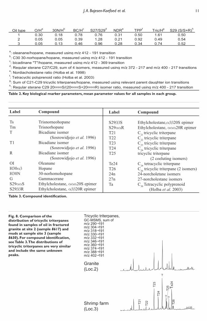
Fig. 8. Comparison of thedistribution of tricyclic triterpanesfound in samples of oil in fracturedgranite at site 2 (sample 8617) andmuds at sample site 3 (sample8630). For compound identification,see Table 3.The distributions oftricyclic triterpanes are very similarand include the same unknownpeaks.
Table 3. Compound identification.
Table 2. Key biological marker parameters, mean parameter values for all samples in each group.
Label Compound
Ts TrisnorneohopaneTm TrisnorhopaneT Bicadiane isomer
(Sosrowidjojo et al. 1996)T1 Bicadiane isomer
(Sosrowidjojo et al. 1996)R Bicadiane isomer
(Sosrowidjojo et al. 1996)OI OleananeH30αβ HopaneH30N 30-norhomohopaneG GammaceraneS29ααS Ethylcholestane, ααα20S epimerS29ββR Ethylcholestane, αββ20R epimer
Label Compound
S29ββS Ethylcholestane,αββ20S epimerS29ααR Ethylcholestane, ααα20R epimerT21 C21 tricyclic triterpaneT22 C22 tricyclic triterpaneT23 C23 tricyclic triterpaneT24 C24 tricyclic triterpaneT25 tricyclic triterpane
(2 coeluting isomers)Te24 C24 tetracyclic triterpaneT26 C26 tricyclic triterpane (2 isomers)24n 24-norcholetane isomers27n 27-norcholestane isomersTa C30 Tetracyclic polyprenoid
(Holba et al. 2003)
12 Oil seepages from Dam Thi Nai, Central Vietnam
rock age. This, however, is not consistent with the highproportions of oleanane which suggests a Tertiary agefor the source rock.
Other samples collected at site 2 have been exposedto weathering for longer periods of time than thosesamples taken from the granite quarry. They generallyshow the same geochemical characteristics as thoseoutlined above, although minor variations areobserved. Of particular interest is that sample 8699,taken from water rising in the beach pit, shows a nearperfect match to the oils described above.
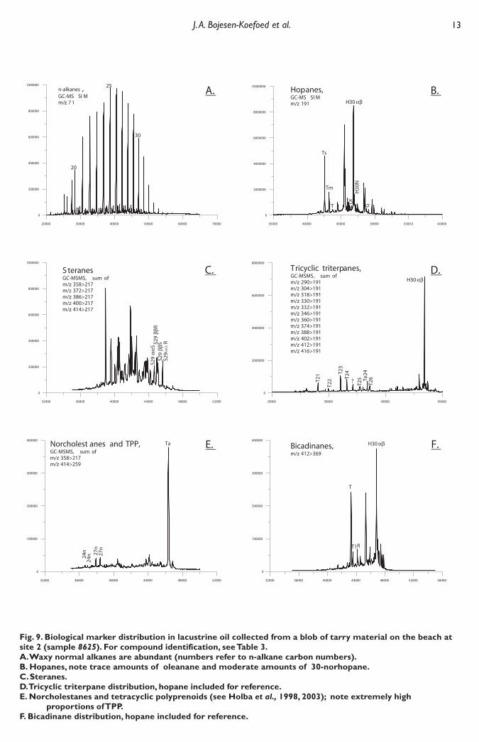
Three samples collected at site 2 show entirelydifferent characteristics. One sample (8625), whichcomprised a blob of tarry material from the beach,was characterized by the presence of a high-wax, non-biodegraded oil with a very high estimated hopane/sterane ratio (signal count, highest hopane to higheststerane); very high concentrations of TPP; and a ratherlow abundance of bicadinanes (Fig. 9). The oilcontains only minor concentrations of oleanane andgammacerane, and the distribution of tricyclictriterpanes is different from that observed in oils fromthe granite at site 2. The characteristics of this sampleare thus clearly different from those displayed by theoil recovered from the nearby granite. However, thecharacteristics of sample 8625 are largely identical tothose of Cenozoic lacustrine oils found elsewhere inVietnam, for instance in the Song Hong Basin,northern Vietnam (Petersen et al., 2004, 2005).
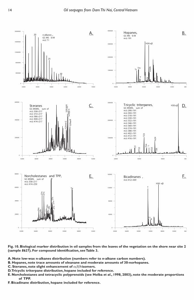
Two samples collected from the leaves ofvegetation in the intertidal zone a short distance fromsample site 2 (8627 and 8682) showed the presenceof fresh non-biodegraded oil with a biological markersignature that suggests its generation from a carbonateor marl source rock (Fig. 10). The oil has a highabundance of 30-norhopanes, slight enhancement ofαββ-sterane isomers, low concentrations of TPP andbicadinanes, traces of oleanane, and a distribution oftricyclic triterpanes which is different from both thatobserved in the oils sampled from the granite at site 2and from that of sample 8625 described above.
In addition, one biodegraded sample (8621) shows amolecular signature that for certain parameters(proportion of oleanane and 30-norhopanes, steranedistribution) seem to have some affinity to either of allthree oil types, and for others (proportions of bicandinanesand tricylic triterpanes) to have affinity to neither of theoil types. The variation does not, however, justify theseparation of this oil into its own group, and it is thusincluded into the main group of oils (Table 1).
Sample site 3Three samples were collected from the shallow basinsin the northern part of the embayment (Fig. 6), and allreveal the presence of severely degraded petroleum.The level of degradation varies somewhat, but both
hopane and sterane biomarkers are influenced,rendering maturity estimation difficult due topreferential degradation of sterane 20R-epimers, andleaving unaffected only robust biomarkers such asgammacerane, oleanane and bicadinanes, and TPPplus tricyclic triterpanes. The level of biodegradationroughly corresponds to stage 7 or 8 on the scale ofPeters and Moldowan (1993). Correlation to other oilsor to potential source rocks using the suite ofbiological marker parameters commonly applied, isvery difficult due to severe biodegradation. However,the distribution of tricyclic triterpanes seems to beunaffected, which is not surprising since thesecompounds are known to be very refractory towardsbiodegradation. The distribution of tricyclic triterpanesfound in the samples from location 3 is more or lessidentical to that of the oils sampled from the freshgranite outcrop at site 2, and includes the sameprominent unknown peaks plus notable proportionsof the well-known C24 tetracylic terpane (Fig 8).
DISCUSSION
Except for three “anomalous” samples notedpreviously, the biological marker signature of the oilsamples from the granite quarry and from the othersample sites at site 2 point to generation from a mixedmarl/carbonate and terrigenous source rock which isat early to peak maturity. The source rock may be aTertiary marine marl with some terrestrial input orperhaps a heterolithic succession that includes bothterrestrial/lacustrine and marine marly lithologies. Thesamples’ observed characteristics are very similar tothose of Tertiary source rock extracts from the NamCon Son Basin (VPI, unpublished data), and also tooil shows recorded in various offshore wells (Traynorand Sladen, 1997; VPI, unpublished data). This pointsto the presence of an active petroleum system in thisarea, although more data and samples from the PhuKhanh Basin are required to confirm the oil-sourcerock correlation.
The inconsistency between the Mezozoic sourcerock age indicated by the nordiacholestane ratio(NDR) and the Tertiary age indicated by the presenceof abundant angiosperm-derived oleanane is notsurprising. Holba et al. (1998) note that certainCretaceous–Tertiary low-latitude samples tend to yieldanomalously low NDR, and hence misleadingindications of the source rock age.
Mud samples collected at site 3 in the northernpart of the lagoon show the presence of severelybiodegraded petroleum which contains very fewrecognisable biological markers. However, thedistribution of tricylic triterpanes is very similar tothat of the petroleum in the samples from the granitequarry in the eastern part of the bay. Although the oils
13 J. A. Bojesen-Koefoed et al.
Fig. 9. Biological marker distribution in lacustrine oil collected from a blob of tarry material on the beach atsite 2 (sample 8625). For compound identification, see Table 3.A. Waxy normal alkanes are abundant (numbers refer to n-alkane carbon numbers).B. Hopanes, note trace amounts of oleanane and moderate amounts of 30-norhopane.C. Steranes.D. Tricyclic triterpane distribution, hopane included for reference.E. Norcholestanes and tetracyclic polyprenoids (see Holba et al., 1998, 2003); note extremely high
proportions of TPP.F. Bicadinane distribution, hopane included for reference.
14 Oil seepages from Dam Thi Nai, Central Vietnam
Fig. 10. Biological marker distribution in oil samples from the leaves of the vegetation on the shore near site 2(sample 8627). For compound identification, see Table 3.
A. Note low-wax n-alkanes distribution (numbers refer to n-alkane carbon numbers).B. Hopanes, note trace amounts of oleanane and moderate amounts of 30-norhopanes.C. Steranes, note slight enhancement of αββ-isomers.D. Tricyclic triterpane distribution, hopane included for reference.E. Norcholestanes and tetracyclic polyprenoids (see Holba et al., 1998, 2003), note the moderate proportions
of TPP.F. Bicadinane distribution, hopane included for reference.
15 J. A. Bojesen-Koefoed et al.
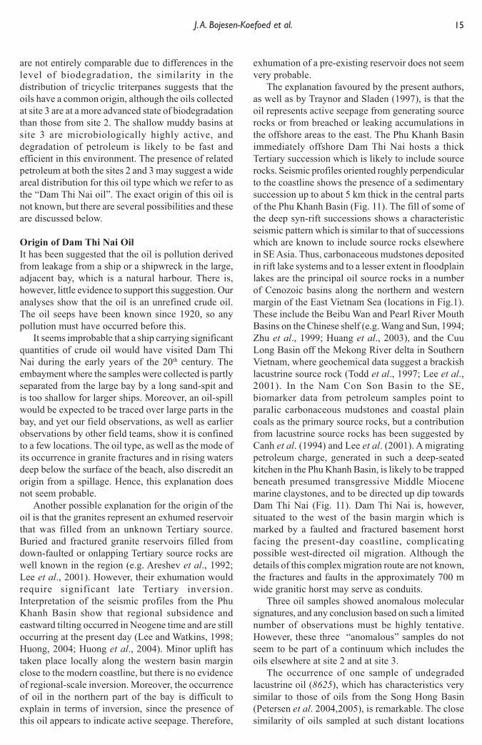
are not entirely comparable due to differences in thelevel of biodegradation, the similarity in thedistribution of tricyclic triterpanes suggests that theoils have a common origin, although the oils collectedat site 3 are at a more advanced state of biodegradationthan those from site 2. The shallow muddy basins atsite 3 are microbiologically highly active, anddegradation of petroleum is likely to be fast andefficient in this environment. The presence of relatedpetroleum at both the sites 2 and 3 may suggest a wideareal distribution for this oil type which we refer to asthe “Dam Thi Nai oil”. The exact origin of this oil isnot known, but there are several possibilities and theseare discussed below.
Origin of Dam Thi Nai OilIt has been suggested that the oil is pollution derivedfrom leakage from a ship or a shipwreck in the large,adjacent bay, which is a natural harbour. There is,however, little evidence to support this suggestion. Ouranalyses show that the oil is an unrefined crude oil.The oil seeps have been known since 1920, so anypollution must have occurred before this.
It seems improbable that a ship carrying significantquantities of crude oil would have visited Dam ThiNai during the early years of the 20th century. Theembayment where the samples were collected is partlyseparated from the large bay by a long sand-spit andis too shallow for larger ships. Moreover, an oil-spillwould be expected to be traced over large parts in thebay, and yet our field observations, as well as earlierobservations by other field teams, show it is confinedto a few locations. The oil type, as well as the mode ofits occurrence in granite fractures and in rising watersdeep below the surface of the beach, also discredit anorigin from a spillage. Hence, this explanation doesnot seem probable.
Another possible explanation for the origin of theoil is that the granites represent an exhumed reservoirthat was filled from an unknown Tertiary source.Buried and fractured granite reservoirs filled fromdown-faulted or onlapping Tertiary source rocks arewell known in the region (e.g. Areshev et al., 1992;Lee et al., 2001). However, their exhumation wouldrequire significant late Tertiary inversion.Interpretation of the seismic profiles from the PhuKhanh Basin show that regional subsidence andeastward tilting occurred in Neogene time and are stilloccurring at the present day (Lee and Watkins, 1998;Huong, 2004; Huong et al., 2004). Minor uplift hastaken place locally along the western basin marginclose to the modern coastline, but there is no evidenceof regional-scale inversion. Moreover, the occurrenceof oil in the northern part of the bay is difficult toexplain in terms of inversion, since the presence ofthis oil appears to indicate active seepage. Therefore,
exhumation of a pre-existing reservoir does not seemvery probable.
The explanation favoured by the present authors,as well as by Traynor and Sladen (1997), is that theoil represents active seepage from generating sourcerocks or from breached or leaking accumulations inthe offshore areas to the east. The Phu Khanh Basinimmediately offshore Dam Thi Nai hosts a thickTertiary succession which is likely to include sourcerocks. Seismic profiles oriented roughly perpendicularto the coastline shows the presence of a sedimentarysuccession up to about 5 km thick in the central partsof the Phu Khanh Basin (Fig. 11). The fill of some ofthe deep syn-rift successions shows a characteristicseismic pattern which is similar to that of successionswhich are known to include source rocks elsewherein SE Asia. Thus, carbonaceous mudstones depositedin rift lake systems and to a lesser extent in floodplainlakes are the principal oil source rocks in a numberof Cenozoic basins along the northern and westernmargin of the East Vietnam Sea (locations in Fig.1).These include the Beibu Wan and Pearl River MouthBasins on the Chinese shelf (e.g. Wang and Sun, 1994;Zhu et al., 1999; Huang et al., 2003), and the CuuLong Basin off the Mekong River delta in SouthernVietnam, where geochemical data suggest a brackishlacustrine source rock (Todd et al., 1997; Lee et al.,2001). In the Nam Con Son Basin to the SE,biomarker data from petroleum samples point toparalic carbonaceous mudstones and coastal plaincoals as the primary source rocks, but a contributionfrom lacustrine source rocks has been suggested byCanh et al. (1994) and Lee et al. (2001). A migratingpetroleum charge, generated in such a deep-seatedkitchen in the Phu Khanh Basin, is likely to be trappedbeneath presumed transgressive Middle Miocenemarine claystones, and to be directed up dip towardsDam Thi Nai (Fig. 11). Dam Thi Nai is, however,situated to the west of the basin margin which ismarked by a faulted and fractured basement horstfacing the present-day coastline, complicatingpossible west-directed oil migration. Although thedetails of this complex migration route are not known,the fractures and faults in the approximately 700 mwide granitic horst may serve as conduits.
Three oil samples showed anomalous molecularsignatures, and any conclusion based on such a limitednumber of observations must be highly tentative.However, these three “anomalous” samples do notseem to be part of a continuum which includes theoils elsewhere at site 2 and at site 3.
The occurrence of one sample of undegradedlacustrine oil (8625), which has characteristics verysimilar to those of oils from the Song Hong Basin(Petersen et al. 2004,2005), is remarkable. The closesimilarity of oils sampled at such distant locations
16 Oil seepages from Dam Thi Nai, Central Vietnam
suggests that lacustrine source rocks occur widelyoffshore Central and Northern Vietnam. Theabandoned but apparently imperfectly pluggedshallow well drilled into the basement in the centralpart of the bay, less than one kilometre from thesampling site, may periodically leak oil. Therefore,the blob of tarry material may have formed followingone such episode of leakage. This would imply localgeneration from a pod of lacustrine source rock; this,however, is unlikely to have occurred becauseNeogene deposits are at most a few hundreds of metresthick in Dam Thi Nai. Active seepage on the beach islikely to occur, but the oil type found in pits dug inthe beach does not match the lacustrine oil. Insummary, the possible unravelling of the origin of thelacustrine oil represented by sample 8625 requiresadditional fieldwork and sampling.
The two oil samples collected from the surface ofleaves of shoreline vegetation near site 2 (8627 and8682) were probably generated from a Tertiary marinemarl which does not seem to be identical to the sourceof the “Dam Thi Nai oil” as defined above. Notabledifferences include the distribution of tricyclictriterpanes, and the abundance of oleanane, tetracyclicpolyprenoid alkanes (TPP) and bicadinanes relativeto various triterpane and sterane biological markers.Based on the presence of bicadinanes, the oil is
probably of SE Asian origin, but the background forits presence in Dam Thi Nai remains elusive.
CONCLUSIONS
On the basis of the results presented in this paper, weconclude that active petroleum seepage is taking placein Dam Thi Nai on the coast of Central Vietnam. Oilprincipally occurs in fissures in Cretaceous granites,and related oils at a more advanced state ofbiodegradation are also found in mud samples fromthe northern part of the bay. In addition, a few samplesyielded oils showing entirely different characteristics.We recognize the presence of three different oil typesin the study area, only one of which has a significantareal distribution:
(i) A lacustrine oil, represented by a single tarsample, is very similar to oils generated fromOligocene lacustrine mudstones in the Song HongBasin offshore Northern Vietnam.
(ii) Oil sampled from leaves of shoreline vegetationis probably derived from a marl/carbonate source rock.Its presence in Dam Thi Nai cannot satisfactorily beexplained with the data available.
(iii) Oil sampled from fissures in granites, from a“tar mat” and from a pit dug in the beach, togetherwith a relatively biodegraded version collected from
Fig. 11. West-east oriented seismic profile across the northern Phu Khanh Basin (for profile location, see Fig.1). The profile displays a general eastward thickening and dip of the basin fill. Continuous high-amplitudereflectors occur in the syn-rift successions, which are interpreted as compristing lacustrine mudstones withcoal seams. By analogy with the neighbouring Cuu Long and Nam Con Son Basins, a transgressive marinemudstone succession is interpreted to occur within the Miocene. This horizon may have served as a regionalseal which trapped generated hydrocarbons and forced them up-dip to the Dam Thi Nai area which is locatedless than 1.5 km to the west of the profile.
0
1
10 km
Middle Miocenemarine mudstone
2
3
Two-
way
trav
el ti
me
(sec
.)
4
5
6
Kitchen
W E
Pliocene–RecentUpper MioceneMiddle MioceneLower MioceneOligocene – ?EoceneAcoustic basement
17 J. A. Bojesen-Koefoed et al.
the northern part of Dam Thi Nai, appear to belong toa single, widespread oil family which we refer to asthe “Dam Thi Nai oil”. Although biodegraded tovarying degrees, this oil shows biological markercharacteristics closely resembling those of extracts ofCenozoic rocks recovered from the Nam Con SonBasin to the south of Dam Thi Nai. They indicate anorigin from a mixed source, probably a marine marlwith minor terrigenous input. The petroleum wasprobably generated in deep-seated kitchen areas, thepresence of which in the Phu Khanh Basin has beensuggested by seismic data. Migration from down-dipkitchen areas in the Phu Khanh Basin possibly tookplace beneath a tight Miocene marine mudstone andalong faults and fractures in the coastal granites.
These results indicate the presence of a livepetroleum system in the Phu Khanh Basin, and arethus encouraging for future exploration.
ACKNOWLEDGEMENTS
This paper builds on long-term co-operation betweenVPI, PetroVietnam and GEUS that has been supportedfinancially by the Energy Research Programme at theDanish Energy Agency, the Royal Danish Embassiesin Hanoi and Bangkok, the Danida Fellowship Centre,and Danida. The results presented here would not havebeen achieved without the support of a large numberof individuals at Vietnam Petroleum Institute,PetroVietnam, the Geological Divisions in Nha Trangand Qui Nhon, and GEUS, who are thanked for theirencouragement and support. VPI, PetroVietnam andGEUS are acknowledged for institutional support,provision of manpower, access to samples and data,and permission to publish the results. Constructivereviews by Drs. G. H. Lee and D. M. McKirdy aregratefully acknowledged. Mass Spectrometricinstrumentation was acquired through financialsupport from the Danish Natural Science ResearchCouncil (grant no. 21-02-0344)
REFERENCES
ARESHEV, E. G., DONG, T. L., SAN, N. T. and SHNIP , O. A.1992. Reservoirs in fractured basement on the continentalshelf of southern Vietnam. Journal of Petroleum Geology,15,451-464.
BOJESEN-KOEFOED, J.A., NYTOFT, H.P., DAU, N.T., HA,N.T.B., HIEN, L.V., QUY, N.H., NIELSEN, L.H. andPETERSEN, H.I., 2003. Geochemical charcteristics of seepoils from Dam Thi Nai (Qui Nhon), central Vietnam –implications for exploration in the offshore Phu KhanhBasin. In: Abstracts Part 2, pp. 193–194. 21st InternationalMeeting on Organic Geochemistry. 8–12 September,Krakow, Poland.
BOJESEN-KOEFOED, J.A., NYTOFT, H.P., DAU, N.T., HA,N.T.B., HIEN, L.V., QUY, N.H., NIELSEN, L.H. andPETERSEN, H. I., 2004. Seep oils from Dam Thi Nai (Qui
Nhon), Central Vietnam; the ENRECA-project reportspromising implications for the future exploration in theoffshore Phu Khanh Basin. In: T. JARUPONGSAKUL and Y.SAITO (Eds), 5th International Conference on Asian MarineGeology. IGCP475 DeltaMap/APN Mega-Delta, 13–18January, Bangkok, Thailand, p. 25.
CANH, T., HA, D.V., CARSTENS, H. and BERSTAD, S., 1994.Viet Nam - attractive plays in a new geological province.Oil and Gas Journal, March 14, 78-83.
HOLBA, A. G., DZOU, L. I., WOOD, G. D., ELLIS, L., ADAM, P.,SCHAEFFER, P., ALBRECHT, P., GREENE, T. and HUGHES,W. B., 2003. Application of tetracyclic polyprenoids asindicators of input from fresh-brackish waterenvironments. Organic Geochemistry, 34, 441-469.
HOLBA, A. G., DZOU, L. I. P., MASTERSON, W. D., HUGHES,W. B., HUIZINGA, B. J., SINGLETARY, M. S., MOLDOWAN,J. M., MELLO, M. R. and TEGELAAR, E., 1998. Applicationof 24-norcholestanes for constraining source age ofpetroleum. Organic Geochemistry, 29, 1269-1283.
HUANG, B., XIAO, X. and ZHANG, M., 2003. Geochemistry,grouping and origins of crude oils in the Western PearlRiver Mouth Basin, offshore South China Sea. OrganicGeochemistry, 34, 993–1008.
HUONG, D.T., 2004. Phuon Phap Dia Tang Va Ung Dung DeXác Dinh Cau Trúc Dia Chat Tap Tram Tích Sau Tách DanBe Phú Khánh. Hanoi University of Mining and Geology,M.Sc. Thesis (in Vietnamese) 107 pp.
HUONG, D.T., THANG, L.D., HUYEN, N.T., BOLDREEL,L.O., NIELSEN, L.H., ABATZIS, I., DUC, N. A. and FYHN,M.W. , 2004. Depositional history of the post-rift successionof the Phu Khanh Basin, offshore central Vietnam basedon interpretation of seismic sequences and facies: firstresults of the ENRECA-Project. In: T. JARUPONGSAKULand Y. SAITO (Eds), 5th International Conference on AsianMarine Geology. IGCP475 DeltaMap/APN Mega-Delta, 13–18 January, Bangkok, Thailand, p. 70.
HUYEN, N.T., 2004. Ap Dung Phuon Pháp Dia Chan - DiaTang De Minh Giai Tài Lieu Dia Chan Lát Cat Tram TíchDong Tách Gian Be Phú Khánh, Them Luc Dia Viet Nam.Hanoi University of Mining and Geology, M.Sc. Thesis (inVietnamese) 50 pp.
HUYEN, N.T., THANG, L.D., HUONG, D.T., BOLDREEL, L.O.,NIELSEN, L.H., ABATZIS, I., DUC, N.A. and FYHN, M.B.W.,2004. Structural development of the Cenozoic Phu KhanhBasin, offshore central Vietnam based on interpretation ofreflection seismic data; first results of the ENRECA-Project.In: T. JARUPONGSAKUL and Y. SAITO (Eds), 5th
International Conference on Asian Marine Geology.IGCP475 DeltaMap/APN Mega-Delta, 13–18 January,Bangkok, Thailand, p. 71.
LEE, G. H. and WATKINS, J. S., 1998. Seismic sequencestratigraphy and hydrocarbon potential of the Phu KhanhBasin, offshore central Vietnam, South China Sea. AAPGBull.,82, 1711-1735.
LEE, G. H , LEE, K. and WATKINS, J. S. 2001. Geologic evolutionof the Cuu Long and Nam Con Son basins offshoresouthern Vietnam, South China Sea. AAPG Bull., 85, 1055-1082.
LEO, C. T. A. M., 1997. Exploration in the Gulf of Thailand indeltaic reservoirs related to the Bongkot Field. In: FRASER,A. J., MATTHEWS, S. J. and MURPHY, R. W. (Eds.), PetroleumGeology of Southeast Asia. Geological Society London SpecialPublication., 126, 77–87.
NIELSEN, L.H., MATHIESEN, A., BIDSTRUP, T., VEJBÆK, O.V.,DIEN, P.T., and TIEM, P.V., 1999. Modelling of hydrocarbongeneration in the Cenozoic Song Hong Basin, Vietnam: ahighly prospective basin. Journal of Asian Earth Sciences, 17,269–294.
NYTOFT, H.P., BOJESEN-KOEFOED, J.A., CHRISTIANSEN, F.G.and FOWLER, M.G., 2002. Oleanane or lupane: reappraisal
18 Oil seepages from Dam Thi Nai, Central Vietnam
SLADEN, C., 1997. Exploring the lake basins of east andsoutheast Asia. In: Fraser, A.J., Matthews, S. J., Murphy, R.W.(Eds.), Petroleum geology of southeast Asia. GeologicalSociety London Special Publication, 126, 49–76.
SOSROWIDJOJO, I.B., MURRAY, A.P., ALEXANDER, R., KAGI,R. and SUMMONS, R., 1996. Bicadinanes and relatedcompounds as maturity indicators for oils and sediments.Organic Geochemistry, 24, 43–55
THANG, L.D., HUONG, D.T., HUYEN, N.T., BOLDREEL, L.O.,NIELSEN, L.H., ABATZIS, I. and DUC, N.A., 2004. Anattempt to predict lithology and ages of depositionalsequences from seismic analysis in the Phu Khanh Basin,offshore central Vietnam; preliminary results of theENRECA-Project. In: T. JARUPONGSAKUL and Y. SAITO(Eds): 5th International Conference on Asian MarineGeology. IGCP475 DeltaMap/APN Mega-Delta, 13–18January, Bangkok, Thailand, pp. 208–209.
TODD, S.P., DUNN, M.E. and BARWISE, A.J.G., 1997.Characterizing petroleum charge systems in the Tertiaryof SE Asia. In: Fraser, A.J., Matthews, S.J., Murphy, R.W. (Eds.),Petroleum geology of southeast Asia. Geological SocietyLondon Special Publication, 126, 25–47.
TRAYNOR, J. J. and SLADEN, C., 1997. Seepage in Vietnam –onshore and offshore examples. Marine and PetroleumGeology, 14, 345-362.
WANG, C. and SUN, Y., 1994. Development of Paleogenedepressions and deposition of lacustrine source rocks inthe Pearl River Mouth Basin, northern margin of the SouthChina Sea. AAPG Bull., 78, 1711–1728.
ZHU, W., LI, M., and WU, P., 1999. Petroleum systems of theZhu III Subbasin, Pearl River Mouth Basin, South ChinaSea. AAPG Bull., 83, 990–1003.
of the presence of oleanane in Cretaceous–Tertiary oilsand sediments. Organic Geochemistry, 33, 1225–1240
PETERS, K. E. and MOLDOWAN, J. M., 1993. The biomarkerguide. Prentice Hall, Englewood Cliffs, New Jersey, 363 pp.
PETERSEN H. I., ANDERSEN, C., ANH, P. H., BOJESEN-KOEFOED J. A., NIELSEN, L. H., NYTOFT, H. P.,ROSENBERG, P. and THANH, L., 2001. Petroleum Potentialof Oligocene lacustrine mudstones and coals at Dong Ho,Vietnam - an outcrop analogue to terrestrial source rocksin the greater Song Hong Basin. Journal of Asian EarthSciences, 19, 135-154.
PETERSEN, H. I., NYTOFT, H. P. and NIELSEN, L. H., 2004.Characterisation of oil and potential source rocks in thenorthern Song Hong Basin, Vietnam: indications of alacustrine-coal sourced petroleum system. OrganicGeochemistry, 35, 493-515
PETERSEN, H., I., VU TRU, L. H. NIELSEN, NGUYEN A. DUCand H. P. NYTOFT, 2005 (this issue). Source rock propertiesof lacustrine mudstones and coals (Oligocene Dong HoFormation), onshore Song Hong Basin, northern Vietnam.Joun. Petrol. Geol., 28 (1), 000 - 000.
RADKE, M., WILLSCH, H. and WELTE, D.H., 1980. Preparativehydrocarbon group type determination by automatedMedium Pressure Liquid Chromatography. AnalyticalChemistry, 52, 406-411.
REID, I.S.A., 1997. Petroleum exploration in Vietnam. PetroMin,July, 32–34.
SAVINYKH, Y. V., DONG, T. L., NGHIA, N. C., GOLOVKO, A. K.and PEVNEVA, G. S., 2001. Hydrocarbon compositionalvariations in crude oils fields of Vietnam. Abstract P/TUE/13, 20th International Meeting on Organic Geochemistry ,Nancy, France, pp. 421-422.


![[Y2 b][online case study][ngan khanh team]](https://img.pdfslide.us/doc/110x75/55a36b501a28ab3d108b477b/y2-bonline-case-studyngan-khanh-team.jpg)


![[Report] vu khanh linh](https://img.pdfslide.us/doc/110x75/55cfe635bb61eb38468b46af/report-vu-khanh-linh.jpg)