Embed Size (px)
Citation preview
When the Weather Becomes Deadly
(in the Greater Varna area)
Simon St.LaurentJanuary 26, 2012

At a complicated intersection
● Varna is NOT in 'Tornado Alley' or hurricane territory, but...
● We get a combination of:● continental weather coming from the west● arctic weather coming from the north● Atlantic weather coming from the south and
occasionally east.
● Usually weather comes from the west, but it can shift around and complicate forecasting.

Yes, it can happen here
● Floods – 1935, 1954 (Hazel), 1972 (Agnes), 1981, 2011 just a little further east
● Blizzards – 1914, 1945, 1958, 1993, 2003● Extreme temperatures - 103 in 1936 and -35 in
1934● Tornadoes and windstorms – 1969 - Dryden,
1983 - Varna, 1994 - Dryden, 1996 - Etna

Floods
● 1935 – disastrous in unsuspecting Trumansburg, serious in Dryden, Freeville.
● 7.9” of rain total, nearly 3” in 6 hours.● Trumansburg Flooding (video)

Floods
● 1954 – Hurricane Hazel, local flooding and winds. 81 deaths in Toronto, Ontario.
● 1972 – Hurricane Agnes washes out Varna-Etna Lehigh Valley tracks.
● 1976 – An old mill dike gives way on Ellis Hollow Creek Road.

Floods
● 1981 – Virgil and Fall Creeks● Freese Road bridge approaches broken. ● Village of Dryden experiences major flooding. Huge
volume of Virgil Creek water, West Main Street Bridge plugged up with debris.
● January 1996 – Fall Creek● Pinckney, Lower Creek, George, Johnson, Mill,
Route 366 closed.● Snowpack plus 2.67” rain not a good combination.

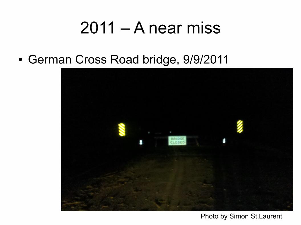
2011 – A near miss
● Hurricanes Irene and (remnants of) Lee● Major flooding in Catskills, Binghamton, Owego● Virgil Creek dam (from 1996) helped● Highway Superintendent Jack Bush, 9/9/11 -
'There is no doubt that the town & village land bordering Virgil Creek was saved by the Dam. As you will see the past high level water mark on the pole was under water I believe 12" to 18".'

2011 – A near miss
● 7:04am, 9/8/2011
Photo by Jack Bush
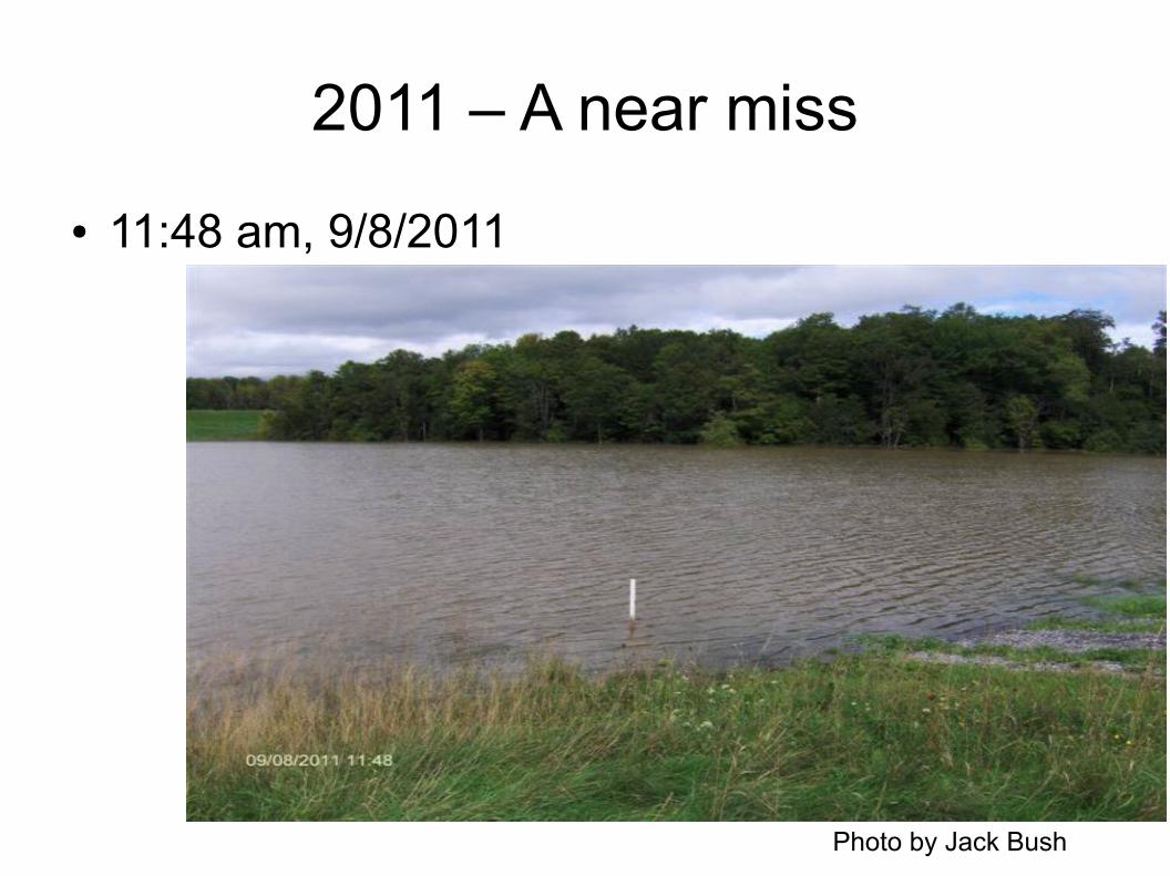
2011 – A near miss
● 11:48 am, 9/8/2011
Photo by Jack Bush

Crispell Dam provides a pause
Photo by Simon St.Laurent
2011 – A near miss
● German Cross Road bridge, 9/9/2011
Photo by Simon St.Laurent
Flash Floods
● Surprised not to find more mention of these, given hills and snow melt. Anyone have stories?

Blizzards
● At least we expect these, right?
Photo from Elsie Gutchess

Blizzards
● January 1945 four-day blizzard stranded students in Dryden schools for a week.
● 15-foot drifts on Gee Hill Road in 1958. ● 1993 blizzard shut down nine-county area.
(I lived on Buffalo Street then – people were skiing down the street.)
● Milder storms in 1997, 2003 – 2003 with bonus ice storm.

Ice storms
● Massive occasional ice storms tend to happen further south, but we get smaller ones regularly.
Photo by David Makar
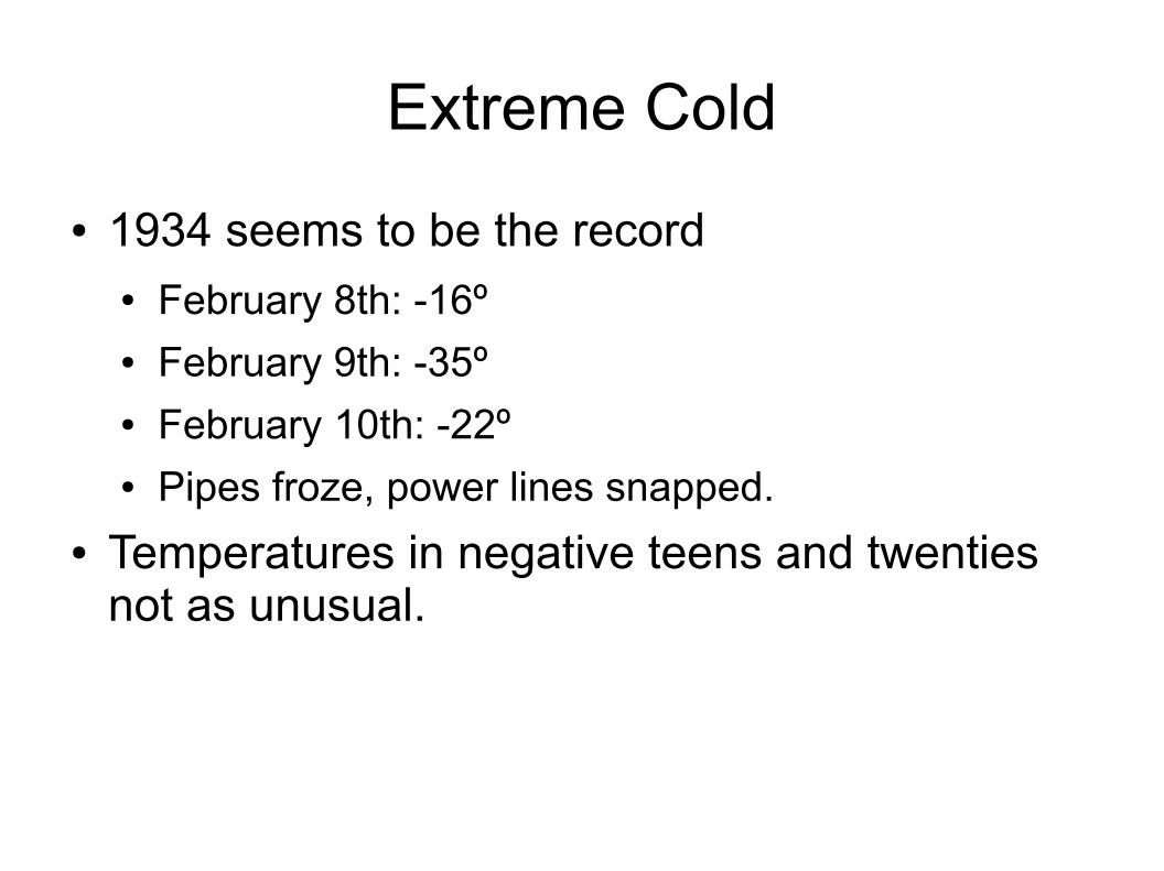
Extreme Cold
● 1934 seems to be the record● February 8th: -16º● February 9th: -35º● February 10th: -22º● Pipes froze, power lines snapped.
● Temperatures in negative teens and twenties not as unusual.

Extreme Heat
● Raw temperatures less terrifying – 90s and occasional hundreds.
● Extreme heat can last longer than extreme cold, however. Weeks in the 90s more common than weeks below zero.

Tornados etc.
● 1969 tornado in Village of Dryden● 1983 tornado? in Varna.● 1994 tornado in Village of Dryden● 1996 75mph wind, 'flash storm', damaged
airplane in Etna, mobile homes, circle around Etna/NYSEG. Warning arrived AFTER weather.
● 2011 tornado on Jersey Hill / East King / Coddington. Also New York State Thruway.
● Usually F1, not F5. (Massachusetts had F3 in 2011, F4 in 1953, though!)

“The Year Without a Summer”-1816
● Caused by the Mount Tambora volcanic eruption of 1815.
● 'The year 1816 was known as the "cold season," in which nearly all of the crops were destroyed by summer frosts, and great scarcity, almost a famine, resulted.…there were no such means of transportation then as now to relieve a section where the crops had failed, and no great supply of produce was carried over from year to year.' - George Goodrich, Centennial History of Dryden. (1898)

Emergency Response and Weather
● Even 'invisible' weather can have effects. Cayuga Medical Center reported that they have waves of pregnant mothers delivering babies when barometric pressure drops.
● It doesn't have to be a disaster – a little rain or ice can substantially increase the risk of motor vehicle accidents.

Forecasts
● Getting better all the time. More readings, more satellites, more weather balloons, more radar, more AVAILABLE.
● Anyone can watch the radar now, from The Weather Channel to computers to cell phones.
● Forecasts usually good at rough temperature, precipitation patterns 2-5 days out.
● Forecasts not so good at details of where precipitation falls, wind gusts, and local differences that can make a huge difference.

Warnings
● The National Weather Service used to refuse to give tornado warnings for fear of creating panic. Changed only in 1950s-1960s.
● Today, warnings a normal part of forecasting.● Specific Area Message Encoding-enabled
weather radios can be tuned to give just warnings for given counties with SAME codes. (Tompkins is 036109.)
● If you ever hear “Particularly Dangerous Situation”, assume major danger on the way.

Local National Weather Service
● The NWS office is in Binghamton, near the airport. They have their own NEXRAD Doppler radar there.
● Also radar in Buffalo,Albany, Montague(near Lowville)

Cornell Weather Stations
● http://www.nrcc.cornell.edu/climate/ithaca/ ● Lists Game Farm Road, Ithaca Airport, Cornell
Orchards, and Harford.● That same page includes links to history,
climate information, and snow survey maps.
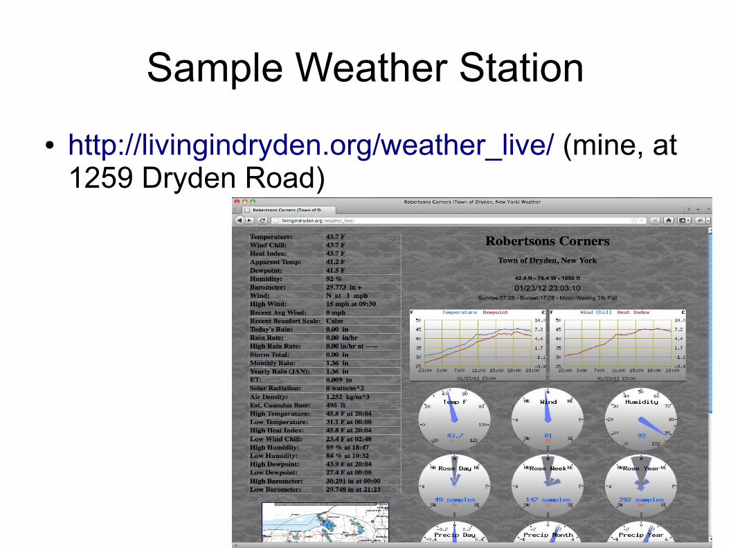
Sample Weather Station
● http://livingindryden.org/weather_live/ (mine, at 1259 Dryden Road)
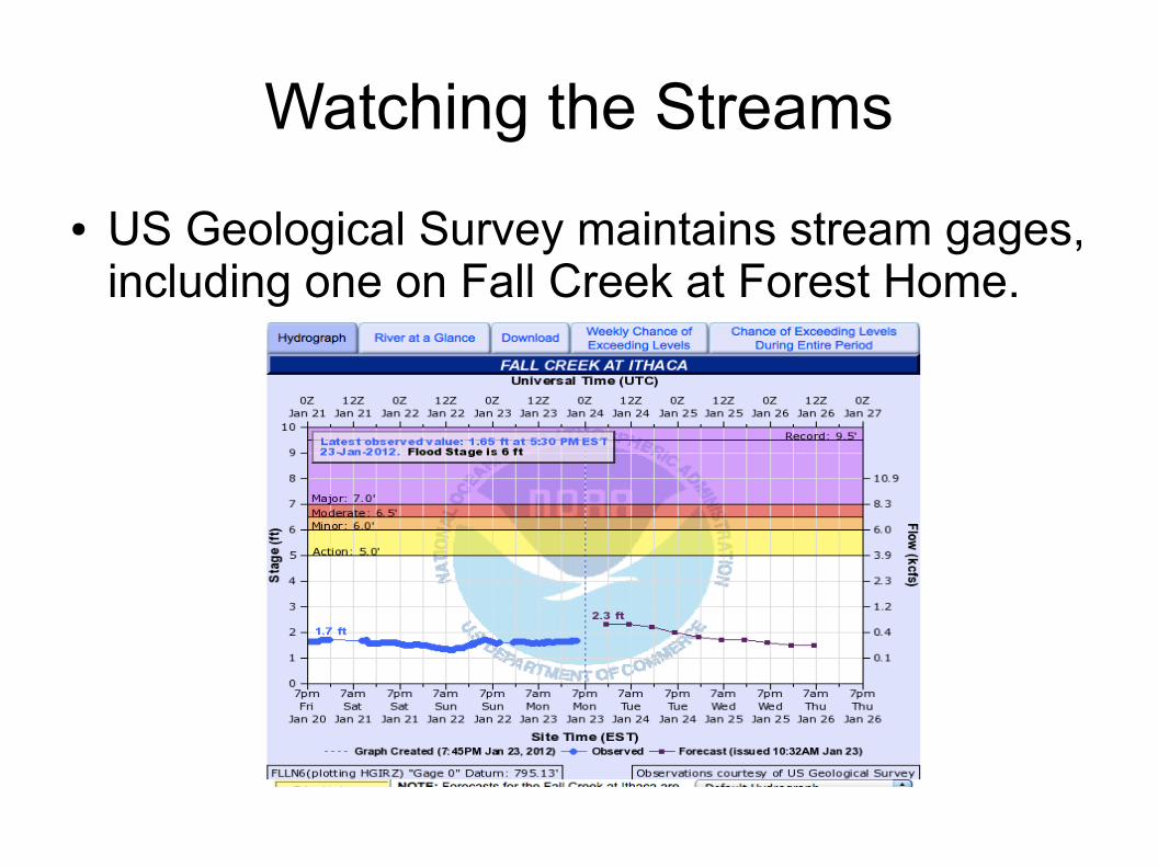
Watching the Streams
● US Geological Survey maintains stream gages, including one on Fall Creek at Forest Home.
Commercial Weather
● The NWS makes its data available to private weather companies – think AccuWeather – and many other distributors from the Weather Channel to Weather Underground and more.
● That data is likely what you're seeing on your TV, computer, or phone. (You can get some NWS data, like radars, directly.)
● If you can sort through meteorological jargon and maybe too many maps, lots of good information available from various sites and blogs.

Limitations
● Do NOT rely on radar to guess where tornadoes or high winds will be. Delays and inaccuracies are dangerous.
● Radar images are not always great at detecting freezing rain, which often depends on road temperature, not just air temperature.
● Detail within rainstorms is often good; detail within snowstorms is not. Light constant snow may not even be visible to radar.
● Sometimes the radar is off or down for repair.

Microclimates (big)
● Lake effect snow takes many forms. We think of Lake Ontario, but sometimes Cayuga Lake gives snow.
From weather.com.

Microclimates (small)
● Even within the Varna coverage district, probably a dozen different areas with noticeably different weather (if you watch carefully).
● Elevation – downtown Varna to the top of Mount Pleasant.
● North and south sides of hills.● Shelter from wind, and lack of it.● Close to creeks, and in gorges. May vary with
water flow.

SKYWARN
● You can report weather, not just experience it.● Doesn't mean you'll be out chasing tornadoes.● Requires training, though modest – 3 hours for
first class.● Training discusses storm formation and what to
watch for – hail, tornado warning signs.● Cloud formations and especially rotation critical.● Gives you a direct phone line to the NWS office
for reporting, and lets you into eSpotter online.
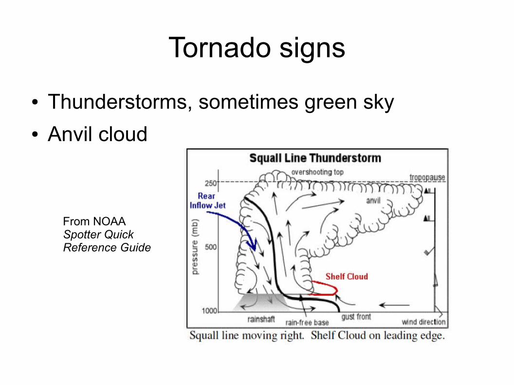
Tornado signs
● Thunderstorms, sometimes green sky● Anvil cloud
From NOAA Spotter Quick Reference Guide
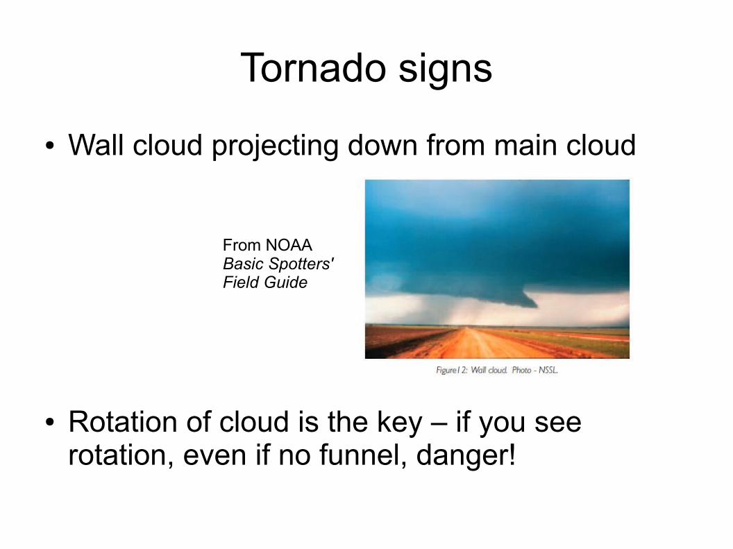
Tornado signs
● Wall cloud projecting down from main cloud
● Rotation of cloud is the key – if you see rotation, even if no funnel, danger!
From NOAA Basic Spotters' Field Guide

Tornado spotting dangers
● Tornado chasing may be popular in the Great Plains where you can see a long ways, but it's much trickier here.
● Take a picture or call the NWS, then take cover. Even small tornadoes can be deadly if you're exposed or in a vehicle.
● “If a tornado appears to not be moving but does appear to be growing larger, then it is coming right at you.” - Warnings, 21

Other options
● Storm reporting with Twitter, #wxreport● Community Collaborative Rain, Hail, and Snow
Network (CoCoRaHS.org). Requires a rain gauge and registration.
● Citizen Weather Observer Program (CWOP) involves setting up a station and sending data over the Internet. Also radio versions.
● Local weather stations, reporting to sites like wunderground.com or weatherbug.com.

Where to Learn a Lot More
● NWS Spotter training when it comes again● The Ultimate Guide to American Weather, from
the American Meteorological Society. ● Warnings, by Mike Smith on how warnings and
tech evolved.● Air Apparent, by Mark Monmonier, on how
weather forecasting came to be.● Eric Sloane's Weather Almanac for a look back
at weather lore.