Embed Size (px)
Citation preview
IN
NTERNAATIONA
SOUTH A
AIR NPER
IMPLFO
AL CIVIL
AMERICA
NAVIGRFORMLEMEN
OR THE
Ver
Aug
L AVIAT
AN REGIO
ATIONMANCENTATIOSAM R
rsion 1.5
gust 2017
TION OR
ONAL OF
N SYSTEE-BASEDON PLAREGION
5
RGANIZA
FFICE
EM D AN N
ATION
- 3 -
TABLE OF CONTENTS Chapter Content Page No.
1. Foreword
1.1 Objective .................................................................................................................................. 6 1.2 Scope ........................................................................................................................................ 6 1.3 Background .............................................................................................................................. 6 1.4 Stakeholder roles and responsibilities .................................................................................... . 7
2. Air Traffic in the SAM Region
2.1 Traffic Forecast in the SAM Region ........................................................................................ 9 3. Planning Considerations
3.1 Introduction ............................................................................................................................ 15 3.2 Planning Methodology ........................................................................................................... 15 3.3 Planning Tools: Implementation strategy within ASBU framework ..................................... 17 3.4 ASBU modules under consideration in the SAM Region ...................................................... 20 3.5 Transition from PFFs to ANRFs ............................................................................................ 22
4. Air Traffic Management (ATM)
4.1 Introduction ............................................................................................................................ 23 4.2 General Principles .................................................................................................................. 24 4.3 Analysis of the current situation ............................................................................................. 24 4.4 Strategy for the Implementation of Performance Objectives ................................................. 25 4.5 En-Route Operations .............................................................................................................. 26 4.6 TMA Operations .................................................................................................................... 27 4.7 Alignment with ASBU ........................................................................................................... 32
5. Communications, Navigation and Surveillance (CNS)
5.1 Introduction ............................................................................................................................ 33 5.2 Analysis of the current situation (2010) ................................................................................. 34 5.3 Strategy for the implementation of performance objectives .................................................. 35 5.4 Alignment with ASBU ........................................................................................................... 38
6. Meteorology
6.1 Introduction ............................................................................................................................ 39 6.2 Meteorological information supporting enhanced operational efficiency and safety ............ 39 6.3 Analysis of the current situation ............................................................................................. 41 6.4 Alignment with ASBU ........................................................................................................... 42
7. Search and Rescue (SAR) Services
7.1 Introduction ............................................................................................................................ 43 7.2 Analysis of the current situation ............................................................................................. 43 7.3 Implementation strategy of performance objectives . ............................................................. 44
- 4 -
7.4 Development of GADSS concept ........................................................................................... 46 7.5 Alignment with ASBU ........................................................................................................... 46
8. Aeronautical Information Services
8.1 Introduction . ........................................................................................................................... 47 8.2 Analysis of the current situation ............................................................................................. 47 8.3 Strategy for the implementation of performance objectives .................................................. 47 8.4 Alignment with ASBU ........................................................................................................... 50
9. Aerodromes and Ground Aids / Aerodrome Operational Planning (AGA/AOP)
9.1 Introduction ............................................................................................................................ 51 9.2 Analysis of the current situation. ............................................................................................ 51 9.3 Strategy for the implementation of performance objectives ................................................... 52 9.4 Alignment with ASBU ........................................................................................................... 54
10. Development of Human Resources and Competence Management
10.1 Introduction ............................................................................................................................ 55 10.2 Analysis of the current situation ............................................................................................. 56 10.3 Strategies for the implementation of performance objectives ................................................ 57 10.4 Alignment with ASBU ........................................................................................................... 58
11. Safety
11.1 Introduction ............................................................................................................................ 59 11.2 Analysis of the Current situation ............................................................................................ 60 11.3 Strategies for the implementation of performance objectives ................................................ 60
12. Environment Protection
12.1 Introduction ............................................................................................................................ 61 12.2 Current situation analysis ....................................................................................................... 62 12.3 Strategy of implementation of the performance objectives .................................................... 63 12.4 Alignment with ASBUs ......................................................................................................... 63
13. Performance Improvement Areas (PIA), modules and Air Navigation Report Forms (ANRF)
13.1 Introduction ............................................................................................................................ 64 13.2 Performance Improvement Area (PIA) .................................................................................. 64 13.3 Air Navigation Report Forms (ANRF) ................................................................................... 66
ATTACHMENTS TO THE DOCUMENT
ATTACHMENT A - Traffic forecasts in the SAM Region ATTACHMENT B - Global plan initiatives and their relationship with the main groups ATTACHMENT C - Performance framework form (PFF) ATTACHMENT D - Description of modules considered for the SAM Region ATTACHMENT E - Air navigation report forms (ANRF) ATTACHMENT F - Glossary of acronyms
ATTACHMENT G - PBN concept of operations for SAM airspace ATTACHMENT H - List of reference documents
- 5 -
FOREWORD
The Air Navigation System Performance-Based Air Navigation System Implementation Plan for the SAM Region is published by the ICAO South American Regional Office on behalf of States accredited and International Organizations involved. It considers implementations at short and mid-term, as indicated in the guidelines contained in the Global Air Navigation Plan and the plan initiatives required for evolution to a Global ATM System, as shown in the Global ATM Operational Concept. The Regional Office, on behalf of States and Organizations involved, will publish the required revised versions of the plan to reflect current implementation activities. Copies of the plan can be obtained by contacting:
ICAO SOUTH AMERICAN OFFICE LIMA, PERU E-mail : [email protected] Website : www.lima.icao.int Tel : +511 6118686 Fax : +511 6118689 Address : Apartado Postal 4127, Lima 100, Perú
The present edition (Version 1.2) includes all revisions and modifications until May 2013. Subsequent amendments and corrigenda will be indicated in the Record of Amendment and Corrigenda Table, according to the procedure established in page 5. It should also be mentioned that a list of reference documents used in the preparation of this document is presented in Attachment H.

- 6 -
The issue of amendments and corrigenda is announced regularly through correspondence with States and International Organizations, and in the ICAO website, which holders of this publication should consult. The blank boxes facilitate the recording of amendments.
RECORD OF AMENDMENTS AND CORRIGENDA
AMENDMENTS CORRIGENDA
No. Date
applicable Date entered Entered by No.
Date applicable
Date entered Entered by
1 May 2013
- 6 -
1. Chapter 1: Foreword 1.1 Objective 1.1.1 This Air Navigation System Performance-Based Implementation Plan for the SAM Region has been drafted taking into account the ICAO Global Air Navigation Plan (GANP) (Doc 9750), and is framed within the Aviation System Block Upgrades (ASBU) methodology, with the aim of achieving a more efficient and interoperable airspace to meet future capacity demand, without compromising air navigation safety. 1.1.2 This Plan seeks to establish an implementation strategy so that benefits can be obtained for the air navigation community, based on the ATM-related infrastructure and available and foreseen aircraft capabilities. The document contains the Regional vision for the air navigation system (AGA/AOP, AIM, ATM, CNS, MET, SAR, Human Resources and Safety), giving high priority to environmental protection, training and safety. 1.2 Scope 1.2.1 This migration plan covers the SAM Region up to its boundaries, and includes the short-and medium-term implementations of the systems in support of the air navigation services between 2017 and 2023, period including the continuation of ASBU Block 0 implementation and the beginning of selected ASBU Block 1 implementation. The long-term initiatives required for the evolution to a global ATM system, as shown in the Global ATM Operational Concept, will be added to this Plan as they are developed and approved. 1.3 Background 1.3.1 The Global ATM Operational Concept was approved by the Eleventh Air Navigation Conference (Montreal, September-October 2003) and published as Doc. 9854-AN/458. 1.3.2 In order to align global planning to the ATM Operational Concept, the Eleventh Air Navigation Conference (AN-Conf/11), recommended States and Regional Planning and Implementation Groups (PIRG), through Recommendation 1/1, to consider the Concept as a common global framework to guide in the planning for the implementation of the systems in support of the air navigation services.
1.3.3 GREPECAS/15 approved Conclusion 15/1 for the development by the Group of a regional performance-based plan, in keeping with the Global Air Navigation Plan and the Global ATM Operational Concept.
1.3.4 The Air Navigation System Performance-Based Implementation Plan for the SAM Region was completed in May 2011, and approved by the Twelfth Meeting of Civil Aviation Authorities of the SAM Region (RAAC/12) (Lima, Peru, October 2011).

- 7 -
1.3.5 The 37 Session of the International Civil Aviation Organization (ICAO) General Assembly (2010) directed the Organization to double its efforts to meet the global needs for airspace interoperability while maintaining its focus on safety. The block upgrades initiative was formalized at the Twelfth Air Navigation Conference (AN-Conf/12) (Montreal, November 2012) and incorporated in the GANP, 4th Edition (Doc 9750). 1.3.6 The block upgrades describe a way to apply the concepts defined in the GANP with the goal of implementing regional performance improvements. They include the development of technology roadmaps, to ensure that standards are mature and to facilitate synchronized implementation between air and ground systems and between regions. The ultimate goal is to achieve global interoperability. Safety demands this level of interoperability and harmonization but it must be achieved at a reasonable cost with commensurate benefits. 1.3.7 Include the development of technology roadmaps to ensure the rules are ready and facilitate the synchronized implementation of between air and land systems and between the regions. The ultimate goal is to achieve global interoperability. Safety demands this level of interoperability and harmonization, but it must be achieved at a reasonable cost with measurable benefits. 1.3.8 Through Recommendation 6/1 - Regional performance framework – planning methodologies and tools, AN-Conf/12 urged States and PIRGs to harmonize the regional and national navigation plans with the ASBU methodology in response to this. 1.3.9 The Air Navigation System Performance-Based Implementation Plan for the SAM Region has been aligned with the ASBU methodology (Version of May 2013). (After this edition, a new amendment was made on November 2013). 1.3.10 Through State Letter AN 13/54-15/77 dated 1 December 2015, ICAO informed on the GANP proposal of amendment (Fifth Edition) reflecting changes incorporated according to recommendations formulated by the Twelfth Air Navigation Conference (AN-Conf/12), as well as slight updating needed. The Fifth Edition of GANP was sustained by the 39 Session of the International Civil Aviation Organization (ICAO) General Assembly. 1.3.11 Considering the progress made in the implementation of air navigation systems in the SAM Region during 2012-2016 and the Fifth Edition of the GANP, the Air Navigation System Performance-Based Implementation Plan for the SAM Region was updated. 1.4 Stakeholder roles and responsibilities 1.4.1 Stakeholders including service providers, regulators, airspace users and manufacturers are facing increased levels of interaction as new, modernized ATM operations are implemented. The highly integrated nature of capabilities covered by the block upgrades requires a significant level of coordination and cooperation among all stakeholders. Working together is essential for achieving global harmonization and interoperability.

- 8 -
1.4.2 States, operators and industry will benefit from the availability of Standards and Recommended Practices (SARPs) with realistic lead times. This will enable regional regulations to be identified, allowing for the development of adequate action plans and, if needed, investment in new facilities and/or infrastructure. 1.4.3 For the industry, this constitutes a basis for planning future development and delivering products on the market at the proper target time. For service providers or operators, block upgrades should serve as a planning tool for resource management, capital investment, training as well as potential reorganization.
2.
2.1 2.1.1 diverse regeographiUNESCOinvestors.transporte
Figu
Sour
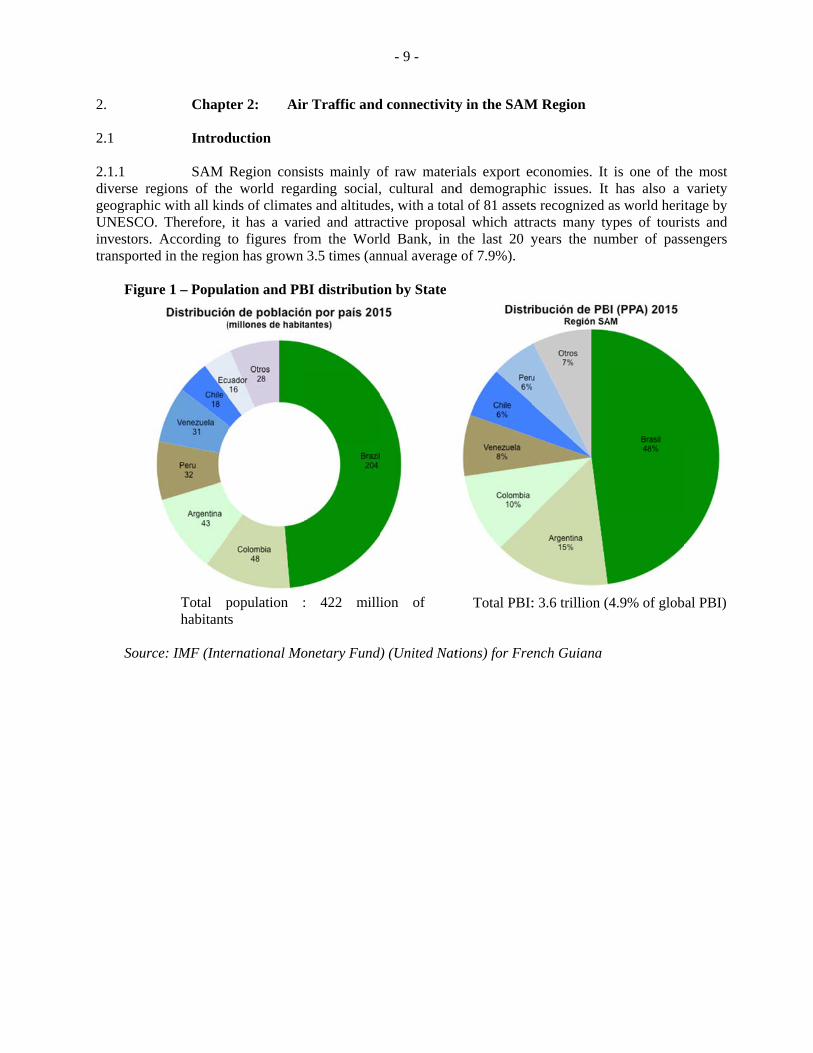
Chapt Introd
SAM egions of theic with all kin
O. Therefore, According t
ed in the regio
re 1 – Popul
Total phabitant
ce: IMF (Inte
ter 2: Air
duction
Region conse world regands of climate
it has a varito figures froon has grown
ation and PB
population :s
ernational Mo
r Traffic and
ists mainly oarding social,es and altitudeied and attraom the Worl3.5 times (an
BI distributio
: 422 mill
onetary Fund)
- 9 -
d connectivity
of raw materi, cultural andes, with a totactive proposald Bank, in
nnual average
on by State
ion of
d) (United Nat
y in the SAM
ials export ed demographal of 81 assetsal which attrthe last 20 y
e of 7.9%).
Total PBI:
tions) for Fre
M Region
economies. It hic issues. It s recognized racts many tyyears the num
: 3.6 trillion (
ench Guiana
is one of thhas also a
as world heriypes of tourimber of pass
4.9% of glob
he most variety tage by sts and sengers
al PBI)
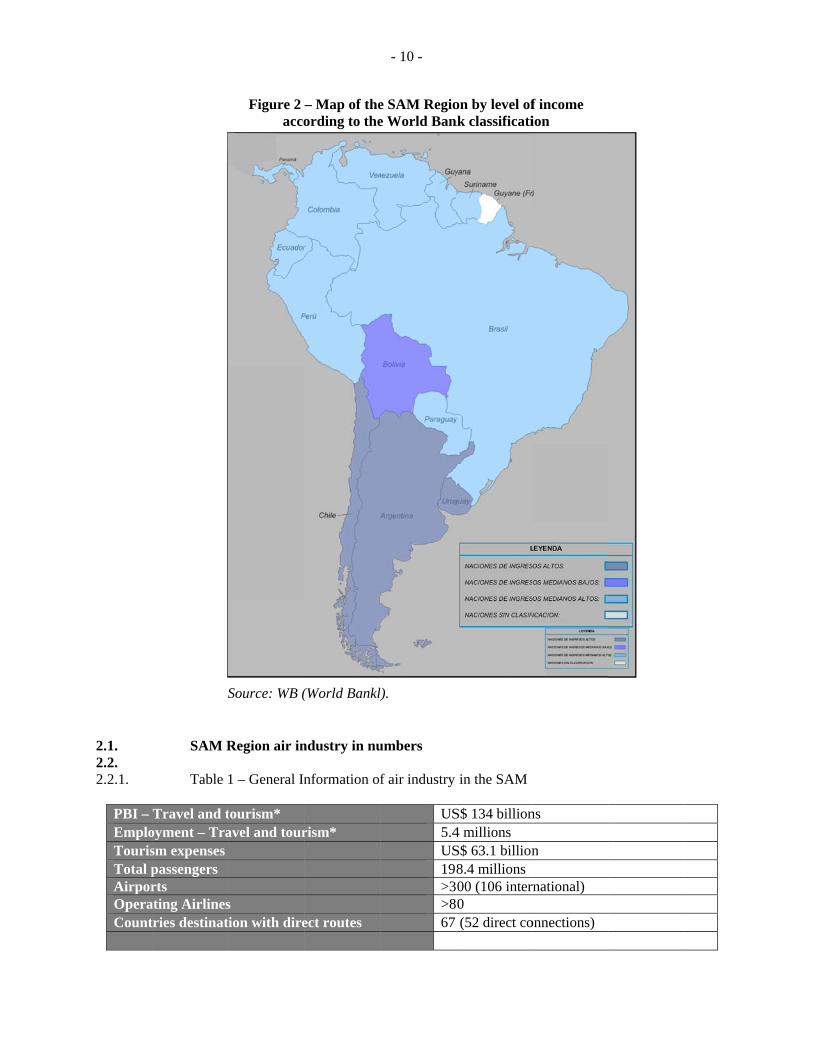
2.1. 2.2. 2.2.1.
PBI – EmploTourisTotal pAirporOperaCount
S
SAM R Table
Travel and toyment – Trasm expenses passengers rts
ating Airlinestries destinat
Figure 2 acco
Source: WB (
Region air in
1 – General In
tourism* avel and tour
s tion with dire
– Map of theording to the
(World Bankl)
ndustry in nu
nformation o
rism*
ect routes
- 10 -
e SAM Regioe World Ban
l).
umbers
f air industry
US5.4US19>3>867
on by level ofnk classificati
in the SAM
S$ 134 billion4 millions S$ 63.1 billion8.4 millions00 (106 inter0 (52 direct co
f income ion
ns
n
rnational)
onnections)
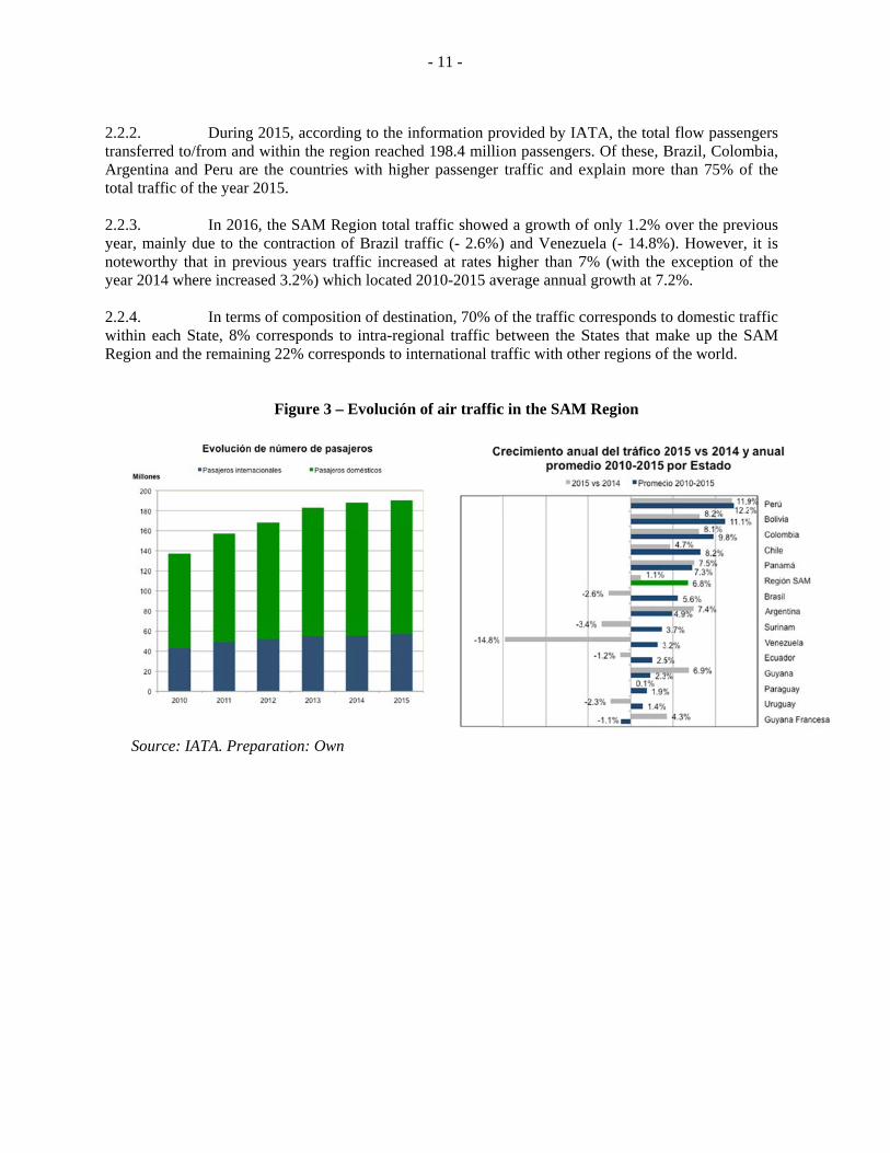
2.2.2. transferreArgentinatotal traffi 2.2.3. year, mainnoteworthyear 2014
2.2.4. within eaRegion an
Sourc
Duringd to/from and
a and Peru aric of the year
In 201nly due to th
hy that in pre4 where increa
In term
ch State, 8%nd the remain
ce: IATA. Prep
g 2015, accord within the rre the countri2015.
6, the SAM Rhe contractionevious years tased 3.2%) w
ms of composi corresponds
ning 22% corr
Figure 3
paration: Ow
rding to the inregion reacheies with high
Region total tn of Brazil tratraffic increa
which located 2
ition of destin to intra-regi
responds to in
– Evolución
wn
- 11 -
nformation prd 198.4 milli
her passenger
traffic showeaffic (- 2.6%)
ased at rates h2010-2015 av
nation, 70% oional traffic bnternational tr
of air traffic
rovided by IAion passenger
traffic and e
ed a growth o) and Venezuhigher than 7verage annual
of the traffic cbetween the Sraffic with oth
c in the SAM
ATA, the totars. Of these, Bexplain more
of only 1.2% ouela (- 14.8%7% (with the l growth at 7.
corresponds toStates that mher regions of
M Region
l flow passenBrazil, Colomthan 75% of
over the prev%). However,
exception of.2%.
o domestic trmake up the Sf the world.
ngers mbia, f the
vious it is
f the
affic SAM
Sourc
2.3.
2.3.1. characteri
Figu
ce: IATA.
Status In term
istics (see App
Brazil is direct rouHowevercomparatdensity loshows a g
The regio1 in 9 frocountriesmore thaRegion st
In terms PBI, the rin the casone of thSAM ReMiddle E
The regiocountriesBrazil is Chile, Pe
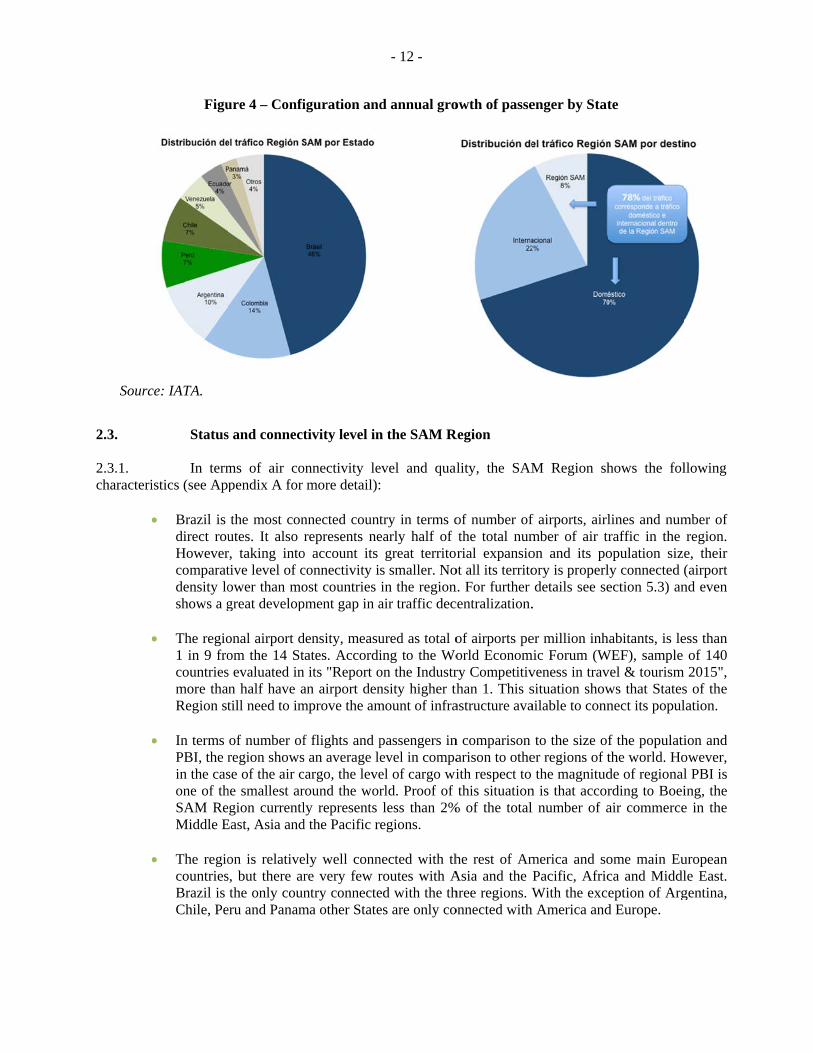
ure 4 – Confi
s and connect
ms of air copendix A for
the most conutes. It also rr, taking intotive level of cower than mogreat develop
onal airport dom the 14 Sts evaluated inn half have atill need to im
of number ofregion showsse of the air che smallest aregion currentlEast, Asia and
on is relatives, but there arthe only coun
eru and Panam
iguration and
tivity level in
onnectivity lemore detail):
nnected countrepresents ne
o account its connectivity iost countries pment gap in a
density, measutates. Accordin its "Report oan airport denmprove the am
f flights and ps an average lecargo, the leveround the worly represents d the Pacific re
ely well connre very few rntry connecte
ma other State
- 12 -
d annual gro
n the SAM R
evel and qual
try in terms oearly half of
great territos smaller. Noin the regionair traffic dec
ured as total oing to the Woon the Industrnsity higher thmount of infra
passengers inevel in compael of cargo wirld. Proof of less than 2%egions.
nected with throutes with Aed with the thes are only co
owth of passe
Region
lity, the SAM
of number ofthe total numrial expansio
ot all its territon. For furthercentralization.
of airports peorld Economry Competitivthan 1. This sastructure ava
n comparison arison to otheith respect to this situation
% of the total
he rest of AmAsia and the Phree regions. Wonnected with
enger by Stat
M Region sh
f airports, airlmber of air tron and its poory is properldetails see se
.
er million inhmic Forum (Wveness in travsituation showailable to conn
to the size ofer regions of tthe magnitud
n is that accorl number of a
merica and soPacific, AfricWith the exce
h America and
te
hows the fol
lines and numraffic in the opulation sizely connected (ection 5.3) an
habitants, is leWEF), sample vel & tourism ws that Statesnect its popul
f the populatithe world. Hode of regionalrding to Boeiair commerce
ome main Euca and Middleption of Argd Europe.
llowing
mber of region. e, their (airport nd even
ess than of 140 2015",
s of the lation.
ion and owever, l PBI is ing, the e in the
uropean le East. gentina,
2.4. 2010-201
2.5.
2.5.1. that air trFor this amillion bypotential f
Figure
Source: IA
In the sam
Also the Guyana, need to le
In terms Accordinby the W(post 28)Region’sbilateral and costs
Appen5 and estimat
Vision Worldw
affic in the Ranalysis, we y 2015 to morfor growth wh
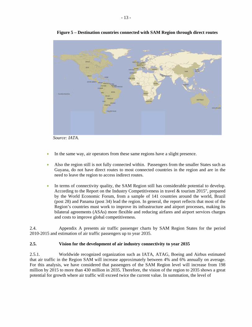
5 – Destinati
ATA.
me way, air o
region still isdo not have
eave the regio
of connectiving to the RepoWorld Econom
and Panama countries muagreements (A
s to improve g
ndix A presention of air traf
n for the deve
wide recogniRegion SAM have considere than 430 mhere air traffi
ion countries
perators from
s not fully condirect routes
on to access in
ity quality, thort on the Indmic Forum, f(post 34) lea
ust work to imASAs) more global compet
nts air trafficffic passenger
elopment of a
ized organizawill increase
ered that passmillion in 2035
c will exceed
- 13 -
s connected w
m these same r
nnected withi to most conndirect routes
he SAM Regidustry Compefrom a samplad the region. mprove its inflexible and titiveness.
c passenger crs up to year 2
air industry
ation such as approximatesengers of th5. Therefore,
d twice the cur
with SAM Re
regions have
in. Passengernnected counts.
ion still has cetitiveness in tle of 141 couIn general, th
nfrastructure areducing airf
charts by SA2035.
connectivity
IATA, ATAely between 4he SAM Regi
the vision ofrrent value. In
egion throug
a slight prese
rs from the smtries in the re
considerable ptravel & touruntries arounhe report refland airport prfares and airp
AM Region S
to year 2035
AG, Boeing an4% and 6% aion level willf the region ton summation,
gh direct rou
ence.
maller States egion and are
potential to dism 2015", pr
nd the world,ects that mosrocesses, mak
port services c
States for the
5
nd Airbus estannually on al increase fro
o 2035 shows , the level of
utes
such as e in the
develop. repared , Brazil st of the king its charges
period
timated average. om 198 a great

- 14 -
2.5.2. regional connectivity will be extended by an increase in demand (number of passengers and cargo) and supply (number of routes, flights and frequencies offered by aircraft operators).
3.
3.1 3.1.1 providers traffic den 3.1.2 will provimore effisignifican 3.1.3 many timglobal and
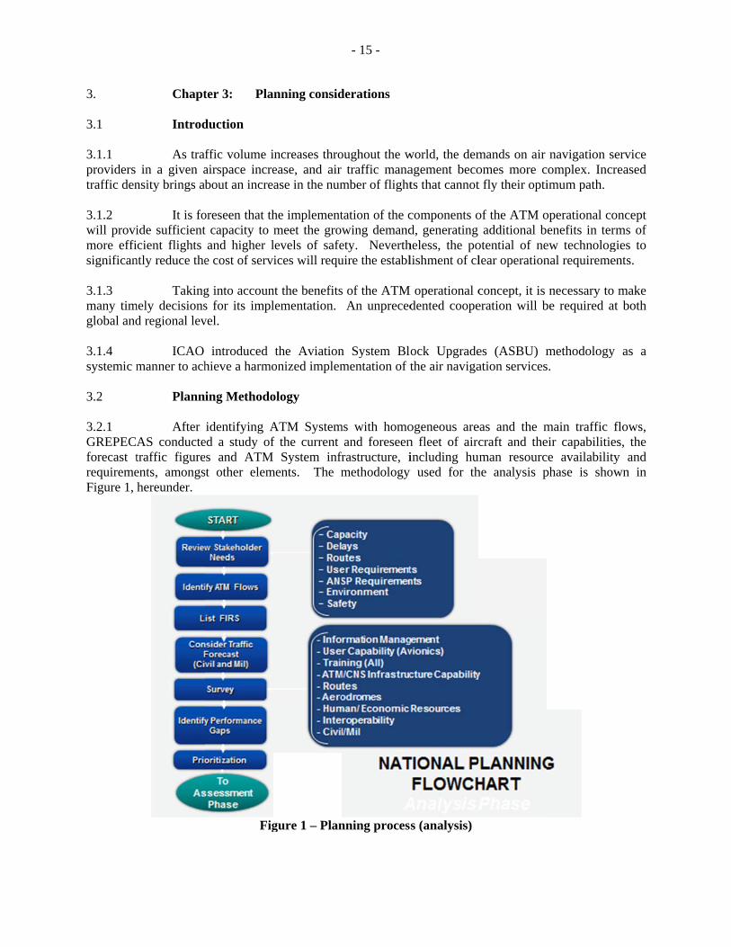
3.1.4 systemic m 3.2 3.2.1 GREPECAforecast trequiremeFigure 1,
Chapt Introd
As train a given a
nsity brings ab
It is foide sufficientcient flights
ntly reduce the
Takingmely decisions
d regional lev
ICAO manner to ach
Plann
After AS conductetraffic figureents, amongshereunder.
ter 3: Pla
duction
ffic volume iairspace increbout an incre
oreseen that tht capacity to and higher l
e cost of serv
g into accouns for its implvel.
introduced hieve a harmo
ing Methodo
identifying Aed a study ofes and ATMst other elem
Fig
nning consid
increases throease, and air ase in the num
he implementmeet the growlevels of safeices will requ
nt the benefitslementation.
the Aviationonized implem
ology
ATM Systemf the current
System infrments. The m
gure 1 – Plan
- 15 -
derations
oughout the wtraffic mana
mber of flight
tation of the cwing demandety. Neverthuire the establ
s of the ATMAn unpreced
n System Blomentation of t
ms with homoand foreseen
frastructure, imethodology
nning proces
world, the demagement becots that cannot
components od, generating heless, the polishment of cl
M operational cdented coope
ock Upgradethe air naviga
ogeneous aren fleet of aircincluding hu
y used for th
s (analysis)
mands on air omes more ct fly their opti
of the ATM oadditional b
otential of nelear operation
concept, it is eration will b
es (ASBU) mation services
eas and the mcraft and the
uman resourche analysis p
navigation secomplex. Incrimum path.
operational coenefits in ter
ew technolognal requireme
necessary to be required at
methodology s.
main traffic feir capabilitiece availabilityphase is show
ervice reased
oncept ms of
gies to ents.
make t both
as a
flows, es, the y and wn in
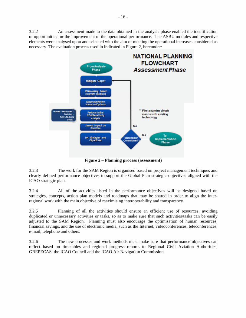
3.2.2 of opportuelements wnecessary
3.2.3 clearly deICAO stra 3.2.4 strategies,regional w 3.2.5 duplicatedadjusted tfinancial se-mail, tel 3.2.6 reflect baGREPECA
An assunities for thewere analysed
y. The evaluat
The wefined performategic plan.
All of, concepts, awork with the
Plannid or unnecessto the SAM savings, and tlephone and o
The neased on timeAS, the ICAO
sessment made improvemend upon and setion process u
Figu
work for the SAmance object
f the activitiection plan m main objecti
ing of all thsary activities
Region. Plthe use of eleothers.
ew processesetables and O Council and
de to the datant of the operelected with tused in indicat
ure 2 – Plann
AM Region itives to suppo
es listed in tmodels and roive of maximi
he activities s or tasks, solanning must
ectronic media
s and work mregional prod the ICAO A
- 16 -
a obtained in rational perforthe aim of meted in Figure
ning process
is organised bort the Globa
the performaoadmaps that ising interope
should ensuro as to make t also encoura, such as the
methods must ogress reportsAir Navigation
the analysis prmance. The
eeting the ope2, hereunder
(assessment)
based on projeal Plan strate
ance objectivmay be shar
erability and t
re an efficiesure that suc
rage the optie Internet, vid
make sure ths to Regionn Commissio
phase enablede ASBU moduerational incre:
)
ect managemgic objective
ves will be dred in order transparency.
ent use of rech activities/timisation of
deoconference
hat performanal Civil Avi
on.
d the identificules and respeeases consider
ment techniquees aligned wit
designed baseto align the
esources, avotasks can be
human resoues, teleconfere
nce objectiveiation Autho
cation ective red as
es and th the
ed on inter-
oiding easily urces, ences,
es can orities,
- 17 -
3.2.7 Based on this Implementation Plan, the States should develop their own national plan, containing the work programme, timetable, responsible parties and status of implementation, in order to monitor and report on the progress made in such activities. Additionally, it should also consider detailed information about the activities required for implementation, the means to provide feedback on the progress made through an annual reporting process, which will help administrations to prioritise the required actions and support, and identify annual assistance requirements of each ICAO Region. 3.2.8 The development of work programmes is based on the experience gained and lessons learned during the previous cycle of the CNS/ATM implementation process. Consequently, this Implementation Plan is aimed at maintaining a uniform regional harmonisation and improving implementation efficiency, taking advantage of infrastructure capacity and existing regional applications.
3.3 Planning tools: Implementation strategy within ASBU framework 3.3.1 An ASBU designates a set of improvements that can be implemented globally from a defined point in time to enhance the capacity and performance of the ATM system. There are four components of a block upgrade. 3.3.2 Module – is a deployable package (performance) or capability. A module will offer an understandable performance benefit, related to a change in operations, supported by procedures, technology, regulations/standards as necessary, and a business case. A module will be also characterized by the operating environment within which it may be applied. The date allocated to a module in a block is that of the initial operating capability (IOC). 3.3.3 Of some importance is the need for each of the modules to be both flexible and scalable to the point where their application could be managed through any set of regional plans and still realize the intended benefits. The preferential basis for the development of the modules relied on the applications being adjustable to fit many regional needs as an alternative to being made mandated as a one-size-fits-all application. Even so, it is clear that many of the modules developed in the block upgrades will not be necessary to manage the complexity of air traffic management in many parts of the world. 3.3.4 Thread – describes the evolution of a given capability through the successive block upgrades, from basic to more advanced capability and associated performance, while representing key aspects of the global ATM concept 3.3.5 Block – is made up of modules that when combined enable significant improvements and provide access to benefits. 3.3.6 The notion of blocks introduces a form of date segmentation in five year intervals. However, detailed considerations will call for more accurate implementation dates, often not at the exact assigned block date. The purpose is not to indicate when a module implementation must be completed unless dependencies among modules logically suggest such a completion date. 3.3.7 Performance improvement area (PIA) – sets of modules in each block are grouped to provide operational and performance objectives in relation to the environment to which they apply, thus forming an executive view of the intended evolution. The PIAs facilitate comparison of ongoing programmes.
3.3.8
3.3.9 Figure 4 e
The fo
a) airb) glo
infc) opd) eff
Figureexplains the c
Figure 3
Figure 4. M
our PIAs are a
rport operatioobally interopformation ma
ptimum capacficient flight p
e 3 illustratesconcept of the
3. Summary o
Module thread
as follows:
ons; perable systemanagement; city and flexibpaths – throug
s the relatione thread.
of blocks ma
d associated
- 18 -
ms and data –
ble flights – thgh trajectory-
nships betwee
apped to perf
to a specific
– through glob
hrough global-based operat
en the modul
formance im
performance
bally interope
l collaborativtions.
les, threads,
provement a
e improveme
erable system
ve ATM; and
blocks, and
areas
ent area
m-wide
PIAs.
3.3.10 they are a 3.3.11 modules tinclude pground aumodule shallows Stathose capa 3.3.12 learned ar1 represenearlier im
3.3.13 the SAM as the netw
In Figua part of the sa
Note tthat form the erformance sutomation anhould have bates wishing tabilities.
Figurere included innt the most m
mplementation
An illuRegion is prework as a wh
ure 4, the moame thread.
that each bloBlocks must
standards, appd other enabeen fielded into adopt the B
e 5 illustrates n preparation fmature of the ns are on the p
Figure
ustration of mesented in Fig
hole including
odules under e
ock includes meet a readi
provals, adviling capabilitn two regionsBlocks to dra
the timing offor the IOC dmodules. Blo
path to the fut
5. Timing re
modules ASBUgure 6. It highg information
- 19 -
each block ca
a target dateness review t
isory/guidancties. In orders and includeaw on the exp
f each block rdate. For the Cocks 2 and 3ture.
elationships b
U Block 0 fohlights that thmanagement
arry the same
e reference fothat includes
ce documentsr to provide ae operational periences gain
relative to eacConference it provide the
between bloc
or the differenhe modules apt and infrastru
e module num
for its availabthe availabili
s, etc.), aviona communityapprovals an
ned by those
ch other. Noteis recognizednecessary vi
cks
nt phases of fpply to all fligucture.
mber indicatin
bility. Each oity of standarnics, infrastruy perspective,d proceduresalready empl
e that early led that Blocks sion to ensur
flight consideght phases, as
ng that
of the rds (to ucture, , each . This loying
essons 0 and
re that
red in s well
3.4 3.4.1 methodoloAlthough around thshould be 3.4.2 integratedintegratedisolated isimultaneairspaces/hoc or iso 3.4.3 (PBN). Aguidance be seen asregional oto implem
ASBU
The Fogy and supthe GANP h
he globe. Som applied wher
Althoud deployment d implementaimplementatioeously across /flight informolated basis.
An exAssembly Res
in accordances required foror sub-region
ment regionall
U modules un
Fourth Editioporting techn
has a global pme of the ASre specific op
ugh some moof a number
ation of a numons. Similarl
a wide areamation regions
xample of a nsolution A37-e with the PBr implementatal deploymenly and in what
Figure 6. Bl
nder consider
on of the Glnology roadmerspective, it
SBU modulesperational requ
odules are sur of modules mber of modly, the benefa (e.g. a nums) may exceed
need for glob-11 urges all
BN concept. Ttion at all airpnt and shouldt circumstanc
- 20 -
lock 0 in pers
ration in the
lobal Air Namaps based o
is not intends contained iuirements or
uitable for ecould genera
dules may befits from thember of proxd the benefits
bal applicabiliStates to im
Therefore, theports. In the s
d take this intces and agreed
B0-OPFL Ito optim
climprocedure
spective
SAM Region
Navigation Plaon a rolling ded that all Ain the GANPcorrespondin
entirely standate additionale greater thane coordinatedximate airpors of the imple
ity would bemplement appe ASBU modusame way, soto account whd timeframes
mproved Access mum FL through mb/descent es using ADS-B)
n
lan introducefifteen-year
ASBU moduleP are specialing benefits ex
d-alone deplol benefits. Thn the benefitd deploymenrts or a numementations c
e performanceproach procedules on PBN ome modules hen consideri.
es ICAO’s Aplanning ho
es are to be apized packageist.
oyment, an ohe benefits fros from a sernt of one m
mber of contigconducted on
e-based navigdures with veapproaches sare well suite
ing which mo
ASBU orizon. pplied
es that
overall om an ies of
module guous an ad
gation ertical should ed for odules
- 21 -
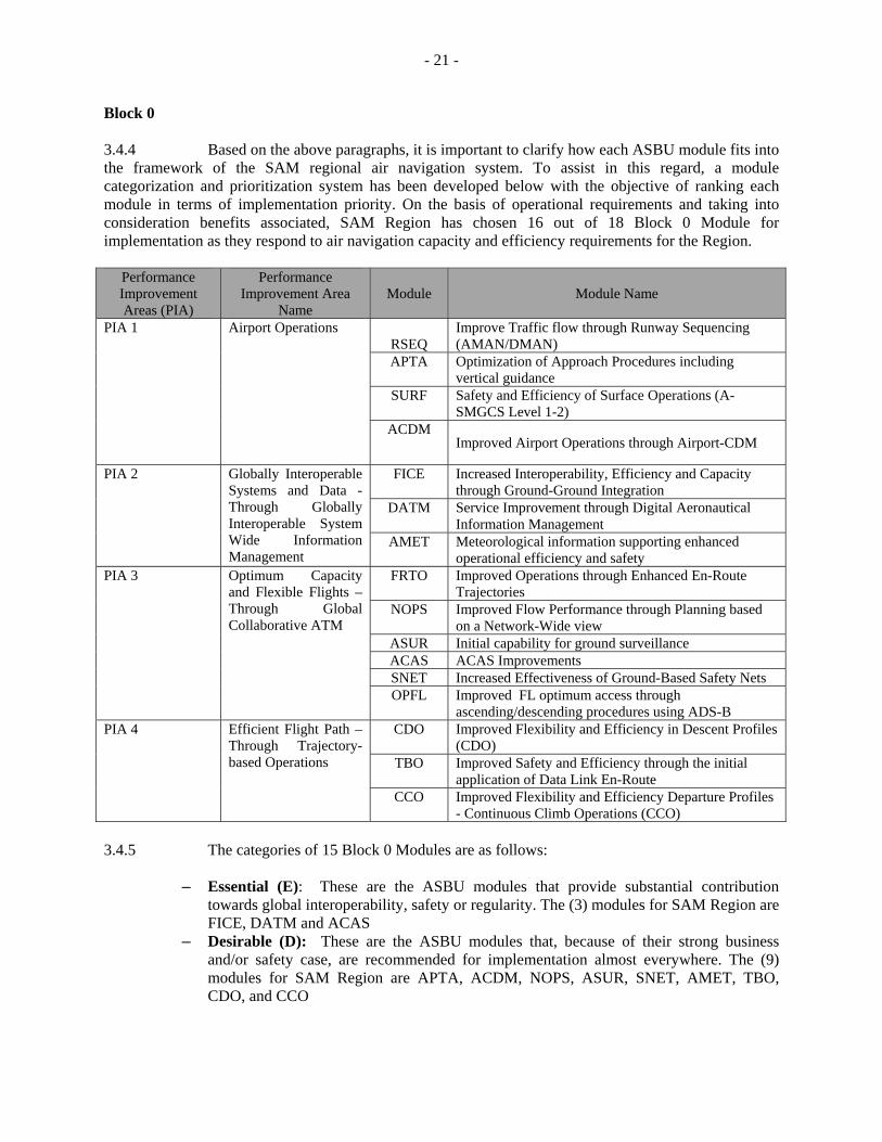
Block 0 3.4.4 Based on the above paragraphs, it is important to clarify how each ASBU module fits into the framework of the SAM regional air navigation system. To assist in this regard, a module categorization and prioritization system has been developed below with the objective of ranking each module in terms of implementation priority. On the basis of operational requirements and taking into consideration benefits associated, SAM Region has chosen 16 out of 18 Block 0 Module for implementation as they respond to air navigation capacity and efficiency requirements for the Region.
Performance Improvement Areas (PIA)
Performance Improvement Area
Name Module Module Name
PIA 1 Airport Operations RSEQ
Improve Traffic flow through Runway Sequencing (AMAN/DMAN)
APTA Optimization of Approach Procedures including vertical guidance
SURF Safety and Efficiency of Surface Operations (A-SMGCS Level 1-2)
ACDM Improved Airport Operations through Airport-CDM
PIA 2 Globally Interoperable Systems and Data - Through Globally Interoperable System Wide Information Management
FICE Increased Interoperability, Efficiency and Capacity through Ground-Ground Integration
DATM Service Improvement through Digital Aeronautical Information Management
AMET Meteorological information supporting enhanced operational efficiency and safety
PIA 3 Optimum Capacity and Flexible Flights – Through Global Collaborative ATM
FRTO Improved Operations through Enhanced En-Route Trajectories
NOPS Improved Flow Performance through Planning based on a Network-Wide view
ASUR Initial capability for ground surveillance ACAS ACAS Improvements SNET Increased Effectiveness of Ground-Based Safety Nets OPFL Improved FL optimum access through
ascending/descending procedures using ADS-B PIA 4 Efficient Flight Path –
Through Trajectory-based Operations
CDO Improved Flexibility and Efficiency in Descent Profiles (CDO)
TBO Improved Safety and Efficiency through the initial application of Data Link En-Route
CCO Improved Flexibility and Efficiency Departure Profiles - Continuous Climb Operations (CCO)
3.4.5 The categories of 15 Block 0 Modules are as follows:
– Essential (E): These are the ASBU modules that provide substantial contribution towards global interoperability, safety or regularity. The (3) modules for SAM Region are FICE, DATM and ACAS
– Desirable (D): These are the ASBU modules that, because of their strong business and/or safety case, are recommended for implementation almost everywhere. The (9) modules for SAM Region are APTA, ACDM, NOPS, ASUR, SNET, AMET, TBO, CDO, and CCO
- 22 -
– Specific (S): These are the ASBU modules that are recommended for implementation to address a particular operational environment or mitigate identified risks. The modules for SAM Region are NIL
– Optional (O): These are the ASBU modules that address particular operational requirements and provide additional benefits that may not be common everywhere. The (4) modules for SAM Region are SURF, RSEQ, OPFL and FRTO
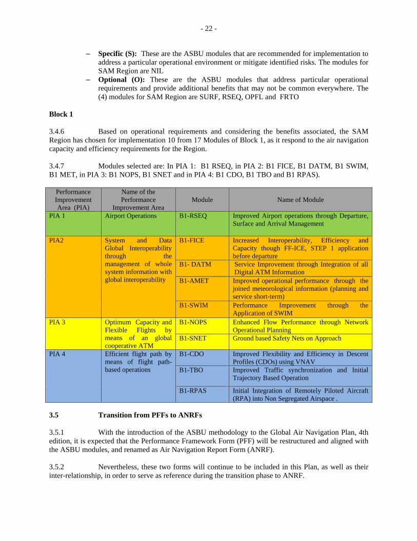
Block 1 3.4.6 Based on operational requirements and considering the benefits associated, the SAM Region has chosen for implementation 10 from 17 Modules of Block 1, as it respond to the air navigation capacity and efficiency requirements for the Region. 3.4.7 Modules selected are: In PIA 1: B1 RSEQ, in PIA 2: B1 FICE, B1 DATM, B1 SWIM, B1 MET, in PIA 3: B1 NOPS, B1 SNET and in PIA 4: B1 CDO, B1 TBO and B1 RPAS).
3.5 Transition from PFFs to ANRFs 3.5.1 With the introduction of the ASBU methodology to the Global Air Navigation Plan, 4th edition, it is expected that the Performance Framework Form (PFF) will be restructured and aligned with the ASBU modules, and renamed as Air Navigation Report Form (ANRF). 3.5.2 Nevertheless, these two forms will continue to be included in this Plan, as well as their inter-relationship, in order to serve as reference during the transition phase to ANRF.
Performance Improvement Area (PIA)
Name of the Performance
Improvement Area Module Name of Module
PIA 1 Airport Operations B1-RSEQ Improved Airport operations through Departure, Surface and Arrival Management
PIA2 System and Data Global Interoperability through the management of whole system information with global interoperability
B1-FICE Increased Interoperability, Efficiency and Capacity though FF-ICE, STEP 1 application before departure
B1- DATM Service Improvement through Integration of all Digital ATM Information
B1-AMET
Improved operational performance through the joined meteorological information (planning and service short-term)
B1-SWIM Performance Improvement through the Application of SWIM
PIA 3 Optimum Capacity and Flexible Flights by means of an global cooperative ATM
B1-NOPS Enhanced Flow Performance through Network Operational Planning
B1-SNET Ground based Safety Nets on Approach
PIA 4 Efficient flight path by means of flight path-based operations
B1-CDO Improved Flexibility and Efficiency in Descent Profiles (CDOs) using VNAV
B1-TBO Improved Traffic synchronization and Initial Trajectory Based Operation
B1-RPAS Initial Integration of Remotely Piloted Aircraft (RPA) into Non Segregated Airspace .
- 23 -
4. Chapter 4: Air Traffic Management (ATM)
4.1 Introduction 4.1.1 Currently, the challenge facing the ATM community consists of how to create conditions so that all users and stakeholders to improve the performance of the air navigation system using the cost-effective deployment of operational improvements and, at the same time, meet the global, regional and local needs. 4.1.2 The Global Plan air navigation plan (GANP) is the strategic guide that lead the States and stakeholders towards interoperability of systems and the harmonization of procedures. As part of the GANP, the Aviation system blocks upgrades framework (ASBU) describes enablers to allow operational improvements and also provides guidance and tools to determine optimized solutions for the local and regional requirements.
4.1.3 According to the Global ATM Operational Concept, the general objective of ATM is to achieve a global, inter-operational air traffic management system for all users during all flight phases, that meets the agreed levels of safety, provides optimum operations, is environmental sustainable, and meets national security requirements. 4.1.4 In this line, the PBN operational concept for the SAM Region 2018-2020 (CONOPS) has been developed, which prioritizes safety and describes required capabilities to improve efficiency, increase capacity and to protect the environment, and defining the specifications of air navigation that will be needed to implement uniformly in the airspace of the SAM Region. The texts of the CONOPS are incorporated into this Plan in attachment H, so is considered a complementary to this chapter document. 4.1.5 The system must evolve from the current system so as to, inasmuch as possible, meets the needs of the users, according to clearly established operational requirements. The reality is that migration and integration are the most difficult institutional issues facing ATM system designers. 4.1.6 Airspace boundaries and divisions might not restrict the development of the airspace structure. Planning should be coordinated, in the regional and interregional scope, as well as between adjacent areas in order to achieve a seamless airspace, in which the user does not perceive any division. The airspace should be free of operational discontinuities and inconsistencies, and should be organised in such as way as to accommodate the requirements of the different types of users. The migration between areas should be seamless to users at all times. 4.1.7 Human intervention within the human factors and training aspects is taken under consideration in all aviation improvement modules. 4.1.1 La consideración de la actuación humana en el marco de los factores humanos y el entrenamiento está considerada en todos los módulos de mejoras de la aviación en forma transversal. 4.1.8 Some of the benefits that are expected from the implementation of these components are improved safety, reduced operating fuel costs for users, reduced delays and gas emissions, and increased system capacity. 4.1.9 The evolution of air traffic management in the SAM Region has been carefully planned to avoid the degradation of the performance of the existing system. The safety level attained to date must be preserved during the transition, as a minimum, gradually improving air navigation efficiency.
- 24 -
Consideration has also been given to avoiding an unnecessary overloading of aircraft with multiple CNS equipment, both existing and new, during the extended transition period. 4.2 General principles 4.2.1 Unrestricted access to air navigation services listed in this document must be foster and pushed for all SAM States. 4.2.2 The need for SAM States, to follow the guidance of this document in order to develop their National Plans oriented to implement the performance based navigation, arranging resources to fully comply with such national plans, as well as with the standards governing the use of the new systems, is acknowledged. 4.2.3 SAM States must accept the global nature of the ATM Operational Concept and the objective of providing integration mechanisms for its timely implementation. 4.2.4 CNS infrastructure must be carefully planned based on the requirements identified for the appropriate level of air traffic management in the SAM Region. 4.2.5 In the early stages, the new CNS elements were planned to be gradually introduced, taking into account the benefits to be derived by the ATM community. In that sense, in the period 2013-2017 it was achieve a progress in the implementation of the advanced elements of the CNS and ATM automation in several areas of the SAM Region, which leads to a new scenario related to CNS/ATM systems that must be considered obsolete or must be dismantled. These elements are referred in this document as the "legacy of air navigation".
4.2.6 However, a solution to the legacy of air navigation, which somewhat hampers the capacity and air traffic growth, aims to build a fully harmonized air navigation system that is supported by performance-based technologies and procedures. Planners of communications, navigation and surveillance/air traffic management (CNS/ATM) have pursued this goal for many years. Given that the technology is not a static discipline, it has proved difficult to mark a strategic line leading to harmonized worldwide system. 4.3 Analysis of the current situation (2017) Gaps of the current ATM system in the SAM Region 4.3.1 The ATM system available in the SAM Region remains some gaps, including the following:
a) Insufficient implementation of Performance-Based Navigation (PBN) and, in general, absence of airspace management (ASM);
b) The lack of a systematic use of cost-benefit analyses for the implementation of new airspace structures causes difficulties in the definition of air navigation infrastructure implementation priorities, and prevents measuring the benefits obtained by the ATM community;
c) The lack of implementation of the policy and procedures for the flexible use of airspace hinders airspace design and management, blocking the implementation of an optimum airspace structure and the use of optimum flight paths;
- 25 -
d) The lack of air traffic flow management (ATFM) in most airspaces of the SAM Region causes congestion in some airspaces and airports, and prevents optimum use of ATC and airport capacity, thus affecting users;
e) The lack of coordination in the provision of the existing CNS/ATM services sometimes generates a duplication of resources and services;
f) Operations still rely on voice radio-communications for air-ground exchanges, that should became congested in the peak hours;
g) The lack of an ATS surveillance service in some portions of the airspace of the Region prevents a harmonised optimization of aircraft spacing, due to the application of different separation criteria in FIR boundaries (with and without ATS surveillance), thus restricting the use of optimum flight profiles;
h) The lack of harmonisation of automated ATM systems in the SAM Region, as well as the scarce sharing of ATS surveillance data, generates discontinuity in ATS services; and
i) Limited facilities for real-time exchange of information between ATM, aerodromes and aircraft operators, leading to a weak response to changes made in the operational requirements of users.
4.3.2 In some airspace segments and some aerodromes, a complete and integrated ATM system implementation has not been accomplished, resulting in inefficient operations. These limitations include:
a) The requirement to fly circling patterns in departure and arrival procedures; b) Existence of airspaces of a permanent nature reserved for military purposes mainly; c) Inadequate airspace planning prevents direct flights between the origin-destination
airports and/or city pairs, and also operations at incorrect flight levels and/or speeds that make it difficult for aircraft to maintain optimum flight profiles;
d) Excessive ground and en-route delays related to the system; e) Insufficient flexibility to properly address disturbances in airline operations caused
by meteorological conditions, unexpected failures in CNS systems and airport services interruption;
f) Weak manage of the ATS and airspace capacity g) Lack of harmonization in aeronautical publications, mainly instrumental procedures.
4.4 Strategy for the implementation of performance objectives 4.4.1 ATM evolution in the SAM Region has been planned taking into account the ASBU that could be applied in the short and medium term. ATM performance objectives, in addition to the requirements for the implementation of ATM improvements, determine the implementation dates of planned improvements, as well as the performance objectives. 4.4.2 The planning period considered is 2017 to 2023. 4.4.3 ATM evolution is based on:
a) En-route operations; b) TMA operations; and c) Air operations in general.
4.4.4 ATM Planning is based on following performance objectives, as shown in Attachment C, and as listed below:
- 26 -
a) En-route airspace optimisation (SAM ATM/01 PFF); b) TMA airspace structure optimisation (SAM ATM/02 PFF); c) Implementation of RNP approaches (SAM ATM/03 PFF); d) Flexible use of the airspace (SAM ATM/04 PFF); e) ATFM implementation (SAM ATM/05 PFF); f) Improvement of ATM situational awareness (SAM ATM/06 PFF).
4.4.5 It should be noted that the different specialties (CNS, AIS; MET; AGA/AOP; SAR) developed in this Implementation Plan support ATM development and, in turn, constitute per-se an integrated, indivisible system. In particular, this Implementation Plan contains some cross-cutting issues that the States must especially address, namely:
a) Development of human resources and competence management (see Chapter 10); and
b) Safety management – SMS (see Chapter 11).
4.5 En-route operations 4.5.1 The evolution of ATM for en-route operations took into account the ASBU Block 0 modules applicable to the SAM Region and was planned in order to permit optimum airspace management and organisation. The implementation of versions of ATS routes network, based on PBN, will continue to be the main feature of the optimisation of enroute airspace for the SAM region, in order to foster the implementation of advanced navigation specifications of the aircraft which, combined with ATM tools, an adequate ATC sectorization and traffic flow management, allows ATS routing that, whenever possible, meet the needs of airspace users, reduce the workload of controllers and pilots and avoid the concentration of aircraft in portions of airspace that may cause congestion of the system. 4.5.2 The concepts and guidelines for the implementation of the PBN enroute operations, for the short and medium term, including specifications of navigation and aircraft separation criteria, are detailed in Chapter 7 of the CONOPS. Situational awareness and en-route data relationship applications 4.5.3 The use of ADS-C and CPDLC in oceanic airspaces will foster the necessary conditions for using 30-NM horizontal separation minima in the EUR/SAM Corridor and in the Santiago-Lima route segment. The need for Aeronautical Mobile Satellite Service (AMSS) will be assessed to ensure such separation. Furthermore, in other oceanic airspaces with less traffic density, ADS-C and CPDLC will provide reliable surveillance and communication media, reducing the workload of controllers and pilots. 4.5.4 In the continental airspace, the use of enhanced surveillance techniques (ADS-B and/or multilateration) will help reduce horizontal separation minima, enhance safety, increase capacity, and improve the cost-effectiveness of flights. The use of CPDLC instead of voice communications could bring significant benefits in terms of safety and pilot and controller workload; however its use must be assessed taking into account that it might not be feasible due to the characteristics of ATC interventions.
- 27 -
4.5.5 These benefits may be achieved by providing surveillance in areas that lack primary or secondary radar when so warranted by cost-benefit analyses. In airspaces where radar is used, improved surveillance may help enhance the quality and reliability of surveillance information both on the ground and in the air. The States shall conduct a consistent cost-benefit analysis to determine if, when the time comes, PSR and/or SSR systems should be replaced by ADS-B systems or multilateration. 4.5.6 The gradual implementation of ATS inter-facility data communication (AIDC) will enhance airspace safety and reduce coordination errors between ATS units. 4.5.7 The implementation of ATS surveillance systems and data Relationship applications should take into account the corresponding automation aspects, mainly with respect to the need for harmonisation between the systems applied, with a view to ensuring system interoperability. 4.5.8 Furthermore, the implementation of ATS surveillance systems and data relationship applications should consider ATM automation tools (minimum safe altitude warning; conflict prediction; conflict alert; conflict resolution advisory; path conformance control; functional integration of ground and airborne systems, etc.).
4.5.9 Amongst others, the following applications that may assist with an improvement of the situational awareness, are identified:
a) TFMS - SYNCHROMAX or similar; b) Surveillance tools to identify the boundaries of the airspace sector; c) Use of A-SMGC at specific aerodromes, as required; d) Availability of SIGMET in graphical format; e) Dissemination of AIS; and f) Implementation of D-VOLMET.
4.6 TMA operations 4.6.1 The evolution of air traffic management in terminal areas shall be harmonised with the evolution of ATM for en-route operations, providing for a harmonious and integrated ATM system. 4.6.2 The evolution of ATM for TMA operations took into account the ASBU Block 0 modules applicable to the SAM Region, and was planned so as to permit an optimum airspace management and organisation. 4.6.3 The TMA structure optimisation is supplementary related to the optimisation of the routes, through the use of approach procedures, SIDs, STARs, based on PBN, the application of TMA design and management techniques, and the functional integration of ground and airborne systems. 4.6.4 As regards situational awareness and implementation of data link applications, the close relationship between the implementation of enhanced surveillance techniques (ADS-B and/or MLAT) and the use of data link applications is taken into account. 4.6.5 There are many factors that should be taken into account when planning the requirements for a TMA air navigation service infrastructure. In addition to traffic volume, consideration should be given to other factors, such as: number and location of aerodromes, traffic characteristics, terrain, meteorological conditions, etc. Therefore, the States should analyse each particular TMA and determine, in coordination with the users, the requirements for the implementation of the corresponding air navigation services.
- 28 -
TMA structure optimisation 4.6.6 TMA airspace structure optimisation will be achieved through the following measures:
a) PBN implementation, which includes the implementation of SIDs and STARs with RNP and/or RNAV, and RNP approach procedures;
b) Implementation of continuous descent operations (CDO) and continuous climb operations (CCO);
c) The functional integration of ground and airborne systems; and d) The use of improved design and management techniques.
Implementation of PBN for TMA operations 4.6.7 TMA operations have specific characteristics, taking into account the separation minima applicable between aircraft, and between aircraft and obstacles. This also involves the diversity of aircraft, including low-performance aircraft that carry out arrival and departure procedures on the same path as, or close to the paths of, high-performance aircraft. 4.6.8 In this sense, the States shall develop their own national TMA PBN implementation plans, based on the the Action Plan Model developed by SAMIG meetings. They shall seek harmonisation of aircraft separation criteria and the applicable RNAV and/or RNP criteria, in order to avoid the need for multiple approvals for intra- and inter-regional operations. 4.6.9 The efficiency of TMA operations in a PBN environment depends on aerodrome design and management and runway operations, taking into account that any air traffic flow increase in TMA operations shall be absorbed by airport infrastructure.
4.6.10 The implementation of PBN, in main TMA in the region giving priority to the implementation on the basis of the traffic volume and considering an appropriate integration with the route network, will continue. Is expected that non PBN-approved aircraft operations will remain, the establishment of exclusionary PBN TMA will depend on the complexity and density of traffic.
4.6.11 The concepts and guidelines for the implementation of the PBN operations in Terminal Areas, for the short and medium term, including specifications of navigation and aircraft separation criteria, are detailed in Chapter 7 of the CONOPS.
- 29 -
Functional integration of ground and airborne systems 4.6.12 The optimisation of TMA efficiency will depend on a maximum use of automation. Likewise, aircraft will be increasingly equipped with time of arrival calculation. Thus, functional integration of ground and on-board systems will enable identification of times of arrival at specific fixes. These schedules should help in the landing sequencing process, allowing aircraft to remain close to their preferred 4D path, contributing to the application of one of the components of the ATM Operational Concept, which is Air Traffic Synchronisation. Use of improved design and management techniques 4.6.13 Airspace planners should apply design techniques, based on PBN criteria, for TMA restructuring, with a view to:
a) Validating the proposed airspace structure; b) Assessing the impact of PBN implementation, including RNAV, GLS procedures
and/or RNP SID and STAR procedures, and FMS-based arrival procedures, using ATC simulations as needed;
c) Ensuring a favourable cost-benefit ratio; and d) Optimising sectoring so as to make it seamless for users and balanced in terms of
workload.
Situational awareness and data relationship applications for TMA 4.6.14 In addition to the considerations contained in the section on en-route operations, which also apply to TMA operations, the States should consider the following aspects for the implementation of ATS surveillance services and data Relationship applications in the TMA. 4.6.15 The implementation of surveillance systems (ADS-B and/or multilateration) at the TMAs will provide the conditions required for the integration of en-route and TMA operations. 4.6.16 The use of ATS surveillance systems (SSR, ADS-B and/or multilateration) will permit the use of RNAV-based navigation specifications, taking into account that surveillance will permit flight monitoring for the detection of any path deviation. Thus, it will be possible to include in TMA operations those users that would not be approved for RNP operations. 4.6.17 The implementation of improved surveillance systems will facilitate the operation of aircraft not approved for RNAV/RNP, taking into account that the controller will be able to vector them to the final approach. 4.6.18 The implementation of CPDLC in the TMA is not expected, taking into account the characteristics of ATC intervention in these airspaces. However, other data Relationship applications will reduce the workload of controllers and pilots, such as: D-ATIS and digital flight plan clearance (DCL). 4.6.19 It should be noted that TMA users might not be equipped with data Relationship systems, since there is a significant number of low performance aircraft that fly in this airspace and might not be capable of being properly equipped. In that case, procedures must be developed to allow non-equipped aircraft to fly, unless air traffic density warrants the use of exclusionary airspaces.
- 30 -
Air operations in general 4.6.20 This part of the Plan includes aspects contributing towards efficiency and capability applicable to general air operations. Flexible Use of Airspace (FUA) 4.6.21 The optimum, balanced and equitable use of airspace by civil and military users, facilitated by strategic coordination and dynamic interaction, will permit the establishment of optimum flight paths, while reducing the operating cost of airspace users. 4.6.22 SAM States should establish policies for temporary or permanent use of restricted airspaces, in order to avoid the adoption of airspace restrictions inasmuch as possible, and also consider and integrate in its air navigation system unmanned aircraft systems (UAS), a new component of the aeronautical system. 4.6.23 The implementation of the flexible use of airspace should start with an assessment of hazardous, restricted and prohibited airspaces that affect or could affect traffic flow. 4.6.24 The establishment of letters of agreement between ATS and military units or other users for the dynamic and flexible use of airspace should avoid restrictions to the use of airspace, thus accommodating the needs of all airspace users. 4.6.25 In those cases in which airspace reserved is inevitable, the letters of agreement should stipulate that the activation of reserved airspace should not exceed the time required. To that end, it will be necessary to develop paths for dynamic re-routing of aircraft to avoid such airspaces. 4.6.26 The cited paths should be published in the AIP to let users know of the need to take into account such possible deviations in flight planning. 4.6.27 FUA implementation requires convincing the reserved airspaces users, mainly military authorities of the States involved, assuring them that their needs will be met whether or not airspace restrictions are applied. Consequently, seminars/meetings with such authorities will be required to demonstrate the importance of an optimised use of airspace.
RPAS systems
4.6.28 The technological advancement of remotely piloted aircraft systems (RPAS) and its fast expansion in various applications of civil aeronautics and in various sciences and arts, observed in the countries of the Region, point to initiate the planning and studies for the implementation of requirements for the operation of these systems in non-segregated airspace. It is expected that this activity will have a direct impact on the concepts of planning airspace and ATS services. Air Traffic Flow Management (ATFM) 4.6.29 In view of significantly increased number of air operations in some areas and international airports of SAM Region, in a scenario in which is observed, at least in certain periods of the day, capacity gaps in the facilities and ATM/CNS infrastructure and airports, SAM States must seek for an adequate balance between demand and capacity, ensuring that in normal operational conditions, the ATM system is able to attend the existing demand of air traffic.
- 31 -
4.6.30 The implementation of timely measures for demand/capacity balancing, in case of events that reduce system capacity, for example adverse weather conditions and/or temporary problems in airport infrastructure or ATC, will avoid an overload of the ATM system and will create the conditions for maximising airport and ATC capacity. This should increase significantly airspace capacity and operational efficiency. 4.6.31 States has initiated the application of air traffic flow management measures and the implementation of FMP/FMU hosted in the main ACC of the Region, and also performing the calculation and maximisation of ATC and airport capacity, particularly runway capacity.
4.6.32 ATFM implementation in the SAM Region should take into account the objective and principles established in Appendix AL to Item 3 of the GREPECAS/13 meeting, noting that ATFM measures must foster a maximum use of existing capacity without compromising safety.
4.6.33 The ATFM Operational Concept establishes a simple strategy that should be developed in stages, maximising available capacity and allowing the parties involved to gain sufficient experience. 4.6.34 The experience gained in other Regions and by some SAM States permits the application of basic ATFM procedures at airports. 4.6.35 Thus, ATFM in the SAM Region will be implemented by stages, based on the established operational requirements, in keeping with the SAM ATFM Operational Concept.
4.6.36 So as to reconcile national plans with the SAM ATFM Regional Plan, civil aviation administrations must take required measures and carry out a close follow-up of the regional development of ATFM, and draft an ATFM implementation programme, where implementation needs are determined, the impact it will have in the national ATC system, in airspace, air traffic services and in airport services, and pertinent coordination is established, to make feasible a harmonious and timely integral regional implementation.
4.6.37 Is highlighted that, while the idea of a single entity ATFM serving a Region in a centrally model has been properly implementing in Europe and North America, and in Brazil at the sub regional level, is observed that this orientation in the short term is not feasible in SAM region. Therefore the works for ATFM implementation have progressed on a State by State approach, based on flow management units or posts (FMU/FMP). 4.6.38 In that sense, in order to maximise its efficiency in a long-term, the feasibility of implementing a centralised ATFM that should be responsible for delivering the service in as much airspace as possible, provided it is homogeneous, should be assessed.
- 32 -
4.6.39 Besides, the SAM States must focus their efforts to improve the coordination of their FMP/FMU with sectors and dependencies in the associated ACC, and emphasising coordination with the FMP/FMU of adjacent States, to eliminate the application of "Flow Control" that pretends to separate aircraft within a FIR following a precarious method, under a unilateral scheme. To do this, it is essential to provide human resources and procedures to the FMP/FMU's defining their competence and authority, as well as to promote the signing ATFM letters of agreement between concerned authorities. 4.7 Alignment with ASBU 4.7.1 Of the ASBU Block 0 and Block 1 modules taken under consideration of the SAM Region, the ATM area contributes to modules B0-RSEQ y B1-RSEQ (Runway sequencing), B0-APTA (Airport Accessibility), B0-SURF (Surface Operations) regarding the PIA 1, modules B0-FRTO (Free route operations), B0-NOPS, B1-NOPS (Network operations), B0-ASUR (Alternative Surveillance), B0- SNET, B1-SNET (Ground based safety nets) y B0-OPFL (Optimum flight levels) regarding the PIA 3, and modules B0-CDO y B1-CDO (Continuous descent operation) , B0-CCO (Continuous Climb operation), B0-TBO (Trajectory Based Operations) y B1-RPAS (Remotely piloted aircraft system) connected to PIA 4. 4.7.2 Following are the ATM PFF indicated in paragraph 4.4.4 reflected on the following ASBU Block 0 modules indicated in paragraph 4.7.1:
a) PFF SAM ATM/01 - Optimization of the en-route airspace structure, with modules
B0-FRTO and B0-OPFL; b) PFFSAM ATM/02 - TMA airspace structure optimization, with modules B0- CDO,
B1-CDO and B0-CCO and B1-RPAS; c) PFF SAM ATM/03 - Implementation of RNP and A-RNP approaches, with module
B0-APTA; d) PFF SAM ATM/04 - Flexible use of airspace, with module B0-FRTO; e) PFF SAM ATM/05 - ATFM implementation, with modules B0-RSEQ, B1-RSEQ,
B0-ACDM, and B0-NOPS and B1-NOPS; and f) PFF SAM ATM/06 - Improve ATM situational awareness, with modules B0-SURF,
B0-ASUR and B0-SNET, B1-SNET.
- 33 -
5. Chapter 5: Communications, Navigation and Surveillance (CNS) 5.1 Introduction 5.1.1 When implementing CNS systems, SAM States must consider the ATM operational requirements contained in this Plan. 5.1.2 In view of the requirements derived from the implementation of the ATM Operational Concept, SAM States shall consider planning improvements to, and the strengthening of, aeronautical communication, navigation and surveillance services, taking into account ASBU modules of the Global Air Navigation Plan. Communications 5.1.3 Communication systems contemplated in this plan respond to short- and medium-term expectations of the operational requirements in the Region. Accordingly, this plan has taken into account the following communication systems:
a) Aeronautical message handling system (AMHS); b) ATS inter-facility data communication (AIDC); c) Controller/pilot data Relationship communications (CPDLC); d) Data link automatic terminal information service (D-ATIS); e) Voice meteorological information for aircraft in flight (VOLMET) and data link
(D-VOLMET); f) Voice clearance delivery (CLRD) and data clearance (DCL); and g) SAM Aeronautical Telecommunications network (ATN).
Navigation
5.1.4 The function of navigation systems is to support en-route, terminal, approach and landing operations and surface movements. 5.1.5 The navigation systems contemplated in this plan respond to short- and medium-term operational requirements of the Region. In this respect, this plan for navigation systems has taken into account continuing with the ground navigation infrastructure (VOR, ILS DME and NDB) remaining the gradual deactivation of NDBs and the GNSS requirements (ABAS multi-constellation, multi-frequency and GBAS CAT 1) concerning the operations foreseen in the CAR/SAM PBN Roadmap. Surveillance 5.1.6 The function of surveillance systems is to provide aircraft position information to air traffic service units (ATS).
- 34 -
5.1.7 The surveillance systems contemplated in this plan respond to short- and medium-term operational requirements in the Region. Accordingly, this plan considers the following:
a) ADS-B; b) ADS-C; c) MLAT and WAM; d) SSR; and e) The integration of the aforementioned.
5.2 Analysis of the current situation (2017) 5.2.1 The current SAM communication, navigation and surveillance services situation in support of air navigation is described below, as per information provided in FASID CNS tables. Communications - Aeronautical fixed service 5.2.2 AFTN service: The circuits foreseen have been fully implemented and gradually migrating to AMHS. 5.2.3 ATS speech service: The circuits foreseen have been fully implemented. Circuits are analogue and operate without any major problem. 5.2.4 AMHS service: This service has been implemented in almost all SAM States and Territories.
5.2.5 Memoranda of Understanding (MoU) have been drafted for the interconnection of AMHS systems between States. 5.2.6 AIDC: Implemented in most all automated systems in the States’ ACCs. 5.2.7 AIDC operation between ACCs and ACCs with other ATS units is only implemented between few SAM Region States. At regional level some States have already implemented it or in pre-operational phase.
Information delivery network
5.2.8 A satellite digital network (REDDIGII) is available in the region. It is based on IP technology and formed by satellite and ground networks. The REDDIG II supports current and future aeronautical fixed services required as well as additional navigation and surveillance services. Aeronautical mobile service 5.2.9 VHF: Services have been implemented as indicated in FASID Table CNS 2A, ensuring coverage in most of the selected areas, with problems at lower levels in selected airspaces. In the case of terminal areas and aerodromes, many facilities do not follow the recommendation of having different frequencies for APP and TWR services. The clearance delivery (CLRD) service has not been implemented at the level required. 5.2.10 HF: Although required in FASID Tables CNS 2 A and 2B, the HF service is not being operationally used in many States of the Region. It is mainly provided at some States that have oceanic areas in their FIRs.
- 35 -
5.2.11 ATIS: Implemented according to Table CNS 2A, but in an insufficient number. Use is made of conventional audio recorders and analogue VHF transmitters for dissemination. 5.2.12 CPDLC:
a) Continental airspace: Not yet implemented; and b) Oceanic airspace: Service implemented at some oceanic FIRs, for FANS equipped
aircraft. 5.2.13 CLRD: Implemented in very few airports for terminal area/aerodrome. 5.2.14 D-ATIS: Implemented in two States from the Region.
5.2.15 D-VOLMET: Implemented in only one State of the Region.
Navigation
5.2.16 Radio aids: All conventional radio navigation aid systems (NDB, VOR, DME and ILS) have been implemented and fully installed pursuant to Table CNS 3 (radio navigation aids). Regarding NDBs, a deactivation process is underway, starting with those stations where the NDB is installed next to a VOR/DME. 5.2.17 ABAS is being implemented in most States of the Region for en-route, terminal area and NPA operations.
Surveillance 5.2.18 Radar systems: Conventional surveillance systems (PSR and SSR) have been implemented and installed almost entirely in the SAM Region according to Table CNS 4 A (surveillance system). The surveillance systems specified in this table cover most of the terminal areas of the States in the Region. However, not all the routes in the Region are covered. 5.2.19 Radar data exchange: It only exists in very few States of the Region. 5.2.20 ADS-B and MLAT: No services have been enabled to date. 5.2.21 ADS-C: Service provided by several oceanic FIRs, with FANS-equipped aircraft. 5.3 Strategy for the implementation of performance objectives 5.3.1 CNS implementation shall be based on a harmonised strategy for the SAM Region, with action plans and consistent timetables, taking into account operational requirements and the corresponding cost-benefit analyses, comparing the current structure with the improvements to be achieved when the new systems are implemented. Consideration should also be given to analysing the existence of two or more technologies to meet the same operational requirement. 5.3.2 Planning has been based on four global aspects, as shown in Attachment C, and as listed below:
a) aeronautical fixed service in the SAM Region (PFF SAM CNS/01);
- 36 -
b) aeronautical mobile service in the SAM Region (PFF SAM CNS/02); c) navigation systems in the SAM Region (PFF SAM CNS/03); and d) air surveillance service in the SAM Region (PFF SAM CNS/04).
5.3.3 A cross-cutting issue is the management of ANS personnel competencies of the air navigation system (PFF SAM HR/01). In this sense, States must pay special attention to meet ICAO requirements (see Chapter 10). Communications
Aeronautical fixed service 5.3.4 AMHS: During this period, it is expected that each one of the AMHS systems installed will be interconnected to its respective AMHS systems.
5.3.5 Communication services for the ATFM: States must make the necessary efforts to implement communication services that effectively support ATFM. 5.3.6 AIDC: The States must make efforts to install automated systems in all their ACCs, with AIDC capability, and use them for the automatic transfer of flight plans between adjacent ACCs.
5.3.7 Improvement of the regional and national ATN network: In order to implement all the new services in a harmonised manner, the current Aeronautical Telecommunication Network (REDDIG II) requires updating. States that have not yet completed or began their national IP network implementation shall do so.
Aeronautical mobile service 5.3.8 VHF: States must ensure coverage of continental VHF communications for lower flight levels when so required by the operations. Likewise, separate VHF channels must be implemented for TWR and APP services in the terminal area. 5.3.9 HF: The HF service must be maintained in keeping with the requirements listed in Table CNS 2B, “HF network designators for CAR/SAM aeronautical stations”. 5.3.10 CPDLC: States that have oceanic areas in their FIRs must make efforts for the provision of CPDLC services in the corresponding ACCs. Likewise, for the continental area, a technical/operational study should has been completed out within the planning period, to permit its later implementation in some States. 5.3.11 DATIS: The States must start providing DATIS services to replace similar conventional services or where they do not exist.
5.3.12 VOLMET/D-VOLMET: In attention to the MET requirement, States should start providing VOLMET services through speech communications systems and data links. 5.3.13 AEROMAC: Airports with more congestion shall begin the implementation of aeronautical mobile communications (data links with great capacity) to support fixed and mobile communications related to safety and regular flights in airports surface.

- 37 -
5.3.14 Protection of the radio frequency spectrum: The States must make the necessary efforts to ensure the protection and proper use of the radio frequency spectrum assigned to aviation for radiocommunication services. Navigation Navigation systems 5.3.15 NDB: States must continue with the NDB phase-out plan, as defined by GREPECAS/14 (April 2007). It is estimated that, during the period defined in the plan, most NDB will be deactivated. 5.3.16 VOR/DME: During the period defined in the plan, it is felt that, as part of the transition to the GNSS, VOR/DME systems must be maintained in selected TMAs, completing the deactivation of en-route VOR systems.
5.3.17 DME/DME: Taking into account en route PBN and TMA implementation, as well as the use of DME/DME navigation as a back-up to the GNSS system, States should maintain the current DME systems coverage and, if necessary, States should carry out studies permitting the coverage extension of selected airspaces. 5.3.18 ILS: It is foreseen that, within the planning period, ILS systems will remain operative. 5.3.19 GLS: Approaches based on CATI GLS will begin at airports that have an operational demand that warrants them. 5.3.20 Flight trial support systems: The States must consider modernising their in-flight and ground trial elements so as to be prepared for a PBN environment. 5.3.21 Protection of the radio frequency spectrum: The States must make the necessary efforts to ensure protection and proper use of the radio frequency spectrum assigned to aviation for radionavigation services. Surveillance
Improvements to the air surveillance service 5.3.22 ADS-B and MLAT: ADS-B (ES Mode S receivers) will be implemented on the ground to cover en-route and terminal areas in all States. Strengthening surveillance in the form of SSR radars will continue being used in TMA services en-route, and Mode S in high density TAMs. Most aircraft will have ADS-B surveillance capacity (ES Mode S receivers). MLAT will be implemented in main airports selected to carry out surface aircraft surveillance. 5.3.23 A-SMGCS: It is foreseen that surface movement guidance and control systems A-SMGCS will be implemented at principal airports where previous studies have identified this requirement. 5.3.24 ADS-C: All States responsible of an oceanic FIR shall make operational use of ADS-C surveillance.
- 38 -
5.3.25 Protection of the radio frequency spectrum: The States must make the necessary efforts to ensure protection and proper use of the radio frequency spectrum assigned to aviation for air surveillance services.
5.4 Alignment with ASBU 5.4.1 Of the ASBU Block 0 modules taken under consideration of the SAM Region, the CNS area contributes to PIA 1 modules B0-APTA and B0-SURF, PIA 2 module B0-FICE, PIA 3 modules B0-NOPS, B0-ASUR and B0-SNET and PIA 4 module B0-TBO. 5.4.2 Regarding Block 1 modules considered by the SAM Region, the CNS area contributes to PIA 2 module B1-FICE, PIA 3 modules B1-NOPS and B1-SNET and PIA 4 module B1-TBO. 5.4.3 Following are the CNS PFF indicated in paragraph 5.3.2 contributing with ASBU Block 0 modules indicated in paragraph 5.4.1 and Block 1 modules indicated in paragraph 5.4.2:
a) PFF SAM CNS/01 – Aeronautical fixed service, with modules B0-FICE and B0-
NOPS, B1-FICE and B1-NOPS; b) PFF SAM CNS/02 – Aeronautical mobile service, with module B0- TBO and B1-
TBO; c) PFF SAM CNS/03 – Navigation, with module B0-APTA; and d) PFF SAM CNS/04 – Surveillance, with modules B0-NOPS, B0-SURF, B0-ASUR,
B0-SNET and B1-NOPS and B1-SNET.
- 39 -
Chapter 6: Meteorology 6.1 Introduction 6.4.1 The fifth edition of the Global Air Navigation Plan (Doc 9750, GANP) maintains the aviation system block upgrade (ASBU) strategy and proposes that future air navigation technology and procedure improvements are organized and based on a consultative strategic approach that coordinates specific global performance capabilities and the flexible upgrade timelines associated with each component. 6.4.2 Meteorological information is an integral component of the tomorrow’s system-wide information management (SWIM) environment, alongside aeronautical information, flight and flow information and other information sources. As meteorological information transitions from today’s predominantly gridded, binary, alphanumeric and graphical formats to interoperable, non-proprietary code forms (such as XML/GML) within the SWIM environment using exchange models like the weather exchange model (WXXM), tremendous potential exists to enhance the safety and the efficiency of the global air traffic management (ATM) system through enhanced availability and use of meteorological information. With this in mind, a planning threads promoting usage of integrated meteorological information to enhance operational decision making.
6.2 Meteorological information supporting enhanced operational efficiency and safety 6.2.1 Within Block 0, improved utilization by ATM of products from world area forecast centres, volcanic ash advisory centres and tropical cyclone advisory centres would support dynamic and flexible management of airspace, dynamically optimized flight trajectory planning, improved situational awareness and collaborative decision making. A focus on local arrangements is intended to enhance utilization of aerodrome warnings as well as wind shear warnings and alerts. 6.2.2 Meteorological challenges in routine operations often arise as a result of adverse and rapidly changing meteorological conditions. The proposed dynamic integration of ATM and meteorological (MET) information is expected to provide timely meteorological information to enable real-time identification, increased predictability and deployment of operationally effective ATM solutions to accommodate changing conditions, as well as facilitate tactical avoidance of hazardous meteorological conditions. Increasing use of airborne capabilities to detect and report meteorological parameters, and enhanced cockpit displays of meteorological information to enhance situational awareness, are additional elements of the strategy.
6.2.3 The Block 1 deployment includes initial ATM-MET integration, and actual and forecast meteorological information is compared with pre-characterized meteorological constraints on airspace or aerodrome threshold events using an ATM impact conversion process to identify near term capacity constraints. Total ATM-MET integration is required in order to incorporate meteorological information into the decision-making rationale and to automatically identify, understand and take into account the impact of meteorological conditions. ATM decision makers are increasingly assisted by decision support tools using integrated meteorological information, consisting of automated systems and processes that create ranked mitigation strategies for consideration and execution. It is also recognized that there is a need for space weather information in Block 1 for the sake of safety and efficiency of international air navigation, due to the sustained growth in the number of flights on transpolar routes where space weather, which affects the surface or the atmosphere of the earth (such as solar radiation storms), represents a hazard to communication and navigation systems and, perhaps, a radiation risk to crew members and passengers.
- 40 -
6.2.4 For the implementation of B1-AMET, the establishment of standards for global exchange of MET information in line with other types of information and using a single reference (ICAO-AIRM) shall be encouraged. The enhancement of meteorological information on different aspects related to service quality, such as data accuracy and standardization, when used in interrelated operational decision-making processes, shall also be encouraged. 6.2.5 It is very important to become aware that, for the transition to the implementation of B1-AMET, States will have to invest in software infrastructure that is compatible with AMHS in order to translate OPMET messages—currently in alphanumeric format—to an interoperable format (XML/GML). 6.2.6 The Block 3 stage, far greater reliance is placed on airborne capabilities to provide meteorological awareness and drive tactical decision making including avoidance of hazardous meteorological conditions. Enhanced meteorological information is dynamically available to support the evolution of 4D trajectory operations. The 4D representations of meteorological information that have replaced traditional gridded, binary, alphanumeric and graphic formats provide wide benefits including increased access to meteorologically constrained airspace. ATM decision-making processes make extensive use of decision support tools that dynamically integrate meteorological information and propose mitigation strategies for consideration. Enhanced interpretation and mitigation of hazardous meteorological conditions results in extended pre-flight and flow planning capabilities.
6.2.7 The technology requirements include the progressive establishment of an integrated 4D database capability of global meteorological information (observations and forecasts), as well as the deployment of automated systems to enable:
a) translation of raw meteorological data into predefined ATM constraints on airspace and aerodromes;
b) use of translated data to assess the impact on ATM operations, for traffic flows
and individual flights; and c) decision support tools, for both air navigation service providers (ANSPs) and
users, which use ATM impact information to generate proposed mitigation strategies.
6.2.8 In the medium term, the availability of SWIM will enable further integration of meteorological information into both airborne and ground based tactical decision support tools. 6.2.9 The realization of globally interoperable, exchangeable meteorological information, including enhanced ground-to-air, air-to-ground and aircraft-to-aircraft meteorological reporting and exchange capabilities will be a significant undertaking.
6.2.10 The transition to integrated meteorological information will require agreement to, and development of, global standards for meteorological information exchange with an emphasis on the exchange of 4D (latitudinal, longitudinal, vertical and temporal) digitized meteorological information. Agreements are also necessary on what will constitute required meteorological information and graphical presentation in the digital information exchange era, to supersede the traditional gridded, binary, alphanumeric and graphic formats. Standardized meteorological information translation parameters and ATM impact conversion parameters will also require global agreement and development. Ensuring the accurate, reliable and wide availability of meteorological information remains a continuing challenge.
- 41 -
6.2.11 Meteorological information is recognized as a component of, ASBU modules concerning airport capacity, SWIM, flight and flow – information for a collaborative environment (FF-ICE), aeronautical information management (AIM), network operations, airborne separation, remotely-piloted aircraft (RPA), trajectory-based operations (TBO), continuous climb operations/continuous descent operations (CCO/CDO) and the global navigation satellite system (GNSS). Deployments from the meteorological information planning thread will need to take account of these wide interdependencies, therefore, States and users are urged to give due consideration to the potential added benefits which could result from the integration of a number of modules across a number of threads. 6.2.12 In this regard, the ASBU describe the way to apply the concepts defined in the Global Air Traffic Management Operational Concept (Doc 9854) in order to achieve local and regional performance improvements. The final target is to achieve global interoperability. Safety and efficiency require this level of interoperability and harmonization, which should be achieved at a reasonable cost and provide proportional benefits. This module promotes the establishment of standards for global exchange of MET information in line with other types of information and using a single reference (ICAO-AIRM). It also encourages the enhancement of meteorological information in various aspects related to service quality, such as data accuracy and standardization, when used in interrelated operational decision-making processes. 6.3 Analysis of the current situation (2017) 6.3.1 SAM States provide an aeronautical meteorological service that has been gradually improving in recent years. However, to ensure the availability accurate, reliable and comprehensive weather information, not all States have the necessary equipment, properly installed and / or maintained. In this respect it is essential that States have automated systems for data verification in accordance with the requirements set out in Annex 3 (thresholds). While quality management systems are in a good implementation process, the process that should have been the basis for Block 0 will need to be adjusted to the new requirements of ISO 9001:2015. 6.3.2 Likewise, the lack of compliance with ICAO and WMO standards and recommendations referred to personnel involved in MET units is a deficiency that should be corrected by the States of the Region. 6.3.3 ICAO, together with the World Meteorological Organization, has made a significant effort to accompany and support the States in the implementation of the MET/QMS, hoping it would bear good results. However, there are still some States that have not yet completed MET/QMS implementation. In order to achieve this goal, it is imperative that top management in the administrations and aeronautical meteorological service providers be committed and in compliance. 6.3.4 Regarding SIGMETs on meteorological phenomena at regional level, there is lack of continuity, homogeneity, and harmonization in FIR surveillance. There have been cases in which the availability of severe en-route weather information for the user has been disrupted, thus affecting safety and flight planning. 6.3.5 Regarding OPMET messages, there has been an improvement in data availability, in addition to a significant reduction of formatting errors. The implementation and use of AMHS templates has significantly improved formatting. The implementation of OPMET messages in XML/GML format is still in an early stage, and initial data exchange testing in this format is just starting. 6.3.6 An element that cuts across all these areas is personnel competency management (PFF SAM/HR 01), in accordance with the requirements of the World Meteorological Organization (WMM).
- 42 -
6.4 Alignment with ASBU 6.4.1 Of the ASBU Block 0 modules taken under consideration of the SAM Region, the MET area contributes to PIA 1 modules B0-ACDM and B0-DATM, and PIA 3 module B0-AMET. Within Block 1, the MET area contributes to modules B1-ACDM, B1-SURF, B1-DATM, B1-AMET, and B1-SWIM. 6.4.2 Following are the MET PFF indicated in paragraph 6.3.2 contributing with ASBU Block 0 modules indicated in paragraph 5.4.1:
a) SAM MET/01 PFF - Implementation of the MET information quality management
system, with module B0-AMET and B1-AMET; b) SAM MET/02 PFF - Improvements in MET facilities, with modules B0-ACDM, B1-
ACDM, and B0-SURF; c) SAM MET/03 PFF - Improvements in the implementation of the international
airways volcano watch (IAVW), in the surveillance of the accidental release of radioactive material, and in the issuance of SIGMET(s), with modules B0-ACDM, B0-AMET, B1-ACDM, and B1-AMET; and
d) SAM/MET 04 PFF - Improvements in OPMET data exchange; follow-up of the evolution of WAFS; and implementation of MET and AIM data interoperability, with modules B0-DATM, B0-ACDM, B0-AMET, B1-DATM, B1-ACDM, B1-AMET, and B1-SWIM.
- - - - -
- 43 -
7. Chapter 7: Search and Rescue (SAR) Services 7.1 Introduction
7.1.1 The mission of SAR services is to find people in danger, help them and transport them to a safe place to receive proper care. The key for organising and having successful SAR services lies in top management, whose mission is to perform managerial tasks that will result in improved SAR operations, that is, the availability of an organised, trained and available SAR system capable of effectively helping people in danger.
7.1.2 The availability of SAR resources is often a critical initial capacity for responding and providing assistance to safe lives during the first stages of a disaster caused by natural causes or by the aviation activity per se. Accordingly, SAR services are sometimes part of an emergency management system.
7.1.3 SAR activities are an excellent means to encourage cooperation among States and organisations at the local, national and international level, since they involve missions that rarely create conflicting situations. Cooperation in this field may also lead to cooperation in other spheres. Such activities protect goods that may have a high value, which contributes to justify the existence of SAR services.
7.1.4 Close coordination between civil and military organisations is essential. National SAR coordination committees are a means for the establishment of such cooperation. The legislation should provide for the use of military and other public resources in support of search and rescue.
7.2 Analysis of the current situation (2017)
SAR requirements
7.2.1 The basic requirements for the establishment of an effective SAR system are:
a) The establishment of a regional framework concerning the need for availability of the
SAR services that have jurisdiction over the different Search and Rescue Regions of the SAM Region;
b) Measures for using the available resources and procuring others as necessary; c) The designation of the geographical areas of responsibility of the associated RCCs
and RSCs; d) Staffing, training and other personnel resources to manage and maintain the system in
operation; e) The appropriate and available means of communication; and f) Agreements, plans, and related documents aimed at meeting the objectives and
defining work relationships.
Note.- Paragraph 7.4 is referred to the operational concept of the global system GADSS, which is in development and which incorporate new SARPS for ICAO documents, including the Annex 12.
7.2.2 The periodic assessment of SAR requirements at regional level is very important for planning SAR resources and personnel in a coordinated manner, taking into account the respective SAR regions of the SAM States.
- 44 -
7.2.3 These updated and regionally harmonised requirements include, inter alia, the timely establishment of agreements between the different SAR services of SAM States for the provision of a regional search and rescue service, in keeping with the characteristics and needs of the aircraft fleet operating in the Region.
7.3 Implementation strategy of performance objectives
Risk management in practice
7.3.1 The use of risk management techniques gives some order to the uncertainty surrounding SAR organisations. It is an extremely useful tool for determining future work priorities and improving the capacity to meet the objective of the organisation, which is to find people in distress and take them to a safe location. 7.3.2 Risk analysis is a useful tool for those responsible for SAR organisations, since it can help in the assignment of resources that have priority for the organisation, and its results may be used to raise awareness amongst independent parties about the importance of search and rescue. SAR organisations should conduct a risk analysis and use the information thus obtained to increase their possibilities of saving lives. Planning has been based mainly on cooperation and Coordination of SAR services at a Regional level (SAM/SAR 01 PFF).
Quality management 7.3.3 Initiatives aimed at improving the quality of SAR services will substantially improve the results and reduce costs, mainly by eliminating the causes of unnecessary expenditures. These are important objectives for any administration, regardless of the volume of resources available. 7.3.4 The top management of a SAR system that assigns importance to quality tends to conduct more activities, make fewer mistakes, enjoy good reputation, and attract the resources necessary for the growth and better performance of the system. 7.3.5 In contrast, SAR organisations that do not pay attention to quality are subject to mistakes that may result in a reduced number of lives saved, the adoption of wrong or late operational decisions that create confusion, accidents and equipment failures, a deficient or inadequate use of resources, and unnecessary expenditure of economic resources. 7.3.6 Given the increasing air traffic activity and the use of large aircraft with a large passenger capacity, and its relationship with the responsibility of SAM States to protect human lives, it is important for SAR top management to develop a quality assurance programme for search and rescue (SAR) services, to be used as a quality management tool to ensure compliance with the objective of the national SAR plan of each SAM State. 7.3.7 This will also contribute to the provision of effective SAR services within the respective areas of SAR responsibility of each of these States, so as to foresee and particularly meet the many needs that would result from an accident with a large aircraft.
- 45 -
Competence of the search and rescue personnel
Training 7.3.8 Training is essential for operations and safety. The purpose of the SAR system is to save those who are in danger, and also to use training to reduce risks for the personnel and their means, which are very valuable. The training of personnel to conduct sound risk assessments will help ensure that the professionals who have received such training and the valuable means continue to be available for future operations.
Qualification 7.3.9 The purpose of the qualification is to validate the capacity of individuals to carry out certain tasks. They must demonstrate that they have a minimum level of knowledge and skills. This validation may be conducted in a specific position, through maintenance activities by a given team, or as a member of a group within a unit. 7.3.10 Qualification methods demonstrate the capacity of an individual to carry out concrete tasks. A qualification programme will cover the essential knowledge required to perform the functions in a given position and will test individuals in the use of the systems that they will have to manage or maintain.
Certification 7.3.11 The term certification is used in ICAO and other organisations within the context of authorising the personnel or the means to carry out certain functions. The term is also used to officially leave on record that an individual is duly trained and qualified to perform the tasks entrusted. 7.3.12 Thus, the objective of the certification is to authorise an individual to serve in a given capacity. Certificates should be issued to applicants that meet the conditions required for the service, as well as age, physical fitness, training, qualification, exam and maturity requirements. The certification must be issued in writing before the individual assumes his/her responsibilities in the surveillance service. 7.3.13 Training can only provide knowledge and skills at a basic level. Qualification and certification procedures help to demonstrate that sufficient experience, maturity and good judgment have been achieved. During the qualification process, the individual, upon showing his/her skill, should demonstrate that he/she is physically and mentally fit to be part of a group. Thus, the certification is the official acknowledgment by the organisation that it trusts the individual in the use of such skill. 7.3.14 The specific certification requirements vary according to the type of work location (ship, aircraft or RCC). The applicant to the title or certification may be assigned to a SAR specialist, who will observe how he/she carries out each of the tasks, and who will attest to his/her competence. A detailed knowledge of the geographical area of operation shall also be demonstrated. Certain tasks may require a periodic certification renewal.
- 46 -
7.3.15 Those responsible for managing the SAR service in general perform administrative functions; consequently, it is advisable that they participate in training courses on the following topics:
a) Planning; b) Organisation; c) Personnel; d) Budget; and e) Performance assessment
7.3.16 The use of means and personnel in search and rescue operations under severe weather or in rough terrain will require a special ability that is not generally learned through normal courses. Consequently, consideration should be given to the conduction of specialised courses for personnel training. 7.3.17 The SAM SAR/01 PFF reflects the short and medium term implementation strategy.
7.4 GADSS concept development 7.4.1 As a result of flights MH370 and AF447 accidents, aeronautical community identified a number of limitations in the current alert and aeronautical search and rescue system, which barred to carry out effectively the tasks of the SAR service and the recovery of aircraft black boxes. 7.4.2 ICAO is developing the operational concept of the Global Aeronautical distress and safety system - GADSS, which is essentially a system of systems. The GADSS functions are based on efficient aircraft tracking, primarily in oceanic areas, autonomous tracking of hazards and the post - location of the flight and recovery of wreckages. Also, is supported by a concept of information management and procedures that feed the alert stages and, later, the investigation of the accident/incident. 7.4.3 In addition, ICAO is reviewing the SARPS of Annexes 2, 6, 8, 10, 11, 12 and 13, as well as other documents and related PANS, in view of the implementation of the provisions of Annex 6 to the period 2018-2021. 7.4.4 You need to plan and promote, in the SAR services of the Region, the implementation of the operational concept GADSS currently in development, expected that, from 2018, ICAO will issue the corresponding technical guides.
7.5 Alignment with ASBU 7.5.1 SAR planning aspects are not taken under consideration in ASBU.
- 47 -
Chapter 8: Aeronautical Information Services / Aeronautical Information Management 8.1 Introduction 8.1.1 SAM States must consider the operational requirements of this Plan when implementing aeronautical information services. 8.1.2 In view of the requirements derived from the implementation of the ATM Operational Concept and the AIS-AIM Transition Roadmap, SAM States shall consider planning for improvements to, and the strengthening of, Aeronautical Information Services, taking into account the initiatives of the Global Air Navigation Plan, as well as new provisions and requirements for short and medium-term implementation, and the related components of the aforementioned concept. 8.2 Analysis of the current situation (2017) 8.2.1 The AIS system, currently available in the SAM Region presents improvement opportunities in some States on issues that involve aeronautical information management, inter alia:
a) information with assurance of quality, integrity, and timely distribution of AIS products;
b) data-oriented activities, and in the provision of electronic information with quality assurance, in real time and with the capability of combining statistical and dynamic information in the same presentation;
c) use of standard models for the creation of integrated aeronautical, terrain and obstacle information data bases;
d) use of English language in AIS publications; e) topographic and land relief information in instrument approach charts; f) implementation of quality control systems; g) implementation of automated systems; h) provision of pre-flight information bulletin (PIB); i) inclusion of area minimum altitudes (AMA) in route navigation charts; j) use of English in plain-language in NOTAMs; k) provision of post-flight information services; l) training for AIS personnel in the new requirements of the Annexes and
Documents related to AIM and ATM operational concept; m) provision of aerodrome obstacle charts; n) provision of 1:500,000 aeronautical charts and 1:1,000,000 global chart; o) minor difficulties in the use of the AIRAC system; and p) coordination between AIS/MET units for consistency between the
NOTAM/ASHTAM and the volcanic ash SIGMET and for updating MET information in the AIP.
8.3 Strategy for the implementation of performance objectives 8.3.1 Planning has been based on two main axes, which are shown in Attachment C, and listed below:
a) Improving the quality, integrity and availability of aeronautical information (SAM AIM/01 PFF); and
b) Transition to the provision of electronic aeronautical information (SAM AIM/02 PFF).
- 48 -
Improving the quality, integrity and availability of aeronautical information
8.3.2 Full compliance with SARPs on quality assurance, integrity and timely availability of aeronautical information is a prerequisite for the transition to AIM. 8.3.3 In this sense, an action plan must be drafted and carried out to resolve current deficiencies as a prerequisite for the migration to AIM.
Aeronautical information regulation and control (AIRAC) 8.3.4 According to the AIS-AIM Transition Roadmap, the States must comply with the aeronautical information regulation and control (AIRAC) process, since the quality of Aeronautical Information Services depends on the efficacy of the mechanisms for distribution, synchronisation and timing of said information.
Quality management system (QMS) 8.3.5 Quality management systems covering all the functions of aeronautical information services will be implemented and maintained. 8.3.6 The use of data sets on airborne equipment (FMS), automated systems for ATC, ground proximity warning systems (GPWS) and other systems related to an improved situational awareness make it absolutely necessary to implement processes to ensure the quality and integrity of the aforementioned data. These processes should be organised in a quality management system (QMS) applicable to all activities performed by the AIS. 8.3.7 The quality management system should be consistent with the ISO 9000 series and be certified by an accredited certification body. This certification is sufficient measure of compliance.
Monitoring of integrity in the data supply chain 8.3.8 Quality management systems should evolve until they are applied to all the data supply chain, starting at their origin. 8.3.9 In order to guarantee raw data integrity, service level agreements (SLA) must be established with the originators. 8.3.10 These SLAs will serve as a regulatory framework for the provision of data by the originators, and will contain details, inter alia, on: services to be provided, related indicators, acceptable and unacceptable levels of service, commitments and responsibilities of the parties, action to be taken in face of given events or circumstances, agreed data transmission formats, etc. 8.3.11 The SLAs are also a tool for measuring service performance, through the use of key performance indicators (KPIs).
Use of WGS-84 8.3.12 GNSS implementation requires the use of a common geodetic reference system. The SARPs determine that this common reference system must be WGS-84.
- 49 -
8.3.13 Consequently, the objective should be to express all coordinates in the WGS-84 reference system in an effective and verifiable manner. This requirement will also apply to future data products.
8.3.14 SAM States have completely implemented WGS-84.
Transition to the provision of electronic aeronautical information 8.3.15 The transition to aeronautical information management (AIM) implies--as already stated--a data-oriented product. This transition to a digital format must be based on standard models and products that permit the exchange at a global level. 8.3.16 Based on this standardisation, the implementation of products and models will be done in a coordinated manner, at a global level, and in keeping with SARP updates resulting from new specifications.
Integrated aeronautical information database 8.3.17 For the design of the aeronautical information database, it is necessary to establish a conceptual model that defines the semantics of aeronautical information in terms of common data structures and takes into consideration the new requirements derived from the ATM Operational Concept. 8.3.18 The implementation of a conceptual model fosters interoperability and should serve as a reference in the design of the specified database. 8.3.19 Use will be made of an integrated aeronautical information database that integrates the digital aeronautical data of a State or Region and will serve to generate AIM products or services. 8.3.20 Use of database engines with spatial characteristics (geo-database) is highly advisable, since it enables data processing in geographical information systems (GIS). 8.3.21 Although it is not necessary for the design of these databases to be identical in all States or Regions, their modelling according to a common conceptual model would facilitate the subsequent exchange of data. 8.3.22 Database management may be carried out by a State or through regional initiatives.
Aeronautical Information Exchange Model (AIXM) 8.3.23 An exchange model is essential for interoperability, since it establishes aeronautical data syntax for names and characteristics. 8.3.24 They have been established based on open standards (XML, GML), facilitating their incorporation into pre-existing or future systems. 8.3.25 It shall contemplate, for a medium term, the exchange of dynamic information (NOTAM), enabling the extension of the traditional NOTAM format to give way to the digital NOTAM digital.
- 50 -
Terrain and obstacle database (e-TOD) 8.3.26 Ground proximity warning systems (GPWS), like the GIS-based procedure design and optimisation tools, require the electronic availability of high-quality terrain and obstacle data products. 8.3.27 To respond to this need, terrain and obstacle databases will be established according to common definitions that will be incorporated into the SARPs.
Electronic aeronautical information publication (e-AIP) 8.3.28 The eAIP must be considered as the evolution from the traditional paper-based AIP to the digital medium. States shall ensure to present the AIP, in the electronic environment, in two formats: one digital format, suited for printing and the other will be accessible only through web browsers. 8.3.29 The eAIP must maintain a standard format, just like its predecessor, facilitating the exchange and preventing the proliferation of different presentations.
Electronic mapping and aerodrome mapping 8.3.30 Taking into account the technology available on board and in order to improve situational awareness, new digital mapping products suited to these devices will be established. 8.3.31 The use of the exchange model will allow these products to incorporate dynamic information in real time.
AIS-MET interoperability 8.3.32 The Aeronautical Information Services and Aeronautical Meteorology should implement the information exchange standard models. Once an information exchange model has been implemented, it will be necessary to implement processes that promote AIM-MET interoperability and thus permit information integration. 8.4 Alignment with ASBU 8.4.1 Of the ASBU Block 0 modules taken under consideration of the SAM Region, the AIM area contributes to PIA 2 module B0-DATM and module B0-AMET. From ASBU Block 1 modules, modules B1-DATM, B1-AMET and B1-SWIM are considered. 8.4.2 Following are the AIM PFF indicated in paragraph 8.3.1 that are reflected with the following ASBU Block 0 modules indicated in paragraph 8.4.1:
a) SAM AIM/01 PFF - Improving the quality, integrity and availability of
aeronautical information) with modules B0-DATM and B1-DATM; and b) SAM AIM/02 PFF - Transition to the provision of electronic aeronautical
information) with modules B0-DATM, B1-DATM, B0-AMET, B1-AMET and B1-SWIM.
- 51 -
9. Chapter 9: Aerodromes and Ground Aids / Aerodrome Operational Planning (AGA/AOP)
9.1 Introduction 9.1.1 SAM States must take into account the operational requirements of this Plan in their aerodrome planning, including their ground aids, infrastructure, procedures and operational systems. 9.1.2 In view of the new requirements derived from the implementation of the ATM Operational Concept, SAM States shall consider the planning of improvements and strengthening of aerodrome services, pointing out that the ATM community includes as members the aerodromes, aerodromes operators and other parties contributing to the supply and operation of the physical infrastructure and surface processes necessary for take-offs, landings and aircrafts on-ground services, taking into account the Global Air Navigation Plan (GANP) initiatives as well as new provisions and requirements that require implementation in the short and medium term, and the related components of the cited concept. 9.2 Analysis of the current situation (2017)
Gaps on SAM Region aerodromes for the implementation of operational improvements
9.2.1 During the analysis of the current situation, it has been identified the following gaps in relation to aerodrome services:
a) Lack of adequate physical infrastructure needed to fit the airport operations growth, especially in connection centres (hubs) and high density traffic airports, due to the lack of adequate planning of the airport facilities;
b) Low situational awareness on the ground airport operations processes due to the lack of real time strategic and tactic information sharing agreements between ATM, aerodrome operators and airlines, resulting in a poor response to changes on the operational requirements of users, especially in adverse conditions;
c) Insufficient application of aerodrome certification and continuous safety oversight requirements, in hand with safety management systems at the aerodrome operators;
d) Insufficient trained and competent staff in safety oversight at both regulators and operators;
e) Lack of implementation of airport capacity calculations that includes aerodrome elements (taxiways, aprons, etc.) and its sharing with ATM;
f) Lack of collaborative decision making procedures, based on precise information, shared at the right time between the right partners at the operation;
g) Difficulty to ensure and provide with the required quality, aeronautical and safety data;
h) Shortage of information regarding terrain characteristics and sites that may constitute an obstacle to air navigation.
- 52 -
9.3 Strategy for the implementation of performance objectives 9.3.1 The implementation of operational improvements at aerodromes should be based on an harmonized strategy for the SAM Region with coherent action plans and schedules, taking into account operational requirements and corresponding cost-benefit analysis, comparing current situation and the improvement achieved with the implementation of these new systems. 9.3.2 As a result of the assessment of factors that directly affect aerodrome capacity in response to the increase in the flow of operations within the framework of safety management, strategies for achieving AGA/AOP objectives are identified, as summarised in three Performance Framework Formats (PFFs).
9.3.3 It’s important to highlight that in comparison to the previous version of the plan (v1.4, 2013), the PFF review has resulted in important changes. PFF SAM/AGA03 “Safe aerodrome operations that to not meet ICAO SARPs” was integrated to PFF SAM/AGA02 due to its direct relation to the aerodrome certification process; PFF SAM/AGA05 “Runway Safety” was also integrated to PFF SAM/AGA02 and PFF SAM/AGA04 was renamed to “Provision of physical capacity and operational improvements to aerodrome” in order to make more emphasis on the performance objective.
9.3.4 Planning has been based on main axes, which are shown in Attachment D, as listed below:
a) Quality assurance and availability of aeronautical data (PFF SAM AGA/01); b) Aerodrome certification (PFF SAM AGA/02); c) Provision of physical capacity and operational improvements to aerodrome (PFF
SAM AGA/03). 9.3.5 It’s important to highlight that the different areas (CNS, AIS, MET, AGA/AOP, SAR) that are developed on this Implementation Plan support ATM development and, at the same time, constitute an integrated system. In particular, this Implementation Plan has some aspects that States should consider in a special way, in which there are:
a) Development of Human Resources and Competence Management (see Chapter 10); and
b) Safety Management (see Chapter 11). Quality assurance and availability of aeronautical data 9.3.6 To achieve more efficient operations at aerodromes and reduce the risk of air accidents, it is necessary to ensure the quality and availability of aeronautical data by standardizing procedures and protocols of aeronautical data update, implementation and maintenance verification of the quality management systems covering all functions of aeronautical information services. 9.3.7 The tasks required to attain this performance objective includes the establishment of mechanisms, such as letter of agreements and protocols with AIM, in order to ensure the quality of aerodrome information, and also to update aerodrome obstacle data in the WGS-84 system through e-TOD.
- 53 -
9.3.8 Other task of special importance for the implementation of PBN is the adoption of systems by the States to ensure the control of emplacements near the aerodromes and the permanent monitoring to prevent irregular constructions and installations that affect negatively air navigation. Aerodrome certification 9.3.9 SAM Region States should make all the possible efforts to ensure that their international aerodromes are certified under the national applicable regulation, adjusted to ICAO’s standards and recommended practices (SARPS) and harmonized to the Latin American Regulations (LAR) developed by the SRVSOP. 9.3.10 Likewise, these processes should ensure that in case that the aerodrome can’t comply completely with all SARPS due to geographical or physical problems, that the discrepancies or deficiencies can be solved by the imposition of conditions that limit, control or compensate, thru exceptions, based on a safety assessment or aeronautical study when corresponding. 9.3.11 In cases where the State cannot overcome in the short term the difficulties for the certification of airports, it is necessary to establish multinational teams of experts of the region under the coordination of the SRVSOP that will carry out evaluations using the regulations harmonized with the LARs and guidance material from the Regional System. Nevertheless, for the State to benefit with the provision of this service, their national regulation should be harmonized with SRVSOP’s LAR AGA set. 9.3.12 The strategy to achieve this performance objective is based on stimulating States to the harmonization of their regulations and procedures with the LAR, which are compatible with ICAO’s SARPS and Procedures for Air Navigation (PANS) Aerodromes, so that those States without a complete mix of specialists could be supported by LAR regional inspectors to push aerodrome initial certification and continuous oversight.
Provision of physical capacity and operational improvements to aerodrome
9.3.13 The SAM Region accounts for 8 of the 10 busiest Latin-American airports, and most of these airports continue to experience year by year growth over the world average. The increase in operations is affected in an important way due to the lack of available infrastructure and lack of collaborative processes that may support to increase the situational awareness, especially on peak hours, which inevitably generate delays and level of service reduction, thus affecting all the flight process. 9.3.14 In term of Air Traffic Flow Management ATFM, conceptual changes of the aerodrome physical and operational characteristics should be introduced, taking into account ATFM in the strategic and tactical phase, airport operators should be conscious about airport capacity and its impact in the ATFM. 9.3.15 Some issues that should be considered in the structure are:
a) the new airport infrastructure must be delivered on time to satisfy demand; b) the design should contemplate the reduction of runway occupancy time; c) safe manoeuvring under every meteorological conditions without capacity decrease; d) precise guide of surface movements to and from a runway under every condition; e) position should be known (under an adequate level of precision) and the intention of
all vehicles and aircrafts that carry out operations in the movement area, and these data should be available to the ATM community members; and
f) collaborative processes to improve situational awareness to all operational partners
- 54 -
involved on ground operations.
9.3.16 The State should ensure that the aerodrome operator delivers the needed infrastructure on time, included among other elements, visual aids, taxiways, runways and their rapid exits, as well as a precise guide of surface movements to improve safety and elevate to maximum the capacity of the aerodrome under every meteorological condition, based on an adequate cost-benefit analysis. 9.3.17 The capacity obtained through the aforementioned strategies relates to the installed infrastructure and its utilisation, understood as capacity with respect to the required demand. Accordingly, aerodrome capacity must be assessed before saturation under current and expected traffic conditions. Therefore, it is very important for the Region to identify airports that are close to this saturation condition in order to propose the development of manuals that contemplate, as a first objective, capacity improvements in runways, turning apron, taxiways and apron, based on the existing infrastructure and, as a second objective, the implementation of new infrastructure. 9.3.18 Accordingly, it is necessary to assess the aerodromes of the Region that are close to the point of saturation, and the development of the movement area capacity optimisation procedures based on collaborative schemes and, as second measure, it is necessary to implement competences in the States related to the planning of aerodrome new infrastructure in harmony with the environment. 9.4 Alignment with ASBU 9.4.1 From ASBU Block 0 modules taken under consideration of the SAM Region, the AGA area contributes to PIA 1 modules B0-RSEQ, B0-SURF and B0-ACDM and PIA 2 module B0-DATM. 9.4.2 Following are the AGA PFF indicated in paragraph 9.3.3 contributing with ASBU Block 0 modules indicated in paragraph 9.4.1:
a) PFF SAM/AGA01 - Quality assurance and availability of aeronautical data, related
to modules B0 ACDM and B0 DATM. b) PFF SAM/AGA 02 - Aerodrome Certification, related to modules B0 ACDM, B0
SURF and B0 DATM. c) PFF SAM/AGA 03 - Provision of physical capacity and operational improvements
to aerodrome, related to modules B0 ACDM, B0 SURF, B0 RSEQ, B0 DATM, and B1 SWIM.
- 55 -
10. Chapter 10: Development of Human Resources and Competence Management 10.1 Introduction 10.1.1 The new requirements for the implementation of the ATM Operational Concept and the Global Air Navigation Plan should be taken under consideration by SAM States to plan the Development of Human Resources and Competence Management, taking into account ASBU Block 0 and Block 1 modules. 10.1.2 The Air Navigation system allows for the collaborative integration of human resources, information, technology, facilities and services with the support of communications, navigation and surveillance. The provision of ATM services in the SAM Region will depend on the performance of individuals and the development of new competencies, making possible their interrelationship with the operational and technical environment. Each system is developed, maintained and operated by human beings that continue to be the most flexible and critical element to manage threats and errors in ATM operations. A seamless navigation scope will be required in the future. An international team prepared to perform its functions in that new operational scenario. To achieve this, the members of this team must receive a uniform and high quality level of training. 10.1.3 The role of the individual and his contribution to the Air Navigation System will mutate according to the changes presented in the Operational Concepts and the structure of the system. The proper provision of air navigation services will depend on the management of the competencies of technical and operational personnel, as well as on their availability in sufficient numbers to cover the different services. It will also demand a redefinition of the profile of the personnel required for the system. 10.1.4 The Civil Aviation Training Centres (CATCs) and instructors of the SAM Region have accompanied the evolution of the concepts and technologies incorporated into the air navigation systems, through the establishment of refined training methodologies and tools in order to provide updated training to air navigation personnel during the last five years. However, the evolution of technology and its use in aviation requires a constant review of teaching methodologies, as well as of the new concepts, which represents a constant challenge for CATCs.
10.1.5 Accompanying this constant evolution within the ATM system will make planning rise to the level of a critical element and its efficient development will have a big impact on all aeronautical personnel, including the managerial levels. That is why competence management is one of the key issues for a successful transition. 10.1.6 As a result of this constant evolution of the components of the ATM Operational Concept, new aeronautical disciplines have emerged. From the point of view of human resource planning, it will be necessary to redistribute, reconvert and train the personnel. The need has been clearly identified for a continuous integration of human resources into safety management, the design and implementation of new ATM systems, as well as for operational training, and for the introduction of new professional profiles for working in the digital environment. 10.1.7 The planning of personnel competence management for continuous implementation of the ATM Operational Concept components shall take into account the specific requirements of all the implementation activity of the different areas that make up this document. The development and implementation of the expertise of human resources, the guidelines, standards, methods and the tools for human error management, the friendly use of the new technology and operational training have been, and shall continue to be, the basis for ATM success in the Region.
- 56 -
10.1.8 The planning of training in the SAM Region shall be done in standardised manner and coordinated with CATCs where the required courses would be given. 10.1.9 ICAO has adopted a training policy that includes a process to support training organisations and courses. This training policy covers all safety and security aspects and supplements the work of the special team on the new generation of aviation professionals (NGAP). The civil aviation training policy of ICAO permits the implementation of an integral framework that ensures that all training provided by ICAO or third parties is subject to assessment to make sure it complies with the stringent standards concerning the design and development of training courses (EB2010/40). 10.2 Analysis of the current situation (2017) 10.2.1 The CAR/SAM e-ANP, within its planning parameters, takes into account human resources and their training. The high level of automation and interdependence of the current system gives rise to several problems related to human resources and human factors and the interaction with their environment and other persons. The experience gained in this are indicates that the human element should be considered as the critical part of any plan for the implementation of new technologies. Achievement of the ATM operational concept will be dependent on the competence of the human resources. 10.2.2 The challenges posed by the development of human resources will continue to multiply as we get closer to the implementation of ASBU Block 1, which seeks to consolidate the ATM Operational Concept. Since the existing and emerging air navigation technologies will work in parallel for some time, civil aviation personnel will have to develop new skills while maintaining those necessary for the operation and maintenance of the existing systems, using a collaborative approach for civil aviation training. 10.2.3 The analysis of the current situation reveals existing weaknesses and emerging threats. 10.2.4 Weaknesses include, inter alia:
a) Lack of sufficient personnel; b) Lack of and duly trained personnel; c) Legal and budgetary limitations of the States; d) High cost of training (initial, specialised, recurrent, remedial); e) Personnel that do not comply with English language proficiency requirements; f) Personnel with inadequate knowledge to manage operate and maintain the systems; g) Replication of courses at regional institutes; h) Absence of training centre assessment to meet the requirements set forth in
EB/2010/40; i) Migration of professionals due to lack of financial incentives; j) No advantage is taken of the knowledge acquired through training and experience; k) Lack of motivation for personal initiatives; and l) Unsuitable mindset.
- 57 -
10.2.5 Emerging threats include inter alia,
a) New technologies; b) Increased and complex traffic volume; c) Change of mindset to embrace a collaborative approach; and d) Lack of communication among the various disciplines and the whole of the
aeronautical community.
10.2.6 Currently, the South American Region has a regional mechanism made up by the Directors of Civil Aviation Training Centres, which meets on an annual basis. These events are aimed at analysing human resource planning and training, cooperation amongst training centres, the creation of introductory courses to the new systems, the need to professionalise training centres in order to face the new demands of the new systems, promote the TRAINAIR programme through the incorporation of new centres into the programme, and the development of courses under this methodology. This mechanism should reflect the new requirements, and establish a programme in keeping with current requirements. 10.2.7 In order to obtain a holistic view, the CATCs should incorporate training in the areas of aeronautical meteorology, aeronautical information management, safety, and the environment. 10.3 Strategies for the implementation of performance objectives 10.3.1 All the areas involved in ATM have participated in the planning of the development of human resources and training requirements, including operations and airworthiness personnel of the aeronautical authority of each State. The starting point was the absence of a full integration and the need to become aware of the role of each individual within the ATM Operational Concept, taking into account the guidelines of Document 9750 – Global Air Navigation Plan, the Global ATM Operational Concept (Doc. 9854) and other related ICAO documents. 10.3.2 In a first phase, the starting point was made known by performing an analysis of the situation, to later develop a roadmap that included concrete activities to face the challenges of the new concepts, with duly trained and updated personnel. 10.3.3 During the last five years, the air navigation system has been designed to reduce potential errors, optimizing their detection and mitigation through the application of a fair culture that included a voluntary incident reporting system enabling organisational learning. 10.3.4 ICAO programmes concerning the training of the new generation of aviation professionals (NGAP) must continue being taken into account, using the results of this panel for planning the courses. 10.3.5 The establishment of annual CATC meetings has facilitated international cooperation for the development of training programmes and material in the SAM Region. In order to build this cooperation, a strategy was applied that involved the early identification of training needs and priorities of Air Navigation Systems personnel, and coordination and planning of training for Air Navigation Systems personnel at regional level. It is important to continue applying this methodology to consolidate the results of personnel competence management, and use them to ensure the training of staff with appropriate profiles to facilitate the implementation of Block 1 requirements. 10.3.6 The civil aviation training centres, based on a specific profile, have trained their instructors in the ATM Operational Concept and the supporting systems for its implementation, such as
- 58 -
ASBU. However, it is necessary to continue strengthening their knowledge on the basis of Block 1 requirements. 10.3.7 When planning specialized training for Block 1, provisions should be made for inclusion of basic training in other areas, so that there will be acknowledgement of the work carried out in other units, and awareness of the impact of the task in the consideration of the global ATM. The strategy applied for personnel competence management in Block 0 shall be maintained, but introducing the competencies required for understanding the new concepts and requirements for implementation of Block 1. The planning should be kept in three stages, as follows:
a) Recurrent and consolidation training: This stage will reinforce knowledge on ATM system concepts, the new communications, navigation and surveillance systems, the new aeronautical information vision, the meteorology system, safety, as well as the environment, which was introduced by Block 0 to reinforce knowledge;
b) Training for those who plan and implement: Training is required at the top management level in order to provide decision makers the necessary information on the new requirements of Block 1. This type of training is required for the ATM systems implementation planners; and
c) Block 1 task-specific training: The third category is that required to allow for ongoing system management, operation and maintenance, in order to consolidate the systems under Block 0, and for continuous implementation of the requirements and services under Block 1. This category accounts for most of the training needs and is the most difficult to develop and implement.
10.3.8 Planning has been based on a main axis, which is shown in Attachment D, and listed below:
a) Planning training to develop air navigation systems personnel skills (SAM HR/01 PFF).
10.3.9 CATCs should continue actively accompanying the planning and development of update and training courses on the ATM Operational Concept to comply with the roadmap outlined as per the ASBU methodology recommended by ICAO and the States. 10.4 Alignment with ASBU 10.4.1 The development of human resources and competency management is an essential element for the implementation of all the ASBU modules taken under consideration (see Chapter 3). Therefore, SAM HR/01 PFF is related with the 15 Block 0 and 10 Block 1 modules selected for the SAM Region.
- 59 -
11. Chapter 11: Safety Management 11.1 Introduction
The Global Aviation Safety Plan 11.1.1 The Global Aviation Safety Plan (GASP) (Doc. 10004) establishes a strategy supporting the prioritization and continuous improvement of civil aviation air navigation safety. The purpose of GASP is to continuously reduce the global accident rate through a structured and progressive approach which comprises short, medium and long term objectives, that adjusts to the ICAO requirements for the application of the States’ State Safety Programmes (SSP), as well as the providers’ Safety Management Systems (SMS). 11.1.2 The regional aviation safety groups (RASG) and the regional safety oversight organizations (RSOO) should actively participate in the coordination and, as possible, in the harmonization of all activities undertaken to solve regional aviation safety problems.
11.1.3 GASP continues prioritizing global action within the three aviation safety areas: runway safety reinforcement, reduction of the controlled flight into terrain accidents, and reduction of the loss of control in-flight accidents. Initiatives in these areas contribute in the decrease of world-wide accidents.
South American Region Safety Plan (SAMSP)
11.1.4 To achieve GASP objectives, the South American Region Safety Plan (SAMSP) is being developed, which encompasses the SAM Region Flight Information Regions (FIR) and takes into consideration safety management implementation in accordance with the GASP objectives established for 2022, 2025, 2028 and 2030. 11.1.5 In addition, the Plan indicates the role of the organizations involved in air navigation safety improvement, establishes regional objectives and, also, the strategy to achieve these objectives through the appropriate road map.
Relationship with the Regional Aviation Safety Groups
11.1.6 The Pan-American States created the Regional Aviation Safety Group — Pan-America (RASG-PA) in 2008 in response to Resolution A 36-7. This Group was established as a focal point to ensure harmonisation and coordination of safety efforts aimed at reducing aviation risks in the North American, Central American and Caribbean (NACC) and South American (SAM) Regions, and the promotion, by all the stakeholders, of the implementation of the resulting safety initiatives. 11.1.7 Regionally, RASG-PA plays a strategic role for the implementation of air navigation improvements. In this sense, RASG-PA will be able to provide information on air navigation safety, so as to reinforce regional plans and provide implementation priorities.
Relationship with the Regional Safety Oversight Cooperation System (SRVSOP)
11.1.8 SRVSOP is a regional safety oversight organization (RSOO) established in 1998 through the signature of a memorandum of understanding between ICAO and the Latin American Civil Aviation Commission (LACAC), which started operations in 2002. One of SRVSOP’s main activities is the regional development and harmonization of the Latin American Regulations (LAR) and its supporting documentation.
- 60 -
11.1.9 SRVSOP plays a tactical role at regional level and is the organization the will provide support in the implementation of the new air navigation capacities as regards any activities involving new standards, procedures and training for approvals or authorizations from civil aviation authorities’ oversight bodies. 11.2 Analysis of the current situation (2017) 11.2.1 Currently, the Region has a 76.12% effective implementation (EI) level, well over the global average of 64.50%, but under the regional objective of 80%, which was the regional commitment through the Declaration of Bogota. In addition, two of the areas with lesser EI are ANS (68.99%) and AGA (70.17%). The SAMSP will establish the strategy to improve the implementation levels in these areas. 11.2.2 RASG-PA supervises the areas on: reinforcement of runway safety, reduction of the controlled flight into terrain accidents, and reduction of the loss of control in-flight accidents. The Group has created working groups to analyse the data and develop various strategies to reduce these types of accidents. This information is important for its sharing with the SAM Implementation Group, with the aim of coordinating actions and/or prioritizing the implementation activities of these new capacities. To date, this has happened very rarely, for which the coordination levels need to be improved.
11.2.3 As to the support to the implementation of standards and process to accompany the new air navigation capacities, there has been a very good coordination with SRVSOP to carry out these activities, for which we will continue in this sense. 11.3 Strategy for the Implementation of Performance Objectives 11.3.1 Planning has been based on a main axis, as shown in Attachment C, called ‘Safety” (SAM SM/01 PFF), as follows: 11.3.1.1 Safety Management (SAM SM/01 PFF).
- 61 -
Chapter 12: Environment Protection 12.1 Introduction
12.1.1 The primary objective of the United Nations Framework Convention on Climate Change (UNFCCC) is to achieve stabilization of concentrations of greenhouse gases in the atmosphere at a level that avoids dangerous anthropogenic interference with the climate system. 12.1.2 In this context, the Kyoto Protocol, adopted by the Conference of the Parties to the UNFCCC in December 1997 and entered into force on 16 February 2005, calls on developed countries (Annex I Parties) to limit or reduce greenhouse gases from fuel used by international aviation and those efforts are directed through ICAO (Article 2.2). 12.1.3 However, it is necessary to recognize the key role of international aviation in global economic and social development and the need to ensure that international aviation continues to develop sustainably; acknowledging the progress made by ICAO in the implementation of the United Nations Neutral Climate Initiative and the significant support provided by ICAO to the initiative, in particular through the development of a common methodology for calculating GHG emissions from air travel. 12.1.4 The 37th ICAO Assembly has recognized that a global average annual improvement of 2% in fuel efficiency to 2020 would not be sufficient to stabilize and then reduce the contribution of total aviation emissions to climate change and that the objectives of increased ambition should be considered for sustainable development. 12.1.5 In order to assist in the achievement of the climate change targets, the 37th Assembly encourages States to present their CO2 reduction action plans, which are a voluntary tool for planning and reporting to ICAO. The level of detail of the information contained in an action plan will ultimately enable ICAO to gather global progress towards meeting the goals set out in A37-19 Assembly Resolution and reaffirmed by A38-18 and A39-2, describing their respective policies and actions. In addition, to invite States that wish to prepare their action plans to submit them to ICAO as soon as possible, so that ICAO can compile information on the achievement of global aspiration objectives and action plans should include information on the range of measures considered by States, reflecting their respective national capacities and circumstances, and information on any specific assistance needs. 12.1.6 According to Doc 9988 - Guidance on the development of State action plans for activities to reduce CO2 emissions, the development of an action plan resembles the implementation of any project, which may involve activities such as obtaining of resources, build a team and the planning and execution of various tasks. Under clauses 11 and 12 of Resolution A38-18, an action plan may assist the State and ICAO in the manner indicated: According to paragraphs 11 and 12 of Resolution A38-18, an action plan contributes to the: (1) States:
(a) submit reports to ICAO on CO2 emissions from international aviation; b) describe their respective policies and actions; (c) provide information on the range of measures they have considered, making known their respective national capacities and circumstances, as well as their specific assistance needs; y
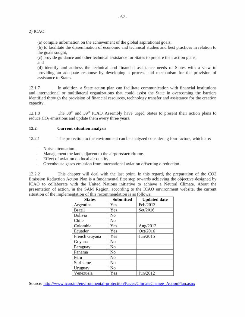
- 62 -
2) ICAO: (a) compile information on the achievement of the global aspirational goals; (b) to facilitate the dissemination of economic and technical studies and best practices in relation to the goals sought; (c) provide guidance and other technical assistance for States to prepare their action plans; and (d) identify and address the technical and financial assistance needs of States with a view to providing an adequate response by developing a process and mechanism for the provision of assistance to States.
12.1.7 In addition, a State action plan can facilitate communication with financial institutions and international or multilateral organizations that could assist the State in overcoming the barriers identified through the provision of financial resources, technology transfer and assistance for the creation capacity.
12.1.8 The 38th and 39th ICAO Assembly have urged States to present their action plans to reduce CO2 emissions and update them every three years. 12.2 Current situation analysis 12.2.1 The protection to the environment can be analyzed considering four factors, which are:
- Noise attenuation. - Management the land adjacent to the airports/aerodrome. - Effect of aviation on local air quality. - Greenhouse gases emission from international aviation offsetting o reduction.
12.2.2 This chapter will deal with the last point. In this regard, the preparation of the CO2 Emission Reduction Action Plan is a fundamental first step towards achieving the objective designed by ICAO to collaborate with the United Nations initiative to achieve a Neutral Climate. About the presentation of action, in the SAM Region, according to the ICAO environment website, the current situation of the implementation of this recommendation is as follows:
States Submitted Updated date Argentina Yes Feb/2013 Brazil Yes Set/2016 Bolivia No Chile No Colombia Yes Aug/2012 Ecuador Yes Oct/2016 French Guyana Yes Jun/2015 Guyana No Paraguay No Panama No Peru No Suriname No Uruguay No Venezuela Yes Jun/2012
Source: http://www.icao.int/environmental-protection/Pages/ClimateChange_ActionPlan.aspx
- 63 -
12.2.3 The 39th ICAO Assembly approved Resolution 39-3, which will implement a carbon offsetting and reduction scheme for international aviation (CORSIA). The key activity included in this Resolution was a Market-Based Measures Implementation Global Plan (MBM) Global Plan to offset CO2
emissions from international aviation. This Plan consists of three phases, which are:
(a) pilot phase shall apply from 2021 to 2023 to those States that have voluntarily opted in to participate in the plan. States involved in this phase may choose the basis for calculating the compensation requirements of their aircraft operators from the options indicated in ICAO Resolution 39-3, paragraph 11 (e) (i);
(b) first phase shall apply from 2024 to 2026 to States which have participated voluntarily in the
pilot phase, as well as to any other State wishing to participate voluntarily in this phase, and the compensation requirements shall be calculated as indicated in paragraph previous;
(c) second phase shall apply from 2027 to 2035 to all States individually having a relative share
in international civil aviation activity, measured in RTK, in excess of 0.5 %of total RTKs or whose cumulative the list of States mandated from highest to lowest amount of RTK reaches 90 % of total RTK, except the least developed countries (LDCs), small island developing States (SIDS) and landlocked developing countries (LLDCs), unless they wish to participate in it voluntarily.
12.2.4 In response to ICAO's request, by letter (SL) ENV 6 / 1-16 / 87 sent by ICAO seeking adherence to CORSIA, so far, any SAM Region States has same in any of the phases. 12.3 Strategy of implementation of the performance objectives 12.3.1 The Secretariat will work with States to develop a plan to achieve the preparation, updating, and submission of the CO2 Reduction Action Plans. States should work internally to achieve multilateral labor between the aeronautical community (authority, service providers, and operators) and other governmental institutions involved in the areas of Environment, Climate Change, Transport, Energy Management and Fossil Fuels. Also, it will be important to prepare a Strategic Plan in order to ensure that the Aviation Action Plans are aligned with the State policy concerning the mitigation of the effects of GHGs. 12.3.2 Working together with the State for the implementation of the MRV will be a significant step for the implementation of CORSIA. The Secretariat should coordinate with States the socialization of Market-Based Measures for their better understanding. 12.4 Alignment with ASBUs 12.4.1 The Environment Protection Development is closely related to aerodrome and air traffic management modules, as operational improvements and improvements in aerodrome capacity and platform management directly affect fuel consumption. Therefore, the modules B0-RSEQ, B0-APTA, B0-ACDM, B0-FICE, B0-FRTO, B0.NOPS, B0-CCO y B0-CDO, of Block 0, and the modules B1-RSEQ, B1-AMET, B1- NOPS y B1-CDO collaborate to PFF SAM ENV/01.
‐ 64 -
Chapter 13: Performance Improvement Areas (PIA), modules and Air Navigation Report Forms (ANRF)
13.1 Introduction 13.1.1 This Chapter describes the Performance Improvement Areas (PIA) with the respective modules taken under consideration in ASBU Block 0 for the SAM Region. In addition, it presents a standard format for each of the modules considered, for the monitoring in their implementation. The format receives the name of Air Navigation Report Form (ANRF). 13.2 Performance Improvement Area (PIA) 13.2.1 Sets of modules in each block are grouped to provide operational and performance objectives in the environment to which they apply, thus forming executive high-level view of the intended evolution. The PIAs facilitate comparison of ongoing programmes. 13.2.2 The four performance improvement areas are as follows:
a) Airport operations b) Globally Interoperable Systems and Data - Through Globally Interoperable
System Wide Information Management c) Optimum Capacity and Flexible Flights – Through Global Collaborative ATM d) Efficient Flight Path – Through Trajectory-based Operations
Performance Improvement Area 1: Airport operations
13.2.3 In relation to airport operations, taking advantage of technical developments in air navigation and aircraft systems may assist in improving airport capacity and efficiency. In order to contribute to an overall strategy enhancing airport capacity, four related significant modules, were selected for inclusion in the ASBU framework:
a) B0-15 - Improve Traffic Flow through Runway Sequencing (AMAN/DMAN); b) B0-65 - Optimization of Approach Procedures including Vertical Guidance; c) B0-75 - Safety and Efficiency of Surface Operations (A-SMGCS Level 1-2); and d) B0-80 - Improved Airport Operations through Airport-CDM.
13.2.4 The initial steps on these modules implement a combination of approach procedures making optimal usage of GNSS-based performance-based navigation (PBN) approaches and traffic flow improvements through the management of arrival and departure runway sequencing. New technology is already available to enhance the surveillance of aircraft surface movement, and may also provide information on suitably equipped vehicles. Improved processes are offered to support CDM involving all stakeholders on the airport.
‐ 65 -
13.2.5 Many of the operational improvements relating to airport capacity are local by essence and may only result in benefits at individual airports. Accordingly, improvements in airport capacity should be made on the basis of local decisions that take into account current and future aircraft operations and the level and type of equipage on board the aircraft. However, in cases where interdependencies in terms of traffic flows, airspace management and so forth exist between airport pairs, the full benefit of arrival/departure/surface management may only be achieved on a harmonized regional basis. The description of the modules chosen for this performance improvement area is presented as Attachment D.
Performance Improvement Area 2: Globally Interoperable Systems and Data - Through Globally Interoperable System Wide Information Management
13.2.6 The Global ATM Operational Concept envisages an integrated, harmonized and globally interoperable system for all users in all phases of flight. The aim is to increase user flexibility and maximize operating efficiencies while increasing system capacity and improving safety levels in the future ATM system. 13.2.7 In relation to globally interoperable systems and data two related significant modules, were selected for inclusion in the ASBU framework:
a) B0-25 - Increased Interoperability, Efficiency and Capacity through Ground-Ground Integration;
b) B0-30 - Service Improvement through Digital Aeronautical Information Management; and
c) B0-105 - Meteorological information supporting enhanced operational efficiency and safety.
13.2.8 At the first stage, these selected modules include the usage of automated ATS interfacility data communications (AIDC) messages as the basis of ground-ground coordination between neighboring ATS units contributing directly to safety improvements such as reductions in coordination errors and supports performance improvements such as reduced separation and enhanced efficiency. 13.2.9 Additionally the introduction of digital processing and management of information, through aeronautical information service (AIS)/aeronautical information management (AIM) implementation, use of aeronautical information exchange model (AIXM), migration to electronic aeronautical information publication (AIP) and better quality and availability of data contributes to the global interoperable systems and data. The description of the modules chosen for this performance improvement area is presented as Attachment D.
Performance Improvement Area 3: Optimum Capacity and Flexible Flights – Through Global Collaborative ATM
13.2.10 This performance improvement area is referred to the Optimum Capacity and Flexible Flights and in this sense 5 Modules were selected to be implemented in the SAM Region.
13.2.11 The modules are:
a) B-010 - Improved Operations through Enhanced En-Route Trajectories; b) B-035 - Improved Flow Performance through Planning based on a Network-
Wide view; c) B-084 - Initial capability for ground surveillance;
‐ 66 -
d) B0-101 - ACAS Improvements; and e) B-102 - Increased Effectiveness of Ground-Based Safety Nets.
13.2.12 These set of modules intend to optimize the use of airspace which would otherwise be segregated (i.e. special use airspace) along with flexible routing adjusted for specific traffic patterns managing Air Traffic Flow Management (ATFM) to minimize delay and maximize the use of the entire airspace. 13.2.13 It also considers the initial capability for lower cost ground surveillance supported by new technologies such as ADS-B OUT and wide area multilateration (MLAT) systems. This capability will be expressed in various ATM services, e.g. traffic information, search and rescue and separation provision. 13.2.14 In addition ground safety nets as short-term conflict alert, area proximity warnings and minimum safe altitude warnings are proposed as well as the MET information to support flexible airspace management, improved situational awareness and collaborative decision making, and dynamically- optimized flight trajectory planning.
Performance Improvement Area 4: Efficient Flight Path – Through Trajectory-based Operations
13.2.15 This performance improvement area is referred to the Efficient Flight Path and in this sense 3 Modules were selected to be implemented in the SAM Region. 13.2.16 The Modules are:
a) B0-05 - Improved Flexibility and Efficiency in Descent Profiles (CDO); b) B0-20 - Improved Flexibility and Efficiency in Departure Profiles (CCO), and; c) B0-40 - Improved Safety and Efficiency through the initial application of Data
Link En-Route. 13.2.17 The cost impact for the selected modules is expected to be minimal and are anticipated to be borne predominantly by the air navigation service providers (ANSPs) on the basis that facilitating operator capabilities, such as performance-based navigation (PBN) and controller-pilot data link communications (CPDLC), are attributable to those programs rather than to CCO and CDO. Based on preliminary indications, the benefits of implementing these modules could be substantial for overall global system performance and, when implemented, the benefits are expected to far outweigh the costs. 13.3 Air Navigation Report Forms (ANRF)
13.3.1 This form provides a standardized approach to implementation monitoring and performance measurement of Aviation System Block Upgrades (ASBU) Modules. The Planning and Implementation Regional Groups (PIRGs) and States could use this report format for their planning, implementation and monitoring framework for ASBU Modules. Also, other reporting formats that provide more details may be used but should contain as a minimum the elements described below. The Reporting and monitoring results will be analysed by ICAO and aviation partners and then utilized in developing the Annual Global Air Navigation Report. The Global Air Navigation Report conclusions will serve as the basis for future policy adjustments aiding safety practicality, affordability and global harmonization, amongst other concerns. Attachment E presents the ANRF for each of the ASBU Block 0 modules taken under consideration in the SAM Region.
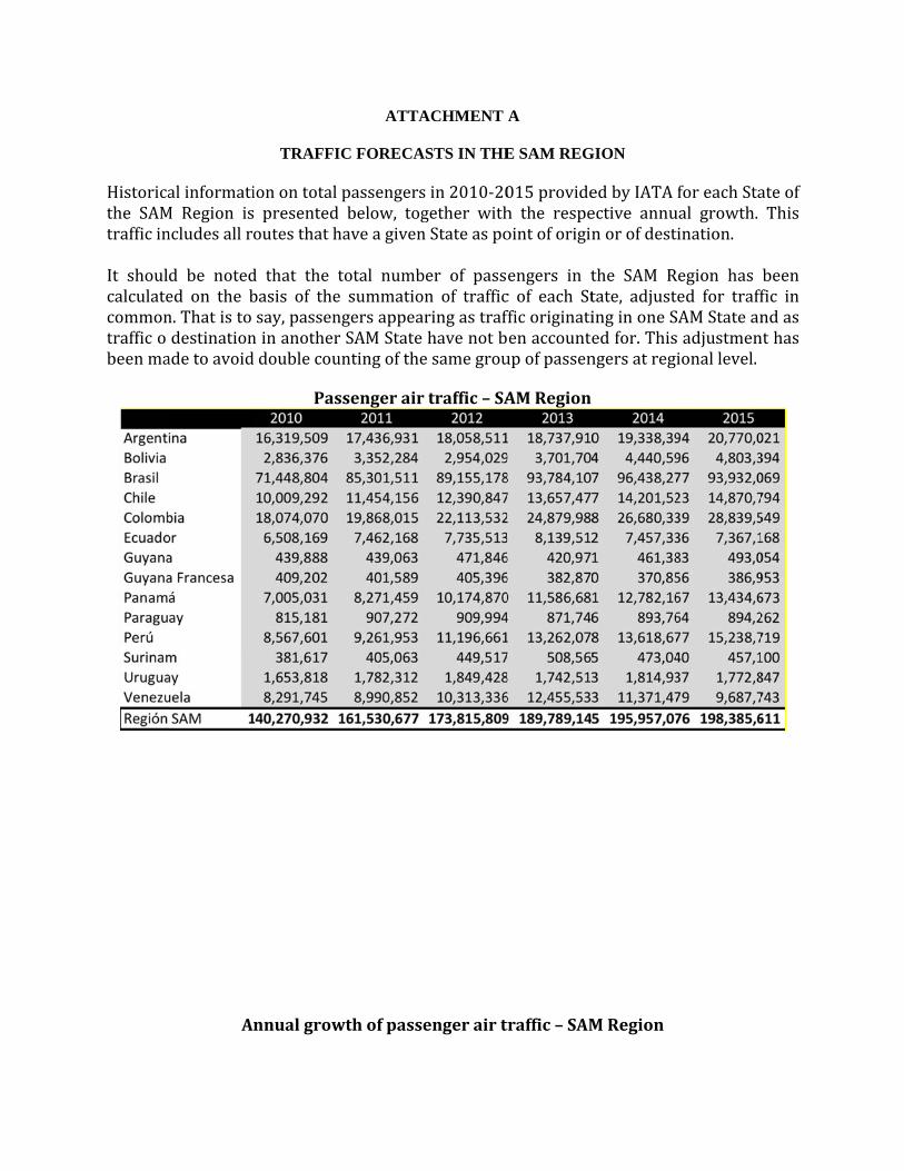
Historicathe SAMtrafficin
It shoulcalculatecommontrafficobeenma
alinformatiM Region isncludesallr
d be noteded on the bn.Thatistodestinationadetoavoid
A
TRAFFI
ionontotal presentedoutesthath
d that the tbasis of thesay,passenninanotherdoublecou
Pas
nnualgrow
ATTA
IC FORECA
passengersd below, toghaveagiven
total numbe summationgersappearSAMStateuntingofthe
ssengerair
wthofpass
ACHMENT
ASTS IN THE
sin2010‐20gether withnStateaspo
ber of passon of trafficaringastrafhavenotbesamegrou
rtraffic–SA
engerairt
A
E SAM REG
015provideh the respeointoforigin
engers in tc of each Stfficoriginatienaccounteupofpassen
AMRegion
traffic–SAM
GION
edbyIATAective annunorofdest
the SAM Rtate, adjustinginoneSedfor.Thisngersatreg
MRegion
foreachStaual growth.tination.
Region hasted for traffSAMStateansadjustmenionallevel.
ateofThis
beenfic inndasnthas
Pas
ssenger air tr
- A2 -
raffic forecasst, per State

Passenger air tra
- A3 -
ffic growth ra
ate, per State
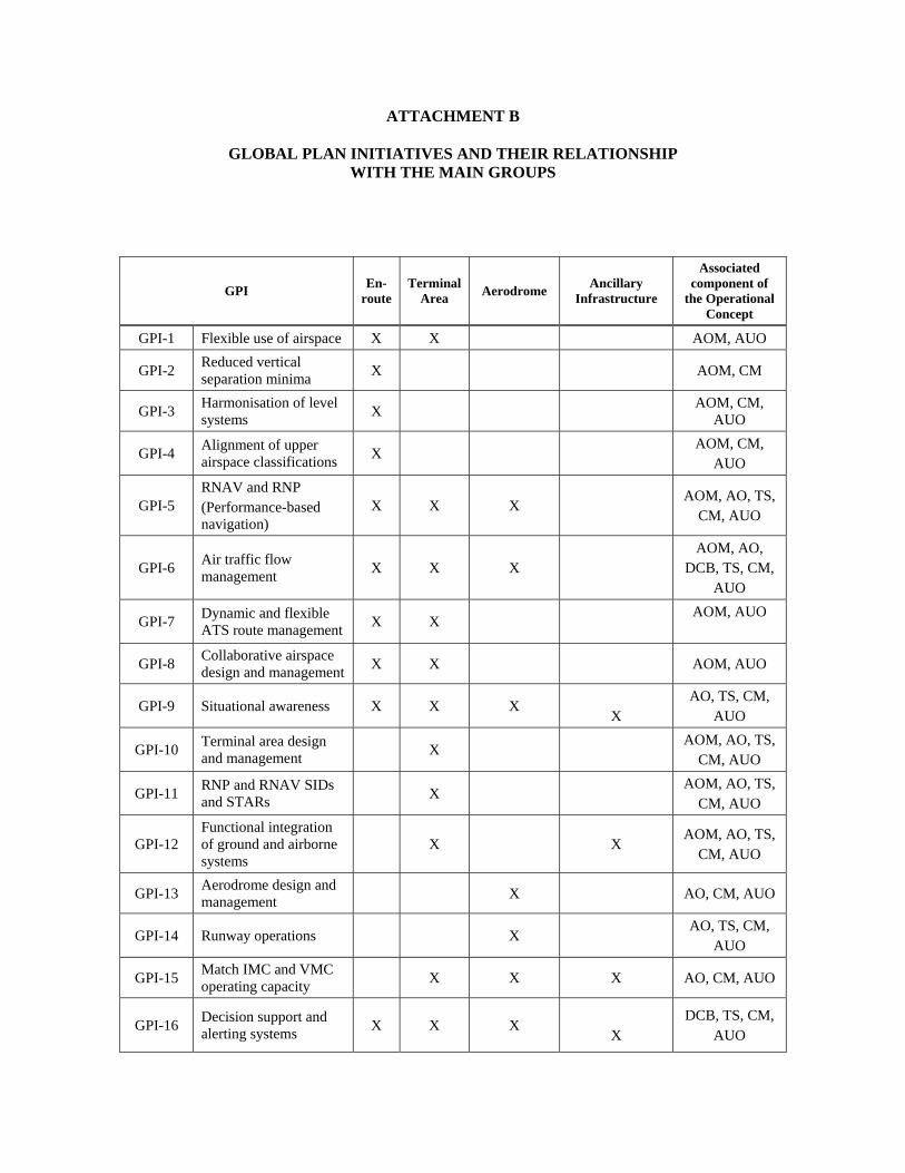
ATTACHMENT B
GLOBAL PLAN INITIATIVES AND THEIR RELATIONSHIP WITH THE MAIN GROUPS
GPI En-
route Terminal
Area Aerodrome
Ancillary Infrastructure
Associated component of
the Operational Concept
GPI-1 Flexible use of airspace X X AOM, AUO
GPI-2 Reduced vertical separation minima
X AOM, CM
GPI-3 Harmonisation of level systems
X AOM, CM,
AUO
GPI-4 Alignment of upper airspace classifications
X AOM, CM,
AUO
GPI-5 RNAV and RNP (Performance-based navigation)
X X X AOM, AO, TS,
CM, AUO
GPI-6 Air traffic flow management
X X X AOM, AO,
DCB, TS, CM, AUO
GPI-7 Dynamic and flexible ATS route management
X X AOM, AUO
GPI-8 Collaborative airspace design and management
X X AOM, AUO
GPI-9 Situational awareness X X X
X AO, TS, CM,
AUO
GPI-10 Terminal area design and management
X AOM, AO, TS,
CM, AUO
GPI-11 RNP and RNAV SIDs and STARs
X AOM, AO, TS,
CM, AUO
GPI-12 Functional integration of ground and airborne systems
X X AOM, AO, TS,
CM, AUO
GPI-13 Aerodrome design and management
X AO, CM, AUO
GPI-14 Runway operations X AO, TS, CM,
AUO
GPI-15 Match IMC and VMC operating capacity
X X X AO, CM, AUO
GPI-16 Decision support and alerting systems
X X X
X DCB, TS, CM,
AUO
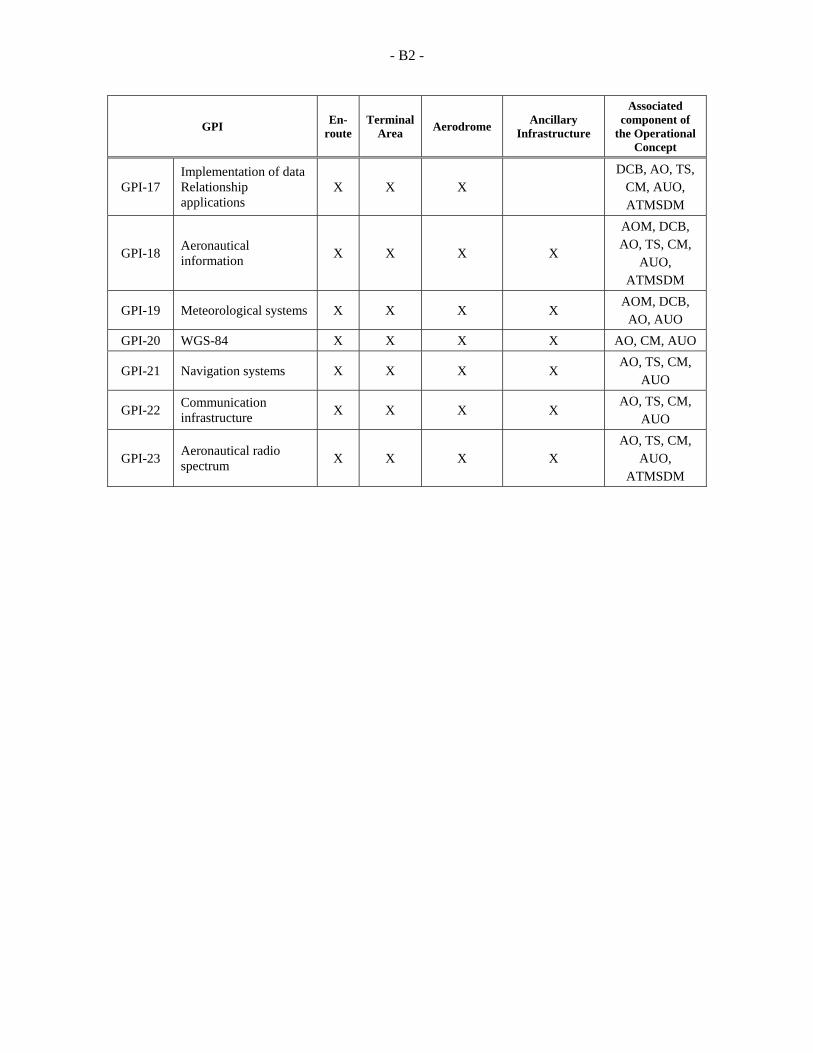
- B2 -
GPI En-
route Terminal
Area Aerodrome
Ancillary Infrastructure
Associated component of
the Operational Concept
GPI-17 Implementation of data Relationship applications
X X X DCB, AO, TS,
CM, AUO, ATMSDM
GPI-18 Aeronautical information
X X X X
AOM, DCB, AO, TS, CM,
AUO, ATMSDM
GPI-19 Meteorological systems X X X X AOM, DCB,
AO, AUO
GPI-20 WGS-84 X X X X AO, CM, AUO
GPI-21 Navigation systems X X X X AO, TS, CM,
AUO
GPI-22 Communication infrastructure
X X X X AO, TS, CM,
AUO
GPI-23 Aeronautical radio spectrum
X X X X AO, TS, CM,
AUO, ATMSDM
ATTACHMENT C
PERFORMANCE FRAMEWORK FORM (PFF) 1. This outcome and management form is applicable to both regional and national planning, and includes references to the Global Plan. Other formats may be appropriate, but they must contain, at least, the elements described below. 1.1 Performance objective: Regional/national performance objectives should be defined, using the performance-based approach that best reflects the activities required to support ATM systems at regional/national level. Along their life cycle, performance objectives may change, depending on the evolution of the ATM system; therefore, during the implementation process, they should be coordinated with all the stakeholders in the ATM community and be at their disposal. The establishment of joint decision-making processes ensures that all stakeholders are involved and agree on the requirements, tasks and timetables. 1.2 Regional performance objectives: Regional performance objectives are the improvements required by the air navigation system to support global performance objectives, and are related to the operational environments and the priorities applicable at regional level. 1.3 National performance objectives: National performance objectives are the improvements required by the air navigation system in support of regional performance objectives, and are related to the operational environments and priorities applicable at State level. 1.4 Benefits: Regional/national performance objectives should meet the expectations of the ATM community, as described in the operational concept; they should generate benefits for the parties involved; and should be attained through operational activities and techniques aligned with each performance objective. 1.5 Metrics: Metrics permit to measure the objectives achieved. The monitoring and measurement of the performance of ATM systems may require metrics in areas such as access, capacity, cost-effectiveness, efficiency, environment, flexibility, prediction capacity, and safety. 1.6 Strategy: ATM evolution requires a clearly-defined gradual strategy that includes the tasks and activities that best represent the national and regional planning processes, in keeping with the global planning framework. The goal is to achieve a harmonised implementation process that evolves towards a global and seamless ATM system. Accordingly, it is necessary to develop short- and medium-term work programmes focused on system improvements that reflect a clear work commitment of the parties involved. 1.7 Components of the ATM operational concept: Each strategy or set of tasks should be associated to components of the ATM operational concept. The designators of the ATM components are as follows:
AOM – Airspace organisation and management DCB – Demand/capacity balancing AO – Aerodrome operations
- C2 -
TS – Traffic synchronisation CM – Conflict management AUO – Airspace user operations ATM SDM – ATM service delivery management
1.8 Tasks: The regional/national work programmes, based on these PFF templates, should define the tasks required to attain said performance objective while maintaining a direct relationship with the components of the ATM system. The following principles should be taken into account when developing a work programme:
Work should be organised using project management techniques and performance-based objectives, in line with ICAO strategic objectives.
All tasks related to the compliance with the performance objectives should be carried out based on strategies, concepts, action plans and roadmaps that may be shared amongst the parties, with the main objective of attaining transparency through interoperability and harmonisation.
Task planning should include the optimisation of human resources, as well as the promotion of the dynamic use of electronic communication amongst the parties (for example, Internet, video-conferences, tele-conferences, e-mail, telephone and fax). Likewise, resources should be used efficiently, avoiding duplication of work or unnecessary tasks.
The process and work methods should ensure the possibility of measuring the performance objectives, comparing them with timetables, and easy reporting of the progress made at national and regional level to the PIRGs and ICAO Headquarters, respectively.
1.9 Period: Indicates the start and end of that task in particular. 1.10 Responsibility: Indicates the organisation/entity/individual responsible for the fulfilment or management of the associated tasks. 1.11 Status: The status basically monitors progress in the fulfilment of said task as it proceeds to the date of completion. For the classification of the status of implementation, the words VALID, COMPLETED, REPLACED and CONTINUOUS will be used. 1.12 Link with the global plan initiatives (GPIs): The 23 GPIs, as described in the Global Plan, provide a global strategic framework for the planning of air navigation systems, and are designed to contribute to the achievement of regional/national performance objectives. Each performance objective should be related with the corresponding GPIs. The goal is to make sure that the evolutionary work process at State and regional level is integrated within the global planning framework. 2. The PFFs prepared for the performance objectives concerning ATM, CNS, MET, SAR, AIS, AGA/AOP, personnel competence management and SMS are presented below. In addition, a matrix with the inter-relationship amongst the PFFs in included.
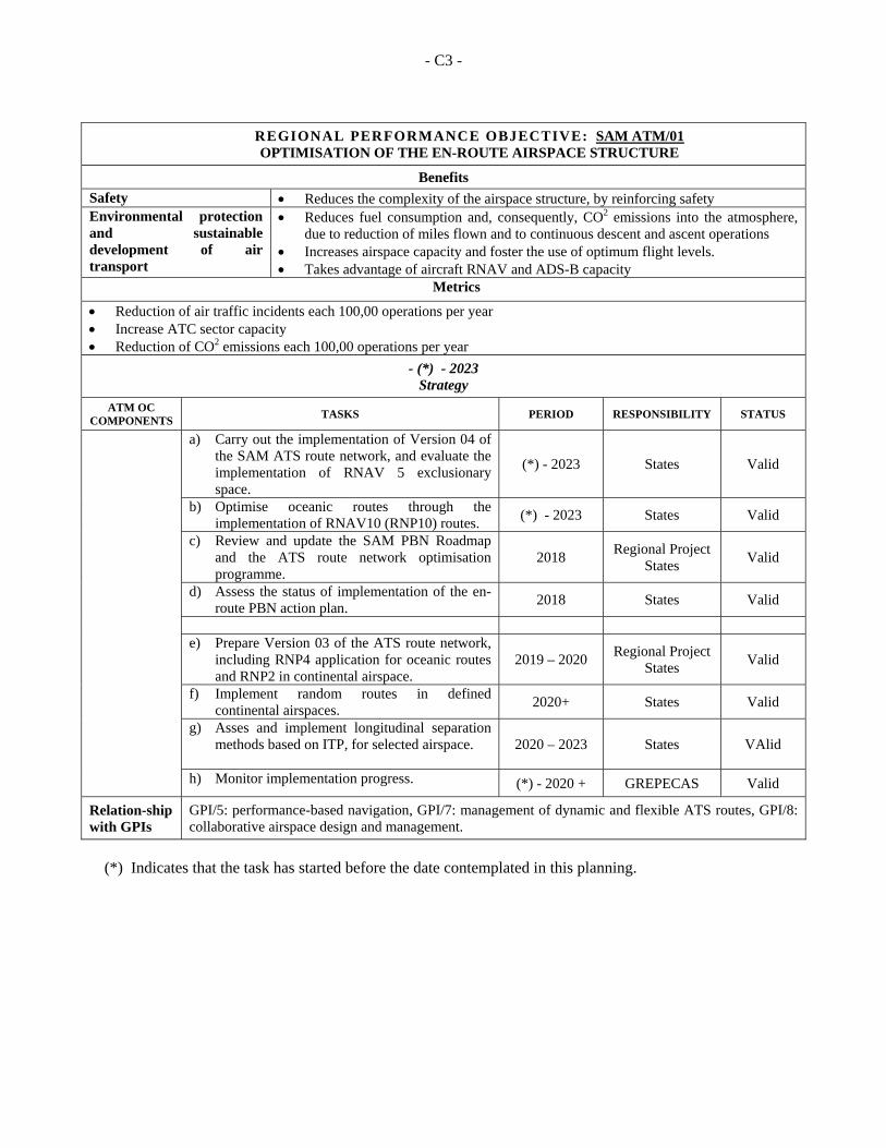
- C3 -
REGIONAL PERFORMANCE OBJECTIVE: SAM ATM/01 OPTIMISATION OF THE EN-ROUTE AIRSPACE STRUCTURE
Benefits
Safety Reduces the complexity of the airspace structure, by reinforcing safety Environmental protection and sustainable development of air transport
Reduces fuel consumption and, consequently, CO2 emissions into the atmosphere, due to reduction of miles flown and to continuous descent and ascent operations
Increases airspace capacity and foster the use of optimum flight levels. Takes advantage of aircraft RNAV and ADS-B capacity
Metrics
Reduction of air traffic incidents each 100,00 operations per year Increase ATC sector capacity Reduction of CO2 emissions each 100,00 operations per year
- (*) - 2023 Strategy
ATM OC COMPONENTS
TASKS PERIOD RESPONSIBILITY STATUS
a) Carry out the implementation of Version 04 of the SAM ATS route network, and evaluate the implementation of RNAV 5 exclusionary space.
(*) - 2023 States Valid
b) Optimise oceanic routes through the implementation of RNAV10 (RNP10) routes.
(*) - 2023 States Valid
c) Review and update the SAM PBN Roadmap and the ATS route network optimisation programme.
2018 Regional Project
States Valid
d) Assess the status of implementation of the en-route PBN action plan.
2018 States Valid
e) Prepare Version 03 of the ATS route network,
including RNP4 application for oceanic routes and RNP2 in continental airspace.
2019 – 2020 Regional Project
States Valid
f) Implement random routes in defined continental airspaces.
2020+ States Valid
g) Asses and implement longitudinal separation methods based on ITP, for selected airspace.
2020 – 2023 States VAlid
h) Monitor implementation progress. (*) - 2020 + GREPECAS Valid
Relation-ship with GPIs
GPI/5: performance-based navigation, GPI/7: management of dynamic and flexible ATS routes, GPI/8: collaborative airspace design and management.
(*) Indicates that the task has started before the date contemplated in this planning.
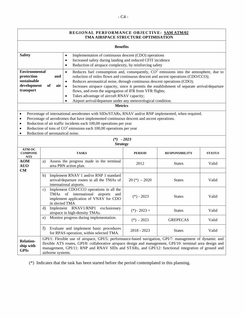
- C4 -
REGIONAL PERFORMANCE OBJECTIVE: SAM ATM/02 TMA AIRSPACE STRUCTURE OPTIMISATION
Benefits
Safety Implementation of continuous descent (CDO) operations Increased safety during landing and reduced CFIT incidence Reduction of airspace complexity, by reinforcing safety
Environmental protection and sustainable development of air transport
Reduces fuel consumption and, consequently, CO2 emissions into the atmosphere, due to reduction of miles flown and continuous descent and ascent operations (CDO/CCO);
Reduces aeronautical noise, through continuous descent operations (CDO); Increases airspace capacity, since it permits the establishment of separate arrival/departure
flows, and even the segregation of IFR from VFR flights; Takes advantage of aircraft RNAV capacity; Airport arrival/departure under any meteorological condition.
Metrics
Percentage of international aerodromes with SIDs/STARs, RNAV and/or RNP implemented, when required. Percentage of aerodromes that have implemented continuous descent and ascent operations. Reduction of air traffic incidents each 100,00 operations per year Reduction of tons of CO2 emissions each 100,00 operations per year Reduction of aeronautical noise.
(*) - 2023 Strategy
ATM OC COMPONE
NTS TASKS PERIOD RESPONSIBILITY STATUS
AOM AUO CM
a) Assess the progress made in the terminal area PBN action plan.
2012 States Valid
b) Implement RNAV 1 and/or RNP 1 standard
arrival/departure routes in all the TMAs of international airports.
20 (*) – 2020 States Valid
c) Implement CDO/CCO operations in all the TMAs of international airports and implement application of VNAV for CDO in slected TMA
(*) - 2023 States Valid
d) Implement RNAV1/RNP1 exclusionary airspace in high-density TMAs.
(*)– 2023 + States Valid
e) Monitor progress during implementation.
(*) - 2023 GREPECAS Valid
f) Evaluate and implement basic procedures for RPAS operation, within selected TMA.
2018 - 2023 States Valid
Relation-ship with GPIs
GPI/1: Flexible use of airspace, GPI/5: performance-based navigation, GPI/7: management of dynamic and flexible ATS routes, GPI/8: collaborative airspace design and management, GPI/10: terminal area design and management, GPI/11: RNP and RNAV SIDs and STARs, and GPI/12: functional integration of ground and airborne systems.
(*) Indicates that the task has been started before the period contemplated in this planning.
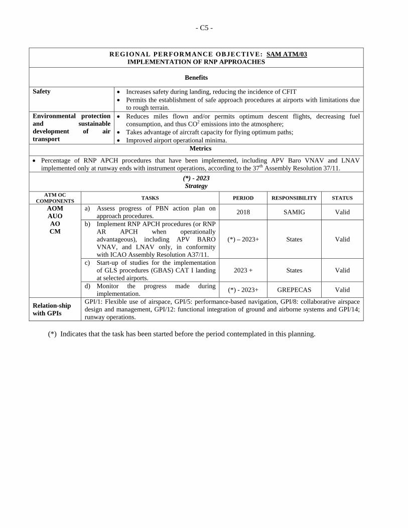
- C5 -
REGIONAL PERFORMANCE OBJECTIVE: SAM ATM/03 IMPLEMENTATION OF RNP APPROACHES
Benefits
Safety
Increases safety during landing, reducing the incidence of CFIT Permits the establishment of safe approach procedures at airports with limitations due
to rough terrain. Environmental protection and sustainable development of air transport
Reduces miles flown and/or permits optimum descent flights, decreasing fuel consumption, and thus CO2 emissions into the atmosphere;
Takes advantage of aircraft capacity for flying optimum paths; Improved airport operational minima.
Metrics
Percentage of RNP APCH procedures that have been implemented, including APV Baro VNAV and LNAV implemented only at runway ends with instrument operations, according to the 37th Assembly Resolution 37/11.
(*) - 2023 Strategy
ATM OC COMPONENTS
TASKS PERIOD RESPONSIBILITY STATUS
AOM AUO AO CM
a) Assess progress of PBN action plan on approach procedures.
2018 SAMIG Valid
b) Implement RNP APCH procedures (or RNP AR APCH when operationally advantageous), including APV BARO VNAV, and LNAV only, in conformity with ICAO Assembly Resolution A37/11.
(*) – 2023+ States Valid
c) Start-up of studies for the implementation of GLS procedures (GBAS) CAT I landing at selected airports.
2023 + States Valid
d) Monitor the progress made during implementation.
(*) - 2023+ GREPECAS Valid
Relation-ship with GPIs
GPI/1: Flexible use of airspace, GPI/5: performance-based navigation, GPI/8: collaborative airspace design and management, GPI/12: functional integration of ground and airborne systems and GPI/14; runway operations.
(*) Indicates that the task has been started before the period contemplated in this planning.
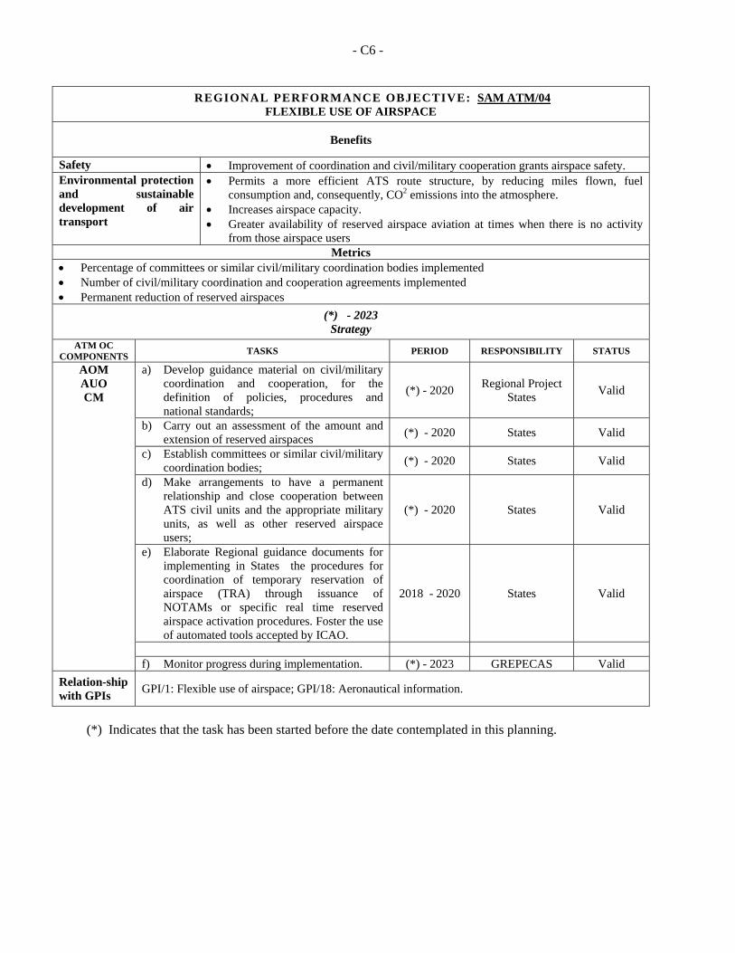
- C6 -
REGIONAL PERFORMANCE OBJECTIVE: SAM ATM/04 FLEXIBLE USE OF AIRSPACE
Benefits
Safety Improvement of coordination and civil/military cooperation grants airspace safety. Environmental protection and sustainable development of air transport
Permits a more efficient ATS route structure, by reducing miles flown, fuel consumption and, consequently, CO2 emissions into the atmosphere.
Increases airspace capacity. Greater availability of reserved airspace aviation at times when there is no activity
from those airspace users Metrics
Percentage of committees or similar civil/military coordination bodies implemented Number of civil/military coordination and cooperation agreements implemented Permanent reduction of reserved airspaces
(*) - 2023 Strategy
ATM OC COMPONENTS
TASKS PERIOD RESPONSIBILITY STATUS
AOM AUO CM
a) Develop guidance material on civil/military coordination and cooperation, for the definition of policies, procedures and national standards;
(*) - 2020 Regional Project
States Valid
b) Carry out an assessment of the amount and extension of reserved airspaces
(*) - 2020 States Valid
c) Establish committees or similar civil/military coordination bodies;
(*) - 2020 States Valid
d) Make arrangements to have a permanent relationship and close cooperation between ATS civil units and the appropriate military units, as well as other reserved airspace users;
(*) - 2020 States Valid
e) Elaborate Regional guidance documents for implementing in States the procedures for coordination of temporary reservation of airspace (TRA) through issuance of NOTAMs or specific real time reserved airspace activation procedures. Foster the use of automated tools accepted by ICAO.
2018 - 2020 States Valid
f) Monitor progress during implementation. (*) - 2023 GREPECAS Valid
Relation-ship with GPIs
GPI/1: Flexible use of airspace; GPI/18: Aeronautical information.
(*) Indicates that the task has been started before the date contemplated in this planning.
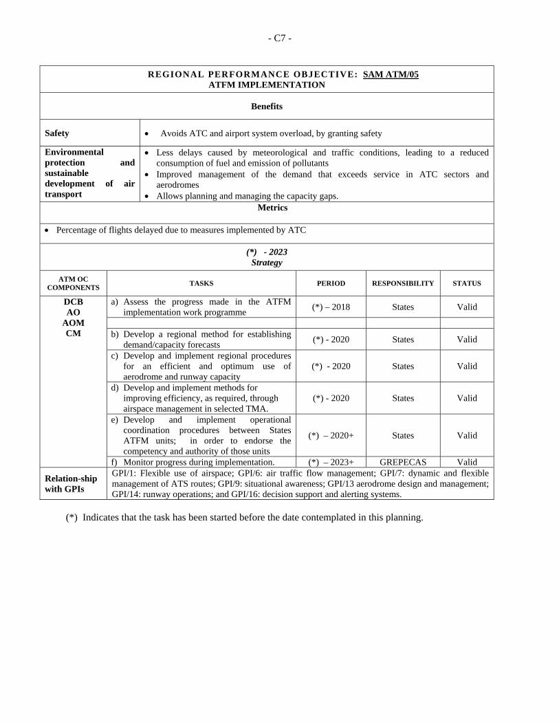
- C7 -
REGIONAL PERFORMANCE OBJECTIVE: SAM ATM/05 ATFM IMPLEMENTATION
Benefits
Safety Avoids ATC and airport system overload, by granting safety
Environmental protection and sustainable development of air transport
Less delays caused by meteorological and traffic conditions, leading to a reduced consumption of fuel and emission of pollutants
Improved management of the demand that exceeds service in ATC sectors and aerodromes
Allows planning and managing the capacity gaps. Metrics
Percentage of flights delayed due to measures implemented by ATC
(*) - 2023 Strategy
ATM OC COMPONENTS
TASKS PERIOD
RESPONSIBILITY
STATUS
DCB AO
AOM CM
a) Assess the progress made in the ATFM implementation work programme
(*) – 2018 States Valid
b) Develop a regional method for establishing
demand/capacity forecasts (*) - 2020 States Valid
c) Develop and implement regional procedures for an efficient and optimum use of aerodrome and runway capacity
(*) - 2020 States Valid
d) Develop and implement methods for improving efficiency, as required, through airspace management in selected TMA.
(*) - 2020 States Valid
e) Develop and implement operational coordination procedures between States ATFM units; in order to endorse the competency and authority of those units
(*) – 2020+ States Valid
f) Monitor progress during implementation. (*) – 2023+ GREPECAS Valid
Relation-ship with GPIs
GPI/1: Flexible use of airspace; GPI/6: air traffic flow management; GPI/7: dynamic and flexible management of ATS routes; GPI/9: situational awareness; GPI/13 aerodrome design and management; GPI/14: runway operations; and GPI/16: decision support and alerting systems.
(*) Indicates that the task has been started before the date contemplated in this planning.
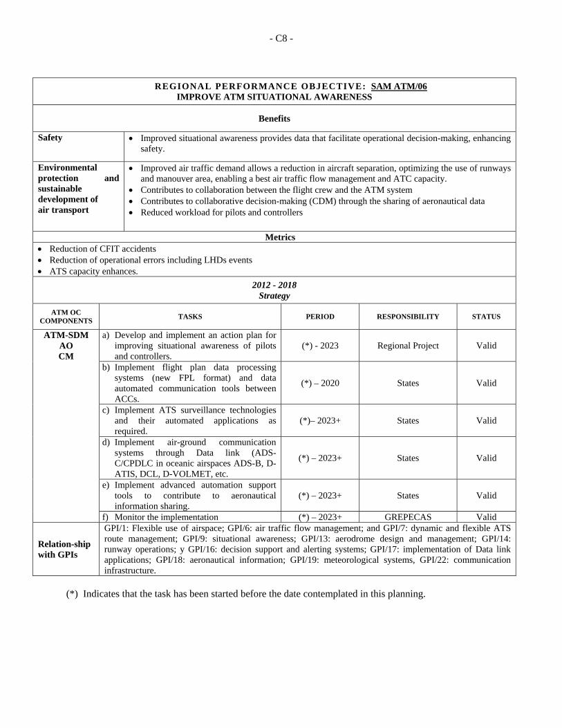
- C8 -
REGIONAL PERFORMANCE OBJECTIVE: SAM ATM/06
IMPROVE ATM SITUATIONAL AWARENESS
Benefits
Safety Improved situational awareness provides data that facilitate operational decision-making, enhancing safety.
Environmental protection and sustainable development of air transport
Improved air traffic demand allows a reduction in aircraft separation, optimizing the use of runways and manouver area, enabling a best air traffic flow management and ATC capacity.
Contributes to collaboration between the flight crew and the ATM system Contributes to collaborative decision-making (CDM) through the sharing of aeronautical data Reduced workload for pilots and controllers
Metrics Reduction of CFIT accidents Reduction of operational errors including LHDs events ATS capacity enhances.
2012 - 2018 Strategy
ATM OC COMPONENTS
TASKS PERIOD
RESPONSIBILITY
STATUS
ATM-SDM AO CM
a) Develop and implement an action plan for improving situational awareness of pilots and controllers.
(*) - 2023 Regional Project Valid
b) Implement flight plan data processing systems (new FPL format) and data automated communication tools between ACCs.
(*) – 2020 States Valid
c) Implement ATS surveillance technologies and their automated applications as required.
(*)– 2023+ States Valid
d) Implement air-ground communication systems through Data link (ADS- C/CPDLC in oceanic airspaces ADS-B, D-ATIS, DCL, D-VOLMET, etc.
(*) – 2023+ States Valid
e) Implement advanced automation support tools to contribute to aeronautical information sharing.
(*) – 2023+ States Valid
f) Monitor the implementation (*) – 2023+ GREPECAS Valid
Relation-ship with GPIs
GPI/1: Flexible use of airspace; GPI/6: air traffic flow management; and GPI/7: dynamic and flexible ATS route management; GPI/9: situational awareness; GPI/13: aerodrome design and management; GPI/14: runway operations; y GPI/16: decision support and alerting systems; GPI/17: implementation of Data link applications; GPI/18: aeronautical information; GPI/19: meteorological systems, GPI/22: communication infrastructure.
(*) Indicates that the task has been started before the date contemplated in this planning.
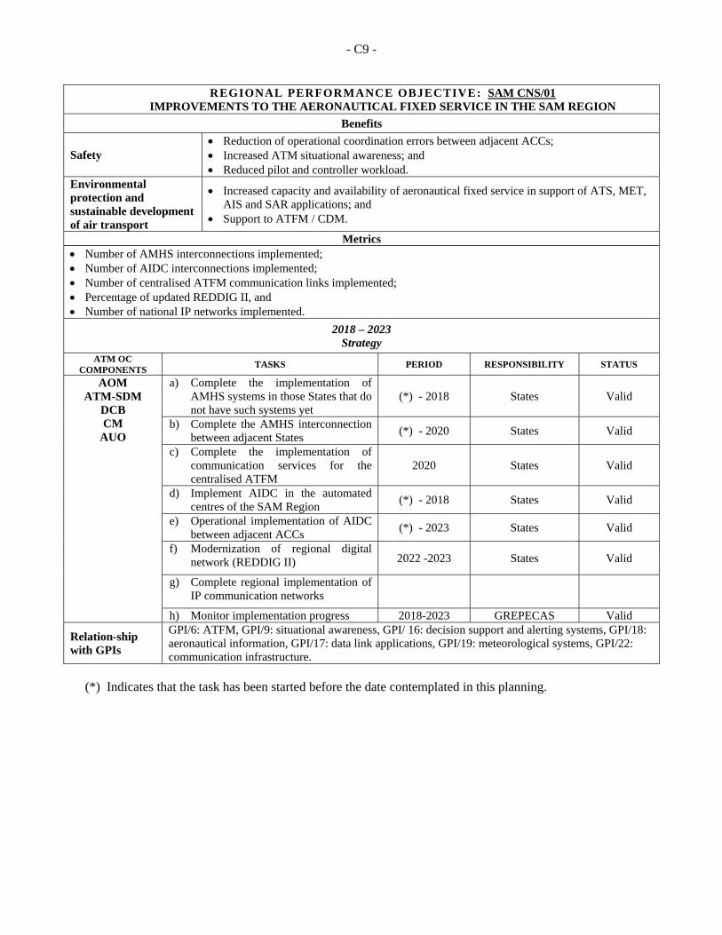
- C9 -
REGIONAL PERFORMANCE OBJECTIVE: SAM CNS/01 IMPROVEMENTS TO THE AERONAUTICAL FIXED SERVICE IN THE SAM REGION
Benefits
Safety Reduction of operational coordination errors between adjacent ACCs; Increased ATM situational awareness; and Reduced pilot and controller workload.
Environmental protection and sustainable development of air transport
Increased capacity and availability of aeronautical fixed service in support of ATS, MET, AIS and SAR applications; and
Support to ATFM / CDM.
Metrics Number of AMHS interconnections implemented; Number of AIDC interconnections implemented; Number of centralised ATFM communication links implemented; Percentage of updated REDDIG II, and Number of national IP networks implemented.
2018 – 2023 Strategy
ATM OC COMPONENTS
TASKS PERIOD RESPONSIBILITY STATUS
AOM ATM-SDM
DCB CM
AUO
a) Complete the implementation of AMHS systems in those States that do not have such systems yet
(*) - 2018 States Valid
b) Complete the AMHS interconnection between adjacent States
(*) - 2020 States Valid
c) Complete the implementation of communication services for the centralised ATFM
2020 States Valid
d) Implement AIDC in the automated centres of the SAM Region
(*) - 2018 States Valid
e) Operational implementation of AIDC between adjacent ACCs
(*) - 2023 States Valid
f) Modernization of regional digital network (REDDIG II) 2022 -2023 States Valid
g) Complete regional implementation of IP communication networks
h) Monitor implementation progress 2018-2023 GREPECAS Valid
Relation-ship with GPIs
GPI/6: ATFM, GPI/9: situational awareness, GPI/ 16: decision support and alerting systems, GPI/18: aeronautical information, GPI/17: data link applications, GPI/19: meteorological systems, GPI/22: communication infrastructure.
(*) Indicates that the task has been started before the date contemplated in this planning.
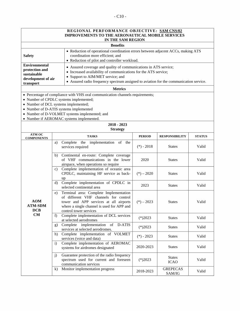
- C10 -
REGIONAL PERFORMANCE OBJECTIVE: SAM CNS/02 IMPROVEMENTS TO THE AERONAUTICAL MOBILE SERVICES
IN THE SAM REGION
Benefits
Safety Reduction of operational coordination errors between adjacent ACCs, making ATS
coordination more efficient; and Reduction of pilot and controller workload.
Environmental protection and sustainable development of air transport
Assured coverage and quality of communications in ATS service; Increased availability of communications for the ATS service; Support to AIM/MET service; and Assured radio frequency spectrum assigned to aviation for the communication service.
Metrics
Percentage of compliance with VHS oral communication channels requirements; Number of CPDLC systems implemented; Number of DCL systems implemented; Number of D-ATIS systems implemented Number of D-VOLMET systems implemented; and Number if AEROMAC systems implemented.
2018 - 2023 Strategy
ATM OC COMPONENTS
TASKS PERIOD RESPONSIBILITY STATUS
AOM ATM-SDM
DCB CM
a) Complete the implementation of the services required (*) - 2018 States Valid
b) Continental en-route: Complete coverage of VHF communications in the lower airspace, when operations so require
2020 States Valid
c) Complete implementation of oceanic area CPDLC, maintaining HF service as back-up
(*) – 2020 States Valid
d) Complete implementation of CPDLC in selected continental area 2023 States Valid
e) Terminal area: Complete Implementation of different VHF channels for control tower and APP services at all airports where a single channel is used for APP and control tower services
(*) – 2023 States Valid
f) Complete implementation of DCL services at selected aerodromes
(*)2023 States Valid
g) Complete implementation of D-ATIS services at selected aerodromes.
(*)2023 States Valid
h) Complete implementation of VOLMET services (voice and data)
(*) - 2023 States Valid
i) Complete implementation of AEROMAC systems for airdromes designated 2020-2023 States Valid
j) Guarantee protection of the radio frequency spectrum used for current and foreseen communication services
(*)2023 States ICAO
Valid
k) Monitor implementation progress 2018-2023
GREPECAS SAM/IG
Valid

- C11 -
Relation-ship with GPIs
GPI/6: ATFM, GPI/9: Situational awareness, GPI/17: Data link applications, GPI/19: Meteorological systems, GPI/22: Communication infrastructure, GPI 23: Aeronautical radio spectrum.
(*) Indicates that the task has been started before the date contemplated in this planning.
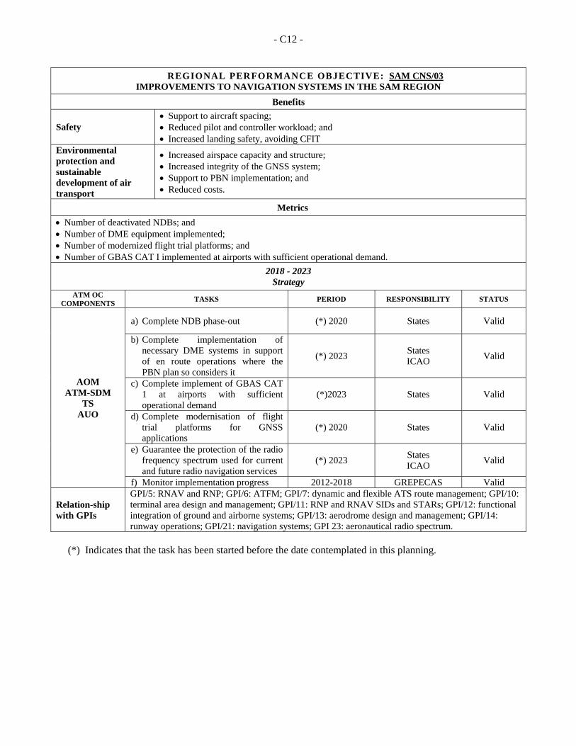
- C12 -
REGIONAL PERFORMANCE OBJECTIVE: SAM CNS/03 IMPROVEMENTS TO NAVIGATION SYSTEMS IN THE SAM REGION
Benefits
Safety Support to aircraft spacing; Reduced pilot and controller workload; and Increased landing safety, avoiding CFIT
Environmental protection and sustainable development of air transport
Increased airspace capacity and structure; Increased integrity of the GNSS system; Support to PBN implementation; and Reduced costs.
Metrics
Number of deactivated NDBs; and Number of DME equipment implemented; Number of modernized flight trial platforms; and Number of GBAS CAT I implemented at airports with sufficient operational demand.
2018 - 2023 Strategy
ATM OC COMPONENTS
TASKS PERIOD RESPONSIBILITY STATUS
AOM ATM-SDM
TS AUO
a) Complete NDB phase-out (*) 2020 States Valid
b) Complete implementation of necessary DME systems in support of en route operations where the PBN plan so considers it
(*) 2023 States ICAO
Valid
c) Complete implement of GBAS CAT 1 at airports with sufficient operational demand
(*)2023 States Valid
d) Complete modernisation of flight trial platforms for GNSS applications
(*) 2020 States Valid
e) Guarantee the protection of the radio frequency spectrum used for current and future radio navigation services
(*) 2023 States ICAO
Valid
f) Monitor implementation progress 2012-2018 GREPECAS Valid
Relation-ship with GPIs
GPI/5: RNAV and RNP; GPI/6: ATFM; GPI/7: dynamic and flexible ATS route management; GPI/10: terminal area design and management; GPI/11: RNP and RNAV SIDs and STARs; GPI/12: functional integration of ground and airborne systems; GPI/13: aerodrome design and management; GPI/14: runway operations; GPI/21: navigation systems; GPI 23: aeronautical radio spectrum.
(*) Indicates that the task has been started before the date contemplated in this planning.
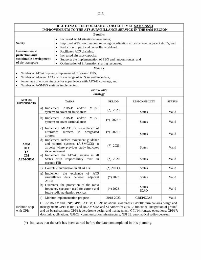
- C13 -
REGIONAL PERFORMANCE OBJECTIVE: SAM CNS/04 IMPROVEMENTS TO THE ATS SURVEILLANCE SERVICE IN THE SAM REGION
Benefits
Safety Increased ATM situational awareness; Improved ATS coordination, reducing coordination errors between adjacent ACCs; and Reduction of pilot and controller workload.
Environmental protection and sustainable development of air transport
Facilitates ATS planning; Increased airspace capacity; Supports the implementation of PBN and random routes; and Optimisation of information sharing resources.
Metrics
Number of ADS-C systems implemented in oceanic FIRs; Number of adjacent ACCs with exchange of ATS surveillance data, Percentage of ensure airspace for upper levels with ADS-B coverage, and Number of A-SMGS systems implemented.
2018 – 2023 Strategy
ATM OC COMPONENTS
TASKS PERIOD
RESPONSIBILITY
STATUS
AOM AO TS CM
ATM-SDM
a) Implement ADS-B and/or MLAT systems to cover en-route areas
(*) 2023
States
Valid
b) Implement ADS-B and/or MLAT systems to cover terminal areas
(*) 2023 +
States
Valid
c) Implement MLAT for surveillance of airdromes surfaces in designated airports
(*) 2023 +
States
Valid
d) Implement surface movement guidance and control systems (A-SMGCS) at airports where previous study indicates its requirement
(*) 2023
States
Valid
e) Implement the ADS-C service in all States with responsibility over an oceanic FIR
(*) 2020 States Valid
f) Complete automation in all ACCs (*) 2023 + States Valid
g) Implement the exchange of ATS surveillance data between adjacent ACCs
(*) 2023 States Valid
h) Guarantee the protection of the radio frequency spectrum used for current and future radio navigation services
(*) 2023 States ICAO
Valid
i) Monitor implementation progress 2018-2023 GREPECAS Valid
Relation-ship with GPIs
GPI/5: RNAV and RNP; GPI/6: ATFM; GPI/9: situational awareness; GPI/10: terminal area design and management; GPI/11: RNP and RNAV SIDs and STARs with; GPI/12: functional integration of ground and on-board systems; GPI/13: aerodrome design and management; GPI/14: runway operations; GPI/17: data link applications, GPI/22: communication infrastructure, GPI 23: aeronautical radio spectrum.
(*) Indicates that the task has been started before the date contemplated in this planning.
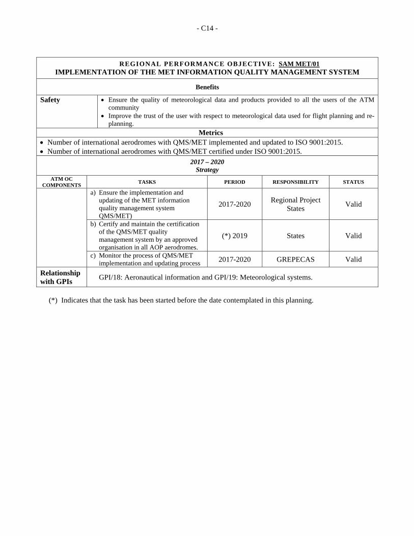
- C14 -
REGIONAL PERFORMANCE OBJECTIVE: SAM MET/01 IMPLEMENTATION OF THE MET INFORMATION QUALITY MANAGEMENT SYSTEM
Benefits
Safety Ensure the quality of meteorological data and products provided to all the users of the ATM community
Improve the trust of the user with respect to meteorological data used for flight planning and re-planning.
Metrics
Number of international aerodromes with QMS/MET implemented and updated to ISO 9001:2015. Number of international aerodromes with QMS/MET certified under ISO 9001:2015.
2017 – 2020 Strategy
ATM OC COMPONENTS
TASKS PERIOD RESPONSIBILITY STATUS
a) Ensure the implementation and updating of the MET information quality management system QMS/MET)
2017-2020 Regional Project
States Valid
b) Certify and maintain the certification of the QMS/MET quality management system by an approved organisation in all AOP aerodromes.
(*) 2019 States Valid
c) Monitor the process of QMS/MET implementation and updating process 2017-2020 GREPECAS Valid
Relationship with GPIs
GPI/18: Aeronautical information and GPI/19: Meteorological systems.
(*) Indicates that the task has been started before the date contemplated in this planning.
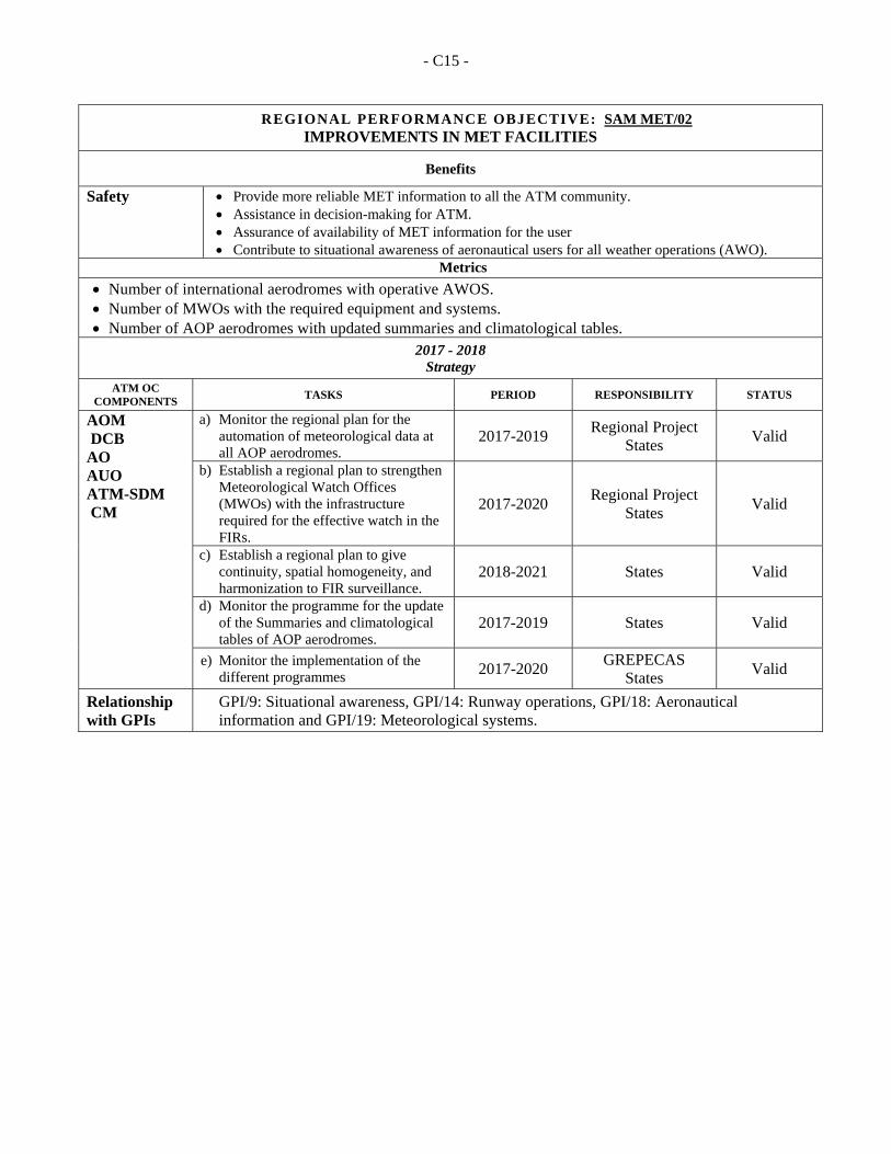
- C15 -
REGIONAL PERFORMANCE OBJECTIVE: SAM MET/02 IMPROVEMENTS IN MET FACILITIES
Benefits
Safety Provide more reliable MET information to all the ATM community. Assistance in decision-making for ATM. Assurance of availability of MET information for the user Contribute to situational awareness of aeronautical users for all weather operations (AWO).
Metrics
Number of international aerodromes with operative AWOS. Number of MWOs with the required equipment and systems. Number of AOP aerodromes with updated summaries and climatological tables.
2017 - 2018 Strategy
ATM OC COMPONENTS
TASKS PERIOD RESPONSIBILITY STATUS
AOM DCB AO AUO ATM-SDM CM
a) Monitor the regional plan for the automation of meteorological data at all AOP aerodromes.
2017-2019 Regional Project
States Valid
b) Establish a regional plan to strengthen Meteorological Watch Offices (MWOs) with the infrastructure required for the effective watch in the FIRs.
2017-2020 Regional Project
States Valid
c) Establish a regional plan to give continuity, spatial homogeneity, and harmonization to FIR surveillance.
2018-2021 States Valid
d) Monitor the programme for the update of the Summaries and climatological tables of AOP aerodromes.
2017-2019 States Valid
e) Monitor the implementation of the different programmes 2017-2020
GREPECAS States
Valid
Relationship with GPIs
GPI/9: Situational awareness, GPI/14: Runway operations, GPI/18: Aeronautical information and GPI/19: Meteorological systems.
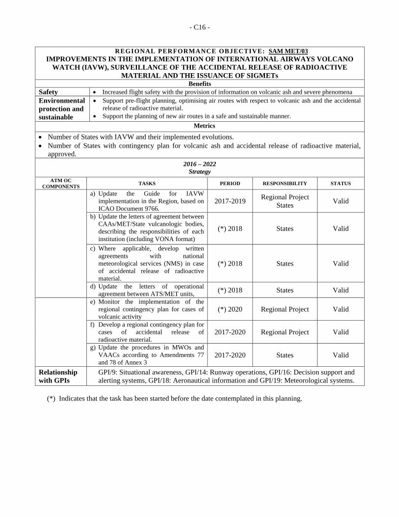
- C16 -
REGIONAL PERFORMANCE OBJECTIVE: SAM MET/03 IMPROVEMENTS IN THE IMPLEMENTATION OF INTERNATIONAL AIRWAYS VOLCANO
WATCH (IAVW), SURVEILLANCE OF THE ACCIDENTAL RELEASE OF RADIOACTIVE MATERIAL AND THE ISSUANCE OF SIGMETs
Benefits Safety Increased flight safety with the provision of information on volcanic ash and severe phenomena Environmental protection and sustainable
Support pre-flight planning, optimising air routes with respect to volcanic ash and the accidental release of radioactive material.
Support the planning of new air routes in a safe and sustainable manner.
Metrics
Number of States with IAVW and their implemented evolutions. Number of States with contingency plan for volcanic ash and accidental release of radioactive material,
approved. 2016 – 2022
Strategy ATM OC
COMPONENTS TASKS PERIOD RESPONSIBILITY STATUS
a) Update the Guide for IAVW implementation in the Region, based on ICAO Document 9766.
2017-2019 Regional Project
States Valid
b) Update the letters of agreement between CAAs/MET/State vulcanologic bodies, describing the responsibilities of each institution (including VONA format)
(*) 2018 States Valid
c) Where applicable, develop written agreements with national meteorological services (NMS) in case of accidental release of radioactive material.
(*) 2018 States Valid
d) Update the letters of operational agreement between ATS/MET units, (*) 2018 States Valid
e) Monitor the implementation of the regional contingency plan for cases of volcanic activity
(*) 2020 Regional Project Valid
f) Develop a regional contingency plan for cases of accidental release of radioactive material.
2017-2020 Regional Project Valid
g) Update the procedures in MWOs and VAACs according to Amendments 77 and 78 of Annex 3
2017-2020 States Valid
Relationship with GPIs
GPI/9: Situational awareness, GPI/14: Runway operations, GPI/16: Decision support and alerting systems, GPI/18: Aeronautical information and GPI/19: Meteorological systems.
(*) Indicates that the task has been started before the date contemplated in this planning.
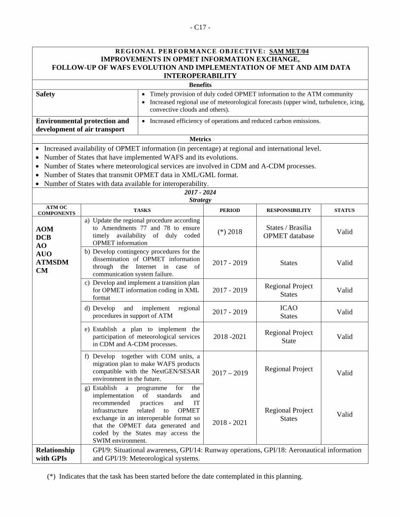
- C17 -
REGIONAL PERFORMANCE OBJECTIVE: SAM MET/04 IMPROVEMENTS IN OPMET INFORMATION EXCHANGE,
FOLLOW-UP OF WAFS EVOLUTION AND IMPLEMENTATION OF MET AND AIM DATA INTEROPERABILITY
Benefits
Safety
Timely provision of duly coded OPMET information to the ATM community Increased regional use of meteorological forecasts (upper wind, turbulence, icing,
convective clouds and others).
Environmental protection and development of air transport
Increased efficiency of operations and reduced carbon emissions.
Metrics
Increased availability of OPMET information (in percentage) at regional and international level. Number of States that have implemented WAFS and its evolutions. Number of States where meteorological services are involved in CDM and A-CDM processes. Number of States that transmit OPMET data in XML/GML format. Number of States with data available for interoperability.
2017 - 2024 Strategy
ATM OC COMPONENTS
TASKS PERIOD RESPONSIBILITY STATUS
AOM DCB AO AUO ATMSDM CM
a) Update the regional procedure according to Amendments 77 and 78 to ensure timely availability of duly coded OPMET information
(*) 2018 States / Brasilia
OPMET database Valid
b) Develop contingency procedures for the dissemination of OPMET information through the Internet in case of communication system failure.
2017 - 2019 States Valid
c) Develop and implement a transition plan for OPMET information coding in XML format
2017 - 2019 Regional Project
States Valid
d) Develop and implement regional procedures in support of ATM 2017 - 2019
ICAO States
Valid
e) Establish a plan to implement the participation of meteorological services in CDM and A-CDM processes.
2018 -2021 Regional Project
State Valid
f) Develop together with COM units, a migration plan to make WAFS products compatible with the NextGEN/SESAR environment in the future.
2017 – 2019
2018 - 2021
Regional Project
Regional Project States
Valid
Valid
g) Establish a programme for the implementation of standards and recommended practices and IT infrastructure related to OPMET exchange in an interoperable format so that the OPMET data generated and coded by the States may access the SWIM environment.
Relationship with GPIs
GPI/9: Situational awareness, GPI/14: Runway operations, GPI/18: Aeronautical information and GPI/19: Meteorological systems.
(*) Indicates that the task has been started before the date contemplated in this planning.
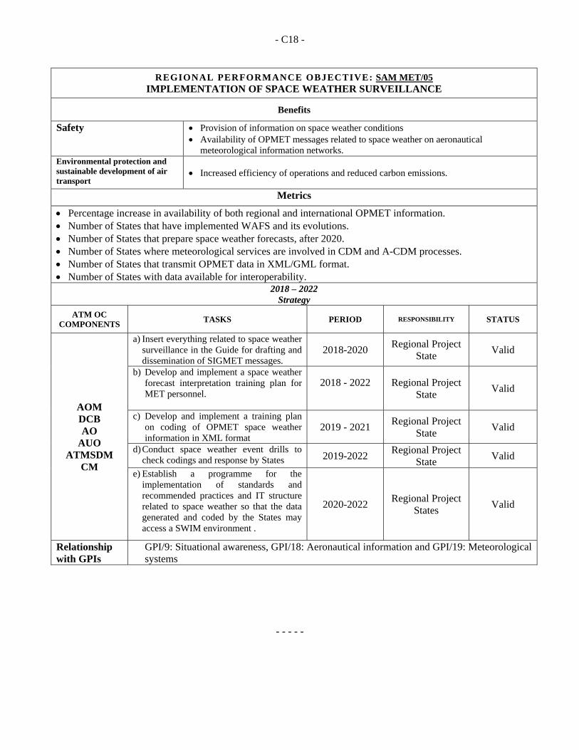
- C18 -
REGIONAL PERFORMANCE OBJECTIVE: SAM MET/05 IMPLEMENTATION OF SPACE WEATHER SURVEILLANCE
Benefits
Safety Provision of information on space weather conditions Availability of OPMET messages related to space weather on aeronautical
meteorological information networks. Environmental protection and sustainable development of air transport
Increased efficiency of operations and reduced carbon emissions.
Metrics
Percentage increase in availability of both regional and international OPMET information. Number of States that have implemented WAFS and its evolutions. Number of States that prepare space weather forecasts, after 2020. Number of States where meteorological services are involved in CDM and A-CDM processes. Number of States that transmit OPMET data in XML/GML format. Number of States with data available for interoperability.
2018 – 2022 Strategy
ATM OC COMPONENTS
TASKS PERIOD RESPONSIBILITY STATUS
AOM DCB AO
AUO ATMSDM
CM
a) Insert everything related to space weather surveillance in the Guide for drafting and dissemination of SIGMET messages.
2018-2020 Regional Project
State Valid
b) Develop and implement a space weather forecast interpretation training plan for MET personnel.
2018 - 2022
Regional Project State
Valid
c) Develop and implement a training plan on coding of OPMET space weather information in XML format
2019 - 2021 Regional Project
State Valid
d) Conduct space weather event drills to check codings and response by States 2019-2022
Regional Project State
Valid
e) Establish a programme for the implementation of standards and recommended practices and IT structure related to space weather so that the data generated and coded by the States may access a SWIM environment .
2020-2022 Regional Project
States Valid
Relationship with GPIs
GPI/9: Situational awareness, GPI/18: Aeronautical information and GPI/19: Meteorological systems
- - - - -
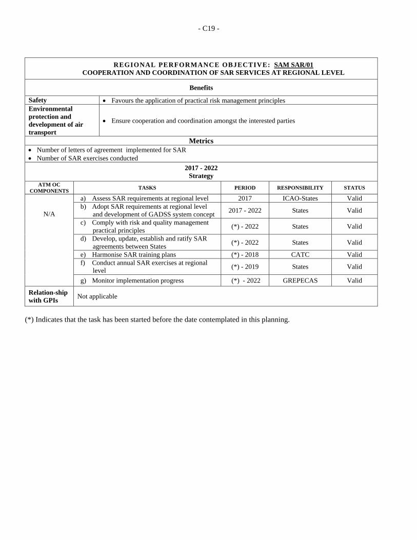
- C19 -
REGIONAL PERFORMANCE OBJECTIVE: SAM SAR/01 COOPERATION AND COORDINATION OF SAR SERVICES AT REGIONAL LEVEL
Benefits
Safety Favours the application of practical risk management principles Environmental protection and development of air transport
Ensure cooperation and coordination amongst the interested parties
Metrics Number of letters of agreement implemented for SAR Number of SAR exercises conducted
2017 - 2022 Strategy
ATM OC COMPONENTS
TASKS PERIOD RESPONSIBILITY STATUS
N/A
a) Assess SAR requirements at regional level 2017 ICAO-States Valid b) Adopt SAR requirements at regional level
and development of GADSS system concept 2017 - 2022 States Valid
c) Comply with risk and quality management practical principles
(*) - 2022 States Valid
d) Develop, update, establish and ratify SAR agreements between States
(*) - 2022 States Valid
e) Harmonise SAR training plans (*) - 2018 CATC Valid f) Conduct annual SAR exercises at regional
level (*) - 2019 States Valid
g) Monitor implementation progress (*) - 2022 GREPECAS Valid
Relation-ship with GPIs
Not applicable
(*) Indicates that the task has been started before the date contemplated in this planning.
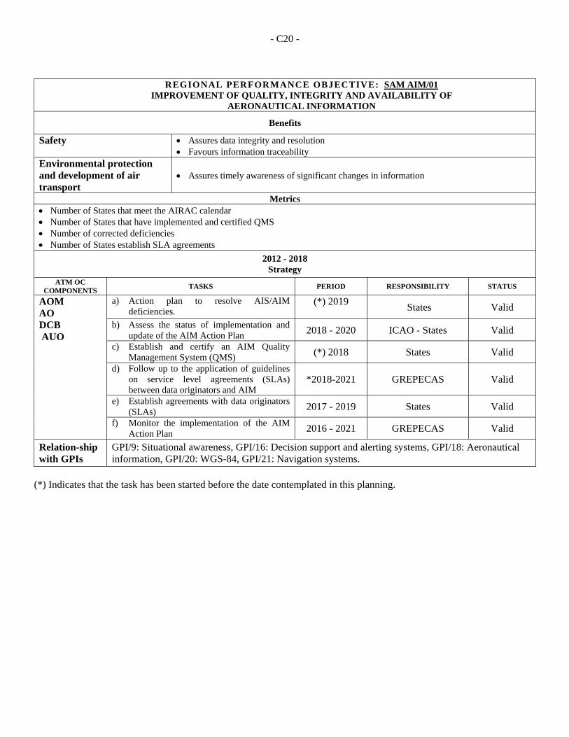
- C20 -
REGIONAL PERFORMANCE OBJECTIVE: SAM AIM/01
IMPROVEMENT OF QUALITY, INTEGRITY AND AVAILABILITY OF AERONAUTICAL INFORMATION
Benefits
Safety Assures data integrity and resolution Favours information traceability
Environmental protection and development of air transport
Assures timely awareness of significant changes in information
Metrics Number of States that meet the AIRAC calendar Number of States that have implemented and certified QMS Number of corrected deficiencies Number of States establish SLA agreements
2012 - 2018 Strategy
ATM OC COMPONENTS
TASKS PERIOD RESPONSIBILITY STATUS
AOM AO DCB AUO
a) Action plan to resolve AIS/AIM deficiencies.
(*) 2019
States Valid
b) Assess the status of implementation and update of the AIM Action Plan 2018 - 2020 ICAO - States Valid
c) Establish and certify an AIM Quality Management System (QMS) (*) 2018 States Valid
d) Follow up to the application of guidelines on service level agreements (SLAs) between data originators and AIM
*2018-2021 GREPECAS Valid
e) Establish agreements with data originators (SLAs) 2017 - 2019 States Valid
f) Monitor the implementation of the AIM Action Plan 2016 - 2021 GREPECAS Valid
Relation-ship with GPIs
GPI/9: Situational awareness, GPI/16: Decision support and alerting systems, GPI/18: Aeronautical information, GPI/20: WGS-84, GPI/21: Navigation systems.
(*) Indicates that the task has been started before the date contemplated in this planning.
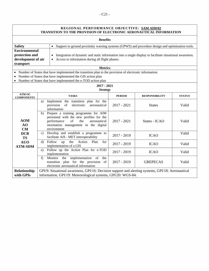
- C21 -
REGIONAL PERFORMANCE OBJECTIVE: SAM AIM/02 TRANSITION TO THE PROVISION OF ELECTRONIC AERONAUTICAL INFORMATION
Benefits
Safety Support to ground proximity warning systems (GPWS) and procedure design and optimisation tools. Environmental protection and development of air transport
Integration of dynamic and static information into a single display to facilitate situational awareness. Access to information during all flight phases.
Metrics Number of States that have implemented the transition plan to the provision of electronic information Number of States that have implemented the GIS action plan Number of States that have implemented the e-TOD action plan
2017 - 2021 Strategy
ATM OC COMPONENTS
TASKS PERIOD RESPONSIBILITY STATUS
AOM AO CM DCB TS
AUO ATM-SDM
a) Implement the transition plan for the provision of electronic aeronautical information
2017 - 2021 States Valid
b) Prepare a training programme for AIM personnal with the new profiles for the performance of the aeronautical inormation management in the digital environment
2017 - 2021 States - ICAO Valid
c) Develop and establish a programme to facilitate AIS - MET interoperability 2017 - 2019 ICAO
Valid
d) Follow up the Action Plan for implementation of a GIS 2017 - 2019 ICAO Valid
e) Follow up the Action Plan for e-TOD implementation 2017 - 2019 ICAO Valid
f) Monitor the implementation of the transition plan for the provision of electronic aeronautical information
2017 - 2019 GREPECAS Valid
Relationship with GPIs
GPI/9: Situational awareness, GPI/16: Decision support and alerting systems, GPI/18: Aeronautical information, GPI/19: Meteorological systems, GPI/20: WGS-84.
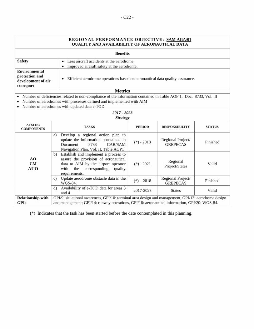
- C22 -
REGIONAL PERFORMANCE OBJECTIVE: SAM AGA/01 QUALITY AND AVAILABILITY OF AERONAUTICAL DATA
Benefits
Safety Less aircraft accidents at the aerodrome; Improved aircraft safety at the aerodrome;
Environmental protection and development of air transport
Efficient aerodrome operations based on aeronautical data quality assurance.
Metrics Number of deficiencies related to non-compliance of the information contained in Table AOP 1. Doc. 8733, Vol. II Number of aerodromes with processes defined and implemented with AIM Number of aerodromes with updated data e-TOD
2017 - 2023 Strategy
ATM OC COMPONENTS
TASKS PERIOD RESPONSIBILITY STATUS
AO CM
AUO
a) Develop a regional action plan to update the information contained in Document 8733 CAR/SAM Navigation Plan, Vol. II, Table AOP1
(*) - 2018 Regional Project/
GREPECAS Finished
b) Establish and implement a process to assure the provision of aeronautical data to AIM by the airport operator with the corresponding quality requirements.
(*) - 2021 Regional
Project/States Valid
c) Update aerodrome obstacle data in the WGS-84.
(*) – 2018 Regional Project/
GREPECAS Finished
d) Availability of e-TOD data for areas 3 and 4
2017-2023 States Valid
Relationship with GPIs
GPI/9: situational awareness, GPI/10: terminal area design and management, GPI/13: aerodrome design and management; GPI/14: runway operations, GPI/18: aeronautical information, GPI/20: WGS-84.
(*) Indicates that the task has been started before the date contemplated in this planning.
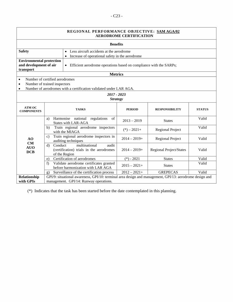
- C23 -
REGIONAL PERFORMANCE OBJECTIVE: SAM AGA/02 AERODROME CERTIFICATION
Benefits
Safety Less aircraft accidents at the aerodrome Increase of operational safety in the aerodrome
Environmental protection and development of air transport
Efficient aerodrome operations based on compliance with the SARPs;
Metrics Number of certified aerodromes Number of trained inspectors Number of aerodromes with a certification validated under LAR AGA.
2017 - 2023 Strategy
ATM OC COMPONENTS
TASKS PERIOD RESPONSIBILITY STATUS
AO CM
AUO DCB
a) Harmonise national regulations of States with LAR-AGA
2013 – 2019 States Valid
b) Train regional aerodrome inspectors with the MIAGA
(*) – 2021+ Regional Project Valid
c) Train regional aerodrome inspectors in auditing techniques
2014 – 2019+ Regional Project Valid
d) Conduct multinational audit (certification) trials in the aerodromes of the Region
2014 – 2019+ Regional Project/States Valid
e) Certification of aerodromes (*) - 2021 States Valid f) Validate aerodrome certificates granted
before harmonization with LAR AGA 2015 – 2021+ States
Valid
g) Surveillance of the certification process 2012 – 2021+ GREPECAS Valid Relationship with GPIs
GPI/9: situational awareness, GPI/10: terminal area design and management, GPI/13: aerodrome design and management. GPI/14: Runway operations.
(*) Indicates that the task has been started before the date contemplated in this planning.
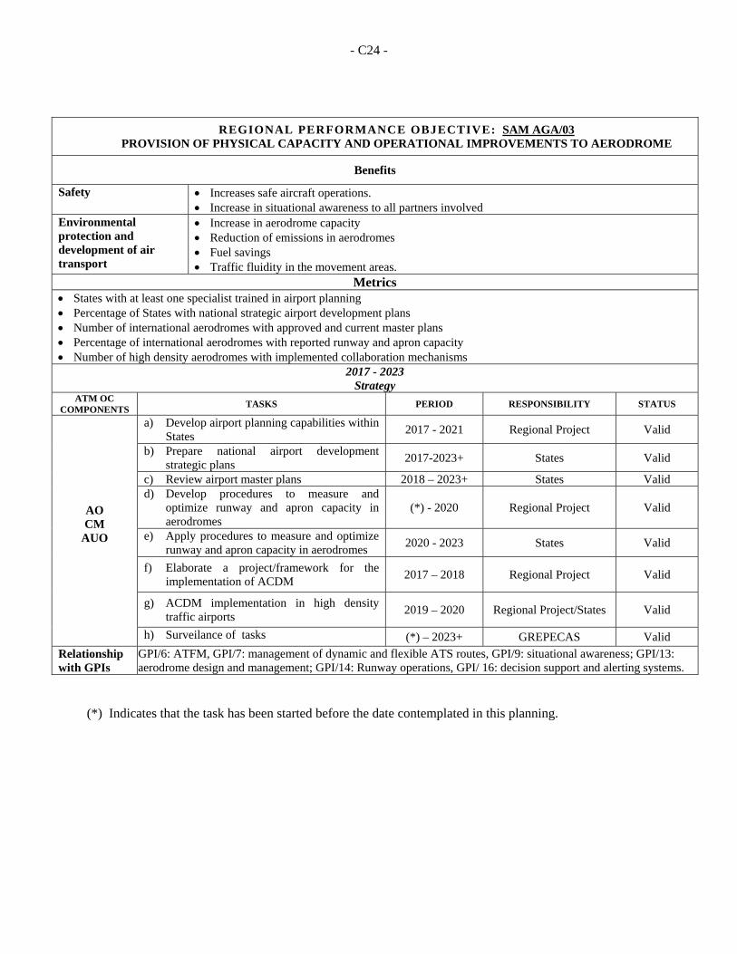
- C24 -
REGIONAL PERFORMANCE OBJECTIVE: SAM AGA/03 PROVISION OF PHYSICAL CAPACITY AND OPERATIONAL IMPROVEMENTS TO AERODROME
Benefits
Safety Increases safe aircraft operations. Increase in situational awareness to all partners involved
Environmental protection and development of air transport
Increase in aerodrome capacity Reduction of emissions in aerodromes Fuel savings Traffic fluidity in the movement areas.
Metrics States with at least one specialist trained in airport planning Percentage of States with national strategic airport development plans Number of international aerodromes with approved and current master plans Percentage of international aerodromes with reported runway and apron capacity Number of high density aerodromes with implemented collaboration mechanisms
2017 - 2023 Strategy
ATM OC COMPONENTS
TASKS PERIOD RESPONSIBILITY STATUS
AO CM
AUO
a) Develop airport planning capabilities within States
2017 - 2021 Regional Project Valid
b) Prepare national airport development strategic plans
2017-2023+ States Valid
c) Review airport master plans 2018 – 2023+ States Valid d) Develop procedures to measure and
optimize runway and apron capacity in aerodromes
(*) - 2020 Regional Project Valid
e) Apply procedures to measure and optimize runway and apron capacity in aerodromes
2020 - 2023 States Valid
f) Elaborate a project/framework for the implementation of ACDM
2017 – 2018 Regional Project Valid
g) ACDM implementation in high density traffic airports
2019 – 2020 Regional Project/States Valid
h) Surveilance of tasks (*) – 2023+ GREPECAS Valid
Relationship with GPIs
GPI/6: ATFM, GPI/7: management of dynamic and flexible ATS routes, GPI/9: situational awareness; GPI/13: aerodrome design and management; GPI/14: Runway operations, GPI/ 16: decision support and alerting systems.
(*) Indicates that the task has been started before the date contemplated in this planning.
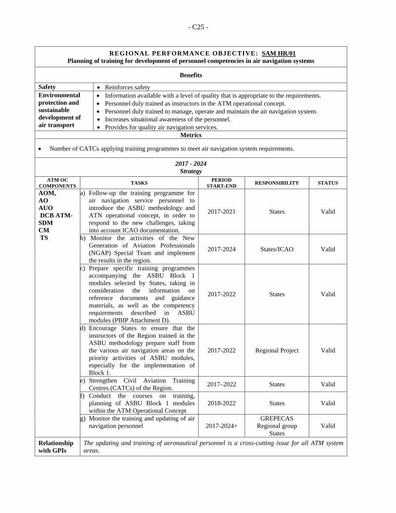
- C25 -
REGIONAL PERFORMANCE OBJECTIVE: SAM HR/01 Planning of training for development of personnel competencies in air navigation systems
Benefits
Safety Reinforces safety Environmental protection and sustainable development of air transport
Information available with a level of quality that is appropriate to the requirements. Personnel duly trained as instructors in the ATM operational concept. Personnel duly trained to manage, operate and maintain the air navigation system. Increases situational awareness of the personnel. Provides for quality air navigation services.
Metrics
Number of CATCs applying training programmes to meet air navigation system requirements.
2017 - 2024 Strategy
ATM OC COMPONENTS
TASKS PERIOD
START-END RESPONSIBILITY STATUS
AOM, AO AUO DCB ATM-SDM CM TS
a) Follow-up the training programme for air navigation service personnel to introduce the ASBU methodology and ATN operational concept, in order to respond to the new challenges, taking into account ICAO documentation.
2017-2021 States Valid
b) Monitor the activities of the New Generation of Aviation Professionals (NGAP) Special Team and implement the results in the region.
2017-2024 States/ICAO Valid
c) Prepare specific training programmes accompanying the ASBU Block 1 modules selected by States, taking in consideration the information on reference documents and guidance materials, as well as the competency requirements described in ASBU modules (PBIP Attachment D).
2017-2022 States Valid
d) Encourage States to ensure that the instructors of the Region trained in the ASBU methodology prepare staff from the various air navigation areas on the priority activities of ASBU modules, especially for the implementation of Block 1.
2017-2022 Regional Project Valid
e) Strengthen Civil Aviation Training Centres (CATCs) of the Region.
2017–2022 States Valid
f) Conduct the courses on training, planning of ASBU Block 1 modules within the ATM Operational Concept
2018-2022 States Valid
g) Monitor the training and updating of air navigation personnel 2017-2024+
GREPECAS Regional group
States Valid
Relationship with GPIs
The updating and training of aeronautical personnel is a cross-cutting issue for all ATM system areas.
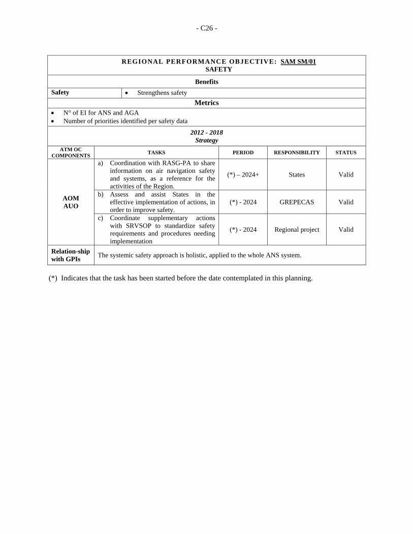
- C26 -
REGIONAL PERFORMANCE OBJECTIVE: SAM SM/01 SAFETY
Benefits
Safety Strengthens safety
Metrics
N° of EI for ANS and AGA Number of priorities identified per safety data
2012 - 2018 Strategy
ATM OC COMPONENTS
TASKS PERIOD RESPONSIBILITY STATUS
AOM AUO
a) Coordination with RASG-PA to share information on air navigation safety and systems, as a reference for the activities of the Region.
(*) – 2024+ States Valid
b) Assess and assist States in the effective implementation of actions, in order to improve safety.
(*) - 2024 GREPECAS Valid
c) Coordinate supplementary actions with SRVSOP to standardize safety requirements and procedures needing implementation
(*) - 2024 Regional project Valid
Relation-ship with GPIs
The systemic safety approach is holistic, applied to the whole ANS system.
(*) Indicates that the task has been started before the date contemplated in this planning.
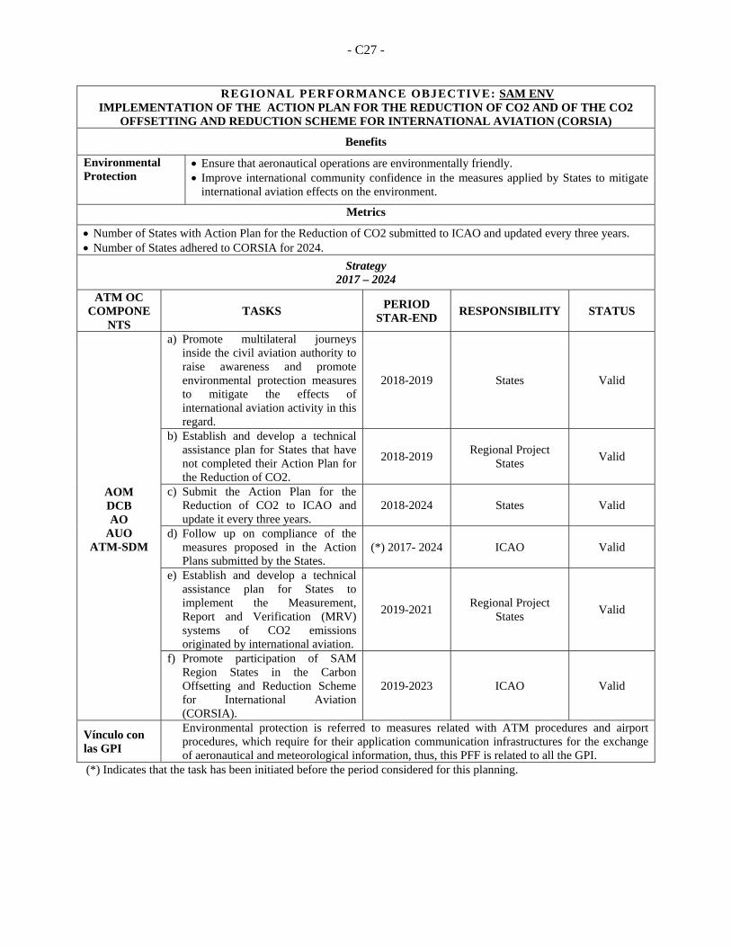
- C27 -
REGIONAL PERFORMANCE OBJECTIVE: SAM ENV IMPLEMENTATION OF THE ACTION PLAN FOR THE REDUCTION OF CO2 AND OF THE CO2
OFFSETTING AND REDUCTION SCHEME FOR INTERNATIONAL AVIATION (CORSIA)
Benefits
Environmental Protection
Ensure that aeronautical operations are environmentally friendly. Improve international community confidence in the measures applied by States to mitigate
international aviation effects on the environment.
Metrics
Number of States with Action Plan for the Reduction of CO2 submitted to ICAO and updated every three years. Number of States adhered to CORSIA for 2024.
Strategy 2017 – 2024
ATM OC COMPONE
NTS TASKS
PERIOD STAR-END
RESPONSIBILITY STATUS
AOM DCB AO
AUO ATM-SDM
a) Promote multilateral journeys inside the civil aviation authority to raise awareness and promote environmental protection measures to mitigate the effects of international aviation activity in this regard.
2018-2019 States Valid
b) Establish and develop a technical assistance plan for States that have not completed their Action Plan for the Reduction of CO2.
2018-2019 Regional Project
States Valid
c) Submit the Action Plan for the Reduction of CO2 to ICAO and update it every three years.
2018-2024 States Valid
d) Follow up on compliance of the measures proposed in the Action Plans submitted by the States.
(*) 2017- 2024 ICAO Valid
e) Establish and develop a technical assistance plan for States to implement the Measurement, Report and Verification (MRV) systems of CO2 emissions originated by international aviation.
2019-2021 Regional Project
States Valid
f) Promote participation of SAM Region States in the Carbon Offsetting and Reduction Scheme for International Aviation (CORSIA).
2019-2023 ICAO Valid
Vínculo con las GPI
Environmental protection is referred to measures related with ATM procedures and airport procedures, which require for their application communication infrastructures for the exchange of aeronautical and meteorological information, thus, this PFF is related to all the GPI.
(*) Indicates that the task has been initiated before the period considered for this planning.
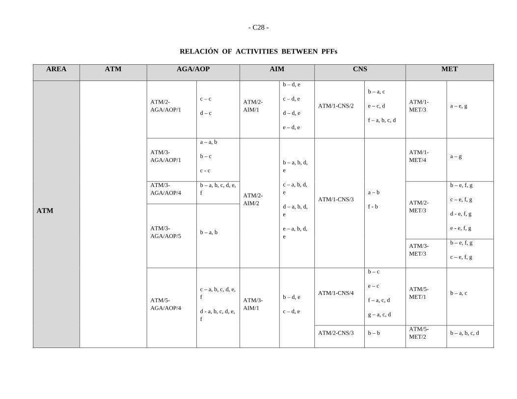
- C28 -
RELACIÓN OF ACTIVITIES BETWEEN PFFs
AREA ATM AGA/AOP AIM CNS MET
ATM
ATM/2-AGA/AOP/1
c – c
d – c
ATM/2-AIM/1
b – d, e
c – d, e
d – d, e
e – d, e
ATM/1-CNS/2
b – a, c
e – c, d
f – a, b, c, d
ATM/1-MET/3
a – e, g
ATM/3-AGA/AOP/1
a – a, b
b – c
c - c
ATM/2-AIM/2
b – a, b, d, e
c – a, b, d, e
d – a, b, d, e
e – a, b, d, e
ATM/1-CNS/3 a – b
f - b
ATM/1-MET/4
a – g
ATM/3-AGA/AOP/4
b – a, b, c, d, e, f
ATM/2-MET/3
b – e, f, g
c – e, f, g
d - e, f, g
e - e, f, g ATM/3-AGA/AOP/5
b – a, b
ATM/3-MET/3
b – e, f, g
c – e, f, g
ATM/5-AGA/AOP/4
c – a, b, c, d, e, f
d - a, b, c, d, e, f
ATM/3-AIM/1
b – d, e
c – d, e
ATM/1-CNS/4
b – c
e – c
f – a, c, d
g – a, c, d
ATM/5-MET/1
b – a, c
ATM/2-CNS/3 b – b ATM/5-MET/2
b – a, b, c, d
- C29 -
AREA ATM AGA/AOP AIM CNS MET
c - b
ATM/3 CNS/3 c - c ATM/5-MET/3
b – a, c, d, e, g, h
ATM/5-CNS/1 f -c ATM/5-MET/4
b – a, b, c, g
ATM/6-CNS/1
b – a, b, c, d, e
d – c, d, f, g, h
ATM/7-MET/1
c – a
d - a
ATM/3-AIM/2
e – b
ATM/6-CNS/4 c – a, b, c, d
d – a, c
ATM/7-MET/4
c – d
d - d
ATM/4-AIM/1
e – c, d, e
ATM/6-AIM/2
b – a, b, d, e
c – a, b, d, e
AGA/AOP
AGA/AOP/1-AIM/1
b – d
g - e
AGA/AOP/4-CNS/4
g - b AGA/AOP/5-MET/2
a - a
AGA/AOP/1-AIM/2
b – d, e
CNS
CNS/1-AIM/2
a – a, b
f – a, b
CNS/2-MET/4
h – a, c. g

- C30 -
AREA ATM AGA/AOP AIM CNS MET
MET
MET/1-AIM/1
a - g
MET/3-AIM/2
f – c
g – c
MET/1-A
IM/2 a-g
SAR SAR/1-ATM/4
f - d
RRHH All area of PFF/1 All area of PFF/1 All area of PFF/1 All area of PFF/1 All area of PFF/1
SM All area of PFF/1 All area of PFF/1 All area of PFF/1 All area of PFF/1 All area of PFF/1
- C31 -
PFF RELATIONSHIP WITH ASBU BLOCK 0 AND BLOCK1 MODULES SELECTED FOR THE SAM REGION RELACIÓN DE LOS PFFCON LOS MÓDULOS DEL ASBU DEL BLOQUE 0 Y DEL BLOQUE 1 SELECCIONADO PARA LA
REGIÓN SAM
PFF AND BLOCK 0 MODULES/ PFF Y MODULOS BLOQUE 0
ASBU
PFF
PIA1 PIA2 PIA3 PIA4
B0 RSEQ
B0 APTA
B0 SURF
B0 ACDM
B0 FICE
B0 DATM
B0 AMET
B0 FRTO
B0 NOPS
B0 ASUR
B0 SNET
B0 OPFL
B0 ACAS
B0 CDO
B0 CC0
B0 TBO
PFF SAM ATM/01 X X PFFSAMATM/02 X X PFFSAM ATM/03 X PFF SAM ATM/04 X PFF SAM ATM/05 X X X PFF SAM ATM/06 X X X PFF SAM CNS/01 X X X PFFSAM CNS/02 X PFF SAM CNS/03 X PFF SAM CNS/04 X X X PFFSAM MET/01 X PFF SAM MET/02 X X X PFF SAM MET/03 X X PFF SAM MET/04 X X X PFFSAM SAR/01 PFF SAM AIM/01 X PFF SAM AIM/02 X X PFF SAM AGA/01 X X PFF SAM AGA/02 X X X PFF SAM AGA/03 X X X X PFF SAM HHRR/01 X X X X X X X X X X X X X X X X PFF SAM SM/01 PFF SAM ENV/01 X X X X X X X X
- C32 -
PFF AND BLOCK 1 MODULES/ PFF Y MODULOS BLOQUE 1
ASBU
PFF
PIA1 PIA2 PIA3 PIA4
B1 RSEQ
B1 FICE B1 DATM B1
AMET B1
SWIM B1
NOPS B1
SNET B1
CDO B1
TBO B1
RPAS
PFF SAM ATM/01 PFFSAMATM/02 X X PFFSAM ATM/03 PFF SAM ATM/04 PFF SAM ATM/05 X X PFF SAM ATM/06 X PFF SAM CNS/01 X X X X X X PFFSAM CNS/02 PFF SAM CNS/03 PFF SAM CNS/04 X X X PFFSAM MET/01 X PFF SAM MET/02 X PFF SAM MET/03 X PFF SAM MET/04 X X X PFFSAM SAR/01 PFF SAM AIM/01 X PFF SAM AIM/02 X X X PFF SAM AGA/01 PFF SAM AGA/02 PFF SAM AGA/03 X PFF SAM HHRR/01 X X X X X X X X X X PFF SAM SM/01 PFF SAM ENV/01 X X X X
ATTACHMENT D
DESCRIPTION OF MODULES CONSIDERED FOR THE SAM REGION PERFORMANCE IMPROVEMENT AREA 1: AIRPORT OPERATIONS 1. B0-15 RSEQ: Improve Traffic Flow through Runway Sequencing
(AMAN/DMAN)
Introduction 1.1 This module introduces system capabilities to provide assistance for sequencing and metering to manage arrivals and departures (including time-based metering) to and from a multi-runway aerodrome or locations with multiple dependent runways at closely proximate aerodromes, to efficiently utilize the inherent runway capacity.
Baseline 1.2 Currently, sequencing is the manual process by which the air traffic controller uses local procedures and his expertise to sequence departures or arrivals in real time. This is generally leading to sub-optimal solutions both for the realized sequence and the flight efficiency, in particular in terms of taxi times and ground holding for departures, and in terms of holding for arrivals.
Change brought by the module 1.3 For departures, the sequence will allow improved start/push-back clearances, reducing the taxi time and ground holding, delivering more efficient departure sequences, reducing surface congestion and effectively and efficiently making use of terminal and aerodrome resources. 1.4 Departure management tools maximize the use of airspace capacity and assure full utilization of resources. They have the additional benefit of fuel efficient alternatives to reduce airborne and ground holding in an era in which fuel continues to be a major cost driver and emissions are a high priority. The use of these tools to assure facility of more efficient arrival and departure paths is a main driver in some modules of Block 0.
Necessary procedures (air and ground) 1.5 It is necessary to develop the systems and operational procedures for AMAN/DMAN. In particular, procedures for the extension of metering into en-route airspace will be necessary. RNAV/RNP for arrival will also be crucial as well.
Element 1: AMAN and time-based metering 1.6 Arrival management (AMAN) sequences the aircraft, based on the airspace state, wake turbulence, aircraft capability, and user preference. The established sequence provides the time that aircraft may have to lose before a reference approach fix, thereby allowing aircraft to fly more efficiently to the that fix and to reduce the use of holding stacks, in particular at low altitude. The smoothed sequence allows increased aerodrome throughput. 1.7 Time-based metering is the practice of separation by time rather than distance. Typically, the relevant ATC authorities will assign a time in which a flight must arrive at the aerodrome. This is known as the control time of arrival (CTA). CTAs are determined based on aerodrome capacity, terminal airspace capacity, aircraft capability, wind and other meteorological factors. Time-based metering is the primary mechanism in which arrival sequencing is achieved.
- D2 -
Element 2: Departure management 1.8 Departure management (DMAN), like its arrival counterpart, serves to optimize departure operation to ensure the most efficient utilization of aerodrome and terminal resources. Slots assignment and adjustments will be supported by departure management automations like departure management (DMAN) or departure flow management (DFM). Dynamic slot allocation will foster smoother integration into overhead streams and help the airspace users to better meet metering points and comply with other ATM decisions. Departure management sequences the aircraft, based on the airspace state, wake turbulence, aircraft capability, and user preference, to fit into the overhead en-route streams without disrupting the traffic flow. This will serve to increase aerodrome throughput and compliance with allotted departure time.
Intended performance operational improvement 1.9 In terms of Capacity improvements, time-based metering will optimize usage of terminal airspace and runway capacity. The utilization of terminal and runway resources will be optimized. 1.10 Efficiency is positively impacted as reflected by increased runway throughput and arrival rates. Efficiency is achieved through:
a) harmonized arriving traffic flow from en-route to terminal and aerodrome. Harmonization is achieved via the sequencing of arrival flights based on available terminal and runway resources; and
b) streamlined departure traffic flow and smooth transition into en-route airspace. Decreased lead time for departure request and time between call for release and departure time. Automated dissemination of departure information and clearances.
1.11 In terms of predictability it decreases uncertainties in aerodrome/terminal demand prediction and in terms of flexibility it enables dynamic scheduling. 1.12 Just as a reference to take into account, a detailed business case has been built for the time-based flow management programme in the United States. The business case has proven the benefit/cost ratio to be positive. Implementation of time-based metering can reduce airborne delay. This capability was estimated to provide over 320 000 minutes in delay reduction and $28.37 million in benefits to airspace users and passengers over the evaluation period.
Necessary system capability
Avionics 1.13 No avionics capability is required in support of the time-based metering for departure. For approach, time-based metering is mainly achieved through ATC speed clearance to adjust the aircraft sequence in the AMAN. This operation can be facilitated by requiring the aircraft to meet a CTA at a metering fix, relying on the aircraft required time of arrival function from current flight management system (FMS).
Ground systems 1.14 The key technological aspects include automation support for the synchronization of arrival sequencing, departure sequencing, and surface information; improve predictability of arrival flow, further hone sector capacity estimates, and management by trajectory. Less congested locations might not require extensive automation support to implement.
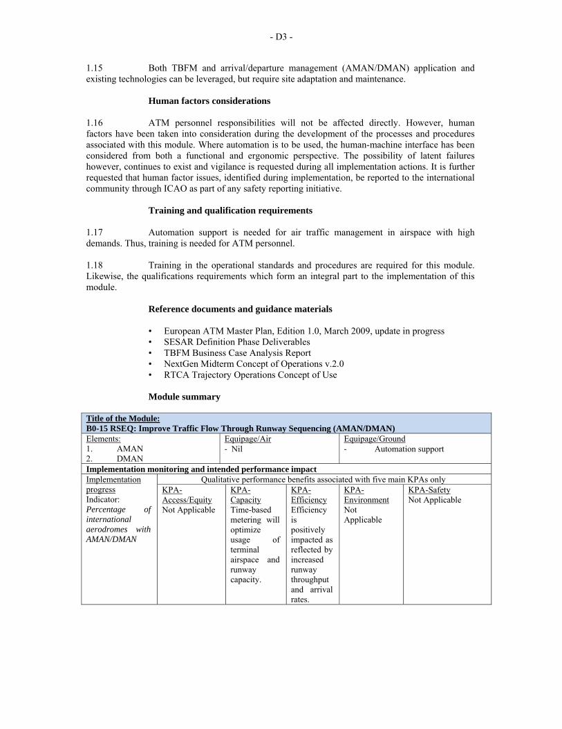
- D3 -
1.15 Both TBFM and arrival/departure management (AMAN/DMAN) application and existing technologies can be leveraged, but require site adaptation and maintenance.
Human factors considerations 1.16 ATM personnel responsibilities will not be affected directly. However, human factors have been taken into consideration during the development of the processes and procedures associated with this module. Where automation is to be used, the human-machine interface has been considered from both a functional and ergonomic perspective. The possibility of latent failures however, continues to exist and vigilance is requested during all implementation actions. It is further requested that human factor issues, identified during implementation, be reported to the international community through ICAO as part of any safety reporting initiative.
Training and qualification requirements 1.17 Automation support is needed for air traffic management in airspace with high demands. Thus, training is needed for ATM personnel. 1.18 Training in the operational standards and procedures are required for this module. Likewise, the qualifications requirements which form an integral part to the implementation of this module.
Reference documents and guidance materials • European ATM Master Plan, Edition 1.0, March 2009, update in progress • SESAR Definition Phase Deliverables • TBFM Business Case Analysis Report • NextGen Midterm Concept of Operations v.2.0 • RTCA Trajectory Operations Concept of Use
Module summary
Title of the Module: B0-15 RSEQ: Improve Traffic Flow Through Runway Sequencing (AMAN/DMAN) Elements: 1. AMAN 2. DMAN
Equipage/Air ‐ Nil
Equipage/Ground ‐ Automation support
Implementation monitoring and intended performance impact Implementation progress Indicator: Percentage of international aerodromes with AMAN/DMAN
Qualitative performance benefits associated with five main KPAs only KPA-Access/Equity Not Applicable
KPA-Capacity Time-based metering will optimize usage of terminal airspace and runway capacity.
KPA-Efficiency Efficiency is positively impacted as reflected by increased runway throughput and arrival rates.
KPA-Environment Not Applicable
KPA-Safety Not Applicable
- D4 -
2. B0-65 APTA: Optimization of Approach Procedures including Vertical Guidance
Introduction
2.1 This module complements other airspace and procedures elements (continuous descent operations (CDO), PBN and airspace management) to increase efficiency, safety, access and predictability. The use of performance-based navigation (PBN) and ground-based augmentation system (GBAS) landing system (GLS1) procedures will enhance the reliability and predictability of approaches to runways, thus increasing safety, accessibility and efficiency. This is possible through the application of Basic global navigation satellite system (GNSS), Baro vertical navigation (VNAV), satellite-based augmentation system (SBAS) and GLS. The flexibility inherent in PBN approach design can be exploited to increase runway capacity.
Baseline 2.2 Conventional navigation aids (e.g. Instrument landing system (ILS), VHF omnidirectional radio range (VOR), non-directional radio beacon (NDB)) have limitations in their ability to support the lowest minima to every runway. In the case of ILS, limitations include cost, the availability of suitable sites for ground infrastructure and an inability to support multiple descent paths to multiple runway ends. VOR and NDB procedures do not support vertical guidance and have relatively high minima that depend on siting considerations.
Change brought by the module 2.3 With the exception of ground-based augmentation system (GBAS) for GLS, performance-based navigation (PBN) procedures require no ground-based navaids and allow designers complete flexibility in determining the final approach lateral and vertical paths. PBN approach procedures can be seamlessly integrated with PBN arrival procedures, along with continuous descent operations (CDO), thus reducing aircrew and controller workload and the probability that aircraft will not follow the expected trajectory. 2.4 States can implement GNSS-based PBN approach procedures that provide minima for aircraft equipped with basic GNSS avionics with or without Baro VNAV capability, and for aircraft equipped with SBAS avionics. GLS, which is not included in the PBN Manual, requires aerodrome infrastructure but a single station can support approaches to all runways and GLS offers the same design flexibility as PBN procedures. This flexibility provides benefits when conventional aids are out of service due to system failures or for maintenance. Regardless of the avionics fit, each aircraft will follow the same lateral path. Such approaches can be designed for runways with or without conventional approaches, thus providing benefits to PBN-capable aircraft, encouraging equipage and supporting the planning for decommissioning of some conventional aids. 2.5 The key to realizing maximum benefits from these procedures is aircraft equipage. Aircraft operators make independent decisions about equipage based on the value of incremental benefits and potential savings in fuel and other costs related to flight disruptions. Experience has shown that operators typically await fleet renewal rather than equip existing aircraft; however retrofits providing RNP/LPV capability are available and have been applied to many bizjet aircraft. 2.6 Metrics to determine success of the module are proposed in the Manual on Global Performance of the Air Navigation System (Doc 9883).
- D5 -
Intended performance operational improvement 2.7 In contrast with ILS, the GNSS-based approaches (PBN and GLS) do not require the definition and management of sensitive and critical areas resulting in potentially increased runway capacity. 2.8 Cost savings related to the benefits of lower approach minima: fewer diversions, overflights, cancellations and delays. Cost savings related to higher airport capacity in certain circumstances (e.g. closely spaced parallels) by taking advantage of the flexibility to offset approaches and define displaced thresholds. 2.9 This implementation contributes to safety with stabilized approach paths and to environment benefits through reduced fuel burn increasing airport accessibility as well. 2.10 In terms of cost benefit analysis Aircraft operators and air navigation service providers (ANSPs) can quantify the benefits of lower minima by using historical aerodrome weather observations and modelling airport accessibility with existing and new minima. Each aircraft operator can then assess benefits against the cost of any required avionics upgrade. Until there are GBAS (CAT I/III) Standards, GLS cannot be considered as a candidate to globally replace ILS. The GLS business case needs to consider the cost of retaining ILS or MLS to allow continued operations during an interference event.
Necessary procedures (air and ground) 2.11 The following documents provide background and implementation guidance for ANSPs, aircraft operators, airport operators and aviation regulators: 2.12 The Performance-based Navigation (PBN) Manual (Doc 9613), the Global Navigation Satellite System (GNSS) Manual (Doc 9849) Annex 10 — Aeronautical Telecommunications and the Procedures for Air Navigation Services — Aircraft Operations, Volume I — Flight Procedures and Volume II — Construction of Visual and Instrument Flight Procedures (PANS-OPS, Doc 8168) provide guidance on system performance, procedure design and flight techniques necessary to enable PBN approach procedures. 2.13 The World Geodetic System — 1984 (WGS-84) Manual (Doc 9674) provides guidance on surveying and data handling requirements. The Manual on Testing of Radio Navigation Aids (Doc 8071) (Doc 8071), Volume II — Testing of Satellite-based Radio Navigation Systems provides guidance on the testing of GNSS. This testing is designed to confirm the ability of GNSS signals to support flight procedures in accordance with the standards in Annex 10. 2.14 ANSPs must also assess the suitability of a procedure for publication, as detailed in PANS-OPS, Volume II, Part I, Section 2, Chapter 4, Quality Assurance. The Quality Assurance Manual for Flight Procedure Design (Doc 9906), Volume 5 –Validation of Instrument Flight Procedures provides the required guidance for validation of instrument flight procedures including PBN procedures. Flight validation for PBN procedures is less costly than for conventional aids for two reasons: the aircraft used do not require complex signal measurement and recording systems; and there is no requirement to check signals periodically.
- D6 -
Necessary system capability
Avionics 2.15 PBN approach procedures can be flown with basic instrument flight rules (IFR) GNSS avionics that support on board performance monitoring and alerting; these support lateral navigation (LNAV) minima. Basic IFR GNSS receivers may be integrated with Baro VNAV functionality to support vertical guidance to LNAV/vertical navigation (VNAV) minima. In States with defined SBAS service areas, aircraft with SBAS avionics can fly approaches with vertical guidance to LPV minima, which can be as low as ILS CAT I minima when flown to a precision instrument runway, and as low as 250 ft minimum descent altitude (MDA) when flown to an instrument runway. Within an SBAS service area, SBAS avionics can provide advisory vertical guidance when flying conventional non-directional beacon (NDB) and very high frequency omnidirectional radio range (VOR) procedures, thus providing the safety benefits associated with a stabilized approach. Aircraft require avionics to fly GBAS land system (GLS) approaches.
Ground systems 2.16 SBAS-based procedures do not require any infrastructure at the airport served, but SBAS elements (e.g. reference stations, master stations, geostationary (GEO) satellites) must be in place such that this level of service is supported. The ionosphere is very active in equatorial regions, making it very technically challenging for the current generation of SBAS to provide vertically guided approaches in these regions. A GLS station installed at the aerodrome served can support vertically guided CAT I approaches to all runways at that aerodrome.
Human performance 2.17 The implementation of approach procedures with vertical guidance enables improved cockpit resource management in times of high and sometime complex workload. By allowing crew procedures to be better distributed during the conduct of the procedure, exposure to operational errors is reduced and human performance is improved. This results in clear safety benefits over procedures that lack guidance along a vertical path. Additionally, some simplification and efficiencies may be achieved in crew training as well. 2.18 Human factors have been taken into consideration during the development of the processes and procedures associated with this module. Where a u t o m a t i o n i s t o be used, the human-machine interface has been considered from both a functional and ergonomic perspective. The possibility of latent failures, however, continues to exist and vigilance is requested during all implementation actions. It is further requested that human factor issues identified during implementation be reported to the international community through ICAO as part of any safety reporting initiative.
Training and qualification requirements 2.19 Training in the operational standards and procedures are required for this module and can be found in the “Reference documents and guidance material” section hereunder. Likewise, the qualification requirements are identified in the “Regulatory/standardization needs and approval plan (air and ground)” section which forms an integral part to the implementation of this module.
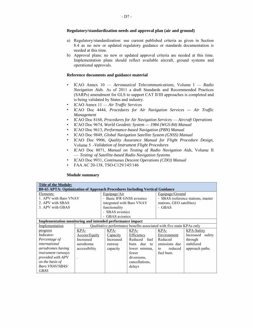
- D7 -
Regulatory/standardization needs and approval plan (air and ground)
a) Regulatory/standardization: use current published criteria as given in Section 8.4 as no new or updated regulatory guidance or standards documentation is needed at this time.
b) Approval plans: no new or updated approval criteria are needed at this time. Implementation plans should reflect available aircraft, ground systems and operational approvals.
Reference documents and guidance material
• ICAO Annex 10 — Aeronautical Telecommunications, Volume I — Radio
Navigation Aids. As of 2011 a draft Standards and Recommended Practices (SARPs) amendment for GLS to support CAT II/III approaches is completed and is being validated by States and industry.
• ICAO Annex 11 — Air Traffic Services • ICAO Doc 4444, Procedures for Air Navigation Services — Air Traffic
Management • ICAO Doc 8168, Procedures for Air Navigation Services — Aircraft Operations • ICAO Doc 9674, World Geodetic System — 1984 (WGS-84) Manual • ICAO Doc 9613, Performance-based Navigation (PBN) Manual • ICAO Doc 9849, Global Navigation Satellite System (GNSS) Manual • ICAO Doc 9906, Quality Assurance Manual for Flight Procedure Design,
Volume 5 -Validation of Instrument Flight Procedures • ICAO Doc 8071, Manual on Testing of Radio Navigation Aids, Volume II
— Testing of Satellite-based Radio Navigation Systems • ICAO Doc 9931, Continuous Descent Operations (CDO) Manual • FAA AC 20-138, TSO-C129/145/146
Module summary
Title of the Module: B0-65 APTA: Optimization of Approach Procedures Including Vertical Guidance Elements: 1. APV with Baro VNAV 2. APV with SBAS 3. APV with GBAS
Equipage/Air ‐ Basic IFR GNSS avionics integrated with Baro VNAV functionality ‐ SBAS avionics ‐ GBAS avionics
Equipage/Ground ‐ SBAS (reference stations, master stations, GEO satellites) ‐ GBAS
Implementation monitoring and intended performance impactImplementation progress Indicator: Percentage of international aerodromes having instrument runways provided with APV on the basis of Baro VNAV/SBAS/ GBAS
Qualitative performance benefits associated with five main KPAs only KPA-Access/Equity Increased aerodrome accessibility .
KPA-Capacity Increased runway capacity
KPA-Efficiency Reduced fuel burn due to lower minima, fewer diversions, cancellations, delays
KPA-Environment Reduced emissions due to reduced fuel burn.
KPA-Safety Increased safety through stabilized approach paths.
- D8 -
3. B0-75 SURF: Safety and Efficiency of Surface Operations (A-SMGCS Level 1-2)
Introduction
3.1 This module builds upon traditional surface movement guidance and control system (SMGCS) implementation (visual surveillance, aerodrome signage, lighting and markings) by the introduction of capabilities enhancing air traffic control (ATC) situational awareness through:
a) display to the aerodrome controller of the position of all aircraft on the aerodrome movement area;
b) display to the aerodrome controller of all vehicles on the aerodrome manoeuvring area; and
c) generation of runway incursion alerts (where local operational, safety and cost- benefit analyses so warrant).
3.2 This level of implementation, corresponding to levels 1 and 2 of the A-SMGCS concept and being associated to the provision of ATS, is independent of aircraft equipage beyond that associated with cooperative surveillance equipage (e.g. SSR Mode S or A/C transponders). 3.3 For automatic dependent surveillance—broadcast (ADS-B) APT the facilities and procedures will be the same with the performance levels associated to conventional SMGCS. The B0 level of implementation is dependent of aircraft/vehicle ADS-B Out equipage.
Baseline 3.4 Surface operations historically have been managed by use of visual scanning by both ANSP personnel and flight crew, both as the basis for taxi management as well as aircraft navigation and separation. These operations are significantly impeded during periods of reduced visibility (weather obscuration, night) and high demand, e.g. when a large proportion of aircraft are from the same operator and/or of the same aircraft type. 3.5 In addition, remote areas of the aerodrome surface are difficult to manage if out of direct visual surveillance. As a result, efficiency can be significantly degraded, and safety services are unevenly provided. Complementary to such historical means of aerodrome traffic management, enhanced surface situational awareness has been based upon use of an aerodrome surface movement primary radar system and display (SMR). This permits the surveillance of all aircraft and ground vehicles without any need for cooperative surveillance equipment installed on the aircraft/vehicles. This improvement allows ANSP personnel to better maintain awareness of ground operations during periods of low visibility. In addition, the presence of safety logic allows for limited detection of runway incursions.
Change brought by the module 3.6 This module implements:
a) additional capabilities to the aerodrome surveillance environment by taking advantage of cooperative surveillance that provides the means to establish the position of all aircraft and vehicles and to specifically identify targets with individual flight/vehicle identification. Ground vehicles operating on the manoeuvring area will be equipped with cooperative surveillance transponders compatible with the specific A-SMGCS equipment installed so as to be visible to tower ground surveillance display systems; and
b) SMR-like capabilities by implementing ADS-B APT at those aerodromes where surveillance is not available.
- D9 -
Element 1 – Surveillance 3.7 In the case of A-SMGCS, this element enhances the primary radar surface surveillance with the addition of at least one cooperative surface surveillance system. These systems include multi-lateration, secondary surveillance radar Mode S, and ADS-B. As with TMA and en-route secondary surveillance radars/ADS-B, the cooperative aspect of the surveillance allows for matching of equipped surveillance targets with flight data, and also reduces clutter and degraded operation associated with primary surveillance. The addition of cooperative surveillance of aircraft and vehicles adds a significant positive benefit to the performance of safety logic, as the tracking and short-term trajectory projection capabilities are improved with the higher quality surveillance. The addition of this capability also provides for a marginal improvement in routine management of taxi operations and more efficient sequencing of aircraft departures. 3.8 In the case of ADS-B APT, as an element of an A-SMGCS system, it provides controllers with traffic situational awareness on movement areas. The provision of surveillance information to the controller will allow the deployment of SMGCS procedures, augmenting the controller‘s situational awareness and helping the controller to manage the traffic in a more efficient way. In this respect, the ADS-B APT application does not aim to reduce the occurrence of runway incursions, but may reduce the occurrence of runway collisions by assisting in the detection of the incursions.
Element 2 – Alerting 3.9 In the case of A-SMGCS, where installed and operated, alerting with flight identification information also improves the ATC response to situations that require resolution such as runway incursion incidents and improved response times to unsafe surface situations. Levels of sophistication as regards this functionality currently vary considerably between the various industrial solutions being offered. B0 implementations will serve as important initial validation for improved algorithms downstream. 3.10 In the case of ADS-B APT, system generated alerting processes and procedures have not been defined (as this is considered premature at this development stage). It is possible that future variations of the ADS-B APT application will assess the surveillance requirements necessary to support alerting functions.
Intended performance operational improvement 3.11 The A-SMGCS improves access to portions of the manoeuvring area obscured from view of the control tower for vehicles and aircraft. It also sustains an improved aerodrome capacity during periods of reduced visibility and ensures equity in ATC handling of surface traffic regardless of the traffic‘s position on the aerodrome. 3.12 The ADS-B APT as an element of an A-SMGCS system, provides traffic situational awareness to the controller in the form of surveillance information and potentially improves capacity. The availability of the data is dependent on the aircraft and vehicle level of equipage. 3.13 In terms of efficiency A-SMGCS reduce taxi times through diminished requirements for intermediate holdings based on reliance on visual surveillance only and ADS-B APT potentially reduces taxi times by providing improved traffic situational awareness to controllers. 3.14 Cost benefit analysis is positive taking into consideration the improved levels of safety and improved efficiencies in surface operations leading to significant savings in aircraft fuel usage. As well, aerodrome operator vehicles will benefit from improved access to all areas of the aerodrome, improving the efficiency of aerodrome operations, maintenance and servicing. 3.15 This implementation reduces ATC workload and improve ATC efficiency.
- D10 -
Necessary system capability
Avionics
3.16 Existing aircraft ADS-B and/or SSR transponder systems, including correct setting of aircraft identification.
Vehicles 3.17 Vehicle cooperative transponder systems, type as a function of the local A-SMGCS installation. Industry solutions readily available.
Ground systems 3.18 A-SMGCS: the surface movement radar should be complemented by a cooperative surveillance means allowing tracking aircraft and ground vehicles. A surveillance display including some alerting functionalities is required in the tower. 3.19 ADS-B APT: cooperative surveillance infrastructure deployed on the aerodrome surface; installation of a tower traffic situational awareness display.
Human performance
Human factors considerations
3.20 Workload analyses will be necessary to ensure ATC can cope with increased aerodrome capacities in reduced visual conditions using A-SMGCS. ATC response to A-SMGCS generated runway incursion alarms and warnings will require human factors assessments to ensure that ATC performance in this regard does in fact improve and not diminish. Human factors assessments will also be necessary for the assessment of the compatibility of A-SMGCS tower display installations with other tower surveillance display systems. 3.21 Human factors have been taken into consideration during the development of the processes and procedures associated with this module. Where automation is to be used, the human-machine interface has been considered from both a functional and ergonomic perspective. The possibility of latent failures however, continues to exist and vigilance is requested during all implementation actions. It is further requested that human factor issues, identified during implementation, be reported to the international community through ICAO as part of any safety reporting initiative.
Training and qualification requirements 3.22 Training in the operational standards and procedures are required for this module and can be found in the links to the documents in the “Reference documents and guidance material” section in this module. Likewise, the qualifications requirements are identified in the “Regulatory/standardization needs and approval plan (Air and Ground)” section, which forms an integral part to the implementation of this module.
Regulatory/standardization needs and approval plan (air and ground) 3.23 Standards approved for aerodrome multilateration, ADS-B and safety logic systems exist for use in Europe, the United States and other Member States. Standards for surface movement radar (SMR) exist for use globally.
- D11 -
Reference documents and guidance material • Community Specification on A-SMGCS Levels 1 and 2 • ICAO Doc 4444, Procedures for Air Navigation Services — Air Traffic
Management • ICAO Doc 7030, Regional Supplementary Procedures (EUR SUPPS) • ICAO Doc 9924, Aeronautical Surveillance Manual • ICAO Doc 9871, Technical Provisions for Mode S Services and Extended
Squitter • ICAO Doc 9830, Advanced Surface Movement Guidance and Control Systems
(A-SMGCS) Manual • ICAO Doc 7030/5, (EUR/NAT) Regional Supplementary Procedures, Section
6.5.6 and 6.5.7 • FAA Advisory Circulars • AC120-86 Aircraft Surveillance Systems and Applications • AC120-28D Criteria for approval of Category III Weather Minima for Take-
off, Landing, and Rollout • AC120-57A Surface Movement Guidance and Control System • Avionics standards developed by RTCA SC-186/Eurocae WG-51 for ADS-B • Aerodrome map standards developed by RTCA SC-217/Eurocae WG-44 • EUROCAE ED 163 Safety, Performance and Interoperability Requirements
document for ADS-B Airport Surface surveillance application (ADS-B APT) • FAA NextGen Implementation Plan • European ATM Master Plan
Module summary
Title of the Module: B0-75 SURF: Safety and Efficiency of Surface Operations (A-SMGCS Level 1-2) Elements 1. Surveillance 2. Alerting systems 3. (Not included in the Module but added here as they are closely linked to this Module) Visual aids for navigation and Wild life strike hazard reduction
Equipage/Air ‐ ADS-B / SSR transponder system
Equipage/Ground ‐ SMR/SSR Mode S/ ADS B/ Multilateration ‐ Surveillance display with alerting functionalities in the tower. ‐ A cooperative transponder system for vehicles ‐ Visual aids for navigation
Implementation monitoring and intended performance impact Implementation Qualitative performance benefits associated with five main KPAs only
- D12 -
progress 1. Indicator: Percentage of international aerodromes with SMR/ SSR Mode S/ ADS-B Multilateration 2. Indicator: Percentage of international aerodromes with a cooperative transponder systems on vehicles 3. Indicator: Percentage of international aerodromes complying with visual aid requirements as per Annex 14
KPA-Access/Equity Improves KPA-Access/Equity to portions of the manoeuvring area obscured from view of the control tower for vehicles and aircraft. Ensures equity in ATC handling of surface traffic regardless of the traffic’s position on the international aerodrome.
KPA-Capacity Sustained level of aerodrome capacity during periods of reduced visibility
KPA-Efficiency Reduced taxi times through diminished requirements for intermediate holdings based on reliance on visual surveillance only. Reduced fuel burn.
KPA-Environment Reduced emissions due to reduced fuel burn
KPA-Safety Reduced runway incursions. Improved response to unsafe situations. Improved situational awareness leading to reduced ATC workload.
4. B0-80 ACDM: Improved Airport Operations through Airport-CDM
Introduction 4.1 This module is designed to implement collaborative applications that will allow the sharing of surface operations data among the different stakeholders on the airport. This will improve surface traffic management reducing delays on movement and manoeuvring areas and enhance safety, efficiency and situational awareness.
Baseline 4.2 Surface operations, especially for the turnaround phase, involve all operational stakeholders at an airport. They each have their own processes that are conducted as efficiently as possible. However, by relying on separated systems and not sharing all relevant information, they currently do not perform as efficiently as they could. 4.3 The baseline will be operations without airport collaboration tools and operations.
Change brought by the module
4.4 Implementation of airport collaborative decision making (A-CDM) will enhance surface operations and safety by making airspace users, ATC and airport operations better aware of their respective situation and actions on a given flight. 4.5 Airport-CDM is a set of improved processes supported by the interconnection of various airport stakeholders information systems. Airport-CDM can be a relatively simple and low cost programme.
- D13 -
Intended performance operational improvement 4.6 In terms of capacity this module enhanced use of existing infrastructure of gate and stands (unlock latent capacity) and reduced workload, and assure a better organization of the activities to manage flights. 4.7 It also increases efficiency of the ATM system for all stakeholders. In particular for aircraft operators: improved situational awareness (aircraft status both home and away); enhanced fleet predictability and punctuality; improved operational efficiency (fleet management); and reduced delay. 4.8 Environmental benefits are achieved with this implementation reducing taxi time, fuel and carbon emissions and lower aircraft engine run time. 4.9 The business case has proven to be positive due to the benefits that flights and the other airport operational stakeholders can obtain. However, this may be influenced depending upon the individual situation (environment, traffic levels investment cost, etc.).
Necessary procedures (air and ground) 4.10 The existing procedures need to be adapted to the collaborative environment in order to provide full benefits. These changes will affect the way the pilot, controller, airlines operations and ATFM unit will exchange information and manage the departing queue. The pushback and engine start-up are just in time taking in account assigned runway, taxiing time, runway capacity, departure slot and departure constraints.
Necessary system capability
Avionics 4.11 No airborne equipment is required.
Ground systems 4.12 Collaborative decision-making (CDM) does not require specific new functionalities. The difficulty is more to interconnect ground systems depending on the systems in place locally but experience has proven that industrial solutions/support exist. Where available, shared surveillance information may enhance operations.
Human factors considerations 4.13 Human factors have been taken into consideration during the development of the processes and procedures associated with this module. Where automation is to be used, the human-machine interface has been considered from both a functional and ergonomic perspective. The possibility of latent failures however, continues to exist and vigilance is requested during all implementation actions. It is further requested that human factor issues, identified during implementation, be reported to the international community through ICAO as part of any safety reporting initiative.
Training and qualification requirements 4.14 Training in the operational standards and procedures are required for this module and can be found in the links to the documents in the “Reference documents and guidance material” section of this module. Likewise, the qualifications requirements are identified in the regulatory requirements in “Regulatory/standardization needs and approval plan (air and ground)” section hereunder, which forms an integral part to the implementation of this module.
- D14 -
Regulatory/standardization needs and approval plan (air and ground)
4.15 Regulatory/standardization: updates are required to the following current published criteria:
• ICAO Doc 4444, Procedures for Air Navigation Services — Air Traffic Management
• ICAO CDM Manual 4.16 Approval plans: updates are required for:
• EUROCONTROL, A-CDM Implementation Manual • FAA NextGen Implementation Plan
Reference documents and guidance material
• ICAO CDM Manual (being finalized) • European Union, OJEU 2010/C 168/04: Community Specification ETSI EN 303
212 v.1.1.1: European Standard (Telecommunications series) Airport Collaborative Decision Making (A-CDM)
• EUROCAE ED-141: Minimum Technical Specifications for Airport Collaborative Decision Making (Airport-CDM) Systems
• EUROCONTROL A-CDM Programme documentation, including an Airport - CDM Implementation Manual
• FAA NextGen Implementation Plan 2011
- D15 -
Module summary Title of the Module: B0-80 ACDM: Improved Airport Operations through Airport-CDM Elements: 1. Airport –CDM 2.(Not included in the Module but added here as they are closely linked to this Module) Aerodrome certification, Aerodrome emergency planning, Airport planning and Heliport operations
Equipage/Air ‐ Nil
Equipage/Ground ‐ Interconnection of ground systems of different partners for Airport-CDM ‐ Rescue and Fire Fighting (RFF) Equipment as per Annexe 14
Implementation monitoring and intended performance impact Implementation progress 1. Indicator: percentage of international aerodromes with Airport-CDM 2. Indicator: Percentage of certified international aerodromes 3. Indicator: Percentage of international aerodromes with RFF equipment as per Annex 14
Qualitative performance benefits associated with five main KPAs only KPA-Access/Equity Enhances equity on the use of aerodrome facilities.
KPA-Capacity Enhanced use of existing Implementation of gate and stands (unlock latent capacity). Reduced workload, better organization of the activities to manage flights.
KPA-Efficiency Improved operational efficiency (fleet management); and reduced delay. Reduced fuel burn due to reduced taxi time and lower aircraft engine run time.
KPA-Environment Reduced emissions due to reduced fuel burn
KPA-Safety Not Applicable
- D16 -
PERFORMANCE IMPROVEMENT AREA 2: GLOBALLY INTEROPERABLE SYSTEMS AND DATA 5. B0-25 FICE: Increased Interoperability, Efficiency and Capacity through
Ground-Ground Integration
Introduction 5.1 This module was designed to improve coordination between air traffic service units (ATSUs) by using ATS interfacility data communication (AIDC) defined by the ICAO Manual of Air Traffic Services Data Link Applications (Doc 9694). The transfer of communication in a data link environment improves the efficiency of this process particularly for oceanic ATSUs.
Baseline 5.2 The baseline for this module is the traditional coordination by phone, and procedural and/or radar distance/time separations. 5.3 Flights which are being provided with air traffic services are transferred from one air traffic services (ATS) unit to the next in a manner designed to ensure safety. In order to accomplish this objective, it is a standard procedure that the passage of each flight across the boundary of the areas of responsibility of the two units is coordinated between them beforehand and that the control of the flight is transferred when it is at, or adjacent to, the said boundary. 5.4 Where it is carried out by telephone, the passing of data on individual flights as part of the coordination process is a major support task at ATS units, particularly at area control centres (ACCs). The operational use of connections between flight data processing systems (FDPSs) at ACCs replacing phone coordination (on-line data interchange (OLDI)) is already proven in Europe. 5.5 This is now fully integrated into the ATS interfacility data communications (AIDC) messages in the Procedures for Air Navigation Services — Air Traffic Management, (PANS-ATM, Doc 4444) which describes the types of messages and their contents to be used for operational communications between ATS unit computer systems. This type of data transfer (AIDC) will be the basis for migration of data communications to the aeronautical telecommunication network (ATN). 5.6 Information exchanges between flight data processing systems are established between air traffic services units for the purpose of notification, coordination and transfer of flights and for the purpose of civil/military coordination. 5.7 These information exchanges rely upon appropriate and harmonized communication protocols to secure their interoperability and apply to:
a) communication systems supporting the coordination procedures between air traffic services units using a peer-to-peer communication mechanism and providing services to general air traffic; and
b) communication systems supporting the coordination procedures between air traffic services units and controlling military units, using a peer-to-peer communication mechanism.
- D17 -
Change brought by the module 5.8 The module makes available a set of messages to describe consistent transfer conditions via electronic means across boundaries of ATS units. It consists of the implementation of the set of AIDC messages in the flight data processing systems (FDPS) of the different ATS units involved and the establishment of a Letter of Agreement (LoA) between these units to set the appropriate parameters. 5.9 Prerequisites for the module, generally available before its implementation, are an ATC system with flight data processing functionality and a surveillance data processing system connected to each other. This module is a first step towards the more sophisticated 4D trajectory exchanges between both ground/ground and air/ground according to the ICAO Global Air Traffic Management Operational Concept (Doc 9854).
Intended performance operational improvement 5.10 Metrics to determine the success of the module are proposed in the Manual on Global Performance of the Air Navigation System (Doc 9883). 5.11 In terms of capacity this implementation reduced controller workload and increased data integrity supporting reduced separations translating directly to cross sector or boundary capacity flow increases. 5.12 This reduced separation can also be used to more frequently offer aircraft flight levels closer to the flight optimum; in certain cases, this also translates into reduced en-route holding contributing to efficiency. 5.13 Additionally in terms of safety the Air Traffic Controllers also, have a better knowledge of more accurate flight plan information reducing errors in the ATC loop coordination. 5.14 Increase of throughput at ATS unit boundary and reduced ATCO workload will outweigh the cost of FDPS software changes. The business case is dependent on the environment.
Necessary procedures (air and ground) 5.15 Required procedures exist. They need local analysis of the specific flows and should be spelled out in a Letter of Agreement between ATS units; the experience from other regions can be a useful reference.
Avionics 5.16 No specific airborne requirements.
Ground systems 5.17 Technology is available. It consists in implementing the relevant set of AIDC messages in flight data processing and could use the ground network standard AFTN-AMHS or ATN. Europe is presently implementing it in ADEXP format over IP wide area networks. 5.18 The technology also includes for oceanic ATSUs a function supporting transfer of communication via data link.
Human factors considerations 5.19 Ground interoperability reduces voice exchange between ATCOs and decreases workload. A system supporting appropriate human-machine interface (HMI) for ATCOs is required.
- D18 -
5.20 Human factors have been taken into consideration during the development of the processes and procedures associated with this module. Where automation is to be used, the HMI has been considered from both a functional and ergonomic perspective (see Section 6 for examples). The possibility of latent failures, however, continues to exist and vigilance is required during all implementation activity. In addition it is important that human factor issues, identified during implementation, be reported to the international community through ICAO as part of any safety reporting initiative.
Training and qualification requirements 5.21 To make the most of the automation support, training in the operational standards and procedures will be required and can be found in the links to the documents in the “Reference documents and guidance material” section of this module. Likewise, the qualifications requirements are identified in the regulatory requirements in the “Regulatory/standardization needs and approval plan (air and ground)” section which are integral to the implementation of this module.
Regulatory/standardization needs and approval plan (air AND ground) 5.22 Regulatory/standardization: use current published criteria that include:
a) ICAO Doc 4444, Procedures for Air Navigation Services — Air Traffic Management; and
b) EU Regulation, EC No 552/2004. 5.23 Approval plans: to be determined based on regional consideration of ATS interfacility data communications (AIDC).
Reference documents and guidance material
• ICAO Doc 4444, Procedures for Air Navigation Services - Air Traffic Management, Appendix 6 - ATS Interfacility Data Communications (AIDC) Messages
• ICAO Doc 9880, Manual on Detailed Technical Specifications for the Aeronautical Telecommunication Network (ATN) using ISO/OSI Standards and Protocols, Part II — Ground-Ground Applications — Air Traffic Services Message Handling Services (ATSMHS).
• ICAO Doc 9694, Manual of Air Traffic Services Data Link Applications; Part 6; • GOLD Global Operational Data Link Document (APANPIRG, NAT SPG), June
2010; • Pan Regional Interface Control Document for Oceanic ATS Interfacility Data
Communications (PAN ICD) Coordination Draft Version 0.3. 31 August 2010; • Asia/Pacific Regional Interface Control Document (ICD) for ATS Interfacility
Data Communications (AIDC) available at http://www.bangkok.icao.int/edocs/icd_aidc_ver3.pdf, ICAO Asia/Pacific Regional Office.
• EUROCONTROL Standard for On-Line Data Interchange (OLDI); and EUROCONTROL Standard for ATS Data Exchange Presentation (ADEXP).
Procedures
5.24 To be determined.
- D19 -
Module summary Title of the Module: B0-25 FICE: Increased Interoperability, Efficiency and Capacity through Ground-Ground IntegrationElements: 1. AIDC 2. (Not included in the Module but added here as they are closely linked to this Module) AMHS/IPS
Equipage/Air ‐ Nil
Equipage/Ground ‐ A set of AIDC messages in FDPS ‐ AFTN (AMHS/IPS)
Implementation monitoring and intended performance impact Implementation progress 1. Indicator: Percentage of ATS units with AIDC 2. Indicator: States implementing AMHS/IPS
Qualitative performance benefits associated with five main KPAs only KPA-Access/Equity Not Applicable
KPA-Capacity Reduced controller workload and increased data integrity supporting reduced separations translating directly to cross sector or boundary capacity flow increases.
KPA-Efficiency The reduced separation can also be used to more frequently offer aircraft flight levels closer to the optimum; in certain cases, this also translates into reduced en-route holding.
KPA-Environment Not Applicable
KPA-Safety Better knowledge of more accurate flight plan information. .
6. B0-30 DATM: Service Improvement through Digital Aeronautical Information
Management
Introduction 6.1 The Eleventh Air Navigation Conference (2003) recommended the urgent adoption of a common aeronautical exchange model which took into account operational systems and concepts of data interchange, including specifically aeronautical information conceptual model/aeronautical information exchange model (AICM/AIXM), and addressed their mutual interoperability. 6.2 The move from aeronautical information service (AIS) to aeronautical information management (AIM), and from paper to electronic media, is already well supported by standardized formats based on widely used information technology standards (UML, XML/GML) operating on commonplace technology products and electronic storage. 6.3 The expectations are that the transition to AIM will not involve many changes in terms of the scope of information to be distributed. The major change will be the increased emphasis on data distribution, which should place the future AIM in a position to better serve airspace users and air traffic management (ATM) in terms of their information management requirements. 6.4 This module describes the planning to initial introduction of digital processing and management of information, through aeronautical information service (AIS)/aeronautical information management (AIM) implementation, use of aeronautical information exchange model (AIXM), migration to electronic aeronautical information publication (AIP) and better quality and availability of data.
- D20 -
6.5 In the short- to medium-term, the focus is on the continuing transition of the services provided by aeronautical information services (AIS) from a product-centred, paper-based and manually- transacted focus to a digitally-enabled, network-centred and service-oriented aeronautical information management (AIM) focus. AIM envisages a migration to a data centric environment where aeronautical data will be provided in a digital form and in a managed way.
Baseline 6.6 The baseline is the traditional provision of aeronautical information, based on paper publications and NOTAMs. 6.7 AIS information provided by SAM States has traditionally been based on paper documents and text messages (NOTAM) and maintained and distributed as such. In spite of manual verifications, this did not always prevent errors or inconsistencies. In addition, the information had to be transcribed from paper to automated ground and airborne systems, thus introducing additional risks. Finally, the timeliness and quality of required information updates could not always be guaranteed.
Change brought by the module 6.8 This module continues the transition of AIS from traditional product provision to a digitally enabled service oriented environment with information exchange utilizing standardized formats based on widely used information technology standards (UML, XML/GML). This will be supported by industrial products and stored on electronics devices. Information quality is increased, as well as that of the management of aeronautical information in general. The AIP moves from paper to electronic support.
Intended performance operational improvement 6.9 Metrics to determine the success of the module are proposed in the Manual on Global Performance of the Air Navigation System (Doc 9883). 6.10 This implementation reduces costs in terms of data inputs and checks, paper and post, especially when considering the overall data chain, from originators, through AIS to the end users. It also reduces the time necessary to promulgate information concerning airspace status that allow for more effective airspace utilization and allow improvements in trajectory management. 6.11 There is an essential contribution to interoperability and safety also, due to the reduction in the number of possible inconsistencies, reducing a several number of manual entries and ensures consistency among data through automatic data checking based on commonly agreed business rules. 6.12 The business case for the aeronautical information conceptual model (AIXM) has been conducted in Europe and in the United States and has shown to be positive. The initial investment necessary for the provision of digital AIS data may be reduced through regional cooperation and it remains low compared with the cost of other ATM systems. The transition from paper products to digital data is a critical pre-requisite for the implementation of any current or future ATM or air navigation concept that relies on the accuracy, integrity and timeliness of data.
Necessary procedures (air and ground) 6.13 No new procedures for air traffic control are required, but the process for AIS needs to be revisited. To obtain the full benefit, new procedures will be required for data users in order to retrieve the information digitally, for example, to allow airlines provide digital AIS data to on-board devices, in particular electronic flight bags (EFBs).
- D21 -
Avionics 6.14 No avionics requirements.
Ground systems 6.15 The aeronautical information is made available to AIS through digital processes and to external users via either a subscription to an electronic access or physical delivery; the electronic access can be based on Internet protocol services. The physical support does not need to be standardized. The main automation functions that need to be implemented to support provision of electronic AIS are the national aeronautical data, NOTAM (both national and international) and meteorological management including data collection, verification and distribution.
Human factors considerations 6.16 The automated assistance is well accepted and proven to reduce errors in manual transcription of data. 6.17 Human factors have been taken into consideration during the development of the processes and procedures associated with this module. Where automation is to be used, the human- machine interface has been considered from both a functional and ergonomic perspective. The possibility of latent failure however, continues to exist and vigilance is requested during all implementation actions. It is further requested that human factor issues, identified during implementation, be reported to the international community through ICAO as part of any safety reporting initiative.
Training and qualification requirements 6.18 Training is required for AIS/AIM personnel.
Regulatory/standardization needs and approval plan (air and ground)
• Regulatory/standardization: current published requirements • Approval plans: to be determined, based upon regional applications.
Reference documents and guidance material
• ICAO Doc 8126, Aeronautical Information Services Manual, including AIXM
and eAIP as per Third Edition • ICAO Doc 8697, Aeronautical Chart Manual • Roadmap for the Transition from AIS to AIM • Manuals on AIM quality system and AIM training.
Note: Further changes to ICAO Annex 15 – Aeronautical Information Services are in preparation.
Procedures 6.19 In preparation.
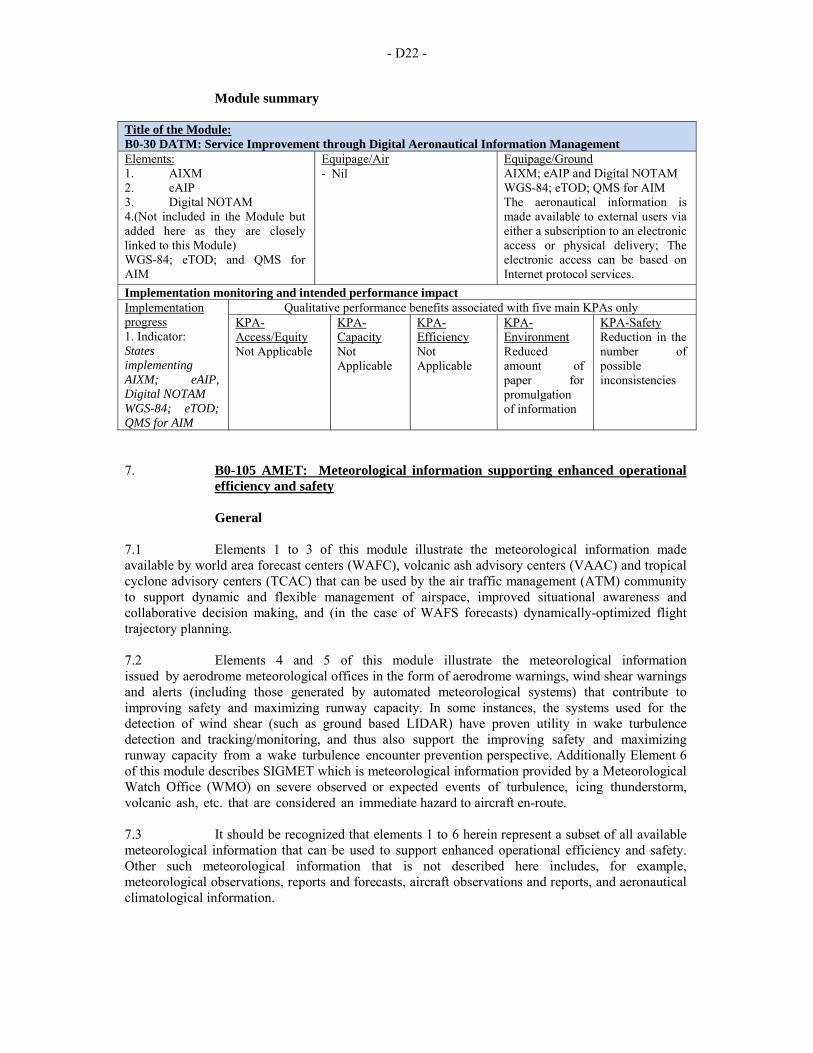
- D22 -
Module summary Title of the Module: B0-30 DATM: Service Improvement through Digital Aeronautical Information Management Elements: 1. AIXM 2. eAIP 3. Digital NOTAM 4.(Not included in the Module but added here as they are closely linked to this Module) WGS-84; eTOD; and QMS for AIM
Equipage/Air ‐ Nil
Equipage/Ground AIXM; eAIP and Digital NOTAM WGS-84; eTOD; QMS for AIM The aeronautical information is made available to external users via either a subscription to an electronic access or physical delivery; The electronic access can be based on Internet protocol services.
Implementation monitoring and intended performance impact Implementation progress 1. Indicator: States implementing AIXM; eAIP, Digital NOTAM WGS-84; eTOD; QMS for AIM
Qualitative performance benefits associated with five main KPAs only KPA-Access/Equity Not Applicable
KPA-Capacity Not Applicable
KPA-Efficiency Not Applicable
KPA-Environment Reduced amount of paper for promulgation of information
KPA-Safety Reduction in the number of possible inconsistencies
7. B0-105 AMET: Meteorological information supporting enhanced operational
efficiency and safety
General 7.1 Elements 1 to 3 of this module illustrate the meteorological information made available by world area forecast centers (WAFC), volcanic ash advisory centers (VAAC) and tropical cyclone advisory centers (TCAC) that can be used by the air traffic management (ATM) community to support dynamic and flexible management of airspace, improved situational awareness and collaborative decision making, and (in the case of WAFS forecasts) dynamically-optimized flight trajectory planning. 7.2 Elements 4 and 5 of this module illustrate the meteorological information issued by aerodrome meteorological offices in the form of aerodrome warnings, wind shear warnings and alerts (including those generated by automated meteorological systems) that contribute to improving safety and maximizing runway capacity. In some instances, the systems used for the detection of wind shear (such as ground based LIDAR) have proven utility in wake turbulence detection and tracking/monitoring, and thus also support the improving safety and maximizing runway capacity from a wake turbulence encounter prevention perspective. Additionally Element 6 of this module describes SIGMET which is meteorological information provided by a Meteorological Watch Office (WMO) on severe observed or expected events of turbulence, icing thunderstorm, volcanic ash, etc. that are considered an immediate hazard to aircraft en-route. 7.3 It should be recognized that elements 1 to 6 herein represent a subset of all available meteorological information that can be used to support enhanced operational efficiency and safety. Other such meteorological information that is not described here includes, for example, meteorological observations, reports and forecasts, aircraft observations and reports, and aeronautical climatological information.
- D23 -
Baseline 7.4 WAFCs within the framework of the world area forecast system (WAFS) prepare global gridded forecasts of upper wind, upper-air temperature and humidity, geopotential altitude of flight levels, flight level and temperature of tropopause, direction, speed and flight level of maximum wind, cumulonimbus clouds, icing, and clear-air and in-cloud turbulence. These global gridded forecasts are issued 4-times per day, with fixed time validity T+0 to T+36 at 3-hour time-steps. In addition, the WAFCs prepare global forecasts of significant weather (SIGWX) phenomena in binary code form. These global forecasts of SIGWX phenomena are issued 4-times per day, with validity at T+24. The United Kingdom and United States are designated as WAFC provider States. Accordingly, WAFCs London and Washington make available the aforementioned forecasts on the ICAO Aeronautical Fixed Service (AFS). 7.5 VAACs within the framework of the International Airways Volcano Watch (IAVW) respond to a notification that a volcano has erupted, or is expected to erupt or volcanic ash is reported in its area of responsibility. The VAACs monitor relevant satellite data to detect the existence and extent of volcanic ash in the atmosphere in the area concerned, and activate their volcanic ash numerical trajectory/dispersion model in order to forecast the movement of any ash cloud that has been detected or reported. In support, the VAACs also use surface-based observations and pilot reports to assist in the detection of volcanic ash. The VAACs issue advisory information (in plain language textual form and graphical form) concerning the extent and forecast movement of the volcanic ash cloud, with fixed time validity T+0 to T+18 at 6-hour time-steps. The VAACs issue these forecasts at least every six hours until such time as the volcanic ash cloud is no longer identifiable from satellite data, no further reports of volcanic ash are received from the area, and no further eruptions of the volcano are reported. The VAACs maintain a 24-hour watch. Argentina, Australia, Canada, France, Japan, New Zealand, the United Kingdom and the United States are designated (by regional air navigation agreement) as the VAAC provider States. Accordingly, VAACs Buenos Aires, Darwin, Montreal, Toulouse, Tokyo, Wellington, London, Anchorage and Washington make available the aforementioned advisories on the ICAO AFS. 7.6 TCACs monitor the development of tropical cyclones in their area of responsibility, using relevant satellite data, meteorological radar data and other meteorological information. The TCACs are meteorological centres designated by regional air navigation agreement on the advice of the World Meteorological Organization (WMO). The TCACs issue advisory information (in plain language textual form and graphical form) concerning the position of the tropical cyclone center, its direction and speed of movement, central pressure and maximum surface wind near the center, with fixed time validity T+0 to T+24 at 6-hour time-steps. The TCACs issue updated advisory information for each tropical cyclone, as necessary, but at least every six hours. Australia, Fiji, France, India, Japan and the United States are designated (by regional air navigation agreement) as TCAC provider States. Aforementioned advisories are made available on the ICAO AFS, through TCACs located in Darwin, Nadi, La Reunion, New Delhi, Tokyo, Honolulu and Miami. 7.7 Aerodrome warnings provide concise information of observed or expected meteorological conditions that could adversely affect aircraft on the ground, including parked aircraft, and the aerodrome facilities and services. 7.8 Wind shear warnings are prepared for aerodromes where wind shear is considered a factor. Wind shear warnings give concise information on the observed or expected existence of wind shear which could adversely affect aircraft on the approach path or take-off path or during circling approach between runway level and 500 m (1 600 ft) above that level and aircraft on the runway during the landing roll or take-off run. Note that where local topography has been shown to produce significant wind shears at heights in excess of 500 m (1 600 ft) above runway level, then 500 m (1,600 ft) is not to be considered restrictive.
- D24 -
7.9 SIGMETs are information that describes the location of specified en-route weather phenomena which may affect the safety of aircraft operations. SIGMETs are issued by MWOs for such phenomena as thunderstorms, turbulence, icing, mountain wave, radiation, volcanic ash and tropical cyclone. The latter two categories of SIGMETs are based on information provided in the appropriate advisories from the respective VAACs and TCACs.
Change brought by the module 7.10 The global availability of meteorological information as provided with the framework of the WAFS and IAVW enhances the pre-tactical and/or tactical decision making for aircraft surveillance, air traffic flow management and flexible/dynamic aircraft routing. Similar information is also provided by TCACs and MWOs in support of ATM decisions. The locally-arranged availability of aerodrome warnings, wind shear warnings and alerts (where wind shear is considered a factor), contributes to improved safety and maximized runway capacity during adverse meteorological conditions. Wind shear detection systems can, in some instances, be utilized for wake turbulence detection and tracking/monitoring.
Element 1: WAFS 7.11 The WAFS is a worldwide system within which two designated WAFCs provide aeronautical meteorological en-route forecasts in uniform standardized formats. The grid point forecasts are prepared by the WAFCs in a regular grid with a horizontal resolution of 1.25 degrees of latitude and longitude, and issued in binary code form using the GRIB code form as prescribed by WMO. The significant weather (SIGWX) forecasts are issued by the WAFCs in accordance with the provisions in Annex 3 — Meteorological Service for International Air Navigation (Chapter 3 and Appendix 2) in binary code form using the BUFR code form prescribed by WMO and in PNG-chart form as formalized backup means. ICAO administers the WAFS with the cooperation of the WAFC provider States and concerned international organizations through the World Area Forecast System Operations Group (WAFSOPSG).
Element 2: IAVW 7.12 The IAVW ensures international arrangements for monitoring and providing advisories to MWOs and aircraft operators of volcanic ash in the atmosphere. The advisories support the issuance of SIGMET on these events by the respective MWOs. The IAVW is based on the cooperation of aviation and non-aviation operational units using information derived from observing sources and networks that are provided by States for the detection of volcanic ash in the atmosphere. The forecasts issued by the nine designated VAACs are in plain language text and PNG chart form. The advisory information on volcanic ash is prepared by VAACs in accordance with Annex 3 (Chapter 3 and Appendix 2). ICAO administers the IAVW with the cooperation of the VAAC provider States and concerned international organizations through the International Airways Volcano Watch Operations Group (IAVWOPSG). Additionally, ICAO recognizes the importance of State volcano observatories as part of the world organization of volcano observatories in their role or providing information on the pre-eruption and eruption of volcanoes.
Element 3: Tropical cyclone watch 7.13 TCAC, per regional air navigation agreement, monitor the formation, movement and degradation of tropical cyclones. The forecasts issued by the TCACs are in plain language text and graphical form. The advisory information on tropical cyclones is prepared by TCACs in accordance with Annex 3 (Chapter 3 and Appendix 2). The advisories support the issuance of SIGMET on these events by the respective MWOs.
- D25 -
Element 4: Aerodrome warnings 7.14 Aerodrome warnings give concise information of meteorological conditions that could adversely affect aircraft on the ground, including parked aircraft, and the aerodrome facilities and services. Aerodrome warnings are issued in accordance with Annex 3 (Chapter 7 and Appendix 6) where required by operators or aerodrome services. Aerodrome warnings should relate to the occurrence or expected occurrence of one or more of the following phenomena: tropical cyclone, thunderstorm, hail, snow, freezing precipitation, hoar frost or rime, sandstorm, dust-storm, rising sand or dust, strong surface wind and gusts, squall, frost, volcanic ash, tsunami, volcanic ash deposition, toxic chemicals, and other phenomena as agreed locally. Aerodrome warnings are issued usually for validity periods of not more than 24 hours. Aerodrome warnings are disseminated within the aerodrome in accordance with local arrangements to those concerned, and should be cancelled when the conditions are no longer occurring and/or no longer expected to occur at the aerodrome.
Element 5: Wind shear warnings and alerts 7.15 Wind shear warnings are prepared for aerodromes where wind shear is considered a factor, issued in accordance with Annex 3 (Chapter 7 and Appendix 6) and disseminated within the aerodrome in accordance with local arrangements to those concerned. Wind shear conditions are normally associated with the following phenomena: thunderstorms, microbursts, funnel cloud (tornado or waterspout), and gust fronts, frontal surfaces, strong surface winds coupled with local topography; sea breeze fronts, mountain waves (including low-level rotors in the terminal area) and low-level temperature inversions. 7.16 At aerodromes where wind shear is detected by automated, ground-based, wind shear remote-sensing or detection equipment, wind shear alerts generated by these systems are issued (updated at least every minute). Wind shear alerts give concise, up-to-date information related to the observed existence of wind shear involving a headwind/tailwind change of 7.5 m/s (15 kt) or more which could adversely affect aircraft on the final approach path or initial take-off path and aircraft on the runway during the landing roll or take-off run. 7.17 In some instances, the systems used for the detection of wind shear have proven utility in wake turbulence detection and tracking/monitoring. This may prove especially beneficial for congested and/or complex aerodromes (e.g. close parallel runways) since ground-based LIDAR at an aerodrome can serve a dual purpose – i.e. wake vortices are an issue when wind shear is not.
Element 6: SIGMET 7.18 SIGMETs are information issued by each State‘s MWO for their respective FIR and/or CTA. SIGMETs are messages that describe the location of specified en-route weather phenomena which may affect the safety of aircraft operations. SIGMETs are typically issued for thunderstorms, turbulence, icing, mountain wave, volcanic ash, tropical cyclones and radiation.
Intended performance operational improvement/metric to determine success 7.19 Optimized usage of airspace capacity, thus achieving arrival and departure rates. 7.20 Reduction in costs through reduced arrival and departure delays (viz. reduced fuel burn). 7.21 Harmonized arriving air traffic (en-route to terminal area to aerodrome) and harmonized departing air traffic (aerodrome to terminal area to en-route) will translate to reduced arrival and departure holding times and thus reduced fuel burn. 7.22 Reduced fuel burn through optimized departure and arrival profiling/scheduling.
- D26 -
7.23 Supports pre-tactical and tactical arrival and departure sequencing and thus dynamic air traffic scheduling. 7.24 Gate-to-gate seamless operations through common access to, and use of, the available WAFS, IAVW and tropical cyclone watch forecast information. 7.25 Common understanding of operational constraints, capabilities and needs, based on expected (forecast) meteorological conditions. 7.26 Decreased variance between the predicted and actual air traffic schedule. 7.27 Increased situational awareness and improved consistent and collaborative decision-making.
Necessary procedures (air and ground) 7.28 No new procedures necessary.
Necessary system capability
Avionics 7.29 No new or additional avionics requirements and brought about by this module.
Ground systems 7.30 ANSPs, airport operators and airspace users may want to implement functionalities allowing them to display in plain text or graphical format the available meteorological information. For Block 0, airspace users may use their AOC data link connection to the aircraft to send the meteorological information where appropriate
Human factors considerations 7.31 General statements on the impact on operational functions. 7.32 This module will not necessitate significant changes in how air navigation service providers and users access and make use of the available meteorological information today.
Training and qualification requirements 7.33 No new or additional training and qualification requirements are brought about by this module.
Reference documents
• ICAO and Industry Standards (i.e. MOPS, MASPS, SPRs) • ICAO and World Meteorological Organization (WMO) international standards
for meteorological information (including, content, format, quantity, quality, timeliness and availability)
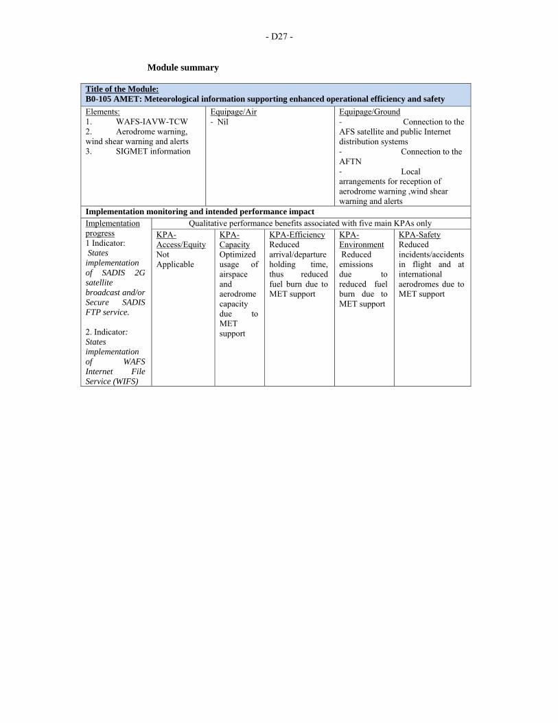
- D27 -
Module summary Title of the Module: B0-105 AMET: Meteorological information supporting enhanced operational efficiency and safety
Elements: 1. WAFS-IAVW-TCW 2. Aerodrome warning, wind shear warning and alerts 3. SIGMET information
Equipage/Air ‐ Nil
Equipage/Ground ‐ Connection to the AFS satellite and public Internet distribution systems ‐ Connection to the AFTN ‐ Local arrangements for reception of aerodrome warning ,wind shear warning and alerts
Implementation monitoring and intended performance impact Implementation progress 1 Indicator: States implementation of SADIS 2G satellite broadcast and/or Secure SADIS FTP service. 2. Indicator: States implementation of WAFS Internet File Service (WIFS)
Qualitative performance benefits associated with five main KPAs only KPA-Access/Equity Not Applicable
KPA-Capacity Optimized usage of airspace and aerodrome capacity due to MET support
KPA-Efficiency Reduced arrival/departure holding time, thus reduced fuel burn due to MET support
KPA-Environment Reduced emissions due to reduced fuel burn due to MET support
KPA-Safety Reduced incidents/accidents in flight and at international aerodromes due to MET support
- D28 -
PERFORMANCE IMPROVEMENT AREA 3: OPTIMUM CAPACITY AND FLEXIBLE FLIGHTS – THROUGH GLOBAL COLLABORATIVE ATM 8. B0-10 FRTO: Improved Operations through Enhanced En-Route Trajectories
Introduction 8.1 This module is applicable to en-route and terminal airspace. Benefits can start locally. The larger the size of the concerned airspace the greater the benefits, in particular for flex track aspects. Benefits accrue to individual flights and flows. This will allow greater routing possibilities, reducing potential congestion on trunk routes and busy crossing points, resulting in reduced flight length and fuel burn. 8.2 In many areas, flight routings offered by air traffic services (ATS) are static and are slow to keep pace with the rapid changes of users operational demands, especially for long-haul city-pairs. In certain parts of the world, legacy regional route structures have become outdated and are becoming constraining factors due to their inflexibility. 8.3 The navigational capabilities of modern aircraft make a compelling argument to migrate away from the fixed route structure towards a more flexible alternative. Constantly changing upper winds have a direct influence on fuel burn and, proportionately, on the carbon footprint. Therein lies the benefit of daily flexible routings. Using what is already available on the aircraft and within air traffic control (ATC) ground systems, the move from fixed to flex routes can be accomplished in a progressive, orderly and efficient manner.
Baseline 8.4 The baseline for this module is varying from a State/region to the next. However, while some aspects have already been the subject of local improvements, the baseline generally corresponds to an airspace organization and management function which is at least in part characterized by: individual State action, fixed route network, permanently segregated areas, conventional navigation or limited use of area navigation (RNAV), rigid allocation of airspace between civil and military authorities. Where it is the case, the integration of civil and military ATS has been a way to eliminate some of the issues, but not all. 8.5 In many areas, flight routings offered by air traffic services (ATS) are static and are slow to keep pace with the rapid changes of users operational demands, especially for long-haul city-pairs. In certain parts of the region, regional route structures have become outdated and are becoming constraining factors due to their inflexibility that affect inclusive other States.
Change brought by the module 8.6 This module is aimed at improving the profiles of flights in the en-route phase through the deployment and full application of procedures and functionalities on which solid experience is already available, but which have not been systematically exploited and which are of a nature to make better use of the airspace. 8.7 The module is the opportunity to exploit performance-based navigation (PBN) capabilities in order to eliminate design constraints and operate more flexibly, while facilitating the overall handling of traffic flows.
- D29 -
8.8 The module is made of the following elements:
a) airspace planning: possibility to plan, coordinate and inform on the use of airspace. This includes collaborative decision-making (CDM) applications for en-route airspace to anticipate on the knowledge of the airspace use requests, take into account preferences and inform on constraints;
b) flexible use of airspace (FUA) to allow both the use of airspace otherwise segregated, and the reservation of suitable volumes for special usage; this includes the definition of conditional routes; and
c) flexible routing (flex tracking): route configurations designed for specific traffic pattern.
8.9 This module is a first step towards more optimized organization and management of the airspace but which would require more sophisticated assistance. Initial implementation of PBN, RNAV for example, takes advantage of existing ground technology and avionics and allows extended collaboration of air navigation service providers (ANSPs) with partners: military, airspace users, neighbouring States.
Element 1: Airspace planning
8.10 Airspace planning entails activities to organize and manage airspace prior to the time of flight. Here it more specifically refers to activities to improve the strategic design by a series of measures to better know the anticipated use of the airspace and adjust the strategic design by pre-tactical or tactical actions.
Element 2: Flexible use of airspace (FUA) 8.11 Flexible use of airspace is an airspace management concept according to which airspace should not be designated as either purely civil or purely military airspace, but should be considered as one continuum in which all users‘ requirements have to be accommodated to the maximum extent possible. There are activities which require the reservation of a volume of airspace for their exclusive or specific use for determined periods, owing to the characteristics of their flight profile or their hazardous attributes and the need to ensure effective and safe separation from non-participating air traffic. Effective and harmonized application of FUA needs clear and consistent rules for civil/military coordination which should take into account all users‘ requirements and the nature of their various activities. Efficient civil/military coordination procedures should rely on rules and standards to ensure efficient use of airspace by all users. It is essential to further cooperation between neighbouring States and to take into account cross border operations when applying the concept of FUA. 8.12 Where various aviation activities occur in the same airspace but meet different requirements, their coordination should seek both the safe conduct of flights and the optimum use of available airspace. 8.13 Accuracy of information on airspace status and on specific air traffic situations and timely distribution of this information to civil and military controllers has a direct impact on the safety and efficiency of operations. 8.14 Timely access to up-to-date information on airspace status is essential for all parties wishing to take advantage of airspace structures made available when filing or re-filing their flight plans. 8.15 The regular assessment of airspace use is an important way of increasing confidence between civil and military service providers and users and is an essential tool for improving airspace design and airspace management.
- D30 -
8.16 FUA should be governed by the following principles:
a) coordination between civil and military authorities should be organized at the strategic, pre-tactical and tactical levels of airspace management through the establishment of agreements and procedures in order to increase safety and airspace capacity, and to improve the efficiency and flexibility of aircraft operations;
b) consistency between airspace management, air traffic flow management and air traffic services should be established and maintained at the three levels of airspace management in order to ensure, for the benefit of all users, efficiency in airspace planning, allocation and use;
c) the airspace reservation for exclusive or specific use of categories of users should be of a temporary nature, applied only during limited periods of time-based on actual use and released as soon as the activity having caused its establishment ceases;
d) States should develop cooperation for the efficient and consistent application of the concept of FUA across national borders and/or the boundaries of flight information regions, and should in particular address cross-border activities; this cooperation shall cover all relevant legal, operational and technical issues; and
e) ATS units and users should make the best use of the available airspace.
Element 3: Flexible routing 8.17 Flexible routing is a design of routes (or tracks) designed to match the traffic pattern and other variable factors such as meteorological conditions. The concept, used over the North-Atlantic since decades can be expanded to address seasonal or week end flows, accommodate special events, and in general better fit the meteorological conditions, by offering a set of routes which provide routings closer to the user preferences for the traffic flows under consideration. 8.18 When already in place, flex tracks systems can be improved in line with the new capabilities of ATM and aircraft, such as PBN and automatic dependent surveillance (ADS). 8.19 Convective meteorological conditions, particularly deep convection associated with towering cumulus and/or cumulonimbus clouds, causes many delays in today‘s system due to their hazardous nature (severe icing, severe turbulence, hail, thunderstorms, etc.), often-localized nature and the labor intensive voice exchanges of complex reroutes during the flight. New data communications automation will enable significantly faster and more efficient delivery of reroutes around such convective activity. This operational improvement will expedite clearance delivery resulting in reduced delays and miles flown during convective meteorological conditions.
Intended Performance Operational Improvement 8.20 Metrics to determine the success of the module are proposed in the Manual on Global Performance of the Air Navigation System (Doc 9883). 8.21 This module supports a better access to airspace by a reduction of the permanently segregated volumes. 8.22 In terms of capacity the availability of a greater set of routing possibilities allows reducing potential congestion on trunk routes and at busy crossing points. The flexible use of airspace gives greater possibilities to separate flights horizontally. PBN helps to reduce route spacing and aircraft separations. This in turn allows reducing controller workload by flight.
- D31 -
8.23 The different elements concur to trajectories closer to the individual optimum by reducing constraints imposed by permanent design. In particular the module will reduce flight length and related fuel burn and emissions. The potential savings are a significant proportion of the ATM related inefficiencies. The module will reduce the number of flight diversions and cancellations. It will also better allow avoiding noise sensitive areas. 8.24 Some of the benefits include: reduced flight operating costs, reduced fuel consumption, more efficient use of airspace (access to airspace outside of fixed airway structure), reduced carbon footprint, and reduced controller workload.
Necessary procedures (air and ground) 8.25 Required procedures exist for the main. They may need to be complemented by local practical guidance and processes; however, the experience from other regions can be a useful reference source to be customized to the local conditions. 8.26 The development of new and/or revised ATM procedures is automatically covered by the definition and development of listed elements. However, given the interdependencies between some of the modules, care needs to be taken so that the development of the required ATM procedures provides for a consistent and seamless process across these modules. 8.27 The airspace requirements (RNAV, RNP and the value of the performance required) may require new ATS procedures and ground system functionalities. Some of the ATS procedures required for this module are linked with the processes of notification, coordination and transfer of control, supported by messages exchange (Module B0-25).
Element 1: Airspace planning 8.28 See general remarks above.
Element 2: FUA 8.29 The ICAO Civil/Military Cooperation in Air Traffic Management (Cir 330) offers guidance and examples of successful practices of civil and military cooperation. It realizes that successful cooperation requires collaboration that is based on communication, education, a shared relationship and trust. 8.30 FUA regional guidance developed for SAM Region.
Element 3: Flexible routing 8.31 A number of operational issues and requirements will need to be addressed to enable harmonized deployment of flex route operations in a given area such as:
a) some adaptation of letters of agreement; b) revised procedures to consider the possibility of transfer of control at other than
published fixes; c) use of latitude/longitude or bearing and distance from published fixes, as sector
or flight information region (FIR) boundary crossing points; d) review of controller manuals and current operating practices to determine what
changes to existing practices will need to be developed to accommodate the different flows of traffic which would be introduced in a flex route environment;
e) specific communication and navigation requirements for participating aircraft will need to be identified;
- D32 -
f) developing procedures that will assist ATC in applying separation minima between flights on the fixed airway structure and flex routes both in the strategic and tactical phases;
g) procedure to cover the transition between the fixed network and the flex route airspace both horizontally and vertically. In some cases, a limited time application (e.g. during night) of flex route operations could be envisaged. This will require modification of ATM procedures to reflect the night traffic patterns and to enable the transition between night flex route operations and daytime fixed airway operations; and
h) training package for ATC.
Necessary system capability
Avionics 8.32 Deployment of PBN is ongoing. The benefits provided to flights can facilitate its dissemination, but it will remain linked to how aircraft can fly. 8.33 Dynamic re-routing can require aircraft connectivity (Aircraft communication addressing and reporting system (ACARS)) to its flight operating center for flight tracking and the up-load of new routes computed by the FOC flight planning system (FPS), and possibly FANS 1/A capability for the exchange of clearance with ATC.
Ground systems 8.34 Technology is available. Even CDM can be supported by a form of internet portal. However, since aviation operations are global, standardization of the information and its presentation will be increasingly required (see thread 30 on SWIM). 8.35 Basic FUA concept can be implemented with the existing technology. Nevertheless for a more advanced use of conditional routes, a robust collaborative decision system will be required including function for the processing and display of flexible or direct routes containing latitude/longitude. In addition to published fixes a coordination function is also needed and may need specific adaptations to support transfer of control over non published points. 8.36 Enhanced FPS today is predicated on the determination of the most efficient flight profile. The calculations of these profiles can be driven by cost, fuel, time, or even a combination of the factors. All airlines deploy FPS at different levels of sophistication and automation in order to assist flight dispatchers/planners to verify, calculate and file flight plans. 8.37 Additionally, the flight dispatcher would need to ensure the applicability of over-flight permissions for the over-flown countries. Regardless of the route calculated, due diligence must always be exercised by the airline in ensuring that NOTAMs and any restrictive flight conditions will always be checked and validated before a flight plan is filed. Further, most airlines are required to ensure a flight following or monitoring program to update the crews with any changes in the flight planning assumptions that might have changed since the first calculation was made.
Human factors considerations 8.38 The roles and responsibilities of controller/pilot are not affected. However, human factors have been taken into consideration during the development of the processes and procedures associated with this module. Where automation is to be used, the human-machine interface has been considered from both a functional and ergonomic perspective. The possibility of latent failures however, continues to exist and vigilance is requested during all implementation actions. It is further requested that human factor issues, identified during implementation, be reported to the international community through ICAO as part of any safety reporting initiative.
- D33 -
Training and qualification requirements
8.39 The required training is available and the change step is achievable from a human factors perspective. Training in the operational standards and procedures required for this module, are described in the “Reference documents and guidance material” section hereunder. Likewise, the qualifications requirements are identified in the “Regulatory/standardization needs and approval plan (air and ground)” section hereunder.
Regulatory/standardization needs and approval plan (air and ground) 8.40 Regulatory/standardization: use current published requirements. 8.41 Approval plans: to be determined, based upon regional applications.
Element 1: Airspace planning 8.42 See general remarks above.
Element 2: FUA 8.43 Until today, the Article 3 of the Chicago Convention expressly excludes the consideration of State aircraft from the scope of applicability. 8.44 Exemption policies for specific State aircraft operations and services are currently used as a method to cope with the discrepancy of civil and military aviation needs. Some States already realize that for State aircraft a solution lays in an optimum compatibility to civil aviation, although military requirements have to be met. 8.45 ICAO provisions related to coordination between civil and military in support to the flexile use of airspace can be found in several annexes, PANS and manuals. 8.46 Annex 11 — Air Traffic Services allows States to delegate responsibility for the provision of ATS to another State. However, States retain sovereignty over the airspace so delegated, as confirmed by their adherence to the Chicago Convention. This factor may require additional effort or coordination in relation to civil/military cooperation and an appropriate consideration in bilateral or multilateral agreements.
Element 3: Flexible routing 8.47 LoA: Letters of agreement (LoA) might be revised to reflect the specificities of flex route operations. Local hand-off procedures, timings and frequency allocations must be clearly detailed. Allocation schemes are also useful in designing major unidirectional flows, such as the EUR-Caribbean flows.
Common enabler: PBN procedures 8.48 Within an airspace concept, PBN requirements will be affected by the communication, surveillance and ATM environments, the navaid infrastructure, and the functional and operational capabilities needed to meet the ATM application. PBN requirements also depend on what reversionary, non-RNAV means of navigation are available and what degree of redundancy is required to ensure adequate continuity of functions.
- D34 -
8.49 The selection of the PBN specification(s) for a specific area or type of operation has to be decided in consultation with the airspace users. Some areas need only a simple RNAV to maximize the benefits, while other areas such as nearby steep terrain or dense air traffic may require the most stringent RNP. International public standards for PBN are still evolving. International PBN is not widespread. According to the ICAO/IATA Global PBN Task Force, international air traffic management and state flight standards rules and regulations lag behind airborne capability. 8.50 There is a need for worldwide harmonization of RNP requirements, standards, procedures and practices, and common flight management system functionality for predictable and repeatable RNP procedures, such as fixed radius transitions, radius-to-fix legs, required time of arrival (RTA), parallel offset, VNAV, 4D control, ADS-B, data link, etc. 8.51 A safety risk management document may be required for every new or amended procedure. That requirement will extend the time required to implement new procedures, especially PBN-based flight procedures.
Reference documents and guidance material
• ICAO Doc 4444, Procedures for Air Navigation Services -Air Traffic Management, Chapter 5
• ICAO Doc 9426, Air Traffic Services Planning Manual • ICAO Doc 9554, Manual Concerning Safety Measures Relating to Military
Activities Potentially Hazardous to Civil Aircraft Operations • ICAO Doc 9613, Performance-based Navigation (PBN) Manual • ICAO Doc 9689, Manual on Airspace Planning Methodology for the
Determination of Separation Minima • ICAO CDM and ATFM (under development) Manual • ICAO Doc 9554, Manual Concerning Safety Measures Relating to Military
Activities Potentially Hazardous to Civil Aircraft Operations • ICAO Circular 330 AN/189, Civil/Military Cooperation in Air Traffic
Management
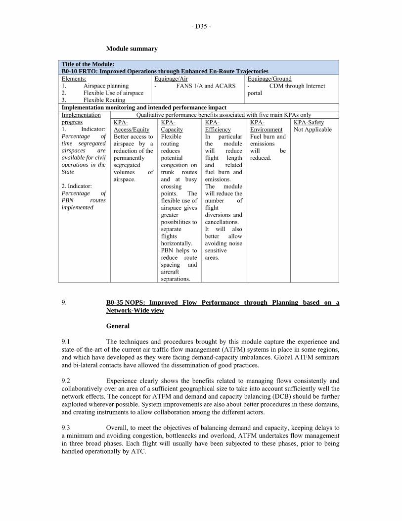
- D35 -
Module summary Title of the Module: B0-10 FRTO: Improved Operations through Enhanced En-Route Trajectories Elements: 1. Airspace planning 2. Flexible Use of airspace 3. Flexible Routing
Equipage/Air ‐ FANS 1/A and ACARS
Equipage/Ground ‐ CDM through Internet portal
Implementation monitoring and intended performance impact Implementation progress 1. Indicator: Percentage of time segregated airspaces are available for civil operations in the State 2. Indicator: Percentage of PBN routes implemented
Qualitative performance benefits associated with five main KPAs only KPA-Access/Equity Better access to airspace by a reduction of the permanently segregated volumes of airspace.
KPA-Capacity Flexible routing reduces potential congestion on trunk routes and at busy crossing points. The flexible use of airspace gives greater possibilities to separate flights horizontally. PBN helps to reduce route spacing and aircraft separations.
KPA-Efficiency In particular the module will reduce flight length and related fuel burn and emissions. The module will reduce the number of flight diversions and cancellations. It will also better allow avoiding noise sensitive areas.
KPA-Environment Fuel burn and emissions will be reduced.
KPA-Safety Not Applicable
9. B0-35 NOPS: Improved Flow Performance through Planning based on a
Network-Wide view
General 9.1 The techniques and procedures brought by this module capture the experience and state-of-the-art of the current air traffic flow management (ATFM) systems in place in some regions, and which have developed as they were facing demand-capacity imbalances. Global ATFM seminars and bi-lateral contacts have allowed the dissemination of good practices. 9.2 Experience clearly shows the benefits related to managing flows consistently and collaboratively over an area of a sufficient geographical size to take into account sufficiently well the network effects. The concept for ATFM and demand and capacity balancing (DCB) should be further exploited wherever possible. System improvements are also about better procedures in these domains, and creating instruments to allow collaboration among the different actors. 9.3 Overall, to meet the objectives of balancing demand and capacity, keeping delays to a minimum and avoiding congestion, bottlenecks and overload, ATFM undertakes flow management in three broad phases. Each flight will usually have been subjected to these phases, prior to being handled operationally by ATC.
- D36 -
9.4 Strategic ATFM activity takes place during the period from several months until a few days before a flight. During this phase, comparison is made between the expected air traffic demand and the potential ATC capacity. Objectives are set for each ATC unit in order for them to provide the required capacity. These objectives are monthly reviewed in order to minimize the impact of the missing capacity on the airspace users. In parallel, an assessment of the number and routings of flights, which aircraft operators are planning, enables ATFM to prepare a routing scheme, balancing the air traffic flows in order to ensure maximum use of the airspace and minimize delays. 9.5 Pre-tactical ATFM is action taken during the few days before the day of operation. Based on the traffic forecasts, the information received from every ATC center covered by the ATFM service, statistical and historical data, the ATFM notification message (ANM) for the next day is prepared and agreed through a collaborative process. The ANM defines the tactical plan for the next (operational) day and informs aircraft operators (AOs) and ATC units about the ATFM measures that will be in force on the following day. The purpose of these measures is not to restrict but to manage the flow of traffic in a way that minimizes delay and maximizes the use of the entire airspace. 9.6 Tactical ATFM is the work carried out on the current operational day. Flights taking place on that day receive the benefit of ATFM, which includes the allocation of individual aircraft departure times, re-routings to avoid bottlenecks and alternative flight profiles to maximize efficiency. 9.7 ATFM has also progressively been used to address system disruptions and evolves into the notion of management of the performance of the Network under its jurisdiction, including management of crises provoked by human or natural phenomena.
Baseline 9.8 The need for ATFM has emerged as traffic densities increased, and it took form progressively. It is observed that this need is now spreading progressively over all continents, and that even where overall capacity is not an issue, the efficient management of flows through a given volume of airspace deserves a specific consideration at a scale beyond that of a sector or an ACC, in order to better plan resources, anticipate on issues and prevent undesired situations.
Change brought by the module 9.9 ATFM has developed progressively over the last thirty years. It is noticeable that key steps have been necessary to be able to predict traffic loads for the next day with a good accuracy, to move from measures defined as rate of entry into a given piece of airspace (and not as departure slots) to measures implemented before take-off and taking into account the flows/capacities in a wider area. 9.10 More recently the importance of proposing alternative routings rather than only a delay diagnosis has been recognized, thereby also preventing over-reservations of capacity. ATFM services offer a range of web-based or business to business services to ATC, airports and aircraft operators, actually implementing a number of CDM applications. 9.11 In order to regulate flows, ATFM may take measures of the following nature:
a) departure slots ensuring that a flight will be able to pass the sectors along its path without generating overflows;
b) rate of entry into a given piece of airspace for traffic along a certain axis; c) requested time at a way-point or an FIR/sector boundary along the flight; d) miles-in-trail figures to smooth flows along a certain traffic axis; e) re-routing of traffic to avoid saturated areas; f) sequencing of flights on the ground by applying departure time intervals (MDI);
- D37 -
g) level capping; and h) delaying of specific flights on the ground by a few minutes ("take-off not
before").
Intended performance operational improvement 9.12 Metrics to determine the success of the module are proposed in the Manual on Global performance of the Air Navigation System (Doc 9883). 9.13 This module improved access by avoiding disruption of air traffic in periods of demand higher than capacity and ATFM processes take care of equitable distribution of delays. 9.14 It provides a better utilization of available capacity, network-wide; in particular the trust of ATC not being faced by surprise to saturation tends to let it declare/use increased capacity levels; ability to anticipate difficult situations and mitigate them in advance. 9.15 Reduced fuel burn due to better anticipation of flow issues; a positive effect to reduce the impact of inefficiencies in the ATM system or to dimension it at a size that would not always justify its costs (balance between cost of delays and cost of unused capacity). It also reduces block times and times with engines on. 9.16 The reduced fuel burn as delays are absorbed on the ground, and the predictability of schedules as the ATFM algorithms tends to limit the number of large delays impact positively in environment. 9.17 The reduced occurrences of undesired sector overloads improve safety. 9.18 The business case has proven to be positive due to the benefits that flights can obtain in terms of delay reduction.
Necessary procedures (air and ground) 9.19 An ICAO guidance material on ATFM is being developed and need to be completed and approved. US/Europe experience is enough to help initiate application in other regions. 9.20 New procedures are required to link much closer the ATFM with ATS in the case of using miles-in-trail or Arrival management or Departure management (see Module B0-15).
Necessary system capability
Avionics 9.21 No avionics requirements.
Ground systems 9.22 When serving several FIRs, ATFM systems are generally deployed as a specific unit, system and software connected to the ATC units and airspace users to which it provides its services. Regional ATFM units have been the subject of specific developments. The main functions for ATFM systems are: demand and capacity balancing, performance measurements and monitoring, network operations plan management and traffic demand management.
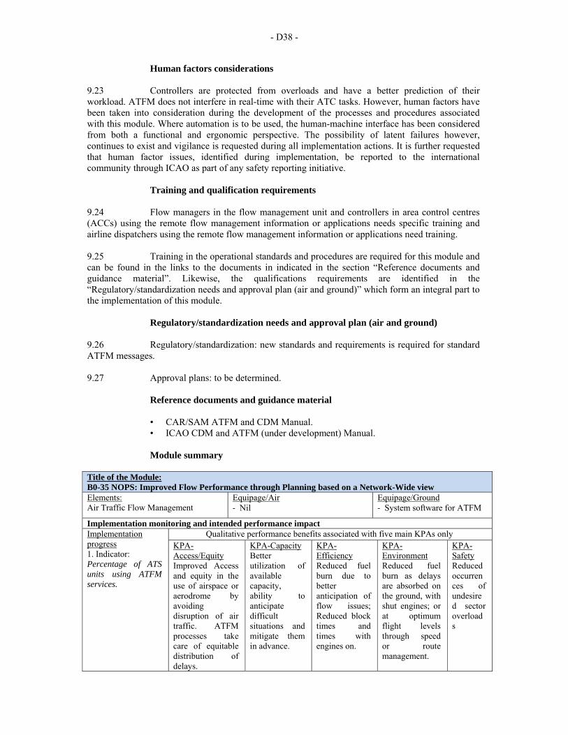
- D38 -
Human factors considerations 9.23 Controllers are protected from overloads and have a better prediction of their workload. ATFM does not interfere in real-time with their ATC tasks. However, human factors have been taken into consideration during the development of the processes and procedures associated with this module. Where automation is to be used, the human-machine interface has been considered from both a functional and ergonomic perspective. The possibility of latent failures however, continues to exist and vigilance is requested during all implementation actions. It is further requested that human factor issues, identified during implementation, be reported to the international community through ICAO as part of any safety reporting initiative.
Training and qualification requirements 9.24 Flow managers in the flow management unit and controllers in area control centres (ACCs) using the remote flow management information or applications needs specific training and airline dispatchers using the remote flow management information or applications need training. 9.25 Training in the operational standards and procedures are required for this module and can be found in the links to the documents in indicated in the section “Reference documents and guidance material”. Likewise, the qualifications requirements are identified in the “Regulatory/standardization needs and approval plan (air and ground)” which form an integral part to the implementation of this module.
Regulatory/standardization needs and approval plan (air and ground) 9.26 Regulatory/standardization: new standards and requirements is required for standard ATFM messages. 9.27 Approval plans: to be determined.
Reference documents and guidance material
• CAR/SAM ATFM and CDM Manual. • ICAO CDM and ATFM (under development) Manual.
Module summary
Title of the Module: B0-35 NOPS: Improved Flow Performance through Planning based on a Network-Wide view Elements: Air Traffic Flow Management
Equipage/Air ‐ Nil
Equipage/Ground ‐ System software for ATFM
Implementation monitoring and intended performance impact Implementation progress 1. Indicator: Percentage of ATS units using ATFM services.
Qualitative performance benefits associated with five main KPAs only KPA-Access/Equity Improved Access and equity in the use of airspace or aerodrome by avoiding disruption of air traffic. ATFM processes take care of equitable distribution of delays.
KPA-Capacity Better utilization of available capacity, ability to anticipate difficult situations and mitigate them in advance.
KPA-Efficiency Reduced fuel burn due to better anticipation of flow issues; Reduced block times and times with engines on.
KPA-Environment Reduced fuel burn as delays are absorbed on the ground, with shut engines; or at optimum flight levels through speed or route management.
KPA-Safety Reduced occurrences of undesired sector overloads
- D39 -
10. B0-84 ASUR: Initial capability for ground surveillance
General 10.1 The surveillance service delivered to users may be based on a mix of three main types of surveillance as defined in the ICAO Aeronautical Surveillance Manual (Doc 9924):
a) independent non-cooperative surveillance: The aircraft position is derived from measurement not using the cooperation of the remote aircraft;
b) independent cooperative surveillance: The position is derived from measurements performed by a local surveillance subsystem using aircraft transmissions. Aircraft-derived information (e.g. pressure altitude, aircraft identity) can be provided from those transmissions; and
c) dependent cooperative surveillance: The position is derived on board the aircraft and is provided to the local surveillance subsystem along with possible additional data (e.g. aircraft identity, pressure altitude). 1.1.2 The module describes the dependent/cooperative and independent/cooperative surveillance services.
Baseline
10.2 Currently, air to ground aircraft position and surveillance is accomplished through the use of primary, secondary radar surveillance, voice position report, ADS-C and CPDLC, etc. The primary surveillance radar derives aircraft position based on radar echo returns. The secondary radar is used to transmit and receive aircraft data for barometric altitude, identification code. However, current primary and secondary radars cannot be easily sited in oceanic locations, or rough terrain such as in mountainous regions, and have a heavy reliance on mechanical components with large maintenance requirements.
Change brought by the module 10.3 This module introduces the opportunity to expand ATC radar equivalent service with two new surveillance techniques that can be used, separately or jointly: ADS-B and MLAT. These techniques provide alternatives to classic radar technology at a lower implementation and maintenance cost, thereby allowing the provision of surveillance services in areas where they are currently not available for geographical or cost reasons. These techniques also allow, in certain conditions, a reduction of separation minima thereby potentially increasing the ability to accommodate larger volumes of traffic.
Element 1: ADS-B 10.4 Dependent surveillance with accurate position sources such ADS-B is recognized as one of the important enablers of several of the ATM operational concept components including traffic synchronization and conflict management (Recommendation 1/7, AN-Conf/11, 2003). The transmission of ADS-B information (ADS-B OUT) is already used for surveillance in some non-radar areas (Block 0). 10.5 Dependent surveillance is an advanced surveillance technology that allows avionics to broadcast an aircraft’s identification, position, altitude, velocity, and other information. The broadcast aircraft position is more accurate than with conventional secondary surveillance radar (SSR) because it is normally based on the global navigation satellite system (GNSS) and transmitted at least once per second. The inherent accuracy of the GPS determined position and the high update rate will provide service providers and users improvements in safety, capacity, and efficiency. Note.– ADS-B is dependent upon having a source of required positional accuracy (such as global navigation satellite system (GNSS) today).
- D40 -
10.6 Operationally, the lower costs of dependent surveillance ground infrastructure in comparison to conventional radars support business decisions to expand radar equivalent service volumes and the use of radar-like separation procedures into remote or non-radar areas. In addition to lower costs, the non-mechanical nature of the ADS-B ground infrastructure allows it to be sited in locations that are difficult for radar installations. 10.7 Use of dependent surveillance also improves the search and rescue support provided by the surveillance network. In non-radar areas, ADS-B’s positional accuracy and update rate allows for improved flown trajectory tracking allowing for early determination of loss of contact and enhances the ability for search and rescue teams to pinpoint the related location. 10.8 Additionally, dependent surveillance information can be an enabler for sharing of surveillance data across FIR boundaries and significantly improves the performance of predictive tools using aircraft derived velocity vector and vertical rate data. This is particularly useful to support safety net tools. It also downlinks other useful ATC relevant data similar to Mode S DAPS. 10.9 ADS-B OUT Standards and Recommended Practices (SARPs) (ICAO Annex 10 — Aeronautical Telecommunications , Volume IV — Surveillance and Collision Avoidance Systems and the Manual on Technical Provisions for Mode S Services and Extended Squitter (Doc 9871)) and MOPS (RTCA-DO260-B/Eurocae ED102-A) are available. AN-Conf/11 recommended ADS-B on 1090MHz for international use and this is happening. Equipage rate is growing together with Mode S, airborne collision avoidance system (ACAS) and ADS-B OUT mandates. ADS-B OUT, Version 2 also provides for ACAS RA DOWNLINK information in support of monitoring activities currently only possible in secondary surveillance radar (SSR) Mode S coverage.
Element 2: Multilateration (MLAT) 10.10 MLAT technique is a new technique providing independent cooperative surveillance. Its deployment is made easier by the use of airborne mode S equipment capability with the spontaneous transmission of messages (squitters). In this case the signal transmitted by aircraft is received by a network of receivers located at different places. The use of the different times of arrival at the different receivers allows an independent determination of the position of the source of signals. In theory this technique can be passive and use the existing transmissions made by the aircraft or be active and trigger replies in the manner of Mode S SSR interrogations. Conventional Mode A/C transponders respond when they are interrogated. 10.11 MLAT systems were initially deployed on main airports to make the surveillance of aircraft on the surface. The technique is now used to provide surveillance over wide area (wide area MLAT system - WAM). MLAT requires more ground stations than ADS-B and reliable linked network and has large geometric requirements than ADS-B, but has the early implementation advantage of using current Mode A/C aircraft equipage.
Intended performance operational improvement/metric to determine success 10.12 This module contributes to Safety reducing the number of major incidents and support to search and rescue services. It also contributes to the capacity in areas of traffic density compared to procedural minima. 10.13 Improved coverage, capacity, velocity vector performance and accuracy can improve ATC performance in both radar and non-radar environments. Terminal area surveillance performance improvements are achieved through high accuracy, better velocity vector and improved coverage.
- D41 -
10.14 Comparison between procedural minima and 5 NM separation minima would allow an increase of traffic density in a given airspace; or comparison between installing/renewing SSR Mode S stations using Mode S transponders and installing ADS-B OUT (and/or MLAT systems) could be used in cost benefit analysis.
Necessary procedures (air and ground) 10.15 The relevant Procedures for Air Navigation Services — Air Traffic Management (PANS-ATM, Doc 4444) provisions are available.
Necessary system capability
Avionics 10.16 For ADS-B surveillance services, aircraft must be equipped with ADS-B OUT. Accuracy and integrity are reported from the avionics. Users of the data decide on the required accuracy and integrity for the application. 10.17 For MLAT, aircraft need to be equipped with Mode S radar transponders.
Ground systems 10.18 Units providing surveillance services must be equipped with a ground-based surveillance data processing system able to process and display the aircraft positions. Connection to a flight data processing system allows positive identification by correlating positions and flight data. 10.19 Units may provide ADS-B surveillance in environments where there is full or partial avionics equipage depending on the capabilities and procedures of the air traffic control (ATC) system. 10.20 ATC systems must also be designed to enable the delivery of separation services between ADS-B-to-ADS-B and ADS-B-to-radar and fused targets.
Human factors considerations 10.21 The air traffic controller has a direct representation of the traffic situation, and reduces the task of controllers or radio operators to collate position reports.
Training and qualification requirements 10.22 Controllers must receive specific training for separation provision, information service and search and rescue based on the ADS-B and WAM systems in use. 10.23 Training in the operational standards and procedures are required for this module, which can be found in the documents listed in the “Reference documents and guidance material” section hereunder. Likewise, the qualifications requirements are identified in the regulatory requirements.
Reference documents and guidance material
• ICAO Annex 10 — Aeronautical Telecommunications, Volume IV � Aeronautical Radio
• Frequency Spectrum Utilization • ICAO Doc 9828, Report of the Eleventh Air Navigation Conference (2003) • ICAO Doc 9871, Technical Provisions for Mode S Services and Extended
Squitter
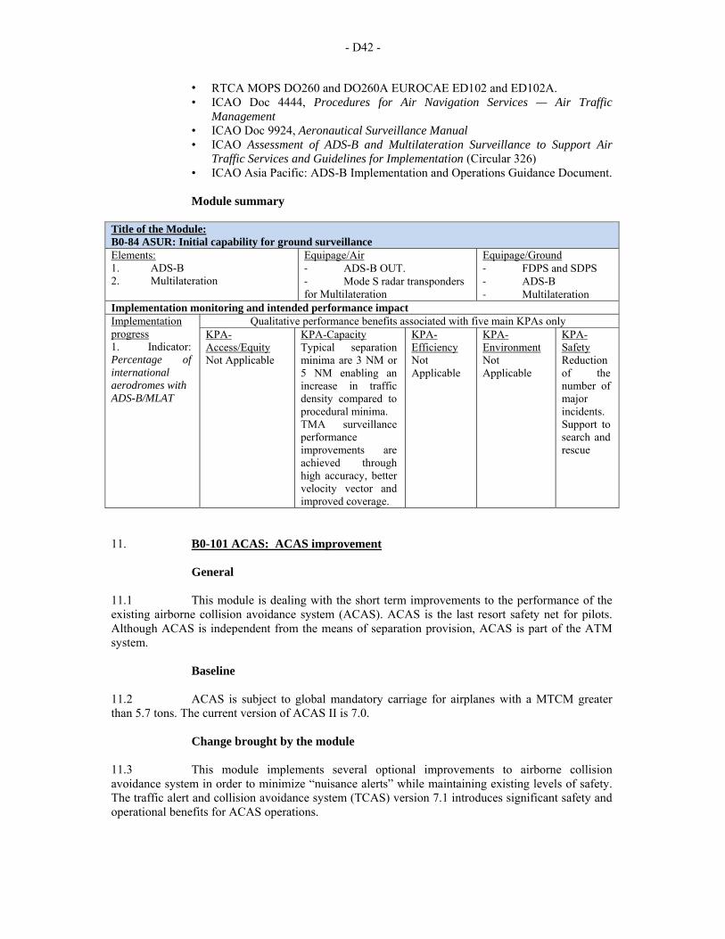
- D42 -
• RTCA MOPS DO260 and DO260A EUROCAE ED102 and ED102A. • ICAO Doc 4444, Procedures for Air Navigation Services — Air Traffic
Management • ICAO Doc 9924, Aeronautical Surveillance Manual • ICAO Assessment of ADS-B and Multilateration Surveillance to Support Air
Traffic Services and Guidelines for Implementation (Circular 326) • ICAO Asia Pacific: ADS-B Implementation and Operations Guidance Document.
Module summary
Title of the Module: B0-84 ASUR: Initial capability for ground surveillance Elements: 1. ADS-B 2. Multilateration
Equipage/Air ‐ ADS-B OUT. ‐ Mode S radar transponders for Multilateration
Equipage/Ground ‐ FDPS and SDPS ‐ ADS-B ‐ Multilateration
Implementation monitoring and intended performance impact Implementation progress 1. Indicator: Percentage of international aerodromes with ADS-B/MLAT
Qualitative performance benefits associated with five main KPAs only KPA-Access/Equity Not Applicable
KPA-Capacity Typical separation minima are 3 NM or 5 NM enabling an increase in traffic density compared to procedural minima. TMA surveillance performance improvements are achieved through high accuracy, better velocity vector and improved coverage.
KPA-Efficiency Not Applicable
KPA-Environment Not Applicable
KPA-Safety Reduction of the number of major incidents. Support to search and rescue
11. B0-101 ACAS: ACAS improvement
General 11.1 This module is dealing with the short term improvements to the performance of the existing airborne collision avoidance system (ACAS). ACAS is the last resort safety net for pilots. Although ACAS is independent from the means of separation provision, ACAS is part of the ATM system.
Baseline 11.2 ACAS is subject to global mandatory carriage for airplanes with a MTCM greater than 5.7 tons. The current version of ACAS II is 7.0.
Change brought by the module 11.3 This module implements several optional improvements to airborne collision avoidance system in order to minimize “nuisance alerts” while maintaining existing levels of safety. The traffic alert and collision avoidance system (TCAS) version 7.1 introduces significant safety and operational benefits for ACAS operations.
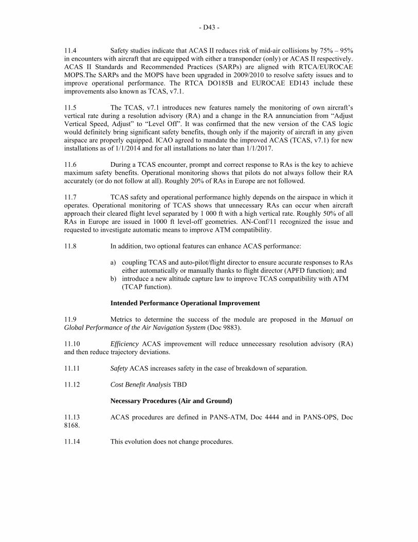
- D43 -
11.4 Safety studies indicate that ACAS II reduces risk of mid-air collisions by 75% – 95% in encounters with aircraft that are equipped with either a transponder (only) or ACAS II respectively. ACAS II Standards and Recommended Practices (SARPs) are aligned with RTCA/EUROCAE MOPS.The SARPs and the MOPS have been upgraded in 2009/2010 to resolve safety issues and to improve operational performance. The RTCA DO185B and EUROCAE ED143 include these improvements also known as TCAS, v7.1. 11.5 The TCAS, v7.1 introduces new features namely the monitoring of own aircraft’s vertical rate during a resolution advisory (RA) and a change in the RA annunciation from “Adjust Vertical Speed, Adjust” to “Level Off”. It was confirmed that the new version of the CAS logic would definitely bring significant safety benefits, though only if the majority of aircraft in any given airspace are properly equipped. ICAO agreed to mandate the improved ACAS (TCAS, v7.1) for new installations as of 1/1/2014 and for all installations no later than 1/1/2017. 11.6 During a TCAS encounter, prompt and correct response to RAs is the key to achieve maximum safety benefits. Operational monitoring shows that pilots do not always follow their RA accurately (or do not follow at all). Roughly 20% of RAs in Europe are not followed. 11.7 TCAS safety and operational performance highly depends on the airspace in which it operates. Operational monitoring of TCAS shows that unnecessary RAs can occur when aircraft approach their cleared flight level separated by 1 000 ft with a high vertical rate. Roughly 50% of all RAs in Europe are issued in 1000 ft level-off geometries. AN-Conf/11 recognized the issue and requested to investigate automatic means to improve ATM compatibility. 11.8 In addition, two optional features can enhance ACAS performance:
a) coupling TCAS and auto-pilot/flight director to ensure accurate responses to RAs either automatically or manually thanks to flight director (APFD function); and
b) introduce a new altitude capture law to improve TCAS compatibility with ATM (TCAP function).
Intended Performance Operational Improvement
11.9 Metrics to determine the success of the module are proposed in the Manual on Global Performance of the Air Navigation System (Doc 9883). 11.10 Efficiency ACAS improvement will reduce unnecessary resolution advisory (RA) and then reduce trajectory deviations. 11.11 Safety ACAS increases safety in the case of breakdown of separation. 11.12 Cost Benefit Analysis TBD
Necessary Procedures (Air and Ground) 11.13 ACAS procedures are defined in PANS-ATM, Doc 4444 and in PANS-OPS, Doc 8168. 11.14 This evolution does not change procedures.
- D44 -
Necessary System Capability
Avionics
• RTCA DO185B / EUROCAE DO143 MOPS are available for TCAS implementation.
• RTCA DO325 Annex C is being modified to accommodate the 2 functions (APFD and TCAP).
Human Performance
Human factors considerations
11.15 ACAS performance is influenced by human behaviour. ACAS is a last resort function implemented on aircraft with a flight crew of two pilots. The operational procedures (PANS-OPS and PANS-ATM) have been developed and refined for qualified flight crews. Airbus has been able to certify the APFD function, which includes human factors aspects, on A380. 11.16 Human factors have been taken into consideration during the development of the processes and procedures associated with this module. Where automation is to be used, the human machine interface has been considered from both a functional and ergonomic perspective (See Section 6 for examples). The possibility of latent failures however, continues to exist and vigilance is required during all implementation activity. It is further requested that human factor issues identified during implementation, be reported to the international community through ICAO as part of any safety reporting initiative.
Training and qualification requirements 11.17 Training in the operational standards and procedures are required for this module and can be found in the links to the documents in Section 8 to this module. Likewise, the qualifications requirements are identified in the regulatory requirements in Section 6 which are integral to the implementation of this module. Training guidelines are described in the Airborne Collision Avoidance System (ACAS) Manual (Doc 9863). Recurrent training is recommended.
Regulatory/standardization needs and Approval Plan (Air and Ground) 11.18 Regulatory/standardization: use current published requirements that include the material given in the “Reference documents” section hereunder. Approval plans: must be in accordance with application requirements e.g. EASA NPA 2010-03 requirement of 1/3/2012 for new installations and 1/12/2015 for all installations, or ICAO mandate of 1/1/2014 for new installations and 1/1/2017 for all installations.
Reference documents
Standards
• ICAO Annex 6 — Operation of Aircraft, Part I — International Commercial Air Transport Aeroplanes
• ICAO Annex 10 — Aeronautical Telecommunications, Volume IV - Surveillance Radar and Collision Avoidance Systems (Including Amendment 85- July 2010)
• EUROCAE ED-143/RTCA DO-185B, Minimum Operational Performance Standards for Traffic Alert and Collision Avoidance System II (TCAS II)
• RTCA DO-325, Minimum Operational Performance Standards (MOPS) for Automatic Flight
• Guidance and Control Systems and Equipment. Appendix C estimated 2013 • RTCA DO185B/EUROCAE DO143 MOPS for TCAS implementation
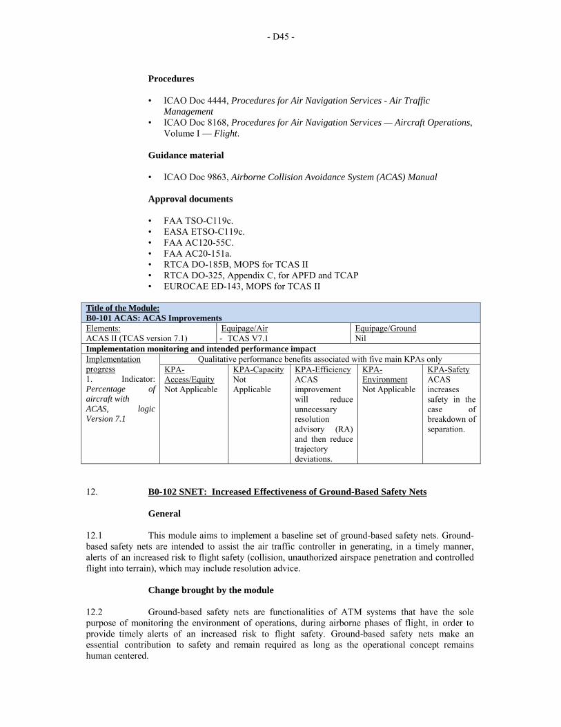
- D45 -
Procedures
• ICAO Doc 4444, Procedures for Air Navigation Services - Air Traffic
Management • ICAO Doc 8168, Procedures for Air Navigation Services — Aircraft Operations,
Volume I — Flight.
Guidance material
• ICAO Doc 9863, Airborne Collision Avoidance System (ACAS) Manual
Approval documents
• FAA TSO-C119c. • EASA ETSO-C119c. • FAA AC120-55C. • FAA AC20-151a. • RTCA DO-185B, MOPS for TCAS II • RTCA DO-325, Appendix C, for APFD and TCAP • EUROCAE ED-143, MOPS for TCAS II
Title of the Module: B0-101 ACAS: ACAS Improvements Elements: ACAS II (TCAS version 7.1)
Equipage/Air ‐ TCAS V7.1
Equipage/Ground Nil
Implementation monitoring and intended performance impact Implementation progress 1. Indicator: Percentage of aircraft with ACAS, logic Version 7.1
Qualitative performance benefits associated with five main KPAs only KPA-Access/Equity Not Applicable
KPA-Capacity Not Applicable
KPA-Efficiency ACAS improvement will reduce unnecessary resolution advisory (RA) and then reduce trajectory deviations.
KPA-Environment Not Applicable
KPA-Safety ACAS increases safety in the case of breakdown of separation.
12. B0-102 SNET: Increased Effectiveness of Ground-Based Safety Nets
General 12.1 This module aims to implement a baseline set of ground-based safety nets. Ground-based safety nets are intended to assist the air traffic controller in generating, in a timely manner, alerts of an increased risk to flight safety (collision, unauthorized airspace penetration and controlled flight into terrain), which may include resolution advice.
Change brought by the module 12.2 Ground-based safety nets are functionalities of ATM systems that have the sole purpose of monitoring the environment of operations, during airborne phases of flight, in order to provide timely alerts of an increased risk to flight safety. Ground-based safety nets make an essential contribution to safety and remain required as long as the operational concept remains human centered.
- D46 -
12.3 Ground-based safety nets have been in use since the 1980s. Provisions for ground-based safety nets were introduced in PANS-ATM, Doc 4444 in the early 2000s. This module corresponds to a baseline version of the safety nets as already implemented or being implemented in many areas. 12.4 This element is intended to assist the controller, in preventing collision between aircraft by generating, in a timely manner, an alert of a potential or actual infringement of separation minima. STCA must alert when the separation provision layer has been compromised but must also provide sufficient warning time to allow for corrective action, i.e. thus avoiding an airborne collision avoidance system (ACAS) resolution advisory (RA) will be generated. In some environments this necessitates the use of separation minima in STCA that are significantly lower than the separation minima used in the separation provision layer. STCA is only effective when each alert causes the controller to immediately assess the situation and if necessary take appropriate action. 12.5 There is presently no system compatibility between STCA (which advises of pending conflict to ATC only) and ACAS (which provides both advisory and mandatory resolution to the pilot only). However, both systems can complement each other and procedures need to be in place, that takes into account the limitations and advantages of each system.
Element 2: Area proximity warning (APW) 12.6 This element is intended to warn the controller, about unauthorized penetration of an airspace volume by generating, in a timely manner, an alert of a potential or actual infringement of the required spacing to that airspace volume. APW can be used to protect static, fixed airspace volumes (e.g. danger areas) but increasingly also dynamic, modular airspace volumes to enable flexible use of airspace.
Element 3: Minimum safe altitude warning (MSAW) 12.7 This element is intended to warn the controller, about increased risk of controlled flight into terrain accidents by generating, in a timely manner, an alert of aircraft proximity to terrain or obstacles. MSAW is only effective when each alert causes the controller to immediately assess the situation and if necessary take appropriate action.
Intended performance operational improvement/metric to determine success 12.8 In terms of safety this module contributes to the significant reduction of the number of major incidents. The business case for this element is entirely made around safety and the application of ALARP (as low as reasonably practicable) in risk management. 12.9 The relevant PANS-ATM provisions exist. In addition they must regularly analyze the data and circumstances pertaining to each alert in order to identify and correct any shortcomings pertaining to ground-based safety nets, airspace design and ATC procedures.
Necessary system capability
Avionics 12.10 Aircraft should support cooperative surveillance using existing technology such as Mode C/S transponder or ADS-B out.
- D47 -
Ground systems 12.11 ATS units providing surveillance services must be equipped with the ground-based safety nets that are appropriate and optimized for their environment. Appropriate offline tools should be available to support the analysis of every safety alerts.
Human factors considerations 12.12 The generated alerts should normally be appropriate and timely, and the controller should understand under which circumstances interactions can occur with normal control practices or airborne safety nets. The two main issues from human performance are related to nuisance alerts which should be kept to a minimum and warning time for a genuine alert which should be high enough to support the completion of the procedure. 12.13 The use of ground-based safety nets will depend on the controller‘s trust. Trust is a result of many factors such as reliability and transparency. Neither mistrust nor complacency is desirable; training and experience is needed to develop trust at the appropriate level.
Training and qualification requirements 12.14 Controllers must receive specific ground-based safety nets training and be assessed as competent for the use of the relevant ground-based safety nets and recovery techniques.
Reference documents and guidance material • PANS-ATM (Doc 4444), section 15.7.2 and 15.7.4 • EUROCONTROL Specifications for STCA, APW, MSAW and APM,
available at http://www.EUROCONTROL.int/safety-nets
Module summary Title of the Module: B0-102 SNET: Increased Effectiveness of Ground-Based Safety Nets Elements: 1. Short Term Conflict Alert (STCA) 2. Area Proximity Warning (APW) 3. Minimum Safe Altitude Warning (MSAW)
Equipage/Air ‐ SSR Mode C/S transponder ‐ ADS-B OUT
Equipage/Ground ‐ Short Term Conflict Alert, ‐ Area Proximity Warnings and ‐ Minimum Safe Altitude Warnings
Implementation monitoring and intended performance impact Implementation progress 1. Indicator: Percentage of ATS units with ground based safety nets
Qualitative performance benefits associated with five main KPAs only KPA-Access/Equity Not Applicable
KPA-Capacity Not Applicable
KPA-Efficiency Not Applicable
KPA-Environment Not Applicable
KPA-Safety Significant reduction of the number of major incidents.
- D48 -
PERFORMANCE IMPROVEMENT AREA 4: EFFICIENT FLIGHT PATH – THROUGH TRAJECTORY-BASED OPERATIONS 13. B0-05 CDO: Improved Flexibility and Efficiency in Descent Profiles (CDO)
Introduction 13.1 This module integrates with other airspace and procedures (continuous descent operations (CDO), performance-based navigation (PBN) and airspace management) to increase efficiency, safety, access and predictability. 13.2 As traffic demand increases, the challenges in terminal areas center on volume, hazardous meteorological conditions (such as severe turbulence and low visibility), adjacent airports and special activity airspace in close proximity whose procedures utilize the same airspace, and policies that limit capacity, throughput, and efficiency. 13.3 Traffic flow and loading (across ingress and egress routes) are not always well-metered, balanced or predictable. Obstacle and airspace avoidance (in the form of separation minima and criteria), noise abatement procedures, as well as wake encounter risk mitigation, tend to result in operational inefficiencies (e.g. added time or distance flown, thus more fuel). 13.4 Inefficient routing can also cause under-use of available airfield and airspace capacity. Finally, challenges are presented to States by serving multiple customers (international and domestic with various capabilities): the intermingling of commercial, business, general aviation and many times military traffic destined to airports within a terminal area that interact and at times inhibit each other‘s operations.
Baseline 13.5 The baseline for this module may vary from one State, to the next. Noted is the fact that some aspects of the movement to PBN have already been the subject of local improvements in many areas; and these areas and users are already realizing benefits.
Change brought by the module 13.6 Flight operations in many terminal areas precipitate the majority of current airspace delays in many States. Opportunities to optimize throughput, improve flexibility, enable fuel-efficient climb and descent profiles, and increase capacity at the most congested areas should be a high-priority initiative in the near-term. 13.7 The core capabilities that should be leveraged are RNAV; RNP where needed; CDO; where possible, increased efficiencies in terminal separation rules in airspace; effective airspace design and classification; air traffic control (ATC) flow and ATC surveillance. Opportunities to reduce emissions and aircraft noise impacts should also be leveraged where possible. 13.8 Aircraft equipage is a significant contributor and the reliance on area navigation (RNAV) and required navigation performance (RNP) capabilities requires the continued development of PBN provisions as well as increased PBN implementation worldwide. ICAO provisions and guidance material are also necessary to support trajectory modelling and trajectory information exchange, and enhanced provisions for data link applications and messages will support exchange of trajectory data.
- D49 -
Element 1: Continuous descent operations 13.9 Continuous descent is one of several tools available to aircraft operators and ANSPs to benefit from existing aircraft capabilities and reduce noise, fuel burn and the emission of greenhouse gases. Over the years, different route models have been developed to facilitate CDO and several attempts have been made to strike a balance between the ideal of environmentally friendly procedures and the requirements of a specific airport or airspace. 13.10 CDO can provide for a reduction in fuel burn and emissions, while increasing flight stability and the predictability of flight path to both controllers and pilots, without compromising the optimal airport arrival rate (AAR). 13.11 CDO is enabled by airspace design, procedure design and facilitation by ATC, in which an arriving aircraft descends continuously, to the greatest possible extent, by employing minimum engine thrust, ideally in a low drag configuration, prior to the final approach fix/final approach point (FAF/FAP). An optimum CDO starts from the top-of-descent (TOD) and uses descent profiles that reduce controller-pilot communications and segments of level flight. 13.12 Furthermore it provides for a reduction in noise, fuel burn and emissions, while increasing flight stability and the predictability of flight path to both controllers and pilots.
Element 2: Performance-based navigation 13.13 PBN is a global set of area navigation standards, defined by ICAO, based on performance requirements for aircraft navigating on departure, arrival, approach or en-route. 13.14 These performance requirements are expressed as navigation specifications in terms of accuracy, integrity, continuity, availability and functionality required for a particular airspace or airport. 13.15 PBN will eliminate the regional differences of various required navigation performance (RNP) and area navigation (RNAV) specifications that exist today. The PBN concept encompasses two types of navigation specifications:
a) RNAV specification: navigation specification-based on area navigation that does not include the requirement for on-board performance monitoring and alerting, designated by the prefix RNAV, e.g. RNAV 5, RNAV 1; and
b) RNP specification: navigation specification based on area navigation that
includes the requirement for on-board performance monitoring and alerting, designated by the prefix RNP, e.g. RNP 4.
Intended performance operational improvement
13.16 Metrics to determine the success of the module are proposed in the Manual on Global Performance of the Air Navigation System (Doc 9883). 13.17 In terms of Efficiency cost savings and environmental benefits through reduced fuel burn and optimal management of the top-of-descent in the en-route airspace have a positive impact as well as the positive contribution on environment. 13.18 There is more predictability in more consistent flight paths and stabilized approach paths reducing the need for vectors and contributing on the ATC workload.
- D50 -
13.19 In addition the reduction in the incidence of controlled flight into terrain (CFIT) added to separation with the surrounding traffic and the reduction of number of conflicts contribute to safety also. 13.20 In terms of potential savings as a result of CDO implementation, it is important to consider that CDO benefits are heavily dependent on each specific ATM environment. Nevertheless, if implemented within the ICAO CDO manual framework, it is envisaged that the benefit/cost ratio (BCR) will be positive.
Necessary procedures (air and ground) 13.21 The ICAO Continuous Descent Operations (CDO) Manual (Doc 9931) provides guidance on the airspace design, instrument flight procedures, ATC facilitation and flight techniques necessary to enable continuous descent profiles. 13.22 It therefore provides background and implementation guidance for:
a) air navigation service providers (ANSPs); b) aircraft operators; c) airport operators; and d) aviation regulators.
13.23 The ICAO Performance-based Navigation (PBN) Manual (Doc 9613) provides general guidance on PBN implementation. This manual identifies the relationship between RNAV and RNP applications and the advantages and limitations of choosing one or the other as the navigation requirement for an airspace concept. 13.24 It also aims at providing practical guidance to States, ANSPs and airspace users on how to implement RNAV and RNP applications, and how to ensure that the performance requirements are appropriate for the planned application.
Necessary system capability
Avionics 13.25 CDO is an aircraft operating technique aided by appropriate airspace and procedure design and appropriate ATC clearances enabling the execution of a flight profile optimized to the operating capability of the aircraft, with low engine thrust settings and, where possible, a low drag configuration, thereby reducing fuel burn and emissions during descent. 13.26 The optimum vertical profile takes the form of a continuously descending path, with a minimum of level flight segments only as needed to decelerate and configure the aircraft or to establish on a landing guidance system (e.g. ILS). 13.27 The optimum vertical path angle will vary depending on the type of aircraft, its actual weight, the wind, air temperature, atmospheric pressure, icing conditions and other dynamic considerations.
Ground systems 13.28 Within an airspace concept, PBN requirements will be affected by the communication, surveillance and ATM environments, the NAVAID infrastructure and the functional and operational capabilities needed to meet the ATM application.
- D51 -
13.29 PBN performance requirements also depend on what reversionary, non-RNAV means of navigation are available and what degree of redundancy is required to ensure adequate continuity of functions. Ground automation needs initially little changes to support CDO: potentially a flag on the display. For better integration the ground trajectory calculation function will need to be upgraded.
Human factors considerations 13.30 The decision to plan for RNAV or RNP has to be decided on a case by case basis in consultation with the airspace user. Some areas need only a simple RNAV to maximize the benefits, while other areas such as nearby steep terrain or dense air traffic may require the most stringent RNP. 13.31 Human factors have been taken into consideration during the development of the processes and procedures associated with this module. Where automation is to be used, the human-machine interface has been considered from both a functional and ergonomic perspective. The possibility of latent failures however, continues to exist and vigilance is requested during all implementation actions. It is further requested that human factor issues, identified during implementation, are reported to the international community through ICAO as part of any safety reporting initiative.
Training and qualification requirements 13.32 Since required navigation performance authorization required (RNP AR) approaches also require significant training, ANSPs should work closely with airlines to determine where RNP AR approach should be implemented. In all cases PBN implementation needs to be an agreement between the airspace user, the ANSP and the regulatory authorities. 13.33 Training in the operational standards and procedures are required for this module and can be found in the links to the documents indicated in the “Reference documents and guidance material” section hereunder. Likewise, the qualifications requirements are identified in the regulatory requirements described in paragraph 13.34.
Regulatory/standardization needs and approval plan (air and ground)
13.34 Regulatory/standardization: use current published requirements that include the material given below. Approval plans: must be in accordance with application requirements e.g. airspace design, air traffic operations, PBN requirements for fixed radius transitions, radius-to-fix legs, required time of arrival (RTA), parallel offset, etc.
Reference documents and guidance material
• For flight plan requirements in Amendment 1, ICAO Procedures for Air
Navigation Services — Air Traffic Management (PANS-ATM, Doc 4444). • ICAO Doc 9613, Performance-based Navigation (PBN) Manual • ICAO Doc 9931, Continuous Descent Operations (CDO) Manual • SAM Advisory Circulars.
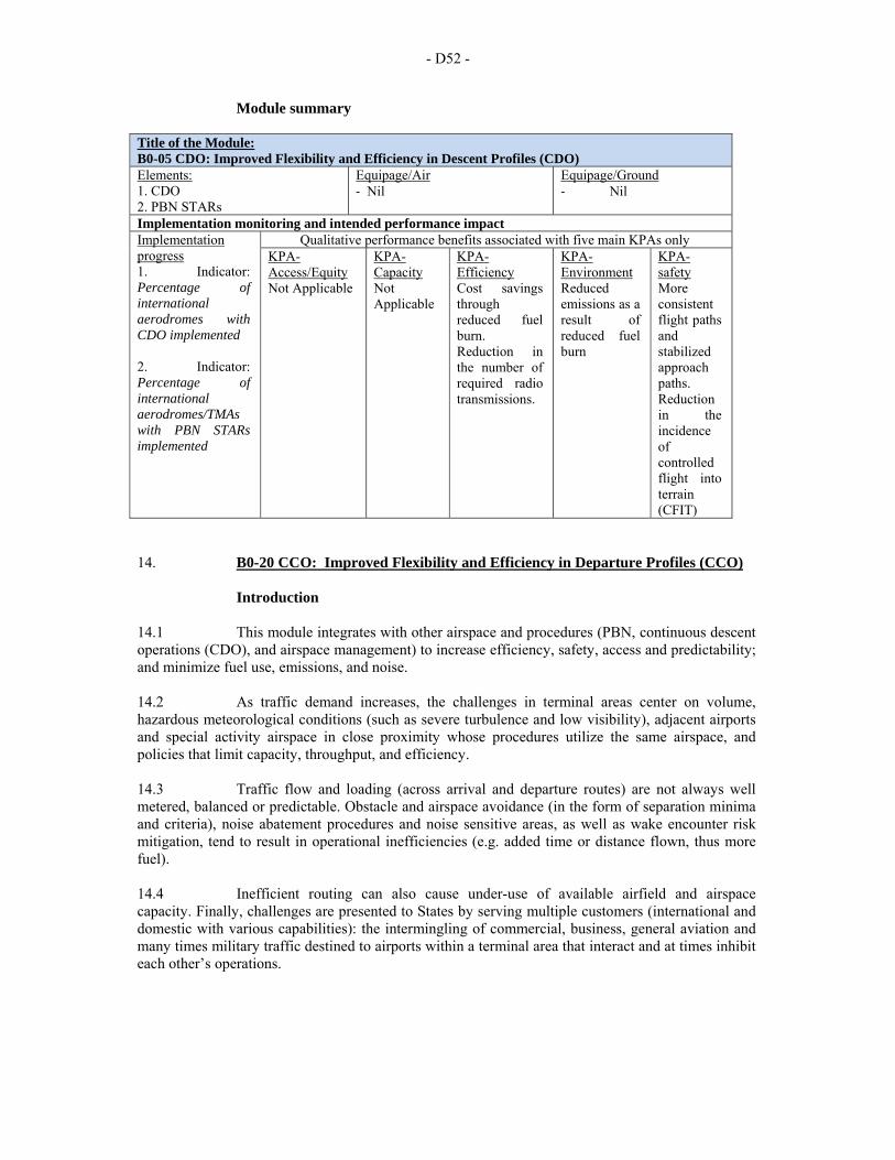
- D52 -
Module summary Title of the Module: B0-05 CDO: Improved Flexibility and Efficiency in Descent Profiles (CDO) Elements: 1. CDO 2. PBN STARs
Equipage/Air ‐ Nil
Equipage/Ground ‐ Nil
Implementation monitoring and intended performance impact Implementation progress 1. Indicator: Percentage of international aerodromes with CDO implemented 2. Indicator: Percentage of international aerodromes/TMAs with PBN STARs implemented
Qualitative performance benefits associated with five main KPAs only KPA-Access/Equity Not Applicable
KPA-Capacity Not Applicable
KPA-Efficiency Cost savings through reduced fuel burn. Reduction in the number of required radio transmissions.
KPA-Environment Reduced emissions as a result of reduced fuel burn
KPA-safety More consistent flight paths and stabilized approach paths. Reduction in the incidence of controlled flight into terrain (CFIT)
14. B0-20 CCO: Improved Flexibility and Efficiency in Departure Profiles (CCO)
Introduction 14.1 This module integrates with other airspace and procedures (PBN, continuous descent operations (CDO), and airspace management) to increase efficiency, safety, access and predictability; and minimize fuel use, emissions, and noise. 14.2 As traffic demand increases, the challenges in terminal areas center on volume, hazardous meteorological conditions (such as severe turbulence and low visibility), adjacent airports and special activity airspace in close proximity whose procedures utilize the same airspace, and policies that limit capacity, throughput, and efficiency. 14.3 Traffic flow and loading (across arrival and departure routes) are not always well metered, balanced or predictable. Obstacle and airspace avoidance (in the form of separation minima and criteria), noise abatement procedures and noise sensitive areas, as well as wake encounter risk mitigation, tend to result in operational inefficiencies (e.g. added time or distance flown, thus more fuel). 14.4 Inefficient routing can also cause under-use of available airfield and airspace capacity. Finally, challenges are presented to States by serving multiple customers (international and domestic with various capabilities): the intermingling of commercial, business, general aviation and many times military traffic destined to airports within a terminal area that interact and at times inhibit each other’s operations.
- D53 -
Baseline 14.5 Flight operations in many terminal areas precipitate the majority of current airspace delays in many States. Opportunities to optimize throughput, improve flexibility, enable fuel-efficient climb and descent profiles, and increase capacity at the most congested areas should be a high-priority initiative in the near-term. 14.6 The baseline for this module may vary from one State, region or location to the next. Noted is the fact that some aspects of the movement to PBN have already been the subject of local improvements in many areas; these areas and users are already realizing benefits. 14.7 The lack of ICAO PBN operational approval guidance material and subsequently the emergence of States or regional approval material, which may differ or be even more demanding than intended, is slowing down implementation and is perceived as one of the main roadblocks for harmonization. 14.8 There is still some work to be done to harmonize PBN nomenclature, especially in charts and States/regional regulations (e.g. most of European regulations still make use of basic area navigation (B-RNAV) and precision area navigation (P-RNAV). 14.9 Efficiency of climb profiles may be compromised by level off segments, vectoring, and an additional overload of radio transmissions between pilots and air traffic controllers. Existing procedure design techniques do not cater for current FMS capability to manage the most efficient climb profiles. There is also excessive use of radio transmissions due to the need to vector aircraft in an attempt to accommodate their preferred trajectories.
Change brought by the module 14.10 The core capabilities that should be leveraged are RNAV; RNP where possible and needed; continuous climb operations (CCO), increased efficiencies in terminal separation rules; effective airspace design and classification; and air traffic flow. Opportunities to reduce flight block times, fuel/emissions and aircraft noise impacts should also be leveraged where possible. 14.11 This module is a first step towards harmonization and a more optimized organization and management of the airspace. Many States will require knowledgeable assistance to achieve implementation. Initial implementation of PBN, RNAV for example, takes advantage of existing ground technology and avionics and allows extended collaboration of air navigation service providers (ANSPs) with partners: military, airspace users, and neighbouring States. Taking small and required steps and only performing what is needed or required allows States to rapidly exploit PBN.
Other remarks 14.12 Operating at the optimum flight level is a key driver to improve flight fuel efficiency and minimizing atmospheric emissions. A large proportion of fuel burn occurs in the climb phase and for a given route length, taking into account aircraft mass and the meteorological conditions for the flight, there will be an optimum flight level, which gradually increases as the fuel on-board is used up and aircraft mass therefore reduces. Enabling the aircraft to reach and maintain its optimum flight level without interruption will therefore help to optimize flight fuel efficiency and reduce emissions. 14.13 CCO can provide for a reduction in noise, fuel burn and emissions, while increasing flight stability and the predictability of flight path to both controllers and pilots. 14.14 CCO is an aircraft operating technique aided by appropriate airspace and procedure design and appropriate air traffic control (ATC) clearances enabling the execution of a flight profile optimized to the operating capability of the aircraft, thereby reducing fuel burn and emissions during the climb portion of flight.

- D54 -
14.15 The optimum vertical profile takes the form of a continuously climbing path, with a minimum of level flight segments only as needed to accelerate and configure the aircraft. 14.16 The optimum vertical path angle will vary depending on the type of aircraft, its actual weight, the wind, air temperature, atmospheric pressure, icing conditions and other dynamic considerations. 14.17 A CCO can be flown with or without the support of a computer-generated vertical flight path (i.e. the vertical navigation (VNAV) function of the flight management system (FMS)) and with or without a fixed lateral path. The maximum benefit for an individual flight is achieved by allowing the aircraft to climb on the most efficient climb profile along the shortest total flight distance possible.
Intended performance operational improvement 14.18 Metrics to determine the success of the module are proposed in the Manual on Global Performance of the Air Navigation System (Doc 9883). 14.19 An optimal management and efficient aircraft operating profiles with reduction in the number of required radio transmissions and lower pilot and air traffic control workload have a positive impact in terms of efficiency. 14.20 It is important to consider that CCO benefits are heavily dependent on each specific ATM environment. Nevertheless, if implemented within the ICAO CCO manual framework, it is envisaged that the benefit/cost ratio (BCR) will be positive.
Necessary procedures (air and ground) 14.21 The ICAO Performance-based Navigation (PBN) Manual (Doc 9613) provides general guidance on PBN implementation. 14.22 This manual identifies the relationship between RNAV and RNP applications and the advantages and limitations of choosing one or the other as the navigation requirement for an airspace concept. 14.23 It also aims at providing practical guidance to States, ANSPs and airspace users on how to implement RNAV and RNP applications, and how to ensure that the performance requirements are appropriate for the planned application. 14.24 The ICAO Continuous Climb Operations (CCO) Manual (Doc xxxx – under development) provides guidance on the airspace design, instrument flight procedures, ATC facilitation and flight techniques necessary to enable continuous descent profiles. 14.25 It therefore provides background and implementation guidance for:
a) air navigation service providers; b) aircraft operators; c) airport operators; and d) aviation regulators.
- D55 -
Necessary system capability
Avionics 14.26 CCO does not require a specific air or ground technology. It is an aircraft operating technique aided by appropriate airspace and procedure design, and appropriate ATC clearances enabling the execution of a flight profile optimized to the operating capability of the aircraft, in which the aircraft can attain cruise altitude flying at optimum air speed with climb engine thrust settings set throughout the climb, thereby reducing total fuel burn and emissions during the whole flight. Reaching cruise flight levels sooner where higher ground speeds are attained can also reduce total flight block times. This may allow a reduced initial fuel upload with further fuel, noise and emissions reduction benefits. 14.27 The optimum vertical profile takes the form of a continuously climbing path. Any level or non-optimal reduced climb rate segments during the climb to meet aircraft separation requirements should be avoided. Achieving this whilst also enabling CDO is critically dependent upon the airspace design and the height windows applied in the instrument flight procedure. Such designs need an understanding of the optimum profiles for aircraft operating at the airport to ensure that the height windows avoid, to greatest extent possible, the need to resolve potential conflicts between the arriving and departing traffic flows through ATC height or speed constraints.
Ground systems 14.28 Controllers would benefit from some automation support to display aircraft capabilities in order to know which aircraft can do what.
Human factors considerations 14.29 Human factors have been taken into consideration during the development of the processes and procedures associated with this module. Where automation is to be used, the human-machine interface has been considered from both a functional and ergonomic perspective. The possibility of latent failures however, continues to exist and vigilance is requested during all implementation actions. It is further requested that human factor issues, identified during implementation, be reported to the international community through ICAO as part of any safety reporting initiative.
Training and qualification requirements 14.30 Training in the operational standards and procedures are required for this module and can be found in the links to the documents below.
Regulatory/standardization needs and approval plan (air and ground) 14.31 Regulatory/standardization: use current published requirements that include the guidance material 14.32 Approval plans: must be in accordance with application requirements. 14.33 Understanding the policy context is important for making the case for local CCO implementation and ensuring high levels of participation. CCO may be a strategic objective at international, State, or local level, and as such, may trigger a review of airspace structure when combined with CDO.
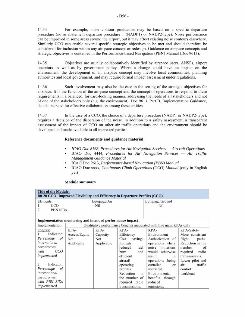
- D56 -
14.34 For example, noise contour production may be based on a specific departure procedure (noise abatement departure procedure 1 (NADP1) or NADP2-type). Noise performance can be improved in some areas around the airport, but it may affect existing noise contours elsewhere. Similarly CCO can enable several specific strategic objectives to be met and should therefore be considered for inclusion within any airspace concept or redesign. Guidance on airspace concepts and strategic objectives is contained in the Performance-based Navigation (PBN) Manual (Doc 9613). 14.35 Objectives are usually collaboratively identified by airspace users, ANSPs, airport operators as well as by government policy. Where a change could have an impact on the environment, the development of an airspace concept may involve local communities, planning authorities and local government, and may require formal impact assessment under regulations. 14.36 Such involvement may also be the case in the setting of the strategic objectives for airspace. It is the function of the airspace concept and the concept of operations to respond to these requirements in a balanced, forward-looking manner, addressing the needs of all stakeholders and not of one of the stakeholders only (e.g. the environment). Doc 9613, Part B, Implementation Guidance, details the need for effective collaboration among these entities. 14.37 In the case of a CCO, the choice of a departure procedure (NADP1 or NADP2-type), requires a decision of the dispersion of the noise. In addition to a safety assessment, a transparent assessment of the impact of CCO on other air traffic operations and the environment should be developed and made available to all interested parties.
Reference documents and guidance material
• ICAO Doc 8168, Procedures for Air Navigation Services — Aircraft Operations • ICAO Doc 4444, Procedures for Air Navigation Services — Air Traffic
Management Guidance Material • ICAO Doc 9613, Performance-based Navigation (PBN) Manual • ICAO Doc xxxx, Continuous Climb Operations (CCO) Manual (only in English
yet)
Module summary Title of the Module: B0-20 CCO: Improved Flexibility and Efficiency in Departure Profiles (CCO)
Elements: 1. CCO 2. PBN SIDs
Equipage/Air ‐ Nil
Equipage/Ground ‐ Nil
Implementation monitoring and intended performance impact Implementation progress 1. Indicator: Percentage of international aerodromes with CCO implemented 2. Indicator: Percentage of international aerodromes with PBN SIDs implemented
Qualitative performance benefits associated with five main KPAs only KPA-Access/Equity Not Applicable
KPA-Capacity Not Applicable
KPA-Efficiency Cost savings through reduced fuel burn and efficient aircraft operating profiles. Reduction in the number of required radio transmissions.
KPA-Environment Authorization of operations where noise limitations would otherwise result in operations being curtailed or restricted. Environmental benefits through reduced emissions.
KPA-Safety More consistent flight paths. Reduction in the number of required radio transmissions. Lower pilot and air traffic control workload
- D57 -
15. B0-40 TBO: Improved Safety and Efficiency through the initial application of
Data Link En-Route
Introduction 15.1 Air-ground data exchanges have been the subject of decades of research and standardization work and are an essential ingredient of the future operational concepts since they can carry reliably richer information than what can be exchanged over radio. This module covers what is available and can be used more widely now. 15.2 One element of the module is the transmission of aircraft position information, forming the automatic dependent surveillance contract (ADS-C), principally for use over oceanic and remote areas where radar cannot be deployed for physical or economic reasons. 15.3 A second element is controller pilot data link communications (CPDLC) comprising a first set of data link applications allowing pilots and controllers to exchange ATC messages concerning communications management, ATC clearances and stuck microphones. CPDLC reduces misunderstandings and controller workload giving increased safety and efficiency whilst providing extra capacity in the ATM system.
Baseline 15.4 Prior to this module, air-ground communications used voice radio (VHF or HF depending on the airspace), known for limitations in terms of quality, bandwidth and security. There are also wide portions of the region with no radar surveillance. ATC instructions, position reports and other information have to be transmitted through HF radios where voice quality is especially bad most of the time, leading to significant workload to controllers and pilots (including HF radio operators), poor knowledge of the traffic situation outside radar coverage, large separation minima, and misunderstandings. In high density airspace controllers currently spend 50% of their time talking to pilots on the VHF voice channels where frequencies are a scarce resource; this also represents a significant workload for controllers and pilots and generates misunderstandings.
Change brought by the module 15.5 The module concerns the implementation of a first package of data link applications, covering ADS-C, CPDLC and other applications for ATC. These applications provide significant improvement in the way ATS is provided as described in the next section. 15.6 At the moment, data link implementations are based on different standards, technology and operational procedures, although there are many similarities.
Element 1: ADS-C over oceanic and remote areas 15.7 ADS-C provides an automatic dependent surveillance service over oceanic and remote areas, through the exploitation of position messages sent automatically by aircraft over data link at specified time intervals. This improved situational awareness (in combination with appropriate PBN levels) is improving safety in general and allows reducing separations between aircraft and progressively moving away from pure procedural modes of control.
Element 2: Continental CPDLC 15.8 This application allows pilots and controllers to exchange messages with a better quality of transmission. In particular, it provides a way to alert the pilot when the microphone is stuck as well as a complementary means of communication. CPDLC is used as supplemental means of communications. Voice remains primary.
- D58 -
15.9 Over dense continental airspace, they can significantly reduce the communication load, allowing better task organization by the controller, in particular by not having to interrupt immediately to answer radio. They provide more reliability for the transmission and understanding of frequency changes, flight levels and flight information etc, thereby increasing safety and reducing the number of misunderstandings and repetitions.
Intended performance operational improvement 15.10 Metrics to determine the success of the module are proposed in the Manual on Global Performance of the Air Navigation System (Doc 9883).
Element 1: ADS-C over oceanic and remote areas
Capacity 15.11 A better localization of traffic and reduced separations allow increasing the offered capacity.
Efficiency 15.12 Routes/tracks and flights can be separated by reduced minima, allowing to apply flexible routings and vertical profiles closer to the user-preferred ones.
Flexibility 15.13 ADS-C permits to make route changes easier
Safety 15.14 Increased situational awareness; ADS-C based safety nets like cleared level adherence monitoring, route adherence monitoring, danger area infringement warning; better support to search and rescue.
Cost Benefit Analysis 15.15 The business case has proven to be positive due to the benefits that flights can obtain in terms of better flight efficiency (better routes and vertical profiles; better and tactical resolution of conflicts).
Element 2: Continental CPDLC
Capacity 15.16 Reduced communication workload and better organization of controller tasks allowing to increase sector capacity
Safety 15.17 Increased situational awareness; reduced occurrences of misunderstandings; solution to stuck microphone situations
- D59 -
Cost Benefit Analysis 15.18 It has to consider:
a) the benefits that flights can obtain in terms of better flight efficiency (better routes and vertical profiles; better and tactical resolution of conflicts); and
b) reduced controller workload and increased capacity.
Necessary procedures (air and ground) 15.19 Procedures have been described and are available in ICAO documents: Manual of Air Traffic Services Data Link Applications (Doc 9694) and the Global Operational Data Link Document (GOLD). Currently GOLD and LINK2000+ operational material is being merged, leading to an update of GOLD that allows global applicability, independent from airspace and technology.
Necessary system capability
Avionics 15.20 Standards for the enabling technology are available in ICAO documents and industry standards. Today, the existing data link implementations are based on two sets of ATS data link services: FANS 1/A and ATN B1, both will exist. FANS1/A is deployed in oceanic and remote regions whilst ATN B1 is being implemented in Europe according to European Commission legislation (EC Reg. No. 29/2009) – the data link services implementing rule. 15.21 These two packages are different from the operational, safety and performance standpoint and do not share the same technology but there are many similarities and can be accommodated together, thanks to the resolution of the operational and technical issues through workaround solutions, such as accommodation of FANS 1/A aircraft implementations by ATN B1 ground systems and dual stack (FANS 1/A and ATN B1) implementations in the aircraft.
Ground systems 15.22 For ground systems, the necessary technology includes the ability to manage ADS-C contract, process and display the ADS-C position messages. CPDLC messages need to be processed and displayed to the relevant ATC unit. Enhanced surveillance through multi-sensor data fusion facilitates transition to/from radar environment.
Human factors considerations 15.23 ADS-C is a means to provide the air traffic controller with a direct representation of the traffic situation, and reduces the task of controllers or radio operators to collate position reports. In addition to providing another channel of communications, the data link applications allow in particular air traffic controllers to better organize their tactical tasks. Both pilots and controllers benefit from a reduced risk of misunderstanding of voice transmissions. 15.24 Data communications allow reducing the congestion of the voice channel with overall understanding benefits and more flexible management of air-ground exchanges. This implies an evolution in the dialogue between pilots and controllers which must be trained to use data link rather than radio. Automation support is needed for both the pilot and the controller. Overall, their respective responsibilities will not be affected.
- D60 -
15.25 Human factors have been taken into consideration during the development of the processes and procedures associated with this module. Where automation is to be used, the human-machine interface has been considered from both a functional and ergonomic perspective. The possibility of latent failures however, continues to exist and vigilance is requested during all implementation actions. It is further requested that human factor issues, identified during implementation, be reported to the international community through ICAO as part of any safety reporting initiative.
Training and qualification requirements 15.26 Automation support is needed for both the pilot and the controller which therefore will have to be trained to the new environment and to identify the aircraft/facilities which can accommodate the data link services in mixed mode environments. 15.27 Training in the operational standards and procedures are required for this module and can be found in the links to the documents indicated in the “Reference documents and guidance material” section hereunder. Likewise, the qualifications requirements are identified in the regulatory requirements described in paragraphs 15.28 to 15.30.
Regulatory/standardization needs and approval plan (air and ground) 15.28 Regulatory/standardization: use current published requirements that include the guidance material. It should also be noted that new ICAO OPLINK OPS guidance material is under development. 15.29 Approval plans: must be in accordance with application requirements. 15.30 The GOLD ad hoc working group is working on an update of GOLD-Ed 1 in the framework of harmonization of procedures independent from airspace and technology.
Reference documents and guidance material
• ICAO Doc 9694, Manual of Air Traffic Services Data Link Applications. • Global Operation Data Link Document (GOLD) Ed 2 (under development). • Commission Regulation (EC) No 29/2009 of 16 January 2009 laying down
requirements on data link services for the single European sky. • EUROCAE ED-100A/RTCA DO-258A, Interoperability Requirements for ATS
Applications using ARINC 622 Data Communications. • EUROCAE ED-110B/RTCA DO-280B, Interoperability Requirements Standard
for Aeronautical Telecommunication Network Baseline 1 (Interop ATN B1). • EUROCAE ED-120/RTCA DO-290, Safety and Performance Requirements
Standard for Initial Air Traffic Data Link Services In Continental Airspace (SPR IC).
• EUROCAE ED-122/RTCA DO-306, Safety and Performance Standard for Air Traffic Data Link Services in Oceanic and Remote Airspace (Oceanic SPR Standard).
• EUROCAE ED-154A/RTCA DO-305A, Future Air Navigation System 1/A – Aeronautical Telecommunication Network Interoperability Standard (FANS 1/A – ATN B1 Interop Standard).
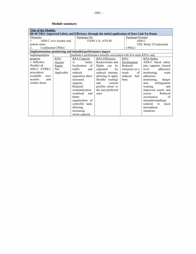
- D61 -
Module summary
Title of the Module: B0-40 TBO: Improved Safety and Efficiency through the initial application of Data Link En-Route Elements: 1. ADS-C over oceanic and remote areas 2. Continental CPDLC
Equipage/Air ‐ FANS 1/A; ATN B1
Equipage/Ground ‐ ADS-C ‐ VDL Mode 2/Continental CPDLC
Implementation monitoring and intended performance impact Implementation progress 1. Indicator: Number of ADS-C /CPDLC procedures available over oceanic and remote Areas
Qualitative performance benefits associated with five main KPAs only KPA-Access/ Equity Not Applicable
KPA-Capacity A better localization of traffic and reduced separation allow increased capacity. Reduced communication workload and better organization of controller tasks allowing increasing sector capacity.
KPA-Efficiency Routes/tracks and flights can be separated by reduced minima, allowing to apply flexible routings and vertical profiles closer to the user-preferred ones.
KPA-Environment Reduced emissions as a result of reduced fuel burn.
KPA-Safety ADS-C based safety nets supports cleared level adherence monitoring, route adherence monitoring, danger area infringement warning and improved search and rescue. Reduced occurrences of misunderstandings; solution to stuck microphone situations.
ATTACHMENT E
AIR NAVIGATION REPORT FORM HOW TO USE - EXPLANATORY NOTES
1. Air Navigation Report Form (ANRF): This form provides a standardized approach to
implementation monitoring and performance measurement of Aviation System Block Upgrades (ASBU) Modules. The Planning and Implementation Regional Groups (PIRGs) and States could use this report format for their planning, implementation and monitoring framework for ASBU Modules. Also, other reporting formats that provide more details may be used but should contain as a minimum the elements described below. The Reporting and monitoring results will be analysed by ICAO and aviation partners and then utilized in developing the Annual Global Air Navigation Report. The Global Air Navigation Report conclusions will serve as the basis for future policy adjustments aiding safety practicality, affordability and global harmonization, amongst other concerns.
2. Regional/National Performance objective: In the ASBU methodology, the performance
objective will be the title of the ASBU module itself. Furthermore, indicate alongside corresponding Performance Improvement area (PIA). Consequently, for ASBU Block 0, a total of 18 ANRFs will need to be developed that reflects respective 18 Modules. In the SAM Region 16 modules were selected.
3. Impact on Main Key Performance Areas: Key to the achievement of a globally interoperable
ATM system is a clear statement of the expectations/benefits to the ATM community. The expectations/benefits are referred to eleven Key Performance Areas (KPAs) and are interrelated and cannot be considered in isolation since all are necessary for the achievement of the objectives established for the system as a whole. It should be noted that while safety is the highest priority, the eleven KPAs shown below are in alphabetical order as they would appear in English. They are access/equity; capacity; cost effectiveness; efficiency; environment; flexibility; global interoperability; participation of ATM community; predictability; safety; and security. However, out of these eleven KPAs, for the present, only five have been selected for reporting through ANRF, which are Access & Equity, Capacity, Efficiency, Environment and Safety. The KPAs applicable to respective ASBU module are to be identified by marking Y (Yes) or N (No).
4. Implementation Progress: This section indicates status of progress in the implementation of
different elements of the ASBU Module for both air and ground segments. 5. Elements related to ASBU module: Under this section list elements that are needed to
implement the respective ASBU Module. Furthermore, should there be elements that are not reflected in the ASBU Module (example: In ASBU B0-80/Airport CDM, Aerodrome certification and data link applications D-VOLMET, D-ATIS, D-FIS are not included; Similarly in ASBU B0-30/AIM, note that WGS-84 and eTOD are not included) but at the same time if they are closely linked to the module, ANRF should specify those elements. As a part of guidance to PIRGs/States, the FASID (Volume II) of every Regional ANP will have the complete list of all 18 Modules of ASBU Block 0 along with corresponding elements, equipage required on the ground and in the air as well as metrics specific to both implementation and benefits.
6. Implementation Status (Ground/Air): Planned implementation date (moth/year) and the current
status/responsibility for each element are to be reported in this section. Please provide as much details as possible and should cover both avionics and ground systems. If necessary, use additional pages.
- E2 -
7. Implementation Roadblocks/Issues: Any problems/issues that are foreseen for the implementation of elements of the Module are to be reported in this section. The purpose of the section is to identify in advance any issues that will delay the implementation and if so, corrective action is to be initiated by the concerned person/entity. The four areas, under which implementation issues, if any, for the ASBU Module to be identified, are as follows:
Ground System Implementation: Avionics Implementation: Procedures Availability: Operational Approvals: Should be there no issues to be resolved for the implementation of ASBU Module, indicate as “NIL”.
8. Performance Monitoring and Measurement: Performance monitoring and measurement is done through the collection of data for the supporting metrics. In other words, metrics are quantitative measure of system performance – how well the system is functioning. The metrics fulfil three functions. They form a basis for assessing and monitoring the provision of ATM services, they define what ATM services user value and they can provide common criteria for cost benefit analysis for air navigation systems development. The Metrics are of two types: A. Implementation Indicators/supporting metrics: This indicator supported by the data
collected for the metric reflects the status of implementation of elements of the Module. For example- Percentage of international aerodromes with CDO implemented. This indicator requires data for the metric “number of international aerodromes with CDO”.
B. Benefit Metrics: This Metric allows to asses benefits accrued as a result of implementation of the module. The benefits or expectations, also known as Key Performance Areas (KPAs), are interrelated and cannot be considered in isolation since all are necessary for the achievement of the objectives established for the system as a whole. It should be noted that while safety is the highest priority, the eleven KPAs shown below are in alphabetical order as they would appear in English. They are access/equity; capacity; cost effectiveness; efficiency; environment; flexibility; global interoperability; participation of ATM community; predictability; safety; and security. However, out of these eleven KPAs, for the present, only five have been selected for reporting through ANRF, which are Access & Equity, Capacity, Efficiency, Environment and Safety. It is not necessary that every module contributes to all of the five KPAs. Consequently, a limited number of metrics per type of KPA, serving to measure the module(s)’ implementation benefits, without trying to apportion these benefits between module, have been identified at the end of this table. This approach would facilitate States in collecting data for the chosen metrics.
On the basis of examples of Performance Indicators/supporting Metrics detailed in this document, PIRGs/States to reflect under this section the appropriate metrics that represents the monitoring of respective ASBU Module both in terms of implementation as well as benefits to five KPAs. The impact on KPAs could be extended to more than five KPAs mentioned above if maturity of the system allows and the process is available within the State to collect the data.
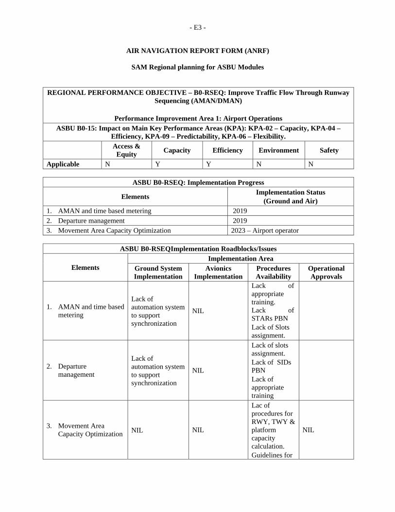
- E3 -
AIR NAVIGATION REPORT FORM (ANRF)
SAM Regional planning for ASBU Modules
REGIONAL PERFORMANCE OBJECTIVE – B0-RSEQ: Improve Traffic Flow Through Runway Sequencing (AMAN/DMAN)
Performance Improvement Area 1: Airport Operations
ASBU B0-15: Impact on Main Key Performance Areas (KPA): KPA-02 – Capacity, KPA-04 – Efficiency, KPA-09 – Predictability, KPA-06 – Flexibility.
Access &
Equity Capacity Efficiency Environment Safety
Applicable N Y Y N N
ASBU B0-RSEQ: Implementation Progress
Elements Implementation Status
(Ground and Air) 1. AMAN and time based metering 2019 2. Departure management 2019 3. Movement Area Capacity Optimization 2023 – Airport operator
ASBU B0-RSEQImplementation Roadblocks/Issues
Elements Implementation Area
Ground System Implementation
Avionics Implementation
Procedures Availability
Operational Approvals
1. AMAN and time based metering
Lack of automation system to support synchronization
NIL
Lack of appropriate training. Lack of STARs PBN Lack of Slots assignment.
2. Departure management
Lack of automation system to support synchronization
NIL
Lack of slots assignment. Lack of SIDs PBN Lack of appropriate training
3. Movement Area Capacity Optimization NIL NIL
Lac of procedures for RWY, TWY & platform capacity calculation. Guidelines for
NIL
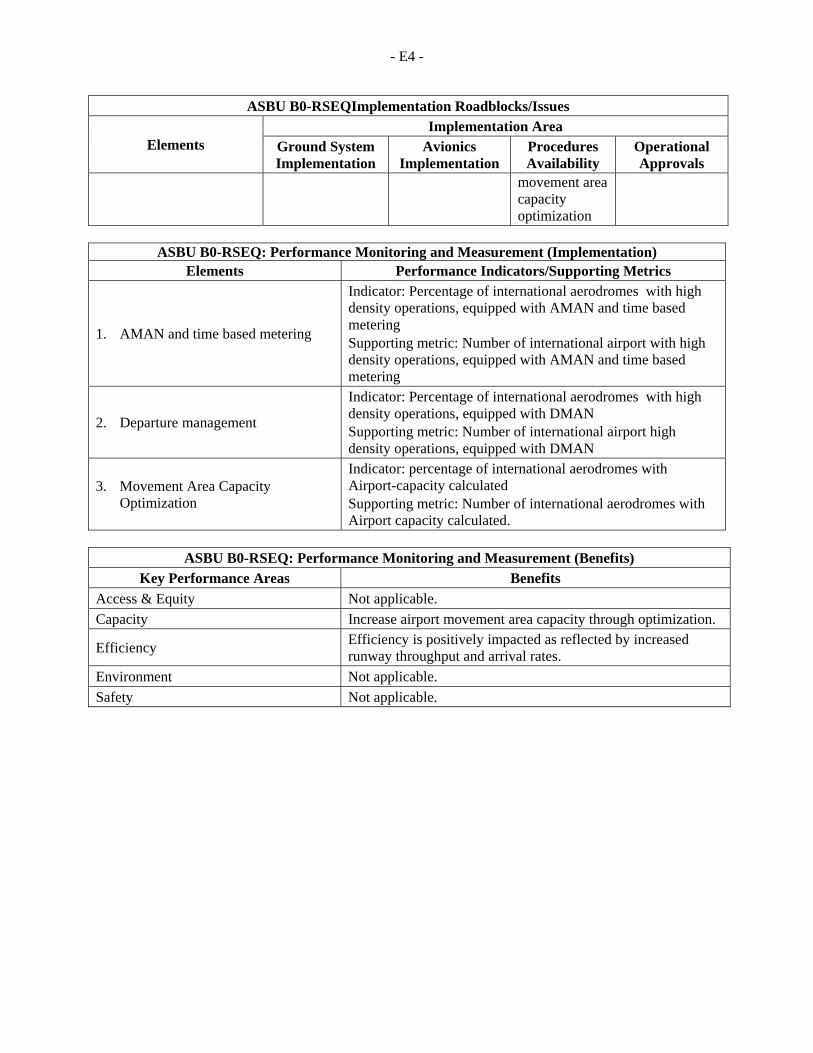
- E4 -
ASBU B0-RSEQImplementation Roadblocks/Issues
Elements Implementation Area
Ground System Implementation
Avionics Implementation
Procedures Availability
Operational Approvals
movement area capacity optimization
ASBU B0-RSEQ: Performance Monitoring and Measurement (Implementation)
Elements Performance Indicators/Supporting Metrics
1. AMAN and time based metering
Indicator: Percentage of international aerodromes with high density operations, equipped with AMAN and time based metering Supporting metric: Number of international airport with high density operations, equipped with AMAN and time based metering
2. Departure management
Indicator: Percentage of international aerodromes with high density operations, equipped with DMAN Supporting metric: Number of international airport high density operations, equipped with DMAN
3. Movement Area Capacity Optimization
Indicator: percentage of international aerodromes with Airport-capacity calculated Supporting metric: Number of international aerodromes with Airport capacity calculated.
ASBU B0-RSEQ: Performance Monitoring and Measurement (Benefits)
Key Performance Areas Benefits
Access & Equity Not applicable.
Capacity Increase airport movement area capacity through optimization.
Efficiency Efficiency is positively impacted as reflected by increased runway throughput and arrival rates.
Environment Not applicable.
Safety Not applicable.
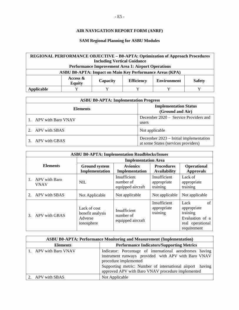
- E5 -
AIR NAVIGATION REPORT FORM (ANRF)
SAM Regional Planning for ASBU Modules
REGIONAL PERFORMANCE OBJECTIVE – B0-APTA: Optimization of Approach Procedures Including Vertical Guidance
Performance Improvement Area 1: Airport Operations ASBU B0-APTA: Impact on Main Key Performance Areas (KPA)
Access & Equity
Capacity Efficiency Environment Safety
Applicable Y Y Y Y Y
ASBU B0-APTA: Implementation Progress
Elements Implementation Status
(Ground and Air)
1. APV with Baro VNAV December 2020 – Service Providers and users
2. APV with SBAS Not applicable
3. APV with GBAS December 2023 – Initial implementation at some States (services providers)
ASBU B0-APTA: Implementation Roadblocks/Issues
Elements Implementation Area
Ground system Implementation
Avionics Implementation
Procedures Availability
Operational Approvals
1. APV with Baro VNAV NIL
Insufficient number of equipped aircraft
Insufficient appropriate training
Lack of appropriate training
2. APV with SBAS Not Applicable Not applicable Not applicable Not applicable
3. APV with GBAS
Lack of cost benefit analysis Adverse ionosphere
Insufficient number of equipped aircraft
Insufficient appropriate training
Lack of appropriate training Evaluation of a real operational requirement
ASBU B0-APTA: Performance Monitoring and Measurement (Implementation)
Elements Performance Indicators/Supporting Metrics 1. APV with Baro VNAV Indicator: Percentage of international aerodromes having
instrument runways provided with APV with Baro VNAV procedure implemented Supporting metric: Number of international airport having approved APV with Baro VNAV procedure implemented
2. APV with SBAS Not Applicable
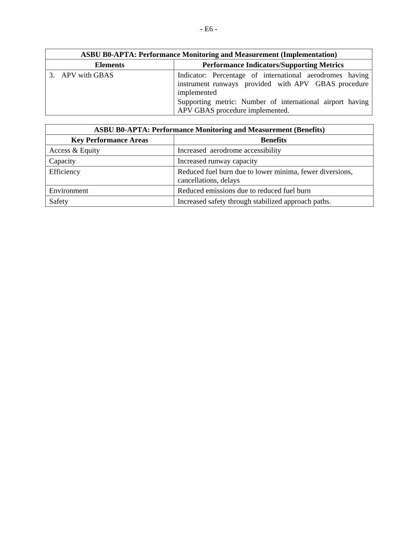
- E6 -
ASBU B0-APTA: Performance Monitoring and Measurement (Implementation) Elements Performance Indicators/Supporting Metrics
3. APV with GBAS Indicator: Percentage of international aerodromes having instrument runways provided with APV GBAS procedure implemented Supporting metric: Number of international airport having APV GBAS procedure implemented.
ASBU B0-APTA: Performance Monitoring and Measurement (Benefits)
Key Performance Areas Benefits Access & Equity Increased aerodrome accessibility
Capacity Increased runway capacity
Efficiency Reduced fuel burn due to lower minima, fewer diversions, cancellations, delays
Environment Reduced emissions due to reduced fuel burn
Safety Increased safety through stabilized approach paths.
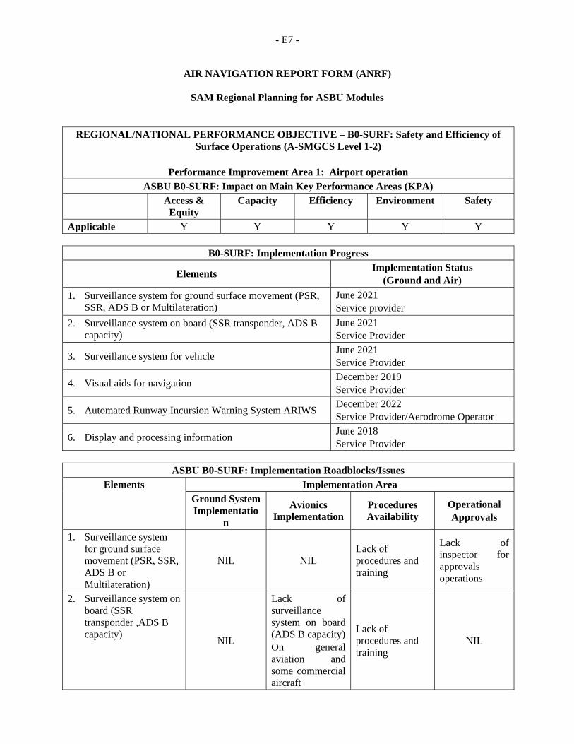
- E7 -
AIR NAVIGATION REPORT FORM (ANRF)
SAM Regional Planning for ASBU Modules
REGIONAL/NATIONAL PERFORMANCE OBJECTIVE – B0-SURF: Safety and Efficiency of Surface Operations (A-SMGCS Level 1-2)
Performance Improvement Area 1: Airport operation
ASBU B0-SURF: Impact on Main Key Performance Areas (KPA) Access &
Equity Capacity Efficiency Environment Safety
Applicable Y Y Y Y Y
B0-SURF: Implementation Progress
Elements Implementation Status
(Ground and Air)
1. Surveillance system for ground surface movement (PSR, SSR, ADS B or Multilateration)
June 2021 Service provider
2. Surveillance system on board (SSR transponder, ADS B capacity)
June 2021 Service Provider
3. Surveillance system for vehicle June 2021 Service Provider
4. Visual aids for navigation December 2019 Service Provider
5. Automated Runway Incursion Warning System ARIWS December 2022 Service Provider/Aerodrome Operator
6. Display and processing information June 2018 Service Provider
ASBU B0-SURF: Implementation Roadblocks/Issues
Elements Implementation Area Ground System Implementatio
n
Avionics Implementation
Procedures Availability
Operational Approvals
1. Surveillance system for ground surface movement (PSR, SSR, ADS B or Multilateration)
NIL NIL Lack of procedures and training
Lack of inspector for approvals operations
2. Surveillance system on board (SSR transponder ,ADS B capacity)
NIL
Lack of surveillance system on board (ADS B capacity) On general aviation and some commercial aircraft
Lack of procedures and training
NIL
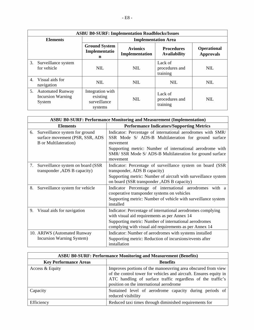
- E8 -
ASBU B0-SURF: Implementation Roadblocks/Issues Elements Implementation Area
Ground System Implementatio
n
Avionics Implementation
Procedures Availability
Operational Approvals
3. Surveillance system for vehicle NIL NIL
Lack of procedures and training
NIL
4. Visual aids for navigation
NIL NIL NIL NIL
5. Automated Runway Incursion Warning System
Integration with existing
surveillance systems
NIL Lack of procedures and training
NIL
ASBU B0-SURF: Performance Monitoring and Measurement (Implementation) Elements Performance Indicators/Supporting Metrics
6. Surveillance system for ground surface movement (PSR, SSR, ADS B or Multilateration)
Indicator: Percentage of international aerodromes with SMR/ SSR Mode S/ ADS-B Multilateration for ground surface movement Supporting metric: Number of international aerodrome with SMR/ SSR Mode S/ ADS-B Multilateration for ground surface movement
7. Surveillance system on board (SSR transponder ,ADS B capacity)
Indicator: Percentage of surveillance system on board (SSR transponder, ADS B capacity) Supporting metric: Number of aircraft with surveillance system on board (SSR transponder ,ADS B capacity)
8. Surveillance system for vehicle Indicator Percentage of international aerodromes with a cooperative transponder systems on vehicles Supporting metric: Number of vehicle with surveillance system installed
9. Visual aids for navigation Indicator: Percentage of international aerodromes complying with visual aid requirements as per Annex 14 Supporting metric: Number of international aerodromes complying with visual aid requirements as per Annex 14
10. ARIWS (Automated Runway Incursion Warning System)
Indicator: Number of aerodromes with systems installed Supporting metric: Reduction of incursions/events after installation
ASBU B0-SURF: Performance Monitoring and Measurement (Benefits)
Key Performance Areas Benefits Access & Equity Improves portions of the manoeuvring area obscured from view
of the control tower for vehicles and aircraft. Ensures equity in ATC handling of surface traffic regardless of the traffic’s position on the international aerodrome
Capacity Sustained level of aerodrome capacity during periods of reduced visibility
Efficiency Reduced taxi times through diminished requirements for

- E9 -
ASBU B0-SURF: Performance Monitoring and Measurement (Benefits) Key Performance Areas Benefits
intermediate holdings based on reliance on visual surveillance only. Reduced fuel burn
Environment Reduced emissions due to reduced fuel burn
Safety Reduced runway incursions. Improved response to unsafe situations. Improved situational awareness leading to reduced ATC workload
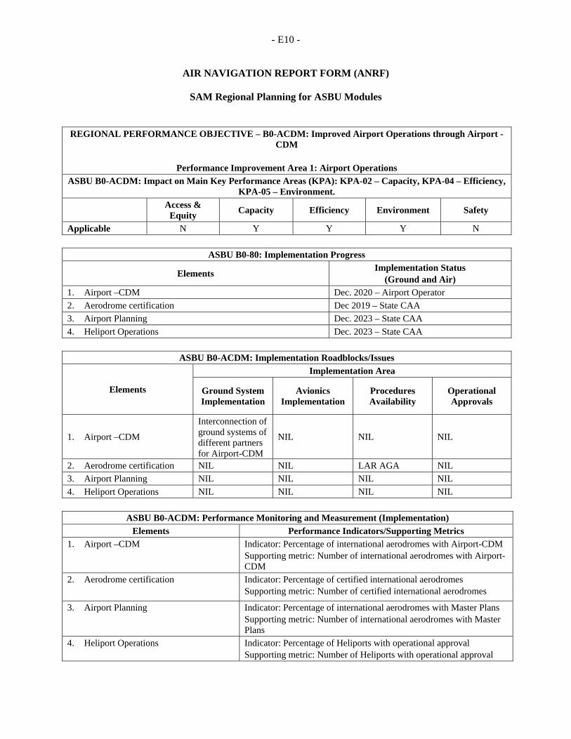
- E10 -
AIR NAVIGATION REPORT FORM (ANRF)
SAM Regional Planning for ASBU Modules
REGIONAL PERFORMANCE OBJECTIVE – B0-ACDM: Improved Airport Operations through Airport - CDM
Performance Improvement Area 1: Airport Operations
ASBU B0-ACDM: Impact on Main Key Performance Areas (KPA): KPA-02 – Capacity, KPA-04 – Efficiency, KPA-05 – Environment.
Access & Equity
Capacity Efficiency Environment Safety
Applicable N Y Y Y N
ASBU B0-80: Implementation Progress
Elements Implementation Status
(Ground and Air) 1. Airport –CDM Dec. 2020 – Airport Operator
2. Aerodrome certification Dec 2019 – State CAA
3. Airport Planning Dec. 2023 – State CAA
4. Heliport Operations Dec. 2023 – State CAA
ASBU B0-ACDM: Implementation Roadblocks/Issues
Elements
Implementation Area
Ground System Implementation
Avionics Implementation
Procedures Availability
Operational Approvals
1. Airport –CDM
Interconnection of ground systems of different partners for Airport-CDM
NIL NIL NIL
2. Aerodrome certification NIL NIL LAR AGA NIL
3. Airport Planning NIL NIL NIL NIL
4. Heliport Operations NIL NIL NIL NIL
ASBU B0-ACDM: Performance Monitoring and Measurement (Implementation)
Elements Performance Indicators/Supporting Metrics 1. Airport –CDM Indicator: Percentage of international aerodromes with Airport-CDM
Supporting metric: Number of international aerodromes with Airport-CDM
2. Aerodrome certification Indicator: Percentage of certified international aerodromes Supporting metric: Number of certified international aerodromes
3. Airport Planning Indicator: Percentage of international aerodromes with Master Plans Supporting metric: Number of international aerodromes with Master Plans
4. Heliport Operations Indicator: Percentage of Heliports with operational approval Supporting metric: Number of Heliports with operational approval
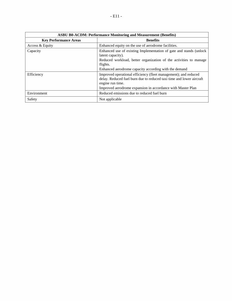
- E11 -
ASBU B0-ACDM: Performance Monitoring and Measurement (Benefits)
Key Performance Areas Benefits Access & Equity Enhanced equity on the use of aerodrome facilities.
Capacity Enhanced use of existing Implementation of gate and stands (unlock latent capacity). Reduced workload, better organization of the activities to manage flights. Enhanced aerodrome capacity according with the demand
Efficiency Improved operational efficiency (fleet management); and reduced delay. Reduced fuel burn due to reduced taxi time and lower aircraft engine run time. Improved aerodrome expansion in accordance with Master Plan
Environment Reduced emissions due to reduced fuel burn
Safety Not applicable
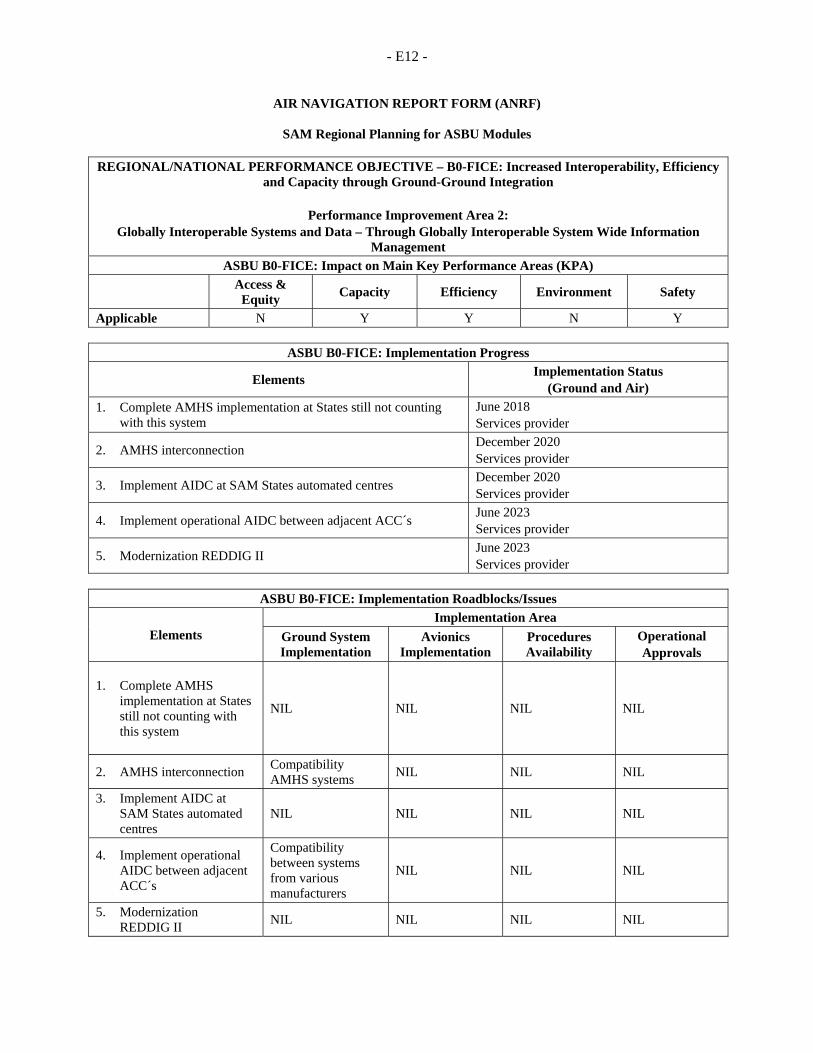
- E12 -
AIR NAVIGATION REPORT FORM (ANRF)
SAM Regional Planning for ASBU Modules
REGIONAL/NATIONAL PERFORMANCE OBJECTIVE – B0-FICE: Increased Interoperability, Efficiency and Capacity through Ground-Ground Integration
Performance Improvement Area 2:
Globally Interoperable Systems and Data – Through Globally Interoperable System Wide Information Management
ASBU B0-FICE: Impact on Main Key Performance Areas (KPA)
Access &
Equity Capacity Efficiency Environment Safety
Applicable N Y Y N Y
ASBU B0-FICE: Implementation Progress
Elements Implementation Status
(Ground and Air)
1. Complete AMHS implementation at States still not counting with this system
June 2018 Services provider
2. AMHS interconnection December 2020 Services provider
3. Implement AIDC at SAM States automated centres December 2020 Services provider
4. Implement operational AIDC between adjacent ACC´s June 2023 Services provider
5. Modernization REDDIG II June 2023 Services provider
ASBU B0-FICE: Implementation Roadblocks/Issues
Elements Implementation Area
Ground System Implementation
Avionics Implementation
Procedures Availability
Operational Approvals
1. Complete AMHS implementation at States still not counting with this system
NIL NIL NIL NIL
2. AMHS interconnection Compatibility AMHS systems
NIL NIL NIL
3. Implement AIDC at SAM States automated centres
NIL NIL NIL NIL
4. Implement operational AIDC between adjacent ACC´s
Compatibility between systems from various manufacturers
NIL NIL NIL
5. Modernization REDDIG II
NIL NIL NIL NIL
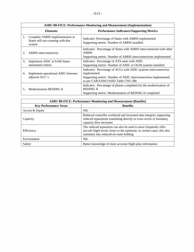
- E13 -
ASBU B0-FICE: Performance Monitoring and Measurement (Implementation)
Elements Performance Indicators/Supporting Metrics
1. Complete AMHS implementation at States still not counting with this system
Indicator: Percentage of States with AMHS implemented Supporting metric: Number of AMHS installed
2. AMHS interconnection Indicator: Percentage of States with AMHS interconnected with other AMHS Supporting metric: Number of AMHS interconnections implemented
3. Implement AIDC at SAM States automated centres
Indicator: Percentage of ATS units with AIDC Supporting metric: Number of AIDC or OLDI systems installed
4. Implement operational AIDC between adjacent ACC´s
Indicator: Percentage of ACCs with AIDC systems interconnection implemented Supporting metric: Number of AIDC interconnections implemented, as per CAR/SAM FASID Table CNS 1Bb
5. Modernization REDDIG II Indicator: Percentage of phases completed for the modernization of REDDIG II Supporting metric: Modernisation of REDDIG II completed
ASBU B0-FICE: Performance Monitoring and Measurement (Benefits)
Key Performance Areas Benefits
Access & Equity NIL
Capacity Reduced controller workload and increased data integrity supporting reduced separations translating directly to cross sector or boundary capacity flow increases
Efficiency The reduced separation can also be used to more frequently offer aircraft flight levels closer to the optimum; in certain cases, this also translates into reduced en-route holding
Environment NIL
Safety Better knowledge of more accurate flight plan information
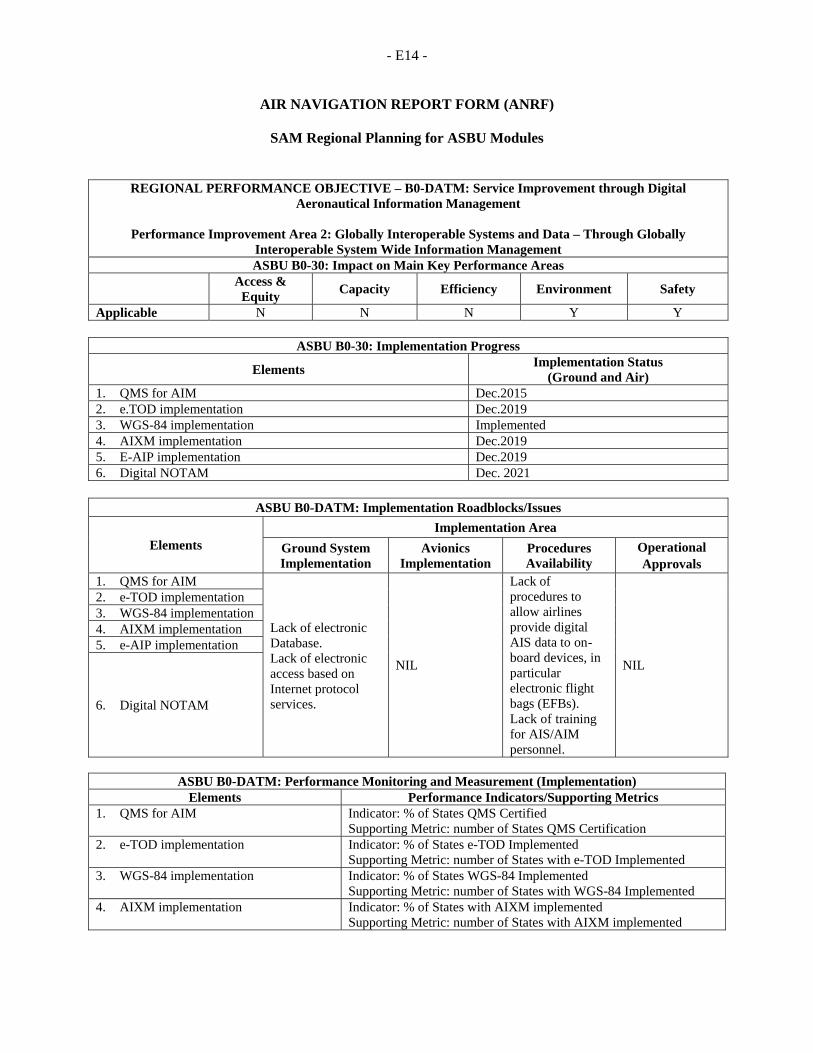
- E14 -
AIR NAVIGATION REPORT FORM (ANRF)
SAM Regional Planning for ASBU Modules
REGIONAL PERFORMANCE OBJECTIVE – B0-DATM: Service Improvement through Digital Aeronautical Information Management
Performance Improvement Area 2: Globally Interoperable Systems and Data – Through Globally
Interoperable System Wide Information Management ASBU B0-30: Impact on Main Key Performance Areas
Access & Equity
Capacity Efficiency Environment Safety
Applicable N N N Y Y
ASBU B0-30: Implementation Progress
Elements Implementation Status
(Ground and Air) 1. QMS for AIM Dec.2015 2. e.TOD implementation Dec.2019 3. WGS-84 implementation Implemented 4. AIXM implementation Dec.2019 5. E-AIP implementation Dec.2019 6. Digital NOTAM Dec. 2021
ASBU B0-DATM: Implementation Roadblocks/Issues
Elements Implementation Area
Ground System Implementation
Avionics Implementation
Procedures Availability
Operational Approvals
1. QMS for AIM
Lack of electronic Database. Lack of electronic access based on Internet protocol services.
NIL
Lack of procedures to allow airlines provide digital AIS data to on-board devices, in particular electronic flight bags (EFBs). Lack of training for AIS/AIM personnel.
NIL
2. e-TOD implementation 3. WGS-84 implementation 4. AIXM implementation 5. e-AIP implementation
6. Digital NOTAM
ASBU B0-DATM: Performance Monitoring and Measurement (Implementation)
Elements Performance Indicators/Supporting Metrics1. QMS for AIM Indicator: % of States QMS Certified
Supporting Metric: number of States QMS Certification 2. e-TOD implementation Indicator: % of States e-TOD Implemented
Supporting Metric: number of States with e-TOD Implemented 3. WGS-84 implementation Indicator: % of States WGS-84 Implemented
Supporting Metric: number of States with WGS-84 Implemented 4. AIXM implementation Indicator: % of States with AIXM implemented
Supporting Metric: number of States with AIXM implemented

- E15 -
ASBU B0-DATM: Performance Monitoring and Measurement (Implementation) Elements Performance Indicators/Supporting Metrics
5. e-AIP implementation Indicator: % of States with e-AIP Implemented Supporting Metric: number of States with e-AIP Implemented
6. Digital NOTAM Indicator: % of States with Digital NOTAM Implemented Supporting Metric: number of States with Digital NOTAM Implemented
ASBU B0-DATM: Performance Monitoring and Measurement (Benefits)
Key Performance Areas Benefits Access & Equity NA Capacity NA Efficiency NA Environment Reduced amount of paper for promulgation of information Safety Reduction in the number of possible inconsistencies
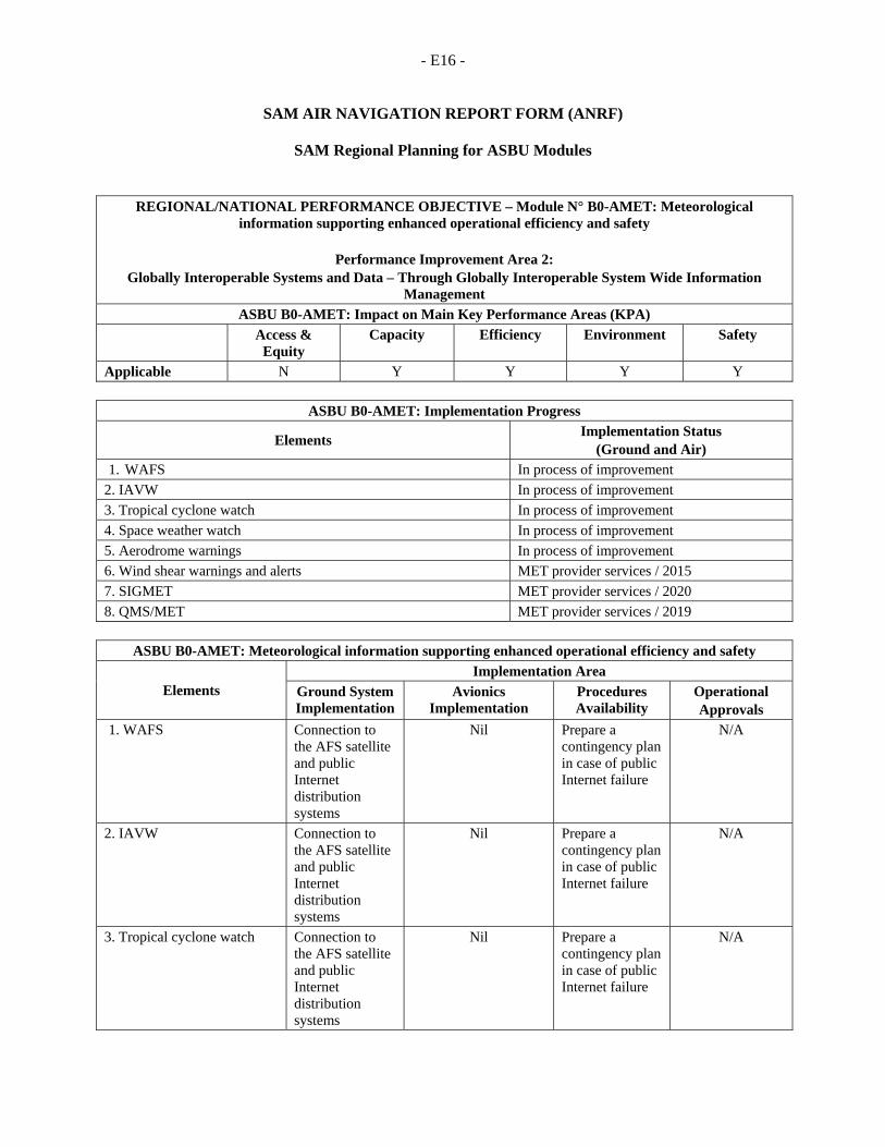
- E16 -
SAM AIR NAVIGATION REPORT FORM (ANRF)
SAM Regional Planning for ASBU Modules
REGIONAL/NATIONAL PERFORMANCE OBJECTIVE – Module N° B0-AMET: Meteorological information supporting enhanced operational efficiency and safety
Performance Improvement Area 2:
Globally Interoperable Systems and Data – Through Globally Interoperable System Wide Information Management
ASBU B0-AMET: Impact on Main Key Performance Areas (KPA) Access &
Equity Capacity Efficiency Environment Safety
Applicable N Y Y Y Y
ASBU B0-AMET: Implementation Progress
Elements Implementation Status
(Ground and Air) 1. WAFS In process of improvement
2. IAVW In process of improvement
3. Tropical cyclone watch In process of improvement
4. Space weather watch In process of improvement
5. Aerodrome warnings In process of improvement
6. Wind shear warnings and alerts MET provider services / 2015
7. SIGMET MET provider services / 2020
8. QMS/MET MET provider services / 2019
ASBU B0-AMET: Meteorological information supporting enhanced operational efficiency and safety
Elements Implementation Area
Ground System Implementation
Avionics Implementation
Procedures Availability
Operational Approvals
1. WAFS Connection to the AFS satellite and public Internet distribution systems
Nil Prepare a contingency plan in case of public Internet failure
N/A
2. IAVW Connection to the AFS satellite and public Internet distribution systems
Nil Prepare a contingency plan in case of public Internet failure
N/A
3. Tropical cyclone watch Connection to the AFS satellite and public Internet distribution systems
Nil Prepare a contingency plan in case of public Internet failure
N/A
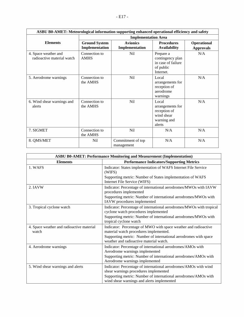
- E17 -
ASBU B0-AMET: Meteorological information supporting enhanced operational efficiency and safety
Elements Implementation Area
Ground System Implementation
Avionics Implementation
Procedures Availability
Operational Approvals
4. Space weather and radioactive material watch
Connection to AMHS
Nil Prepare a contingency plan in case of failure of public Internet.
N/A
5. Aerodrome warnings Connection to the AMHS
Nil Local arrangements for reception of aerodrome warnings
N/A
6. Wind shear warnings and alerts
Connection to the AMHS
Nil Local arrangements for reception of wind shear warning and alerts
N/A
7. SIGMET Connection to the AMHS
Nil N/A N/A
8. QMS/MET Nil Commitment of top management
N/A N/A
ASBU B0-AMET: Performance Monitoring and Measurement (Implementation)
Elements Performance Indicators/Supporting Metrics
1. WAFS Indicator: States implementation of WAFS Internet File Service (WIFS) Supporting metric: Number of States implementation of WAFS Internet File Service (WIFS)
2. IAVW Indicator: Percentage of international aerodromes/MWOs with IAVW procedures implemented Supporting metric: Number of international aerodromes/MWOs with IAVW procedures implemented
3. Tropical cyclone watch Indicator: Percentage of international aerodromes/MWOs with tropical cyclone watch procedures implemented Supporting metric: Number of international aerodromes/MWOs with tropical cyclone watch
4. Space weather and radioactive material watch
Indicator: Percentage of MWO with space weather and radioactive material watch procedures implemented. Supporting metric: Number of international aerodromes with space weather and radioactive material watch.
4. Aerodrome warnings Indicator: Percentage of international aerodromes/AMOs with Aerodrome warnings implemented Supporting metric: Number of international aerodromes/AMOs with Aerodrome warnings implemented
5. Wind shear warnings and alerts Indicator: Percentage of international aerodromes/AMOs with wind shear warnings procedures implemented Supporting metric: Number of international aerodromes/AMOs with wind shear warnings and alerts implemented
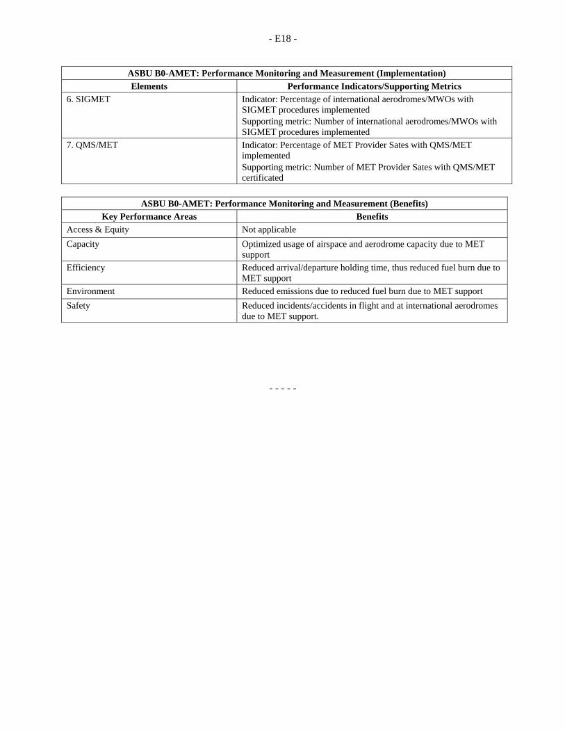
- E18 -
ASBU B0-AMET: Performance Monitoring and Measurement (Implementation)
Elements Performance Indicators/Supporting Metrics 6. SIGMET Indicator: Percentage of international aerodromes/MWOs with
SIGMET procedures implemented Supporting metric: Number of international aerodromes/MWOs with SIGMET procedures implemented
7. QMS/MET Indicator: Percentage of MET Provider Sates with QMS/MET implemented Supporting metric: Number of MET Provider Sates with QMS/MET certificated
ASBU B0-AMET: Performance Monitoring and Measurement (Benefits)
Key Performance Areas Benefits
Access & Equity Not applicable
Capacity Optimized usage of airspace and aerodrome capacity due to MET support
Efficiency Reduced arrival/departure holding time, thus reduced fuel burn due to MET support
Environment Reduced emissions due to reduced fuel burn due to MET support
Safety Reduced incidents/accidents in flight and at international aerodromes due to MET support.
- - - - -
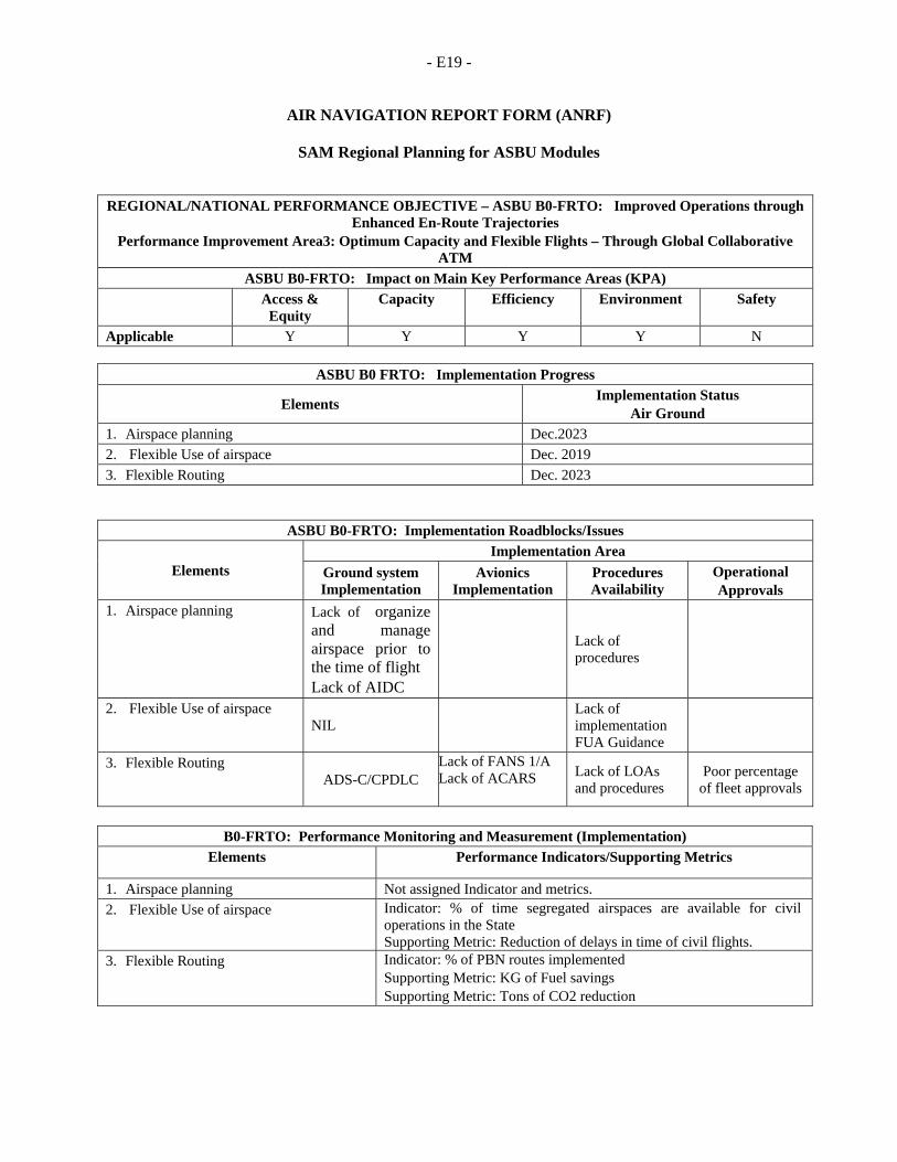
- E19 -
AIR NAVIGATION REPORT FORM (ANRF)
SAM Regional Planning for ASBU Modules
REGIONAL/NATIONAL PERFORMANCE OBJECTIVE – ASBU B0-FRTO: Improved Operations through Enhanced En-Route Trajectories
Performance Improvement Area3: Optimum Capacity and Flexible Flights – Through Global Collaborative ATM
ASBU B0-FRTO: Impact on Main Key Performance Areas (KPA) Access &
Equity Capacity Efficiency Environment Safety
Applicable Y Y Y Y N
ASBU B0 FRTO: Implementation Progress
Elements Implementation Status
Air Ground 1. Airspace planning Dec.2023
2. Flexible Use of airspace Dec. 2019
3. Flexible Routing Dec. 2023
B0-FRTO: Performance Monitoring and Measurement (Implementation)
Elements Performance Indicators/Supporting Metrics
1. Airspace planning Not assigned Indicator and metrics.
2. Flexible Use of airspace Indicator: % of time segregated airspaces are available for civil operations in the State Supporting Metric: Reduction of delays in time of civil flights.
3. Flexible Routing Indicator: % of PBN routes implemented Supporting Metric: KG of Fuel savings Supporting Metric: Tons of CO2 reduction
ASBU B0-FRTO: Implementation Roadblocks/Issues
Elements Implementation Area
Ground system Implementation
Avionics Implementation
Procedures Availability
Operational Approvals
1. Airspace planning Lack of organize and manage airspace prior to the time of flight Lack of AIDC
Lack of procedures
2. Flexible Use of airspace NIL
Lack of implementation FUA Guidance
3. Flexible Routing ADS-C/CPDLC
Lack of FANS 1/A Lack of ACARS
Lack of LOAs and procedures
Poor percentage of fleet approvals

- E20 -
ASBU B0-FRTO: Performance Monitoring and Measurement (Benefits)
Key Performance Areas Benefits Access & Equity Better access to airspace by a reduction of the permanently segregated
volumes of airspace.
Capacity Flexible routing reduces potential congestion on trunk routes and at busy crossing points. The flexible use of airspace gives greater possibilities to separate flights horizontally. PBN helps to reduce route spacing and aircraft separations.
Efficiency In particular the module will reduce flight length and related fuel burn and emissions. The module will reduce the number of flight diversions and cancellations. It will also better allow avoiding noise sensitive areas.
Environment Fuel burn and emissions will be reduced
Safety NA
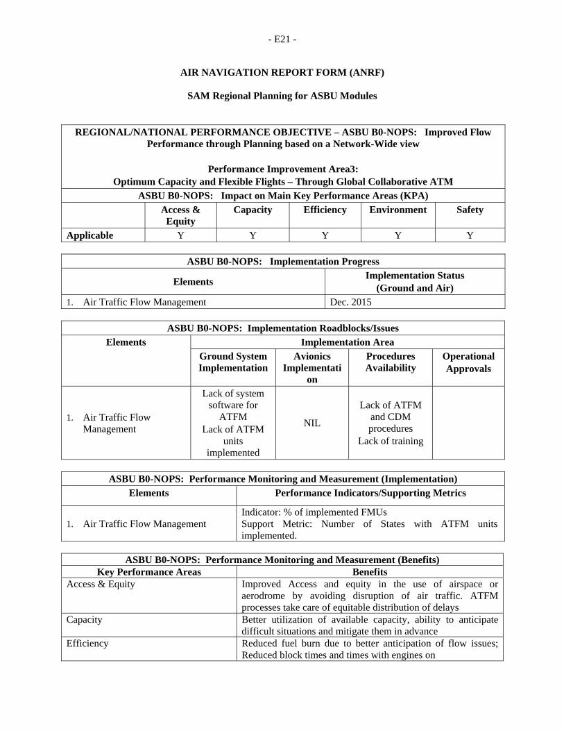
- E21 -
AIR NAVIGATION REPORT FORM (ANRF)
SAM Regional Planning for ASBU Modules
REGIONAL/NATIONAL PERFORMANCE OBJECTIVE – ASBU B0-NOPS: Improved Flow Performance through Planning based on a Network-Wide view
Performance Improvement Area3:
Optimum Capacity and Flexible Flights – Through Global Collaborative ATM ASBU B0-NOPS: Impact on Main Key Performance Areas (KPA)
Access & Equity
Capacity Efficiency Environment Safety
Applicable Y Y Y Y Y
ASBU B0-NOPS: Implementation Progress
Elements Implementation Status
(Ground and Air) 1. Air Traffic Flow Management Dec. 2015
ASBU B0-NOPS: Implementation Roadblocks/Issues Elements Implementation Area
Ground System Implementation
Avionics Implementati
on
Procedures Availability
Operational Approvals
1. Air Traffic Flow Management
Lack of system software for
ATFM Lack of ATFM
units implemented
NIL
Lack of ATFM and CDM procedures
Lack of training
ASBU B0-NOPS: Performance Monitoring and Measurement (Implementation)
Elements Performance Indicators/Supporting Metrics
1. Air Traffic Flow Management Indicator: % of implemented FMUs Support Metric: Number of States with ATFM units implemented.
ASBU B0-NOPS: Performance Monitoring and Measurement (Benefits)
Key Performance Areas Benefits Access & Equity Improved Access and equity in the use of airspace or
aerodrome by avoiding disruption of air traffic. ATFM processes take care of equitable distribution of delays
Capacity Better utilization of available capacity, ability to anticipate difficult situations and mitigate them in advance
Efficiency Reduced fuel burn due to better anticipation of flow issues; Reduced block times and times with engines on

- E22 -
ASBU B0-NOPS: Performance Monitoring and Measurement (Benefits) Key Performance Areas Benefits
Environment Reduced fuel burn as delays are absorbed on the ground, with shut engines; or at optimum flight levels through speed or route management
Safety Reduced occurrences of undesired sector overloads
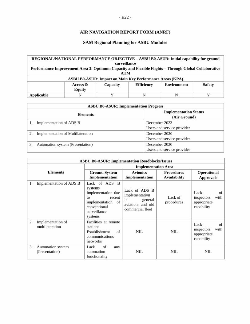
- E22 -
AIR NAVIGATION REPORT FORM (ANRF)
SAM Regional Planning for ASBU Modules
REGIONAL/NATIONAL PERFORMANCE OBJECTIVE – ASBU B0-ASUR: Initial capability for ground surveillance
Performance Improvement Area 3: Optimum Capacity and Flexible Flights – Through Global Collaborative ATM
ASBU B0-ASUR: Impact on Main Key Performance Areas (KPA) Access &
Equity Capacity Efficiency Environment Safety
Applicable N Y N N Y
ASBU B0-ASUR: Implementation Progress
Elements Implementation Status
(Air Ground) 1. Implementation of ADS B December 2023
Users and service provider
2. Implementation of Multilateration December 2020 Users and service provider
3. Automation system (Presentation) December 2020 Users and service provider
ASBU B0-ASUR: Implementation Roadblocks/Issues
Elements Implementation Area
Ground System Implementation
Avionics Implementation
Procedures Availability
Operational Approvals
1. Implementation of ADS B Lack of ADS B systems implementation due to recent implementation of conventional surveillance systems
Lack of ADS B implementation in general aviation, and old commercial fleet
Lack of procedures
Lack of inspectors with appropriate capability
2. Implementation of multilateration
Facilities at remote stations Establishment of communications networks
NIL NIL
Lack of inspectors with appropriate capability
3. Automation system (Presentation)
Lack of any automation functionality
NIL NIL NIL
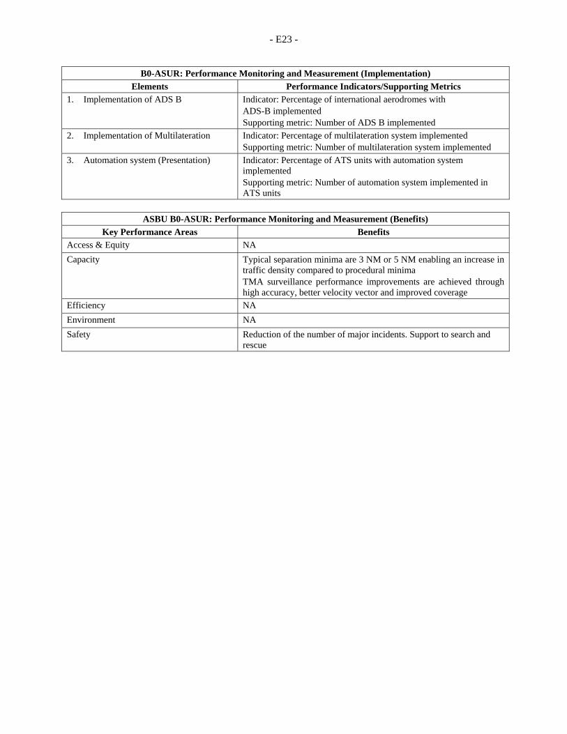
- E23 -
B0-ASUR: Performance Monitoring and Measurement (Implementation)
Elements Performance Indicators/Supporting Metrics 1. Implementation of ADS B Indicator: Percentage of international aerodromes with
ADS-B implemented Supporting metric: Number of ADS B implemented
2. Implementation of Multilateration Indicator: Percentage of multilateration system implemented Supporting metric: Number of multilateration system implemented
3. Automation system (Presentation) Indicator: Percentage of ATS units with automation system implemented Supporting metric: Number of automation system implemented in ATS units
ASBU B0-ASUR: Performance Monitoring and Measurement (Benefits)
Key Performance Areas Benefits Access & Equity NA
Capacity Typical separation minima are 3 NM or 5 NM enabling an increase in traffic density compared to procedural minima TMA surveillance performance improvements are achieved through high accuracy, better velocity vector and improved coverage
Efficiency NA
Environment NA
Safety Reduction of the number of major incidents. Support to search and rescue
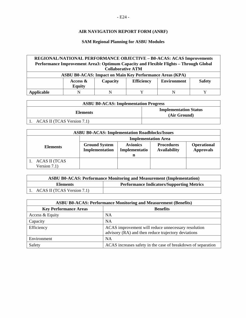
- E24 -
AIR NAVIGATION REPORT FORM (ANRF)
SAM Regional Planning for ASBU Modules
REGIONAL/NATIONAL PERFORMANCE OBJECTIVE – B0-ACAS: ACAS Improvements Performance Improvement Area3: Optimum Capacity and Flexible Flights – Through Global
Collaborative ATM ASBU B0-ACAS: Impact on Main Key Performance Areas (KPA)
Access & Equity
Capacity Efficiency Environment Safety
Applicable N N Y N Y
ASBU B0-ACAS: Implementation Progress
Elements Implementation Status
(Air Ground) 1. ACAS II (TCAS Version 7.1)
ASBU B0-ACAS: Implementation Roadblocks/Issues
Elements
Implementation Area Ground System Implementation
Avionics Implementatio
n
Procedures Availability
Operational Approvals
1. ACAS II (TCAS Version 7.1)
ASBU B0-ACAS: Performance Monitoring and Measurement (Implementation) Elements Performance Indicators/Supporting Metrics
1. ACAS II (TCAS Version 7.1)
ASBU B0-ACAS: Performance Monitoring and Measurement (Benefits)
Key Performance Areas Benefits Access & Equity NA
Capacity NA
Efficiency ACAS improvement will reduce unnecessary resolution advisory (RA) and then reduce trajectory deviations
Environment NA
Safety ACAS increases safety in the case of breakdown of separation
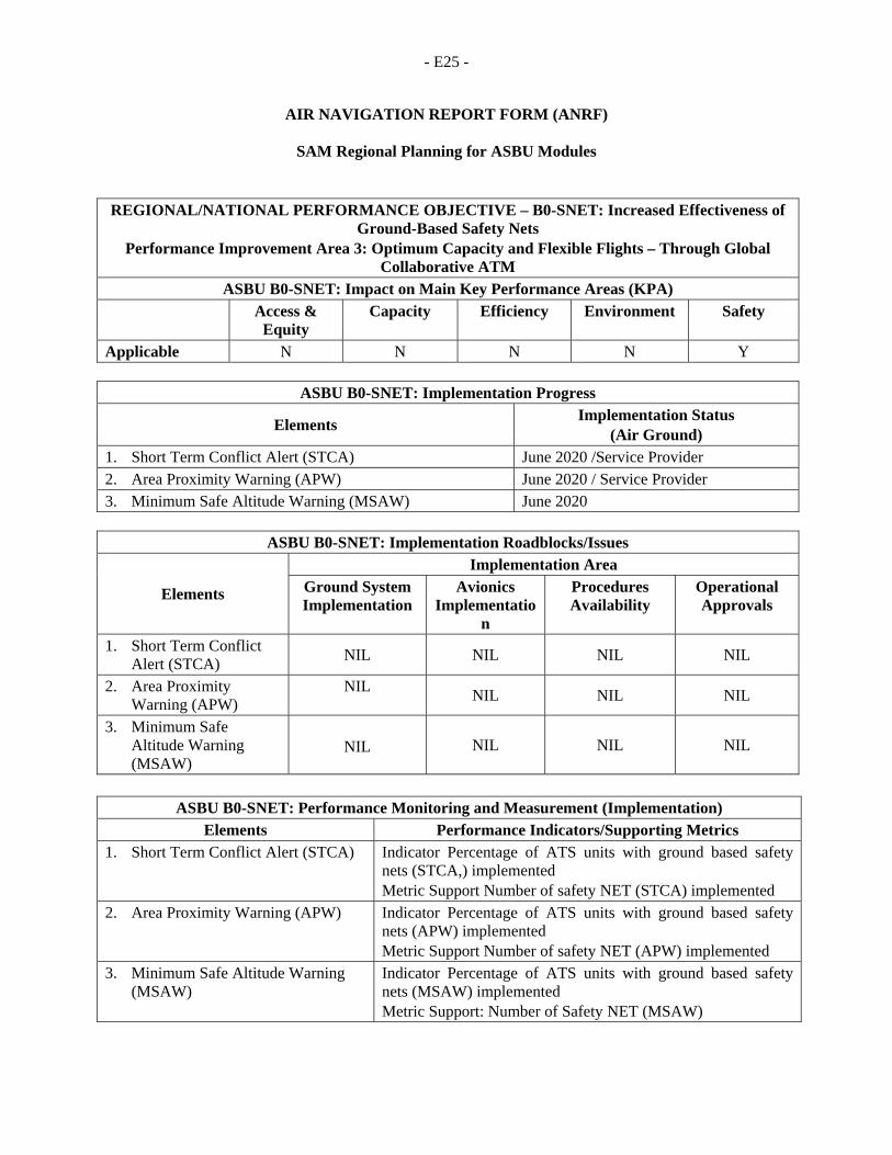
- E25 -
AIR NAVIGATION REPORT FORM (ANRF)
SAM Regional Planning for ASBU Modules
REGIONAL/NATIONAL PERFORMANCE OBJECTIVE – B0-SNET: Increased Effectiveness of Ground-Based Safety Nets
Performance Improvement Area 3: Optimum Capacity and Flexible Flights – Through Global Collaborative ATM
ASBU B0-SNET: Impact on Main Key Performance Areas (KPA) Access &
Equity Capacity Efficiency Environment Safety
Applicable N N N N Y
ASBU B0-SNET: Implementation Progress
Elements Implementation Status
(Air Ground) 1. Short Term Conflict Alert (STCA) June 2020 /Service Provider 2. Area Proximity Warning (APW) June 2020 / Service Provider 3. Minimum Safe Altitude Warning (MSAW) June 2020
ASBU B0-SNET: Implementation Roadblocks/Issues
Elements
Implementation Area Ground System Implementation
Avionics Implementatio
n
Procedures Availability
Operational Approvals
1. Short Term Conflict Alert (STCA)
NIL NIL NIL NIL
2. Area Proximity Warning (APW)
NIL NIL NIL NIL
3. Minimum Safe Altitude Warning (MSAW)
NIL NIL NIL NIL
ASBU B0-SNET: Performance Monitoring and Measurement (Implementation) Elements Performance Indicators/Supporting Metrics
1. Short Term Conflict Alert (STCA) Indicator Percentage of ATS units with ground based safety nets (STCA,) implemented Metric Support Number of safety NET (STCA) implemented
2. Area Proximity Warning (APW) Indicator Percentage of ATS units with ground based safety nets (APW) implemented Metric Support Number of safety NET (APW) implemented
3. Minimum Safe Altitude Warning (MSAW)
Indicator Percentage of ATS units with ground based safety nets (MSAW) implemented Metric Support: Number of Safety NET (MSAW)

- E26 -
ASBU B0-SNET: Performance Monitoring and Measurement (Benefits) Key Performance Areas Benefits
Access & Equity NA
Capacity NA
Efficiency NA
Environment NA
Safety Significant reduction of the number of major incidents
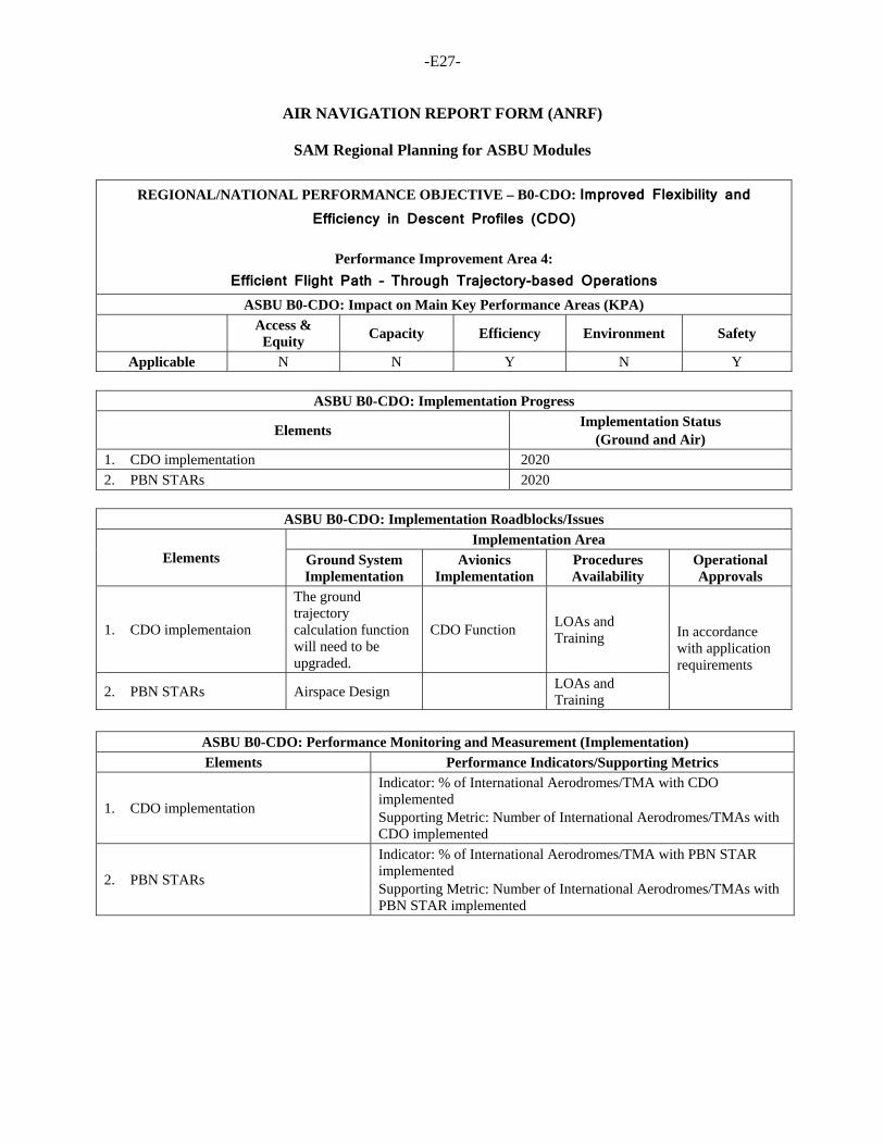
-E27-
AIR NAVIGATION REPORT FORM (ANRF)
SAM Regional Planning for ASBU Modules
REGIONAL/NATIONAL PERFORMANCE OBJECTIVE – B0-CDO: Improved Flexibility and Efficiency in Descent Profiles (CDO)
Performance Improvement Area 4:
Efficient Flight Path – Through Trajectory-based Operations
ASBU B0-CDO: Impact on Main Key Performance Areas (KPA)
Access &
Equity Capacity Efficiency Environment Safety
Applicable N N Y N Y
ASBU B0-CDO: Implementation Progress
Elements Implementation Status
(Ground and Air) 1. CDO implementation 2020
2. PBN STARs 2020
ASBU B0-CDO: Implementation Roadblocks/Issues
Elements Implementation Area
Ground System Implementation
Avionics Implementation
Procedures Availability
Operational Approvals
1. CDO implementaion
The ground trajectory calculation function will need to be upgraded.
CDO Function LOAs and Training In accordance
with application requirements
2. PBN STARs Airspace Design LOAs and Training
ASBU B0-CDO: Performance Monitoring and Measurement (Implementation)
Elements Performance Indicators/Supporting Metrics
1. CDO implementation
Indicator: % of International Aerodromes/TMA with CDO implemented Supporting Metric: Number of International Aerodromes/TMAs with CDO implemented
2. PBN STARs
Indicator: % of International Aerodromes/TMA with PBN STAR implemented Supporting Metric: Number of International Aerodromes/TMAs with PBN STAR implemented
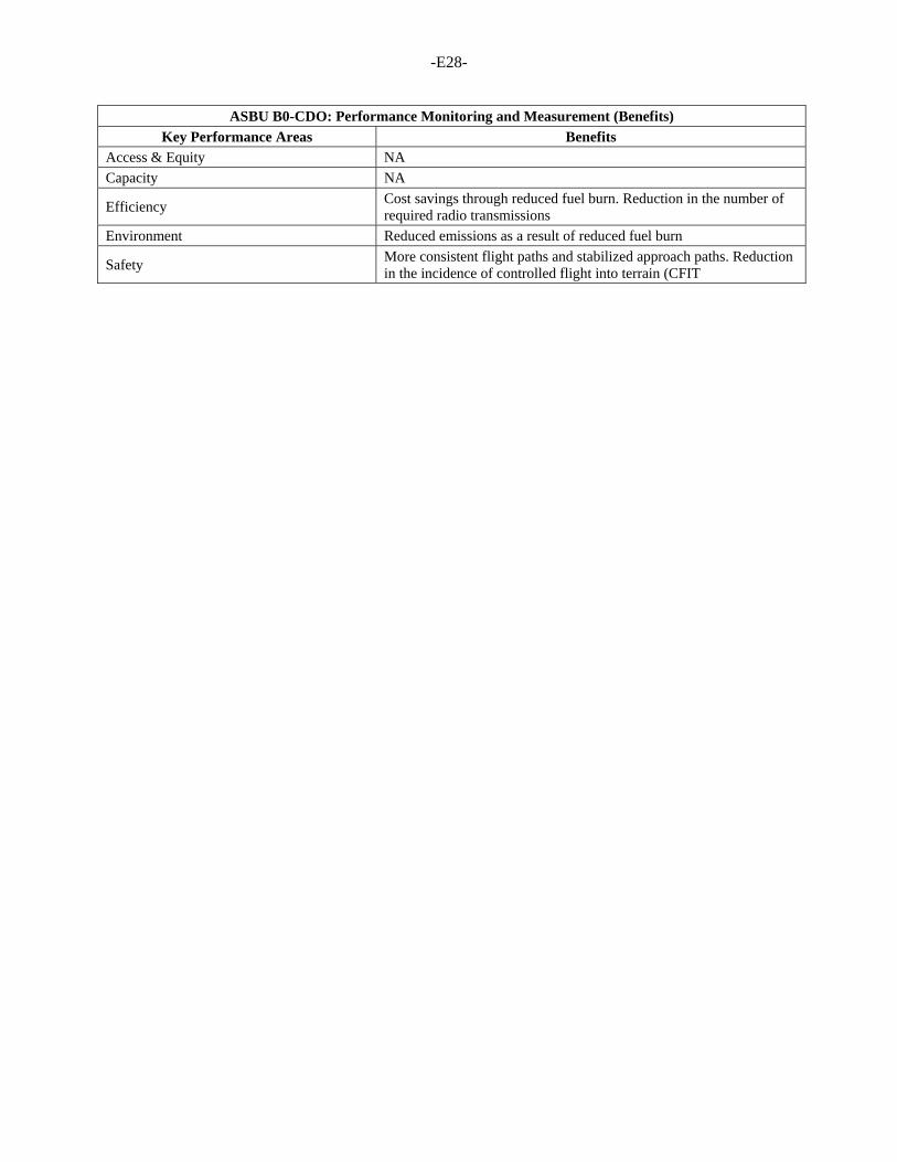
-E28-
ASBU B0-CDO: Performance Monitoring and Measurement (Benefits)
Key Performance Areas Benefits Access & Equity NA
Capacity NA
Efficiency Cost savings through reduced fuel burn. Reduction in the number of required radio transmissions
Environment Reduced emissions as a result of reduced fuel burn
Safety More consistent flight paths and stabilized approach paths. Reduction in the incidence of controlled flight into terrain (CFIT
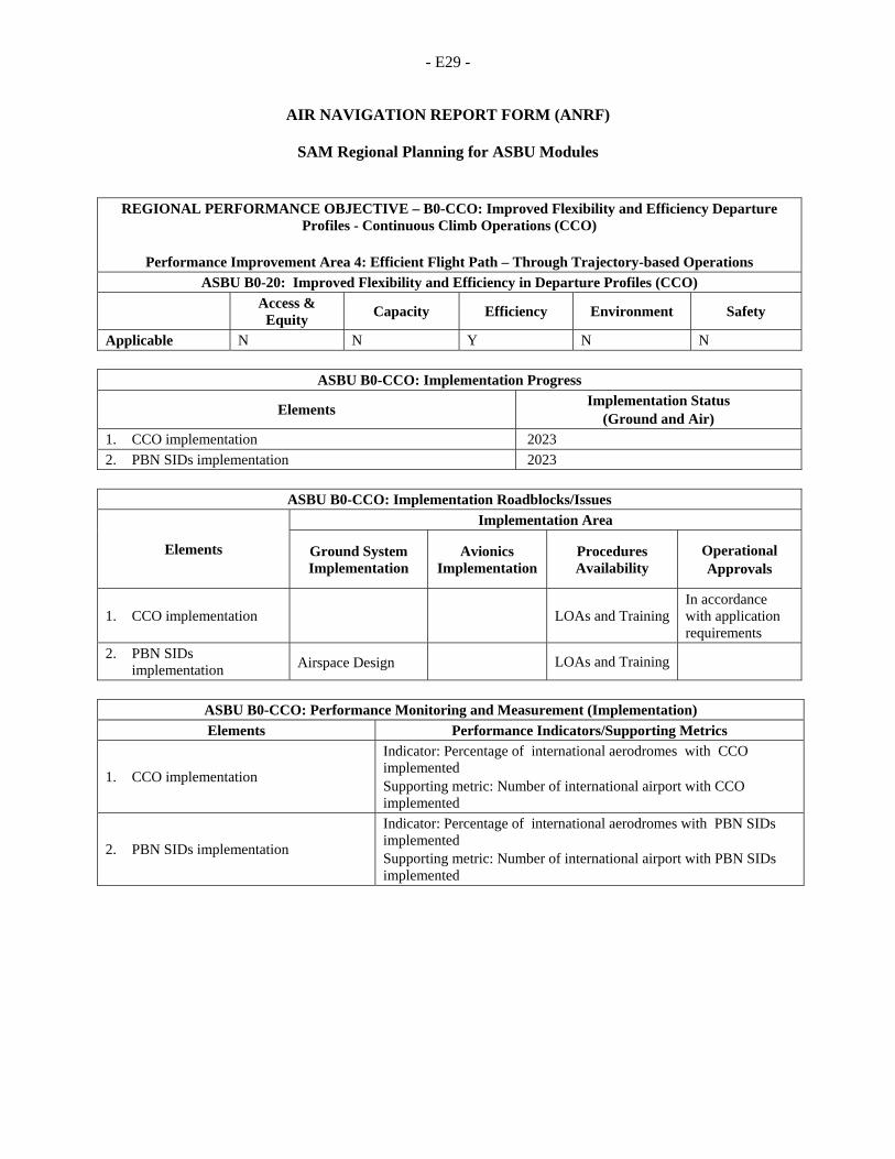
- E29 -
AIR NAVIGATION REPORT FORM (ANRF)
SAM Regional Planning for ASBU Modules
REGIONAL PERFORMANCE OBJECTIVE – B0-CCO: Improved Flexibility and Efficiency Departure Profiles - Continuous Climb Operations (CCO)
Performance Improvement Area 4: Efficient Flight Path – Through Trajectory-based Operations
ASBU B0-20: Improved Flexibility and Efficiency in Departure Profiles (CCO)
Access &
Equity Capacity Efficiency Environment Safety
Applicable N N Y N N
ASBU B0-CCO: Implementation Progress
Elements Implementation Status
(Ground and Air) 1. CCO implementation 2023
2. PBN SIDs implementation 2023
ASBU B0-CCO: Implementation Roadblocks/Issues
Elements
Implementation Area
Ground System Implementation
Avionics Implementation
Procedures Availability
Operational Approvals
1. CCO implementation LOAs and Training In accordance with application requirements
2. PBN SIDs implementation Airspace Design LOAs and Training
ASBU B0-CCO: Performance Monitoring and Measurement (Implementation)
Elements Performance Indicators/Supporting Metrics
1. CCO implementation
Indicator: Percentage of international aerodromes with CCO implemented Supporting metric: Number of international airport with CCO implemented
2. PBN SIDs implementation
Indicator: Percentage of international aerodromes with PBN SIDs implemented Supporting metric: Number of international airport with PBN SIDs implemented

- E30 -
ASBU B0-CCO: Performance Monitoring and Measurement (Benefits)
Key Performance Areas Benefits Access & Equity
Capacity
Efficiency Cost savings through reduced fuel burn and efficient aircraft operating profiles. Reduction in the number of required radio transmissions
Environment Authorization of operations where noise limitations would otherwise result in operations being curtailed or restricted. Environmental benefits through reduced emissions
Safety More consistent flight paths. Reduction in the number of required radio transmissions. Lower pilot and air traffic control workload
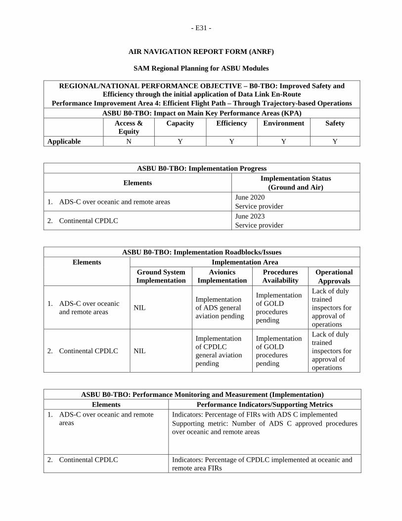
- E31 -
AIR NAVIGATION REPORT FORM (ANRF)
SAM Regional Planning for ASBU Modules
REGIONAL/NATIONAL PERFORMANCE OBJECTIVE – B0-TBO: Improved Safety and Efficiency through the initial application of Data Link En-Route
Performance Improvement Area 4: Efficient Flight Path – Through Trajectory-based Operations ASBU B0-TBO: Impact on Main Key Performance Areas (KPA)
Access & Equity
Capacity Efficiency Environment Safety
Applicable N Y Y Y Y
ASBU B0-TBO: Implementation Progress
Elements Implementation Status
(Ground and Air)
1. ADS-C over oceanic and remote areas June 2020 Service provider
2. Continental CPDLC June 2023 Service provider
ASBU B0-TBO: Implementation Roadblocks/Issues Elements Implementation Area
Ground System Implementation
Avionics Implementation
Procedures Availability
Operational Approvals
1. ADS-C over oceanic and remote areas
NIL Implementation of ADS general aviation pending
Implementation of GOLD procedures pending
Lack of duly trained inspectors for approval of operations
2. Continental CPDLC NIL
Implementation of CPDLC general aviation pending
Implementation of GOLD procedures pending
Lack of duly trained inspectors for approval of operations
ASBU B0-TBO: Performance Monitoring and Measurement (Implementation) Elements Performance Indicators/Supporting Metrics
1. ADS-C over oceanic and remote areas
Indicators: Percentage of FIRs with ADS C implemented Supporting metric: Number of ADS C approved procedures over oceanic and remote areas
2. Continental CPDLC Indicators: Percentage of CPDLC implemented at oceanic and remote area FIRs
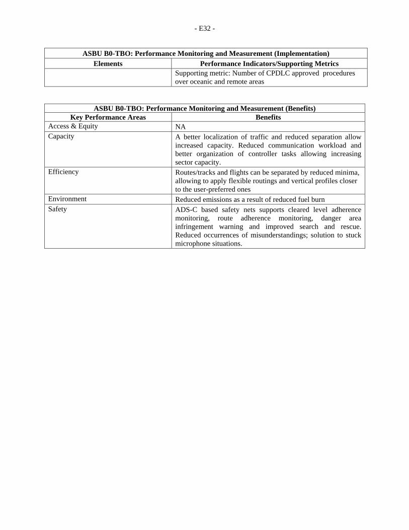
- E32 -
ASBU B0-TBO: Performance Monitoring and Measurement (Implementation) Elements Performance Indicators/Supporting Metrics
Supporting metric: Number of CPDLC approved procedures over oceanic and remote areas
ASBU B0-TBO: Performance Monitoring and Measurement (Benefits) Key Performance Areas Benefits
Access & Equity NA Capacity A better localization of traffic and reduced separation allow
increased capacity. Reduced communication workload and better organization of controller tasks allowing increasing sector capacity.
Efficiency Routes/tracks and flights can be separated by reduced minima, allowing to apply flexible routings and vertical profiles closer to the user-preferred ones
Environment Reduced emissions as a result of reduced fuel burn Safety ADS-C based safety nets supports cleared level adherence
monitoring, route adherence monitoring, danger area infringement warning and improved search and rescue. Reduced occurrences of misunderstandings; solution to stuck microphone situations.
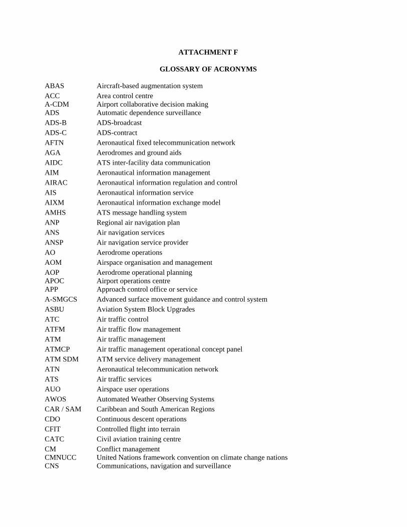
ATTACHMENT F
GLOSSARY OF ACRONYMS
ABAS Aircraft-based augmentation system ACC A-CDM
Area control centre Airport collaborative decision making
ADS Automatic dependence surveillance ADS-B ADS-broadcast ADS-C ADS-contract AFTN Aeronautical fixed telecommunication network AGA Aerodromes and ground aids AIDC ATS inter-facility data communication AIM Aeronautical information management AIRAC Aeronautical information regulation and control AIS Aeronautical information service AIXM Aeronautical information exchange model AMHS ATS message handling system ANP Regional air navigation plan ANS Air navigation services ANSP Air navigation service provider AO Aerodrome operations AOM Airspace organisation and management AOP APOC
Aerodrome operational planning Airport operations centre
APP Approach control office or service A-SMGCS Advanced surface movement guidance and control system ASBU Aviation System Block Upgrades ATC Air traffic control ATFM Air traffic flow management ATM Air traffic management ATMCP Air traffic management operational concept panel ATM SDM ATM service delivery management ATN Aeronautical telecommunication network ATS Air traffic services AUO Airspace user operations AWOS Automated Weather Observing Systems CAR / SAM Caribbean and South American Regions CDO Continuous descent operations CFIT Controlled flight into terrain CATC Civil aviation training centre CM CMNUCC
Conflict management United Nations framework convention on climate change nations
CNS Communications, navigation and surveillance
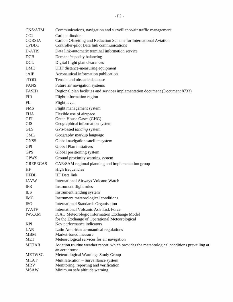
- F2 -
CNS/ATM Communications, navigation and surveillance/air traffic management CO2 CORSIA
Carbon dioxide Carbon Offsetting and Reduction Scheme for International Aviation
CPDLC Controller-pilot Data link communications D-ATIS Data link-automatic terminal information service DCB Demand/capacity balancing DCL Digital flight plan clearances DME UHF distance-measuring equipment eAIP Aeronautical information publication eTOD Terrain and obstacle database FANS Future air navigation systems FASID Regional plan facilities and services implementation document (Document 8733) FIR Flight information region FL Flight level FMS Flight management system FUA GEI
Flexible use of airspace Green House Gases (GHG)
GIS Geographical information system GLS GPS-based landing system GML Geography markup language GNSS Global navigation satellite system GPI Global Plan initiatives GPS Global positioning system GPWS Ground proximity warning system GREPECAS CAR/SAM regional planning and implementation group HF High frequencies HFDL HF Data link IAVW International Airways Volcano Watch IFR Instrument flight rules ILS Instrument landing system IMC Instrument meteorological conditions ISO International Standards Organisation IVATF IWXXM
International Volcanic Ash Task Force ICAO Meteorologic Information Exchange Model for the Exchange of Operational Meteorological
KPI Key performance indicators LAR MBM
Latin American aeronautical regulations Market-based measure
MET Meteorological services for air navigation METAR Aviation routine weather report, which provides the meteorological conditions prevailing at
an aerodrome. METWSG Meteorological Warnings Study Group MLAT MRV
Multilateration – Surveillance system Monitoring, reporting and verification
MSAW Minimum safe altitude warning
- F3 -
MWO Meteorological Watch Office NDB Non-directional radio beacon NGAP New generation of aviation professionals NM Nautical miles NPA Non-precision approach NOTAM Notice to personnel concerned with flight operations ICAO International Civil Aviation Organization OLDI Direct data interchange OMA Automatic weather office WMO World Meteorological Organization OPMET Operational meteorological information PDC PDSL PEID
Predeparture clearance Landlocked Developing Countries (LLDCs) Small Island Developing States (SIDS)
PFF Performance Framework Form PIRG PMA
Planning and implementation regional group Least developed coutries (LDCs)
PSR Primary surveillance radar QMS Quality management system RASG-PA Regional aviation safety group - Pan-American REDDIG South American digital communication network RNAV Area navigation RNP RTK
Required navigation performance Revenue tonne-kilometer
RVR Runway visual range RVSM Reduced vertical separation minimum SADIS Satellite distribution system for information relating to air navigation SAM South American Region SARPS Standards and recommended practices SID Standard instrument departure SIGMET Significant weather SLA Service level agreement AMSS Aeronautical mobile-satellite service SMGCS Surface movement guidance and control system SPECI Special aviation weather report SSR Secondary surveillance radar STAR SWIM
Standard instrument arrival System wide information management
TMA Terminal control area TRA Temporary reservation of airspace TS Traffic synchronisation TWR Aerodrome control tower or aerodrome control UAS Unmanned aircraft systems VDL VHF digital Relation-ship

- F4 -
VFR Visual flight rules VHF Very high frequency VOLMET Meteorological information for aircraft in flight VOR VHF omnidirectional radio range WAFS World area forecast system WATRS Western Atlantic route system WGS-84 World geodetic system — 1984 XML Extensible markup language
INTERN
PBN CO
NATIONSOUTH
ONCEPT
ATTA
NAL CIVIH AMERIC
OF OPER
PERIO
(CONOP
Version
ACHMENT
IL AVIACAN REG
RATIONS
OD 2018-2
PS 2018-2
0.4 May
G
ATION OGIONAL O
S FOR SA
2020
2020)
2017
ORGANIOFFICE
AM AIRSP
IZATION
PACE
N

- G3 -
PBN CONCEPT OF OPERATIONS FOR SAM AIRSPACE PERIOD 2018-2020
This document has been prepared for analysis and amendment by SAM States, as appropriate, at the SAMIG/19 meeting to be held in May 2017.
CHANGE CONTROL
Version Date Change Pages
0.1 November 2016 Initial document All
0.2 December 2016 Revision with IATA All
0.3 December 2016 Integration of revisions and formats
All
0.4 May 2017 Harmonisation of planning dates
All

- G5 -
TABLE OF CONTENTS
1 Acronyms ........................................................................................................... 6
2 Reference documents ........................................................................................ 7
3 EXECUTIVE SUMMARY ................................... Error! Bookmark not defined.
4 GENERAL INTRODUCTION ............................................................................. 8
4.1 Objective ........................................................... Error! Bookmark not defined.
4.2 Background ....................................................... Error! Bookmark not defined.
4.3 Current status .................................................... Error! Bookmark not defined.
5 AIRSPACE CONCEPT (CONOPS) ................................................................. 11
5.1 ICAO strategic objectives ................................................................................ 12
5.2 Statistics and growth ....................................................................................... 12
5.3 Theoretical assumptions of the concept of operations .................................... 13
5.4 PBN implementation enabling elements ......................................................... 14
5.5 Other factors to be considered in the implementation ..................................... 17
6 PBN NAVIGATION SPECIFICATIONS ............................................................ 18
6.1 RNAV 10 (RNP 10) ......................................................................................... 18
6.2 RNP 4 .............................................................................................................. 18
6.3 RNP 2 .............................................................................................................. 18
6.4 RNAV 5 ........................................................................................................... 19
6.5 RNAV 1 and RNAV 2 ...................................................................................... 19
6.6 RNP 1 .............................................................................................................. 19
6.7 RNP APCH ...................................................................................................... 20
6.8 A-RNP ............................................................................................................. 20
6.9 RNP AR APCH ................................................................................................ 21
7 EN ROUTE PBN OPERATIONS ...................................................................... 22
7.1 Concept description. ......................................... Error! Bookmark not defined.
7.2 Specific objectives ........................................................................................... 23
7.3 Principles ........................................................... Error! Bookmark not defined.
7.4 Oceanic airspace ............................................................................................ 24
7.5 Continental airspace ....................................................................................... 25
8 PBN OPERATIONS IN TERMINAL AREAS .................................................... 26
8.1 SID/STAR routes ............................................................................................. 26
8.2 Instrument approach procedures – IAP .......................................................... 28
9 METRICS and INDICATORS ........................................................................... 30
Appendix A ………………………………………………………………………………………...34
Appendix B ………………………………………………………………………………………..47
- G6 -
Appendix C ........................................................................................................................ 49
Appendix D ........................................................................................................................ 51
1 Acronyms A-RNP Advanced RNP ADS-B Automatic dependent surveillance - broadcast ADS-C Automatic dependent surveillance - contract AIP Aeronautical information publication ANSP Air navigation service provider AORRA Atlantic Ocean Random Routing Area APCH Approach APV Approach procedure with vertical guidance ASBU Aviation system block upgrades ATC Air traffic control ATFM Air traffic flow management ATM Air traffic management ATS Air traffic service CCO Continuous climb operations CDO Continuous descent operations CDM Collaborative decision-making CDR Conditional route CNS Communication, navigation and surveillance CONOPS PBN concept of operations for the SAM Region CPDLC Controller-pilot data link communications DME Distance measuring equipment e-ANP Electronic air navigation plan EDTO Extended diversion time operations FAF Final approach fix FANS Future air navigation systems FPL Flight plan FUA Flexible use of airspace GA General aviation GANP Global air navigation plan GBAS Ground-based augmentation system GLS GBAS landing system GNSS Global navigation satellite system GPS Global positioning system IAP Instrument approach procedure IFP Instrument flight procedure ILS Instrument landing system INS Inertial navigation system IRS Inertial reference system IRU Inertial reference unit MLAT Multilateration NAVAID Air navigation aid PBC Performance-based communication PBN Performance-based navigation PBS Performance-based surveillance RAAC Meeting of civil aviation authorities of the SAM Region
- G7 -
RNAV Area navigation RCP Required communication performance RF Fixed radius turn RNP Required navigation performance RPAS Remotely piloted aircraft systems RSP Required surveillance performance SAM/IG South American implementation group SAM-PBIB Performance-based air navigation implementation plan for the SAM Region SARPS Standards and recommended practices SATVOICE Satellite voice communications SBAS Satellite-based augmentation system SID Standard instrument departure STAR Standard instrument arrival SUA Special use airspace VFR Visual flight rules VHF Very high frequency VNAV Vertical navigation
2 Reference documents The following ICAO documents are associated to the PBN concept
GANP, fifth edition (draft) SAM-PBIB V1.4, 2013 Doc 4444 Air traffic management, fifteenth edition, 7th amendment Doc 8168 Aircraft operations, Volume II, sixth edition Doc 9613 Performance-based navigation (PBN) manual, fourth edition Doc. 9869 Manual on required communication performance (RCP), first edition Doc. 9905 Required navigation performance authorization required (RNP AR)
procedure design manual, first edition Doc. 9924 Aeronautical surveillance manual, first edition Doc. 9931 Continuous descent operations (CDO) manual, first edition Doc. 9992 Manual on the use of performance-based navigation (PBN) in
airspace design, first edition Doc. 9993 Continuous climb operations (CCO) manual, first edition Doc. 9997 PBN operational approval manual, first edition ICAO circular 324, Guidelines for lateral separation of arriving and departing
aircraft on published adjacent instrument flight procedures.
- G8 -
3 EXECUTIVE SUMMARY
This document, the PBN Concept of Operations (CONOPS), is an update and an extension of the PBN implementation concept, applicable in the SAM Region until December 2016 and whose main objective is to improve efficiency, increase capacity, ensure environmental protection, taking into account safety, and define air navigation specifications to be uniformly applied at regional level. The CONOPS is aligned with the Global Air Navigation Plan (GANP) and the Aviation System Block Upgrade (ASBU) methodology. The CONOPS is a document prepared collaboratively, which contemplates the needs of all ATM community stakeholders and provides a frame of reference for PBN planning and implementation during the period 2018-2020.
The concept contemplates the use of more advanced PBN specifications en route and in terminal areas for continued optimisation of the regional airspace. It also contemplates that implementation planning will continue taking place in a collaborative manner. It also proposes compliance objectives that will be submitted to the consideration of the States of the Region when updating the regional PBN plan and the respective national PBN plans. 4 GENERAL INTRODUCTION Continuous growth of aviation imposes increasing demands in terms of airspace capacity and efficiency and poses the need for a performance-based system. The transition to a performance-based airspace system is a critical aspect of the evolution towards a globally safe and efficient air traffic management (ATM) environment. As ATM evolves, it will be necessary to ensure an acceptable operational performance, taking into account the evolving technologies. ICAO has concentrated its efforts on developing and implementing performance-based navigation (PBN), focusing on implementation in ATS routes and in terminal areas (TMAs), using techniques such as continuous descent operations (CDO) and continuous climb operations (CCO). Likewise, through Assembly Resolution A37-11, it has prioritised the implementation of instrument approach with vertical guidance at all international airports. In addition to these efforts, the South American Region has established goals in the Declaration of Bogota that shall be pursued until fulfilment within the framework of this Concept of Operations, which sets directions, guidelines, and principles, as well as metrics and indicators to be applied in airspace planning and design, both en route as well as in the terminal area. 4.1 Objective The PBN Concept of Operations (CONOPS) of the SAM Region prioritises safety and describes the functionalities required for improving efficiency, capacity and environmental protection, and defines the air navigation specifications that will need to be implemented uniformly in SAM airspace.
- G9 -
4.2 Background The SAM Region works in a coordinated manner, through the meetings of the SAM Implementation Group (SAM/IG), in the fulfilment of tasks and actions leading to a sustained evolution towards the implementation of the global ATM concept of operations. Accordingly, implementation programmes are developed, which have initially focused on the following:
a) ATS optimisation in the SAM Region b) Implementation of performance-based navigation (PBN) for en-route,
terminal area and approach operations c) Air traffic flow management (ATFM) d) CNS system enhancement, and e) ATM automation
The SAM/IG/10 meeting, held in October 2012, analysed the SAM ATS route network optimisation action plan and felt it advisable to extend it to include the optimisation of all flight phases within South American airspace, with a view to integrating ATS routes with terminal areas and instrument approaches. PBN implementation has high priority in the ATM Work Programme of the South American Regional Office and many of its activities, such as PBN workshops, PANS-OPS courses and workshops, have been promoted by Regional Project RLA/06/901 in support of PBN planning and implementation in the Region. The thirteenth meeting of Civil Aviation Authorities of the South American Region (RAAC/13), held in Bogota, Colombia, on 4-6 December 2013, established in the Declaration of Bogota the indicators and safety and air navigation goals for the SAM Region to be attained by December 2016. The goals that were not met by the States on the defined date are still in force and are part of this concept of operations. 4.3 Status 4.3.1 En-route PBN
En-route implementation of PBN is discussed at ATS/RO meetings, based on gradual improvement of route network versions. The use of route network versions reflects the need for an integrated periodic review to ensure that the best possible airspace structure is always in place, within an integrated development concept. Phase 1 of the route optimisation programme was completed on 20 October 2011 with the implementation of RNAV 5, while RNP10 was maintained in some upper airspace oceanic routes, as in the EUR/SAM Corridor, the Lima-Santiago routes, and the Atlantic Ocean Random Routing Area (AORRA). At present, taking advantage of PBN-based airspaces, part of version 3 of the ATS route network is being integrated with TMA SIDs and STARs. Likewise, flexible use of airspace has been implemented in some selected airspaces for their optimisation.
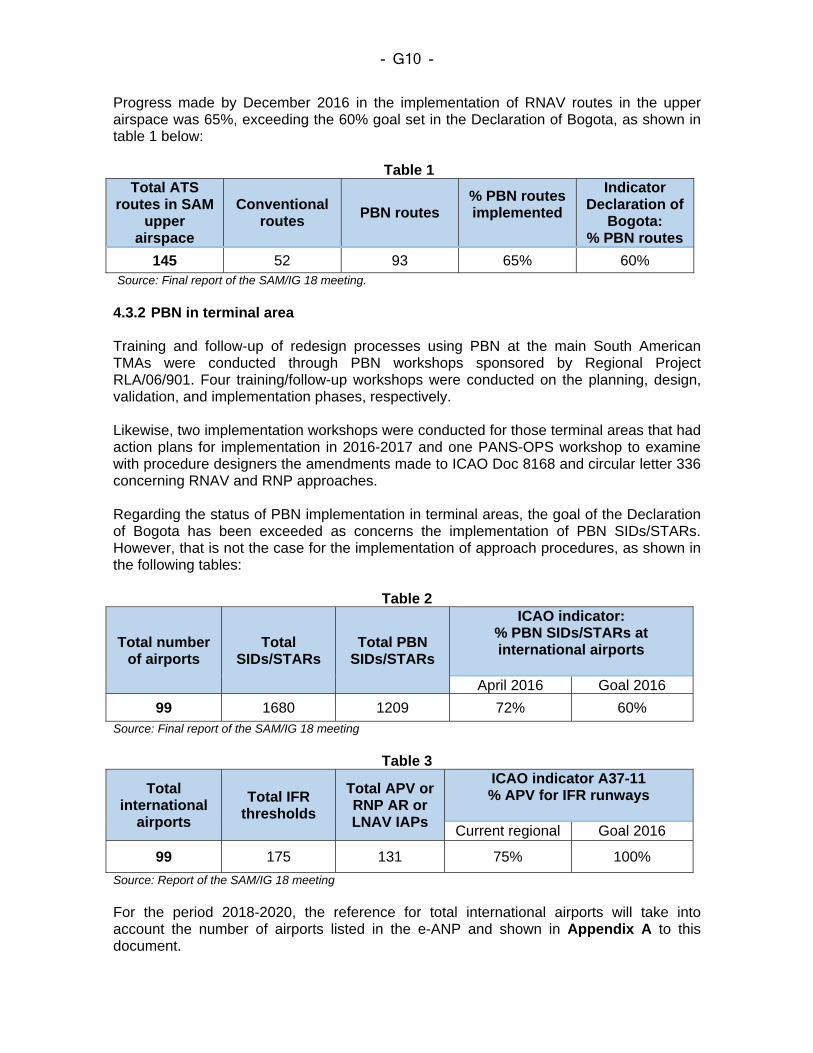
- G10 -
Progress made by December 2016 in the implementation of RNAV routes in the upper airspace was 65%, exceeding the 60% goal set in the Declaration of Bogota, as shown in table 1 below:
Table 1 Total ATS
routes in SAM upper
airspace
Conventional routes
PBN routes % PBN routes implemented
Indicator Declaration of
Bogota: % PBN routes
145 52 93 65% 60% Source: Final report of the SAM/IG 18 meeting. 4.3.2 PBN in terminal area Training and follow-up of redesign processes using PBN at the main South American TMAs were conducted through PBN workshops sponsored by Regional Project RLA/06/901. Four training/follow-up workshops were conducted on the planning, design, validation, and implementation phases, respectively. Likewise, two implementation workshops were conducted for those terminal areas that had action plans for implementation in 2016-2017 and one PANS-OPS workshop to examine with procedure designers the amendments made to ICAO Doc 8168 and circular letter 336 concerning RNAV and RNP approaches. Regarding the status of PBN implementation in terminal areas, the goal of the Declaration of Bogota has been exceeded as concerns the implementation of PBN SIDs/STARs. However, that is not the case for the implementation of approach procedures, as shown in the following tables:
Table 2
Total number of airports
Total SIDs/STARs
Total PBN SIDs/STARs
ICAO indicator: % PBN SIDs/STARs at international airports
April 2016 Goal 2016
99 1680 1209 72% 60% Source: Final report of the SAM/IG 18 meeting
Table 3
Total international
airports
Total IFR thresholds
Total APV or RNP AR or LNAV IAPs
ICAO indicator A37-11 % APV for IFR runways
Current regional Goal 2016
99 175 131 75% 100%
Source: Report of the SAM/IG 18 meeting For the period 2018-2020, the reference for total international airports will take into account the number of airports listed in the e-ANP and shown in Appendix A to this document.
- G11 -
4.3.3 Relationship with the ICAO GANP/ASBU The International Civil Aviation Organization (ICAO) has developed Doc 9854 “Global ATM Concept”, which describes ICAO’s vision of a global ATM. Furthermore, it has developed the global “Aviation system block upgrade” (ASBU) framework, which sets forth a set of air traffic management (ATM) solutions or upgrades that build upon existing equipment, establishing an implementation framework for attaining global interoperability within certain timelines. ASBU consists of a set of modules, organised in flexible and scalable blocks. The block upgrades describe a way of applying the concepts defined in the ICAO Global Air Navigation Plan (Doc 9750) for the implementation of regional performance improvements. It includes the development of technological roadmaps to make sure that standards are mature and to facilitate synchronisation between air and ground systems, and between Regions. The final objective is global interoperability.
The following block upgrades have been defined:
• Block 0: in progress • Block 1: (starts in 2019) • Block 2: (starts in 2025) • Block 3: (starts in 2031)
The CONOPS set forth in this document contemplates, amongst other related applications, the following ASBU block 0 modules:
B0‐APTA Optimisation of approach procedures, including vertical guidance First step towards universal implementation of GNSS-based approaches
B0‐FRTO Improved operations through enhanced en-route trajectories To allow the use of airspace that would otherwise be segregated (i.e., special use airspace) along with flexible routing adjusted for specific traffic patterns. This will allow greater routing possibilities, reducing potential congestion on trunk routes and busy crossing points, resulting in reduced flight length and fuel burn. B0‐CDO Improved flexibility and efficiency in descent profiles (CDO) Deployment of performance-based airspace and arrival procedures that allow aircraft to fly their optimum aircraft profile, taking account of airspace and traffic complexity with continuous descent operations (CDOs). B0‐CCO Improved flexibility and efficiency in departure profiles – Continuous climb operations (CCO) Deployment of departure procedures that allow aircraft to fly their optimum aircraft profile, taking account of airspace and traffic complexity with continuous climb operations (CCOs). 5 AIRSPACE CONCEPT (CONOPS)
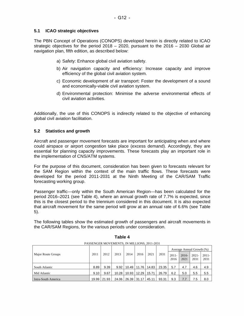
- G12 -
5.1 ICAO strategic objectives The PBN Concept of Operations (CONOPS) developed herein is directly related to ICAO strategic objectives for the period 2018 – 2020, pursuant to the 2016 – 2030 Global air navigation plan, fifth edition, as described below:
a) Safety: Enhance global civil aviation safety.
b) Air navigation capacity and efficiency: Increase capacity and improve efficiency of the global civil aviation system.
c) Economic development of air transport: Foster the development of a sound and economically-viable civil aviation system.
d) Environmental protection: Minimise the adverse environmental effects of civil aviation activities.
Additionally, the use of this CONOPS is indirectly related to the objective of enhancing global civil aviation facilitation.
5.2 Statistics and growth Aircraft and passenger movement forecasts are important for anticipating when and where could airspace or airport congestion take place (excess demand). Accordingly, they are essential for planning capacity improvements. These forecasts play an important role in the implementation of CNS/ATM systems. For the purpose of this document, consideration has been given to forecasts relevant for the SAM Region within the context of the main traffic flows. These forecasts were developed for the period 2011-2031 at the Ninth Meeting of the CAR/SAM Traffic forecasting working group. Passenger traffic—only within the South American Region—has been calculated for the period 2016–2021 (see Table 4), where an annual growth rate of 7.7% is expected, since this is the closest period to the triennium considered in this document. It is also expected that aircraft movement for the same period will grow at an annual rate of 6.6% (see Table 5). The following tables show the estimated growth of passengers and aircraft movements in the CAR/SAM Regions, for the various periods under consideration.
Table 4
PASSENGER MOVEMENTS, IN MILLIONS, 2011-2031
Major Route Groups 2011 2012 2013 2014 2016 2021 2031
Average Annual Growth (%)
2011- 2016
2016- 2021
2021-2031
2011-2031
South Atlantic 8.89 9.39 9.92 10.49 11.76 14.83 23.35 5.7 4.7 4.6 4.9
Mid Atlantic 9.10 9.67 10.28 10.93 12.29 15.71 26.79 6.2 5.0 5.5 5.5
Intra-South America 19.99 21.93 24.06 26.39 31.17 45.11 93.31 9.3 7.7 7.5 8.0
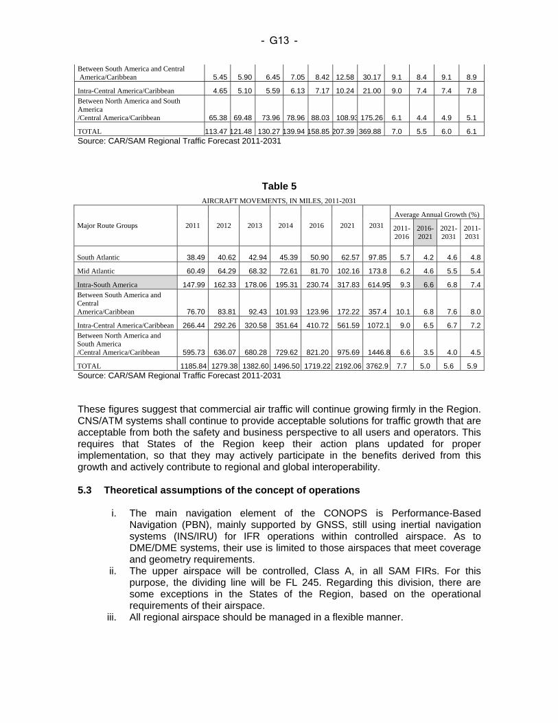
- G13 -
Between South America and Central America/Caribbean 5.45 5.90 6.45 7.05 8.42 12.58 30.17 9.1 8.4 9.1 8.9
Intra-Central America/Caribbean 4.65 5.10 5.59 6.13 7.17 10.24 21.00 9.0 7.4 7.4 7.8 Between North America and South America /Central America/Caribbean 65.38 69.48 73.96 78.96 88.03 108.93 175.26 6.1 4.4 4.9 5.1
TOTAL 113.47 121.48 130.27 139.94 158.85 207.39 369.88 7.0 5.5 6.0 6.1 Source: CAR/SAM Regional Traffic Forecast 2011-2031
Table 5 AIRCRAFT MOVEMENTS, IN MILES, 2011-2031
Major Route Groups 2011 2012 2013 2014 2016 2021 2031
Average Annual Growth (%)
2011- 2016
2016- 2021
2021-2031
2011-2031
South Atlantic 38.49 40.62 42.94 45.39 50.90 62.57 97.85 5.7 4.2 4.6 4.8
Mid Atlantic 60.49 64.29 68.32 72.61 81.70 102.16 173.8 6.2 4.6 5.5 5.4
Intra-South America 147.99 162.33 178.06 195.31 230.74 317.83 614.95 9.3 6.6 6.8 7.4Between South America and Central America/Caribbean 76.70 83.81 92.43 101.93 123.96 172.22 357.4 10.1 6.8 7.6 8.0
Intra-Central America/Caribbean 266.44 292.26 320.58 351.64 410.72 561.59 1072.1 9.0 6.5 6.7 7.2Between North America and South America /Central America/Caribbean 595.73 636.07 680.28 729.62 821.20 975.69 1446.8 6.6 3.5 4.0 4.5
TOTAL 1185.84 1279.38 1382.60 1496.50 1719.22 2192.06 3762.9 7.7 5.0 5.6 5.9 Source: CAR/SAM Regional Traffic Forecast 2011-2031 These figures suggest that commercial air traffic will continue growing firmly in the Region. CNS/ATM systems shall continue to provide acceptable solutions for traffic growth that are acceptable from both the safety and business perspective to all users and operators. This requires that States of the Region keep their action plans updated for proper implementation, so that they may actively participate in the benefits derived from this growth and actively contribute to regional and global interoperability. 5.3 Theoretical assumptions of the concept of operations
i. The main navigation element of the CONOPS is Performance-Based Navigation (PBN), mainly supported by GNSS, still using inertial navigation systems (INS/IRU) for IFR operations within controlled airspace. As to DME/DME systems, their use is limited to those airspaces that meet coverage and geometry requirements.
ii. The upper airspace will be controlled, Class A, in all SAM FIRs. For this purpose, the dividing line will be FL 245. Regarding this division, there are some exceptions in the States of the Region, based on the operational requirements of their airspace.
iii. All regional airspace should be managed in a flexible manner.
- G14 -
iv. The CONOPS assumes that voice VHF is the main means of communication in continental airspace. For oceanic/remote airspace, specific applications are foreseen for each case, such as CPDLC or SATVOICE, which will replace HF communications.
v. Ground-based navigation aids will continue to be used in support of navigation reversal and contingency procedures.
vi. It is assumed that ATM capacity will be expanded to absorb IFR traffic growth. vii. There will still be commercial and general aviation operators that, given the
characteristics of their fleet, will not be PBN-approved. Nevertheless, airspace planning will be based on PBN, applying the “Best Equipped, Best Served” concept.
viii. Environmental factors gain more importance. ix. Collaborative decision-making (CDM) will be adopted in the design of both en-
route and TMA airspace. x. RPAS operations are expected to grow significantly in the coming years,
covering different activities and business sectors, and should be considered in airspace planning and procedures.
xi. The States of the Region will continue striving to modernise their air navigation systems in accordance with their operational needs and new developments of the industry.
xii. Air cargo and passenger operators will continue modernising their fleet and on-board equipment in order to add more PBN functionalities. They will expect to recover their investments through more efficient operations using procedures that take advantage of the enhanced functionalities of their fleet.
5.4 PBN implementation enablers 5.4.1 State PBN implementation plans States have developed PBN implementation plans based on Doc 9613 and Doc 9992, which clearly define PBN implementation strategies. These implementation plans are developed in accordance with implementation objectives agreed at regional level, which are, in turn, defined in accordance with the guidance set forth in the Global Air Navigation Plan and the block upgrades required for evolution to a global ATM system. 5.4.2 Communications At present, almost all pilot-controller communications are mainly through VHF voice communications in continental areas. However, with the growing number of flights that are expected to fly PBN procedures, it will be necessary to change the way in which pilots and controllers communicate in order to support an enhanced and more robust exchange of information, without affecting the workload of the pilot or the controller. The concept of operations contemplates data link communications (CPDLC) or SATVOICE in oceanic airspace in support of RNP 2 implementation. Some States of the Region have implemented ADS-C with CPDLC in their oceanic airspace, and it is expected that beyond 2020, a growing number of digital data communication applications and services will be gradually introduced until it becomes the primary means of communication. But there will still be cases in which clearances and instructions will be issued by voice.
- G15 -
In accordance with the global air traffic management (ATM) concept of operations, communication specifications will be established in accordance with the required communication performance (RCP) and the airspace where operations take place. 5.4.3 ATS surveillance ATS surveillance plays an important role in air traffic. The ability to accurately determine, track, and update the position of aircraft contributes to optimise aircraft separation and improves the efficient use of a given airspace. ATS surveillance will be implemented taking into account the operational requirements of the airspace under consideration. The States of the Region, especially those with rough terrain, are expected to study the possibility of ATS surveillance using ADS and/or MLAT systems. Like in RCP, ATS surveillance specifications will be established in accordance with the required surveillance performance (RSP) and the airspace in which operations will take place. 5.4.4 Flexible use of airspace Aviation includes a broad range of users, from commercial aviation to military and recreational operations, each with its own mission or business objectives. The CONOPS considers SAM airspace as a unique resource shared by all airspace users, with different and sometimes conflicting interests and requirements, which must be taken into account and accommodated to the extent possible. The flexible use of airspace is an airspace management concept based on the principle of accommodating all the users of that airspace inasmuch as possible, taking into account effective communications, cooperation, and the coordination required to ensure safety, efficiency and environmental sustainability. Where conditions allow, standard arrival and departure procedures, as well as conditional routes (CDR) will be implemented for more efficient use of airspace. 5.4.5 Use of information on flight operations for FOQA and/or ICAO “Big Data”
project Once FOQA (Flight Operations Quality Assurance) is available, this information will be used for the design of procedures, routes, and mainly for post-implementation assessment of a PBN airspace concept, since it offers actual data on the benefits derived from implementation. The information provided by the Big Data Project on air traffic movement is a high-value input for airspace planning. This information results from the analysis of the data provided by airborne ADS equipment and transmitted to a network of ground receivers for analysis and for the development of safety or statistical indicators that may be used for airspace measurement and planning. Information can be updated every three hours, thus providing constant, accurate and low-cost information. The following are some of the indicators that have been defined for use in airspace planning within a PBN concept of operations:
- G16 -
a) SID utilisation rate: number of flights conducted for each SID within a given period
of time, e.g., one month. b) STAR utilisation rate: number of operations conducted for each STAR within a
given period of time, e.g., one month. c) APCH utilisation rate: number of operations conducted for each APCH within a
given period of time, e.g., one month. d) Mean top of descent: a figure can be obtained for the mean at which aircraft
descent in a STAR is started. It can be classified by airway category, by period of time, etc.
e) Average number of deviations in PBN airspace: information can be provided on the percentage of STAR, SID or APCH deviations.
f) Number of ACAS RAs: a measure of RAs can be obtained and filtered by levels, altitudes or airspace segments.
Likewise, the information captured by “Big Data” can help determine aircraft movement flows, as an input for airspace design, especially useful for noise segregation procedures or other applications. The aforementioned are just a few indicators that will be at the disposal of the Big Data project users, and will directly support airspace planning tasks. 5.4.6 Air traffic flow management (AMAN/DMAN) The optimisation of aircraft operations cannot be achieved through PBN implementation alone. Additional tools are needed for supply/demand balancing, as well as for traffic flow enhancement through runway sequencing and proper distribution of control sectors. The automation of arrival and departure sequencing maximises capacity usage, ensures full utilisation of the most efficient departure and arrival paths, and supplements path design optimisation in terminal areas and PBN-based routes. 5.4.7 PBN certification of aircraft operators It is expected that the number of users without PBN certification will gradually decrease. The benefits derived from the concept of operations are based on the modern navigation capabilities of most of the commercial fleets operating in the Region. 5.4.8 Human factors An increasing level of automation will be required as we move towards the Global ATM Concept of Operations. However, humans will always be in control of automation. In simple terms, this means that humans will decide what needs to be done, will delegate the execution of tasks, and will intervene as needed. 5.4.9 Human resources and training Duly certified individuals with the appropriate skills and competencies will continue to be the pillars of ATM operations. In view of the expected growth in aviation, it is essential to have an adequate number of competent personnel to guarantee a safe and efficient aviation system.
- G17 -
States must take into account human performance when planning and implementing the new systems and technologies. Early participation of operational personnel is also essential. Regarding the above, it is important to highlight the role that aviation training centres in the States of the Region play in the training of aeronautical personnel and, for purposes of this document, more specifically in PBN training of both the service provider and the regulator. Procedure and airspace designers play a significant role in the development of flight procedures and routes. The Region has experts with the necessary competencies to perform these tasks, but some States still do not have the staff required to perform PBN implementation tasks. SAM States will promote the development of PANS-OPS training courses, as well as the conduction of PANS-OPS workshops for reviewing, updating, and standardising the criteria to be applied in the design of PBN procedures and routes. An aspect to be taken into account in the PBN implementation action plan is that Sates must make sure that all the experts and air controllers concerned receive sufficient information, guidance material and training, including, as applicable, the corresponding practice in the new operational environment through ATC simulators. Regarding the above, it is expected that experts that receive PBN training will replicate such training in their own State, thus multiplying the specialised knowledge and optimising the economic investment made by administrations in the area of training. 5.5 Other factors to be considered in the implementation 5.5.1 Cost/benefit analysis The States of the Region should perform a cost/benefit analysis of airspace modifications and of infrastructure and modernisation investments planned. 5.5.2 Pre-operational analysis and accessibility It should be noted that, within route optimisation, there are factors of interest to the user, such as: aeronautical charges, routes in case of depressurisation (escape routes), distance to alternate aerodromes, weather conditions, etc., which might determine that, in certain cases, the shortest distance between two points is not necessarily the optimum path. Consideration should also be given to the impact of publishing meteorological minima for the alternate airport that are greater than the minima of the instrument approach procedures published for the same aerodrome in order to ensure accessibility. 5.5.3 Safety assessment Safety must be guaranteed in any procedure or design modification in an airspace considered for PBN implementation. This includes compliance with ICAO SARPs and the regulations that each State may have on the matter.
- G18 -
After implementing airspace changes, the system should be monitored and operational data collected to make sure that safety is preserved, to determine whether strategic objectives have been achieved, and to identify opportunities for improvement. 6 PBN NAVIGATION SPECIFICATIONS The navigation specifications listed in ICAO Doc 9613 are summarised below. Likewise, chapters 7 and 8 of this document define the appropriate specifications for the corresponding airspaces, in accordance with the operational scenario identified. Table 6 below contains a summary of navigation specifications, divided by flight phase and the required navigation aid sensors. 6.1 RNAV 10 (RNP 10) The RNP 10 specification was defined in support of reduced lateral and longitudinal separation minima, for application in oceanic and remote areas with limited availability of navigation aids, communications and surveillance. The minimum spacing between routes when using RNP 10 is 50 NM. RNP 10 operational requirements are defined in Chapter 1, Volume II, Part B of ICAO Doc 9613. 6.2 RNP 4 The RNP 4 specification was developed for operations in oceanic and remote airspace, where ground-based navaid infrastructure is not available. The GNSS is the primary navigation sensor in support of RNP 4, whether as autonomous navigation system or as pat of a multisensory system. It supports procedure-based separation defined in ICAO Doc 4444-PANS ATM with a longitudinal separation minimum of 30 NM. In order to apply this separation standard, RNP 4 must be combined with additional communication capabilities, specifically ADS-C. The operational requirements of RNP 4 are defined in ICAO Doc 9613, Volume II, Part C, Chapter 1. 6.3 RNP 2 RNP 2 was developed for en-route applications, particularly in geographical areas with limited or no ground navaid infrastructure, with limited or no ATS surveillance. Use of RNP 2 in continental applications requires a continuity requirement less stringent than that used for oceanic and remote applications. The RNP 2 specification is based on GNSS and will not be used in areas of known interference of GNSS signals. GNSS-based operators must have the means to predict GNSS failure detection availability to support operations along the ATS RNP 2 route. RNP 2 operational requirements are defined in ICAO Doc 9613, Volume II, Part C, Chapter 2.
- G19 -
6.4 RNAV 5 RNAV 5 operations are based on the use of RNAV equipment that automatically determines the position of the aircraft on the horizontal plane, using information from one of the following types of position sensors or a combination thereof, and the means for establishing and maintaining the desired path:
a) VOR/DME; b) DME/DME; c) INS or IRS; and d) GNSS.
In a large portion of SAM airspace, RNAV 5 operations using only VOR/DME and DME/DME sensors have limitations due to inadequate coverage and geometry of ground radio aids and insufficient number of stations to provide an appropriate support infrastructure. Direct pilot-controller speech communications are mandatory. ATS surveillance can be used to mitigate the risk of gross navigation errors, provided the route is under ATS surveillance and the volume of communication services and ATS resources is enough for the task. 6.5 RNAV 1 and RNAV 2 RNAV 1 and RNAV 2 specifications are applicable to all ATS routes, for both en-route and terminal area operations. They also apply to IAPs up to the FAF. RNAV 1 and RNAV 2 specifications have been developed for RNAV operations within an ATS surveillance context. However, they can be used in a setting without ATS surveillance, if GNSS is required and if the State of implementation guarantees an appropriate level of safety of the system and responds for the lack of on-board performance monitoring and alert. RNAV 1 and RNAV 2 operations are based on the use of the same aircraft receivers as those required for RNAV 5. Additional functional infrastructure and aircraft navigation aids are required to meet the most stringent RNAV 1 and RNAV 2 performance. RNAV 1 and RNAV 2 routes contemplate direct pilot-controller speech communications. 6.6 RNP 1 The RNP 1 specification provides a means for developing connecting routes between the en-route structure and the terminal airspace with or without ATS surveillance. RNP 1 may be associated with the termination of an RF path and baro-VNAV. The RNP 1 specification is based on GNSS and will not be used in areas of known interference with the navigation signal (GNSS). Although RNAV systems based on DME/DME may have RNP 1 precision capability, supported by a robust DME station
- G20 -
infrastructure, this navigation specification is mainly intended for environments where such infrastructure cannot support DME/DME area navigation for the required performance. 6.7 RNP APCH The RNP APCH specification is based on GNSS to support RNP APCH operations up to LNAV or LNAV/VNAV minima. RNP APCH does not include specific requirements for ATS communication or surveillance. Adequate obstacle clearance is obtained through aircraft performance and operating procedures. 6.8 A-RNP For en-route and terminal applications, this navigation specification has requirements that only address the lateral aspects of navigation. A-RNP is based on GNSS. No ground infrastructure with multiple DME is required, but may be provided based on State requirements, operational requirements and available services. RF is an additional functional element required for A-RNP. The following functional elements are optional:
a) RNP scalability b) Greater continuity c) Fixed radius turns (FRT) d) Time of arrival control (TOAC) e) Baro-VNAV
Advanced RNP is the only navigation specification that allows for operations under other associated navigation specifications. The aircraft navigation precision and the functional requirements of other navigation specifications that are met when certified for A-RNP are:
a) RNAV 5 b) RNAV 1 c) RNAV 2 d) RNP 2 e) RNP 1 f) RNP APCH
The A-RNP specification has a very broad operational application: for operations in oceanic/remote airspace, in the continental en-route structure, arrival and departure routes, and approach procedures. Operations would only depend on the integrity of the RNP system with no capability of reversal to conventional means of navigation, since a conventional infrastructure might not be available. Notwithstanding the above, the corresponding contingency procedures must be developed and implemented. A-RNP is to be implemented in support of the ICAO aviation system block upgrades and the Global air navigation plan.
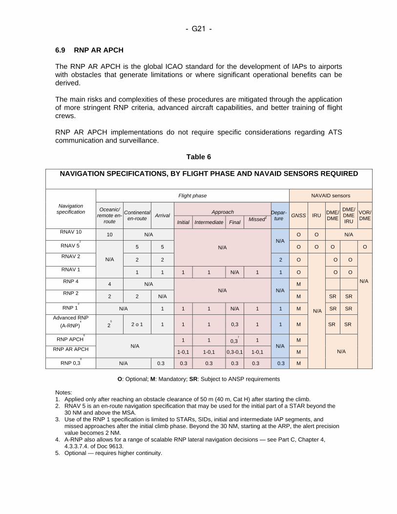
- G21 -
6.9 RNP AR APCH The RNP AR APCH is the global ICAO standard for the development of IAPs to airports with obstacles that generate limitations or where significant operational benefits can be derived. The main risks and complexities of these procedures are mitigated through the application of more stringent RNP criteria, advanced aircraft capabilities, and better training of flight crews. RNP AR APCH implementations do not require specific considerations regarding ATS communication and surveillance.
Table 6
NAVIGATION SPECIFICATIONS, BY FLIGHT PHASE AND NAVAID SENSORS REQUIRED
Navigation specification
Flight phase NAVAID sensors
Oceanic/ remote en-
route
Continental en-route
Arrival
Approach Depar-
ture GNSS IRU
DME/ DME
DME/ DME IRU
VOR/ DME
Initial Intermediate Final Missed1
RNAV 10 10 N/A
N/A N/A
O O N/A
RNAV 52
N/A
5 5 O O O O
RNAV 2 2 2 2 O
N/A
O O
N/A
RNAV 1 1 1 1 1 N/A 1 1 O O O
RNP 4 4 N/A N/A N/A
M
RNP 2 2 2 N/A M SR SR
RNP 13
N/A 1 1 1 N/A 1 1 M SR SR
Advanced RNP
(A-RNP)4
25 2 o 1 1 1 1 0,3 1 1 M SR SR
RNP APCH6
N/A
1 1 0,37
1 N/A
M
N/A RNP AR APCH 1-0,1 1-0,1 0,3-0,1 1-0,1 M
RNP 0,38
N/A 0.3 0.3 0.3 0.3 0.3 0.3 M
O: Optional; M: Mandatory; SR: Subject to ANSP requirements
Notes: 1. Applied only after reaching an obstacle clearance of 50 m (40 m, Cat H) after starting the climb. 2. RNAV 5 is an en-route navigation specification that may be used for the initial part of a STAR beyond the
30 NM and above the MSA. 3. Use of the RNP 1 specification is limited to STARs, SIDs, initial and intermediate IAP segments, and
missed approaches after the initial climb phase. Beyond the 30 NM, starting at the ARP, the alert precision value becomes 2 NM.
4. A-RNP also allows for a range of scalable RNP lateral navigation decisions — see Part C, Chapter 4, 4.3.3.7.4. of Doc 9613.
5. Optional — requires higher continuity.
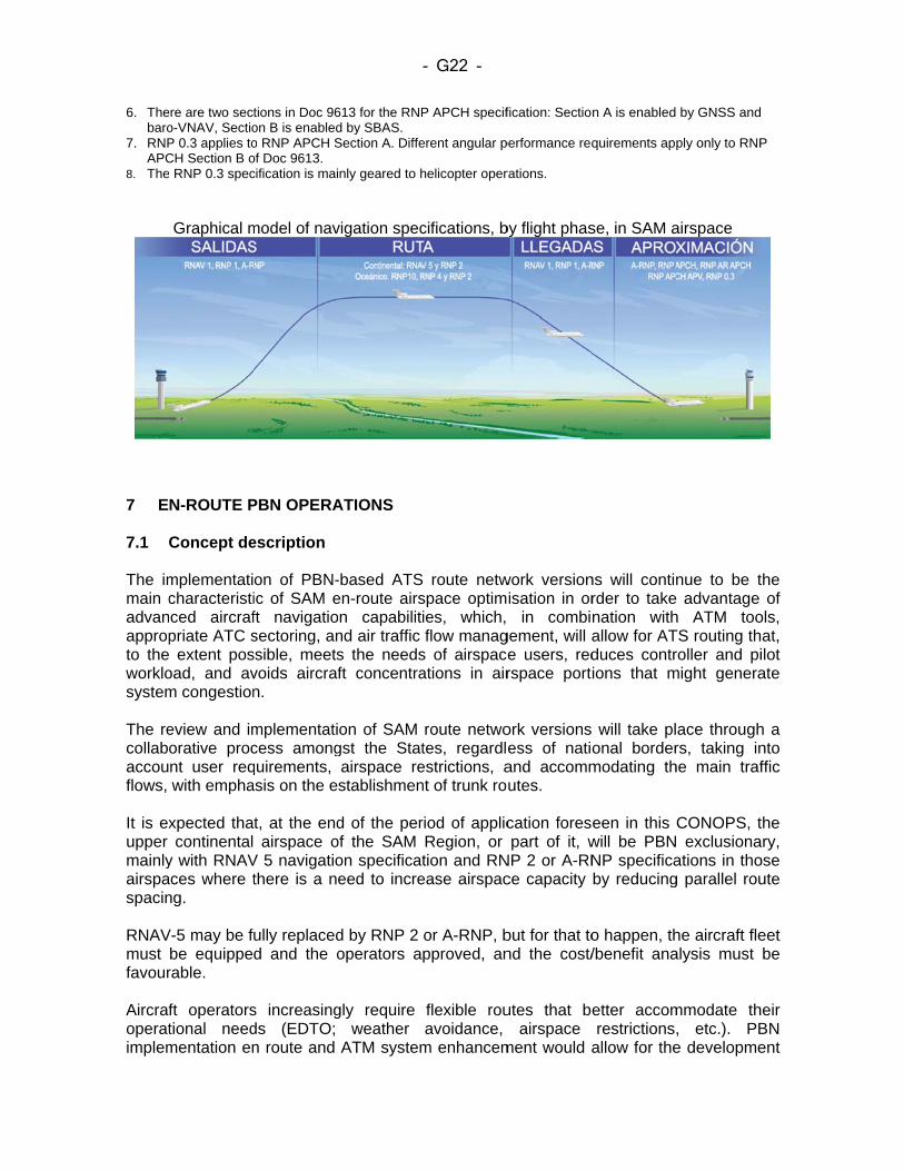
6. Thebaro
7. RNPAPC
8. The
7 E 7.1 The immain cadvanappropto theworklosystem The recollabaccouflows, It is exupper mainlyairspaspacin RNAVmust favour Aircrafoperatimplem
ere are two secto-VNAV, SectioP 0.3 applies toCH Section B oe RNP 0.3 spec
Graphical m
N-ROUTE P
Concept de
mplementaticharacteristiced aircrafpriate ATC s extent pos
oad, and avm congestion
eview and imorative procnt user reqwith empha
xpected thacontinental
y with RNAVaces where tng.
V-5 may be fbe equipperable.
ft operatorstional needmentation en
tions in Doc 96on B is enabledo RNP APCH Sof Doc 9613. cification is mai
model of nav
PBN OPERA
escription
on of PBN-ic of SAM eft navigatiosectoring, anssible, meetsvoids aircrafn.
mplementaticess amongquirements, asis on the e
t, at the endairspace o
V 5 navigatiothere is a ne
ully replacedd and the o
s increasingds (EDTO; n route and
613 for the RNPd by SBAS. Section A. Diffe
nly geared to h
vigation spec
ATIONS
-based ATSen-route airsn capabilitind air traffic s the needsft concentra
on of SAM gst the Statairspace restablishmen
d of the perof the SAM on specificateed to incre
d by RNP 2 operators a
gly require weather
ATM system
- G22 -
P APCH specif
erent angular p
helicopter oper
cifications, b
route netwspace optimies, which, flow manag
s of airspaceations in air
route netwotes, regardlestrictions, ant of trunk ro
riod of applicRegion, or tion and RN
ease airspac
or A-RNP, bpproved, an
flexible rouavoidance,
m enhancem
fication: Sectio
performance req
rations.
by flight phas
work versionisation in or
in combigement, will ae users, redrspace port
ork versionsess of natiand accommutes.
cation forespart of it, w
NP 2 or A-RNce capacity
but for that tond the cost/
utes that beairspace
ment would a
n A is enabled
quirements app
se, in SAM a
ns will continrder to takenation withallow for ATduces contrions that m
will take plonal bordermodating th
een in this will be PBNNP specificaby reducing
o happen, th/benefit ana
etter accomrestrictions,
allow for the
by GNSS and
ply only to RNP
airspace
nue to be t advantage
h ATM tooTS routing throller and pi
might genera
ace throughrs, taking in
he main traf
CONOPS, t exclusiona
ations in thog parallel rou
he aircraft flealysis must
mmodate th, etc.). PBe developme
P
the of
ols, at, ilot ate
h a nto ffic
the ary, ose ute
eet be
eir BN ent
- G23 -
of this type of routes. It is expected that future route network versions will contemplate the possibility of implementing random route airspaces, initially in low-density areas, establishing the appropriate COM/SUR requirements. Flexible route airspaces can be defined using:
Geographic coordinates that define them laterally; Exit/entry points to/from these airspaces; and/or Windows between the specified levels.
Additionally, flexible route airspaces may be activated during certain periods of time. In more complex airspaces, a fixed airspace structure would be maintained using a route network, which, combined with advanced on-board and ground capabilities, will ensure continued system capacity and safety levels. The concept recognises that, in high complex traffic, the required capacity can only be achieved at the expense of some restriction to individual optimum paths (e.g., segregated paths may add to miles flown or impair optimum profiles). In highly congested areas where climbing and descending traffic flows prevail it will be necessary to increase airspace capacity through the deployment of route structures that provide a higher degree of strategic segregation. The implementation of more advanced navigation specifications, such as RNP 2 or A-RNP will enable a reduction of route spacing. Likewise, in congested areas, and to the extent possible, overflights should not cross or interfere with incoming and outgoing flows at the main TMAs, and the duration of any possible crossings should be kept to a minimum. SAM airspace optimisation must also take into account ATC sectors, which should accommodate the main traffic flows and the route network, based on operational requirements. More ATC sectors (including vertical sectoring) will be developed and implemented as needed. ATC sectors must be designed to be adjustable, in shape and size (predefined), to variations in airspace demand and availability. It is foreseen that there will be a need to create cross-border ATC sectors to support operations. 7.2 Specific objectives It is expected that PBN and airspace optimisation implementation in the South American Region will contribute to the attainment of ICAO strategic objectives. 7.3 Principles
i. Replacement of conventional ATS routes with RNAV routes will continue in the
upper airspace, expecting 100% migration by 2020, and considering the possibility for this PBN airspace to be exclusionary by regional agreement.
ii. The optimisation of route network structures will be based on operational requirements, regardless of national borders or FIR boundaries.
- G24 -
iii. The design of route network structures will be a transparent process that takes into account the needs of all users, while addressing safety, capacity, environmental protection aspects, and military and national security requirements.
iv. The airspace structure, in general, will be developed in close coordination
between airspace design, airspace management, and air traffic flow management.
v. When required in oceanic routes, RNP 4 / RNP 2 will be implemented with a
lateral separation of 23 NM in parallel routes.
vi. In continental airspace where an operational advantage is to be derived, RNP 2 or A-RNP routes will be implemented with a spacing of 15 NM between parallel routes.
vii. In unidirectional routes where levels are assigned in accordance with the semi-
circular course table, a separation of 10 NM can be applied with an RNP 2 navigation specification.
viii. For dynamic airspace management, consideration will be given to the
implementation of conditional routes, taken into account that no airspace should be restricted on a permanent or fixed basis, or for an extended period of time, to which end effective civil-military coordination is required for flexible use of airspace (FUA).
ix. Safety assessments will be performed during the pre- and post-implementation
phases.
x. Ensure the connectivity between the route network and the SIDs and STARs of terminal areas.
7.4 Oceanic airspace Taking into account low traffic density in oceanic airspaces, no significant changes are expected in the current airspace structure. RNP10 (RNAV10) is applied in certain airspaces, such as the EUR/SAM Corridor, Lima-Santiago routes, and the South Atlantic Random Routing Area. Migration to RNP4 / RNP2 is foreseen, with the application of communication and surveillance performance, in order to reduce separation in accordance with Doc 4444, wherever there is a need to improve safety and/or increase airspace capacity (see Appendix B). Navigation in random routing areas should consider ADS-C/CPDLC, and aircraft flying in these areas should be conveniently equipped with FANS/1A. 7.4.1 Separation In oceanic airspace, separation between PBN routes will be applied in accordance with the following table:
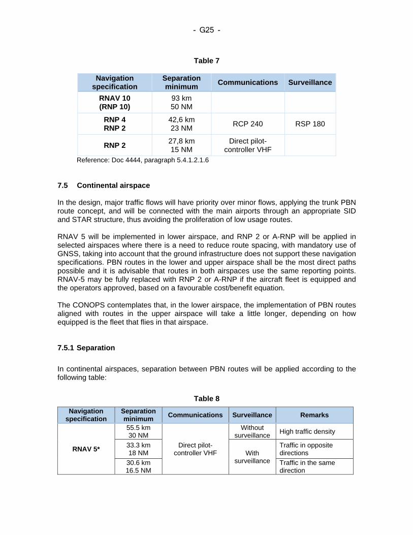
- G25 -
Table 7
Navigation
specification Separation minimum
Communications Surveillance
RNAV 10 (RNP 10)
93 km 50 NM
RNP 4 RNP 2
42,6 km 23 NM
RCP 240 RSP 180
RNP 2 27,8 km 15 NM
Direct pilot-controller VHF
Reference: Doc 4444, paragraph 5.4.1.2.1.6 7.5 Continental airspace In the design, major traffic flows will have priority over minor flows, applying the trunk PBN route concept, and will be connected with the main airports through an appropriate SID and STAR structure, thus avoiding the proliferation of low usage routes. RNAV 5 will be implemented in lower airspace, and RNP 2 or A-RNP will be applied in selected airspaces where there is a need to reduce route spacing, with mandatory use of GNSS, taking into account that the ground infrastructure does not support these navigation specifications. PBN routes in the lower and upper airspace shall be the most direct paths possible and it is advisable that routes in both airspaces use the same reporting points. RNAV-5 may be fully replaced with RNP 2 or A-RNP if the aircraft fleet is equipped and the operators approved, based on a favourable cost/benefit equation. The CONOPS contemplates that, in the lower airspace, the implementation of PBN routes aligned with routes in the upper airspace will take a little longer, depending on how equipped is the fleet that flies in that airspace. 7.5.1 Separation
In continental airspaces, separation between PBN routes will be applied according to the following table:
Table 8
Navigation specification
Separation minimum
Communications Surveillance Remarks
RNAV 5*
55.5 km 30 NM
Direct pilot-controller VHF
Without surveillance
High traffic density
33.3 km 18 NM With
surveillance
Traffic in opposite directions
30.6 km 16.5 NM
Traffic in the same direction
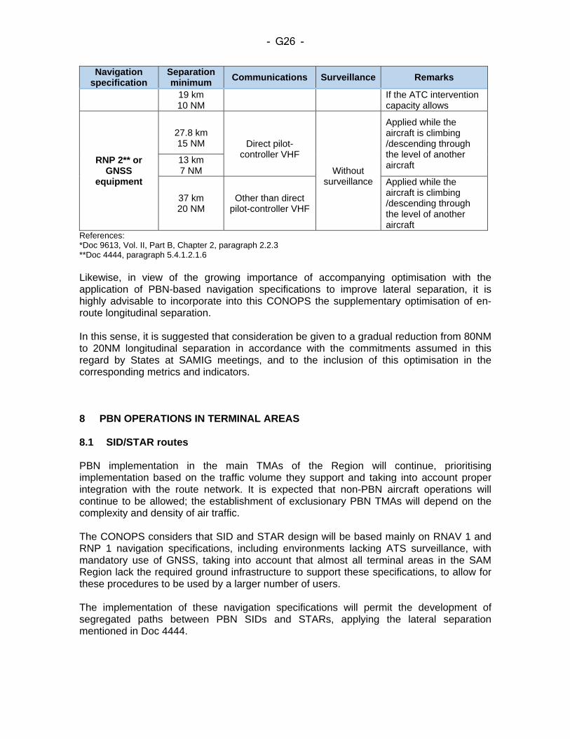
- G26 -
Navigation specification
Separation minimum
Communications Surveillance Remarks
19 km 10 NM
If the ATC intervention capacity allows
RNP 2** or GNSS
equipment
27.8 km 15 NM
Direct pilot-
controller VHF
Without surveillance
Applied while the aircraft is climbing /descending through the level of another aircraft 13 km
7 NM
37 km 20 NM
Other than direct pilot-controller VHF
Applied while the aircraft is climbing /descending through the level of another aircraft
References: *Doc 9613, Vol. II, Part B, Chapter 2, paragraph 2.2.3 **Doc 4444, paragraph 5.4.1.2.1.6 Likewise, in view of the growing importance of accompanying optimisation with the application of PBN-based navigation specifications to improve lateral separation, it is highly advisable to incorporate into this CONOPS the supplementary optimisation of en-route longitudinal separation. In this sense, it is suggested that consideration be given to a gradual reduction from 80NM to 20NM longitudinal separation in accordance with the commitments assumed in this regard by States at SAMIG meetings, and to the inclusion of this optimisation in the corresponding metrics and indicators.
8 PBN OPERATIONS IN TERMINAL AREAS 8.1 SID/STAR routes PBN implementation in the main TMAs of the Region will continue, prioritising implementation based on the traffic volume they support and taking into account proper integration with the route network. It is expected that non-PBN aircraft operations will continue to be allowed; the establishment of exclusionary PBN TMAs will depend on the complexity and density of air traffic. The CONOPS considers that SID and STAR design will be based mainly on RNAV 1 and RNP 1 navigation specifications, including environments lacking ATS surveillance, with mandatory use of GNSS, taking into account that almost all terminal areas in the SAM Region lack the required ground infrastructure to support these specifications, to allow for these procedures to be used by a larger number of users. The implementation of these navigation specifications will permit the development of segregated paths between PBN SIDs and STARs, applying the lateral separation mentioned in Doc 4444.
- G27 -
In low-traffic, low-complexity airspaces that have no significant terrain obstacles, an efficiency and safety assessment should be conducted to justify the implementation of PBN STARs, in order to avoid exactly the opposite result to that intended. In more complex environments that have obstacles or environmental restrictions that call for more advanced specifications, the design of SIDs and STARs will take into account the application of the A-RNP specification in order to take advantage of the functionality of RF segments and/or precision values below 1 NM down to 0.3 NM. It is not expected that design criteria for the implementation of RNP AR in SID design will be available within the period of validity of this CONOPS. Nevertheless, there is already one State that applies RNP AR criteria for SIDs and other States might have the same requirement and could make use of available experiences. (Appendix C) Improved management of climbing or descending flight profiles, together with the use of PBN, provides safer and more profitable operations in terminal areas. PBN procedures facilitate increasing use of CCO/CDO, which improves flight efficiency and reduces fuel burn, CO2 emissions and noise. In SID/STAR design, the States shall take into account the application of CCO/CDO within the possibilities of each scenario under consideration. Work shall be carried out in collaboration with the operators in order to improve the possibilities of success in the validation and implementation of CCO/CDO. At airports with a more complex operational environment, with a larger number of SID and STAR procedures, consideration should be given to the transition concept in chart identification in order to make it easier for the pilot to access the procedure cleared by the controller, and to prevent the ATCO to have to memorise a significant number of SIDs/STARs. In terminal areas that are adjacent or very close to each other, SIDs connecting directly to a STAR in the following terminal area and vice versa may be implemented, thus channelling two-way traffic flow between two aerodromes, keeping it strategically segregated (see Appendix D). In the terminal area setting and the aerodrome surroundings, navigation precision often leads to concentration of the perceived noise because there are more aircraft following the same approach profile. In some specific cases, mainly in the initial segments of the SIDs, it might be necessary to allow for a greater dispersal of paths, despite the precision of the RNAV system, in order to mitigate the effects of aviation noise. Consideration should be given to mitigating the environmental impact caused by noise in residential communities affected by procedure design, which over time may suffer cumulative noise pollution, through the application of noise abatement measures based on ICAO methods. The treatment to be given to VFR flights and the activities conducted by such flights, as well as those airspaces to be used for protecting visual corridors for VFR aircraft operations shall be defined during planning and design. 8.1.1 Navigation specifications Navigation specifications applicable to terminal areas are RNAV 1, RNP 1 or A-RNP.
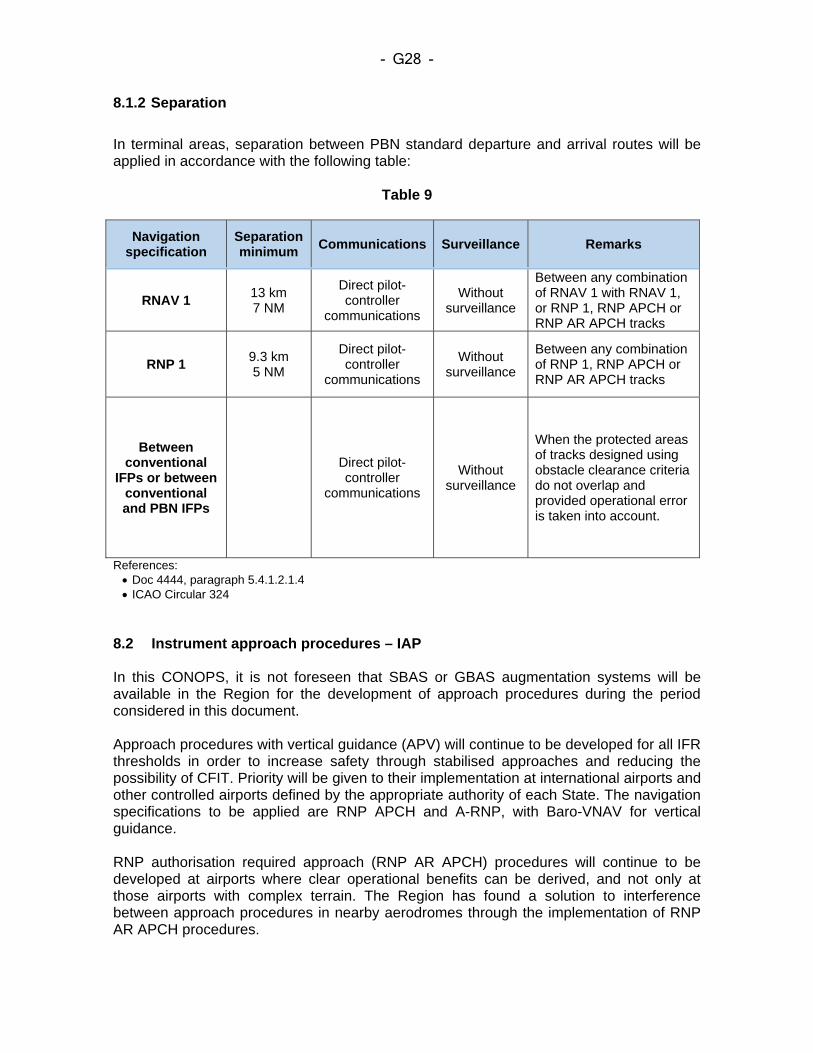
- G28 -
8.1.2 Separation
In terminal areas, separation between PBN standard departure and arrival routes will be applied in accordance with the following table:
Table 9
Navigation specification
Separation minimum
Communications Surveillance Remarks
RNAV 1 13 km 7 NM
Direct pilot-controller
communications
Without surveillance
Between any combination of RNAV 1 with RNAV 1, or RNP 1, RNP APCH or RNP AR APCH tracks
RNP 1 9.3 km 5 NM
Direct pilot-controller
communications
Without surveillance
Between any combination of RNP 1, RNP APCH or RNP AR APCH tracks
Between conventional
IFPs or between conventional and PBN IFPs
Direct pilot-controller
communications
Without surveillance
When the protected areas of tracks designed using obstacle clearance criteria do not overlap and provided operational error is taken into account.
References: Doc 4444, paragraph 5.4.1.2.1.4 ICAO Circular 324
8.2 Instrument approach procedures – IAP In this CONOPS, it is not foreseen that SBAS or GBAS augmentation systems will be available in the Region for the development of approach procedures during the period considered in this document. Approach procedures with vertical guidance (APV) will continue to be developed for all IFR thresholds in order to increase safety through stabilised approaches and reducing the possibility of CFIT. Priority will be given to their implementation at international airports and other controlled airports defined by the appropriate authority of each State. The navigation specifications to be applied are RNP APCH and A-RNP, with Baro-VNAV for vertical guidance. RNP authorisation required approach (RNP AR APCH) procedures will continue to be developed at airports where clear operational benefits can be derived, and not only at those airports with complex terrain. The Region has found a solution to interference between approach procedures in nearby aerodromes through the implementation of RNP AR APCH procedures.
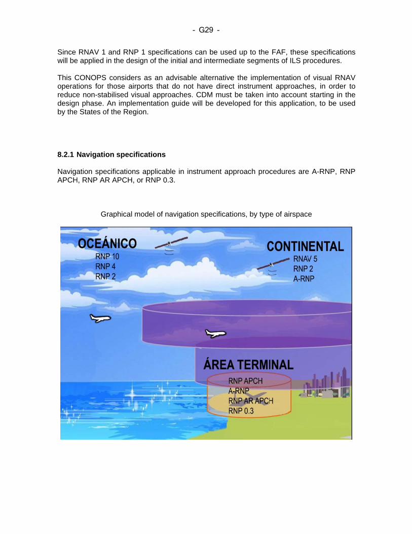
Since will be This Coperatreducedesignby the 8.2.1 NavigaAPCH
RNAV 1 ane applied in t
CONOPS cotions for thoe non-stabilin phase. Ane States of th
Navigation
ation specifiH, RNP AR A
Grap
nd RNP 1 spthe design o
onsiders as ose airports ised visual a implementa
he Region.
specificatio
ications appAPCH, or RN
phical model
pecifications f the initial a
an advisablthat do not
approaches.ation guide w
ons
plicable in inNP 0.3.
of navigatio
- G29 -
can be useand intermed
e alternativet have direc. CDM mustwill be deve
strument ap
on specificat
ed up to thediate segmen
e the implemct instrument be taken ineloped for th
pproach proc
tions, by type
FAF, thesents of ILS pr
mentation ofnt approachento account his applicatio
cedures are
e of airspace
specificatiorocedures.
f visual RNAes, in order starting in t
on, to be us
e A-RNP, RN
e
ons
AV to
the sed
NP
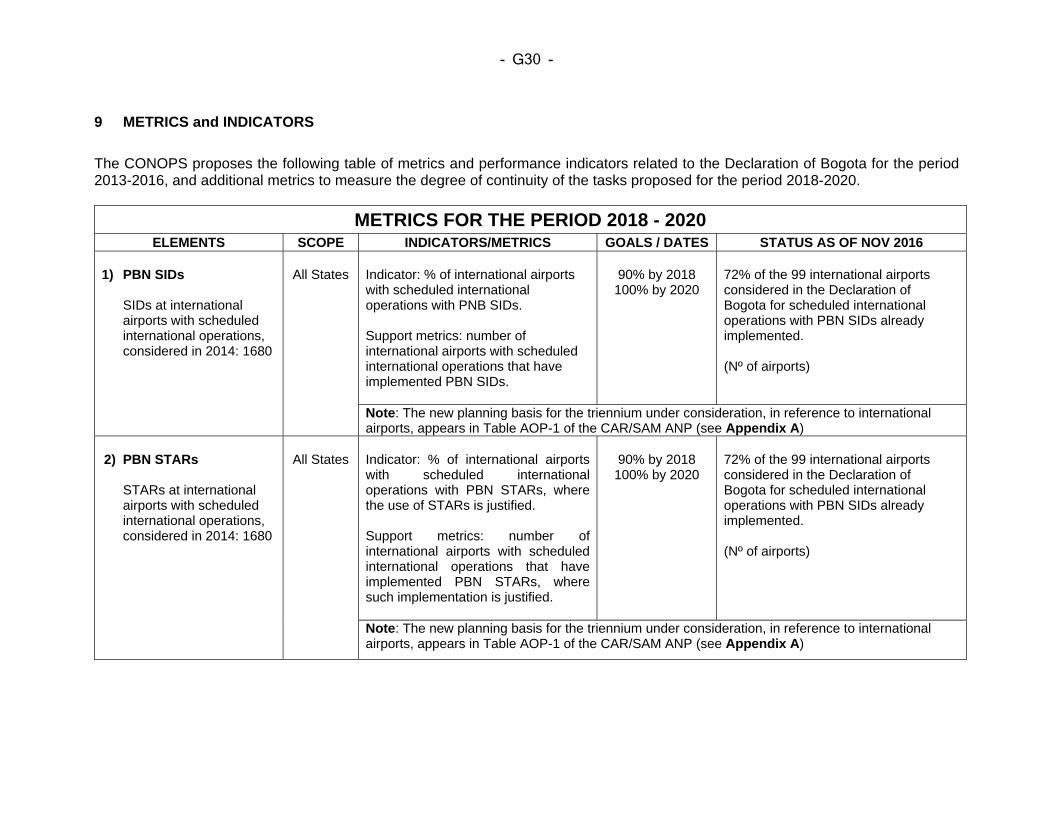
- G30 -
9 METRICS and INDICATORS
The CONOPS proposes the following table of metrics and performance indicators related to the Declaration of Bogota for the period 2013-2016, and additional metrics to measure the degree of continuity of the tasks proposed for the period 2018-2020.
METRICS FOR THE PERIOD 2018 - 2020 ELEMENTS SCOPE INDICATORS/METRICS GOALS / DATES STATUS AS OF NOV 2016
1) PBN SIDs
SIDs at international airports with scheduled international operations, considered in 2014: 1680
All States
Indicator: % of international airports with scheduled international operations with PNB SIDs. Support metrics: number of international airports with scheduled international operations that have implemented PBN SIDs.
90% by 2018 100% by 2020
72% of the 99 international airports considered in the Declaration of Bogota for scheduled international operations with PBN SIDs already implemented.
(Nº of airports)
Note: The new planning basis for the triennium under consideration, in reference to international airports, appears in Table AOP-1 of the CAR/SAM ANP (see Appendix A)
2) PBN STARs
STARs at international airports with scheduled international operations, considered in 2014: 1680
All States
Indicator: % of international airports with scheduled international operations with PBN STARs, where the use of STARs is justified. Support metrics: number of international airports with scheduled international operations that have implemented PBN STARs, where such implementation is justified.
90% by 2018 100% by 2020
72% of the 99 international airports considered in the Declaration of Bogota for scheduled international operations with PBN SIDs already implemented.
(Nº of airports)
Note: The new planning basis for the triennium under consideration, in reference to international airports, appears in Table AOP-1 of the CAR/SAM ANP (see Appendix A)
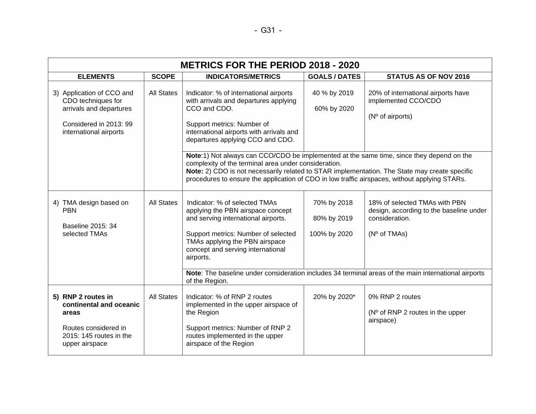
- G31 -
METRICS FOR THE PERIOD 2018 - 2020 ELEMENTS SCOPE INDICATORS/METRICS GOALS / DATES STATUS AS OF NOV 2016
3) Application of CCO and
CDO techniques for arrivals and departures
Considered in 2013: 99 international airports
All States
Indicator: % of international airports with arrivals and departures applying CCO and CDO. Support metrics: Number of international airports with arrivals and departures applying CCO and CDO.
40 % by 2019
60% by 2020
20% of international airports have implemented CCO/CDO
(Nº of airports)
Note:1) Not always can CCO/CDO be implemented at the same time, since they depend on the complexity of the terminal area under consideration. Note: 2) CDO is not necessarily related to STAR implementation. The State may create specific procedures to ensure the application of CDO in low traffic airspaces, without applying STARs.
4) TMA design based on
PBN
Baseline 2015: 34 selected TMAs
All States
Indicator: % of selected TMAs applying the PBN airspace concept and serving international airports. Support metrics: Number of selected TMAs applying the PBN airspace concept and serving international airports.
70% by 2018
80% by 2019
100% by 2020
18% of selected TMAs with PBN design, according to the baseline under consideration.
(Nº of TMAs)
Note: The baseline under consideration includes 34 terminal areas of the main international airports of the Region.
5) RNP 2 routes in
continental and oceanic areas
Routes considered in 2015: 145 routes in the upper airspace
All States
Indicator: % of RNP 2 routes implemented in the upper airspace of the Region Support metrics: Number of RNP 2 routes implemented in the upper airspace of the Region
20% by 2020*
0% RNP 2 routes
(Nº of RNP 2 routes in the upper airspace)
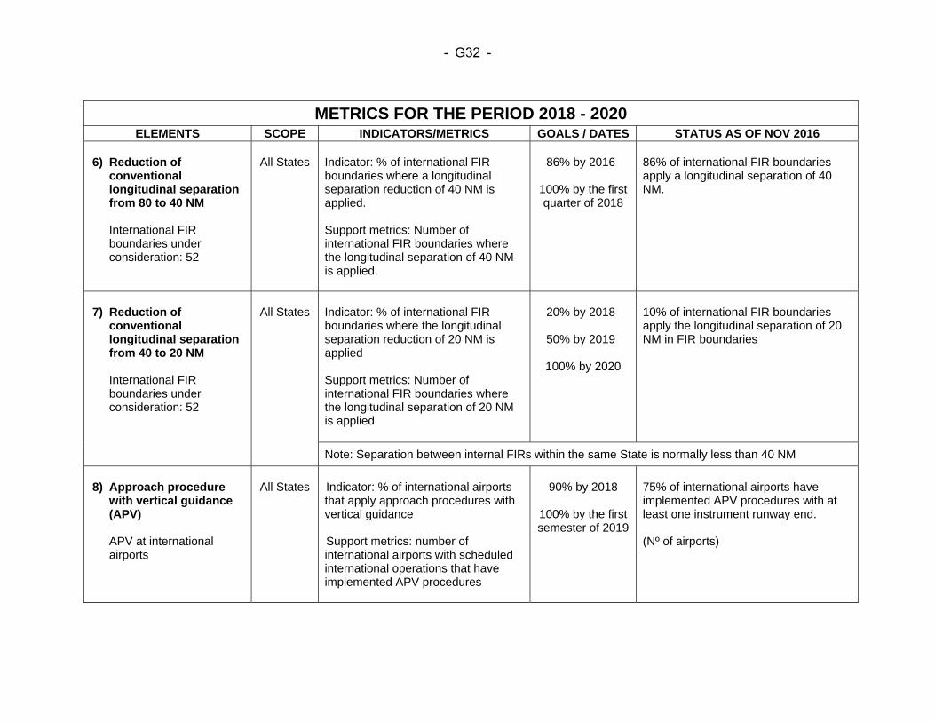
- G32 -
METRICS FOR THE PERIOD 2018 - 2020 ELEMENTS SCOPE INDICATORS/METRICS GOALS / DATES STATUS AS OF NOV 2016
6) Reduction of
conventional longitudinal separation from 80 to 40 NM
International FIR boundaries under consideration: 52
All States
Indicator: % of international FIR boundaries where a longitudinal separation reduction of 40 NM is applied. Support metrics: Number of international FIR boundaries where the longitudinal separation of 40 NM is applied.
86% by 2016
100% by the first quarter of 2018
86% of international FIR boundaries apply a longitudinal separation of 40 NM.
7) Reduction of
conventional longitudinal separation from 40 to 20 NM
International FIR boundaries under consideration: 52
All States
Indicator: % of international FIR boundaries where the longitudinal separation reduction of 20 NM is applied Support metrics: Number of international FIR boundaries where the longitudinal separation of 20 NM is applied
20% by 2018
50% by 2019
100% by 2020
10% of international FIR boundaries apply the longitudinal separation of 20 NM in FIR boundaries
Note: Separation between internal FIRs within the same State is normally less than 40 NM
8) Approach procedure
with vertical guidance (APV)
APV at international airports
All States
Indicator: % of international airports that apply approach procedures with vertical guidance Support metrics: number of international airports with scheduled international operations that have implemented APV procedures
90% by 2018
100% by the first semester of 2019
75% of international airports have implemented APV procedures with at least one instrument runway end. (Nº of airports)
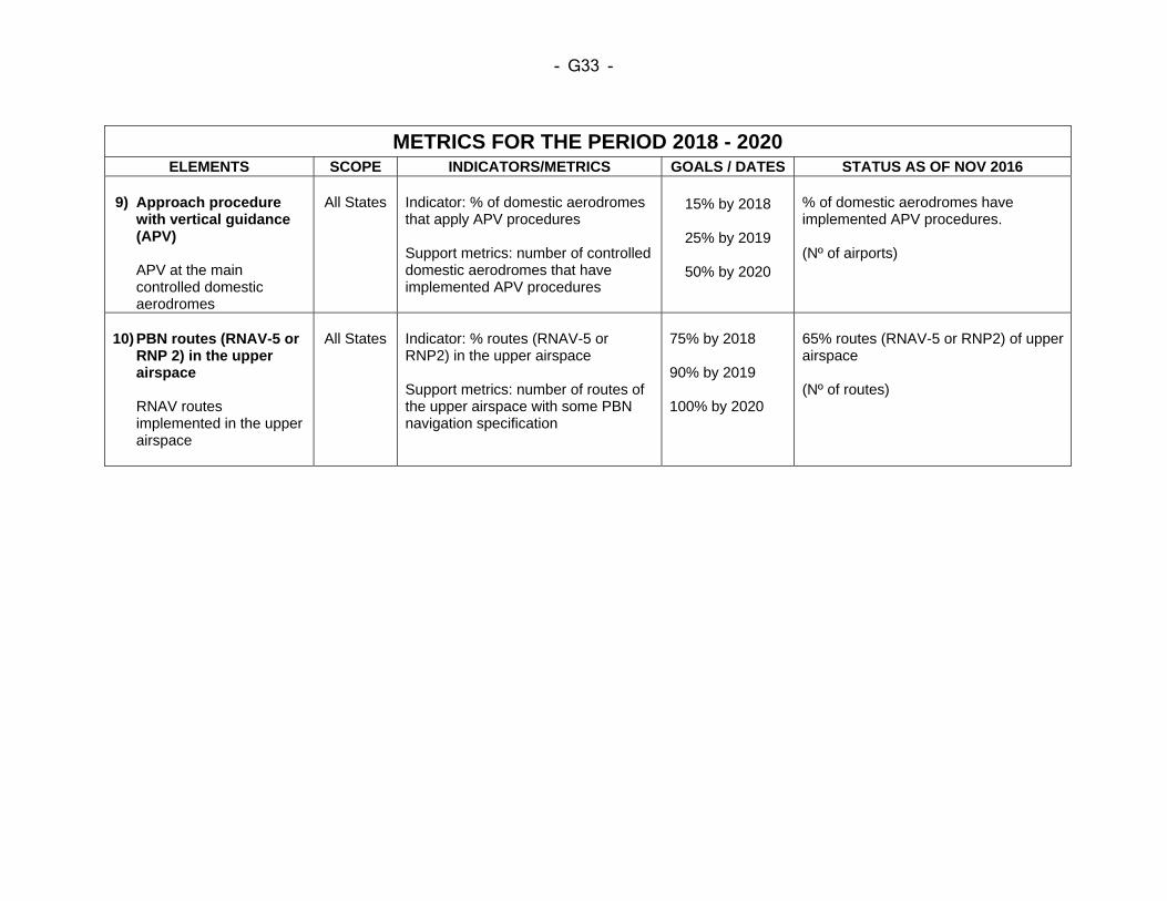
- G33 -
METRICS FOR THE PERIOD 2018 - 2020 ELEMENTS SCOPE INDICATORS/METRICS GOALS / DATES STATUS AS OF NOV 2016
9) Approach procedure
with vertical guidance (APV)
APV at the main controlled domestic aerodromes
All States
Indicator: % of domestic aerodromes that apply APV procedures Support metrics: number of controlled domestic aerodromes that have implemented APV procedures
15% by 2018
25% by 2019
50% by 2020
% of domestic aerodromes have implemented APV procedures. (Nº of airports)
10) PBN routes (RNAV-5 or
RNP 2) in the upper airspace
RNAV routes implemented in the upper airspace
All States
Indicator: % routes (RNAV-5 or RNP2) in the upper airspace Support metrics: number of routes of the upper airspace with some PBN navigation specification
75% by 2018 90% by 2019 100% by 2020
65% routes (RNAV-5 or RNP2) of upper airspace (Nº of routes)
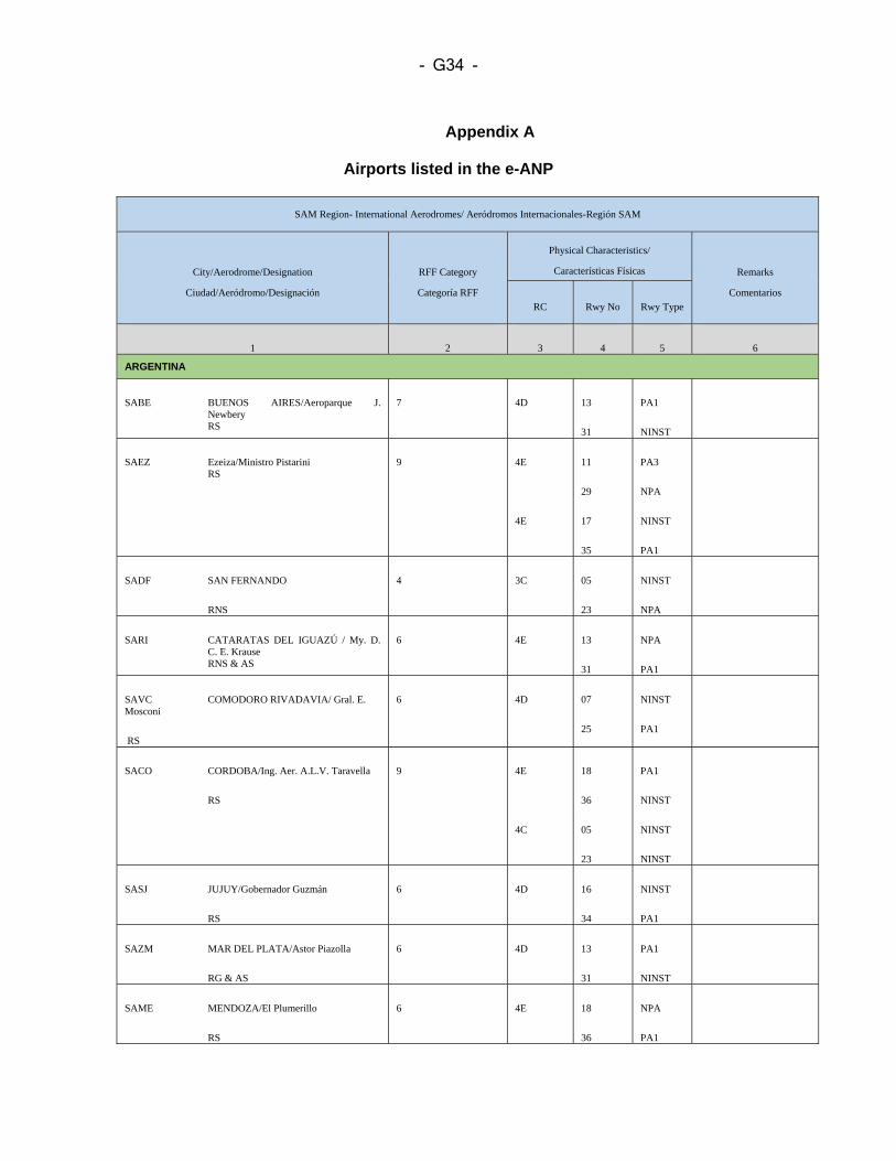
- G34 -
Appendix A
Airports listed in the e-ANP
SAM Region- International Aerodromes/ Aeródromos Internacionales-Región SAM
City/Aerodrome/Designation
Ciudad/Aeródromo/Designación RFF Category
Categoría RFF
Physical Characteristics/
Características Físicas Remarks
Comentarios RC Rwy No Rwy Type
1 2 3 4 5 6
ARGENTINA
SABE BUENOS AIRES/Aeroparque J. Newbery
RS
7 4D 13
31
PA1
NINST
SAEZ Ezeiza/Ministro Pistarini RS
9
4E
4E
11
29
17
35
PA3
NPA
NINST
PA1
SADF SAN FERNANDO
RNS
4 3C 05
23
NINST
NPA
SARI CATARATAS DEL IGUAZÚ / My. D. C. E. Krause
RNS & AS
6 4E 13
31
NPA
PA1
SAVC COMODORO RIVADAVIA/ Gral. E. Mosconi
RS
6 4D 07
25
NINST
PA1
SACO CORDOBA/Ing. Aer. A.L.V. Taravella
RS
9 4E
4C
18
36
05
23
PA1
NINST
NINST
NINST
SASJ JUJUY/Gobernador Guzmán
RS
6 4D 16
34
NINST
PA1
SAZM MAR DEL PLATA/Astor Piazolla
RG & AS
6 4D 13
31
PA1
NINST
SAME MENDOZA/El Plumerillo
RS
6
4E
18
36
NPA
PA1
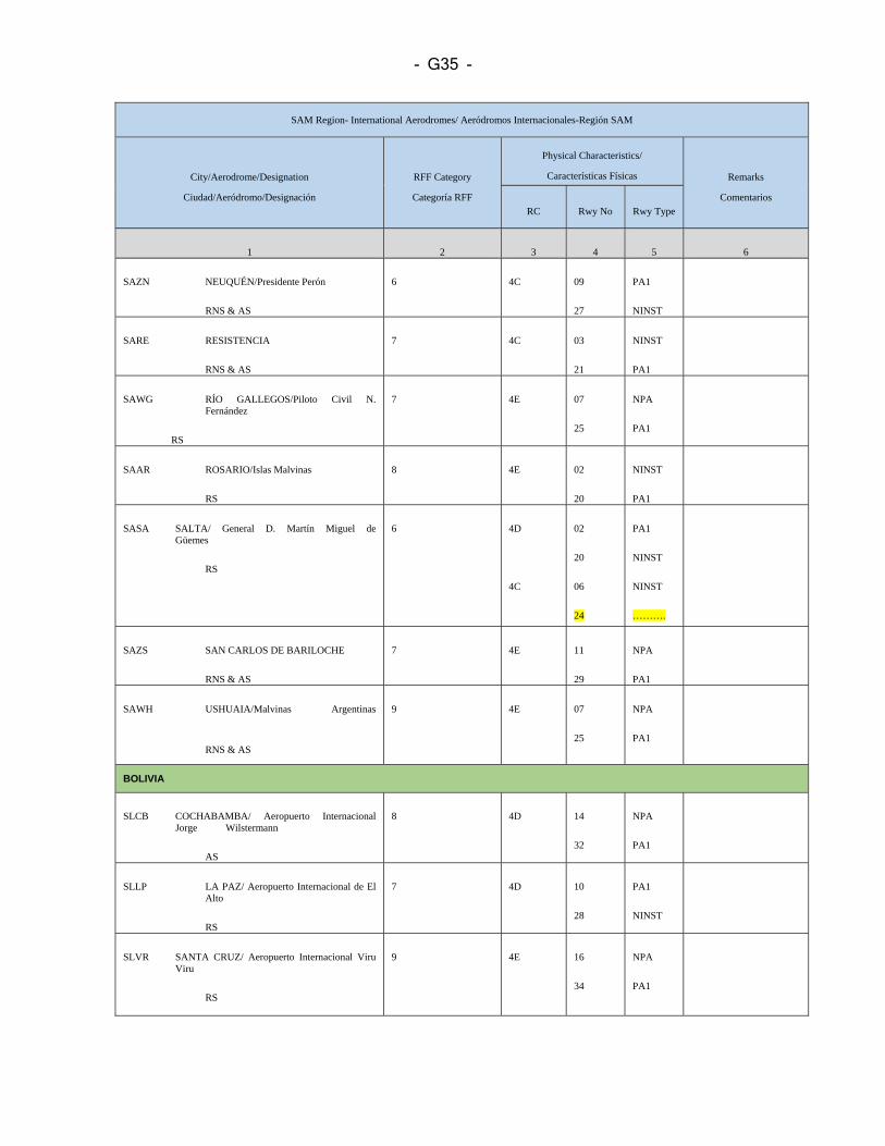
- G35 -
SAM Region- International Aerodromes/ Aeródromos Internacionales-Región SAM
City/Aerodrome/Designation
Ciudad/Aeródromo/Designación RFF Category
Categoría RFF
Physical Characteristics/
Características Físicas Remarks
Comentarios RC Rwy No Rwy Type
1 2 3 4 5 6
SAZN NEUQUÉN/Presidente Perón
RNS & AS
6 4C 09
27
PA1
NINST
SARE RESISTENCIA
RNS & AS
7 4C
03
21
NINST
PA1
SAWG RÍO GALLEGOS/Piloto Civil N. Fernández
RS
7 4E 07
25
NPA
PA1
SAAR ROSARIO/Islas Malvinas
RS
8 4E 02
20
NINST
PA1
SASA SALTA/ General D. Martín Miguel de Güemes
RS
6 4D
4C
02
20
06
24
PA1
NINST
NINST
……….
SAZS SAN CARLOS DE BARILOCHE
RNS & AS
7 4E 11
29
NPA
PA1
SAWH USHUAIA/Malvinas Argentinas
RNS & AS
9 4E 07
25
NPA
PA1
BOLIVIA
SLCB COCHABAMBA/ Aeropuerto Internacional Jorge Wilstermann
AS
8 4D 14
32
NPA
PA1
SLLP LA PAZ/ Aeropuerto Internacional de El Alto
RS
7 4D 10
28
PA1
NINST
SLVR SANTA CRUZ/ Aeropuerto Internacional Viru Viru
RS
9 4E 16
34
NPA
PA1
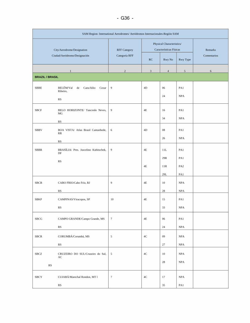
- G36 -
SAM Region- International Aerodromes/ Aeródromos Internacionales-Región SAM
City/Aerodrome/Designation
Ciudad/Aeródromo/Designación RFF Category
Categoría RFF
Physical Characteristics/
Características Físicas Remarks
Comentarios RC Rwy No Rwy Type
1 2 3 4 5 6
BRAZIL / BRASIL
SBBE BELÉM/Val de Cans/Júlio Cezar Ribeiro,
RS
9 4D
06
24
PA1
NPA
SBCF BELO HORIZONTE/ Tancredo Neves, MG
RS
9 4E 16
34
PA1
NPA
SBBV BOA VISTA/ Atlas Brasil Cantanhede, RR
RS
6
4D
08
26
PA1
NPA
SBBR BRASÍLIA/ Pres. Juscelino Kubitschek, DF
RS
9 4E
4E
11L
29R
11R
29L
PA1
PA1
PA2
PA1
SBCB CABO FRIO/Cabo Frío, RJ
RS
9 4E 10
28
NPA
NPA
SBKP CAMPINAS/Viracopos, SP
RS
10 4E 15
33
PA1
NPA
SBCG CAMPO GRANDE/Campo Grande, MS
RS
7
4E 06
24
PA1
NPA
SBCR CORUMBÁ/Corumbá, MS
RS
5 4C 09
27
NPA
NPA
SBCZ CRUZEIRO DO SUL/Cruzeiro do Sul, AC
RS
5 4C 10
28
NPA
NPA
SBCY CUIABÁ/Marechal Rondon, MT l
RS
7 4C 17
35
NPA
PA1
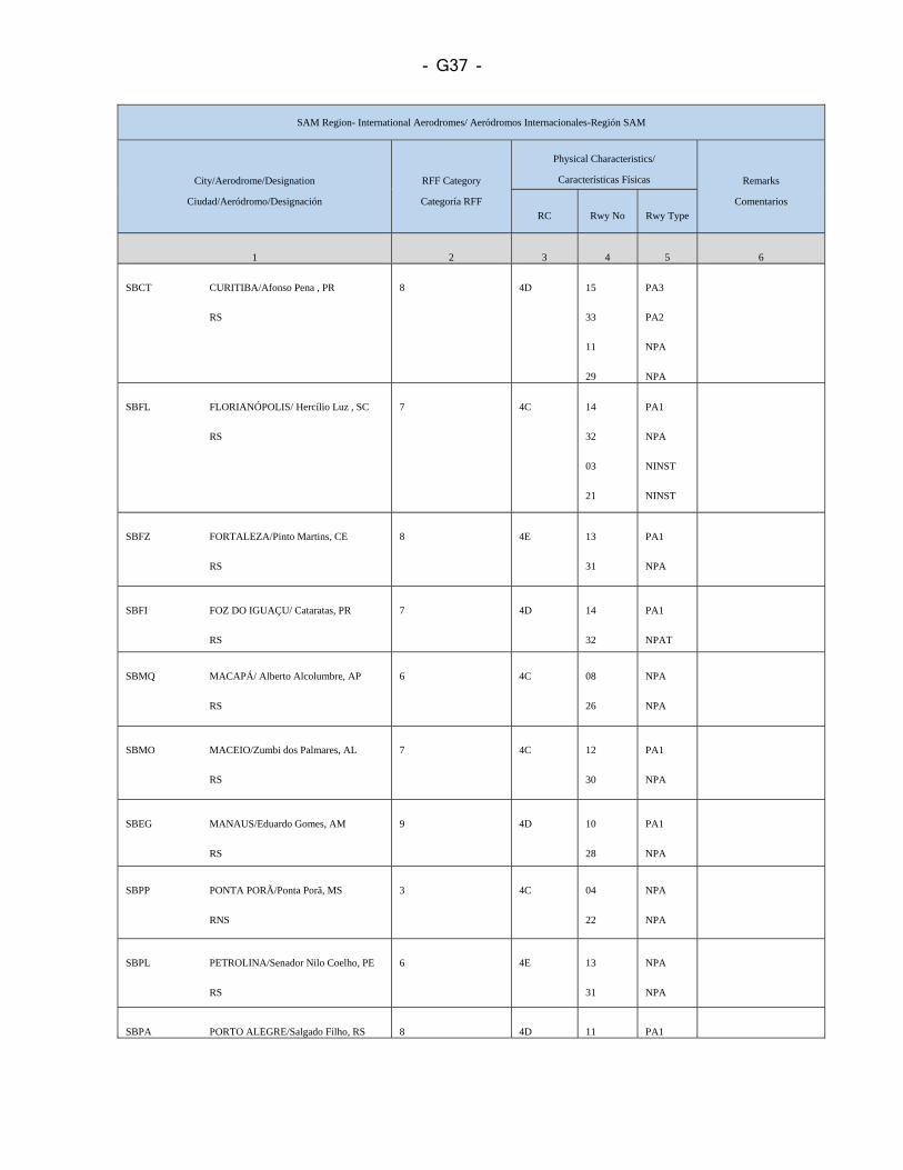
- G37 -
SAM Region- International Aerodromes/ Aeródromos Internacionales-Región SAM
City/Aerodrome/Designation
Ciudad/Aeródromo/Designación RFF Category
Categoría RFF
Physical Characteristics/
Características Físicas Remarks
Comentarios RC Rwy No Rwy Type
1 2 3 4 5 6
SBCT CURITIBA/Afonso Pena , PR
RS
8 4D 15
33
11
29
PA3
PA2
NPA
NPA
SBFL FLORIANÓPOLIS/ Hercílio Luz , SC
RS
7 4C 14
32
03
21
PA1
NPA
NINST
NINST
SBFZ FORTALEZA/Pinto Martins, CE
RS
8 4E 13
31
PA1
NPA
SBFI FOZ DO IGUAÇU/ Cataratas, PR
RS
7 4D 14
32
PA1
NPAT
SBMQ MACAPÁ/ Alberto Alcolumbre, AP
RS
6 4C 08
26
NPA
NPA
SBMO MACEIO/Zumbi dos Palmares, AL
RS
7 4C 12
30
PA1
NPA
SBEG MANAUS/Eduardo Gomes, AM
RS
9 4D 10
28
PA1
NPA
SBPP PONTA PORÃ/Ponta Porã, MS
RNS
3
4C 04
22
NPA
NPA
SBPL PETROLINA/Senador Nilo Coelho, PE
RS
6 4E 13
31
NPA
NPA
SBPA PORTO ALEGRE/Salgado Filho, RS 8 4D 11 PA1
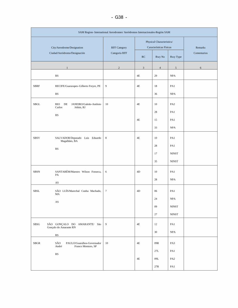
- G38 -
SAM Region- International Aerodromes/ Aeródromos Internacionales-Región SAM
City/Aerodrome/Designation
Ciudad/Aeródromo/Designación RFF Category
Categoría RFF
Physical Characteristics/
Características Físicas Remarks
Comentarios RC Rwy No Rwy Type
1 2 3 4 5 6
RS 4E 29 NPA
SBRF RECIFE/Guararapes–Gilberto Freyre, PE
RS
9 4E 18
36
PA1
NPA
SBGL RIO DE JANEIRO/Galeão-Antônio Carlos Jobim, RJ
RS
10
4E
4E
10
28
15
33
PA2
PA1
PA1
NPA
SBSV SALVADOR/Deputado Luis Eduardo Magalhães, BA
RS
8 4E 10
28
17
35
PA1
PA1
NINST
NINST
SBSN SANTARÉM/Maestro Wilson Fonseca, PA
AS
6
4D
10
28
PA1
NPA
SBSL SÃO LUÍS/Marechal Cunha Machado, MA
AS
7 4D 06
24
09
27
PA1
NPA
NINST
NINST
SBSG SÃO GONÇALO DO AMARANTE/ São Gonçalo do Amarante RN
RS
9 4E 12
30
PA1
NPA
SBGR SÃO PAULO/Guarulhos-Governador André Franco Montoro, SP
RS
10
4E
4E
09R
27L
09L
27R
PA3
PA1
PA2
PA1
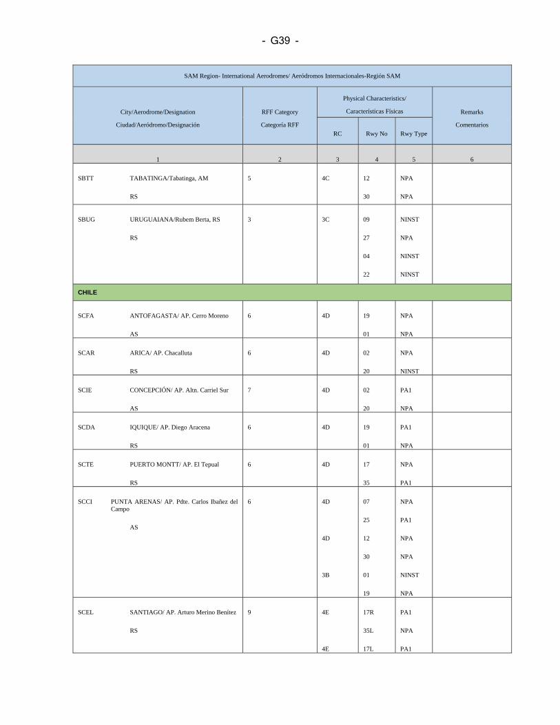
- G39 -
SAM Region- International Aerodromes/ Aeródromos Internacionales-Región SAM
City/Aerodrome/Designation
Ciudad/Aeródromo/Designación RFF Category
Categoría RFF
Physical Characteristics/
Características Físicas Remarks
Comentarios RC Rwy No Rwy Type
1 2 3 4 5 6
SBTT TABATINGA/Tabatinga, AM
RS
5 4C 12
30
NPA
NPA
SBUG URUGUAIANA/Rubem Berta, RS
RS
3 3C 09
27
04
22
NINST
NPA
NINST
NINST
CHILE
SCFA ANTOFAGASTA/ AP. Cerro Moreno
AS
6 4D 19
01
NPA
NPA
SCAR ARICA/ AP. Chacalluta
RS
6 4D 02
20
NPA
NINST
SCIE CONCEPCIÓN/ AP. Altn. Carriel Sur
AS
7
4D 02
20
PA1
NPA
SCDA IQUIQUE/ AP. Diego Aracena
RS
6 4D 19
01
PA1
NPA
SCTE PUERTO MONTT/ AP. El Tepual
RS
6
4D
17
35
NPA
PA1
SCCI PUNTA ARENAS/ AP. Pdte. Carlos Ibañez del Campo
AS
6 4D
4D
3B
07
25
12
30
01
19
NPA
PA1
NPA
NPA
NINST
NPA
SCEL SANTIAGO/ AP. Arturo Merino Benítez
RS
9
4E
4E
17R
35L
17L
PA1
NPA
PA1
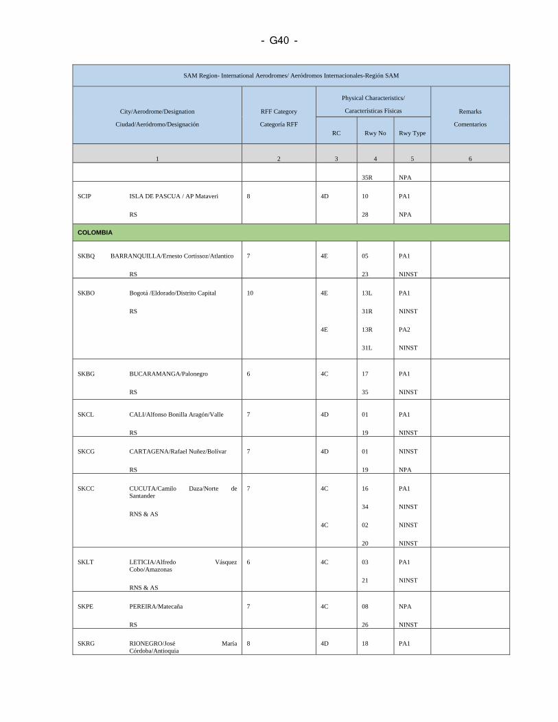
- G40 -
SAM Region- International Aerodromes/ Aeródromos Internacionales-Región SAM
City/Aerodrome/Designation
Ciudad/Aeródromo/Designación RFF Category
Categoría RFF
Physical Characteristics/
Características Físicas Remarks
Comentarios RC Rwy No Rwy Type
1 2 3 4 5 6
35R NPA
SCIP ISLA DE PASCUA / AP Mataveri
RS
8 4D 10
28
PA1
NPA
COLOMBIA
SKBQ BARRANQUILLA/Ernesto Cortissoz/Atlantico
RS
7 4E 05
23
PA1
NINST
SKBO Bogotá /Eldorado/Distrito Capital
RS
10 4E
4E
13L
31R
13R
31L
PA1
NINST
PA2
NINST
SKBG BUCARAMANGA/Palonegro
RS
6 4C 17
35
PA1
NINST
SKCL CALI/Alfonso Bonilla Aragón/Valle
RS
7 4D 01
19
PA1
NINST
SKCG CARTAGENA/Rafael Nuñez/Bolívar
RS
7 4D 01
19
NINST
NPA
SKCC CUCUTA/Camilo Daza/Norte de Santander
RNS & AS
7 4C
4C
16
34
02
20
PA1
NINST
NINST
NINST
SKLT LETICIA/Alfredo Vásquez Cobo/Amazonas
RNS & AS
6 4C 03
21
PA1
NINST
SKPE PEREIRA/Matecaña
RS
7 4C 08
26
NPA
NINST
SKRG RIONEGRO/José María Córdoba/Antioquia
8 4D 18 PA1
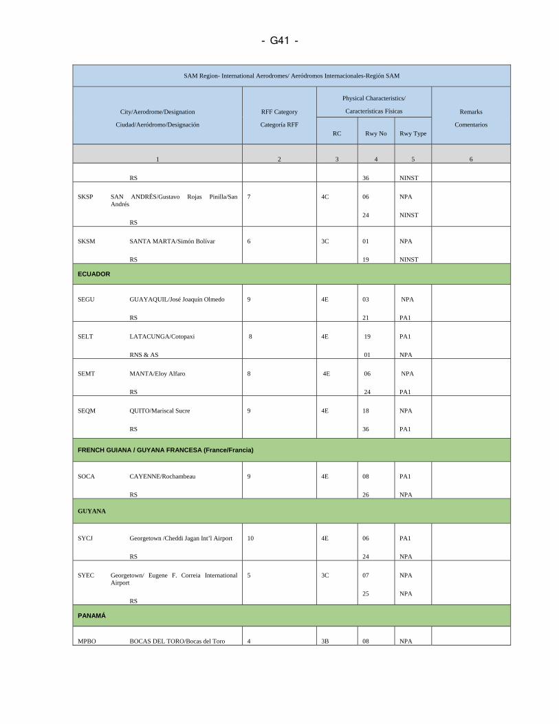
- G41 -
SAM Region- International Aerodromes/ Aeródromos Internacionales-Región SAM
City/Aerodrome/Designation
Ciudad/Aeródromo/Designación RFF Category
Categoría RFF
Physical Characteristics/
Características Físicas Remarks
Comentarios RC Rwy No Rwy Type
1 2 3 4 5 6
RS 36 NINST
SKSP SAN ANDRÉS/Gustavo Rojas Pinilla/San Andrés
RS
7 4C 06
24
NPA
NINST
SKSM SANTA MARTA/Simón Bolívar
RS
6 3C 01
19
NPA
NINST
ECUADOR
SEGU GUAYAQUIL/José Joaquín Olmedo
RS
9 4E 03
21
NPA
PA1
SELT LATACUNGA/Cotopaxi
RNS & AS
8 4E 19
01
PA1
NPA
SEMT MANTA/Eloy Alfaro
RS
8 4E 06
24
NPA
PA1
SEQM QUITO/Mariscal Sucre
RS
9 4E 18
36
NPA
PA1
FRENCH GUIANA / GUYANA FRANCESA (France/Francia)
SOCA CAYENNE/Rochambeau
RS
9 4E 08
26
PA1
NPA
GUYANA
SYCJ Georgetown /Cheddi Jagan Int’l Airport
RS
10
4E
06
24
PA1
NPA
SYEC Georgetown/ Eugene F. Correia International Airport
RS
5 3C 07
25
NPA
NPA
PANAMÁ
MPBO BOCAS DEL TORO/Bocas del Toro 4 3B 08 NPA
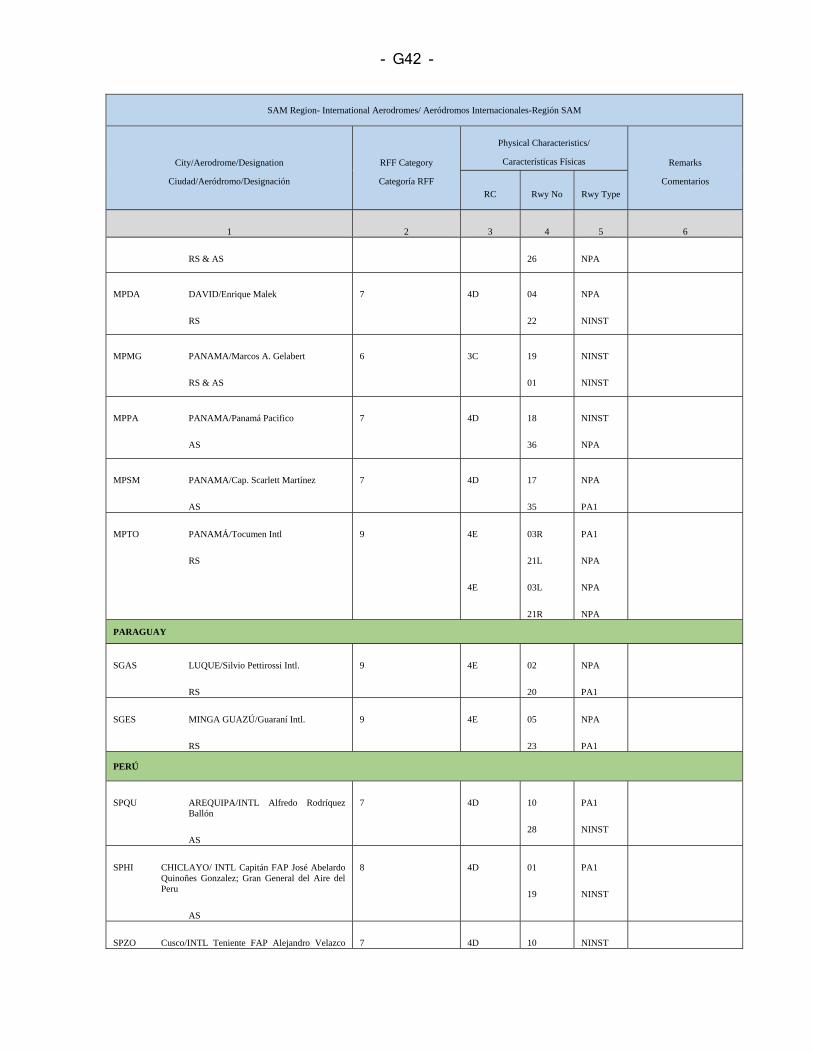
- G42 -
SAM Region- International Aerodromes/ Aeródromos Internacionales-Región SAM
City/Aerodrome/Designation
Ciudad/Aeródromo/Designación RFF Category
Categoría RFF
Physical Characteristics/
Características Físicas Remarks
Comentarios RC Rwy No Rwy Type
1 2 3 4 5 6
RS & AS 26 NPA
MPDA DAVID/Enrique Malek
RS
7 4D 04
22
NPA
NINST
MPMG PANAMA/Marcos A. Gelabert
RS & AS
6 3C 19
01
NINST
NINST
MPPA PANAMA/Panamá Pacifico
AS
7 4D 18
36
NINST
NPA
MPSM PANAMA/Cap. Scarlett Martínez
AS
7 4D 17
35
NPA
PA1
MPTO PANAMÁ/Tocumen Intl
RS
9 4E
4E
03R
21L
03L
21R
PA1
NPA
NPA
NPA
PARAGUAY
SGAS LUQUE/Silvio Pettirossi Intl.
RS
9 4E 02
20
NPA
PA1
SGES MINGA GUAZÚ/Guaraní Intl.
RS
9 4E 05
23
NPA
PA1
PERÚ
SPQU AREQUIPA/INTL Alfredo Rodríquez Ballón
AS
7 4D 10
28
PA1
NINST
SPHI CHICLAYO/ INTL Capitán FAP José Abelardo Quinoñes Gonzalez; Gran General del Aire del Peru
AS
8 4D 01
19
PA1
NINST
SPZO Cusco/INTL Teniente FAP Alejandro Velazco 7 4D 10 NINST
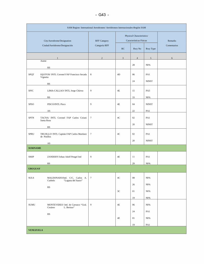
- G43 -
SAM Region- International Aerodromes/ Aeródromos Internacionales-Región SAM
City/Aerodrome/Designation
Ciudad/Aeródromo/Designación RFF Category
Categoría RFF
Physical Characteristics/
Características Físicas Remarks
Comentarios RC Rwy No Rwy Type
1 2 3 4 5 6 Astete
RS 28 NPA
SPQT IQUITOS/ INTL Coronel FAP Francisco Secada Vignetta
RS
8 4D 06
24
PA1
NINST
SPJC LIMA-CALLAO/ INTL Jorge Chávez
RS
9
4E
15
33
PA3
NPA
SPSO PISCO/INTL Pisco
AS
9 4E 04
22
NINST
PA1
SPTN TACNA/ INTL Coronel FAP Carlos Ciriani Santa Rosa
RS
7 4C 02
20
PA1
NINST
SPRU TRUJILLO/ INTL Capitán FAP Carlos Martínez de Pinillos
AS
7 4C
02
20
PA1
NINST
SURINAME
SMJP ZANDERY/Johan Adolf Pengel Intl
RS
9 4E 11
29
PA1
NPA
URUGUAY
SULS MALDONADO/Intl. C/C, Carlos A. Curbelo “Laguna del Sauce”
RS
7 4C
3C
08
26
01
19
NPA
NPA
NPA
NPA
SUMU MONTEVIDEO/ Intl. de Carrasco “Gral. Cesáreo L. Berisso”
RS
9 4E
4E
06
24
01
19
NPA
PA1
NPA
PA1
VENEZUELA
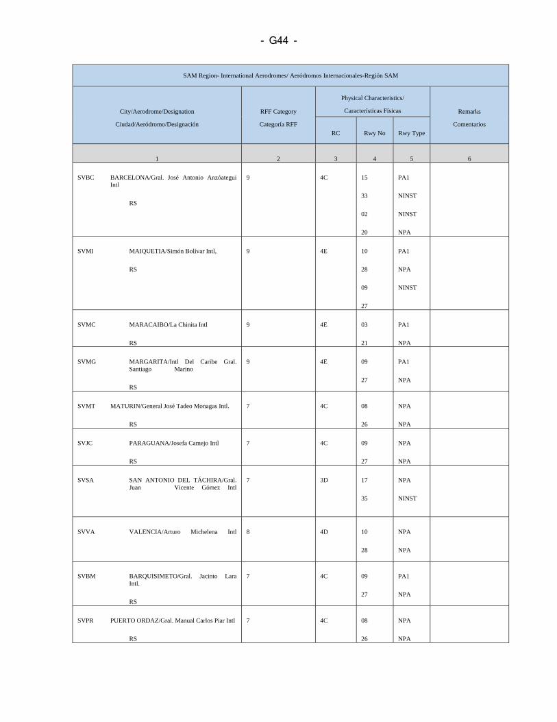
- G44 -
SAM Region- International Aerodromes/ Aeródromos Internacionales-Región SAM
City/Aerodrome/Designation
Ciudad/Aeródromo/Designación RFF Category
Categoría RFF
Physical Characteristics/
Características Físicas Remarks
Comentarios RC Rwy No Rwy Type
1 2 3 4 5 6
SVBC BARCELONA/Gral. José Antonio Anzóategui Intl
RS
9 4C 15
33
02
20
PA1
NINST
NINST
NPA
SVMI MAIQUETIA/Simón Bolívar Intl,
RS
9 4E 10
28
09
27
PA1
NPA
NINST
SVMC MARACAIBO/La Chinita Intl
RS
9 4E 03
21
PA1
NPA
SVMG MARGARITA/Intl Del Caribe Gral. Santiago Marino
RS
9 4E 09
27
PA1
NPA
SVMT MATURIN/General José Tadeo Monagas Intl.
RS
7 4C 08
26
NPA
NPA
SVJC PARAGUANA/Josefa Camejo Intl
RS
7 4C 09
27
NPA
NPA
SVSA SAN ANTONIO DEL TÁCHIRA/Gral. Juan Vicente Gómez Intl
7 3D 17
35
NPA
NINST
SVVA VALENCIA/Arturo Michelena Intl
8 4D 10
28
NPA
NPA
SVBM BARQUISIMETO/Gral. Jacinto Lara Intl.
RS
7 4C 09
27
PA1
NPA
SVPR PUERTO ORDAZ/Gral. Manual Carlos Piar Intl
RS
7 4C 08
26
NPA
NPA
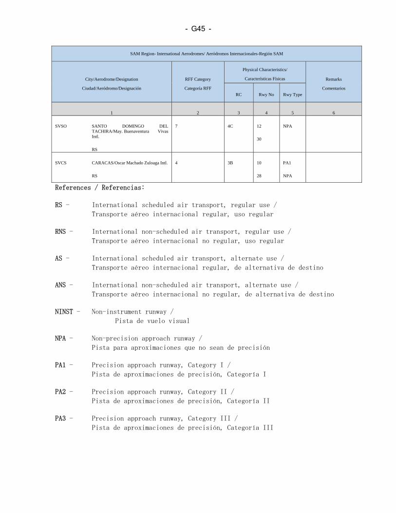
- G45 -
SAM Region- International Aerodromes/ Aeródromos Internacionales-Región SAM
City/Aerodrome/Designation
Ciudad/Aeródromo/Designación RFF Category
Categoría RFF
Physical Characteristics/
Características Físicas Remarks
Comentarios RC Rwy No Rwy Type
1 2 3 4 5 6
SVSO SANTO DOMINGO DEL TACHIRA/May. Buenaventura Vivas Intl.
RS
7 4C 12
30
NPA
SVCS CARACAS/Oscar Machado Zuloaga Intl.
RS
4 3B 10
28
PA1
NPA
References / Referencias: RS - International scheduled air transport, regular use /
Transporte aéreo internacional regular, uso regular RNS - International non-scheduled air transport, regular use /
Transporte aéreo internacional no regular, uso regular AS - International scheduled air transport, alternate use /
Transporte aéreo internacional regular, de alternativa de destino ANS - International non-scheduled air transport, alternate use /
Transporte aéreo internacional no regular, de alternativa de destino NINST - Non-instrument runway /
Pista de vuelo visual
NPA - Non-precision approach runway /
Pista para aproximaciones que no sean de precisión PA1 - Precision approach runway, Category I /
Pista de aproximaciones de precisión, Categoría I PA2 - Precision approach runway, Category II /
Pista de aproximaciones de precisión, Categoría II PA3 - Precision approach runway, Category III /
Pista de aproximaciones de precisión, Categoría III

- G46 -
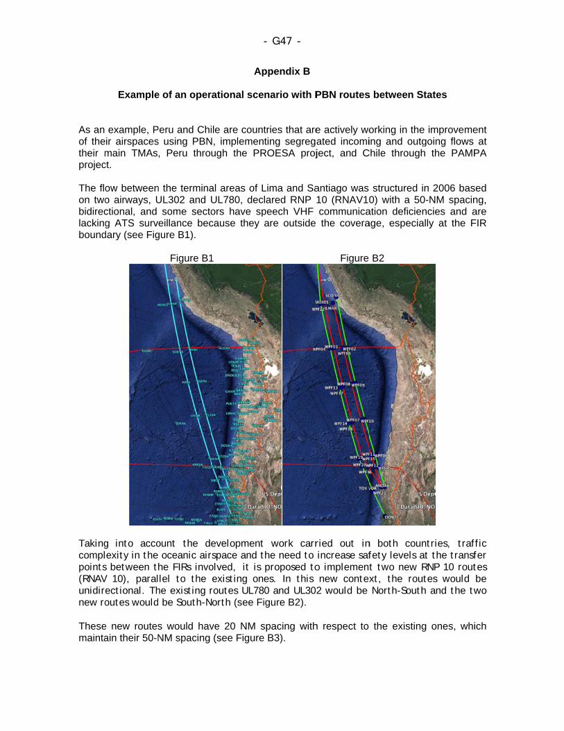
As an of thetheir mprojec The floon twobidireclackingbound
Takingcomplpoints(RNAVunidirenew ro Thesemainta
Example
example, Pir airspacesmain TMAsct.
ow betweeno airways, Uctional, and g ATS surv
dary (see Fig
g into accolexity in thes between tV 10), paralectional. Thoutes would
e new routesain their 50-N
e of an oper
Peru and Chis using PBN, Peru thro
n the terminaUL302 and
some sectoeillance bec
gure B1).
Figure B1
ount the de oceanic airhe FIRs invollel to the he existing r be South-N
s would havNM spacing
Ap
rational sce
ile are countN, implemenugh the PR
al areas of LUL780, decors have spcause they
1
evelopmentrspace and tolved, it is existing onroutes UL78
North (see Fi
ve 20 NM s(see Figure
- G47 -
ppendix B
nario with P
tries that areting segrega
ROESA proj
Lima and Salared RNP peech VHF are outside
t work carrthe need to proposed toes. In this 0 and UL302igure B2).
spacing withe B3).
PBN routes
e actively woated incomiject, and C
antiago was 10 (RNAV10communicathe covera
Figure
ried out in increase safo implemennew contex2 would be
h respect to
s between S
orking in theing and outg
Chile through
structured i0) with a 50
ation deficieage, especia
B2
n both counfety levels at two new Rxt, the rou North-South
the existing
States
e improvemegoing flows h the PAMP
in 2006 bas0-NM spacinncies and a
ally at the F
ntries, trafat the transfRNP 10 rout
utes would h and the tw
g ones, whi
ent at
PA
sed ng, are FIR
ffic fer tes be wo
ich

The sspecifikm (2climbincommRNP 2takingequipmthe req This abetweflight lGNSS When these advansame
pacing betwfied on paral20 NM) sepng/descendiunication ot
2 navigation into accoument and thaquirements o
airway confen ATS unievel are not
S-equipped;
warranted airways is ced navigatroute structu
ween routes llel tracks or aration mining throughther than dirperformanc
unt that RNat the use ofof Annex 10
figuration wits; provide t constrainedand support
by the needprepared, ittion specificure.
F
allows for r ATS routesimum betwe
h the leverect pilot-conce or a GNSSNP 10-apprf the letter G, Volume I.
would mitigaoperational
d by traffic int the estimat
d to increast will be pos
cation, such
- G48 -
Figure B3
separation fs”, describedeen tracks
el of anothntroller VHFS equipmenroved aircra
G in the FPL
ate possibleefficiencies
n the opposited traffic gro
se airspace ssible to thias RNP 2,
for “RNAV d in chapter 5
can be apher aircraft F speech, if nt, declared aft meet thmeans that
e operationas in the shote direction, owth in the c
capacity, aink of the imon an excl
operations w5 of Doc 444plied while
when usthere is a pin the FPL we requiremethe GNSS r
al errors inrt term, sinc if the aircracoming year
and the fleetmplementatlusionary ba
where RNP 44. Thus, a an aircraft
ing types prescription fwith a letterent of GNSreceiver mee
n coordinatice changes
aft involved ars.
t operating ion of a mo
asis, using t
P is 37 is of
for G,
SS ets
on in
are
on ore the
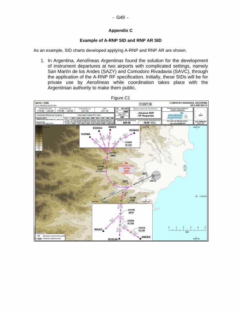
As an
1.
example, S
In Argentof instrumSan Martíthe applicprivate uArgentinia
Exam
ID charts de
ina, Aerolínment departín de los Ancation of theuse by Aean authority
Ap
mple of A-RN
eveloped app
neas Argentures at twndes (SAZYe A-RNP Rerolíneasy to make th
F
- G49 -
ppendix C
NP SID and
plying A-RN
ntinas foundwo airports wY) and ComF specificawhile coo
hem public.
Figure C1
RNP AR SI
P and RNP
d the solutiwith compl
modoro Rivtion. Initiall
ordination .
ID
AR are show
ion for the licated settadavia (SAy, these SItakes plac
wn.
developmetings, name
AVC), througDs will be fce with t
ent ely gh for he
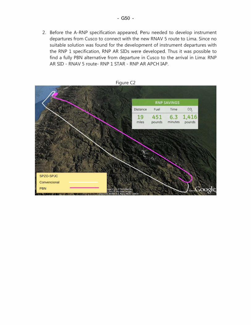
2.
SPZO
Conv
PBN
Before thedeparturessuitable sothe RNP 1find a fullyAR SID - R
O-SPJC
vencional
e A-RNP sps from Cuscolution was 1 specificatiy PBN altern
RNAV 5 rout
pecification co to connec
found for ton, RNP ARnative fromte- RNP 1 ST
F
- G50 -
appeared, Pct with the the developR SIDs were departure TAR - RNP A
Figure C2
Peru needenew RNAV
pment of inse developed
in Cusco toAR APCH IA
d to develo5 route to Lstrument ded. Thus it wao the arrivalAP.
op instrumeLima. Since epartures was possible in Lima: RN
ent no ith to
NP
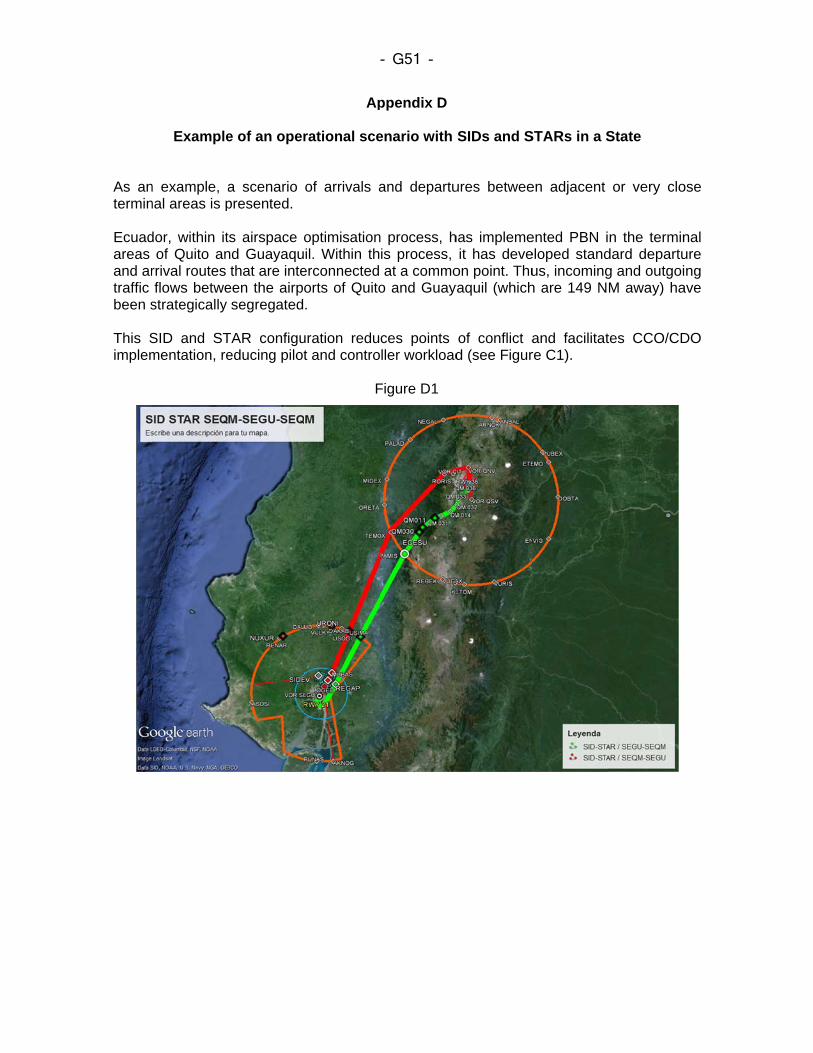
As antermin Ecuadareas and artraffic been s This Simplem
Example
n example, anal areas is p
dor, within itof Quito an
rrival routes flows betwe
strategically
SID and STmentation, re
e of an oper
a scenario presented.
ts airspace ond Guayaquthat are inte
een the airposegregated
TAR configueducing pilot
Ap
rational sce
of arrivals a
optimisationil. Within th
erconnectedorts of Quito.
uration redut and contro
F
- G51 -
ppendix D
enario with
and departu
n process, his process, at a commo
o and Guay
ces points ller workload
Figure D1
SIDs and S
ures betwee
has implemeit has deve
on point. Thuyaquil (which
of conflict ad (see Figur
STARs in a S
en adjacent
ented PBN ieloped standus, incomingh are 149 N
and facilitatre C1).
State
or very clo
n the termindard departug and outgoiM away) ha
tes CCO/CD
ose
nal ure ng
ave
DO
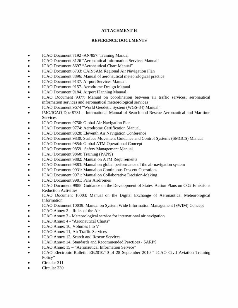
ATTACHMENT H
REFERENCE DOCUMENTS
ICAO Document 7192 -AN/857: Training Manual ICAO Document 8126 “Aeronautical Information Services Manual” ICAO Document 8697 “Aeronautical Chart Manual” ICAO Document 8733: CAR/SAM Regional Air Navigation Plan ICAO Document 8896: Manual of aeronautical meteorological practice ICAO Document 9137. Airport Services Manual. ICAO Document 9157. Aerodrome Design Manual ICAO Document 9184. Airport Planning Manual. ICAO Document 9377: Manual on coordination between air traffic services, aeronautical
information services and aeronautical meteorological services ICAO Document 9674 “World Geodetic System (WGS-84) Manual”. IMO/ICAO Doc 9731 – International Manual of Search and Rescue Aeronautical and Maritime
Services ICAO Document 9750: Global Air Navigation Plan ICAO Document 9774: Aerodrome Certification Manual. ICAO Document 9828: Eleventh Air Navigation Conference ICAO Document 9830. Surface Movement Guidance and Control Systems (SMGCS) Manual ICAO Document 9854: Global ATM Operational Concept ICAO Document 9859. Safety Management Manual. ICAO Document 9868: Training (PANS) ICAO Document 9882: Manual on ATM Requirements ICAO Document 9883: Manual on global performance of the air navigation system ICAO Document 9931: Manual on Continuous Descent Operations ICAO Document 9971: Manual on Collaborative Decision-Making ICAO Document 9981: Pans Airdromes ICAO Document 9988: Guidance on the Development of States' Action Plans on CO2 Emissions
Reduction Activities ICAO Document 10003: Manual on the Digital Exchange of Aeronautical Meteorological
Information ICAO Document 10039: Manual on System Wide Information Management (SWIM) Concept ICAO Annex 2 – Rules of the Air ICAO Annex 3 - Meteorological service for international air navigation. ICAO Annex 4 - “Aeronautical Charts” ICAO Annex 10, Volumes I to V ICAO Annex 11, Air Traffic Services ICAO Annex 12, Search and Rescue Services ICAO Annex 14, Standards and Recommended Practices - SARPS ICAO Annex 15 – “Aeronautical Information Service” ICAO Electronic Bulletin EB2010/40 of 28 September 2010 “ ICAO Civil Aviation Training
Policy” Circular 311 Circular 330
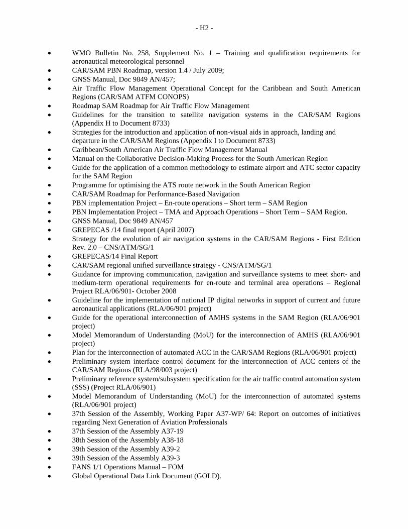
- H2 -
WMO Bulletin No. 258, Supplement No. 1 – Training and qualification requirements for aeronautical meteorological personnel
CAR/SAM PBN Roadmap, version 1.4 / July 2009; GNSS Manual, Doc 9849 AN/457; Air Traffic Flow Management Operational Concept for the Caribbean and South American
Regions (CAR/SAM ATFM CONOPS) Roadmap SAM Roadmap for Air Traffic Flow Management Guidelines for the transition to satellite navigation systems in the CAR/SAM Regions
(Appendix H to Document 8733) Strategies for the introduction and application of non-visual aids in approach, landing and
departure in the CAR/SAM Regions (Appendix I to Document 8733) Caribbean/South American Air Traffic Flow Management Manual Manual on the Collaborative Decision-Making Process for the South American Region Guide for the application of a common methodology to estimate airport and ATC sector capacity
for the SAM Region Programme for optimising the ATS route network in the South American Region CAR/SAM Roadmap for Performance-Based Navigation PBN implementation Project – En-route operations – Short term – SAM Region PBN Implementation Project – TMA and Approach Operations – Short Term – SAM Region. GNSS Manual, Doc 9849 AN/457 GREPECAS /14 final report (April 2007) Strategy for the evolution of air navigation systems in the CAR/SAM Regions - First Edition
Rev. 2.0 – CNS/ATM/SG/1 GREPECAS/14 Final Report CAR/SAM regional unified surveillance strategy - CNS/ATM/SG/1 Guidance for improving communication, navigation and surveillance systems to meet short- and
medium-term operational requirements for en-route and terminal area operations – Regional Project RLA/06/901- October 2008
Guideline for the implementation of national IP digital networks in support of current and future aeronautical applications (RLA/06/901 project)
Guide for the operational interconnection of AMHS systems in the SAM Region (RLA/06/901 project)
Model Memorandum of Understanding (MoU) for the interconnection of AMHS (RLA/06/901 project)
Plan for the interconnection of automated ACC in the CAR/SAM Regions (RLA/06/901 project) Preliminary system interface control document for the interconnection of ACC centers of the
CAR/SAM Regions (RLA/98/003 project) Preliminary reference system/subsystem specification for the air traffic control automation system
(SSS) (Project RLA/06/901) Model Memorandum of Understanding (MoU) for the interconnection of automated systems
(RLA/06/901 project) 37th Session of the Assembly, Working Paper A37-WP/ 64: Report on outcomes of initiatives
regarding Next Generation of Aviation Professionals 37th Session of the Assembly A37-19 38th Session of the Assembly A38-18 39th Session of the Assembly A39-2 39th Session of the Assembly A39-3 FANS 1/1 Operations Manual – FOM Global Operational Data Link Document (GOLD).

F-3
http://www2.icao.int/en/anb/met-aim/met/sadisopsg/Pages/default.aspx http://www.metoffice.gov.uk/sadis/index.html http://www2.icao.int/en/anb/met-aim/met/wafsopsg/Pages/default.aspx http://www2.icao.int/en/anb/met-aim/met/metwsg/Pages/HomePage.aspx http://www2.icao.int/en/anb/met-aim/met/iavwopsg/Pages/HomePage.aspx http://www2.icao.int/en/anb/met-aim/met/ivatf “AIS-AIM Transition Roadmap” – ICAO Report of the seventh meeting of the AGA/AOP/SG7 Subgroup, Buenos Aires, Argentina, 9 to 13
September 2009. SESAR HP in the Single European Sky ATM Research Programme.


![Department of Economics - University of Bologna · Department of Economics ... and Schone Am Econ Rev 1997; Engers and Stern, Int Econ Rev 2002]; ... Need-based access .5725 .3127*](https://img.pdfslide.us/doc/110x75/5b68494a7f8b9a6f778c9022/department-of-economics-university-of-bologna-department-of-economics-.jpg)