Embed Size (px)
Citation preview
1
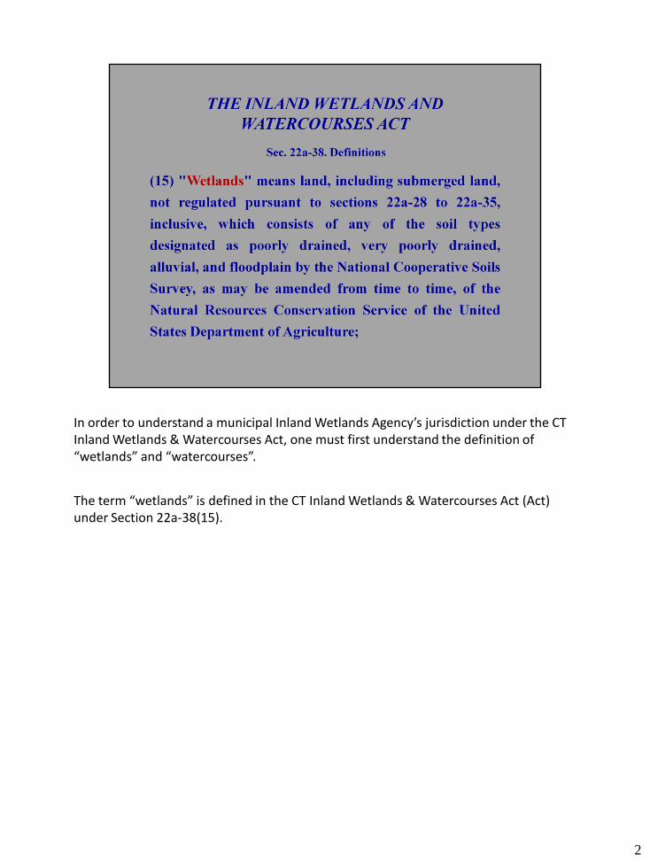
In order to understand a municipal Inland Wetlands Agency’s jurisdiction under the CT Inland Wetlands & Watercourses Act, one must first understand the definition of “wetlands” and “watercourses”.
The term “wetlands” is defined in the CT Inland Wetlands & Watercourses Act (Act) under Section 22a-38(15).
2
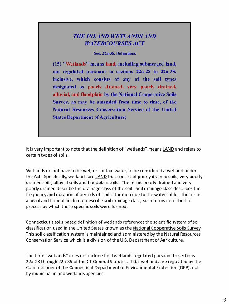
It is very important to note that the definition of “wetlands” means LAND and refers to certain types of soils.
Wetlands do not have to be wet, or contain water, to be considered a wetland under the Act. Specifically, wetlands are LAND that consist of poorly drained soils, very poorly drained soils, alluvial soils and floodplain soils. The terms poorly drained and very poorly drained describe the drainage class of the soil. Soil drainage class describes the frequency and duration of periods of soil saturation due to the water table. The terms alluvial and floodplain do not describe soil drainage class, such terms describe the process by which these specific soils were formed.
Connecticut’s soils based definition of wetlands references the scientific system of soil classification used in the United States known as the National Cooperative Soils Survey. This soil classification system is maintained and administered by the Natural Resources Conservation Service which is a division of the U.S. Department of Agriculture.
The term “wetlands” does not include tidal wetlands regulated pursuant to sections 22a-28 through 22a-35 of the CT General Statutes. Tidal wetlands are regulated by the Commissioner of the Connecticut Department of Environmental Protection (DEP), not by municipal inland wetlands agencies.
3
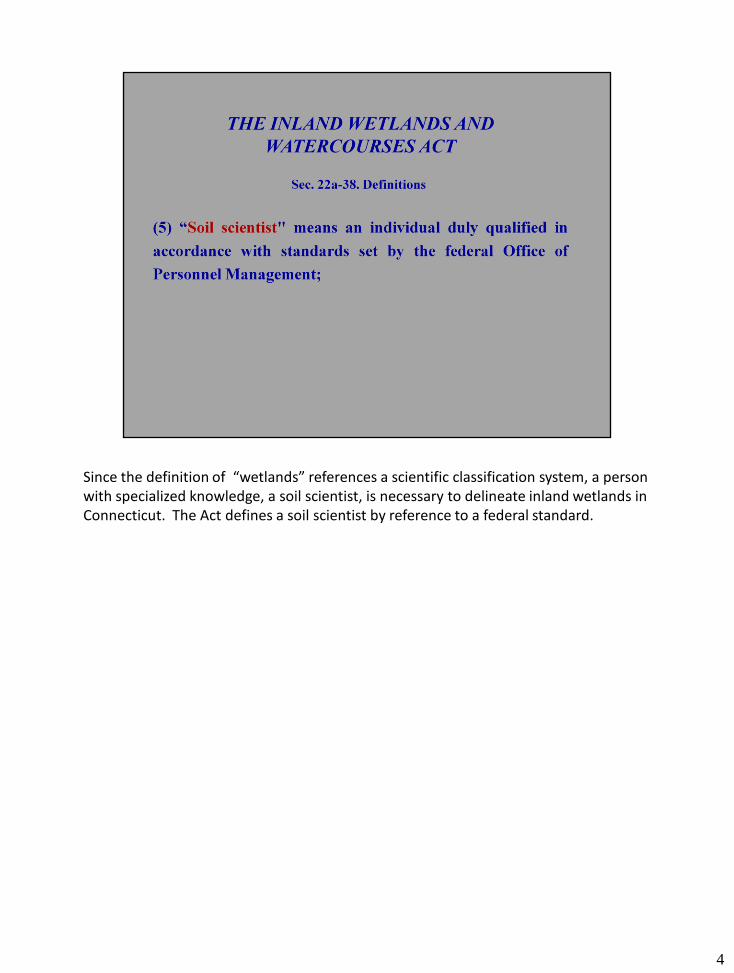
Since the definition of “wetlands” references a scientific classification system, a person with specialized knowledge, a soil scientist, is necessary to delineate inland wetlands in Connecticut. The Act defines a soil scientist by reference to a federal standard.
4
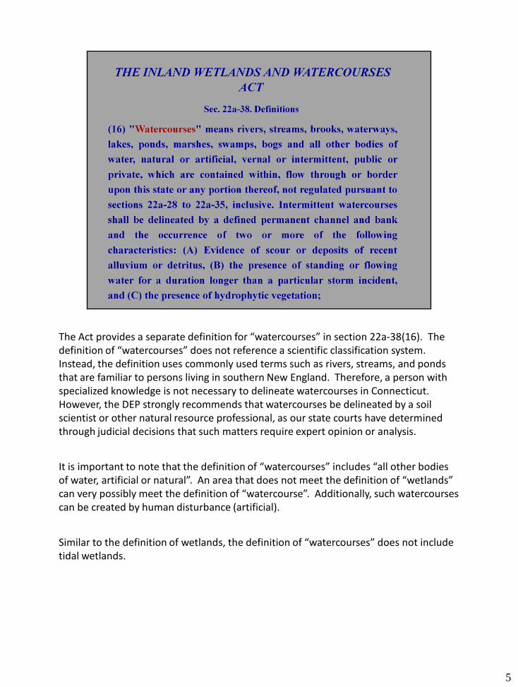
The Act provides a separate definition for “watercourses” in section 22a-38(16). The definition of “watercourses” does not reference a scientific classification system. Instead, the definition uses commonly used terms such as rivers, streams, and ponds that are familiar to persons living in southern New England. Therefore, a person with specialized knowledge is not necessary to delineate watercourses in Connecticut. However, the DEP strongly recommends that watercourses be delineated by a soil scientist or other natural resource professional, as our state courts have determined through judicial decisions that such matters require expert opinion or analysis.
It is important to note that the definition of “watercourses” includes “all other bodies of water, artificial or natural”. An area that does not meet the definition of “wetlands” can very possibly meet the definition of “watercourse”. Additionally, such watercourses can be created by human disturbance (artificial).
Similar to the definition of wetlands, the definition of “watercourses” does not include tidal wetlands.
5
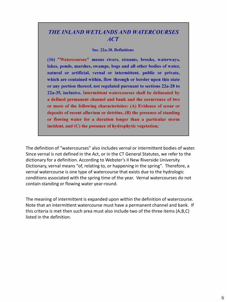
The definition of “watercourses” also includes vernal or intermittent bodies of water. Since vernal is not defined in the Act, or in the CT General Statutes, we refer to the dictionary for a definition. According to Webster’s II New Riverside University Dictionary, vernal means “of, relating to, or happening in the spring”. Therefore, a vernal watercourse is one type of watercourse that exists due to the hydrologic conditions associated with the spring time of the year. Vernal watercourses do not contain standing or flowing water year-round.
The meaning of intermittent is expanded upon within the definition of watercourse. Note that an intermittent watercourse must have a permanent channel and bank. If this criteria is met then such area must also include two of the three items (A,B,C) listed in the definition.
6
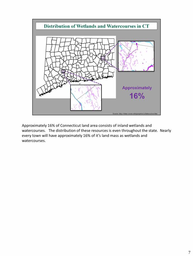
Approximately 16% of Connecticut land area consists of inland wetlands and watercourses. The distribution of these resources is even throughout the state. Nearly every town will have approximately 16% of it’s land mass as wetlands and watercourses.
7

When delineating inland wetlands in Connecticut, a soil scientists digs observation holes with a spade or auger. The soil scientists observes certain soil characteristics such as soil color and the arrangement of soil layers to determine if a soil is poorly drained, very poorly drained, alluvial or floodplain. Soil scientists also use numerous site features such as topography, hydrology, and plant cover in their evaluations of soils.
8
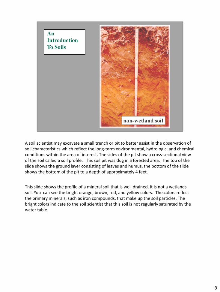
A soil scientist may excavate a small trench or pit to better assist in the observation of soil characteristics which reflect the long-term environmental, hydrologic, and chemical conditions within the area of interest. The sides of the pit show a cross-sectional view of the soil called a soil profile. This soil pit was dug in a forested area. The top of the slide shows the ground layer consisting of leaves and humus, the bottom of the slide shows the bottom of the pit to a depth of approximately 4 feet.
This slide shows the profile of a mineral soil that is well drained. It is not a wetlands soil. You can see the bright orange, brown, red, and yellow colors. The colors reflect the primary minerals, such as iron compounds, that make up the soil particles. The bright colors indicate to the soil scientist that this soil is not regularly saturated by the water table.
9
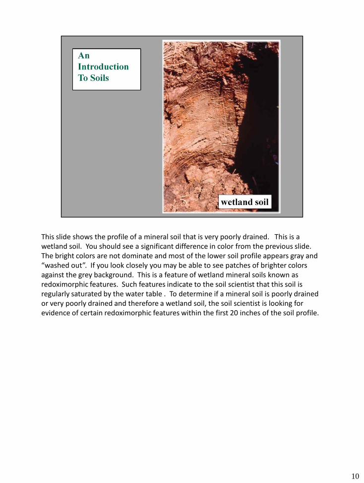
This slide shows the profile of a mineral soil that is very poorly drained. This is a wetland soil. You should see a significant difference in color from the previous slide. The bright colors are not dominate and most of the lower soil profile appears gray and “washed out”. If you look closely you may be able to see patches of brighter colors against the grey background. This is a feature of wetland mineral soils known as redoximorphic features. Such features indicate to the soil scientist that this soil is regularly saturated by the water table . To determine if a mineral soil is poorly drained or very poorly drained and therefore a wetland soil, the soil scientist is looking for evidence of certain redoximorphic features within the first 20 inches of the soil profile.
10
11
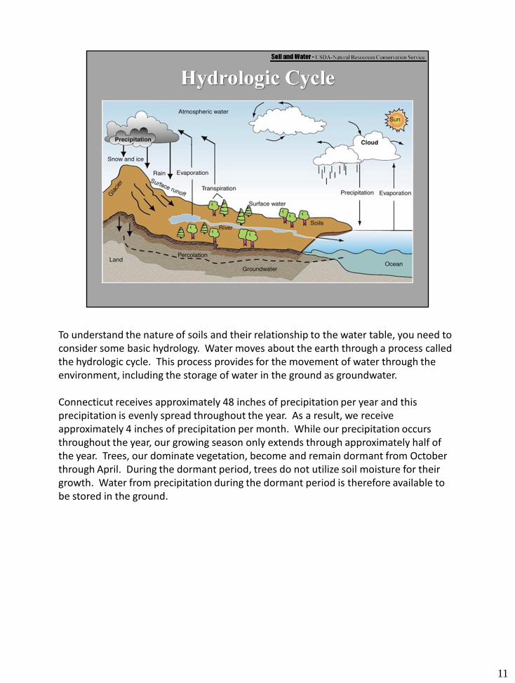
To understand the nature of soils and their relationship to the water table, you need to consider some basic hydrology. Water moves about the earth through a process called the hydrologic cycle. This process provides for the movement of water through the environment, including the storage of water in the ground as groundwater.
Connecticut receives approximately 48 inches of precipitation per year and this precipitation is evenly spread throughout the year. As a result, we receive approximately 4 inches of precipitation per month. While our precipitation occurs throughout the year, our growing season only extends through approximately half of the year. Trees, our dominate vegetation, become and remain dormant from October through April. During the dormant period, trees do not utilize soil moisture for their growth. Water from precipitation during the dormant period is therefore available to be stored in the ground.
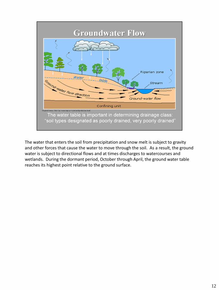
The water that enters the soil from precipitation and snow melt is subject to gravity and other forces that cause the water to move through the soil. As a result, the ground water is subject to directional flows and at times discharges to watercourses and wetlands. During the dormant period, October through April, the ground water table reaches its highest point relative to the ground surface.
12
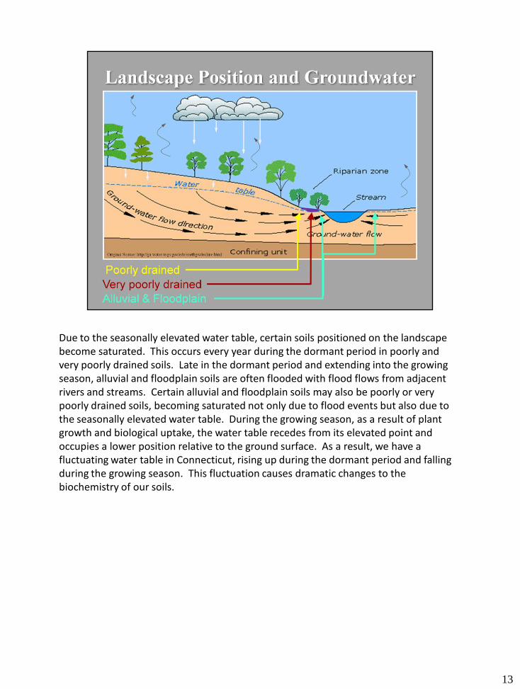
Due to the seasonally elevated water table, certain soils positioned on the landscape become saturated. This occurs every year during the dormant period in poorly and very poorly drained soils. Late in the dormant period and extending into the growing season, alluvial and floodplain soils are often flooded with flood flows from adjacent rivers and streams. Certain alluvial and floodplain soils may also be poorly or very poorly drained soils, becoming saturated not only due to flood events but also due to the seasonally elevated water table. During the growing season, as a result of plant growth and biological uptake, the water table recedes from its elevated point and occupies a lower position relative to the ground surface. As a result, we have a fluctuating water table in Connecticut, rising up during the dormant period and falling during the growing season. This fluctuation causes dramatic changes to the biochemistry of our soils.
13
14
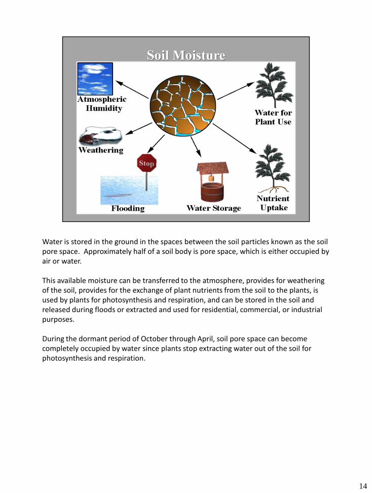
Water is stored in the ground in the spaces between the soil particles known as the soil pore space. Approximately half of a soil body is pore space, which is either occupied by air or water.
This available moisture can be transferred to the atmosphere, provides for weathering of the soil, provides for the exchange of plant nutrients from the soil to the plants, is used by plants for photosynthesis and respiration, and can be stored in the soil and released during floods or extracted and used for residential, commercial, or industrial purposes.
During the dormant period of October through April, soil pore space can become completely occupied by water since plants stop extracting water out of the soil for photosynthesis and respiration.
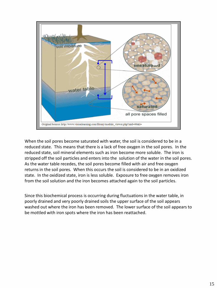
When the soil pores become saturated with water, the soil is considered to be in a reduced state. This means that there is a lack of free oxygen in the soil pores. In the reduced state, soil mineral elements such as iron become more soluble. The iron is stripped off the soil particles and enters into the solution of the water in the soil pores. As the water table recedes, the soil pores become filled with air and free oxygen returns in the soil pores. When this occurs the soil is considered to be in an oxidized state. In the oxidized state, iron is less soluble. Exposure to free oxygen removes iron from the soil solution and the iron becomes attached again to the soil particles.
Since this biochemical process is occurring during fluctuations in the water table, in poorly drained and very poorly drained soils the upper surface of the soil appears washed out where the iron has been removed. The lower surface of the soil appears to be mottled with iron spots where the iron has been reattached.
15
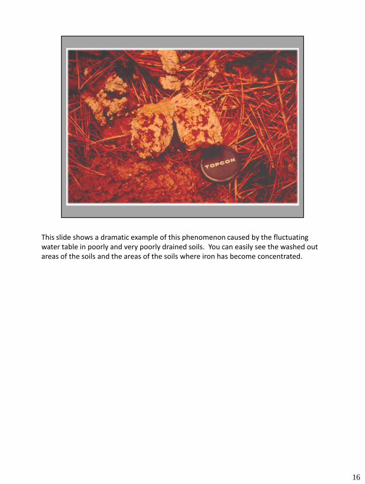
This slide shows a dramatic example of this phenomenon caused by the fluctuating water table in poorly and very poorly drained soils. You can easily see the washed out areas of the soils and the areas of the soils where iron has become concentrated.
16
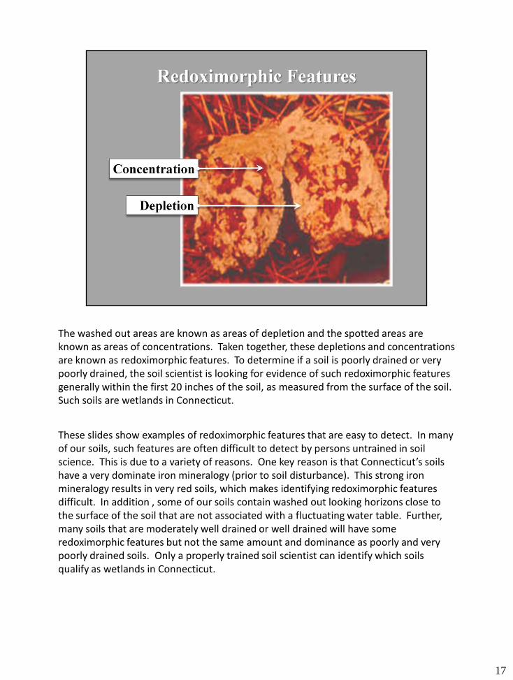
The washed out areas are known as areas of depletion and the spotted areas are known as areas of concentrations. Taken together, these depletions and concentrations are known as redoximorphic features. To determine if a soil is poorly drained or very poorly drained, the soil scientist is looking for evidence of such redoximorphic features generally within the first 20 inches of the soil, as measured from the surface of the soil. Such soils are wetlands in Connecticut.
These slides show examples of redoximorphic features that are easy to detect. In many of our soils, such features are often difficult to detect by persons untrained in soil science. This is due to a variety of reasons. One key reason is that Connecticut’s soils have a very dominate iron mineralogy (prior to soil disturbance). This strong iron mineralogy results in very red soils, which makes identifying redoximorphic features difficult. In addition , some of our soils contain washed out looking horizons close to the surface of the soil that are not associated with a fluctuating water table. Further, many soils that are moderately well drained or well drained will have some redoximorphic features but not the same amount and dominance as poorly and very poorly drained soils. Only a properly trained soil scientist can identify which soils qualify as wetlands in Connecticut.
17
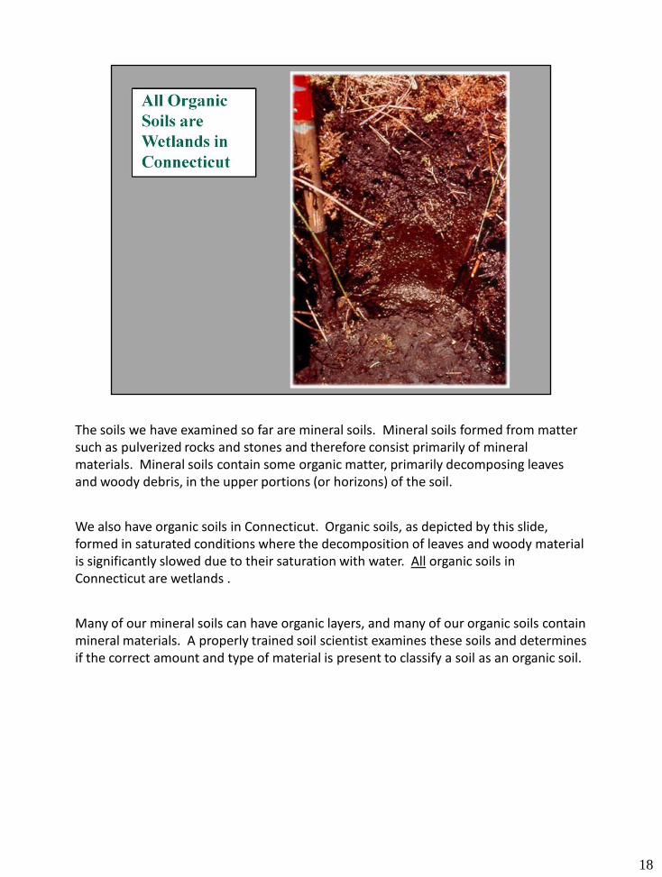
The soils we have examined so far are mineral soils. Mineral soils formed from matter such as pulverized rocks and stones and therefore consist primarily of mineral materials. Mineral soils contain some organic matter, primarily decomposing leaves and woody debris, in the upper portions (or horizons) of the soil.
We also have organic soils in Connecticut. Organic soils, as depicted by this slide,formed in saturated conditions where the decomposition of leaves and woody material is significantly slowed due to their saturation with water. All organic soils in Connecticut are wetlands .
Many of our mineral soils can have organic layers, and many of our organic soils contain mineral materials. A properly trained soil scientist examines these soils and determines if the correct amount and type of material is present to classify a soil as an organic soil.
18
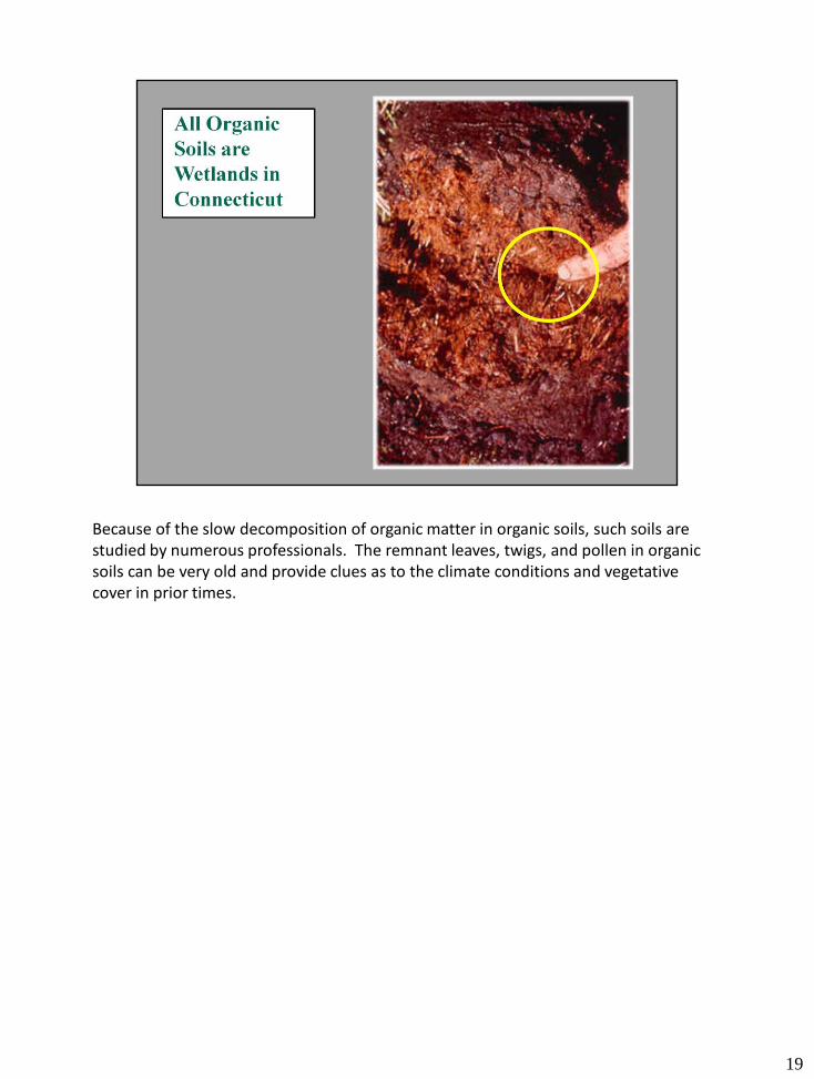
Because of the slow decomposition of organic matter in organic soils, such soils are studied by numerous professionals. The remnant leaves, twigs, and pollen in organic soils can be very old and provide clues as to the climate conditions and vegetative cover in prior times.
19
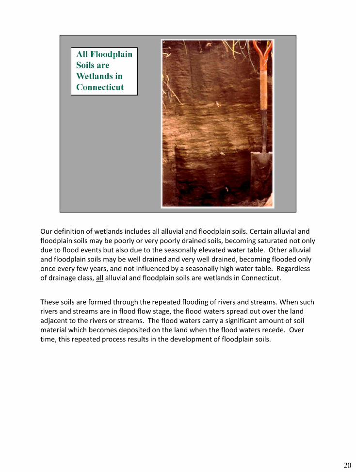
Our definition of wetlands includes all alluvial and floodplain soils. Certain alluvial and floodplain soils may be poorly or very poorly drained soils, becoming saturated not only due to flood events but also due to the seasonally elevated water table. Other alluvial and floodplain soils may be well drained and very well drained, becoming flooded only once every few years, and not influenced by a seasonally high water table. Regardless of drainage class, all alluvial and floodplain soils are wetlands in Connecticut.
These soils are formed through the repeated flooding of rivers and streams. When such rivers and streams are in flood flow stage, the flood waters spread out over the land adjacent to the rivers or streams. The flood waters carry a significant amount of soil material which becomes deposited on the land when the flood waters recede. Overtime, this repeated process results in the development of floodplain soils.
20
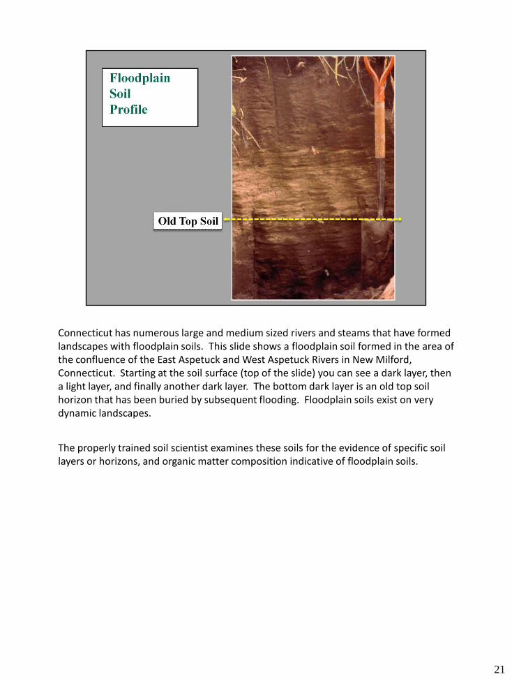
Connecticut has numerous large and medium sized rivers and steams that have formed landscapes with floodplain soils. This slide shows a floodplain soil formed in the area of the confluence of the East Aspetuck and West Aspetuck Rivers in New Milford, Connecticut. Starting at the soil surface (top of the slide) you can see a dark layer, then a light layer, and finally another dark layer. The bottom dark layer is an old top soil horizon that has been buried by subsequent flooding. Floodplain soils exist on very dynamic landscapes.
The properly trained soil scientist examines these soils for the evidence of specific soil layers or horizons, and organic matter composition indicative of floodplain soils.
21
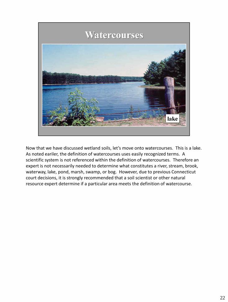
Now that we have discussed wetland soils, let’s move onto watercourses. This is a lake. As noted eariler, the definition of watercourses uses easily recognized terms. A scientific system is not referenced within the definition of watercourses. Therefore an expert is not necessarily needed to determine what constitutes a river, stream, brook, waterway, lake, pond, marsh, swamp, or bog. However, due to previous Connecticut court decisions, it is strongly recommended that a soil scientist or other natural resource expert determine if a particular area meets the definition of watercourse.
22
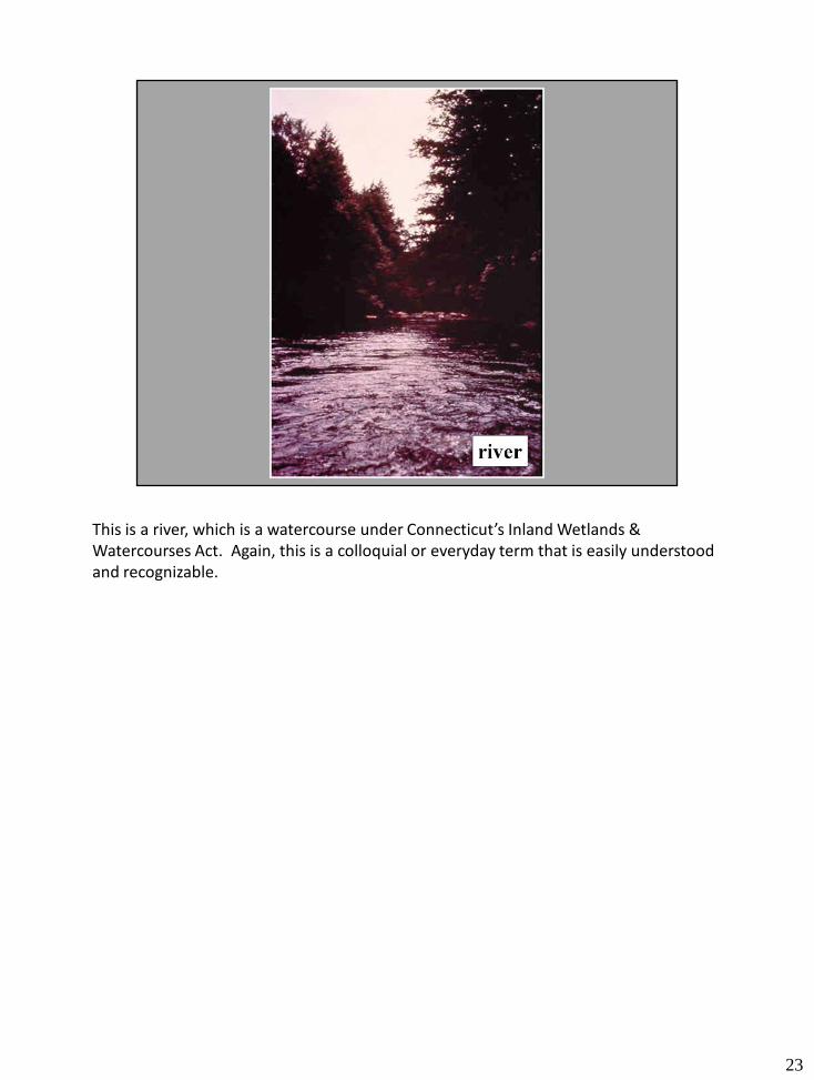
This is a river, which is a watercourse under Connecticut’s Inland Wetlands & Watercourses Act. Again, this is a colloquial or everyday term that is easily understood and recognizable.
23
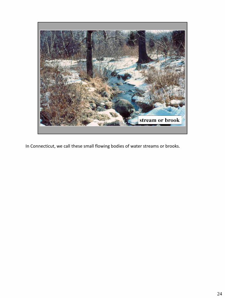
In Connecticut, we call these small flowing bodies of water streams or brooks.
24
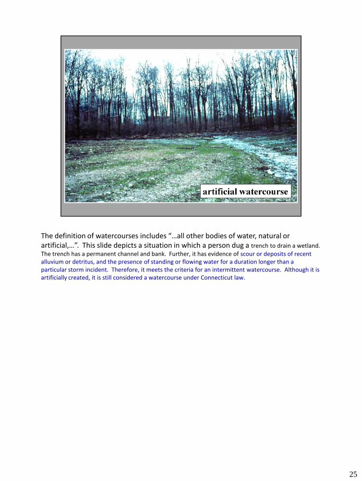
The definition of watercourses includes “…all other bodies of water, natural or artificial,…”. This slide depicts a situation in which a person dug a trench to drain a wetland.
The trench has a permanent channel and bank. Further, it has evidence of scour or deposits of recent alluvium or detritus, and the presence of standing or flowing water for a duration longer than a particular storm incident. Therefore, it meets the criteria for an intermittent watercourse. Although it is artificially created, it is still considered a watercourse under Connecticut law.
25
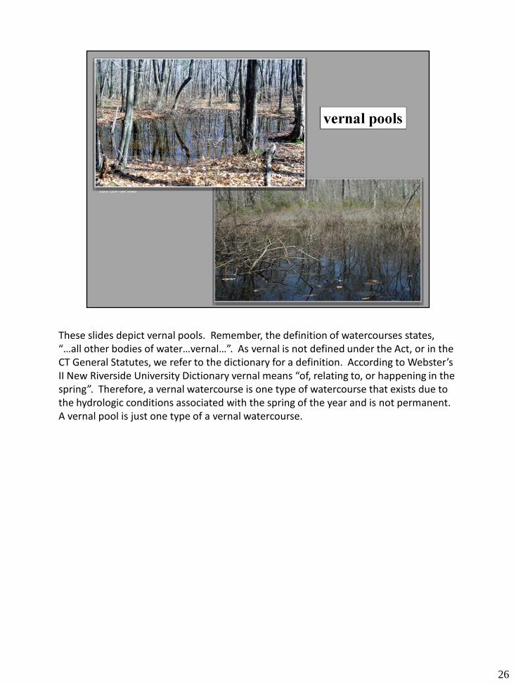
These slides depict vernal pools. Remember, the definition of watercourses states, “…all other bodies of water…vernal…”. As vernal is not defined under the Act, or in the CT General Statutes, we refer to the dictionary for a definition. According to Webster’s II New Riverside University Dictionary vernal means “of, relating to, or happening in the spring”. Therefore, a vernal watercourse is one type of watercourse that exists due to the hydrologic conditions associated with the spring of the year and is not permanent. A vernal pool is just one type of a vernal watercourse.
26

This is a red-maple swamp. Some of the terms listed within the definition of watercourses, such as swamp, marsh and bog, can be distinguished by the type of vegetation present.
Red maple swamps tend to be dominated by trees that grow to heights of twenty or more feet.
During wet times of the year, water is present in swamps. Due to the high water table, the soils will exhibit redoximorphic features. Therefore this resource can be considered both a watercourse and a wetland.
27
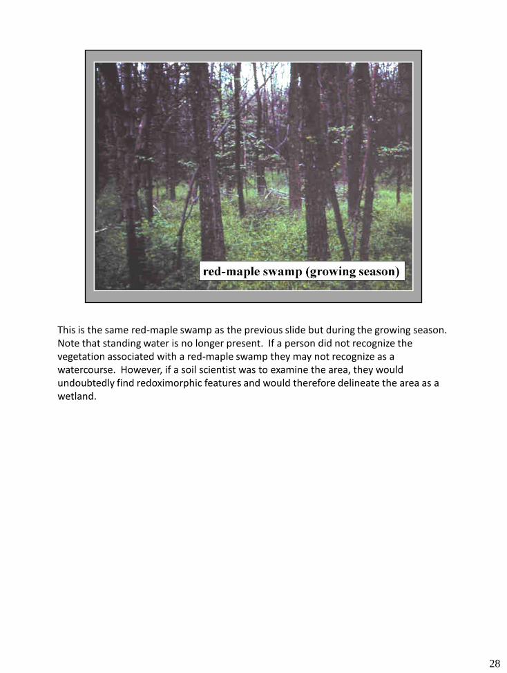
This is the same red-maple swamp as the previous slide but during the growing season. Note that standing water is no longer present. If a person did not recognize the vegetation associated with a red-maple swamp they may not recognize as a watercourse. However, if a soil scientist was to examine the area, they would undoubtedly find redoximorphic features and would therefore delineate the area as a wetland.
28
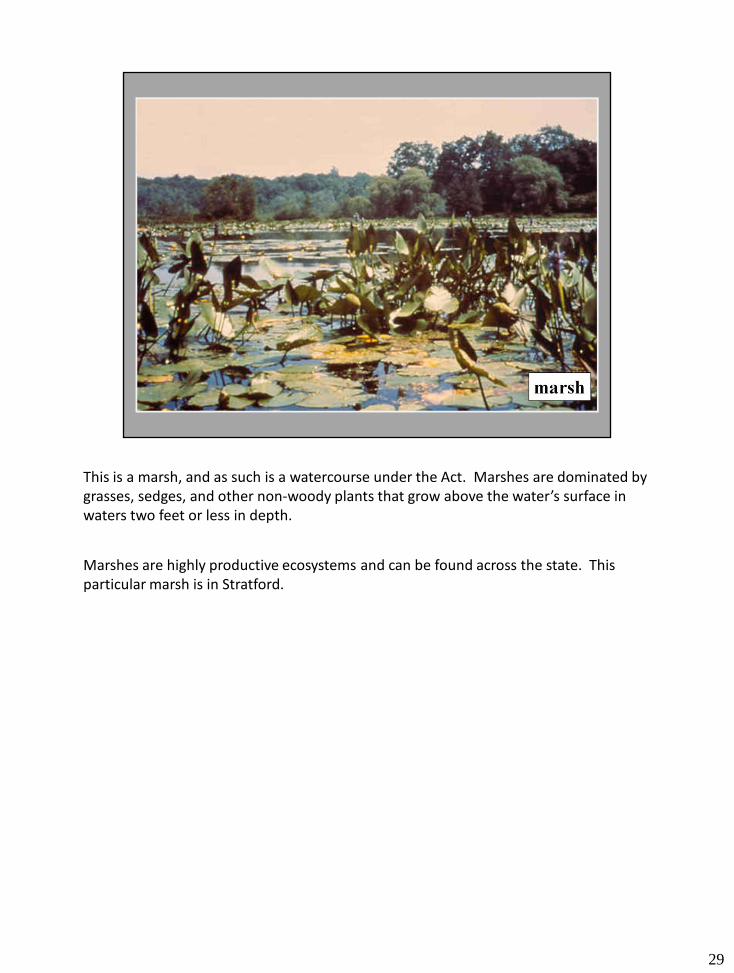
This is a marsh, and as such is a watercourse under the Act. Marshes are dominated by grasses, sedges, and other non-woody plants that grow above the water’s surface in waters two feet or less in depth.
Marshes are highly productive ecosystems and can be found across the state. This particular marsh is in Stratford.
29
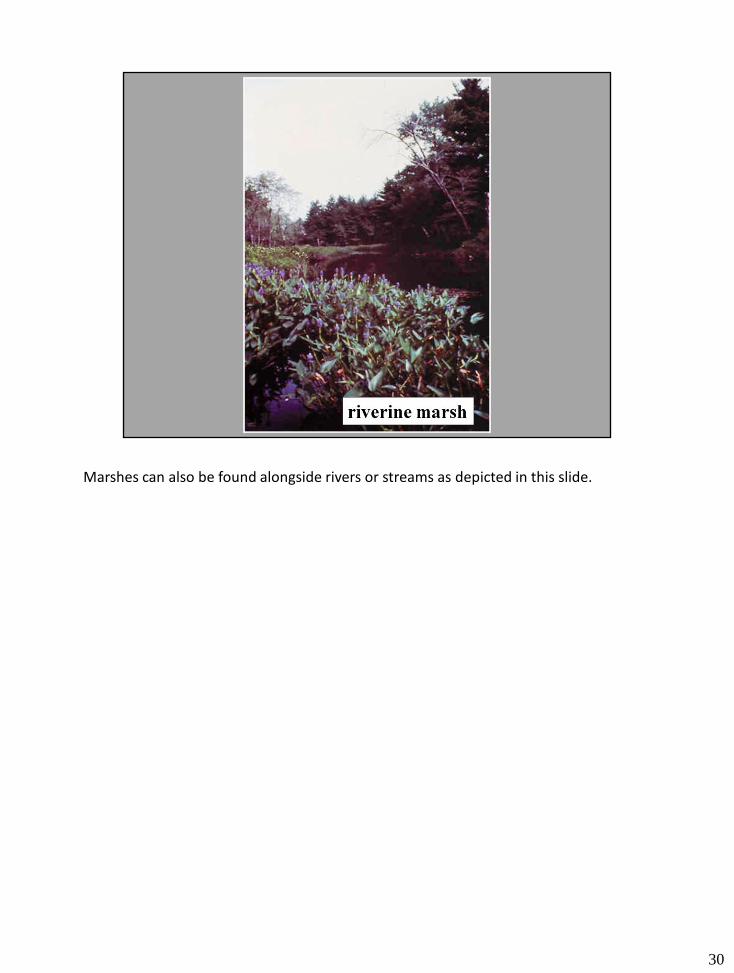
Marshes can also be found alongside rivers or streams as depicted in this slide.
30
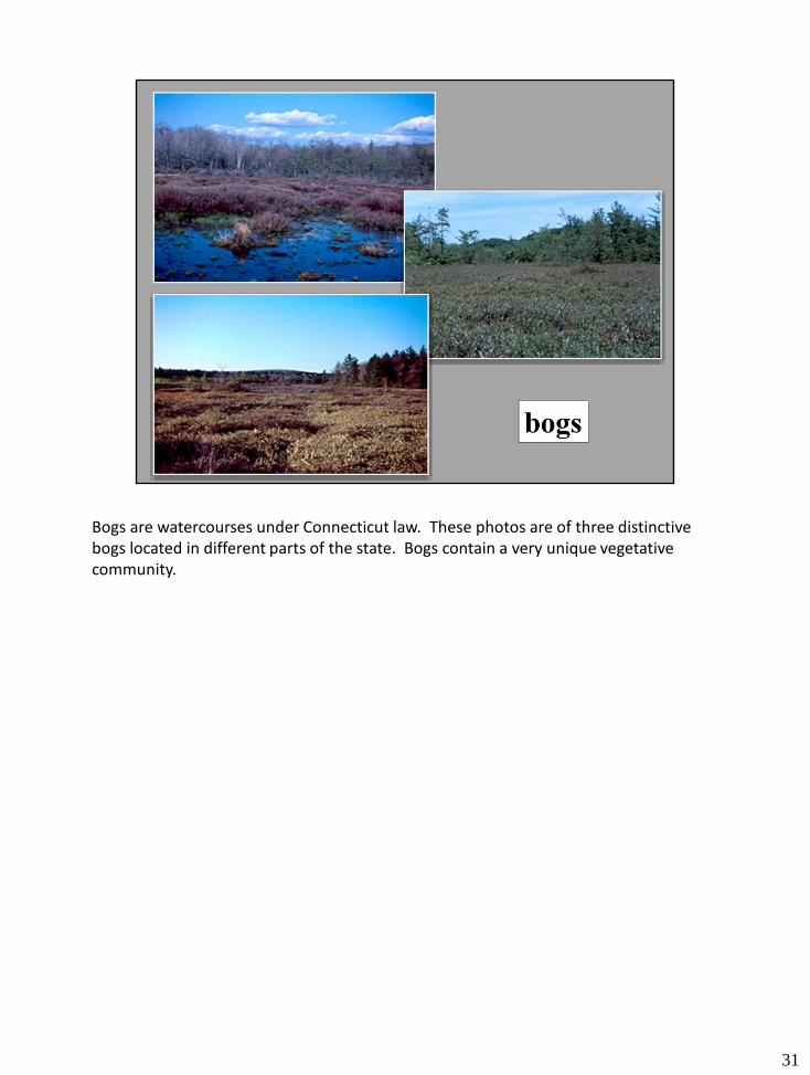
Bogs are watercourses under Connecticut law. These photos are of three distinctive bogs located in different parts of the state. Bogs contain a very unique vegetative community.
31
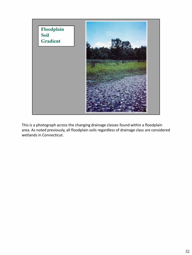
This is a photograph across the changing drainage classes found within a floodplain area. As noted previously, all floodplain soils regardless of drainage class are considered wetlands in Connecticut.
32
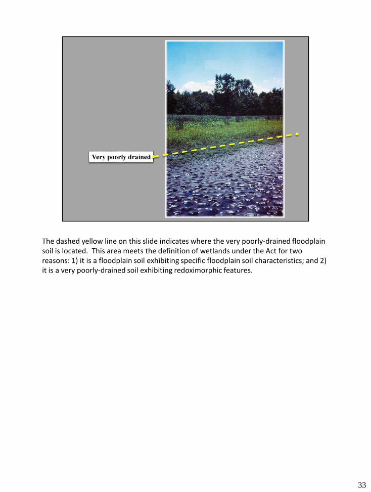
The dashed yellow line on this slide indicates where the very poorly-drained floodplain soil is located. This area meets the definition of wetlands under the Act for two reasons: 1) it is a floodplain soil exhibiting specific floodplain soil characteristics; and 2) it is a very poorly-drained soil exhibiting redoximorphic features.
33

The light blue line on this slide indicates where the poorly-drained floodplain soil is located. This area also meets the definition of wetlands under the Act for two reasons: 1) it is a floodplain soil exhibiting specific floodplain soil characteristics; and 2) it is a poorly-drained soil exhibiting redoximorphic features.
34
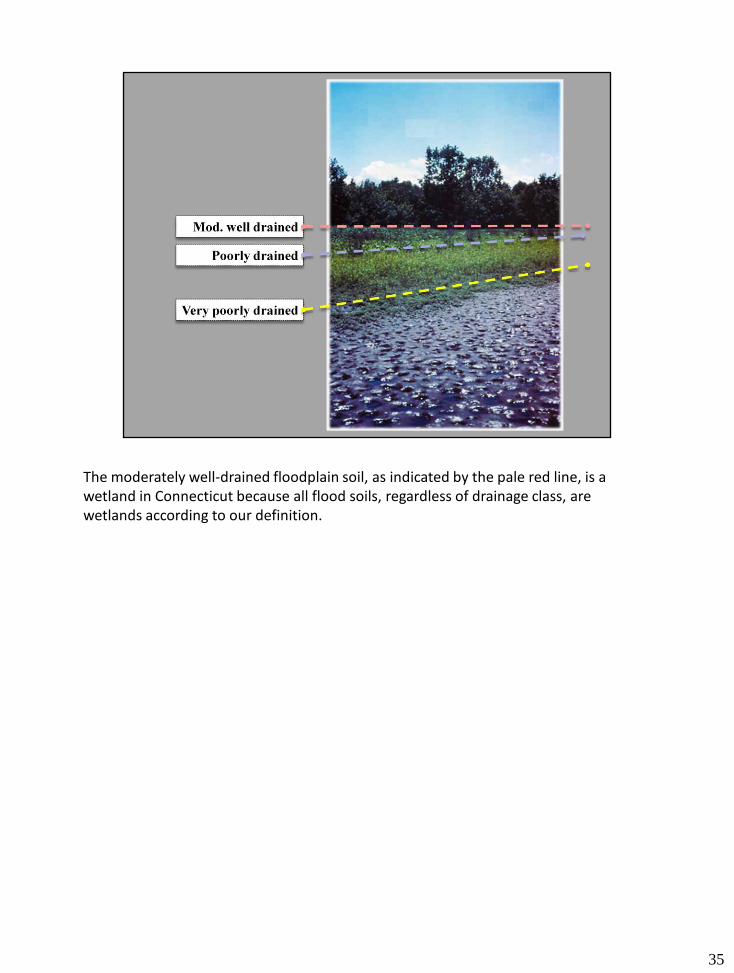
The moderately well-drained floodplain soil, as indicated by the pale red line, is a wetland in Connecticut because all flood soils, regardless of drainage class, are wetlands according to our definition.
35
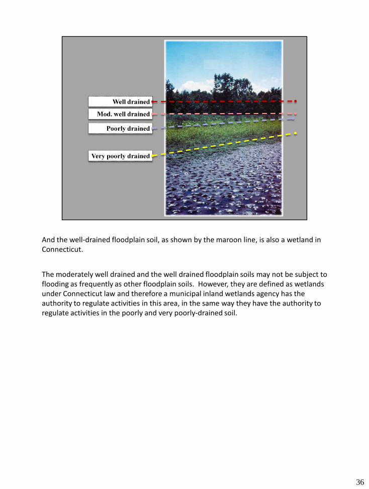
And the well-drained floodplain soil, as shown by the maroon line, is also a wetland in Connecticut.
The moderately well drained and the well drained floodplain soils may not be subject to flooding as frequently as other floodplain soils. However, they are defined as wetlands under Connecticut law and therefore a municipal inland wetlands agency has the authority to regulate activities in this area, in the same way they have the authority to regulate activities in the poorly and very poorly-drained soil.
36
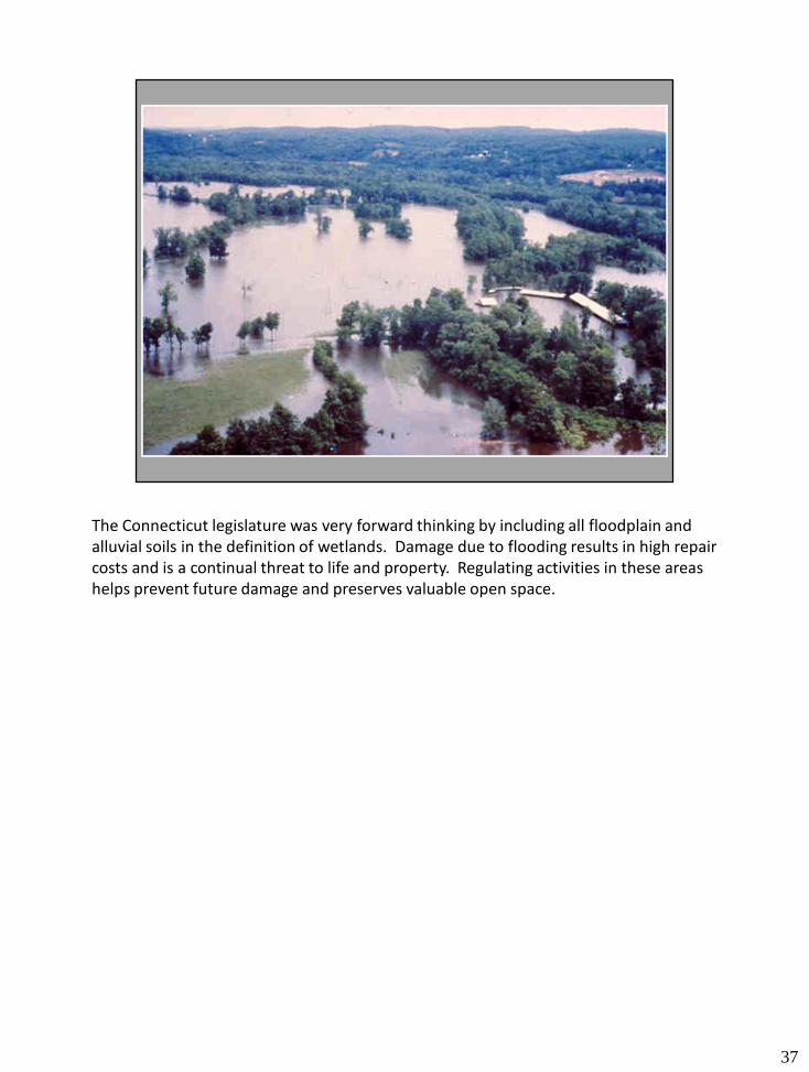
The Connecticut legislature was very forward thinking by including all floodplain and alluvial soils in the definition of wetlands. Damage due to flooding results in high repair costs and is a continual threat to life and property. Regulating activities in these areas helps prevent future damage and preserves valuable open space.
37
38