Embed Size (px)
Citation preview

Rail Walksin Greater Manchester(Mid Cheshire Line)

3 2
Motorway
Major roads
Other roads
The Mid Cheshire Community Rail Partnership and the Mid Cheshire Rail Users’Association (MCRUA) welcome you to their third rail walks booklet offering walksfrom stations along the Greater Manchester part of the Mid Cheshire Line. Use a map alongside the walk
details and follow thedirections and path markers.Do not cross fields of cropsunless following thedesignated footpath.
Take care crossing the golfcourse, watching out forflying golf balls.
Take your litter home withyou. Dropping litter anddumping rubbish are criminaloffences.
Leave gates as you find themor follow instructions onsigns. If walking in a group,make sure the last personknows how to leave thegates.
Wild animals, birds and farmanimals can behaveunpredictably - do notattempt to approach them ortry to stroke them.
Keep dogs under close controlbut, if a farm animal chasesyou and your dog, it is safer to
let your dog off the lead –don’t risk getting hurt bytrying to protect it.
Take care on the canal towpath – it can be narrow,uneven and very muddy inplaces.
Dogs are not allowed onMetrolink trams or the MetroShuttle bus.
Support the local economy -for example, buy yoursupplies from local shops.
Walking in the countryside
Mid Cheshire Rail Users’Association (MCRUA)The Mid Cheshire Rail Users' Association withover 600 members is the rail user group for theMid Cheshire Line. MCRUA is active inrepresenting the interests of passengers on theMid Cheshire Line from Chester to Manchesterand those travelling between Crewe andLiverpool on the West Coast Main Line. They workto improve the service and its usage, and provideinformation on timetable changes and news onfuture developments.
MCRUA is also well known for the popularexcursion trains, including steam specials that ithas run over the years.
For more information on MCRUA activities orjoining the group, please look atwww.mcrua.org.uk. If you can’t find what you arelooking for then email [email protected] more information.
M62
A57
A34
A56A5103
M56
M60M60
M60
M6
ASHLEY
HALEALTRINCHAM
TIMPERLEYCHEADLE
MANCHESTER
STOCKPORT
SALE
Information on the maps is shown as follows:
Railway line
Railway station
The walks in this booklet are a series of fairly shortwalks, mainly over generally easy terrain and theyare either circular walks from stations or betweenstations so that walkers can return to their startingpoint by tram or train. However as most of thesewalks follow the Bridgewater Canal they can belinked together to create longer routes.
The circular walk from Altrincham via Dunham Parkcan be continued towards Timperley andSale by notleaving the canal after it passes underneathManchester Road. The instructions for the next sectioncan be found in the walk from Altrincham to Sale.
To continue to Manchester, without stopping atCornbrook, simply remain on the canal pathimmediately before Cornbrook and then follow theinstructions found in the Cornbrook to Piccadillysection.
If all the individual routes are made into acontinuous walk the total distance isapproximately 15 miles (24 kilometres). There areno stiles after the canal is reached, however thereare steps on the walks.
There are no toilet facilities on these walks, buteach route has opportunities to access local cafes,restaurants and pubs.
These walks are not accessible for those withprams or using wheelchairs because of steps, stilesand uneven, narrow canal towpaths on the routes.
The walks can be found on OS Explorer Map (1:25 000) Sheet 268 Wilmslow, Macclesfield andCongleton and Sheet 277 Manchester and Salford.
There is no walk listed for Stockport, insteadwalkers are encouraged to explore the area usingthe free Stockport Metro Shuttle. There is aninteresting town centre heritage trail to walk whichcan be downloaded or picked up at the TouristInformation Centre (TIC) in the Market Place.
Train services on the Mid Cheshire Line run hourlyMonday through to Saturday and two hourly onSundays. Northern Timetable 17 features all thetrain times for the Mid Cheshire Line and can bedownloaded from www.midcheshirerail.org.ukInformation on the Metrolink trams can be foundat: www.metrolink.co.uk/pages/default.aspxTrams generally run every 6 to 12 minutes alongthe Altrincham to Piccadilly Line.
Mid Cheshire Community Rail Partnership can be contacted at www.midcheshirerail.orgor email [email protected] phone 01244 976788 or 0773 652 3863.
Metrolink
Metrolink stop
Suggested route
The Mid Cheshire LineThe line links the cities of Manchester andChester running through the scenic MidCheshire countryside. There are 16 stationsalong the line including Stockport,Navigation Road, Altrincham, Hale, Ashley,Knutsford, Northwich and Delamere.
The line has a Community Rail Partnershipfounded in 2003 to promote increasedusage and to develop and improve facilitiesalong the route. Enthusiastic volunteers arealways welcome to get involved at stationsand events along the line.
To find out more about the Mid CheshireCommunity Rail Partnership and theopportunities for travelling on the MidCheshire Line, go towww.midcheshirerail.org.uk.
Transport for Greater Manchester:There are plenty of walks across the wider Greater Manchester area which youcan access by train. Further details can be found at: http://www.tfgm.com/trains/Pages/Rail-Walks.aspx

Rive
r Bo
llin
R iver Bollin
M56
Broomfield Lane
Ashley Road
Ashley Roa d
Ashley Road
Bankhall Lane
Park Road
Harrop Road
Sout h Downs Road
Ashley Road
Victoria Road A538
Cow Lane
Ashley Road
Back Lane
Ashl
ey R
oad
Tolla
nd L
ane
Ashl
ey R
oad
Bower Road
War
wic
k Ro
ad
Warwick
Gilbert Road
Mar
lbor
ough
Roa
d
Ashley Road
Hale Road
Ashley
Grange RoadYorkDrive
Priv
ate
Road
(Ash
ley
Road
)
Ashley Mill Lane
Road
Drive
Hardy’s Covert
AshleyHall
BowdonChurch
St Peter’sChurch
BowdonChurchSchool
AltrinchamGrammar
Schoolfor Boys
AshleyMill
House
St Elizabeth’sChurch
ASHLEY
HALE
HALE
ASHLEY
1
2
3
4
5
6
7
5 4
Ashley to Hale
DISTANCE: Approximately 23⁄4 miles(51⁄2 kilometres). Allow up to 11⁄2 hours
MAP: OS Explorer Map (1:25 000) Sheet 268Wilmslow, Macclesfield and Congleton
GROUND CONDITIONS: The walk is mostly onpaths with good drainage, but walking boots arerecommended
STILES: None
KISSING GATES: None
REFRESHMENTS: ‘The Greyhound’ pub in Ashley.Many cafes, café/bars and restaurants in Hale
Ashley is an original station on the oldCheshire Midland railway now called theMid Cheshire Line.
The route1. Leave the station on to Ashley Road
and turn right. Pass St Elizabeth’sChurch and then turn right ontoSouth Lodge just before a sharp turnin the road.
2. Continue on the private road whichcrosses the M56 and then pass theextensive Ashley Farm complex. Thehall itself is a listed building withparts which date back to the 16thcentury. On a clear day, you can seethe Pennine hills to the east and thewooded escarpment of Bowdonstraight ahead.
7 6
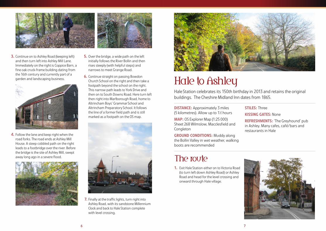
Hale to Ashley
DISTANCE: Approximately 3 miles (5 kilometres). Allow up to 11⁄2 hours
MAP: OS Explorer Map (1:25 000) Sheet 268 Wilmslow, Macclesfield andCongleton
GROUND CONDITIONS: Muddy alongthe Bollin Valley in wet weather, walkingboots are recommended
STILES: Three
KISSING GATES: None
REFRESHMENTS: ‘The Greyhound’ pubin Ashley. Many cafes, café/bars andrestaurants in Hale
Hale Station celebrates its 150th birthday in 2013 and retains the originalbuildings. The Cheshire Midland Inn dates from 1865.
1. Exit Hale Station either on to Victoria Road(to turn left down Ashley Road) or AshleyRoad and head for the level crossing andonward through Hale village.
The route
3. Continue on to Ashley Road (keeping left)and then turn left into Ashley Mill Lane.Immediately on the right is Coppice Barn, afine oak cruck-frame building dating fromthe 16th century and currently part of agarden and landscaping business.
4. Follow the lane and keep right when theroad forks. The road ends at Ashley MillHouse. A steep cobbled path on the rightleads to a footbridge over the river. Beforethe bridge is the site of Ashley Mill, sweptaway long ago in a severe flood.
5. Over the bridge, a wide path on the leftinitially follows the River Bollin and thenrises steeply (with helpful steps) andnarrows to meet Grange Road.
6. Continue straight on passing BowdonChurch School on the right and then take afootpath beyond the school on the right.This narrow path leads to York Drive andthen on to South Downs Road. Here turn leftthen right into Marlborough Road, home toAltrincham Boys’ Grammar School andAltrincham Preparatory School. It followsthe line of a former field path and is stillmarked as a footpath on the OS map.
7. Finally at the traffic lights, turn right intoAshley Road, with its sandstone MillenniumClock and back to Hale Station completewith level crossing.

here turn left. After themotorway bridge is TanyardFarm and just beyond here turnright at the road junction intoTanyard Lane.
8. This becomes Back Lane and onthe left is the former Ashleyvillage school, nowappropriately a nursery. Aheadis the Greyhound Public Housefor rest and recuperation.Beyond, in a short distancealong Ashley Road, is AshleyStation.
9 8
Rive
r Bo
llin
R iver Bollin
M56 M56
Broomfield Lane
Ashley Road
Ashley Roa d
Ashley Road
Bankhall Lane
Park Road
Park Road
Harrop Road
Victoria Road A538
Cow Lane
Ashley Road
Tany
ard
Lane
Back Lane Back Lane
Ashl
ey R
oad
Tolla
nd L
ane
Ashl
ey R
oad
Bower Road
War
wic
k Ro
ad
Warwick
Gilbert Road
Ashley Road
Hale Road
Priv
ate
Road
(Ash
ley
Road
)
Drive
Castle Mill Lane
Castle Mill Lane
1
2
3
4
5
6
7
8
HaleGolf Course
Hardy’s Covert
AshleyHall
St Peter’sChurch
BankhallFarm
AltrinchamGrammar
Schoolfor Boys
St Elizabeth’sChurch
Grove Park
ASHLEY
HALE
HALE
ASHLEY
2. After passing St Peter’s Church on the leftcarry on and turn left into Warwick Roadand then eventually turn left again intoGilbert Road.
3. At the end of the cul-de-sac follow anarrow path whichleads on to Park Road.Cross over and intoTolland Lane, next tothe shops. The nameis believed to be fromthe open field of amedieval settlement.
4. At the end of TollandLane turn left intoBankhall Lane,eventually passing Bank Hall (Farm) on theright. This is a former moated site and theone time home of Eddie Shah, the formernewspaper boss.
5. Where Bankhall Lane bears to the left turnright on to a signposted path which leadsto the Bollin Valley. Follow the path andafter a steep section, the path turns to theleft and soon follows the River Bollinupstream.
Further on, do not turn to the left off thispath at the 3 way directional pathway signbut continue onwards to the metalfootbridge over the river.
6. Cross the bridge, bear left following anindistinct path and in a short distance thepath climbs up out of the wooded floodplain, passes through a derelict stile andskirts the edge of the open fields.
7. Cross the stile into the field and continuewith the hedge to the left. A second stile leads to Castle Mill Lane and

11 10
Bridgewater Canal
Bridgewater Canal
Oldfield Lane
Oldfield
Smithy
Lane
School Lane
Dunham Road
High
gate
Road
Gros
veno
r Roa
d
Road
St Margaret’s Rd.
New St
.
Regent Rd.
Stamford
New Road
Church St.
Woodlands Rd.
Manchester
DunhamForest Golf andCountry Club
JohnLeighPark
AltrinchamGolf Course
Stamfordpark
A56
B5160
A56
A56
A560
1
2
3
4
56
78
9
10
11
13
Woodville Rd.
Bowdon Rd.
Navigation
Road
Se amon’s
O ldfield RoadRoad
Lane
DUNHAMTOWN
ALTRINCHAM
ALTRINCHAM
NAVIGATIONROAD
Gorsey Ln.
Barrington Road
Bradgate Rd.
12
Altrincham Circular
DISTANCE: Approximately 6 miles (91⁄2 kilometres)Allow approximately 2 1⁄4 hours
MAP: OS Explorer Map (1:25 000) Sheet 268 Wilmslow, Macclesfield and Congleton
GROUND CONDITIONS: The walk ismostly on paths with good drainage, butwalking boots are recommended as partsof the canal tow path can be very muddy
STILES: Two
KISSING GATES: None
REFRESHMENTS: Various pubs, cafes andtakeways in Altrincham and several pubson the route
This walk can be either a circular walk from and to Altrincham Station or thestart of a walk to Timperley the long way round.
1. Exit Altrincham Station from platform oneand turn left around the bus stands andthen proceed on to Stamford New Road.Turn left and at the traffic lights cross to theright and enter Cross Street. Where thestreet curves to the left, carry straight on tothe pedestrianised section and at thejunction turn left and proceed to the end ofthe pedestrian precinct.
2. Turn right at Regent Road and then turn leftat the first road, New Street, and follow thisto the end. Turn right into The Downs andalmost immediately take the right fork intoWoodville Road. After about 300 yards turnleft into Bowdon Road.
3. At its end turn right into St Margaret's Road.Cross to the far side (here there is a footpaththat goes into Devisdale which is worthexploring) and continue in the same
direction until the main road (A56) toManchester is met, with St Margaret'sChurch opposite. It is necessary to cross thisroad but care is needed as it is a busy road.
The route

13 12
4. When the road has been crossed turn leftand proceed. Shortly three roads will becrossed, Gorsey Lane, Highgate Road andBradgate Road. As Bradgate Road is crosseda footpath can be seen signposted to'Dunham Town'. Take this path.
5. After a few yards take the right fork andafter a while the footpath improves andeffectively becomes a surfaced track.Continue in the same direction and shortly itwill be observed that there is a golf courseon both sides.
6. When the track leaves the wooded areafollow it across the golf course fairway,bearing left, and taking care of flying golfballs coming from the right. Shortly afteranother wood is entered there is a depot forgolf course workers on the right.
Almost immediately after this take thefootpath on the right. At the end of thiswood, further fairways are encountered.There are metal oblong warning signs andthese give the direction of travel, but againbeware of flying golf balls.
7. At the end of this section a low stile in thehedge will be observed. Go through this andthen immediately turn right and follow thispath through two fields.
8. At the end turn left onto Oldfield Lane andafter about 100 yards there is a footpath onthe right. Follow this until School Lane ismet. Turn right here, past the old Post Office.Proceed past the Axe and Cleaver publichouse and Dunham Village Hall.
9. Immediately after this the road crosses theBridgewater Canal. Care is needed as theroad is single track here with no footpath.As soon as the bridge has been crossed turnright into the footpath and then turn leftonto the bank of the canal.
10.Follow the canal and in just under a mile aroad overbridge is met, with a pub (BayMalton) on the left. Continue to follow thecanal and in about the same distanceanother road overbridge is met. To returnto Altrincham leave the canal at this point,but to continue to Timperley stay on thecanal and follow the instructions for thenext walk.
11. The exit from the canal is a few yards pastthe bridge. Turn left to the main road andthen turn left back over the canal and leftagain at the Navigation public house intoNavigation Road. Follow this untilNavigation Road Station is met.
12.From Navigation Road Station either thetram can be caught from the nearsideplatform or the train from the far platform.This avoids the last three quarters of a milewalk to Altrincham Station.
13.Or to walk back to Altricham, just before thelevel crossing barriers cross to the right andenter Grosvenor Road. Follow this until itmeets Barrington Road at the BarringtonHotel. Keep on the left and walk back to thestation.

BROADHEATH
Bridgewater Canal
Sinderland Brook
Timperley Brook
Bridgewater Canal
A560Stockport Road
Barrington Road
Stam
ford
New
Road
Navigation Rd.
Gro
sven
or R
d.
Park Road
Park Road
Woodhouse Lane
Brooklands Road
Marsland Road
Northenden Road
Harboro Road
Man
ches
ter R
oad
Man
ches
ter
Road
Dunham Road
SALE
ALTRICHAM
A56
A56
A6144
Sinderland Road
BecclesWood
AltrinchamGolf Course Timperley
Sports Club
NavigationRecreation
Ground
JohnLeigh Park
Newton Park
Woodheys Park
Walton Park
ALTRINCHAM
TIMPERLEY
1
NAVIGATIONROAD
TIMPERLEY
BROOKLANDS
2
3
4
5
6
7
Wellington Rd .
Woo dlands Rd.
15 14
Altrincham to SaleThis is a linear walk from Altrincham to Sale with an option to exploreTimperley Flood Basin. It can be made in to a longer walk by doing theAltrincham circular walk first and staying on the canal.
DISTANCE: Approximately 31⁄2 miles (51⁄2 kilometres)Allow approximately 11⁄2 hours
MAP: OS Explorer Map (1:25 000) Sheet 277 Manchester and Salford
GROUND CONDITIONS: The walk ismostly on paths with good drainage,but walking boots are recommended asparts of the canal tow path can bemuddy
STILES: None
KISSING GATES: None
REFRESHMENTS: Various pubs, cafes and takeways in Altrincham,Navigation Road and Sale

17
Also the next building is the headquartersof the Trafford Rowing Club and someserious rowing might be observed alongthe canal.
After this, again on the left, is BrooklandsCemetery. The next overbridge is MarslandRoad Bridge and is the location ofBrooklands Station. To reach this station, ifrequired, the exit from the tow path is onthe far side of the bridge.
7. The final section of the walk continuesalong the tow path until the nextoverbridge is encountered. This is Sale andthe station is adjacent to the bridge. The exitfrom the tow path is about one hundredyards past the bridge. To reach the stationwalk back along the open area behind theSale Town Hall towards the main road, turnleft on to the road and immediately in frontthe station entrance is there.
1. Leave Altrincham Station from platform oneand turn right immediately, keeping the wallof the station on your right. Just after theend of the bus stands the Barrington Hotelwill be observed. Take the road to the rightof this, Grosvenor Road, and keep to thepavement on the left hand side.
2. Follow this until Navigation Road Station isseen on the right. Cross the road in front ofyou, Navigation Road, and then turn leftalong it. Very shortly on the left hand sidewill be observed a carved full sized bearwith a baby.
3. Follow Navigation Road to its end and turnright at The Old Packet House ontoManchester Road and cross the bridge. Overthe bridge take the first footpath on theright into the car park in front of the SeaCadets premises and immediately at theend of this building take the footpath ontothe tow path of the canal. This is the point atwhich the previous walk left the canal.
4. Turn left on to the tow path. Immediatelybefore the first overbridge is passed on theleft will be seen notices about the Timperleyflood basin.
A short detour can be taken to observeparts of the basin. Immediately before theoverbridge take the footpath on the left andfollow this, keeping the embankment on theright and the ponds on the left. When thepath turns left and crosses Timperley Brookfollow this and turn left again to return tothe canal tow path. This detour is about halfa mile and might enable some interestingwild life to be seen around the ponds.
5. When the tow path is regained continue inthe original direction. The next overbridge isat Timperley Station. To end the walk here,the path to the station is just before thebridge is reached. Take the path to the roadabove and the entrances to the station areon the opposite side of the road.
6. To continue the walk proceed under theoverbridge. After about three quarters of amile on the left is Walton Park. This includesa miniature railway and on occasions,mainly weekends or bank holidays, thismight be working.
The route
16

19 18
Sale to Cornbrook
DISTANCE: Approximately 4¼ miles(6¾ kilometres)Allow approximately 2 hours
MAP: OS Explorer Map (1:25 000) Sheet 277 Manchester and Salford
GROUND CONDITIONS: The walk ismostly on paths with good drainage,but walking boots are recommended asparts of the canal tow path can be verymuddy on the second half of the walk
STILES: None
KISSING GATES: None
REFRESHMENTS: Various pubs, cafesand takeways in Sale and two pubs on the route
This walk continues to follow the canal through a changing urbanlandscape where it is still possible to see kingfishers!
SeymourPark
Gorse HillPark
LongfordPark
ManleyPark
VictoriaPark
HullardPark
BridgeInn
A56
A56
A5145
B5217
A56
M60
M60
Brid
gew
ater
Can
al
Brid
gew
ater
Cana
l
Sale WaterPark
Old Trafford
TheLowry
Riv e r M
ersey
River Mersey
River Mersey
MANCHESTER UTDFOOTBALL GROUND
Brid
gew
ater
Cana
l
Ches
ter R
oad
Cros
s St
reet
Ches
ter R
oad
Ches
ter R
oad
Chester Road
Traf
ford
Roa
d
Bridgewater Way
Wharfside Way
Talbot Road
Stretford Road
Derbyshire Lane
Edge Lane
High Lane
Kingsway
Northenden Road
Dane Road
School Rd. SALE
DANE ROAD
STRETFORD
TRAFFORD BAR
OLD TRAFFORD
CORNBROOKEXCHANGE
QUAY
1
2
3
4
5
6
7
8
9
POMONA
WorthingtonPark
SaleGolf Course
Chorlton-cum-HardyGolf Club
Chorlton WaterPark
ChorltonPark
Avoid this walk if there isa match at Old Trafford

7. After the stadium there are four roadoverbridges then there is another bridgewith the name 'Throstle Nest Bridge' writtenin large letters on it. At this point it isnecessary to change to the right hand sideof the canal. This is done by using thebridge. Go a few yards past and then turnback up the ramp on the left, go over thebridge and then down the ramp on theother side to reach the tow path on the righthand side of the canal.
8. Very shortly on the right will be seen therailway line from the Liverpool direction andon the left is the tram line from Eccles andMedia City. Then there is the tram station of
Pomona and the Manchester Ship Canal canalso be seen on the left after Pomona Station.Continue along the tow path. A lock gate willbe observed on the left which links theBridgewater Canal to the Manchester ShipCanal. Shortly after there is a bridge with a setof steps leading up to the road.
9. At this point leave the canal by climbing thesteps to the bridge and then at the road onthe top turn right. The route in front appearsto be obstructed but there is gap just roundto the left hand side. Go through this andthen turn left before the railwayoverbridges. The entrance to CornbrookStation is the first open arch on the right.There are either four sets of stairs to climbor a lift to the platforms.
20
1. Exit Sale Station and immediately crossSchool Road by the pedestrian crossing andthen turn left on the far pavement. Crossthe Bridgewater Canal then turn right andproceed down the slope. At the bottom goonto the tow path and turn left. This is thepoint where the previous walk ends.
2. Follow the tow path to the first overbridgeby the Bridge Inn which offers refreshmentsand is accessible from the tow path.
3. Continue along the tow path. The next over-bridge is the M60 and just before thisbridge the footpath keeps close to the canalwhile the cycle path keeps more to the left.
On the left at this point is the CrossfordBridge sports ground.
4. Continue along the tow path and shortlythe River Mersey will be crossed. The nextfeature on the left is a cruising club which
has a sign in the window stating thatwalkers are welcome. Continue along thetow path and the next overbridge is EdgeLane, with Stretford Station over the bridgeand then on the left.
5. Shortly after this the canal bears left andthen goes under Chester Road. Follow thecanal and in approximately ¼ mile the pathmoves away from the water. Follow thepath around the basin where barges andcruisers are stored and then return to thecanal side. Pass under two railway bridgesand immediately in front is a ramp. This iswhere the canal splits into two differentbranches. Go up the ramp and then downon to the right hand canal which has anunsurfaced towpath.
6. Keep walking along the canal under first adisused railway bridge and then two roadbridges. Shortly after this on the right OldTrafford, the home of Manchester Unitedcan be seen. Becareful on thissection as thereare a number ofbollards on thetowpath.
The route
21

23 22
Cornbrook to Manchester Piccadilly
DISTANCE: Approximately 2 1⁄2 miles (4 kilometres) Allow approximately 1 hour
MAP: OS Explorer Map (1:25 000) Sheet277 Manchester and Salford
GROUND CONDITIONS: The groundconditions are generally good, but careshould be exercised crossing some of thepaved areas as these can be slippery
STILES: None
KISSING GATES: None but there are stepsalong the route
REFRESHMENTS: Many places inCastlefield and just off the canal –Bridgewater Hall, the City Centre, CanalStreet and Piccadilly
This walk is not very long but will allow you to see parts of Manchester notnormally visited.
The route1. Exit Cornbrook Station down the stairs and
out onto the cobbled service road outside.Turn left and then almost immediately rightinto what looks like a closed road. Howevercloser examination will show a gap in thefence on the right hand corner. Go throughthis and almost immediately take the steepsteps on the left hand side down to thecanal footpath.
2. Turn right and pass under the bridge, followthe canal towpath. It shortly passes under arail bridge and in due course crosses anumber of small disused entrances to canalbasins on the right.
3. The path then passes under the end of theMancunian Way. Shortly after this there is amodern, curved footbridge over the canal -this is Castlefield. However, before crossingthe bridge it is worth exploring the basin onthe right. This is in fact the end of the
Bridgewater Canal and the River Medlockcomes into the basin at the far end. Thewhole of this basin can be explored inunder a quarter of an hour.
4. Now cross the curved footbridge into CatalanSquare. The footpath passes through themiddle of the tabled area in front of the bar.Recross the canal by the road bridge andimmediately rejoin the canal towpath on theright hand side of the canal.
Dea nsgate
A57(M)
A57(M)
Pomona Strand
Roch
dale
Cana
l
AshtonCanal
A56
A34
A34
B5117
A56
A6143
A34
B6469A57
Chester Road
Chester Road
Dawson St.
Princess St.
Princess St.
Sackville St.
Sackville St.
Minshull St.Aytoun St.Chorlton St.
Whitw
orthPiccadilly
London Rd.
London Rd.
Fairfield St.Fairfield St.Fairfield St.Fairfield St.
Canal St.
Ducie St.
Dale St.
Store St.
Store St.
Boad St.
Jutland St.
St.
Oxford Rd.
Oxford St.
Oxford Rd.
Oxford St.
Quay St.
Hulme St.
Mou
nt S
t.
Albian St.M
edlock St.
Dean
sgat
e
DEANSGATE
DEANSGATE-CASTLEFIELD
OXFORDROAD
PICCADILLY
Mancunian Way
Mancunian Way
1
2
3
5
6
7
89
4
St John’sGardens
HulmePark
Gartsidegardens
CORNBROOKCORNBROOKCORNBROOK
Pomona Strand
PICCADILLYPICCADILLYGARDENSGARDENS
PICCADILLYGARDENS
MOSLEYSTREET
ST PETERSSQUARE

25 24
Stockport
Stockport InfirmaryBuilt in 1832 to a design byRichard Lane in the classicalGreek style. There is animposing centralpedimented portico, withfour large fluted Doriccolumns. Since its closureas a hospital in the latterpart of the twentiethcentury, it has operated asoffices, with only the facademaintained in its original state.
5. After a short distance the canal and thetowpath goes into Deansgate tunnel. At theend of the tunnel there are a number ofbars on the opposite bank. At the end of thisstretch of buildings there is a footpathleading back right. To go to Deansgate-Castlefield Station (formerly G-Mex Station)use this path then cross the bridge backover the canal and the station is there.
6. To continue the walk just follow the canal.After a short distance Tib Lock, which isunder a road bridge, is passed. Next theBridgewater Basin will be observed on theleft hand side of the canal. Then go underbridge 97 which is Princess Street and at thispoint cross the canal to the left hand side andwalk along Canal Street which runs parallelto the canal. The next street crossed over isSackville Street - to go to Piccadilly Gardensturn left along this street.
7. Continue alongside the canal, crossingChorlton Street, and at the next bridge(Minshull Street) change to the right handside of the canal and go down the rampback on to the tow path to eventually passunder bridge 92.
Continue past lock 85 and as soon as lock 84is reached turn right on to Dale Street andthen right again to cross the canal. Take thefirst right turn through the car park andrejoin the canal on the left hand side.
8. At bridge 91A cross to the other bank. Aftercrossing the bridge turn left to go backunder the bridge now following theRochdale Canal. Turn right onto the AshtonCanal and follow the canal under thebuilding in front. The canal turns left and atthe first bridge (number 2) climb the stepsand then turn right onto the road, cross thecanal and proceed downhill to the bottom.
9. Turn right here into Store Street, with a carpark on the right, and continue along thisstreet and proceed under the bridge. Afterthis bridge turn right and proceed up thegentle slope to the traffic lights. Turn righthere and Piccadilly Station is at the top ofthe rise.
At Piccadilly Station to catch trains toStockport and Altrincham stay on the mainconcourse but to catch the Metrolink go tothe right hand side of the concourse andthen descend two levels to the tram station.
Just outside the main entrance of Stockport Station is a bus stop whereit is possible to catch the free Stockport Metroshuttle bus which linksthe station and town centre.
The map can be downloaded at: www.tfgm.com/Corporate/Documents/Information/Stockport-Metroshuttle.pdf
However the town centre is also accessible on foot and offersopportunities for interesting urban walks through the historic centre.
The Tourist Information Centre is located within Staircase House onthe Market Place and offers information on local attractions in the town centre – the Hat Works, the Air Raid Shelters and Stockport Art Gallery.
There is also a Stockport heritage trail available from the TIC or it can be downloaded at:www.stockport.gov.uk/2013/3000/558305/stockportheritagetrailbrochure
Here is a taste of some of the heritage within the town within walking distance of the station.

Town HallBuilt in 1904-1908 and designed bySir Alfred Brumwell Thomas, whobased his design mostly on BelfastCity Hall. The hall is built in Portlandstone in a free and exuberant“William and Mary” style. Its tall,tiered, central tower is basedloosely on the style of SirChristopher Wren’s City ChurchTowers in London and itsappearance has caused thebuilding to be nicknamed “TheWedding Cake”.
Pendlebury HallA Grade II listed Gothic style Victorianbuilding that began life in 1881 as anorphanage, bequeathed by localphilanthropist, Sir Ralph Pendlebury. It hasfulfilled many different roles since, todayoperating as a psychiatric care home.
Market Hall A splendid timber, glass and cast-iron Victorian structure built in 1861.The sides of the Hall were originallyopen and it was known as the “glassumbrella”; the sides were infilledwith timber in the late 1890s.
27 26
St Peter’s Church A classical Georgian churcherected in 1768 and is thesecond oldest church inStockport. The tower isdesigned in the manner of aclassical tomb.
Away from the centre but stillwithin walking distance of thestation are Edgeley Reservoirs- built to serve the EdgeleyBleach Works established 1793by William Sykes – andAlexandra Park.
Stockport Central LibraryBuilt in 1912-1913 and funded by theCarnegie United Kingdom Trust, it wasdesigned by architects Bradshaw, Gassand Hope in a free “William and Mary”style. It is built mainly of brick but withextensive use of white Portland stone fortrimmings and carved details.

• Eating out at one of themany excellent pubs, cafesand restaurants
• Visiting National Trustproperties at Tatton andDunham Massey
• Learning about the salt andcanal heritage at Northwich
Please contact us if you would like to receive this leaflet in an alternative format such as large print.
The Mid Cheshire Line offers people the opportunity toleave the car behind and enjoy a day out by train. Aside from interesting rail walks there is plenty to do along the Line: Further information on
exploring Mid Cheshire by trainand visiting the many localattractions can be found atwww.midcheshirerail.org.uk
• Shopping in Chester,Knutsford, Stockport and Manchester
• Ice skating in Altrincham• Visiting museums in
Chester, Northwich, Stockport and Manchester
• Cycling and walking inDelamere Forest