Embed Size (px)
Citation preview
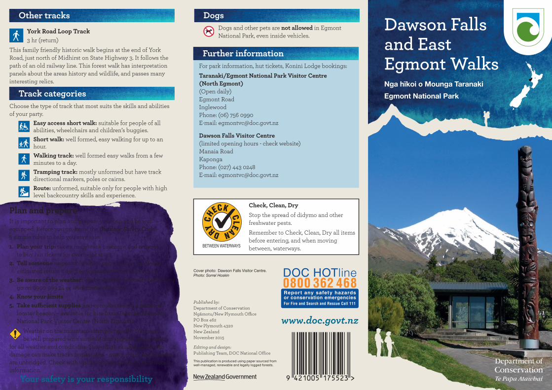
Other tracksYork Road Loop Track3 hr (return)
This family friendly historic walk begins at the end of York Road, just north of Midhirst on State Highway 3. It follows the path of an old railway line. This forest walk has interpretation panels about the areas history and wildlife, and passes many interesting relics.
Dawson Falls and East Egmont Walks
Further information For park information, hut tickets, Konini Lodge bookings:Taranaki/Egmont National Park Visitor Centre (North Egmont) (Open daily) Egmont Road Inglewood Phone: (06) 756 0990 E-mail: [email protected]
Dawson Falls Visitor Centre (limited opening hours - check website) Manaia Road Kaponga Phone: (027) 443 0248 E-mail: [email protected]
Cover photo: Dawson Falls Visitor Centre. Photo: Sorrel Hoskin
Track categoriesChoose the type of track that most suits the skills and abilities of your party.
Easy access short walk: suitable for people of all abilities, wheelchairs and children’s buggies.Short walk: well formed, easy walking for up to an hour.Walking track: well formed easy walks from a few minutes to a day.Tramping track: mostly unformed but have track directional markers, poles or cairns.Route: unformed, suitable only for people with high level backcountry skills and experience.
Nga hīkoi o Mounga Taranaki
Egmont National Park
www.doc.govt.nz
Published by: Department of Conservation Ngāmotu/New Plymouth Office PO Box 462 New Plymouth 4320 New Zealand November 2015
Editing and design: Publishing Team, DOC National Office
This publication is produced using paper sourced from well-managed, renewable and legally logged forests.
Plan and prepareIt is important to plan and prepare your trip and be well equipped. Before you go, know the Outdoor Safety Code – 5 simple rules to help you stay safe:1. Plan your trip: take a map/track brochure and remember
to buy hut tickets for overnight stays.2. Tell someone responsible where you are going and your
estimated return time. See www.adventuresmart.org.nz.3. Be aware of the weather: check weather forecasts before you
go on 0900 999 24 or www.metservice.com.4. Know your limits5. Take sufficient supplies and consider taking a personal
locator beacon – available for hire from Taranaki/EgmontNational Park Visitor Centre (North Egmont).
Weather on the mountain changes rapidly. You must be well prepared with suitable clothing and equipment
for all weather and conditions. Snow, high rainfall and storm damage can make tracks impassable – many rivers and streams are unbridged. Check with visitor centres for up-to-date track information.
Your safety is your responsibility
DogsDogs and other pets are not allowed in Egmont National Park, even inside vehicles.
Check, Clean, DryStop the spread of didymo and other freshwater pests.Remember to Check, Clean, Dry all items before entering, and when moving between, waterways.
DRYCH
ECK
CLEAN
BETWEEN WATERWAYS
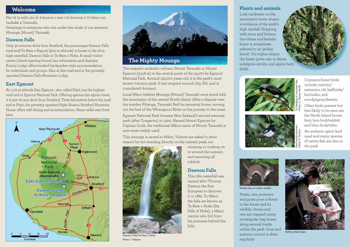
WelcomeNei rā te mihi atu ki ā koutou i raro i te korowai ō tō tātou nei tauheke a Taranaki.Greetings to everyone who sits under the cloak of our ancestor Mounga (Mount) Taranaki.
Dawson FallsOnly 30 minutes drive from Stratford, the picturesque Dawson Falls road end/Te Rere o Kapuni (902 m altitude) is home to the 18 m high waterfall, Dawson Falls or Te Rere o Noke. A small visitor centre (check opening hours) has information and displays. Konini Lodge offers booked backpacker-style accommodation for individuals and groups. Also at this road end is the privately operated Dawson Falls Mountain Lodge.
East EgmontAt 1,172 m altitude East Egmont , also called Pōpō, has the highest road end in Egmont National Park. Offering spectacular alpine views, it is just 20 min drive from Stratford. Three kilometres before the road end at Pōpō, the privately operated Ngāti Ruanui Stratford Mountain House offers café dining and accommodation. Many walks start from here.
Dawson Falls/Te Rere o Noke.
Photo T. Weston
The Mighty MoungaThe majestic andesitic volcano Mount Taranaki or Mount Egmont (2,518 m) is the central point of the 34,170 ha Egmont National Park. Around 125,000 years old, it is the park’s most recent volcanic peak. It last erupted around 1755 AD, and is considered dormant.Local Māori believe Mounga (Mount) Taranaki once stood with the mountains of the central North Island. After a dispute over the maiden Pihanga, Taranaki fled his ancestral home, carving out the bed of the Whanganui River on his journey to the coast.Egmont National Park became New Zealand’s second national park (after Tongariro) in 1900. Named Mount Egmont by Captain Cook, the traditional Māori name of Mount Taranaki is now more widely used.This mounga is sacred to Māori. Visitors are asked to show respect by not standing directly on the summit peak, not
camping or cooking on or around the summit, and removing all rubbish.
Dawson FallsThis 18m waterfall was named after Thomas Dawson the first European to discover it in 1885. To Māori the falls are known as Te Rere o Noke (the Falls of Noke), a Māori warrior who hid from his pursuers behind the falls.
Plants and animalsLush rainforest on the mountain’s lower slopes is evidence of the park’s high rainfall. Dripping with moss and lichens this tōtara and kamahi forest is sometimes referred to as ‘goblin forest’. On higher slopes the forest gives way to dense subalpine shrubs and alpine herb fields.
Setting stoat traps
Pie
d t
omtit
/miro
miro
. P
hoto
: P. S
chilo
vTū
ī fee
din
g on
mou
ntai
n fla
x.
Pho
to: D
. Dev
ery-
Sm
ith
Stoats, rats, possums and goats pose a threat to the forest and its wildlife. Stoats and rats are trapped using rectangular trap boxes along several tracks within the park. Goat and possum control is done regularly.
Common forest birds include: tomtits/miromiro, tūī, bellbirds/korimako, and woodpigeon/kererū. Other birds present but less likely to be seen are the North Island brown kiwi, fern bird/mātātā and blue duck/whio.An endemic giant land snail and many species of native fish are also in the park.
Stoats prey on native wildlife
Goblin fores
t

Mt Taranaki or Mt Egmont 2518 m
Fanthams Peak/Panitahi 1966 m
Stratford Plateau 1172 m
Dawson Falls Visitor Centre 902 m
Manaia Road
Pembroke Road
Konini Lodge
Waingongoro Hut
Syme Hut
Hooker Shelter 1140 m
Kapuni Lodge
(Private)
Manganui Lodge (Private)
Tahurangi Lodge (Private)
Manganui Shelter
Dawson Falls Mountain Lodge
Ngāti Ruanui Stratford Mountain
House
Dawson Falls Power Station
Dawson Falls/Te Rere o Noke
Fanth
ams
Peak Tr
ackUpper Lake Dive Track
Lower Lake Dive Track
(Ro
ute)
Wilkies Pools Loo
p Track
Ridge TrackW
aingongoro Track
Enchanted Track Patea Loop TrackCurtis Falls Track
Summit Track
(Route)
Manganui Gorge Track
Kamahi Loop TrackKapuni
Loop Track
Manganui Skifield
To Lake Dive
To Maketawa
Hut
To North Egmont
Jackson’s lookout
Wilkies Pools
Swingbridge
Hillary Seat
Curtis Falls
To Waiaua Gorge Hut
The perspective of this map may distort distances. This map does not show rivers and streams and is not suitable for navigation. For greater detail refer to Egmont National
Parkmap 273-09 and NZTopo50 map series.
Hasties Hill
East Egmont/Pōpō
To Potaema Track
Dawson Falls Lookout
(Route)
Short walk
Walking track
Track categoryTramping track
Route
Dawson Falls and East Egmont Walks
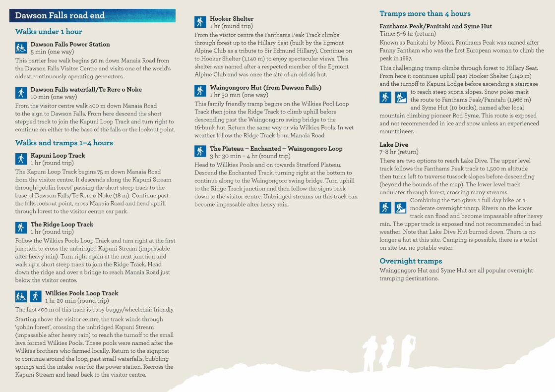
Tramps more than 4 hoursFanthams Peak/Panitahi and Syme Hut Time: 5–6 hr (return)Known as Panitahi by Māori, Fanthams Peak was named after Fanny Fantham who was the first European woman to climb the peak in 1887.This challenging tramp climbs through forest to Hillary Seat. From here it continues uphill past Hooker Shelter (1140 m) and the turnoff to Kapuni Lodge before ascending a staircase
to reach steep scoria slopes. Snow poles mark the route to Fanthams Peak/Panitahi (1,966 m) and Syme Hut (10 bunks), named after local
mountain climbing pioneer Rod Syme. This route is exposed and not recommended in ice and snow unless an experienced mountaineer.
Lake Dive7–8 hr (return)There are two options to reach Lake Dive. The upper level track follows the Fanthams Peak track to 1,500 m altitude then turns left to traverse tussock slopes before descending (beyond the bounds of the map). The lower level track undulates through forest, crossing many streams.
Combining the two gives a full day hike or a moderate overnight tramp. Rivers on the lower track can flood and become impassable after heavy
rain. The upper track is exposed and not recommended in bad weather. Note that Lake Dive Hut burned down. There is no longer a hut at this site. Camping is possible, there is a toilet on site but no potable water.
Overnight trampsWaingongoro Hut and Syme Hut are all popular overnight tramping destinations.
Dawson Falls road end
Walks under 1 hourDawson Falls Power Station 5 min (one way)
This barrier free walk begins 50 m down Manaia Road from the Dawson Falls Visitor Centre and visits one of the world’s oldest continuously operating generators.
Dawson Falls waterfall/Te Rere o Noke 10 min (one way)
From the visitor centre walk 400 m down Manaia Road to the sign to Dawson Falls. From here descend the short stepped track to join the Kapuni Loop Track and turn right to continue on either to the base of the falls or the lookout point.
Walks and tramps 1–4 hoursKapuni Loop Track 1 hr (round trip)
The Kapuni Loop Track begins 75 m down Manaia Road from the visitor centre. It descends along the Kapuni Stream through 'goblin forest' passing the short steep track to the base of Dawson Falls/Te Rere o Noke (18 m). Continue past the falls lookout point, cross Manaia Road and head uphill through forest to the visitor centre car park.
The Ridge Loop Track 1 hr (round trip)
Follow the Wilkies Pools Loop Track and turn right at the first junction to cross the unbridged Kapuni Stream (impassable after heavy rain). Turn right again at the next junction and walk up a short steep track to join the Ridge Track. Head down the ridge and over a bridge to reach Manaia Road just below the visitor centre.
Wilkies Pools Loop Track 1 hr 20 min (round trip)
The first 400 m of this track is baby buggy/wheelchair friendly.Starting above the visitor centre, the track winds through ‘goblin forest’, crossing the unbridged Kapuni Stream (impassable after heavy rain) to reach the turnoff to the small lava formed Wilkies Pools. These pools were named after the Wilkies brothers who farmed locally. Return to the signpost to continue around the loop, past small waterfalls, bubbling springs and the intake weir for the power station. Recross the Kapuni Stream and head back to the visitor centre.
Hooker Shelter 1 hr (round trip)
From the visitor centre the Fanthams Peak Track climbs through forest up to the Hillary Seat (built by the Egmont Alpine Club as a tribute to Sir Edmund Hillary). Continue on to Hooker Shelter (1,140 m) to enjoy spectacular views. This shelter was named after a respected member of the Egmont Alpine Club and was once the site of an old ski hut.
Waingongoro Hut (from Dawson Falls) 1 hr 30 min (one way)
This family friendly tramp begins on the Wilkies Pool Loop Track then joins the Ridge Track to climb uphill before descending past the Waingongoro swing bridge to the 16-bunk hut. Return the same way or via Wilkies Pools. In wetweather follow the Ridge Track from Manaia Road.
The Plateau – Enchanted – Waingongoro Loop 3 hr 30 min – 4 hr (round trip)
Head to Willkies Pools and on towards Stratford Plateau. Descend the Enchanted Track, turning right at the bottom to continue along to the Waingongoro swing bridge. Turn uphill to the Ridge Track junction and then follow the signs back down to the visitor centre. Unbridged streams on this track can become impassable after heavy rain.

Kamahi Loop Track 15–30 min (return)
Begin just above Ngāti Ruanui Stratford Mountain House and walk through 'goblin forest' to exit in the car park by the Mountain House.
Manganui Gorge Track 30 min (one way)
From Stratford Plateau car park follow the track to Manganui Skifield flying fox used to transport supplies. Continue through the tunnel, down into the gorge (extreme care needed in winter conditions due to ice and avalanche risk) and up to the ski field area, operated in winter by a local club. To continue on to North Egmont allow a further 2 – 2 hr 30 min.
Walks and Tramps 1–4 hoursPatea Loop Track 1 hr 30 min (round trip)
From the Ngāti Ruanui Stratford Mountain House follow the Waingongoro Track a short way before heading uphill through forest with large Pahautea/mountain cedar trees. Cross Pembroke Road and descend through forest back to the Mountain House.
East Egmont/Pōpō road end
Walks under 1 hourStratford Plateau Lookout 5 min (one way)
Beginning just below the toilets at the Stratford Plateau car park, this barrier free walk offers spectacular views of Mount Taranaki and the central North Island mountains: Ruapehu, Ngaruhoe and Tongariro.
Potaema Track 15–30 min (return)
From the Potaema picnic area (not shown on map) on Pembroke Road, walk through lowland forest to a viewing platform overlooking a large wetland with the mountain as a stunning backdrop.
Waingongoro Hut (from East Egmont/Pōpō) 1 hr 30 min (one way)
This family friendly tramp starts from the Ngāti Ruanui Stratford Mountain House and crosses several unbridged streams before reaching the Waingongoro swing bridge. Across the bridge a short track leads down to the hut. Return the same way.
Enchanted Track 2–3 hr (round trip)
Access the track from Stratford Plateau. Start the track to Dawson Falls then descend the Enchanted Track past Jackson's Lookout through 'goblin forest.' At the track junction turn left to the Ngāti Ruanui Stratford Mountain House. Allow about 40 min to walk up the road back to Stratford Plateau.
Stratford Plateau to Dawson Falls 2 hr 30 min (return)
From Stratford Plateau head through subalpine vegetation to Dawson Falls via Wilkies Pools. Return the same way or take the longer option via Waingongoro and Enchanted Tracks (allow an extra 1 hr 30 min).
Curtis Falls Track 2–3 hr (round trip)
Starting opposite Ngāti Ruanui Stratford Mountain House this track, with many ladders and steps, undulates through mountain forest to the Manganui River. Follow the riverbed rockhopping upstream to the waterfall - your feet will get wet. Streams can become impassable after heavy rain. Curtis Falls to North Egmont via Maketawa Hut is a further 3 hr 30 min one way along a track that is steep and eroded in places.
Waingongoro – Dawson Falls – Enchanted Loop 4–5 hr (round trip)
From Ngāti Ruanui Stratford Mountain House follow Waingongoro Track to the swing bridge and on up to the Ridge Track junction. Dawson Falls is signposted from here. Return past Wilkies Pools towards Stratford Plateau, then down Enchanted Track and back to the Mountain House. Streams along this track can be impassable after heavy rain.