Embed Size (px)
Citation preview

IMPROVING QSCAT RETRIEVALS IMPROVING QSCAT RETRIEVALS OF HIGH WINDSOF HIGH WINDS
Lucrezia Ricciardulli and Frank WentzLucrezia Ricciardulli and Frank WentzRemote Sensing Systems, Santa Rosa, CA, USARemote Sensing Systems, Santa Rosa, CA, USA
This work is supported by NASA Physical Oceanography, OVWST
Outline: Challenges of high wind retrievals Development of the new GMF Ku2009 Validation of Ku2009 winds Storm examples Impact of rain on wind retrievals Future plans

CHALLENGES OF SATELLITE HIGH WINDS CHALLENGES OF SATELLITE HIGH WINDS RETRIEVALSRETRIEVALS
Satellite sensors retrieve a physical property (QSCAT=surface Satellite sensors retrieve a physical property (QSCAT=surface backscatter ratio) that needs to be calibrated to a reliable backscatter ratio) that needs to be calibrated to a reliable observed “ground truth” (buoy wind, NCEP wind, other satellite observed “ground truth” (buoy wind, NCEP wind, other satellite data, etc..)data, etc..)
When methodology and retrieval algorithms for QSCAT were When methodology and retrieval algorithms for QSCAT were developed at Remote Sensing Systems, there was a lack of in developed at Remote Sensing Systems, there was a lack of in situ validation data at high winds ( wind > 20 m/s) situ validation data at high winds ( wind > 20 m/s)
Geophysical Model Function Ku2001: Assumptions and Geophysical Model Function Ku2001: Assumptions and extrapolations were made, also based on feedback from extrapolations were made, also based on feedback from researchers using hurricane data. researchers using hurricane data.
Now we have 10 yrs of scatterometer wind data that can be Now we have 10 yrs of scatterometer wind data that can be validated, together with an extensive buoy dataset, and validated, together with an extensive buoy dataset, and additional wind observations.additional wind observations.

WHAT DO WE USE FOR CALIBRATION OF WHAT DO WE USE FOR CALIBRATION OF HIGH WINDS?HIGH WINDS? Hurricane Research Division wind analyses (HRD)Hurricane Research Division wind analyses (HRD) Problem: Most of the colocated QSCATProblem: Most of the colocated QSCAT--HRD observations coexist HRD observations coexist
with rain, which makes QSCAT unusable.with rain, which makes QSCAT unusable.
HRD QSCAT, NO RAINFLAG QSCAT, 1 HR RAINFLAG
Example: ATLANTIC STORM ISABEL, SEP 2003

HOW DO WE SEPARATE RAIN FROM THE HOW DO WE SEPARATE RAIN FROM THE WIND SIGNAL?WIND SIGNAL?
Rain affects the Rain affects the scatterometerscatterometer winds. winds.
Best way to separate windBest way to separate wind--rain effects is to use radiometer rain effects is to use radiometer observations with multiple channels: low frequency (C and Xobservations with multiple channels: low frequency (C and X--band) is less sensitive to rain than high frequency (Kband) is less sensitive to rain than high frequency (K--band). band). WINDSAT has this capability. WINDSAT has this capability.
WINDSATWINDSAT WINDSAT V7 data recently processed at RSS.WINDSAT V7 data recently processed at RSS. They are global, therefore they include many rainThey are global, therefore they include many rain--free high free high
wind cases from wind cases from extratropicalextratropical stormsstorms WINDSAT has been validated at high winds using HRD.WINDSAT has been validated at high winds using HRD. WINDSAT includes algorithms capable of measuring wind WINDSAT includes algorithms capable of measuring wind
under rain or hurricane conditions (under rain or hurricane conditions (MeissnerMeissner and Wentz, 2009;and Wentz, 2009;Meissner’sMeissner’s presentation on Tuesdaypresentation on Tuesday).).

THE NEW QSCAT GMF: KU2009THE NEW QSCAT GMF: KU2009 Goal: use Windsat V7 to redevelop RSS QSCAT GMF.Goal: use Windsat V7 to redevelop RSS QSCAT GMF. As a preliminary step, we used 9 yrs of SSMI V6 data to As a preliminary step, we used 9 yrs of SSMI V6 data to
calibrate QSCAT to develop the methodology for the new calibrate QSCAT to develop the methodology for the new Geophysical Model Function (GMF). Geophysical Model Function (GMF).
The GMF relates the radar backscatter cross section The GMF relates the radar backscatter cross section 00 to to wind speed w and wind direction wind speed w and wind direction RR relative to the satellite relative to the satellite look angle. look angle.
We only use the best rainWe only use the best rain--free retrievals to develop the GMFfree retrievals to develop the GMF
Step 1: Build a table of observed Step 1: Build a table of observed 00 binned for wind speed binned for wind speed and wind direction using a calibration “ground truth”and wind direction using a calibration “ground truth”
00
( , ) cos( )( )N
R pol Ri
iA iwf w
BINNING BINNING 0 0 FOR WIND DIRECTION: NCEP OR FOR WIND DIRECTION: NCEP OR CCMP?CCMP?
0 CONTOUR PLOT USING NCEP OR CCMP WIND DIRECTION
WIND SPEED
0-30 M/S
WIND SPEEDS0-5 m/s
WIND DIRECTION WIND DIRECTION

BINNING BINNING 0 0 FOR WIND SPEED: FOR WIND SPEED: THE NONTHE NON--DIRECTIONAL COEFFICIENT ADIRECTIONAL COEFFICIENT A00
Flagging for rain at colocation site and surrounding area is essential. The A1coefficients are largely underestimated at high winds if area-rain flagging is not performed (not shown).

BINNING BINNING 0 0 FOR WIND SPEED: FOR WIND SPEED: THE DIRECTIONAL COEFFICIENTSTHE DIRECTIONAL COEFFICIENTS
A1UPWIND-DOWNWIND INFO A2 UPWIND-CROSSWIND INFO

SATURATION AT HIGH WINDS?SATURATION AT HIGH WINDS?
BACKSCATTER RATIO (linear)
dB units (logarithmic)
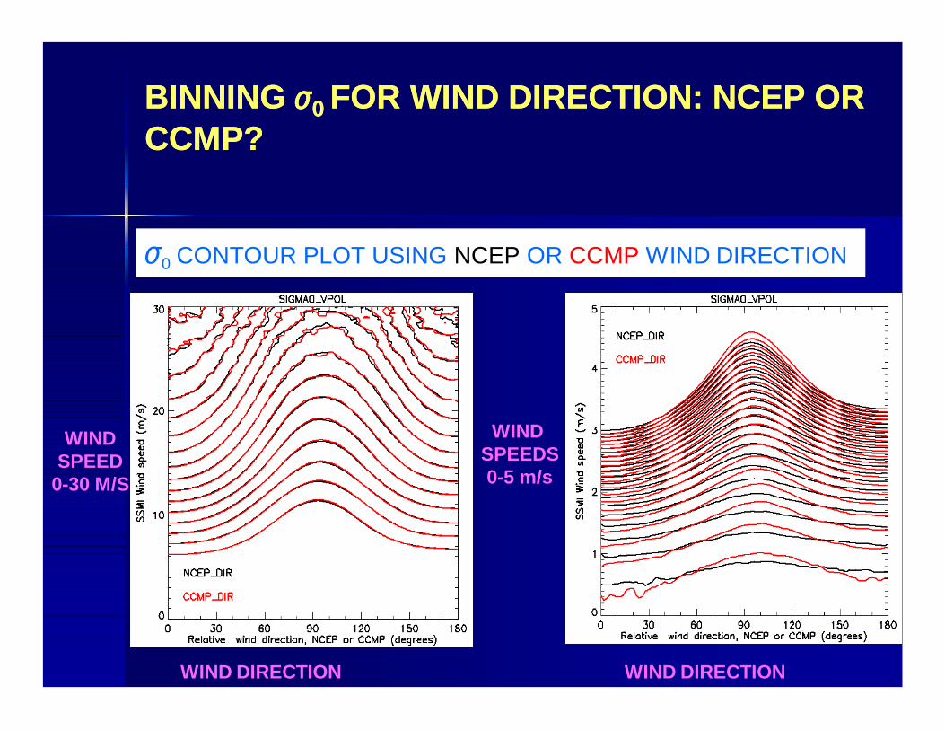
CORRECTION FOR UNCERTAINTY IN CORRECTION FOR UNCERTAINTY IN NCEP/CCMP WIND DIRECTIONNCEP/CCMP WIND DIRECTION
Uncertainty in NCEP/CCMP wind direction leads to Uncertainty in NCEP/CCMP wind direction leads to underestimation of Aunderestimation of Ai i from harmonic fitfrom harmonic fit
We used an alternative method to estimate AWe used an alternative method to estimate A11 and Aand A22 (described in (described in Wentz et al, 1999Wentz et al, 1999), based on the statistical distribution of upwind), based on the statistical distribution of upwind--downwind or upwinddownwind or upwind--crosswind sigma0 retrievals. crosswind sigma0 retrievals.
Does not use ancillary wind direction.Does not use ancillary wind direction. It needs many colocations to be reliable (9 yrs of SSMI)It needs many colocations to be reliable (9 yrs of SSMI)
With this method, we estimated With this method, we estimated a correction (in the figure) to be a correction (in the figure) to be applied to the harmonic applied to the harmonic coefficients Ai (i=1,5) to account coefficients Ai (i=1,5) to account for uncertainty in NCEP/CCMP for uncertainty in NCEP/CCMP wind directionwind direction

DIRECTIONAL BIAS:DIRECTIONAL BIAS:KU2001 KU2001 KU2009KU2009
Crosswind=90
Downwind=180
QSCAT QSCAT
SSM
ISS
MI
SSM
ISS
MI

STATISTICS OF KU2009: STATISTICS OF KU2009: WIND SPEED PDFsWIND SPEED PDFs
Wind (m/s)
Wind (m/s)
1 FULL YEAR OF COLOCATIONS
QSCAT VERSUS SSMI QSCAT VERSUS NCEP

QSCAT WIND DIRECTION RMS: QSCAT WIND DIRECTION RMS: Ku2001 versus Ku2009Ku2001 versus Ku2009

WIND DIRECTION STATISTICS KU2009:WIND DIRECTION STATISTICS KU2009: Good improvement at high winds with Ku2009 versus Ku2001
Ku2001NCEP(20-22 M/S)
Ku2009NCEP(20-22 M/S)
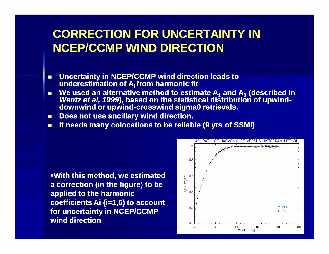
ALL RETRIEVALS,QSCAT rain flag on
RETRIEVALS colocated with SSMI radiometerOnly rain-free (rad rain < 0.15 mm/hr)
No data left !
September 18, 2003
KU2001KU2001 KU2009KU2009
HURRICANE ISABELHURRICANE ISABEL

Extratropical storm, Pacific: Feb 17, 2003Extratropical storm, Pacific: Feb 17, 2003

Extratropical storm, Atlantic: Feb 17, 2003Extratropical storm, Atlantic: Feb 17, 2003
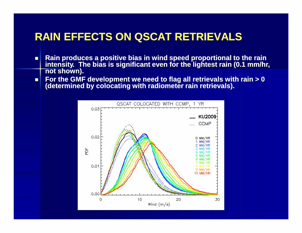
RAIN EFFECTS ON QSCAT RETRIEVALSRAIN EFFECTS ON QSCAT RETRIEVALS
Rain produces a positive bias in wind speed proportional to the rain Rain produces a positive bias in wind speed proportional to the rain intensity. The bias is significant even for the lightest rain (0.1 mm/hr, intensity. The bias is significant even for the lightest rain (0.1 mm/hr, not shown). not shown).
For the GMF development we need to flag all retrievals with rain > 0 For the GMF development we need to flag all retrievals with rain > 0 (determined by colocating with radiometer rain retrievals).(determined by colocating with radiometer rain retrievals).

AIRCRAFT DATA VALIDATION (T. Meissner, D. Smith)AIRCRAFT DATA VALIDATION (T. Meissner, D. Smith) Aircraft observations taken during the
Greenland Flow Distortion Experiment (GFDex), Feb and Mar 2007 (Renfrew et al, QJRMS 2009).
150 data points spread over 6 days with each data point equivalent to a 12 km spatial average. Possible sea ice contamination
Observations taken at 30-50 m above sea level and adjusted to standard 10m height
KU2001 (RainKU2001 (Rain--free)free) KU2009 (RainKU2009 (Rain--free)free) WINDSAT (all weather)WINDSAT (all weather)
AIRCRAFT WIND (M/S)
QSC
AT W
IND
(M/S
)
QSC
AT W
IND
(M/S
)
WIN
DSA
T W
IND
(M/S
)AIRCRAFT WIND (M/S) AIRCRAFT WIND (M/S)

SUMMARY
We developed an interim GMF (Ku2009) using 9 years of colocated SSMI winds to calibrate high wind retrievals.
The new GMF has lower high winds compared to Ku2001.
Rain flagging is very important for studies that require accuracy (climate, calibration, intercomparisons).
The final GMF will be developed using the same methodology presented here but using Windsat winds (and possibly wind direction) for calibration.

NEARNEAR--FUTURE WORKPLANFUTURE WORKPLAN
We just finished validating WindSat V7 retrievals. The We just finished validating WindSat V7 retrievals. The radiometer high winds (WindSat and SSMI) are reliable at least radiometer high winds (WindSat and SSMI) are reliable at least up to 40 m/s. WindSat also detects rain. up to 40 m/s. WindSat also detects rain.
1.1. Redevelop the GMF by using rainRedevelop the GMF by using rain--free WindSat for calibration (7 free WindSat for calibration (7 years). Many rainyears). Many rain--free high wind retrievals in extratropics.free high wind retrievals in extratropics.
2.2. Develop a GMF for wind stress (Bourassa; Rodriguez)Develop a GMF for wind stress (Bourassa; Rodriguez)3.3. Develop a physically based rain Develop a physically based rain
correction algorithm (Kyle Hilburn at RSS).correction algorithm (Kyle Hilburn at RSS).4.4. Develop GMF for ASCAT/ERS: use of consistentDevelop GMF for ASCAT/ERS: use of consistent
methodology is important when creating methodology is important when creating climate data recordclimate data record

Thank youThank you