Embed Size (px)
Citation preview
IMPROVING LAND VALUE INFORMATION PROCESS THROUGH THE USE OF GEO-INFORMATION TECHNOLOGY
J.O.Nyarko (Mrs)a *, C.H.J. Lemmenb
aLand Valuation Board, P.O. Box 4149, Kumasi, Ghana – [email protected]
bITC, Department of Urban and Regional Planning and Geoinformation Management, P.O. Box 6, Enschede, The Netherlands – [email protected]
KEY WORDS: Mobile GIS, Cadastre, Visualization, Object-oriented data model, Data Integration. ABSTRACT: Land is a basic resource for wealth creation, and on it activities of man take place. Efficient information on land is a good foundation for wealth generation and national development. Land valuation is an important component in land administration. Information on land value comprises the ownership, tenure and use of land; for, in principle, it is not the land/property per se that is valued but the interest that subsist in it. In many developing countries, land administration is handled by government agencies and the process is mostly manual. The use of technology to automate and streamline the process and provide timely and less expensive service delivery to stakeholders is essential for the improvement and development of land administration and national development as a whole. The development of Information Technology is advancing at a very fast rate. As a result many devices and software are available to enhance and speed up information communication in a more efficient and effective manner. The need to adopt one form or the other of an information system in an organisation is therefore becoming imperative.This paper considers the use of MobileGIS to capture field data of a particular land parcel and using ArcGIS to analyse, visualise and present Land Value Information. The result is simple straight forward information that gives all necessary information about a particular parcel of land.
1. INTRODUCTION
1.1 Background
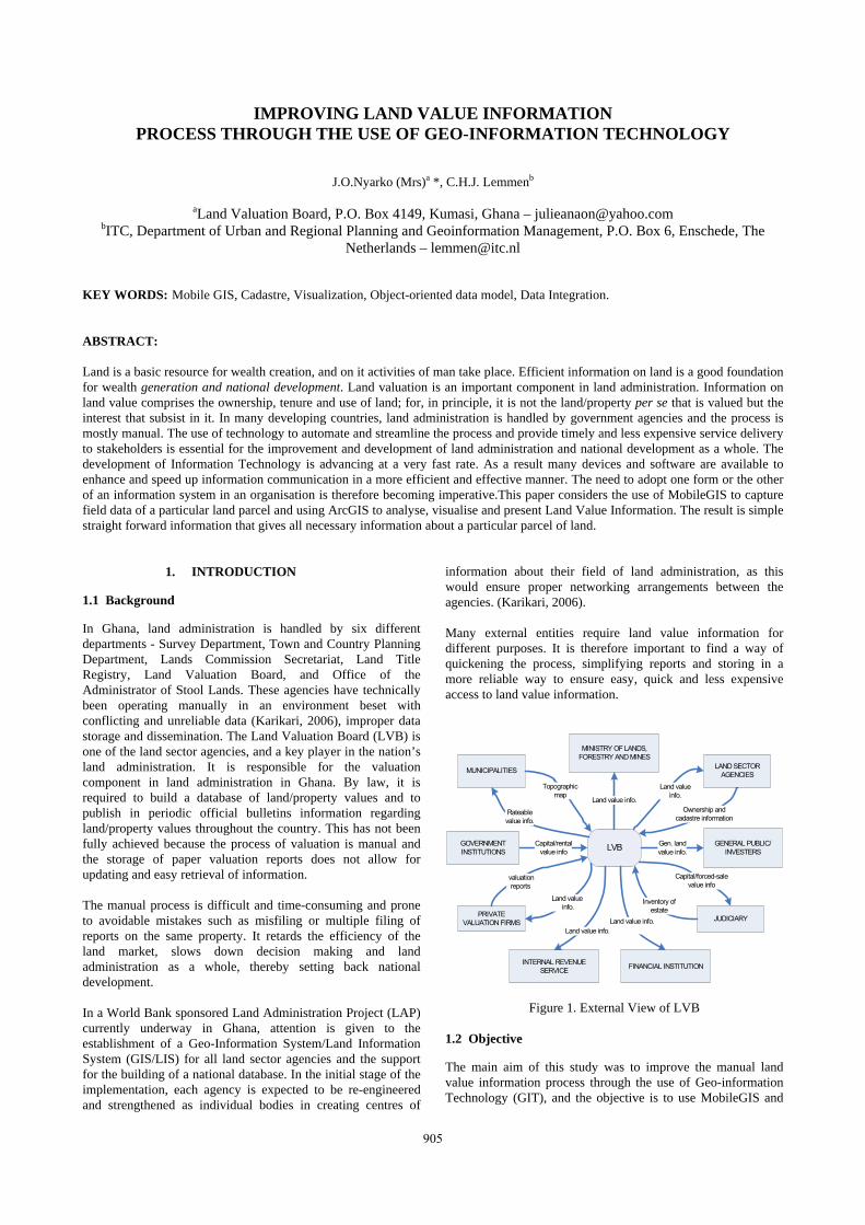
In Ghana, land administration is handled by six different departments - Survey Department, Town and Country Planning Department, Lands Commission Secretariat, Land Title Registry, Land Valuation Board, and Office of the Administrator of Stool Lands. These agencies have technically been operating manually in an environment beset with conflicting and unreliable data (Karikari, 2006), improper data storage and dissemination. The Land Valuation Board (LVB) is one of the land sector agencies, and a key player in the nation’s land administration. It is responsible for the valuation component in land administration in Ghana. By law, it is required to build a database of land/property values and to publish in periodic official bulletins information regarding land/property values throughout the country. This has not been fully achieved because the process of valuation is manual and the storage of paper valuation reports does not allow for updating and easy retrieval of information. The manual process is difficult and time-consuming and prone to avoidable mistakes such as misfiling or multiple filing of reports on the same property. It retards the efficiency of the land market, slows down decision making and land administration as a whole, thereby setting back national development. In a World Bank sponsored Land Administration Project (LAP) currently underway in Ghana, attention is given to the establishment of a Geo-Information System/Land Information System (GIS/LIS) for all land sector agencies and the support for the building of a national database. In the initial stage of the implementation, each agency is expected to be re-engineered and strengthened as individual bodies in creating centres of
information about their field of land administration, as this would ensure proper networking arrangements between the agencies. (Karikari, 2006). Many external entities require land value information for different purposes. It is therefore important to find a way of quickening the process, simplifying reports and storing in a more reliable way to ensure easy, quick and less expensive access to land value information.
LVB
Land value info.
Land value info.
Gen. land value info.
Land value info.
Rateable value info.
Ownership and cadastre information
Capital/rental value info
Capital/forced-sale value info
LAND SECTOR AGENCIESMUNICIPALITIES
JUDICIARY
INTERNAL REVENUE SERVICE
GOVERNMENT INSTITUTIONS
PRIVATE VALUATION FIRMS
GENERAL PUBLIC/INVESTERS
MINISTRY OF LANDS, FORESTRY AND MINES
Land value info.
Topographic map
valuation reports
Inventory of estate
FINANCIAL INSTITUTION
Land value info.
Figure 1. External View of LVB
1.2 Objective
The main aim of this study was to improve the manual land value information process through the use of Geo-information Technology (GIT), and the objective is to use MobileGIS and
905
The International Archives of the Photogrammetry, Remote Sensing and Spatial Information Sciences. Vol. XXXVII. Part B4. Beijing 2008
ArcGIS to capture and analyse land/property data to produce land value information. 1.3 Some Literature Review
In the UN Land Administration Guidelines (UN/ECE, 1996), land administration is defined as the ‘process of determining, recording, and disseminating information on ownership, value and use of land when implementing land management policies’. According to van der Molen, (2006) this definition has proven to be a guiding principle and stands firm especially when the concepts of ‘ownership’, ‘value’, and ‘use’ are interpreted in a broad sense.(van der Molen 2006). From the definition, ‘information’ could be said to be the pivot of land administration and information on land value is prominent. Dale and McLaughlin (2000) in their book ‘Land Administration’ identified ‘three key attributes of land that every country must manage - its tenure, value, and use’. They further stated that ‘Access to information on the ownership, value, and use of land helps to further social and political objectives’. From these two statements the three attributes can be said to be the pillars of land administration, such that without one there can not be a stable land administration. Geographic information is information about geography, that is, information tied to some specific set of locations on the Earth’s surface (Longley, et al. 2005). Geographic Information Technology is technology for collecting and dealing with geographic information. There are three types: Global Positioning System (GPS), Remote Sensing (RS), and Geographic Information System (GIS) (Michael, 1997). In this study GPS and GIS were used. Karikari (2006) observes that, ‘LIS and GIS have similar meanings in terms of analytical functions and other operations performed on the data’. The difference lies in the fact that, whereas GIS refers to a more generic idea of geographic location, LIS on the other hand refers to parcel-based information, and thus they are often used interchangeably. The use of GIS as a technology for Geo-Information has been identified with a number of benefits. To Chorley (1987), a well designed GIS has the capability of providing
Quick and easy access to large volumes of data Ability to select detail by area or theme; link or
merge one data set to another; analyse spatial charac-teristic of data; update data quickly and cheaply; and
New and flexible forms of output tailored to meet par-ticular needs.
Tuladhar (2007) considers the benefits of LIS from three main perspectives – Efficiency, Effectiveness, and Competitive Advantage benefits. Some of the benefits considered were:
Repetitive tasks are diminished; saving space in stor-age; automatic control of process; eliminate time wasted in retrieving maps, drafting and duplication, difficulties of map based analysis against GIS; as ef-ficiency benefits,
High level of achievement; improving productive-ness; data sharing; better services; high quality prod-ucts; as effectiveness benefits, and
Gaining an edge over competitors (who do not use LIS) as an advantage.
The application of GIS in valuation practice is almost non-existent. It is therefore needful to consider how it can be done.
2. CONCEPTUAL MODELS
To improve the manual system of the land value information processes a Data Base Management System (DBMS) and a Data Model as shown below was proposed.
Cadastral data
Property data
Building data
Other data
- Data analysis- GIS analysis
Reporting and appeals
Valuation Quality control
DBMS - Rights/Restrictions Database - Property Database - Building Database - Valuation Database - Other Database
Figure 2. Components of CAV system adapted from (Tuladhar,
2002) 2.1 Database Management System (DBMS)
A real estate object (parcel of land and /or building) is always the subject matter of a valuation, thus a cadastral data showing the parcel, who owns it and restrictions in the exercise of property rights is required. Data on the object as to whether it is a parcel or it has developments in the form of farm or building is necessary. If the parcel has a building development, details of it and other necessary data are required. All these are needed to build a database which enables the preparation of a Land Value Information. Data/GIS Analysis: this component provides for the analysis of data collected, economic and other factors affecting value, for the assessment of property value. This may be done in Microsoft Excel. GIS analysis is then made linking spatial data to non-spatial data. Valuation/Quality Control: valuation is prepared based on models and standards of the valuation practice in Ghana. Submission of report for review by a senior valuer is a measure of quality control. Reporting and Appeals: the customer must be informed about the property value and he/she has the right to comment on the information, or appeal against the value and the valuation would be referred back for review if needed. 1.0 Object Oriented Data Model
Information held in a structured way in a computer, or by other pieces of information technology, for subsequent retrieval is commonly referred to as an information system (Grimshaw, 2000). To input data into computer-based information system requires that the data be modelled for easy storage.
906
RealEstateObject-ObjectID : Integer-Location : Char-Tmin : Date-Tmax : Date
Parcel-ParcelID : Integer-Area : float-Use : Char
FarmUnit-FarmID : Integer-Area : float-CropType : Char-SketchPlan : Object
Valuation-PurposeOfVal : Char-BasisOfValuation : Char-MethodOfVal : Char-AccommodationS : Char-RPSM : Char-OtherValue : Char-DepRate : Char-Value : Char-ValDate : Date
Building-BuildingID : Integer-Type : Char-NumOfFloors : Integer-NumOfRooms : Integer-TotalFloorArea : float-ConsDetails : Char-DepRemarks : Char-SketchPlan : Object
0..* 1..*
11..*
Impeovements-Type : Char-Tmin : Date-Tmax : Date
0..*
ImprovementHistory-ObjectID : Integer-TypeOfChange : Char-AccSchedule : Char-Condition : Char-Tmin : Date-Tmax : Date
wt
RightOrRestriction-Type : Char-RegNumber : Integer-RegDate : Date-Tmin : Date-Tmax : Date
Right-TypeOfRight : Char-Terms : Char
Restriction-RestrictionType : Char
1 0..*
Mortgage-MortgageValue : Char
Person-PersonID : Char-PostalAdd : Char-EmailAdd : Char-PhoneNo : Char
NaturalPerson-Name : Char-Age : Char
NonNaturalPerson-CompanyName : Char-CompanyRegNo : Integer
1..* 1..*
Cf厖 .come from
Wt� .厀 ent to
0..*
1
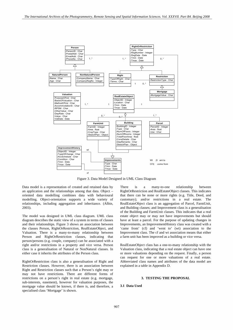
cf Figure 3. Data Model Designed in UML Class Diagram
Data model is a representation of created and retained data by an application and the relationships among that data. Object –oriented data modelling combines data with behavioural modelling. Object-orientation supports a wide variety of relationships, including aggregation and inheritance. (Albin, 2003). The model was designed in UML class diagram. UML class diagram describes the static view of a system in terms of classes and their relationships. Figure 3 shows an association between the classes Person, RightOrRestriction, RealEstateObject, and Valuation. There is a many-to-many relationship between Person and RightOrRestriction classes, indicating that person/persons (e.g. couple, company) can be associated with a right and/or restrictions in a property and vice versa. Person class is a generalisation of Natural or NonNatural classes. In either case it inherits the attributes of the Person class. RightOrRestriction class is also a generalisation of Right and Restriction classes. However, there is an association between Right and Restriction classes such that a Person’s right may or may not have restrictions. There are different forms of restrictions on a person’s right in real estate (e.g. mortgage, sub-interests, easement), however for valuation purposes, the mortgage value should be known, if there is, and therefore, a specialised class ‘Mortgage’ is shown.
There is a many-to-one relationship between RightOrRestriction and RealEstateObject classes. This indicates that there can be none or more rights (e.g. Title, Deed, and customary); and/or restrictions in a real estate. The RealEstateObject class is an aggregation of Parcel, FarmUnit, and Building classes; and Improvement class is a generalisation of the Building and FarmUnit classes. This indicates that a real estate object may or may not have improvements but should have at least a parcel. For the purpose of updating changes in Improvements, an ImprovementHistory class was created with a ‘came from’ (cf) and ‘went to’ (wt) association to the Improvement class. The cf and wt association means that either a farm unit has been improved as a building or vice versa. RealEstateObject class has a one-to-many relationship with the Valuation class, indicating that a real estate object can have one or more valuations depending on the request. Finally, a person can request for one or more valuations of a real estate. Abbreviated class names and attributes of the data model are explained in a table in Appendix D.
3. TESTING THE PROPOSAL
3.1 Data Used
907
The International Archives of the Photogrammetry, Remote Sensing and Spatial Information Sciences. Vol. XXXVII. Part B4. Beijing 2008
The International Archives of the Photogrammetry, Remote Sensing and Spatial Information Sciences. Vol. XXXVII. Part B4. Beijing 2008
A cadastral map of a portion of an area layout was used. All necessary attribute data needed was input in ArcGIS, and then loaded on ArcPAD 1.0 Devices used for the test
Global Positioning System (GPS) Receiver: It is a device which is enabled by a Global Navigation Satellite System (GNSS) to determine its location. Many GPS receivers can relay position data to a PC or other device. Data recorded are frequently used to add accuracy to information on maps (Corbett et. al., 2006). Personal Digital Assistance (PDA): These are handheld computers that can be used to capture field data. The hp iPAQ PDA was used for this exercise. It is an old and mostly used PDA. It provides more multimedia capabilities. The familiar Microsoft Windows interface and the presence of a touch screen and its detachable stylus are significant characteristics. The Bluetooth wireless connectivity makes it possible to connect to GPS and many other accessories (Wikipedia, 2007). GIS Software: Geographic information system is a computerised system that facilitates the phases of data entry, data analysis and data presentation especially in cases when we are dealing with georeferenced data.(de By, de By et al. 2004). Software for the system may be produced by different vendors. In this exercise, ESRI ArcPAD and ArcGIS were used. ArcPAD: It is mobile GIS software for field mapping applications. It provides field personnel with the ability to capture, analyse and display geo information. It can integrate input from GPS receivers and digital cameras. ArcGIS: It is software that allows the discovering of patterns, relationships, and trends in data that are not readily apparent in databases, spreadsheets, or statistical packages. ArcGIS Desktop gives the power to manage and integrate data, perform advanced analysis, model and automate operational processes, and display results on professional-quality maps. (ESRI, 2007). 2.0 Steps Taken in Testing the Proposal
The following steps were taken in the process: Step one: the cadastral data was loaded on ArcPAD and with a
GPS and an assistant the site was visited. Step two: with the help of the GPS the property was located on
the map in ArcPAD. The parcel was then selected with the stylus in ArcPAD and the required attributes added. A picture of the property and a movie around the immediate neighbourhood was taken.
Step three: the internal floor plan was sketched and measurements taken. The condition of the building was also entered in ArcPAD. NOTE: because permission was not sought to enter in the building, this step was not taken in this exercise.
Step four: the memory card in the iPAQ was removed and the data transferred to the workstation. In ArcMap the data was analysed by linking spatial to non-spatial data including the property value. Hyperlinks referencing the building photo, a sketch plan and neighbourhood movie were also added.
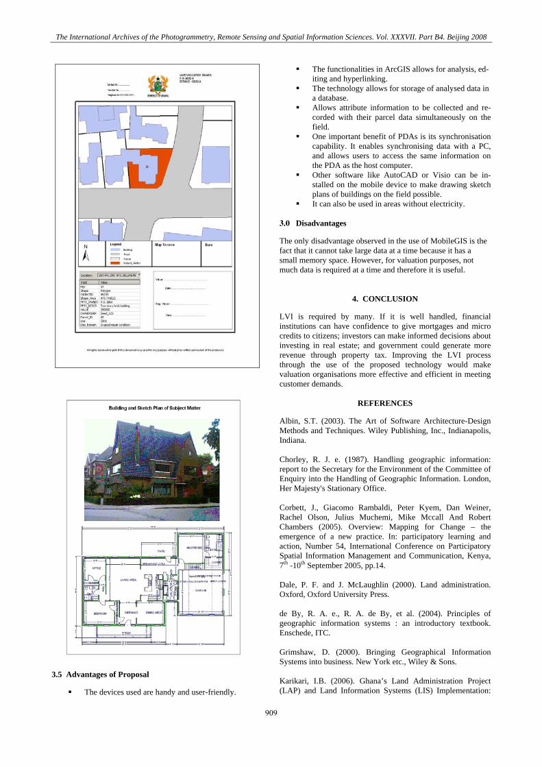
Step five: an output data was then created in layout view in ArcMap as the land value information to be
submitted to the customer. This is shown in Appendix E.
3.4 The Results
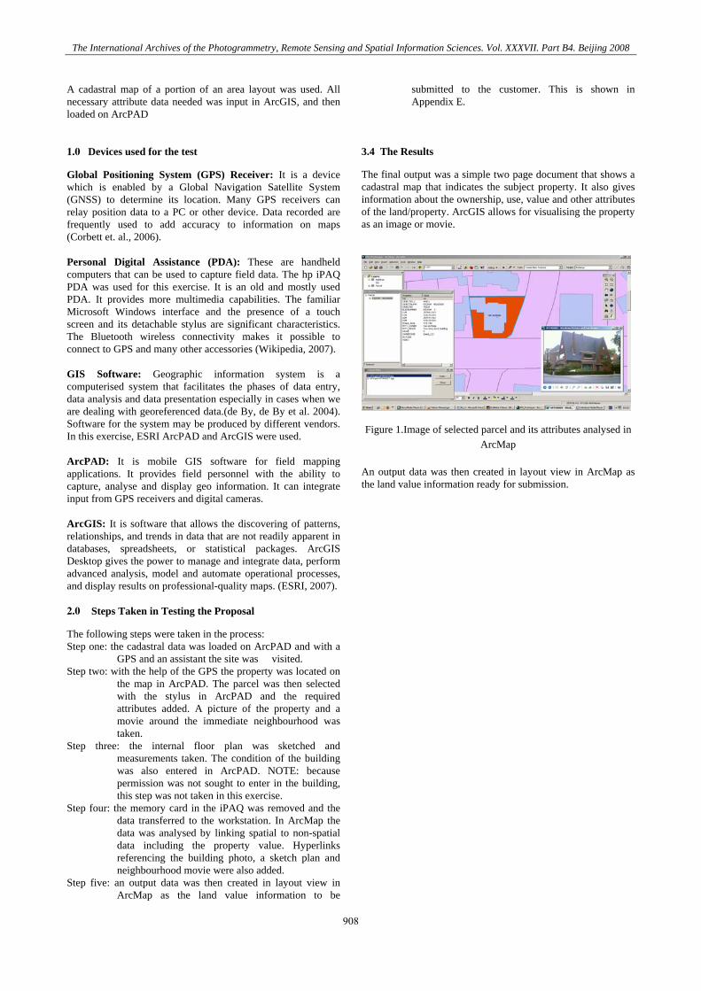
The final output was a simple two page document that shows a cadastral map that indicates the subject property. It also gives information about the ownership, use, value and other attributes of the land/property. ArcGIS allows for visualising the property as an image or movie.
Figure 1.Image of selected parcel and its attributes analysed in
ArcMap An output data was then created in layout view in ArcMap as the land value information ready for submission.
908
The International Archives of the Photogrammetry, Remote Sensing and Spatial Information Sciences. Vol. XXXVII. Part B4. Beijing 2008
3.5 Advantages of Proposal
The devices used are handy and user-friendly.
The functionalities in ArcGIS allows for analysis, ed-iting and hyperlinking.
The technology allows for storage of analysed data in a database.
Allows attribute information to be collected and re-corded with their parcel data simultaneously on the field.
One important benefit of PDAs is its synchronisation capability. It enables synchronising data with a PC, and allows users to access the same information on the PDA as the host computer.
Other software like AutoCAD or Visio can be in-stalled on the mobile device to make drawing sketch plans of buildings on the field possible.
It can also be used in areas without electricity. 3.0 Disadvantages
The only disadvantage observed in the use of MobileGIS is the fact that it cannot take large data at a time because it has a small memory space. However, for valuation purposes, not much data is required at a time and therefore it is useful.
4. CONCLUSION
LVI is required by many. If it is well handled, financial institutions can have confidence to give mortgages and micro credits to citizens; investors can make informed decisions about investing in real estate; and government could generate more revenue through property tax. Improving the LVI process through the use of the proposed technology would make valuation organisations more effective and efficient in meeting customer demands.
REFERENCES
Albin, S.T. (2003). The Art of Software Architecture-Design Methods and Techniques. Wiley Publishing, Inc., Indianapolis, Indiana. Chorley, R. J. e. (1987). Handling geographic information: report to the Secretary for the Environment of the Committee of Enquiry into the Handling of Geographic Information. London, Her Majesty's Stationary Office. Corbett, J., Giacomo Rambaldi, Peter Kyem, Dan Weiner, Rachel Olson, Julius Muchemi, Mike Mccall And Robert Chambers (2005). Overview: Mapping for Change – the emergence of a new practice. In: participatory learning and action, Number 54, International Conference on Participatory Spatial Information Management and Communication, Kenya, 7th -10th September 2005, pp.14. Dale, P. F. and J. McLaughlin (2000). Land administration. Oxford, Oxford University Press. de By, R. A. e., R. A. de By, et al. (2004). Principles of geographic information systems : an introductory textbook. Enschede, ITC. Grimshaw, D. (2000). Bringing Geographical Information Systems into business. New York etc., Wiley & Sons. Karikari, I.B. (2006). Ghana’s Land Administration Project (LAP) and Land Information Systems (LIS) Implementation:
909
The International Archives of the Photogrammetry, Remote Sensing and Spatial Information Sciences. Vol. XXXVII. Part B4. Beijing 2008
The Issues. Article of the Month, 5th FIG Regional Conference - Promoting Land Administration and Good Governance held in Accra, Ghana, March 8-11, 2006. http://www.fig.net (Accessed 30/06/07 - 21.36hrs). Longley, P. A., M. F. Goodchild, et al. (2005). Geographic information : systems and science. Chichester etc., Wiley & Sons. Michael F. Goodchild. (1997). What is Geographic Information Science? NCGIA Core Curriculum in GIScience, http://www.ncgia.ucsb.edu/giscc/units/u002/u002.html, posted October 7, 1997. (Accessesd 16/08/07 at 12:37hrs). UN/ECE (1996). Land administration guidelines: with special reference to countries in transition. Geneva van der Molen, P. (2006). Tenure and tools, two aspects of innovative land administration. In: Decision makers meeting : good administration of land : Windhoek, Namibia, 7-8 December 2006. / ed. by P. van der Molen and A. Otieno Lamba. Windhoek, Enschede, Apeldoorn, School for Land Administration Studies and Polytechnic of Namibia, ITC, Cadastre, Land Registration and Mapping Agency (Kadaster), 2006. 23 p. Tuladhar, A.M. (2007). LIS, Geo-Information Management in Application Domain. Lecture Notes, Module 7&8, ITC, Enschede, The Netherlands, pp.3. Tuladhar, A.M. (2002). Property Valuation and Computer Assisted Valuation, Module 7 and 8: GIM Programme, ITC, Enschede, The Netherlands, pp. 26. www.esri.com Last Updated: Tuesday, July17, 2007 (Accessed 26/07/07 – 10:00 hrs) http://en.wikipedia.org/wiki/Personal_digital_assistant
ACKNOWLEDGEMENTS
I would like to acknowledge the support of Mr. Christiaan Lemmen of ITC, Netherlands, who was my supervisor during the preparation of this paper. I am also grateful to my husband and children who morally supported me to the completion of this work.
910