Embed Size (px)
DESCRIPTION
Improved Conjunction Analysis via Collaborative Space Situational Awareness. T.S. Kelso & David A. Vallado, CSSI Joseph Chan & Bjorn Buckwalter, Intelsat Corporation. Overview. Motivation Background Proposed Solution Analysis of Orbital Data Sources Supplemental TLEs - PowerPoint PPT Presentation
Citation preview

Improved Conjunction Analysis via Collaborative Space Situational
AwarenessT.S. Kelso & David A. Vallado, CSSI
Joseph Chan & Bjorn Buckwalter, Intelsat Corporation

3rd IAASS, Rome, 2008 Oct 21-23Pg 2 of 17
Overview
• Motivation
• Background
• Proposed Solution
• Analysis of Orbital Data Sources– Supplemental TLEs
• GPS, GLONASS, Intelsat
• Application: SOCRATES-GEO
• Summary & Conclusions

3rd IAASS, Rome, 2008 Oct 21-23Pg 3 of 17
Motivation
• Recent events emphasize need for improved SSA for conjunction analysis– Chinese ASAT test (2007 Jan 11)– USA 193 intercept (2008 Feb 21)– ISS maneuver to avoid Cosmos 2421 debris (2008 Aug)
• Geostationary orbit (GEO) is a limited resource– More satellites = more conjunctions– Implications of a collision are significant
• Potential loss of colliding satellites and associated revenues• Increase in debris, putting other satellites at risk
3rd IAASS, Rome, 2008 Oct 21-23Pg 4 of 17
Background
• Conjunction analysis needs full-catalog orbital data– TLEs are currently the only such source
• Low accuracy results in high false-alarm rate
• More accurate orbital data could– Reduce false alarms– Improve use of limited tracking resources
3rd IAASS, Rome, 2008 Oct 21-23Pg 5 of 17
Background
• Current system limited to non-cooperative tracking– SSN uses combination of radar and optical resources
• Operational satellites most difficult to track due to maneuvers– Maneuvers typically not known ahead of time– Delay in detecting maneuvers can result in poor
accuracy or even ‘lost’ satellites– Requires more SSN resources to maintain orbits
3rd IAASS, Rome, 2008 Oct 21-23Pg 6 of 17
Proposed Solution
• Satellite operators already maintain orbits– Active ranging, GPS can be very accurate
• Develop Data Center to collect operator data– Use operator data to improve conjunction analysis– Provide analysis/data to all contributors
• Current Data Center participation– Intelsat, Inmarsat, EchoStar, SES (Astra, New Skies,
Americom), NOAA, Star One, Telesat– 117 satellites—32% of all active GEO satellites
• 24 satellites pending
3rd IAASS, Rome, 2008 Oct 21-23Pg 7 of 17
Analysis of Orbital Data Sources
• Many sources of operator orbital data– Direct from satellite operator (Data Center)– Public sources
• GPS (almanacs, precise ephemerides)• GLONASS (precise ephemerides)• Intelsat (11-parameter data, ephemerides)• NOAA, EUMETSAT (state vectors)
• Challenges– User-defined data formats– Variety of coordinate frames & time systems used

3rd IAASS, Rome, 2008 Oct 21-23Pg 8 of 17
Supplemental TLEs
• Use public orbital data– GPS almanacs
– GLONASS precise ephemerides
– Intelsat 11-parameter data
• Import data into STK to generate ephemerides
• Generate TLE from ephemerides– http://celestrak.com/NORAD/elements/supplemental/
– Allows users to see benefit• Test cases with supporting data
– Overcomes limitations in most orbital software• Most applications can handle TLEs/SGP4

3rd IAASS, Rome, 2008 Oct 21-23Pg 9 of 17
GPS Almanacs vs. TLEs
Mean: 1.292 km
Max: 3.073 km
Mean: 7.544 km
Max: 32.449 km

3rd IAASS, Rome, 2008 Oct 21-23Pg 10 of 17
GPS Supplemental TLEs
Mean: 0.872 km
Max: 2.366 km
Mean: 7.544 km
Max: 32.449 km

3rd IAASS, Rome, 2008 Oct 21-23Pg 11 of 17
GLONASS Supplemental TLEs
Mean: 3.301 km
Max: 9.388 km
Mean: 0.201 km
Max: 0.539 km
3rd IAASS, Rome, 2008 Oct 21-23Pg 12 of 17
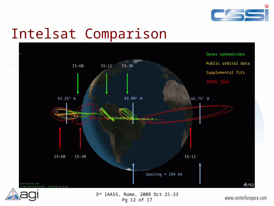
Intelsat Comparison
IS-6B IS-3R IS-11
IS-6B IS-3RIS-11
Owner ephemerides
Public orbital data
Supplemental TLEs
AFSPC TLEs
43.25° W 43.00° W 42.75° W
Spacing = 184 km

3rd IAASS, Rome, 2008 Oct 21-23Pg 13 of 17
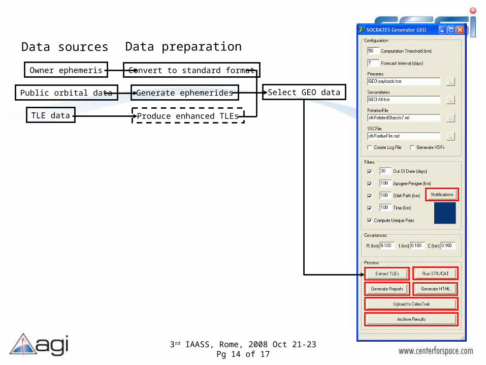
Application: SOCRATES-GEO
• New system on CelesTrak– Looks for all objects which pass within 250 km of GEO– Uses improved data sources, when available– Generates standard reports, including orbital data– Allows user-defined notification criteria– Automatically sends notification– Web access via secure system
3rd IAASS, Rome, 2008 Oct 21-23Pg 14 of 17
Data sources
Owner ephemeris
Public orbital data
TLE data
Convert to standard format
Generate ephemerides
Produce enhanced TLEs
Select GEO data
Data preparation

3rd IAASS, Rome, 2008 Oct 21-23Pg 15 of 17

3rd IAASS, Rome, 2008 Oct 21-23Pg 16 of 17
3rd IAASS, Rome, 2008 Oct 21-23Pg 17 of 17
Summary & Conclusions
• Collaborative effort addresses current limitations– Improves orbital accuracy– Reduces search volumes– Reduces false-alarm rate– Supplements full-catalog orbital data source
• Reduces SSA tracking requirements– Trust but verify

Questions?