Embed Size (px)
Citation preview

18 SWIM. Cartagena 2004, Spain. (Ed. Araguás, Custodio and Manzano). IGME
259
IMPORTANCE OF A HIGH RESOLUTION LITHOLOGICAL AND GEOMETRICALKNOWLEDGE FOR MEDITERRANEAN COASTAL SEDIMENTARY AQUIFERS
MANAGEMENT. APPLICATION TO THE ROUSSILLON BASIN, SOUTH OFFRANCE
B. AUNAY1,2,*, C. DUVAIL3,4, P. LE STRAT4, N. DÖRFLIGER2, P. LACHASSAGNE2 and S. PISTRE1
1 Hydrosciences Montpellier - UMR 5569 - CNRS-IRD - Montpellier II University.Place Eugène Bataillon. CC MSE; 34095 Montpellier, Cedex 5, France.
Email: [email protected] BRGM – Water Division, Resource Assessment, Discontinuous Aquifers Unit. 1039, rue de Pinville;
34000 Montpellier, France3 UMR 5573 CNRS- Montpellier II University. Laboratoire DL, CC 060; 34095 Montpellier, Cedex 05, France.
4 BRGM – Regional Geological Service Languedoc-Roussillon. 1039, rue de Pinville; 34000 Montpellier, France.
Abstract
A good understanding of coastal aquifers is particularly important for their management and preservation,as well as for specific implementations (artificial recharge). A detailed knowledge of the lithology andgeometry of the aquitards and aquicludes is as important as that of the aquifers, particularly for seawaterencroachment dynamics. A new methodology, based on reservoir geology, is used to contribute to high-resolution lithological and geometrical knowledge of coastal sedimentary aquifers. The proposedmethodology is being applied on the Roussillon Basin, located along the southernmost part of the FrenchMediterranean coast, near the Spanish border. This basin covers an area of 700 km2 and comprises twoPliocene aquifers whose characteristics are linked to the Messinian event, and is overlain by the Quaternaryaquifer whose geometry is linked to eustatic variations. All these aquifers consist of alluvial and coastaldeposits. A detailed lithology and geometry model of this basin has been made mainly on the basis ofreservoir geology methods: (i) on-shore, through genetic stratigraphy and (ii) off-shore, through seismicstratigraphy. A detailed mapping of the elevation of the top and base of the aquifers andaquitards/aquicludes is thus available and will be used in a hydrogeological finite difference model. Thismodel will be used for various applications such as aquifer management, location of the outflow areas ofthe aquifers and sensitivity analysis on geometry (on-shore-off-shore).
Keywords: Sequence stratigraphy, on-shore and off-shore geology, saltwater intrusion, Roussillon basin,Mediterranean sea, well logging, eustatism, groundwater, hydrodynamic modelling.
* Corresponding author
Introduction
A good understanding of coastal aquifers is particularly important for their management and preservation,as well as for specific implementations (e.g. artificial recharge). In fact, a detailed knowledge of thelithology and geometry of the aquitards and aquicludes is as important as that of the aquifers, particularlyfor up-coning risk evaluation, salt water encroachment dynamics through surfaces water bodies (rivers,lagoons…) or directly through the sea, etc.
A new methodology is applied to the Roussillon basin in southern France: It is based on high-resolutiongeology and correlation between off-shore and on-shore domains. Continuity of geometry between off-shore and on-shore fields should permit the testing of new boundary conditions within groundwatermodelling.
Case study
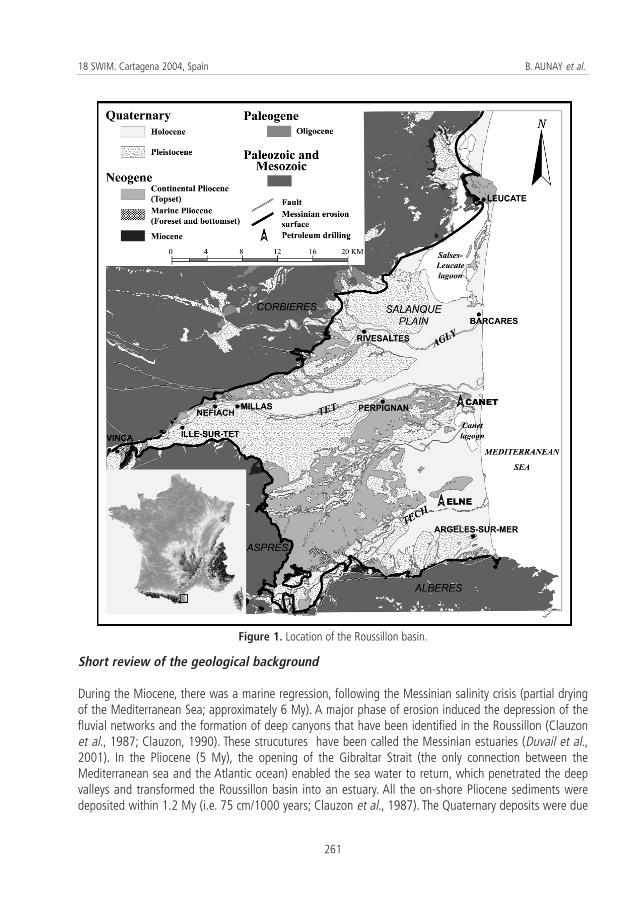
The Roussillon basin is located along the southernmost part of the French Mediterranean coast, near theSpanish border, and lies between Albères in the south, Aspres in the west, Corbières in the north and theMediterranean Sea in east (Figure 1). This basin has an area of approximately 700 km2 and contains threemajor aquifers, from bottom to top: the Quaternary aquifer, the continental Pliocene aquifer and the sandymarine Pliocene aquifer. These geological units are embedded within a Miocene structured margin.
A detailed lithological and geometrical-geological model of this basin has been built, mainly on the basisof reservoir geology methods:
– on-shore, through genetic stratigraphy performed with BRGM (French Geological Survey) publicunderground database (more than 500 wells in that area, with about 120 logging), theinterpretation of well logging, and cross checking the outcrops;
– off-shore, through seismic stratigraphy (existing sections provided by oil companies and high-resolution seismic profiles provided by the University of Perpignan).
Detailed mapping of the elevation of the top and base of the aquifers, the aquitards and aquicludes, oftheir lithology, their internal relationships and with other aquifers (especially a karstic one, whose structure,also influenced by the sea level variations, has been studied separately) is thus available, and is beingimplemented in an hydrogeological finite difference model.
Methodology
Reservoir geology and some of its tools, used in oil prospecting, are applied to hydrogeology. Tools suchas genetic stratigraphy (on-shore domain) and seismic stratigraphy (off-shore domain) were used on pre-existing data (logging -on-shore, seismic profile -off-shore). From established sedimentary process,interpretations have resulted in a better knowledge of the sedimentary geometry, following correlationbetween on-shore and off-shore domains (Duvail et al., in press). It is thus possible to preciselydifferentiate coastal groundwater aquifers and to establish their relative connections.
260
Importance of a high resolution lithological and geometrical knowledge for Mediterranean coastal sedimentary aquifersmanagement. Application to the Roussillon Basin, South of France
Short review of the geological background
During the Miocene, there was a marine regression, following the Messinian salinity crisis (partial dryingof the Mediterranean Sea; approximately 6 My). A major phase of erosion induced the depression of thefluvial networks and the formation of deep canyons that have been identified in the Roussillon (Clauzonet al., 1987; Clauzon, 1990). These strucutures have been called the Messinian estuaries (Duvail et al.,2001). In the Pliocene (5 My), the opening of the Gibraltar Strait (the only connection between theMediterranean sea and the Atlantic ocean) enabled the sea water to return, which penetrated the deepvalleys and transformed the Roussillon basin into an estuary. All the on-shore Pliocene sediments weredeposited within 1.2 My (i.e. 75 cm/1000 years; Clauzon et al., 1987). The Quaternary deposits were due
261
18 SWIM. Cartagena 2004, Spain B. AUNAY et al.
Figure 1. Location of the Roussillon basin.

to the interglacial transgression and regression phases. The last transgression (sea-level rise) resulted insome coastal constructions (e.g. dunes) and a lagoon area from Leucate to Argelès. Today only the Salses-Leucate and Canet lagoons remain (Dörfliger, 2003).
Analysis of on-shore well logging
More than 2000 boreholes (exploratory drilling and exploitation boreholes) were carried out for thegeotechnical, hydrogeological and petroleum purposes in the sedimentary Roussillon basin. Lithologicaldescriptions of these, with varied quality and depth, are available in the BRGM database. Well-loggingand/or precise lithological description exist for approximately 300 boreholes and this information was usedto determine the geometry of sedimentary sets and the distribution of internal facies.
For each borehole, cuttings and well logging data (Serra, 1985) provide information on sedimentarydepositional environments (Duvail and Le Strat, 2002). Preliminarily, sedimentary facies must be recognisedby cross checking on outcrops (Clauzon, 1987; Clauzon et al., 1990, 1995; Calvet, 1996; Duvail and LeStrat, 2002). Genetic stratigraphy principles (Galloway, 1989; Cross, 1988; Guillocheau, 1991; Homewoodet al., 1992) are used to (i) determine the vertical stacking of the depositional environments for eachborehole and to (ii) build correlation between boreholes. This methodology of analysis (Duvail et al., inpress) provides the stacking pattern of the genetic sequences (on-shore domain), identified in terms ofprogradation, aggradation and retrogradation. Fall in the relative sea level corresponds to erosion surfaces.
Vertical units stacking are a function of subsidence, eustatism and supply of sediments. With the aim ofcorrelating stacking patterns along the same deposit profile, it is necessary to know and measure theinfluence of local variations (local subsidence and supply of autocyclic sediments), influences of regionalvariations (margin subsidence and allocyclic sediments supply influenced by climate) and influences ofglobal variations (eustatism). Thus, one dominant stacking pattern is characterised for all studiedboreholes. It permits to highlight local perturbations. In order to be able to dissociate the global andregional influences, it is necessary to study several sedimentary basins.
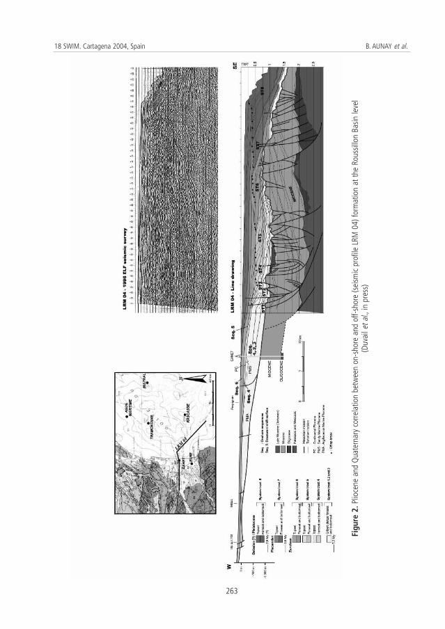
In this paper, we will use the term of "system tract" in the off-shore domain and "sequences" in the on-shore domain. When correlations between on-shore and off-shore domains will be established, we will usethe term of "system tract". In the on-shore domain this methodology helped to determine six sequencesof the same order and their stacking pattern (Duvail et al, in press). For our case study these six zancleansequences are the following (Figure 2):
(i) sequences 1, 2 and 3, on-shore, are mainly composed by stacking of argillaceous bottomset beds.The top of sequence 3 constitutes the first aquifer, named the sandy marine Pliocene aquifer. Itcorresponds to beach and shore face sands (thickness: 30-40 m);
(ii) sequence 4, on-shore, begin by paludal deposit like lignite (aquiclude thickness: 0-5 meters).Argillaceous flood-plain deposits with intersected stream-channel are atop marsh deposits. Theyconstitute part of the continental Pliocene aquifer. Sequence 5, on-shore, is a downward shiftsurface without sedimentary deposit preserved;
(iii) sequence 6, on-shore, is characterized by the modification of the sedimentological mode linked tosequence boundaries. Higher sedimentary contribution increases the hydrodynamic properties ofthe continental Pliocene aquifer-top (Pliocene continental aquifer thickness: 50-150 m).
262
Importance of a high resolution lithological and geometrical knowledge for Mediterranean coastal sedimentary aquifersmanagement. Application to the Roussillon Basin, South of France
263
18 SWIM. Cartagena 2004, Spain B. AUNAY et al.
Figu
re 2
.Plio
cene
and
Qua
tern
ary
corre
latio
n be
twee
n on
-sho
re a
nd o
ff-sh
ore
(sei
smic
prof
ile L
RM 0
4) fo
rmat
ion
at th
e Ro
ussil
lon
Basin
leve
l (D
uvai
l et a
l.,in
pre
ss)
Quaternary terraces are the answer to glacio-eustatic dynamics in a context of generalized tilting,underlined by the on-shore downstream convergence of the levels of the most ancient fluviatile terraces(Duvail et al., 2001).
Analysis of the off-shore seismic section
In the off-shore domain, the Pliocene-Quaternary series have been analysed from 1968 and 1996 ElfAquitaine seismic data (Figure 2) and Labaune et al., 2003 (Figure 3). These data have been provided byTotal within the "GDR marge" framework and the University of Perpignan (BDSI Laboratory).
In the off-shore domain the classical method of sequence stratigraphy (Vail et al., 1977; Posamentier andVail, 1988; Posamentier et al., 1988; Van Wagoner et al., 1988) is used to analyse seismic profiles. Thus,sequence boundaries (unconformities) individualise the top and base of the major system tracts. Offlapbreak-picking (Homewood et al., 1999) characterises the different systems tracts. Spatial evolutionaccording to time of this reference point helps to determine the stacking pattern of each system tractidentified in terms of progradation, aggradation, retrogradation and forced regression. This methodologyhelped to determine eight systems tracts (Duvail et al., in press), not detailed in this paper (Figure 2).
Geological results
Correlations between on-shore and off-shore domains
Modifications of regional and global geological factors are identified, in the on-shore domain, by thestacking patterns of the genetic sequences, and in the off-shore domain, by the stacking pattern of theofflap breaks. Stacking pattern comparisons between both domains allow proposing correlations betweenthe Roussillon basin and the Gulf of Lions occidental shelf within respected biostratigraphic knowledge(Clauzon and Cravatte, 1985; Cravatte et al., 1974, 1984; Aguilar et al., 1999; Fauquette et al., 1999). Off-shore – on-shore correlations are not based on geometrical or lithological arguments but on geologicalevents, and they are expressed as variations in sedimentary dynamics. These are identified and put incoherence on a same deposit profile thanks to the stacking pattern between both domains. Fourcorrelations have been determined (Duvail et al., in press) (Figure 2):
(i) the earlier Zanclean (on-shore): sequences 1, 2 and 3 are correlated with systems tract 1, 2 and 3off-shore;
(ii) the late Zanclean (on-shore): sequences 4 and 6 are correlated with systems tract off-shore 4 and6, off-shore; system tract 5 is correlated with the downward shift surface, intermediary withsequences 4 and 6;
(iii) the Piacenzian (?): systems tract 7 is limited at its base by the eustatic fall, estimated at 3.8-3.6 My.On-shore, it is likely that the first fluviatile incisions, posterior to the roof of the Pliocene filling, areinduced by the eustatic fall of the Zanclean-Piacenzian limit. The first level of fluviatile terraceobserved on-shore may correspond to the installation of the prograding systems tract 7;
(iv) the Gelasian (?) - Pleistocene: this period is marked, off-shore, by a tendency of aggradation ofsystem tract 8. In the on-shore domain it shows a base-level falling tendency, underlined by
264
Importance of a high resolution lithological and geometrical knowledge for Mediterranean coastal sedimentary aquifersmanagement. Application to the Roussillon Basin, South of France

265
18 SWIM. Cartagena 2004, Spain B. AUNAY et al.
Figu
re 3
.Cor
rela
tion
betw
een
Qua
tern
ary
and
Plio
cene
dep
osits
of t
he o
n-sh
ore
and
off-s
hore
dom
ains
,int
erpr
eted
in te
rms
of h
ydro
geol
ogica
l cha
ract
erist
ics.

fluviatile incisions and the settling of the alluvial terraces staged system (Clauzon, 1998 ; Le Stratet al., 2001). The existing differences between the two domains correspond to the appearance ofa hinge point around which the on-shore domain uplifted and the off-shore domain subsided. Thetilting of the margin was described by modelling of the Quaternary systems tract (Rabineau, 2001).
Correlations between data logs and hydrodynamic parameters
Hydrodynamic parameters of the new formations identified are not always known. In order to characterisethe hydraulic conductivity (K), the transmissivity (T) and the storage coefficient (S), the numerical logsvalues numerical, followed by field tests, will be used to obtain the parameters. This extrapolation will becarried out based on a principle of lithological similarity. New extrapolation of parameters will be providedby the geostatistical approach.
Hydrogeological results
The Quaternary aquifer
The Quaternary aquifers are mainly composed of alluviums (conglomerate, flood-plain) and coastaldeposits whose geometry is linked to the Pliocene-Quaternary glacio-eustatic variations (Figure 3). Twotypes of deposits are distinguished:
(i) old and recent banks of stream terraces with gravel and pebbles (Figure 3), for the old banks(average thickness 2 m), and sand, gravel and pebbles for the recent banks (average thickness5 m);
(ii) Holocene layers corresponding to the last post-glacial sedimentation. The lithology corresponds toa regressive prism composed by sand, clay and marsh facies.
The Quaternary aquifer lies along the main rivers and the coastline. Its thickness varied from 10 m for thesectors located in the upper parts of the valleys (Agly, Têt and Tech) to 20-30 m for the coastal fringe. Theporosity of the aquifer is about 7×10⁻². This aquifer is confined at the coastal fringe, where its specificstorage coefficient varies from 0.1 to 0.4×10⁻⁵ m-1. The transmissivity values differ according to the sectors:thus, current values in the Têt valley are 4-5×10⁻³ to 1-2×10⁻² m2/s, with pumping rates going from 50 to100 and even to 200 m3/h. In the Tech valley, on the coastal fringe, values are 5×10⁻³ to 10-2 m2/s andeven locally higher, whereas at Salanque they are 5×10⁻³ to 2×10⁻² m2/s (Chabart, 1996). The coastal partof the Quaternary aquifer associated with the Agly, Têt and Tech valleys is affected by seawater intrusion(Cl > 300 mg/L) (Dörfliger, 2003).
The Pliocene aquifer system
The characteristics of the system are linked to the Messinian event: (i) digging out of huge canyons duringthe Messinian Salinity Crisis (5.9 - 5.3 My), during which the mean sea level dropped down to 1500 mbelow present mean sea level (pmsl), and (ii) filling-up of these canyons, after the sea level rise up to 80 m
266
Importance of a high resolution lithological and geometrical knowledge for Mediterranean coastal sedimentary aquifersmanagement. Application to the Roussillon Basin, South of France

above pmsl (5.3 - 3.8 My) (Hardenbold et al, 1998), with the marine and fluvial sands that constitute thetwo main Pliocene aquifers. The sediments settled according to the "Gilbert delta" genetic model(Figure 4).
Figure 4. "Gilbert delta" genetic model (Clauzon et al., 1990).
- The continental Pliocene aquifer (topset beds)Prograding fluvial sands filled the distributary channels of the deltaic complex and covered the marinesands, forming this aquifer. It contains excessive water mineralisation in the northern part of the basin,along the lagoon and even more along the coast at Barcares.
The aquifer is very productive, especially in the Salanque plain, with a transmissivity of 10-2 to 3×10⁻² m2/s(T = 10-4 m2/s at the edge of the aquifer). It is a confined aquifer with a storage coefficient between 2.2and 6.4×10⁻⁵ m-1 (Chabart, 1996). Locally there are some connections between the Quaternary and thePliocene aquifers, mainly because of two reasons:
– leakage from pre-existing borewells;– incision of the Pliocene aquifer by Quaternary channels (Figure 3). One consequence of the Pliocene
subsidence is the shifting of Pliocene sediments (Clauzon, 1990; Duvail et al., 2001).
- The continental Pliocene aquicludeThis aquiclude is located between the continental Pliocene and the marine Pliocene aquifers.It is formed by diachronous layers of lignite with plants remains alternating with marsh plastic-clays. Theselayers are not present everywhere: 20 km to the west of Perpignan, lignite layers disappear in several wellsand they reappear in the west side of the basin. This fact implies the local connection between thecontinental and the marine Pliocene aquifers.
- The sandy marine Pliocene aquifer (foreset beds)Sandy marine Pliocene sediments correspond to the prograding deltaic shoreface. Theoretically, this aquiferis not connected to the sea and it is preserved from seawater intrusion; however, some areas contain highlymineralised water. The origin of the contamination is the vertical leakage from the partially contaminated
267
18 SWIM. Cartagena 2004, Spain B. AUNAY et al.
Quaternary aquifers to the Pliocene ones, due to the existence of defective boreholes. New boreholesdrilled next to the old ones show a strong decrease in the salt content (Dörfliger, 2003).
The sandy marine Pliocene aquifer is characterised by transmissivity values of 10-3 to 3×10⁻³ m2/s (Chabart,1996) and a storage coefficient of between 0.2 and 1×10⁻⁵ m-1. In the southwest of the Roussillon plain,the Pliocene aquifer is semi-confined, having a storage coefficient about 5×10⁻².
- The Marine Pliocene aquiclude (bottomset beds)The grain-size distribution decreases with water depth and the marine sands (foreset beds) graduallychanges to plastic-blue-clays. As a result, hydraulic conductivity decreases gradually from the on-shoredomain to the off-shore domain.
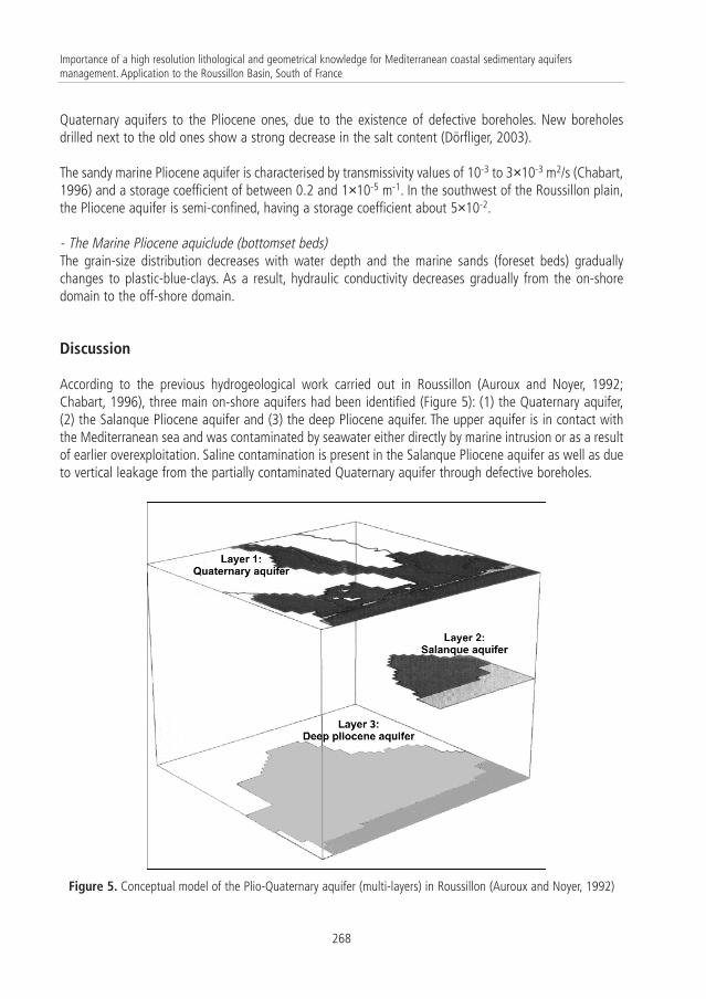
Discussion
According to the previous hydrogeological work carried out in Roussillon (Auroux and Noyer, 1992;Chabart, 1996), three main on-shore aquifers had been identified (Figure 5): (1) the Quaternary aquifer,(2) the Salanque Pliocene aquifer and (3) the deep Pliocene aquifer. The upper aquifer is in contact withthe Mediterranean sea and was contaminated by seawater either directly by marine intrusion or as a resultof earlier overexploitation. Saline contamination is present in the Salanque Pliocene aquifer as well as dueto vertical leakage from the partially contaminated Quaternary aquifer through defective boreholes.
268
Importance of a high resolution lithological and geometrical knowledge for Mediterranean coastal sedimentary aquifersmanagement. Application to the Roussillon Basin, South of France
Figure 5. Conceptual model of the Plio-Quaternary aquifer (multi-layers) in Roussillon (Auroux and Noyer, 1992)
The present geological research on the geometry, the structure and the on-shore-off-shore continuum inthis area, may require a revision of the groundwater conceptual model: boundary conditions,interconnection between aquifers, new aquifer subdivision within the Pliocene, etc.…
In fact, actual research shows local confusion between the continental Pliocene and the Quaternaryaquifers. Moreover, the deep Pliocene aquifers, namely the continental Pliocene aquifer and the marinePliocene one, are separated by a lignite layer and are independent in part of the Roussillon basin area.
The new fitting of aquifers and aquicludes -according to off-shore and on-shore correlation- will beimplemented in a hydrogeological finite difference model. New model results -based on high-resolutiongeology- will be compared with the classical model (Auroux and Noyer, 1992) in order to determine theinfluence of high-resolution lithological and geometrical knowledge on groundwater modelling. Sensitivitytests with theoretical groundwater modeling will be carried out in parallel to evaluate the relevance ofhigh-resolution geology.
Conclusions
Contribution to hydrogeology
High-resolution geology of the sedimentary prisms, derived from oil companies, allows a betterunderstanding of the coastal aquifers. It makes possible to have a precise geometry of the aquifers andaquicludes so that the state of relationship (identified connections, compartments) between differentaquifers can be precisely known. This knowledge must be integrated at the time of determining newborehole locations. For the existing boreholes already contaminated by saltwater intrusion, high-resolutiongeology helps to establish the origin of salinity. Indeed, it is possible to determine whether if direct orindirect (e.g. through defective boreholes) connection with seawater exists. Simultaneously, potentialsubmarine spring or basement morphology can be considered.
Applicability of the results
The studied area is a good representation of most of the peri-Mediterranean porous (and also karstic)aquifers, which have, in fact, all undergone the same geodynamic processes and display similar structures.Mediterranean littoral geodynamics is an overall result of the eustatic variations and of the tectonicconstraints. Thus, the methodology developed is applicable to most of the Mediterranean coastal areas,particularly to the Pliocene aquifers (linked to filled canyons during the Messinian salinity crisis), and to alesser extent, to the whole coastal Quaternary aquifers.
Acknowledgements
This study is a part of a PhD at the University of Montpellier II (France), funded by the regional governmentof Languedoc-Roussillon Septimanie (CPER - Syscolag program) and by the BRGM in the framework of theKARSTEAU project (PDR04EAU01).
269
18 SWIM. Cartagena 2004, Spain B. AUNAY et al.
References
AGUILAR, J.P.; LEGENDRE, S.; MICHAUX, J. and MONTUIRE, S. (1999). Pliocene mammals and climatic reconstruction in theWestern Mediterranean area. In: The Pliocene: Time of Change. Wren J.H., et al. American Association ofStratigraphic Palynologists Foundation: 109-120.
AUROUX, F. and NOYER, M.L. (1992). Modèle mathématique de gestion de l'aquifère plio-quaternaire du Roussillon.Modélisation mathématique des risques d'intrusion d'eau marine dans l'aquifère plio-quaternaire. Withcollaboration of Marchal J.P. and Martin J.C. BRGM Report, R34 981LRO4S92. 31 p.
CALVET, M. (1996). Morphogenèse d'une montagne méditerranéenne ; les Pyrénées Orientales. Doc. du BRGM, 255.BRGM, Orléans. 3 t., 1177 p.
CHABART, M. (1996). La recharge de l'aquifère multicouche du Roussillon et les conséquences d'un éventuelchangement climatique sur la gestion des ressources en eau (Pyrénées Orientales). Doc. du BRGM, 257, BRGM,Orléans. 299 p.
CLAUZON, G. (1987). Le détritisme néogène du bassin du Roussillon (Pyrénées orientales, France). Géol. Alpine, Mém.h.s., 13: 427-441.
CLAUZON, G. (1990). Restitution de l'évolution géodynamique néogène du bassin du Roussillon et de l'unité adjacentedes Corbières d'après les données écostratigraphiques et paléogéographiques. Paléobiologie continentale,Montpellier, XVII: 125-155.
CLAUZON, G. (1998). L’impact des variations eustatiques du bassin de Méditerranée occidentale sur l’orogène alpindepuis 20 Ma. Et. Géogr. Phys., XXVIII - 1999. Conference acts "La montagne méditerranéenne" 8 - 10 october1998, Aix-en-Provence: 33-40.
CLAUZON, G. and CRAVATTE, J. (1985). Révision chronostratigraphique de la série marine traversée par le sondage Canet1(Pyrénées-Orientales, France) : contribution à l'histoire néogène du bassin du Roussillon. C. R. Acad. Sc. Paris, 301,II, (19): 1351-1354.
CLAUZON, G.; AGUILAR, J.P. and MICHAUX, J. (1987). Le bassin pliocène du Roussillon (Pyrénées–Orientales, France):exemple d'évolution géodynamique d'une ria méditerranéenne consécutive à la crise de salinité messinienne. C. R.Acad. Sc. Paris, 304, II, (11): 585-590.
CLAUZON, G.; SUC J.P.; AGUILAR, J.P.; AMBERT, P.; CAPPETTA, H.; CRAVATTE, J.; DRIVALIARI, A.; DOMÈNEH, R.; DUBAR, M.; LEROY, S.;MARTINELL, J.; MICHAUX, J.; ROIRON, P.; RUBINO, J.L.; SAVOYE, B. and VERNET, J.L. (1990). Pliocene geodynamic and climaticevolutions in the French Mediterranean region. IX Cong. R.C.M.N.S. In: Iberian Neogene Basins, Paleontologia iEvolucio, Sabadell, Mem. Sp. 2: 133-186.
CLAUZON, G.; RUBINO, J.L. and SAVOYE, B. (1995). Marine Pliocene Gilbert-type fan deltas along the French Mediterraneancoast. A typical infill feature of preexisting subaerial Messinian canyons. 16 th IAS Regional Meeting ofSedimentology, 5ème Congrès Français de Sédimentologie, Field Trip Guide Book, Publ. ASF, Paris, 23: 145-222.
CRAVATTE, J.; DUFAURE, P.; PRIM, M. and ROUAIX, S. (1974). Les sondages du Golfe du Lion : stratigraphie et sédimentologie.Notes et Mém. C.F.P., 11: 209-274.
CRAVATTE, J.; MATTIAS, I. and SUC, J.P. (1984). Nouvelles recherches biostratigraphiques sur le Pliocène du Roussillon.Géologie de la France, 1-2:149-163.
CROSS, T.A. (1988). Controls on Coal Distribution in Transgressive-regressive cycles, Upper Cretaceous, Western Interior,U.S.A. – Soc. Econ. Paleont. Miner., Sp. Publ., 42: 371-380.
DÖRFLIGER, N. (2003). The State of the French Mediterranean coastal aquifers. Coastal aquifers intrusion technology:mediterranean countries. Publicaciones del Instituto Geológico y Minero de España. Serie Hidrogeología y AguasSubterráneas, 8(II): 187-206.
DUVAIL, C.; LE STRAT, P. and BOURGINE, B. (2001). Atlas géologique des formations plio-quaternaires de la plaine duRoussillon (Pyrénées Orientales). BRGM report, RP-51197-FR. 44 p.
DUVAIL, C. and LE STRAT, P. (2002). Architecture et géométrie haute résolution des prismes sédimentaires plio-
270
Importance of a high resolution lithological and geometrical knowledge for Mediterranean coastal sedimentary aquifersmanagement. Application to the Roussillon Basin, South of France
quaternaires au droit du Roussillon suivant un profil terre-mer. With collaboration of Gorini C., Lofi J. and G.Clauzon; BRGM report, RP-51972-FR, 71 p.
DUVAIL, C.; GORINI, C.; LOFI, J.; LE STRAT, P.; CLAUZON, G. and DOS REIS, A.T. (in press) Correlation between on-shore and off-shore Pliocene-Quaternary systems tracts below the Roussillon Basin (eastern Pyrenees, France). Marine andPetroleum Geology.
FAUQUETTE, S.; SUC, J.P.; GUIOT, J.; DINIZ, F.; FEDDI, N.; ZHENG, Z.; BESSAIS, E. and DRIVALIARI, A. (1999). Climate and biomas inthe West Mediterranean area during the Pliocene. Palaeogeography, Palaeoclimaty, Palaeoecology. 152: 15-36.
GALLOWAY, W.E. (1989). Genetic Stratigraphic Sequences in Basin Analysis: Architecture and Genesis of Flooding-surfaceBounded Depositional Units – Amer. Assoc. Petrol. Geol. Bull., 73: 125-142.
GUILLOCHEAU, F. (1991). Modalités d’empilement des séquences génétiques dans un bassin de plate-forme (DévonienArmoricain) : nature et distorsion des différents ordres de séquences de dépôts emboîtées. Bull. Centres Rech.Explor.-Prod. Elf-Aquitaine, 15, 2: 383-410.
HARDENBOL, J.; THIERRY, J.; FARLEY, M.B.; JACQUIN, T.; DE GRACIANSKY, P.C. and VAIL, P.R. (1998). Mesozoic and CenozoicSequence Chronostratigraphic Chart. Mesozoic and Cenozoic Sequence Chronostratigraphic Framework ofEuropean Basins. In: de Graciansky P.C., Hardenbol J., Jacquin T., Vail P.R. (eds), Mesozoic and Cenozoic SequenceStratigraphy of European Basins, Society for Sedimentary Geology, Spec. Publ., 60: 3-13.
HOMEWOOD, P.; GUILLOCHEAU, F.; ESCHARD, R. and CROSS, T.A. (1992). Corrélations haute résolution et stratigraphiegénétique : une démarche intégrée. Bull. Centre Rech. Explor.-Prod. Elf-Aquitaine, 16: 357-381.
HOMEWOOD, P.W.; MAURIAUD, P. and LAFONT, F. (1999). Best practices in Sequence Stratigraphy for explorationists andreservoir engineers. [Vade-mecum de Stratigraphie Séquentielle pour géologues, géophysiciens et ingénieursréservoir]. Bull. Centre Rech. Elf Explor. Prod., Mem. 25. 81 p.
LABAUNE, C.; TESSON, M. and GENSOUS, B. (2003). Architecture des dépôts post-glaciaires du littoral du "Roussillon":lagune, cordon et plate-forme interne. 9ème Congrès des Sédimentologues Français – 14-16 October 2003 –abstracts book, ASF publ. 38 - Bordeaux. 285 p.
LE STRAT, P.; DUVAIL, C. and CLAUZON, G. (2001). Presentation of BRGM cartography work in the Roussillon basin since1996. In: "GDR marges" workshop "Messinien dans le Golfe du Lion", Perpignan, France, 7-10 September 2001.
POSAMENTIER, H.W. and VAIL, P.R. (1988). Eustatic controls on clastic deposition II – Sequence and systems tract models.In: Sea level changes – An integrated approach. Wilgus C.K., Hastings B.S., Kendall C.G. St. C., Posamentier H., RossC.A., Van Wagoner J. (eds.), Soc. Econ. Paleontol. Mineral., Spec. Publ., 42: 125-154.
POSAMENTIER, H.W.; JERVEY, M.T. and VAIL, P.R. (1988). Eustatic control on clastic depositions I - Conceptual framework.In: Sea level changes – An integrated approach. Wilgus C.K., Hastings B.S., Kendall C.G. St. C., Posamentier H., RossC.A., Van Wagoner J. (eds.), Soc. Econ. Paleontol. Mineral., Spec. Publ., 42: 109-124.
RABINEAU, M. (2001). Un modèle géométrique et stratigraphique des séquences de dépôt quaternaires sur la marge duGolfe du Lion : Enregistrement des cycles climatiques de 100 000 ans. PhD, University of Rennes 1. 480 p.
SERRA, O. (1985). Diagraphies différées, bases de l’interprétation. 2: Interprétation des données diagraphiques. Bull.Centres Rech. Explor.-Prod. Elf-Aquitaine, Mém. 7.
VAIL, P.R.; MITCHUM, R.M. JR; TODD, R.G.; WIDMIER, J.W.; THOMSON, S.; SANGREE, J.B.; BUBB, J.N. and HATLELID, W.G. (1977).Seismic stratigraphy and global changes of sea level. Payton CE (eds.). Seimic Stratigraphy: Application tohydrocarbon Exploration, Mem. Am. Assoc. Pet. Geol., 26: 49-212.
VAN WAGONER, J.C.; POSAMENTIER, M.W.; MITCHUM, R.M. JR.; VAIL, P.R.; SARG, J.F.; LOUTIT, T.S. and HARDENBOL, J. (1988). Anoverview of the fundamentals of sequence stratigraphy and key definitions. In: Sea level changes – An integratedapproach. Wilgus C.K., Hastings B.S., Kendall C.G. St. C., Posamentier H., Ross C.A., Van Wagoner J. (eds.), Soc.Econ. Paleontol. Mineral., Spec. Publ., 42: 39-46.
271
18 SWIM. Cartagena 2004, Spain B. AUNAY et al.