Embed Size (px)
Citation preview
S249
Bulletin of the Seismological Society of America, Vol. 97, No. 1A, pp. S249–S270, January 2007, doi: 10.1785/0120050619
Implications of the 26 December 2004 Sumatra–Andaman Earthquake
on Tsunami Forecast and Assessment Models for Great
Subduction-Zone Earthquakes
by Eric L. Geist, Vasily V. Titov, Diego Arcas, Fred F. Pollitz, and Susan L. Bilek
Abstract Results from different tsunami forecasting and hazard assessment mod-els are compared with observed tsunami wave heights from the 26 December 2004Indian Ocean tsunami. Forecast models are based on initial earthquake informationand are used to estimate tsunami wave heights during propagation. An empiricalforecast relationship based only on seismic moment provides a close estimate to theobserved mean regional and maximum local tsunami runup heights for the 2004Indian Ocean tsunami but underestimates mean regional tsunami heights at azimuthsin line with the tsunami beaming pattern (e.g., Sri Lanka, Thailand). Standard forecastmodels developed from subfault discretization of earthquake rupture, in which deep-ocean sea level observations are used to constrain slip, are also tested. Forecastmodels of this type use tsunami time-series measurements at points in the deep ocean.As a proxy for the 2004 Indian Ocean tsunami, a transect of deep-ocean tsunamiamplitudes recorded by satellite altimetry is used to constrain slip along four subfaultsof the M �9 Sumatra–Andaman earthquake. This proxy model performs well incomparison to observed tsunami wave heights, travel times, and inundation patternsat Banda Aceh. Hypothetical tsunami hazard assessments models based on end-member estimates for average slip and rupture length (Mw 9.0–9.3) are comparedwith tsunami observations. Using average slip (low end member) and rupture length(high end member) (Mw 9.14) consistent with many seismic, geodetic, and tsunamiinversions adequately estimates tsunami runup in most regions, except the extremerunup in the western Aceh province. The high slip that occurred in the southern partof the rupture zone linked to runup in this location is a larger fluctuation than expectedfrom standard stochastic slip models. In addition, excess moment release (�9%)deduced from geodetic studies in comparison to seismic moment estimates may gen-erate additional tsunami energy, if the exponential time constant of slip is less thanapproximately 1 hr. Overall, there is significant variation in assessed runup heightscaused by quantifiable uncertainty in both first-order source parameters (e.g., rupturelength, slip-length scaling) and spatiotemporal complexity of earthquake rupture.
Introduction
The 26 December 2004 Sumatra–Andaman earthquakewas the first M �9 event to be recorded by a global networkof broadband seismic stations and regional Global Position-ing System (GPS) networks. Analysis of this data has led toa new understanding of the mechanics of great subductionzone earthquakes. In addition, tsunami data from both con-ventional measurements (postevent surveys and tide gauges)as well as deep-ocean amplitudes recorded clearly for thefirst time by satellite altimetry, provide the necessary infor-mation to reconstruct the evolution of the Indian Ocean tsu-nami (Titov et al., 2005b; Hirata et al., 2006; Fujii and Sa-
take, 2007). We can use this new knowledge to test existingtsunami forecast and assessment models and determinewhether specific improvements are needed when applied toM �9 earthquakes. As tsunami systems are expanded aroundthe world in the aftermath of the 2004 Indian Ocean tsunami,it is important to refine these models for the dual purpose ofmitigating future tsunami hazards and reducing false alarms.
Kinematic rupture models for the 2004 Sumatra–Andaman earthquake exhibit complexity on broadscales inboth space and time (Ammon et al., 2005). In contrast tosmaller events for which tsunami generation can be ade-

S250 E. L. Geist, V. V. Titov, D. Arcas, F. F. Pollitz, and S. L. Bilek
quately approximated by instantaneous finite dislocations,the large-scale complexity associated with great earthquakeshas a significant effect on tsunami generation in predictinglocal and regional tsunami waveforms. In the past, seismicinversions for subduction zone earthquakes provided suffi-cient information for determining tsunami generation (e.g.,Geist and Bilek, 2001). For the 2004 Sumatra–Andamanearthquake, however, seismic inversions have been compli-cated by overlapping seismic phases and have been difficultto perform (Ammon et al., 2005). Analysis of geodetic mea-surements in combination with seismic inversions, however,have helped to reduce the discrepancy between seismic andtsunami models of the earthquake (Banerjee et al., 2007;Chlieh et al., 2007).
The primary objective of this study is to examine tsu-nami generation from the 2004 Sumatra–Andaman earth-quake at different levels of parameterization for the purposeof forecasting and assessing future tsunamis. Starting froma point-source, scalar representation of the earthquake, weexamine what level of information can be obtained abouttsunami generation. There are two distinct applications forsuch an analysis. The first is real-time forecasting as part ofa tsunami warning system (Titov et al., 2005a), termed hereas forecast models. In this case, tsunami modeling beginswith a limited amount of initial information on earthquakerupture (typically moment magnitude and hypocentral lo-cation) soon after the event occurs. The second applicationis hazard assessment, in the form of inundation maps thatuse either a maximum credible source (Tinti and Armigliato,2003; Gonzalez et al., 2005) or a probabilistic assessmentthat includes all relevant sources and associated uncertainty(Rikitake and Aida, 1988; Ward, 2002; Geist and Parsons,2006). We call this latter application assessment models.
In addition to how tsunami generation models are ap-plied, the necessary level of parameterization is also linkedto the propagation distance away from the source. For allbut the largest earthquakes, the tsunami wave field can beestimated in the far field using point source or line sourcedescriptions (Ward, 1980, 1982a; Okal, 1988; Pelayo andWiens, 1992). Geometric spreading of the tsunami tends tosmooth out source-related variations in the wave field. How-ever, it is quite clear that slip heterogeneity for great earth-quakes can be ascertained from regional and far-field wave-forms, as indicated by numerous tsunami inversion studies(e.g., Satake and Kanamori, 1991; Satake, 2002). Thus,whether or not a simple parameterization can be used de-pends on both the size of the earthquake and the propagationdistance. Most of the damaged regions in the Indian Oceanfollowing the 2004 Sumatra–Andaman earthquake occurredat regional, rather than far-field, distances. In this study, wefocus on the effects source parameterization has on tsunamiamplitudes at regional distances (up to 1500 km) and nearthe source. These results will have particular application inassessing tsunami hazards for other vulnerable regions suchas the Caribbean and Mediterranean where tsunamis canhave significant impact at similar distances.
Background
Tectonics
The 2004 Sumatra–Andaman earthquake occurredalong the interplate thrust separating the oceanic India platefrom the overriding Burma (Andaman) microplate that bor-ders the larger Sunda plate (Fig. 1). The convergence direc-tion along this northern part of the Sumatra subduction zoneis highly oblique and can be considered a type area for slippartitioning as originally described by Fitch (1972) and laterrefined in this region by others (Moore et al., 1980; Mc-Caffrey, 1991; Dasgupta and Mukhopadhyay, 1993; Mc-Caffrey et al., 2000). Whereas relative plate convergence isaccommodated along the interplate thrust, most of the arc-parallel component of motion is accommodated by the Su-matran strike-slip fault, which trends northward into theAndaman Sea spreading centers (Mukhopadhyay, 1984;Maung, 1987; Bird, 2003). Some of the arc-parallel motionis also accommodated in the forearc region (Genrich et al.,2000), as would be predicted from continuum deformationmodels (McCaffrey et al., 2000). In addition to an increasein the obliquity of convergence from south to north, there isalso a significant increase in the thickness of sediment en-tering the subduction zone (possibly with a concomitant in-crease in pore pressure) (Karig et al., 1980; Moore et al.,1980; Prawirodirdjo et al., 1997), a decrease in the width ofthe forearc (Moore et al., 1980), and a decrease in both thedip and depth of Benioff-zone seismicity (Newcomb andMcCann, 1987; Gudmundsson and Sambridge, 1998). BothMoore et al. (1980) and Mukhopadhyay (1984) note exten-sional deformation in the oceanic India plate and downdiptension stress axes for slab earthquakes, respectively, in theAndaman Islands region. Dasgupta and Mukhopadhyay(1993) indicate that the Benioff zone is contorted in the far-northern part of the Sumatra–Andaman subduction zone, andsuggest that the India plate and Burma microplate are weaklycoupled in this region.
Analysis of (GPS) data indicates that the total relativeplate motion between the India and Sunda plates is approx-imately 45–52 mm/yr (Simons et al., 1999), whereas onlyabout 7–14 mm/yr of convergence is estimated at the latitudeof Port Blair, in the Andaman Islands (Paul et al., 2000;Michel et al., 2001). As recurrence times are linked to faultslip rates (Ward, 1994; McCaffrey, 1997; Kagan, 2002), oc-currence of great earthquakes along the northern section ofthe Sumatra–Andaman subduction zone were prone to undersampling by the historic catalog. One of the lessons fromthis earthquake is that all subduction zones, no matter theirconvergence rate, should be considered dangerous in termsof producing earthquakes of tsunamigenic magnitude (Birdand Kagan, 2004). Indeed, the Sumatra–Andaman subduc-tion zone had produced a tsunamigenic earthquake in 1881near the island of Car Nicobar (Ortiz and Bilham, 2003),although prior to the December 2004 earthquake, it was gen-erally unclear whether M �9 earthquakes could occur inhighly oblique subduction zones such as this one.

Implications of the 26 December 2004 Sumatra–Andaman Earthquake on Tsunami Forecast and Assessment Models S251
Figure 1. Location map of the study region. Solid line indicates the trackline of theJason-1 altimetry satellite approximately 2 hr after the 26 December 2004 earthquake(star, epicenter). Shaded region indicates subduction zone segment for which tsunamiforecast and assessment models are tested. Sumatra–Andaman interplate thrust indi-cated by barbed line. Arrow indicates relative motion of the India plate with respect tothe Eurasia plate reference frame (Paul et al., 2000). Bathymetric contour interval:1000 m.
One cannot ignore possible tectonic or geologic controlson rupture for this earthquake. Previous studies have sug-gested that topographic features of the downgoing plate suchas the Ninetyeast Ridge and Investigator Fracture Zone(Fig. 1) are linked to variations in deformation patterns inthe overriding plate (Newcomb and McCann, 1987; Das-gupta and Mukhopadhyay, 1993; Krishna and Sanu, 2002).The 2004 earthquake originated near a sharp bend in thetrench and a corresponding bend in the subducted slab (Fauziet al., 1996). Also at this latitude, paleoseismic evidence
suggest that this might be a segment boundary for interplatethrust earthquakes—the Simeulue saddle (Sieh et al., 2005).
Rupture Process for the 2004 Sumatra–AndamanEarthquake
The hypocenter for the December 2004 Sumatra–Andaman earthquake is located just north of Simeulue Islandat a depth of 30 km, where rupture propagated unilaterallyto the north for approximately 1300–1600 km (Ishii et al.,

S252 E. L. Geist, V. V. Titov, D. Arcas, F. F. Pollitz, and S. L. Bilek
2005; Lay et al., 2005; Subarya et al., 2006) (Fig. 1). Thepropagation speed of the rupture front is estimated to be 2.1–2.8 km/sec from imaging using the Hi-Net seismic array inJapan (Ishii et al., 2005) and hydroacoustic data (Tolstoyand Bohnenstiehl, 2005), although de Groot-Hedlin (2005)suggests that the rupture front slowed to about 1.5 km/sec600 km away from the epicenter. Slower rupture velocitiesare also suggested by some tsunami studies (Hirata et al.,2006; Fujii and Satake, 2007). As indicated by Ni et al.(2005) the high-frequency seismic waves used to image thepropagation of the rupture front cannot uniquely map theslip evolution and distribution on the fault. For this, long-period seismic waves were analyzed.
Though the inversions of body and long-period surfacewaves that have been performed to date differ in specificaspects, most of the results indicate relatively small slip atthe hypocenter, large regions of slip near northern Sumatraand near the Nicobar Islands, and a gradual tapering of slipnorthward beneath the Andaman Islands (Ammon et al.,2005; Ishii et al., 2005; Kruger and Ohrnberger, 2005; Tsaiet al., 2005). Analysis and inversion of GPS data indicatesimilar patterns of slip, although the magnitude of estimatedslip is greater than the seismic solutions, potentially owingto aseismic afterslip and postseismic deformation (Banerjeeet al., 2005, 2007; Vigny et al., 2005; Subarya et al., 2006).Banerjee et al. (2005) show how the radial component ofthe moment tensor (Mrr), one of the principal componentsthat governs tsunami generation (Ward, 1982b), varies rela-tive to the observational period—a threefold increase is es-timated from centroid moment tensor (CMT) analysis(T � 300 sec) to static GPS analysis. Overall, the total mo-ment of the earthquake as deduced from geodetic studies isapproximately 9% greater than the long-period seismic mo-ment (Banerjee et al., 2007). As discussed by Kanamori(1972), Ward (1982a), and in this article, tsunami generationis sensitive to longer source process times than seismic-waveexcitation, although there is a limit to how slow deformationcan occur and still generate a tsunami.
Variation in First-Order Source Parameters
Both tsunami forecast and assessment models start witha source location and a measured earthquake magnitude(forecast) or estimated scenario magnitude (assessment).The 2004 Sumatra–Andaman earthquake demonstrated thateven once the earthquake occurs, there is considerable un-certainty in the magnitude of very large earthquakes, as itwould be used for tsunami forecast modeling. Current mag-nitude estimates range from Mw 9.0 (initial estimate, Lay etal., 2005) to Mw 9.3 (Stein and Okal, 2005). Much of thisuncertainty relates to the complex temporal rupture pro-cesses, though some of it also relates to uncertainty in faultdip. Michael and Geller (1984) discuss the difficulty in es-tablishing the focal mechanism for shallow thrust earth-quakes and the effect that fault dip has on the estimatedscalar moment (see also Honda and Seno, 1989; Kawakatsu
and Cadena, 1991; Banerjee et al., 2005; Park et al., 2005).Advances in rapidly estimating moment magnitude for tsu-nami warning have been made by examining first-arrival Pwaveforms (Mwp) (Tsuboi et al., 1995; Tsuboi, 1999, 2000)and using the variable-period mantle magnitude (Mm)(Weinstein and Okal, 2005).
In addition to structural parameters such as fault ge-ometry, other first-order static source parameters needed fortsunami modeling (average slip, rupture length, etc.) are es-timated from scaling relationships (Kanamori and Anderson,1975; Geller, 1976; Wyss, 1979; Scholz, 1982, 1994; Das,1988; McGarr and Fletcher, 2003; Romanowicz and Rundle,1993). There is, however, significant uncertainty in thesescaling relationships (Geller, 1976), with less known aboutsubduction-zone earthquakes than on-land (typically strike-slip) earthquakes (e.g., Wells and Coppersmith, 1994). Localtsunami runup varies nearly linearly with slip (Geist andYoshioka, 1996), whereas variations in rupture length affectrunup distribution in the near field (Okal and Synolakis,2004) and amplitude beaming in the far field (Ben-Menahemand Rosenman, 1972; Ward, 1982a; Okal, 1988, 1991; Titovet al., 1999). Ishii et al. (2005) notes that the rupture lengthof the 2004 Sumatra–Andaman earthquake exceeds that forother M �9 earthquakes, although the rupture width appearsto be considerably smaller than M �9 continental subductionzone earthquakes (M 9.5 1960 Chile and M 9.2 1964Alaska). Kajiura (1981) and Geist (1999) demonstrate howother first-order source parameters such as rupture width anddip affect the tsunami wave field.
Tsunami Forecast Models
Scalar, Point-Source Representation
Several studies have indicated that far-field tsunami am-plitudes can be estimated from the scalar seismic moment ofthe earthquake (Comer, 1980; Ward, 1980; Okal, 1988; Pe-layo and Wiens, 1992). Empirical and theoretical relation-ships that link far-field tsunami amplitudes with seismic mo-ment include the attenuating effects of geometric spreadingas a function of propagation distance (R) (Wu, 1981; Mei,1989). In particular, Abe (1979, 1995) gives an empiricalrelationship relating the tsunami height (in meters) (Ht) tomoment magnitude (Mw):
log Ht � M � log R � 5.55 � C , (1)w
where C � 0.0 for interplate thrust earthquakes and C �0.2 for backarc events and where R is in kilometers measuredfrom the epicenter. Because this regression overpredicts tsu-nami heights in the near field, a local limiting tsunami height(Hr) that is independent of distance is established by Abe(1981, 1995):
log Hr � 0.5 M � 3.30 � C . (2)w

Implications of the 26 December 2004 Sumatra–Andaman Earthquake on Tsunami Forecast and Assessment Models S253
Abe (1995) indicates that Hr statistically represents the meanlocal runup and that 2Hr approximates the maximum localrunup. Abe (1995) provides a detailed statistical comparisonfor local tsunamis, and Furumoto (1996) provides a test forthis relationship at far-field distances.
To determine how these empirical relations fare for the2004 Sumatra–Andaman earthquake, we use Mw 9.0, whichwas determined soon after the event using 300- to 500-sec-period surface waves (Lay et al., 2005). At regional dis-tances, the far-field relationship (equation 1) for example,slightly underpredicts with mean observed runup heights insoutheast India (Yeh et al., 2005) (Ht � 2.8 m; 2.5–5.2 mreported) and is consistent with the mean runup heights inDawei, Myanmar (Satake et al., 2006b) (Ht � 2.3 m; 0.9–2.9 m reported). In contrast, along an azimuth in line withthe tsunami beaming pattern, the empirical equation (1)greatly underpredicts the mean recorded tsunami runup inSri Lanka (Liu et al., 2005; Goff et al., 2006) (Ht � 1.7 m;2.5–7.0 m reported). Locally, the mean (Hr � 16 m) andmaximum limiting runup height (2Hr � 32 m) is very closeto the runup heights observed along the western Aceh Prov-ince of Sumatra (30–35 m) (Borrero, 2005; Tsuji et al., 2005;Jaffe et al., 2006).
The close correspondence of predicted and observedmaximum local runup heights is consistent with little scatterin observations for M �9 events using other local tsunamimagnitude scales (Geist, 2002), though there are few eventsin the historical catalog to provide a measure of uncertainty.For more frequently occurring tsunamigenic earthquakes inthe range 7.0 � Mw � 8.5, the uncertainty associated withthe empirical relationship greatly increases because ofgreater variability in source depth, rupture width, and waterdepth above the source—all parameters that relate to earth-quakes with rupture widths smaller than the saturation widthof subduction zones. The Mw 8.7 March 2005 Sumatra earth-quake is shown to be deficient in tsunami generation com-pared to other earthquakes of similar magnitude and definesa new lower bound in the scatter for empirical local tsunamirelationships at this magnitude (Geist et al., 2006). There-fore, while empirical tsunami relationships provide impor-tant mean and maximum tsunami height estimates basedonly on point-source characterization of the earthquake(magnitude, epicenter), there is considerable uncertainty inthese estimates. These statistics also do not yield any infor-mation on the site-specific distribution of runup heights thatcan be ascertained from real-time, finite-source modeling de-scribed in the next section.
Subfault Dislocation Models, Real-TimeTsunami Measurements
The next level of source parameterization for tsunamiforecasts are subfault dislocation models. These modelsspecify uniform slip over one-to-several subfaults for cal-culating the coseismic vertical displacement field. This, inturn, specifies the initial conditions for the tsunami propa-
gation calculations, such as for the forecasting system in thePacific Ocean (Titov et al., 1999, 2005a). The objective ofthe forecasting system is to provide site-specific and event-specific forecasts of tsunami wave amplitudes and traveltimes in real time.
This forecasting system consists of a precomputed prop-agation database and real-time assimilation of water-leveldata, primarily from Deep-ocean Assessment and Reportingof Tsunamis (DART) stations. The propagation database con-sists of basinwide wave-field calculations (amplitude as afunction of location and propagation time) from individualsubfaults, or unit sources, measuring 50 km wide and100 km long. Each major subduction zone interplate thrustat seismogenic depths is discretized into unit sources. Faultgeometry is estimated from observed seismicity and geo-physical studies. Coseismic vertical displacement from theunit sources is used as initial conditions for the Method ofSplitting Tsunami (MOST) propagation model (Titov andSynolakis, 1997, 1998). The MOST model is based on afinite-difference numerical approximation to the nonlinear,shallow-water wave equations. For the far-field applications,the equations are transformed into spherical coordinates andthe effects of the Coriolis force are added (Titov and Gon-zalez, 1997). Because the equations for both the vertical dis-placement calculations and offshore tsunami amplitude cal-culations are dominated by linear terms, variable amounts ofuniform slip can be assigned to each unit source, and unitsources can be linearly combined to determine the tsunamiwave field for any earthquake of arbitrary magnitude andsubfault discretized slip distribution. Sea level observationsfrom the DART data are used to invert the tsunami wavefield to determine the slip distribution for any given tsuna-migenic earthquake.
In practice, this forecasting system proceeds in fourstages once an earthquake of a given magnitude and locationoccurs: (1) An initial tsunami wave field is determined usingthe nonlinear MOST model from a number of unit sourceswith uniform slip, both of which are scaled relative to theearthquake magnitude. (2) The initial source parameteriza-tion is refined based on the inversion results from the DARTdata. (3) Propagation calculations are recomputed based onthe refined source. (4) For specific sites (e.g., Hilo, Hawai’i),inundation calculations are performed using a small-scale,finite-difference grid and where the nonlinear propagationterms become increasingly important. The latter step is aboundary-value problem in which the offshore linear wave-field is used as a boundary condition for the small-scale in-undation calculations (Titov and Synolakis, 1998). Titov etal. (1999, 2001) present the results of sensitivity analysesindicating that other source parameters such as rake anglehave a secondary influence on far-field tsunami amplitudes,in comparison to slip and rupture length.
To determine how tsunami estimates from a subfaultparameterization for the 2004 Sumatra–Andaman earth-quake compare to observations, Titov et al. (2005b) dividesthe 1300-km-long rupture zone into four subfaults (Fig. 2a).

S254 E. L. Geist, V. V. Titov, D. Arcas, F. F. Pollitz, and S. L. Bilek
Figure 2. (a) Subfault discretization of the 2004 Sumatra–Andaman earthquake.(b) Comparison of computed tsunami heights (red line) along Jason-1 trackline (Fig. 1)in comparison to the altimetry measurements (*). Top: Rms best fit to all data; Bottom:Rms best fit to direct arrivals (see Fig. 3). Values of slip for each subfault (south tonorth) indicated above figure.

Implications of the 26 December 2004 Sumatra–Andaman Earthquake on Tsunami Forecast and Assessment Models S255
Figure 3. Perspective view of synthetic tsunami wave field 115 min after generation,using the Mw 9.15 source model from Chlieh et al. (2007). Line represents Jason-1satellite altimetry trackline (blue-modeled negative phase; pink-modeled positivephase). Interpretation of direct-arrival phases indicated by white lines: d-1, d-2, andd-3 correspond to regions of high slip in the source model (1, southern slip patch;2, slip patch near Nicobar Islands; 3, slip patch near Andaman Islands).
This source characterization is similar to that used for ana-lyzing static offsets in the GPS data (Banerjee et al., 2005).Slip for each subfault is constrained by the Jason-1 satellitealtimetry measurements that record a transect of the tsunamiwave field approximately 2 hr after the earthquake (Gower,2005). The phases recorded on the satellite altimetry recordinclude both direct arrivals south of the equator as well asreflections from coastlines and submarine topographic fea-tures such as the Ninetyeast Ridge (Fig. 1). An interpretationof the direct arrival phases is shown in Figure 3. At greaterdistances, Hanson and Bowman (2005) also detect reflec-tions from other bathymetric features such as the MascarenePlateau between the Seychelles and Mauritius Islands fromhydrophone records. Fault slip is constrained from both therms prediction error of all phases (Fig. 2b, top) resulting ina slip distribution of 17, 22, 10, and 30 m, respectively oneach fault segment taken from south to north, or from thedirect arrival (Fig. 2b, bottom) with an associated slip dis-tribution of 21, 13, 17, and 2 m on each segment. A mapshowing the maximum tsunami amplitude in the IndianOcean over 10 hr of propagation time is shown in Figure 4a.Titov et al. (2005b) note that this level of source parame-terization adequately estimates regional and far-field tsunamitravel times and amplitudes.
In addition, as a test of the inundation calculations
(stage 4 of the forecast model described previously), the sub-fault source model with the slip distribution shown in Figure2b (top) is used to hindcast inundation at Banda Aceh. Thefine-scale bathymetric/topographic elevation database forthis calculation was compiled from digitized bathymetriccharts, shuttle radar mission elevation data, and othersources. Using the same source description that provides afit to the Jason-1 deep-ocean tsunami measurements, the ex-tent of inundation is well predicted in comparison to satelliteimagery of the inundated region (Fig. 4b). Flow depths andrunup heights are also reasonably estimated in comparisonto results from the international tsunami survey team (Bor-rero, 2005; Tsuji et al., 2005; Jaffe et al., 2006). This com-parison indicates that a forecasting system based on subfaultparameterization can adequately forecast tsunami ampli-tudes and inundation, given initial information on first-orderearthquake parameters and deep-ocean tsunami measure-ments. It should be emphasized that both sources of infor-mation are necessary for this system to perform well.
Tsunami Assessment Models
For assessing future tsunami hazards, a priori earth-quake information discussed in the previous section for fore-cast models is not available. From a tsunami assessment

S256 E. L. Geist, V. V. Titov, D. Arcas, F. F. Pollitz, and S. L. Bilek
Figure 4. (a) Maximum tsunami amplitude over 10 hr of propagation time, usingthe subfault geometry shown in Figure 2a and slip constrained, by Jason-1 satellitealtimetry (Fig. 2b, top). Wave height is in centimeters. See Titov et al. (2005b) fordetails. (b) Inundation hindcast at Banda Aceh from this source model. White linerepresents landward inundation limit determined from satellite imagery.

Implications of the 26 December 2004 Sumatra–Andaman Earthquake on Tsunami Forecast and Assessment Models S257
standpoint, we estimate the range of tsunami amplitudes as-sociated with uncertainty in primarily slip and rupture lengthfor a Mw 9.0–9.3 earthquake along the Sumatra–Andamansubduction zone. From a seismic moment–based perspec-tive, uncertainty in shear modulus and slip-length scaling ingeneral leads to uncertainty in u (average slip). Because ofthe lack of data defining scaling relationships for earth-quakes of this size, we draw upon several studies of the 2004Sumatra–Andaman earthquake in addition to studies ofM �9 earthquakes prior to 2004. In the next section weexamine how other source parameters in addition to slip andrupture length affect tsunami estimates.
Methodology
The effect of coseismic slip is examined both in termsof scaling of average slip with respect to magnitude and thevariability of spatially heterogeneous slip patterns. Hetero-geneous slip distribution patterns are evident from seismicinversions of major earthquakes, as well as theoretical stud-ies examining the dynamics of earthquake rupture. The com-bination of effects from physical heterogeneities with non-linear dynamics of rupture results in mix of characteristicand noncharacteristic modes of slip distributions noted inboth theoretical studies (Ben-Zion and Rice, 1995, 1997;Zheng and Rice, 1998; Nielsen and Carlson, 2000; Perfettiniet al., 2001; Shaw, 2004) and observational studies specificto subduction zone earthquakes (Thatcher, 1990; Mendoza,1993; Boyd et al., 1995; Schwartz, 1999; Mazzotti et al.,2000; Hirata et al., 2004; Satake et al., 2006a). Recent stud-ies have also indicated that spatial heterogeneity at scalessmaller than typically resolved in seismic and geodetic in-versions (�1 km) (cf., Perfettini et al., 2001) can have asignificant effect on near-field static displacement (Hondaand Yomogida, 2003; Fu and Sun, 2004). Small-scale spatialheterogeneity in slip translates to variations in local tsunamirunup, though the effects are diminished with increasingpropagation distance and source depth (Titov et al., 2001;Geist, 2002).
The stochastic source model developed by Andrews(1980) and refined by Herrero and Bernard (1994) is usedto determine the variations in offshore tsunami waveformsand peak tsunami amplitudes, in a manner as described byGeist (2002, 2005). Tsunami generation models used for tsu-nami assessments such as presented here have been modifiedfrom models previously used for strong ground motion stud-ies (Herrero and Bernard, 1994; Berge et al., 1998; Somer-ville et al., 1999; Hisada, 2000, 2001; Honda and Yomogida,2003). At low wavenumbers, stochastic slip distributions arescaled relative to average slip or static stress drop. Tsunamigeneration is less affected by the high wavenumber charac-teristics of slip distribution in comparison to strong groundmotion.
For each case examined, one hundred slip distributions(u(x,y)) are computed on a 7.5-km fault grid extending alongthe Sunda trench to a down-dip width of 150 km. Each of
the slip distributions conform to a k�2 radial-wavenumberspectrum for k � kc where kc scales with the characteristicrupture dimension (Herrero and Bernard, 1994; Tsai, 1997;Somerville et al., 1999; Hisada, 2000, 2001; Mai and Be-roza, 2002). For the more general case of a k�� spectrum,Zeng et al. (2005) note that scaling of u with rupture length(L) is physically related to the degree of slip heterogeneity(�) and indicate that linear scaling between u and L occursonly for relatively smooth slip distributions.
For each slip distribution, the coseismic displacementfield is calculated based on Okada’s (1985) point-source ex-pressions for an elastic half-space. While these expressionsare adequate in the near field, displacement models based ona layered spherical geometry are more appropriate at re-gional and far-field distances (Pollitz, 1996; Banerjee et al.,2007). Because horizontal displacements are large for thisevent and there are steep bathymetric gradients in places nearthe source region (Fig. 1), their combined effect is includedin the initial conditions to the tsunami propagation model asdescribed by Tanioka and Satake (1996). To accommodatethe large number of cases that are run (approximately 1000),the computationally efficient finite-difference approximationto the linear-long wave equations is implemented on a 2 arc-minute bathymetric grid (ETOPO2), using a timestep of10 sec to satisfy the Courant–Friedrichs–Lewy stability cri-terion (Satake, 2002). Reflection boundary conditions areimposed at the 50 m isobath, which approximately repre-sents the limit of accuracy of ETOPO2 bathymetry and thevalidity of the linearized form of the shallow-water waveequations. This type of modeling is often termed “thresholdmodeling.” Radiant boundary conditions are imposed on theopen-ocean boundaries (Reid and Bodine, 1968). For eachrun, the maximum tsunami amplitude during propagation istracked at the 50 m isobath, termed “peak nearshore tsunamiamplitude.”
Results
Tsunami amplitudes at local and regional distances arecalculated for four cases, representing two different endmembers for both average slip and rupture length. To estab-lish the higher end member of average slip, we use highaverage slip values that are needed to explain the direct ar-rival south of the equator on the Jason-1 record (Fig. 2b, 3)as indicated by the inversion of Hirata et al. (2006) (13.4 m),the subfault forecast model presented here (13.2–19.8 m),and from the stochastic source model (16 m). In addition,relatively high values of uniform slip (19–21 m) are used toexplain tsunami observations in Japan from the 1700 Cas-cadia earthquake of comparable magnitude (M �9) (Satakeet al., 2003). For the lower estimate, the average slip fromtsunami inversions using both satellite altimetry and tidegauge data is 5.5–8.7 m (Fujii and Satake, 2007) and 9.2 m(Tanioka et al., 2006). In addition, the average slip for theM 9.2 1964 Alaska earthquake is 8.6 m (Johnson et al.,1996). From this, we consider end members of 9 m and 16 m

S258 E. L. Geist, V. V. Titov, D. Arcas, F. F. Pollitz, and S. L. Bilek
for average slip. For rupture length, we use 900 km as alower bound, from both the inverse tsunami travel time (Ko-walik et al., 2005; Neetu et al., 2005) and the primary regionof uplift (Model III, Ammon et al., 2005) for the 2004Sumatra–Andaman earthquake. The rupture length for 1964Alaska earthquake was approximately 700 km, though therupture width was much greater (200–300 km) than the 2004Sumatra–Andaman earthquake (Johnson et al., 1996). Forthe upper bound, we use a rupture length of 1600 km, asindicated by the emergence and subsidence of coral reefsfollowing the 2004 event (Meltzner et al., 2006). Taken to-gether, these four cases span the magnitude range 9.0 � M� 9.3, assuming a shear modulus of 30 GPa.
For the u � 9 m, L � 1600 km case, mean and extremapeak nearshore tsunami amplitude are displayed in Figure 5as a function of latitude for four different coastline segments.In general, the variation in nearshore tsunami amplitude de-creases with distance from the source, consistent with thesensitivity analysis of Titov et al. (1999, 2001), and is mostpronounced for local tsunamis near the source region. Alsoshown in Figure 5 are synthetic marigrams (amplitude as afunction of time) at representative offshore locations. Simi-lar to the nearshore tsunami amplitude plots, the marigramsshow the mean and extrema amplitudes and indicate ex-pected variation in waveforms. Significant phase shiftsamong time series in the ensemble are indicated where theextrema values are not parallel with the mean value mari-gram (e.g., Phuket). The frequency content of the marigramsis dependent on the propagation path (obliquity of incidence)and the nearshore response, in particular, the excitation oftrapped (edge waves) and reflected modes (Fujima et al.,1995; Rabinovich, 1997; Liu et al., 1998; Koshimura et al.,1999).
Results from using a shorter rupture length and higherslip (Fig. 6), shows significant variations in comparison tothe previous case (Fig. 5). In both cases, Mw 9.14 � 0.02,such that the differences are not attributable to changes inoverall magnitude. Increasing the slip value results in a sig-nificant increase in tsunami amplitudes, particularly at sitesin line with the beaming pattern emanating from the southernpart of the fault where the 900 km and 1600-km-long faultsoverlap. Decreasing the rupture length partially compensatesfor the increase in runup values in the northern part of thestudy region, particularly offshore Myanmar.
We also compare results from varying average slip andrupture length to observed runup from the international tsu-nami survey teams. This can only be a qualitative compar-ison for several reasons. Accurate determination of tsunamirunup from offshore amplitude values is greatly dependenton nearshore propagation effects and as such, detailed in-undation modeling depends on the availability and accuracyof fine-scale (�30–100 m horizontal resolution) nearshorebathymetry and coastal topography. Data at this resolutiondoes not currently exist for most of the coastlines affectedby the Indian Ocean tsunami. Small-scale variation in near-shore topography can result in extreme variations in runup
as shown by Titov and Synolakis (1997) for the 1993 Hok-kaido tsunami. In addition, for large tsunamis such as the2004 Indian Ocean tsunami, turbulent dissipation in thenearshore region and during propagation across shallow con-tinental shelves may have a significant effect on runup. Asan approximation, we use an amplification parameter thattranslates offshore tsunami amplitudes to runup that has beenpreviously be applied to threshold models (Shuto, 1991;Satake, 1995). The value of the amplification parameter istypically 2–3 for coarse grid calculations, although it canlocally be greater, depending on nearshore bathymetry (Sa-take, 1995).
The results of three cases (u � 9 m, L � 1600 km;u � 16 m, L � 900 km; and u � 16 m, L � 1600 km) arecompared to the runup observations for 11 sites, using anamplification parameter of 2 (Fig. 7). Runup measurementsin the Nicobar and Andaman Islands represent only single-site measurements (Jain et al., 2005). For comparison, wealso show the mean runup estimate using scalar, point-source forecast (Abe, 1995) and for 9 m and 16 m of uniformslip (L � 1600 km). The point-source forecast is based onthe distance from the epicenter, except near the source regionwhere the local, limiting height equation (2) is used (Abe,1995).
In general, the tsunami from using the smaller averageslip (9 m) and longer fault (1600 km) is consistent withrunup values in most regions except western Aceh where itdoes not predict the extreme runup values and Myanmarwhere it overpredicts runup. The 16-m average slip modelmatches the runup in western Aceh well, although it tendsto overpredict runup everywhere else. This is not unex-pected, since large values of maximum slip (20–30 m) havebeen resolved in the southern part of the rupture zone fromseismic, geodetic, and tsunami inversions and since the16-m higher-end average slip estimate is based in part fromthe direct arrival emanating from the southern slip patch asobserved on the Jason-1 altimetry profile (2�–5� S, Figs. 2and 3). The overestimation of runup in Myanmar and Thai-land can be partially compensated by using a smaller rupturelength (Satake et al., 2006b), though the u � 16 m, L �900 km still overpredicts runup in these locations. It shouldbe also noted that the broad shelf and complicated bathym-etry offshore Thailand and Myanmar (Mergui Terrance,Fig. 1) will likely have a measurable effect on the results.In such regions, tsunami attenuation may occur through dis-persion (Shibata, 1983) and turbulent dissipation after break-ing (Synolakis and Skjelbreia, 1993). Because we do notaccount for these effects in the linear assessment model usedhere, tsunami runup may be overestimated in this region.For the uniform displacement models, using a slip value of9 m tends to underpredict the local tsunami amplitudes,whereas a value of 16 m tends to overpredict the regionaltsunami amplitudes (Fig. 7). As mentioned previously, thescalar, point-source estimate generally does well, except forsites on the main beam of tsunami energy.

Implications of the 26 December 2004 Sumatra–Andaman Earthquake on Tsunami Forecast and Assessment Models S259
Figure 5. Peak nearshore tsunami amplitude and synthetic nearshore marigrams inthe Bay of Bengal for the u � 9 m, L � 1600 km case (Mw 9.14). Variations innearshore tsunami amplitude are shown as a function of latitude for four coastlines(average, heavy line; extrema, light lines). Variations in marigrams (average, heavyline; extrema, light lines) for five representative location also shown.
Effects of Secondary Source Parameters on Forecastand Assessment Models
Shallow Rupture Properties
As with slip distribution, it is difficult to know variousaspects of shallow rupture, such as surface rupture or splayfaulting, prior to the event (assessment models) or evenshortly after the occurrence of an earthquake (forecast mod-els). For ideal crack models, the circumstance of surfacerupture results in a fundamentally different slip distributionin the dip direction, because of the traction-free boundarycondition at the surface (Dmowska and Kostrov, 1973; Rud-
nicki and Wu, 1995). For these crack models, the maximumand average slip doubles in amplitude with the circumstanceof surface rupture, although there is not a corresponding dif-ference in the vertical displacement field (Geist andDmowska, 1999). The stochastic source used previously isdeveloped with a smooth taper in slip toward both the up-dip and down-dip edges of the rupture zone (as well as nearthe rupture ends along strike). To test the effect that surfacerupture has on the regional tsunami wave field, we modifythe standard stochastic source model to remove the slip taperat the up-dip edge. This is performed by computing a sto-chastic slip distribution for a fault that is twice as wide, and

S260 E. L. Geist, V. V. Titov, D. Arcas, F. F. Pollitz, and S. L. Bilek
Figure 6. Same as Figure 5 for the u � 16 m, L � 900 km case (Mw 9.14).
using only the down-dip half of the slip distribution as inputto the coseismic displacement and tsunami computations. Thisalso simulates the fundamental shift from a half-ellipsoidalto quarter-ellipsoidal shape for the down-dip slip distributionpredicted for a surface-rupturing earthquake (Rudnicki andWu, 1995). Results shown in Figure 8 for two different slipdistributions indicate that the surface-rupture model pro-duces slightly higher tsunami amplitudes in the source re-gion in comparison to the imbedded-rupture model. Thereis also a broadening of the zone of uplift commensurate withthe shift to the quarter-ellipsoidal shape of the down-dip slipdistribution. This pushes the hingeline of coseismic verticaldisplacement farther to the east from its position for the im-bedded rupture. The position of the hingeline for the Decem-ber 2004 earthquake determined from satellite imagery of
coral microatolls (Meltzner et al., 2006) is most consistentwith that for the imbedded rupture.
Local and regional modeling of tsunamis from surface-rupturing events (Fig. 9) yield interesting results in compar-ison to that for standard imbedded ruptures (Fig. 5). For theeastward propagating tsunamis (nominally, the leading-depression wave), tsunami amplitudes are higher for the sim-ulated surface-rupturing events in comparison to imbeddedruptures. In addition, the amplitude variation caused by dif-ferent slip distribution patterns is greater. In contrast, forwestward-propagating tsunamis (nominally, the leading-elevation wave), tsunami amplitudes are slightly lower forsurface-rupturing events. One explanation for this is that,whereas the overall vertical displacement from a surface rup-ture is slightly greater than that for an imbedded rupture, the

Implications of the 26 December 2004 Sumatra–Andaman Earthquake on Tsunami Forecast and Assessment Models S261
Figure 7. Comparison of tsunami runup observations (black bars, gray for singlelocation observations) with estimates from three sets of end-member source parametersusing the stochastic source model. Modeled runup is approximated by applying anamplification factor of 2 to the peak nearshore tsunami amplitudes. Range for eachmodel is caused by variation in slip distribution patterns and propagation paths fromsubevents. Also shown for comparison are mean runup estimates from Abe’s (1995)expression (triangle) and mean runup from uniform slip models: 9 m (circle) and 16 m(square). Approximate latitude range and reference for runup surveys are as follows:western Aceh, 4.6�–5.7� N (Borrero, 2005; Tsuji et al., 2005; Jaffe et al., 2006); GreatNicobar, Car Nicobar, and Little Andaman (Jain et al., 2005); Khao Lak 8.3�–9.2� N(Tsuji et al., 2006); Ranong, 9.2�–10.0� N, Dawei, 13.6�–14.1� N, and Ayeyarwaddy15.7�–15.8� (Satake et al., 2006b); Southeast India 10.4�–13.4� N (Yeh et al., 2005);East Sri Lanka, 6.7�–8.8� N (Liu et al., 2005; Goff et al., 2006). (See Fig. 1 forlocations.)
steep leading wavefront associated with the westbound wavemay collapse during propagation, owing to the effects offrequency dispersion. Whether the reduced peak nearshoretsunami amplitude values associated with the westwardpropagating waves can be ascribed solely to the character-istics of the leading wave, however, is unclear.
Another important aspect of shallow rupture is howseismic moment is distributed at shallow depths in subduc-tion zones. Through the derivation of tsunami eigenfunc-tions, Okal (1988) indicates that if 10% of the moment re-lease occurs in a low-rigidity sediment layer, tsunamiexcitation can increase by an order of magnitude. In a seriesof studies, the systematic increase in rupture duration forshallow subduction zone earthquakes of decreasing focaldepth is linked to depth-dependent material properties andlateral heterogeneities along the plate interface (Tanioka et
al., 1997; Bilek and Lay, 1999, 2000; Polet and Kanamori,2000; Bilek and Lay, 2002; Bilek et al., 2003). Although itis unclear whether the increase in rupture duration is relatedto changes in stress drop or shear modulus (Bilek and Lay,1999), the latter would result in significantly different tsu-nami generation from a moment-based characterization ofthe earthquake (Geist and Bilek, 2001). Because in this case,we are using slip-based earthquake models, the effects ofmaterial heterogeneity do not result in large differences intsunami generation as they would for moment-based models.Examination of earthquakes from 1992 to 2004 in theSumatra–Andaman source region by Bilek (2007), however,indicate significant along-strike variation in source dura-tions, suggesting accompanying along-strike variations infrictional conditions.

S262 E. L. Geist, V. V. Titov, D. Arcas, F. F. Pollitz, and S. L. Bilek
Figure 8. Maximum tsunami amplitude over 4 hr of propagation time for two dif-ferent slip distributions (bottom). (a) Standard stochastic source model with standardimbedded rupture; (b) modified stochastic source model for a surface rupture (no sliptaper near the trench).
Variations in Rake
For oblique subduction zones such as the Sumatra–Andaman segment, variations in rake angle are expected.Without prior information on the December 2004 earth-quake, general models for rake distribution based on tectonicanalysis such as McCaffrey (1992) can be used. In this study,he indicates that the slip vector will approximately bealigned with the direction of relative plate motion up to acritical angle Wmax measured with respect to the trench nor-mal. For Sumatra, McCaffrey (1992) indicates that Wmax �15�–25�. We compare the tsunami wave field for the as-sumption of pure thrust for the entire rupture length with acase where the rake is assumed to vary linearly south to northfrom 90� to 115�. The latter case represents a greater varia-tion than what was used by Banerjee et al. (2005) for thethree subfault characterization, but less than the maximumvariation used by Banerjee et al. (2007) in the subdiscreti-zation of the Andaman segment. Results indicate the varia-tions in rake only slightly affect the maximum tsunami am-plitudes (�1 m difference) for the range tested, consistentwith the results of Titov et al. (1999, 2001).
Temporal Earthquake Rupture Processes
Because tsunami phase speeds are considerably slowerthan earthquake rupture velocities, tsunami generation is of-
ten assumed to occur instantaneously. For great earthquakeswith unilateral rupture propagation, however, the rupture du-ration will be of sufficient magnitude to affect tsunami traveltimes. In addition, there is weak directivity of tsunami am-plitudes in the direction of rupture propagation for time-dependent tsunami generation models (Geist, 1999). Again,the direction of rupture propagation cannot be reliably pre-dicted ahead of time for most subduction zone earthquakes,although one may be able to determine rupture propagationdirection from seismic analysis, such as the second-degreeseismic moments (McGuire et al., 2001), soon after theevent. An illustration of the effect that rupture direction hason tsunami amplitudes is shown in Figure 10, where south-to-north unilateral rupture (Fig. 10a) is compared with north-to-south unilateral rupture (Fig. 10b). For each case, an iden-tical slip distribution and rupture velocity (2.5 km/sec) areused. In addition to the slight increase in near-field tsunamiamplitudes in the direction of rupture propagation, there isa noticeable rotation in the regional tsunami beaming pat-tern. These effects of rupture propagation on the tsunamiwave field increase with decreasing rupture velocity (Geist,1999).
The other temporal effect that has been noted from ge-odetic studies is potential afterslip along the fault occurringat periods beyond those that are typically observed by anal-ysis of seismic waves. Banerjee et al. (2007) estimate a 9%
Implications of the 26 December 2004 Sumatra–Andaman Earthquake on Tsunami Forecast and Assessment Models S263
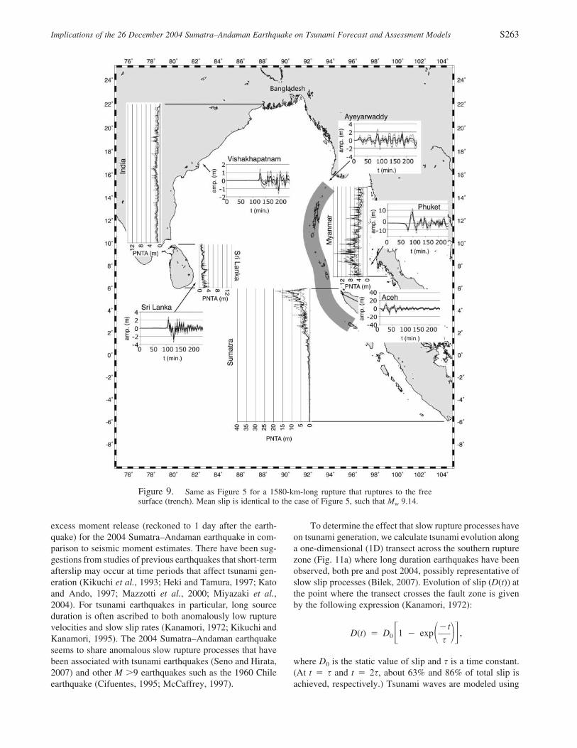
Figure 9. Same as Figure 5 for a 1580-km-long rupture that ruptures to the freesurface (trench). Mean slip is identical to the case of Figure 5, such that Mw 9.14.
excess moment release (reckoned to 1 day after the earth-quake) for the 2004 Sumatra–Andaman earthquake in com-parison to seismic moment estimates. There have been sug-gestions from studies of previous earthquakes that short-termafterslip may occur at time periods that affect tsunami gen-eration (Kikuchi et al., 1993; Heki and Tamura, 1997; Katoand Ando, 1997; Mazzotti et al., 2000; Miyazaki et al.,2004). For tsunami earthquakes in particular, long sourceduration is often ascribed to both anomalously low rupturevelocities and slow slip rates (Kanamori, 1972; Kikuchi andKanamori, 1995). The 2004 Sumatra–Andaman earthquakeseems to share anomalous slow rupture processes that havebeen associated with tsunami earthquakes (Seno and Hirata,2007) and other M �9 earthquakes such as the 1960 Chileearthquake (Cifuentes, 1995; McCaffrey, 1997).
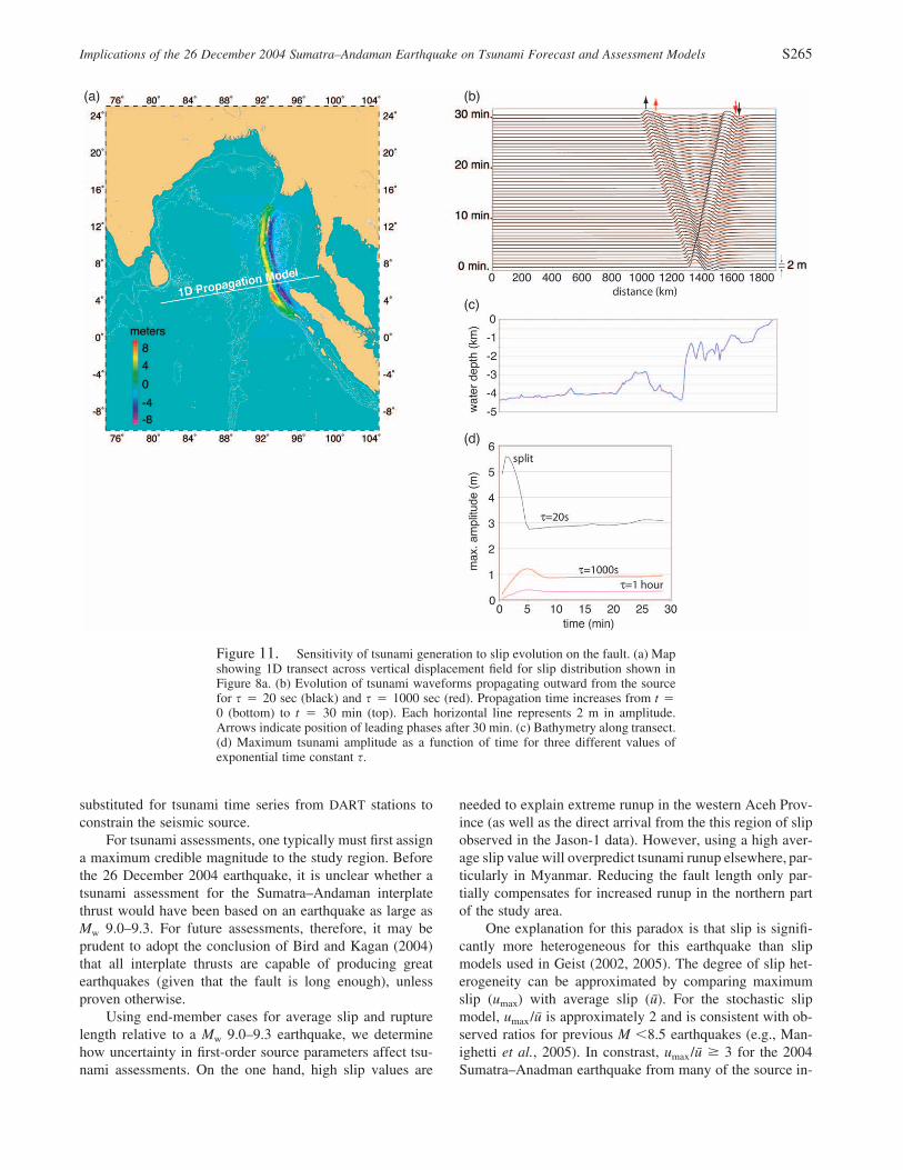
To determine the effect that slow rupture processes haveon tsunami generation, we calculate tsunami evolution alonga one-dimensional (1D) transect across the southern rupturezone (Fig. 11a) where long duration earthquakes have beenobserved, both pre and post 2004, possibly representative ofslow slip processes (Bilek, 2007). Evolution of slip (D(t)) atthe point where the transect crosses the fault zone is givenby the following expression (Kanamori, 1972):
�tD(t) � D 1 � exp ,0� � ��s
where D0 is the static value of slip and s is a time constant.(At t � s and t � 2s, about 63% and 86% of total slip isachieved, respectively.) Tsunami waves are modeled using

S264 E. L. Geist, V. V. Titov, D. Arcas, F. F. Pollitz, and S. L. Bilek
Figure 10. Comparison of rupture direction assumption on maximum tsunami am-plitude over 4 hr. (a) South-to-north unilateral rupture; (b) north-to-south unilateralrupture. In both cases, identical slip distribution and rupture velocity (2.5 km/sec areused (bottom).
the nonlinear, dispersive form of the 1D shallow-water waveequations given by Peregrine (1967) and decimated ETOPO2bathymetry along the transect (Fig. 11c).
For small values of s (e.g., 20 sec), tsunami evolutionproceeds in a standard manner, where the tsunami splits fromthe source region (Fig. 11b, black), with each outgoing wavedecreasing to approximately half its initial amplitude(Fig. 11d). For longer values of s (1000 sec and 1 hr), thetsunami waves leave the source region before generation iscompleted, such that the overall amplitude of the outgoingwaves is reduced. There is also a lag in the leading phasesfor the eastward (depression) and westward (elevation) prop-agating waves for the s � 1000 sec case in comparison tos � 20 sec (red and black arrows, Fig. 11b). In contrast tothe s � 20 sec case, there is little reduction in amplitude asthe waves leave the source region for longer values of s,indicating that for these large values of s, tsunami generationis more sensitive to the time history of movement than de-tails of the initial vertical displacement profile (cf., Ham-mack, 1973). Thus, afterslip with an exponential time con-stant less than 1 hr probably has a significant contributionto tsunami amplitude. A two-stage slip evolution descriptionmight be most reasonable, in which normal seismic risetimes are followed by a physical afterslip model (e.g., Hash-
imoto et al., 2006). Such a model would correspond to brittlefailure followed by creeplike deformation as originally pro-posed for tsunami generation by Kanamori (1972). For tsu-nami assessment purposes, however, more information isneeded to quantify temporal afterslip than is currently avail-able for most subduction zones.
Discussion
The objective of this study has been to test current meth-ods of tsunami forecasting and assessment against a varietyof observations of the 2004 Indian Ocean tsunami. Simplescalar, point-source empirical relationships can be used toestimate mean and maximum tsunami amplitudes once theseismic moment is known. These relationships provide aquick estimate of tsunami amplitudes and, as tested againsttsunami observations from the 2004 Sumatra–Andamanearthquake, are fairly accurate except at sites along the mainbeam of tsunami energy. Tsunami forecasting using a com-bination of a subfault characterization of earthquake rupturewith slip constrained by real-time deep-ocean tsunami mea-surements, appears to perform well in hindcasts of regionaltsunami amplitudes, travel times, and inundation at BandaAceh. For this hindcast, satellite altimetry measurements are
Implications of the 26 December 2004 Sumatra–Andaman Earthquake on Tsunami Forecast and Assessment Models S265
Figure 11. Sensitivity of tsunami generation to slip evolution on the fault. (a) Mapshowing 1D transect across vertical displacement field for slip distribution shown inFigure 8a. (b) Evolution of tsunami waveforms propagating outward from the sourcefor s � 20 sec (black) and s � 1000 sec (red). Propagation time increases from t �0 (bottom) to t � 30 min (top). Each horizontal line represents 2 m in amplitude.Arrows indicate position of leading phases after 30 min. (c) Bathymetry along transect.(d) Maximum tsunami amplitude as a function of time for three different values ofexponential time constant s.
substituted for tsunami time series from DART stations toconstrain the seismic source.
For tsunami assessments, one typically must first assigna maximum credible magnitude to the study region. Beforethe 26 December 2004 earthquake, it is unclear whether atsunami assessment for the Sumatra–Andaman interplatethrust would have been based on an earthquake as large asMw 9.0–9.3. For future assessments, therefore, it may beprudent to adopt the conclusion of Bird and Kagan (2004)that all interplate thrusts are capable of producing greatearthquakes (given that the fault is long enough), unlessproven otherwise.
Using end-member cases for average slip and rupturelength relative to a Mw 9.0–9.3 earthquake, we determinehow uncertainty in first-order source parameters affect tsu-nami assessments. On the one hand, high slip values are
needed to explain extreme runup in the western Aceh Prov-ince (as well as the direct arrival from the this region of slipobserved in the Jason-1 data). However, using a high aver-age slip value will overpredict tsunami runup elsewhere, par-ticularly in Myanmar. Reducing the fault length only par-tially compensates for increased runup in the northern partof the study area.
One explanation for this paradox is that slip is signifi-cantly more heterogeneous for this earthquake than slipmodels used in Geist (2002, 2005). The degree of slip het-erogeneity can be approximated by comparing maximumslip (umax) with average slip (u). For the stochastic slipmodel, umax/u is approximately 2 and is consistent with ob-served ratios for previous M �8.5 earthquakes (e.g., Man-ighetti et al., 2005). In constrast, umax/u � 3 for the 2004Sumatra–Anadman earthquake from many of the source in-

S266 E. L. Geist, V. V. Titov, D. Arcas, F. F. Pollitz, and S. L. Bilek
versions (e.g., Fujii and Satake, 2007). For the 1957 Aleutianearthquake, umax/u is also quite large (�4) (Johnson andSatake, 1993). It is unlikely that the difference in slip het-erogeneity is specific to M �9 earthquakes, though, sincethe maximum/average slip ratio for the 1964 Alaska earth-quake is approximately 2 (Johnson et al., 1996), suggestingself-similarity with smaller earthquakes. Lavallee and Ar-chuleta (2003) and Lavallee et al. (2006) recently indicatethat stochastic slip models based on Gaussian random vari-ables may not fully account for the spatial variability of slip.Instead, Lavallee et al. (2006) suggest that the Levy proba-bility law in general better captures extreme values of slipfor a given earthquake. Further research is needed to explainwhy some earthquakes such as the 2004 Sumatra–Andamanevent seem to be characterized by large fluctuations in slip.
What is clear from this and previous tsunami assessmentmodels is that uncertainty in first-order source parameterssuch as rupture length and slip-length scaling leads to sig-nificant, but quantifiable, uncertainty in tsunami amplitudes,particularly at local and regional distances. Uncertainty inslip distribution patterns also has a significant effect on localtsunamis, as does the rupture mechanics in the shallow sub-duction zones. These and other uncertainties can be incor-porated into a probabilistic tsunami assessment (Lin andTung, 1982; Ward, 2002; Geist and Parsons, 2006) using anapproach similar to probabilistic seismic hazard analysis.From a probabilistic perspective, the uncertainty in slip-length scaling and the uncertainty expressed by slip hetero-geneity can be considered sources of epistemic and aleatoryuncertainty, respectively, although the two may not beindependent as suggested by Zeng et al. (2005). Because thehydrodynamics of runup and inundation critically depend onhigh-resolution digital elevation models and computation-ally intensive nonlinear calculations, incorporating any levelof source uncertainty into probabilistic assessment of tsu-nami hazards has only been recently attempted (TsunamiPilot Study Working Group, 2006). Computationally effi-cient threshold modeling is a technique where effects of awide range of source-parameter variation on tsunami ampli-tudes can be examined, prior to detailed inundation studiesor where the nearshore bathymetric data is unavailable.
Conclusions
Different earthquake parameterizations as implementedin tsunami generation models have been tested against ob-servations from the 26 December 2004 Indian Ocean tsu-nami. For forecast models, simple scalar tsunami estimatesfrom the seismic moment of the earthquake yield a surpris-ingly good match to the observed mean regional runup andmaximum local runup, but a poorer match to regional tsu-nami runup heights on an azimuth in line with the tsunamibeaming pattern. While the empirical relations do not relyon numerical modeling or higher-order parameterization ofthe earthquake, there is significant uncertainty and no siteresponse associated with these estimates. The tsunami fore-
cast model implemented in the Pacific Ocean uses a staticsubfault representation of earthquake rupture and real-timesea level observations to constrain slip on the subfaults. Inplace of time series of deep-ocean tsunami amplitudes atspecific points, a transect of deep-ocean tsunami amplitudesrecorded by satellite altimetry were used to constrain slip onfour subfaults for the Sumatra–Andaman rupture. This proxyappears to perform well in comparison to observed regionaltsunami amplitudes, travel times, and inundation patterns atBanda Aceh.
Tsunami assessments based on an Mw 9.0–9.3 earth-quake were compared, using end-member values for bothaverage slip and rupture length. The linear propagationmodel is adequate for performing such a comparison of tsu-nami amplitude produced by different source parameters, al-though it should be emphasized that a detailed tsunami haz-ard assessment for a particular site requires high-resolutionbathymetry and nonlinear runup and inundation computa-tions. Average slip values in line with several seismic, ge-odetic, and tsunami inversions are consistent with mostrunup observations following the 2004 Sumatra–Andamanearthquake, except near the region of high slip in the south-ern part of the rupture. Peak slip, higher than what is ex-pected from standard stochastic slip distributions, is neededto explain the extreme runup values in western Aceh Prov-ince and the direct arrival observed on the Jason-1 altimetryprofile. Although estimation of peak slip is a critical param-eter, especially for estimating local tsunami runup, it is un-clear under what conditions great earthquakes may result inlarge fluctuations of slip.
Acknowledgments
The authors appreciate inversion results for the 2004 Sumatra–Andaman earthquake generously provided by Mohamed Chlieh, Chen Ji,and Hong Kie Thio. This article greatly benefited from constructive reviewsby Tom Parsons, Paul Whitmore, Barry Hirshorn, guest editor Kenji Satake,and an anonymous reviewer. Some maps were created using GenericMapping Tools software (Wessel and Smith, 1995).
References
Abe, K. (1979). Size of great earthquake of 1837–1974 inferred from tsu-nami data, J. Geophys. Res. 84, 1561–1568.
Abe, K. (1981). Physical size of tsunamigenic earthquakes of the north-western Pacific, Phys. Earth Planet. Interiors 27, 194–205.
Abe, K. (1995). Estimate of tsunami run-up heights from earthquake mag-nitudes, in Tsunami: Progress in Prediction, Disaster Prevention andWarning, Y. Tsuchiya and N. Shuto (Editors), Kluwer Academic Pub-lishers, Dordrecht, pp. 21–35.
Ammon, C. J., C. Ji, H. K. Thio, D. Robinson, S. Ni, V. Hjorleifsdottir, H.Kanamori, T. Lay, S. Das, D. Helmberger, G. Ichinose, J. Polet, andD. Wald (2005). Rupture process of the 2004 Sumatra-Andamanearthquake, Science 308, 1133–1139.
Andrews, D. J. (1980). A stochastic fault model 1. Static case, J. Geophys.Res. 85, 3867–3877.
Banerjee, P., F. F. Pollitz, and R. Burgmann (2005). The size and durationof the Sumatra–Andaman earthquake from far-field static offsets, Sci-ence 308, 1769–1772.

Implications of the 26 December 2004 Sumatra–Andaman Earthquake on Tsunami Forecast and Assessment Models S267
Banerjee, P., F. F. Pollitz, B. Nagarajan, and R. Burgmann (2007). Coseis-mic slip distributions of the 26 December 2004 Sumatra–Andamanand 28 March 2005 Nias earthquake from GPS static offsets, Bull.Seism. Soc. Am. 97, no. 1A, S86–S102.
Ben-Menahem, A., and M. Rosenman (1972). Amplitude patterns of tsu-nami waves from submarine earthquakes, J. Geophys. Res. 77, 3097–3128.
Ben-Zion, Y., and J. R. Rice (1995). Slip patterns and earthquake popula-tions along different classes of faults in elastic solids, J. Geophys.Res. 100, 12,959–12,983.
Ben-Zion, Y., and J. R. Rice (1997). Dynamic simulations of slip on asmooth fault in an elastic solid, J. Geophys. Res. 102, 17,771–17,784.
Berge, C., J. C. Gariel, and P. Bernard (1998). A very broad-band stochasticsource model used for near source strong motion prediction, Geophys.Res. Lett. 25, 1063–1066.
Bilek, S. L. (2007). Using earthquake rupture variations along the Sumatra–Andaman subduction system to examine fault zone variations, Bull.Seism. Soc. Am. 97, no. 1A, S62–S70.
Bilek, S. L., and T. Lay (1999). Rigidity variations with depth along inter-plate megathrust faults in subduction zones, Nature 400, 443–446.
Bilek, S. L., and T. Lay (2000). Depth dependent rupture properties incircum-Pacific subduction zones, in GeoComplexity and the Physicsof Earthquakes, J. B. Rundle, D. L. Turcotte, and W. Klein (Editors),American Geophysical Union, Washington, D.C., pp. 165–186.
Bilek, S. L., and T. Lay (2002). Tsunami earthquakes possibly widespreadmanifestations of frictional conditional stability, Geophys. Res. Lett.29, doi 10.1029/2002GL015215.
Bilek, S. L., S. Y. Schwartz, and H. R. DeShon (2003). Control on seafloorroughness on earthquake rupture behaviour, Geology 31, 455–458.
Bird, P. (2003). An updated digital model of plate boundaries, Geochem.Geophys. Geosystems 4, doi 10.1029/2001GC000252.
Bird, P., and Y. Y. Kagan (2004). Plate-tectonic analysis of shallow seis-micity: apparent boundary width, beta-value, corner magnitude, cou-pled lithosphere thickness, and coupling in 7 tectonic settings, Bull.Seism. Soc. Am. 94, 2380–2399.
Borrero, J. C. (2005). Field survey of northern Sumatra and Banda Aceh,Indonesia after the tsunami and earthquake of 26 December 2004,Seism. Res. Lett. 76, 312–320.
Boyd, T. M., E. R. Engdahl, and W. Spence (1995). Seismic cylces alongthe Aleutian arc: analysis of seismicity from 1957 through 1991,J. Geophys. Res. 100, 621–644.
Chlieh, M., J. P. Avouac, V. Hjorleifsdottir, T. A. Song, C. Ji, K. Sieh, A.Sladen, H. Hebert, L. Prawirodirdjo, Y. Bock, and J. Galetzka (2007).Coseismic slip and afterslip of the great (Mw 9.15) Sumatra–Andamanearthquake of 2004, Bull. Seism. Soc. Am. 97, no. 1A, S152–S173.
Cifuentes, I. L. (1995). Seismic moment and duration of recent large andgreat earthquakes, J. Geophys. Res. 100, no. 20, 3030–3020, 3309.
Comer, R. P. (1980). Tsunami height and earthquake magnitude: theoreticalbasis of an empirical relation, Geophys. Res. Lett. 7, 445–448.
Das, S. (1988). Relation between average slip and average stress drop forrectangular faults with multiple asperities, Bull. Seism. Soc. Am. 78,924–930.
Dasgupta, S., and M. Mukhopadhyay (1993). Seismicity and plate defor-mation below the Andaman arc, northeastern Indian Ocean, Tecton-ophysics 225, 529–542.
de Groot-Hedlin, C. D. (2005). Estimation of the rupture length and velocityof the Great Sumatra earthquake of Dec. 26, 2004 using hydroacousticsignals, Geophys. Res. Lett. 32, doi 10.1029/2005GL022695.
Dmowska, R., and B. V. Kostrov (1973). A shearing crack in a semi-spaceunder plane strain conditions, Arch. Mech. 25, 421–440.
Fauzi, R. M., R. McCaffrey, D. Wark, D. Sunaryo, and P. Y. Prih Haryadi(1996). Lateral variation in slab orientation beneath Toba Caldera,northern Sumatra, Geophys. Res. Lett. 23, 443–446.
Fitch, T. J. (1972). Plate convergence, transcurrent faults, and internal de-formation adjacent to southeast Asia and the western Pacific, J. Geo-phys. Res. 77, 4432–4460.
Fu, G., and W. Sun (2004). Effects of spatial distribution of fault slip on
calculating coseismic displacement: case studies of the Chi-Chi earth-quake (Mw 7.6) and the Kunlun earthquake (Mw 7.8), Geophys. Res.Lett. 31, doi 10.1029/2004GL020841.
Fujii, Y., and K. Satake (2007). Tsunami source of the 2004 Sumatra–Andaman earthquake inferred from tide gauge and satellite data, Bull.Seism. Soc. Am. 97, no. 1A, S192–S207.
Fujima, K., D. Yuliadi, C. Goto, K. Hayashi, and T. Shigemura (1995).Characteristics of long wave trapped by conical island, Coastal Eng.Jpn. 38, 111–132.
Furumoto, A. S. (1996). Using Mw or Mt to forecast tsunami heights, Sci.Tsunami Haz. 14, 107–118.
Geist, E. L. (1999). Local tsunamis and earthquake source parameters, Adv.Geophys. 39, 117–209.
Geist, E. L. (2002). Complex earthquake rupture and local tsunamis, J.Geophys. Res. 107, doi 10.1029/2000JB000139.
Geist, E. L. (2005). Local tsunami hazards in the Pacific Northwest fromCascadia Subduction Zone earthquakes, U.S. Geol. Surv. Profess.Pap. 1661B, 17 pp.
Geist, E. L., and S. L. Bilek (2001). Effect of depth-dependent shear mod-ulus on tsunami generation along subduction zones, Geophys. Res.Lett. 28, 1315–1318.
Geist, E. L., and R. Dmowska (1999). Local tsunamis and distributed slipat the source, Pure Appl. Geophys. 154, 485–512.
Geist, E. L., and T. Parsons (2006). Probabilistic analysis of tsunami haz-ards, Nat. Haz. 37, 277–314.
Geist, E. L., and S. Yoshioka (1996). Source parameters controlling thegeneration and propagation of potential local tsunamis along the Cas-cadia margin, Nat. Haz. 13, 151–177.
Geist, E. L., S. L. Bilek, D. Arcas, and V. V. Titov (2006). Differences intsunami generation between the 26 December 2004 and 28 March2005 Sumatra earthquakes, Earth Planets Space 58, 185–193.
Geller, R. J. (1976). Scaling relations for earthquake source parameters andmagnitudes, Bull. Seism. Soc. Am. 66, 1501–1523.
Genrich, J. F., Y. Bock, R. McCaffrey, L. Prawirodirdjo, C. W. Stevens,S. S. O. Puntodewo, C. Subarya, and S. Wdowinski (2000). Distri-bution of slip at the northern Sumatran fault system, J. Geophys. Res.105, 28,327–28,341.
Goff, J. R., P. L. F. Liu, B. Higman, R. Morton, B. E. Jaffe, H. Fernando,P. Lynett, H. M. Fritz, C. E. Synolakis, and S. Fernando (2006). SriLanka Field Survey after the December 2004 Indian Ocean tsunami,Earthquake Spectra 22, S155–S172.
Gonzalez, F. I., V. V. Titov, H. O. Mofjeld, A. J. Venturato, S. Simmons,R. Hansen, R. A. Combellick, R. K. Eisner, D. Hoirup, B. Yanagi, S.Yong, M. Darienzo, G. R. Priest, G. Crawford, and T. Walsh (2005).Progress in NTHMP hazard assessment, Nat. Haz. 35, 89–110.
Gower, J. (2005). Jason 1 detects the 26 December 2004 tsunami, EOSTrans. AGU 86, 37–38.
Gudmundsson, O., and M. Sambridge (1998). A regionalized upper mantle(RUM) seismic model, J. Geophys. Res. 103, 7121–7136.
Hammack, J. L. (1973). A note on tsunamis: their generation and propa-gation in an ocean of uniform depth, J. Fluid Mech. 60, 769–799.
Hanson, J. A., and J. R. Bowman (2005). Dispersive and reflected tsunamisignals from the 2004 Indian Ocean tsunami observed on hydrophonesand seismic stations, Geophys. Res. Lett. 32, doi 10.1029/2005GL023783.
Hashimoto, M., N. Choosakul, M. Hashizume, S. Takemoto, H. Takiguchi,Y. Fukuda, and K. Fujimore (2006). Crustal deformations associatedwith the great Sumatra–Andaman earthquake deduced from contin-uous GPS observation, Earth Planets Space 58, 127–139.
Heki, K., and Y. Tamura (1997). Short term afterslip in the 1994 Sanriku-Haruka-Oki earthquake, Geophys. Res. Lett. 24, 3285–3288.
Herrero, A., and P. Bernard (1994). A kinematic self-similar rupture processfor earthquakes, Bull. Seism. Soc. Am. 84, 1216–1228.
Hirata, K., K. Satake, Y. Tanioka, T. Kuragano, Y. Hasegawa, Y. Hayashi,and M. Hamada (2006). The 2004 Indian Ocean tsunami: tsunamisource model from satellite altimetry, Earth Planets Space 58, 195–201.
S268 E. L. Geist, V. V. Titov, D. Arcas, F. F. Pollitz, and S. L. Bilek
Hirata, K., Y. Tanioka, K. Satake, S. Yamaki, and E. L. Geist (2004). Thetsunami source area of the 2003 Tokachi-oki earthquake estimatedfrom tsunami travel times and its relationship to the 1952 Tokachi-oki earthquake, Earth Planets Space 56, 367–372.
Hisada, Y. (2000). A theoretical omega-square model considering the spa-tial variation in slip and rupture velocity, Bull. Seism. Soc. Am. 90,387–400.
Hisada, Y. (2001). A theoretical omega-square model considering the spa-tial variation in slip and rupture velocity, part 2: Case for a two-dimensional source model, Bull. Seism. Soc. Am. 91, 651–666.
Honda, R., and K. Yomogida (2003). Effect of complex fault geometry andslip style on near-fault strong motions and static displacment, EarthPlanets Space 55, 515–530.
Honda, S., and T. Seno (1989). Seismic moment tensors and source depthsdetermined by the simultaneous inversion of body and surface waves,Phys. Earth Planet. Interiors 57, 311–329.
Ishii, M., P. M. Shearer, H. Houston, and J. E. Vidale (2005). Extent, du-ration and speed of the 2004 Sumatra–Andaman earthquake imagedby the Hi-Net array, Nature 435, 933–936.
Jaffe, B. E., J. C. Borrero, G. S. Prasetya, R. Peters, B. McAdoo, G. Gel-fenbaum, R. Morton, P. Ruggiero, B. Higman, L. Dengler, R. Hidayat,E. Kingsley, W. Kongko, Lukijanto, A. Moore, V. V. Titov, andE. Yulianto (2006). Northwest Sumatra and Offshore Islands FieldSurvey after the December 2004 Indian Ocean tsunami, EarthquakeSpectra 22, S105–S135.
Jain, S. K., C. V. R. Murty, D. C. Rai, J. N. Malik, A. R. Sheth, A. Jaiswal,S. A. Sanyal, H. B. Kaushik, P. Gandhi, G. Mondal, S. R. Dash, J. S.Sodhi, and G. S. Kumar (2005). The great Sumatra Earthquake andIndian Ocean tsunami of December 26, 2004, Report 3: The effectsin mainland India and in the Andaman-Nicobar Islands, EERI SpecialEarthquake Report, April 2005, 1–12.
Johnson, J. M., and K. Satake (1993). Source parameters of the 1957 Aleu-tian earthquake from tsunami waveforms, Geophys. Res. Lett. 20,1487–1490.
Johnson, J. M., K. Satake, S. R. Holdahl, and J. Sauber (1996). The 1964Prince William Sound earthquake: Joint inversion of tsunami and ge-odetic data, J. Geophys. Res. 101, 523–532.
Kagan, Y. Y. (2002). Seismic moment distribution revisited: II. Momentconservation principle, Geophys. J. Int. 149, 731–754.
Kajiura, K. (1981). Tsunami energy in relation to parameters of the earth-quake fault model, Bull. Earthquake Res. Ins. 56, 415–440.
Kanamori, H. (1972). Mechanism of tsunami earthquakes, Phys. EarthPlanet. Interiors 6, 346–359.
Kanamori, H., and D. L. Anderson (1975). Theoretical basis of some em-pirical relations in seismology, Bull. Seism. Soc. Am. 65, 1073–1095.
Karig, D. E., G. F. Moore, J. R. Curray, and M. B. Lawrence (1980).Morphology and shallow structure of the lower trench slope off NiasIsland, Sunda Arc, in The Tectonic and Geologic Evolution of South-east Asian Seas and Islands, D. E. Hayes (Editor), American Geo-physical Monograph 23, 179–208.
Kato, T., and M. Ando (1997). Source mechanisms of the 1944 Tonankaiand 1946 Nankaido earthquakes: spatial heterogeneity of rise times,Geophys. Res. Lett. 24, 2055–2058.
Kawakatsu, H., and G. P. Cadena (1991). Focal mechanisms of the March6, 1987 Ecuador earthquakes—CMT inversion with a first motion con-straint, J. Phys. Earth 39, 589–597.
Kikuchi, M., and H. Kanamori (1995). Source characteristics of the 1992Nicaragua tsunami earthquake inferred from teleseismic body waves,Pure Appl. Geophys. 144, 441–453.
Kikuchi, M., H. Kanamori, and K. Satake (1993). Source complexity of the1988 Armenian earthquake: evidence for a slow after-slip event, J.Geophys. Res. 98, 15,797–15,808.
Koshimura, S., F. Imamura, and N. Shuto (1999). Propagation of obliquelyincident tsunamis on a slope, Part I: Amplification of tsunamis on acontinental slope, Coastal Eng. J. 41, 151–164.
Kowalik, Z., W. Knight, T. Logan, and P. Whitmore (2005). Numericalmodeling of the global tsunami: Indonesian Tsunami of 26 December2004, Sci. Tsunami Haz. 23, 40–56.
Krishna, M. R., and T. D. Sanu (2002). Shallow seismicity, stress distri-bution and crustal deformation pattern in the Andaman–West Sundaarc and Andaman Sea, northeastern Indian Ocean, J. Seism. 6, 25–41.
Kruger, F., and M. Ohrnberger (2005). Tracking the rupture of the Mw �
9.3 Sumatra earthquake over 1,150 km at teleseismic distance, Nature435, 937–939.
Lavallee, D., and R. J. Archuleta (2003). Stochastic modeling of slip spatialcomplexities for the 1979 Imperial Valley, California, earthquake,Geophys. Res. Lett. 30, doi 10.1029/2002GL015839.
Lavallee, D., P. Liu, and R. J. Archuleta (2006). Stochastic model of het-erogeneity in earthquake slip spatial distributions, Geophys. J. Int.165, 622–640.
Lay, T., H. Kanamori, C. J. Ammon, M. Nettles, S. N. Ward, R. C. Aster,S. L. Beck, S. L. Bilek, M. R. Brudzinski, R. Butler, H. R. DeShon,G. Ektrom, K. Satake, and S. A. Sipkin (2005). The great Sumatra–Andaman earthquake of 26 December 2004, Science 308, 1127–1133.
Lin, I., and C. C. Tung (1982). A preliminary investigation of tsunamihazard, Bull. Seism. Soc. Am. 72, 2323–2337.
Liu, P. L. F., P. Lynett, H. Fernando, B. E. Jaffe, H. M. Fritz, B. Higman,R. Morton, J. R. Goff, and C. E. Synolakis (2005). Observations bythe International Tsunami Survey Team in Sri Lanka, Science 308,1595.
Liu, P. L. F., H. Yeh, P. Lin, K. T. Chang, and Y. S. Cho (1998). Generationand evolution of edge-wave packets, Phys. Fluids 10, 1635–1657.
Mai, P. M., and G. C. Beroza (2002). A spatial random field model tocharacterize complexity in earthquake slip, J. Geophys. Res. 107, doi10.1029/2001JB000588.
Manighetti, I., M. Campillo, C. Sammis, P. M. Mai, and G. King (2005).Evidence for self-similar, triangular slip distributions on earthquakes:implications for earthquake and fault mechanics, J. Geophys. Res.110, doi 10.1029/2004JB003174.
Maung, H. (1987). Trancurrent movements in the Burma-Andaman Searegion, Geology 15, 911–912.
Mazzotti, S., X. Le Pichon, P. Henry, and S. Miyazaki (2000). Full interse-ismic locking of the Nankai and Japan-west Kurile subduction zones:an analysis of uniform elastic strain accumulation in Japan con-strained by permanent GPS, J. Geophys. Res. 105, 13,159–13,177.
McCaffrey, R. (1991). Slip vectors and stretching of the Sumatran fore arc,Geology 19, 881–884.
McCaffrey, R. (1992). Oblique plate convergence, slip vectors, and forearcdeformation, J. Geophys. Res. 97, 8905–8915.
McCaffrey, R. (1997). Influences of recurrence times and fault zone tem-peratures on the age-rate dependence of subduction zone seismicity,J. Geophys. Res. 102, 22,839–22,854.
McCaffrey, R., P. C. Zwick, Y. Bock, L. Prawirodirdjo, J. F. Genrich, C.W. Stevens, S. S. O. Puntodewo, and C. Subarya (2000). Strain par-titioning during oblique plate convergence in northern Sumatra: Ge-odetic and seismologic constraints and numerical modeling, J. Geo-phys. Res. 105, 28,363–28,376.
McGarr, A., and J. B. Fletcher (2003). Maximum slip in earthquake faultzones, apparent stress, and stick-slip friction, Bull. Seism. Soc. Am.93, 2355–2362.
McGuire, J. J., L. Zhao, and T. H. Jordan (2001). Teleseismic inversion forthe second-degree moments of earthquake space-time distributions,Geophys. J. Int. 145, 661–678.
Mei, C. C. (1989). The Applied Dynamics of Ocean Surface Waves, WorldScientific, Singapore, 740 pp.
Meltzner, A., K. Sieh, M. Abrams, D. C. Agnew, K. W. Hudnut, J. P.Avouac, and D. Natawidjaja (2006). Uplift and subsidence associatedwith the Great Aceh-Andaman earthquake of 2004, J. Geophys. Res.111, doi 10.1029/2005JB003891.
Mendoza, C. (1993). Coseismic slip of two large Mexican earthquakes fromteleseismic body waveforms: implications for asperity interaction inthe Michoacan plate boundary segment, J. Geophys. Res. 98, 8197–8210.
Michael, A. J., and R. J. Geller (1984). Linear moment tensor inversion for

Implications of the 26 December 2004 Sumatra–Andaman Earthquake on Tsunami Forecast and Assessment Models S269
shallow thrust earthquakes combining first-motion and surface wavedata, J. Geophys. Res. 89, 1889–1897.
Michel, G. W., M. Becker, C. Reigber, R. Tibi, Y. Q. Yu, and S. Y. Zhu(2001). Regional GPS data confirm high strain accumulation prior tothe 2000 June 4 Mw � 7.8 earthquake at southeast Sumatra, Geophys.J. Int. 146, 571–582.
Miyazaki, S., K. M. Larson, K. Choi, K. Hikima, K. Koketsu, P. Bodin, J.Haase, G. Emore, and A. Yamagiwa (2004). Modeling the ruptureprocess of the 2003 September 25 Tokachi-Oki (Hokkaido) earth-quake using 1-Hz GPS data, Geophys. Res. Lett. 31, doi 10.1029/2004GL021457.
Moore, G. F., J. R. Curray, D. G. Moore, and D. E. Karig (1980). Variationsin geologic structure along the Sunda fore arc, northeastern IndianOcean, in The Tectonic and Geologic Evolution of Southeast AsianSeas and Islands, D. E. Hayes (Editor), American Geophysical Mono-graph 23, 145–160.
Mukhopadhyay, M. (1984). Seismotectonics of subduction and back-arcrifting under the Andaman Sea, Tectonophysics 108, 229–239.
Neetu, S., I. Suresh, R. Shankar, D. Shankar, S. S. C. Shenoi, S. R. Shetye,D. Sundar, and B. Nagarajan (2005). Comment on “The GreatSumatra-Andaman Earthquake of 26 December 2004,” Science 310,1431.
Newcomb, K. R., and W. R. McCann (1987). Seismic history and seis-motectonics of the Sunda arc, J. Geophys. Res. 92, 421–439.
Ni, S., H. Kanamori, and D. Helmberger (2005). Energy radiation from theSumatra earthquake, Nature 434, 582.
Nielsen, S. B., and J. M. Carlson (2000). Rupture pulse characterization:self-healing, self-similar, expanding solutions in a continuum modelof fault dynamics, Bull. Seism. Soc. Am. 90, 1480–1497.
Okada, Y. (1985). Surface deformation due to shear and tensile faults in ahalf-space, Bull. Seism. Soc. Am. 75, 1135–1154.
Okal, E. A. (1988). Seismic parameters controlling far-field tsunami am-plitudes: a review, Nat. Haz. 1, 67–96.
Okal, E. A. (1991). Erratum. Seismic parameters controlling far-field tsu-nami amplitudes: a review, Nat. Haz. 4, 433.
Okal, E. A., and C. E. Synolakis (2004). Source discriminants for near-field tsunamis, Geophys. J. Int. 158, 899–912.
Ortiz, M., and R. Bilham (2003). Source area and rupture parameters of the31 December 1881 Mw � 7.9 Car Nicobar earthquake estimated fromtsunamis recorded in the Bay of Bengal, J. Geophys. Res. 108, doi10.1029/2002JB001941.
Park, J., T. A. Song, J. Tromp, E. A. Okal, S. Stein, G. Roult, E. Clevede,G. Laske, H. Kanamori, P. Davis, J. Berger, C. Braitenberg, M. VanCamp, X. Lei, H. Sun, H. Xu, and S. Rosat (2005). Earth’s free os-cillations excited bythe 26 December 2004 Sumatra–Andaman earth-quake, Science 308, 1139–1144.
Paul, J., R. Burgmann, V. K. Gaur, R. Bilham, K. M. Larson, M. B. Ananda,S. Jade, M. Mukal, T. S. Anupama, G. Satyal, and D. Kumar (2000).The motion and active deformation of India, Geophys. Res. Lett. 28,647–650.
Pelayo, A. M., and D. A. Wiens (1992). Tsunami earthquakes: slow thrust-faulting events in the accretionary wedge, J. Geophys. Res. 97,15,321–15,337.
Peregrine, D. H. (1967). Long waves on a beach, J. Fluid Mech. 27, 815–827.
Perfettini, H., J. Schmittbuhl, and J. P. Vilotte (2001). Slip correlations ona creeping fault, Geophys. Res. Lett. 28, 2137–2140.
Polet, J., and H. Kanamori (2000). Shallow subduction zone earthquakesand their tsunamigenic potential, Geophys. J. Int. 142, 684–702.
Pollitz, F. F. (1996). Coseismic deformation from earthquake faulting on alayered spherical earth, Geophys. J. Int. 125, 1–14.
Prawirodirdjo, L., Y. Bock, R. McCaffrey, J. F. Genrich, E. Calais, C. W.Stevens, S. S. O. Puntodewo, C. Subarya, J. Rais, P. C. Zwick, andR. M. Fauzi (1997). Geodetic observations of interseismic strain seg-mentation at the Sumatra subduction zone, Geophys. Res. Lett. 24,2601–2604.
Rabinovich, A. B. (1997). Spectral analysis of tsunami waves: separation
of source and topography effects, J. Geophys. Res. 102, 12,663–12,676.
Reid, R. O., and B. R. Bodine (1968). Numerical model for storm surgesin Galveston Bay, J. Waterways Harbors Div. A.C.E. 94, 33–57.
Rikitake, T., and I. Aida (1988). Tsunami hazard probability in Japan, Bull.Seism. Soc. Am. 78, 1268–1278.
Romanowicz, B., and J. B. Rundle (1993). On scaling relationships for largeearthquakes, Bull. Seism. Soc. Am. 83, 1294–1297.
Rudnicki, J. W., and M. Wu (1995). Mechanics of dip-slip faulting in anelastic half-space, J. Geophys. Res. 100, 22,173–22,186.
Satake, K. (1995). Linear and nonlinear computations of the 1992 Nica-ragua earthquake tsunami, Pure Appl. Geophys. 144, 455–470.
Satake, K. (2002). Tsunamis, in International Handbook of Earthquake andEngineering Seismology, Part A, W. H. K. Lee, H. Kanamori, P. C.Jennings and C. Kisslinger (Editors) Academic Press, San Diego,437–451.
Satake, K., and H. Kanamori (1991). Use of tsunami waveforms for earth-quake source study, Nat. Haz. 4, 193–208.
Satake, K., T. T. Aung, Y. Sawai, Y. Okamura, K. S. Win, W. Swe, C.Swe, T. L. Swe, S. T. Tun, M. M. Soe, T. Z. Oo, and S. H. Zaw(2006b). Tsunami heights and damage along the Myanmar coast fromthe December 26 Sumatra-Andaman earthquake, Earth Planets Space58, 243–252.
Satake, K., K. Hirata, S. Yamaki, and Y. Tanioka (2006a). Re-estimationof tsunami source of the 1952 Tokachi-oki earthquake, Earth PlanetsSpace 58, 535–542.
Satake, K., K. Wang, and B. F. Atwater (2003). Fault slip and seismicmoment of the 1700 Cascadia earthquake inferred from Japanese tsu-nami descriptions, J. Geophys. Res. 108, ESE.7-1–7-17.
Scholz, C. H. (1982). Scaling laws for large earthquakes: consequences forphysical models, Bull. Seism. Soc. Am. 72, 1–14.
Scholz, C. H. (1994). A reappraisal of large earthquake scaling, Bull. Seism.Soc. Am. 84, 215–218.
Schwartz, S. Y. (1999). Noncharacteristic behavior and complex recurrenceof large subduction zone earthquakes, J. Geophys. Res. 104, 23,111–23,125.
Seno, T., and K. Hirata (2007). Is the 2004 Sumatra–Andaman earthquakea tsunami earthquake? Bull. Seism. Soc. Am. 97, no. 1A, S296–S306.
Shaw, B. E. (2004). Dynamic heterogeneities versus fixed heterogeneitiesin earthquake models, Geophys. J. Int. 156, 275–286.
Shibata, M. (1983). One-dimensional dispersive deformation of tsunamiwith typical inital profiles on continental topographies, in Tsunamis:Their Science and Engineering, K. Iida and T. Iwasaki (Editors), TerraScience Publication Company, Tokyo, 241–250.
Shuto, N. (1991). Numerical simulation of tsunamis—its present and nearfuture, Nat. Haz. 4, 171–191.
Sieh, K., R. Briggs, A. Meltzner, D. Natawidjaja, N. Hananto, and I. Su-prihanto (2005). The Simeulue saddle: evidence for a barrier to rup-ture for both the 2004 and 2005 Sumatran megathrust failures (ab-stract), EOS Trans. AGU. 86, no. 52, Fall Meeting Suppl., abstractU14A-01.
Simons, W. M. F., B. A. C. Ambrosius, R. Noomen, D. Angermann, P.Wilson, M. Becker, E. Reinhard, A. Walpersdorf, and C. Vigny(1999). Observing plate motions in SE Asia: geodetic results of theGEODYSSEA project, Geophys. Res. Lett. 26, 2081–2084.
Somerville, P., K. Irikura, R. Graves, S. Sawada, D. Wald, N. A. Abraham-son, Y. Iwasaki, T. Kagawa, N. Smith, and A. Kowada (1999). Char-acterizing crustal earthquake slip models for the prediction of strongground motion, Seism. Res. Lett. 70, 59–80.
Stein, S., and E. A. Okal (2005). Speed and size of the Sumatra earthquake,Nature 434, 581–582.
Subarya, C., M. Chlieh, L. Prawirodirdjo, J. P. Avouac, Y. Bock, K. Sieh,A. Meltzner, D. Natawidjaja, and R. McCaffrey (2006). Plate-boundary deformation associated with the great Sumatra–Andamanearthquake, Nature 440, 46–51.
Synolakis, C. E., and J. E. Skjelbreia (1993). Evolution of maximum am-plitude of solitary waves on plane beaches, J. Waterway Port CoastalOcean Eng. 119, 323–342.

S270 E. L. Geist, V. V. Titov, D. Arcas, F. F. Pollitz, and S. L. Bilek
Tanioka, Y., and K. Satake (1996). Tsunami generation by horizontal dis-placement of ocean bottom, Geophys. Res. Lett. 23, 861–865.
Tanioka, Y., L. J. Ruff, and K. Satake (1997). What controls the lateralvariation of large earthquake occurrence along the Japan trench?Island Arc 6, 261–266.
Tanioka, Y., Y. Yudhicara, T. Kususose, S. Kathiroli, Y. Nishimura, S.Iwasaki, and K. Satake (2006). Rupture process of the 2004 greatSumatra–Andaman earthquake estimate from tsunami waveforms,Earth Planets Space 58, 203–209.
Thatcher, W. (1990). Order and diversity in the modes of circum-Pacificearthquake recurrence, J. Geophys. Res. 95, 2609–2623.
Tinti, S., and A. Armigliato (2003). The use of scnarios to evaluate thetsunami impact in southern Italy, Mar. Geol. 199, 221–243.
Titov, V. V., and F. I. Gonzalez (1997). Implementation and testing of themethod of splitting tsunami (MOST) model, NOAA Technical Mem-orandum, NOAA/PMEL, Seattle, Washington, 11 pp.
Titov, V. V., and C. E. Synolakis (1997). Extreme inundation flows duringthe Hokkaido-Nansei-Oki tsunami, Geophys. Res. Lett. 24, 1315–1318.
Titov, V. V., and C. E. Synolakis (1998). Numerical modeling of tidal waverunup, J. Waterway Port Coastal Ocean Eng. 124, 157–171.
Titov, V. V., F. I. Gonzalez, E. N. Bernard, J. E. Ebel, H. O. Mofjeld, J. C.Newman, and A. J. Venturato (2005a). Real-time tsunami forecasting:challenges and solutions, Nat. Haz. 35, 40–58.
Titov, V. V., H. O. Mofjeld, F. I. Gonzalez, and J. C. Newman (1999).Offshore forecasting of Hawaiian tsunamis generated in Alaskan-Aleutian subduction zone, NOAA Technical Memorandum ERL, Pa-cific Marine Environmental Laboratory (PMEL), Seattle, Washington,26 pp.
Titov, V. V., H. O. Mofjeld, F. I. Gonzalez, and J. C. Newman (2001).Offshore forecasting of Alaskan tsunami in Hawaii, in Tsunami Re-search at the End of a Critical Decade, G. T. Hebenstreit (Editor),Kluwer Academic Publishers, Dordrecht, The Netherlands, 75–90.
Titov, V. V., A. B. Rabinovich, H. O. Mofjeld, R. Thomson, and F. I.Gonzalez (2005b). The global reach of the 26 December 2004 Su-matra tsunami, Science 309, 2045–2048.
Tolstoy, M., and D. R. Bohnenstiehl (2005). Hydroacoustic constraints onthe rupture duration, length, and speed of the great Sumatra–Andamanearthquake, Seism. Res. Lett. 76, 419–425.
Tsai, C. P. (1997). Slip, stress drop and ground motion of earthquakes: aview from the perspective of fractional Brownian motion, Pure Appl.Geophys. 149, 689–706.
Tsai, V. C., M. Nettles, G. Ektrom, and A. M. Dziewonski (2005). MultipleCMT source analysis of the 2004 Sumatra earthquake, Geophys. Res.Lett. 32, doi 10.1029/2005GL023813.
Tsuboi, S. (1999). Application of Mwp to deep and teleseismic earthquakes,Bull. Seism. Soc. Am. 89, 1345–1351.
Tsuboi, S. (2000). Application of Mwp to tsunami earthquake, Geophys.Res. Lett. 27, 3105–3108.
Tsuboi, S., K. Abe, K. Takano, and Y. Yamanaka (1995). Rapid determi-nation of Mw from broadband P waveforms, Bull. Seism. Soc. Am.85, 606–613.
Tsuji, Y., H. Matsutomi, Y. Tanioka, Y. Nishimura, T. Sakakiyama, T.Kamataki, Y. Murakami, A. Moore, and G. Gelfenbaum (2005). Dis-tribution of the tsunami heights of the 2004 Sumatera tsunami inBanda Aceh measured by the Tsunami Survey Team, edited, Univer-sity of Tokyo, http://www.eri.u-tokyo.ac.jp/namegaya/sumatera/surveylog/eindex.htm (last accessed January 2005).
Tsuji, Y., Y. Namegaya, H. Matsumoto, S. Iwasaki, W. Kanbua, M. Sri-wichai, and V. Meesuk (2006). The 2004 Indian tsunami in Thailand:surveyed runup heights and tide gauge records, Earth Planets Space58, 223–232.
Tsunami Pilot Study Working Group (2006). Seaside, Oregon TsunamiPilot Study—Modernization of FEMA Flood Hazard Maps, U.S.Geol. Surv. Open-File Rep. 2006-1234, http://pubs.usgs.gov/of/2006/1234.
Vigny, C., W. M. F. Simons, S. Abu, R. Bamphenyu, C. Satirapod, N.Choosakul, C. Subarya, A. Socquet, K. Omar, H. Z. Abidin, andB. A. C. Ambrosius (2005). Insight into the 2004 Sumatra-Andamanearthquake from GPS measurements in southeast Asia, Nature 436,201–206.
Ward, S. N. (1980). Relationships of tsunami generation and an earthquakesource, J. Phys. Earth 28, 441–474.
Ward, S. N. (1982a). On tsunami nucleation II. An instantaneous modulatedline source, Phys. Earth Planet. Interiors 27, 273–285.
Ward, S. N. (1982b). Earthquake mechanisms and tsunami generation: theKurile Islands event of 13 October 1963, Bull. Seism. Soc. Am. 72,759–777.
Ward, S. N. (1994). A multidisciplinary approach to seismic hazard insouthern California, Bull. Seism. Soc. Am. 84, 1293–1309.
Ward, S. N. (2002). Tsunamis, in The Encyclopedia of Physical Scienceand Technology, R. A. Meyers (Editor), Academic Press, San Diego,175–191.
Weinstein, S. A., and E. A. Okal (2005). The mantle wave magnitude Mm
and the slowness parameter H: five years of real-time use in the con-text of tsunami warning, Bull. Seism. Soc. Am. 95, 779–799.
Wells, D. L., and K. J. Coppersmith (1994). New empirical relationshipsamong magnitude, rupture length, rupture width, rupture area, andsurface displacement, Bull. Seism. Soc. Am. 84, 974–1002.
Wessel, P., and W. H. F. Smith (1995). New version of the Generic Map-ping Tools released, EOS Trans. AGU 76, F329.
Wu, T. Y. (1981). Long waves in ocean and coastal waters, J. Eng. Mech.Div. ASCE 107, 501–522.
Wyss, M. (1979). Estimating maximum expectable magnitude of earth-quake from fault dimensions, Geology 6, 336–340.
Yeh, H., C. Peterson, R. K. Chadha, G. Latha, and T. Katada (2005). Thegreat Sumatra Earthquake and Indian Ocean tsunami of December 26,2004, Report 2: Tsunami survey along the southeast Indian Coast,EERI Special Earthquake Report, March 2005, 5–8.
Zeng, J. L., T. H. Heaton, and C. DiCaprio (2005). The effect of slip vari-ability on earthquake slip-length scaling, Geophys. J. Int. 162, 841–849.
Zheng, G., and J. R. Rice (1998). Conditions under which velocity-weakening friction allows a self-healing versus a cracklike mode ofrupture, Bull. Seism. Soc. Am. 88, 1466–1483.
U.S. Geological Survey345 Middlefield Road, MS 999Menlo Park, California [email protected]
(E.L.G., F.F.P.)
National Oceanic and Atmospheric AdministrationPacific Marine Environmental Laboratory7600 Sand Point Way NE, Bldg. 3Seattle, Washington 98115
(V.V.T., D.A.)
Joint Institute for the Study of the Atmosphere and OceansUniversity of WashingtonSeattle, Washington 98195
(V.V.T., D.A.)
New Mexico TechEarth and Environmental Science DepartmentSocorro, New Mexico 87801
(S.L.B.)
Manuscript received 17 January 2006.