Embed Size (px)
Citation preview

FS 4C - Adjustment Techniques and Reference Frames Vivian de O. Fernandes and Ruth Emilia Nogueira Implications for the Adoption of Global Reference Geodesic System (4419) FIG Congress 2010 Facing the Challenges – Building the Capacity Sydney, Australia, 11-16 April 2010
1/15
Implications for the Adoption of Global Reference Geodesic System SIRGAS2000 on the Large Scale Cadastral Cartography in Brazil
Vivian de Oliveira FERNANDES and Ruth Emilia NOGUEIRA, Brazil
Key words: SIRGAS2000, SAD69, Global Geodesic System SUMMARY Since 2005 Brazil is going through a singular moment into Cartography. In January 2005, SIRGAS2000 began to be the geodetic official reference system for Geodesy and Cartography, with the concomitant use of SAD69. Since January 2015, only SIRGAS2000 will be official, and all cartographical products will have to be referenced into this Datum. The adoption of a geocentric reference system happens from the technological evolution that has favored an improvement of the Geodetic Reference System – SGR. Differently of a single alternative for the improvement of the SGR, the adoption of a new geocentric reference system is a basic necessity into the world-wide scenery to activities that depend on spatialized information. The technological advancements in the global positioning methods, specially in the satellite positioning systems. This change reaches more quickly the organs that need spatialized information in their infrastructure and planning activities, like town halls and services concessionaires like Telecommunications, Sanitation, Electric Energy among others, which need the real knowledge of the urban space: use and occupation of the soil, subsoil and air space, fiscal and housing technical register, generic plant of values, block plant, register reference plant, municipal master plan, among others that are derived from a cartographical basis of quality. Officially, were adopted these geodetic reference systems in Brazil: Córrego Alegre, Astro Datum Chuá, SAD69, and now SIRGAS2000. For legislation it is in transition for the SIRGAS2000. The adoption of a new reference system implies in the necessity of conversion of the data and maps already produced for the new system. Up to the present moment there is not a model of transformation that simultaneously is applicable to the cartography in large scale and that is homogeneous for the whole country. The official parameters divulged by IBGE are applicable only for the Systematic Cartography – with scale less than 1:25000, which is of responsibility of IBGE and DSG. This work proposes a mathematical model for the calculation of transformation parameters. As well as a comparative study of the adoption of global and local parameters for Cartography in large scale. This way, this work tries to check the implications resulted from the adoption of a new reference system in the country.
FS 4C - Adjustment Techniques and Reference Frames Vivian de O. Fernandes and Ruth Emilia Nogueira Implications for the Adoption of Global Reference Geodesic System (4419) FIG Congress 2010 Facing the Challenges – Building the Capacity Sydney, Australia, 11-16 April 2010
2/15
1. INTRODUCTION. The adoption of the reference system with geocentric conception is the global necessity
due the new technologies that have been developed in recent days. The adoption of the Geocentric Referential demands adequate infrastructure that it attend of the accuracy standards in the global context, for example, the existence of a network based on the Global Navigation Satellite System – GNSS.
The reference system of the satellites network GNSS (Global Navigation Satellite Systems) is the geocentric system WGS-84. When the coordinates of a point in the Earth’s surface are computed by using GNSS receiver, they are computed for this reference system. However, for practical purposes is desirable that the computed point be in the local coordinate system of the user, which is associated to an ellipsoid that best fits the region of work. Nowadays in Brazil is accepted two systems: South American Datum (SAD-69) and Geodesic Reference System for Americas (SIRGAS2000). SIRGAS2000 is a geocentric system but SAD-69 is not, is necessary to perform some transformation of coordinates. The transformation parameters of the coordinates between two systems, present regional divergences: From this point of view, this paper discusses a case that can be applied to determine the transformation parameters between SAD-69 and SIRGAS2000 systems, for the region of Chapecó in Santa Catarina, Brazil. 2. GEODETIC REFERENCE SYSTEM.
A geodetic reference system is defined as a total of the data for representing positions on the Earth and the reference frames for realizing the data. Latitude, longitude and height are common concepts for representing a position on the Earth. Many people may think that these concepts are defined by natural law and consequently are uniquely defined. In fact, references for theses are artificially defined by each nation and had varied in each nation until the middle of the 20th century, as is well know in the geodesy community. The reason why the references varied by nation is that these had been established and defined by results of astronomical observations in each nation or area and surveying and mapping were carried out based on their own references.
In the late 20th century, “classic” geodetic reference systems were replaced by space geodetic technologies such as VLBI (Very Long Baseline Interferometry), LLR (Lunar Laser Ranging), SLR (Satellite Laser Ranging) and GPS (Global Positioning System). The geocenter and the rotation axis of the Earth and other parameters, which are necessary for obtaining globally common geometric position by latitude and longitude, could be observed with height accuracy by these new technologies.
On the other hand, the vertical reference systems of each nation, which depend on potential of gravity, are not yet globally common at the moment. 3. MODERN GEODETIC REFERENCE SYSTEM.
In agreement with Casaca et al (2000) the Modern Geodetic reference presents the following characteristics:
- Adoption of revolution ellipsoid with origin in the centre of mass of the Earth by definition;
- Axis of revolution is coincident with the Earth’s rotation axis;
FS 4C - Adjustment Techniques and Reference Frames Vivian de O. Fernandes and Ruth Emilia Nogueira Implications for the Adoption of Global Reference Geodesic System (4419) FIG Congress 2010 Facing the Challenges – Building the Capacity Sydney, Australia, 11-16 April 2010
3/15
- The materialization of a modern geodetic reference system happens thought the establishment of a 3-dimensional geodetic network stations, it were replaced by space geodetic technologies such as VLBI, LLR, SLR and GNSS;
- The International Terrestrial Reference System – ITRS is an example of Modern Reference System; 4. ITRS e ITRF.
According to McCarthy (2004) ITRF is a realization of ITRS. ITRF is a set of points with their 3-dimensional cartesian coordinates which realize an ideal reference system, the International Reference System (ITRS), as defined by the IUGG (1991) – Resolution on the Conventional Terrestrial Reference System, adopted in Vienna 1991. And ITRS constitutes a set of prescriptions and conventions together with the modelling required defining the origin, scale, orientation and time evolution of a Conventional Terrestrial Reference System (CTRS). The ITRS is realised by the ITRF based upon estimated coordinates and velocities of a set of stations observed by VLBI, LLR, GPS, SLR and DORIS. The ITRS can be connected to International Celestial Reference System (ICRS) by use of the IERS Earth Orientation Parameters (EOP). The ITRS contents the definition of origin, scale, orientation and time evolution for the realization of CTRS. With origin in the center of mass, is defined for the whole Earth, including oceans and atmosphere. The unit of length is the metre (SI). Initially given by the BIH (Bureau de I’Heure) orientation at 1984,0. The time evolution of the orientation is ensured by using a no-net-rotation condition with regard to horizontal tectonic motions over the whole Earth.
5. WGS84.
According to COSTA (1999) WGS84 is the geocentric geodetic system adopted by GPS. WGS84 includes definition of a reference ellipsoid and a geoid model as well as a definition and realization of geocentric geodetic. WGS84 was developed and is maintained by the United States Department of Defense. WGS 84 has become more consistent with ITRF after several revisions. The present WGS84 is coincident with ITRF within 1-centimeter accuracy. The WGS84 reference ellipsoid is slightly different from GRS80 ellipsoid by about 0,3 millimetres of its minor-axis radius.
6. DENSIFICATION OF THE GEOCENTRIC GEODETIC SYSTEM.
The number of stations directly realized by the geocentric geodetic system is not enough for practical use, as there several hundred realized stations in ITRF and about twenty stations in WGS84 over the world. Therefore, it is necessary to raise the density of local stations based on the given stations realized by geocentric geodetic system in each nation or area, which is called “densification”. Examples of densification projects are NAD 83 – North American Datum of 1983 in North America, SIRGAS 2000 – Sistema de Referência Geocêntrico para as
FS 4C - Adjustment Techniques and Reference Frames Vivian de O. Fernandes and Ruth Emilia Nogueira Implications for the Adoption of Global Reference Geodesic System (4419) FIG Congress 2010 Facing the Challenges – Building the Capacity Sydney, Australia, 11-16 April 2010
4/15
Américas, ETRF – European Terrestrial Reference Frame in Europe, APRGP – Asia and Pacific Region Geodetic Project.
NAD83 covers not only the North American Area such Canada, the USA and Mexico but also the other areas such as Hawaii, the Caribbean Islands and Greenland. These nations and areas have adopted the geocentric system.
In Asia and pacific Area, several nations and areas such as Japan, Korea, Taiwan, Indonesia, Australia and New Zealand have adopted the geocentric system.
7. SIRGAS PROJECT – GEOCENTRIC REFERENCE SYSTEM FOR THE AMERICAS.
SIRGAS is a joint project of South, Central and North American countries in cooperation with some international institutions for the establishment and maintenance of a geocentric reference frame for practical and scientific use. A unique reference frame for the American continent was established by two extremely successful geodetic observation campaigns, SIRGAS95 and SIRGAS2000.
It provides the basis for the requirements of modern geodesy, and is one of the most important enterprises within geodetic science. At present, its goals aim at the complete integration of all American countries, the maintenance and processing of a continuously observing stations network in the continent, and the adoption of a unified vertical system (height datum).
SIRGAS was established during an international meeting in Asunción, Paraguay, in October 1993 by representatives of most of the South American countries, the International Association of Geodesy (IAG), the Pan American Institute of Geography and History (PAIGH), and the National Imagery and Mapping Agency (NIMA), now National Geospatial- Intelligence Agency (NGA), as the South American Geocentric Reference System Project.
According to DALAZOANA (2002) considering the advances gotten thought the SIRGAS Project, related to a unified reference system, the 7th United nations regional Cartographic Conference for the Americas, carried through in New York, period of 22 to 26 January 2001, it recommended that the American members countries integrated its reference systems with Sirgas (ONU, 2001). This integration is important, therefore diverse problems, as for example, the relative frontier problems can be decided with more easiness with the adoption of geocentric datum, besides facilitating to the integration and data interchange, among others.
To define a geocentric reference system for America, being adapted ITRS, realized that time by the International Terrestrial Reference Frame (ITRF) of 1993, and the GRS-80 ellipsoid.
Old reference systems are being substituted for the SIRGAS adoption. For example in Brazil, it is being substituted the South American Datum 1969 (SAD-69), despite the existence cartography in some regions of Brazil, still with reference to Córrego Alegre, Astro Datum Chuá, old official geodesic reference systems.
FS 4C - Adjustment Techniques and Reference Frames Vivian de O. Fernandes and Ruth Emilia Nogueira Implications for the Adoption of Global Reference Geodesic System (4419) FIG Congress 2010 Facing the Challenges – Building the Capacity Sydney, Australia, 11-16 April 2010
5/15
The SAD-69 was the first SAD-69 unification attempt datum for the South America, however topocentric datum. The existence fact of previous attempts of unification facilitated the acceptance of the SIRGAS adoption. Beyond Brazil, the SAD-69 is used in other South-American countries, beyond other data as Provisional South American Datum of 1956 – PSAD56, Campo Inschauspe, among others.
In the North and Central America there are SIRGAS 2000 stations, but the geocentric datum in these countries is the NAD-83 (North American Datum), based on GRS80 ellipsoid. In agreement with KOUBA & POPELAR (1994) the North American datum 1983 was based on Doppler station coordinates transformed to conform to the international convention for geocentric origin, scale and orientation of the reference ellipsoid. Classical geodetic observations for more than 260.000 control
points have been readjusted and integrated within the framework to provide the NAD-83 coordinates of the horizontal control network monuments for practical use.
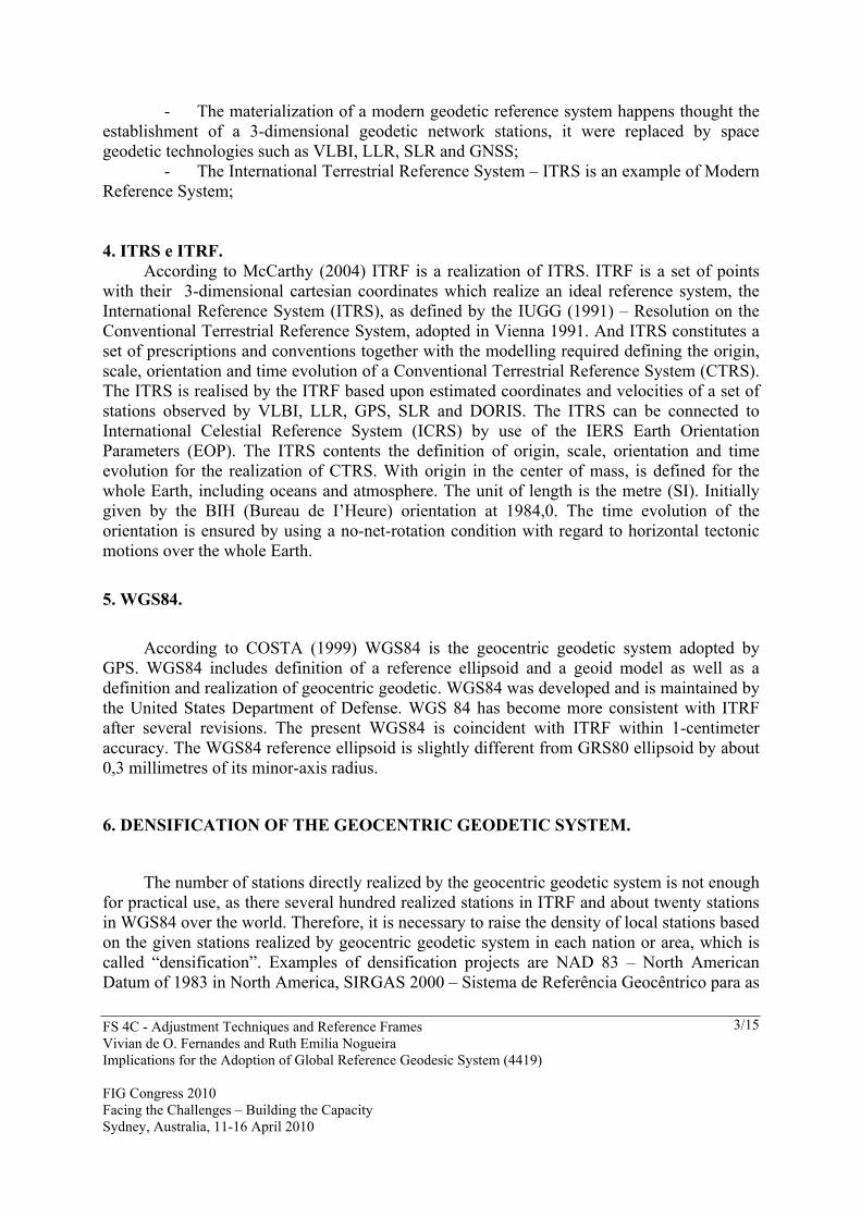
The adoption of the Geocentric Reference System for the Americas is one in such a way polarized. The EUA is creator from GNSS systems. As well as the strong politics influence of U.S.A. in the Caribbean islands and Central America, it made with that these regions adopted also the NAD-83. Through the figure 1, it is verified localization of the stations of SIRGAS 2000 in Americas.
8. A RECENT HISTORY OF GEODETIC DATUMS IN BRAZIL. According to (PING, 2008) from the early 1900's until the 1950´s, geodetic and
mapping work in Brazil was conducted by the Army's Geographical Service. Since then, the responsibility for systematic topographical mapping has been shared with the Brazilian Institute of Geography and Statistics (IBGE), and States and Municipalities have the coordination of cadastral mapping. In terms of geodetic activities, IBGE is the institution responsible for them since then. From about the time IBGE started its work in mapping until the 1980's, Brazil adopted a geodetic datum known as Córrego Alegre (the name comes from the geodetic marker used as the origin), based on the Ellipsoid of Hayford. In the 1980's, the South American Datum of 1969 (known as SAD-69), based on the international ellipsoid of 1967, was defined by law as the official datum to be adopted. In practice, several institutes and agencies kept on using Córrego Alegre (most notably some very important state agencies
FS 4C - Adjustment Techniques and Reference Frames Vivian de O. Fernandes and Ruth Emilia Nogueira Implications for the Adoption of Global Reference Geodesic System (4419) FIG Congress 2010 Facing the Challenges – Building the Capacity Sydney, Australia, 11-16 April 2010
6/15
in the states of São Paulo and Minas Gerais) and still do today, maps are produced in both datums. With GPS era, a network adjustment was carried out, connecting GPS and classical networks. This new realization of the SAD69 has been called SAD-69/96. With this, new maps were created using this realization and causing the change of few metres in a geodetic marker's coordinates. With the suggestion that IBGE took a piecemeal approach to solving the problem, a project to move towards a new, geocentric coordinate frame was proposed by IBGE to the Brazilian community in October 2000, during a Workshop in Rio. The project was called the Projeto Mudança do Referencial Geodésico no Brasil (PMRG) or Project for Changing the Geodetic Reference System in Brazil.
The Workshop II on Geocentric Reference System in Brazil, in November 2004, was the first joint event of the Brazilian/Canadian cooperation project and was the sequence of the Workshop I on Geocentric Reference System in Brazil, in 2000, when IBGE presented the proposal of changing the Brazilian geodetic system to a geocentric one. It counted with representatives of relevant government and private companies, universities and users that deal with geospatial information. With the choice of SIRGAS2000 as the new Brazilian geodetic reference system during the first workshop, the main purpose of the second workshop was to discuss with the community about the possible impacts of SIRGAS2000 implementation, to provide them with all the possible support on the move and to identify demonstration projects in the scope of the PIGN project (PING, 2008).
In January 2005, a federal law was signed defining IBGE as responsible for defining the horizontal and vertical reference systems for geodesy and cartography in Brazil. As a result, in February 2005 a resolution from IBGE´s President officially established SIRGAS2000 as the geodetic reference system for the country and defined a transition period of no more than 10 years when the old and the new systems can be used at the same time. The signatures of these documents were immediately followed by the availability of a new and friendly geodetic database and geoid model with coordinates in both systems to the users. It was also made available on internet were all the presentations from the Workshop II and a document with information about the reference system change.
9. COORDINATES TRANSFORMATIONS BETWEEN DIFFERENT GEODETIC REFERENCE SYSTEMS.
The datum usually consists of one or more origin stations and a best fitting model of the earth (an ellipsoid). Positions in terms of the locally adopted datum are propagated through the country, with varying degrees of accuracy, by survey networks. In the past datums were generally based on one or more astronomically determined positions and the best model of the earth for the local area. However, with modern technology, such as the Global Navigation Satellite System (GPNSS), global datums are now readily accessible.
FS 4C - Adjustment Techniques and Reference Frames Vivian de O. Fernandes and Ruth Emilia Nogueira Implications for the Adoption of Global Reference Geodesic System (4419) FIG Congress 2010 Facing the Challenges – Building the Capacity Sydney, Australia, 11-16 April 2010
7/15
The difference between positions in terms of an individual local datum and positions in terms of a global datum may be of the order of several hundred metres, and may vary considerably even for a single local datum. If the local survey network has variable quality or does not have a continuous landmass, a country may effectively have a number of local datums, requiring a number of different transformations to the global datum.
With the increasing exchange of geographic information local and globally, positions need to be available in terms of both a local and global datums. The process of mathematically converting positions from one datum to the other is known as transformation. 9.1 Transforming Positions
There are a number of ways to mathematically transform positions from one datum to another, but they all require "common points". Common points are surveyed points that have known positions in terms of both the local and the global datum. The achievable accuracy of the datum transformation will be determined by the number, distribution and accuracy of these common points and the transformation technique adopted. Generally speaking, the greater the accuracy required, the more common points are needed.
The common points chosen should be a good sample of the true relationship between the local and global datums. If the local survey network was entirely consistent and regular and was merely offset from the global datum, a single common point would be sufficient to determine this block shift. However, this is a highly unlikely scenario and the more irregular the local survey network, the more common points will be required. A good understanding of the local datum and survey framework is required before a datum transformation can be produced. 9.2 Transformation Methods.
There are many ways of modelling the transformation between two datums, but those in commonly use include:
a) Molodenskys b) 7-Parameter c) Surface Fitting
a) Molodensky’s Formulae:
Molodensky's method is commonly used in hand-held GPS receivers and Geographic Information Systems (GIS). The formulae are simple, assuming that the transformation between the local and global datums can be represented by 5 parameters: a shift at the origin (the earth's centre of mass) along the earth-centred Cartesian coordinate axes (ΔX, ΔY, ΔZ); and the difference between the local and global ellipsoids (semi major axis and flattening). The origin shifts can be determined by an averaging of the same differences at each of the common points and the difference in ellipsoids is a simple subtraction of the ellipsoid parameters
The United States Department of Defense WGS84 Technical report provides Molodensky parameters to transform between many local datums and WGS84. However, the
FS 4C - Adjustment Techniques and Reference Frames Vivian de O. Fernandes and Ruth Emilia Nogueira Implications for the Adoption of Global Reference Geodesic System (4419) FIG Congress 2010 Facing the Challenges – Building the Capacity Sydney, Australia, 11-16 April 2010
8/15
data on which these parameters are based may be very limited and the parameters may have limited accuracy.
Although it depends on the data used, the best accuracy that could be expected from this method would be perhaps 5 metres.
b) 7- Parameter Transformation:
The 7-parameter method assumes a similarity relationship between the local and global datums. The common points are used in a Least Squares process to solve for 7 parameters which represent the relationship between the two datums: origin shifts at the earth's centre of mass (ΔX, ΔY, ΔZ); rotations about each of the axes (Rx, Ry, Rz); and a scale change between the two systems. To be able to solve for these seven parameters a minimum of three common points are required, but in fact many more are needed to reliably model the relationship. Even with many hundreds of common points, the results of a 7-parameter transformation may not be acceptable if the coordinates used are non-homogeneous. In this case, it may be possible to produce separate 7-parameter sets for sub-regions that are more consistent, but even this may not be satisfactory and for consistency, if not for accuracy, it may be necessary to use a more sophisticated method.
Again the accuracy of this method is limited by the data used, but the best that could typically be expected would be a metre or two. c) Surface fitting:
If the neither the Molodensky nor 7-parameter transformation methods are suitable it may be necessary to adopted a method that uses the difference in position at each common point to in effect fit a surface, which can then be used to interpolate the change for other points. This means that there will be a surface for the change in latitude, and another for the change in longitude.
Examples of this type of transformation are the Minimum Curvature method used in the USA (NadCon); the Multiple Regression method used in Canada; and the Collocation method used in Australia.
The Collocation method used in Australia caters for the datum transformation and also distortion in the local survey network, providing improved transformation for derived data sets. Where sufficient quality data has been used, transformation with accuracy of better than 10 cm has been achieved (COLLIER, 2002).
Although initially mathematically complex, the results from this method can be presented to users as a simple file of shifts in terms of latitude & Longitude, on a regular grid, which can be used to interpolate the shifts for any other point. If this grid is provided in a well-accepted format (such as NTv2) the grid file can be immediately used in many GIS packages. 10. CASE STUDY.
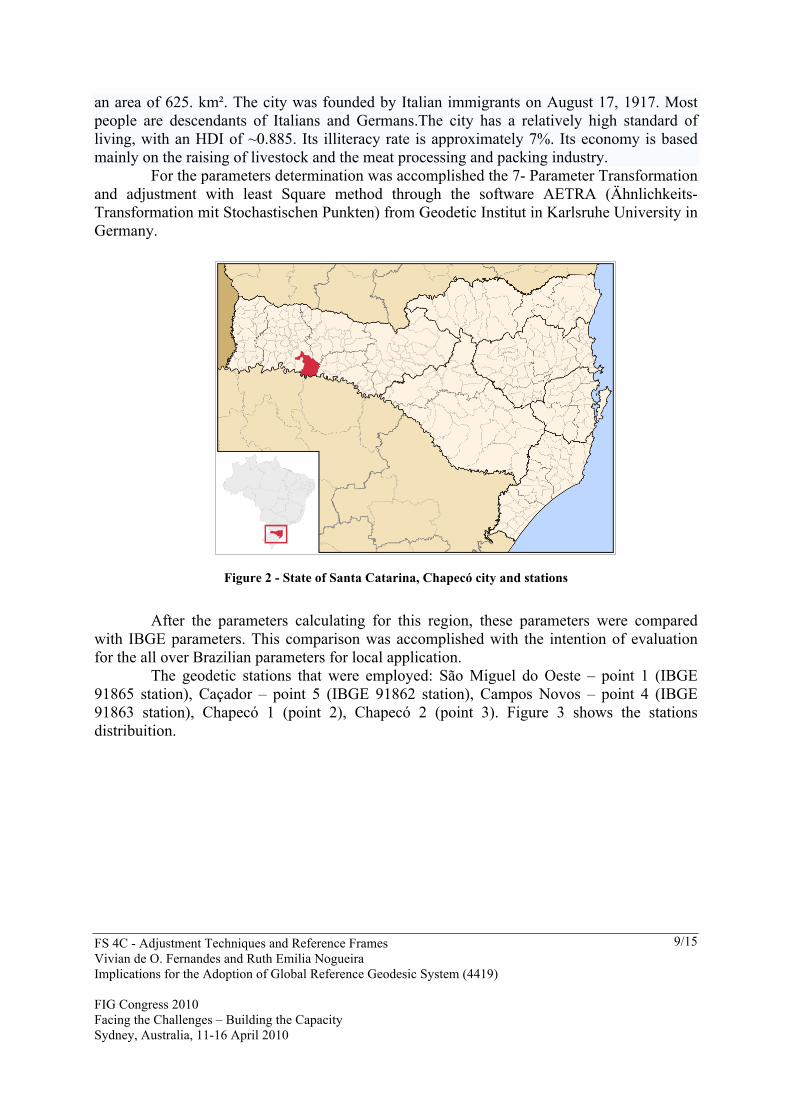
This case study is based on the municipality that is called Chapecó. Chapecó is a major city in the western area of the state of Santa Catarina, Brazil, located 630 km west of Florianópolis, the capital of the state. As of 2004, it has a population of 130,000 inhabitants (96,000 living in the urban area and 34,000 in the surrounding rural areas). The city itself has
FS 4C - Adjustment Techniques and Reference Frames Vivian de O. Fernandes and Ruth Emilia Nogueira Implications for the Adoption of Global Reference Geodesic System (4419) FIG Congress 2010 Facing the Challenges – Building the Capacity Sydney, Australia, 11-16 April 2010
9/15
an area of 625. km². The city was founded by Italian immigrants on August 17, 1917. Most people are descendants of Italians and Germans.The city has a relatively high standard of living, with an HDI of ~0.885. Its illiteracy rate is approximately 7%. Its economy is based mainly on the raising of livestock and the meat processing and packing industry.
For the parameters determination was accomplished the 7- Parameter Transformation and adjustment with least Square method through the software AETRA (Ähnlichkeits-Transformation mit Stochastischen Punkten) from Geodetic Institut in Karlsruhe University in Germany.
Figure 2 - State of Santa Catarina, Chapecó city and stations
After the parameters calculating for this region, these parameters were compared
with IBGE parameters. This comparison was accomplished with the intention of evaluation for the all over Brazilian parameters for local application.
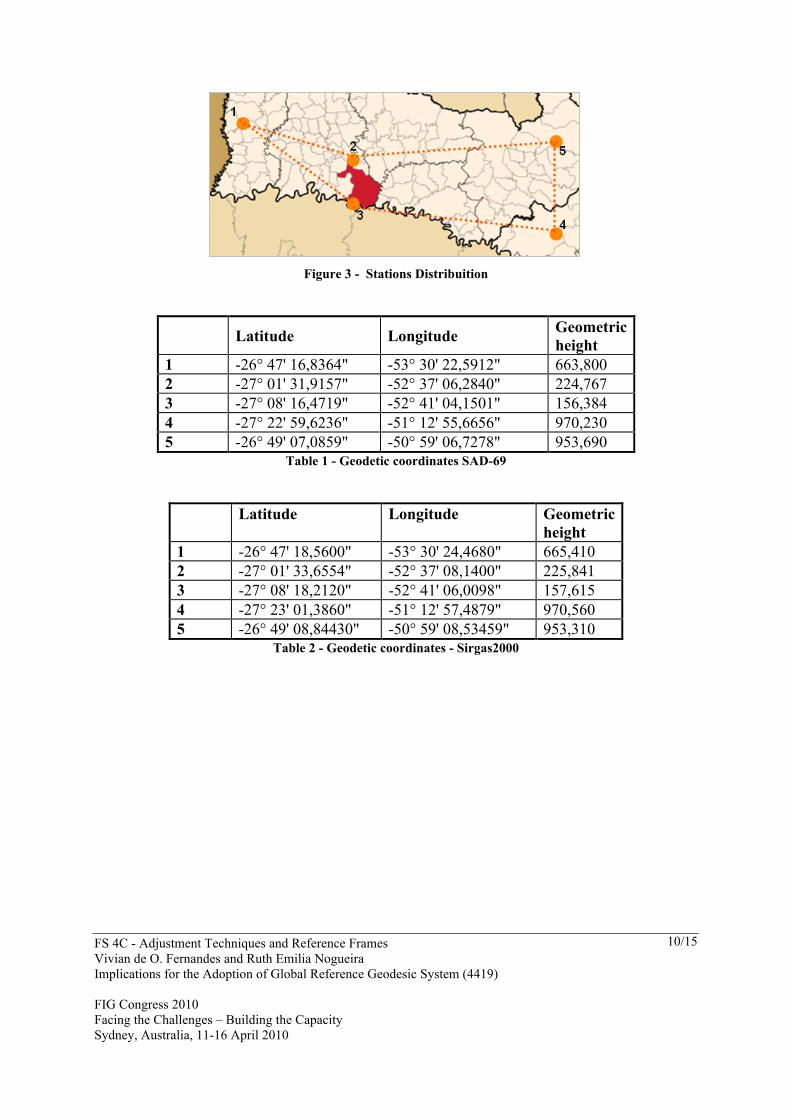
The geodetic stations that were employed: São Miguel do Oeste – point 1 (IBGE 91865 station), Caçador – point 5 (IBGE 91862 station), Campos Novos – point 4 (IBGE 91863 station), Chapecó 1 (point 2), Chapecó 2 (point 3). Figure 3 shows the stations distribuition.
FS 4C - Adjustment Techniques and Reference Frames Vivian de O. Fernandes and Ruth Emilia Nogueira Implications for the Adoption of Global Reference Geodesic System (4419) FIG Congress 2010 Facing the Challenges – Building the Capacity Sydney, Australia, 11-16 April 2010
10/15
Figure 3 - Stations Distribuition
Latitude Longitude Geometric height
1 -26° 47' 16,8364" -53° 30' 22,5912" 663,800 2 -27° 01' 31,9157" -52° 37' 06,2840" 224,767 3 -27° 08' 16,4719" -52° 41' 04,1501" 156,384 4 -27° 22' 59,6236" -51° 12' 55,6656" 970,230 5 -26° 49' 07,0859" -50° 59' 06,7278" 953,690
Table 1 - Geodetic coordinates SAD-69
Latitude Longitude Geometric height
1 -26° 47' 18,5600" -53° 30' 24,4680" 665,410 2 -27° 01' 33,6554" -52° 37' 08,1400" 225,841 3 -27° 08' 18,2120" -52° 41' 06,0098" 157,615 4 -27° 23' 01,3860" -51° 12' 57,4879" 970,560 5 -26° 49' 08,84430" -50° 59' 08,53459" 953,310
Table 2 - Geodetic coordinates - Sirgas2000
FS 4C - Adjustment Techniques and Reference Frames Vivian de O. Fernandes and Ruth Emilia Nogueira Implications for the Adoption of Global Reference Geodesic System (4419) FIG Congress 2010 Facing the Challenges – Building the Capacity Sydney, Australia, 11-16 April 2010
11/15
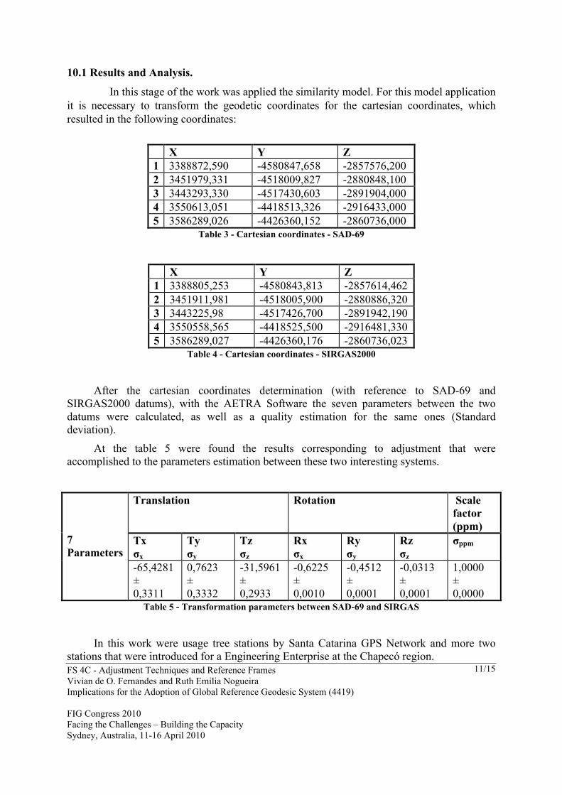
10.1 Results and Analysis.
In this stage of the work was applied the similarity model. For this model application it is necessary to transform the geodetic coordinates for the cartesian coordinates, which resulted in the following coordinates:
X Y Z 1 3388872,590 -4580847,658 -2857576,200 2 3451979,331 -4518009,827 -2880848,100 3 3443293,330 -4517430,603 -2891904,000 4 3550613,051 -4418513,326 -2916433,000 5 3586289,026 -4426360,152 -2860736,000
Table 3 - Cartesian coordinates - SAD-69
X Y Z 1 3388805,253 -4580843,813 -2857614,462 2 3451911,981 -4518005,900 -2880886,320 3 3443225,98 -4517426,700 -2891942,190 4 3550558,565 -4418525,500 -2916481,330 5 3586289,027 -4426360,176 -2860736,023
Table 4 - Cartesian coordinates - SIRGAS2000
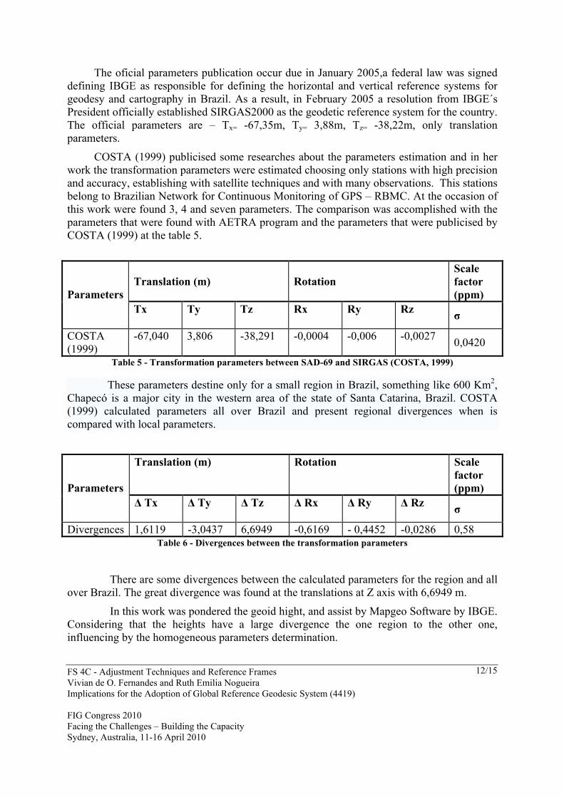
After the cartesian coordinates determination (with reference to SAD-69 and
SIRGAS2000 datums), with the AETRA Software the seven parameters between the two datums were calculated, as well as a quality estimation for the same ones (Standard deviation).
At the table 5 were found the results corresponding to adjustment that were accomplished to the parameters estimation between these two interesting systems.
Translation Rotation Scale factor (ppm)
Tx σx
Ty σy
Tz σz
Rx σx
Ry σy
Rz σz
σppm 7 Parameters
-65,4281 ± 0,3311
0,7623 ± 0,3332
-31,5961 ± 0,2933
-0,6225 ± 0,0010
-0,4512 ± 0,0001
-0,0313 ± 0,0001
1,0000 ± 0,0000
Table 5 - Transformation parameters between SAD-69 and SIRGAS
In this work were usage tree stations by Santa Catarina GPS Network and more two stations that were introduced for a Engineering Enterprise at the Chapecó region.
FS 4C - Adjustment Techniques and Reference Frames Vivian de O. Fernandes and Ruth Emilia Nogueira Implications for the Adoption of Global Reference Geodesic System (4419) FIG Congress 2010 Facing the Challenges – Building the Capacity Sydney, Australia, 11-16 April 2010
12/15
The oficial parameters publication occur due in January 2005,a federal law was signed defining IBGE as responsible for defining the horizontal and vertical reference systems for geodesy and cartography in Brazil. As a result, in February 2005 a resolution from IBGE´s President officially established SIRGAS2000 as the geodetic reference system for the country. The official parameters are – Tx= -67,35m, Ty= 3,88m, Tz= -38,22m, only translation parameters.
COSTA (1999) publicised some researches about the parameters estimation and in her work the transformation parameters were estimated choosing only stations with high precision and accuracy, establishing with satellite techniques and with many observations. This stations belong to Brazilian Network for Continuous Monitoring of GPS – RBMC. At the occasion of this work were found 3, 4 and seven parameters. The comparison was accomplished with the parameters that were found with AETRA program and the parameters that were publicised by COSTA (1999) at the table 5.
Translation (m) Rotation Scale factor (ppm) Parameters
Tx
Ty
Tz
Rx
Ry
Rz σ
COSTA (1999)
-67,040
3,806
-38,291
-0,0004
-0,006
-0,0027 0,0420
Table 5 - Transformation parameters between SAD-69 and SIRGAS (COSTA, 1999)
These parameters destine only for a small region in Brazil, something like 600 Km2, Chapecó is a major city in the western area of the state of Santa Catarina, Brazil. COSTA (1999) calculated parameters all over Brazil and present regional divergences when is compared with local parameters.
Translation (m) Rotation Scale factor (ppm) Parameters
Δ Tx
Δ Ty
Δ Tz
Δ Rx
Δ Ry
Δ Rz σ
Divergences 1,6119 -3,0437 6,6949 -0,6169 - 0,4452 -0,0286 0,58 Table 6 - Divergences between the transformation parameters
There are some divergences between the calculated parameters for the region and all over Brazil. The great divergence was found at the translations at Z axis with 6,6949 m.
In this work was pondered the geoid hight, and assist by Mapgeo Software by IBGE. Considering that the heights have a large divergence the one region to the other one, influencing by the homogeneous parameters determination.
FS 4C - Adjustment Techniques and Reference Frames Vivian de O. Fernandes and Ruth Emilia Nogueira Implications for the Adoption of Global Reference Geodesic System (4419) FIG Congress 2010 Facing the Challenges – Building the Capacity Sydney, Australia, 11-16 April 2010
13/15
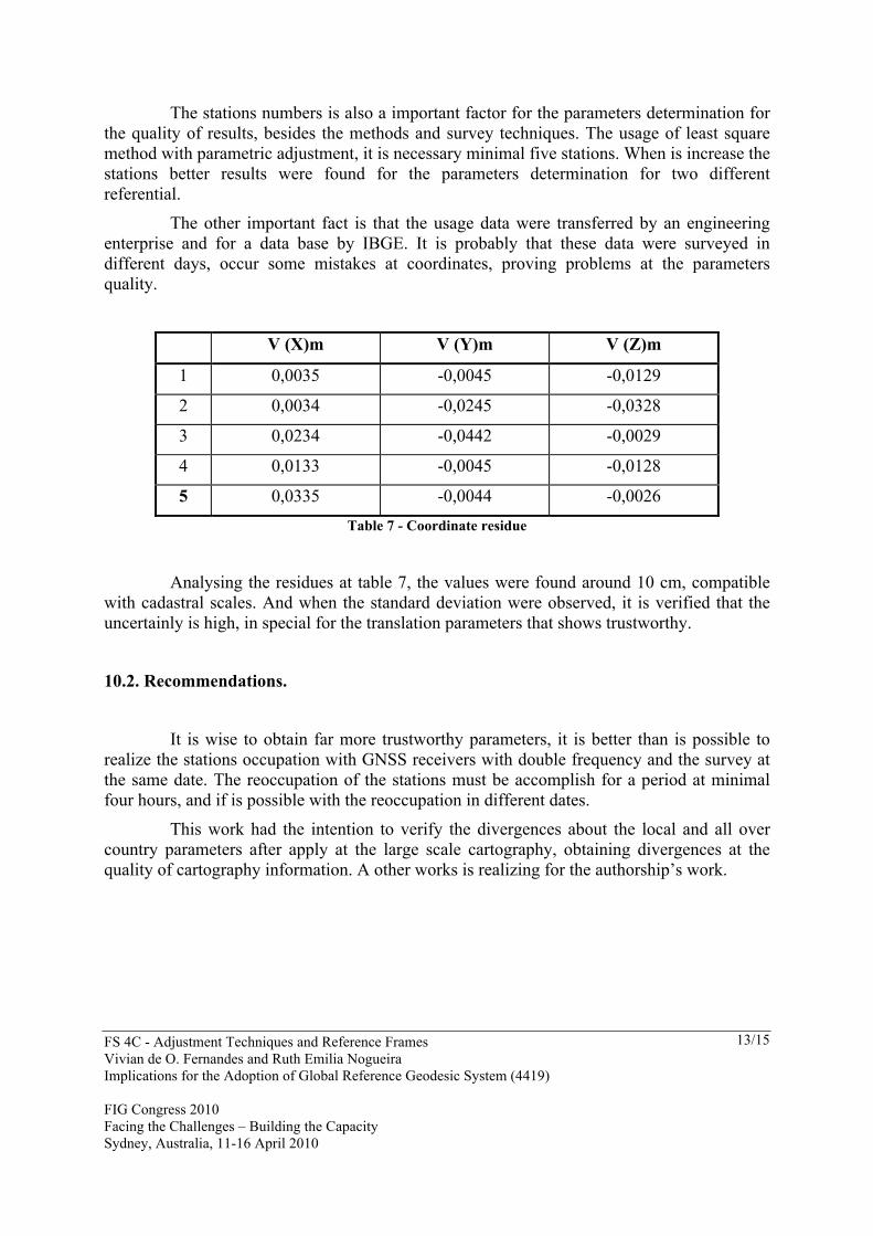
The stations numbers is also a important factor for the parameters determination for the quality of results, besides the methods and survey techniques. The usage of least square method with parametric adjustment, it is necessary minimal five stations. When is increase the stations better results were found for the parameters determination for two different referential.
The other important fact is that the usage data were transferred by an engineering enterprise and for a data base by IBGE. It is probably that these data were surveyed in different days, occur some mistakes at coordinates, proving problems at the parameters quality.
V (X)m V (Y)m V (Z)m
1 0,0035 -0,0045 -0,0129
2 0,0034 -0,0245 -0,0328
3 0,0234 -0,0442 -0,0029
4 0,0133 -0,0045 -0,0128
5 0,0335 -0,0044 -0,0026 Table 7 - Coordinate residue
Analysing the residues at table 7, the values were found around 10 cm, compatible with cadastral scales. And when the standard deviation were observed, it is verified that the uncertainly is high, in special for the translation parameters that shows trustworthy.
10.2. Recommendations.
It is wise to obtain far more trustworthy parameters, it is better than is possible to realize the stations occupation with GNSS receivers with double frequency and the survey at the same date. The reoccupation of the stations must be accomplish for a period at minimal four hours, and if is possible with the reoccupation in different dates.
This work had the intention to verify the divergences about the local and all over country parameters after apply at the large scale cartography, obtaining divergences at the quality of cartography information. A other works is realizing for the authorship’s work.
FS 4C - Adjustment Techniques and Reference Frames Vivian de O. Fernandes and Ruth Emilia Nogueira Implications for the Adoption of Global Reference Geodesic System (4419) FIG Congress 2010 Facing the Challenges – Building the Capacity Sydney, Australia, 11-16 April 2010
14/15
REFERENCES ALBRECHT, C. (1999) Die Zusammenf´hrung von Daten mit raumbezug aus dem Grenzgebit zwischen dem Saarland und Frankreich. Universität karlsruhe. Geodätisches Institut.
COLLIER P. (2002) Development of Australia’s National GDA94 Transformation Grids. Consultant’s Report, Dept. of Geomatics, The University of Melbourne, Australia, 36p.
CASACA, J. M. BAIO, M. (2000) Topografia Geral. Lidel Ed. Tecnicas. Lisboa.
CASTANEDA, R. M. (1986) Ensaio para definição de parâmetros de transformação entre o SAD-69 e o NSWC-9Z2. UFPR. Curso de Pós Graduação em Ciências Geodésicas. Curitiba,
CASTRO, A. L. P.; PEREZ, José Aurélio da Silva ; ESPINHOSA, M. L. ; MARINI, Márcia Cristina ; MONICO, J F G.; CAMARGO. (2001) Estimativa de parâmetros de transformação entre sistemas geodésicos: estudo do caso SAD69 e SIRGAS.. In: Série em Ciências Geodésicas. 1 ed. Curitiba: Curso de pós-graduação em Ciências Geodésicas, v. 1, p. 62-81
COSTA, M. F.; SANTOS, M. C. (1998) Compatibilização entre Sistemas Geodésicos. Cobrac 98. Florianópolis.
COSTA, S. M. A. (1999) Integração da rede geodésica brasileira aos sistemas de referência terrestres. Tese. Universidade Federal do Paraná. Curitiba.
COSTA, S. M. A.; LIMA, M. A. A. (2005) Ajustamento da rede planimétrica brasileira em SIRGAS2000. IV Colóquio Brasileiro de Ciências Geodésicas - IV CBCG. Curitiba.
DALAZOANA, R.; FREITAS, S. R. C. de. (2000) Efeitos na Cartografia devido a Evolução do Sistema Geodésico Brasileiro e Adoção de um Referencial Geocêntrico. UFPR. Curitiba – PR.
FRANÇOSO, Maria Teresa; SEGANTINE, Paulo César Lima; LOPES, Segundo Carlos. (2005) Necessidade de Conhecimento da Evolução Cartográfica para Aplicações em Cadastro Urbano., 09/2005, XXII Congresso Brasileiro de Cartografia,Vol. 1, pp.1-3, MACAÉ, RJ, Brasil.
HARVEY B.R. (1986) Transformation of 3-D Coordinates. The Australian Surveyor, 32, 105−125.
IBGE. (2003) Sistemas de Referência em Geodésia. Departamento de Geodésia. Instituto Brasileiro de Geografia e Estatística. Rio de Janeiro.
OLIVEIRA, L. C.; FERREIRA, L. F.; BLITYKOW, D. (1995) Um estudo particular sobre a transformação SAD-69 e WGS-84. Congresso Brasileiro de Cartografia. Salvador.
PACILÉO NETO, N.; BLITZKOW, Denizar; NERO, Marcelo Antonio; FONSECA JÚNIOR, Edvaldo Simões da; CINTRA, Jorge Pimentel; ARAÚJO, S. C. (2003) Metodologia para integração de diferentes redes geodésicas para atualização cartográfica: Estudo de caso em concessionária de energia elétrica.. Revista Ieee America Latina, São Paulo, v. 1, n. 1.
FS 4C - Adjustment Techniques and Reference Frames Vivian de O. Fernandes and Ruth Emilia Nogueira Implications for the Adoption of Global Reference Geodesic System (4419) FIG Congress 2010 Facing the Challenges – Building the Capacity Sydney, Australia, 11-16 April 2010
15/15
PING (2008) Projeto de Infra-estrutura Geoespacial Nacional. Canadá-Brasil. Acesso em 03.01.2008.
SALOMONI, C. S.; SOUZA, S. F. (2006) Determinação de Parâmetros de transformação entre os data Carta Geral (CG) e South American Datum 1969 (SAD69) para a Região de Porto Alegre/RS. Cobrac 2006. Florianópolis.
TORGE, W. (2001) Geodesy. 3º ed. Ed. De Gruyter. Berlin, New York.
VANICEK, P.; KRAKIWSKY, E. J. (1996) Geodesy: the Concepts. Second Ed. North-Holland. Amsterdam.
VANSCONCELOS, G. A. de. (2005) Desenvolvimento dos Sistemas referenciais Geodésicos e suas Conseqüências no Mapeamento Topográfico Sistemático Brasileiro. PPGEC-UFRJ. Rio de Janeiro.
CONTACTS Vivian de O. Fernandes UFBA Aristides Novis, 02 Salvador Brazil Tel. +55 71 32833 9826 Web site: www.geodesia.ufba.br