Embed Size (px)
Citation preview

Page 1
CSISSCenter for Spatial Information Science and Systems
06/27/2006
Center for Spatial Information Science and Systems (CSISS)
George Mason University (GMU)
Implementation of Geospatial Product Virtualization
in Grid Environment
Liping Di, Aijun Chen, Yuqi Bai, and Yaxing Wei
Dr. Aijun Chen
Page 2
CSISSCenter for Spatial Information Science and Systems
06/27/2006
Outline
Introduction
Open Geospatial Consortium (OGC) Web Services
Geospatial Grid Services
Abstract Model and Grid Services Workflow
System Architecture of Geospatial Grid Framework
Testbed and System Implementation
Conclusion
Future Vision
Page 3
CSISSCenter for Spatial Information Science and Systems
06/27/2006
Introduction
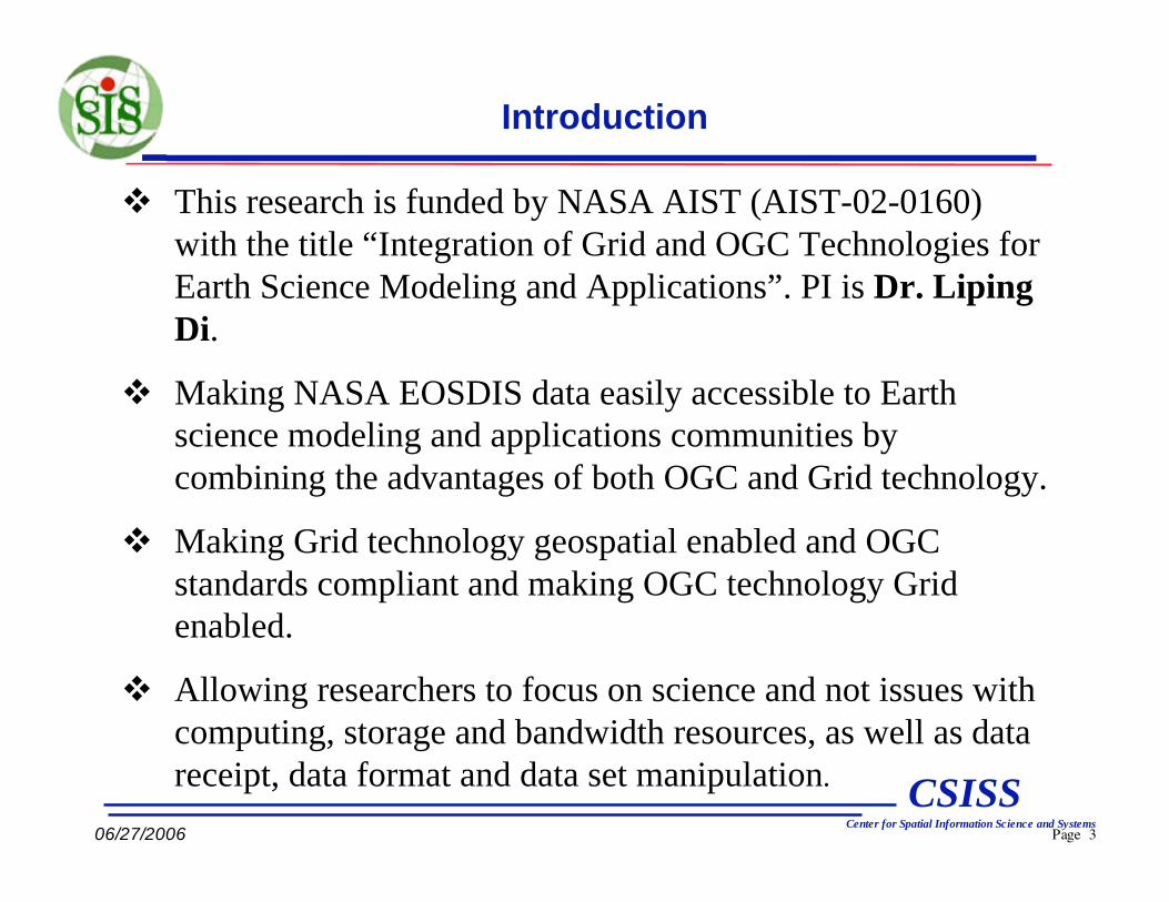
This research is funded by NASA AIST (AIST-02-0160)
with the title “Integration of Grid and OGC Technologies for
Earth Science Modeling and Applications”. PI is Dr. Liping
Di.
Making NASA EOSDIS data easily accessible to Earth
science modeling and applications communities by
combining the advantages of both OGC and Grid technology.
Making Grid technology geospatial enabled and OGC
standards compliant and making OGC technology Grid
enabled.
Allowing researchers to focus on science and not issues with
computing, storage and bandwidth resources, as well as data
receipt, data format and data set manipulation.

Page 4
CSISSCenter for Spatial Information Science and Systems
06/27/2006
Introduction (Cont.)
The project has two major work items:
1) Enable to access real data in the Grid environment with
OGC protocols.
2) Study the approach for geospatial product virtualization in
the Grid environment and develop a prototype.
Try to establish a service-oriented geospatial standard-
compliant Grid framework for users to build up their specific
application abstract model, execute it and get back their
desired data products virtually through utilizing the OGC
standard services and data and computing resources provided
by Grid technologies.

Page 5
CSISSCenter for Spatial Information Science and Systems
06/27/2006
The OGC Web Services
The Web Coverage Services (WCS) specification: defines the standard
interfaces between web-based clients and servers for accessing
coverage data.
-- All imagery type of remote sensing data is coverage data.
The Web Feature Services (WFS) specification: defines the standard
interfaces between web-based clients and servers for accessing feature-
based geospatial data.
-- vector and point data are feature data.
The Web Map Services (WMS) specification: define the standard
interfaces for accessing and assembling maps from multiple servers.
-- visualization of geospatial data
The Catalog Services for Web (CS/W) specification: defines the
interfaces between web-based clients and servers for finding the
required data or services from registries. It’s based on the ebRIM.
WCS, WMS, CSW, and WFS form the foundation for the interoperable
geospatial data access and service environment.
The Grid-enabled standard Portals for the above OGC services.

Page 6
CSISSCenter for Spatial Information Science and Systems
06/27/2006
Design of the Information Model (IM) of CS/W
RegistryObject
Classification
ClassificationSchema
……
Association
ServiceBindings
RegistryEntry
Service
ExtrinsicObject
CSWExtrinsicObject
RepositoryItem
Service IM (ISO 19119)
Dataset IM (ISO 19115)
NASA EOS Core System (ECS)
ebRIM + OGC Catalogue Service for Web + OGC Catalogue Service for ISO 19115/19119
Extension of OGC CS/W for geospatial resources
Slot
Page 7
CSISSCenter for Spatial Information Science and Systems
06/27/2006
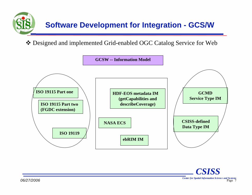
Software Development for Integration - GCS/W
Designed and implemented Grid-enabled OGC Catalog Service for Web
ISO 19115 Part one
ISO 19115 Part two
(FGDC extension)
NASA ECS
ISO 19119
ebRIM IM
HDF-EOS metadata IM
(getCapabilities and
describeCoverage)
GCMD
Service Type IM
CSISS-defined
Data Type IM
GCSW -- Information Model

Page 8
CSISSCenter for Spatial Information Science and Systems
06/27/2006
Design of Data Registration of CS/W
HDF File
(MODIS,
ASTER, …)
ECS – ISO
Mapping Table
XML File
(Based on
ISO19139)
Template
XML File
(Based on
ISO19139)
ECS Metadata
Key/Value
Read
out
MapISO Metadata
Key/ValueModify
1
2 3
a b
a
b
Create a mapping table between ECS metadata and ISO19139 metadata. Store it in MySQL database.
Create a template XML file based on the selected ISO19139 schemas.Pre-steps
1
2
3
Read out the ECS metadata from HDF files (MODIS, ASTER, …).
Map the ECS metadata elements to ISO elements according to the selected ISO19139 schemas.
Modify the template XML file by inserting the mapped ISO elements.
Steps

Page 9
CSISSCenter for Spatial Information Science and Systems
06/27/2006
Geospatial Grid Services and other Grid services
Grid-enabled Catalog Service for Web (GCS/W)
Grid-enabled Catalog Service Federation (GCSF)
Grid-enabled Web Coverage Service (GWCS)
Grid-enabled Web Map Service (GWMS)
Intelligent Grid Service Mediator (iGSM)
Replica and Optimization Service (ROS)
Data Transfer Service (DTS)
BPEL-compliant Grid INstantiation Service(GINS)
BPEL-compliant Grid Workflow Engine Service (GWES)
Other Grid Services for application

Page 10
CSISSCenter for Spatial Information Science and Systems
06/27/2006
Globus MDS IM
Hostname
Memory
CPU ……
Grid Enabled Catalogue Service for Web (GCS/W)
Integration of Information Model of CS/W and Grid RLS/MDS
Extended CS/W IM
repositoryItem
Dataset Metadata IM
UUID (logical ID)
ProductName
ProductDateTime
……
Globus RLS IM
ID
Logical File Name
Physical File Name
Client Requester
Send:
Data requirement
Obtain:
An optimal data service
among the VO.
Legend
IM – Information Model
CS/W – Catalogue Service for Web
RLS – Replica Location Service
MDS – Monitoring & Discovery Service
VO – Virtual Organization
Page 11
CSISSCenter for Spatial Information Science and Systems
06/27/2006
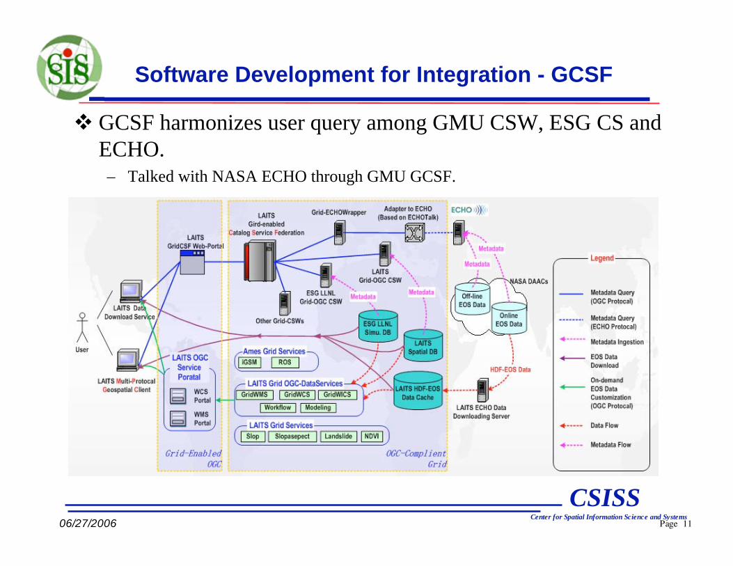
Software Development for Integration - GCSF
GCSF harmonizes user query among GMU CSW, ESG CS and
ECHO.
– Talked with NASA ECHO through GMU GCSF.

Page 12
CSISSCenter for Spatial Information Science and Systems
06/27/2006
(iGSM: intelligent Grid Service Mediator)
Support WCS portal, WMS portal and Grid Virtual WCS to distribute their
request to proper GWCS and GWMS.
Intelligent Grid Service Mediator (iGSM)
WCS Portal
GCSF
GVWCS
GWMS
iGSM
ROS MDS
DTS
WMS Portal

Page 13
CSISSCenter for Spatial Information Science and Systems
06/27/2006
Replica and Optimization Service (ROS)
Globus RLS as Grid Service
Replica and Optimization Service
Globus Index service
Globus MDS scripts modification
LRC (Laits) LRC (Laits-data) LRC (Ames/LLNL)
RLI (Laits) RLI (Laits-data)
ROS
RLS Index Service (MDS)
Page 14
CSISSCenter for Spatial Information Science and Systems
06/27/2006
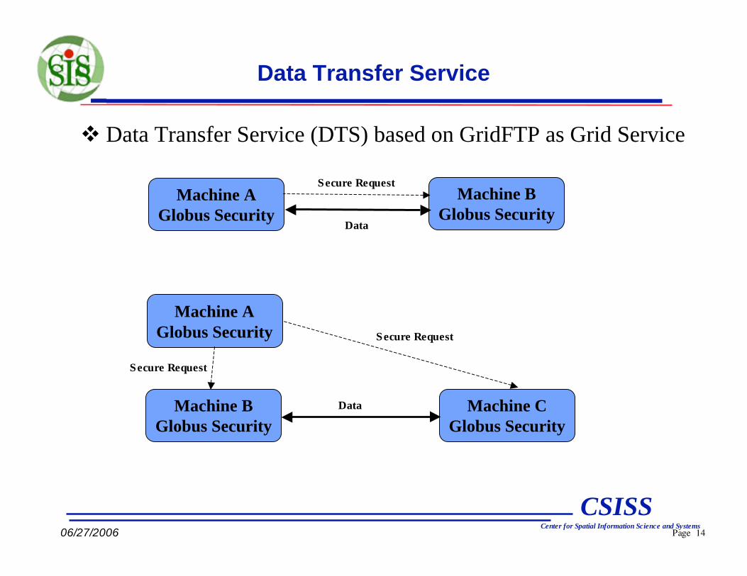
Data Transfer Service (DTS) based on GridFTP as Grid Service
Data Transfer Service
Machine A
Globus Security
Machine B
Globus Security
Machine B
Globus Security
Machine C
Globus Security
Machine A
Globus Security
Data
Secure Request
Secure Request
Data
Secure Request

Page 15
CSISSCenter for Spatial Information Science and Systems
06/27/2006
Concept Models of Virtual Data Products (VDP)
Archived geo-object
User geo-object
Intermediate geo-object Automated data transformation service(WCS/WFS)
no service data servicemodeling and virtual data services
User Requested
User Obtained
Geospatial web/Grid services

Page 16
CSISSCenter for Spatial Information Science and Systems
06/27/2006
Design of Abstract Model for Modeling VDP
Information Model of VDP
• DTC: Data Type Catalogue. Data are classified into type based on their
scientific meaning. e.g. DEM, Slope, SlopeAspect, Landslide etc.
• STC: Service Type Catalogue. Services are classified into service types
based on their scientific meanings. e.g. DEM2Slope, DEM2SlopeAspect,
SlopeAspect2Landslide, DEM2Landslide etc.
DataType
ServiceType
DataType
output
input
ServiceType
DataType
ServiceInstance
DataInstance
decides
associates to
associates to
associates to
GVWCSInstance
uses Real Data
Virtual Data
proce
ss
Page 17
CSISSCenter for Spatial Information Science and Systems
06/27/2006
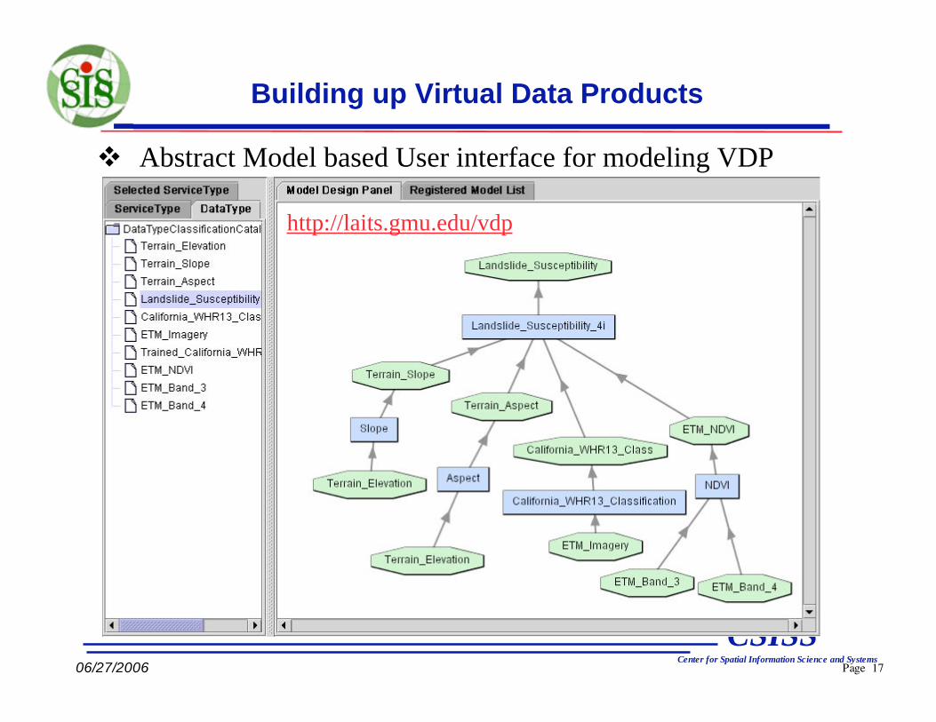
Building up Virtual Data Products
Abstract Model based User interface for modeling VDP
http://laits.gmu.edu/vdp
Page 18
CSISSCenter for Spatial Information Science and Systems
06/27/2006
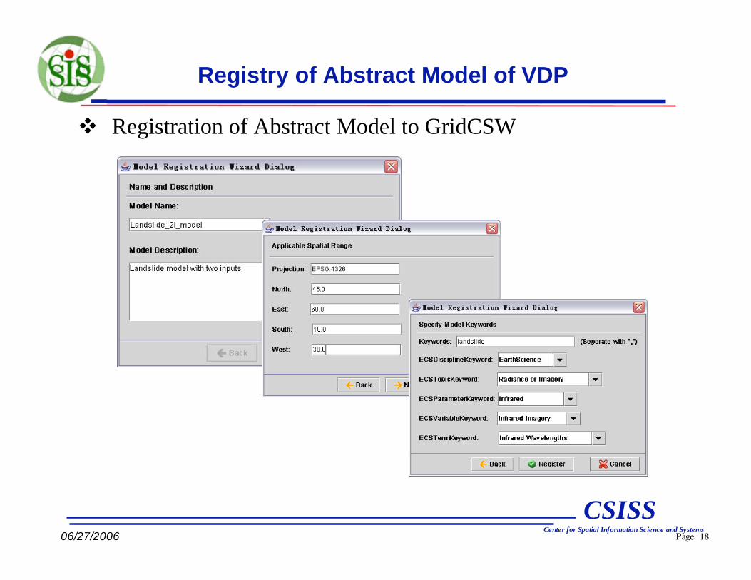
Registry of Abstract Model of VDP
Registration of Abstract Model to GridCSW
Page 19
CSISSCenter for Spatial Information Science and Systems
06/27/2006
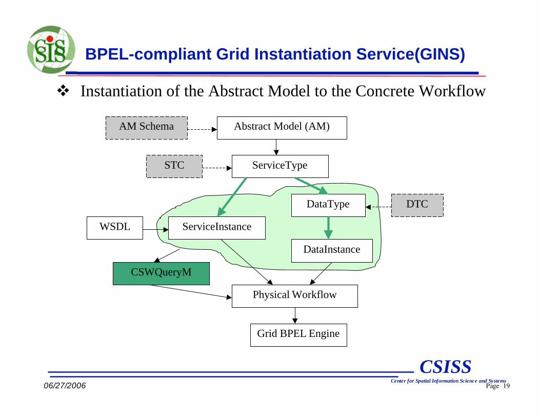
BPEL-compliant Grid Instantiation Service(GINS)
Instantiation of the Abstract Model to the Concrete Workflow
Abstract Model (AM)
ServiceType
ServiceInstanceWSDL
DataType
DataInstance
AM Schema
STC
DTC
Physical Workflow
Grid BPEL Engine
CSWQueryM

Page 20
CSISSCenter for Spatial Information Science and Systems
06/27/2006
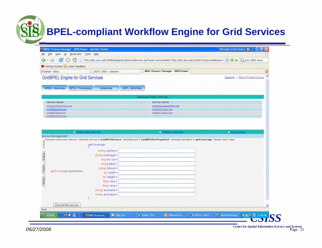
Design BPEL-compliant Grid Workflow Engine Service (GWES)
BPEL engine architecture – Execute Grid Services with
Standard BPEL workflows.
ActivitiesBPEL Processes InstancesWSDL Services
BPEL Process Manager
BPELPower
Instantiation
Logic
Process
Model
Deployment
As a server
or middlewareAs a service
Browser-oriented clients
Service-oriented clients
Page 21
CSISSCenter for Spatial Information Science and Systems
06/27/2006
BPEL-compliant Workflow Engine for Grid Services

Page 22
CSISSCenter for Spatial Information Science and Systems
06/27/2006
Grid Services for Materialization of VDP
Existed Geospatial Grid services for modeling VDP
• GWCS; GWMS
• GCS/W; GCSF
• GWICS (Grid-enabled WICS)
• GWCTS (Grid-enabled WCTS)
Other Grid Services
• iGSM; ROS; DTS, GINS, GWES
For the prototype demonstration of VDP, additional Grid service
instances have been developed
• GridSlope
• GridAspect
• GridCalifornia_WHR3_Classification
• GridNDVI
• GridLandslide_Susceptibility_2i
• GridLandslide_Susceptibility_4i

Page 23
CSISSCenter for Spatial Information Science and Systems
06/27/2006
System Architecture of Geospatial Grid Framework
Diagram of user request and data workflow
Globus Toolkit 4.0/4.0.1 with GSI
HDF-EOS
DataOther
Data
NetCDF
Data
LAITS WCS
Portal
CSW Portal
Client
V+
V+
+ default WCS/WMS portal IP
V+
V+
Other WCS
LAITS
GridCSW
GCSF
GESGCS
LAITS WMS
Portal
ECHO
Catalog
V+
V+
V+
Real data request
Ames
GridWCSAmes
DTSRLS
ROS
MDS
iGSM
LLNL
GridWCS
LAITS
GridWCS
V+
V+
V+
11
VGVWCS
VGWES
GridWICS
GridWCTS
VGrid Tier
Real data
request
OGC Tier
User Tier
Page 24
CSISSCenter for Spatial Information Science and Systems
06/27/2006
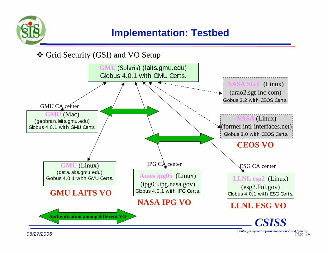
Implementation: Testbed
GMU (Solaris) (laits.gmu.edu)
Globus 4.0.1 with GMU Certs.
GMU (Mac)(geobrain.laits.gmu.edu)
Globus 4.0.1 with GMU Certs.
GMU CA center
Ames ipg05 (Linux)
(ipg05.ipg.nasa.gov)Globus 4.0.1 with IPG Certs.GMU LAITS VO
NASA IPG VO
GMU (Linux)(data.laits.gmu.edu)
Globus 4.0.1 with GMU Certs.
IPG CA center
NASA SGT (Linux)
(arao2.sgt-inc.com)Globus 3.2 with CEOS Certs.
NASA (Linux)
(former.intl-interfaces.net)Globus 3.0 with CEOS Certs.
CEOS VO
Authentication among different VO
LLNL esg2 (Linux)
(esg2.llnl.gov)Globus 4.0.1 with ESG Certs.
LLNL ESG VO
ESG CA center
Grid Security (GSI) and VO Setup
Page 25
CSISSCenter for Spatial Information Science and Systems
06/27/2006
Conclusion
The Grid service-oriented approach to serving geospatial data is a
promising strategy for establishing an open, wide and secure system that
securely provides access to huge volumes of distributed geospatial
data/information through querying geospatial catalogs.
Devised a new geospatial abstract information model for virtually
building up geospatial application abstract model.
Implemented a BPEL-compliant Grid service workflow engine for
executing concrete workflow which is expressed in standard BPEL.
Applied the abstract model to Grid environment and concrete it to Grid-
service workflow and execute it with Grid Workflow Engine.
Implements a prototype system that demos a landslide virtual data
products.
Page 26
CSISSCenter for Spatial Information Science and Systems
06/27/2006
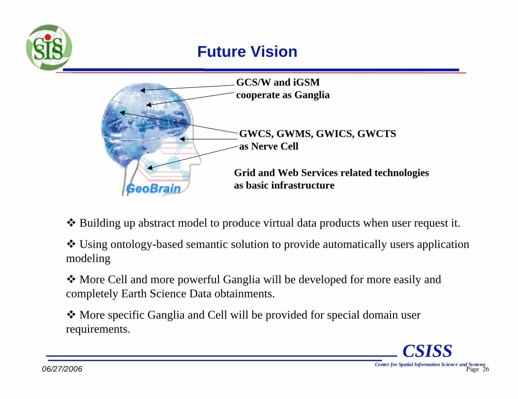
Future Vision
GCS/W and iGSM
cooperate as Ganglia
GWCS, GWMS, GWICS, GWCTS
as Nerve Cell
Grid and Web Services related technologies
as basic infrastructure
Building up abstract model to produce virtual data products when user request it.
Using ontology-based semantic solution to provide automatically users application
modeling
More Cell and more powerful Ganglia will be developed for more easily and
completely Earth Science Data obtainments.
More specific Ganglia and Cell will be provided for special domain user
requirements.
Page 27
CSISSCenter for Spatial Information Science and Systems
06/27/2006
Thank You !
Any Questions ?