Embed Size (px)
Citation preview

Image: Florida Keys, FL | July 5, 2011 | 50cm DigitalGlobe Proprietary and Business Confidential
Kumar Navulur, PhD
Imagery Applications in Mining and
Exploration

www.digitalglobe.com 2 4/24/2012
Imagery Impacts Many Groups Within A Mining and Exploration Organization
Feasibility Studies • Determine the best
development approach considering all aspects of the surrounding location
Geological and Structural Mapping • Identifying subsurface geology
which correlates to mineralogy or geophysics
Reclamation Management • Planning and monitoring
reclamation progress • Manage surface water plans,
wetland plans, and other aspects of an EIS
Geotechnical Assessment & Slope Stability Assessment
• Determine how terrain interacts with proposed development
• Analyze cut or fill scenarios from the original topography
Exploration and Navigation • Determining location of existing infrastructure such as roads and
railway and accessibility to operational sites • Distribution of equipment and personnel to remote locations
Resource Calculations • Determine how much of a given ore is
present or has been removed
The Mining Lifecycle

www.digitalglobe.com 3 4/24/2012
Some Use Cases for Imagery
• DigitalGlobe imagery has been used in mining applications:
Exploration and Planning
Environmental Compliance and Reclamation
Asset Management
Mine Operations
Cerro Colorado Open Pit Copper Cathode Mine, Chile – 2007 and 2008

www.digitalglobe.com 4 4/24/2012
Exploration
Exploration and Planning Mine Operations Asset Management
Environmental Compliance and Reclamation
Imagery supports exploration strategies in remote, mountainous and hostile areas worldwide that would otherwise be costly to research. Geologists can study multispectral images to analyze topographic surface features in conjunction with geological data to predict subsurface geology.

www.digitalglobe.com 5 4/24/2012
Potential Geologic Applications using WV2 and WV3
New SWIR bands on WV3 ideal for mineralogy. Aid in identify potential minerals and rocks for mining exploration

www.digitalglobe.com 6 4/24/2012
Natural Color - RGB Traditional VNIR bands have spectral overlap between various minerals limiting the use of these bands for geologic applications
Natural Color (Red, Green ,Blue) Lunar Lake, Nevada Simulated WV-2 data. Data source AVIRIS

www.digitalglobe.com 7 4/24/2012
Potential Cuprites Location
Now you are viewing the same area with the band combination of NIR2, yellow and coastal. The addition of Yellow and Coastal bands for visual spectral discrimination of certain minerals
NIR2, Yellow, Coastal Bands Lunar Lake, Nevada Simulated WV-2 data. Data source AVIRIS

www.digitalglobe.com 8 4/24/2012
Mine Operations
Exploration and Planning Mine Operations Asset Management
Environmental Compliance and Reclamation
Base map imagery allows geologist to plan drilling within targeted areas and extract locations and features such as roads, pipelines, water resources, electric lines, and facilities. Imagery also provides historical perspective and document changes over time.
www.digitalglobe.com 9 4/24/2012
Stereo Pair: Terrain Analysis and Elevation Models
• WorldView Satellites have the agility and capacity to collect large areas in stereo.
• From our stereo pair, elevation, 3D and terrain surface models can be
created for analysis of mining site volumetric (e.g. open pits, leach pads and waste dump)
• Accuracies achieved with WorldView-1 generated DEM: 25 to 50 cm
relative vertical accuracy and 1 meter absolute vertical accuracy (LE 90).
La Herradura Gold Mine, Sonora Mexico

www.digitalglobe.com 10 4/24/2012
Environmental Monitoring
Exploration and Planning Daily Operations Asset Management
Environmental Compliance and Reclamation
Imagery used during pre-planning allows engineers to implement control measures for air, noise, land, and water pollution to ensure compliance with local government regulations and minimize impacts to surrounding areas.
Near-infrared band is essential for analyzing the impact to surrounding vegetation and the effects of daily mining activities especially areas of underground mining.

www.digitalglobe.com 11 4/24/2012
Reclamation
Imagery of varying dates reflects progress of extensive rehabilitation measures for the land, post mining, in order to meet agreed and appropriate local government standards. Imagery is a cost-effective and efficient way of monitoring changes in vegetation and disturbance over time for both underground and open-cut mining.
Exploration and Planning Mine Operations Asset Management
Environmental Compliance and Reclamation
www.digitalglobe.com 12 4/24/2012
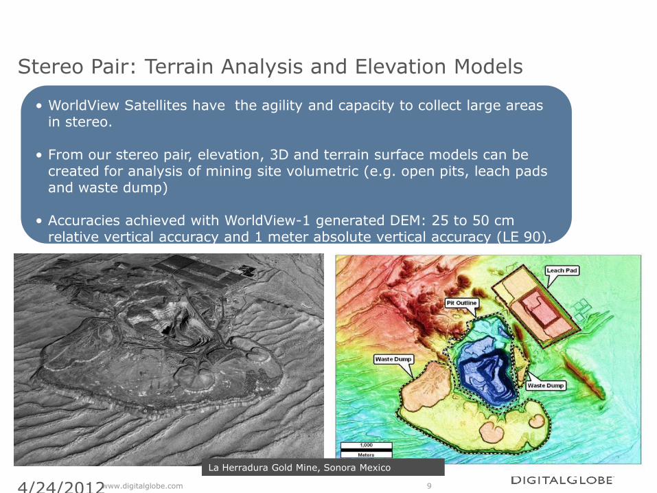
Asset Management
Exploration and Planning Mine Operations Asset Management
Environmental Compliance and Reclamation
Planned production, location of reserves, and costs can be linked to prospective and active mine locations Imagery can be easily annotated to represent regional mines, prospect and regional geological data. With our imagery easily integrated with leading GIS software, we can provide a backdrop for a map with links to associated data layers and tables.
Summary
• Satellite Remote Sensing is a complementary technology for mining and exploration
• Imagery and derived information can be used any multiple stages of the life cycle
• Worldview3 SWIR bands open up additional opportunities for imagery applications in this industry
www.digitalglobe.com 13 4/24/2012