Embed Size (px)
Citation preview

/ k ?a
FEASIBILTY STUDY GRANT PROGRAM
I. Grant Information
Study Name: Banks-Green Mountain ASR Feasibilitv Studv
Type of Feasibility Study: 0 Water Conservation [] Reuse 0 Above-Ground Storage§ Storage Other Than Above-Ground [?ncluding Aquifer Storage and Recovery (ASR)]
Program Funding Dollars Requested: $ 102,191.00Note: Request may not exceed $500,000
Total Cost of Feasibility Study: $ 204,382.00
II. Applicant Information
Certification:
I certify that this application is a true and accurate representation of the proposed work for a project feasibility study and that Iam authorized to sign as the Applicant or Co-Applicant. By the following signature, the Applicant certifies that they are awareof the requirements of an Oregon Water Resources Department grant, have read and agree to all conditions within the samplegrant agreement and are prepared to conduc.??i$ feasibility study if awarded.
/?'l,.
, .-J.%
Applicant Signature: , :-'9?- ' Date:?2/]/2016l- 0%
Print Name: jolvnn Becker Title: City Manager
III. Feasibility Study SummaryPlease give a brief summary of the feasibility study using no more than 150 words.The City proposes to assess feasibility of ASR, umter conservation, and alternative water supplies, to develop sustainable ASRstorage of wm tertime sprmg flow, or another source wate6 to meet 100% of 2050 summer demands with stored ASR water.The project success will allow the certificated water rights of the Green Mountain Springs to flow directly to West Dairy Creekfrom June to October. Elements of the Banks-Green Mountain ASR feasibility study include a 1) Local and Regional MunicipalDemand Review, 2) Seller's Road Well Field Source Assessment, 3) ASR Hydrogeologic Study- Hydrogeologic Conditions andAquifer Storage Capacity, 4) Water Management and Conservation Plan Update, 5) lnfrastructure Assessment - SelleYs RoadPipeline, and Well 2 Construction, 6) ASR Source Water Compatibility Assessment, and 7) Cost Estimate for Implementation ofASR vs sources. The ASR project development is proposed as three phases.
Grant Program Funding Application Form - August 2015 Page 3
Applicant Name: Cig o,f Banks Co-Applicant Name:Address: 13680NWMainStreet, Address:
Banks, OR 97106Phone: 503-324-5112 Phone:
Fax: 503-324-6674 Fax:
Email: jbecker@cityojbanks. org Email:
Principle Contact: Jolynn Eecker, Cig ManagerAddress: 13680NWMainStreet
Bnaks, OR 97106Phone: 503-324-5112
Fax: 503-324-6674
Email: [email protected]

IV. Grant Specifics
Section A. Common Criteria
Instructions: Please answer all questions contained in this section. It is anticipated that completed applications willresult in additional pages.
1. Describe your goal and how this study helps to achieve the goal.
Through conservation, water source management, and implementation of the Banks-Green Mountain AquiferStorage and Recovery (BGM ASR) Project as an innovative water resource management tool, the City intends tomeet 100% of the long-term water needs to the year 2050. The City would seek to implement ASR such thathistoric groundwater levels could be maintained on an annual basis and watershed environmentalenhancement might occur by introducing summertime flow of the Green Mountain Springs to the West Fork ofDairy Creek. Other opportunities for enhancing summer flows on West Fork Dairy Creek will also be assessed inthe evaluation of alternate sources of ASR recharge water.
This study is designed to complete evaluations of water source and storage options developed in the City's 201 1Water Master Plan Update and 2010 Water Management and Conservation Plan. These include aHydrogeologic Study of the SelleYs Road Wellfield concept for improving control, quantity, and quality ofsource water available under the City's current surface water right certificates (ASR source water), and a ASRHydrogeologic Feasibility Study including an infrastructure assessment of Well2 and the Quail Valley Well forASR, and development of the Southwest ASR Well Field. Also included in this proposal is an assessment ofalternative local and regional source umter that could be developed for ASR in phases to meet 2050 demandprojections.
The BGM ASR study will include the evaluation of existing infrastructure for distribution and ASR operations.These include; the SelleYs Road Pipeline from the Green Mountain Springs to the City, and an assessment ofWell 2 for ASR. The Well 2 infrastructure study will include an assessment of water well construction and theinteraction of water bearing zones with in the Columbia River Basalt Group Aquifer. Completion of these studieswill determine it is feasible 1 ) to develop a sustainable local source water for ASR via a transfer of water rightfrom springs to groundwater at the SelleYs Road Test Well, 2) if the City's current infrastructure is amenable todeveloping a viable ASR Limited License Application.
2. Describe the water supply need(s) that the proposed project addresses. Identify any critical local, regional, orstatewide water supply needs that implementation of the project associated with the feasibility study willaddress. Responses should rely upon solid water availability and needs data/analysis. For examples of watersupply needs see "Criteria and Evaluation Guidance Document."
The City has a critical water need based on their 2011 Water Master Plan water demand projection for the year2028 (Attachment 1 ) Table ES-3: Population, Demands, and Water Use Characteristics, (Kennedy-Jenks, 2010).The 2028 Maximum Day Demand (MDD) of 984 gallons per minute (gpm) or 1.4 million gallons per day (mgd)cannot be met with the current water rights, well construction configuration and the degradation of spring flowand seasonal variability of the Green Mountain Springs. The 2050 MDD is anticipated to increase anotherapproximate 15% to 1.61 mgd based on the demand projections forecast presented for Washington County inOregon's 2012 Integrated Water Resources Strategy, amendment 2A Long-Term Water Demand Forecast.In September 2014 Kennedy-Jenks (Attachment 2), updated the water right and supply status of the Cityindicating that the average capacity of the City's water supply assets are capable of an annual averagediversion rate of O.56 cubic feet per second (cfs) or approximately O.39 mgd. This is a shortfall of 1.22 mgdwhen compared to the 2050 estimate water demand.Kennedy-Jenks (2014) also noted:
Grant Program Funding Application Form - August 2015 Page 4

?During hot weather in August 2014 the City implemented a curtailment program for 8 days because thedemand exceeded available supply. While many factors enter into the demand and supply, the need to curtailwater use in August 2014 indicates that demand is approaching the systems current water productioncapability.?
The City's surface water rights total O. 6 cfs at the springs. Their utilization is limited to an average use of O.32cfs due to apparent decreases in spring flow over the past 25 years and summer variability of the spring flow.The groundwater permits total 1.67 cfs but are limited by available drawdown and water level declines theWells 1 and 2 that restrict the total annualized use to an annualized rate of O.29 cfs. This trend may beexacerbated by the potential need to assess well construction issues in Well 2, which taps two water bearingunits within the CBBG Aquifer. OWRD has notified the City that this well construction issue must be addressbefore additional permit amendments or transfers can occur.The proposed BGM ASR Feasibility Study will directly assess these issues to determine if existing groundwaterrights and ASR storage can be implemented in a phases that address the current limitations on water sourcesand incrementally move the City toward meeting the 1.22 mgd shortfall projected in 2050.The City understands that this discussion is based on annualized estimates and projected MDD flows and doesnot directly correlate to the needed ASR storage capacity. The necessary ASR Storage capacity andgroundwater pumping capacity to meet the peak demand shortfall will be determined in the course of theproposed project. This discussion is presented to define the water supply need alone.
3. Explain how the proposed project will meet the water supply need(s), and indicate what percentage of that needwill be met. (For example: If your water supply need is 20,000 acre-feet of additional water and the project willsupply 10,000 additional acre-feet, 50 percent of your need will be met).
The City intends to assess the feasibility of meeting 100% of the 2050 demand by fully utilizing surface waterrights during the winter months for the first phase of the BGM ASR project. This will include continued improvementof water conservation, and the development of the remaining City held groundwater permits through ASR well fieldexpansion and acquisition of local water rights or a regional intertie. The proposed study would test the feasibilityof each of three phases of ASR development. While the development of each phase is cinticipated to be sequentialif found feasible, the BGM ASR Feasibility Study will assess each phase of development. The BGM ASR FeasibilityStudy scope of work is presented in Item s in the next section. Each development phase is summarized below:
Phase /- SelleYs Road Well Field-Source Water; Increase water production from O.32 cfs to O. 60 cfs via a surfacewater (spring) to groundumter water right transfer. The wellfield would be operated in the winter to maximizegroundwater production near the springs for ASR storage in Well 2 via the SelleYs Road Pipeline. The storage ofwinter water might O//OW partial of full restoration of spring discharge during summer months. The BGM ASRFeasibility Study would assess to what extent this stomge might off-set limitations due to declining water levels inWell2 and evaluate the storage capacity of the aquifer associated with Well 1 and 2. Well 2 would constructionwould be evaluated for use as an ASR well. Preliminary assessments estimate storage up to 50 Acre-Feet (1 6.3million gallons) of winter storage, which could account for up to four months of peak water volume above the 2014Average Day Demand.
Phase // - Quail Valley and Southwest Well Field; Assessment of the existing Quail Valley Well for ASR and thefeasibility of developing a Southwest ASR Well Field for utilization of existing water rights and ASR could fully utilizethe City's current water rights. This would increase permitted water available to meet demand from the current0.29 cfs to the full extent of the water rights of 1.67 cfs. The BGM ASR Feasibility Study would evaluate thehydrogeologic conditions southwest of the City to estimate the potential for the development of the Southwest ASRWell Field. The existing Quail Valley Well would be assessed for compliance with drinking water well standards andtested to determine estimates of aquifer characteristics (Transmissivity and Storativity), water quality, long-termyield and storage capacity. The total volume of ASR storage and the recovery rate necessary to meet 2050 would beassessed based on the results of these assessments.
Grant Program Funding Application Form - August 2015 Page s
Phase /// - Local or Regional Source Water Acquisition; This work would run in parallel with Phase // to acquire newsource of recharge water that will be necessary within the next 24-years to meet the 2050 demand estimates. TheBGM ASR Feasibility Study would compile and evaluate existing water rights held within the ASR Study area. Aneconomic assessment of the water rights value would be completed to assess the relative cost of acquiring nearbywater rights to transfer to municipal use. The BGM ASR Feasibility Study would also assess the availability and costof acquiring source water from nearby cities and regional water providers, including the cost of infrastructure.
4. Describe the technical aspects of the feasibility study and why your approach is appropriate for accomplishingthe specific study goals and objectives.
The BGM ASR Feasibility Study is designed to evaluate the technical aspects of ASR hydrogeologic feasibilitywithin the CRBG aquifer system in and around the City, the relative groundwater - surface waterinterconnection between the Green Mountain Springs and the CRBG aquifer system that feeds the springs, thelimits of water conservation, water availability, water qualit5t, water supply infrastructure, aquistion or lease ofwater rights, and the economics of water to determine the overall feasibility and return on investment ofimplementing a fully functional ASR system capable of meeting the City's water demands to 2050.
The hydrogeologic evaluation will use existing information regarding the extent and nature of the ColumbiaRiver Basalt aquifer system to assess the suitability of the aquifer system for implementing ASR in the vicinityof Banks. Our project has the support of the City of Hillsboro and the Joint Water Commission who arecurrently developing a joint ASR system within the CRBG approximately 15 miles south of Banks. Our projectwill rely on the significant body of work develop for these projects. Locally the City of Banks has completed along-term aquifer test on Well 2 that will be used to assess local aquifer conditions and hydrogeologicboundaries. Other sources of information will include, area OWRD observation wells and study data, publishedgeologic mapping, U.S. Geological Survey study reports. Direct interaction and potential collaboration withOWRD is also possible in the evaluation of water well construction and water bearing zone interaction.
This available information will be used to evaluate key factors affecting the hydrogeologic feasibility of ASR,including the geologic framework, which determines recharge feasibility and the fate (recoverability) ofrecharged water; aquifer hydraulic characteristics, which determine storage volumes and recharge andrecovery rates; water quality; and the presence of nearby pumping wells and potential connections withsurface water, which may affect recovery rates and volumes (loss of stored water).
The planning study will have the benefit of surface source water quality data from the City's springs, wells andwater treatment plant. Other regional native groundwater quality data from the key wells studied in the CityHillsboro groundwater feasibility will also be available for comparison and to preliminarily assess compliancewith water quality regulations, potentially a preliminary evaluation of geochemical compatibility and recoveredwater quality, and to identify potential data needs to fully assess compatibility.
Several key infrastructure elements for an ASR project are already in place, including the Green MountainSprings as a recharge source water diversion and treatment facilities with excess available capacity duringwinter months. However the BGM ASR project anticipates evaluating the feasibility of these surface waterrights to a hydraulically connected groundwater source, thereby removing the need for treatment. The SelleYsRO(7C/ pipeline is available to connect the spring water source (or converted groundwater source to the City'sdistribution system and receiving ASR Well 2. However, additional infrastructure would be needed to developASR opportunities for the Quail Valley Well and the Southwest ASR Well Field.
Banks has recently updated its Water Master Plan and Water System Capital Improvement Plan, providingcurrent information on existing infrastructure upon which to base an evaluation of infrastructure needs andcosting for an ASR system. Notably the City has included evaluations of the Quail Valley Golf Course Well, theSelleYs Road Well Field Study, and the Southwest Well Field Study in the 2014 update. These evaluations total5220,000 for the 2016-201 7 Schedule and 5300,000 for the 2018 Schedule.
The final technical area will include evaluation of grant elements including identification of environmentalimpacts resulting from the potential implementation of the studied alternatives and assessment of potential
Grant Program Funding Application Form - August 2015 Page 6

alternative methods for supplying water. The assessment of alternative methods for supplying water will utilizework from existing water master and management and conservation planning documents. Evaluation ofenvironmental impacts will utilize existing smte, county and city documents and data to consider land use,important farmland, wetlands, cultural resources, biological resources, water quality issues, socio-economic/environmental justice issues, and other miscellaneous applicable issues.
s. Describe how the feasibility study will be performed. Include:General summary statement that describes the study progression.When the feasibility study will begin.Listing of key tasks to be accomplished with each task having:
i. Title
it. Timeline for completion
iii. Description of the activities to be performed in this key task
tv. Description of the resources necessary for accomplishing the key task
a.
b.
C.
Example:
(i) Streamflow measurement;
(ii) September-April;
(iii) Weekly streamflow measurements will be performed to gather hydrographic data for thehydrologic analysis to take place in May;
(iv) A technician will be hired to perform the streamflow measurements.
(Key tasks listed here are to be placed in Section VI. Project Feasibility Study Schedule for a quickreference ?graphical" representation of the schedule.)
a) General Project Summary:
The City's Manager will be the primary contact for the project and will compile quarterly progressreports for the program and oversee consulting scopes of work and contracts. The City Managerwill be supported by the City Engineer of Record, Rob Peacock, P.E. of Kennedy-Jenks Consultants,Inc. (KJC) and Hydrogeologist of Record, Robert Long RG, CWRE of Energy & Water EnvironmentalConsultants LLC (E WEC) who will act as project managers for the engineering and hydrogeologictasks. E WEC is a Certified Emerging Small Business and will act as the prime consultant for theBGM ASR Feasibility Study.
The City anticipates completing project planning to refine desk top research, reporting, and fieldschedules. This will include collection of available data for hydrogeologic and water rights,intergovernmental and agency meetings, and development of infrastructure testing work plansand final cost estimates as the foundation to finalizing the ovemll feasibility program. Severalcomponents of the feasibility have been completed in the conservation assessments and aredocumented in the in-kind and other matching items.
Following the completion of final planning desk top feasibility assessment will commence toupdate local and regional demands and water availability, evaluate hydrogeologic conditions, areawater rights and economic valuations of water rights and water supply.
Field programs to assess groundwater - surface water interconnection with springs, test welldrilling, water well construction compliance, and other infrastructure assessment will occur afterthe peak summer conditions in 2016 and continue into the 1st Quarter of 201 7. All baselinestudies and field work is anticipated to be complete at that time, leaving the 2nd Quarter of 201 7available for draft and final reporting.
Grant Program Funding Application Form - August 2015 Page 7

b) When the feasibility study will begin:
The City anticipates starting the project planning, desk top studies, and agency meetings uponapproval of this grant application, approximately the start of the 2nd Quarter of 2016.
c) Key Task List
1. Task 1: Local and Regional Municipal Demand Review
i. Timeline: March 2016-June 2016
it. This scope of work will update local water demand estimates and assess umter rightswithin the ASR study area for possible purchase or lease. Based on the City's recent conservationimprovements and data provided by the Joint Water Commission, the City of Forest Grove, andNorth Plains, this assessment will refine /OCO/ long-term water demand and identify the quantity,quality and seasonal availability of water from regional providers. The update of the local demandwill be used to assess the potential water savings from the aggressive water conservation programthat the City has implemented in the 2014-2015 and 2015-2016 fiscal years.
iii. Resources necessary: Professional Consultant, and City staff time for planning meetingswith team, OWRD, and supporting cities and regional water provider.
2. Task 2: Seller's Road Well Field- Source Assessment
i. Timeline: June 2016- December 2016
it. This work will include data collection on all flow history of spring source, assessment ofdata gaps to support a water right transfer from the springs to groundwater, a hydrogeologicstudy to select a test well location along SelleYs Road to assess the relative interconnection of thegroundwater system to the Green Mountain Springs. Installation and testing of the one well. Thisfeasibility study will determine if the City can reliably generate source water at the full capacity ofthe surface water rights. Water quality samples will also be collected.
iii. Resource necessary: Consultant time, drilling and pump contractor, instrumentation.
Task 3: ASR Hydrogeologic Study- Hydrogeologic Conditions and Aquifer Storage Capacity3.
i. Timeline: March 2016-May 201 7
it. This will be a desk top hydrogeologic study based on existing data from previous aquifertests completed on Well 2, area well logs, published geologic and hydrogeologic reports byagencies and other consultants. This study will catalog area water rights, wells, and will developgeologic cross sections across the BGM ASR Study Area presented in Figure 2. Assessment of theCRBG aquifer system. ASR storage capacity estimates, general water quality and groundwatermounding assessment will be completed to identify potential adverse impacts to springs andsurrounding water wells, and water right holders. The results from Tasks 1, 2, 4, s, 6 and 7 will alsobe included this report.
iii. Resources necessary: ASR Prefeasibility Meeting with OWRD, ODEQ and Oregon HealthAuthority Drinking Water Services. City Staff to attend meeting progress meetings and developCity Council Briefings. Consultant time.
4. Task 4: Water Management and Conservation Plan Update
i. Timeline:December20l5-December20l6
it. This task will evaluate the significance of the City current water conservation strategy andmake recommendations for continued improvement to the plan to reduce average day andmaximum day demands and reduce water loss to less than 10%. The product from this assessmentwill be an update of the 2010 Water Management and Conservation Plan.
Grant Program Funding Application Form - August 2015 Page 8

/7/. Resources necessary: Consultant time and meeting time with the City staff.
s. Task s: lnfrastructure Assessment
i. Timeline: October 2016-March 201 7
it. This task will evaluate the status of City infrastructure needed to complete ASR at Well 2.The City's Well 2 went on-line in 2012. Since that time, OWRD has reviewed transfer request T-10055 and suggested that Well 2 ( WASH 6237/L-75346) is out of compliance with water wellconstruction standards due to the well tapping two water bearing zones within the Columbia RiverBasalt Group (CRBG) Aquifer, thereby potentially allowing co-mingling of separate aquifers(Wozniak, 2014). Well 2 requires assessment to determine A) the extent, if any, of aquifer co-mingling occurs, B) how implementation of ASR in the well, as presently constructed, can mitigateloss of water from one water bearing zone to another, and C) how beneficial use of water fromboth water bearing zones can be quantified regardless of water movement between the two waterbearing zones. This will include identificationany additional valves or water flow controlmodifications necessary to complete ASR at Well 2. This task will include the removal of Well 2pump and motor to allow for video, caliper, spinner log and inter-borehole flow analysis. TheSelleYs Road Pipeline will also be assess as critical infrastructure. A water quality sample will becollected and analyzed for the water compatiblity assessment in Task 6.
///. Resources necessary: Staff time to monitor contractors, Consultant time for projectmanagement, contracting, and meeting with OWRD to discuss well construction standards andtesting protocol. Pump or water well contractor.
6. Task 6: ASR Source Water Compatibility Assessment
i. Timeline: January 201 7 to March 201 7
it. Water quality samples collected from springs and Well 2 will be assessed for water qualitycompatibility via a water quality mixing model (PHREEQC). Other identifred source water may alsobe sampled and analyzed for compatibility.
iii. Resources necessary: Consultant time.
7. Task 7: Cost Estimate ASR vs Other Source Options an an Economics Analysis of Return onInvestment.
Timeline: March 201 7-May 201 7
7/. In this task the design and construction of the full three phases of ASR contemplated forfull build out will be assessed for cost and compared to other water source options identifiedduring the course of this study or as presented in previous Water Master Plans.
i.
iii. Resources Consultant time.
6. Please provide the following data and information for the proposed project and the project' s sources of watersupply:
a. The location of the proposed project. Include the basin, county, township, range and section. Attach amap that identifies the project's implementation area to this application.
Figure 1 Vicinity Map shows the general location of the Banks-Green Mountains SpringsHydrogeologic Study Area and the Banks ASR Hydrogeologic Study Area. Each are is also shown inFigure 2 Bank Green Mountain ASR Study Area, Washington County, Oregon and Figure 3 Seller'sRoad Well Field-Source Study Area, Washington County, Oregon.
Each study area is within the Tualatin Basin, Washington County.
Grant Program Funding Application Form - August 2015 Page 9

The Seller's Road Well Field- Source Study covers Township 2 North, Range 4 West, South 1/2Section 1 and Section 12 and Township 2 North, Range 3 West, South 1/2 Section 6 and Section 7.
The Banks-Green Mountain ASR Study Areas covers; Township 2 North, Range 4 West, Section 25and 36; Township I North, Range 4 West Section 1; Township 2 North, Range 3 West, Sections 29,30, 31, 32; and Township 1 North, 3 West, Section 6 and Section s.
b. The name(s) and river mile(s) of the source water and what they are tributary to, if applicable.
The Green Mountain Springs o tributary to West Fork Dairy Creek
c. Whether the project will be off-channel or on-channel (for above-ground storage only).
NA
d. Water availability to meet project storage. For above-ground storage the Department typically evaluatesavailability using a 50 percent exceedance water availability analysis.
Water Available - Water rights already certificated and available for Phase / of the ASR project.Additional source waters will be identified in the water rights assessment and regional demandassessments.
e. Proposed purposes and/or uses of conserved or stored water.
Municipal Supply
f. Environmental flow needs and water quality requirements of supply source water bodies.
Not known for the springs in question.
7. What local, state or federal project permitting requirements/issues/approvals do you anticipate in order for thefeasibility study to be conducted? If approvals are required, indicate whether you have obtained them. If you havenot obtained the necessary permits/governmental approval, describe the steps you have taken to obtain them. Ifno permits are needed, please provide explanation.
No local, state, or federal permits are need to complete the BGWASR Feasibility Project. The City maintains thecurrent water rights and has access to all properties necessasary to complete the project. There is no federalnexus on this project.
8. Describe the level of involvement, interest and/or commitment of local entities associated with the feasibilitystudy. Describe how the feasibility study and/or proposed project will benefit/impact these entities. Attach lettersof support if available.
The following local entities have expressed support for the BGM ASR Feasibilty Project. Please find their letters ofendorsement in Attachement 3.
1. Tualatin River Watershed Committee- The project may benefit this orgainization by returning spring flow to theTualatin River during summer months. The TRWC has also pledged up to 55,000 of in-kind services to supportthe project with water level or stream level montioring.
2. City of North Plains. - The City may benefit from water supply intertie that would provide a redundant watersupply line to their City.
3. City of Forest Grove- The City may benefit from a redundant water supply through a potential water supplyintertie. They may also have an interest in providing additional winter source water for ASR storage if seasonalwater is found available from their system.
4. City of Hillsboro/Joint Water Commission- (Pending) Hillsboro and the Joint Water Commission have an interestin supporting this ASR storage project. The City has pledged assistant gathering technial information from theirown ASR project to support the BGM ASR program.
Grant Program Funding Application Form - August 2015 Page 10

9. Identify when matching funds will be secured, from whom, and the dates of matching funds availability.
The City of Banks will secure matching funds in the coming 201 6-201 7 fincal year. It is anticpated that all fundswill be available starting June 1, 2016. Other entities have pledged in-kind funds as discribed in Section V.Match Funding Information.
10. Provide a description of the relevant professional qualifications and/or experience of the person(s) that will playkey roles in performing the feasibility study. If the personnel have not been decided upon, include a descriptionof the professional qualifications and/or experience of the person(s) you anticipate will play key roles inperforming the feasibility study.
The key technical professional qualifications are attached for Robert Long, RG, C WRE and Rob Peacock.P.E. in resumes provided (Attachment 4). The relevant professional qualifications include at least tenyears of hydrogeologic assessment and water supply development as well as engineering planningand cost assessment. Mr. Long has over 20-year of water supply planning, development, andimplementation of water supply and ASR projects. Mr. Peacock has over 15 years of water resourceengineering planning, design, and cost estimating experience for muncipal and private clients.
11. If the project concept is ultimately deemed feasible, describe how the project will be implemented. Responseshould include a tentative funding plan for project implementation (e.g. other state or federally sponsored grant orloan programs) and the project proponent's track record in implementing similar projects.
If the BGM ASR project is deemed feasible the City will evaluate the costs and include those costs in an update totheir Water System Capital Improvement Plan and Water Master Plan. The City will seek traditional funding onthe open market for municipal bonds and pursue loans or grants through the Water Supply DevelopmentAccount that provides loans and grants for water development projects that have economic, environmental andsocial/cultural benefits. The City will also seek co-applicants in the full build out of the BGM ASR project whomay also value the sustainable water supply benefits of the project.
Section B. Unique Criteria
Instructions: Address the set of items below that applies to the type of feasibility study that this grant willfund.
lJWater Conservation or % Reuse
1. Water Conservation or Reuse projects that are identified by the Department in a statewide water assessment andinventory receive a preference in the scoring process. Contact the Department's Grant Specialist to include yourproject on the inventory.
2. Explain how the associated project will either: (a) mitigate the need to develop new water supplies and/or (b)use water more efficiently. Reference documentation and/or examples of the success of similar or comparablewater conservation/reuse projects that would be available upon request.
3. Provide a description of: (a) Local, state and/or federal permitting requirements and issues posed by theimplementation of the project associated with the feasibility study and (b) property ownership status within theproject implementation area. If permitting or other approvals are not needed please indicate and provide anexplanation.
Grant Program Funding Application Form - August 2015 Pagell

lJAbove-Ground StoragePlease answer the following three questions BEFORE proceeding:
Will the project divert more than 500 acre-feet of surface water annually?
Will the project impound surface water on a perennial stream?
Will the project divert water from a stream that supports sensitive, threatenedor endangered species? gYes€No
If you answered "Yes" to any of these questions, by signature on this application, you are committing to include thefollowing required elements in your feasibility study.
Describe how you intend to address the required elements in your feasibility study:
a) Analyses of by-pass, optimum peak, flushing and other ecological flows of the affected stream and theimpact of the storage project on those flows.
gYesgYes
[1 No€ No
b) Comparative analyses of alternative means of supplying water, including but not limited to the costs andbenefits of water conservation and efficiency alternatives and the extent to which long-term water supplyneeds may be met using those alternatives.
c) Analyses of environmental harm or impacts from the proposed storage project.
d) Evaluation of the need for and feasibility of using stored water to augment instream flows to conserve,maintain and enhance aquatic life, fish life and any other ecological values.
Is the proposed storage project for municipal use?gYes€No
If ?Yes," then please describe how you intend to address the following required element in your feasibility study:
e) For a proposed storage project that is for municipal use, analysis of local and regional water demand andthe proposed storage project's relationship to existing and planned water supply projects.
Proceed in addressing the following items:
1. Describe to what extent the project associated with the feasibility study includes provisions for using storedwater to augment instream flows to conserve, maintain and enhance aquatic life, fish life or other ecologicalvalues. Projects that include the above provisions receive preference in the scoring process.
2. Provide a review of: (a) Local, state and/or federal permitting requirements and issues posed by theimplementation of the project associated with the feasibility study and (b) property ownership status within theproject implementation area.
Grant Program Funding Application Form - August 2015 Page 12

QStorage Other Than Above-Ground j?ncluding Aquifer Storage and Recovery (ASR)]Please answer the following three questions BEFORE proceeding:
Will the project divert more than 500 acre-feet of surface water annually? 0 Yes § Nowill the project impound surface water on a perennial stream? 0 Yes [gl NOWill the project divert water from a stream that supports sensitive, threatenedor endangered species? 0 Yes [gl NO
If you answered "Yes" to any of these questions, by signature on this application, you are committing to include thefollowing required elements in your feasibility study.Describe how you intend to address the required elements in your feasibility study:
a) Analyses of by-pass, optimum peak, flushing and other ecological flows of the affected stream and theimpact of the storage project on those flows.NA
b) Comparative analyses of alternative means of supplying water, including but not limited to the costs andbenefits of water conservation and efficiency alternatives and the extent to which long-term water supplyneeds may be met using those alternatives.NA
c) Analyses of environmental harm or impacts from the proposed storage project.NA
d) Evaluation of the need for and feasibility of using stored water to augment instream flows to conserve,maintain and enhance aquatic life, fish life and any other ecological values.NA
Is the proposed storage project for municipal use?[gYesgNo
If "Yes," then please describe how you intend to address the following required element in your feasibility study:
e) For a proposed storage project that is for municipal use, analysis of local and regional water demand andthe proposed storage project' s relationship to existing and planned water supply projects.
The BGM ASR feasiblity study will include an update of local water demand with in the City's UrbanGrowth Boundary. The City has recently completed two years of aggressive conservation assessment,meter calibration, meter replacement, leak detection and mitigation of leaks to reduce loss of water. Thenew demand update will evaluate the resulting seasonal and annual water demand and water loss. Thisupdated demand analysis will be used to project water demands to 2050. The regional demand estimatewill inlcude a review of demands on Forest Grove water rights on Gales Creek both with and withoutsupply from the Joint Water Commission. Long-term availabiliy of water from the Foreset Grove and theJoint Water Commission will also be assessed in term of those supplies meeting summer peak demandsprojected in 2050.
Proceed in addressing the following items:
1 . Underground storage projects that are identified by the Department in a statewide water assessment andinventory receive a preference in the scoring process. Contact the Department's Grant Specialist to include yourproject on the inventory.
The City of Banks met with Jon Unger to discuss the merits of the proposed ASR Project and on January 6, 2016submitted a letter requesting priority status for consideration under Senate Bill 1069 (Attachment 4). It is theCity's position that this project fully meets the priority status and is entitled to full points in the scoring process.
Grant Program Funding Application Form - August 2015 Page 13

2. Provide a review oft (a) Local, state and/or federal permitting requirements and issues posed by theimplementation of the project associated with the feasibility study and (b) property ownership status within theproject implementation area.In response to (a) Local permits are limited to building and electrical permits associted with the modificaiton ofwellhead facilities and well improvments, similar to traditional building projects. State permits could include; adrilling start card, health department drinking water well design approval, an ASR Limited License, andpotentially a constuction stormwater permit for the replacement of the Seller's Road Pipeline. No federalpermiting would be required. All lands with in the study areas are privately owned, municipally owned by theCity of Banks, or in the case of roadway, state owned or controlled. No federally owned lands are know to occurwithin the project boundaries.
Grant Program Funding Application Form - August 2015 Page 14

V. Match Funding Information
Applicants must demonstrate a minimum dollar-for-dollar match based on the total funding request. The match mayinclude a) secured funding commitment from other sources, b) pending funding commitment from other sources,and/or c) the value of in-kind labor, equipment rental, and materials essential to the feasibility study. For securedfunding, you must attach a letter of support from the match funding source that specifically mentions the dollaramount shown in the "Amount/Dollar Value" column. For pending resources, documentation showing a request forthe matching funds must accompany the application.
In the ?type" column below matching funds mayinclude:
* Cash - Cash is direct expenditures made in support ofthe feasibility study by the applicant or partner*.
In the ?status" column below matching fundsmay have the following status:
* Secured - Secured funding commitmentsfrom other sources.
* In-Kind - The value of in-kind labor, equipment rentaland materials essential to the feasibility study providedby the applicant or partner.
* Pending - Pending commitments of fundingfrom other sources. In such instances,Department funding will not be released priorto securing a commitment of the funds fromother sources. Pending commitments of thefunding must be secured within 12 monthsfrom the date of the award.
*"Partner" means a non-governmental or governmental person or entity that has committed funding, expertise,materials, labor, or other assistance to a proposed project planning study. OAR 690-600-0010.
Grant Program Funding Application Form - August 2015 Pagel5
Match Funding Source(if in-kind, briefly describe the nature of the contribution)
Type( l One)
Status
({One)Amount/ Dollar
Value
Date Match Funds Available
(Month/ Year)
City of Banks-Water Conservation Contractorand Consultant Costs 2014-2015
Qcashgin-kind
[gl5ecured0pending
$23,986 Junel4
City of Banks-Conservation Program-LeakInvestigations and repair- 2014-2015 Staff
gcashQin-kind
(glsecured0pending
$ 7, 448 Junel4
City of Banks-Conservation Program-Contractor and Consultant 2015-2016
Q CaSh[lin-kind
Q5ecured0pending
$17230 Junel5
City of Banks -Conservation Program LeakInvestigation and Repair 2015-2016 Staff
€ CaSh[J in-kind
Qsecured0pending
$5, 586 Junel5
City of Banks - Proposed BGM ASR - 2016-2017 Staff, Supplies & Admin Cost
€ CaSh[gin-kind
§5ecured€pending
$14,740 Junel6
City of Banks- Proposed BGM Consulting F eesfor Tasks 1 through 7
(g CaShgin-kind
€securedQpending
$18,201 Junel6
City of Banks- Proposed BGM Consulting F ees € CaSh€in-kind
[J secured0 pending
$10,000 March 16
Tualatin River Watershed Committee- stream
aSSeSSment
[]cash(glin-kind
[]securedQpending
$5, 000 Junel6
€ CaShgin-kind
[]secured[]pending
[lcash[lin-kind
[] secured€pending
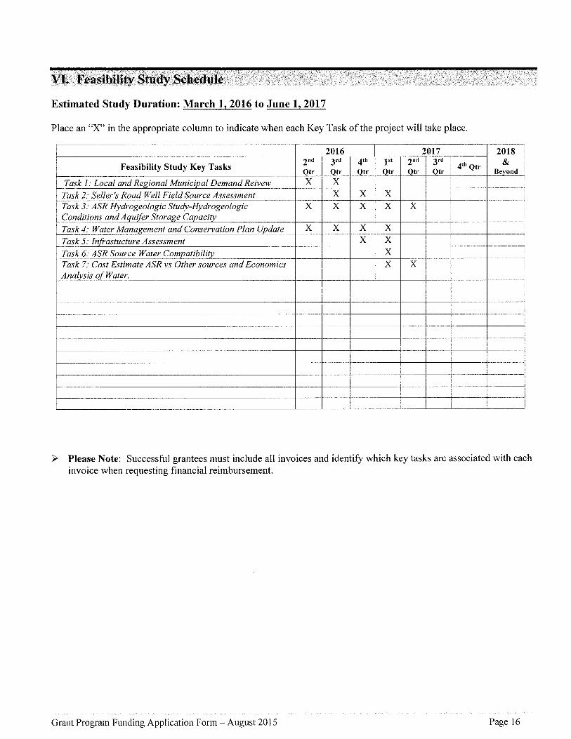
VI. Feasibility Study Schedule
Estimated Study Duration: March 1, 2016 to June 1, 2017
Place an "X" in the appropriate column to indicate when each Key Task of the project will take place.
l Feasibility Study Key Tasks
2017
2nd 3rd 4th lsi 2nd 3rdQtr Qtr Qtr Qtr Qtr Qtr
Qocaianar<egionaiuunici aivemanar<eivew i X2
li;u=l.'5'::Task 2.' Seller's Road Well Field Source Assessment
Task 3.' ASR Hydrogeologic Study-HydrogeologicConditions and Aquifer Storage Capaci
Task 4.' Water Management and Conservation Plan Update X X J X I X llTask s: Infrastucture Assessment r l l
lTask 6: ASR Source Water Compatibilii r l l
rasky.'costpstimateiiSpvsothersourcesandbconomics i i $ x iAnalysis of Water. i i % i
ll
ll l
l +-Th l
r
+ l lly i ? i
l 2018&
'ond4'h Qtr
ll
ll
ll
ll
ll
h
l
q
ll
> Please Note: Successful grantees must include all invoices and identify which key tasks are associated with eachinvoice when requesting financial reimbursement.
Grant Program Funding Application Form - August 2015 Page 16

VII. Feasibility Study Budget
Section A
Please provide an estimated line item budget for the proposed feasibility study. Examples would include: labor,materials, equipment, contractual services and administrative costs.
* Note: The "Unit" should be per "hour" or "day" - not per "project" or "contract." Units x Unit Costs = Total Cost* * Administrative Costs may not exceed 10 percent of the total funding requested from the Department
Section B
If grant amount requested is $50,000 or greater, you ? complete Section B. Key Tasks in Section B shouldbe the same as the Key Tasks in Section VI (Feasibility Study Schedule).
Grant Program Funding Application Form - August 2015 Pagel7
Line Items
Number of
Units"
(e. g. # of Hours)
Unit Cost
(e.g. hourlyrale)
In-Kind
Match
Cash Match
Funds
OWRD Grant
Funds
Total Cost
Staff Salary/Benefits 370 29 $10,730 o o $10,730
Contractual/Consulting 1103 128 $18,034 $45,186 $77,963 $141,183
Equipment (must be approved) 30 hours 150 o $2,250 $2,250 $4,500
Supplies 3 70 hours 3 $1,110 o o $1,110Other.' o o o o
Pump Contract (Testing) 60 hours 300 o $9,000 $9,000 $18,000
Well Logging 20 hours 400 $4, 000 $4,000 $8,000
Water Quality Testing 2 each $3,200 o $3,200 $3,200 $6,400
$6,600Water Quality Modelling 40 Hours $165 o $3,300 $3,300
$4,959GW Modeling 30 Hours $163.30 o $2,481 $2,478
$2,900Administrative Cost* * lOOhours 29 $2,900 o o
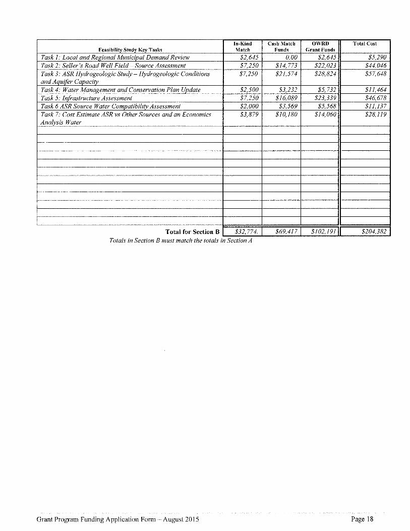
Totals in Section B must match the totals in Section A
Grant Program Funding Application Form - August 2015 Pagel8
Feasibility Study Key Tasks
'-' -'d-'-'-'Match
- CashMatchFunds
OWRD
Grant Funds
Total Cost
Task 1 .' Local and Regional Municipal Demand Review $2, 645 0. 00 $2, 645 $5,290Task 2.' Seller's Road Well Field - Source Assessment $7250 $14,773 $22, 023 $44, 046Task 3 ; ASR Hydrogeologic Study - Hydrogeologic Conditionsand Aquifer Capacity
$7250 $21,574 $28, 824 $57,648
Task 4.' Water Management and Conservation Plan Update $2,500 $3,232 $5, 732 $11,464
Task 5 .' Infrastructure Assessment $7250 $16,089 $23, 339 $46,678
Task 6 ASR Source Water Compatibility Assessment $2, 000 $3,569 $5,568 $11,137Task 7.' Cost Estimate ASR vs Other Sources and an Economics
Analysis Water$3,879 $10,280 $14,060 $28,119

APPLICATION CHECKLIST
Instructions: Use this checklist to ensure that your application is complete. An incomplete applicationwill jeopardize your application's review. This form does not need to be included in your application?
General
If submitting electronically, the preferred format is either a Microsoft word or Adobe pdf00nly one application is included with the packet (other applications must be sent separately).
Paper submissions only?The application and attachments are on 8 h" x s s " paper.?The application and attachments are single-sided.QThe application and attachments are not stapled or bound.
Section I - Grant Information
?A?? questions in this section have been answered.@The Grant Dollars Requested and the Total Project Cost mirror the totals shown in Section VII.
Section II - Applicant Information€All contact information for the applicant(s) and fiscal officer is complete and current.?The certification is signed by an authorized signer.
Section III - Feasibility Study Summary€A brief summary, ofno more than 1 so words, is complete.
Section IV - Grant Specifics[]htt questions in Section A have been answered.??f the type of feasibility study is water conservation, reuse or storage other than above-ground,
you have contacted the Department and requested project be added to the Oregon WaterResources Department's statewide water assessment and inventory.
?A?? applicable questions for the type of grant requested have been answered.
Section V - Match Funding Information0Applicant has identified that at least so percent match has been sought, secured or expended.[lLetters of support are included for "secured" match funding sources.?Documentation is included for ?expended? match funds.?Documentation is included for ?pending? match funds.
Section VI - Feasibility Study Schedule[lEstimated pro3ect duration dates have been supplied.?A?? Key Tasks of the project are listed.
Section VII - Feasibility Study Budget?Section A is com'plete.[lAdministration costs do not exceed 10 percent of the requested OWRD Grant Funds.[lJf grant amount requested is $50,000 or greater, Section B has been completed.?A?? Key Tasks listed in Section B mirror the Key Tasks listed in Section VI.
Grant Program Funding Application Form - August 2015 Page 19

FIGURE 1
Vicinity MapWashington County, Oregon
Legendf)-
*SpringsCities
Rivers
Water Bodies
City Limits
Supply Wells
Major Roads
-'-'-' Railroads
$Banks-Green Mountain ASR Feasibility StudySeller's Road Well Field - Source Study
@ i:-. 'l' -'.'.7j Public Land Surveyj' j County Boundary
o
l
o0.5
I
1
lMiles
1.5
l
2
l
1 inch = 2 miles
l
,, i. i i " I
!......, . ======== - = -== -,. i-Z:(:. l
so' . .::j......
N. =
l
iii IL lX 'h.j i ,a': 4} ,in; =. . i.47 -13a.i'9.;3";r')lJf)j'c/#).Ea a II'j' l Do ' ". =l" :r) ; l." V"' "' /' ' . :l' E ' :: " : . . " ' ' l
::; ., ,;' X 'a:' '.: Mouritaindale ' -Tha' B a n kS*. @ go l" t ' . t i ;. .i .lli ' , ,l., ., .1,' W::' . ,.l: (l- li -lil ,' y'.-s- =. " a - l
% - I . -).- -l. % ) ' - - -- a -+= - i
t0.-......-.-.....-.......-..--.-..... .-. .-.-....-.-.. ...-... .-..-.-... . l- - -' - -- --'-'-N,orth'--'-'-'-'---- ' - - -' . Plains a.,, ,l Me'vet'a =' , ,, Grenville Roy ..:a'
Ii S i)9i(7 ' l {Scheffiii .. .,Thatctxer i 'X .. :.1
SX ;'l ,: Verboort li , ll
I
lI
i ',0 Forest'a" "J, 1 Hillsboro "-(3,((yB-+-+--+--"-. Oomelms-,,.... J >.i X'-'-'--- -'-'-- ' ' '- '- a* *-. - - a" '-"- Th ;%,'- S... / - 'S" % -' " aSourcesEsn,USGS.NO/Va '
o' I .,- ' 'o%%- =, -Ik, ... .,,, City of Banks13680 NW Main Street
Banks, OR 97106
Drafk
Rev. 29January20l6Final
Project 1501 00al .002

FIGURE 2
Banks-Green Mountain ASR Study AreaWashington County, Oregon
r
Legend
* Cities Banks Groundwater Supply Wells
Rivers Major Roads
Water Bodies -)-+-+ Railroads
City Limits J-. -.'i?'7? Public Land surveyJBanks-Green Mountain ASR Feasibility Study
@ @o
lo.i
l0.2 0.3 0.4 o.s
Miles
1 inch = 2,333 feet
-..r- - ,'= i "i""i:Enu H,% (,I 9.i:l.. olay.u l aal' l 17 at:' Raindancein MalletLn - ' "';O '21, l(
lgi '==- @ .X4."-il IS= IDjjTr:# 11 ,.6,A;,
A 11 fi 'C" l':)lli Banks e",. 3' Wells (':iBaysD (e(iaCanyonRd l&2t HarnsonRdBanks Rdi.-
{'%Banks 4 '," QuailValleyGolf')Vilkes SI Course Welll e
.1 ,5
l
yTyellis Way
j tDakWay Washmgton Ave0
I! PacificAve
- -- - --------: ---- - --,------ --D:etickx Rd !
(7
Il '5".'I '0.
)
l
li
L GreenveRd: ..,'-Greenville Sources:Esri, NOA}'l
"' i= , .= , .== ='-%, .. ...: - -:}S:! -'(A :}:!C-! ' i::vy:' .i'a{el'ene.-g}CO:-151 :il co:pCity of Banks
13680 NW Main Street
Banks, OR 97106
Draft
Rev. 29 January 2C)16Final
Project 1501001.002

r
FIGURE 3
Seller's Road Well Field - Source StudyWashington County, Oregon
o',
S
:)
l
l
r
s
b
%el
*%?s9?? "
k.?Q.
4%
-.1 >r*k
>
Z Banks Water Treatment Pla?nt
?l}:lk:
?e
,,, 4171
?%
l
I'
%
80/ced1(
l
s
l
,'-..l
I
l
1l
Source: Esri. DigitalGl'obe, Geo'Eye. Ear(hstar @eoqraphics, ONESVAirbus j=DS, USDA. USC>'S. A(EX, (5etrnappimg, Aerogrid. IGffi. 1.(ISP, swissto.po. anal l(he Gl?s User oommuiai(y. soiv<ces: (fsiii. us(s's. NOAA l
LegendO- Springs Major Roads
Rivers ';:'?"3 Public Land Surveywws
[:E] Water Treatment Plant Seller's Road Well Field - Source Studyo
l
oi,ooo 2.000
l lFeet
3,000
l
1 inch = 2,389 feet
===-=- l' - E:4E;';.Y :i '#VA'. FJ';
",0'3 99 03i'4 l ,si'x'is':" .s'ale:'e+le!9}COiSl!l:.CDm
l CityofBanks 1i 13680 NW Main Street li Banks, OR 97106 llDrafti Rev.i Finali Project1 Februa 20161501001 .002

FOREST(?rROVE rmr:c<-yx
A place ssihere fantilies cmd lmsinesses tiirisie
January 25, 2016
City of Banlcs13680 NW Main Street
Banks, OR. 97106
RE: SUPPORT FOR THE BANKS-GREEN l'vlOUNTAlN ASR FEASIBJL}TY STUDY
Dear Ms. Becker:
The City of Forest Grovc supports the City of Banks application for matching fiiiids to the Oregon WaterR.esource Depaitment to assess the feasibilily of implementing an Aquifer Storage and Rccharge (ASR)project in the noilhern Tualatin Basin. .Altl'iough sve understmid that the ASR feasibility study is currentlyfocuscd on Banlcs, v=ie be}icve that an ASR project thaI addresses uiater reso?irces needs across Baii.ks,Forest Grove, and North P?aiiis and assesses the economie and ecologic benefits to all tlu-ee cities arid tl:ieiioithcrn rcgioii of tbc valley would bc an cxcdlent addilion to the feasibility study.
We support this project and will provide (llll' city's water use infomxation from our latest llyater MasterPlan and/or Water Management and Coiisei'vation l)lan for consideration iu the feasibility study. Ourcommunity looks [orward to the res?ills o[ this innovative water rcsotirces feasibility study arid hosv O?ITcity and the noithci'n T?ialatin Valley might benefit froi'n the implemeiitatioii of this project.
Sincerely,C][TY OF FORF,ST GROVE
f;kf-,J=],%Robert A. Foster, PEDirector of Public Works axid Engineering
C!TY '-.)!r FOr'bt€-'T!' GROVE l'ii,0,(34)X3.a!C; l':i.')r'.ESTGr<('y'i.i'l,(li-<97'i'i6 503=99':'-3';00 viy*ixisi.Woa:st51rtive?oi.5(oai

.]'€hb"?. TUAL6TIN RJVER!Jci'/j*
AT T[Tl
P. 0. Box 338
Hillsboro, OR 97123-0338503-846-4810; www.trwc.org
Engaging the community to sustain our watershedJanuary 28, 2016
Bob LongJolynn BeckerCity of Banks13680 S. Main Street
Banks, OR 97106
Dear Bob and Jolynn:Re: Banks - Green Mountain ASR project
I'm writing on behalf of the Tualatin River Watershed Council (TRWC) in support of theCity' s Banks'-Green Mountain ASR proj ect for which the City of Banks is submitting agrant application to Oregon Water Resources Department. It is our understanding thatthe grant application funding will assist the city in planninig for its future water supplyand storage options by gaining additional information about its current water sources(wells and ground water).
A major City of Banks' water source is springs which feed Garrigus Creek, a West ForkDairy Creek tributary. This stream provides cold water refugia for juvenile Coho salmonand cutthroat trout during the summer and autumn lower water/bigher temperatureperiod. The proposed studies will help the City gain additional information about thesource and based on this information, may allow increased summer and autumn streamflows as well as future stream enhancement projects.
This project meets two TRWC Action Plan items: Action #6, ?Promote managementpractices that improve watershed functions and protect values"; and Action #7, ?Workwith Tualatin Basin water managers to implement Integrated Water ResourceManagement strategy (IWRM)?. TRWC will provide an in-kind match of up to $5000through sharing of data; participate by TRWC staff and/or TRWC members in meetingsand/or studies, and/or evaluation of data, etc.
We look forward to the opportunity to work together with you on this project.
'f;:'=Coumcil Coordinator

5.C,ri?hlxhs
January 25, 2016
City of Banks13680 NW Main Street
Banks, OR 97106
RE: Support for the Banks-Green Mountain ASR Feasibility Study
Dear Ms. Becker,
The City of Banks City Council supports the City of Banks application for matchingfunds to the Oregon Water Resource Department to assess the feasibility ofimplementing an Aquifer Storage and Recharge (ASR) project in the northernTualatin Basin. Although we understand that the ASR feasibility study is currentlyfocused on Banks, we believe that an ASR project that addresses water resourcesneeds across Banks, Forest Grove, and North Plains and assesses the economicand ecologic benefits to all three cities and the northern region of the valleywould be an excellent addition to the feasibility study.
Our community Iooks forward to the results of this innovative water resourcesfeasibility study and how our city and the northern Tualatin Valley might benefitfrom the implementation of this project.
Sincerely,
?te %
Peter C. Edison
Mayor
13680 NW Main Street, Banks, Oregon 97106Phone: 503-324-5112 Fax: 503-324-6674 TTY l-800-735-2900
The City of Banks is an Equal Oppoitunity Employer and Provider

Q
7 J(?
J a ru4Mfl@81 6j? CITY OF NOR<oRai'li- Pi..t['sS
('ilvjn lhp Syuispl3.1360 N?yV Conuiierciai S/. A'ori;i PJai;xs, Oregon 97133
'H PLAINicburv:>
City of Banks13680 NW Main Street
Banks, OR 97106
RE: Support €or the Banks-Green Mountain ASR Feasibility Study
Oear Ms. Becker,
The City of North Plains supports the City of Banks appiication for matching funds to the Oregon WaterResource Department to assess the feasibility of implementing an Aquifer Storage and Recharge (ASR)project in the northern Tualatin Basin. Although we understand that the ASR feasibility study is currentlyfocused on Banks, we believe that an ASR project that addresses vva{er resources needs across Banks,Forest Grove, and Noith Plains and assesses the economic and ecologic benefits to all three cities and thenorthern region of the valley woiild be an excellent addition to the feasibility study.
We support this project and will provide our city's water use information from our latest Water MasterPlan and/or Water Management and Conservation Plan for consideration in the feasibility study. . Ourcommunity looks forward to the results of this innovative vialer resources feasibility study and how ourcity and the northern Tualatin Valley might benefit from the implementation of this project.
Sincerely,
Blake Boyles
City Mariaqer
Citv Hall (503) 647-s-555 Emergen<:y 9-1-/ Police (503 ) 64r'-260-! s';isansnorthplains.org

Kennedy/Jenks Consultants
s September 2014
Memorandum
To: Jolynn Becker - City of Banks
From: Rob Peacock - Kennedy/Jenks Consultants
Subject: Updated Water System Capital Improvement Plan 2014 (Revised 9/5/14)K/J 079l0al5'O0
An updated Water System Capital Improvement Plan (CIP) is presented below. We added aSource Water Protection Plan for the springs and well field, a Water Master Plan Update, and aWa{ei Management and Conservation Plan Update. The list has been arranged in chronologicalorder, and the timing of the projects has been coordinated with the draff CIP provided in the ratestudy currently in development by Shaun Piggot & Associates. Projects 1, 3, 3.1, 3.2, and 4from the 2011 CIP Update (attached) have been completed.
Water System Capital Improvement Plan
cip Project SDC-Eligible
ProJect Description Cost Cost
Water ConservaUon Management Plan Update $ 30,000 $ o
6 Distribution System Looping and Upgrades $ 620,000 $ o
Source Water Protection Plan $ 50,000 $ o
Investigate Alternative Water Providers $ o $ o
Quail V?a!IeyGolf Course Study" s 70,000 $ 70,000
Design & Construction $ 1,200,000 $1,200,00011 B Sellers Road Well Field Study a $ 150,000 $ 150,000
Design & Construction $ 2,400,000 $ 2,400,000
Transmission Pipeline Replacement $ 2,750,000 $ 530,000Southwest Well Field Stud}") $ 300,000 $ 300,000
Design & construction $ 1,500,000 $1,500,000Paint Carsten Reservoirs $ 630,000 $ o
Banks Road Line Replacement(d' $ 400,000 $ o
Cedar Canyon Line Rep!acement $ 300,000 $ o
1 .0-MG Main Zone Reservoir $ 2,200,000 $ 2,200,000Leak Detection Survey ?' $ 30,000 $ o
Water Master Plan Update $ 50,000 $ o
8 Automatic Meter Reading $ 420,000 $ o
Security System Upgrades $ 100,000 $ o
SSF Inlet Control $ 4,500 $ o
CIP Total $"l3,300,000 $8,400,000(a) One source development project will be needed to accommodate growth within the planning window, it is unlikelythe second will be needed. Pro}ects completed for development will likely be shared with developers.(b) Project schedule is based on current :anticipated need', however, changes to this schedule should be based onactual need such as growth or asset condRion.(c) Leak Detection Survey cost is approximately $5,000 per survey and scheduled every 3 years.(d) Replacement of 2" water line with 8' with no expansion beyond current service area.
Schedule(b)2014-2015
2016-2026
2016-2017
20"l6
2016
zoiz
2017
2018
2018-2020
2018
2019
2019
2021
2022
2022 (By 2024)Every 3 years
2025
optionaloptionaloptionai
11D
11A
2
11C
s
10
3.3
q :l07 prop 79I 015 .oo-ban 3 celwaler aP pioleds'kipd a}e 009051 41upd a(ed?ap?0905 1 QreV} .dOCX @ Kennedy/Jenks Consultan(s, Inc.

I
Kennedy/Jenks Consultants
MemorandumJolynn Becker - City of Bankss September 20140791015.00
Page 2
Banks Road and Cedar Canyon water line replacements have been added to the CIP becausethe pipes are under-sized and don't meet City design standards. The proposed replacementswould increase line size, but would not extend beyond current service areas. Extensions ofthese lines to serve new development would be driven by development, and would be funded bydevelopers. The estimated costs for extensions are summarized below.
Water Line Extension Projects
DescriptionBanks Road Line Extension
Cedar Canyon Line ExtensionTotal
Estimated
Project Cost$ 500,000$ 1,300,000$1,800,000
Schedule
Devetopment-DrivenDevelopment-Driven
Water Rights and 8upply Status
The status of the City's water rights and water supply are summarized in the following table.
Average UnusedAuthorized Diversion Authorized
Amount 20l4b AmountWater Source (cfs)a (cfs) (cfs)
Behrman Well #1 0.67 0.02 0.65
Behrrnan Well #2 1.0 0.27 0.73
Large Spring 0.42 0.26 0.16
Small Spring 0.18 0.02 0.i6
Total 2.27 0.56 1.71
(a) cfs = cubic feet per second, 1 cfs = 449 gallons per minute(b) September 2013 through August 2014
The actual capacity of these sources varies throughout the year. During hot weather in August2014 the City implemented a curtailment program for 8 days because demand exceededavailable supply.- While many factors enter into demand and supply, the need to curtail wateruse in August 2014 indicates the demand is approaching the system's current water productioncapacity.
q:l07pmp79l Ol6.€l0??banks??celwaler cip proleds'mpdale 0090514'kipdaled.cip?ogos4ev).doo @ Kennedy/Jenks Consullants, Inc.

g,?v< luiz? %ss&.t?v=-? z - J-=-hs Q- s - ( "aa's-Th-
[[?'7§ ]?14-r( ";,-Dll
Table E8-3: Population, Demands, and Water Use Characteristics
Currently the City of Banks is at buildout conditions with regard to its City Limits boundary(which is the same as its urban growth boundary [UGB]). Banks is in the process of expandingits UGB. The Iand to be added has not yet been determined, however the amount of Iand isintended to provide for a specified population increase at noted in Table ES-3. The City is alsoin the process identifying Urban Reserve Areas (URAs), but has not determined where or howlarge this may be.
There are three Iarge-volume water users in Banks that use at least 2.0 MG of water per year:the Home Owners Association (HOA) at Arbor Park (irrigation), the Quail Hollow Apartments(residential), and the Banks Lumber Co. (industrial).
The fire flows used for Banks are 1,500 gpm for 2 hours for the High Zone (rural low-densityresidential) and 3,000 gpm for 3 hours for the Main Zone (commercial, industrial, or institutionaldevelopments) and 1,000 gpm for 2 hours for the residential area within the City Iimits..
A Water Management and Conservation Plan (WMCP) is being prepared concurrently. Theresults of that planning effort will expound upon how Banks can curtail its water use, instituteconservational measures, and capture more source availability to meet the water requirementsof its growing population and demands.
8ection 3, System Analysis Criteria and Hydraulic Model
This section contains a discussion of the criteria used to evaluate the adequacy of the watersystem to provide for the existing and projected demands.
Source, Storage, and Pipeline
The source capacity is required to supply the MDD- Demand greater than the MDD are servedfrom the reservoir storage.
The storage requirements are split into three components: peaking equalization (25 percent ofthe MDD),- emergency (twice the ADD), and fire flow storage (described in the previous section).
Water System Master Plan-AMENDED, City of Banksy:%+iojedsffl7pq:79{ 015JX) - banksl09 iepo* & }ech memost9.l 1-waler sysk?m masjer planlflnal?vvmd nav 2011!aler mas)et plan*mended .doc
Executive Summary - N
Year 2008 2028
Population in UGB' 1,875 3,739Population Served outsidethe UGB
305 305
Potential population in uR N/A unknown
Per capita daily water use 152gpcpd ' 152.gpcpdPeaking factor from ADD toMDD
2.3 2.3
Average Day Demand (ADD) 184gpmi265,000 gpd
428 gpm620,000 gpd
Maximum Day Demand(MDD)
414 gpm600,000 gpd
984 gpm1.4 rngd
Average Water Loss 27%

Robert S. Peacock, P.E.
Senior Associate Engineer
Education
BS, Environmental Engineering, University ofFlorida, 1992
ME, Environmental Engineering, University ofFlorida, 1994
Registrations
Professional Engineer, Hawaii (14886)Professional Environmental Engineer, Oregori
(67045)
t 1;eeitk 'V
Rob Peacock has more than 20 years of experience and expertise is the planning and design ofwater treatment, storage, and distribution facilities. His is City Engineer for Banks and ColumbiaCity, Oregon, and oversees their vvater system function, planning, and improvements. He directsKennedy/Jenks' team of engineers and scientists to execute Iarge and small infrastructureproject throughout the Pacific Northwest.
Water System Master Planning, Oregon Military Department, Morrow and UmatillaCounties, Oregon - Pmject Manager -Kennedy/Jenks preparer3 a Wa'ter System Master Plan forthe proposed Oregon National Guard Installation Iocated at (ormer Umatilla Army Depot. Thestudy included determination of Needed Fireflow (ISO Method) and development of a watersystem model employing the WaterGems software package to simulate pressure and flowconditions in the water system. The model indicated some areas of the existing system failed tomaintain a minimum of 20 psi while providing 4.3 mgd (3,000 gpm) to all fire hydrants. A similarset of simulations were run for three development alternatives to establish reservoir locationsand pipe diameters for the proposed development. The selected alternative included theincreased pipe diameters as well as new reservoirs, water supply, and treatment.
Administration Building Pump Station Rehabilitation, Nehalem Bay VVastewater Agency,Nehalem, OR - Project Manager - Robert managed a team for upgrades to this wastewaterpump station to bring it into compliance with Oregon Department of Environmental Qualityregulations. Robert Ied the team to evaluate the existing facilities, which consisted of a wet welland two 7.5 HP pumps, with a connection Iocation for one additional pump. Workingcollaboratively with the client, we developed and selected the preferred improvementalternatives. Then our team provided design services for the selected improvements. Robert andthe team sized and designed the installation of a third, 15 HP pump with connection to theexisting force main header within the existing drywell, to increase the pumping capacity of thepump station. To address this facility's historical flooding issues (due to its proximity to theNehalem River), we specified a submersible pump equipped with a cooling jacket to allow fordry well operation, as well as protect the motor should a flooding event occur. Robert and theteam worked expeditiously to complete the design within two months and get theimprovements built within six months.
Kennedy/Jenks Consuttatwts

Rob Peacock
Page 2
Lahaina Wastewater Pump Station #2 Modifications, County of Maui, Lahaina, HI -Environmental Engineer - Provided technical support and QC review for'l hydraulic analysis of thepumping system; worked with the team to develop the equations to describe the system andapplication of pumps to the system. Also provided QC review of the hydraulic analysis and thatsection of the preliminary engineering report.
Hoodland WPCP Outfall Repair Design and Construction Services, County of ClackamasWater Environment Services, Clackamas, OR - Project Engineer - Designed emergency repairsto an outfall that failed during flooding. Work included fast-track permitting of in-water repairwork; incorporating complex needs of property owners, agencies, and the Owner. Design workwas fast-tracked to complete in 3 weeks to take place within the in-water work period.
Lower Columbia Reload Civil Design Services Phase 1, Clearwater Paper Company, StHelens, OR - Project Engineer - Designed and permitted a grading project to moveapproximately 25,000 cubic yards of soil and construct additional driveway and equipmentspace on a bulk fiber storage facility for Clearwater Paper's barge loading facility at the Port ofSt. Helens. The design and permitting were fast tracked to enable Clearwater to meet criticaltimelines for receiving and shipping bulk material to Clearwater's paperboard mill in Lewiston,Idaho. The effort included applying for City and County building department permitting, as wellas a DEQ 1200-C construction dewatering permit.
Redwood Valley Wastewater Project Design, u.s. Dept of Health & Human Services,Arcata, CA - Lead Designer - The Rancheria serves approximately 150 people with a communitywastewater system that consists of individual septic tanks, a standard gravity collection system,followed by a community drainfield with a dosing system.The drainfield failed due to highgroundwater coupled with high Ioading rates. It was upgraded, and failed again. The Iandavailable for the drainfield and treatment was limited. A study was performed to determine themost effective combination of treatment and disposal. Alternatives revievved for dischargeincluded direct discharge to the Russian River, reuse, a mound system, and combinations of the{hree.The treatment options included recirculating filters, wetlands, and MBR's.Therecommended system included a package recirculating media system followed by a mounddisposal system. A treatment plant design was completed in 2007.
Wastewater Collection System Rehabilitation Plan, City of Simi Valley, Simi Valley, CA -Project Engtneer - The purpose of the survey was to assist the City in determining the conditionof the highest Iiability segments of collection of sewer, with the greatest emphasis on asbestos-cement pipe near the end of its reported service life. The study included reviewing 47 miles ofvideo footage and documenting defects in accordance with the National Association of SewerService Companies' (NASSCO) Pipeline Assessment Certification Protocol (PACP) using theWinCanaR software package. The pipelines were prioritized into three groups and a schedule ofreplacement was recommended.
Wastewater Treatment Plant Headworks Design, Nehalem Bay Wastewater Agency,Nehalem, OR - Project Manager - Managed project design team for the design of a newheadworks for the Agency's wastevva{er treatment plant. The project included revising thehydraulics of 3 forcemain pipelines that serve the plant; instrumentation for aerated treatmentlagoons; and new onsite sanitary waste pump station.
Kennmy/Jenks Consultams

???fl%s'%;
/0(
100% l %?
W ti 0-m
-{Xl l l %/ l Nl el
C O Nl S U :..,oi':il :<'l .?.', ':-.i,,,(,
Robert E. Long, RG, CWRE, LHG
Education: B.A., Geology, State University of New York at Buffalo, 1986SUNY School of Environmental Science and Forestry 1987Syracuse University, LC Smith School of Engineering, Hydrogeology 1988-92
Registrations: Registered Professional Geologist, OregonRegistered Professional Geologist and Hydrogeologist, WashingtonCertified Water Rights Examiner, Oregon
Certifications: OSHA 40-hour Supervisor, Hazardous Waste Site Operations
Mr. Robert (Bob) Long, R.G. is a Senior Consultant and Hydrogeologist with over 25-years of experience inthe water resources consulting, planning, and research. Bob specializes in conjunctive-use of water(optimization of surface, ground, and stormwater resources), water resource master planning, water sourceevaluation, development of groundwater and surface water sources, aquifer storage and recovery (ASR), andwater rights. Bob works with ciients to evaluate and manage their water resource options and to explorecooperative solutions to meet competing needs for water resources.
Bob has Ied and participated in groundwater supply development and ASR projects across the PacificNorthwest. He is well versed in developing groundwater from basalt, glacial, sand dune, marine and alluvialterrains. This includes groundwater supply for the Cities of Banks, Beaverton, Coos Bay-North Bend, Dayton,Lafayette, and Portland. His experience includes the specification design and development of a ten milliongallon per day (mgd) wellfield for a confidential power client, Portland's Iast three production wells withcapacities over 2000 gallons per minute (gpm), and the structural evaluation of existing production wells foruse as ASR wells.
Bob has extensive experience in developing water demand forecasts in agricultural and municipal settingsand has used both population projection and land use protocol in developing Iong-term demand forecasts.Techniques he has utilized to evaluate water resources include satellite imagery, remote sensing false colorimagery, and historical air photo analysis.
WATER RESOURCES PLANNING
Groundwater lnfrastructure Management Plan, City of Portland, Oregon.This planning document evaluated the reliable capacity of the Columbia South Shore Well Field.Completed tasks that included a detailed evaluation of historical pumping regimes combined with anassessment of the reliability of pumps, valves, controls, piping, and pump station. Assisted in theconstruction of a hydraulic model of the well field used to assess the system's conveyance. Alsocompleted conceptual designs of three well field expansion alternatives presented with conveyanceimprovements and costs estimates. Each expansion option would provide additional capacity and systemredundancy to improve the total reliable capacity of the well field to 100 mgd.
Water Management and Conservation Plan, City of Banks, OregonProject manager for the City's Water Management and Conservation Plan. This small city relies ongroundwater wells and headland springs for water supply. The WMCP will evaluate the supply anddemand, and available water rights to develop a strategy for managing these sources and improvingconservation of vvater with in the City's service area. Options included evaluation of Aquifer Storage andRecovery technology.
09132015

??'%'l+ l %
Jk
iu /(
rs w
('.' (.') N S lJ :?'!?A l'al 'T q. . ?. . ', (.-.'
Robert E. Long, RG, CWRE, LHG
WISE Basin Study, Rogue River Basin, OregonAs Golder Project Manager, delivered a basin wide (300 Sq. Mile) GIS evaluation and report of water lossfrom irrigation canals to the geologic terrain using available GIS data and mapping. The estimatequantified the loss from canals and the potential benefit that this recharge makes to basin-widegroundwater users and natural ecosystems. The Water for Irrigation, Streams, and Industry (WISE) projectis a study aimed at improving water management in the Rogue River Basin.
u.s. Army Corps of Engineers (Portland District), Oregon and WashingtonConducted an evaluation of potential impacts to publicly owned wells in Washington and Oregon resultingfrom planned John Day Dam minimum pool drawdowns. The study involved interviewing water systemoperators in the Umatilla Basin and documenting 59 public water supply wells along the Columbia Fliverand their relative production capacities. Completed well evaluations and prepared preliminary designs forfacilities necessary to maintain existing water production quantity and quality during periods of pooldrawdown.
Columbia Basin Conservation Inventory and Demand Forecast, Oregon, WashingtonProvided strategy and senior review for the approach to gathering water rights data on the ColombiaRiver in Washington and Oregon. Acted as liaison with Oregon Department of Water Resources todevelop long term planning report to Department of Ecology. This study included a comprehensiveinventory and review of potential water conservation and storage opportunities, water rights, water use,and long-term water supply and demand for water from the Columbia River.
Water Rights Master Plan, Clackamas River Water Providers, OregonEvaluated all municipal water rights that divert water from the Clackamas River. The resulting WaterRights Master Plan presented each municipality with a strategy for strengthening water use claims on theriver. The water providers participating in the study included: North Clackamas County WaterCommission, Clackamas River Water, South Fork Water Board, and the Cities of Estacada and LakeOswego.
Water Rights Master Plan, City of Dallas, OregonProvided expert assistance in developing a strategy to retain existing water right permits and to certify theuse of surface water and reservoir permits held by the City. This project included water right masterplanning for reservo:r rights in the Oregon Coast Range. The resulting plan presented a strategy thatallowed the City to certify all permits held by Dallas.
WELLFIELD AND AQUIFER STORAGE AND RECOVERY (ASR) DEVELOPMENT
South Columbia Wellfield, ASR Feasibility, Portland, Oregon.Managed the groundwater monitoring database, participated in the water quality evaluation, andreviewed well construction records to assess the suitability of using existing production wells for ASRwells.
ASR Pilot Testing, Portland, OregonPortland area project manager for testing ASR technology in the City's South Columbia Wellfield alluvialaquifer. This project tested the capability for utilizing untreated Bullrun reservoir water as an injectionsource for implementation of ASR. The results of the pilot test found that entrained micro-particulatematter did cause a small percentage of well yield Ioss due to pugging. Under tested conditions ASR wasfound infeasible due to the additional required maintenarice to preserve well production capacity.
09L]20l5

'Q;??'%'m
-01
/'[ )
k..rl
l!
?-?? ('. O ': ': !'.i U L' { A ;l l ?(3, i... l?(?.
Robert E. Long, RG, CWRE, LHG
ASR Feasibility Study, Tualatin Valley Water District, Oregon.Supported an ASR feasibility study to store excess treated drinking water in the underlying basalt aquiferduring the winter months and then recover the vvater in the summer to meet peak demand. Workincluded ASR well design, preparation of technical specifications, contracting, and coordinating variouspermitting agencies.
ASR Feasibility Study, City of Beaverton, Oregon.Supported a well siting study that included geologic mapping and management of a GeographicInformation Database. Also provided groundwater modeling of multiple basalt aquifers in the Beavertonarea to assess groundwater capture zones of the well head protection plan.
ASR Production Well, Mount Scott Water District, Oregon.Provided oversight and design services to construct an ASR production well and convert a test well into amonitoring well installation in the Troutdale Formation aquifer. Also assisted the District in obtaining awater right. The ASR production well capacity is greater than 500 gpm.
Production Well Evaluation for ASR, City of Portland, Oregon.Reviewed the construction of eight production wells for use as ASR wells. Also consulted with City staff tofully develop ASR opportunities and support well field expansion options. This project included review ofconstruction methods, well seal configuration and video inspection and assessment of casing and screencondition.
Dune Well Field Expansion, Coos Bay North Bend Water Board, OregonAs project manager, Ied this study to assess the feasibility of constructing 30 addition wells in the dunesalong the Oregon coast. This hydrogeologic study will include the installation of one production well andtwo monitoring wells. Data collected during the long-term pump testing of the production well will be useto assess the feasibility of additional expansions.
Well Field Site Selection, Design, and Installation, Opal City, OregonAs protect manager for water supply, provided expert consulting to a privately held energy company thatrequired assistance in developing a 10-mgd well field in the basalts of Central Oregon. Completed a basin-wide groundwater study that located optimal well field sites, designed wells and drilling prog,rams, andinstalled the first two test wells. The design of the well field included groundwater modeling to determinethe optimum well field configuration and to assess the potential for interaction with the nearby CrookedRiver. The well field design includes six 1,600-foot-deep wells yielding 1,400 to 2,000gpm. Oneproduction well and monitoring well were constructed. The single production well has a capacity of morethan 5,000gpm. Other facilities in the conceptual design include wellhead design and conveyance, areservoir head tank, and a separate pump station facility to deliver the vvater though an 18-mile pipeline.
Well Field Evaluation and Water Rights, Tumwater Brewery WashingtonProject manager for evaluating groundwater rights and assessing the condition of the well field. Thebrewery, Iocated in Tumwater, uses groundwater for production and operation. Provided an expertrevievt of the available water rights owned by the brewery. Also assessed 18 production wells forcondition of operation. The assessment included efficiency of pumps, motors and well construction. Thisproject helped the E!revvery refine its pumping schedules and retain the maximum use of their rights whilemaintaining the highest possible water quality.
09132015

Qjj??Nb ?
l+a I %
rkll ' l ffi l
l
C(.?'tNS(iL'.'A'!'l';'S. LL'C
Robert E. Long, RG, CWRE, LHG
Columbia South Shore Well Field Expansion, Bureau of Vdater Works, Portland, Oregon.Helped complete three new production wells in the 90-million-gallon-per-day (mgd) well field. Providedexpertise in well design and installation that successfully managed the risk of sand production in the newwells installed. The new wells have individual production capacities of approximately 3,000 gallons perminute (gpm). Ranging in depth from 520 to 620 feet, these wells are some of the most efficient andsand-free in the well field.
Well Field Feasibility Study, Troutdale Aquifer, Wilsonville, Oregon.This well field feasibility project included assessment of the technical hydrogeologic and institutional landuse and water rights issues associated with siting and constructing a well field. Completed a hydrogeologicevaluation of the Troutdale aquifer for the development of high-capacity groundwater production wells.The evaluation included well field layout, drilling specifications, land acquisition, and groundwatertreatment options.
Well Field Development and Permitting, Dayton and Lafayette, OregonThis well field development project for Dayton and Lafayette included a detailed groundwater study toidentify well field locations for a new drinking viater supply. Prepared a 10-well design and groundwatermodel to optimize well spacing and minimize well interference. Assisted in the preparation of a detailedbid package that included five wells, pumping systems, telemetry, 4 miles of pipeline, a 1.5 million-gallonreservoir, and a water treatment system.
Well Field Evaluation, Land-Use and Water Rights, Newberg, OregonCompleted a hydrogeologic evaluation and provided input into a groundwater modeling task to determinethe optimum expansion scenario including options for the installation of a s mgd or 10 mgd collector well.The results indicated that three conventional wells would provide the City with the best options forgroundwater production and cost savings. Designed and installed the first of three planned expansionwells with a sustainable yield of 1,500 gpm.
Groundwater Technical Services, City of Portland Bureau of Water Works, Oregon.Project manager for an on-call flexible serv:ces contract providing technical expertise to bureau staff.Services include g,roundwater studies, monitoring well installation, production well design andinstallation, aquifer testing and evaluation, and groundwater modeling.
Artesian Basalt Production Well, Private Client, Yakima, Washington.Provided technical specifications and Iead the geologic fieldwork for mud rotary drilling operations of anew 1,000-Bpm production well. This included completion of the geologic logging, downhole geophysicalIog analysis during construction, and analysis of the pump test. When finished the well was completed toa depth of greater than 1,700 feet and was flowing under positive head.
Artesian Basalt Production Well, Private Client, Toppenish, Washington.Provided construction oversight, geologic logging, pump and flow testing support for a new productionwell. When completed, this 1,000-foot well maintained artesian flow conditions.
High-Pressure Artesian Basalt Well Installation, Bullrun Wellfield, Portland, Oregon.Provided oversight, geologic logging, and pump and flow testing support for a production well drilled andcompleted in the Columbia River Basalts. The well is Iocated in the pristine Bullrun River watershedowned by the City of Portland. This 600-foot well maintains a 72-pound-per-square-inch shut-in pressure.
09132015

??''%'
Aljh.l
-l
%l-{ l?
(.-. (.) ?i%l S l? ii..T try ;'a: ?'( ' a'.,3, l { ( :?
Robert E. Long, RG, CWRE, LHG
This high pressure allowed flow testing without the need of a pump. The test ran for 30 days at a freeflowing rate of 1,100 gpm.
Pumping and Injection Well Field Installation, Fort Lewis, Washington.This well field construction project included the installation of 15 pumping wells and 2 injection wells. Thewell field was designed to capture a plume of contaminated ground water in a sand and gravel aquifer.The water would then be treated to drinking water standards and injected back into the same aquifer formunicipal use. Acted as the project hydrogeologist for the production well installation, which includedobservation of drilling operations, natural pack screen design, and oversight of aquifer testing, dataanalysis, and reporting.
Groundwater Source Evaluation, Dallesport, Washington.Acted as lead hydrogeologist to complete an evaluation of the groundwater resources in the Dallesportarea for a private industrial client. The evaluation included assessing area production wells, water rightsthat could be transferred for industria! use, geologic mapping, and exploratory drilling of aliuvial andbasalt aquifers. The site is currently being monitored for long-term groundwater trends.
Production Well Technical Specifications and Installation, Clark County PUD, Washington.Wrote the technical specifications for construction of the new Salmon Creek water supply well #2. Ahistory of fine sand production from the existing well called for detailed gravel pack and screen design toprevent sand movement. Construction services included geologic Iogging, construction observation, andaquifer pump test analysis.
Production Well, King County, Washington.Provided consultation and construction services for drilling operations related to the Ravensdale Parkwater supply. Completed geologic logging, screen design, pump testing, and data analysis to determineaquifer parameters and the required pump size.
Production Well Siting and Installation, City of Fairview, Oregon.Production Well # 7 site selection, provided a technical review of the available groundwater supply andpotential well yields for City-selected sites. Also calculated potential interference with existing wellswithin the Troutdale Sandstone Aquifer and provided technical specifications for construction of the well.Construction services included geologic Iogging to 720 feet in the Troutdale Formation and observation ofthe aquifer pump test.
Panther Lake Flood Control Project, Federal Way, Washington.Performed a hydrogeologic investigation to site a subsurface recharge gallery for the Panther Lake floodcontrol project. Completed an 80-gpm constant head infiltration test with a gallery prototype. Thepermanent infiltration gallery recharges the regional water supply aquifer. The test gallery allowed us toidentify aquifer limitations and recommend capacity for the permanent installation.
Groundwater Availability Review, Portland General Electric (PGE), Deschutes River, Ore(4on.PGE supplies drinking water for the See subdivision, below the Pelton Regulating Dam on the DeschutesRiver. Provided a review of groundwater availability and potential transfers of surface water rights togroundwater rights to develop an efficient water supply to the community.
091?2015