Embed Size (px)
Citation preview

MINNESOTA DEPARTMENT OF TRANSPORTATION
AI'RIL2005
/ I\
I I • i .
/ \ II!
,. • )
,,
" V I'\ j \ ! ,JI \
'/ ': ,,-'I ,
" ,).\
I I
I ~
j',. J"II 1\
, \ ,~ \ /
\. I \\ j - ., . l \ / \I ,
,'( i , , \.
,
•
SUPPLEMENT TO
HISTORIC ROADSIDJEDJEVELOPMJENT STRUCTURES
ON MINNESOTA TRUNK HIGHWAYS
PREPARED BY
SUSAN GRANGER, SCOTT KELLY, AND KAy GROSSMAN
GEMINI RESEARCH, MORRIS, MINNESOTA

+))))))))))))))))))))))))))))))))))))0))))))))))))))))))0))))))))))0)))))))))))))))))))))),*~~~~~~~~~~~~~~~~~~~~~~~~~~~~~~~~~~~~*~~~~~~~~~~~~~~~~~~*~~~~~~~~~~*~~~~~~~~~~~~~~~~~~~~~~**~~~~~~~~~~~~~~~~~~~~~~~~~~~~~~~~~~~~*~~~~~~~~~~~~~~~~~~*~~~~~~~~~~*~~~~~~~~~~~~~~~~~~~~~~**~~~~~~~~~~~~~~~~~~~~~~~~~~~~~~~~~~~~*~~~~~~~~~~~~~~~~~~*~~~~~~~~~~*~~~~~~~~~~~~~~~~~~~~~~**~~~~~~~~~~~~~~~~~~~~~~~~~~~~~~~~~~~~*~~~~~~~~~~~~~~~~~~*~~~~~~~~~~*~~~~~~~~~~~~~~~~~~~~~~*/))))))))))))))))))))))))))))))))))))2))))))))))))))))))2))))))))))3))))))))))))))))))))))1*~~~~~~~~~~~~~~~~~~~~~~~~~~~~~~~~~~~~~~~~~~~~~~~~~~~~~~~~~~~~~~~~~~*~~~~~~~~~~~~~~~~~~~~~~**~~~~~~~~~~~~~~~~~~~~~~~~~~~~~~~~~~~~~~~~~~~~~~~~~~~~~~~~~~~~~~~~~~*~~~~~~~~~~~~~~~~~~~~~~**~~~~~~~~~~~~~~~~~~~~~~~~~~~~~~~~~~~~~~~~~~~~~~~~~~~~~~~~~~~~~~~~~~*~~~~~~~~~~~~~~~~~~~~~~**~~~~~~~~~~~~~~~~~~~~~~~~~~~~~~~~~~~~~~~~~~~~~~~~~~~~~~~~~~~~~~~~~~*~~~~~~~~~~~~~~~~~~~~~~**~~~~~~~~~~~~~~~~~~~~~~~~~~~~~~~~~~~~~~~~~~~~~~~~~~~~~~~~~~~~~~~~~~*~~~~~~~~~~~~~~~~~~~~~~**~~~~~~~~~~~~~~~~~~~~~~~~~~~~~~~~~~~~~~~~~~~~~~~~~~~~~~~~~~~~~~~~~~*~~~~~~~~~~~~~~~~~~~~~~**~~~~~~~~~~~~~~~~~~~~~~~~~~~~~~~~~~~~~~~~~~~~~~~~~~~~~~~~~~~~~~~~~~*~~~~~~~~~~~~~~~~~~~~~~**~~~~~~~~~~~~~~~~~~~~~~~~~~~~~~~~~~~~~~~~~~~~~~~~~~~~~~~~~~~~~~~~~~/))))))))))))))))))))))1*~~~~~~~~~~~~~~~~~~~~~~~~~~~~~~~~~~~~~~~~~~~~~~~~~~~~~~~~~~~~~~~~~~*~~~~~~~~~~~~~~~~~~~~~~**~~~~~~~~~~~~~~~~~~~~~~~~~~~~~~~~~~~~~~~~~~~~~~~~~~~~~~~~~~~~~~~~~~*~~~~~~~~~~~~~~~~~~~~~~**~~~~~~~~~~~~~~~~~~~~~~~~~~~~~~~~~~~~~~~~~~~~~~~~~~~~~~~~~~~~~~~~~~*~~~~~~~~~~~~~~~~~~~~~~*/))))))))))))))))))))))))))))))))))))))))))))))))))))))))))))))))))3))))))))))))))))))))))1*~~~~~~~~~~~~~~~~~~~~~~~~~~~~~~~~~~~~~~~~~~~~~~~~~~~~~~~~~~~~~~~~~~*~~~~~~~~~~~~~~~~~~~~~~**~~~~~~~~~~~~~~~~~~~~~~~~~~~~~~~~~~~~~~~~~~~~~~~~~~~~~~~~~~~~~~~~~~*~~~~~~~~~~~~~~~~~~~~~~**~~~~~~~~~~~~~~~~~~~~~~~~~~~~~~~~~~~~~~~~~~~~~~~~~~~~~~~~~~~~~~~~~~*~~~~~~~~~~~~~~~~~~~~~~**~~~~~~~~~~~~~~~~~~~~~~~~~~~~~~~~~~~~~~~~~~~~~~~~~~~~~~~~~~~~~~~~~~*~~~~~~~~~~~~~~~~~~~~~~**~~~~~~~~~~~~~~~~~~~~~~~~~~~~~~~~~~~~~~~~~~~~~~~~~~~~~~~~~~~~~~~~~~*~~~~~~~~~~~~~~~~~~~~~~*/))))))))))))))))))))))))))))))))))))))))))))))))))))))))))))))))))3))))))))))))))))))))))1*~~~~~~~~~~~~~~~~~~~~~~~~~~~~~~~~~~~~~~~~~~~~~~~~~~~~~~~~~~~~~~~~~~*~~~~~~~~~~~~~~~~~~~~~~**~~~~~~~~~~~~~~~~~~~~~~~~~~~~~~~~~~~~~~~~~~~~~~~~~~~~~~~~~~~~~~~~~~*~~~~~~~~~~~~~~~~~~~~~~**~~~~~~~~~~~~~~~~~~~~~~~~~~~~~~~~~~~~~~~~~~~~~~~~~~~~~~~~~~~~~~~~~~*~~~~~~~~~~~~~~~~~~~~~~**~~~~~~~~~~~~~~~~~~~~~~~~~~~~~~~~~~~~~~~~~~~~~~~~~~~~~~~~~~~~~~~~~~*~~~~~~~~~~~~~~~~~~~~~~**~~~~~~~~~~~~~~~~~~~~~~~~~~~~~~~~~~~~~~~~~~~~~~~~~~~~~~~~~~~~~~~~~~*~~~~~~~~~~~~~~~~~~~~~~**~~~~~~~~~~~~~~~~~~~~~~~~~~~~~~~~~~~~~~~~~~~~~~~~~~~~~~~~~~~~~~~~~~*~~~~~~~~~~~~~~~~~~~~~~**~~~~~~~~~~~~~~~~~~~~~~~~~~~~~~~~~~~~~~~~~~~~~~~~~~~~~~~~~~~~~~~~~~*~~~~~~~~~~~~~~~~~~~~~~**~~~~~~~~~~~~~~~~~~~~~~~~~~~~~~~~~~~~~~~~~~~~~~~~~~~~~~~~~~~~~~~~~~/))))))))))))))))))))))1*~~~~~~~~~~~~~~~~~~~~~~~~~~~~~~~~~~~~~~~~~~~~~~~~~~~~~~~~~~~~~~~~~~*~~~~~~~~~~~~~~~~~~~~~~**~~~~~~~~~~~~~~~~~~~~~~~~~~~~~~~~~~~~~~~~~~~~~~~~~~~~~~~~~~~~~~~~~~*~~~~~~~~~~~~~~~~~~~~~~**~~~~~~~~~~~~~~~~~~~~~~~~~~~~~~~~~~~~~~~~~~~~~~~~~~~~~~~~~~~~~~~~~~*~~~~~~~~~~~~~~~~~~~~~~**~~~~~~~~~~~~~~~~~~~~~~~~~~~~~~~~~~~~~~~~~~~~~~~~~~~~~~~~~~~~~~~~~~*~~~~~~~~~~~~~~~~~~~~~~*/))))))))))))))))))))))))))))))))))))))))))))))))))))))))))))))))))3))))))))))))))))))))))1*~~~~~~~~~~~~~~~~~~~~~~~~~~~~~~~~~~~~~~~~~~~~~~~~~~~~~~~~~~~~~~~~~~*~~~~~~~~~~~~~~~~~~~~~~**~~~~~~~~~~~~~~~~~~~~~~~~~~~~~~~~~~~~~~~~~~~~~~~~~~~~~~~~~~~~~~~~~~*~~~~~~~~~~~~~~~~~~~~~~**~~~~~~~~~~~~~~~~~~~~~~~~~~~~~~~~~~~~~~~~~~~~~~~~~~~~~~~~~~~~~~~~~~*~~~~~~~~~~~~~~~~~~~~~~**~~~~~~~~~~~~~~~~~~~~~~~~~~~~~~~~~~~~~~~~~~~~~~~~~~~~~~~~~~~~~~~~~~*~~~~~~~~~~~~~~~~~~~~~~**~~~~~~~~~~~~~~~~~~~~~~~~~~~~~~~~~~~~~~~~~~~~~~~~~~~~~~~~~~~~~~~~~~*~~~~~~~~~~~~~~~~~~~~~~**~~~~~~~~~~~~~~~~~~~~~~~~~~~~~~~~~~~~~~~~~~~~~~~~~~~~~~~~~~~~~~~~~~*~~~~~~~~~~~~~~~~~~~~~~**~~~~~~~~~~~~~~~~~~~~~~~~~~~~~~~~~~~~~~~~~~~~~~~~~~~~~~~~~~~~~~~~~~*~~~~~~~~~~~~~~~~~~~~~~**~~~~~~~~~~~~~~~~~~~~~~~~~~~~~~~~~~~~~~~~~~~~~~~~~~~~~~~~~~~~~~~~~~*~~~~~~~~~~~~~~~~~~~~~~**~~~~~~~~~~~~~~~~~~~~~~~~~~~~~~~~~~~~~~~~~~~~~~~~~~~~~~~~~~~~~~~~~~*~~~~~~~~~~~~~~~~~~~~~~**~~~~~~~~~~~~~~~~~~~~~~~~~~~~~~~~~~~~~~~~~~~~~~~~~~~~~~~~~~~~~~~~~~*~~~~~~~~~~~~~~~~~~~~~~**~~~~~~~~~~~~~~~~~~~~~~~~~~~~~~~~~~~~~~~~~~~~~~~~~~~~~~~~~~~~~~~~~~/))))))))))))))))))))))1*~~~~~~~~~~~~~~~~~~~~~~~~~~~~~~~~~~~~~~~~~~~~~~~~~~~~~~~~~~~~~~~~~~*~~~~~~~~~~~~~~~~~~~~~~**~~~~~~~~~~~~~~~~~~~~~~~~~~~~~~~~~~~~~~~~~~~~~~~~~~~~~~~~~~~~~~~~~~*~~~~~~~~~~~~~~~~~~~~~~**~~~~~~~~~~~~~~~~~~~~~~~~~~~~~~~~~~~~~~~~~~~~~~~~~~~~~~~~~~~~~~~~~~*~~~~~~~~~~~~~~~~~~~~~~*/))))))))))))))))))))))))))))))))))))))))))))))))))))))))))))))))))2))))))))))))))))))))))1*~~~~~~~~~~~~~~~~~~~~~~~~~~~~~~~~~~~~~~~~~~~~~~~~~~~~~~~~~~~~~~~~~~~~~~~~~~~~~~~~~~~~~~~~~**~~~~~~~~~~~~~~~~~~~~~~~~~~~~~~~~~~~~~~~~~~~~~~~~~~~~~~~~~~~~~~~~~~~~~~~~~~~~~~~~~~~~~~~~~**~~~~~~~~~~~~~~~~~~~~~~~~~~~~~~~~~~~~~~~~~~~~~~~~~~~~~~~~~~~~~~~~~~~~~~~~~~~~~~~~~~~~~~~~~**~~~~~~~~~~~~~~~~~~~~~~~~~~~~~~~~~~~~~~~~~~~~~~~~~~~~~~~~~~~~~~~~~~~~~~~~~~~~~~~~~~~~~~~~~**~~~~~~~~~~~~~~~~~~~~~~~~~~~~~~~~~~~~~~~~~~~~~~~~~~~~~~~~~~~~~~~~~~~~~~~~~~~~~~~~~~~~~~~~~*/)))))))))))))))))))))))))))))))))))))))))))))))))))))))))))))))))))))))))))))))))))))))))1*~~~~~~~~~~~~~~~~~~~~~~~~~~~~~~~~~~~~~~~~~~~~~~~~~~~~~~~~~~~~~~~~~~~~~~~~~~~~~~~~~~~~~~~~~**~~~~~~~~~~~~~~~~~~~~~~~~~~~~~~~~~~~~~~~~~~~~~~~~~~~~~~~~~~~~~~~~~~~~~~~~~~~~~~~~~~~~~~~~~**~~~~~~~~~~~~~~~~~~~~~~~~~~~~~~~~~~~~~~~~~~~~~~~~~~~~~~~~~~~~~~~~~~~~~~~~~~~~~~~~~~~~~~~~~**~~~~~~~~~~~~~~~~~~~~~~~~~~~~~~~~~~~~~~~~~~~~~~~~~~~~~~~~~~~~~~~~~~~~~~~~~~~~~~~~~~~~~~~~~**~~~~~~~~~~~~~~~~~~~~~~~~~~~~~~~~~~~~~~~~~~~~~~~~~~~~~~~~~~~~~~~~~~~~~~~~~~~~~~~~~~~~~~~~~**~~~~~~~~~~~~~~~~~~~~~~~~~~~~~~~~~~~~~~~~~~~~~~~~~~~~~~~~~~~~~~~~~~~~~~~~~~~~~~~~~~~~~~~~~**~~~~~~~~~~~~~~~~~~~~~~~~~~~~~~~~~~~~~~~~~~~~~~~~~~~~~~~~~~~~~~~~~~~~~~~~~~~~~~~~~~~~~~~~~**~~~~~~~~~~~~~~~~~~~~~~~~~~~~~~~~~~~~~~~~~~~~~~~~~~~~~~~~~~~~~~~~~~~~~~~~~~~~~~~~~~~~~~~~~**~~~~~~~~~~~~~~~~~~~~~~~~~~~~~~~~~~~~~~~~~~~~~~~~~~~~~~~~~~~~~~~~~~~~~~~~~~~~~~~~~~~~~~~~~**~~~~~~~~~~~~~~~~~~~~~~~~~~~~~~~~~~~~~~~~~~~~~~~~~~~~~~~~~~~~~~~~~~~~~~~~~~~~~~~~~~~~~~~~~**~~~~~~~~~~~~~~~~~~~~~~~~~~~~~~~~~~~~~~~~~~~~~~~~~~~~~~~~~~~~~~~~~~~~~~~~~~~~~~~~~~~~~~~~~**~~~~~~~~~~~~~~~~~~~~~~~~~~~~~~~~~~~~~~~~~~~~~~~~~~~~~~~~~~~~~~~~~~~~~~~~~~~~~~~~~~~~~~~~~**~~~~~~~~~~~~~~~~~~~~~~~~~~~~~~~~~~~~~~~~~~~~~~~~~~~~~~~~~~~~~~~~~~~~~~~~~~~~~~~~~~~~~~~~~**~~~~~~~~~~~~~~~~~~~~~~~~~~~~~~~~~~~~~~~~~~~~~~~~~~~~~~~~~~~~~~~~~~~~~~~~~~~~~~~~~~~~~~~~~**~~~~~~~~~~~~~~~~~~~~~~~~~~~~~~~~~~~~~~~~~~~~~~~~~~~~~~~~~~~~~~~~~~~~~~~~~~~~~~~~~~~~~~~~~**~~~~~~~~~~~~~~~~~~~~~~~~~~~~~~~~~~~~~~~~~~~~~~~~~~~~~~~~~~~~~~~~~~~~~~~~~~~~~~~~~~~~~~~~~**~~~~~~~~~~~~~~~~~~~~~~~~~~~~~~~~~~~~~~~~~~~~~~~~~~~~~~~~~~~~~~~~~~~~~~~~~~~~~~~~~~~~~~~~~**~~~~~~~~~~~~~~~~~~~~~~~~~~~~~~~~~~~~~~~~~~~~~~~~~~~~~~~~~~~~~~~~~~~~~~~~~~~~~~~~~~~~~~~~~*/)))))))))))))))))))))))))))))))))))))))))))))))))))))))))))))))))))))))))))))))))))))))))1*~~~~~~~~~~~~~~~~~~~~~~~~~~~~~~~~~~~~~~~~~~~~~~~~~~~~~~~~~~~~~~~~~~~~~~~~~~~~~~~~~~~~~~~~~**~~~~~~~~~~~~~~~~~~~~~~~~~~~~~~~~~~~~~~~~~~~~~~~~~~~~~~~~~~~~~~~~~~~~~~~~~~~~~~~~~~~~~~~~~**~~~~~~~~~~~~~~~~~~~~~~~~~~~~~~~~~~~~~~~~~~~~~~~~~~~~~~~~~~~~~~~~~~~~~~~~~~~~~~~~~~~~~~~~~**~~~~~~~~~~~~~~~~~~~~~~~~~~~~~~~~~~~~~~~~~~~~~~~~~~~~~~~~~~~~~~~~~~~~~~~~~~~~~~~~~~~~~~~~~**~~~~~~~~~~~~~~~~~~~~~~~~~~~~~~~~~~~~~~~~~~~~~~~~~~~~~~~~~~~~~~~~~~~~~~~~~~~~~~~~~~~~~~~~~**~~~~~~~~~~~~~~~~~~~~~~~~~~~~~~~~~~~~~~~~~~~~~~~~~~~~~~~~~~~~~~~~~~~~~~~~~~~~~~~~~~~~~~~~~**~~~~~~~~~~~~~~~~~~~~~~~~~~~~~~~~~~~~~~~~~~~~~~~~~~~~~~~~~~~~~~~~~~~~~~~~~~~~~~~~~~~~~~~~~**~~~~~~~~~~~~~~~~~~~~~~~~~~~~~~~~~~~~~~~~~~~~~~~~~~~~~~~~~~~~~~~~~~~~~~~~~~~~~~~~~~~~~~~~~**~~~~~~~~~~~~~~~~~~~~~~~~~~~~~~~~~~~~~~~~~~~~~~~~~~~~~~~~~~~~~~~~~~~~~~~~~~~~~~~~~~~~~~~~~**~~~~~~~~~~~~~~~~~~~~~~~~~~~~~~~~~~~~~~~~~~~~~~~~~~~~~~~~~~~~~~~~~~~~~~~~~~~~~~~~~~~~~~~~~**~~~~~~~~~~~~~~~~~~~~~~~~~~~~~~~~~~~~~~~~~~~~~~~~~~~~~~~~~~~~~~~~~~~~~~~~~~~~~~~~~~~~~~~~~**~~~~~~~~~~~~~~~~~~~~~~~~~~~~~~~~~~~~~~~~~~~~~~~~~~~~~~~~~~~~~~~~~~~~~~~~~~~~~~~~~~~~~~~~~**~~~~~~~~~~~~~~~~~~~~~~~~~~~~~~~~~~~~~~~~~~~~~~~~~~~~~~~~~~~~~~~~~~~~~~~~~~~~~~~~~~~~~~~~~**~~~~~~~~~~~~~~~~~~~~~~~~~~~~~~~~~~~~~~~~~~~~~~~~~~~~~~~~~~~~~~~~~~~~~~~~~~~~~~~~~~~~~~~~~**~~~~~~~~~~~~~~~~~~~~~~~~~~~~~~~~~~~~~~~~~~~~~~~~~~~~~~~~~~~~~~~~~~~~~~~~~~~~~~~~~~~~~~~~~**~~~~~~~~~~~~~~~~~~~~~~~~~~~~~~~~~~~~~~~~~~~~~~~~~~~~~~~~~~~~~~~~~~~~~~~~~~~~~~~~~~~~~~~~~*/))))))))))))))))))))))))))))))))))))0)))))))))))))))))))))))))))))0))))))))))))))))))))))1*~~~~~~~~~~~~~~~~~~~~~~~~~~~~~~~~~~~~*~~~~~~~~~~~~~~~~~~~~~~~~~~~~~*~~~~~~~~~~~~~~~~~~~~~~**~~~~~~~~~~~~~~~~~~~~~~~~~~~~~~~~~~~~*~~~~~~~~~~~~~~~~~~~~~~~~~~~~~*~~~~~~~~~~~~~~~~~~~~~~**~~~~~~~~~~~~~~~~~~~~~~~~~~~~~~~~~~~~*~~~~~~~~~~~~~~~~~~~~~~~~~~~~~*~~~~~~~~~~~~~~~~~~~~~~**~~~~~~~~~~~~~~~~~~~~~~~~~~~~~~~~~~~~*~~~~~~~~~~~~~~~~~~~~~~~~~~~~~*~~~~~~~~~~~~~~~~~~~~~~**~~~~~~~~~~~~~~~~~~~~~~~~~~~~~~~~~~~~/)))))))))))))))))))))))))))))3))))))))))))))))))))))1*~~~~~~~~~~~~~~~~~~~~~~~~~~~~~~~~~~~~*~~~~~~~~~~~~~~~~~~~~~~~~~~~~~*~~~~~~~~~~~~~~~~~~~~~~**~~~~~~~~~~~~~~~~~~~~~~~~~~~~~~~~~~~~*~~~~~~~~~~~~~~~~~~~~~~~~~~~~~*~~~~~~~~~~~~~~~~~~~~~~**~~~~~~~~~~~~~~~~~~~~~~~~~~~~~~~~~~~~*~~~~~~~~~~~~~~~~~~~~~~~~~~~~~*~~~~~~~~~~~~~~~~~~~~~~*.))))))))))))))))))))))))))))))))))))2)))))))))))))))))))))))))))))2))))))))))))))))))))))-
50272-101
REPORT DOCUMENT 1. REPORT NO. 2. 3. Recipient's Accession No.
PAGE
4. Title and Subtitle 5. Report Date
6.
7. Author(s) 8. Performing Organization Report No.
9. Performing Organization Name and Address 10. Project/Task/Work Unit No.
11. Contract (C) or Grant (G) No.
12. Sponsoring Organization Name and Address 13. Type of Report & Period Covered
14.
15. Supplementary Notes
16. Abstract (Limit 200 words)
17. Document Analysis a. Descriptors
b. Identifiers/Open-ended Terms
c. COSATI Field/Group
18. Availability Statement: 19. Security Class (This Period) 21. No. of Pages
20. Security Class (This Page) 22. Price
(see ANSI-Z39.18) OPTIONAL FORM 272 (4-77) (Formerly NTIS-35) Department of Commerce
Supplement to Historic Roadside Development Structures on Minnesota Trunk Highways April 2005
Susan Granger, Scott Kelly, and Kay Grossman
Gemini Research15 East Ninth StreetMorris, MN 56267
Agr. 82693, work order 5
Minnesota Department of TransportationSt. Paul, Minnesota 55155
Final: Nov. 2002-April 2005
Authorized and funded by the Minnesota Department of Transportation and the Federal Highway Administration
In 2002-2004 the Minnesota Department of Transportation (Mn/DOT), working through its consultant Gemini Research, conducted a culturalresources survey and evaluation of eight properties to be added to Mn/DOT's Historic Roadside Development Structures Inventory. The additionof the eight brings the total inventory to 110 properties. Gemini Research recommends that three of the eight newly-inventoried properties areeligible for the National Register of Historic Places. This document, intended as a supplement to the 1998 inventory report Historic RoadsideDevelopment Structures on Minnesota Trunk Highways, adds the eight new properties to the inventory, updates key inventory information, andcorrects selected errors in the original inventory. The updated information lists, for example, the historic preservation treatment reports thatMn/DOT has prepared for National Register-eligible and -listed sites. The report also briefly discusses serious threats facing the inventory sitesincluding their deteriorating physical condition.
release unlimited unclassified
unclassified

____________________________________________________________________________________________________________________________________________________________________
__________________________________________________________________________________
SUPPLEMENT TOHISTORIC ROADSIDE DEVELOPMENT STRUCTURES
ON MINNESOTA TRUNK HIGHWAYS
Submitted to theMinnesota Department of Transportation
April 2005
Authorized and funded by theMinnesota Department of Transportationand the Federal Highway Administration
Agreement 82693, work order 5
Prepared bySusan Granger, Scott Kelly, and Kay Grossman
Gemini Research, Morris, Minnesota
____________________________________________________________________________________________________________________________________________________________________
__________________________________________________________________________________
ABSTRACT
In 2002-2004 the Minnesota Department of Transportation (Mn/DOT), working through itsconsultant Gemini Research, conducted a cultural resources survey and evaluation of eight propertiesto be added to Mn/DOT's Historic Roadside Development Structures Inventory. The addition of theeight brings the total inventory to 110 properties. Gemini Research recommends that three of theeight newly-inventoried properties are eligible for the National Register of Historic Places. Thisdocument, intended as a supplement to the 1998 inventory report Historic Roadside DevelopmentStructures on Minnesota Trunk Highways, adds the eight new properties to the inventory, updateskey inventory information, and corrects selected errors in the original inventory. The updatedinformation lists, for example, the historic preservation treatment reports that Mn/DOT has preparedfor National Register-eligible and -listed sites. The report also briefly discusses serious threats facingthe inventory sites including their deteriorating physical condition.

____________________________________________________________________________________________________________________________________________________________________
__________________________________________________________________________________
TABLE OF CONTENTS
Introduction . . . . . . . . . . . . . . . . . . . . . . . . . . . . . . . . . . . 1.1Inventory Objectives and Methods . . . . . . . . . . . . . . . . . . . . . . . . . 2.1Newly-Inventoried Properties . . . . . . . . . . . . . . . . . . . . . . . . . . . . 3.1 List of Newly-Inventoried Properties . . . . . . . . . . . . . . . . . . . . . . 3.1 Characteristics of Newly-Inventoried Properties . . . . . . . . . . . . . . . . . 3.1 Evaluation of Newly-Inventoried Properties . . . . . . . . . . . . . . . . . . . 3.8Inventory Update and Errata . . . . . . . . . . . . . . . . . . . . . . . . . . . . 4.1Revised National Register Status . . . . . . . . . . . . . . . . . . . . . . . . . . 5.1 Revised List of National Register-Listed Properties . . . . . . . . . . . . . . . 5.1 Revised List of National Register-Eligible Properties . . . . . . . . . . . . . . . 5.1 Revised List of National Register-Ineligible Properties . . . . . . . . . . . . . . 5.3Recommendations . . . . . . . . . . . . . . . . . . . . . . . . . . . . . . . . 6.1Illustrations . . . . . . . . . . . . . . . . . . . . . . . . . . . . . . . . . . . . 7.1 Photographs . . . . . . . . . . . . . . . . . . . . . . . . . . . . . . . . 7.1 Revised Map of Inventory Properties . . . . . . . . . . . . . . . . . . . . . 7.7References Additional to Those in the 1998 Report . . . . . . . . . . . . . . . . . 8.1
Appendix A: Mn/DOT Historic Roadside Development Structures Inventory of 110 Properties Ordered by Mn/DOT Control Section Number . . . . . . . 9.1Appendix B: Mn/DOT Historic Roadside Development Structures Inventory of 110 Properties Ordered by Mn/DOT District . . . . . . . . . . . . . . 10.1Appendix C: Mn/DOT Historic Roadside Development Structures Inventory of 110 Properties Ordered by Site Name . . . . . . . . . . . . . . . . . 11.1

____________________________________________________________________________________________________________________________________________________________________
__________________________________________________________________________________
LIST OF ILLUSTRATIONS
Fig. 1 Council ring, Hewitt Roadside Parking Area, 1942. Courtesy Marvel Blaske . . 7.1Fig. 2 Spring enclosure, Hewitt Roadside Parking Area, April 2003 . . . . . . . . . 7.2Fig. 3 Stone table, Hewitt Roadside Parking Area, April 2003 . . . . . . . . . . . 7.2Fig. 4 LaCrescent Overlook, Jan. 2003 . . . . . . . . . . . . . . . . . . . . . . 7.3Fig. 5 Flagpole and plaza, Noyes Roadside Parking Area, April 2003 . . . . . . . . 7.3Fig. 6 Pipestone National Monument Entrance Marker, Oct. 2002 . . . . . . . . . . 7.4Fig. 7 Reno Spring Roadside Parking Area, Jan. 2003 . . . . . . . . . . . . . . . 7.4Fig. 8 Stillwater Retaining Wall, Nov. 2002 . . . . . . . . . . . . . . . . . . . . 7.5Fig. 9 Thompson Hill-Skyline Parkway Overlook, Oct. 2003 . . . . . . . . . . . . 7.5Fig. 10 Revised Map of Inventory Properties . . . . . . . . . . . . . . . . . . . . 7.7

_____________________________________________________________________________________________________________________________________________________ INTRODUCTION
__________________________________________________________________________________1.1
INTRODUCTION
This supplement to the report Historic Roadside Development Structures on Minnesota TrunkHighways (1998) is intended to serve two purposes. First, the supplement reports the fact thateight additional properties were recently added to the Historic Roadside Development StructuresInventory of 102 properties that was completed in 1998. Secondly, the supplement provides anupdate of some key information in the 1998 inventory report, corrects some of the errors containedin the report and on individual inventory forms, and provides further recommendations.
P THREATS TO THE SITES
This supplemental report does not describe in detail an important change that has occurred since the1998 inventory – the additional physical deterioration of many of the sites, including some of themost popular. Some cases have been so acute that Mn/DOT has been compelled to close sites, orportions thereof, to protect fragile stonework and ensure public safety. The fact that many of theapproximately 70-year-old properties are functional and well-loved today is a testament to theirexcellent design and craftsmanship. However, many have reached the age where serious problemshave developed and drainage needs correcting, walls need stabilizing, stones need remortaring, andplant materials need replacement. Mn/DOT has assessed the condition and preservation potentialof the most significant sites and is ready with strategies for their repair. If partnerships can beestablished, funding acquired, and the necessary work completed, the sites will continue to servethe public for another 70 years.
The fragile physical condition of the inventoried properties is also exacerbated by reduced fundingfor rest area maintenance and operation in a time of state and federal budget constraint. Mn/DOTis actively seeking outside funding and caretaking partnerships to help preserve its historic properties,but budgetary shortfalls and reduced staff time will continue to be a serious challenge for the nearfuture.
Finally, many of the sites in the central and eastern parts of the state are being affected byroad-widening projects that threaten to irreversibly alter these significant historic landscapes and theirsetting. Historic roadside development sites were often built along the most scenic stretches ofhighway – highways that today carry ever-increasing traffic loads. It is Mn/DOT's challenge tomeaningfully take these historic properties into account during early project planning and to developsensitive ways to ensure safety and traffic capacity along with protecting significant historicresources.
Fortunately, since 1998 Mn/DOT has been able to undertake substantial repair and rehabilitation atsome important sites including Gooseberry Falls Concourse (2000), Orr Roadside Parking Area(2003), Craigie Flour Mill Historical Marker (2004), Reads Landing Overlook (2004), and Cold SpringRoadside Parking Area (2004-2005). In addition, plant materials were rehabilitated at the Floyd B.Olson Memorial Statue in a joint project with the City of Minneapolis (2004).

__________________________________________________________________________________INTRODUCTION ___________________________________________________________________
__________________________________________________________________________________1.2
P RECOGNITION
Since the original inventory was conducted, Mn/DOT's efforts to inventory, evaluate, and manageits significant collection of historic roadside development properties has been recognized with threeprestigious awards:
In November 2001 the original survey and its report Historic Roadside Development Structures onMinnesota Trunk Highways (1998) won an Honor Award from the Preservation Alliance ofMinnesota. In its recognition the Preservation Alliance stated, "the Minnesota Department ofTransportation exercised extraordinary and commendable stewardship in creating and supporting thisstatewide program to identify and evaluate historic roadside development structures, many of whichwere constructed of local materials during the New Deal Era."
In May 2004, Mn/DOT's ongoing effort to inventory and manage its historic roadside developmentstructures was chosen as the subject of Volume 6 of Cultural Landscape Currents, the onlinemagazine of the National Park Service's Historic Landscape Initiative. Currents has a nationalaudience and provides detailed, well-illustrated accounts of projects that serve as exemplary modelsfor the treatment of historic landscapes.
In September 2004, Mn/DOT's rehabilitation of the stone overlook wall at the Orr Roadside ParkingArea won a Merit Award in Excellence in Highway Design, a biennial awards program of the FederalHighway Administration. The award was presented in the historic preservation category, with anational field of competitors. The rehabilitation of the 1938 Orr overlook wall was completed in2003.

_______________________________________________________________________________________________________________________________ INVENTORY OBJECTIVES AND METHODS
__________________________________________________________________________________2.1
INVENTORY OBJECTIVES AND METHODS
P OBJECTIVES
The purpose of the inventory portion of the project was to survey and evaluate a group of roadsidedevelopment properties that were identified by Mn/DOT after the original Historic RoadsideDevelopment Structures Inventory was conducted in 1996-1998.
P METHODS
The Mn/DOT Historic Roadside Development Structures Inventory is a recording of properties locatedon current Mn/DOT right-of-way that contain pre-1961 standing structures.
To create the original inventory, Gemini Research compiled a master list of possible sites for inclusionby contacting Mn/DOT District staff and perusing a variety of highway department documents andlists from both historical and recent periods. Several hundred sites were reviewed. As the projectproceeded, sites were dropped from the list if they contained no pre-1961 structures (determinedthrough research and fieldwork), or if the site's structures were found to postdate 1960 (determinedthrough research). A few sites whose structures postdate 1960 escaped the culling process (andremained in the inventory) because dates were not confirmed until fairly late in the project.
The eight new sites to be investigated came to the attention of the Mn/DOT Site Development Unitthrough various means including communication with Mn/DOT District staff.
In addition to investigating the eight sites, Gemini Research also reviewed some of the documentsused to create the original inventory to determine whether any other sites were inadvertently missedin 1996-1998. Gemini concluded that no sites with major standing structures were missed, althoughit is likely that wayside rests with minor structures (such as pre-1961 timber dummy posts or lowconcrete fireplaces) have not been inventoried.
Methods for fieldwork, research, and evaluation the of the eight sites were identical to thoseemployed during the original survey. The sites' potential National Register eligibility was evaluatedusing the historic context "Roadside Development on Minnesota Trunk Highways, 1920-1960,"which was developed during the original inventory project. Fieldwork, research, and evaluation ofthe eight sites occurred in late 2002-early 2004.
The project was conducted by Gemini Research with Susan Granger serving as principal investigatorand Scott Kelly as investigator. Liz Walton of the Mn/DOT Site Development Unit was projectmanager. Jackie Sluss of the Mn/DOT Cultural Resources Unit and Susan Roth of the SHPOprovided oversight and technical support.
P FINAL PRODUCTS
The final products include eight inventory files and this supplemental report. The eight inventory filesare identical to those developed during the original survey. (The contents of inventory files are listed

__________________________________________________________________________________INVENTORY OBJECTIVES AND METHODS _____________________________________________
__________________________________________________________________________________2.2
on page 2.4 of the 1998 report.) All inventory files are stored in the Mn/DOT Site DevelopmentUnit, with an abbreviated set on file in the State Historic Preservation Office (SHPO) located at theMinnesota Historical Society.
____________________________________________________________________________________________________________________________________ NEWLY-INVENTORIED PROPERTIES
__________________________________________________________________________________3.1
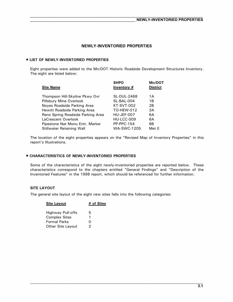
NEWLY-INVENTORIED PROPERTIES
P LIST OF NEWLY-INVENTORIED PROPERTIES
Eight properties were added to the Mn/DOT Historic Roadside Development Structures Inventory.The eight are listed below:
SHPO Mn/DOTSite Name Inventory # District
Thompson Hill-Skyline Pkwy Ovr SL-DUL-2468 1APillsbury Mine Overlook SL-BAL-004 1BNoyes Roadside Parking Area KT-SVT-002 2BHewitt Roadside Parking Area TO-HEW-012 3AReno Spring Roadside Parking Area HU-JEF-007 6ALaCrescent Overlook HU-LCC-009 6APipestone Nat Monu Entr. Marker PP-PPC-154 8BStillwater Retaining Wall WA-SWC-1205 Met E
The location of the eight properties appears on the "Revised Map of Inventory Properties" in thisreport's Illustrations.
P CHARACTERISTICS OF NEWLY-INVENTORIED PROPERTIES
Some of the characteristics of the eight newly-inventoried properties are reported below. Thesecharacteristics correspond to the chapters entitled "General Findings" and "Description of theInventoried Features" in the 1998 report, which should be referenced for further information.
SITE LAYOUT
The general site layout of the eight new sites falls into the following categories:
Site Layout # of Sites
Highway Pull-offs 5Complex Sites 1Formal Parks 0Other Site Layout 2

__________________________________________________________________________________NEWLY-INVENTORIED PROPERTIES _________________________________________________
__________________________________________________________________________________3.2
REST AREA CLASS
The eight new sites represent the following Mn/DOT rest area classes:
Rest Area Class # of Sites
Class 1 0Class 2 0Class 3 1Class 4 5No class assigned 2
STYLE OF PROPERTIES
All eight of the inventoried properties show the influence of the National Park Service Rustic Style.
AGE OF PROPERTIES
Four of the eight properties were built during the New Deal (1933-1943) and four were built afterthe New Deal era. The eight sites are listed below in the order of year built:
During the New DealHewitt Roadside Parking Area 1936 TO-HEW-012 3ANoyes Roadside Parking Area 1937 KT-SVT-002 2BStillwater Retaining Wall ca. 1937 WA-SWC-1205 Met ELaCrescent Overlook 1941 HU-LCC-009 6A
After the New DealReno Spring R.P.A. 1950 HU-JEF-007 6APipestone Nat Monu Entrance Mrkr 1952 PP-PPC-154 8BPillsbury Mine Overlook 1962 SL-BAL-004 1BThompson Hill-Skyline Pkwy Ovr ca. 1967 SL-DUL-2468 1A
DESIGNERS
The designers of the eight newly-inventoried properties are indicated below. Three of the propertieswere designed by prominent landscape architect A. R. Nichols.
A. R. Nichols Noyes Roadside Parking Area KT-SVT-002 2BHewitt Roadside Parking Area TO-HEW-012 3AStillwater Retaining Wall WA-SWC-1205 Met E
Fred Vogt (of the MHD) Pipestone Nat Monu Ent Marker PP-PPC-154 8B

____________________________________________________________________________________________________________________________________ NEWLY-INVENTORIED PROPERTIES
__________________________________________________________________________________3.3
Minnesota Dept. of Highways (Unspecified) Thompson Hill-Skyline Pkwy Ovr SL-DUL-2468 1APillsbury Mine Overlook SL-BAL-004 1BReno Spring R.P.A. HU-JEF-007 6ALaCrescent Overlook HU-LCC-009 6A
BUILDERS
Two of the eight new sites were built with the assistance of New Deal federal relief agencies andsix were built by the Minnesota Department of Highways:
Federal Relief Programs
National Youth Administration (NYA)Stillwater Retaining Wall WA-SWC-1205 Met E
Works Progress Administration (WPA)Hewitt Roadside Parking Area TO-HEW-012 3A
Minnesota Department of Highways
Thompson Hill-Skyline Pkwy Ovr SL-DUL-2468 1APillsbury Mine Overlook SL-BAL-004 1BNoyes Roadside Parking Area KT-SVT-002 2BLaCrescent Overlook HU-LCC-009 6AReno Spring R.P.A. HU-JEF-007 6APipestone Nat Monu Ent Marker PP-PPC-154 8B
INTEGRITY AND CONDITION
The integrity of the eight new sites was categorized as follows:
Integrity # of Sites
Intact or slightly altered 4Moderately altered 3Very altered 1
The condition of the eight properties ranges from fair to very poor.
ORIGINAL CONSTRUCTION PLANS
Original or early construction plans were identified for five of the eight newly-inventoried sites.
__________________________________________________________________________________NEWLY-INVENTORIED PROPERTIES _________________________________________________
__________________________________________________________________________________3.4
PLANT MATERIALS
Plant materials used on the eight new sites were consistent with those found on the majority of sitesin the original inventory. (For example, see Appendix H in the 1998 report.) These plants includeturf grass, trees and shrubs that appear to be native to the surrounding forests, and trees, shrubs,and vines introduced to the site by the designer. The latter includes plants chosen for hardiness, lowmaintenance, and year-around interest.
HISTORIC CONTEXT
All eight properties are associated with the historic context entitled "Roadside Development onMinnesota Trunk Highways, 1920-1960."
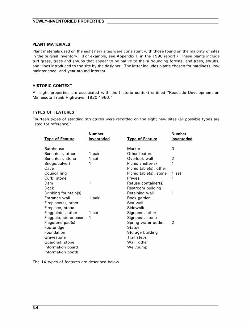
TYPES OF FEATURES
Fourteen types of standing structures were recorded on the eight new sites (all possible types arelisted for reference):
Number NumberType of Feature Inventoried Type of Feature Inventoried
Bathhouse Marker 3Bench(es), other 1 pair Other featureBench(es), stone 1 set Overlook wall 2Bridge/culvert 1 Picnic shelter(s) 1Cave Picnic table(s), otherCouncil ring Picnic table(s), stone 1 setCurb, stone Privies 1Dam 1 Refuse container(s)Dock Restroom buildingDrinking fountain(s) Retaining wall 1Entrance wall 1 pair Rock gardenFireplace(s), other Sea wallFireplace, stone SidewalkFlagpole(s), other 1 set Signpost, otherFlagpole, stone base 1 Signpost, stoneFlagstone pad(s) Spring water outlet 2Footbridge StatueFoundation Storage buildingGravestone Trail stepsGuardrail, stone Wall, otherInformation board Well/pumpInformation booth
The 14 types of features are described below.

____________________________________________________________________________________________________________________________________ NEWLY-INVENTORIED PROPERTIES
__________________________________________________________________________________3.5
BENCHES
One of the sites has stone (or part stone) benches:
Noyes Roadside Parking Area KT-SVT-002 2B
One of the sites has benches of concrete, wood, or metal:
LaCrescent Overlook HU-LCC-009 6A
The benches at Noyes Roadside Parking Area – a set of three – have poured concrete slabseats resting on mortared fieldstone pedestals. The benches rest on a fieldstone plaza. Thepair of benches at LaCrescent Overlook has seats and pedestals of poured concrete. Thebenches stand against the overlook wall.
BRIDGES AND CULVERTS
One of the eight sites has a culvert:
Reno Spring R.P.A. HU-JEF-007 6A
The culvert at Reno Spring Roadside Parking Area is a small structure with a headwall andwing walls of limestone rubble. The culvert helps carry spring water away from the waysiderest.
DAMS
One of the sites has a dam:
Hewitt Roadside Parking Area TO-HEW-012 3A
The dam at Hewitt Roadside Parking Area is a small, simple, low concrete structure that wasbuilt by the WPA in 1936 to create a pool for fishing and swimming within the park.
ENTRANCE WALLS
One set of entrance walls was recorded at:
Pipestone Nat Monu Ent Marker PP-PPC-154 8B
The Pipestone National Monument Entrance Marker Walls are a pair of stone pylons built in1952 to mark the state highway entrance to the Pipestone National Monument. Thestructures have a battered, angular design and the tallest pylon supports a hanging-arm sign.

__________________________________________________________________________________NEWLY-INVENTORIED PROPERTIES _________________________________________________
__________________________________________________________________________________3.6
FLAGPOLES
One of the eight new sites has a stone flagpole base:
Noyes Roadside Parking Area KT-SVT-002 2B
Another of the sites has a set of recent flagpoles with concrete bases:
La Crescent Overlook HU-LCC-009 6A
The flagpole base at Noyes Roadside Parking Area, built in 1937, is an elaborate 8'-tallfieldstone structure that is similar in scale to stone flagpole bases at Blazer Park and GarrisonConcourse – both recorded in the original inventory. Noyes' flagpole and the stone plaza onwhich it stands create the focal point of the site. (Note: because of post-9/11 border security,the public can no longer visit the site.) The structures at LaCrescent Overlook are a trio ofrecent flagpoles with low, unobtrusive concrete bases.
MARKERS
Two of the eight newly-inventoried properties have interpretive markers – one site has onemarker and the other has two. The markers are free-standing and represent the followingtypes (which are described in the 1998 report):
Lecterns, Free-standing 1Metal signs 1Other, Free-standing 1
The free-standing lectern-style marker stands at:
Pillsbury Mine Overlook SL-BAL-004 1B
The marker at Pillsbury Mine Overlook is one of a series of Minnesota Highway Departmentmarkers built in the 1950s and 1960s at Clifton-French River, Marine on St. Croix, MinnesotaWoman, and elsewhere. The marker at Pillsbury is similar to the other markers in the serieswith one exception: it is built of ore-laden rock from the local area. Most of the othermarkers in the series are built of tan, rockfaced, random ashlar limestone, regardless of wherein the state they are located. (The use of a single type of stone distinguishes the1950s-1960s marker series from the New Deal-era markers, which were usually made of thestone native to a locale.)
The metal marker stands at:
Noyes Roadside Parking Area KT-SVT-002 2B
The marker at Noyes Roadside Parking Area is a metal and plastic interpretive sign that waserected by Mn/DOT in 1997.
The other free-standing marker stands at:

____________________________________________________________________________________________________________________________________ NEWLY-INVENTORIED PROPERTIES
__________________________________________________________________________________3.7
Noyes Roadside Parking Area KT-SVT-002 2B
This marker at Noyes Roadside Parking Area is a stone obelisk with incised lettering. It waserected circa 1929 to mark the location of the international boundary line between the UnitedStates and Canada. (Note: because of post-9/11 border security, the public can no longer visitthe site.)
OVERLOOK WALLS
Overlook walls stand at two of the eight properties:
Thompson Hill-Skyline Pkwy Ovr SL-DUL-2468 1ALa Crescent Overlook HU-LCC-009 6A
The overlook wall at LaCrescent was built in 1941 during the Depression by the MinnesotaDepartment of Highways. It has a tripartite design with a curving, central lookout bay thatfaces the Mississippi River flood plain. The wall is built of tan, rockfaced, coursed ashlarlimestone (native to the region) and is basically intact and in fair condition.
Research revealed that the overlook wall at Thompson Hill-Skyline Parkway Overlook wasprobably not built until circa 1967. It is a low, 560'-long wall built of undressed, dark grayand brown stone that is native to the Duluth area. The wall is in very poor condition, butoffers an outstanding view of the Duluth harbor. The overlook is located below and fairlyclose to the Thompson Hill Travel Information Center building and therefore receives frequentvisitors.
PICNIC SHELTERS
One picnic shelter was included among the eight sites. It stands at:
Hewitt Roadside Parking Area TO-HEW-012 3A
Built circa 1978, the shelter at Hewitt Roadside Parking Area is a simple, modern structurewith a gabled roof supported by metal poles.
PICNIC TABLES, STONE
A set of four unusual stone picnic tables was inventoried at:
Hewitt Roadside Parking Area TO-HEW-012 3A
The tables at Hewitt Roadside Parking Area have randomly-laid granite trestle supports. Thetable tops and bench seats are made of poured concrete with chamfered edges. The tablesrest on poured concrete pads. They are in poor condition and deserve careful repair becauseof their unique and rare design. The tables were built by the WPA in 1936.
__________________________________________________________________________________NEWLY-INVENTORIED PROPERTIES _________________________________________________
__________________________________________________________________________________3.8
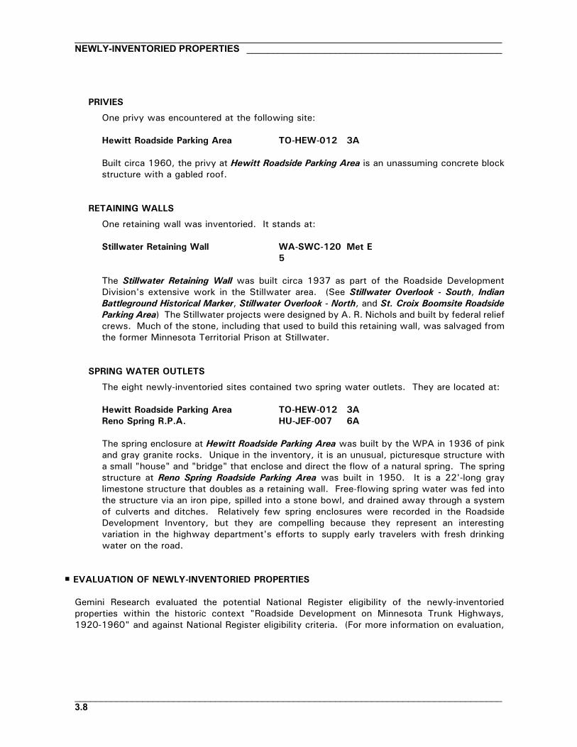
PRIVIES
One privy was encountered at the following site:
Hewitt Roadside Parking Area TO-HEW-012 3A
Built circa 1960, the privy at Hewitt Roadside Parking Area is an unassuming concrete blockstructure with a gabled roof.
RETAINING WALLS
One retaining wall was inventoried. It stands at:
Stillwater Retaining Wall WA-SWC-1205
Met E
The Stillwater Retaining Wall was built circa 1937 as part of the Roadside DevelopmentDivision's extensive work in the Stillwater area. (See Stillwater Overlook - South, IndianBattleground Historical Marker, Stillwater Overlook - North, and St. Croix Boomsite RoadsideParking Area) The Stillwater projects were designed by A. R. Nichols and built by federal reliefcrews. Much of the stone, including that used to build this retaining wall, was salvaged fromthe former Minnesota Territorial Prison at Stillwater.
SPRING WATER OUTLETS
The eight newly-inventoried sites contained two spring water outlets. They are located at:
Hewitt Roadside Parking Area TO-HEW-012 3AReno Spring R.P.A. HU-JEF-007 6A
The spring enclosure at Hewitt Roadside Parking Area was built by the WPA in 1936 of pinkand gray granite rocks. Unique in the inventory, it is an unusual, picturesque structure witha small "house" and "bridge" that enclose and direct the flow of a natural spring. The springstructure at Reno Spring Roadside Parking Area was built in 1950. It is a 22'-long graylimestone structure that doubles as a retaining wall. Free-flowing spring water was fed intothe structure via an iron pipe, spilled into a stone bowl, and drained away through a systemof culverts and ditches. Relatively few spring enclosures were recorded in the RoadsideDevelopment Inventory, but they are compelling because they represent an interestingvariation in the highway department's efforts to supply early travelers with fresh drinkingwater on the road.
P EVALUATION OF NEWLY-INVENTORIED PROPERTIES
Gemini Research evaluated the potential National Register eligibility of the newly-inventoriedproperties within the historic context "Roadside Development on Minnesota Trunk Highways,1920-1960" and against National Register eligibility criteria. (For more information on evaluation,

____________________________________________________________________________________________________________________________________ NEWLY-INVENTORIED PROPERTIES
__________________________________________________________________________________3.9
see chapter 6 of the 1998 report.) The sites' National Register eligibility within other statewidehistoric contexts was also reviewed. The result of this evaluation is listed below:
Thompson Hill-Skyline Pkwy Ovr SL-DUL-2468 1A Not EligiblePillsbury Mine Overlook SL-BAL-004 1B Not EligibleNoyes Roadside Parking Area KT-SVT-002 2B Eligible1
Hewitt Roadside Parking Area TO-HEW-012 3A Not EligibleReno Spring Roadside Parking Area HU-JEF-007 6A Eligible1
LaCrescent Overlook HU-LCC-009 6A Eligible1
Pipestone Nat Monu Entr. Marker PP-PPC-154 8B Not EligibleStillwater Retaining Wall WA-SWC-1205 Met E Not Eligible
1Eligible under the Roadside Development historic context.

__________________________________________________________________________________NEWLY-INVENTORIED PROPERTIES _________________________________________________
__________________________________________________________________________________3.10

____________________________________________________________________________________________________________________________________ INVENTORY UPDATE AND ERRATA
__________________________________________________________________________________4.1
INVENTORY UPDATE AND ERRATA
The next several pages provide an update of the information that appears in the 1998 inventoryreport and on the inventory forms. The updated information is generally designed to:
M Incorporate the eight new properties into the inventory.M Report major changes to the original inventory properties and to the information compiled about
them and correct selected errors therein.
P INFORMATION THAT SUPPLEMENTS THE INVENTORY FILES
Since 1998, Mn/DOT has conducted several projects that provide important supplementation to theinformation contained in the original inventory files. Through these treatment reports, boundarystudies, and National Register nominations, Mn/DOT gathered important assessments of the physicalcondition of the properties and other information necessary to help plan the short- and long-termfuture of the sites.
TREATMENT REPORTS
Mn/DOT contracted with five architectural firms to prepare historic preservation treatmentrecommendations for the National Register-eligible and -listed sites. The treatment reports assesscurrent physical condition and recommend strategies for the preservation, repair, and rehabilitationof the properties. They should be used in conjunction with the inventory forms; in many cases theyupdate the physical descriptive information on the forms. The treatment reports were completed in2005. A list of the treatment reports appears in the References section of this report.
BOUNDARIES STUDIES
The original inventory files did not specify or describe the recommended boundaries for NationalRegister-eligible properties. Mn/DOT contracted with Gemini Research to prepare these boundarystudies, which are based on historic plans, fieldwork, aerial photos, and Mn/DOT right-of-way maps.The project was completed in 2004. A list of properties for which boundary studies were preparedappears in the References section of this report. The boundary studies should be used in conjunctionwith the inventory forms.
NEW NATIONAL REGISTER NOMINATIONS
Mn/DOT prepared several National Register nominations for historic roadside development propertiesin 2002-2003 as mitigation for the demolition of Spang Spring Roadside Parking Area. Thisinformation is more detailed and, in some cases, more complete than the information on theinventory forms. Included are:

__________________________________________________________________________________INVENTORY UPDATE AND ERRATA __________________________________________________
__________________________________________________________________________________4.2
M National Register nominations for seven inventory properties. A list of the seven appears in theReferences section of this report.
M a National Register nomination for the Hinckley State Line Marker (PN-OGM-004) in District 1A.The Hinckley Marker is among approximately 16 state line markers that were created by theMinnesota Department of Highway's Roadside Development Division. These properties were notrecorded during the original inventory nor in this supplemental inventory because of budgetconstraints, but should be considered among Mn/DOT's historic roadside development propertiesfor management purposes and eventually added to the inventory. The state line markers aredescribed in Appendix K of the 1998 report.
M an amendment to the SHPO's National Register Multiple Property Documentation Form (MPDF)entitled "Federal Relief Construction in Minnesota, 1933-1941." The amendment addressesfederal-relief-built roadside development properties in Minnesota.
RECOMMENDATIONS FOR NON-ELIGIBLE PROPERTIES
Mn/DOT contracted with Gemini Research to prepare brief recommendations for the inventoryproperties that were evaluated as being ineligible for the National Register. While these propertiesdo not meet the criteria for listing on the National Register (usually because of age or sitealterations), many have valuable qualities. For example, Babcock Memorial Park in Elk River,designed by A. R. Nichols and built by the National Youth Administration, has three stone picnictables and two stone council rings on a beautiful riverside site that merits careful management.Similarly, the Silver Lake Roadside Parking Area in Rochester contains a Nichols-designed stoneoverlook wall (built by the Works Progress Administration) that is historically and functionally withinand part of the city's Silver Lake Park – a large city park designed by A. R. Nichols and built by theW.P.A. with stone bridges and other structures that match Mn/DOT's overlook wall.
P CHANGES IN NATIONAL REGISTER STATUS
Since 1998, the National Register status of several inventoried properties has changed as listed inthe table below. After the table, each change is described.

____________________________________________________________________________________________________________________________________ INVENTORY UPDATE AND ERRATA
__________________________________________________________________________________4.3
TABLE OF CHANGES IN NATIONAL REGISTER STATUS
Status in 1998 Report Current Status Reason for Change
Lester River Bridge (Bridge 5772) SL-DUL-2428 1A Eligible Listed New National Register nominationCascade River Wayside1 CK-UOG-044 1A Eligible Listed New National Register nominationSpang Spring R.P.A. IC-SPG-OO4 1B Eligible Ineligible Site razed (fully or partly)Orr Roadside Parking Area SL-ORC-005 1B Eligible Listed New National Register nominationVineland Historical Marker ML-KAN-006 3A Eligible in future and
in a listed districtEligible and in alisted district
Site reached 50 years old; status inKathio Hist District unchanged
Dickinson Spring R.P.A. WR-RKT-006 3B Eligible Ineligible Site razed (fully or partly)Craigie Flour Mill Historical Marker OT-OTT-021 4A Eligible Listed New National Register nominationGraceville Historical Marker BS-GRA-017 4B Eligible Listed New National Register nominationKensington Runestone Replica R.P.A. DL-ALE-067 4B Ineligible Eligible SHPO determined site eligible ca. 2000Chatfield Historical Marker FL-CHC-034 6A Ineligible Eligible Gemini changed recommendationReads Landing Overlook WB-PEP-012 6A Eligible Listed New National Register nominationPreston Overlook FL-PRC-041 6A Eligible Listed New National Register nominationBirch Coulee Historical Marker RN-BCO-004 8A Eligible in future Eligible Site reached 50 years oldBurns Avenue Overlook RA-SPC-2927 Met E Eligible in future Eligible Site reached 50 years oldIndian Battle Ground Hist. Marker WA-SWC-713 Met E Individually eligible
and on a listed siteIneligible Site razed (fully or partly) and territorial
prison site razedPine Bend Historical Marker DK-IVG-023 Met E Eligible Ineligible Site being razed (fully or partly)Stillwater Overlook - North WA-SWT-013 Met E Ineligible On a listed site Gemini error in 1998; is on a listed site:
the St. Croix BoomsiteBlazer Park HE-GVC-047B Met W Not indiv eligible but
in elig districtNot indiv eligible;district ineligible
site and district razed (fully or partly)
Graeser Park HE-RBC-025 Met W Individually eligibleand in elig district
Not indiv eligible;district ineligible
Site altered; district razed (fully orpartly)
Graeser Park - South HE-RBC-160 Met W Not indiv eligible butin elig district
Not indiv eligible;district ineligible
Site and district razed (fully or partly)
Lilac Park HE-SLC-013 Met W Not indiv eligible butin elig district
Not indiv eligible;district ineligible
Site to be razed; district razed (fully orpartly)

__________________________________________________________________________________INVENTORY UPDATE AND ERRATA __________________________________________________
__________________________________________________________________________________4.4
St. Louis Park R.P.A. HE-SLC-017 Met W Individually eligibleand in elig district
Still indiv elig;district ineligible
District razed (fully or partly); siteretained and still eligible
TH 100 Culvert (Bridge 5442) HE-GVC-051 Met W Not indiv eligible butin elig district
Not indiv eligible;district ineligible
Site and district razed (fully or partly)
TH 100 at TH 55 Ret. Walls HE-GVC-053 Met W Not indiv eligible butin elig district
Not indiv eligible;district ineligible
Site and district razed (fully or partly)
1Note name change: originally listed in the inventory as Cascade River Overlook, name changed to Cascade River Wayside at the time of National Register nomination.

____________________________________________________________________________________________________________________________________ INVENTORY UPDATE AND ERRATA
__________________________________________________________________________________4.5
Described below are the changes in National Register status summarized in the table above.
Lester River Bridge (Bridge 5772) SL-DUL-2428 1A
Mn/DOT contracted with Gemini Research to prepare a National Register nomination for the LesterRiver Bridge (Bridge 5772). The site was listed on the National Register in 2002.
Cascade River Wayside CK-UOG-044 1A
Mn/DOT contracted with Gemini Research to prepare a National Register nomination for CascadeRiver Wayside – called Cascade River Overlook in the 1998 inventory. The site was listed on theNational Register in 2003.
Spang Spring R.P.A. IC-SPG-OO4 1B
Spang Spring Roadside Parking Area, which was eligible for the National Register, was razed as partof Mn/DOT's reconstruction of TH 169.
Orr Roadside Parking Area SL-ORC-005 1B
Mn/DOT contracted with Gemini Research to prepare a National Register nomination for Orr RoadsideParking Area. The site was listed on the National Register in 2002.
Vineland Historical Marker ML-KAN-006 3A
In 1998 Gemini recommended that Vineland Historical Marker would be eligible for the NationalRegister when it reached 50 years of age (a National Register requirement). The site is now 50years old and eligible.
Dickinson Spring R.P.A. WR-RKT-006 3B
Dickinson Spring Roadside Parking Area, which was eligible for the National Register, was partlydemolished by Mn/DOT.
Craigie Flour Mill Historical Marker OT-OTT-021 4A
Mn/DOT contracted with Gemini Research to prepare a National Register nomination for Craigie FlourMill Historical Marker. The site was listed on the National Register in 2003.
Graceville Historical Marker BS-GRA-017 4B
Mn/DOT contracted with Gemini Research to prepare a National Register nomination for GracevilleHistorical Marker. The site was listed on the National Register in 2004.
__________________________________________________________________________________INVENTORY UPDATE AND ERRATA __________________________________________________
__________________________________________________________________________________4.6
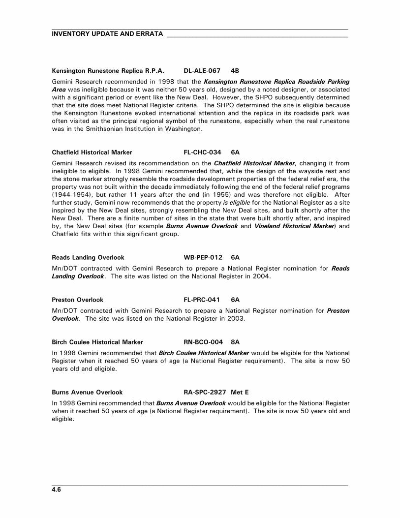
Kensington Runestone Replica R.P.A. DL-ALE-067 4B
Gemini Research recommended in 1998 that the Kensington Runestone Replica Roadside ParkingArea was ineligible because it was neither 50 years old, designed by a noted designer, or associatedwith a significant period or event like the New Deal. However, the SHPO subsequently determinedthat the site does meet National Register criteria. The SHPO determined the site is eligible becausethe Kensington Runestone evoked international attention and the replica in its roadside park wasoften visited as the principal regional symbol of the runestone, especially when the real runestonewas in the Smithsonian Institution in Washington.
Chatfield Historical Marker FL-CHC-034 6A
Gemini Research revised its recommendation on the Chatfield Historical Marker, changing it fromineligible to eligible. In 1998 Gemini recommended that, while the design of the wayside rest andthe stone marker strongly resemble the roadside development properties of the federal relief era, theproperty was not built within the decade immediately following the end of the federal relief programs(1944-1954), but rather 11 years after the end (in 1955) and was therefore not eligible. Afterfurther study, Gemini now recommends that the property is eligible for the National Register as a siteinspired by the New Deal sites, strongly resembling the New Deal sites, and built shortly after theNew Deal. There are a finite number of sites in the state that were built shortly after, and inspiredby, the New Deal sites (for example Burns Avenue Overlook and Vineland Historical Marker) andChatfield fits within this significant group.
Reads Landing Overlook WB-PEP-012 6A
Mn/DOT contracted with Gemini Research to prepare a National Register nomination for ReadsLanding Overlook. The site was listed on the National Register in 2004.
Preston Overlook FL-PRC-041 6A
Mn/DOT contracted with Gemini Research to prepare a National Register nomination for PrestonOverlook. The site was listed on the National Register in 2003.
Birch Coulee Historical Marker RN-BCO-004 8A
In 1998 Gemini recommended that Birch Coulee Historical Marker would be eligible for the NationalRegister when it reached 50 years of age (a National Register requirement). The site is now 50years old and eligible.
Burns Avenue Overlook RA-SPC-2927 Met E
In 1998 Gemini recommended that Burns Avenue Overlook would be eligible for the National Registerwhen it reached 50 years of age (a National Register requirement). The site is now 50 years old andeligible.

____________________________________________________________________________________________________________________________________ INVENTORY UPDATE AND ERRATA
__________________________________________________________________________________4.7
Indian Battle Ground Hist. Marker WA-SWC-713 Met E
Indian Battle Ground Historical Marker was individually eligible for the National Register and locatedon a listed site, the Minnesota Territorial Prison. Both the wayside rest and the prison have beenfully or partly demolished. The site has also been transferred to a local unit of government.
Pine Bend Historical Marker DK-IVG-023 Met E
Pine Bend Historical Marker, which is eligible for the National Register, is in the process of beingpartly demolished by Mn/DOT.
Stillwater Overlook - North WA-SWT-013 Met E
While it is not individually eligible for the National Register, Stillwater Overlook - North is located ona National Register-listed site called the St. Croix Boomsite. Gemini did not record this informationon either the inventory form or in the 1998 report. (The St. Croix Boomsite is also a NationalHistoric Landmark and is important to the history of St. Croix logging. Mn/DOT's St. Croix BoomsiteRoadside Parking Area is also located here.)
Blazer Park HE-GVC-047B Met W
Blazer Park was not individually eligible for the National Register but was located within an eligibledistrict called Lilac Way Historic District. Blazer Park and the district have both been partly or fullyrazed as part of Mn/DOT's reconstruction of TH 100.
Graeser Park HE-RBC-025 Met W
Mn/DOT's reconstruction of TH 100 on and near Graeser Park altered the property. Gemini Researchrecommended that it is no longer individually eligible for the National Register. For more informationsee The Potential Effect of S.P. 2735-159 on Graeser Park in Robbinsdale (TH 100) (Granger andKelly 2001). The TH 100 reconstruction also razed the Lilac Way Historic District in which the sitewas located.
Graeser Park - South HE-RBC-160 Met W
Graeser Park - South was not individually eligible for the National Register but was located withinan eligible district called Lilac Way Historic District. Both Graeser Park - South and the district wererazed as part of Mn/DOT's reconstruction of TH 100.
Lilac Park HE-SLC-013 Met W
Lilac Park was not individually eligible for the National Register but was located within an eligibledistrict called Lilac Way Historic District. The district was razed as part of Mn/DOT's reconstructionof TH 100. Lilac Park is also scheduled to be partly or fully razed.

__________________________________________________________________________________INVENTORY UPDATE AND ERRATA __________________________________________________
__________________________________________________________________________________4.8
St. Louis Park R.P.A. HE-SLC-017 Met W
St. Louis Park Roadside Parking Area was individually eligible for the National Register as well asbeing located within an eligible district called Lilac Way Historic District. While the St. Louis site isintact and still eligible, the surrounding district has been razed as part of Mn/DOT's reconstructionof TH 100.
TH 100 Culvert (Bridge 5442) HE-GVC-051 Met W
The TH 100 Culvert (Bridge 5442) was not individually eligible for the National Register but waslocated within an eligible district called Lilac Way Historic District. Both the culvert and the districtwere razed as part of Mn/DOT's reconstruction of TH 100.
TH 100 at TH 55 Ret. Walls HE-GVC-053 Met W
The TH 100 at TH 55 Retaining Walls were not individually eligible for the National Register but werelocated within an eligible district called Lilac Way Historic District. Both the retaining walls and thedistrict were razed as part of Mn/DOT's reconstruction of TH 100.
P OTHER CHANGES SINCE THE ORIGINAL INVENTORY
ADDITIONAL DEMOLITIONS
Described above are several properties that have been fully or partly demolished since the inventorywas conducted. This action changed their National Register status. Two more inventoried propertieshave also been partly or fully razed, but their National Register status did not change because theywere not eligible for the National Register. They are:
Cross River Rest Area CK-UOG-047 1A Not EligibleDustin Memorial Wayside WR-MDL-004 3B Not Eligible
PROPERTIES NO LONGER ON MN/DOT RIGHT-OF-WAY
Four of the original inventoried properties are no longer on Mn/DOT right-of-way. Some weretransferred to local units of government during the 1996-1998 inventory and some weresubsequently transferred. Plans for the potential transfer of other properties such as the MendotaOverlook are being discussed.
Glenwood Overlook PO-GLC-022 4B EligibleBolles Mill Historical Marker WA-AFC-035 Met E Not EligibleIndian Battle Ground Hist. Marker1 WA-SWC-713 Met E EligibleMill Pond Roadside Parking Area SC-SPC-069 Met W Not Eligible
1Site was subsequently demolished.

____________________________________________________________________________________________________________________________________ INVENTORY UPDATE AND ERRATA
__________________________________________________________________________________4.9
PROPERTIES REHABILITATED SINCE THE ORIGINAL INVENTORY
Since 1998 Mn/DOT has conducted full or partial rehabilitations at the following inventory properties:
Gooseberry Falls Concourse LA-SVC-046 1A Indiv. elig andon a listed site
Orr Roadside Parking Area SL-ORC-005 1B ListedCold Spring Roadside Parking Area1 SH-CSC-024 3A EligibleCraigie Flour Mill Historical Marker OT-OTT-001 4A ListedReads Landing Overlook WB-PEP-012 6A ListedOlson, Floyd B., Memorial Statue2 HE-MPC-9013 Met W Eligible
1In progress.2Plant materials only.
Construction plans prepared for the rehabilitations provide additional information about these sites.(See Mn/DOT Rehabilitation Construction Plans in the References section of this report.)
P SELECTED ERRORS, OMISSIONS, AND NEW INFORMATION LEARNED
In the six years that the inventory forms and 1998 report have been in use, several errors andomissions have been detected. Fortunately, most have been minor. Described below are some ofthe errors and omissions, as well as new information learned. The information reported hereingenerally affects the National Register eligibility of the properties and/or the characteristics of theproperties that are important to compare with others in the inventory.
Cascade River Wayside CK-UOG-044 1A
Gemini Research conducted additional research on Cascade River Wayside (formerly known asCascade River Overlook) to prepare a National Register nomination for the property. Based onthis research and additional fieldwork to understand integrity, Gemini recommended that an118-acre parcel – much larger than originally inventoried – be nominated to the National Register.The property includes the highway overlook, a segment of the highway itself, roadsidelandscaping, foot trails extending up both sides of the Cascade River and along the lakeshore, apicnic area east of the highway overlook, and many other features. See the National Registernomination (2003) for maps and updated information.
Fond du Lac Culvert (Bridge 5757) SL-DUL-2416 1A
During research to prepare treatment recommendations for Fond du Lac Culvert (Bridge 5757),Gemini Research learned that the design of the parkway along which the bridge is located likelydates from 1937-1938 – the same time that the bridge was built. (The parkway was namedEvergreen Memorial Drive in 1947 and renamed Veteran's Evergreen Memorial Drive in 1986.)The parkway is about six blocks long and has an intact, somewhat formal design with dividedtraffic lanes, grassy medians, sidewalks, grassy boulevards, and mature trees such as Americanelm and spruce. Gemini recommends that the National Register eligibility of the entire parkway

__________________________________________________________________________________INVENTORY UPDATE AND ERRATA __________________________________________________
__________________________________________________________________________________4.10
be evaluated and that all Mn/DOT activities regarding the Fond du Lac Culvert also take intoaccount preservation of the six-block parkway.
Split Rock Lighthouse Overlook LA-BBT-023 1A
After 1998 Gemini Research learned that the Split Rock Lighthouse Overlook wall was not builtin 1948, as Gemini stated on the inventory form, but more likely in the early 1950s. Furtherresearch is needed to determine the exact year. Despite the apparent change in age, Split Rockis still an example of a roadside development property that was built shortly after the New Dealand has a design directly inspired by it. It remains eligible for the National Register.
Thompson Hill Overlook SL-DUL-2431 1A
Both the inventory form for the Thompson Hill Overlook and the 1998 report state that theoverlook wall is the longest wall in the inventory and measures approximately 440' long. Thisis an error – the Thompson Hill Overlook wall is approximately 1,100' long. It remains thelongest wall recorded in the inventory.
Orr Roadside Parking Area SL-ORC-005 1B
Gemini conducted additional research on Orr Roadside Parking Area to prepare a National Registernomination for the property. Based on this research and additional fieldwork, Gemini learned thatthe property is larger than indicated on the 1998 inventory form (about 10 acres) and includesland on the eastern side of the highway (as well as on the west as indicated on the form). Eastof the highway are a foot path and a second picnic area that was used for overnight camping.The picnic area includes at least four concrete fireplace bases and a boulder fire ring. WhatGemini erroneously identified as concrete lamp pole bases in the western part of the park areconcrete fireplace bases. Gemini also learned more about the relationship between the park andthe state forestry station adjacent to the north. See the National Register nomination (2001) formaps and updated information.
Camp Ripley Entrance Walls MO-GRE-047 3A
The Camp Ripley Entrance Walls site has two Control Section numbers because it is located atthe intersection of two trunk highways. The inventory form and the 1998 report provide theControl Section number as CS 4908 (for TH 115), but the site is also in CS 4912 (for TH 371).TH 371 is the more well-traveled highway.
Garrison Concourse CW-GRC-001 3A
The inventory form for Garrison Concourse and the 1998 report both state that two of theinventory's overlook walls project into lakes – the Garrison Concourse and the Lake CityConcourse. This is an error – only the Garrison Concourse projects into a lake. The Lake CityConcourse is entirely on the shore.

____________________________________________________________________________________________________________________________________ INVENTORY UPDATE AND ERRATA
__________________________________________________________________________________4.11
Since 1998, Gemini Research has revised the boundaries of the Garrison Concourse site toencompass the entire designed intersection including traffic islands, granite curbing, and a portionof the shoreline. The revised boundary is based on a better understanding of the original project(designed by the National Park Service and built by the CCC) and how much integrity the siteretains. See the Garrison Concourse boundary study (2004) for more information.
On the 1998 inventory form, Gemini did not report the full extent of the granite curbing on thesite. In addition to the curbing near the concourse wall and southward along TH 169, there isalso considerable granite curbing (some partly buried in turf) that extends along TH 18 northwestof the concourse wall. See the "Garrison Concourse Site Boundaries" aerial map with blue linesindicating granite curbing (Gemini Research 2003). The additional curbing was not discovereduntil 2003 and was therefore not included in the treatment recommendations for the site preparedby Michael J. Burns Architects (with Gemini Research).
Pine-Hickory Lakes R.P.A. AK-FIS-017 3A
After the 1998 inventory, Gemini discovered a set of original plans for Pine-Hickory LakesRoadside Parking Area. The original plans indicate that the site is larger than described on the1998 inventory form and that it contains several more standing structures. In subsequentfieldwork Gemini confirmed that another stone council ring, a small concrete dam, a stonefireplace, a stone refuse container, and a concrete highway bridge (Bridge 3911) still exist, inaddition to the features described on the inventory form. (See the treatment report forPine-Hickory Lakes Roadside Parking Area for more information.) The extent of the park'sdevelopment and the integrity of the larger site make Pine-Hickory even more important thanoriginally indicated.
The original plans are signed by A. R. Nichols, confirming that he is the designer. On theinventory form and in the 1998 report the site is only attributed to Nichols with no confirmation.
Lake City Concourse WB-LKC-093 6A
The inventory form for Lake City Concourse and the 1998 report both erroneously state that theLake City Concourse projects into Lake Pepin. The overlook wall is entirely on the shore and doesnot project into the lake. (The Garrison Concourse is the only overlook wall in the inventory thatprojects into a lake.)
New Ulm Spring R.P.A. NL-CTT-006 7B
On the 1998 inventory form, Gemini did not report that the following features at New Ulm SpringRoadside Parking Area are extant: two stone fireplaces, a stone check dam, and two brick andconcrete spring boxes. These structures were built in the woods above the spring enclosure walland were located by HDR Engineering during fieldwork to prepare treatment recommendations forthe site.

__________________________________________________________________________________INVENTORY UPDATE AND ERRATA __________________________________________________
__________________________________________________________________________________4.12
Granite Falls Overlook YM-GRN-078 8B
In 2002, Gemini Research learned that the Granite Falls Overlook was designed and built as partof a larger effort to redesign and improve the city of Granite Falls' adjacent park called World WarMemorial Park (which is also eligible for the National Register). Memorial Park has extensivestone features that, like the overlook, are built of native stone. The Minnesota Department ofHighways was involved in building both the park and the overlook. For more information, seePhase I and II (Identification and Evaluation) Investigation of Historic Structures Associated withthe Memorial Park Trail Project in Granite Falls, Yellow Medicine County, Minnesota (Granger etal 2002).
Marine on St. Croix R.P.A. WA-MXC-015 Met E
On the 1998 inventory form, Gemini Research incorrectly defined the northern boundary ofMarine on St. Croix Roadside Parking Area as Maple Street. Instead, the park is bisected byMaple Street (an east-west local street) and includes a parcel of land north of Maple. Standingin this northern parcel is a structure not recorded on the inventory form, a wooden gazebo.
Christmas Lake R.P.A. HE-SHC-022 Met W
Christmas Lake Roadside Parking Area is in the city of Shorewood, not in the city of Minnetonkaas reported on the inventory form. The SHPO has assigned a new SHPO inventory number toreflect this correction. That number is HE-SHC-022, rather than HE-MKC-065 as originallyassigned.
After the 1998 inventory, Gemini Research discovered a set of original plans for the ChristmasLake Roadside Parking Area. The plans are signed by A. R. Nichols, confirming that he is thedesigner. On the inventory form and in the 1998 report the site is only attributed to Nichols withno confirmation.
Graeser Park HE-RBC-025 Met W
On the 1998 inventory form, Gemini did not report that the following features at Graeser Parkare extant: a stone stairway leading from Broadway Avenue down into the park (it was buriedunder turf grass), a small V-shaped retaining wall near the Broadway Avenue inslope (also buried),and the remains of a stone refuse container (hidden in the northeastern spirea hedge). They werediscovered during subsequent fieldwork by Gemini to assess the potential effects of thereconstruction of TH 100 on the park.

________________________________________________________________________________________________________________________________ REVISED NATIONAL REGISTER STATUS
__________________________________________________________________________________5.1
REVISED NATIONAL REGISTER STATUS
P REVISED LIST OF NATIONAL REGISTER-LISTED PROPERTIES
The table below is a revised list of properties in the Mn/DOT Historic Roadside DevelopmentStructures Inventory that are listed on the National Register or located within a listed NationalRegister site or district. This table takes into account the information on the preceding pages of thisreport.
Cascade River Wayside1 CK-UOG-044 1A ListedFond du Lac Culvert (Bridge 5757) SL-DUL-2416 1A ListedGooseberry Falls Concourse LA-SVC-046 1A On Listed Site2
Lester River Bridge (Bridge 5772) SL-DUL-2428 1A ListedOrr Roadside Parking Area SL-ORC-005 1B ListedGarrison Ped Underpass (Bridge 5265) CW-GRC-005 3A ListedVineland Historical Marker ML-KAN-006 3A In Listed District3
Craigie Flour Mill Historical Marker OT-OTT-001 4A ListedGraceville Historical Marker BS-GRA-017 4B ListedPreston Overlook FL-PRC-041 6A ListedReads Landing Overlook WB-PEP-012 6A ListedMantorville Retaining Walls DO-MTC-038 6B In Listed District2
Minn State Training School Ent. Walls GD-RWC-021 6B On Listed Site2
Camp Release State Mem Wayside LP-CAM-003 8B ListedMarine on St. Croix R.P.A. WA-MXC-015 Met E In Listed District2
Sibley Pioneer Church Monument DK-MDC-011 Met E In Listed District3
St. Croix Boomsite Roadside Prkg Area WA-SWT-004 Met E On Listed Site3
Stillwater Overlook - North WA-SWT-013 Met E On Listed Site3
1Note name change; originally listed in the inventory as Cascade River Overlook.2Contributing to the eligibility of the site or district.3Noncontributing to the eligibility of the site or district.
P REVISED LIST OF NATIONAL REGISTER-ELIGIBLE PROPERTIES
The table below is a revised list of properties in the Mn/DOT Historic Roadside DevelopmentStuctures Inventory that are eligible for the National Register under the Roadside Developmenthistoric context.
Cascade River Wayside1 CK-UOG-044 1A ListedFond du Lac Culvert (Bridge 5757) SL-DUL-2416 1A ListedGooseberry Falls Concourse LA-SVC-046 1A On Listed Site2
Lester River Bridge (Bridge 5772) SL-DUL-2428 1A ListedSplit Rock Lighthouse Overlook LA-BBT-023 1ASpruce Creek Culvert (Bridge 8292) CK-UOG-045 1AOrr Roadside Parking Area SL-ORC-005 1B Listed

__________________________________________________________________________________REVISED NATIONAL REGISTER STATUS ______________________________________________
__________________________________________________________________________________5.2
Whipholt Roadside Parking Area CA-PLK-003 2ANoyes Roadside Parking Area KT-SVT-002 2BCamp Ripley Entrance Walls MO-GRE-047 3AGarrison Concourse CW-GRC-001 3AGarrison Ped Underpass (Bridge 5265) CW-GRC-005 3A ListedKenney Lake Overlook CW-GRT-003 3APine-Hickory Lakes Roadsde Prkg Area AK-FIS-017 3ATH 169 Culvert at St. Alban's Bay CW-GRT-002 3AVineland Historical Marker ML-KAN-006 3A In Listed District3
Whitefish Creek Bridge (Bridge 3355) ML-KAN-005 3AWillow Lake Roadside Parking Area CA-TOR-002 3ACold Spring Roadside Parking Area SN-CSC-024 3BSt. Cloud Historical Marker SH-SCC-048 3BCraigie Flour Mill Historical Marker OT-OTT-001 4A ListedOtter Tail City Historical Marker OT-OTC-004 4APelican Rapids Village Hist Marker OT-PRC-021 4ABrowns Valley Historical Marker TR-FOL-006 4BGlenwood Overlook PO-GLC-022 4B Ownrshp TransferredGraceville Historical Marker BS-GRA-017 4B ListedKensington Runestone Replica R.P.A. DL-ALE-067 4BStage Station Historical Marker DL-OSA-021 4BChatfield Historical Marker FL-CHC-034 6AInspiration Point Wayside Rest FL-CRL-011 6ALaCrescent Overlook HU-LCC-009 6ALake City Concourse WB-LKC-093 6APreston Overlook FL-PRC-041 6A ListedReads Landing Overlook WB-PEP-012 6A ListedReno Spring Roadside Parking Area HU-JEF-007 6AFort Beauharnois Historical Marker GD-FLC-056 6BNew Ulm Spring Roadside Prking Area NL-CTT-006 7BBirch Coulee Historical Marker RN-BCO-004 8AAvoca Historical Marker MU-AVC-010 8BCamp Release State Mem Wayside LP-CAM-003 8B ListedGranite Falls Overlook YM-GRN-078 8BRedwood Falls Retaining Wall RW-RFC-032 8BBurns Avenue Overlook RA-SPC-2927 Met EMendota Overlook DK-MHC-012 Met EStillwater Overlook - South WA-OHC-005 Met ETaylors Falls Overlook - South CH-SHT-032 Met EChaska Historical Marker CR-CKC-057 Met WChristmas Lake Roadside Parking Area4 HE-SHC-022 Met WNational Grange Historical Marker SH-ERC-029 Met WOlson, Floyd B., Memorial Statue HE-MPC-9013 Met WSt. Louis Park Roadside Parking Area HE-SLC-017 Met W
1Note name change; originally listed in the inventory as Cascade River Overlook.2Contributing to the eligibility of the site or district. 3Noncontributing to the eligibility of the site or district. 4Note change in SHPO inventory number.

________________________________________________________________________________________________________________________________ REVISED NATIONAL REGISTER STATUS
__________________________________________________________________________________5.3
P REVISED LIST OF NATIONAL REGISTER-INELIGIBLE PROPERTIES
The table below is a revised list of properties in the Mn/DOT Historic Roadside DevelopmentStructures Inventory that are not eligible for the National Register under the Roadside Developmenthistoric context.
Berglund, Ray, Roadside Parking Area CK-TFT-001 1ABig Pine Lake Roadside Parking Area PN-PLK-006 1AClifton-French River Historical Marker SL-DUT-002 1ACross River Rest Area CK-UOG-047 1A Razed1
Fond du Lac Historical Marker SL-DUL-2429 1AGrand Marais Harbor Sea Wall CK-GMC-029 1ANew Duluth Overlook SL-DUL-2430 1ATemperance River Roadside Parking Area CK-UOG-046 1AThompson Hill Overlook SL-DUL-2431 1AThompson Hill-Skyline Pkwy Ovr SL-DUL-2468 1AWrenshall Ovr/Veterans' Memor. Ovr CL-TLK-004 1APillsbury Mine Overlook SL-BAL-004 1BSoudan Roadside Parking Area SL-SOC-001 1BSpang Spring Roadside Parking Area IC-SPG-004 1B Razed1
Baudette Rest Area LW-BDC-030 2AGarrison Creek Culvert (Bridge 5266) CW-GRC-006 3AGarrison Rest Area CW-GRT-001 3AHewitt Roadside Parking Area TO-HEW-012 3ALong Lake Roadside Parking Area CW-NSC-004 3ABabcock Memorial Park SH-ERC-028 3BDickinson Spring Roadside Prking Area WR-RKT-006 3B Razed1
Dustin Memorial Wayside WR-MDL-004 3B Razed1
Maine Prairie Corners Hist Marker SN-MPR-004 3BDetroit Lakes Overlook BK-DLC-157 4ALeaf City Historical Marker OT-LLT-001 4AMinnesota Woman Roadside Parkng Area OT-PEL-001 4APomme de Terre Roadside Parking Area SW-MOY-007 4BSilver Lake Roadside Parking Area OL-ROC-105 6AWabasha Overlook WB-WBC-183 6AFrontenac R.P.A./Maiden Rock GD-FLC-054 6BFrontenac State Park Gates GD-FLC-057 6BMantorville Retaining Walls2 DO-MTC-038 6BMinn State Training School Entr Walls2 GD-RWC-021 6BRed Wing Roadside Parking Area GD-RWC-849 6BMapleton Historical Marker BE-MPC-031 7AVictory Memorial Rest Area BE-DEC-008 7AMorton Pioneer Monuments R.P.A. RN-BFS-002 8APipestone Nat Monu Entr. Marker PP-PPC-154 8BBolles Mill Historical Marker WA-AFC-035 Met E Ownrshp TransferredIndian Battle Ground Hist. Marker WA-SWC-713 Met E Ownrs Trans, Razed1
Marine on St. Croix R.P.A.2 WA-MXC-015 Met E

__________________________________________________________________________________REVISED NATIONAL REGISTER STATUS ______________________________________________
__________________________________________________________________________________5.4
Mendota Granite Arrow Marker DK-MDC-010 Met EPine Bend Historical Marker DK-IVG-023 Met E Being razed1
Point Douglas Road Retaining Wall RA-SPC-2928 Met ESt. Croix Boomsite Roadside Prkng Area2 WA-SWT-004 Met ESibley Pioneer Church Monument2 DK-MDC-011 Met EStillwater Overlook - North2 WA-SWT-013 Met EStillwater Retaining Wall WA-SWC-1205 Met ETamarack House Historical Marker WA-SWC-714 Met ETaylors Falls Overlook - North CH-TFC-055 Met EBlazer Park HE-GVC-047B Met W Razed1
Daytonport Roadside Parking Area AN-RMC-008 Met WGraeser Park HE-RBC-025 Met WGraeser Park - South HE-RBC-160 Met W Razed1
Lilac Park HE-SLC-013 Met W To be razed1
Mill Pond Roadside Parking Area SC-SPC-069 Met W Ownrshp TransferredTH 55 Retaining Wall HE-GVC-052 Met WTH 100 at TH 55 Retaining Walls HE-GVC-053 Met W Razed1
TH 100 Culvert (Bridge 5442) HE-GVC-051 Met W Razed1
1Fully or partly demolished.2On a listed site or in a listed district.
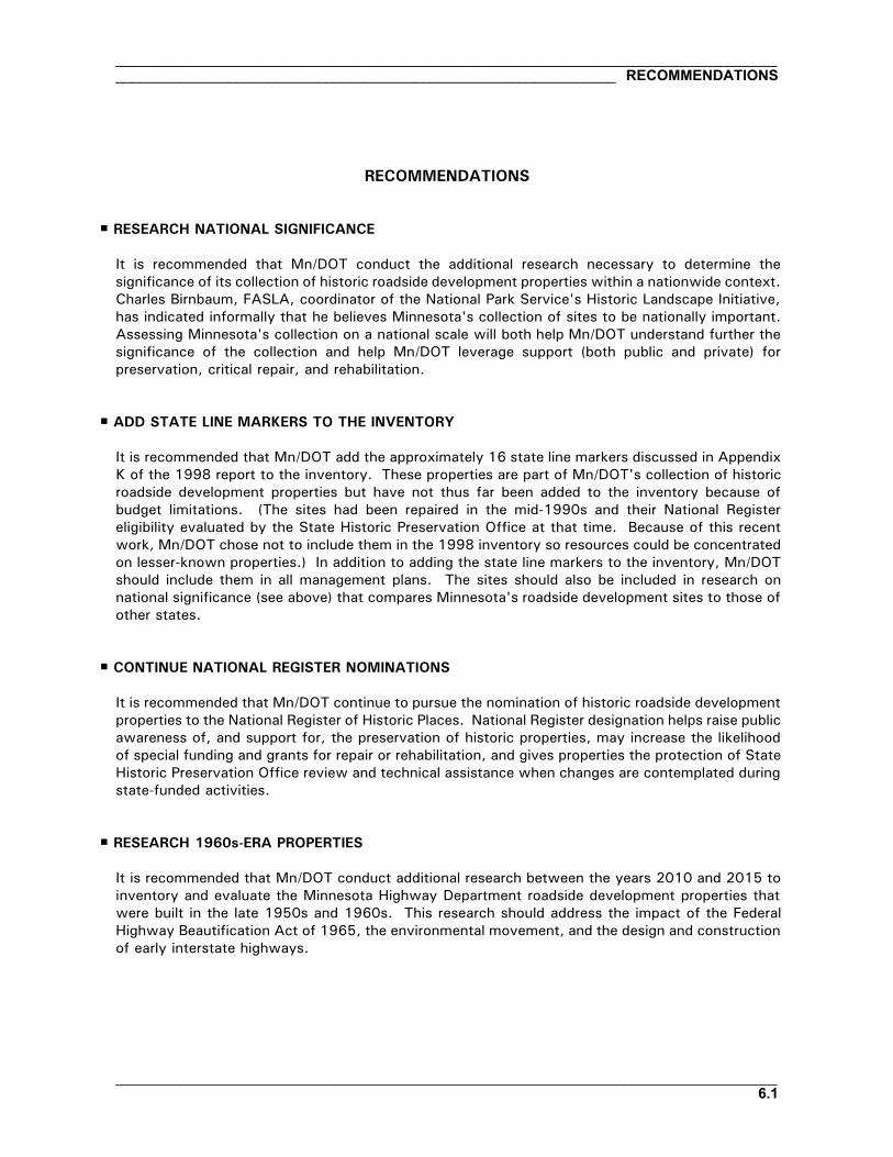
________________________________________________________________________________________________________________________________________________ RECOMMENDATIONS
__________________________________________________________________________________6.1
RECOMMENDATIONS
P RESEARCH NATIONAL SIGNIFICANCE
It is recommended that Mn/DOT conduct the additional research necessary to determine thesignificance of its collection of historic roadside development properties within a nationwide context.Charles Birnbaum, FASLA, coordinator of the National Park Service's Historic Landscape Initiative,has indicated informally that he believes Minnesota's collection of sites to be nationally important.Assessing Minnesota's collection on a national scale will both help Mn/DOT understand further thesignificance of the collection and help Mn/DOT leverage support (both public and private) forpreservation, critical repair, and rehabilitation.
P ADD STATE LINE MARKERS TO THE INVENTORY
It is recommended that Mn/DOT add the approximately 16 state line markers discussed in AppendixK of the 1998 report to the inventory. These properties are part of Mn/DOT's collection of historicroadside development properties but have not thus far been added to the inventory because ofbudget limitations. (The sites had been repaired in the mid-1990s and their National Registereligibility evaluated by the State Historic Preservation Office at that time. Because of this recentwork, Mn/DOT chose not to include them in the 1998 inventory so resources could be concentratedon lesser-known properties.) In addition to adding the state line markers to the inventory, Mn/DOTshould include them in all management plans. The sites should also be included in research onnational significance (see above) that compares Minnesota's roadside development sites to those ofother states.
P CONTINUE NATIONAL REGISTER NOMINATIONS
It is recommended that Mn/DOT continue to pursue the nomination of historic roadside developmentproperties to the National Register of Historic Places. National Register designation helps raise publicawareness of, and support for, the preservation of historic properties, may increase the likelihoodof special funding and grants for repair or rehabilitation, and gives properties the protection of StateHistoric Preservation Office review and technical assistance when changes are contemplated duringstate-funded activities.
P RESEARCH 1960s-ERA PROPERTIES
It is recommended that Mn/DOT conduct additional research between the years 2010 and 2015 toinventory and evaluate the Minnesota Highway Department roadside development properties thatwere built in the late 1950s and 1960s. This research should address the impact of the FederalHighway Beautification Act of 1965, the environmental movement, and the design and constructionof early interstate highways.

__________________________________________________________________________________RECOMMENDATIONS ______________________________________________________________
__________________________________________________________________________________6.2
P SHARE INFORMATION WITH LOCAL GOVERNMENTS
It is recommended that Mn/DOT share its inventory and contextual information with local units ofgovernment, particularly when a site is located within municipal limits. In many cases localgovernments do not realize the significance of the properties and may be potential partners in theircare. It is also recommended that Mn/DOT share historic context information with local governmentsthat own an historic property that was built by the MHD as part of its early roadside program butwas transferred to the local government before 1998 (and therefore not included in the inventory).For example, important historic roadside development structures designed by A. R. Nichols and builtby the MHD and New Deal federal relief agencies stand outside of current right-of-way in St. Joseph,Cambridge, Eden Prairie, South St. Paul, Grand Marais, rural Redwood County, and in several otherlocations.

_____________________________________________________________________________________________________________________________________________________ ILLUSTRATIONS
__________________________________________________________________________________7.1
Fig 1. Council ring, Hewitt Roadside Parking Area, 1942. Courtesy Marvel Blaske.
Fig 2. Spring enclosure, Hewitt Roadside Parking Area, April 2003.

__________________________________________________________________________________ILLUSTRATIONS ___________________________________________________________________
__________________________________________________________________________________7.2
Fig 3. Stone table, Hewitt Roadside Parking Area, April 2003.
Fig 4. LaCrescent Overlook, Jan. 2003.

_____________________________________________________________________________________________________________________________________________________ ILLUSTRATIONS
__________________________________________________________________________________7.3
Fig. 5. Flagpole and plaza, Noyes Roadside Parking Area, April 2003.
Fig. 6. Pipestone National Monument Entrance Marker, Oct. 2002.

__________________________________________________________________________________ILLUSTRATIONS ___________________________________________________________________
__________________________________________________________________________________7.4
Fig. 7. Reno Spring Roadside Parking Area, Jan. 2003.
Fig. 8. Stillwater Retaining Wall, Nov. 2002.

_____________________________________________________________________________________________________________________________________________________ ILLUSTRATIONS
__________________________________________________________________________________7.5
Fig. 9. Thompson Hill-Skyline Parkway Overlook, Oct. 2003.

__________________________________________________________________________________ILLUSTRATIONS ___________________________________________________________________
__________________________________________________________________________________7.6
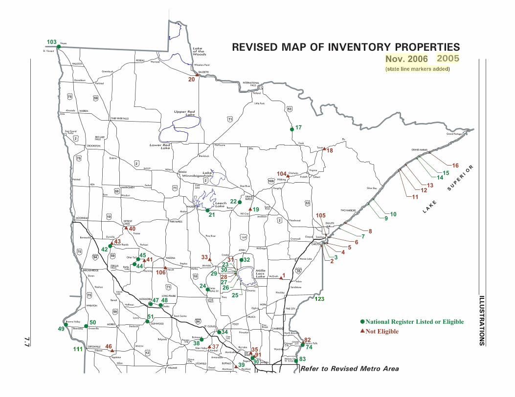
L A K
E
S U P
E R
I O
R
BUFFALO
Monticello
Annandale
Montrose
Milan
WILLMAR
LITCHFIELD
GroveCity
Dassel
BENSON
Appleton
Odessa
ORTONVILLE
Beardsley Graceville
Browns ValleyMORRIS GLENWOOD
Lowry
Starbuck
Belgradeville
Paynes-
Sauk Centre
Richmond
Eden ValleyKimball
Clear
Big Lake
Princeton
ST. CLOUD PineBrook
CAMBRIDGE
Wyoming
Taylors FallsChisagoCity
CENTERCITY
North Branch
PINE CITY
Sandstone
Askov
Isle
Ogilvie
MORA
Onamia
MILACA
FOLEY
PierzLITTLEFALLS
CampRipley Jct.
Osakis
LONG PRAIRIEALEXANDRIA
Hoffman
Barrett
ELBOWLAKE
WHEATON
Nashua
BRECKENRIDGE
Doran
BattleLake
Dunvilla
Pelican Rapids Perham
Otter Tail
Henning
WADENA
Hewitt
Staples
Motley
Pine River
BRAINERD
Garrison
Crosby
AITKINMcGregor
McGrath
Moose Lake
CromwellCloquet Scanlon
CARLTON
DULUTH
TWO HARBORS
Floodwood
SwanRiver
JacobsonHill City
RemerWALKER
Akeley
PARK RAPIDSDETROITLAKES
Frazee
MOORHEAD
Barnesville
Halstad
Syre
ADA
Waubun
MAHNOMENZerkel
BAGLEY
BEMIDJIWilton
CassLake
GRANDRAPIDS
Pengilly
Hibbing
ChisholmVirginia
Eveleth Gilbert
Cook
Tower
Ely
GRAND MARAIS
Grand Portage
Effie
INTERNATIONALFALLS
Pelland
Little Fork
Blackduck
Northome
2
Erskine
CROOKSTON
OsloAlvarado WARREN
East GrandForks
RED LAKEFALLS
THIEF RIVER FALLS
Wheelers Point
BAUDETTE
ROSEAU
Greenbush
KarlstadDonaldson
HALLOCK
59
St. Vincent
Noyes
Silver Bay
Lake
Warroad
75
DeerRiver
Hinckley
FERGUSFALLS
Rockford
Rogers
Monticello
ELK
ANOKASt. CroixMarine On
1
18
19
17
21
20
24
32 33
22
34
35 37 38
39
40
41
42 43
44
45
46
47 48
49 50
51
74 82
83 90 91
35
94
Lake of the Woods
Upper Red Lake
Lower Red Lake
Lake Winnibigoshish
Leech Lake
Mille Lacs Lake
2526
27
2330
29 28
31
10
1112
1314
1516
4
RIVER
Not Eligible National Register Listed or Eligible
75
2
71
2
2
53
169
169
53
71
71
10
10
59
5994
59
75
75
12
9
3
67
8
5
2
ILLUSTRA
TIO
NS
7.7
Refer to Revised Metro Area
103
104
106
105
REVISED MAP OF INVENTORY PROPERTIES2005

NEWULMSleepy
Eye
ST. JAMES
LUVERNE
WORTHINGTONAdrian
JACKSON FAIRMONT BLUE EARTH
Alden ALBERTLEA
AUSTIN DexterPRESTON
SpringValley
Chatfield
Fountain
Harmony
Lanesboro
CALEDONIA
Houston Hokah
La Crescent
WINONA
DakotaWilson
ROCHESTER
OWATONNAWASECA
Mapleton
WINDOM
SLAYTON
Fulda
PIPESTONE
LakeBenton
IVANHOE
MARSHALL
Florence
REDWOODFALLS
Nicollet ST. PETERWaterville
New Prague
FARIBAULT
Northfield
Zumbrota
CannonFalls
WING
WABASHALakeCity
GAYLORD
Belle Plaine
Green Isle
BrowntonGLENCOE Norwood
Hutchinson
Hector
WinthropFairfaxMorton
OLIVIA
Canby
GRANITEFALLS
MONTEVIDEO CityCosmos
MANKATO
MANTORVILLE
Sherburn
RED
Jordan
Excelsior
CHASKAHASTINGS
Prescott
5253
54
58 59
65
66
67
68 69
70
71
72 78 101
102
89
W TR
TA
O
N
OT
DE
MT
RA
PE
M
N
N
T A
OPSNA
E S
N
N
T
S
F
O
R
E
10
10
0 10
0SCALE
20
10
30 40
20 30 MILES
50 KILOMETERS
35
90
5556
5761
6263
6460
75
59
71
14
90
212
212
169218
63
52
61
Kellogg
36 Map EnlargementDelanoClara73 MADISON
See Metro Area Map Enlargement for sites 75-77, 79-81, 84-88, 92-100, 107
s 1 Big Pine Lake Roadside Parking Areas 2 Wrenshall Overlook/Veterans' Memorial Overlookl 3 Fond du Lac Culvert (Bridge 5757)s 4 Fond du Lac Historical Markers 5 New Duluth Overlook
s 6 Thompson Hill Overlookl 7 Lester River Bridge (Bridge 5772)s 8 Clifton-French River Historical Markerl 9 Gooseberry Falls Concoursel 10 Split Rock Lighthouse Overlook
s 11 Cross River Rest Areas 12 Temperance River Roadside Parking Areas 13 Berglund, Ray, Roadside Parking Areal 14 Spruce Creek Culvert (Bridge 8292)l 15 Cascade River Overlook
s 16 Grand Marais Harbor Sea Walll 17 Orr Roadside Parking Areas 18 Soudan Roadside Parking Area
19 Spang Spring Roadside Parking Areas 20 Baudette Rest Area
l 21 Whipholt Roadside Parking Areal 22 Willow Lake Roadside Parking Areal 23 Kenney Lake Overlookl 24 Camp Ripley Entrance Wallsl 25 Vineland Historical Marker
l 51 Glenwood Overlookl 52 Inspiration Point Wayside Restl 53 Preston Overlook
54 Chatfield Historical Markers 55 Wabasha Overlook
l 56 Reads Landing Overlookl 57 Lake City Concourses 58 Silver Lake Roadside Parking Areal 59 Mantorville Retaining Wallss 60 Red Wing Roadside Parking Area
s 61 Frontenac R.P.A./Maiden Rocks 62 Frontenac State Park Gatesl 63 Fort Beauharnois Historical Markerl 64 Minn State Training School Ent. Wallss 65 Mapleton Historical Marker
s 66 Victory Memorial Rest Areal 67 New Ulm Spring Roadside Parking Areal 68 Birch Coulee Historical Markers 69 Morton Pioneer Monuments R.P.A.l 70 Redwood Falls Retaining Wall
l 71 Avoca Historical Markerl 72 Granite Falls Overlookl 73 Camp Release State Memorial Waysidel 74 Taylors Falls Overlook - Southl 75 Mendota Overlook
l 26 Whitefish Creek Bridge (Bridge 3355)l 27 TH 169 Culvert at St. Alban's Bays 28 Garrison Rest Areal 29 Garrison Ped Underpass (Bridge 5265)l 30 Garrison Concourse
s 31 Garrison Creek Culvert (Bridge 5266)l 32 Pine-Hickory Lakes Roadside Parking Areas 33 Long Lake Roadside Parking Areal 34 St. Cloud Historical Markers 35 Babcock Memorial Park
s 36 Dustin Memorial Waysides 37 Maine Prairie Corners Historical Markerl 38 Cold Spring Roadside Parking Area
39 Dickinson Spring Roadside Parking Areas 40 Detroit Lakes Overlook
42 Pelican Rapids Village Historical Marker43 Minnesota Woman Roadside Parking Area44 Craigie Flour Mill Historical Marker45 Otter Tail City Historical Marker
s 46 Pomme de Terre Roadside Parking Area47
l 48 Stage Station Historical Markerl 49 Browns Valley Historical Markerl 50 Graceville Historical Marker
l 76 Sibley Pioneer Church Monumentl 77 Stillwater Overlook - South
78 Pine Bend Historical Markers 79 Mendota Granite Arrow Markers 80 Point Douglas Road Retaining Wall
l 81 Burns Avenue Overlooks 82 Taylors Falls Overlook - Northl 83 Marine on St. Croix R.P.A.l 84 St. Croix Boomsite Roadside Parking Area
85 Stillwater Overlook - North
s 86 Tamarack House Historical Marker87 Indian Battle Ground Historical Marker
s 88 Bolles Mill Historical Markerl 89 Christmas Lake Roadside Parking Areal 90 National Grange Historical Marker
s 91 Daytonport Roadside Parking Areas 92 TH 55 Retaining Walll 93 Olson, Floyd B., Memorial Statuel 94 St. Louis Park Roadside Parking Area
95 Lilac Park
96 TH 100 Culvert (Bridge 5442)97 Blazer Park98 TH 100 at TH 55 Retaining Walls99 Graeser Park - South
100 Graeser Park
s101 Mill Pond Roadside Parking Areal102 Chaska Historical Marker
41 Leaf City Historical Marker
s
l
l
l
s
103 Noyes Roadside Parking Area104 Pillsbury Mine Overlook105 Thompson Hill-Skyline Pkwy Overlook
s106 Hewitt Roadside Parking Area107 Stillwater Retaining Wall
s108 Pipestone Nat. Mon. Entrance Markerl109 LaCrescent Overlookl110 Reno Spring Roadside Parking Area
110
109
l
s
s
sl
ll
Site fully or partially razed
108
s
ss
s
s
s
s
s
s
s
Kensington Runestone Replica R.P.A.

10099
97 98 9396
94
76
75
81
80 88
8586
84
87
77
92
79
95
35W
694
35E
100
94
55
394
100
494 35W
55
61
494
94
95
35E
107
Robbinsdale
Brooklyn Center
Blaine
Mounds
Columbia Heights
Golden Valley
Medicine Lake
St. Louis Park
Edina
InverGrove
Heights
Maplewood
Roseville
VadnaisHeights
White
Lake Elmo
Oakdale
STILLWATER
Bayport
Lakeland
Afton
NorthSt. Paul
Fridley
Minnetonka
Richfield
So. St. Paul
ViewNew
Brighton
Mendota Heights
LittleCanada
Not Eligible
National Register Listed or Eligible
BearLake
METRO AREA MAP ENLARGEMENT
1
1
0 1
0SCALE
2
1
3 4
2 3 MILES
5 KILOMETERS
W TR
TA
O
N
OT
DE
MT
RA
PE
M
N
N
T A
OPSNA
E S
N
N
T
S
F
O
R
E
ST. PAUL
7.9
ILLUSTRA
TIO
NS
REVISED

State Line Markers on Minnesota Trunk Highways
Map No.
Trunk Hwy.
Nearby City
County
Year Built
Builder
National Register Eligible
111 12 Ortonville Big Stone 1942 WPA Yes 112 169 Elmore Faribault NYA Yes 113 52 Prosper Fillmore 1941 NYA No 114 63 Chester Fillmore NYA Yes 115 139 Harmony Fillmore NYA Yes 116 65 Gordonsville Freeborn 1941 NYA Yes 117 69 Emmons Freeborn NYA Yes 118 61 LaCrescent Houston 1943 Maint. Lab Yes 119 71 Jackson Jackson NYA Yes 120 212 Dawson Lac qui Parle NYA Yes 121 14 Lake Benton Lincoln NYA Yes 122 218 Lyle Mower NYA Yes 123 48 Hinckley Pine NYA * Yes 124 30 Pipestone Pipestone NYA Yes 125 75 Luverne Rock 1941-42 NYA Yes 126 68 Canby Yellow Medicine NYA Yes * This site may have been built by the CCC.
NOTE: There are two additional state line markers believed to have been demolished prior
to the historic roadside development structures research began: one marker on TH 15 in Mower County and one on TH 60 in Nobles County.

_______________________________________________________________________________________________________________________________________________________ REFERENCES
__________________________________________________________________________________8.1
REFERENCES ADDITIONAL TO THOSE IN THE 1998 REPORT
P GENERAL SOURCES
Anderson, Rolf T. "Federal Relief Construction in Minnesota, 1933-1941." National Register ofHistoric Places Multiple Property Documentation Form. Oct. 9, 1990; amended by Anderson Aug.30, 1993; amended by Gemini Research 2002. [Note 2002 amendment.]
Anderson, Rolf T. "Innovative Program Undertaken by Minnesota Department of TransportationDocuments and Evaluates Historic Roadside Landscape Features." Vineyard [Historic LandscapeInitiative of the National Park Service], vol. 3 (2001): 9-11.
Anderson, Rolf T, with Liz Walton and Gemini Research. "New Deal Roadside Landscape Features."Cultural Landscape Currents, vol. 6 (2004). Historic Landscape Initiative of the National ParkService. http://www2.cr.nps.gov/hli/currents/index.htm
Birnbaum, Charles A., with Christine Capella Peters. The Secretary of the Interior's Standards forthe Treatment of Historic Properties with Guidelines for the Treatment of Cultural Landscapes.Washington, DC: U.S. Department of the Interior, National Park Service Cultural ResourceStewardship and Partnerships Heritage Preservation Services, Historic Landscape Initiative, 1996.
Carr, Ethan. Wilderness by Design: Landscape Architecture and the National Park Service. Lincoln:Univ. of Nebraska Press, 1998.
Kopischke, Gregory. "Morell, Anthony Urbanski." In Pioneers of American Landscape Design. Ed.Charles A. Birnbaum and Robin Karson. New York: McGraw-Hill, 2000.
Kopischke, Gregory. "Nichols, Arthur Richardson." In Pioneers of American Landscape Design. Ed.Charles A. Birnbaum and Robin Karson. New York: McGraw-Hill, 2000.
Long, Barbara Beving. Phase III Historical Mitigation: T.H. 61 in Gooseberry Falls State Park andBridge No. 3585. Prepared for Mn/DOT by Rivercrest Associates. Sept. 1996.
McClelland, Linda Flint. Building the National Parks. Baltimore: Johns Hopkins Univ. Press, 1998.
P Mn/DOT REPORTS
Granger, Susan, and Scott Kelly. Draft Historic Preservation Plan for the Cold Spring RoadsideParking Area, Cold Spring, Minnesota. Submitted to Mn/DOT by Gemini Research. January 2002[Draft].
Granger, Susan, Scott Kelly, and Kay Grossman. Evaluation of the National Register Eligibility ofStone Culverts on T.H. 74, Whitewater State Park, Winona County, Minnesota [S.P. 7909-02].Submitted to Mn/DOT by Gemini Research. Dec. 26, 2000. [Includes impressive Rustic Style stoneculverts and flumes.]

__________________________________________________________________________________REFERENCES _____________________________________________________________________
__________________________________________________________________________________8.2
Granger, Susan, Scott Kelly, and Kay Grossman. Historic Roadside Development Structures onMinnesota Trunk Highways. Prepared for Mn/DOT by Gemini Research. Dec. 1998.
Granger, Susan, Scott Kelly, and Kay Grossman. Phase I and II (Identification and Evaluation)Investigation of Historic Structures Along T.H. 52 Near Preston and Fountain in Fillmore County,Minnesota [S.P. 2310-22]. Submitted to Mn/DOT by Gemini Research. Aug. 28, 2001. [IncludesPreston Overlook and an MHD Retaining Wall at Fountain.]
Granger, Susan, Scott Kelly, and Kay Grossman. Phase I and II (Identification and Evaluation)Investigation of Historic Structures Associated with the Memorial Park Trail Project in Granite Falls,Yellow Medicine County, Minnesota [S.P. 87-090-01]. Submitted to Mn/DOT and Yellow MedicineCounty by Gemini Research. Nov. 26, 2002. [Includes Granite Falls Overlook.]
Granger, Susan, Scott Kelly, and Kay Grossman. Phase II (Evaluation) Investigation of HistoricStructures Along T.H. 169 on the Western Shore of Mille Lacs Lake (S.P. 1804-50). Submitted toMn/DOT by Gemini Research. Aug. 28, 2001. [Includes Garrison Concourse, Garrison Ped.Underpass (Bridge 5265), Garrison Rest Area, TH 169 Culvert at St. Alban's Bay, Vineland HistoricalMarker, and Whitefish Creek Bridge (Bridge 3355).]
Granger, Susan, Scott Kelly, and Kay Grossman. Supplement One (North Half of Corridor), PhaseI and II Identification and Evaluation of Historic Structures in the T.H. 169 Corridor Near the WesternShore of Mille Lacs Lake (S.P. 1804-50). Submitted to Mn/DOT by Gemini Research. Sept. 15,2003. [Includes Kenney Lake Overlook.]
Granger, Susan, and Scott Kelly. Phase I Standing Structures Survey Along T.H. 169 on theWestern Shore of Mille Lacs Lake (S.P. 1804-50). Submitted to Mn/DOT by Gemini Research.March 15, 2000. [Includes Garrison Concourse, Garrison Ped. Underpass (Bridge 5265), GarrisonRest Area, TH 169 Culvert at St. Alban's Bay, Vineland Historical Marker, and Whitefish CreekBridge (Bridge 3355).]
Granger, Susan, and Scott Kelly. The Potential Effect of S.P. 2735-159 on Graeser Park inRobbinsdale (T.H. 100). Submitted to Mn/DOT by Gemini Research. Feb. 7, 2001.
Granger, Susan, and Scott Kelly. Potential Effects on Historic Structures From the T.H. 169 Mill andOverlay, By-pass and Turn lanes Project (S.P. 1804-48). Submitted to Mn/DOT by Gemini Research.Nov. 15, 1999. [Includes Garrison Concourse, Garrison Ped. Underpass (Bridge 5265), TH 169Culvert at St. Alban's Bay, Vineland Historical Marker, and Whitefish Creek Bridge (Bridge 3355).]
P Mn/DOT BOUNDARY STUDIES
Boundary studies were prepared by Gemini Research in 2004 for the sites listed below. Thesestudies, which include aerial photographs, are housed in the Mn/DOT Site Development Unit.
Cascade River Wayside CK-UOG-044 1AFond du Lac Culvert (Bridge 5757) SL-DUL-2416 1AGooseberry Falls Concourse LA-SVC-046 1AHinckley State Line Marker PN-OGM-004 1A

_______________________________________________________________________________________________________________________________________________________ REFERENCES
__________________________________________________________________________________8.3
Lester River Bridge (Bridge 5772) SL-DUL-2428 1ASplit Rock Lighthouse Overlook LA-BBT-023 1ASpruce Creek Culvert (Bridge 8292) CK-UOG-045 1AOrr Roadside Parking Area SL-ORC-005 1BWhipholt Roadside Parking Area CA-PLK-003 2ANoyes Roadside Parking Area KT-SVT-002 2BCamp Ripley Entrance Walls MO-GRE-047 3AGarrison Concourse CW-GRC-001 3AGarrison Ped Underpass (Bridge 5265) CW-GRC-005 3AKenney Lake Overlook CW-GRT-003 3APine-Hickory Lakes Roadsde Prkg Area AK-FIS-017 3ATH 169 Culvert at St. Alban's Bay CW-GRT-002 3AVineland Historical Marker ML-KAN-006 3AWhitefish Creek Bridge (Bridge 3355) ML-KAN-005 3AWillow Lake Roadside Parking Area CA-TOR-002 3ACold Spring Roadside Parking Area SN-CSC-024 3BSt. Cloud Historical Marker SH-SCC-048 3BCraigie Flour Mill Historical Marker OT-OTT-001 4AOtter Tail City Historical Marker OT-OTC-004 4APelican Rapids Village Hist Marker OT-PRC-021 4ABrowns Valley Historical Marker TR-FOL-006 4BGraceville Historical Marker BS-GRA-017 4BStage Station Historical Marker DL-OSA-021 4BChatfield Historical Marker FL-CHC-034 6AInspiration Point Wayside Rest FL-CRL-011 6ALaCrescent Overlook HU-LCC-009 6ALake City Concourse WB-LKC-093 6APreston Overlook FL-PRC-041 6AReads Landing Overlook WB-PEP-012 6AReno Spring Roadside Parking Area HU-JEF-007 6AFort Beauharnois Historical Marker GD-FLC-056 6BMantorville Retaining Walls DO-MTC-038 6BMinn State Training School Ent. Walls GD-RWC-021 6BNew Ulm Spring Roadside Prking Area NL-CTT-006 7BBirch Coulee Historical Marker RN-BCO-004 8AAvoca Historical Marker MU-AVC-010 8BCamp Release State Mem Wayside LP-CAM-003 8BGranite Falls Overlook YM-GRN-078 8BRedwood Falls Retaining Wall RW-RFC-032 8BBurns Avenue Overlook RA-SPC-2927 Met EMarine on St. Croix R.P.A. WA-MXC-015 Met ESibley Pioneer Church Monument DK-MDC-011 Met ESt. Croix Boomsite Roadsde PrkgArea WA-SWT-004 Met EStillwater Overlook - South WA-OHC-005 Met EStillwater Overlook - North WA-SWT-013 Met ETaylors Falls Overlook - South CH-SHT-032 Met EChaska Historical Marker CR-CKC-057 Met WChristmas Lake Roadside Parking Area HE-SHC-022 Met W
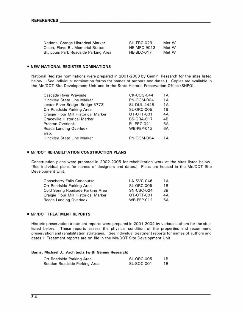
__________________________________________________________________________________REFERENCES _____________________________________________________________________
__________________________________________________________________________________8.4
National Grange Historical Marker SH-ERC-029 Met WOlson, Floyd B., Memorial Statue HE-MPC-9013 Met WSt. Louis Park Roadside Parking Area HE-SLC-017 Met W
P NEW NATIONAL REGISTER NOMINATIONS
National Register nominations were prepared in 2001-2003 by Gemini Research for the sites listedbelow. (See individual nomination forms for names of authors and dates.) Copies are available inthe Mn/DOT Site Development Unit and in the State Historic Preservation Office (SHPO).
Cascade River Wayside CK-UOG-044 1AHinckley State Line Marker PN-OGM-004 1ALester River Bridge (Bridge 5772) SL-DUL-2428 1AOrr Roadside Parking Area SL-ORC-005 1BCraigie Flour Mill Historical Marker OT-OTT-001 4AGraceville Historical Marker BS-GRA-017 4BPreston Overlook FL-PRC-041 6AReads Landing Overlook WB-PEP-012 6Aalso:Hinckley State Line Marker PN-OGM-004 1A
P Mn/DOT REHABILITATION CONSTRUCTION PLANS
Construction plans were prepared in 2002-2005 for rehabilitation work at the sites listed below.(See individual plans for names of designers and dates.) Plans are housed in the Mn/DOT SiteDevelopment Unit.
Gooseberry Falls Concourse LA-SVC-046 1AOrr Roadside Parking Area SL-ORC-005 1BCold Spring Roadside Parking Area SN-CSC-024 3BCraigie Flour Mill Historical Marker OT-OTT-001 4AReads Landing Overlook WB-PEP-012 6A
P Mn/DOT TREATMENT REPORTS
Historic preservation treatment reports were prepared in 2001-2004 by various authors for the siteslisted below. These reports assess the physical condition of the properties and recommendpreservation and rehabilitation strategies. (See individual treatment reports for names of authors anddates.) Treatment reports are on file in the Mn/DOT Site Development Unit.
Burns, Michael J., Architects (with Gemini Research)
Orr Roadside Parking Area SL-ORC-005 1BSoudan Roadside Parking Area SL-SOC-001 1B
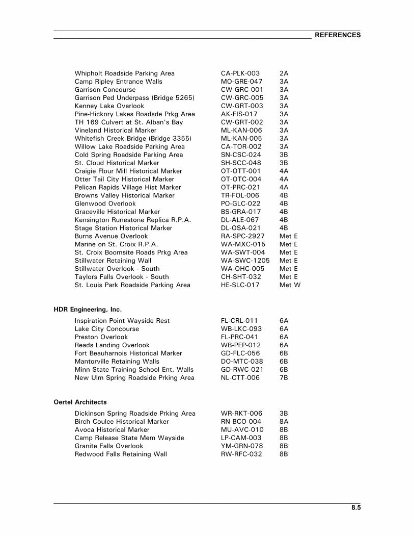
_______________________________________________________________________________________________________________________________________________________ REFERENCES
__________________________________________________________________________________8.5
Whipholt Roadside Parking Area CA-PLK-003 2ACamp Ripley Entrance Walls MO-GRE-047 3AGarrison Concourse CW-GRC-001 3AGarrison Ped Underpass (Bridge 5265) CW-GRC-005 3AKenney Lake Overlook CW-GRT-003 3APine-Hickory Lakes Roadsde Prkg Area AK-FIS-017 3ATH 169 Culvert at St. Alban's Bay CW-GRT-002 3AVineland Historical Marker ML-KAN-006 3AWhitefish Creek Bridge (Bridge 3355) ML-KAN-005 3AWillow Lake Roadside Parking Area CA-TOR-002 3ACold Spring Roadside Parking Area SN-CSC-024 3BSt. Cloud Historical Marker SH-SCC-048 3BCraigie Flour Mill Historical Marker OT-OTT-001 4AOtter Tail City Historical Marker OT-OTC-004 4APelican Rapids Village Hist Marker OT-PRC-021 4ABrowns Valley Historical Marker TR-FOL-006 4BGlenwood Overlook PO-GLC-022 4BGraceville Historical Marker BS-GRA-017 4BKensington Runestone Replica R.P.A. DL-ALE-067 4BStage Station Historical Marker DL-OSA-021 4BBurns Avenue Overlook RA-SPC-2927 Met EMarine on St. Croix R.P.A. WA-MXC-015 Met ESt. Croix Boomsite Roads Prkg Area WA-SWT-004 Met EStillwater Retaining Wall WA-SWC-1205 Met EStillwater Overlook - South WA-OHC-005 Met ETaylors Falls Overlook - South CH-SHT-032 Met ESt. Louis Park Roadside Parking Area HE-SLC-017 Met W
HDR Engineering, Inc.
Inspiration Point Wayside Rest FL-CRL-011 6ALake City Concourse WB-LKC-093 6APreston Overlook FL-PRC-041 6AReads Landing Overlook WB-PEP-012 6AFort Beauharnois Historical Marker GD-FLC-056 6BMantorville Retaining Walls DO-MTC-038 6BMinn State Training School Ent. Walls GD-RWC-021 6BNew Ulm Spring Roadside Prking Area NL-CTT-006 7B
Oertel Architects
Dickinson Spring Roadside Prking Area WR-RKT-006 3BBirch Coulee Historical Marker RN-BCO-004 8AAvoca Historical Marker MU-AVC-010 8BCamp Release State Mem Wayside LP-CAM-003 8BGranite Falls Overlook YM-GRN-078 8BRedwood Falls Retaining Wall RW-RFC-032 8B

__________________________________________________________________________________REFERENCES _____________________________________________________________________
__________________________________________________________________________________8.6
Mendota Overlook DK-MHC-012 Met ESibley Pioneer Church Monument DK-MDC-011 Met EChaska Historical Marker CR-CKC-057 Met WChristmas Lake Roadside Parking Area HE-SHC-022 Met WNational Grange Historical Marker SH-ERC-029 Met W
Sanders Wacker Bergly Inc.
Pine Bend Historical Marker DK-IVG-023 Met EGraeser Park HE-RBC-025 Met WOlson, Floyd B., Memorial Statue HE-MPC-9013 Met W
SMSQ Architects
Cascade River Wayside CK-UOG-044 1AFond du Lac Culvert (Bridge 5757) SL-DUL-2416 1AGooseberry Falls Concourse LA-SVC-046 1ALester River Bridge (Bridge 5772) SL-DUL-2428 1ASplit Rock Lighthouse Overlook LA-BBT-023 1ASpruce Creek Culvert (Bridge 8292) CK-UOG-045 1A
P RECOMMENDATIONS FOR INELIGIBLE PROPERTIES
Most of the treatment reports and boundary studies listed above were prepared for sites that arelisted on, or eligible for, the National Register. Mn/DOT also requested that Gemini Research preparebrief recommendations for inventory properties that are not listed or eligible. Theserecommendations are on file in the Mn/DOT Site Development Unit.

________________________________________________________________________________________________________________________________________________________ APPENDIX A
__________________________________________________________________________________9.1
APPENDIX A: MN/DOT HISTORIC ROADSIDE DEVELOPMENT STRUCTURESINVENTORY OF 110 PROPERTIES ORDERED BY MN/DOT CONTROL SECTION
Control SHPO Section Trunk Hwy Site Name Inventory #
0115 TH 169 Pine-Hickory Lakes Roadside Parking Area AK-FIS-0170202 TH 10/169 Daytonport Roadside Parking Area AN-RMC-0080302 TH 10 Detroit Lakes Overlook BK-DLC-1570605 TH 28 Graceville Historical Marker BS-GRA-0170703 TH 22 Mapleton Historical Marker BE-MPC-0310704 TH 22 Victory Memorial Rest Area BE-DEC-0080901 TH 23 Wrenshall Overlook/Veterans' Memorial Ov CL-TLK-0041013 TH 212 Chaska Historical Marker CR-CKC-0571104 TH 6 Willow Lake Roadside Parking Area CA-TOR-0021106 TH 200 Whipholt Roadside Parking Area CA-PLK-0031301 TH 8/95 Taylors Falls Overlook - South CH-SHT-0321306 TH 95 Taylors Falls Overlook - North CH-TFC-0551601 TH 61 Berglund, Ray, Roadside Parking Area CK-TFT-0011601 TH 61 Cross River Rest Area CK-UOG-0471601 TH 61 Temperance River Roadside Parking Area CK-UOG-0461602 TH 61 Cascade River Overlook CK-UOG-0441602 TH 61 Grand Marais Harbor Sea Wall CK-GMC-0291602 TH 61 Spruce Creek Culvert (Bridge 8292) CK-UOG-0451803 TH 18 Kenney Lake Overlook CW-GRT-0031804 TH 169 Garrison Concourse CW-GRC-0011804 TH 169 Garrison Creek Culvert (Bridge 5266) CW-GRC-0061804 TH 169 Garrison Ped Underpass (Bridge 5265) CW-GRC-0051804 TH 169 Garrison Rest Area CW-GRT-0011804 TH 169 TH 169 Culvert at St. Alban's Bay CW-GRT-0021810 TH 371 Long Lake Roadside Parking Area CW-NSC-0041901 TH 13 Mendota Overlook DK-MHC-0121902 TH 13 Sibley Pioneer Church Monument DK-MDC-0111907 TH 52/55 Pine Bend Historical Marker DK-IVG-0231909 TH 55/110 Mendota Granite Arrow Marker DK-MDC-0102007 TH 57 Mantorville Retaining Walls DO-MTC-0382106 TH 27 Kensington Runestone Replica R.P.A. DL-ALE-0672106 TH 27 Stage Station Historical Marker DL-OSA-0212304 TH 16 Inspiration Point Wayside Rest FL-CRL-0112310 TH 52/16 Preston Overlook FL-PRC-0412311 TH 52 Chatfield Historical Marker FL-CHC-0342510 TH 58 Red Wing Roadside Parking Area GD-RWC-8492513 TH 61/63 Fort Beauharnois Historical Marker GD-FLC-0562513 TH 61/63 Frontenac R.P.A./Maiden Rock GD-FLC-0542513 TH 61/63 Frontenac State Park Gates GD-FLC-0572513 TH 61/63 Minn State Training School Ent. Walls GD-RWC-021

__________________________________________________________________________________APPENDIX A ______________________________________________________________________
__________________________________________________________________________________9.2
2706 TH 7 Christmas Lake Roadside Parking Area HE-MKC-0652735 TH 100 Blazer Park HE-GVC-047B2735 TH 100 Graeser Park HE-RBC-0252735 TH 100 Graeser Park - South HE-RBC-1602735 TH 100 Lilac Park HE-SLC-0132735 TH 100 St. Louis Park Roadside Parking Area HE-SLC-0172735 TH 100 TH 100 at TH 55 Retaining Walls HE-GVC-0532735 TH 100 TH 100 Culvert (Bridge 5442) HE-GVC-0512751 TH 55 Olson, Floyd B., Memorial Statue HE-MPC-90132752 TH 55 TH 55 Retaining Wall HE-GVC-0522802 TH 26 Reno Spring Roadside Parking Area HU-JEF-0072805 TH 61/14 LaCrescent Overlook HU-LCC-0093115 TH 169 Spang Spring Roadside Parking Area IC-SPG-0043509 TH 75 Noyes Roadside Parking Area KT-SVT-0023706 TH 212/59 Camp Release State Memorial Wayside LP-CAM-0033806 TH 61 Gooseberry Falls Concourse LA-SVC-0463806 TH 61 Split Rock Lighthouse Overlook LA-BBT-0233905 TH 72 Baudette Rest Area LW-BDC-0304814 TH 169 Vineland Historical Marker ML-KAN-0064814 TH 169 Whitefish Creek Bridge (Bridge 3355) ML-KAN-0054908 TH 115/371 Camp Ripley Entrance Walls MO-GRE-0475104 TH 59 Avoca Historical Marker MU-AVC-0105202 TH 14 New Ulm Spring Roadside Parking Area NL-CTT-0065510 TH 63 Silver Lake Roadside Parking Area OL-ROC-1055618 TH 59 Minnesota Woman Roadside Parking Area OT-PEL-0015618 TH 59 Pelican Rapids Village Historical Marker OT-PRC-0215620 TH 78 Craigie Flour Mill Historical Marker OT-OTT-0015621 TH 78 Otter Tail City Historical Marker OT-OTC-0045624 TH 108 Leaf City Historical Marker OT-LLT-0015808 TH 18 Big Pine Lake Roadside Parking Area PN-PLK-0065906 TH 75 Pipestone Nat Monu Entr. Marker PP-PPC-1546108 TH 55 Glenwood Overlook PO-GLC-0226220 TH 61 Point Douglas Road Retaining Wall RA-SPC-29286220 TH 61/10 Burns Avenue Overlook RA-SPC-29276403 TH 19/71 Redwood Falls Retaining Wall RW-RFC-0326508 TH 71 Birch Coulee Historical Marker RN-BCO-0046508 TH 71 Morton Pioneer Monuments R.P.A. RN-BFS-0026904 TH 169/1 Soudan Roadside Parking Area SL-SOC-0016910 TH 23 Fond du Lac Culvert (Bridge 5757) SL-DUL-24166910 TH 23 Fond du Lac Historical Marker SL-DUL-24296910 TH 23 New Duluth Overlook SL-DUL-24306922 TH 53 Orr Roadside Parking Area SL-ORC-0056924 I 35 Thompson Hill Overlook SL-DUL-24316925 TH 61 Lester River Bridge (Bridge 5772) SL-DUL-24286926 TH 61 Clifton-French River Historical Marker SL-DUT-0026934 TH 169/73 Pillsbury Mine Overlook SL-BAL-0046982 I 35 Thompson Hill-Skyline Pkwy Ovr SL-DUL-24687005 TH 101 Mill Pond Roadside Parking Area SC-SPC-069
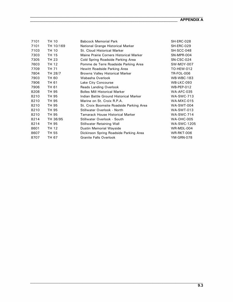
________________________________________________________________________________________________________________________________________________________ APPENDIX A
__________________________________________________________________________________9.3
7101 TH 10 Babcock Memorial Park SH-ERC-0287101 TH 10/169 National Grange Historical Marker SH-ERC-0297103 TH 10 St. Cloud Historical Marker SH-SCC-0487303 TH 15 Maine Prairie Corners Historical Marker SN-MPR-0047305 TH 23 Cold Spring Roadside Parking Area SN-CSC-0247603 TH 12 Pomme de Terre Roadside Parking Area SW-MOY-0077709 TH 71 Hewitt Roadside Parking Area TO-HEW-0127804 TH 28/7 Browns Valley Historical Marker TR-FOL-0067903 TH 60 Wabasha Overlook WB-WBC-1837906 TH 61 Lake City Concourse WB-LKC-0937906 TH 61 Reads Landing Overlook WB-PEP-0128208 TH 95 Bolles Mill Historical Marker WA-AFC-0358210 TH 95 Indian Battle Ground Historical Marker WA-SWC-7138210 TH 95 Marine on St. Croix R.P.A. WA-MXC-0158210 TH 95 St. Croix Boomsite Roadside Parking Area WA-SWT-0048210 TH 95 Stillwater Overlook - North WA-SWT-0138210 TH 95 Tamarack House Historical Marker WA-SWC-7148214 TH 36/95 Stillwater Overlook - South WA-OHC-0058214 TH 95 Stillwater Retaining Wall WA-SWC-12058601 TH 12 Dustin Memorial Wayside WR-MDL-0048607 TH 55 Dickinson Spring Roadside Parking Area WR-RKT-0068707 TH 67 Granite Falls Overlook YM-GRN-078

__________________________________________________________________________________APPENDIX A ______________________________________________________________________
__________________________________________________________________________________9.4

________________________________________________________________________________________________________________________________________________________ APPENDIX B
__________________________________________________________________________________10.1
APPENDIX B: MN/DOT HISTORIC ROADSIDE DEVELOPMENT STRUCTURESINVENTORY OF 110 PROPERTIES ORDERED BY MN/DOT DISTRICT
Mn/DOT Trunk SHPO District Highway Site Name Inventory #
1A TH 18 Big Pine Lake Roadside Parking Area PN-PLK-0061A TH 23 Wrenshall Overlook/Veterans' Memorial Ov CL-TLK-0041A TH 23 Fond du Lac Culvert (Bridge 5757) SL-DUL-24161A TH 23 Fond du Lac Historical Marker SL-DUL-24291A TH 23 New Duluth Overlook SL-DUL-24301A I 35 Thompson Hill Overlook SL-DUL-24311A I 35 Thompson Hill-Skyline Pkwy Ovr SL-DUL-24681A TH 61 Lester River Bridge (Bridge 5772) SL-DUL-24281A TH 61 Clifton-French River Historical Marker SL-DUT-0021A TH 61 Gooseberry Falls Concourse LA-SVC-0461A TH 61 Split Rock Lighthouse Overlook LA-BBT-0231A TH 61 Cross River Rest Area CK-UOG-0471A TH 61 Temperance River Roadside Parking Area CK-UOG-0461A TH 61 Berglund, Ray, Roadside Parking Area CK-TFT-0011A TH 61 Spruce Creek Culvert (Bridge 8292) CK-UOG-0451A TH 61 Cascade River Wayside CK-UOG-0441A TH 61 Grand Marais Harbor Sea Wall CK-GMC-029
1B TH 53 Orr Roadside Parking Area SL-ORC-0051B TH 169/1 Soudan Roadside Parking Area SL-SOC-0011B TH 169 Spang Spring Roadside Parking Area IC-SPG-0041B TH 169/73 Pillsbury Mine Overlook SL-BAL-004
2A TH 72 Baudette Rest Area LW-BDC-0302A TH 200 Whipholt Roadside Parking Area CA-PLK-003
2B TH 75 Noyes Roadside Parking Area KT-SVT-002
3A TH 6 Willow Lake Roadside Parking Area CA-TOR-0023A TH 18 Kenney Lake Overlook CW-GRT-0033A TH 71 Hewitt Roadside Parking Area TO-HEW-0123A TH 115/371 Camp Ripley Entrance Walls MO-GRE-0473A TH 169 Vineland Historical Marker ML-KAN-0063A TH 169 Whitefish Creek Bridge (Bridge 3355) ML-KAN-0053A TH 169 TH 169 Culvert at St. Alban's Bay CW-GRT-0023A TH 169 Garrison Rest Area CW-GRT-0013A TH 169 Garrison Ped Underpass (Bridge 5265) CW-GRC-0053A TH 169 Garrison Concourse CW-GRC-0013A TH 169 Garrison Creek Culvert (Bridge 5266) CW-GRC-0063A TH 169 Pine-Hickory Lakes Roadside Parking Area AK-FIS-017

__________________________________________________________________________________APPENDIX B ______________________________________________________________________
__________________________________________________________________________________10.2
3A TH 371 Long Lake Roadside Parking Area CW-NSC-004
3B TH 10 St. Cloud Historical Marker SH-SCC-0483B TH 10 Babcock Memorial Park SH-ERC-0283B TH 12 Dustin Memorial Wayside WR-MDL-0043B TH 15 Maine Prairie Corners Historical Marker SN-MPR-0043B TH 23 Cold Spring Roadside Parking Area SN-CSC-0243B TH 55 Dickinson Spring Roadside Parking Area WR-RKT-006
4A TH 10 Detroit Lakes Overlook BK-DLC-1574A TH 59 Pelican Rapids Village Historical Marker OT-PRC-0214A TH 59 Minnesota Woman Roadside Parking Area OT-PEL-0014A TH 78 Craigie Flour Mill Historical Marker OT-OTT-0014A TH 78 Otter Tail City Historical Marker OT-OTC-0044A TH 108 Leaf City Historical Marker OT-LLT-001
4B TH 12 Pomme de Terre Roadside Parking Area SW-MOY-0074B TH 27 Kensington Runestone Replica R.P.A. DL-ALE-0674B TH 27 Stage Station Historical Marker DL-OSA-0214B TH 28/7 Browns Valley Historical Marker TR-FOL-0064B TH 28 Graceville Historical Marker BS-GRA-0174B TH 55 Glenwood Overlook PO-GLC-022
6A TH 16 Inspiration Point Wayside Rest FL-CRL-0116A TH 26 Reno Spring Roadside Parking Area HU-JEF-0076A TH 52/16 Preston Overlook FL-PRC-0416A TH 52 Chatfield Historical Marker FL-CHC-0346A TH 60 Wabasha Overlook WB-WBC-1836A TH 61 Reads Landing Overlook WB-PEP-0126A TH 61 Lake City Concourse WB-LKC-0936A TH 61/14 LaCrescent Overlook HU-LCC-0096A TH 63 Silver Lake Roadside Parking Area OL-ROC-105
6B TH 57 Mantorville Retaining Walls DO-MTC-0386B TH 58 Red Wing Roadside Parking Area GD-RWC-8496B TH 61/63 Frontenac R.P.A./Maiden Rock GD-FLC-0546B TH 61/63 Frontenac State Park Gates GD-FLC-0576B TH 61/63 Fort Beauharnois Historical Marker GD-FLC-0566B TH 61/63 Minn State Training School Ent. Walls GD-RWC-021
7A TH 22 Mapleton Historical Marker BE-MPC-0317A TH 22 Victory Memorial Rest Area BE-DEC-008
7B TH 14 New Ulm Spring Roadside Parking Area NL-CTT-006
8A TH 71 Birch Coulee Historical Marker RN-BCO-0048A TH 71 Morton Pioneer Monuments R.P.A. RN-BFS-002

________________________________________________________________________________________________________________________________________________________ APPENDIX B
__________________________________________________________________________________10.3
8B TH 19/71 Redwood Falls Retaining Wall RW-RFC-0328B TH 59 Avoca Historical Marker MU-AVC-0108B TH 67 Granite Falls Overlook YM-GRN-0788B TH 75 Pipestone Nat Monu Entr. Marker PP-PPC-1548B TH 212/59 Camp Release State Memorial Wayside LP-CAM-003
Met E TH 8/95 Taylors Falls Overlook - South CH-SHT-032Met E TH 13 Mendota Overlook DK-MHC-012Met E TH 13 Sibley Pioneer Church Monument DK-MDC-011Met E TH 36/95 Stillwater Overlook - South WA-OHC-005Met E TH 52/55 Pine Bend Historical Marker DK-IVG-023Met E TH 55/110 Mendota Granite Arrow Marker DK-MDC-010Met E TH 61 Point Douglas Road Retaining Wall RA-SPC-2928Met E TH 61/10 Burns Avenue Overlook RA-SPC-2927Met E TH 95 Taylors Falls Overlook - North CH-TFC-055Met E TH 95 Marine on St. Croix R.P.A. WA-MXC-015Met E TH 95 St. Croix Boomsite Roadside Parking Area WA-SWT-004Met E TH 95 Stillwater Overlook - North WA-SWT-013Met E TH 95 Tamarack House Historical Marker WA-SWC-714Met E TH 95 Indian Battle Ground Historical Marker WA-SWC-713Met E TH 95 Stillwater Retaining Wall WA-SWC-1205Met E TH 95 Bolles Mill Historical Marker WA-AFC-035
Met W TH 7 Christmas Lake Roadside Parking Area HE-SHC-022Met W TH 10/169 Daytonport Roadside Parking Area AN-RMC-008Met W TH 10/169 National Grange Historical Marker SH-ERC-029Met W TH 55 Olson, Floyd B., Memorial Statue HE-MPC-9013Met W TH 55 TH 55 Retaining Wall HE-GVC-052Met W TH 100 Blazer Park HE-GVC-047BMet W TH 100 Graeser Park HE-RBC-025Met W TH 100 Graeser Park - South HE-RBC-160Met W TH 100 Lilac Park HE-SLC-013Met W TH 100 St. Louis Park Roadside Parking Area HE-SLC-017Met W TH 100 TH 100 at TH 55 Retaining Walls HE-GVC-053Met W TH 100 TH 100 Culvert (Bridge 5442) HE-GVC-051Met W TH 101 Mill Pond Roadside Parking Area SC-SPC-069Met W TH 212 Chaska Historical Marker CR-CKC-057

__________________________________________________________________________________APPENDIX B ______________________________________________________________________
__________________________________________________________________________________10.4

________________________________________________________________________________________________________________________________________________________ APPENDIX C
__________________________________________________________________________________11.1
APPENDIX C: MN/DOT HISTORIC ROADSIDE DEVELOPMENT STRUCTURESINVENTORY OF 110 PROPERTIES ORDERED BY SITE NAME
SHPO Mn/DOT TrunkSite Name Inventory # District Highway
Avoca Historical Marker MU-AVC-010 8B TH 59Babcock Memorial Park SH-ERC-028 3B TH 10Baudette Rest Area LW-BDC-030 2A TH 72Berglund, Ray, Roadside Parking Area CK-TFT-001 1A TH 61Big Pine Lake Roadside Parking Area PN-PLK-006 1A TH 18Birch Coulee Historical Marker RN-BCO-004 8A TH 71Blazer Park HE-GVC-047B Met W TH 100Bolles Mill Historical Marker WA-AFC-035 Met E TH 95Browns Valley Historical Marker TR-FOL-006 4B TH 28/7Burns Avenue Overlook RA-SPC-2927 Met E TH 61/10Camp Release State Memorial Wayside LP-CAM-003 8B TH 212/59Camp Ripley Entrance Walls MO-GRE-047 3A TH 115/371Cascade River Wayside CK-UOG-044 1A TH 61Chaska Historical Marker CR-CKC-057 Met W TH 212Chatfield Historical Marker FL-CHC-034 6A TH 52Christmas Lake Roadside Parking Area HE-SHC-022 Met W TH 7Clifton-French River Historical Marker SL-DUT-002 1A TH 61Cold Spring Roadside Parking Area SN-CSC-024 3B TH 23Craigie Flour Mill Historical Marker OT-OTT-001 4A TH 78Cross River Rest Area CK-UOG-047 1A TH 61Daytonport Roadside Parking Area AN-RMC-008 Met W TH 10/169Detroit Lakes Overlook BK-DLC-157 4A TH 10Dickinson Spring Roadside Parking Area WR-RKT-006 3B TH 55Dustin Memorial Wayside WR-MDL-004 3B TH 12Fond du Lac Culvert (Bridge 5757) SL-DUL-2416 1A TH 23Fond du Lac Historical Marker SL-DUL-2429 1A TH 23Fort Beauharnois Historical Marker GD-FLC-056 6B TH 61/63Frontenac R.P.A./Maiden Rock GD-FLC-054 6B TH 61/63Frontenac State Park Gates GD-FLC-057 6B TH 61/63Garrison Concourse CW-GRC-001 3A TH 169Garrison Creek Culvert (Bridge 5266) CW-GRC-006 3A TH 169Garrison Ped Underpass (Bridge 5265) CW-GRC-005 3A TH 169Garrison Rest Area CW-GRT-001 3A TH 169Glenwood Overlook PO-GLC-022 4B TH 55Gooseberry Falls Concourse LA-SVC-046 1A TH 61Graceville Historical Marker BS-GRA-017 4B TH 28Graeser Park HE-RBC-025 Met W TH 100Graeser Park - South HE-RBC-160 Met W TH 100Grand Marais Harbor Sea Wall CK-GMC-029 1A TH 61

__________________________________________________________________________________APPENDIX C ______________________________________________________________________
__________________________________________________________________________________11.2
Granite Falls Overlook YM-GRN-078 8B TH 67Hewitt Roadside Parking Area TO-HEW-012 3A TH 71Indian Battle Ground Historical Marker WA-SWC-713 Met E TH 95Inspiration Point Wayside Rest FL-CRL-011 6A TH 16Kenney Lake Overlook CW-GRT-003 3A TH 18Kensington Runestone Replica R.P.A. DL-ALE-067 4B TH 27LaCrescent Overlook HU-LCC-009 6A TH 61/14Lake City Concourse WB-LKC-093 6A TH 61Leaf City Historical Marker OT-LLT-001 4A TH 108Lester River Bridge (Bridge 5772) SL-DUL-2428 1A TH 61Lilac Park HE-SLC-013 Met W TH 100Long Lake Roadside Parking Area CW-NSC-004 3A TH 371Maine Prairie Corners Historical Marker SN-MPR-004 3B TH 15Mantorville Retaining Walls DO-MTC-038 6B TH 57Mapleton Historical Marker BE-MPC-031 7A TH 22Marine on St. Croix R.P.A. WA-MXC-015 Met E TH 95Mendota Granite Arrow Marker DK-MDC-010 Met E TH 55/110Mendota Overlook DK-MHC-012 Met E TH 13Mill Pond Roadside Parking Area SC-SPC-069 Met W TH 101Minn State Training School Ent. Walls GD-RWC-021 6B TH 61/63Minnesota Woman Roadside Parking Area OT-PEL-001 4A TH 59Morton Pioneer Monuments R.P.A. RN-BFS-002 8A TH 71National Grange Historical Marker SH-ERC-029 Met W TH 10/169New Duluth Overlook SL-DUL-2430 1A TH 23New Ulm Spring Roadside Parking Area NL-CTT-006 7B TH 14Noyes Roadside Parking Area KT-SVT-002 2B TH 75Olson, Floyd B., Memorial Statue HE-MPC-9013 Met W TH 55Orr Roadside Parking Area SL-ORC-005 1B TH 53Otter Tail City Historical Marker OT-OTC-004 4A TH 78Pelican Rapids Village Historical Marker OT-PRC-021 4A TH 59Pillsbury Mine Overlook SL-BAL-004 1B TH 169/73Pine Bend Historical Marker DK-IVG-023 Met E TH 52/55Pine-Hickory Lakes Roadside Parking Area AK-FIS-017 3A TH 169Pipestone Nat Monu Entr. Marker PP-PPC-154 8B TH 75Point Douglas Road Retaining Wall RA-SPC-2928 Met E TH 61Pomme de Terre Roadside Parking Area SW-MOY-007 4B TH 12Preston Overlook FL-PRC-041 6A TH 52/16Reads Landing Overlook WB-PEP-012 6A TH 61Red Wing Roadside Parking Area GD-RWC-849 6B TH 58Redwood Falls Retaining Wall RW-RFC-032 8B TH 19/71Reno Spring Roadside Parking Area HU-JEF-007 6A TH 26Sibley Pioneer Church Monument DK-MDC-011 Met E TH 13Silver Lake Roadside Parking Area OL-ROC-105 6A TH 63Soudan Roadside Parking Area SL-SOC-001 1B TH 169/1Spang Spring Roadside Parking Area IC-SPG-004 1B TH 169Split Rock Lighthouse Overlook LA-BBT-023 1A TH 61Spruce Creek Culvert (Bridge 8292) CK-UOG-045 1A TH 61St. Cloud Historical Marker SH-SCC-048 3B TH 10
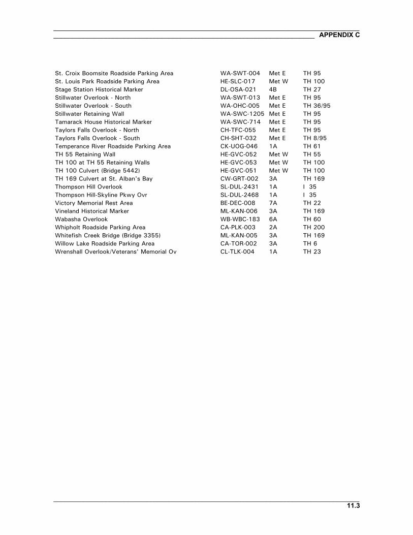
________________________________________________________________________________________________________________________________________________________ APPENDIX C
__________________________________________________________________________________11.3
St. Croix Boomsite Roadside Parking Area WA-SWT-004 Met E TH 95St. Louis Park Roadside Parking Area HE-SLC-017 Met W TH 100Stage Station Historical Marker DL-OSA-021 4B TH 27Stillwater Overlook - North WA-SWT-013 Met E TH 95Stillwater Overlook - South WA-OHC-005 Met E TH 36/95Stillwater Retaining Wall WA-SWC-1205 Met E TH 95Tamarack House Historical Marker WA-SWC-714 Met E TH 95Taylors Falls Overlook - North CH-TFC-055 Met E TH 95Taylors Falls Overlook - South CH-SHT-032 Met E TH 8/95Temperance River Roadside Parking Area CK-UOG-046 1A TH 61TH 55 Retaining Wall HE-GVC-052 Met W TH 55TH 100 at TH 55 Retaining Walls HE-GVC-053 Met W TH 100TH 100 Culvert (Bridge 5442) HE-GVC-051 Met W TH 100TH 169 Culvert at St. Alban's Bay CW-GRT-002 3A TH 169Thompson Hill Overlook SL-DUL-2431 1A I 35Thompson Hill-Skyline Pkwy Ovr SL-DUL-2468 1A I 35Victory Memorial Rest Area BE-DEC-008 7A TH 22Vineland Historical Marker ML-KAN-006 3A TH 169Wabasha Overlook WB-WBC-183 6A TH 60Whipholt Roadside Parking Area CA-PLK-003 2A TH 200Whitefish Creek Bridge (Bridge 3355) ML-KAN-005 3A TH 169Willow Lake Roadside Parking Area CA-TOR-002 3A TH 6Wrenshall Overlook/Veterans' Memorial Ov CL-TLK-004 1A TH 23

__________________________________________________________________________________APPENDIX C ______________________________________________________________________
__________________________________________________________________________________11.4