Embed Size (px)
Citation preview
II. PROJECT INFORMATION
(Please read the “ATP instructions” document prior to attaching your responses to all of the questions in Sections II. Project Information, Section III. Screening Criteria and Section IV. Narrative Questions - 20 pages max)
1. Project Location: The project is located in the City of Coalinga, California
2. Project Coordinates: Latitude: 36.1396; Longitude: -120.36015
3. Project Description:
The City of Coalinga (population 16,789) requests $240,000 in Active Transportation funds to
develop an Active Transportation Plan. The purpose of the project is to develop a comprehensive
Active Transportation Plan (AT Plan) that will provide the recommended actions to: 1) increase biking
and walking in the City, 2) provide non-motorized travel infrastructure to support the projected
population growth, and 3) provide safer, walkable streets for the 7,898 students (kindergarten through
college) who travel to school each day in Coalinga.
The City of Coalinga is in desperate need of a comprehensive plan to make our streets more
complete, with safer conditions for alternative modes of transportation. The City has unique
conditions that, with the right plan, will be ideal for recreational and practical infrastructure for
pedestrians and cyclists. The City will issue a Request for Qualifications (RFQ) and execute a contract
with an experienced Planning Consultant. The consultant will work with the City to: develop an
aggressive community outreach strategy; host community-based planning meetings; develop an Active
Transportation Plan based heavily on community input and aligned with the regional Fresno County
Active Transportation Plan; and provide concept-level site plans for priority projects (identified through
extensive community outreach). The City’s Active Transportation plan will meet the criteria of the
Active Transportation guidelines and will be suitable to include into a General Plan update of the City’s
Circulation Element. The project is estimated to take 24 months.
Coalinga Active Transportation Plan 13
4. Project Status:
The City is ready to proceed with the planning project immediately after the grant is awarded.
The City will hire a qualified Planning Consultant to execute the steps necessary to develop the robust,
comprehensive Active Transportation Plan that directly aligns with the forthcoming Fresno Council of
Governments (COG) Active Transportation Plan.
III. SCREENING CRITERIA
1. Demonstrated Needs of the Applicant
The City of Coalinga is located in the San Joaquin Valley, at the base of the Coast mountain
range, on the western side of California's Central Valley. It is considered a rural area approximately
100 miles northwest of the City of Bakersfield, and 60 miles southwest of the City of Fresno. The City is
considered a disadvantaged community, with median household income of $46,712.1 Coalinga also
meets disadvantaged community status because over 75% of the students at each of the City’s six
public schools qualify for free or reduced price meals (between 76% and 84%), according to the
California Department of Education.
The developed area of Coalinga covers approximately 4.5 square miles, and includes
elementary, intermediate, high school, and college facilities; residential areas; parks; libraries; and
commercial, industrial, and agricultural areas. (Please see Exhibit 1 Project Map.) The required daily
commute within the City is generally short and could be easily accomplished by alternative
transportation such as walking or biking. However, the existing pedestrian and bicycle infrastructure
does not support widespread non-motorized vehicle travel within the City. U.S. Census data from the
1 U.S. Census, American FactFinder, 2008-2012 American Community Survey.
Coalinga Active Transportation Plan 14
2008-2012 American Community Survey shows us that of 5,473 workers age 16 or older in the City,
less than 4% walk. In fact, it is reported that 92.8% of these workers drive to work each day.
We believe that this “car culture” is, in
part, due to fears about safety, because of a lack
of pedestrian and bicycle amenities. The City is
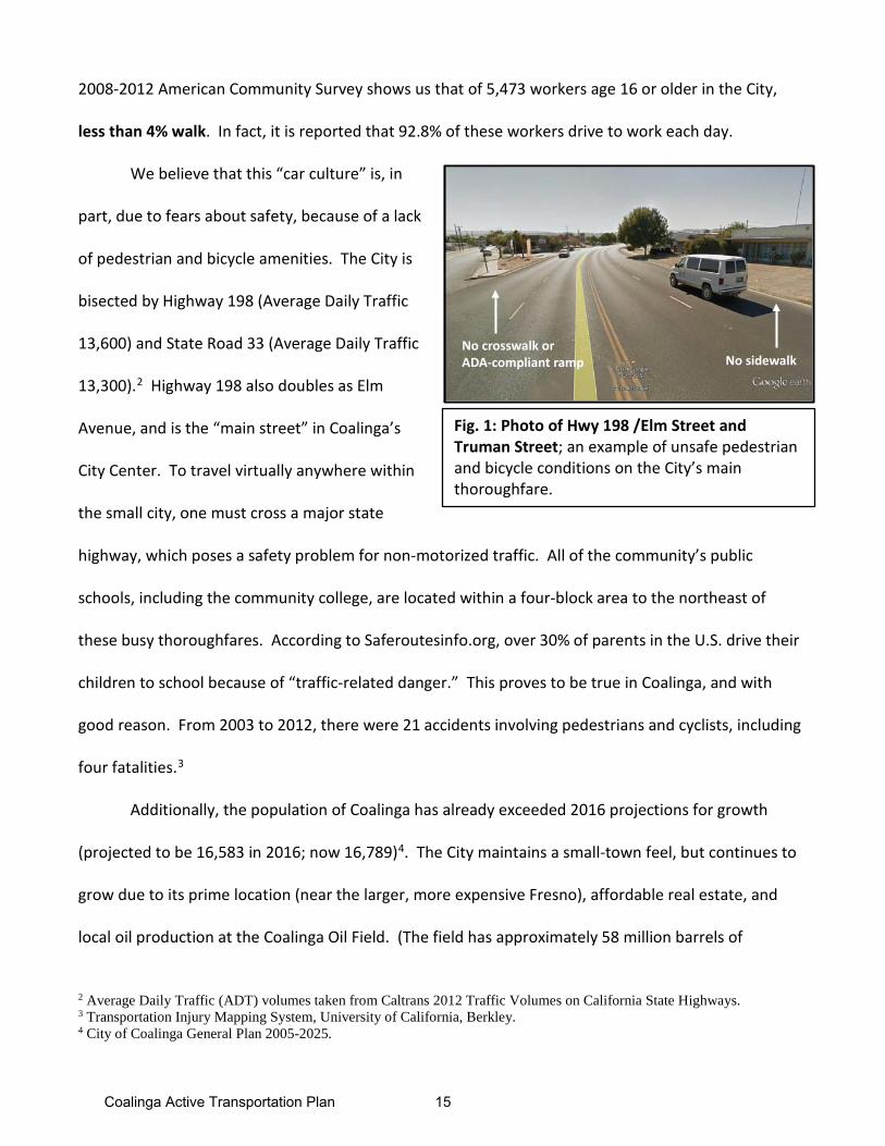
bisected by Highway 198 (Average Daily Traffic
13,600) and State Road 33 (Average Daily Traffic
13,300).2 Highway 198 also doubles as Elm
Avenue, and is the “main street” in Coalinga’s
City Center. To travel virtually anywhere within
the small city, one must cross a major state
highway, which poses a safety problem for non-motorized traffic. All of the community’s public
schools, including the community college, are located within a four-block area to the northeast of
these busy thoroughfares. According to Saferoutesinfo.org, over 30% of parents in the U.S. drive their
children to school because of “traffic-related danger.” This proves to be true in Coalinga, and with
good reason. From 2003 to 2012, there were 21 accidents involving pedestrians and cyclists, including
four fatalities.3
Additionally, the population of Coalinga has already exceeded 2016 projections for growth
(projected to be 16,583 in 2016; now 16,789)4. The City maintains a small-town feel, but continues to
grow due to its prime location (near the larger, more expensive Fresno), affordable real estate, and
local oil production at the Coalinga Oil Field. (The field has approximately 58 million barrels of
2 Average Daily Traffic (ADT) volumes taken from Caltrans 2012 Traffic Volumes on California State Highways. 3 Transportation Injury Mapping System, University of California, Berkley. 4 City of Coalinga General Plan 2005-2025.
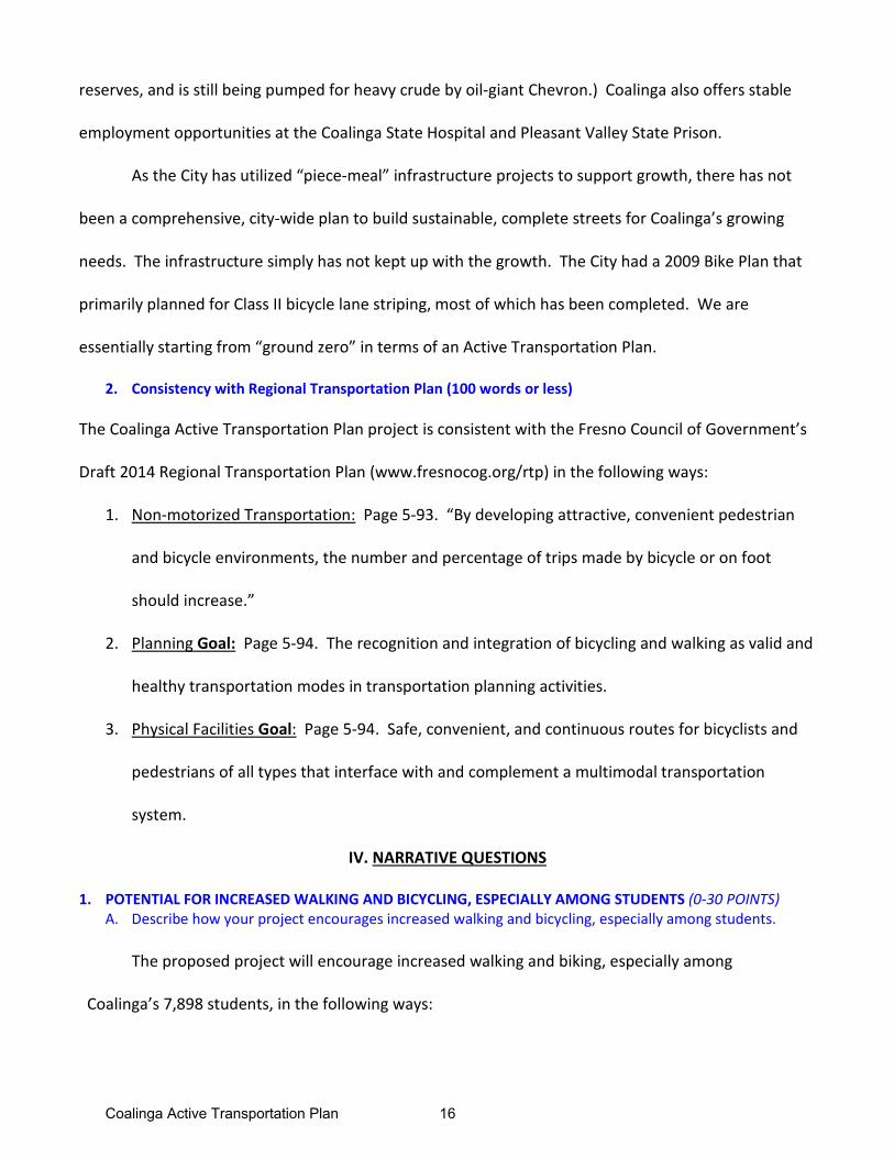
Fig. 1: Photo of Hwy 198 /Elm Street and Truman Street; an example of unsafe pedestrian and bicycle conditions on the City’s main thoroughfare.
No sidewalkNo crosswalk or ADA-compliant ramp
Coalinga Active Transportation Plan 15
reserves, and is still being pumped for heavy crude by oil-giant Chevron.) Coalinga also offers stable
employment opportunities at the Coalinga State Hospital and Pleasant Valley State Prison.
As the City has utilized “piece-meal” infrastructure projects to support growth, there has not
been a comprehensive, city-wide plan to build sustainable, complete streets for Coalinga’s growing
needs. The infrastructure simply has not kept up with the growth. The City had a 2009 Bike Plan that
primarily planned for Class II bicycle lane striping, most of which has been completed. We are
essentially starting from “ground zero” in terms of an Active Transportation Plan.
2. Consistency with Regional Transportation Plan (100 words or less)
The Coalinga Active Transportation Plan project is consistent with the Fresno Council of Government’s
Draft 2014 Regional Transportation Plan (www.fresnocog.org/rtp) in the following ways:
1. Non-motorized Transportation: Page 5-93. “By developing attractive, convenient pedestrian
and bicycle environments, the number and percentage of trips made by bicycle or on foot
should increase.”
2. Planning Goal: Page 5-94. The recognition and integration of bicycling and walking as valid and
healthy transportation modes in transportation planning activities.
3. Physical Facilities Goal: Page 5-94. Safe, convenient, and continuous routes for bicyclists and
pedestrians of all types that interface with and complement a multimodal transportation
system.
IV. NARRATIVE QUESTIONS
1. POTENTIAL FOR INCREASED WALKING AND BICYCLING, ESPECIALLY AMONG STUDENTS (0-30 POINTS)A. Describe how your project encourages increased walking and bicycling, especially among students.
The proposed project will encourage increased walking and biking, especially among
Coalinga’s 7,898 students, in the following ways:
Coalinga Active Transportation Plan 16
1) The AT Plan will evaluate infrastructure deficiencies and opportunities city-wide including, but not
limited to: curb and sidewalk repair; closing gaps in sidewalks; installing ADA-compliant ramps and
curbs; installing signalized crossings where needed; adding street lighting; and rehabilitating gutters
and valleys in the existing street gutter system. The improvements identified in the AT Plan will make
walking and biking to school less intimidating for Coalinga students when implemented.
2) The AT Plan will identify routes for constructing multi-use paths, including trail networks that
bypass the busiest thoroughfares in the City, and provide access to the northern Coalinga corridor
where six public schools and West Hills College are located.
3) The proposed project will provide guidelines for required easements or Right of Way for sidewalks
and bicycle infrastructure in all future development projects. New subdivisions will be planned with
sidewalks to support new neighborhood schools planned by the Coalinga-Huron Unified School District.
The City of Coalinga is unique in that many independent elements support a walking and biking
culture. For example, the majority of the City’s employment, school, and leisure destinations are
located within a 2-mile radius (see Exhibit 2 Two-Mile Radius Map), and adjacent to concentrated
residential neighborhoods, making it easy to reach nearly any location by taking a twenty-minute walk.
The average temperature is 65 degrees Fahrenheit,
and the City experiences just 8.27 inches of rain per
year,5 providing a mild climate year-round that is
ideal for walking and biking. Coalinga Transit
provides bus service from Hwy 198 in the City
Center to multiple employment areas, and the
5 www.usclimatedata.com
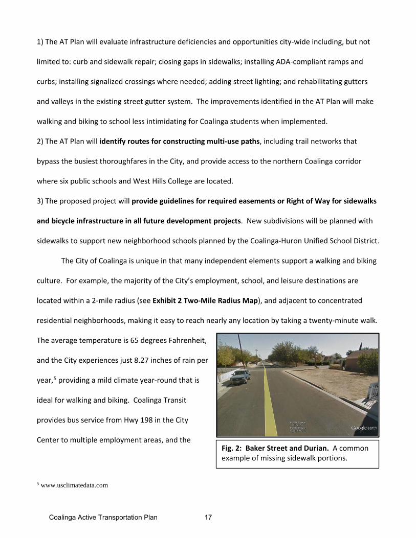
Fig. 2: Baker Street and Durian. A common example of missing sidewalk portions.
Coalinga Active Transportation Plan 17
nearby Cities of Huron and Fresno. A quick walk to the bus stop would allow residents to forgo any
vehicle miles in their own cars. The City has natural amenities such as parks and creeks that are well-
suited for recreational activities like walking or biking. The website www.walkscore.com gives the City
a rating of 83 out of 100 for “walkability,” calling Coalinga “very walkable.” The problem is that
residents are not walking. The idea of crossing major thoroughfares by foot or on bike can be a barrier
to walking. Large gaps in sidewalks (sometimes entire streets lack sidewalks) and aging curbs present
safety hazards as well.
Two creeks, Los Gatos and Warthan, run along the northeast and southeast edges of the
City, partially defining the boundaries of the urban area. This provides an excellent opportunity
for waterway trails that can provide safe, alternative routes for non-motorized traffic that bypass
the two main highways. (Please see Exhibit 1 Project Map for possible multi-use trail location.)
The City will utilize its natural boundaries and waterways in the AT Plan, which may include a
multi-use trail loop to encircle the City.
A comprehensive AT Plan will guide land use and circulation, prioritize infrastructure
projects, and provide plans for non-motorized, multi-use trail networks. Interestingly, nearly 48%
of the City’s residents are students. Improved road conditions and new multi-use trail networks
may shift behavior patterns to create life-long habits of walking and bike-riding, and encourage
families to become less car-dependent.
B. Describe the number and type of possible users and their destinations, and the anticipated percentage increase in users upon completion of your project. Data collection methods should be described.
The AT Plan is designed to make non-motorized travel in Coalinga a real option. As stated
above, there are over 7,898 students residing in Coalinga with their families. The proposed project will
outline a community outreach strategy to actively seek CHUSD and West Hills College students’ and
Coalinga Active Transportation Plan 18
families’ input from at least three public workshops. These meetings will provide the City’s residents
an opportunity to engage in a process to identify priority projects. The City will circulate informational
pamphlets, newsletters, attachments in school hand-outs, materials for parents, and social media
pushes to capture the Coalinga student “voice” for the AT Plan workshops. We anticipate that
students and their families will utilize safe sidewalks, roadways, and multi-use paths for recreation and
as travel to school, after-school activities, work, and home.
Employees will also benefit. The proposed plan will make it easier for residents who work
within the area to walk or bike to work. Commercial activity in Coalinga is largely located along Elm
Avenue (Hwy 198) and Polk Street (SR 33) which are the two main corridors in Coalinga. Connected
multi-use trails and added pedestrian and bicycle amenities will allow residents to easily walk or bike to
this area, also considered the City “Center,” which has dozens of shops, restaurants, public buildings,
and the Coalinga Transit bus stop. Coalinga Transit can carry employees to the Coalinga State Hospital
(employs 1,600), the Pleasant Valley State Prison (employs 1,416), or further to the Cities of Huron or
Fresno. Ideally, Coalinga residents will be able to travel to work without ever needing to use their car
or fill up their gas tanks.
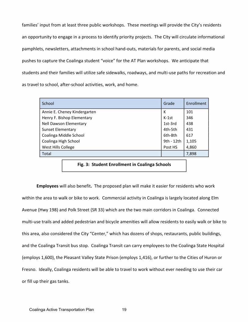
School Grade Enrollment
Annie E. Cheney Kindergarten K 101 Henry F. Bishop Elementary K-1st 346 Nell Dawson Elementary 1st-3rd 438 Sunset Elementary 4th-5th 431 Coalinga Middle School 6th-8th 617 Coalinga High School 9th - 12th 1,105 West Hills College Post HS 4,860 Total 7,898
Fig. 3: Student Enrollment in Coalinga Schools
Coalinga Active Transportation Plan 19
Recreational trail runners and cyclists will benefit from a comprehensive AT Plan. Along with
its flat, valley terrain, and mild climate, the City of Coalinga is situated just miles from Los Gatos County
Park. The City is also connected to the planned Fresno County regional Class I and Class II Bicycle Trails,
which span from west to east across the county (the fifth largest county in California). In April of 2014,
West Hills College partnered with the Fresno Cycling Club to host the first annual West Hills Metric
Century ride, and had over 100 participants. The City is eager to expand cycling and outdoor
recreation opportunities.
Finally, the AT Plan will provide the framework to develop a walkable, bike-friendly City.
Coalinga residents will be able to choose alternate forms of transportation when heading out for
errands, to pick up their children from school, or taking a trip to the one of the City’s parks. As the City
of Coalinga experiences growth, bicycle and pedestrian trips to these locations and future locations are
expected to increase substantially. The AT Plan will include methodology to determine pre- and post-
usage figures, once infrastructure is designed as a result of the Plan.
C. Describe how this project improves walking and bicycling routes to and from, connects to, or is part of a school or school facility, transit facility, community center, employment center, state or national trail system, points of interest, and/or park.
The proposed plan will improve walking and bicycling routes to Coalinga’s six public schools and
West Hills College; the Coalinga Transit stop; the City’s Center that includes numerous stores and
restaurants; the police and fire stations; parks and residential neighborhoods; and regional trail
systems. The plan will evaluate the feasibility of a multi-use path that runs along the Los Gatos and
Wathan Creeks, and potentially along the City’s other borders to create a continuous circular path that
will run along the two-mile radius radiating from the City Center. The AT Plan will also identify and
prioritize infrastructure repair and safety measures that will increase non-motorized travel along busy
thoroughfares that currently intimidate walkers and cyclists.
Coalinga Active Transportation Plan 20
D. Describe how this project increases and/or improves connectivity, removes a barrier to mobility and/or closes a gap in a non-motorized facility.
The largest existing barrier to non-motorized travel in our City is the lack of a comprehensive AT
Plan. The City has implemented piece-meal projects to correct portions of cracked/missing sidewalks
and install ADA-compliant ramps and curbs. The City needs a plan that will provide the framework for
complete streets, connected multi-use trails, and connections to the region’s trail network. The
proposed plan will remove barriers to pedestrian and bicycle travel by implementing safety measures
like Class II bicycle lanes, ADA-compliant curbs and ramps, and signalized crossing areas along Hwy 198
(Elm Avenue) and SR 33 (Polk Street). The project will remove barriers for students traveling to existing
and future Coalinga public schools by implementing the safety measures mentioned above, and by
providing guidelines to develop a future multi-use trail loop that will bypass the City’s busiest streets.
Finally, the proposed project will close the gap in the planned regional trail network. The City will work
in concert with Fresno County Council of Governments as it develops a county-wide Active
Transportation Plan. This will ensure the regional network of trails connects with planned multi-use
trail systems in Coalinga.
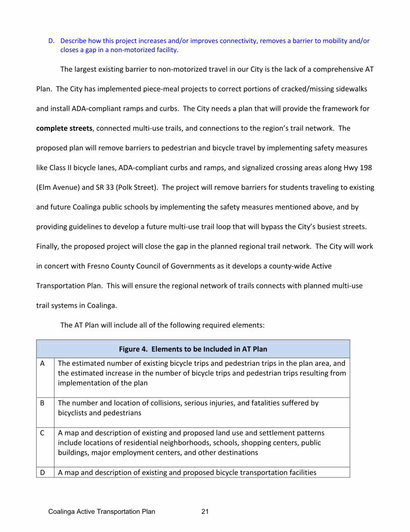
The AT Plan will include all of the following required elements:
Figure 4. Elements to be Included in AT Plan
A The estimated number of existing bicycle trips and pedestrian trips in the plan area, and the estimated increase in the number of bicycle trips and pedestrian trips resulting from implementation of the plan
B The number and location of collisions, serious injuries, and fatalities suffered by bicyclists and pedestrians
C A map and description of existing and proposed land use and settlement patterns include locations of residential neighborhoods, schools, shopping centers, public buildings, major employment centers, and other destinations
D A map and description of existing and proposed bicycle transportation facilities
Coalinga Active Transportation Plan 21
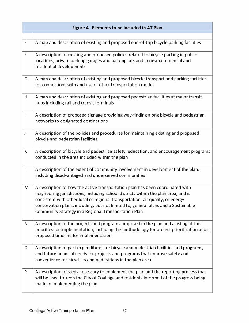
Figure 4. Elements to be Included in AT Plan
E A map and description of existing and proposed end-of-trip bicycle parking facilities
F A description of existing and proposed policies related to bicycle parking in public
locations, private parking garages and parking lots and in new commercial and residential developments
G A map and description of existing and proposed bicycle transport and parking facilities for connections with and use of other transportation modes
H A map and description of existing and proposed pedestrian facilities at major transit hubs including rail and transit terminals
I A description of proposed signage providing way-finding along bicycle and pedestrian networks to designated destinations
J A description of the policies and procedures for maintaining existing and proposed bicycle and pedestrian facilities
K A description of bicycle and pedestrian safety, education, and encouragement programs conducted in the area included within the plan
L A description of the extent of community involvement in development of the plan, including disadvantaged and underserved communities
M A description of how the active transportation plan has been coordinated with neighboring jurisdictions, including school districts within the plan area, and is consistent with other local or regional transportation, air quality, or energy conservation plans, including, but not limited to, general plans and a Sustainable Community Strategy in a Regional Transportation Plan
N A description of the projects and programs proposed in the plan and a listing of their priorities for implementation, including the methodology for project prioritization and a proposed timeline for implementation
O A description of past expenditures for bicycle and pedestrian facilities and programs, and future financial needs for projects and programs that improve safety and convenience for bicyclists and pedestrians in the plan area
P A description of steps necessary to implement the plan and the reporting process that will be used to keep the City of Coalinga and residents informed of the progress being made in implementing the plan
Coalinga Active Transportation Plan 22
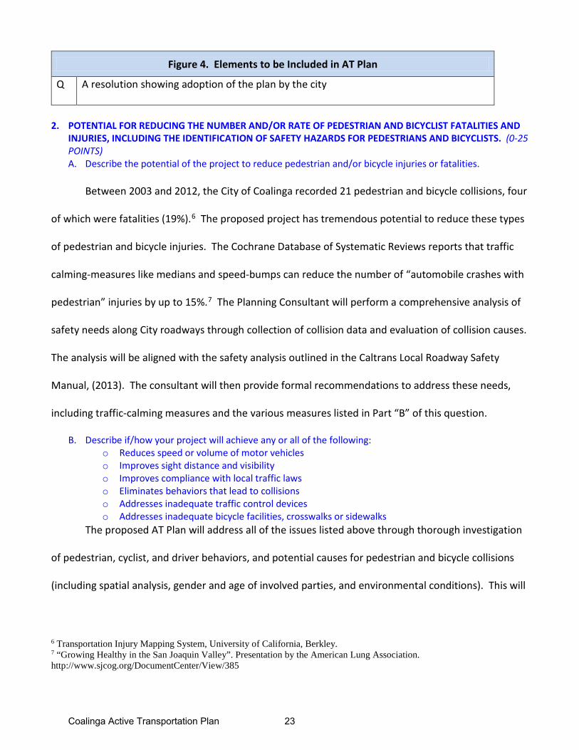
Figure 4. Elements to be Included in AT Plan
Q A resolution showing adoption of the plan by the city
2. POTENTIAL FOR REDUCING THE NUMBER AND/OR RATE OF PEDESTRIAN AND BICYCLIST FATALITIES ANDINJURIES, INCLUDING THE IDENTIFICATION OF SAFETY HAZARDS FOR PEDESTRIANS AND BICYCLISTS. (0-25POINTS)A. Describe the potential of the project to reduce pedestrian and/or bicycle injuries or fatalities.
Between 2003 and 2012, the City of Coalinga recorded 21 pedestrian and bicycle collisions, four
of which were fatalities (19%).6 The proposed project has tremendous potential to reduce these types
of pedestrian and bicycle injuries. The Cochrane Database of Systematic Reviews reports that traffic
calming-measures like medians and speed-bumps can reduce the number of “automobile crashes with
pedestrian” injuries by up to 15%.7 The Planning Consultant will perform a comprehensive analysis of
safety needs along City roadways through collection of collision data and evaluation of collision causes.
The analysis will be aligned with the safety analysis outlined in the Caltrans Local Roadway Safety
Manual, (2013). The consultant will then provide formal recommendations to address these needs,
including traffic-calming measures and the various measures listed in Part “B” of this question.
B. Describe if/how your project will achieve any or all of the following: o Reduces speed or volume of motor vehicleso Improves sight distance and visibilityo Improves compliance with local traffic lawso Eliminates behaviors that lead to collisionso Addresses inadequate traffic control deviceso Addresses inadequate bicycle facilities, crosswalks or sidewalks
The proposed AT Plan will address all of the issues listed above through thorough investigation
of pedestrian, cyclist, and driver behaviors, and potential causes for pedestrian and bicycle collisions
(including spatial analysis, gender and age of involved parties, and environmental conditions). This will
6 Transportation Injury Mapping System, University of California, Berkley. 7 “Growing Healthy in the San Joaquin Valley”. Presentation by the American Lung Association. http://www.sjcog.org/DocumentCenter/View/385
Coalinga Active Transportation Plan 23
involve evaluation of collision history, field observations, collaboration with community members,
reviewing police reports, and academic research. The Planning Consultant will develop a list of safety
priorities, and provide recommendations for countermeasures including education, engineering, and
enforcement measures. These will include awareness and education programs for students,
community members, and law enforcement officials that will improve compliance with local traffic
laws; and initiatives that will: reduce speed and volume of motor vehicles; improve sight distance and
visibility; eliminate behaviors that lead to collisions; improve traffic control devices, bicycle facilities,
crosswalks, and sidewalks.
C. Describe the location’s history of events and the source(s) of data used (e.g. collision reports, community observation, surveys, audits) if data is not available include a description of safety hazard(s) and photos.
Please see Exhibit 3 Injury Accidents Map provided by the Traffic Injury Mapping System (TIMS)
from the University of California, Berkley. This map represents 20 of 21 injury accidents involving
pedestrian or bicycles in Coalinga from January 1, 2003 - December 31, 2012. Please note that 14 of
these collisions occurred along Hwy 198 (Elm Street) and SR 33 (Polk Avenue), as well as three
fatalities. Please also see Exhibit 4 Photos of Project Area for photos of safety hazards along these
roadways. Of the 21 collisions, 16 collisions involved pedestrians (76.2%), five involved bicycles
(23.8%), and four involved fatalities (19%). Three incidents involved severe injuries (14.3%), seven
involved visible injuries (33.3%), and seven involved injuries that led to complaints of pain (33%).
3. PUBLIC PARTICIPATION and PLANNING (0-15POINTS)
A. Describe the community based public participation process that culminated in the project proposal orplan, such as noticed meetings/public hearings, consultation with stakeholders, etc.
In 2009, the City of Coalinga solicited community feedback to update its 2025 General Plan. As
part of the strategic planning, the City emphasized the importance of community input in the planning
process. The community and City leaders identified improved pedestrian and bicycle infrastructure as
Coalinga Active Transportation Plan 24
a top priority. The proposed AT Plan will also engage community residents to identify needs and
priority projects for implementation. The City will work with the Planning Consultant to develop a
robust outreach plan that will publicize at least three community meetings. The Planning Consultant
will distribute flyers, utilize direct mail, and publish information in local news outlets including the
Coalinga Post and the City’s website (www.coalinga.com). Most importantly, stakeholders at the
CHUSD and West Hills College will help plan for the workshops. The workshops will include
walkability audits, hands-on mapping exercises and identification of priority projects for
implementation.
B. Describe the local participation process that resulted in the identification and prioritization of the project:
Please see Exhibit 5 Stakeholder Participation. These agendas and notes are from meetings to
discuss improvements to city infrastructure and develop an AT Plan, and resulted in the prioritization
of this grant application. This request for planning funds is designed to engage residents in an
interactive, well-attended, series of workshops. Community input and identification of priorities will
lead to critical next steps. The Planning Consultant will then prepare preliminary designs and cost
estimates for the priority projects to bring them one step closer to implementation.
C. Is the project cost over $1 Million? Y/N
No, the project will not cost over $1 Million.
4. COST EFFECTIVENESS (0-10 POINTS)
A. Describe the alternatives that were considered. Discuss the relative costs and benefits of all thealternatives and explain why the nominated one was chosen.
The alternatives that were considered to developing a City-wide, comprehensive Active
Transportation Plan were: 1) develop no plan ($0); 2) develop a plan for increasing only pedestrian
infrastructure; 3) develop a plan for increasing only bicycle infrastructure; 4) develop a Safe Routes to
Coalinga Active Transportation Plan 25
Schools plan. The latter three alternatives would be approximately 60% less in cost. The City chose
instead to develop a comprehensive, multimodal AT Plan. The City seeks a comprehensive
bicycle/pedestrian network with connectivity to destinations city-wide and in the County. During the
General Plan update, City Leaders noted a significant need for a multi-faceted, comprehensive AT Plan
to achieve a safe, walkable, bike-able City. The City also feels that the timing for creating a city-wide
AT Plan is ideal as the Fresno COG will be developing a similar AT Plan for the entire County. This will
allow the two entities to collaborate and ensure that the final AT Plans are comprehensive and
complementary. Coalinga’s plan will provide greater depth and detail, especially for the priority
projects. It will also provide for synergy with the County’s plan.
B. Calculate the ratio of the benefits of the project relative to both the total project cost and funds
requested (i.e., 𝐵𝐵𝐵𝐵𝐵𝐵𝐵𝐵𝐵𝐵𝐵𝐵𝐵𝐵∗𝑇𝑇𝑇𝑇𝐵𝐵𝑇𝑇𝑇𝑇 𝑃𝑃𝑃𝑃𝑇𝑇𝑃𝑃𝐵𝐵𝑃𝑃𝐵𝐵 𝐶𝐶𝑇𝑇𝐶𝐶𝐵𝐵
and 𝐵𝐵𝐵𝐵𝐵𝐵𝐵𝐵𝐵𝐵𝐵𝐵𝐵𝐵∗𝑃𝑃𝑃𝑃𝑇𝑇𝑃𝑃𝑃𝑃𝑇𝑇𝑃𝑃 𝐹𝐹𝐹𝐹𝐵𝐵𝐹𝐹𝐶𝐶 𝑅𝑅𝐵𝐵𝑅𝑅𝐹𝐹𝐵𝐵𝐶𝐶𝐵𝐵𝐵𝐵𝐹𝐹
).
The proposed Benefit/Cost Ratio for the Coalinga AT Plan directly relates to the ATP Program
goal: Increase the proportion of trips accomplished by biking and walking. We project that the
improvements to pedestrian infrastructure and overall mobility in the City of Coalinga will result in
double the amount of pedestrians, aged 16 and older, walking to work, over a 20-year time-span. To
calculate the monetary benefit of this goal, we utilized the World Health Organization’s (WHO) Health
Economic Tool Assessment (HEAT). The HEAT analyzes the economic impact an intervention (such as
the AT Plan) has on adults within a study area. The tool provides an estimate of the economic benefits
accrued from walking as a result of lower death rates.8 We used a baseline of current data from the
8 The tool is based on relative risk data from published studies such as leisure-time physical activity as well as the usual socioeconomic variables (age, sex, smoking, etc.). The tool uses these relative risks and applies them to the amount of walking or cycling entered by the user, assuming a log-linear relationship between walking/cycling and mortality. The HEAT then uses population-level mortality data to estimate the number of adults who would normally be expected to die in any given year in the target population. Next, it calculates the reduction in expected deaths in this population that cycle or walk at the level by the user, using the adjusted relative risk. Finally, the tool produces an estimate of economic savings from this calculated reduction in deaths, as well as discounted and average savings. (www.heatwalkingcycling.org)
Coalinga Active Transportation Plan 26
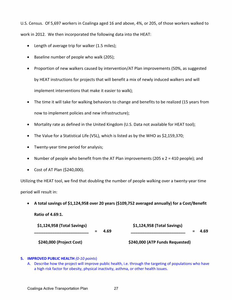
U.S. Census. Of 5,697 workers in Coalinga aged 16 and above, 4%, or 205, of those workers walked to
work in 2012. We then incorporated the following data into the HEAT:
• Length of average trip for walker (1.5 miles);
• Baseline number of people who walk (205);
• Proportion of new walkers caused by intervention/AT Plan improvements (50%, as suggested
by HEAT instructions for projects that will benefit a mix of newly induced walkers and will
implement interventions that make it easier to walk);
• The time it will take for walking behaviors to change and benefits to be realized (15 years from
now to implement policies and new infrastructure);
• Mortality rate as defined in the United Kingdom (U.S. Data not available for HEAT tool);
• The Value for a Statistical Life (VSL), which is listed as by the WHO as $2,159,370;
• Twenty-year time period for analysis;
• Number of people who benefit from the AT Plan improvements (205 x 2 = 410 people); and
• Cost of AT Plan ($240,000).
Utilizing the HEAT tool, we find that doubling the number of people walking over a twenty-year time
period will result in:
• A total savings of $1,124,958 over 20 years ($109,752 averaged annually) for a Cost/Benefit
Ratio of 4.69:1.
$1,124,958 (Total Savings) $1,124,958 (Total Savings) ________________________ = 4.69 ________________________ = 4.69
$240,000 (Project Cost) $240,000 (ATP Funds Requested)
5. IMPROVED PUBLIC HEALTH (0-10 points)A. Describe how the project will improve public health, i.e. through the targeting of populations who have
a high risk factor for obesity, physical inactivity, asthma, or other health issues.
Coalinga Active Transportation Plan 27
The City of Coalinga is located in Fresno County, which is ranked 46 out of 57 California counties
for level of “Health” based on factors including health behaviors, obesity, air quality, education, and
income.9 The proposed AT Plan will provide guidelines for policies that will increase opportunities for
physical activity, reduce vehicle miles driven in the City, and decrease risks for the City’s students to
walk and bike to school, thereby increasing health factors and behaviors, and leading to a healthier
environment.
The City of Coalinga is situated in the San Joaquin Valley Air Basin, defined by the Sierra Nevada
Mountain Range to the east, and the Coastal Ranges to the west. The topography and geography
result in weak air flow that becomes trapped in the region, and is therefore highly susceptible to air
pollution accumulation. High traffic volumes on Highway 198 (ADT 13,600), State Road 33 (ADT
13,300), and Interstate 5, 10 miles to the east (ADT 37,500 at Hwy 198)10, cause dangerous levels of
ozone and transportation-related air pollution.
The State of the Air 2013 “Most Polluted Cities” Report named nearby Fresno as the fourth
most polluted city in the nation, and the American Lung Association reports that 1,500 premature
deaths occur annually in the San Joaquin Valley due to pollution-related health risks (including asthma,
heart attacks, strokes, infections, lung cancer, and premature births).11 The American Lung Association
also reports that the populations most vulnerable to pollution-related health risks include children,
seniors, low-income communities, communities of color, and outdoor workers. The U.S. Census 2008-
2012 American Community Survey shows us that Coalinga is at risk: more than half of the City’s
9 County Health Rankings & Roadmaps. University of Wisconsin Population Health Institute and Robert Wood Johnson Foundation. 10 All Average Annual Daily Traffic (AADT) volumes taken from Caltrans 2012 Traffic Volumes on California State Highways. 11 “Growing Healthy in the San Joaquin Valley”. Presentation by the American Lung Association. http://www.sjcog.org/DocumentCenter/View/385
Coalinga Active Transportation Plan 28
population is Hispanic (53.5%), 12.2% of Coalinga’s workers are in agriculture or similar industry, and
8.3% are in the construction industry. As stated previously, nearly 48% of the City’s residents are
students, and the City qualifies as a low-income, disadvantaged community. The California Health
Interview Survey (CHIS) concluded that in 2013, 642,000 residents in the San Joaquin Valley were
diagnosed with asthma, including 184,000 asthmatic children.12 The San Joaquin Valley diabetes rates
are also alarming: 10.7% of the Valley’s population suffer from diabetes compared to the statewide
average of 8.4%.13 Obesity is also a problem in the San Joaquin Valley. The CHIS reports that 63.7% of
teens and adults in the Valley are overweight or obese, compared to the state’s average of 55.5%.
The proposed AT Plan will outline policies that will provide more opportunities for children and
adults to walk and ride their bikes to their preferred destinations, and target students and parents for
education through school-related handouts and community meetings. The Rails-to-Trails Conservancy
(2008) estimates that even modest increases in walking/biking can reduce greenhouse gas emissions
by 3-8 percent. The American Heart Association recommends 60 minutes per day of moderate to
vigorous physical activity for children and adolescents, and residents will have more opportunities to
fulfill that daily goal with the policies that will be proposed in the AT Plan. In addition, the American
Journal of Preventive Medicine claims that “people who live in neighborhoods with sidewalks on more
streets are 47% more likely to be active at least 30 minutes per day.”14 These increased opportunities
for physical activity combined with less traffic related air pollution will increase the City’s overall health
and improve the City’s Health rating, reflecting an increased quality of life for Coalinga residents.
12 “Growing Healthy in the San Joaquin Valley”. Presentation by the American Lung Association. http://www.sjcog.org/DocumentCenter/View/385 13 “Growing Healthy in the San Joaquin Valley”. Presentation by the American Lung Association. http://www.sjcog.org/DocumentCenter/View/385 14 “Growing Healthy in the San Joaquin Valley”. Presentation by the American Lung Association. http://www.sjcog.org/DocumentCenter/View/385
Coalinga Active Transportation Plan 29
6. BENEFIT TO DISADVANTAGED COMMUNITIES (0-10 points)
A. I. Is the project located in a disadvantaged community? Y/N YES
II. Does the project significantly benefit a disadvantaged community? Y/N YES
a. Which criteria does the project meet? (Answer all that apply)
o Median household income for the community benefited by the project: $ 46,712
o California Communities Environmental Health Screen Tool (CalEnvironScreen) scorefor the community benefited by the project: 25.07
o For projects that benefit public school students, percentage of students eligible forthe Free or Reduced Price Meals Programs: 80.1 %
b. Should the community benefitting from the project be considered disadvantaged basedon criteria not specified in the program guidelines? If so, provide data for all criteriaabove and a quantitative assessment of why the community should be considereddisadvantaged.
B. Describe how the project demonstrates a clear benefit to a disadvantaged community and what percentage of the project funding will benefit that community, for projects using the school based criteria describe specifically the school students and community will benefit.
The proposed AT Plan will benefit the City of Coalinga, which meets the ATP criteria for a
disadvantaged community. According to 2008-2012 U.S. Census data, the City of Coalinga qualifies as a
disadvantaged community (DAC) with median household income (MHI) of $46,712. This MHI is 75.3%
of the state median household income of $61,632. A city is considered a DAC at 80% or less of the
state MHI. Over 3,000 Coalinga residents are students attending six public schools in the Coalinga-
Huron Unified School District. Eighty percent of CHUSD students qualify for free or reduced price
meals under the national School Lunch Program.
As mentioned above, disadvantaged communities are at a higher risk for vulnerability to
transportation pollution-related disease. Dr. Kelly Clifton from Portland State University also shows
that “the transportation disadvantaged, including communities of color, the poor, older adults, youth
Coalinga Active Transportation Plan 30
and people with disabilities, are at a significant disadvantage without access to convenient, safe, well
integrated transportation alternatives. All of these groups are often without easy access to cars and
live in locations without convenient, safe transportation alternatives, which severely hampers their
ability to function as productive members of society.”15 According to Jana Lynott of the AARP, “not
having safe and viable transportation alternatives can contribute to increased isolation and decline.”
The Coalinga AT Plan will accommodate all users by identifying safety issues and prioritizing projects
that will provide daily access to safe routes for pedestrians and cyclists of all ages and abilities.
As the population of Coalinga continues to grow, the AT Plan will support policies that will
encourage a more walkable environment, implement complete streets infrastructure to grow with the
population, and ensure the safety and health of our City’s students and most vulnerable residents.
7. USE OF CALIFORNIA CONSERVATION CORPS (CCC) OR A CERTIFIED COMMUNITY CONSERVATIONCORPS (0 to -5 points)
A. The applicant has coordinated with the CCC to identify how a state conservation corps can be a partner of the project. Y/N YES
a. Name, e-mail, and phone # of the person contacted and the date the informationwas submitted to them
Virginia Clark, Region Deputy, Region 1, California Conservation Corps, 916-341-3147,[email protected]. Information was submitted on May 2, 2014.
B. The applicant has coordinated with a representative from the California Association of Local Conservation Corps (CALCC) to identify how a certified community conservation corps can be a partner of the project. Y/N YES
a. Name, e-mail, and phone # of the person contacted and the date the informationwas submitted to them
Cynthia Vitale, CALCC, 916-558-1516, cynthia@csgcalifornia, [email protected] on May 2, 2014.
15 “The Path to Complete Streets in Underserved Communities.” Dr. Kelly Clifton, Portland State University. www.smartgrowthamerica.org.
Coalinga Active Transportation Plan 31
C. The applicant intends to utilize the CCC or a certified community conservation corps on all items where participation is indicated? Y/N awaiting response from Cynthia Vitale
I have coordinated with a representative of the CCC; and the following are project items that they are qualified to partner on:
I have contacted Virginia Clark, and received a response that the Coalinga AT Plan is not a fit.
I have coordinated with a representative of the CALCC; and the following are project items that they are qualified to partner on:
I have contacted Cynthia Vitale and am awaiting a response. Please see the contact email submitted with this application.
8. APPLICANT’S PERFORMANCE ON PAST GRANTS ( 0 to -10 points)
A. Describe any of your agency’s ATP type grant failures during the past 5 years, and what changes your agency will take in order to deliver this project.
Not applicable; Coalinga has not had any ATP-type grant failures during the past five years.
Coalinga Active Transportation Plan 32