Embed Size (px)
Citation preview

COLJiigAflll
YEllOw AND REDD'SH
BROW flo' aUA RTZ SAND
WIT H SOM E GRAVEL
GNeiSS. SCH'S T. A MPHI BOLITE
AN D MI NOR SERPENTI NE
COC KEYSV.llE MA RBL E
FElSPATHICBIOTlH GNEISS
AN D .... NOR SCHIST
AHOATHOsl TE
"NDE SINE AN ORT HOSIT E A ND
ANOR THOSI TI C GA Il BRO
JAM ES RUN fM
APRil 1976
AGE Uf,jDETERMI NEO
GRAY. GREEN AND RfD BROWN . GLAUCON.TIC
FINE TO MEO'UM. QUARTZ :'ANO WIT H SOME SILT
r MA RSHAllTOWtoIFM
DM . G" , ",,,, G'AY "ASSOY' . VE"
GL A UCO NI TICSILTY FINE SANO
IIIATAWAN ENGLISHTOWN FM.
GRau.
~lIGHT GRAY AN D RU::;T BRO Wflo WELL SQRTED
MI CACEOUS SA NO WITH THIN INTERBEDDfD
LA YERS O f DA RI( GRA '( sn T.,. SAND
ABU NDA NT FOSSI L BURROW:;
MERCHAN TV IL L E fM.....,CRET ACEOUS
LDA RI( GRA Y TO DA RI( BLUE MICACEOUS
GLAUCONITIC SANDY su T AND SIl TY
FIN E SAND
..... OOTHY f ilii
Km
WHIT E " NO BU Ff OUARTZ SANO ....ITH
Il EDS O=YEY SILT
f'OTOMAC filii
r-----=LOWE R VA R. EGATEOSI LTSANDCLAYS ....fTH
CAETACEOUS eros OF OUA RTZ SAND
: ~,
HY PERSTHE NE GNEISS WI TH
MI NOR A MPH IBO LITE
O SA LON G OflA.""A Rf 1'1 I\/'E 1'1 ,
BA YS A ND ATLANTIC OCEA I\l
STAVT~LE \JfIlIT
MOTT LED GRAY "'",0 BROWfl\l
su T AND CUV[ y SANO
OMARr ..
~1Na R8EDOEDGRAY TO DA RI(
GRAY QUA Rtz SAND AN D Si l TS
BEAVERDAM f ill
II"RESf Polf!~SOUTHfll"" SUSSE.
COUl'rolTv ~, TEl ... ...",, 0 1
FAIA l Y WEL L SORTE D
Il,lE=EL
BAYN MAWR FM
t:Baeo AND BROW"" QUARTZ SAND WI TH
SitT. CL A Y AN D F INE GRA VEL UN PIEDMONT!
~r- ~E"''''EG'au.-
PllOfEfllE l®
~'OCk-EN£ BLUI SH GRAY su r WIT H OUA.RT Z SA"'O
"''''0 SOI,lESHfllBfDS
............. ........
~ vw.cENTOWN FM
TfRTlARY I a
l OCE1NE J GREEN. GRAY "''''0 RE DD ISH BROWN FI NE
TO COA RS E, HIGlil Y QUARTZOSE
PAlEOCL-ENf GLAUCONITIC SAND WI TH SO¥E SIL T
HO fl NERS TOWN f M
fiBGflHN, GflAY AND REDDISh ! RO WN FINE
TO MED' UM. SILTY. HIGHLYGLAUCONIT'C
SAND AfIo'o SANOY SILT
IilIIOl.JfIl T LAUREL f M - MONMOUTH f ...
"'E~T fAUl T
"" f, f
",MPHIISU l fTE , H YPER STHENE GNEISS
"'NO M INOR PEU Tl C GN Erss
M UtFIloIGT""" COMPL EX
;- TPublic Access Copy
DO NOT REMOVE
from Room208
PREPARED BY, DELAWARE GEOLOGICAL SURVEY,
UNIVERSITY OF DELAWARE, NEWARK, IN CO
OPERATION WITH THE DELAWARE STATE PLAN
NING OFFICE, DOVER.
CRETACEOUS
REVISED BY THOMAS E. PICKETT, APRIL 1976
FROM NENAD SPOLJARIC AND ROBERT R JORDAN
AUGUST 1966.
MAP OF
10=
GENERALIZED GEOLOGIC
DELAWARES~ " I ., \ II) .. L1(( "l;v~
75(.115'
39°00' +
N
t
Ieozo C' OE "'S E WIi ITE C RYST ALLINE ""ARB LE
~~~~~~III~~- ""'0' ''" "i' -"-",,,.
SC ALf OF' WIL E S
o--=-
NEW CASTLE
75° 45'
38°30' +
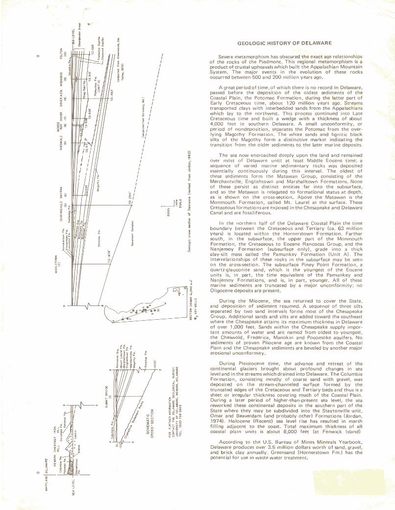
A great period of time, of which there is no record in Delaware,passed before the deposition of the oldest sediments of theCoastal Plain, the Potomac Formation, during the latter part ofEarly Cretaceous time, about 120 million years ago. Streamstransported clays with interbedded sands from the Appalachianswhich lay to the northwest. This process continued into LateCretaceous time and built a wedge with a thickness of about4,000 feet in southern Delaware. A small unconformity, orperiod of nondeposition, separates the Potomac from the overlying Magothy Formation. The white sands and Iignitic blacksilts of the Magothy form a distinctive marker indicating thetransition from the older sediments to the later marine deposits.
GEOLOGIC HISTORY OF DELAWARE
During Pleistocene time, the advance and retreat of thecontinental glaciers brought about profound changes in sealevel and in the streams which drained into Delaware. The ColumbiaFormation, consisting mostly of coarse sand with gravel, wasdeposited on the stream-channeled surface formed by thetruncated edges of the Cretaceous and Tertiary beds and thus is asheet or irregular thickness covering much of the Coastal Plain.During a later period of higher-than-present sea level, the seareworked these continental deposits in the southern part of theState where they may be subdivided into the Stavtonville unit,Omar and Beaverdam (and probably other) Formations (Jordan,1974). Holocene (Recent) sea level rise has resulted in marshfilling adjacent to the coast. Total maximum thickness of allcoastal plain units is about 8,000 feet (at Fenwick Island)
During the Miocene, the sea returned to cover the State,and deposition of sediment resumed. A sequence of three siltsseparated by two sand intervals forms most of the ChesapeakeGroup. Additional sands and silts are added toward the southeastwhere the Chesapeake attains its maximum thickness in Delawareof over 1,000 feet. Sands within the Chesapeake supply important amounts of water and are named from oldest to youngest,the Cheswold, Frederica, Manokin and Pocomoke aquifers. Nosediments of proven Pliocene age are known from the CoastalPlain and the Chesapeake sediments are beveled by another majorerosional unconformity.
According to the U.S. Bureau of Mines Minerals Yearbook,Delaware produces over 3.5 million dollars worth of sand, gravel,and brick clay annually . Greensand (Hornerstown Fm.l has thepotential for use in waste water treatment.
In the northern half of the Delaware Coastal Plain the timeboundary between the Cretaceous and Tertiary (ca. 63 millionyears) is located within the Hornerstown Formation. Farthersouth, in the SUbsurface, the upper part of the MonmouthFormation, the Cretaceous to Eocene Rancocas Group, and theNanjemoy Formation (subsurface only), grade into a thickclay-silt mass called the Pamunkey Formation (Unit A). Theinterrelationships of these rocks in the subsurface may be seenon the cross-section. The subsurface Piney Point Formation, aquartz-glauconite sand, which is the youngest of the Eoceneunits is, in part, the time equivalent of the Pamunkey andNanjemoy Formations, and is, in part, younger. All of thesemarine sediments are truncated by a major unconformity; noOligocene deposits are present.
The sea now encroached deeply upon the land and remainedover most of Delaware until at least Middle Eocene time; asequence of varied marine sedimentary rocks was depositedessentially continuously during this interval. The oldest ofthese sediments form the Matawan Group, consisting of theMerchantville, Englishtown and Marshalltown Formations. Noneof these persist as distinct entities far into the subsurface,and so the Matawan is relegated to formational status at depth,as is shown on the cross-section. Above the Matawan is theMonmouth Formation, called Mt. Laurel at the surface. TheseCretaceous formations are exposed in the Chesapeake and DelawareCanal and are fossiliferous.
Severe metamorphism has obscured the exact age relationshipsof the rocks of the Piedmont. This regional metamorphism is aproduct of crustal upheavals which built the Appalachian MountainSystem, The major events in the evolution of these rocksoccurred between 500 and 200 million years ago .
..0:
~i~~;~
0
~..~
~ ~
"e
zo
0;::;::0"' ..:E'".. ,x'"0'"",0
0:o
"EiJ
,II11111I1II
~ /~ /.:: 1~ 1-: I- 1i IKI-,I11III1IIIIII
, I! I::J,~I
'.~_~,,......,..,o
~
!o j~
z >o ..i= "u '"
~~!'::'-__---- l:l •
Q
Z..~
~~
o
I •.....~ ~
i !~ ~
~Q
-~ « i15 !~
g S0 ! ~
1~.. '0 H0 ;;;.. .. 0 s8 I".. ~.. ~ 'N
~ :. !'
~s c
I"
~ E.."z ~Ill\!::I
dI ii

![Transcriptomic and chemical analyses to identify candidate genes … · 2021. 1. 22. · Sainfoin (Onobrychis viciifolia Scop) is a perennial herb-aceous forage legume [1] that is](https://img.pdfslide.us/doc/110x75/6100d6130252ac6ef94ba0c6/transcriptomic-and-chemical-analyses-to-identify-candidate-genes-2021-1-22.jpg)