Embed Size (px)
Citation preview
Initial Environmental Examination Stage of the document: Final Project number: 49026-003 June 2017
VIE: Basic Infrastructure for Inclusive Growth in Nghe An, Ha Tinh, Quang Binh and Quang Tri Provinces Sector Project-Improving and Upgrading Tourism Route Connecting Dong Hoi City and Southern Areas of Quang Binh Province Prepared by Planning and Investment Department of Quang Binh province for the Asian Development Bank.
CURRENCY EQUIVALENTS (as of 12 June 2017)
Currency unit – Viet Nam Dong (D) D1.00 = $0.000044 $1.00 = Ð 22,680
ACRONYMS AND ABBREVIATIONS
ADB Asian Development Bank
CPC Commune People’s Committee
CSC Construction Supervision Consultant
DARD Department of Agriculture and Rural Development
DONRE Department of Natural Resources and Environment
DOT Department of Transportation
DPC District People’s Committee
DPI
ECT
Department of Planning and Investment
Emergency Control Team
EIAR Environmental Impact Assessment Report
EMP Environmental Management Plan
EPP Environmental Protection Plan
ESO Environmental Safeguards Staff
ESS Environmental Safeguard Specialist
IEE Initial Environmental Examination
IPM Integrated Pest Management
LEP Law on Environmental Protection
MPI Ministry of Planning and Investment
MPN Most Probable Number of viable cells of a pathogen - a measure of water quality
PMU Project Management Unit
PPC Provincial People’s Committee
PPE Personal Protective Equipment
PPTA Project Preparatory Technical Assistant
ROW Right of Way
SPS Safeguard Policy Statement
SST Subproject Support Teams
The PPTA The Project Preparatory Technical Assistant Consultants
The Project Basic Infrastructure for Inclusive Growth in Nghe An, Ha Tinh,
Quang Binh and Quang Tri Provinces Sector Project
The Subproject
Improving and Upgrading Tourism Route Connecting Dong Hoi City and Southern Areas of Quang Binh Province
UXO Unexploded ordnance
WEIGHTS AND MEASURES
Km2 (square kilometer) – unit of length
m3 (cubic meter) – A measure of volume
Note:
(i) In this report, "$" refers to US dollars.
The initial environmental examination is a document of the borrower. The views expressed herein do not necessarily represent those of ADB’s Board of Directors, Management, or staff, and may be preliminary in nature. In preparing any country program or strategy, financing any project, or by making any designation of or reference to a particular territory or geographic area in this document, the Asian Development Bank does not intend to make any judgments as to the legal or other status of any territory or area.

CONTENTS
Page
I. EXECUTIVE SUMMARY 6
A. Subproject Summary 6
B. Environment impacts and mitigation 7
C. Institutional arrangements 9
D. Conclusion 10
II. Background 12
A. Objectives of the Project 12
III. POLICY AND LEGAL FRAMEWORK 14
A. Asian Development Bank Requirements 14
B. Legal and Administrative Framework for Environmental Protection in Vietnam 14
C. Requirements for Subproject Categorization and Approval 16
IV. DESCRIPTION OF THE SUBPROJECT 17
A. General description 17
B. The need for subproject 17
C. Subproject summary 17
D. Land acquisition 20
E. Cost estimate 21
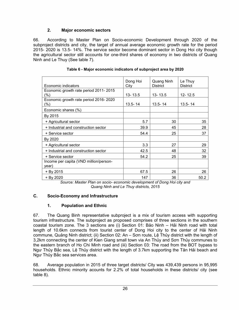
V. DESCRIPTION OF THE ENVIRONMENT 24
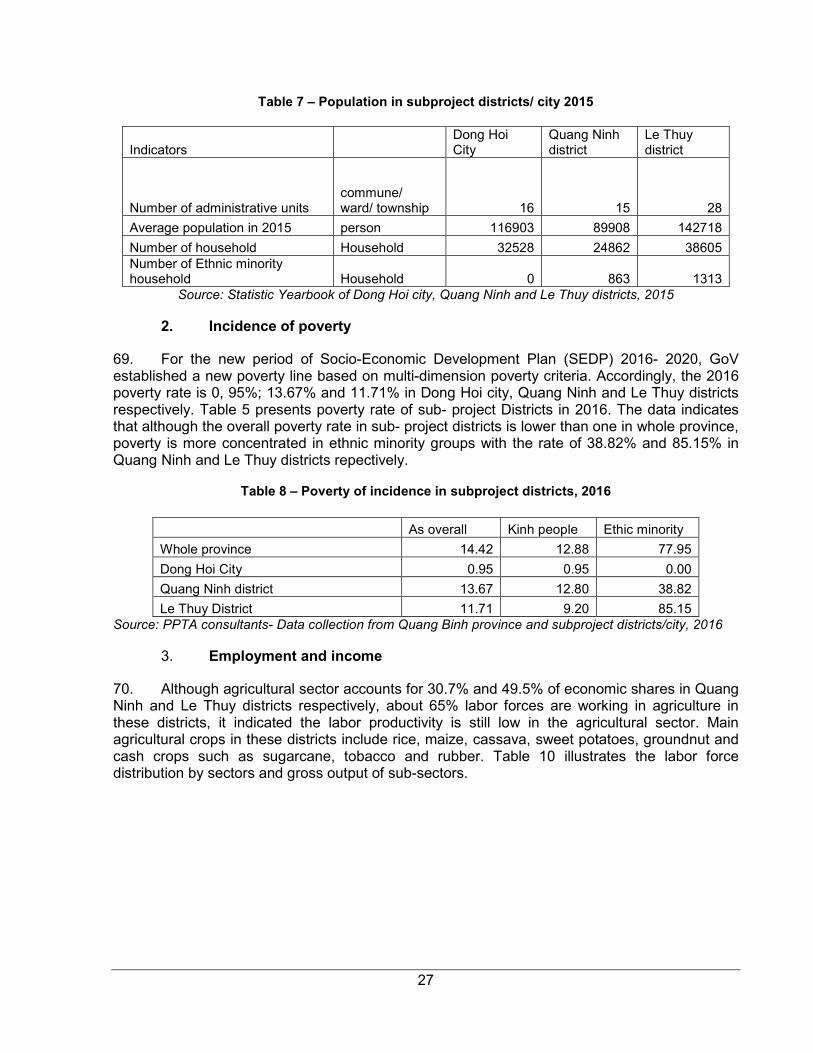
A. Physical Environment 24
B. Biological Environment 25
C. Socio-Economy and Infrastructure 26
D. Archaeological, Historical and Cultural Treasures 31
E. Key Environmental Features 32
VI. ANTICIPATED ENVIRONMENTAL IMPACTS AND MITIGATION MEASURES 33
A. Potential Impacts and Mitigation Measures in the Pre-Construction Phase 33
B. Potential Impacts and Mitigation Measures in the Construction Phase 34
C. Potential Impacts and Mitigation Measures in the Operation Phase 37
VII. INFORMATION DISCLOSURE, CONSULTATION AND PARTICIPATION 39
A. Public Consultation Preparation 39
B. Information Dissemination during Public Consultation 39
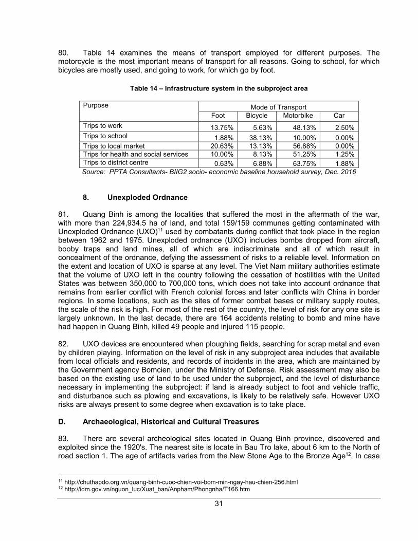
C. Information Dissemination during Public Consultation 39
D. Public Consultation during Detailed Design 40
VIII. GRIEVANCE REDRESS MECHANISM 41
A. Purpose of the Mechanism 41
B. Grievance Redress Process 41
IX. ENVIRONMENTAL MANAGEMENT PLAN 43
A. Implementation Arrangements 43
B. Environmental Mitigation 46
C. Environmental Monitoring 53

D. Reporting 57
E. Capacity Building 58
X. CONCLUSIONS AND RECOMMENDATIONS 60
XI. Appendix 61
A. Appendix 1: Photos of the subproject road and the vicinity 61
B. Appendix 2: Source of Reference Information 63
C. Appendix 3: Environmental Mitigation Measures to Include into Bidding Documents 64
D. Appendix 4: Consultation minute and list of interviewees 66
E. Appendix 5: National Technical Regulations of Vietnam 68
F. Appendix 6: Guidelines for Traffic Management Plan Preparation 77
LIST OF FIGURES
Figure 1 – General Map of the Subproject Area 11
Figure 2 – Typical Straight Line Section 18
Figure 3 – EMP Implementation Organization Chart 45
LIST OF TABLES
Table 1 – Bridge and causeways under the subproject road 7
Table 2 – Road Subproject Summary 17
Table 3 – Hydrological survey results of spillways on the 3 road sections 19
Table 4 - Land use in subproject district, 2015 28
Table 5 - Impacts on land of households and organizations 21
Table 6 – Estimated budget of the subproject 22
Table 7 - Major economic indicators of subproject area by 2020 26
Table 8 – Population in subproject districts/ city 2015 27
Table 9 – Poverty of incidence in subproject districts, 2016 27
Table 10 – Labor force and gross output in subproject area, 2015 28
Table 11 – Major social indicators in subproject area, 2015 29
Table 13 - Knowledge of HIV/AIDS (% of survey respondents) 30
Table 14 – Infrastructure system in the subproject area 31
Table 15 - Summary of affected tree by subproject implementation 34
Table 16 – Main issues and information from local authorities 40
Table 17 – Main environmental concerns from public consultation 40
Table 18 – Responsibilities for EMP implementation 43
Table 19 - Detail Environmental Mitigation Plan 47
Table 20 - Environmental Monitoring Compliance 54
Table 21 - Environmental Affect Monitoring 56
Table 22 – Reporting procedures 57
Table 23 – Estimated cost for EMP Implementation (2-year construction/ 4-year in total) 57
Table 24 – Detail capacity building program 58
6
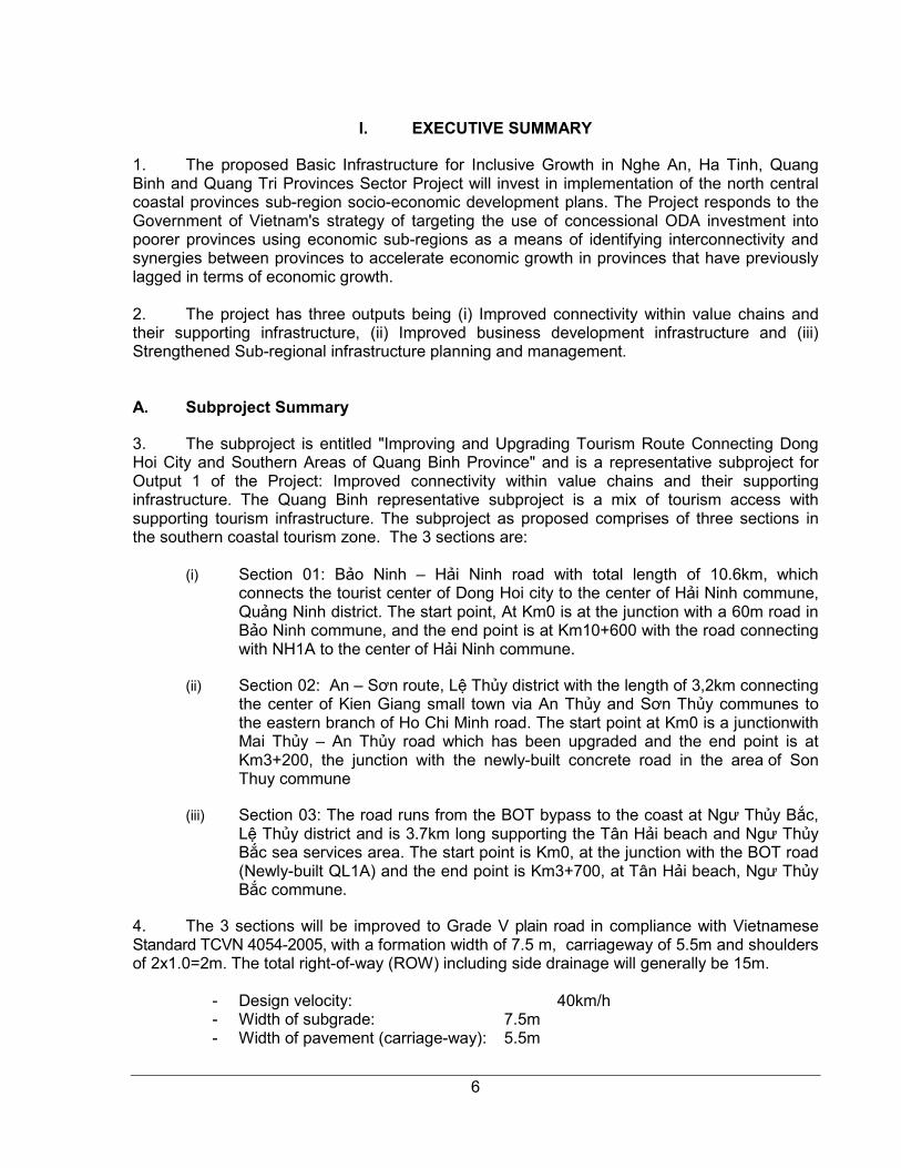
I. EXECUTIVE SUMMARY
1. The proposed Basic Infrastructure for Inclusive Growth in Nghe An, Ha Tinh, Quang Binh and Quang Tri Provinces Sector Project will invest in implementation of the north central coastal provinces sub-region socio-economic development plans. The Project responds to the Government of Vietnam's strategy of targeting the use of concessional ODA investment into poorer provinces using economic sub-regions as a means of identifying interconnectivity and synergies between provinces to accelerate economic growth in provinces that have previously lagged in terms of economic growth. 2. The project has three outputs being (i) Improved connectivity within value chains and their supporting infrastructure, (ii) Improved business development infrastructure and (iii) Strengthened Sub-regional infrastructure planning and management. A. Subproject Summary
3. The subproject is entitled "Improving and Upgrading Tourism Route Connecting Dong Hoi City and Southern Areas of Quang Binh Province" and is a representative subproject for Output 1 of the Project: Improved connectivity within value chains and their supporting infrastructure. The Quang Binh representative subproject is a mix of tourism access with supporting tourism infrastructure. The subproject as proposed comprises of three sections in the southern coastal tourism zone. The 3 sections are:
(i) Section 01: Bảo Ninh – Hải Ninh road with total length of 10.6km, which connects the tourist center of Dong Hoi city to the center of Hải Ninh commune, Quảng Ninh district. The start point, At Km0 is at the junction with a 60m road in Bảo Ninh commune, and the end point is at Km10+600 with the road connecting with NH1A to the center of Hải Ninh commune.
(ii) Section 02: An – Sơn route, Lệ Thủy district with the length of 3,2km connecting the center of Kien Giang small town via An Thủy and Sơn Thủy communes to the eastern branch of Ho Chi Minh road. The start point at Km0 is a junctionwith Mai Thủy – An Thủy road which has been upgraded and the end point is at Km3+200, the junction with the newly-built concrete road in the area of Son Thuy commune
(iii) Section 03: The road runs from the BOT bypass to the coast at Ngư Thủy Bắc, Lệ Thủy district and is 3.7km long supporting the Tân Hải beach and Ngư Thủy Bắc sea services area. The start point is Km0, at the junction with the BOT road (Newly-built QL1A) and the end point is Km3+700, at Tân Hải beach, Ngư Thủy Bắc commune.
4. The 3 sections will be improved to Grade V plain road in compliance with Vietnamese Standard TCVN 4054-2005, with a formation width of 7.5 m, carriageway of 5.5m and shoulders of 2x1.0=2m. The total right-of-way (ROW) including side drainage will generally be 15m.
- Design velocity: 40km/h - Width of subgrade: 7.5m - Width of pavement (carriage-way): 5.5m
7
- Width of shoulder: 2 x 1,0m - Normal cross fall (%): 2% - Max. Super elevation (%): 6% - Pavement structure: An Son road cement concrete; Bao Ninh – Hai Ninh and the
road from the BOT bypass to Ngư Thủy Bắc sea asphalt concrete.
5. The three sections under the subproject are basically to be upgraded an existing aggregate road on the same alignment. Some minor realignment will be necessary to comply with Category III standards, particularly the section at the end of the route where the alignment will need to be adjusted near a residential area to avoid land acquisition. On the other two sections, the alignment will follow the existing road.
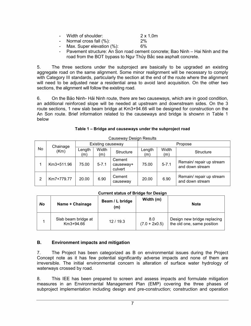
6. On the Bảo Ninh- Hải Ninh route, there are two causeways, which are in good condition, an additional reinforced slope will be needed at upstream and downstream sides. On the 3 route sections, 1 new slab beam bridge at Km3+94.66 will be designed for construction on the An Son route. Brief information related to the causeways and bridge is shownn in Table 1 below
Table 1 – Bridge and causeways under the subproject road
Causeway Design Results
No Chainage
(Km)
Existing causeway Propose Length
(m) Width (m)
Structure Length
(m) Width (m)
Structure
1 Km3+511.96 75.00 5-7.1 Cement causeway+ culvert
75.00 5-7.1 Remain/ repair up stream and down stream
2 Km7+779.77 20.00 6.90 Cement causeway
20.00 6.90 Remain/ repair up stream and down stream
Current status of Bridge for Design
No Name + Chainage Beam / L bridge
(m)
Width (m) Note
1 Slab beam bridge at
Km3+94.66 12 / 19.3
8.0 (7.0 + 2x0.5)
Design new bridge replacing the old one, same position
B. Environment impacts and mitigation
7. The Project has been categorized as B on environmental issues during the Project Concept note as it has few potential significantly adverse impacts and none of them are irreversible. The initial environmental concern is alteration of surface water hydrology of waterways crossed by road. 8. This IEE has been prepared to screen and assess impacts and formulate mitigation measures in an Environmental Management Plan (EMP) covering the three phases of subproject implementation including design and pre-construction; construction and operation
8
phases and to set out the institutional arrangements needed to ensure that the subproject EMP will be implemented. 9. In the design and preconstruction phases, the potential issues that have been identified are (i) disturbance of UXO; and (ii) land acquisition and resettlement. To minimize the first impact, the PMU will coordinate with appropriate agencies to identify any UXO left and engage an authorized UXO clearing contractor. To minimize the impact on income and disturbance of local people’s lives, the PMU will check and review the Land acquisition and resettlement process before construction starts to ensure that all affected households have received compensation adequately in accordance with GOV and ADB safeguard policies. 10. The potential negative impacts of the construction phase have been identified as (i) encroachment of the line of trees planted as a windbreak along coastal side of Section 1. To minimize the impact, the contractor also may not store construction material or source any materials from around the trees. The workers should be informed and prohibited from cutting trees for firewood or extraction of any other tree products. 11. Alteration of surface water hydrology of waterways crossed by the subproject road. There are 2 causeways will be upgraded in Section 1 and 1 new bridge will be constructed in Section 2 of the subproject road. Excavation for foundations and pipe installation in the flows for causeways and bridge construction will result in increased sediment release during the construction period. The proposed mitigation measures are design of bridge/ causeways of sufficient capacity to handle flood events; ensuring that no excavated material is deposited in the streams or river; use of coffer dams, silt fences, sediment barriers or other devices as appropriate during construction; and re-vegetation of bare surfaces with grasses and creepers to reduce runoff and prevent filling. 12. Deterioration of surface water quality due to silt runoff and sanitary wastes from worker-based camps. Sections 1 and 3 are located in the coastal area while Section 3 is located in a lowland area and usually suffers from inundation and floods, and any release of raw sewage or other waste from workers' camps will impair the quality of canal, river, water rice field and the coastal water. To minimize the impact, the contractor will provide adequate drainage and sanitation facilities at construction sites and worker camps; store lubricants, fuels and wastes in dedicated enclosures at least 10m from water bodies and use silt fences and coverings over stockpiles as necessary to prevent release of fine materials into the air or waterways. 13. Impact of the operation of construction machines and vehicles on local traffic; impeding traffic flows and increasing risks of work accidents and traffic accidents. These risks will be reduced by careful planning of transport of materials and equipment around the site, restricting movements during peak traffic hours, parking vehicles and plant in designated areas that do not cause obstruction and ensuring that only trained and certified operators may drive vehicles or operate plant. 14. Noise, vibration and gaseous emissions from construction machines such as excavators, concrete mixing plants or trucks could disturb local people or damage their houses, especially at the end of Section 1, in residential area of Tan Dinh village, Hai Ninh commune, Quang Ninh district and Section 2 in the residential areas of Son Thuy and An Thuy communes, Le Thuy district. Risks will be mitigated by ensuring that plant and vehicles are in sound operable condition, free of leaks and fitted with exhaust baffles to reduce noise. Construction methods that involve heavy vibration should be excluded from areas that are in
9
close proximity to houses and structures. The Contractor will be responsible to rectify damage to private property caused by vibration or accidents involving construction vehicles ore plant. 15. The construction activities will pose potential safety risks to workers and also to the local public, to be mitigated by briefing and training workers on safety procedures, marking hazardous work sites, providing warning signs and assigning responsibility for site safety to on-site supervisors; (vii) Large numbers of construction workers brought to the construction area could cause social impacts on the local communities, particularly associated with activities such as gambling, use of drugs and alcohol and antisocial behavior. The Contractor will be required to implement strict codes of conduct relating to social and commercial interaction with local communities and facilitate constructive recreation such as sport activities; 16. In the operation phase, the main potential negative impacts that have been identified are related to driving conditions and traffic safety. To minimize the negative impact of driving condition and traffic safety, Quang Binh Department of Transportation (DOT), the responsible agency for subproject management in the operation phase, will cooperate with Quang Binh DONRE, Dong Hoi City People Committee, Le Thuy and Quang Ninh DPCs, 6 CPCs to maintain the road periodically and collaborate with traffic police to control speeds and vehicle loads on the road, especially near the end point of Section 1, the start and end points of Section 2 and the start point of Section 3. 17. The PPTA Consultant has also identified key stakeholders and conducted public consultations from provincial to commune level with a focus on the affected people’s views. In general all the stakeholders expresed their support for the subproject. There are concerns from local people related to construction quality monitoring and risks of failure to pay compensation. The concerns are addressed in the EMP (See Table 16 – 17 for more details). 18. An EMP has been prepared under this IEE to detail responsibilities of relevant stakeholders on mitigation measures to be implemented during construction and operation phases of the subproject. C. Institutional arrangements
19. Quang Binh DPI will establish an Official Development Assistance (ODA) Project Management Unit (PMU) to implement the subproject in all phases. One PMU staff will be assigned as the Environmental Safeguards Officer (ESO). An Environmental Safeguards Specialist (ESP), within the Loan Implementation Consultant (LIC) team will organize a formal training course in roles and responsibilities for EMP implementation and on-the-job training for relevant PMU staff, CSC, communities, contractors; and support for establishment and operation of the subproject environment management system in construction phase. The ESS will also support PMU’s capacity building by reviewing and evaluating the capacity for environmental protection of the PMU and Quang Binh Department of Transportation (DOT) – subproject management organization in the operation phase.
20. To ensure that environmental protection and mitigation measures are included in the civil works contracts, the EMP will be included in the bidding documents and civil works contracts. Any omission of environmental management costs will create high risks for implementing mitigation measures during the construction phase due to lack of resources and capacity, thus the environmental protection cost and responsibilities need to be involved from the beginning. Bid documents will also specify that contractors shall engage capable and
10
trained staff to take responsibility for the environmental management and safety issues at the working level and to monitor the effectiveness and review mitigation measures as the subproject proceeds. D. Conclusion
21. The IEE concludes that the feasibility study of the subproject combined with available information is sufficient to identify the scope of potential environmental impacts and formulate mitigation measures for the subproject. Providing that significant changes to the subproject description do not occur at the detailed design phase, and that new sensitive environmental, or cultural resources are not encountered, further detailed environmental impact assessment (EIA) is not required. In case of any change in the subproject design, the ESS will update EMP before detailed design finalization.

11
Figure 1 – General Map of the Subproject Area
12
II. BACKGROUND
A. Objectives of the Project
1. Basic Infrastructure for Inclusive Growth in Nghe An, Ha Tinh, Quang Binh and Quang Tri Provinces Sector Project
22. The Project Preparation Technical Assistance (PPTA) for the proposed Basic Infrastructure for Inclusive Growth Project in Nghe An, Ha Tinh, Quang Binh and Quang Tri Provinces (Project) was included in the Asian Development Bank’s (ADB) Viet Nam Country Operations and Business Plan (2015–2017).1
23. The proposed Project will invest in implementation of the north central coastal provinces (NCCP) subregion socio-economic development plans. The Project responds to the Government of Vietnam’s strategy of targeting the use of concessional ODA investment into poorer provinces using economic subregions as a means of identifying interconnectivity and synergies between provinces to accelerate economic growth in provinces that have previously lagged in terms of economic growth. 24. The project has three outputs being (i) Improved connectivity within value chains and their supporting infrastructure, (ii) Improved business development infrastructure and (iii) Strengthened Sub-regional infrastructure planning and management.
2. The Subproject
25. The road connecting from Dong Hoi city to the southern areas of Quang Binh province for tourism includes 03 sections: Bảo Ninh - Hải Ninh road; the road from the BOT bypass to Ngư Thủy Bắc sea, and An Sơn - Lệ road, after constructed, will complete the traffic infrastructure between Đồng Hới city and the southern region of Quảng Bình province. 26. Section 1 - Bảo Ninh – Hải Ninh route: This route currently has a drainage problem. There are two spillways to discharge water from the field to the sea when it rains heavily. It is said by local people that following long periods of heavy rainfall, the water concentrates at the spillways flooding the road. Although the flood does not happen frequently each year, it is dangerous for tourists and it is necessary prevent this. 27. Section 3 - The road from the BOT bypass to Ngư Thủy Bắc sea: this secction has is no bridge but small culverts for water drainage. These need lengthening to match thet width of the expanded road. 28. Section 2 - An – Sơn route, Lệ Thủy district: there is one slab bridge with the width of 4m and the length of L=12m, which is in use but in poor condition and in addition, two culverts need to be replaced. 29. The subproject is initially categorized as ‘B’ for environmental safeguards, and this IEE is required according to the ADB Safeguards Policy Statement (SPS) of 2009. The objectives and scope of this IEE are to (i) assess the existing environmental conditions in the vicinity of the subproject road; (ii) identify potential environmental impacts from the proposed road improvement works; (iii) evaluate and determine the significance of the impacts; (iv) develop an
1 The Project is consistent with ADB’s Country Partnership Strategy (CPS) 2012-2015.
13
environmental management plan (EMP) detailing mitigation measures, monitoring activities, reporting requirements, institutional responsibilities and cost estimates to address adverse environmental impacts; and (v) carry out public consultations to document any issues/ concerns that stakeholders may have on the subproject and to ensure that such concerns are addressed in the subproject design and mitigation measures.
14
III. POLICY AND LEGAL FRAMEWORK
30. The subproject shall comply with requirements of ADB SPS 2009 and the GOV’s Guidelines on Implementation of Law on Environmental Protection 2014. Decree No. 18/2015/ND-CP has detailed information on strategic environmental assessment, environmental impact assessment and environmental protection plans. However certain activities commonly associated with infrastructure subproject such as quarry operations, extraction of gravel, etc., will also require permission from the relevant provincial level authorities. The bridge and causeways, which will be constructed or upgraded by the subproject, are small in dimensions and will not be required for separated Environmental Impact Assessment2. A. Asian Development Bank Requirements
31. ADB safeguard policy statement (SPS) 2009 imposes safeguard requirements for all its funded projects. The SPS 2009 clarifies the rationale, scope and contents of the environmental assessment. It emphasizes environmental and social sustainability in progress of economic growth and poverty reduction in Asia and the Pacific, with the following aims:
- Avoid adverse impacts of projects on the environment and affected people, where possible;
- Minimize/mitigate and/or compensate for adverse impacts on environment and affected people when avoidance is not possible; and
- Help borrowers/clients to strengthen their safeguard systems and develop the capacity to manage environmental and social risks
32. For environmental safeguards, the Subproject is initially categorized as ‘B’. A subproject that is classified as category A on environmental safeguards would be ineligible as a BIIG 2 subproject.
B. Legal and Administrative Framework for Environmental Protection in Vietnam
33. The subproject has to comply with the environmental legal framework of Vietnam, which is outlined in this section. The main components of the framework, if not, the more applicable ones are shown here.
1. Laws
• Law No. 55/2014/QH13 of 23 June 2014 by the National Assembly on environment protection
• Law No. 17/2012/QH13 of 21 June 2012 by the National Assembly on water resources
• Law No. 20/2008/QH12 of 13 November 2008 by the National Assembly on Biodiversity Conservation
• Law No. 68/2006/QH11 of 29 June 2006 by the National Assembly on standards and technical regulations
• Law No. 29/2004/QH11 of 03 December 2004 by the National Assembly on forest protection and development
2 In accordance to Decree No.18/2015/ND-CP, the construction or upgrade bridge with total length more than 500m
should implement a separated Environmental Impact Assessment.
15
2. Decrees and Regulations
• Decree No. 18/2015/ND-CP dated February 14, 2015 on environmental protection planning, strategic environmental assessment, environmental impact assessment and environmental protection plans.
• Circular No. 27/2015/TT-BTNMT dated May 29, 2015 on strategic environmental assessment, environmental impact assessment and environmental protection plans.
• Circular No. 36/2015/TT-BTNMT of 30 June 2015 by the Ministry of Natural Resources and Environment stipulating hazardous waste management
• Decision 07/2012/QD-TTg dated February 08, 2012 of the Prime Minister promulgating some regulations on intensified enforcement of forest protection
• Decision 186/2006/QD-TTg dated August 14, 2006 of the Prime Minister promulgating the Regulation on forest management
• Decree 09/2006/ND-CP dated 16th January, 2006 of the Government on forest fire prevention and control
• National Technical Regulations on air and noise quality
- QCVN 05: 2013/BTNMT on ambient air quality
- QCVN 26: 2010/BTNMT on noise
- QCVN 27: 2010/BTNMT on vibration
• National Technical Regulations on water quality
- QCVN 01: 2009/BYT on drinking water quality
- QCVN 02: 2009/BYT on domestic water quality
- QCVN 08-MT:2015/BTNMT on surface water quality
- QCVN 09-MT:2015/BTNMT on underground water quality
- QCVN 14: 2008/BTNMT on domestic wastewater
3. Other legislation applicable to the subproject are the following:
• Law No. 27/2001/QH10 of 29 June 2001 by the National Assembly on fire prevention and fighting
• Law No. 40/2013/QH13 of 22 November 2013 by the National Assembly on amending and adding a number of articles of the Law No. 27/2001/QH10 of 29 June 2001 on fire prevention and fighting
• Decision No. 3733/2002/QD-BYT of 10 October 2002 by the Ministry of Health promulgating 21 labor hygiene standards, 5 principles and 7 labor hygiene measurements
• Law No. 50/2014/QH13 of 18 June 2014 by the National Assembly on construction
• Circular No. 22/2010/TT-BXD of 03 December 2010 by the Ministry of Construction on labor safety in work construction
• Law No. 10/2012/QH13 of 18 June 2012 by the National Assembly on labor code.

16
C. Requirements for Subproject Categorization and Approval
34. Subproject selection and screening ensures that only subprojects ranked as Category B or C to follow ADB SPS 2009 will be included in the list of eligible subprojects for possible funding under the proposed Project. It is anticipated that all eligible subprojects will fall into Category B, whereby some adverse environmental impacts are expected additional subprojects will be screened by carrying out initial site visits to view local conditions, identify potential negative impacts, and complete Rapid Environmental Assessment (REA) Checklists. With regard to the requirements of Decree No. 18/2015/ND-CP, an Environmental Assessment Report is required for all development projects, either an Environmental Impact Assessment Report (EIAR) or an Environmental Protection Plan (EPP). In common with projects classified as Category B under the ADB SPS, smaller projects with some but limited adverse impacts will be subject to a lesser level of assessment in the form of an EPP. EPPs are required to be submitted for appraisal at the time of Subproject Investment Report preparation. 35. An IEE/EPP needs to be prepared if a subproject is classified as environmental category B following ADB SPS 2009. The IEE needs to include an environmental management plan (EMP). The PMU will select an appropriate national consulting firm to prepare the IEE/EPP with support from PMU/LIC environment specialist and update the representative IEE/EMP prepared by the PPTA Consultants if needed to reflect any change in the subproject detail design. The IEE/EPP should include the subproject scope, baseline information, materials to be used construction techniques, impact assessment, mitigation and environmental monitoring, and a minute of public consultation. The content and format of the IEE report should satisfy the requirements of both ADB and the Government of Viet Nam (EPP). Adequate public consultation needs to be carried out to share and get feedback on the initial findings of the IEE.
36. Review of IEE/EPPs: On completion, IEE/EPP reports will be reviewed initially by the PMU and if satisfactory, IEE/EPP reports will be forwarded to relevant PPC for approval. The environmental assessment and review procedures for IEE/EPP are as follows:
(i) PMU reviews IEE/EPP reports; (ii) If found satisfactory, the PMU will forward to relevant PPC for approval and
submit the IEE/EPP for each subproject to ADB for review, endorsement and uploading on the ADB website.

17
IV. DESCRIPTION OF THE SUBPROJECT
A. General description
37. The 3 Sections, are located in 6 communes of Dong Hoi city, Quang Ninh and Le Thuy districts, Quang Binh province. The proposed improvements will create linkages between coastal roads, the BOT bypass, QL1A, and the eastern branch of the Hồ Chí Minh bypass road and improve the traffic network connecting the regions in the east and west of Quảng Bình province. B. The need for subproject
38. The connection between Đồng Hới city and well-known tourist attractions create favourable conditions for tourists to visit local attractions which include places of interest Dong Hoi city and coastal areas to the south of the city, and make important contribution to changing economic structure of the province toward tourism services. Sites linked Đồng Hới city by the roads include high-class resorts along the Nhật Lệ and Bảo Ninh beaches, an archaeological site at Bàu Tró, the Nhật Lệ river, a statue at Mẹ Suốt ancient relicts at Lũy Thầy (the Thay rampart), Quảng Bình Gate, Đồng Hới great wall, other war relics such as bell tower of Tam Tòa church, and a banyan tree at Chùa Ông.. 39. The project when invested will benefit directly 3 localities including Đồng Hới city, Quảng Ninh district and Lệ Thủy district. The communities that beneft are
(i) Bao Ninh which has a total 2,289 households of which 26 are poor and 28 are near poor households, and is reliant on marine resources, sea food and related services though these livelihoods are severely damaged by pollution from the Formosa steel works in Ha Tinh Province in 2016.
(ii) Quảng Ninh district, which has 24,862 households including 2,272 poor households and 2,940 near poor households. Within Quảng Ninh district is Hải Ninh commune which has a total of 1,328 households including 108 poor households and 88 pro-poor households. A private developer (FLC group) plans to establish a large tourism and recreational investment centre in Hải Ninh commune.
(iii) Lệ Thủy district which has 38,605 households including 4,652 poor households and 2,707 near poor households. Within this district, Ngư Thủy Bắc commune has a total of 954 households, 227 of which are poor 275 near poor;An Thủy commune has a total of 2,775 households of which 130 are poor and 133 near poor; Sơn Thủy commune has 1,940 households of which 323 are poor and 95 near poor.
40. In addition the connectivity provided by the roads will facilitate local trading with neighbouring areas, with a growth in non-farm rural employment that supports the restructuing of agriculture with labor moving into trade and services, minimizing the risks caused by natural disasters, drought and sea environment incidents and stabilizing people’s production as well as improving living standards for local people. C. Subproject summary
41. The three road sections will be improved to Category V in compliance with Vietnamese Standard TCVN 4054-2005, the features of which are summarised below:
Table 2 – Road Subproject Summary

18
Name Representative Improving and Upgrading Tourism route connecting Dong Hoi
City and Southern areas of Quang Binh Province.
Length Representative (km) 17.5Km
District – Representative Dong Hoi city, Quang Ninh and Le Thuy districts
Total Number Districts 3
Total Number Communes Bao Ninh, Hai Ninh, Ngu Thuy Bac, An Thuy, Son Thuy
Beneficiaries 9,286
Investment Representative $mill 7,470,973 Investment per km (USD/km) $’000’ 426,912
Figure 2 – Typical Straight Line Section
1. Hydrological and hydraulic investigations
42. The hydrological survey was conducted through observation interviews with the local people living in the subproject areas. Parameters of the hydrological survey of bridges, the river, and streams along the road sections are summarized in Table 3 below:
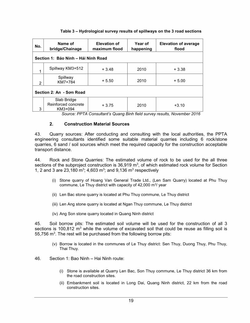
19
Table 3 – Hydrological survey results of spillways on the 3 road sections
No. Name of
bridge/Chainage Elevation of
maximum flood Year of
happening Elevation of average
flood
Section 1: Bảo Ninh – Hải Ninh Road
1 Spillway KM3+512 + 3.48 2010 + 3.38
2
Spillway KM7+784 + 5.50 2010 + 5.00
Section 2: An - Sơn Road
3
Slab Bridge Reinforced concrete
KM3+094 + 3.75 2010 +3.10
Source: PPTA Consultant’s Quang Binh field survey results, November 2016
2. Construction Material Sources
43. Quarry sources: After conducting and consulting with the local authorities, the PPTA engineering consultants identified some suitable material quarries including 6 rock/stone quarries, 6 sand / soil sources which meet the required capacity for the construction acceptable transport distance. 44. Rock and Stone Quarries: The estimated volume of rock to be used for the all three sections of the subproject construction is 36,919 m3, of which estimated rock volume for Section 1, 2 and 3 are 23,180 m3; 4,603 m3; and 9,136 m3 respectively
(i) Stone quarry of Hoang Van General Trade Ltd., (Len Sam Quarry) located at Phu Thuy commune, Le Thuy district with capacity of 42,000 m3/ year
(ii) Len Bac stone quarry is located at Phu Thuy commune, Le Thuy district
(iii) Len Ang stone quarry is located at Ngan Thuy commune, Le Thuy district
(iv) Ang Son stone quarry located in Quang Ninh district
45. Soil borrow pits: The estimated soil volume will be used for the construction of all 3 sections is 100,812 m3 while the volume of excavated soil that could be reuse as filling soil is 55,756 m3. The rest will be purchased from the following borrow pits:
(v) Borrow is located in the communes of Le Thuy district: Sen Thuy, Duong Thuy, Phu Thuy, Thai Thuy.
46. Section 1: Bao Ninh – Hai Ninh route:
(i) Stone is available at Quarry Len Bac, Son Thuy commune, Le Thuy district 36 km from the road construction sites.
(ii) Embankment soil is located in Long Dai, Quang Ninh district, 22 km from the road construction sites.
20
(iii) Fine sand is availalbe at Cam Thuy in Le Thuy District, 15 km from the road construction sites.
(iv) Coarse sand is available in My Trung, Quang Ninh district, 15 km from the road construction sites.
(v) Asphalt and bitumen is available from a supplier in Da Nang city, 237 km from the road construction sites.
47. Section 3: The road from the BOT bypass to Ngư Thủy Bắc coast:
(i) Stones of all kinds are available from the Len Sam stone quarry, Le Thuy district, 25km from the workplace.
(ii) Embankment soil for works is available from borrow pit sources in Thai Thuy Commune - Le Thuy district, 30 km from the workplace.
(iii) Coarse sand for works is availalbe from a sand source at My Thuy commune – Le Thuy district, 13 km from the workplace.
(iv) Asphalt and bitumen is available from the supplier in Da Nang, 231 km from the workplace.
48. Section 2: An – Son route:
(i) Stones of all kinds are available from Len Ang stone quarry, Ngan Thuy commune – Le Thuy district, 19km from the workplace.
(ii) Embankment soil for works is available from a borrow pit source in Thai Thuy Commune, Le Thuy district, 18 km from the workplace.
(iii) Fine sand is available from a source in Cam Thuy commune – Le Thuy district 15 km from the workplace.
(iv) Coarse sand for the works is from a source in My Thuy commune – Le Thuy district, 12 km from the workplace.
(v) Asphalt and bitumen is agian available from the supplier in Da Nang, 237 km from the workplace.
49. Materials source investigation: Working with the local authorities and people (district, commune) the survey team collected information on potential sites and then conduct an investigation of these sites near the project road and nearby areas which meet requirements in terms of transport distance, dumping site capacity for the construction project and get confirmation from the local authorities. D. Land acquisition
50. Impacts on land: According to the IOL (Inventory of Lossess) results, the subproject will permanently acquire totally 90,150m2 of various kinds of land including 1,070m2 of residential land of households (720m2 of four households in Hai Ninh and 350m2 of three households in An Thuy); 3,558m2 of agricultural land for annual crops under management of CPCs (2,536m2 in An Thuy commune and 1,022m2 in Son Thuy commune); 4,160m2 of protection forest land of three households in Hai Ninh commune; 81,362m2 of protection forest land (31,415m2 under management of Dong Hoi protection forest management unit, 37,147m2 under management of Long Dai protection forest management unit, 12,800m2 under management of Nam Quang Binh protection forest management unit). The IOL results are presented in Table 5.

21
Table 4 - Impacts on land of households and organizations
No. District/commune Total affected land area (m2)
Residential land (m2)
Annual crop land (m2)
Production forest land (m2)
Protection forest land (m2)
1 Bao Ninh 31,415 - - - 31,415
2 Hai Ninh 42,027 720 - 4,160 37,147
3 An Thuy 2,886 350 2,536 - -
4 Son Thuy 1,022 - 1,022 - -
5 Ngu Thuy Bac 12,800 - - - 12,800
Total 90,150 1,070 3,558 4,160 81,362
Source: IOL in December 2016 51. Impacts on houses and structures: The subproject will affect 249m2 of structures of 12 households in Son Thuy commune at route section of An – Son; one tomb of one household in Hai Ninh commune at route section of Bao Ninh – Hai Ninh. And the subproject does not affect house of household/organization. E. Cost estimate
52. In the plan, the subproject will be constructed within 24 months with the estimated budget in Table 6 below:
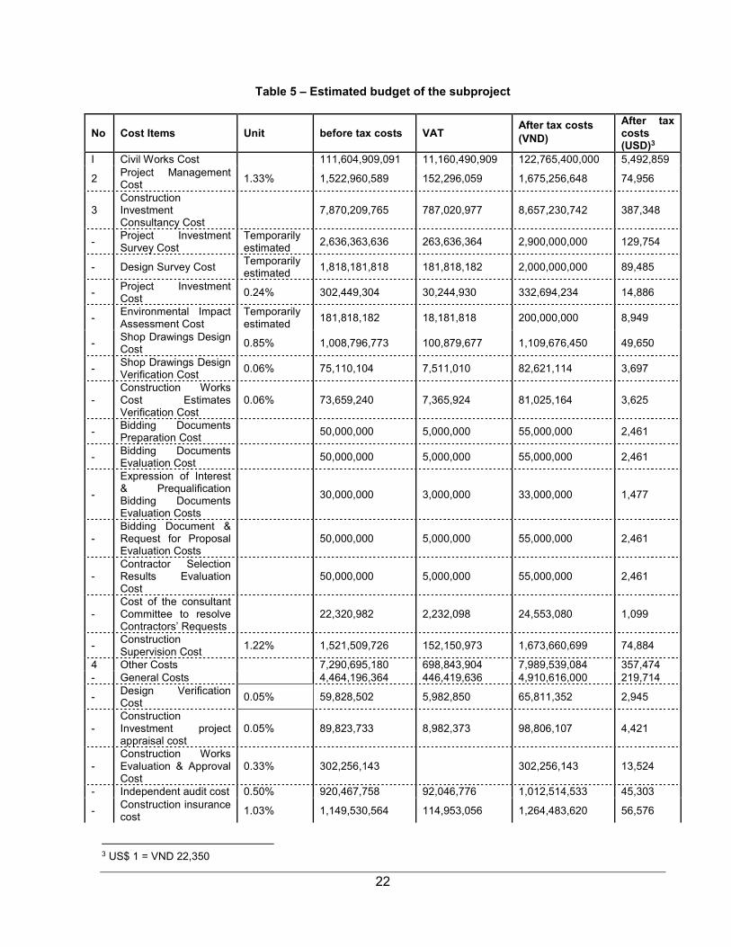
22
Table 5 – Estimated budget of the subproject
No Cost Items Unit before tax costs VAT After tax costs (VND)
After tax costs (USD)3
I Civil Works Cost 111,604,909,091 11,160,490,909 122,765,400,000 5,492,859
2 Project Management Cost
1.33% 1,522,960,589 152,296,059 1,675,256,648 74,956
3 Construction Investment Consultancy Cost
7,870,209,765 787,020,977 8,657,230,742 387,348
- Project Investment Survey Cost
Temporarily estimated
2,636,363,636 263,636,364 2,900,000,000 129,754
- Design Survey Cost Temporarily estimated
1,818,181,818 181,818,182 2,000,000,000 89,485
- Project Investment Cost
0.24% 302,449,304 30,244,930 332,694,234 14,886
- Environmental Impact Assessment Cost
Temporarily estimated
181,818,182 18,181,818 200,000,000 8,949
- Shop Drawings Design Cost
0.85% 1,008,796,773 100,879,677 1,109,676,450 49,650
- Shop Drawings Design Verification Cost
0.06% 75,110,104 7,511,010 82,621,114 3,697
- Construction Works Cost Estimates Verification Cost
0.06% 73,659,240 7,365,924 81,025,164 3,625
- Bidding Documents Preparation Cost
50,000,000 5,000,000 55,000,000 2,461
- Bidding Documents Evaluation Cost
50,000,000 5,000,000 55,000,000 2,461
-
Expression of Interest & Prequalification Bidding Documents Evaluation Costs
30,000,000 3,000,000 33,000,000 1,477
- Bidding Document & Request for Proposal Evaluation Costs
50,000,000 5,000,000 55,000,000 2,461
- Contractor Selection Results Evaluation Cost
50,000,000 5,000,000 55,000,000 2,461
- Cost of the consultant Committee to resolve Contractors’ Requests
22,320,982 2,232,098 24,553,080 1,099
- Construction Supervision Cost
1.22% 1,521,509,726 152,150,973 1,673,660,699 74,884
4 Other Costs 7,290,695,180 698,843,904 7,989,539,084 357,474 - General Costs 4,464,196,364 446,419,636 4,910,616,000 219,714
- Design Verification Cost
0.05% 59,828,502 5,982,850 65,811,352 2,945
- Construction Investment project appraisal cost
0.05% 89,823,733 8,982,373 98,806,107 4,421
- Construction Works Evaluation & Approval Cost
0.33% 302,256,143 302,256,143 13,524
- Independent audit cost 0.50% 920,467,758 92,046,776 1,012,514,533 45,303
- Construction insurance cost
1.03% 1,149,530,564 114,953,056 1,264,483,620 56,576
3 US$ 1 = VND 22,350

23
No Cost Items Unit before tax costs VAT After tax costs (VND)
After tax costs (USD)3
- Project Investment supervision and evaluation Cost
20.00% 304,592,118 30,459,212 335,051,330 14,991
5 Land Acquisition and Resettlement Costs
Temporarily estimated
1,367,065,597 136,706,950 1,503,772,547 67,282
6 Contingency 16.00% 21,835,294,849 2,183,529,485 24,018,824,334 1,074,668 Total (1+2+3+4+5+6) 166,610,020,000 7,454,586
24
V. DESCRIPTION OF THE ENVIRONMENT
A. Physical Environment
1. Topography, Geology, and Soils
53. Quang Binh is situated in the north central coastal province with coordinates of 105036’55'' to 106059’37'' North latitude and 1705’02'' to 1805’12'' East longitude. It borders with Ha Tinh province in the North, Quang Tri province to the South, the East Sea in the East and the Lao People's Democratic Republic in the West.
54. The topography of the province is divided into 4 main types: (i) a high mountainous area which lies along the East Truong Son Range; (ii) hills and small plateaux; (iii) a coastal plain; and (iv) a sandy coastal area. Road sections 1 3 are located in the sandy coastal area elevations between 2 - 250m and a high slope ratio of up to 600. The total area of the sandy coastal zone makes up only 5% of the total provincial area. Section 2 is located on the coastal plain area which makes up to 8% of the total provincial area. This area has fertile soils and 32.8% of the land area is used for rice cultivation.
55. Soils in Quang Binh are primarily of 10 types and 23 soil units according to the FAO classification system, including sandy soils, saline soils, acidic soils, alluvial soils, gley soils, newly modified soils, scattered soils, grey soils, red soils and thin layer soils.
2. Weather, natural disaster and climate change
56. Quang Binh province has a tropical monsoon climate, affected by its location in the transition zone between the North and the South of the country, featuring two distinct seasons, a dry season from April to August each year and a rainy season from September to Marcheach year. The three months with the highest average temperature are May, June and July when a dry and hot Southwest wind predominates, while the period with the highest rainfall is September to November. The rainfall in this period makes up 55-65% over 1,800-2,600mm rainfall of the year. The dry and hot Southwest wind in June and July causes drought conditions, while heavy rain concentrates in September to November together with storms making the area prone to flooding.4
3. Hydrology
57. Quang Binh has a dense river and stream network. The stream/river density ratio reaches to 0.8 to 1.1 km/km2 although this density decreases from the West to the East corresponding to the mountainous area to the coastline. Rivers and streams in Quang Binh are typically short and steep, with low water regulation capacity. Flash flooding can occur in the rainy season5.
58. Section 2 of the subproject runs along the Cam Ly canal, originating from the Cam Ly Reservoir, providing irrigation water for thje communes of Le Thuy district. The Kien Giang River flows in parallel with the coastline, near the start point of Section 2 before joining with Nhat Le River and flows to the East Sea.
4 Status of Environment (SOE) Report of Quang Binh Province, 2015 5 Status of Environment (SOE) Report of Quang Binh Province, 2015

25
4. Surface and ground water
Surface water resources
59. Quang Binh also has a dense lake and reservoir network with more than 140 lakes. The estimated total water capacity of these lakes and reservoirs is 431.88 million cubic meters. There are 65 dams, 164 pumping stations and 1 saline intrusion prevention dam in Quang Binh province.
60. The State of the Environment (SOE) report for Quang Binh, 2015 states that the surface water quality of the Kien Giang River in the subproject area is still of good quality. All the testing parameters are within the allowed limits of standard QCVN 08-MT:2015/BTNMT. The nearest monitoring point is My Trach railway bridge, about 9 km to the South of Section 26.
Groundwater resources
61. There is no detailed assessment of groundwater resources for Quang Binh province. However, the result of several researches has shown rich groundwater resources, though unevly distributed between the plains and mountainous area and also prone to low yields during the dry season. The coastal plain area usually has abundant of groundwater with a high water level7.
5. Air quality and noise
62. Compared to the standard QCVN8 for ambient air quality, the monitored parameters for air quality in Quang Binh province are all within permissible limits, showing some minor variation between 2010 and 2014. The nearest monitoring point to the subproject area is located in Kien Giang town, about 5 and 6 km to the start point of Section 3 and Section 2 respectively.
63. In general, noise levels in the province are within the allowed levels of the QCVN9 standard, with noise level of production, construction, trade and service activities not higher than 70 dBA during the daytime (from 6 am to 9 pm) and 55 dBA at night (from 9 pm to 6 am).10 B. Biological Environment
1. Forestry
64. The province has complicated topography with mountains, forests lying next to the sea, forming slope down from the West to the East. Small, narrow plains account for 15% of the total natural area mainly situated in the banks of the main rivers. 85% of the total land is hills, mountains, limestone, etc.
65. Land in the sandy costal and coastal plains zone is heavily developed with residential and industrial areas. Vegetation types include scrubland and dune vegetation. The pan-tropical species Casuarina equsetifolia is planted as windbreaks. Such windbreaks line road sections 1 and 3.
6 Monitoring by DONRE of Quang Binh for 2010-2014 period 7 Status of Environment (SOE) Report of Quang Binh Province, 2015 8 QCVN 05: 2013/BTNMT National Technical Regulation on Ambient Air Quality 9 QCVN 26:2010/BTNMT National Technical Regulation on Noise 10 Quang Binh SOE report 2015
26
2. Major economic sectors
66. According to Master Plan on Socio-economic Development through 2020 of the subproject districts and city, the target of annual average economic growth rate for the period 2015- 2020 is 13.5- 14%. The service sector become dominant sector in Dong Hoi city though the agricultural sector still accounts for one-third shares of economy in two districts of Quang Ninh and Le Thuy (See table 7).
Table 6 - Major economic indicators of subproject area by 2020
Economic indicators Dong Hoi City
Quang Ninh District
Le Thuy District
Economic growth rate period 2011- 2015 (%) 13- 13.5 13- 13.5 12- 12.5 Economic growth rate period 2016- 2020 (%) 13.5- 14 13.5- 14 13.5- 14
Economic shares (%)
By 2015
+ Agricultural sector 5.7 30 35
+ Industrial and construction sector 39.9 45 28
+ Service sector 54.4 25 37
By 2020
+ Agricultural sector 3.3 27 29
+ Industrial and construction sector 42.5 48 32
+ Service sector 54.2 25 39 Income per capita (VND million/person- year)
+ By 2015 67.5 26 26
+ By 2020 147 36 50.2 Source: Master Plan on socio- economic development of Dong Hoi city and
Quang Ninh and Le Thuy districts, 2015 C. Socio-Economy and Infrastructure
1. Population and Ethnic
67. The Quang Binh representative subproject is a mix of tourism access with supporting tourism infrastructure. The subproject as proposed comprises of three sections in the southern coastal tourism zone. The 3 sections are (i) Section 01: Bảo Ninh – Hải Ninh road with total length of 10.6km connects from tourist center of Dong Hoi city to the center of Hải Ninh commune, Quảng Ninh district; (ii) Section 02: An – Sơn route, Lệ Thủy district with the length of 3,2km connecting the center of Kien Giang small town via An Thủy and Sơn Thủy communes to the eastern branch of Ho Chi Minh road and (iii) Section 03: The road from the BOT bypass to Ngư Thủy Bắc sea, Lệ Thủy district with the length of 3.7km supporting the Tân Hải beach and Ngư Thủy Bắc sea services area.
68. Average population in 2015 of three target districts/ City was 439,439 persons in 95,995 households. Ethnic minority acounts for 2.2% of total households in these districts/ city (see table 8).
27
Table 7 – Population in subproject districts/ city 2015
Indicators Dong Hoi City
Quang Ninh district
Le Thuy district
Number of administrative units commune/ ward/ township 16 15 28
Average population in 2015 person 116903 89908 142718
Number of household Household 32528 24862 38605 Number of Ethnic minority household Household 0 863 1313
Source: Statistic Yearbook of Dong Hoi city, Quang Ninh and Le Thuy districts, 2015
2. Incidence of poverty
69. For the new period of Socio-Economic Development Plan (SEDP) 2016- 2020, GoV established a new poverty line based on multi-dimension poverty criteria. Accordingly, the 2016 poverty rate is 0, 95%; 13.67% and 11.71% in Dong Hoi city, Quang Ninh and Le Thuy districts respectively. Table 5 presents poverty rate of sub- project Districts in 2016. The data indicates that although the overall poverty rate in sub- project districts is lower than one in whole province, poverty is more concentrated in ethnic minority groups with the rate of 38.82% and 85.15% in Quang Ninh and Le Thuy districts repectively.
Table 8 – Poverty of incidence in subproject districts, 2016
As overall Kinh people Ethic minority
Whole province 14.42 12.88 77.95
Dong Hoi City 0.95 0.95 0.00
Quang Ninh district 13.67 12.80 38.82
Le Thuy District 11.71 9.20 85.15 Source: PPTA consultants- Data collection from Quang Binh province and subproject districts/city, 2016
3. Employment and income
70. Although agricultural sector accounts for 30.7% and 49.5% of economic shares in Quang Ninh and Le Thuy districts respectively, about 65% labor forces are working in agriculture in these districts, it indicated the labor productivity is still low in the agricultural sector. Main agricultural crops in these districts include rice, maize, cassava, sweet potatoes, groundnut and cash crops such as sugarcane, tobacco and rubber. Table 10 illustrates the labor force distribution by sectors and gross output of sub-sectors.

28
Table 9 – Labor force and gross output in subproject area, 2015
Indicator Dong Hoi City
Quang Ninh district Le Thuy District
Labor force (from aged 15 to 60) person 62,447 47,139 83342
+ Agricultural sector person 12,782 30,355 56417
+ Industrial and Construction sector person 11,646 5,805 9945
+ Services person 38,019 10,979 16,980
Gross output of agricultural sector at current price VND million
770,273 1,090,182 2,501,910
Of which: + Cultivation and livestocks VND million
250,715
797,609
1,864,761
+ Forestry VND million 34,679 76,853 233,712 + Fishery and aquaculture VND million
484,879
215,720
403,437
Gross output of industrial sector at current price VND million
6,118,096
1,465,946
889,684
Of which: + Industry VND million 2,953,071 1,065,815 419,391
+ Construction VND million 3,165,025 400,131 470,293 Gross output of service sector at current price VND million
7,170,527
991,664
1,665,897
Source: Statistic Yearbook 2015 of Dong Hoi City and Quang Ninh and Le Thuy districts
4. Land use status in subproject area
71. Agricultural land accounts for 63% and 90% of total land area in Dong Hoi City and Quang Ninh and Le Thuy districts respectively, of which the agricultural land area available for plantation of annual crops and perennial plants is about 21 % in Dong Hoi City, and 7.5% in Quang Ninh district and 16.2% in Le Thuy district. Forestland occupies 42 %, 84% and 75% of total district land area in Dong Hoi city, Quang Ninh and Le Thuy districts respectively.
Table 10 - Land use in subproject district, 2015
Type of land Dong Hoi City
Quang Ninh district
Le Thuy District
Total land area ha 15,587.3 119,418.19 140,180.44
Agricultural Land ha 9,967.2 109,205.20 127,516.90
Agricultural production land ha 2,982.6 8,349.00 22,238.00
Land for annual crops ha 1,548.1 7,716.60 16,002.00
Paddy land ha 1,249.8 5,340.60 10,986.70
Land for other crops ha 398.3 2,376.00 5,015.60
Land for perennial plant ha 1,434.5 632.40 6,236.30
Forestry land ha 6,582.5 100,328.00 104,851.00
Aquaculture land ha 396.4 471.90 356.70

29
Non- agricultural land ha 5,095.1 6,929.60 9,763.58 Source: Dong Hoi City, Quang Ninh and Le Thuy Districts Statistic Yearbook, 2015
5. Education and Public Health
72. In each district there is one hospital, one regional hospital and health care station is available in each commune – one in each commune. Primary school and secondary school facilities are available at commune level but high school is only available in district centers or in inter-commune locations where students from adjacent communes gain access.
Table 11 – Major social indicators in subproject area, 2015
Indicator Dong Hoi Quang Ninh Le Thuy
Number of school
+ Primary school School 23 22 33
+ Secondary school School 18 16 29
+ High school School 5 3 6
Number of hospital 3 3 2 Number of commune healthcare station 20 15 28
Rate of malnourished children under 5 years old % 7.47 na 14.8
Rate of children under one year of age were immunized % 98 98.8 90
Source: Dong Hoi City, Quang Ninh and Le Thuy Districts Statistic Yearbook, 2015
6. HIV and human trafficking
73. Human trafficking has not been recorded in the subproject area. Related to knowledge of HIV/AIDS, only 84.4% of respondents had heard about HIV/AIDS. For those that had some knowledge of HIV/AIDS, the main sources of information were television (80.6%). The medical staff/ healthcare workers at commune/ village level play a crucial role in dissemination of HIV/AIDS knowledge; about 49% of respondents had knowledge of HIV/AIDS through health worker.
74. Respondents understand and have a good knowledge of HIV/AIDS. Overall the survey results revealed that many people are certain of what causes and prevents HIV/AIDS.
Table 12 - Sources of information on HIV/AIDS
HIV Sources
TV Radio Images/ posters
Friends/ Family
Medical staffs
Percentage of respondents know about HIV
84.38%
Percentage of respondents 80.63% 39.38% 25.63% 55.00% 48.75%
Men 79.80% 41.41% 28.28% 56.57% 47.47%
30
Women 81.97% 36.07% 21.31% 52.46% 50.82%
No. of respondents with female-headed family know about HIV 82.14% 35.71% 17.86% 50.00% 42.86%
Table 13 - Knowledge of HIV/AIDS (% of survey respondents)
Survey responses Men Women Total
Female headed HH
Having sex with only one faithful partner reduces the risk of HIV transmission
83% 80% 82% 86%
Using condom every time during sex prevents HIV transmission
59% 66% 61% 57%
In your opinion, can you tell someone is infected with HIV just by looking at him/her
0% 0% 0% 0%
Mosquitoes and other insect bites will transmit HIV 1% 0% 1% 0%
One can get HIV if one uses public toilets 0% 0% 0% 0% Source: PPTA Consultants- BIIG socio- economic baseline household survey, Dec. 2016
7. Infrastructure
75. Transportation: 76. The subproject as proposed comprises of three sections in the southern coastal tourism zone. The 3 sections are (i) Section 01: Bảo Ninh – Hải Ninh road with total length of 10.6km connects from tourist center of Dong Hoi city to the center of Hải Ninh commune, Quảng Ninh district; (ii) Section 02: An – Sơn route, Lệ Thủy district with the length of 3,2km connecting the center of Kien Giang small town via An Thủy and Sơn Thủy communes to the eastern branch of Ho Chi Minh road and (iii) Section 03: The road from the BOT bypass to Ngư Thủy Bắc sea, Lệ Thủy district with the length of 3.7km supporting the Tân Hải beach and Ngư Thủy Bắc sea services area. 77. Focus group discussions (FGDs) with local authorities and villagers, it is reported that the roads of section 1 and 3 are mainly for tourism purpose with a few population who live along these road. However, the section 2 - An- Son route of Le Thuy district is an arterial road and the shortest connection with the center of Kiến Giang small town for communes in the west of Lệ Thủy district (including An Thủy, Sơn Thủy, Lệ Ninh farm, Ngân Thủy, Kim Thủy, Lâm Thủy,). This road was constructed in the period of 1999-2000 with the road surface of 3.5m lengths but it is degraded resulting in a very muddy slippery road in the rainy season and dust in the dry season, reducing speed of travel and in some cases being impassable. 78. Because the current bad condition road, villagers in communes also face some difficulties, especially in rainy season such as (i) difficult access to market, therefore low price offered by traders for farmer’s products; (ii) difficult access to social services such as education and health care. Participants in FGDs at communes indicated that women have to spend 3-4 hours per day to bring their children to school.
79. Mean of transportation use:
31
80. Table 14 examines the means of transport employed for different purposes. The motorcycle is the most important means of transport for all reasons. Going to school, for which bicycles are mostly used, and going to work, for which go by foot.
Table 14 – Infrastructure system in the subproject area
Purpose Mode of Transport Foot Bicycle Motorbike Car
Trips to work 13.75% 5.63% 48.13% 2.50% Trips to school 1.88% 38.13% 10.00% 0.00% Trips to local market 20.63% 13.13% 56.88% 0.00% Trips for health and social services 10.00% 8.13% 51.25% 1.25% Trips to district centre 0.63% 6.88% 63.75% 1.88% Source: PPTA Consultants- BIIG2 socio- economic baseline household survey, Dec. 2016
8. Unexploded Ordnance
81. Quang Binh is among the localities that suffered the most in the aftermath of the war, with more than 224,934.5 ha of land, and total 159/159 communes getting contaminated with Unexploded Ordnance (UXO)11 used by combatants during conflict that took place in the region between 1962 and 1975. Unexploded ordnance (UXO) includes bombs dropped from aircraft, booby traps and land mines, all of which are indiscriminate and all of which result in concealment of the ordnance, defying the assessment of risks to a reliable level. Information on the extent and location of UXO is sparse at any level. The Viet Nam military authorities estimate that the volume of UXO left in the country following the cessation of hostilities with the United States was between 350,000 to 700,000 tons, which does not take into account ordnance that remains from earlier conflict with French colonial forces and later conflicts with China in border regions. In some locations, such as the sites of former combat bases or military supply routes, the scale of the risk is high. For most of the rest of the country, the level of risk for any one site is largely unknown. In the last decade, there are 164 accidents relating to bomb and mine have had happen in Quang Binh, killed 49 people and injured 115 people. 82. UXO devices are encountered when ploughing fields, searching for scrap metal and even by children playing. Information on the level of risk in any subproject area includes that available from local officials and residents, and records of incidents in the area, which are maintained by the Government agency Bomcien, under the Ministry of Defense. Risk assessment may also be based on the existing use of land to be used under the subproject, and the level of disturbance necessary in implementing the subproject: if land is already subject to foot and vehicle traffic, and disturbance such as plowing and excavations, is likely to be relatively safe. However UXO risks are always present to some degree when excavation is to take place. D. Archaeological, Historical and Cultural Treasures
83. There are several archeological sites located in Quang Binh province, discovered and exploited since the 1920's. The nearest site is locate in Bau Tro lake, about 6 km to the North of road section 1. The age of artifacts varies from the New Stone Age to the Bronze Age12. In case
11 http://chuthapdo.org.vn/quang-binh-cuoc-chien-voi-bom-min-ngay-hau-chien-256.html 12 http://idm.gov.vn/nguon_luc/Xuat_ban/Anpham/Phongnha/T166.htm
32
excavations lead to the discovery of artifacts, procedures for addressing chance finds of antiques and artifacts will be set up for the construction phase.
E. Key Environmental Features
84. Physical environmental features: Section 1 of the subproject runs along the coastal line with lines of trees planted as windbreaks along the route. Sections 1 and 3 are locateed in the sandy coastal area with high sand dunes and various flows crossing toward the sea. Section 2 runs in the middle of the coastal plain with water rice field along the route. This area is prone to flooding and inundation in the rainy season. This Section is also runs along the Cam Ly canal, which provides irrigation water for several communes of Le Thuy district. The Kien Giang River flow along the coastal line, between the coastal plain and the sandy coastal area.
85. Social environmental features: Three Sections of the subproject roads lie in the administrative areas of 6 communes of Dong Hoi city; Quang Ninh and Le Thuy districts. Several residential areas are located along Section 2 while the end point of the Section 1 is also located in the residential area of Hai Ninh commune, Quang Ninh district.
33
VI. ANTICIPATED ENVIRONMENTAL IMPACTS AND MITIGATION MEASURES
86. This section discusses the potential environmental impacts of the subproject and identifies mitigation measures to minimize the impacts in all design, construction and operation phases of the subproject. 87. Activities during the construction phase will be mainly confined to the existing road footprint. The main physical issues relate to impacts such as vegetation clearance, earthworks, erosion control, obtaining rock based construction materials, spoil disposal, and disposal of other waste. The effects of these activities are examined. 88. Subproject implementation will impact on the lives of local people, especially those who live along the subproject road. Several residential areas are located near the start and end point of Section 2 like Tan Le, Thach Ban villages of An Thuy commune and Lai Xa, My Hoa villages of Son Thuy commune, Le Thuy district. 89. The potential environmental impacts as well as the mitigation measures associated with the pre-construction, construction and operational phases are assessed below. The criteria for assessment are in line with ADB's Safeguard Policy Statement 2009 and the Government of Viet Nam standards based on the Environmental Protection Law (2014). Where government standards or guidelines conflict with the ADB SPS, the ADB SPS will be applied as the policy for the subproject implementation. The EMP is presented below including mitigation measures and monitoring plan for the implementation of the subproject road.
A. Potential Impacts and Mitigation Measures in the Pre-Construction Phase
1. Land acquisition and resettlement
90. Impacts: The impact is mainly on the residential area along Section 2 and near the end point of Section 1 like Tan Le, Thach Ban, Lai Xa, My Hoa villages, An Thuy and Son Thuy communes, Le Thuy district and Tan Dinh village, Hai Ninh commune, Quang Ninh district. The subproject will affect a total of 21 households (AH) in two communes of Hai Ninh and An Thuy (14 households in Hai Ninh and seven households in An Thuy). There is no household adversely affected by construction of the subproject who looses more than 10% of their productive land and no household who has house affected and relocated. Besides impact on households, the subproject also causes impacts on land and trees/crops of five agencies/organizations, including: An Thuy CPC, Son Thuy CPC, Dong Hoi protection forest management unit, Long Dai protection forest management unit and Nam Quang Binh protection forest management unit who manage the protection forest, play the role as windbreaks along the coastal area of the road section 1 and 3.
91. Mitigation measures: During the feasibility study phase, resettlement and land acquisition impacts have been identified and a Resettlement and Ethnic Minority Development Plan has been prepared. As there is no household adversely affected by construction of the subproject, the REMDP will be updated and validated, and will provide for compensation and support of affected households as appropriate before construction starts. PMU will also inform An Thuy, Son Thuy CPCs, local people and Dong Hoi, Long Dai and Nam Quang Binh protection forest management unit all information related to the road construction in advance.. Arrangements will be made for regular monitoring and to record and redress grievances.
34
2. Disturbance of Unexploded Ordnance (UXO)
92. Impacts: Along the 3 sections of the subproject road, there is some possibility that UXO remains from wartime, especially for Quang Binh, the province with small land area and one of the province that suffered the most in the aftermath of the war. The risk of UXO exploded should be verified by consultations with authorized organizations and local residents to find out if there is knowledge of fighting in the area during the war.
93. Mitigation measures: The PMU will conduct consultations with roadside residents to determine any history of conflict in the area that may have resulted in items UXO being left in the area. The PMU will also verify with the Quang Binh Provincial Military Command to check whether the area along the subproject route has been checked for in the past. If it is not, and if a risk is identified following consultation, an authorized UXO clearing contractor will be engaged to undertake UXO detection and clearing along the subproject road. The PMU must ensure that the construction contractors shall only commence site works after the UXO clearing contractor has certified that the subproject areas as safe. B. Potential Impacts and Mitigation Measures in the Construction Phase
1. Encroachment the forest
94. Impacts: Construction work will involve some removal of trees along the 3 Sections, mainly in Section 1 as it goes through the windbreak protection forest and other trees cultivated by people who live along the road. There are total 3,558 m2 of rice were affected and 1,006 trees of all kinds affected by the upgrading and renovation of the 3 sections. Workers could cut down trees in the forest for fuel wood. These risks occur particularly in the production forest area. The impact will take place over 24 months of construction time.
Table 15 - Summary of affected tree by subproject implementation
Total Tree 1,006
Casuarina tree 780 Eucalyptus tree 152 Acacia tree 26 Ficus microcarpa tree 2 Meliaceae tree 9 Beetle palm tree 4 Banana tree 26 Barringtonia acutangula tree 2 Other tree 5
Source: IOL in December 2016
95. Mitigation measures: Trees and crops cultivated by local residents that will be removed, will be compensated under the provisions of the REMDP. To reduce the impact on further trees and vegetation, DARD offices of Dong Hoi city, Le Thuy and Quang Ninh districts will be informed about the construction time and schedule, scope of works as well as location of worker camps and material storage sites. The contractor should also inform Dong Hoi, Long Dai and Nam Quang Binh protection forest management unit before remove trees under the management of these three organizations. No construction camps, bitumen heating facilities, depots or material storage sites will to be located in or near forested areas. The contractors will not use or permit the use of fuel wood for construction activities or for cooking and water heating in worker's camps. The contractors should not buy or use wood from illegal sources. The PMU

35
assisted by the ESS and CSC will strictly supervise and monitor the protection of trees and other vegetation.
2. Impact on crossing streams or bridge construction locations
96. Impacts: Careless construction and poor handling of materials at bridge construction site in Section 2 and causeway construction sites in Section 1 can cause blockages and release of silt to Cam Ly canal, Kien Giang River and streams. Runoff water during its rain could bring waste and soil into the streams, river and canal. That could lead to siltation and reduce the water quality and impact downstream user of Cam Ly canal and Kien Giang River.
97. Mitigation measures: The design of bridges will take into account maximum flood levels including appropriate design of abutments. During construction, contractors will confine activity to the dry season and take all reasonable precautions to minimize the release of silt into the ream, and avoid release of any chemical or human waste contaminants into the water.
3. Deterioration of surface water quality
98. Impacts: The surface water quality of the subproject area could be degraded due to silt runoff, release of chemicals used in construction and of sanitary wastes from workers camps as follows: i) surface and subsurface water resources may be contaminated by fuel and chemicals use in construction, or by solid waste and effluents generated by the kitchens and toilets at construction campsites; (ii) Streams, Cam Ly canal and the Kien Giang River may subject to release of silt from borrow materials piled near the construction area (iii) Water in streams, canal could be temporary blocked during construction period at the crossing positions. The impact will mainly on water bodies along the 3 sections of subproject road and Le Thuy, Ngu Thuy Bac beach and worker camps area, especially at the bridge construction site in the end point of Section 2 where flood and inundation usually happen. 99. Mitigation measures: In order to minimize this negative impact, the contractor will (i) provide an alternative source of clean water for worker's camps if necessary, (ii) provide adequate drainage facilities at construction sites and worker camps; (iii) store lubricants, oils, paints and other hazardous materials in designated roofed areas with impervious floors at least 50m from water bodies, controlled by authorized personnel only, (v) place sediment ditches or silt fences in suitable locations to avoid runoff, erosion and siltation in to the water bodies and (v) provide silt fences and, for fine material, covers on materials stockpiles and locate them at least 50m away from water bodies. The Contractor will detail proposed measures in the Contractor's Environmental Management Plan (CEMP). The PMU and CSC will be responsible to check the adequacy of the CEMP to provide the required mitigation monitor the implementation of the mitigation measures.
4. Increased local air pollution due to rock crushing, cutting and filling works
100. Impacts: Earthworks and rock crushing activities will be the main sources of dust. Construction machines and vehicles will generate gaseous emissions (NOx SOx, CO, CO2, etc.) when they are in operation. Bitumen activity will also generate gas and odor. Construction machines will also create noise during their operation. These gaseous emissions, dust and noise could cause respiratory and hearing problems for residents who live along 3 sections of the subproject road likes Lai Xa and Tan Le villages (Section 2), Tan Dinh village (end of Section 1). They could also affect sensitive habitats such as forests.
36
101. Mitigation measures: The contractors should not locate any noisy machines or large material storage site near or within forests or residential areas. Warning signs, speed limit signs should be placed at Lai Xa, Tan Le and Tan Dinh villages to reduce the transportation speed and reduce dust, gaseous emissions. The contractors will work with the 6 CPCs as well as Dong Hoi City People Committee, Quang Ninh and Le Thuy DPCs and the representatives of ESS and PMU; to identify areas for depots will also include a materials transportation plan and details such as wetting of areas or stockpiles with fine material in the CEMP. The PMU and CSC will responsible to monitor these mitigation measures.
5. Impact on the local traffic
102. Impacts: Construction activities on the Subproject road are likely to cause hindrance in traffic flow if not mitigated properly especially as there is no alternative route for most trips or they will take much longer time. Section 2 of the road runs along the cultivation areas with several residential area and it is the tourist route to visit the house of General Giap. Section 1 and Section 3 are the tourist routes to the beach and they are the short routes for tourist to access Le Thuy and Ngu Thuy Bac beaches. Local people, tourist and people from other areas who travel on the subproject road will be affected during 24 months construction period.
103. Mitigation measures: To minimize the disturbance to local people, the contractor will include in the CEMP, submitted to the CSC, a construction traffic plan indicating the timing of vehicle journeys to avoid peak traffic hours, when people get to work, pupil goes to school and back home or peak tourist season. The contractor will also coordinate with local traffic authorities to implement appropriate traffic diversion schemes to avoid inconvenience due to subproject operations to road users and schedule transport of material to avoid congestion, setup clear traffic signal boards and traffic advisory signs at the start and end points of the road. The contractor will also install bold diversion signs that would be clearly visible even at night and provide flag persons to warn of dangerous conditions. A traffic officer will be designated for each construction site. Guidance for the preparation of traffic management plans is provided as Appendix 6.
6. Safety of local people or construction workers
104. Impacts: Works and the public are at risk of accidents associated with construction, particularly excavations, and operations involving heavy machinery. Material transport and construction activities on the existing road may create the risk of traffic safety and affect houses and other structures on roadsides, particularly on the residential areas along the road likes Lai Xa, Tan Le and Tan Dinh villages as well as the tourist who visit General Giap Memorial House and the two beaches - Le Thuy and Ngu Thuy Bac. 105. Mitigation measures: The contractors will (i) conduct training for workers on safety, including roles and responsibilities, safe site practices and environmental hygiene (ii) institute site and camp rules such as wearing proper safety apparel such as safety boots, helmets, protective clothes, gloves and ear protection, (iii) ensure vehicle and plant operators are trained and licensed (iv) ensure all excavation sites are fenced with sign boards and perimeter markers and (v) allocate responsibility to supervisor staff to ensure that all safety rules are followed by all staff at all times. The project will take note of opinions and complaints from local people and authorities on safety.

37
7. Impact by the large influx of construction worker
106. Impacts: About 100 workers will be mobilized discontinuously in 24-month construction phase. The influx of construction workers can cause (i) a burden on local public services like electric and water supplies; (ii) risks of transmission of diseases in the subproject area; (iii) conditions that favor the spread of diseases such as sore eyes, cholera, flu and respiratory problems; (iv) risks of social problems such as those associated with gambling, drug use, prostitution, and violence. The impacts would be on both workers and on the communities near the construction sites in residential areas and may also impact to the tourist. 107. Mitigation measures: (i) Careful siting of workers' camps and facilities as agreed by local communities and approved by the PMU (ii) Registration of workers with local police while resident in the subproject area (iii) the workers' camps should be located in areas with sufficient drainage to avoid water logging and formation of breeding sites for mosquitoes and flies, (iv) workers' camps and other depots should be kept cleaned to ensure that site drainage continues to be effective (v) workers should have health checks before start work in the subproject and should be trained for living and working behavior before joining the sites, the contractor should establish rules of conduct for workers, facilitate leisure activities such as sports and raise awareness on risks of disease transmission (vi) engaging local people including for unskilled or semi skilled tasks to the extent that they are able and willing to undertake them.
C. Potential Impacts and Mitigation Measures in the Operation Phase
1. Driving conditions and community safety
108. The upgrading and construction of the road is likely to increase the vehicle speed on the road. Increases in traffic flow indicate additional future traffic should be moderate and unlikely to create many community safety issues. Increases in traffic flow will possible create traffic jam condition. On the other hand, the condition of the road facilities will be enhanced and driving conditions should improve. The beneficiaries of the subproject are local people in the 6 communes of Dong Hoi city, Quang Ninh and Le Thuy districts and tourist who visit the beaches and General Giap Memorial House. This is an average impact as the subproject road will be upgraded to Grade V - Moutainous road and creates favorable travel condition for local people as well as serves for tourism activities.
109. Mitigation measures: Quang Binh DOT will install speed limit board and road hump at the start and end points of the 3 Sections and at the residential areas near the 3 Sections of the road, and some other sensitive points. Danger cross signboard will be installed at the start and end points of the 3 Sections, and at the residential areas. Quang Binh DOT will cooperate with local traffic police to navigate the transportation along all 3 Sections of the subproject road.
2. Favorable conditions for transportation of goods and people movement
110. Impacts: The subproject roads will create linkages between coastal roads, the BOT bypass, QL1A, and the eastern branch of Hồ Chí Minh bypass road and create a complete traffic network connecting regions in the east and west of Quảng Bình province. The connection between Đồng Hới city and well-known tourist attractions creates favourable conditions for tourists to participate in spiritual tour and resorts within Dong Hoi city and southern regions of Quang Binh city, and make important contribution to changing economic structure of the province toward tourism – services direction. Create a close tour from Đồng Hới city including staying in the high-class resorts along Nhật Lệ and Bảo Ninh beaches, visit Bào Tró
38
archaeological site, watching Nhật Lệ river, visit Mẹ Suốt statue, study on Lũy Thầy (Thay rampart), Quảng Bình Gate, Đồng Hới great wall, war relics such as bell tower of Tam Tòa church, water tower, Chùa Ông banian tree, etc. Đức Ninh cannon battle field is also an important relics of Dong Hoi people.
111. Besides the connectivity provided by the roads will facilitate local trading with neighbouring areas, with a growth in non-farm rural employment that supports the restructuing of agriculture with labor moving into trade and services, minimizing the risks caused by natural disasters, drought and sea environment incidents, stabilizing people’s production as well as improving living standards for local people.
39
VII. INFORMATION DISCLOSURE, CONSULTATION AND PARTICIPATION
112. The objectives of the stakeholder consultation process was to disseminate information on the subproject and its expected impact, long-term as well as short-term, among primary and secondary stakeholders, and to gather information on relevant issues so that the feedback received could be used to address these issues at early stages of subproject design. Another important objective was to determine the extent of the concerns amongst the community, to address these in the subproject implementation and to suggest appropriate mitigation measures. A. Public Consultation Preparation
113. The stakeholders consulted for the construction of the 3 Sections of the road included representatives from Quang Binh DPI, DONRE and DARD. Consultation has also been implemented in the form of interviews with local people in residential area along the 3 sections of the road, the beneficiaries and affected people of the subproject implementation;. 9 people were consulted, including 6 women. Consultations took place in 22 and 23 December 2017. B. Information Dissemination during Public Consultation 114. Providing information through local authority offices will provide a conduit for the improvement of the subproject implementation to better serve the stakeholders. Public consultation can also assist in:
i) harnessing cooperation from informed people to help local authorities reconfirm the
extent of local permits and licenses that will be required at a later stage; ii) obtaining cooperation from informed residents and groups which to avoid cost and time in
dealing with complaints; iii) identifying local infrastructure subprojects or other local initiatives that will interface with
the subproject roads with assistance from informed local authorities; iv) the collection of relevant information on the current condition of the local environment
including aspects of forest and wildlife and conservation.
115. The information disseminated during public consultation included: (i) background of the Project and subproject; (ii) basic information related to ADB and the Government requirement for environmental protection and management; (iii) potential impacts during subproject implementation and mitigation measures; and (iv) the grievance redress mechanism.
C. Information Dissemination during Public Consultation
116. The results of the public consultations are recorded in Table 16 and 17 below. In general, all the relevant stakeholders are support the implementation of the subproject. As the subproject located in the low population density and the main construction work will be upgrade road surface based on the existing road foundation, no house needs to be relocated and no major land acquisition will be required, the local people is totally support the subproject implementation.
40
Table 16 – Main issues and information from local authorities
Main issues Information from relevant authorities Forest in the subproject area
Quang Binh DARD: There are small area of windbreak protection forest along Section 1 and Section 3.
Protected area in the subproject area
Quang Binh DONRE: There is no protected area in the subproject area.
Table 17 – Main environmental concerns from public consultation
Concerns expressed How concerns are addressed in IEE Bad construction quality lead to short service time of the road
The PMU will engage a Construction Supervision Consultant (CSC) for the monitoring and supervision of the subproject in general and for environmental monitoring as well. The CSC will ensure that the contractors implement the provisions of the subproject EMP
Land acquisition and compensation
During the feasibility study phase, resettlement and land acquisition impacts have been identified and a Resettlement and Ethnic Minority Development Plan has been prepared. PMU will also inform An Thuy, Son Thuy CPCs, local people and Dong Hoi, Long Dai and Nam Quang Binh protection forest management unit all information related to the road construction in advance. Arrangements will be made for regular monitoring and to record and redress grievances.
117. The environmental assessment process under the SPS 2009 requires the disclosure of the IEE. The IEE, including the EMP will be displayed at the PPC Headquarter and on the ADB website. Quang Binh PMU will responsible for IEE translation to Vietnamese and disclose at An Thuy, Son Thuy, Cam Thuy, Ngu Thuy Bac communes, Le Thuy district; Hai Ninh commune, Quang Ninh district and Bao Ninh commune of Dong Hoi city. D. Public Consultation during Detailed Design
118. Further public consultation will take place during detailed design. This will be organized in each of An Thuy, Son Thuy, Cam Thuy, Ngu Thuy Bac communes. Meetings will be announced in advance, and shall be open to all members of public and in a manner free of coercion. Updates on the subproject will be given, including an outline of the improvements to be made, and information on the construction schedule including duration of construction and likely construction impacts on local communities. Views will be recorded and any concerns referred to the design engineers to take consideration of in detailed design.
41
VIII. GRIEVANCE REDRESS MECHANISM
A. Purpose of the Mechanism
119. During the preparation of the subproject, information is disseminated to local people on the scope of the subproject, and environmental and social impacts. Negative impacts of an environmental or social nature, or resettlement impacts, may occur during the construction and operational phases. Any comments/ suggestions of local people will be solved quickly, transparently in accordance with protected the law, particularly for people affected by the subproject. This grievance redress mechanism is classified by level and responsibilities of involved parties. B. Grievance Redress Process
120. There are four steps to address complaints received from stakeholders:
Stage 1: If a household or individual has any complaint he/she can submit a complaint in written or verbal form to the representative of the CPC-community monitoring board (usually the Deputy Chairman of the commune/town). The CPC will work with PMU to solve complaints and a representative PMU will respond in written form to the complainant. The CPC, as a whole body will meet personally with the aggrieved affected household and will have 30 days and a maximum of 60 days after the lodging of the complaint to resolve the complaint, however, depending upon whether it is a complicated case or case comes from a remote area. The CPC secretariat is responsible for documenting and keeping file of all complaints that it handles. Stage 2: If after 30 days or 45 days (in remote areas) the aggrieved affected household does not hear from the CPC, or if the affected household is not satisfied with the decision taken on his/her complaint, the affected household may bring the case, either in writing, to any member of the DPC. The DPC in turn will have 30 days or a maximum of 70 days after the lodging of the complaint to resolve the case, however, depending on whether the case is complicated or in remote area. The DPC is responsible for documenting and keeping file of all complaints that it handles and will inform the District Resettlement Committee (DRC) of any decision made and the DRC is responsible for supporting DPC to resolve AH’s complaint. The DPC must ensure that the complainant is notified of the decision made Stage 3: If after 30 days or 45 days (in remote area) the aggrieved affected household does not hear from the DPC, or if the affected household is not satisfied with the decision made on his/her complaint, the affected household may bring the case, either in writing, to any member of the PPC. The PPC has 30 days or a maximum of 70 days to resolve the complaint to the satisfaction of all concerned. However, depending if the case is complicated or from a remote area The PPC is responsible for maintaining records of complaints received, action taken and outcomes. Stage 4: If efforts to resolve disputes using the grievance procedures remain unresolved or unsatisfactory, after a period of thirty days, complainants have the right to bring the case to a Court of law for adjudication. The decision of the Court is binding on all parties.
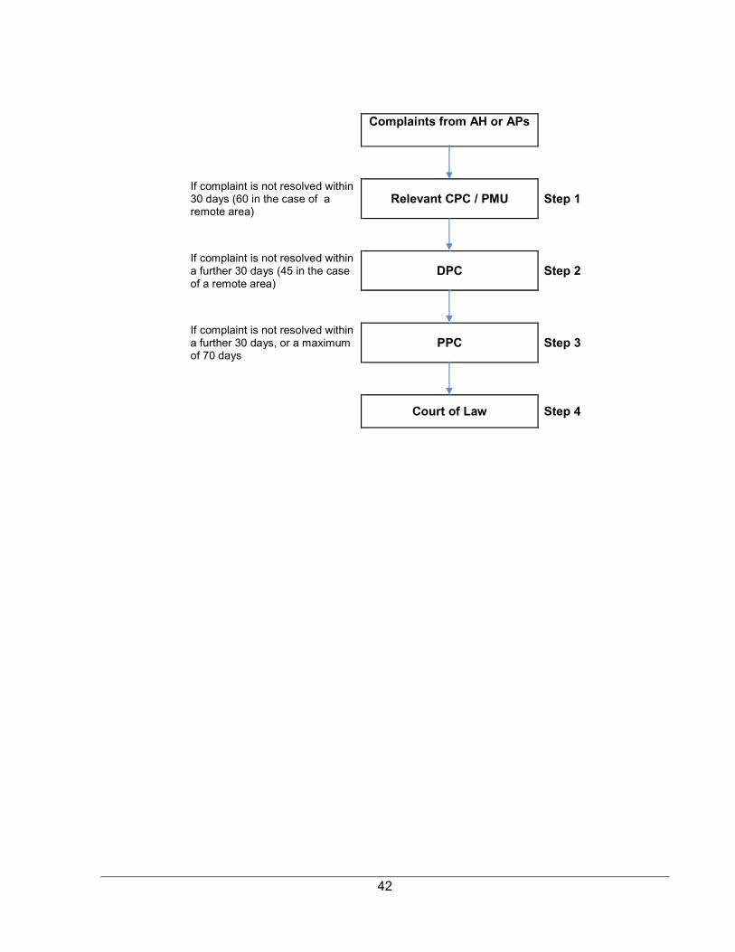
42
Complaints from AH or APs
If complaint is not resolved within 30 days (60 in the case of a remote area)
Relevant CPC / PMU Step 1
If complaint is not resolved within a further 30 days (45 in the case of a remote area)
DPC Step 2
If complaint is not resolved within a further 30 days, or a maximum of 70 days
PPC Step 3
Court of Law Step 4
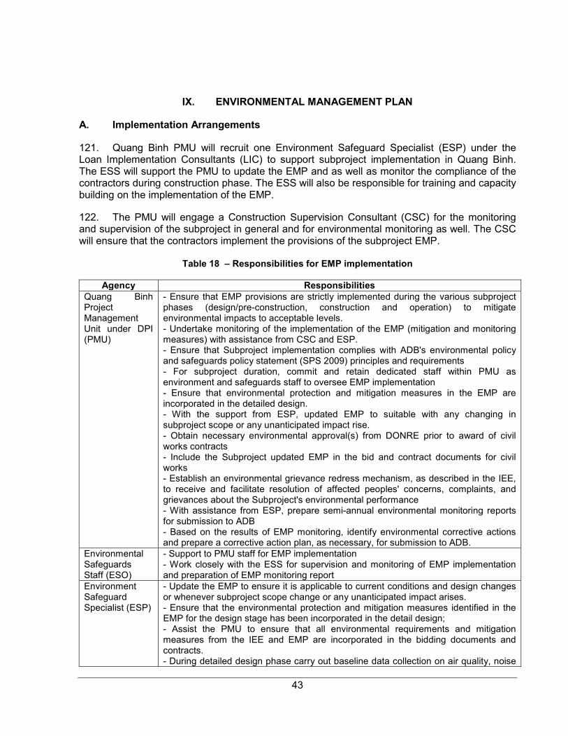
43
IX. ENVIRONMENTAL MANAGEMENT PLAN
A. Implementation Arrangements
121. Quang Binh PMU will recruit one Environment Safeguard Specialist (ESP) under the Loan Implementation Consultants (LIC) to support subproject implementation in Quang Binh. The ESS will support the PMU to update the EMP and as well as monitor the compliance of the contractors during construction phase. The ESS will also be responsible for training and capacity building on the implementation of the EMP. 122. The PMU will engage a Construction Supervision Consultant (CSC) for the monitoring and supervision of the subproject in general and for environmental monitoring as well. The CSC will ensure that the contractors implement the provisions of the subproject EMP.
Table 18 – Responsibilities for EMP implementation
Agency Responsibilities Quang Binh Project Management Unit under DPI (PMU)
- Ensure that EMP provisions are strictly implemented during the various subproject phases (design/pre-construction, construction and operation) to mitigate environmental impacts to acceptable levels. - Undertake monitoring of the implementation of the EMP (mitigation and monitoring measures) with assistance from CSC and ESP. - Ensure that Subproject implementation complies with ADB's environmental policy and safeguards policy statement (SPS 2009) principles and requirements - For subproject duration, commit and retain dedicated staff within PMU as environment and safeguards staff to oversee EMP implementation - Ensure that environmental protection and mitigation measures in the EMP are incorporated in the detailed design. - With the support from ESP, updated EMP to suitable with any changing in subproject scope or any unanticipated impact rise. - Obtain necessary environmental approval(s) from DONRE prior to award of civil works contracts - Include the Subproject updated EMP in the bid and contract documents for civil works - Establish an environmental grievance redress mechanism, as described in the IEE, to receive and facilitate resolution of affected peoples' concerns, complaints, and grievances about the Subproject's environmental performance - With assistance from ESP, prepare semi-annual environmental monitoring reports for submission to ADB - Based on the results of EMP monitoring, identify environmental corrective actions and prepare a corrective action plan, as necessary, for submission to ADB.
Environmental Safeguards Staff (ESO)
- Support to PMU staff for EMP implementation - Work closely with the ESS for supervision and monitoring of EMP implementation and preparation of EMP monitoring report
Environment Safeguard Specialist (ESP)
- Update the EMP to ensure it is applicable to current conditions and design changes or whenever subproject scope change or any unanticipated impact arises. - Ensure that the environmental protection and mitigation measures identified in the EMP for the design stage has been incorporated in the detail design; - Assist the PMU to ensure that all environmental requirements and mitigation measures from the IEE and EMP are incorporated in the bidding documents and contracts. - During detailed design phase carry out baseline data collection on air quality, noise
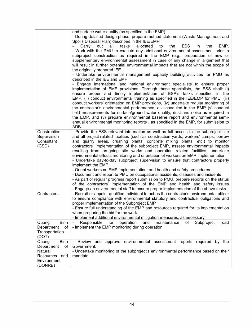
44
and surface water quality (as specified in the EMP) - During detailed design phase, prepare method statement (Waste Management and Spoils Disposal Plan) described in the IEE/EMP. - Carry out all tasks allocated to the ESS in the EMP. - Work with the PMU to execute any additional environmental assessment prior to subproject construction as required in the EMP (e.g., preparation of new or supplementary environmental assessment in case of any change in alignment that will result in further potential environmental impacts that are not within the scope of the originally prepared IEE. - Undertake environmental management capacity building activities for PMU as described in the IEE and EMP. - Engage international and national environment specialists to ensure proper implementation of EMP provisions. Through these specialists, the ESS shall: (i) ensure proper and timely implementation of ESP’s tasks specified in the EMP, (ii) conduct environmental training as specified in the IEE/EMP for PMU, (iii) conduct workers’ orientation on EMP provisions, (iv) undertake regular monitoring of the contractor’s environmental performance, as scheduled in the EMP (v) conduct field measurements for surface/ground water quality, dust and noise as required in the EMP, and (v) prepare environmental baseline report and environmental semi-annual environmental monitoring reports , as specified in the EMP, for submission to ADB.
Construction Supervision Consultant (CSC)
- Provide the ESS relevant information as well as full access to the subproject site and all project-related facilities (such as construction yards, workers' camps, borrow and quarry areas, crushing plants, concrete mixing plants, etc.) to monitor contractors' implementation of the subproject EMP, assess environmental impacts resulting from on-going site works and operation related facilities, undertake environmental effects monitoring and orientation of workers on EMP implementation. - Undertake day-to-day subproject supervision to ensure that contractors properly implement the EMP. - Orient workers on EMP implementation, and health and safety procedures - Document and report to PMU on occupational accidents, diseases and incidents - As part of regular progress report submission to PMU, prepare reports on the status of the contractors’ implementation of the EMP and health and safety issues - Engage an environmental staff to ensure proper implementation of the above tasks.
Contractors - Recruit or appoint qualified individual to act as the contractor's environmental officer to ensure compliance with environmental statutory and contractual obligations and proper implementation of the Subproject EMP - Ensure full understanding of the EMP and resources required for its implementation when preparing the bid for the work. - Implement additional environmental mitigation measures, as necessary
Quang Binh Department of Transportation (DOT)
- Responsible for operation and maintenance of Subproject road - Implement the EMP monitoring during operation
Quang Binh Department of Natural Resources and Environment (DONRE)
- Review and approve environmental assessment reports required by the Government. - Undertake monitoring of the subproject’s environmental performance based on their mandate

45
The organization structure of Environmental Management Plan is shown in the chart below:
Figure 3 – EMP Implementation Organization Chart
ADB (Asian Development Bank) DONREs
Supervise
Environment Safeguard Specialist (ESP)
Nghe An
PMU -
ESO
Ha Tinh
PMU - ESO
Quang
Binh
PMU - ESO
Quang Tri
PMU -
ESO
Construction Supervision Consultant (CSC)
Construction Contractors
Report
46
B. Environmental Mitigation
123. The anticipated environmental impacts and mitigation measures discussed in the previous section are presented in Table 19. The table also shows responsibilities and timeframe/schedule for implementation of mitigation measures and monitoring. 124. Table 19 shows that most mitigation activities during pre-construction are to be implemented by the ESS while during construction, measures shall be primarily implemented by the contractors. During the operation stage, DOT shall undertake environmental mitigation and monitoring requirements specified in the EMP. To ensure implementation of mitigation measures during construction, the EMP shall be included in the tender and contract documents for civil works. Contractors’ conformity with environmental contract procedures and specifications shall be regularly monitored by PMU with assistance from CSC and results shall be reported semi-annually to ADB.
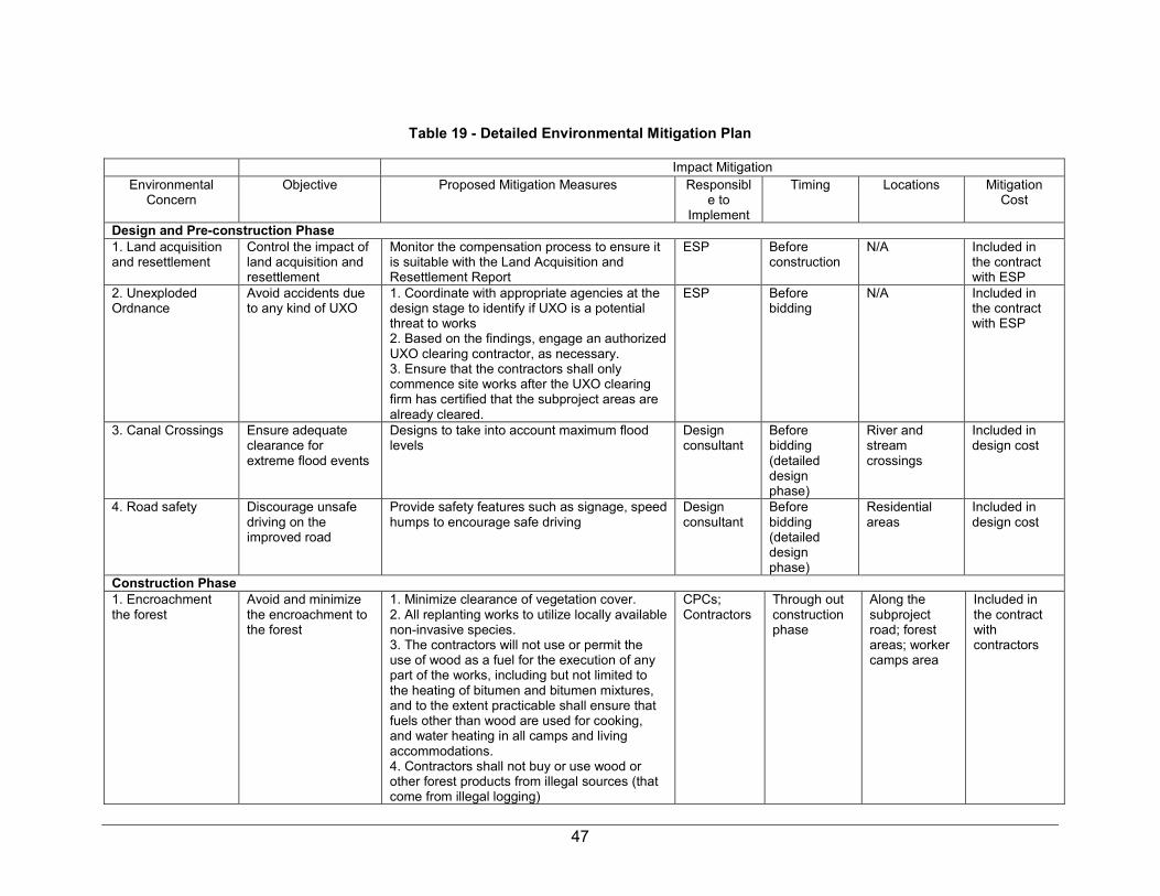
47
Table 19 - Detailed Environmental Mitigation Plan
Impact Mitigation Environmental
Concern Objective Proposed Mitigation Measures Responsibl
e to Implement
Timing Locations Mitigation Cost
Design and Pre-construction Phase 1. Land acquisition and resettlement
Control the impact of land acquisition and resettlement
Monitor the compensation process to ensure it is suitable with the Land Acquisition and Resettlement Report
ESP Before construction
N/A Included in the contract with ESP
2. Unexploded Ordnance
Avoid accidents due to any kind of UXO
1. Coordinate with appropriate agencies at the design stage to identify if UXO is a potential threat to works 2. Based on the findings, engage an authorized UXO clearing contractor, as necessary. 3. Ensure that the contractors shall only commence site works after the UXO clearing firm has certified that the subproject areas are already cleared.
ESP Before bidding
N/A Included in the contract with ESP
3. Canal Crossings Ensure adequate clearance for extreme flood events
Designs to take into account maximum flood levels
Design consultant
Before bidding (detailed design phase)
River and stream crossings
Included in design cost
4. Road safety Discourage unsafe driving on the improved road
Provide safety features such as signage, speed humps to encourage safe driving
Design consultant
Before bidding (detailed design phase)
Residential areas
Included in design cost
Construction Phase 1. Encroachment the forest
Avoid and minimize the encroachment to the forest
1. Minimize clearance of vegetation cover. 2. All replanting works to utilize locally available non-invasive species. 3. The contractors will not use or permit the use of wood as a fuel for the execution of any part of the works, including but not limited to the heating of bitumen and bitumen mixtures, and to the extent practicable shall ensure that fuels other than wood are used for cooking, and water heating in all camps and living accommodations. 4. Contractors shall not buy or use wood or other forest products from illegal sources (that come from illegal logging)
CPCs; Contractors
Through out construction phase
Along the subproject road; forest areas; worker camps area
Included in the contract with contractors
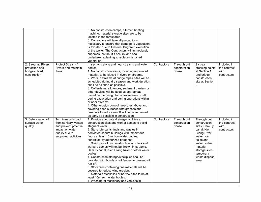
48
5. No construction camps, bitumen heating machine, material storage sites are to be located in the forest area. 6. Contractors will take all precautions necessary to ensure that damage to vegetation is avoided due to fires resulting from execution of the works. The Contractors will immediately suppress the fire, if it occurs, and shall undertake replanting to replace damaged vegetation.
2. Streams/ Rivers protection and bridge/culvert construction
Protect Streams/ Rivers and maintain flows
In sections along and near streams and water bodies: 1. No construction waste, including excavated material, to be placed in rivers or streams. 2. Work in streams at bridge repair sites will be scheduled during dry season and work duration shall be as short as possible. 3. Cofferdams, silt fences, sediment barriers or other devices will be used as appropriate based on the design to control release of silt during excavation and boring operations within or near streams. 4. Other erosion control measures above and covering open surfaces with grasses and creepers to reduce runoff will be implemented as early as possible in construction.
Contractors Through out construction phase
2 stream crossing points at Section 1 and bridge construction site at Section 2
Included in the contract with contractors
3. Deterioration of surface water quality
To minimize impact from sanitary wastes and prevent potential impact on water quality due to subproject activities
1. Provide adequate drainage facilities at construction sites and worker camps to avoid stagnant water. 2. Store lubricants, fuels and wastes in dedicated secure buildings with impervious floors at least 10 m from water bodies, controlled by authorized personnel 3. Solid waste from construction activities and workers camps will not be thrown in streams, Cam Ly canal, Kien Giang River or other water bodies. 4. Construction storage/stockpiles shall be provided with bunds or silt fences to prevent silt run-off. 5. Stockpiles containing fine materials will be covered to reduce wind erosion. 6. Materials stockpiles or borrow sites to be at least 10m from water bodies. 7. Washing of machinery and vehicles in
Contractors Through out construction phase
Through out construction sites; Cam Ly canal, Kien Giang River, water rice fields and water bodies, material storage sites, temporary waste disposal area
Included in the contract with contractors

49
surface waters shall be prohibited. 8. Inform 6 CPCs and Dong Hoi, Le Thuy, Quang Ninh DCPs in advance construction schedule and scope. 9. Work with relevant Division of 3 DPCs to find out suitable water block/ water cut schedule, avoid impact to downstream users of the Cam Ly canal and Kien Giang River
4. Noise, dust and vibration
To minimize negative impacts from noise, dust and vibration during construction period
1. Restrict works to daylight hours within 500 m of residential settlements. 2. Powered mechanical equipment and vehicle emissions to meet national TCVN/QCVN standards. All construction equipment and vehicles shall have valid certifications indicating compliance to vehicle emission and noise creation standards. 3. Monitor and investigate complaints; propose alternative mitigation measures. 4. Tightly cover trucks transporting construction materials (sand, soil, cement, gravel, etc.) to avoid or minimize spills and dust emissions. 5. On rainless days undertake watering, at least twice per day, on dusty and exposed areas at construction yards, materials storage sites, construction sites, access roads, quarry areas, borrow sites and other subproject areas where residential sites are located nearby. 6. Clean up road surfaces after work. 7. To protect buildings and structures from vibration, non-vibrating rollers shall be used in construction sites near buildings and structures. 8. Structures, which are damaged due to vibration caused by the construction activities, shall be repaired immediately as directed by ESP/PMU. 9. Machinery shall be turned off when not in use. 10. Pile driving to be schedule for daytime if construction site is near residential areas or approved by DONRE, CPCs and ESP/PMU. 11. Impose speed limits on construction machines and transportation vehicles to minimize dust emission along areas where residential areas are located.
Contractors Through out construction phase
Through out construction site
Included in the contract with contractors
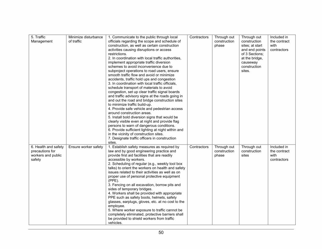
50
5. Traffic Management
Minimize disturbance of traffic
1. Communicate to the public through local officials regarding the scope and schedule of construction, as well as certain construction activities causing disruptions or access restrictions. 2. In coordination with local traffic authorities, implement appropriate traffic diversion schemes to avoid inconvenience due to subproject operations to road users, ensure smooth traffic flow and avoid or minimize accidents, traffic hold ups and congestion 3. In coordination with local traffic officials, schedule transport of materials to avoid congestion, set up clear traffic signal boards and traffic advisory signs at the roads going in and out the road and bridge construction sites to minimize traffic build-up. 4. Provide safe vehicle and pedestrian access around construction areas. 5. Install bold diversion signs that would be clearly visible even at night and provide flag persons to warn of dangerous conditions. 6. Provide sufficient lighting at night within and in the vicinity of construction sites. 7. Designate traffic officers in construction sites.
Contractors Through out construction phase
Through out construction sites; at start and end points of 3 Sections; at the bridge, causeway construction sites.
Included in the contract with contractors
6. Health and safety precautions for workers and public safety
Ensure worker safety 1. Establish safety measures as required by law and by good engineering practice and provide first aid facilities that are readily accessible by workers. 2. Scheduling of regular (e.g., weekly tool box talks) to orient the workers on health and safety issues related to their activities as well as on proper use of personal protective equipment (PPE). 3. Fencing on all excavation, borrow pits and sides of temporary bridges. 4. Workers shall be provided with appropriate PPE such as safety boots, helmets, safety glasses, earplugs, gloves, etc. at no cost to the employee. 5. Where worker exposure to traffic cannot be completely eliminated, protective barriers shall be provided to shield workers from traffic vehicles.
Contractors Through out construction phase
Through out construction sites
Included in the contract with contractors
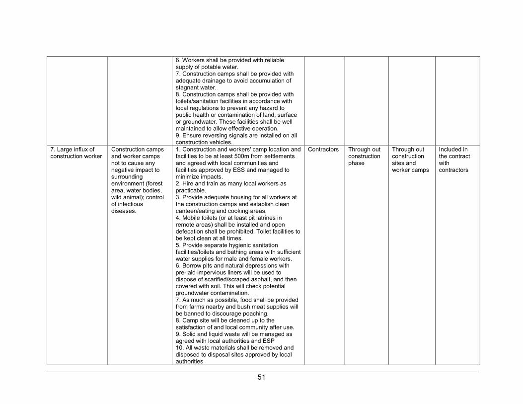
51
6. Workers shall be provided with reliable supply of potable water. 7. Construction camps shall be provided with adequate drainage to avoid accumulation of stagnant water. 8. Construction camps shall be provided with toilets/sanitation facilities in accordance with local regulations to prevent any hazard to public health or contamination of land, surface or groundwater. These facilities shall be well maintained to allow effective operation. 9. Ensure reversing signals are installed on all construction vehicles.
7. Large influx of construction worker
Construction camps and worker camps not to cause any negative impact to surrounding environment (forest area, water bodies, wild animal); control of infectious diseases.
1. Construction and workers' camp location and facilities to be at least 500m from settlements and agreed with local communities and facilities approved by ESS and managed to minimize impacts. 2. Hire and train as many local workers as practicable. 3. Provide adequate housing for all workers at the construction camps and establish clean canteen/eating and cooking areas. 4. Mobile toilets (or at least pit latrines in remote areas) shall be installed and open defecation shall be prohibited. Toilet facilities to be kept clean at all times. 5. Provide separate hygienic sanitation facilities/toilets and bathing areas with sufficient water supplies for male and female workers. 6. Borrow pits and natural depressions with pre-laid impervious liners will be used to dispose of scarified/scraped asphalt, and then covered with soil. This will check potential groundwater contamination. 7. As much as possible, food shall be provided from farms nearby and bush meat supplies will be banned to discourage poaching. 8. Camp site will be cleaned up to the satisfaction of and local community after use. 9. Solid and liquid waste will be managed as agreed with local authorities and ESP 10. All waste materials shall be removed and disposed to disposal sites approved by local authorities
Contractors Through out construction phase
Through out construction sites and worker camps
Included in the contract with contractors
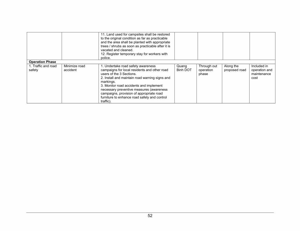
52
11. Land used for campsites shall be restored to the original condition as far as practicable and the area shall be planted with appropriate trees / shrubs as soon as practicable after it is vacated and cleaned. 12. Register temporary stay for workers with police.
Operation Phase 1. Traffic and road safety
Minimize road accident
1. Undertake road safety awareness campaigns for local residents and other road users of the 3 Sections. 2. Install and maintain road warning signs and markings. 3. Monitor road accidents and implement necessary preventive measures (awareness campaigns, provision of appropriate road furniture to enhance road safety and control traffic).
Quang Binh DOT
Through out operation phase
Along the proposed road
Included in operation and maintenance cost
53
C. Environmental Monitoring
1. Compliance Monitoring
125. Table 20 below shows the program for monitoring the compliance and environmental affect monitoring on various provisions of the EMP during pre-construction, construction and operation phases. ESS needs to implement a number of measures during detailed design phase (e.g., incorporation of environmental design measures into the detailed design, update EMP, etc.) and this will be confirmed by PMU to ADB. During construction, most of the mitigation the contractors shall implement measures and CSC and ESS shall monitor their environmental performance, in terms of implementation of such measures. The timing or frequency of monitoring is also specified in Table 16. During operation EMP implementation shall be the responsibility of Quang Binh DOT. 126. At design phase, PMU shall ensure that EMP measures for the design stage are incorporated in the detailed design. The effective incorporation of the EMP in the civil works contracts shall also be ensured be by PMU with assistance from ESS and this, along with implementation of EMP provisions, shall be audited by ADB as part of the loan conditions. 127. Prior to implementation of the subproject the IEE and EMP will be updated and amended, as necessary, by ESS after the detailed designs are complete and contracting arrangements are known. Such updating shall be based on reconfirmation and any additional information on the assumptions made at this feasibility stage on location scale and expected conditions of the subproject.
2. Environmental Effects Monitoring
128. Table 20 below displays the parameters to be measured before during and after construction, to monitor effects on the environment and detect emerging problems to elicit appropriate action.
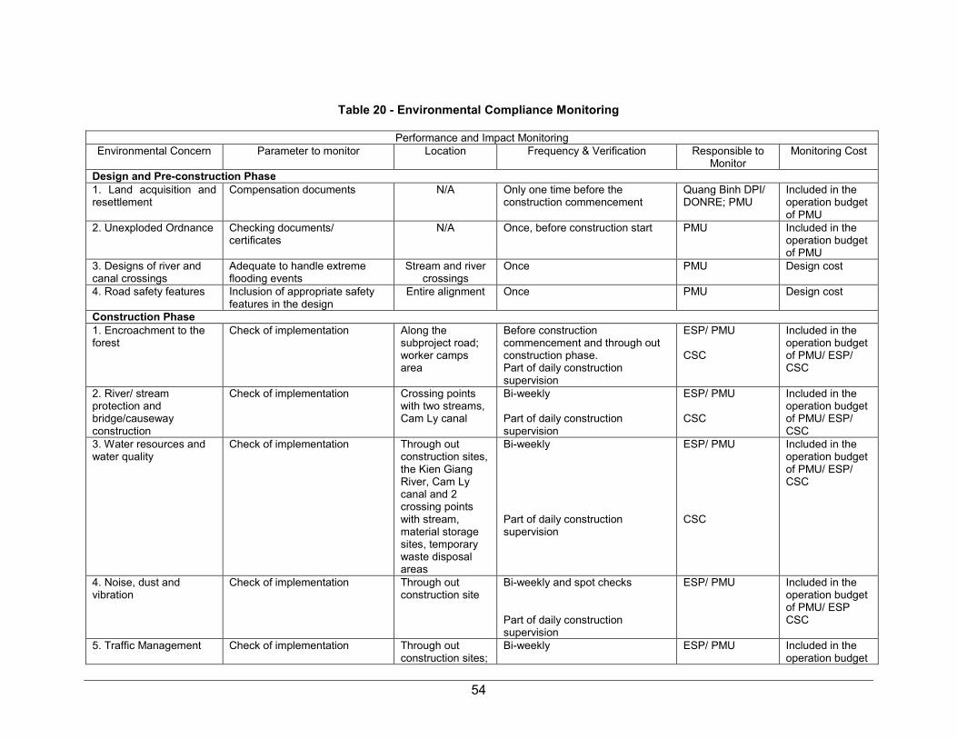
54
Table 20 - Environmental Compliance Monitoring
Performance and Impact Monitoring Environmental Concern Parameter to monitor Location Frequency & Verification Responsible to
Monitor Monitoring Cost
Design and Pre-construction Phase 1. Land acquisition and resettlement
Compensation documents N/A Only one time before the construction commencement
Quang Binh DPI/ DONRE; PMU
Included in the operation budget of PMU
2. Unexploded Ordnance Checking documents/ certificates
N/A Once, before construction start PMU Included in the operation budget of PMU
3. Designs of river and canal crossings
Adequate to handle extreme flooding events
Stream and river crossings
Once PMU Design cost
4. Road safety features Inclusion of appropriate safety features in the design
Entire alignment Once PMU Design cost
Construction Phase 1. Encroachment to the forest
Check of implementation Along the subproject road; worker camps area
Before construction commencement and through out construction phase. Part of daily construction supervision
ESP/ PMU CSC
Included in the operation budget of PMU/ ESP/ CSC
2. River/ stream protection and bridge/causeway construction
Check of implementation Crossing points with two streams, Cam Ly canal
Bi-weekly Part of daily construction supervision
ESP/ PMU CSC
Included in the operation budget of PMU/ ESP/ CSC
3. Water resources and water quality
Check of implementation Through out construction sites, the Kien Giang River, Cam Ly canal and 2 crossing points with stream, material storage sites, temporary waste disposal areas
Bi-weekly Part of daily construction supervision
ESP/ PMU CSC
Included in the operation budget of PMU/ ESP/ CSC
4. Noise, dust and vibration
Check of implementation
Through out construction site
Bi-weekly and spot checks Part of daily construction supervision
ESP/ PMU
Included in the operation budget of PMU/ ESP CSC
5. Traffic Management Check of implementation Through out construction sites;
Bi-weekly
ESP/ PMU
Included in the operation budget

55
at start and end of the road and junctions; residential areas
Part of daily construction supervision
CSC of PMU/ ESP/ CSC
6. Safety precautions for workers and public safety
Check of implementation. Check compliance to Labor Code of Vietnam and other relevant Decision, Decree and Circular under Government requirements
Through out construction sites
Bi-weekly Part of daily construction supervision
ESP/ PMU CSC
Included in the operation budget of PMU/ ESP/ CSC
7. Large influx of workers. Construction and worker camps, sanitation and diseases
Check of implementation Through out construction sites and worker camps
Before establishment of the facilities and through out the construction phase Part of daily construction supervision
ESP/ PMU CSC
Included in the operation budget of PMU/ ESP/ CSC
Operation Phase 1. Road safety
Check of implementation Along the route Semi-annual Quang Binh DOT Included in the operation budget of DOT

56
Table 21 - Environmental Effects Monitoring
Construction Phase 1. Water resources and water quality
Surface water quality Ground water quality
2 sampling points at 20m downstream of the two crossing streams in Section 1; 1 sampling point in Cam Ly canal at Bridge construction site in Section 2; 1 sampling point in Kien Giang River near the start point of Section 2. (4 in total) 1 sampling point near the bridge construction site in Section 2.
1 time before construction start and semi-annually during 2 years construction time (5 times in total) 1 time before construction start and semi-annually during 2 years construction time (5 times in total)
ESP ESP
8,000 USD 2,000 USD13
4. Noise, dust and vibration
Ambient air quality (temperature, moisture, wind direction and speed, PM10, PM2.5, PB, NO2, SO2k); Noise level (average noise level, maximum noise level, vehicles frequencyk)
6 monitoring points at start and end points of the 3 Sections
1 time before construction start and semi-annually during 2 years construction time (5 times in total)
ESP
1,800 USD14
13 Figures have been estimated base on environmental monitoring cost norm of Quang Binh Province issued under Decision No. 453/QD-UBND of Quang Binh
PPC dated 3 March 2014. 14 Figures have been estimated base on environmental monitoring cost norm of Quang Binh Province issued under Decision No. 453/QD-UBND of Quang Binh
PPC dated 3 March 2014.
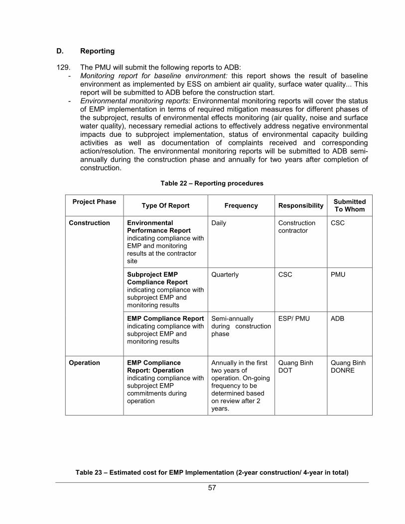
57
D. Reporting
129. The PMU will submit the following reports to ADB: - Monitoring report for baseline environment: this report shows the result of baseline
environment as implemented by ESS on ambient air quality, surface water quality... This report will be submitted to ADB before the construction start.
- Environmental monitoring reports: Environmental monitoring reports will cover the status of EMP implementation in terms of required mitigation measures for different phases of the subproject, results of environmental effects monitoring (air quality, noise and surface water quality), necessary remedial actions to effectively address negative environmental impacts due to subproject implementation, status of environmental capacity building activities as well as documentation of complaints received and corresponding action/resolution. The environmental monitoring reports will be submitted to ADB semi-annually during the construction phase and annually for two years after completion of construction.
Table 22 – Reporting procedures
Project Phase
Type Of Report Frequency Responsibility Submitted To Whom
Construction Environmental Performance Report indicating compliance with EMP and monitoring results at the contractor site
Daily Construction contractor
CSC
Subproject EMP Compliance Report indicating compliance with subproject EMP and monitoring results
Quarterly CSC PMU
EMP Compliance Report indicating compliance with subproject EMP and monitoring results
Semi-annually during construction phase
ESP/ PMU ADB
Operation EMP Compliance Report: Operation indicating compliance with subproject EMP commitments during operation
Annually in the first two years of operation. On-going frequency to be determined based on review after 2 years.
Quang Binh DOT
Quang Binh DONRE
Table 23 – Estimated cost for EMP Implementation (2-year construction/ 4-year in total)
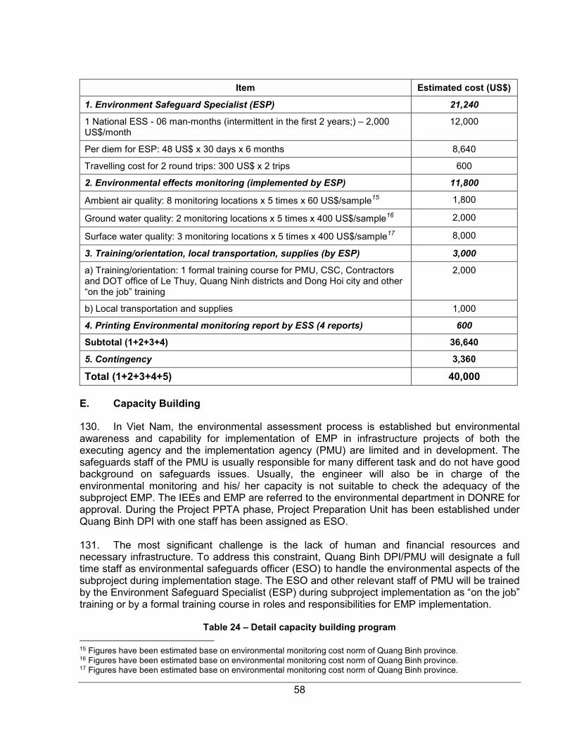
58
Item Estimated cost (US$)
1. Environment Safeguard Specialist (ESP) 21,240
1 National ESS - 06 man-months (intermittent in the first 2 years;) – 2,000 US$/month
12,000
Per diem for ESP: 48 US$ x 30 days x 6 months 8,640
Travelling cost for 2 round trips: 300 US$ x 2 trips 600
2. Environmental effects monitoring (implemented by ESP) 11,800
Ambient air quality: 8 monitoring locations x 5 times x 60 US$/sample15 1,800
Ground water quality: 2 monitoring locations x 5 times x 400 US$/sample16 2,000
Surface water quality: 3 monitoring locations x 5 times x 400 US$/sample17 8,000
3. Training/orientation, local transportation, supplies (by ESP) 3,000
a) Training/orientation: 1 formal training course for PMU, CSC, Contractors and DOT office of Le Thuy, Quang Ninh districts and Dong Hoi city and other “on the job” training
2,000
b) Local transportation and supplies 1,000
4. Printing Environmental monitoring report by ESS (4 reports) 600
Subtotal (1+2+3+4) 36,640
5. Contingency 3,360
Total (1+2+3+4+5) 40,000
E. Capacity Building
130. In Viet Nam, the environmental assessment process is established but environmental awareness and capability for implementation of EMP in infrastructure projects of both the executing agency and the implementation agency (PMU) are limited and in development. The safeguards staff of the PMU is usually responsible for many different task and do not have good background on safeguards issues. Usually, the engineer will also be in charge of the environmental monitoring and his/ her capacity is not suitable to check the adequacy of the subproject EMP. The IEEs and EMP are referred to the environmental department in DONRE for approval. During the Project PPTA phase, Project Preparation Unit has been established under Quang Binh DPI with one staff has been assigned as ESO. 131. The most significant challenge is the lack of human and financial resources and necessary infrastructure. To address this constraint, Quang Binh DPI/PMU will designate a full time staff as environmental safeguards officer (ESO) to handle the environmental aspects of the subproject during implementation stage. The ESO and other relevant staff of PMU will be trained by the Environment Safeguard Specialist (ESP) during subproject implementation as “on the job” training or by a formal training course in roles and responsibilities for EMP implementation.
Table 24 – Detail capacity building program
15 Figures have been estimated base on environmental monitoring cost norm of Quang Binh province. 16 Figures have been estimated base on environmental monitoring cost norm of Quang Binh province. 17 Figures have been estimated base on environmental monitoring cost norm of Quang Binh province.
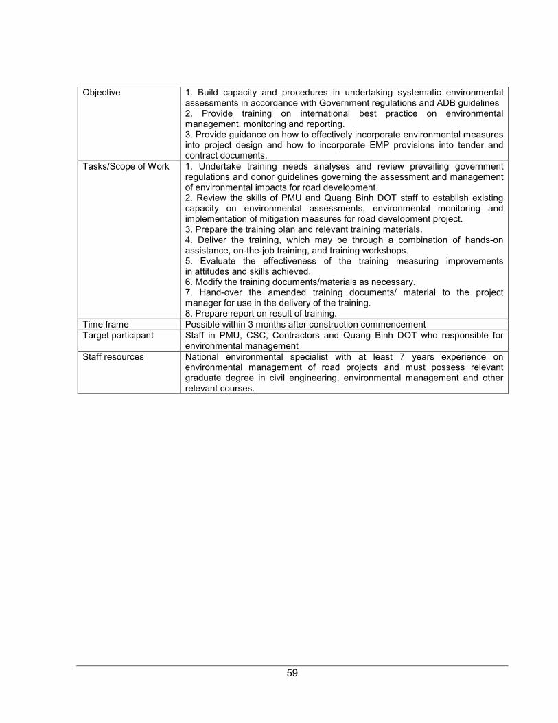
59
Objective 1. Build capacity and procedures in undertaking systematic environmental
assessments in accordance with Government regulations and ADB guidelines 2. Provide training on international best practice on environmental management, monitoring and reporting. 3. Provide guidance on how to effectively incorporate environmental measures into project design and how to incorporate EMP provisions into tender and contract documents.
Tasks/Scope of Work 1. Undertake training needs analyses and review prevailing government regulations and donor guidelines governing the assessment and management of environmental impacts for road development. 2. Review the skills of PMU and Quang Binh DOT staff to establish existing capacity on environmental assessments, environmental monitoring and implementation of mitigation measures for road development project. 3. Prepare the training plan and relevant training materials. 4. Deliver the training, which may be through a combination of hands-on assistance, on-the-job training, and training workshops. 5. Evaluate the effectiveness of the training measuring improvements in attitudes and skills achieved. 6. Modify the training documents/materials as necessary. 7. Hand-over the amended training documents/ material to the project manager for use in the delivery of the training. 8. Prepare report on result of training.
Time frame Possible within 3 months after construction commencement Target participant Staff in PMU, CSC, Contractors and Quang Binh DOT who responsible for
environmental management Staff resources National environmental specialist with at least 7 years experience on
environmental management of road projects and must possess relevant graduate degree in civil engineering, environmental management and other relevant courses.
60
X. CONCLUSIONS AND RECOMMENDATIONS
132. This IEE study was carried out in the Technical Assistant for Project Preparation (PPTA) phase. Primary and secondary data were used to assess potential environmental impacts in a comprehensive manner and public consultation and route reconnaissance were carried out in order complete the environmental assessments and recommend suitable mitigation measures. The IEE report provides a picture of potential environmental impacts associated with the upgrading of the subproject road and suitable mitigation measures have been recommended. 133. The implementation of the subproject “Improving and Upgrading Tourism Route Connecting Dong Hoi City and Southern Areas of Quang Binh Province” will create the linkages between coastal roads, the BOT bypass, QL1A, and the eastern branch of Hồ Chí Minh bypass road and create a complete traffic network connecting regions in the east and west of Quảng Bình province; then create favorable conditions for developing agriculture, rural area and exploiting the potential of the areas which it passes, particularly in tourism, forestation, production and agricultural and forest products processing. Several actions are required during the detailed design stage to minimize impacts to acceptable levels. The negative environmental impacts from the upgrading works will mostly take place during the construction stage. All of the impacts during construction phase should be very predictable and manageable and with appropriate mitigation and few residual impacts are likely. Additional human and financial resources will be required to improve environmental capability and to progress and achieve necessary statutory compliance and environmental clearance certification for the subproject or associated activities that also require environmental permits under the environmental laws of Viet Nam – LEP 2014. 134. No further or additional impact assessment is considered necessary at this stage. At the implementation stage, PMU through ESS will develop detail EMP to monitor the schedules of mitigation measures and conduct of environmental effects monitoring activities. EMP must be updated to ensure effective environmental monitoring and should be develop follow-monitoring plan as specified in the EMP. With these measures in place, environmental impacts of the subproject should be manageable and will not result in any residual impacts, which are above accepted environmental standards.
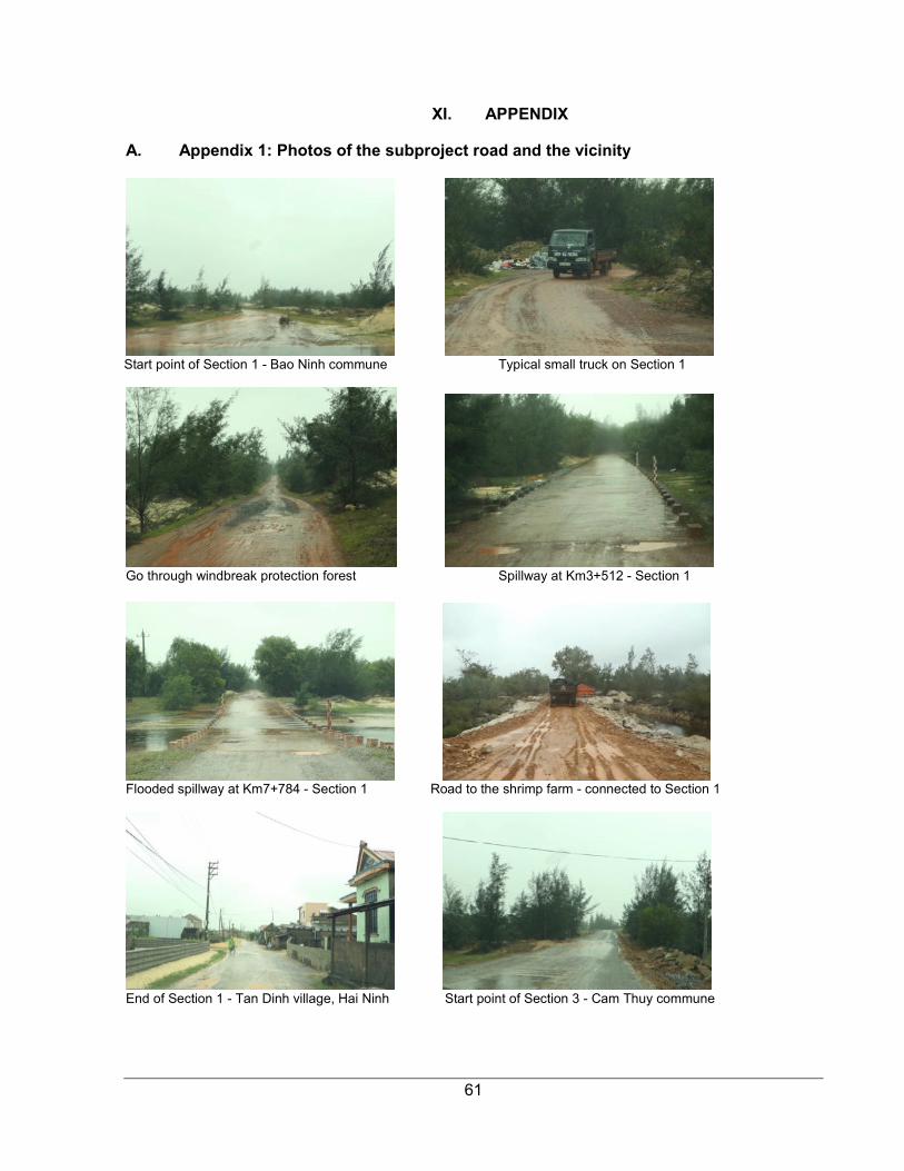
61
XI. APPENDIX
A. Appendix 1: Photos of the subproject road and the vicinity
Start point of Section 1 - Bao Ninh commune Typical small truck on Section 1
Go through windbreak protection forest Spillway at Km3+512 - Section 1
Flooded spillway at Km7+784 - Section 1 Road to the shrimp farm - connected to Section 1
End of Section 1 - Tan Dinh village, Hai Ninh Start point of Section 3 - Cam Thuy commune

62
A good road section in Section 3 Sand covered the road in Section 3
End of Section 3-view towards Ngu Thuy Bac beach Start point of Section 2 - An Thuy commune
Flooded rice fields along Section 2 of the road Bad road section in Section 2 of the road
Car stuck in bad road section of Section 2 End point of Section 2
63
B. Appendix 2: Source of Reference Information
1. Quang Binh Status of Environmental Report 2015 2. Feasibility Report of the Subproject 3. http://idm.gov.vn/nguon_luc/Xuat_ban/Anpham/Phongnha/T166.htm 4. Climate Change and Adaptation Plan of Quang Binh to 2020 with the view to 2030

64
C. Appendix 3: Environmental Mitigation Measures to Include into Bidding Documents
1. Encroachment the forest
1. Minimize clearance of vegetation cover. 2. All replanting works to utilize locally available non-invasive species. 3. The contractors will not use or permit the use of wood as a fuel for the execution of any part of the works, including but not limited to the heating of bitumen and bitumen mixtures, and to the extent practicable shall ensure that fuels other than wood are used for cooking, and water heating in all camps and living accommodations. 4. Contractors shall not buy or use wood or other forest products from illegal sources (that come from illegal logging) 5. No construction camps, bitumen heating machine, material storage sites are to be located in the forest area. 6. Contractors will take all precautions necessary to ensure that damage to vegetation is avoided due to fires resulting from execution of the works. The Contractors will immediately suppress the fire, if it occurs, and shall undertake replanting to replace damaged vegetation.
2. Streams/ Rivers protection and bridge/culvert construction
In sections along and near streams and water bodies: 1. No construction waste, including excavated material, to be placed in rivers or streams. 2. Work in streams at bridge repair sites will be scheduled during dry season and work duration shall be as short as possible. 3. Cofferdams, silt fences, sediment barriers or other devices will be used as appropriate based on the design to control release of silt during excavation and boring operations within or near streams. 4. Other erosion control measures above and covering open surfaces with grasses and creepers to reduce runoff will be implemented as early as possible in construction.
3. Deterioration of surface water quality
1. Provide adequate drainage facilities at construction sites and worker camps to avoid stagnant water. 2. Store lubricants, fuels and wastes in dedicated secure buildings with impervious floors at least 10 m from water bodies, controlled by authorized personnel 3. Solid waste from construction activities and workers camps will not be thrown in streams, Cam Ly canal or other water bodies. 4. Construction storage/stockpiles shall be provided with bunds or silt fences to prevent silt run-off. 5. Stockpiles containing fine materials will be covered to reduce wind erosion. 6. Materials stockpiles or borrow sites to be at least 10m from water bodies. 7. Washing of machinery and vehicles in surface waters shall be prohibited. 8. Inform 6 CPCs and Dong Hoi, Le Thuy, Quang Ninh DCPs in advance construction schedule and scope. 9. Work with relevant Division of 3 DPCs to find out suitable water block/ water cut schedule, avoid impact to downstream users of the Cam Ly canal and Kien Giang River
4. Noise, dust and vibration
1. Restrict works to daylight hours within 500 m of residential settlements. 2. Powered mechanical equipment and vehicle emissions to meet national TCVN/QCVN standards. All construction equipment and vehicles shall have valid certifications indicating compliance to vehicle emission and noise creation standards. 3. Monitor and investigate complaints; propose alternative mitigation measures. 4. Tightly cover trucks transporting construction materials (sand, soil, cement, gravel, etc.) to avoid or minimize spills and dust emissions. 5. On rainless days undertake watering, at least twice per day, on dusty and exposed areas at construction yards, materials storage sites, construction sites, access roads, quarry areas, borrow sites and other subproject areas where residential sites are located nearby. 6. Clean up road surfaces after work. 7. To protect buildings and structures from vibration, non-vibrating rollers shall be used in construction sites near buildings and structures. 8. Structures, which are damaged due to vibration caused by the construction activities, shall be repaired immediately as directed by ESP/PMU. 9. Machinery shall be turned off when not in use. 10. Pile driving to be schedule for daytime if construction site is near residential areas or approved by DONRE, CPCs and ESP/PMU. 11. Impose speed limits on construction machines and transportation vehicles to minimize dust emission along areas where residential areas are located.
65
5. Traffic Management
1. Communicate to the public through local officials regarding the scope and schedule of construction, as well as certain construction activities causing disruptions or access restrictions. 2. In coordination with local traffic authorities, implement appropriate traffic diversion schemes to avoid inconvenience due to subproject operations to road users, ensure smooth traffic flow and avoid or minimize accidents, traffic hold ups and congestion 3. In coordination with local traffic officials, schedule transport of materials to avoid congestion, set up clear traffic signal boards and traffic advisory signs at the roads going in and out the road and bridge construction sites to minimize traffic build-up. 4. Provide safe vehicle and pedestrian access around construction areas. 5. Install bold diversion signs that would be clearly visible even at night and provide flag persons to warn of dangerous conditions. 6. Provide sufficient lighting at night within and in the vicinity of construction sites. 7. Designate traffic officers in construction sites.
6. Health and safety precautions for workers and public safety
1. Establish safety measures as required by law and by good engineering practice and provide first aid facilities that are readily accessible by workers. 2. Scheduling of regular (e.g., weekly tool box talks) to orient the workers on health and safety issues related to their activities as well as on proper use of personal protective equipment (PPE). 3. Fencing on all excavation, borrow pits and sides of temporary bridges. 4. Workers shall be provided with appropriate PPE such as safety boots, helmets, safety glasses, earplugs, gloves, etc. at no cost to the employee. 5. Where worker exposure to traffic cannot be completely eliminated, protective barriers shall be provided to shield workers from traffic vehicles. 6. Workers shall be provided with reliable supply of potable water. 7. Construction camps shall be provided with adequate drainage to avoid accumulation of stagnant water. 8. Construction camps shall be provided with toilets/sanitation facilities in accordance with local regulations to prevent any hazard to public health or contamination of land, surface or groundwater. These facilities shall be well maintained to allow effective operation. 9. Ensure reversing signals are installed on all construction vehicles.
7. Large influx of construction worker
1. Construction and workers' camp location and facilities to be at least 500m from settlements and agreed with local communities and facilities approved by ESS and managed to minimize impacts. 2. Hire and train as many local workers as practicable. 3. Provide adequate housing for all workers at the construction camps and establish clean canteen/eating and cooking areas. 4. Mobile toilets (or at least pit latrines in remote areas) shall be installed and open defecation shall be prohibited. Toilet facilities to be kept clean at all times. 5. Provide separate hygienic sanitation facilities/toilets and bathing areas with sufficient water supplies for male and female workers. 6. Borrow pits and natural depressions with pre-laid impervious liners will be used to dispose of scarified/scraped asphalt, and then covered with soil. This will check potential groundwater contamination. 7. As much as possible, food shall be provided from farms nearby and bush meat supplies will be banned to discourage poaching. 8. Camp site will be cleaned up to the satisfaction of and local community after use. 9. Solid and liquid waste will be managed as agreed with local authorities and ESP 10. All waste materials shall be removed and disposed to disposal sites approved by local authorities 11. Land used for campsites shall be restored to the original condition as far as practicable and the area shall be planted with appropriate trees / shrubs as soon as practicable after it is vacated and cleaned. 12. Register temporary stay for workers with police.

66
D. Appendix 4: Consultation minute and list of interviewees
67
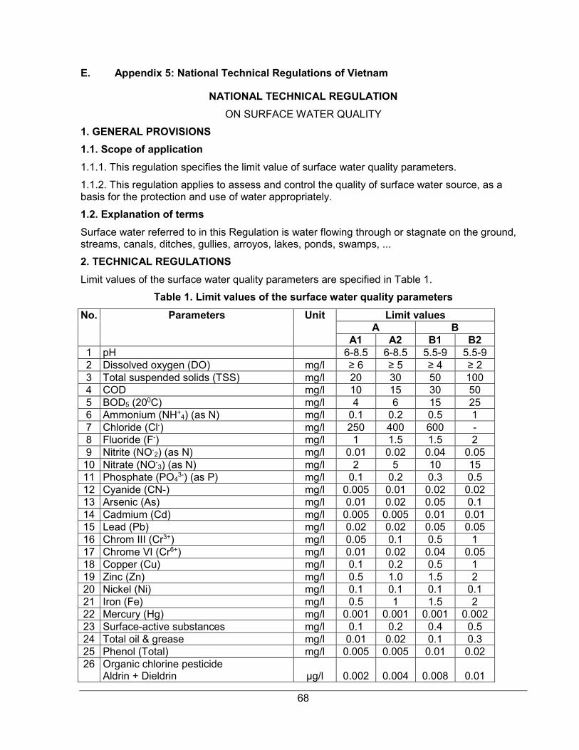
68
E. Appendix 5: National Technical Regulations of Vietnam
NATIONAL TECHNICAL REGULATION
ON SURFACE WATER QUALITY
1. GENERAL PROVISIONS
1.1. Scope of application
1.1.1. This regulation specifies the limit value of surface water quality parameters.
1.1.2. This regulation applies to assess and control the quality of surface water source, as a basis for the protection and use of water appropriately.
1.2. Explanation of terms
Surface water referred to in this Regulation is water flowing through or stagnate on the ground, streams, canals, ditches, gullies, arroyos, lakes, ponds, swamps, ...
2. TECHNICAL REGULATIONS
Limit values of the surface water quality parameters are specified in Table 1.
Table 1. Limit values of the surface water quality parameters
No. Parameters Unit Limit values A B
A1 A2 B1 B2 1 pH 6-8.5 6-8.5 5.5-9 5.5-9 2 Dissolved oxygen (DO) mg/l ≥ 6 ≥ 5 ≥ 4 ≥ 2 3 Total suspended solids (TSS) mg/l 20 30 50 100 4 COD mg/l 10 15 30 50 5 BOD5 (200C) mg/l 4 6 15 25 6 Ammonium (NH+
4) (as N) mg/l 0.1 0.2 0.5 1 7 Chloride (Cl-) mg/l 250 400 600 - 8 Fluoride (F-) mg/l 1 1.5 1.5 2 9 Nitrite (NO-
2) (as N) mg/l 0.01 0.02 0.04 0.05 10 Nitrate (NO-
3) (as N) mg/l 2 5 10 15 11 Phosphate (PO4
3-) (as P) mg/l 0.1 0.2 0.3 0.5 12 Cyanide (CN-) mg/l 0.005 0.01 0.02 0.02 13 Arsenic (As) mg/l 0.01 0.02 0.05 0.1 14 Cadmium (Cd) mg/l 0.005 0.005 0.01 0.01 15 Lead (Pb) mg/l 0.02 0.02 0.05 0.05 16 Chrom III (Cr3+) mg/l 0.05 0.1 0.5 1 17 Chrome VI (Cr6+) mg/l 0.01 0.02 0.04 0.05 18 Copper (Cu) mg/l 0.1 0.2 0.5 1 19 Zinc (Zn) mg/l 0.5 1.0 1.5 2 20 Nickel (Ni) mg/l 0.1 0.1 0.1 0.1 21 Iron (Fe) mg/l 0.5 1 1.5 2 22 Mercury (Hg) mg/l 0.001 0.001 0.001 0.002 23 Surface-active substances mg/l 0.1 0.2 0.4 0.5 24 Total oil & grease mg/l 0.01 0.02 0.1 0.3 25 Phenol (Total) mg/l 0.005 0.005 0.01 0.02 26 Organic chlorine pesticide
Aldrin + Dieldrin
µg/l
0.002
0.004
0.008
0.01
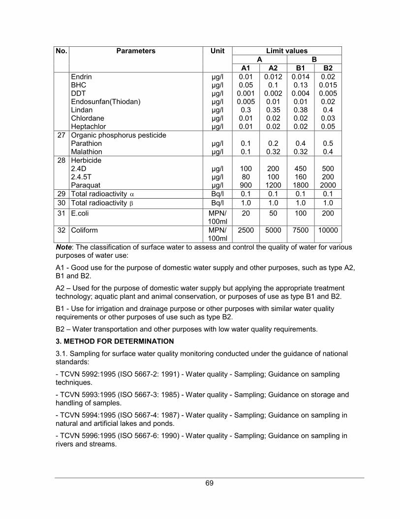
69
No. Parameters Unit Limit values A B
A1 A2 B1 B2 Endrin BHC DDT Endosunfan(Thiodan) Lindan Chlordane Heptachlor
µg/l µg/l µg/l µg/l µg/l µg/l µg/l
0.01 0.05
0.001 0.005 0.3 0.01 0.01
0.012 0.1
0.002 0.01 0.35 0.02 0.02
0.014 0.13
0.004 0.01 0.38 0.02 0.02
0.02 0.015 0.005 0.02 0.4 0.03 0.05
27 Organic phosphorus pesticide Parathion Malathion
µg/l µg/l
0.1 0.1
0.2 0.32
0.4 0.32
0.5 0.4
28 Herbicide 2.4D 2.4.5T Paraquat
µg/l µg/l µg/l
100 80
900
200 100 1200
450 160 1800
500 200 2000
29 Total radioactivity Bq/l 0.1 0.1 0.1 0.1 30 Total radioactivity Bq/l 1.0 1.0 1.0 1.0
31 E.coli MPN/ 100ml
20 50 100 200
32 Coliform MPN/ 100ml
2500 5000 7500 10000
Note: The classification of surface water to assess and control the quality of water for various purposes of water use:
A1 - Good use for the purpose of domestic water supply and other purposes, such as type A2, B1 and B2.
A2 – Used for the purpose of domestic water supply but applying the appropriate treatment technology; aquatic plant and animal conservation, or purposes of use as type B1 and B2.
B1 - Use for irrigation and drainage purpose or other purposes with similar water quality requirements or other purposes of use such as type B2.
B2 – Water transportation and other purposes with low water quality requirements.
3. METHOD FOR DETERMINATION
3.1. Sampling for surface water quality monitoring conducted under the guidance of national standards:
- TCVN 5992:1995 (ISO 5667-2: 1991) - Water quality - Sampling; Guidance on sampling techniques.
- TCVN 5993:1995 (ISO 5667-3: 1985) - Water quality - Sampling; Guidance on storage and handling of samples.
- TCVN 5994:1995 (ISO 5667-4: 1987) - Water quality - Sampling; Guidance on sampling in natural and artificial lakes and ponds.
- TCVN 5996:1995 (ISO 5667-6: 1990) - Water quality - Sampling; Guidance on sampling in rivers and streams.
α
β
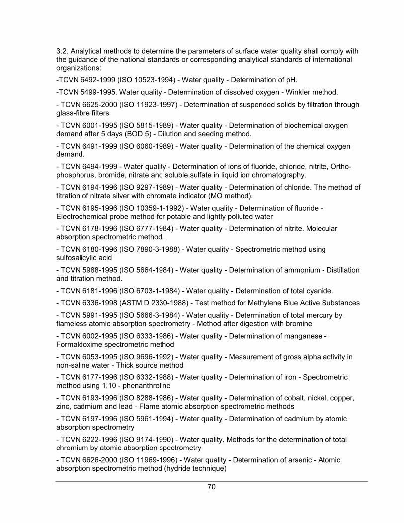
70
3.2. Analytical methods to determine the parameters of surface water quality shall comply with the guidance of the national standards or corresponding analytical standards of international organizations:
-TCVN 6492-1999 (ISO 10523-1994) - Water quality - Determination of pH.
-TCVN 5499-1995. Water quality - Determination of dissolved oxygen - Winkler method.
- TCVN 6625-2000 (ISO 11923-1997) - Determination of suspended solids by filtration through glass-fibre filters
- TCVN 6001-1995 (ISO 5815-1989) - Water quality - Determination of biochemical oxygen demand after 5 days (BOD 5) - Dilution and seeding method.
- TCVN 6491-1999 (ISO 6060-1989) - Water quality - Determination of the chemical oxygen demand.
- TCVN 6494-1999 - Water quality - Determination of ions of fluoride, chloride, nitrite, Ortho-phosphorus, bromide, nitrate and soluble sulfate in liquid ion chromatography.
- TCVN 6194-1996 (ISO 9297-1989) - Water quality - Determination of chloride. The method of titration of nitrate silver with chromate indicator (MO method).
- TCVN 6195-1996 (ISO 10359-1-1992) - Water quality - Determination of fluoride -Electrochemical probe method for potable and lightly polluted water
- TCVN 6178-1996 (ISO 6777-1984) - Water quality - Determination of nitrite. Molecular absorption spectrometric method.
- TCVN 6180-1996 (ISO 7890-3-1988) - Water quality - Spectrometric method using sulfosalicylic acid
- TCVN 5988-1995 (ISO 5664-1984) - Water quality - Determination of ammonium - Distillation and titration method.
- TCVN 6181-1996 (ISO 6703-1-1984) - Water quality - Determination of total cyanide.
- TCVN 6336-1998 (ASTM D 2330-1988) - Test method for Methylene Blue Active Substances
- TCVN 5991-1995 (ISO 5666-3-1984) - Water quality - Determination of total mercury by flameless atomic absorption spectrometry - Method after digestion with bromine
- TCVN 6002-1995 (ISO 6333-1986) - Water quality - Determination of manganese - Formaldoxime spectrometric method
- TCVN 6053-1995 (ISO 9696-1992) - Water quality - Measurement of gross alpha activity in non-saline water - Thick source method
- TCVN 6177-1996 (ISO 6332-1988) - Water quality - Determination of iron - Spectrometric method using 1,10 - phenanthroline
- TCVN 6193-1996 (ISO 8288-1986) - Water quality - Determination of cobalt, nickel, copper, zinc, cadmium and lead - Flame atomic absorption spectrometric methods
- TCVN 6197-1996 (ISO 5961-1994) - Water quality - Determination of cadmium by atomic absorption spectrometry
- TCVN 6222-1996 (ISO 9174-1990) - Water quality. Methods for the determination of total chromium by atomic absorption spectrometry
- TCVN 6626-2000 (ISO 11969-1996) - Water quality - Determination of arsenic - Atomic absorption spectrometric method (hydride technique)

71
- TCVN 6216-1996 (ISO 6439-1990) - Water quality - Determination of phenol index - 4-Aminoantipyrine spectrometric methods after distillation
- TCVN 5070-1995 - Water quality - Weight method for determination of oil and oil products
- TCVN 6053-1995 (ISO 9696-1992) - Water quality - Measurement of gross alpha activity in non-saline water - Thick source method
- TCVN 6219-1995 (ISO 9697-1992) - Water quality - Measurement of gross beta activity.
- TCVN 6187-1-1996 (ISO 9308-1-1990) - Water quality - Detection and enumeration of coliform organisms, thermotolerant coliform organisms and presumptive Escherichia coli - Part 1: Membrane filtration method
The parameters specified in this Regulation not having national standards guiding the analytical method shall apply the corresponding analytical standards of the international organizations
4. IMPLEMENTATION ORGANIZATION
This Regulation shall apply in substitution for TCVN 5942:1995 - Water quality - surface water quality standards in the List of Vietnamese standards on environment which is mandatorily applied and issued together with Decision No. 35/2002/QD-BKHCNMT dated June 25, 2002 of the Minister of Science, Technology and Environment.
In case the national standards referred in this Regulation amended and supplemented or superseded shall be applied under new documents.
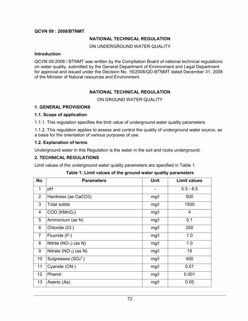
72
QCVN 09 : 2008/BTNMT
NATIONAL TECHNICAL REGULATION
ON UNDERGROUND WATER QUALITY
Introduction
QCVN 09:2008 / BTNMT was written by the Compilation Board of national technical regulations on water quality, submitted by the General Department of Environment and Legal Department for approval and issued under the Decision No. 16/2008/QD-BTNMT dated December 31, 2008 of the Minister of Natural resources and Environment.
NATIONAL TECHNICAL REGULATION
ON GROUND WATER QUALITY
1. GENERAL PROVISIONS
1.1. Scope of application
1.1.1. This regulation specifies the limit value of underground water quality parameters.
1.1.2. This regulation applies to assess and control the quality of underground water source, as a basis for the orientation of various purposes of use.
1.2. Explanation of terms
Underground water in this Regulation is the water in the soil and rocks underground.
2. TECHNICAL REGULATIONS
Limit values of the underground water quality parameters are specified in Table 1.
Table 1: Limit values of the ground water quality parameters
No. Parameters Unit Limit values
1 pH - 5.5 - 8.5
2 Hardness (as CaCO3) mg/l 500
3 Total solids mg/l 1500
4 COD (KMnO4) mg/l 4
5 Ammonium (as N) mg/l 0.1
6 Chloride (Cl-) mg/l 250
7 Fluoride (F-) mg/l 1.0
8 Nitrite (NO-2) (as N) mg/l 1.0
9 Nitrate (NO-3) (as N) mg/l 15
10 Sulgreasee (SO42-) mg/l 400
11 Cyanide (CN-) mg/l 0.01
12 Phenol mg/l 0.001
13 Asenic (As) mg/l 0.05
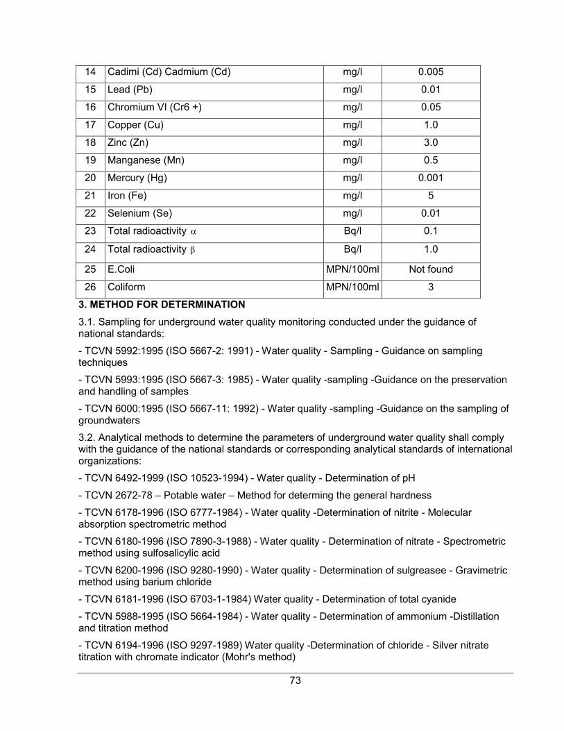
73
14 Cadimi (Cd) Cadmium (Cd) mg/l 0.005
15 Lead (Pb) mg/l 0.01
16 Chromium VI (Cr6 +) mg/l 0.05
17 Copper (Cu) mg/l 1.0
18 Zinc (Zn) mg/l 3.0
19 Manganese (Mn) mg/l 0.5
20 Mercury (Hg) mg/l 0.001
21 Iron (Fe) mg/l 5
22 Selenium (Se) mg/l 0.01
23 Total radioactivity Bq/l 0.1
24 Total radioactivity Bq/l 1.0
25 E.Coli MPN/100ml Not found
26 Coliform MPN/100ml 3
3. METHOD FOR DETERMINATION
3.1. Sampling for underground water quality monitoring conducted under the guidance of national standards:
- TCVN 5992:1995 (ISO 5667-2: 1991) - Water quality - Sampling - Guidance on sampling techniques
- TCVN 5993:1995 (ISO 5667-3: 1985) - Water quality -sampling -Guidance on the preservation and handling of samples
- TCVN 6000:1995 (ISO 5667-11: 1992) - Water quality -sampling -Guidance on the sampling of groundwaters
3.2. Analytical methods to determine the parameters of underground water quality shall comply with the guidance of the national standards or corresponding analytical standards of international organizations:
- TCVN 6492-1999 (ISO 10523-1994) - Water quality - Determination of pH
- TCVN 2672-78 – Potable water – Method for determing the general hardness
- TCVN 6178-1996 (ISO 6777-1984) - Water quality -Determination of nitrite - Molecular absorption spectrometric method
- TCVN 6180-1996 (ISO 7890-3-1988) - Water quality - Determination of nitrate - Spectrometric method using sulfosalicylic acid
- TCVN 6200-1996 (ISO 9280-1990) - Water quality - Determination of sulgreasee - Gravimetric method using barium chloride
- TCVN 6181-1996 (ISO 6703-1-1984) Water quality - Determination of total cyanide
- TCVN 5988-1995 (ISO 5664-1984) - Water quality - Determination of ammonium -Distillation and titration method
- TCVN 6194-1996 (ISO 9297-1989) Water quality -Determination of chloride - Silver nitrate titration with chromate indicator (Mohr's method)
α
β
74
- TCVN 6195-1996 (ISO 10359-1-1992) - Water quality - Determination of fluoride - Part 1: Electrochemical probe method for potable and lightly polluted water
- TCVN 6216-1996 (ISO 6439-1990) - Water quality - Determination of phenol index -4-Aminoantipyrine spectrometric methods after distillation
- TCVN 6626-2000 (ISO 11969-1996) - Water quality - Determination of arsenic - Atomic absorption spectrometric method (hydride technique)
- TCVN 6193-1996 (ISO 8288-1986) - Water quality - Determination of cobalt, nickel, copper, zinc, cadmium and lead - Flame atomic absorption spectrometric methods
- TCVN 6197-1996 (ISO 5961-1994) - Water quality - Determination of cadmium by atomic absorption spectrometry
- TCVN 6002-1995 (ISO 6333-1986) - Water quality - Determination of manganese - Formaldoxime spectrometric method
- TCVN 6177-1996 (ISO 6332-1988) - Water quality - Determination of iron - Spectrometric method using 1,10 - phenanthroline
- TCVN 6183-1996 (ISO 9965-1993) -Water quality - Determination of selenium - Atomic absorption spectrometric method (hydride technique)
- TCVN 59910-1995 (ISO 5666-3-1984) Water quality - Determination of total mercury by flameless atomic absorption spectrometry - Method after digestion with bromine
- TCVN 6222-1996 (ISO 9174-1990) - Water quality -Determination of chromium - Atomic absorption spectrometric methods
- TCVN 6187-1-1996 (ISO 9308-1-1990) - Water quality - Detection and enumeration of coliform organisms, thermotolerant coliform organisms and presumptive Escherichia coli - Part 1: Membrane filtration method
The parameters specified in this Regulation not having national standards guiding the analytical method shall apply the corresponding analytical standards of the international organizations
4. IMPLEMENTATION ORGANIZATION
This Regulation shall apply in substitution for TCVN 5944:1995- Water quality - underground water quality standards in the List of Vietnamese standards on environment which is mandatorily applied and issued together with Decision No. 35/2002/QD-BKHCNMT dated June 25, 2002 of the Minister of Science, Technology and Environment.
In case the national standards referred in this Regulation amended and supplemented or superseded shall be applied under new document
75
QCVN 05:2013/BTNMT
NATIONAL TECHNICAL REGULATIONS ON AMBIENT AIR QUALITY
Introduction
QCVN 05:2013/BTNMT was written by the Compilation Board of national technical regulations on ambient air quality, submitted by the General Department of Environment and Legal Department for approval and issued under the Circular No. 32/2013/TT-BTNMT dated October 25, 2013 of the Minister of Natural resources and Environment.
National Technical Regulation on Ambient Air Quality
1. GENERAL PROVISIONS
1.1. Scope of applications
1.1.1. This Regulation deals with limitations on values of basic factors including sulphur dioxide (SO2), carbon monoxide (CO), dioxide nitrogen (NO2), ozone (O3), total suspended particles (TSP), PM10, PM2.5, particles, and lead (Pb) in ambient air.
1.1.2. This Regulation applies to supervision and assessment of ambient air quality.
1.1.3. This Regulation does not apply to air within manufacturing facilities and indoor air.
1.2. Interpretation of terms
In this Regulation, the terms below are construed as follows:
1.2.1. Total suspended particles (TSP) is total particles with aerodynamic diameter less than or equal to 100 µm.
1.2.2. Particle PM10 is total suspended particles with aerodynamic diameter less than or equal to 10 µm.
1.2.3. Particle PM2,5 is total suspended particles with aerodynamic diameter less than or equal to 2,5 µm.
1.2.4. Average 1 hour: The arithmetic average of the measured values over a period of 1 hour.
1.2.5. Average 8 hours: The arithmetic average of the measured values over a period of 8 consecutive hours.
1.2.6. Average 24 hours: The arithmetic average of the measured values over a period of 24 consecutive hours (a day).
1.2.7. Annual average: The arithmetic average of the 24-hour average values measured over a period of one year.
2. Technical Reputation
Maximum value of basic parameters of ambient air is specified in Table 1.
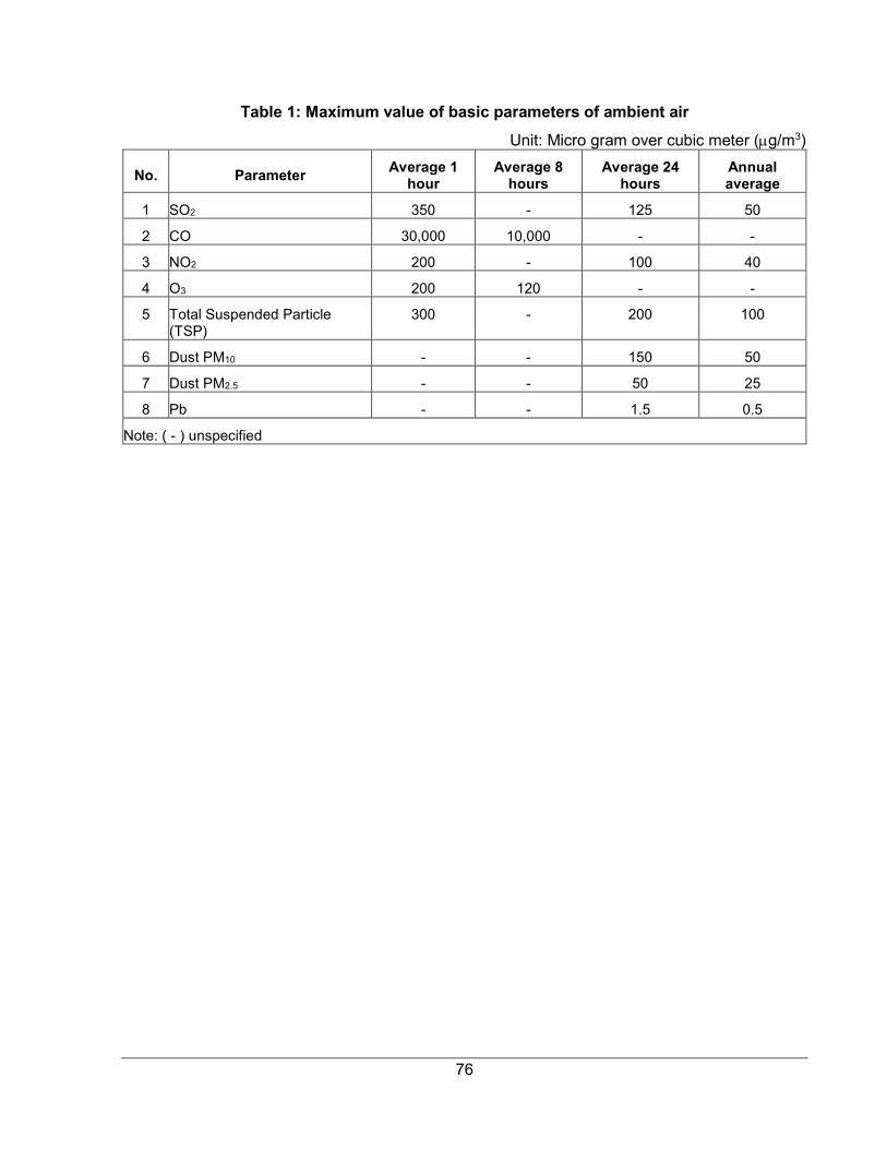
76
Table 1: Maximum value of basic parameters of ambient air
Unit: Micro gram over cubic meter (µg/m3)
No. Parameter Average 1
hour Average 8
hours Average 24
hours Annual average
1 SO2 350 - 125 50
2 CO 30,000 10,000 - -
3 NO2 200 - 100 40
4 O3 200 120 - -
5 Total Suspended Particle (TSP)
300 - 200 100
6 Dust PM10 - - 150 50
7 Dust PM2.5 - - 50 25
8 Pb - - 1.5 0.5
Note: ( - ) unspecified
77
F. Appendix 6: Guidelines for Traffic Management Plan Preparation
I. Objectives of a traffic management plan 1. A traffic management plan should set out the measures required to ensure the safety of road users around work zones and to permit the flow of traffic, reducing impedance to the extent practicable. It should provide for as much protection as practicable to all people on the work site, consistent with minimizing disruption and risk to road users and minimizing the number of signs and devices used to achieve this. It should ensure that:
• Fixed work areas are marked by barrier boards and delineation devices
• Condition signs are used where the road surface at the work area is sufficiently different from the approach roads as to be hazardous to traffic.
• The needs of all non vehicular users (pedestrians, cyclists, school children, etc.) as well as drivers and passengers of vehicles and work crews are provided for.
2. To be able to achieve this a traffic management plan should:
• Provide clear guidance to drivers, cyclists and pedestrians as they approach and travel through temporary traffic control zones
• Ensure the staff who operate the traffic control systems are adequately trained
• Keep the public well informed and
• Make appropriate arrangements for property owners, residents, businesses, emergency services and schools in the work zones.
3. Traffic Management Plans should comply with the Law on Road Traffic (2008).
II. Control Measures A. Signs and Signals 4. All signs used in traffic management plans must be compliant with the National Standards on Traffic Signs (November 2016).
5. Cones and bollards should be used to define the traffic path past or through work areas and must have reflective bands if required for night use.
6. Signs include warning signs, such as "roadworks ahead" signs or those indicating road conditions such as "loose gravel", and instructions such as "prepare to stop". Signs should be clearly read from a vehicle, be in local language and use reflective lettering and backgrounds.
7. The placement and spacing of signs should be designed, taking into account the likely length of traffic queues, estimated by considering the expected delay in minutes, hourly volumes at the time of the work and type or mix of traffic (longer queues where there are heavy vehicles). Signs should cover the estimate queue length plus 10% to allow for some greater demand.
8. Figure 1 below provides guidance for the layout of signage for a worksite that occupies half of the carriageway.
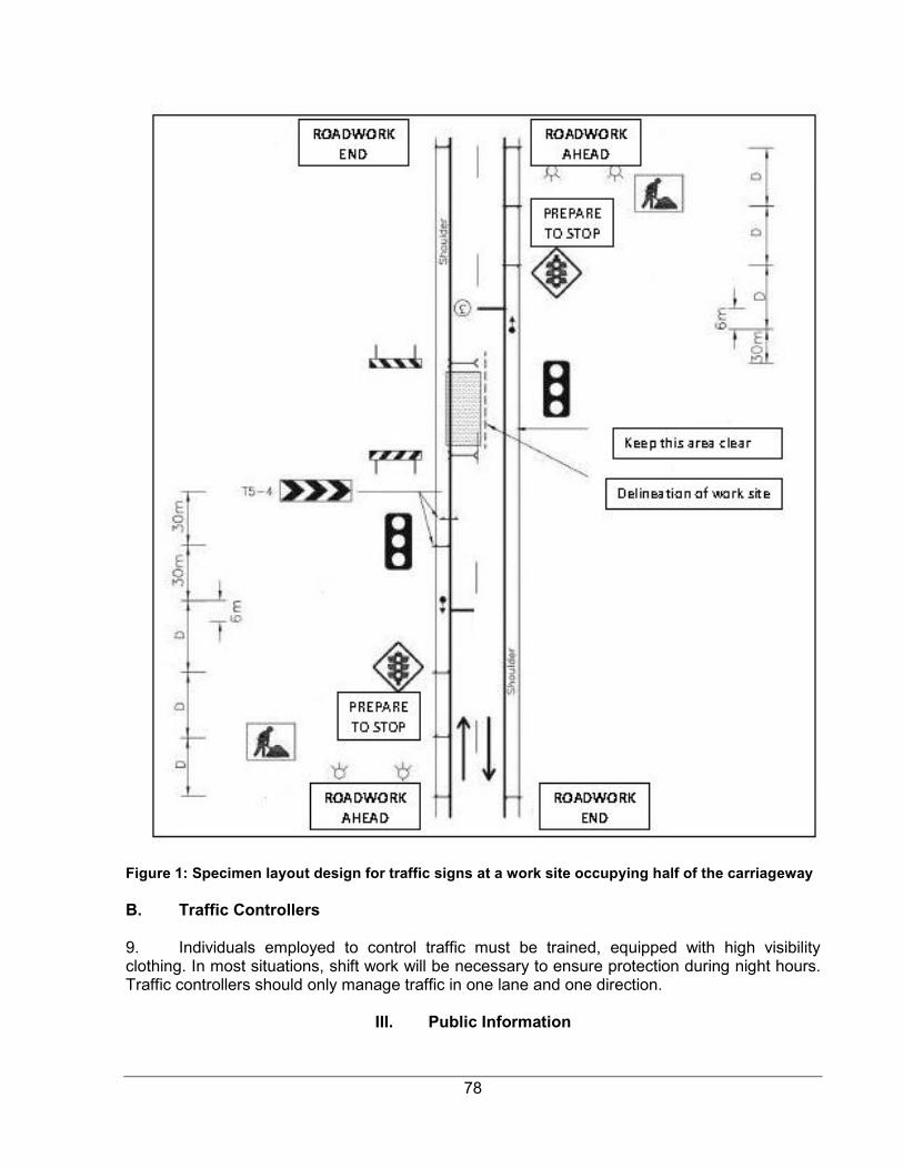
78
Figure 1: Specimen layout design for traffic signs at a work site occupying half of the carriageway B. Traffic Controllers 9. Individuals employed to control traffic must be trained, equipped with high visibility clothing. In most situations, shift work will be necessary to ensure protection during night hours. Traffic controllers should only manage traffic in one lane and one direction.
III. Public Information
79
10. The public should be kept continuously informed by providing prior notification and regular updates. Public meetings should be held prior to the works both to inform local residents of the works program and methods and to obtain feedback and suggestions. Noticeboards should be established to provide updates on matters such as work schedules and any service disruptions. The project Grievance Redress Mechanism is applicable for issues that arise over traffic management.
11. Local traffic police should be consulted during management plan preparation and the plan should reflect requirements and advice given
IV. Steps in Traffic Management Plan Preparation 1. Review of construction schedule and methods
2. Identify routes for traffic diversions, where available and practicable
3. Assess requirements for traffic control measures and detour routes
4. Conduct community consultation and information meetings
5. Identify areas for temporary parking
6. Consult with local traffic police
7. Place signs and control systems as the work