Embed Size (px)
Citation preview

1
REPUBLIC OF KENYA
THE INDEPENDENT ELECTORAL AND
BOUNDARIES COMMISSION
PRELIMINARY REPORT ON THE FIRST
REVIEW RELATING TO THE
DELIMITATION OF BOUNDARIES OF
CONSTITUENCIES AND WARDS
9TH JANUARY 2012

2
CONTENTS
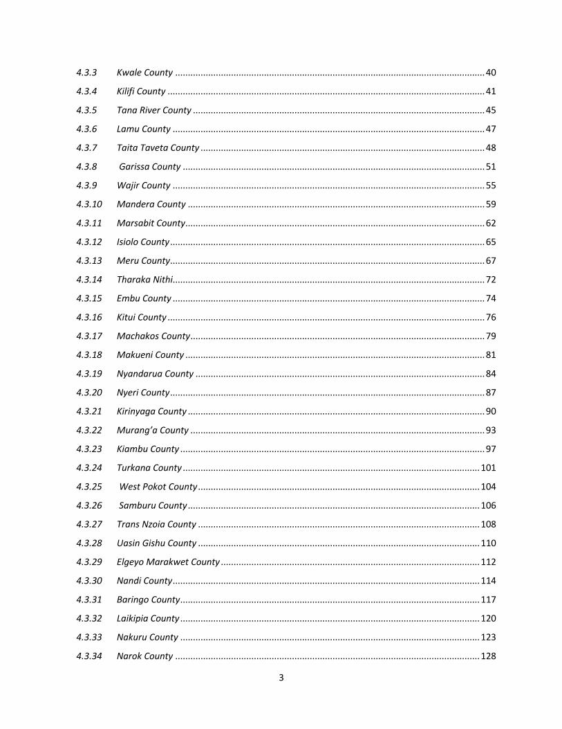
CHAPTER ONE ............................................................................................................................................... 8
BACKGROUND INFORMATION ...................................................................................................................... 8
1.1. Introduction ................................................................................................................................... 8
1.2. System and Criteria in Delimitation .............................................................................................. 9
1.3. Objective ....................................................................................................................................... 9
1.4. Procedure ...................................................................................................................................... 9
1.5. Boundary Delimitation In Kenya: Historical Perspective ............................................................. 11
1.5.1 An Overview of Boundary Delimitation in Kenya ........................................................................... 11
CHAPTER TWO ............................................................................................................................................ 14
LEGAL FRAMEWORK FOR THE DELIMITATION OF BOUNDARIES ................................................................ 14
2.1 Introduction ................................................................................................................................. 14
2.3 The Constitution of Kenya, 2010. ................................................................................................ 15
2.4 Article 89 of the Constitution. ..................................................................................................... 15
2.5 The Fifth Schedule of the IEBC Act, 2011 .................................................................................... 16
2.6 Review of IEBC Boundaries Report .............................................................................................. 17
2.7 Public Sensitization ..................................................................................................................... 17
CHAPTER THREE .......................................................................................................................................... 19
REVIEW OF INTERIM INDEPENDENT BOUNDARIES REVIEW COMMISSION REPORT .................................. 19
3.1 Introduction ................................................................................................................................. 19
3.2 Consultations with Stakeholders and the Public ......................................................................... 19
3.3 Determination of Population Quota by the IIBRC ....................................................................... 20
3.4 Data for Population for Constituencies as stipulated by IIBRC ................................................... 25
3.5 Protected Constituencies under Article 262 Section, 27(4) of the Constitution .......................... 27
CHAPTER FOUR ........................................................................................................................................... 29
PUBLIC PRESENTATIONS, IIBRC PROPOSALS ON DELIMITATION OF CONSTITUENCIES AND EMERGING
ISSUES ......................................................................................................................................................... 29
4.1 Introduction ................................................................................................................................. 29
4.2 General Views on the IIBRC Report ............................................................................................. 29
4.3 Public Views, IIBRC Proposals on Constituency Boundaries and Emerging Issues ...................... 31
4.3.1 Nairobi County ........................................................................................................................ 31
4.3.2 Mombasa County .................................................................................................................... 37
3
4.3.3 Kwale County .......................................................................................................................... 40
4.3.4 Kilifi County ............................................................................................................................. 41
4.3.5 Tana River County ................................................................................................................... 45
4.3.6 Lamu County ........................................................................................................................... 47
4.3.7 Taita Taveta County ................................................................................................................ 48
4.3.8 Garissa County ....................................................................................................................... 51
4.3.9 Wajir County ........................................................................................................................... 55
4.3.10 Mandera County ..................................................................................................................... 59
4.3.11 Marsabit County ...................................................................................................................... 62
4.3.12 Isiolo County ............................................................................................................................ 65
4.3.13 Meru County ............................................................................................................................ 67
4.3.14 Tharaka Nithi........................................................................................................................... 72
4.3.15 Embu County ........................................................................................................................... 74
4.3.16 Kitui County ............................................................................................................................. 76
4.3.17 Machakos County .................................................................................................................... 79
4.3.18 Makueni County ...................................................................................................................... 81
4.3.19 Nyandarua County .................................................................................................................. 84
4.3.20 Nyeri County ............................................................................................................................ 87
4.3.21 Kirinyaga County ..................................................................................................................... 90
4.3.22 Murang’a County .................................................................................................................... 93
4.3.23 Kiambu County ........................................................................................................................ 97
4.3.24 Turkana County ..................................................................................................................... 101
4.3.25 West Pokot County ............................................................................................................... 104
4.3.26 Samburu County ................................................................................................................... 106
4.3.27 Trans Nzoia County ............................................................................................................... 108
4.3.28 Uasin Gishu County ............................................................................................................... 110
4.3.29 Elgeyo Marakwet County ...................................................................................................... 112
4.3.30 Nandi County ......................................................................................................................... 114
4.3.31 Baringo County ...................................................................................................................... 117
4.3.32 Laikipia County ...................................................................................................................... 120
4.3.33 Nakuru County ...................................................................................................................... 123
4.3.34 Narok County ........................................................................................................................ 128

4
4.3.35 Kajiado County ...................................................................................................................... 132
4.3.36 Bomet County ....................................................................................................................... 135
4.3.37 Kericho County ...................................................................................................................... 137
4.3.38 Kakamega County ................................................................................................................. 139
4.3.39 Vihiga County ........................................................................................................................ 144
4.3.40 Bungoma County ................................................................................................................... 146
4.3.41 Busia County .......................................................................................................................... 150
4.3.45 Migori County ........................................................................................................................ 163
4.3.46 Kisii County ............................................................................................................................ 167
4.3.47 Nyamira County ................................................................................................................... 171
CHAPTER FIVE............................................................................................................................................ 175
PROPOSALS ON DELIMTATIONS OF COUNTY ASSEMBLYWARDS .............................................................. 175
5.1 Introduction ............................................................................................................................... 175
CHAPTER SIX .............................................................................................................................................. 326
PROPOSALS & WAYFORWARD .................................................................................................................. 326
6.1 Introduction ............................................................................................................................... 326
6.2 Methodology and criteria for boundary delimitation ............................................................... 326
6.3 Applicable Framework .............................................................................................................. 326
6.4 Work Plan .................................................................................................................................. 327
6.5 Communications to the public .................................................................................................. 328

5
Foreword
The legal framework for elections requires objective drawing of electoral unit
boundaries to achieve the principle of equal weight to each vote. To the greatest
degree, this principle is aimed at ensuring effective representation and a translation of
the will of the electorate into a representative government. It should be noted that the
ideal international standards for delimitation is the equality of voting power for each
vote so as to provide effective representation. Thus, boundary delimitation by its very
nature is intended to produce the result of effective representation.
Indeed Article 89(1) of the Constitution of Kenya 2010 states clearly the number of
constituencies that are supposed to be in place - maximum of two hundred and ninety
(290). Further, the Constitution stipulates the criteria and procedures that need to be
applied in the delimitation of boundaries and which notably shall be undertaken at
intervals of not less than eight years and not more than twelve years. This has to be
completed at least twelve months before a general election.
It is therefore worth noting that pursuant to the provisions made in the Constitution
of Kenya 2010, the Independent Electoral and Boundaries Commission (IEBC) has
been mandated to carry out boundary delimitation of constituencies and wards. But
this does not extend into the first review of the boundaries of constituency and wards.
It should be acknowledged that the Interim Independent Boundaries Review
Commission (IIBRC) did the first review of boundaries. IIBRC did its work and
submitted its report to the Parliamentary Committee on Justice and Legal Affairs
(JLA) which prepared its report and submitted to Parliament for adoption.
According to the Fifth Schedule of the IEBC Act 2011, IEBC is mandated to ‘resolve
all issues arising from the first review relating to the delimitation of boundaries of
constituencies and wards and publish its final report within a period of four months
6
of the date of its appointment. It is predetermined that the Commission shall, in
addressing the issues arising out of the first review:-
a) Use as its primary reference material, the report of the former boundaries
commission on the first review as adopted by Parliament; and
b) Use as its secondary reference material the report of the Parliamentary
committee on the report of the former Boundaries Commission.
The issues arising out of the first review are -
(a) re-distribution of such wards or administrative units in the affected
constituencies as may be appropriate;
(b) subject to the Constitution, addressing issues of new constituencies falling
outside the population quota as provided for by Article 89(6) of the
Constitution but at the same time ensuring that such a process shall –
(i) take into account the provisions of Article 89(7)(b) of the
Constitution that requires progressive efforts and not instant
demographic equality of all towards attaining the population
quota in each constituency and ward for the purposes of the first
review;
(ii) not be subject to new definitions of cities, urban areas and
sparsely populated areas or to new population figures;
(iii) be subject to the use of enumerated national census figures and
not projected figures.
(c) addressing the issue of progressively advancing towards the population
quota in protected constituencies in relation to neighboring constituencies
where appropriate.
While recognizing the provisions of the Constitution to redefine boundaries to
accommodate other interests in the electoral sphere, it is important to note that any

7
review of constituency boundaries is political in nature and is attached to highly
competitive and emotive political issues. This means that it requires clarity and clear
criteria and procedure commensurate to the electoral dynamics of the country. There
is need for transparency, accuracy, objectivity and patriotism in presentations
anticipated towards the process of resolving issues arising from the first review.
Similarly, it requires that a middle ground be struck to achieve a win-win-situation.
Thus, in line with the IEBC Act, the Commission has prepared this Preliminary
Report outlining the proposed delimitation of constituencies and wards and specific
geographical and demographic details and hereby avail it to the general public for a
period of twenty-one days and invite representations from the public on the proposals
hereto. The public presentations and recommendations will be reviewed within
fourteen days after receipt and the Commission will submit a Revised Report to
Parliament for deliberation. Consequently, the Commission will consider the
resolutions of Parliament and prepare a Final Report for publication in the Kenya
Gazette.
We must recognize that achieving the ideal and optimum population quota for our
electoral units is not an instant achievement. The First Review and the exercise of
addressing issues arising thereof is a process towards addressing gross disparities in
the voting populations of different electoral units. It is indeed a step closer towards
ensuring that the fundamental principle of the equality of the vote is attained. I
therefore urge fellow Kenyans to read and understand the Preliminary Report in order
to effectively engage in the process.
Ahmed Issack Hassan, EBS
CHAIRMAN

8
CHAPTER ONE
BACKGROUND INFORMATION
1.1. Introduction
The Constitution of Kenya, 2010, Article 89 gives the Independent Electoral and Boundaries
Commission (IEBC) the mandate of creating and delimiting constituencies and wards. This has to
be done at intervals of not less than eight and not more than twelve years. Additionally, the
Constitution in Article 89 (5) spells out the criteria to be used in boundary delimitation as well as the
maximum number of constituencies (Article 89 (1)). The IEBC Act, 2011 limits the IEBC to
resolve issues arising from the first review and to use Interim Independet Boundaries Commission
(IIBRC) Report as its primary reference material and Parliamentary Committee Report as its
secondary reference material.
The delimitation of boundaries of constituencies and wards under the Constitution of Kenya
Amendment Act 2008, Section 41C was a mandate of the Interim Independent Boundaries Review
Commission IIBRC which was specifically responsible for:
a) making recommendations to Parliament on delimitation of constituencies and local authority electoral units and optimal number of constituencies on the basis of equality of votes taking into account –
i. density of population and in particular the need to ensure adequate reprsenation of urban and sparserly-populated rural areas;
ii. population trends;
iii. means of communication;
iv. geographical features and community of interst; and
v. community interests
b) making recommendations to Parliament on administrative on boundaries, including the fixing, reviewing and variation of boundaries of districts and other units; and
c) the performance of such other function as may be prescribed by Parliament.
The IIBRC conducted the first review and submitted its report to the Parliamentary Departmental
Committee on Justice and Legal Affairs (JLA). Following the presentations of the JLA Report to
Parliament, the IIBRC Report was adopted but there were several outstanding issues raised by the
Public and Members of Parliament. It is as a result of these issues that the IIBRC mandate was

9
widely perceived as not complete, hence the requirement that IEBC addresses issues and concerns
emerging from their Report.
1.2. System and Criteria in Delimitation
An appropriate system and criteria require that internationally accepted standards and procedures be
used in the boundary delimitation process. The accepted standards have to take into consideration
political, economic, social and other factors within a given country. Notwithstanding this, there is
need for openness, accuracy, objectivity and patriotism in presentations anticipated towards the
process of boundary delimitation. Based on the legal framework predetermined in the Constitution
(2010) and the IEBC Act 2011, the resolution of issues arising from the first review have to be
completed in the shortest time possible (120 days according to the statutory timelines). This should
include proposals made to the public on the 290 Constituencies provided in the Constitution.
It is important to note that any constituency boundary review process is political in nature and is
attached to highly competitive and emotive political issues. This means that, in undertaking to
resolve the arising issues, it requires clarity, criteria and procedure commensurate to the electoral
dynamics of the country. In the case of IEBC resolution of arising issues, the Constitution and the
IEBC Act 2011 provide for the criteria and procedures to be followed. Similarly, it requires that a
middle ground be reached through a win-win-situation.
1.3. Objective
The main objective of the IEBC Preliminary Report On the First Review Relating to the
Delimitation of Boundaries of Constitutencies and Wards (hereinafter referred to as The
Preliminary Report): is to provide information to the public on outstanding issues emerging from
the IIBRC Report as well as reactions from the Parliamentary Committee on JLA Report. This is
aimed at eliciting debate on presentations and proposals contained in the Report. The information
gathered will be analyzed and used to delimit the required constituencies as stipulated in the
Constitution.
1.4. Procedure
The Preliminary Report: is based on the analysis of the outstanding issues derived from the
primary and secondary reference materials as provided for in the IEBC Act, 2011. The Primary
document reviewed is the IIBRC Report submitted to the Parliamentary Departmental Committee
on Justice and Legal Affairs dated 27th November, 2010 while the Secondary reference materials is

10
the Report of the Departmental Committee on Justice and Legal affairs as presented to the
Parliament on 16th December, 2010. The Report included the following annexes:
Committee minutes ( JLA 1);
Arising Issues ( JLA 2);
Draft Independent Electoral and Boundaries Commission’s Bill 2010 (JLA 3);
Presentation by the Hon. Andrew Ligale in Mombasa (JLA 4);
Presentation on Constitution Methodology (JLA 5);
Views of dissenting Commissioners (JLA 6);
Draft Gazzette Notice and Court Ruling by Justice Musinga JLA 7;
Written Submissions JLA 9;
Other documents analyzed include:
The Constitution of Kenya Amendment Act of 2008, that created and mandated IIBRC to carry out the delimitation of constituencies and ward boundaries herein referred as the review;
The Constitution of Kenya, 2010;
Presentation to Members of Parliament (6th December, 2010) by Professeur F.W.O Aduol;
Delimitation of Electoral Units: A critique of the process and product of IIBRC by Sakaja Johnson;
Independent Electoral Boundaries Commission Act, 2011;
Delimitation of Electoral Units: Background, Outstanding Issues and Way forward. Presentation made to IEBC – 21st November, 2011 by Sakaja Johnson;
IIBRC Public hearings Verbatim Reports;
Memoranda presented by the Public to the IIBRC during public hearings and visits.

11
1.5. Boundary Delimitation In Kenya: Historical Perspective
The delimitation of boundaries of constituencies and wards is not a new phenomenon in the
Kenyan history. Delimitation of boundaries was started by colonial authorities in 1962 when the
Royal Commission was created to go round the country and carry out an inquiry into electoral and
administrative boundaries. The Royal Commission held consultations with leaders at different levels
including influential tribal leaders and chiefs.
1.5.1 An Overview of Boundary Delimitation in Kenya
The country’s Constitution provided for the delimitation of constituencies so as to facilitate the
conduct of elections in independent Kenya (Section 40 of the Constitution of Kenya, 1963). At that
time, the determination of electoral units in Kenya started with creation of 117 Constituencies based
on a clearly established principle that all constituencies contain as nearly as possible an equal number
of inhabitants. The Constitution provided that no constituency was to form part or more than one
administrative unit; or of both the Nairobi area and a region.
Towards the delimitation of boundaries, the Commission also took into account the following:
(a) population density and in particular, the need to ensure adequate representation of urban
and sparsely-populated rural areas;
(b) means of communication;
(c) geographical features;
(d) community of interest; and
(e) boundaries of existing administrative areas.
The Constitutional amendments of 1964 and 1966 resulted in the abolition of the seven regional
assemblies and the Senate. The House of Representatives was renamed the National Assembly with
158 Parliamentary Constituencies consisting of the initial 117 plus 41 newly created constituencies
following the abolition of the senate. In 1986, Parliament raised the number of constituencies from
158 to 188.
The Electoral Commission of Kenya (ECK) established in 1992, published through a Gazette Order
the names and boundaries of these constituencies. In 1996, the ECK reviewed the boundaries and
names of constituencies and raised the number from 188 to a maximum of 210 as provided under
the previous Constitution.

12
Following the disputed results of the Presidential elections in 2007, a National Accord
Implementation Committee (NAIC) was established. NAIC recommended a review of the electoral
process in Kenya, which led to the establishment of the Independent Review Commission (IREC),
popularly known as the Kriegler Commission. The IREC in turn recommended a review of the
entire constitutional and legal framework in line with the political and legal aspirations of Kenyans.
A major impact of the IREC recommendations was the amendment of Section 41 of the 1963
Constitution by Parliament in 2008, resulting in the disbandment of the ECK and the creation of the
Interim Independent Electoral Commission-IIEC (Section 41A), and the Interim Independent
Boundaries Review Commission-IBRC (Section 41B).
The Constitution of Kenya, 2010 provides for the IEBC to assume the mandate of the defunct
IIBRC as the successor body.
(a) In this regard, the IEBC has responsibility for the delimitation of constituencies and wards
[Constitution of Kenya, 2010 Article 88 (4)(c)].
(b) The IEBC Act provides for the IEBC to resolve all issues relating to the delimitation of
boundaries of constituencies and wards. It further binds the Commission to employ the
Report of the IIBRC as its primary reference material [Paragraphs 1 and 2(1)(a) of the Fifth
Schedule of IEBC Act].
(c) The Act also requires that the Report of the Parliamentary Committee on JLA on the former
IIBRC be used by IEBC as secondary reference material in resolving issues relating to
delimitation of boundaries.
In the light of the foregoing, the Report of the Parliamentary Committee on JLA sets the Agenda
for the IEBC in completing the outstanding work of the IIBRC.
This Report is divided into six chapters –
(a) Chapter One presents background information and an overview from a historical
perspective on boundary delimitation in Kenya;
(b) Chapter Two outlines the legal framework governing the delimitation of boundaries of
Constituencies and wards;

13
(c) Chapter Three is a review of the IIBRC boundary delimitation Report;
(d) Chapter Four presents an analysis of public presentations, IIBRC proposals on delimitation
of constituencies and emerging issues;
(e) Chapter Five covers proposals on delimataion of county assembly wards;
(f) Chapter Six outlines the framework on public presentations and public consultation forums,
within 21 days from the date of publication of this Report.
14
CHAPTER TWO
LEGAL FRAMEWORK FOR THE DELIMITATION OF BOUNDARIES
2.1 Introduction
Any boundary delimitation process has to be guided by a legal frame work. International standards
dictate that such a legal framework should determine how constituencies or the electoral units are
defined and drawn. The legal framework regulating drawing of boundaries for electoral units is
expected to address:
a) The frequency of such determination;
b) The criteria for such determination;
c) The degree of public participation in the process;
d) The respective roles of the legislature, judiciary and executive in the process;
e) The ultimate authority for the final determination of the electoral units.
The 1963 Constitution of Kenya (1963) provided guidance for boundary delimitation. The
Constitution of Kenya (Amendment) Act 2008 mandated IIBRC to make recommendations to
Parliament on the delimitation of boundaries for constituencies and local authority electoral units.
The Constitution of Kenya, 2010 and the Fifth Schedule of the IEBC Act, 2011 provides the criteria
for delimitation of constituencies and wards.
2.2 The Constitution of Kenya (Amendment) Act, 2008 The Constitution of Kenya (Amendment Act), 2008 that established IIEC and IIBRC gave the two
bodies different mandates. Whereas IIEC was mandated to reform the electoral process, the IIBRC
was mandated to:-
a) make recommendations to Parliament on the delimitation of constituencies and Local
authority electoral units and the optimal number of constituencies on the basis of equality
of votes;
b) make recommendations to Parliament on administrative boundaries, including the fixing,
reviewing and variation of boundaries of districts and other units; and
c) perform such functions as may be prescribed by Parliament.

15
2.3 The Constitution of Kenya, 2010.
The promulgation of the Constitution of Kenya, 2010 provided for the continuation of the
functions of IIBRC in accordance with terms of section 41B and 41C of the former Constitution
but was restricted from determining the boundaries of counties established under the new
Constitution. The Commission was to:-
a) determine the boundaries of constituencies and wards using the Criteria mentioned in the Constitution (2010);
b) observe the requirements of Article 89(2) of the Constitution (2010); and
c) ensure that the first review of constituencies undertaken under the new Constitution (2010) shall not result in the loss of a constituency existing on the effective date.
2.4 Article 89 of the Constitution.
Article 89(1) of the Constitution of Kenya, 2010 sets the maximum number of constituencies at two
hundred and ninety (290). Further, the Constitution stipulates the procedures that need to be applied
in the delimitation of boundaries and which notably shall be undertaken at intervals of not less than
eight years and not more than twelve years. This has to be completed at least twelve months before
a general election.
Article 89(5) of the Constitution stipulates the criteria to be applied in the boundary delimitation
process. It provides that the “boundaries of each constituency shall be such that the number of
inhabitants in the constituency is as nearly as possible equal to the population quota”. The
Constitution further provides that this number may be greater or lesser than the population quota
only by a margin of -
a) not more than forty per cent (40%)for cities and sparsely populated areas; and
b) thirty percent (30%) for other areas
In determining the number of inhabitants, IEBC is expected to take into account:
a) geographical features and urban centres;
b) community interest, economic and cultural ties; and

16
c) means of communication.
The Commission shall progressively work towards ensuring that the number of inhabitants in each
constituency and ward is as nearly as possible equal to the population quota (and in so doing consult
all interested parties.) (Article 89 (7)(b) and Paragrpah 2(c) of the Fifth Schedule of the IEBC Act.
2.5 The Fifth Schedule of the IEBC Act, 2011
The provision regulating the completion by the IEBC of the First Review are set out in the Fifth
Schedule of the Act. The IEBC is enjoined by the Act to “ resolve all the issues arising out of the
first review relating to the delimitation of boundaries of constituencies and wards and
publish its final report within the period of four months from the date of its appointment
under this Act.” The Act lists the isssues arising out of the first review as:
a) re-distribute such wards or administrative units in the affected constituencies as may be
appropriate;
b) subject to the Constitution, addressing issues of new constituencies falling outside the
population quota as provided for by Article 89(6) of the Constitution, but at the same
time ensure that such a process shall –
(i) take into account the privisions of Article 89(7)(b) of the Constitution that
requires progressive efforts and not instant demographic equality of all towards
attining the population quota in each constituency and ward for the purposes of
the first review;
(ii) not be subject to definitions of urban areas, cities or sparsely populated areas or
to population figures;
(iii) be subject to the use of enumerated national census figures and not projected
figures.
c) address the issues of progressively advancing towards population quota in protected
constituencies in relation to neighbouring constituencies where appropriate.
In addressing the issues arising out of the first review, IEBC is restricted by the IEBC Act and
Paragraph 29(1) of the Fifth Schedule to -

17
a) use as its primary reference material, the report of the former boundaries commission
(IIBRC) on the first review as adopted by Parliament; and
b) use as its secondary reference material the report of the Parliamentary committee on the
report of the former Boundaries Commission (IIBRC).
Pursuant to the provisions of the IEBC Act the Commission shall:
a) prepare and publish a preliminary report outlining the proposed delimitation of
boundaries of constituencies and wards, outlining specific geographical and
demographical details ;
b) avail the report to the general public for a period of twenty-one days and invite
representations from the public on the proposals;
c) review the public representations received within fourteen days after receipt of
recommendations;
d) forward the revised report to Parliament; and
e) consider views received from the national assembly and revise accordingly before final
print for publication in the Kenya Gazette.
2.6 Review of IEBC Boundaries Report
Article 89(10) of the Constitution and paragraph 4 of the Fifth Schedule of the IEBC Act, 2011
provides for any person dissatisfied with the outcome of the Final Report of the Commission on
Boundaries Delimitation to apply to the High Court for review of the Commission decision.
“An application for the review of a decision made under this Article (Article 89 of
the Constitution) shall be filed within thirty days of the publication of the decision in
the Gazette and shall be heard and determined within three months of the date on
which it is filed.”
2.7 Public Sensitization
The principle of public particiation and involvement is a running thread in the Constitution
and the Commission is required by the IEBC Act to observe the principle of public
participation and consultation with stakeholders in its processes. Paragraph 6 of the Fifth
18
Schedule of the IEBC Act requires the Commission to conduct public sensitization on the
proposed boundaries for a period of thirty days.
19
CHAPTER THREE
REVIEW OF INTERIM INDEPENDENT BOUNDARIES REVIEW COMMISSION REPORT
3.1 Introduction
The IIBRC presented a report titled “Delimitation of Constituencies and Recommendations on Local Authority
Electoral Units and Administrative Boundaries for Districts and other Units” addressed to the President, the
Prime Minister and the Speaker of the National Assembly dated 27th November, 2010. After the
Report was presented to the Parliamentary Committee on Justice and Legal Affairs and Parliament it
elicited intense public debate. Some Kenyans were in support of the Report while others were
opposed to some recommendations in the Report. However, not all Kenyans had a chance to read
the IIBRC report and make their own views known.
3.2 Consultations with Stakeholders and the Public
From the Report it is evident that IIBRC held consultations and public hearings with stakeholders
throughout the country as per its mandate. This was done between 1st February and 14th May, 2010.
A total of one hundred and seventy (170) out of two hundred and ten (210) MPs attended the public
hearings including the Prime Minister and the two Deputy Prime Ministers. Many Councillors and
opinion leaders from all spheres of society also attended the hearings. The hearings were
characterized by oral and written submissions. After 14th May 2010, the IIBRC continued to receive
memoranda and held hearings with interested parties. All the leaders and senior public officials not
only attended the meetings to give their views but also to listened to views of the public on
boundaries delimitation. Eight (8) Provincial visits were held during which thousands of people
attended. In addition, there were one hundred and six (106) public hearings in which a total of
20,726 members of the public attended. During these hearings, 2,646 persons gave oral submissions
to the Commission.

20
3.3 Determination of Population Quota by the IIBRC
In embarking on the delimitation process IIBRC was guided by the provisions in the Constitution
of Kenya 2010, Article 89 and the 2009 Census data. IIBRC calculated the population quota based
on a definition provided in Article 89(12) of the Constitution (2010).
National population = 38,610,097
a) Population Quota = 38,610,097 = 133,138.26 290
b) 40% greater than population quota for cities = 186,393.6 c) 30% greater than population quota for other areas = 173,079.4 d) 30% less than population quota for other areas = 93,196.6 e) 40% less than population quota for sparsely populated areas = 79,882.8
I. Nairobi Province Population = 3,138,369
No. of constituencies for Nairobi (40% limit) = 3,138,369 = 16.84 = 17 186,393 No. of existing constituencies = 8 No. of additional constituencies = 17 – 8= 9 II. Coast Province Population = 3,325,307
No. of constituencies for Coast = 3,325,307 = 24.98 = 25 133,138
No. of existing constituencies = 21 No. of additional constituencies = 25 – 21= 4 III. North Eastern Province Population = 2,310,757
No. of constituencies for North Eastern = 2,310,757 = 17.36 = 17 133,138 No. of existing constituencies = 11 No. of additional constituencies = 17 – 11= 6 IV. Eastern Province Population = 5,668,123
No. of constituencies for Eastern = 5,668,123 = 42.57 = 43 133,138 No. of existing constituencies = 36 No. of additional constituencies = 43 – 36= 7 V. Central Province Population = 4,383,743

21
No. of constituencies for Central = 4,383,743 = 32.93 = 33 133,138 No. of existing constituencies = 29 No. of additional constituencies = 33 – 29= 4 VI. Rift Valley Province Population = 10,006,805
No. of constituencies for Rift Valley = 10,006,805 = 75.16 = 75 133,138 No. of existing constituencies = 49 No. of additional constituencies = 75 – 49= 26 VII. Western Province Population = 4,334,282
No. of constituencies for Western = 4,334,282 = 32.56 = 33 133,138 No. of existing constituencies = 24 No. of additional constituencies = 33 – 24= 9 VIII. Nyanza Province Population = 5,442,711
No. of constituencies for Nyanza = 5,442,711 = 40.88 = 41 133,138 No. of existing constituencies = 32 No. of additional constituencies = 41 – 32= 9
Option 1 PROVINCE CONSTITUENCIES
Current No. Additional Total
1 Nairobi 8 9 17
2 Coast 21 4 25
3 North Eastern 11 6 17
4 Eastern 36 7 43
5 Central 29 4 33
6 Rift Valley 49 26 75
7 Western 24 9 33
8 Nyanza 32 9 41
TOTAL 210 74 284
Option 1 **
PROVINCE CONSTITUENCIES
Current No. Additional Total
1 Nairobi 8 9 17
2 Coast 21 5 26
3 North Eastern 11 7 18

22
PROVINCE CONSTITUENCIES
4 Eastern 36 8 44
5 Central 29 5 34
6 Rift Valley 49 27 76
7 Western 24 9 33
8 Nyanza 32 10 42
TOTAL 210 80 290
Option 1 above was then subjected to the scientific mathematical formula shown below:
1. Nairobi being the only legal city, the population of Nairobi subjected to its population quota
as follows:
(40% x 133,138) + 133,138) = 186,393
2. Subjecting the population of Nairobi to the population quota for cities then:
= (3,138,369/186,393) = 17 Constituencies
3. Subtracting the population of Nairobi from the national population:
= (38,610.097 – 3,138,369) = 35,471,728
4. Subtracting the 17 constituencies given to Nairobi from the 290 Constituencies:
= (290-17) = 273
5. Dividing the remaining population by remaining Constituencies
= (35,471,728/273) = 129,933
6. Subjecting the remaining provinces to this quota:
= Province Population (X)/129,933
7. This gives a total of 291 constituencies. The allocation of constituencies in the Rift Valley
was reduced by 1 because of its large number of constituencies.

23
Population Area (Sq. Km)
KENYA 38,610,097 581,315.9
Constituencies 290 581,315.9
Average per Constituency 133,138.27 2,004.54
Average -30% 93,196.79
Average+30% 173,079.75
Average -40% 79,882.96
Average +40% 186,393.57
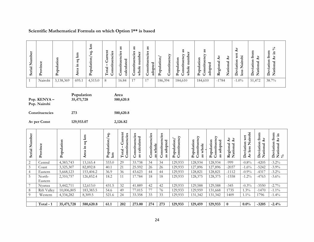
24
Scientific Mathematical Formula on which Option 1** is based
Seri
al
Nu
mb
er
Pro
vin
ce
Po
pu
lati
on
Are
a i
n s
q k
m
Po
pu
lati
on
/sq
. k
m
To
tal
– C
urr
en
t
Co
nst
itu
en
cie
s
Co
nst
itu
en
cie
s as
calc
ula
ted
Co
nst
itu
en
cie
s as
wh
ole
nu
mb
er
Co
nst
itu
en
cie
s as
ad
op
ted
Po
pu
lati
on
/
Co
nst
itu
en
cy
Po
pu
lati
on
Co
nst
itu
en
cy a
s
wh
ole
nu
mb
er
Po
pu
lati
on
Co
nst
itu
en
cy a
s
ad
op
ted
Reg
ion
al
Av
Nati
on
al
Av
Devi
ati
on
wrt
Av
less
Nair
ob
i
Devi
ati
on
fro
m
Nati
on
al
Av
Devi
ati
on
fro
m
Nati
on
al
Av
in %
1 Nairobi 3,138,369 695.1 4,515.0 8 16.84 17 17 186,394 184,610 184,610 -1784 -1.0% 51,472 38.7%
Population Area
Pop. KENYA – 35,471,728 580,620.8 Pop. Nairobi Constituencies 273 580,620.8 Av per Const 129,933.07 2,126.82
Seri
al
Nu
mb
er
Pro
vin
ce
Po
pu
lati
on
Are
a i
n s
q k
m
Po
pu
lati
on
/sq
.
km
To
tal
– C
urr
en
t
Co
nst
itu
en
cie
s
Co
nst
itu
en
cie
s
as
calc
ula
ted
Co
nst
itu
en
cie
s
as
wh
ole
nu
mb
er
Co
nst
itu
en
cie
s
as
ad
op
ted
Po
pu
lati
on
/
Co
nst
itu
en
cy
Po
pu
lati
on
Co
nst
itu
en
cy
as
wh
ole
nu
mb
er
Po
pu
lati
on
Co
nst
itu
en
cy
as
ad
op
ted
Reg
ion
al
Av
Nati
on
al
Av
Devi
ati
on
wrt
Av
less
Nair
ob
i
Devi
ati
on
fro
m
Nati
on
al
Av
Devi
ati
on
fro
m
Nati
on
al
Av
in
%
2 Central 4,383,743 13,165.4 333.0 29 33.738 34 34 129,933 128,934 128,934 -999 -0.8% -4205 -3.2%
3 Coast 3,325,307 82,892.8 40.1 21 25.592 26 26 129,933 127,896 127,896 -2037 -1.6% -5242 -3.9%
4 Eastern 5,668,123 153,404.2 36.9 36 43.623 44 44 129,933 128,821 128,821 -1112 -0.9% -4317 -3.2%
5 North-Eastern
2,310,757 126,852.4 18.2 11 17.784 18 18 129,933 128,375 128,375 -1558 -1.2% -4763 -3.6%
7 Nyanza 5,442,711 12,613.0 431.5 32 41.889 42 42 129,933 129,588 129,588 -345 -0.3% -3550 -2.7%
8 Rift Valley 10,006,805 183,383.5 54.6 49 77.015 77 76 129,933 129,959 131,668 1735 1.3% -1470 -1.1%
9 Western 4,334,282 8,309.5 521.6 24 33.358 33 33 129,933 131,342 131,342 1409 1.1% 1796 -1.4%
Total - 1 35,471,728 580,620.8 61.1 202 273.00 274 273 129,933 129,459 129,933 0 0.0% -3205 -2.4%

25
Table 3-1: Table on Delimitations
Provinces Population Constituencies Fraction
Constituencies Rounded
IIBRC Delimitation
Current Constituencies
Additional Constituencies
Nairobi 3,138,369 16.84 17 17 8 9
Coast 3,325,307 25.59 26 26 21 5
Central 4,383,743 33.74 34 34 29 5
N. Eastern 2,310,757 17.78 18 18 11 7
Eastern 5,668,123 43.62 44 44 36 8
R. Valley 10,006,805 77.02 77* 76 49 27
Western 4,334,282 33.36 33 33 24 9
Nyanza 5,442,711 41.89 42 42 32 10
291 290 210 80
The result and summary of this analysis is captured in option 1** and the above Table of
Delimitations.
*All the 290 constituencies being delimited according to this formula strictly meet the
requirement of Article 89 (5,6,&7) and Section 6 of the Constitution of Kenya.
3.4 Data for Population for Constituencies as stipulated by IIBRC
The use of the criteria specified in the Constitution by IIBRC resulted into the following different
categories of the existing 210 constituencies. These are:-
i. Constituencies that have a population above the highest limits (186,393.6 for cities);
ii. Constituencies that have a population below the lowest limit (79,882.8) for sparsely
populated areas;
iii. Constituencies that have a population within the limits of the lowest and highest (79,882.8 to
133,138.26) for sparsely populated areas;
iv. Constituencies that have a population above the National population quota (133,138.26) for
sparsely populated areas;
v. Constituencies that have a population above the highest limits (173,079.4) for other areas;

26
vi. Constituencies that have a population within the limits of the lowest and highest (93,196.6 to
133,138.26) for sparsely populated areas;
vii. Lastly, constituencies that have a population below the lowest limits (93,196.6) for other
areas.
The constituencies under each of these categories are shown in Table 2 below:
Table 3-2: Analysis of Population Quota Limits in Relation to Populations in the 210 Constituencies
Population Quota limits
Areas Name of 210 Constituencies
Above 186,393.6
Cities Makadara, Kamukunji, Strarehe, West lands, Langata, Dagoretti, Embakasi.
Below 79,882.8
Sparsely populated Mwatate, Galole, Lamu East, North Horr, Saku, Laisamis, Isiolo south, Saburu East
Between 79,882.8 to 133,138.26
Sparsely Populated Bura, Garsen, Voi, Fafi, Ijara, Wajir South, Moyale, Isiolo North, Mutito,
Above 133,138.26
Sparsely Populated Kinango, Dujis, Lagdera, Wajir North, Wajir West, Wajir East, Mandera, Mandera Central, Mandera, Kitui Central, Kitui South, Turkana North, Turkana Central, Turkana South, Kacheliba, Kapenguria, Sigor, Saburu West, Kajiado Central, Loitokitok.
Above 173,079.4
Other Areas Changamwe, Kisauni, Likoni, Msambweni, Bahari, Kaloleni, Malindi, Igembe South, Igembe North, North Imenti, South Imenti, Nithi, Mwingi North, Mwingi South, Kathiani, Machakos Town, Mbooni, Makueni, Kibwezi, Kinangop, Ol-kalou, Mwea, Kiharu, Juja, Kiambaa, Kabete, Kwanza, Saboti, Cherangany, Eldoret North, Eldoret East, Eldoret South, Engwen, Tinderet, Laikipia West, Laikipia East, Naivasha, Nakuru Town, Kuresoi, Molo, Subukia, Kilgoris, Narok North, Narok South, Kajiado North, Bomet, Sotik, Belgut, Ainamoi, Kipkelion, Malaba, Lugari, Mumias, Lurambi, Emuhaya, Kimilili, Webuye, Sirisia, Kanduyi, Bumula, Amagoro, Nambale, Ugenya, Kisumu Town East, Kasipul Kabondo, Karachuonyo, Rongo, Migori, Kuria, Bomachoge, Bobasi, Kitutu Chache, Kitutu Masaba, North Mugirango Borabu,
Between 93,196.6 to 173,079.4
Other Areas Matuga Ganze, Magarini, Tigania West, Tigania East, Central Imenti, Tharaka, Manyatta, Runyenjes, Gachoka, Kitui west, Masinga, Yatta, Kangundo, Mwala, Kaiti, Kipipiri, Kieni, Mathira, Nyeri Town, Gichugu, Ndia, Kirinyaga Central, Kigumo, Maragua, Kandara, Gatanga, Gatundu South, Gatundu North, Githunguri, Limuru, Lari, Marakwet West, Keiyo South, Mosop, Aldai, Baringo East, Baringo North, Baringo Central, Eldama Ravine, Rongai, Chepalungu, Konoin, Buret, Funyula,

27
Population Quota limits
Areas Name of 210 Constituencies
Funyula, Matungu, Shinyalu, Ikolomani, Butere, Khwisero, Sabatia, Hamisi, Mt. Elgon, Butula, Gem, Bondo, Rarieda, Kisumu Town West, Kisumu Rural, Nyando, Muhoroni, Kasipul Kabondo, Karachuonyo, Ndhiwa, Uriri, Nyatike, Mbita, Gwasi, Bonchari, South Mugirango, Nyaribari Masaba, Nyaribari Chache, West Mugirango.
Below 93,196.6
Other Areas Mvita, , Lamu west, Taveta, Wundanyi, Siakago, Kilome, Ndaragwa, Tetu, Othaya, Mukurwe-ini, Kangema, Mathioya, Marakwet East, Keiyo North, Mogotio, Vihiga, Bundalangi.
(Source: IIBRC Report Table 1: 210 Constituency Populations compared to the Population Quota)
3.5 Protected Constituencies under Article 262 Section, 27(4) of the Constitution
Out of the the 290 constituencies, prescribed by the constitution, a total of 27 constituencies were
protected. The protected constituencies were as follows:
Table 3-3: Protected Constituencies
27 PROTECTED CONTITUENCIES
Area km. Sq. Population
NAIROBI (NONE)
COAST (9/27)
1. Mvita 7 74,735
2. Galole 9,657 60,866
3. Bura 12,796 82,545
4. Lamu East 1,663 18,841
5. Lamu West 4,504 82,698
6. Taveta 4,205 67,665
7. Wundanyi 702 56,021
8. Mwatate 1,873 71,513
9. Voi 10,348 89,458
NORTH EASTERN (NONE)
EASTERN (6/27)
10. North Horr 38,953 75,196
11. Saku 2,078 46,502
12. Laisamis 20,266 65,669
13. Isiolo South 9,817 43,118
14. Siakago 777 89,035
15. Kilome 630 87,864
CENTRAL (6/27)
16. Ndaragwa 80 934 92,626

28
27 PROTECTED CONTITUENCIES
Area km. Sq. Population
17. Tetu 81 418 78,320
18. Othaya 84 600 87,374
19. Mukurweini 85 180 83,932
20. Kangema 91 260 76,988
21. Mathioya 92 262 88,219
RIFT VALLEY (4/27)
22. Samburu East 113 10,142 59,094
23. Marakwet East 120 783 78,749
24. Keiyo North 122 541 73,715
25. Mogotio 131 1,364 60,959
WESTERN (2/27)
26. Vihiga 166 90 91,616
27. Budalangi 178 187 66,723
NYANZA (NONE)
29
CHAPTER FOUR PUBLIC PRESENTATIONS, IIBRC PROPOSALS ON DELIMITATION OF CONSTITUENCIES AND EMERGING ISSUES
4.1 Introduction
The methodology of particular emphasis IIBRC employed in the first review relating to the
delimitation of boundaries of constituencies and wards - was public hearings. This was like a tool
that both facilitated consultation on its mandate and for gathering and compiling relevant
information from the general public on matters of concern. The public hearings promoted advocacy,
awareness-raising and building consensus on the electoral reform process. In particular, the public
hearings afforded the IIBRC unrivalled opportunity on a nation-wide scale to engage in public
information, civic education and receiving public views on issues related to its mandate. The
objectives, procedures and principles guiding the public hearings were determined and published
beforehand.
To ensure maximum benefit of the public hearings to the delivery of its mandate, IIBRC formulated
a checklist of documents and materials, provided for rapportuer’s briefing notes and terms of
reference, and used verbatim audio-visual recordings of all the proceedings. It is through the public
hearings that several issues concerning boundary delimitation were presented to IIBRC. Based on
such issues and the requirements of the Constitution of Kenya 2010, IIBRC developed a Report -
“Delimitation of Constituencies and Recommendations on Local Authority Electoral Units and Administrative
Boundaries for Districts and other Units”- that had proposals and maps indicating 80 new constituencies.
However, the proposals presented in the Report elicited several reactions from county to county.
4.2 General Views on the IIBRC Report
The delimitation process and criteria adopted by IIBRC has been subjected to debate with remarks
pitted against the proposed constituencies. Some critics fault the “formula” applied and the resulting
inequities. Other critics of the Report have cited lack of adequate consultation between IIBRC and
the Kenyan public as the cause of their contest.
A Report from the Parliamentary Departmental Committee on Justice and Legal Affairs that was
presented to parliament notably underscored several issues. Some of the issues cited included:

30
(i) The determination of boundaries on the basis of three types of population quotas
instead of one;
(ii) The use of regions and provinces as units of analysis (yet not provided in the
Constitution);
(iii) The treatment of Cities and urban areas in a similar way (definition of cities not agreed
on);
(iv) The description of boundaries based on wards or sub-locations;
(v) Inconsistency in the division of constituencies where some with large population were
not split yet others with less population were split;
(vi) The creation or alteration of boundaries without taking into account geographical
features and community interests;
(vii) There was nullification census results in eight (8) constituencies yet no clarity on their
delineation was stipulated; and
(viii) Lastly, that there was no public participation.
Latently, the argument brought forth was that the proposals on which each scenario that was used
or applied in the delimiting of boundaries by IIBRC were never considered.
Some experts on demographic issues have analyzed the IIBRC Report and noted that population
limits are too tight to accommodate the wide variations in constituencies. A number of
inconsistencies emerge with regard to constituencies /legal limits and interpretation of the legal
population limits; variations of constituencies in population and area; special consideration for
sparsely populated areas and qualitative factors such as geographical features and socio-economic
factors.
In arriving at its review and variation of boundaries, it appeared that the IIBRC had not undertaken
consultations as required by the constitution (evidenced by the elicited intense public reaction
following the gazettment of the boundaries). However, whether there was public consultation or
not, there are several documented evidences that indicate that there were public hearings that took
place across the country. Similarly, there are memorandums through which the public presented
their suggestions and opinions.
31
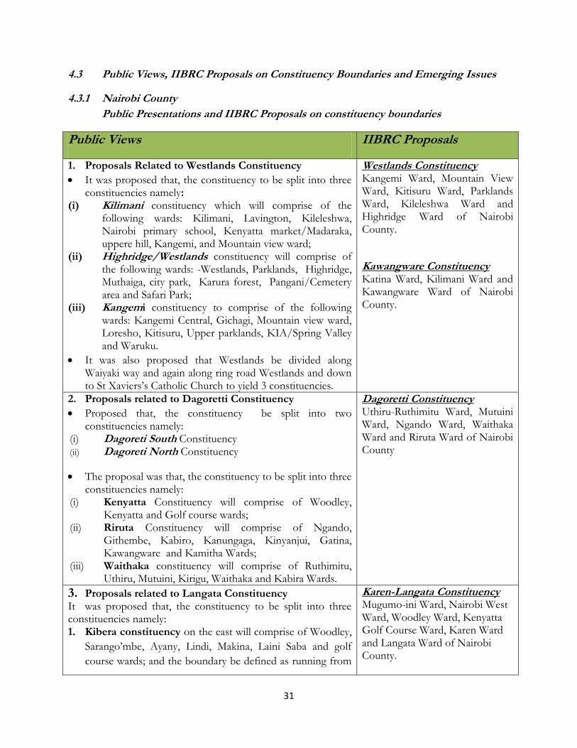
4.3 Public Views, IIBRC Proposals on Constituency Boundaries and Emerging Issues
4.3.1 Nairobi County
Public Presentations and IIBRC Proposals on constituency boundaries
Public Views IIBRC Proposals
1. Proposals Related to Westlands Constituency
It was proposed that, the constituency to be split into three constituencies namely:
(i) Kilimani constituency which will comprise of the following wards: Kilimani, Lavington, Kileleshwa, Nairobi primary school, Kenyatta market/Madaraka, uppere hill, Kangemi, and Mountain view ward;
(ii) Highridge/Westlands constituency will comprise of the following wards: -Westlands, Parklands, Highridge, Muthaiga, city park, Karura forest, Pangani/Cemetery area and Safari Park;
(iii) Kangemi constituency to comprise of the following wards: Kangemi Central, Gichagi, Mountain view ward, Loresho, Kitisuru, Upper parklands, KIA/Spring Valley and Waruku.
It was also proposed that Westlands be divided along Waiyaki way and again along ring road Westlands and down to St Xaviers’s Catholic Church to yield 3 constituencies.
Westlands Constituency Kangemi Ward, Mountain View Ward, Kitisuru Ward, Parklands Ward, Kileleshwa Ward and Highridge Ward of Nairobi County.
Kawangware Constituency Katina Ward, Kilimani Ward and Kawangware Ward of Nairobi County.
2. Proposals related to Dagoretti Constituency
Proposed that, the constituency be split into two constituencies namely:
(i) Dagoreti South Constituency (ii) Dagoreti North Constituency
The proposal was that, the constituency to be split into three constituencies namely:
(i) Kenyatta Constituency will comprise of Woodley, Kenyatta and Golf course wards;
(ii) Riruta Constituency will comprise of Ngando, Githembe, Kabiro, Kanungaga, Kinyanjui, Gatina, Kawangware and Kamitha Wards;
(iii) Waithaka constituency will comprise of Ruthimitu, Uthiru, Mutuini, Kirigu, Waithaka and Kabira Wards.
Dagoretti Constituency Uthiru-Ruthimitu Ward, Mutuini Ward, Ngando Ward, Waithaka Ward and Riruta Ward of Nairobi County
3. Proposals related to Langata Constituency It was proposed that, the constituency to be split into three constituencies namely: 1. Kibera constituency on the east will comprise of Woodley,
Sarango’mbe, Ayany, Lindi, Makina, Laini Saba and golf
course wards; and the boundary be defined as running from
Karen-Langata Constituency Mugumo-ini Ward, Nairobi West Ward, Woodley Ward, Kenyatta Golf Course Ward, Karen Ward and Langata Ward of Nairobi County.
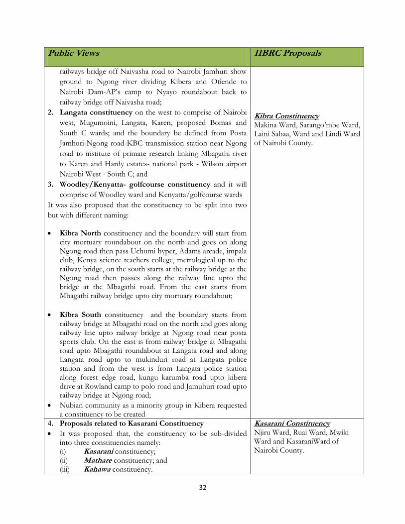
32
Public Views IIBRC Proposals
railways bridge off Naivasha road to Nairobi Jamhuri show
ground to Ngong river dividing Kibera and Otiende to
Nairobi Dam-AP’s camp to Nyayo roundabout back to
railway bridge off Naivasha road;
2. Langata constituency on the west to comprise of Nairobi
west, Mugumoini, Langata, Karen, proposed Bomas and
South C wards; and the boundary be defined from Posta
Jamhuri-Ngong road-KBC transmission station near Ngong
road to institute of primate research linking Mbagathi river
to Karen and Hardy estates- national park - Wilson airport
Nairobi West - South C; and
3. Woodley/Kenyatta- golfcourse constituency and it will
comprise of Woodley ward and Kenyatta/golfcourse wards
It was also proposed that the constituency to be split into two
but with different naming:
Kibra North constituency and the boundary will start from city mortuary roundabout on the north and goes on along Ngong road then pass Uchumi hyper, Adams arcade, impala club, Kenya science teachers college, metrological up to the railway bridge, on the south starts at the railway bridge at the Ngong road then passes along the railway line upto the bridge at the Mbagathi road. From the east starts from Mbagathi railway bridge upto city mortuary roundabout;
Kibra South constituency and the boundary starts from railway bridge at Mbagathi road on the north and goes along railway line upto railway bridge at Ngong road near posta sports club. On the east is from railway bridge at Mbagathi road upto Mbagathi roundabout at Langata road and along Langata road upto to mukinduri road at Langata police station and from the west is from Langata police station along forest edge road, kungu karumba road upto kibera drive at Rowland camp to polo road and Jamuhuri road upto railway bridge at Ngong road;
Nubian community as a minority group in Kibera requested a constituency to be created
Kibra Constituency Makina Ward, Sarango’mbe Ward, Laini Sabaa, Ward and Lindi Ward of Nairobi County.
4. Proposals related to Kasarani Constituency
It was proposed that, the constituency to be sub-divided into three constituencies namely: (i) Kasarani constituency; (ii) Mathare constituency; and (iii) Kahawa constituency.
Kasarani Constituency Njiru Ward, Ruai Ward, Mwiki Ward and KasaraniWard of Nairobi County.

33
Public Views IIBRC Proposals
Kasarani constituency to comprise of Kasarani, Mwiki,
Lucky Summer, Ngomongo, Babadogo, Kariobangi and wards covering an area of 29.2 km2;
Mathare constituency to comprise of Mathare 4A/Utalii, Mathare North, Kariobangi, Kariobangi light industry and Korogocho wards covering an area of 29.6 km2;
Kahawa constituency to comprise of Kahawa West, Githurai, Zimmerman, Maziwa, Thome, Roysambu and Garden Estate wards covering an area of 33.8 km2;
Secondly, it was also proposed that, the constituency be split into two constituencies using Thika road as the boundary right from Muthaiga roundabout up to Githurai roundabout;
(i) Githurai constituency; (ii) Kasarani constituency; (iii) Githurai constituency to comprise of Kahawa
West, Githurai, Zimmerman, Maziwa, Thome, Roysambu and Garden Estate wards; and
(iv) Kasarani constituency to comprise of Kasarani, Mwiki, Mathare 4A , Utalii, Mathare North, Babadogo, Kariobangi and Korogocho wards;
Roysambu Constituency Roysambu Ward, Githurai Ward, Kahawa Ward of Nairobi County.
5. Proposals related to Starehe Constituency Proposals that starehe constituency be split into two constituencies namely:
a) Starehe Constituency will cover the following wards: Central East, Central West(new), Ngara East, Ngara West, Kariokor and Pangani (new) wards; and the boundary will run from Muranga road, Pangani road roundabout, forest road, museum hill roundabout, Uhuru highway up to the railway bridge then using railway boundary up to railway station, then HQs, then back to Haile Sellasie avenue, Pumwani road, Digo road, Meru road, Muratina road, Mathare river up to Muranga road;
b) Mathare Constituency will cover the following wards: Mathare, Hospital(new), Mabatini, Ngei(new), Huruma and Kiamaiko wards; and the boundary will run from Outering road, Gitathuru river up to Kiambu road then Muthaiga roundabout, Muranga road up to Mathare river down to Muratina road up to Juja road and then back to Outering road.
It was also proposed that alternatively, starehe be split into three constituencies namely::- (i) Starehe constituency to comprise of ngara east,
Starehe Constituency Central Ward, Kariokor Ward, Pumwani Ward, Ngara West Ward and Ngara East Ward of Nairobi County. Ruaraka Constituency Korogocho Ward, Mathare North Ward, Utalii Ward and Babadogo Ward of Nairobi County. Mathare Constituency Mathare Ward, Huruma Ward, Kia Maiko Ward and Mabatini Ward of Nairobi County.
34
Public Views IIBRC Proposals
ngara west, central, pangani and ziwani wards;
(ii) Mathare constituency to comprise of mathare,
mabatini, huruma, kiamako and mathare north
wards;
(iii) Nairobi central constituency
6. Proposals related to Embakazi Constituency It was proposed that, the constituency to be split into three constituencies namely: 1. Njiru constituency will cover the vast from Dandora, I -
IV wards, Kariobangi South, Njiru and Ruai wards; proposed Mowlem, Saika and Ngondo wards;
2. Kayole constituency will cover Umoja I, Umoja II, Kayole south, Savannah, Kayole North, and Kamarock wards; proposed Soweto, Kayole central wards;
3. Embakasi constituency will cover Kwa Njenga, Imara Daima, Airport and Mihango wards, proposed Mukuru Kwa Reuben, Pipeline, Utawala, Tassia and Kamulu wards;
Further, it was propsed that, the constituency to be split into four constituencies namely:
1. Dandora constituency will constitute Dandora 1, Dandora 2, Dandora 3, Dandora 4, Kariobangi south wards;
2. Umoja constituency will constitute Umoja 1, Umoja 2, Savannah, Kayole South and Komarock Wards;
3. Njiru constituency will constitute Njiru, Ruai, Kayole North, and Mihango Wards;
4. Embakasi constituency will constitute Embakasi, Kwa Njenga and Imara Daima Wards.
That, the three constituencies have there natural boundaries
of Kangundo road for Kayole; Njiru and Ngong river for
Kayole and Embakasi; however Njiru and Embakasi shall
border by Kangundo road after leaving Kayole at Ngong
river after Njiru;
Embakasi Constituency Imara Daima and Kwa Njenga Ward of Nairobi County Kariobangi Constituency Kariobangi North Ward, Dandora Area I Ward, Dandora Area II Ward, Dandora Area III Ward and Dandora Area IV Ward of Nairobi County. Kayole Constituency Komarock Ward, Kayole North Ward and Kayole South Ward of Nairobi County. Mihango Constituency Embakasi Ward, Savanna Ward and Mihango Ward of Nairobi County Umoja Constituency Umoja I Ward, Umoja II Ward, Kariobangi South Ward and Harambee Ward of Nairobi County.
7. Proposals related to Makadara constituency
The constituency be split into two constituencies namely:-
a) Makadara/Viwandani constituency to comprise of South B, Mbotela, Maringo, Hamza, Lumumba, viwandani and Harambee wards;
b) Nairobi South constituency to comprise of Hazina, Nairobi South, Land Mawe, Makongeni and Kaloleni wards;
Makadara Constituency Nairobi South Ward, Land Mawe Ward, Hamza- Lumumba Ward, Ofafa Ward, Viwandani Ward, Mbotela Ward and Makongeni Ward of Nairobi County.
35
Public Views IIBRC Proposals
The existing boundaries in the administrative units should remain and be used as the boundaries for the proposed sub-divisions of the constituency and Likoni road should be the boundary of the two constituencies.
8. Proposals related to Kamukunji Constituency
Option 1 The constituency be split into three constituencies namely:
(i) Eastleigh constituency, (ii) Pumwani constituency and (iii) Kamukunji constituency
Option 2 The constituency be split into two constituencies namely;
a) Eastleigh/Pumwani constituency to comprise of the following wards: Pumwani, bondeni, Carlifonia, Eastliegh South, Eastleigh North and Eastleigh Airbase wards;
b) Kamukunji constituency to comprise Kumukunji, Muthurwa, Shauri Moyo, Uhuru, Kimathi and Bahati wards;
Kamukunji Constituency Eastleigh North Ward, Eastleigh South Ward, Kimathi Ward, Muthurwa-Shauri Moyo, Uhuru Ward and Air Base Ward of Nairobi County.
(ii) IIBRC Proposed Map for Nairobi County
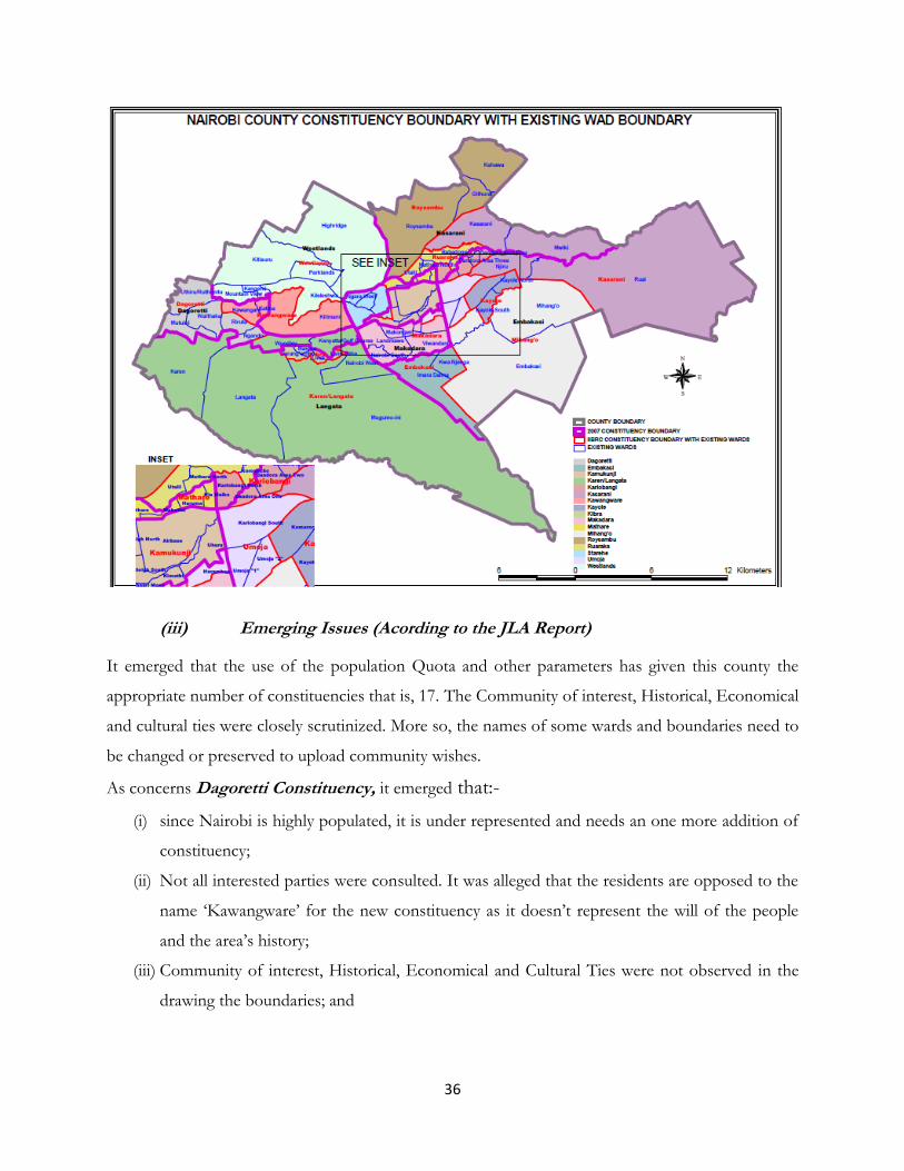
36
(iii) Emerging Issues (Acording to the JLA Report)
It emerged that the use of the population Quota and other parameters has given this county the
appropriate number of constituencies that is, 17. The Community of interest, Historical, Economical
and cultural ties were closely scrutinized. More so, the names of some wards and boundaries need to
be changed or preserved to upload community wishes.
As concerns Dagoretti Constituency, it emerged that:-
(i) since Nairobi is highly populated, it is under represented and needs an one more addition of
constituency;
(ii) Not all interested parties were consulted. It was alleged that the residents are opposed to the
name ‘Kawangware’ for the new constituency as it doesn’t represent the will of the people
and the area’s history;
(iii) Community of interest, Historical, Economical and Cultural Ties were not observed in the
drawing the boundaries; and

37
(iv) That the people also desire to retain Woodley ward in Dagoretti instead of moving it to
Kibra Constituency.
In relation to Embakasi constituency, it emerged that:-
The population quota was not well used in the sub-division of the constituency. It also emerged that
not all interested parties were consulted. The constituency should have been split into five
constituencies using the formula of quota + maximum deviation per constituency; hence giving
186,393 people per constituency, and divide the wards as proposed by the leaders and constituents.
4.3.2 Mombasa County
(i) Public Presentations and IIBRC Proposals on Constituency Boundaries
Public Views IIBRC Proposals
1. Proposals related to Changamwe Constituency
It was propsed that Changamwe constituency be split into two: o Changamwe Constituency (current) - Portreitz
Ward, Magongo Ward, Kipevu/chaani Ward, Airport Ward and Changamwe Ward;
o Jomvu constituency comprising of : Jomvu kuu Ward,
Iritini Ward, Mikindani Ward and Kwa Shee Ward
Changamwe Constituency Port Reitz Ward, Kipevu Ward, Airport Ward, and Miritini Ward of Mombasa County. Jomvu Constituency Jomvu Kuu Ward, Changamwe Ward, and Mikindani Ward of Mombasa County.
2. Proposals related Kisauni Constituency
The following 2 proposals were presented, first:
i. Kisauni Constituency (Follow Kisauni Division Boundary);
ii. Kongowea Constituency (Follow Kongowea Boundary);
iii. Bamburi constituency (Follow Bamburi Division Boundary);
Secondly, it was proposed that:
i. Mzizima Constituency – Boundary right from the
island part of the Makupa causeway starting from Jomo
Kenyatta Avenue upto Ronald Ngala Road Junction (77)
connecting to Sheikh Abdalla Farsy Avenue to coast and
turn right along Kisauni road connecting back with Jomo
Kenyatta Avenue going down to Digo road moving
straight down Nyerere avenue upto Likoni ferry bus
terminus;
ii. Kisauni Constituency will comprise of the remaining
part of the current Kisauni Constituency.
Kisauni Constituency Mjambere Ward, Junda Ward, Mwakirunge Ward and Bamburi Ward of Mombasa County
Nyali Constituency Shanzu Ward, Frere Town Ward, Maweni Ward, Nyali-Mkomani Ward, Kongowea Ward of Mombasa County.
3. Proposals related to Likoni Constituency Likoni Constituency Mtongwe Ward, Likoni Ward,

38
Public Views IIBRC Proposals
It was proposed that Likoni Constituency Remain as it is currently.
Bofu Ward, Timbwani Ward and Shika Adabu Ward of Mombasa County.
4. Proposals related to Mvita constituency The first proposal was to split the constituency (Island) into two as indicated below:
1. Mji Wa Kale constituency 2. Mvita Constituency
The second proposal was to plit the constituency into 3 as indicated, though the proposed names were not given;
Constituency 1: Kizingo, Old Town, Makadara, Mji wa kale,
Constituency 2: Tudor Estate ward, Tudor four ward, Shimanzi ward, King’orani
Constituency 3: Bondeni, Mwembe Tayari, Tononoka, Majengo
No specific names of these three constituencies were given.
Mvita Constituency Tudor Estate Ward, Tudor Four Ward, Shimanzi Ward, Tononoka
Ward, Majengo Ward, King‟orani Ward, Mwembe Tayari Ward, Bondeni Ward, Mji wa Kale-Makadara Ward, Kizingo Ward and Ganjoni Ward of Mombasa County.
(ii) IIBRC Proposed Map for Mombasa County
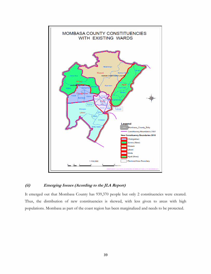
39
(ii) Emerging Issues (Acording to the JLA Report)
It emerged out that Mombasa County has 939,370 people but only 2 constituencies were created.
Thus, the distribution of new constituencies is skewed, with less given to areas with high
populations. Mombasa as part of the coast region has been marginalized and needs to be protected.
40
4.3.3 Kwale County
(i) Public Presentations and IIBRC Proposals
Public Views IIBRC Proposals
1. Prosposals given related to Msambweni Constituency
The proposal was to split the Constituency into two as indicated below:
Msambweni Constituency ( from River Mwachema to River Ramisi)- (it should include Msambweni, Mvumoni, Kinondo, Gombato, Ukunda, Kingwede shirazi wards);
Lunga Lunga Constituency (River Ramisi to Tanzania border) – to comprise of Pongwe Kidimu, Kikoneni, Dzombo, Kasemeni, Vanga, Kilimangondo and Mwena wards
Mackinon Road Ward should remain as part of Kinango District/Constiuency in the county council of Kwale and should NOT be moved to Voi municipality.
Msambweni Constituency Gombato-Bongwe Ward, Ukunda Ward, Kinondo Ward, Mivumoni Ward, Kikoneni Ward, Msambweni Ward, Kingwende-Shirazi, Ward and Pongwe-Kidimu Ward of Kwale County.
Lunga Lunga Constituency Vanga Ward, Kasemeni-Sega Ward, Mwena Ward and Kilima-Ngondo Ward and Dzombo Ward of Kwale County.
2. Proposals related to Matunga Constituency Proposed to create two constituencies:-
Matuga Constituency starting near Likoni upto Lunga Lunga.
Kubo constituency comprising Maluwamba, Mkongani, Mangawani, Lukore, Mwaluvanga and Mashimoni. Mkongani to be division Tiribe, Mkomba and Msangani.
Another proposal was that Kubo be divided into Ng’ombeni, Mbuguni, Waa, Tiwi, Simba and Golini to be Matuga Constituency. But if Simba and Golini is taken to Kubo Constituency it won’t be fine for the residents.
Matuga Constituency Mwalupamba Ward, Mkongani Ward, Mangawani Ward, Kubo South Ward, Mazumalume Ward, Mwamgunga Ward, Mbuguni Ng’ombeni Ward, Ngolini-Vyongwani Ward, Ziwani Ward, Waa Ward and Tiwi Ward, Vuga Ward, Kwale Ward of Kwale County
3. Proposals Related to Kinango Constituency Two proposals given:-
Maintain Status quo; or
Divide Kinango Constituency into two:- Kinango Constituency and Samburu Constituency.
Kinango Constituency Mackinnon Ward, Chengoni Ward, Samburu Ward, Vigurungani Ward, Mwavumbo Ward, Kasemeni West Ward, Mtaa Ward, Kinango Ward, Ndavaya Ward, Taru Ward, Makamini Ward, Puma Ward, Gandini Ward, Mwatate Ward and Kasemeni East Ward of Kwale County.
41
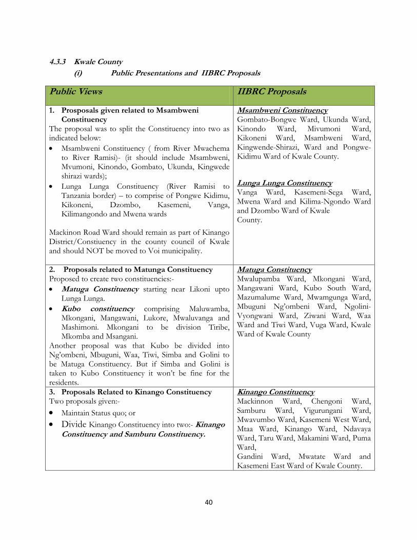
(ii) IIBRC Proposed Map for Kwale County
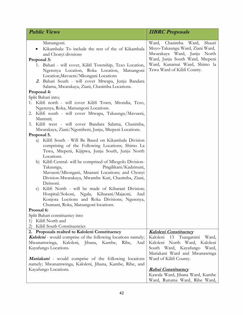
(ii) Emerging Issues (Acording to the JLA Report)
No major issue was raised against the IIBRC proposals.
4.3.4 Kilifi County
(i) Public Presentations and IIBRC Proposals on constituency boundaries
Public Views IIBRC Proposals
1. Proposals related to Bahari Constituency Six proposals came up from the presentations. Proposal 1: Split Bahari constituency into Bahari and Kikambala/Chonyi constituencies. Proposal 2:
Bahari - to stretch from Mbogolo River all the way to
Kilifi Constituency Matsangoni Ward, Roka Ward, Ngerenya Ward, Ngala Ward, Kibarani Ward, Hospital-Sokoni Ward of Kilifi County. Kilifi South Constituency Mnarani Ward, Mavueni-Mkongani
42
Public Views IIBRC Proposals
Matsangoni.
Kikambala: To include the rest of the of Kikambala and Chonyi divisions
Proposal 3: 1. Bahari - will cover, Kilifi Township, Tezo Location,
Ngerenya Location, Roka Location, Matsangoni Location,Mavueni/Mkongani Locations
2. Bahari South - will cover Mtwapa, Junju Bandara Salama, Mwarakaya, Ziani, Chasimba Locations.
Proposal 4: Split Bahari into; 1. Kilifi north - will cover Kilifi Town, Mtondia, Tezo,
Ngerenya, Roka, Matsangoni Locations. 2. Kilifi south - will cover Mtwapa, Takaungu/Mavueni,
Manrani; 3. Kilifi west - will cover Bandara Salama, Chasimba,
Mwarakaya, Ziani/Ngombeni, Junju, Mtepeni Locations. Proposal 5.
a) Kilifi South - Will Be Based on Kikambala Division comprising of the Following Locations; Shimo La Tewa, Mtepeni, Kijipwa, Junju South, Junju North Locations.
b) Kilifi Central- will be comprised of Mbogolo Division- Takaungu, Pingilikani/Kadzinuni, Mavueni/Mkongani, Mnarani Locations; and Chonyi Division-Mwarakaya, Mwambe Kati, Chasimba, Ziani, Dzitsoni.
c) Kilifi North - will be made of Kibarani Division; Hospital/Sokoni, Ngala, Kibarani/Majaoni, And Konjora Loctions and Roka Divisions; Ngerenya, Chumani, Roka, Matsangoni locations.
Proosal 6: Split Bahari constituency into 1) Kilifi North and 2) Kilifi South Constituencies
Ward, Chasimba Ward, Shauri Moyo-Takaungu Ward, Ziani Ward, Mwarakaya Ward, Junju North Ward, Junju South Ward, Mtepeni Ward, Kanamai Ward, Shimo la Tewa Ward of Kilifi County.
2. Proposals realted to Kaloleni Constituency Kaloleni - would comprise of the following locations namely; Mwanamwinga, Kaloleni, Jibana, Kambe, Ribe, And Kayafungo Locations. Mariakani - would comprise of the following locations namely; Mwanamwinga, Kaloleni, Jibana, Kambe, Ribe, and Kayafungo Locations.
Kaloleni Constituency Kaloleni 13 Tsangatsini Ward, Kaloleni North Ward, Kaloleni South Ward, Kayafungo Ward, Mariakani Ward and Mwanawinga Ward of Kilifi County. Rabai Constituency Kawala Ward, Jibana Ward, Kambe Ward, Ruruma Ward, Ribe Ward,

43
Public Views IIBRC Proposals
Kaliang‟ombe Ward, Mugumo-wa- Patsa Ward, Rabai Part Ward and Mwaweza Ward of Kilifi County.
3. Proposals related to Ganze Constituency
The following proposal was presented:-
Split the current Ganze constituency into; a) Vitengeni Constituency - will cover the following
locations, Mitangoni, Ndigiria, Bandari, Mrima Wa Ndege, Vitengeni, Dungicha, Mwahera, Sokoke and Dida Locations and;
b) Ganze constituency - be composed of Kauma, Vyambani, jaribuni, Ganze, Bamba, palakumi, Mtsara wa tsatsu, Mitangoni locations.
That the Jaribuni ward, be retained in Ganze Constituency.
Solution of disputes in Kauma Jaribuni wards, and in Mwahera location.
Ganze Constituency Mitanganyi Ward, Dungicha-Ganze
Ward, Vitengeni Ward, Sokoke Ward, Mrima wa Ndege Ward, Kauma-Jaribuni Ward, Bamba Ward, Mwahera Ward, Ndigiria-Bandari Ward and Palakumi Ward of Kilifi County.
4. Proposal related to Malindi Constituency Proposal 1:
Proposed to split Malindi constituency into Malindi Constituency and Galana Constituencies;
Proposal 2:
Merge the Malindi and Magarini constituencies then split them into:-
i. Malindi constituency; ii. Galana Constituency; and iii. Magarini Constituency
The residents wanted the constituency split into two; Malindi and Galana constituency. There was however a variation in the naming of the wards.
Another option was to merge the existing two constituencies i.e. Malindi and Magarini then split them into three constituencies.
Malindi Constituency Chakama Ward, Lango Baya Ward, Madunguni Ward, Malimo Ward, Jilore Ward, Gede South Ward, Gede North Ward, Gede Ward, Maweni Ward, Ganda-Mkaomoto Ward, and Watamu Town Ward, Malindi North Ward, Malindi Central Ward, Shella Ward, Kijiwetanga Ward and Barani Ward of Kilifi County.
5. Proposal related to Magarini Constituency
No proposals were presented.
Magarini Constituency Adu Ward, Bungale Ward, Marafa Ward, Garashi Ward, Dagamra Ward, Fundi-Issa Ward, Gongoni Ward, Magarini West Ward, Magarini East Ward and Marereni Ward of Kilifi County.
(ii) IIBRC Proposed Map for Kilifi County

44
(ii) Emerging Issues (Acording to the JLA Report)

45
No major emerging issue came as concerns the IIBRC boundary proposals and names for the new
constituencies.
4.3.5 Tana River County
(i) Public Presentations and IIBRC Proposals on Constituency Boundaries
Public Views IIBRC Proposals
1.Proposals related to Garsen Constituency
It was proposed that Garsen constituency be split to: (1) Chaffa constituency- Comprised of Galiai, Kipao and
Kilelengwani; and (2) Garsen constituency
All locations to be granted their electoral autonomy
Garsen Constituency Kipini East Ward,Kipini West Ward, Shirikisho Ward, Assa Ward, Salama-Mwina Ward, Ndera Ward, Bilisa Ward, Garsen Central Ward, Garsen South Ward of Tana River County.
2. Proposals related to Galole Constituency Proposal 1:
Hive parts of Galole and Garsen Constituencies to create a new one as indicated below:
Proposed Gale Dertu Constituency: (To cover all areas on the western part of Galole and Assa, Waldena, Wayu, Chifiri, kalikacha Locations of Garsen Constituency);
Proposal 2:
Split Galole Constituency to create Wenje Constituency
Galole Constituency Zubaki-Mikinduni Ward, Milalulu
Ward, Wayu Ward, Waldena Ward,
Chifiri Ward, Chewani-Kiarukungu Ward, Gwano Ward, Ndura Ward, and
Kinakomba Ward of Tana River
County.
3. Proposals related to Bura Constituency Split the Constituency into two as indicated below: Proposals 1: Bura (Comprised of Hirimani Divisions) Madogo (Comprised of Mbalambala and Nanighi Divisions) Proposal 2: Split into two as follows:
Duresa (Comprised of Hirimani, Bangale Kamaguru Locations)
Bura (Comprised of Bura, Nanighi, Madogo, Mbalambala Locations);
Boundary between Bura and Madogo Constituencies to start from Mbalambala to Chwele following the existing divisional and Locational boundaries. Support quest for sisterconstituencies of Garsen and Galole to be split.
Bura Constituency Chewele Ward, Bura Ward, Nanighi Ward, Hirimani Ward, Madogo South Ward, Sala Ward, Saka Ward, Bangale Ward, Kamaguru Ward, and Mbalambala Ward of Tana River District.

46
(ii) IIBRC Proposed Map for Tana River County
(ii) Emerging Issues (Acording to the JLA Report)
No major issue was raised as concerns the proposed boundaries by IIBRC for the Tana River
County.

47
4.3.6 Lamu County
(i) Public Presentations and IIBRC Proposals on Constituency Boundaries
Public Views IIBRC Proposals
1. Proposals related to Lamu East Constituency It was proposed that two constituencies be created:
i. Lamu East constituency- Include Kisiwa cha Pate, ndau and Kiwayuu; and
ii. Barani constituency- Include Kililana, Magogoni, Kiangwi, Mangai, Baasuba , Barigoni, Milimani, Mkononi, Mvunduni, Rubu, Sendeni, Marereni, Kiunga, Ishakani upto Somali boarder.
Lamu East Constituency Faza-Tchundwa Ward, Ndau Ward, Siyu-Pate Ward, Kizingitini West Ward, Kiunga Ward and Basuba Ward of Lamu County.
2. Proposals related to Lamu West Constituency Proposal 1: The status quo be maintained i.e boundaries remain as they are currently. Proposal 2: Split Lamu West constituency into:
Lamu Central constituency- Cover Hindu and the proposed Langoni and Mkomani Divisions
Lamu west constituency – Cover Witu, Mpeketoni and the proposed Mkunumbi divisions
Proposed the creation of a special ward in Lamu Couty council for the marginalized Boni Minority ethnic community. It should include Bargoni, Ndununi. It is proposed Boni ward should be created for BonislBajuni
Lamu West Constituency Hindi-Magogoni Ward, Kiongwe Ward, Mokowe Ward, Mkomani-Matondoni Ward, Langoni Ward, Mapenya Ward, Hongwe Ward, Shella Manda Ward, Central Ward, Mkunumbi Ward, Baharini Ward, Dide Waride Ward and Witu Ward of Lamu County.
(ii) IIBRC Proposed Map for Lamu County
48
(ii) Emerging Issues (Acording to the JLA Report)
Issues that came up were general in nature referring to all islands in the Indian Ocean and Lake
Victoria. It was argued that Geographical features are spread out in large areas separated by water
bodies. Secondly that Community of interest, historical, Economic and cultural ties were not
considered in the first review and lastly that these areas are difficulty to access.
4.3.7 Taita Taveta County
(i) Public Presentations and IIBRC Proposals on Constituency Boundaries
Public Views IIBRC Proposals
1. Proposals related to Taveta Constituency
No proposals on the electoral boundaries given
Taveta Constituency Chala-Njukini Ward, Mboghoni Ward, Taveta North Ward, Taveta South Ward, Kitobo-Kimorigho Ward, Mahoo Ward

49
Public Views IIBRC Proposals
and Mata Ward of Taita-Taveta County.
2. Proposals related to Wundanyi constituency
No Proposals submitted
Wundanyi constituency Wundanyi Ward, Werugha Ward, Wumingu-Kishushe Ward, Mbale Ward, and Mwanda-Mghange Ward of Taita-Taveta County.
3. Proposals related to Mwatate Constituency
The proposal was to split the Constituency into two as indicated below:
i. Ronge (To follow; Mwakishalua, Vigegu kwa Kena ya mwafuali, Ronge Nyika water intake, Zungula Juu, mnyichi Kishamba mbumbunyi, kanisa Morice, Kungu, ngerenyi, Mwafungu S.S, Chawia mruru, Mwatate Stage, Peleleza road, mwatate S. Estate, Mgeno, Nanak quarry, Makajini, Voi River, Kirutai, Ingoja ng’ombe, Voi, kwa mwakishalua; and
ii. Mwatate.
Mwatate Constituency Bura Ward, Mwatate Ward, Kighononyi
Ward, Chawia-Kishamba Ward, Ron‟ge
Kati Ward, Rong‟e Juu Ward, Maktau Ward and Mwachabo Ward of Taita-Taveta County.
4. Proposals related to voi Constituency Proposal 1.
Split Voi constituency to form Voi Town constituency and
Voi constituency. Proposal 2
Split Voi constituency to form Voi Town constituency- to cover area of Voi municipal jurisdiction including Kirutai, Voi west, Voi central, and Voi North East ward Voi Rural Constituency- Cover Mbololo, Ngalia, Maungu, and Kasiagu.
Proposal 3
Split Voi constituency to form Voi west constituency to comprise of Mwambirwa and Tausa Divisions and parts of Rong’e Kati proceeding from Mtito Andei based on the 1963 demarcations, going west to Ngulia Safari lodge, Southwards up to Mtwa-Mwagoti following Msau River, through Voi Municipality up to Tsavo National Park at Sala Gate; and
Voi East Constituency to comprise of Parts of Voi Municipality and Sagalla.
Proposal 4
Split Voi constituency to: a) Taita central b) Taita East
Voi Constituency
Voi Central Ward, Mbololo Ward, Sagala Ward, Ngolia Ward, Kasigau Ward, Voi South Ward, Voi North East Ward, Voi West Ward, Kirutai Ward and Marungu Ward of Taita-Taveta County.

50
Public Views IIBRC Proposals
Proposal 5
New Tausa constituency to be curved from Tausa and Mwambirwa (from Voi constituency and Mwatete division of Mwatate constituency and Paranga which is in Wundanyi Constituency;
Proposal 6
Remain as it is
(ii) IIBRC Proposed Map for Taita Taveta County
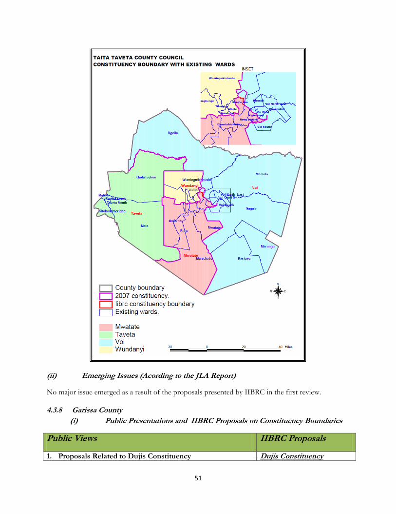
51
(ii) Emerging Issues (Acording to the JLA Report)
No major issue emerged as a result of the proposals presented by IIBRC in the first review.
4.3.8 Garissa County
(i) Public Presentations and IIBRC Proposals on Constituency Boundaries
Public Views IIBRC Proposals
1. Proposals Related to Dujis Constituency Dujis Constituency

52
Public Views IIBRC Proposals
Four proposals were made as follows: i). To split the constituency plit into two, Dujis and Garissa
Central Constituencies. ii). To split Dujis into Dujis and Garissa North Constituencies iii). To split Dujis into Garissa and Garissa South
Constituencies iv). To split Dujis into Garissa Town (or south) and
Balambala constituency and for Balambala constituency to be composed of Mbalabala division, Danyere division and the proposed Saka Division; while the former Dujis constituency will be comprised of Central Division which includes Garissa Municipality, Korakora Division and Sankuri Division
On the wards, the following proposals were made; i). Wards for proposed Garissa central constituencies:Biashara
Ward, Mashambani, Stadium, Sambul-Garissa Municipal;Garissa County Council-Boralgi, Korkora, Fafi, Yumbis, Hagardera, Welmerer, Jarajilla
ii). Wards for Garissa North: Garissa Municipal- Market Ward, Bulla Ward, Jamhuri Ward, Garissa Ndogo, Garissa County Council- Sankuri, Saka Ward, Balambala Ward, Danyere, Shimbireye;
(iii) Wards for Garisaa South : Garissa Municipal Council; Market Ward, Bulla Ward, Jamhuri Ward, Garissa Ndogo,Garissa County Council; Sankuri Ward, Saka Ward, Balambala Ward, Danyere Ward, Shimbireye Ward;
(iv) Garissa Municipal Council; Biashara Ward, Mashambani Ward, Stadium Ward, Sambul Ward,Garrisa Couty Council; Bor’algi, Korkora Wards, Galmagalla, Bullagolol, Bura, Mansabubu, Nanighi, Kamuthe, Warabe;
(v) Sambul ward to be calved from Stadium Ward, Kamuthe; (vi) Maendeleo Ward Added to Garissa Municipal Council.
Biashara Ward, Bulla Ward, Jamuhuri Ward, Market Ward, Mashambani Ward, Stadium Ward, Sankuri/Raya Ward, Kora kora Ward, Shimbirey Ward, Bouralgi and Ward.
Balambala Constituency Balambala Ward, Danyere Ward, Jarajilla Ward and Saka Ward of Garissa County.
2. Proposals Related to Lagdera Constituency
Two proposals were made : i). Lagdera constituency to be split into:Lagdera constituency
and Dujis constituency;
ii). Lagdera constituency to be split into:Lagdera East constituency- Comprised of Garufa, Baraki, Goreale, Kumahumato, Labisigale, Dagahaley, Dadaab, Abakile, Alango Arba, Dertu,Kulan Liboi, Damajale locations and Lagdera West constituency- Comprised of Madogashe, Ilan, Maalimin, Eldere,Tokojo, Benane Locations
Lagdera Constituency Benane Ward, Modogashe Ward, Maalim Ward, Gurufa Ward, Baraki Ward and Shanta-Abak Ward.
Daadab Constituency Dertu Ward, Abakaile Ward, Kumahumato Ward, Dadaab Ward, Labisigale Ward, Dagahley Ward, Damajale Ward and Liboi Ward of Garissa County.
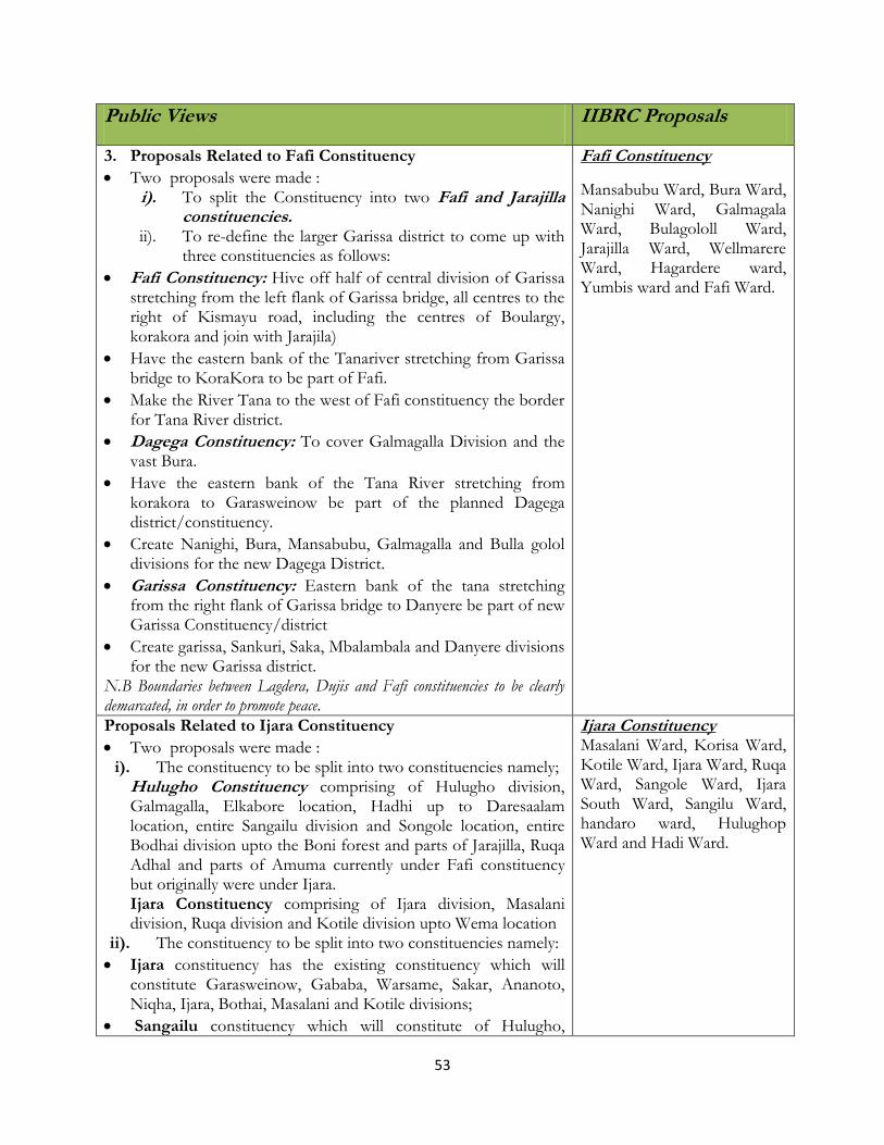
53
Public Views IIBRC Proposals
3. Proposals Related to Fafi Constituency
Two proposals were made : i). To split the Constituency into two Fafi and Jarajilla
constituencies. ii). To re-define the larger Garissa district to come up with
three constituencies as follows:
Fafi Constituency: Hive off half of central division of Garissa stretching from the left flank of Garissa bridge, all centres to the right of Kismayu road, including the centres of Boulargy, korakora and join with Jarajila)
Have the eastern bank of the Tanariver stretching from Garissa bridge to KoraKora to be part of Fafi.
Make the River Tana to the west of Fafi constituency the border for Tana River district.
Dagega Constituency: To cover Galmagalla Division and the vast Bura.
Have the eastern bank of the Tana River stretching from korakora to Garasweinow be part of the planned Dagega district/constituency.
Create Nanighi, Bura, Mansabubu, Galmagalla and Bulla golol divisions for the new Dagega District.
Garissa Constituency: Eastern bank of the tana stretching from the right flank of Garissa bridge to Danyere be part of new Garissa Constituency/district
Create garissa, Sankuri, Saka, Mbalambala and Danyere divisions for the new Garissa district.
N.B Boundaries between Lagdera, Dujis and Fafi constituencies to be clearly demarcated, in order to promote peace.
Fafi Constituency
Mansabubu Ward, Bura Ward, Nanighi Ward, Galmagala Ward, Bulagololl Ward, Jarajilla Ward, Wellmarere Ward, Hagardere ward, Yumbis ward and Fafi Ward.
Proposals Related to Ijara Constituency
Two proposals were made : i). The constituency to be split into two constituencies namely;
Hulugho Constituency comprising of Hulugho division, Galmagalla, Elkabore location, Hadhi up to Daresaalam location, entire Sangailu division and Songole location, entire Bodhai division upto the Boni forest and parts of Jarajilla, Ruqa Adhal and parts of Amuma currently under Fafi constituency but originally were under Ijara. Ijara Constituency comprising of Ijara division, Masalani division, Ruqa division and Kotile division upto Wema location
ii). The constituency to be split into two constituencies namely:
Ijara constituency has the existing constituency which will constitute Garasweinow, Gababa, Warsame, Sakar, Ananoto, Niqha, Ijara, Bothai, Masalani and Kotile divisions;
Sangailu constituency which will constitute of Hulugho,
Ijara Constituency Masalani Ward, Korisa Ward, Kotile Ward, Ijara Ward, Ruqa Ward, Sangole Ward, Ijara South Ward, Sangilu Ward, handaro ward, Hulughop Ward and Hadi Ward.

54
Public Views IIBRC Proposals
Galma Galla and Amuma Divisions,
(ii) IIBRC Proposed Map for Garisa County
(ii) Emerging Issues (Acording to the JLA Report)
a) Ijara Constituency
It was observed that there was discrimination of small clans. The big clans each have a constituency
while small clans have only one between them. There was concern over means of communication
with poor road network in the constituency. Further there is a minority group (the Boni and

55
Abdulla) who have no representation. It was claimed that the historical ties of Abdulla community
were ignored. It was also observed that the boundary between North Eastern province and Coast
province need to be addressed. And lastly, the Geographical features such as a major river running
through the constituency was not considered. The population of 92,000 in an area of 11,323 sq Km.
should have warranted a extra constituency.
b) Fafi Constituency
An issue was raised concerning the boundaries between Fafi and Ijara.
c) Dujis Constituency
An observation was made that IIBRC did not take into account the geographical features in the
constituency. Further, the Formula used to come up with protected constituency was termed as
unclear. North Eastern Province did not have a protected constituency. Commission did not use all
parameters provide in Article 89 of the Constitution. It only applied the population quota.
4.3.9 Wajir County
(i) Public Presentations and IIBRC Proposals on Constituency Boundaries
Public Views IIBRC Proposals
1. Proposals Related to Wajir North Constituency
Three proposals were made : i). For the Constituency to remain the same
ii). To split Wajir North to Buna constituency and Bute constituency
iii). To split Wajir North to Eldas constituency and Wajir North constituency
On the wards, the following proposals were made: i). Batalu ward (Follow Butala location wards)Bute – to
cover Bute, Bute Goda, and Makutano, ii). Ogorji- to cover Ogorji, Adadi Jole, and
Walensatutu, iii). Ajawa- to cover Ajawa location, iv). Gurar- to cover Gurar location, v). Danaba- to cover Danaba and Qudama locations, vi). Korondille- to over Korondille, vii). Buna- to cover Buna and Malkaggufu, viii). Ingirir-to cover Ingirir, Garsaakey and Chibder,
Lensayu- Cover Lensayu and Lakoole
Wajir North Constituency Buna Ward, Korondille Ward,
Lensayu Ward, Batalu ward, Bute
Ward, Danaba ward, Ajawa Ward,
Godoma Ward and Gurara Ward.
2. Proposals Related to Wajir West Constituency
Two proposals were made :
Wajir West Constituency Griftu Part (Griftu Township,

56
Public Views IIBRC Proposals
i). Split Wajir West Constituency to Eldas constituency(maintain the current Eldas district boundaries) and Wajir West constituency (maintain the current Wajir West district District boundaries);
ii). Split Wajir West Constituency to Hadado
constituency – comprising of Hadado and Adamasajida divisions;Griftu Constituency comprising of Griftu and Arbajahan and Eldas constituency comprising of Eldas, Anole and Elnur division
Ward Proposals Reinstate the following wards Lolakuta North, Barmish, Aden Awale, Boji Heri, Garse, Shanta Abaq, Kukale wards. Subdivision of Wagalla to Wagalla Central and North. Creation of Jira, Griftu Township, Griftu central, Baji, Mathow wards, Bojiyare
Matho,Fatuma Nur and Kurman Locations)Ward, Tulatula Ward, Wagalla Ward, Logbogol North Ward, Boji Heri-Garse Ward, Ganyure Ward, Hadado Ward,Ademasajida Ward, Arbjahan Ward and Athibohol Ward. Eldas Constituency Griftu Part (Balatul Amin, Biad and El Yunis Locations) Ward, Eldas Ward, Lakoley South Ward, Dela Ward, El Nur Ward and Basir Ward of Wajir County.
3. Proposals Related to Wajir East Constituency It was proposed t split Wajir East Constituency into:
Tarbaj constituency- Comprising of Tarbaj, Mansa, Sarman and Kutulo division; and
Wajir East Constituency- Comprising of Central, Wajir-Bor and Khorof Divisions.
The following wards were proposed under this proposal.
◦ Ali Maow Comprising Maow and Hodhan location;
◦ Halane – Comprising Halane and Godade location;
◦ Airport – Comprising of Maalim salat, Elmi sub location;
◦ Wajir air port, Wajir pri and sec sch, Ministry of water camp and Wajir district Hospital;
◦ Kotulo wards consisting of Kotulo and Boji Garas locations;
◦ Mansa ward consisting of Mansa and Ogoralle locations; and
◦ Gunana wards- Constiting of Gunana and Burmayo locations
It was also prposed to split wajir East Constituency into: (i) Wajir East Constituency comprising of the entire Mansa
division, Kutulo division and Tarbaj divisions; and
(ii) Wajir Central Constituency comprising of Central
Wajir East Constituency Township Ward, Wagberi ward, Jogbaru Ward, Barwako Ward, Wajir Bor Ward and Khorof-Harar Ward.
Tarbaji Constituency Tarbaj Ward, Dambas Ward, Sarman Ward Elben Ward, Wargadud Ward and Lafaley Ward of Wajir County.

57
Public Views IIBRC Proposals
Division, Wajir –Bor division and Khorof Harar divisions And the following wards were proposed under this option: Elben ward- Consisting of Elben and Mansa locations and Ogoralle ward- Consisting of Ogoralle and Bur Mayo locations.
4. Proposals Related to Wajir South Constituency
The constituency to be split into two constituencies namely: Habaswein constituency to be created out of the current constituency and it will constitute of Habaswein, Sabule, Benane divisions and Wajir South constituency which will constitute Diif, Wajir-Bor South and Kulaaley divisions.
The following wards to be created: Burder West, Burder East, Burder CentralLelehey, Shalekey, Wajir-Bor South, Gerilley, Hambalash, Argani, Salel Maa, Sarif, Dagahley, Meri, Kursi, Macheza, Tesorie, Habaswein Township
Wajir South Constituency Burder Ward, Diif Ward, Ibrahim
Ure Ward, Kulaaley Ward, Kibilai
Ward, Ndege Ward, Dilmanyale
Ward, Abakore Ward, Lag-Boghol
South Ward, Sabule Ward, Benane
Ward and Dadaja Bulla Ward.
(ii) IIBRC Proposed Map for Wajir County
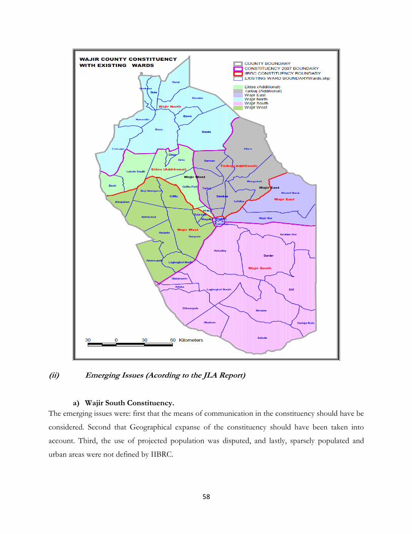
58
(ii) Emerging Issues (Acording to the JLA Report)
a) Wajir South Constituency.
The emerging issues were: first that the means of communication in the constituency should have be
considered. Second that Geographical expanse of the constituency should have been taken into
account. Third, the use of projected population was disputed, and lastly, sparsely populated and
urban areas were not defined by IIBRC.
59
b) Wajir East
It emerged that the expanse of the constituency was not considered. Second, the Census results were
used, and lastly. Minority of interest was not taken into consideration.
4.3.10 Mandera County
(i) Public Presentations and IIBRC Proposals on Constituency Boundaries
Public Views IIBRC Proposals
1. Proposals Related to Mandera West Constituency
The constituency to be split into two to produce: (i) Mandera North constituency to be curved out from the
current Mandera central and ;
(ii) Mandera West –will comprise of the current Rhamu-dimtu, Malkamari and Ashabito divisions.
Proposed Wards to be be created: Derkale South, Derkale North, Lulis , Banisa West, Eymole, Kiliwehuri, Goljo, Malka Mari, Guba, garsey, kalicha, shantoley, towfig, tulla doday, kubi, orgowein, sarman, gofa, hullow, makaruqu, choroqo.
Mandera West Constituency Takaba North Ward, Takaba South
Ward, Gither ward and Dandu
Ward.
Banisa Constituency Banisa Ward, Derkale Ward, Eymole Ward, Keliwe Hiri Ward, Malkamari Ward and Guba Ward of Mandera County.
2. Proposals Related to Mandera Central Constituency Proposal made:-
Split the Constituency into two:- (i) Mandera North Constituency (To cover Rhamu,
Rhamu Dimtu, Ashabito, Malkamari Divisions); and
(ii) Mandera Central Constituency (To cover Kutulo, Qalaqalesa, Elwak and Shimbir Fatuma Divisions)
Proposed Mandera North constituency to cater for the Degodia, Murule and Gareh communities;
Proposed constituency boundaries to follow the boundaries of the 2 districts in the current Mandera Central constituency;
Infrastructural conditions, Poor health care, poor food security and literacy levels key issues necessitating a split.
(iii) All the memoranda analyzed propose the creation of Mandera North Constituency as a matter of urgency and utmost necessity.
Mandera North Constituency Rhamu Ward, Girissa Ward,
Yabicho Ward Rhamu Dimtu
Ward, Ashabito Ward, Marothile
Ward, Guticha Ward, Shirshir
Ward, Ola Ward and Wargadud
Ward Part (Quramadow location)
of Mandera County.
Mandera South Constituency Elwak North Ward, Elwak South Ward, Wargadud Ward Part (Wargadud Town, Wargadud East Locations), Shimbir Fatuma Ward, Fincharo Ward, Kutulo North Ward, Kutulo Ward and Kutulo South of Mandera County.
Proposals related to Mandera East Constituency Mandera East Constituency

60
Public Views IIBRC Proposals
Several Proposals given:- Proposal 1. Split Mandera East constituency into:-
◦ Lafey constituency - will be based on Lafey Division, Warankara Division, Fino Location, Sala Location, Wargadud Ward, Dasheng Wante Ward);
◦ Mandera East constituencies Mandera east constituency will be based on Khalalio division, Central division, hareri division, Lebehia division, Arabia location and Omar-Jilaow location.
Proposal 2. Split Mandera East Constituency into:
Mandera central will be comprised of the following divisions. Kutulo, Elwak, Shimbir Fatuma, Qalaanqaleesa;
Mandera North will be composed of the following divisions; Wargadud, Rhmu, Rhamu Dimtu, Ashabito;
Mandera West will be comprised of the following divisions; takaba, Dandu, Gather;
Mandera east will be composed of the following divisions lafey, Finno, Waranqara, hareri, libahiya;
Daua constituency will have central mandera, and Khalalio divisions; and
Banisa constituency will consist of banissa malkamari,and kiliwe Hirri divisions.
Proposal 3 Split mandera east into Lafey Lafey constituency boundary will be Rhamu-Elwak road
on the western side from Dumiga Der to Elwak Town; Elwak Boru Hache Road as its southern boundary from Elwak, on the eastern side will be the Somali border.
Khalalio constituency
Proposal 5
Create Dawa Constituency The proposed Dawa constituency is to be curved from the Existing Mandera East Constituency and Khalalio and Central Divisions of Mandera East district.
Bulla Mpya Ward, Bulla Jamhuria Ward, B.P.1 Ward, Township Ward, Barwako Ward, Shafshefy Ward, Neboi Ward, Garba Goley Ward, Hareri Hosle Ward, Burabor Ward, Bella Ward, Kalalio Ward, Libehia Ward, Aressa Ward, Hareri Ward, and Arabia Ward of Mandera County.
Lafey Constituency Alango Ward, Lafey Ward, Warankara Ward, Fino Ward and Sala Ward of Mandera County.
(ii) IIBRC Proposed Map for Mandera County

61
(ii) Emerging Issues (Acording to the JLA Report)
There was need for more constituencies based on geographical features.

62
4.3.11 Marsabit County
(i) Public Presentations and IIBRC Proposals on Constituency Boundaries
Public Views IIBRC Proposals
1. Proposals related to Moyale Constituency
Split the constituency into 2 as follows: 1. Moyale Constituency 2. Sololo Constituency
The boundaries of the above constituencies should follow
their current respective district boundaries.
Moyale Constituency Galole Ward, Gurumesa Ward, Manyatta Ward, Heillu Ward, Butinye Ward, Bori Ward, Uran Ward, Walda-Rawana Ward, Godoma Ward, Nana Ward, Sololo Ward, Sololo Makutano Ward, Odda Ward, Dabel Ward, Dambala – Fachana Ward and Moyale Ward of Marsabit County.
2. Proposals related to North Horr Constituency Proposal 1. Split the Constituency into three as indicated below:
1. Chalbi East (to comprise of Turbi Division and Maikona Location covering an area of 13,000 sq km.)
2. Chalbi North (Comprising Dukana diviwsion and Hurri Hills Location of Maikona division covering an area of 14, 000 sq km); and
3. Chalbi West (comprising of North Horr Division and kalacha location of Maikona division covering an area of 13,000 sq km)
Proposal 2. Split the Constituency into two as indicated below:
1. North Horr (Comprising of North Horr and Dukana Divisions);
2. Chalbi East (Comprising Maikona and Torbi Divisions)
North Horr Constituency Dukana Ward, North Horr Ward, Ileret Ward, Bubisa Ward, Balesa Ward, Ririba Ward, Galas Ward, Turbi Ward, Hurri Hills Ward, Maikona Ward and Kalacha Ward of Marsabit County.
3. Proposals related to Saku Constituency Curve some Locations from neighbouring North Horr
and Laisamis to add on the small sized Saku Constituency
Rename the constituency to MARSABIT constituency
Saku Constituency Mountain Ward, Sagante Ward, Karare Ward, Dakabaricha Ward, Dirib-Gombo Ward, Jarime Ward and Qilta Ward of Marsabit County.
4. Proposals related to Laisamis Constituency
Laisamis Constituency

63
Proposal 1. Split of Laisamis constituency:
Laisamis Constituency- Comprised of Loglogo, Laisamis, Merille amd ngurunit;
Hafare/Loiyangalani constituency- Comprised of Kargi, Korr, Mt. Kulal, South Horr and Loiyangalani locations.
Proposal 2. Split of Laisamis constituency to:
Marsabit South constituency- Comprise of Merille, Laisamis, Logologo, Ngurunit ilaut and Lontolio wards
Marsabit west constituency- Comprise of Korr, Kargi, South horr, Kulal and Loiyangalani, Balah wards
Logologo Ward, Korr Ward, Laisamis Ward, South Horr Ward, Mt. Kulal Ward, Loiyangalani Ward, Ngurunit Ward and Merille Ward of Marsabit County.
(ii) IIBRC Proposed Map for Marsabit County

64

65
(i) Emerging Issues (Acording to the JLA Report)
a) Moyale
It emerged that the population figures used to delineate were unreliable. The means of
communication in the region is poor and was not taken into consideration in the first review. Lastly,
the population deviation used is too low for sparsely populated.
b) North Horr
The constituency is the largest in the country in terms of size but has a population of only 75,596.
The means of communication should have been considered in the delimitation. It was alleged that
IIBRC failed to define sparsely populated, urban areas and cities. And lastly, the use of projected
population in determining boundaries was disputed since at the time of the census most people had
migrated to Somalia (sic) to look for pasture.
c) Laisamis
The expansiveness of the constituency was not taken into consideration. The community of interest
was not considered. There were unfair census results that were used to determine the population yet
some people were not reached due to poor road network. Lastly, there are insufficient wards in
Laisamis and the neighboring constituencies.
4.3.12 Isiolo County
(i) Public Presentations and IIBRC Proposals on Constituency Boundaries
Public Views IIBRC Proposals
1. Proposals related to Isiolo North Constituency
Proposal 1.
It was proposed that Isiolo North should remain intact.
But should it be divided, it will separate communities who have lived in here for a long time and know no other place.
Proposal 2 Isiolo North Constituency be divided into 2;
Isiolo North or Merti Constituency with its HQ at Merti and to encompass the Shaba Game reserve. The
Isiolo North Constituency Yamicha Ward, Malka Galla Ward, Korbesa Ward, Merti Ward, Bulesa Ward, Bisano-Biliqo Ward, Ngare Mara Ward, Burat Ward, Isiolo West Ward, Odha Ward Wabera Ward, Kiwanjani Ward, Bula Pesa Ward, Oldonyiro Ward and Kipsing Ward, of Isiolo County.

66
Public Views IIBRC Proposals
constituency shall comprise of Cherab Merti and Proposed Kom divisions;
Isiolo Central Constituency with its HQ in Isiolo town and to comprise of Buffallo-Springs game reserve. The constituency to comprise of Central, East, Oldonyiro divisions and the proposed Ngaremara Divison.
2. Proposals related to Isiolo South Constituency
Requested the split of Isiolo South on the basis that the Boranas have been marginalised for a long time, though the population is not large enough.
Proposal 2
Split Isiolo south into:-
Isiolo South (Rename Isiolo South to Garbatulla)and;
Sericho constituencies.
Isiolo South Constituency Kula Mawe Ward, Kinna Ward, Rapsu Ward, Malkadaka Ward, Garbatulla Ward, Garfarsa Ward, Madogashe Ward, Sericho Ward and Eresaboru Ward of Isiolo County.
(ii) IIBRC Proposed Map for Isiolo County

67
(ii) Emerging Issues (Acording to the JLA Report)
No emerging issues.
4.3.13 Meru County
(i) Public Presentations and IIBRC Proposals on Constituency Boundaries
Public Views IIBRC Proposals
1. Proposals related to Igembe South Constituency
Proposal 1. Split the constituency into:-
Igembe South and;
Igembe Central Constituencies. Kangeta and Kiengu divisions will be the basis for Igembe Central constituency while the other four divisions-Maua, Kanuni, Akachiu, Athiru Gaiti; will form Igembe south constituency.
Igembe South Constituency Kiegoi Ward, Maua East Ward, Stadium Ward, Maua South Ward, Giteretu Ward, Giteretu-Achenge Ward, Igembe South West Ward, Igembe South Ward and Igembe South East Ward of Meru County. Igembe Central Constituency

68
Public Views IIBRC Proposals
Proposal 2.
Split igembe South into:-
Igembe South and;
Igembe West Constituencies That igembe west will cover Kangeta and Kiengu divisions; while the proposed Igembe South Constituency will cover; Maua, Kanuni, Akachu, Athiru Gaiti divisions.
Igembe East ward, Maua North Ward, Maili Tatu Ward, Njia Ward, Kangeta Ward Akirang’ondu Ward, Athiru Rujine Ward and Kawiru of Meru County.
2. Proposals related to Igembe North Constituency
It was proposed that it should be split to get 2 more constituencies or at worst 1. Proposal 1. Split igembe North Constituency into
Laare Constituency and;
Mutuati constituency
That the proposed Laare constituency will comprise of Laare Division (Akirang’ondu, Antuambui, Ntunene locations); Ndoleli division (Athiru rujine, Kawiru locations). Mutuati constituency will comprise of Mutuati Division (Kabachi and Naathu Locations); Ndoleli division (Luciutu, A/Kiongo Locations)
Proposal 2. Split igembe North into:-
Igembe North and;
Igembe Central constituencies That the proposed Igembe North Constituency will be comprised of Kabachi, Naathi, and Luciuti Locations. That the proposed Igembe Central Constituency will comprise of Akirang’ondu, Antuambui, Ntunene Athiru Ruujine and Kawiru Locations.
Igembe North Constituency Antuambui Ward, Ntunenene Ward, Naathu Ward, Antubetwe Kiongo Ward, Amuathi II Ward and Amuathi I Ward of Meru County.
3. Proposals related to Tigania West Constituency
All the wards should revert to the old wards before the 2002 general election;
Tigania West Constituency Kianjai Ward, Mituntu Ward, Thinyaine-Nchoro Ward, Athwana-Rwanda Ward, Nkomo Ward, Kitheo Ward and Mbeu Ward of Meru County.
4. Proposals related to Tigania East Constituency Tigania East Constituency

69
Public Views IIBRC Proposals
Create a new consituency on the strength of expansiveness of the constituency and high population.
Proposal 1. Merge Tigania West and Tigania East and curve out an extra constituency Proposal 2. Tigania constituency to be split into: 1. Tigania North constituency- Comprise Karama and
Tigania North(Muthara) divisions; Tigania East constituency – Tigania central and Tigania East divisions Proposal 3. Tigania East and West boundaries to be adjusted to create
1. Tigania East constituency- Comprise Buuri, Muthara, Karama, Kigucwa, Ankamia, thangatha, Mikinduri East wards
2. Tigania West constituency- Comprise Mikinduri west, Mbeu, Kitheo, Uringu;
3. Tigania central constituency- Comprise Mituntu, Kianjai, Akithi, Rwanda/Athwana
Muthara Ward, Buuri Ward, Karama Ward, Kigucwa Ward, Ankamia Ward, Mikinduri East Ward, Mikinduri West Ward and Thangatha Ward of Meru County.
5. Proposals related to North Imenti Constituency
Proposal 1. Create Buuri Constituency
That Buuri constituency follow the boundary of the newly created Buuri district.
Proposal 2. Split North Imenti into:-Imenti North, Buuri East and Buuri West constituencies.
Imenti North constituency will cover Nyaki, Ntima, and meru municipality divisions.
Buuri east will cover naari, Kiirua, ruiri, Rwareera divisions and
Buuri west will comprise of Ontulili, Kirimaara, ngusishi and kisima Divisions.
Proposal 3. Timau, North imenti and Buuri constituency Proposal 4. Option 1:
North Imenti Constituency Thuura Ward, Giaki Ward, Nthimbiri Part Ward, Chugu Ward, Ntakira Part Ward, Nthimbiri Part Ward, Kaaga Ward, Ngakurumune Ward, Stadium Ward, Milimani Ward, Cathedral Ward, Central Ward, Commercial Ward, Hospital Ward and Mwendatu Ward of Meru County. Buuri Constituency Kibirichia Ward, Ntugi Ward, Naari Ward, Kiirua Ward, Ruiri Ward, Kirimara Ward, Kisima Ward and Ontulili Wards of Meru County.
70
Public Views IIBRC Proposals
Split Imenti North constituency into;
North Imenti and;
Ruguru constituencies. Option 2: Split the constituency into:-
Ruguru (composed of Buuri East and West Districts) and;
Gaiti (Comprised of the current North Imenti Constituency.
Proposal 5 Option 1
Imenti North,
Buuri,
Meru Urban(Municipality) Option 2
Buuri Imenti North as per present boundary
6. Proposals related to Central Imenti Constituency
It was proposed that since the population was high, it should be split. Proposal 1. Proposed that Imenti central to be split to: 1. Abothuguchi East Constituency- Comprised
Abothuguchi central, Abothuguchi East, Kiagu, Kiija (to be delineated from from current Kiagu division);
2. Central Imenti constituency Proposal 2. 1. Abothuguchi East constituency- Former Abothuguchi
East division; 2. Abothuguchi west constituency- former Abothuguchi
west division. Proposal 3. Imenti central to be split to: 1. Meru central west constituency and; 2. Meru central east constituency
Central Imenti Constituency Kiagu Ward, Uruku Ward, Kithirune Ward, Kibaranyaki Ward, Gatimbi Ward, Katheri Ward, Kariene Ward and Mwangathia Ward of Meru County.
7. Proposals related to South Imenti Constituency
Split the Constituency into two as indicated below: 1. Nkuene Constituency ( Comprising Nkuene &
South Imenti Constituency Mitunguu Ward, Mikumbune Ward, Igoki Ward, Kathera Ward, Mweru

71
Public Views IIBRC Proposals
Mitunguu Divisions); and 2. South Imenti Constituency (Abogeta West,
Abogeta East, Igoji East and Igoji West.
Ward, Karia Ward, Kanyakine Ward, Kinoro-Kianjogu Ward, Abogeta Ward, Kithangari Ward and Igoji Ward of Meru County.
(ii) IIBRC Proposed Map for Meru County
(ii) Emerging Issues (Acording to the JLA Report)
Imenti North.
The consultation was not all inclusive. Interested parties were not consulted widely hence moving to
wards from central Imenti to the newly created Buuri Constituency. This was against the
community’s wish. Some of the wards are not named correctly.

72
4.3.14 Tharaka Nithi
(i) Public Presentations and IIBRC Proposals on Constituency Boundaries
Public Views IIBRC Proposals
1. Proposals related to Nithi Constiuency
Nithi Constituency is the largest constituency in Eastern Province as per the 2007 registered voters with 123,972.
Proposal 1. Split the Constituency into two as indicated below:
1. Meru South Constituency: Comprising of Magumoni, Chuka, Mwonge, Mariani and Igambang’ombe Divisions;
2. Maara Constituency: Comprising of Mwimbi, Muthambi, Ganga, Chogoria and Mitheru divisions
Proposal 2. Split the Constituency into five as indicated below:
1. Igambang’ombe constituency: Comprising of Igambangombe Division
2. Chuka Constituency: Comprising of Chuka and Mariani Divisions
3. Magumoni constituency: Comprising of magumoni and Mwonge divisions
4. Muthambi Constituency: Comprising of Muthambi and Mitheru divisions Mwimbi Constituency: Comprising of Mwimbi, Chogoria, Ganga Divisions.
Proposal 3. Split the Constituency into three as indicated below: 1. Igambangombe Constituency:
Comprising of Igambangombe 2. Chuka Constituency: comprising of
Magumoni, chukka, Mwonge and Mariani Divisions;
3. Maara Constituency: comprising of Mwimbi, Muthambi, Ganga, Chogoria and Mitheru Divisions
Nithi Constituency Kiang’ondu Ward, Chuka East Ward, Muiru East Ward, Muiru West Ward, Mugirirwa East Ward, Mugirirwa West Ward, Mwoge Ward, Githarene Ward, Thuita Ward, Mukuuni Ward, Kamwinbi Ward, Kithangani-Mariani Ward and Kajuki Ward of Tharaka–Nithi County. Maara Constiuency Chogoria Ward, Kiraru Ward, Maara Ward, Kiera Ward, Ganga Ward, Murugi East Ward, Murugi West Ward, Muthambi Ward, Gitije ward and Mitheru Ward of Tharaka-Nithi County.
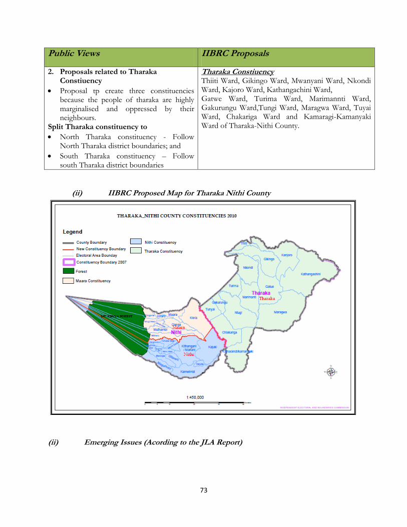
73
Public Views IIBRC Proposals
2. Proposals related to Tharaka Constiuency
Proposal tp create three constituencies because the people of tharaka are highly marginalised and oppressed by their neighbours.
Split Tharaka constituency to
North Tharaka constituency - Follow North Tharaka district boundaries; and
South Tharaka constituency – Follow south Tharaka district boundaries
Tharaka Constiuency Thiiti Ward, Gikingo Ward, Mwanyani Ward, Nkondi Ward, Kajoro Ward, Kathangachini Ward, Gatwe Ward, Turima Ward, Marimannti Ward, Gakurungu Ward,Tungi Ward, Maragwa Ward, Tuyai Ward, Chakariga Ward and Kamaragi-Kamanyaki Ward of Tharaka-Nithi County.
(ii) IIBRC Proposed Map for Tharaka Nithi County
(ii) Emerging Issues (Acording to the JLA Report)

74
4.3.15 Embu County
(i) Public Presentations and IIBRC Proposals on Constituency Boundaries
Public Views IIBRC Proposals
1. Proposals related to Manyatta Constituency
No major proposals
Manyatta Constituency Ngandori Ward, Nginda Ward, Ruguru Ward, Gaturi South Ward, Kithimu Ward, Njukiri Ward, Blue Valley Ward, Majengo Ward, Kamiu Ward, Matakari Ward, Kangaru Ward and Itabua Ward of Embu County.
2. Proposals related to Runyenjes Constituency
No major proposals
Runyenjes Constituency Nthangaiya Ward, Gaturi North Ward, Kagaari North East Ward, Kagaari North West Ward, Runyenjes Central Ward, Kieni North Ward, Kieni Urban Ward, Karurumo-Kigumo Ward of Embu County.
3. Proposals related to Gachoka Constituency
No major proposals
Gachoka Constituency Kiambere Ward, Kianjiru Ward, Mavuria Ward, Mbeti South Ward, Karaba Ward, Riakanau Ward and Makima Ward of Embu County.
4. Proposals related to Siakago Constituency
No major proposals
Siakago Constituency Ishiara Ward, Kanyuambora Ward, Kiangombe Ward, Ndurumori Ward, Nthawa Ward, Muminji Ward and Gituguri Ward of Embu County.
(ii) IIBRC Proposed Map for Embu County
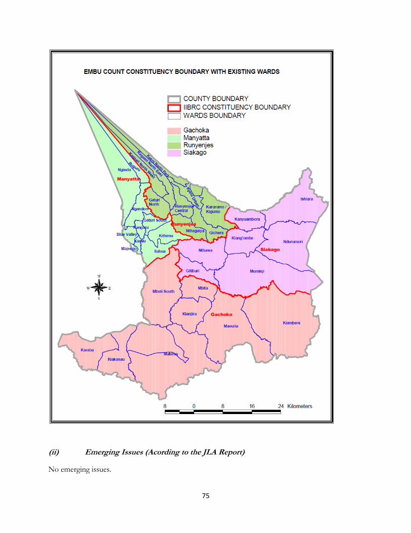
75
(ii) Emerging Issues (Acording to the JLA Report)
No emerging issues.

76
4.3.16 Kitui County
(i) Public Presentations and IIBRC Proposals on Constituency Boundaries
Public Views IIBRC Proposals
1. Proposals related to Mwingi North Constituency Option 1
Curve a third constituency from Mwingi South and
Mwingi North and name it Mwingi Central.
Mwingi North Constituency Tseikuru-Musavani Ward, Masyungwa Ward, Tharaka Ward, Mivukoni Ward, Kanthungu Ward, Kathe- Mtanda-Nguuku Ward, Ngomeni Ward, Kakuyu- Mkonga Ward, Kimangau Ward, Kyuso-Kamuwongo Ward and Mitamisyi Ward of Kitui
County.
Mwingi Central Constituency Waita-Endui Ward, Mwingi-Ithumbi Ward, Enziu-Kivou Ward, Kanzanzu Ward, Nguni Ward, Ukasi Ward, Kyethani-Kyomo Ward, Kavuvwani Ward and Mbuvu Ward of Kitui County.
2. Proposals related to Mwingi South Constituency Convert all the 6 districts into constituencies:- Kyuso,
Tseikuru, Mumoni, Mwingi East, Mwingi Central, Mwigwani
Mwingi South Constituency Wingemi Ward, Mutyangome Ward, Mui Ward, Katalwa-Nzeluni Ward, Nuu Ward, Kalitini Ward Kyome Ward, Migwani Ward, Nzauni Ward, Nguutani Ward, Thitani Ward, and
of Kitui County.
3. Proposals related to Kitui West Constituency Spilt the constituency into two constituencies:-
Kitui North; and
Lower Yatta.
Kitui West Constituency Kakeani-Mutonguni Ward, Katutu-Mutunda Ward, Kivani-Kauwi Ward, Kwa-Mutonga-Kathivo Ward, Kalimani-Matinyani-Mutulu Ward, Kithumula-Kauma Ward and Kwa Vonza Ward Yatta of Kitui County.
Kitui Rural Constituency Itoleka-Katulani Ward, Yatta-Ntonguni Ward, Kanyangi Ward, Kiseuni Ward, Maliku-Itoleka Ward, Kisasi Ward, Mbitini Ward and

77
Public Views IIBRC Proposals
Mbusiyani Ward of Kitui County
4. Proposals related to Kitui Central Constituency Proposed to split into three:-
Kitui Central
Mulango
Kisasi
Kitui Central Constituency Township Ward, Kyangwithya West Ward, Mulango Ward, Musengo-Usiani Ward, Miambani Ward, Kaveta Ward and Kyangwithya East Ward of Kitui County.
5. Proposals related to Mutito Constituency Proposals presented requested for a split to form two constituencies:-
Nzambani
Mtito
Mutito Constituency Kyanika Ward, Thua-Nzagathi-Ithumula Ward, Sombe Ward, Malalani-Endau Ward, Mwitika-Kyamatu Ward, Mutito-Kaliku Ward and Voo Ward of Kitui County.
6. Proposals related to Kitui South Constituency Proposed to split into two:-
Ikutha Constituency
Mutomo Constituency
Kitui South Constituency Ikanga Ward, Mutomo-Kibwea Ward, Mutha-Ndakani Ward, Maluma-Kalivu Ward, Kyatune Ward, Athi Ward, Kanziku-Simisi Ward, Mathima Ward and Ikutha-Kasala Ward of Kitui County.
(ii) IIBRC Proposed Map for Kitui County

78
(ii) Emerging Issues (Acording to the JLA Report)
a) Kitui South

79
The area is vast and covers 12.544sq.km with a population of 166,050. The Means of
communication are poor and this is characterized by a poor road network due to historical neglect
and vastness of the area. Based on the Population Quota, the constituency should be categorized as
sparsely populated since the population density is 13 people/sq km.
b) Mwingi South
The Means of communication are poor in the constituency. Consultations with all interested parties
were not adequately done. A new constituency, Mwingi Central was created in the middle of Mwingi
South, leaving two portions of Mwingi without a means of communication from the rest. The
boundaries need to be redrawn per the residents’ views.
4.3.17 Machakos County
(i) Public Presentations and IIBRC Proposals on Constituency Boundaries
Public Views IIBRC Proposals
1. Proposals related to Masinga Constituency
Requested a new constituency to be curved out of Masinga to take care of Ndithini Division.
Create Masinga constituency and Ndithini constituency
Masinga Constituency Masinga Ward, Kivaa Ward, Kithyoko Ward, Kangonde Ward, Ekalakala-Ikatini Ward, Mananja Ward, Ndithini Ward and Muthesyia Ward of Machakos County.
2. Proposals related to Yatta Constituency
Split Yatta into two due to its expansive nature and thus bring services closer to the people.
Form Yatta Constituency and Katangi Constituency.
Yatta Constituency Ndalani Ward, Kinyaata Ward, Katangi Ward, Ikombe Ward, Mavoloni Ward,Kakuumini-Central Ward, Katulani-Kaluluini Ward, Kithimani Ward, Kithendu Ward, Kyua Ward of Machakos County.
3. Proposals related to Kangundo Constituency
Split Kangundo into 2 due to high population and expansiveness.
This should create Kangundo Constituency and Matungulu Constituency
Kangundo Constituency Kangundo North Ward, Kangundo East Ward and Kangundo West Ward of Machakos County. Matungulu Constituency Matungulu North Ward, Matungulu West Ward and Matungulu East Ward of Machakos County.
4. Proposals related to Kathiani Constituency
To be split into two citing high population growth and influx of land buyers from neighbouring Nairobi. The boundary can be the Komarocks road.
Kathiani Constituency Mitaboni Ward, Mathunya Ward, Kathiani Ward, Kaewa Ward,Iveti Ward and Kaani Ward of Machakos County.

80
Public Views IIBRC Proposals
Create Kathiani and Athi River Constituency.
Mavoko Constituency Athi River North Ward, Katani Ward, Industrial-Station Ward, Makadara Ward, Sophia-Kenya Meat Ward, Kinanie-Mathatani Ward and Muthwani Ward of Machakos County.
5. Proposals related to Machakos Town Constituency Option 1
Split into two with the boundary being Mwania River up to Kyanzaasu to the East and Kapiti ranch along the railwayline to the west to form Machakos and Kalama Constituency
Option 2
Split into two to form Machakos Town South and Machakos Town north Constituencies.
Machakos Town Constituency Kalama-Kiyangala Ward,Muumandu-Kola Ward, Ngelani Ward, Kimutwa Ward, Kiima-Kimwe Ward, Mutituni Ward, Mua Ward, Mumbuni North Ward,Muumbuni South Ward, Katheka Kai Ward, Mjini Ward, Eastleigh Ward and Muvuti Ward of Machakos County.
6. Proposals related to Mwala Constituency
Mwala may not qualify to be split and can wait for the
next review. The residents of Mwala however stated that
they do not want any part of Mwala to be taken to any
other constituency.
Alternatively, if it split, then form Mwala Constituency and Yathui Constituency
Mwala Constituency Mbiuni Ward, Mwala Ward, Masii Ward, Vyulya Ward, Muthetheni Ward, Wamunyu Ward, Kibauni Ward, Makutano-Mango Ward, Kathama Ward, Miu Ward, Yathui Ward and Ikalaasa Ward of Machakos County.
(ii) IIBRC Proposed Map for Machakos County
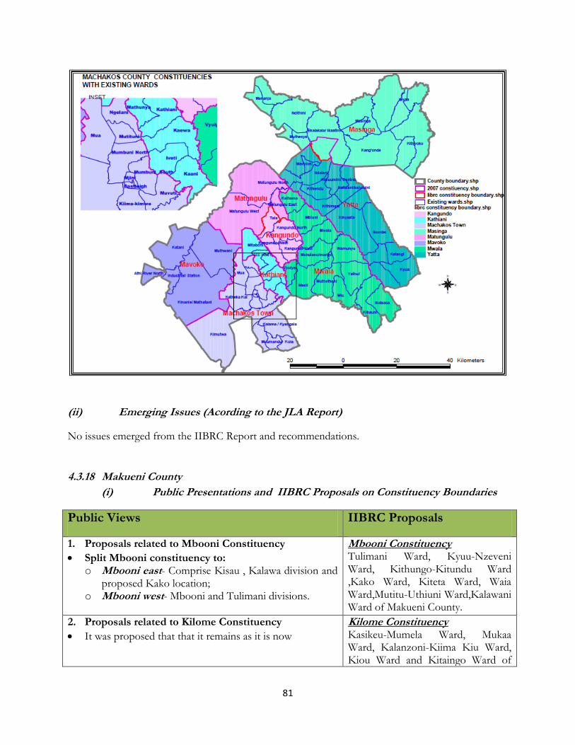
81
(ii) Emerging Issues (Acording to the JLA Report)
No issues emerged from the IIBRC Report and recommendations.
4.3.18 Makueni County
(i) Public Presentations and IIBRC Proposals on Constituency Boundaries
Public Views IIBRC Proposals
1. Proposals related to Mbooni Constituency
Split Mbooni constituency to: o Mbooni east- Comprise Kisau , Kalawa division and
proposed Kako location; o Mbooni west- Mbooni and Tulimani divisions.
Mbooni Constituency Tulimani Ward, Kyuu-Nzeveni Ward, Kithungo-Kitundu Ward ,Kako Ward, Kiteta Ward, Waia Ward,Mutitu-Uthiuni Ward,Kalawani Ward of Makueni County.
2. Proposals related to Kilome Constituency
It was proposed that that it remains as it is now
Kilome Constituency Kasikeu-Mumela Ward, Mukaa Ward, Kalanzoni-Kiima Kiu Ward, Kiou Ward and Kitaingo Ward of

82
Public Views IIBRC Proposals
Makueni County.
3. Proposals related to Kaiti Constituency That, the constituency to be split into two constituencies namely:
Kilungu constituency to cover Kithembe, Kilungu And Ilima divisions;
Kaiti constituency to cover Kaiti, Kee, Wote And Mumbuni divisions
Kaiti Constituency Kithembe Ward, Ukia-Iuani Ward, Watema-Kee-Kivani Ward, Kaumoni Ward, Kikoko Ward and Kilungu-Ilima Ward of Makueni County.
4. Proposals related to Makueni Constituency The constituency to be split into three constituencies namely: 1. Makueni constituency will cover the lower region
comprising of kathonzweni district and wote division and will cover the following wards wote, kikumini, muvau, nziu and the proposed Mumbuni, mwaani, kambi mawe wards;
2. Nzauni constituency which will cover the upper region comprising of the current nzaui district and will cover the following wards mbitini, mulala, kalamba, kilili, nguu and the proposed Wolwa, kyemundu, email, nzaui, ikangavya wards;
3. Manguu constituency which will constitute makindu division of kibwezi constituency and nguu division of makueni constituency and its centre will be in makindu town.
Makueni Constituency Mavindini Ward, Wote Ward, Muvau Ward, Kathonzweni Ward Kikumini Ward, Kanthuni-Kithuki Ward, Mbuvo-Kitise Ward and Nziu Ward of Makueni County.
5. Proposals related to Kibwezi Constituency Option 1 The constituency to be split into two constituencies namely:
Makindu constituency will constitute makindu district with makindu, nguumo, muuni and kavete divisions
Kibwezi constituency will constitute kibwezi district with kibwezi, machinery and mtito andei divisions;
Nb: the boundary should follow the current administrative units’ boundaries between the two districts Option 2 The constituency to be split into three constituencies namely:
Kibwezi west constituency to cover the old makindu, kikumbulyu, and kinyambu areas;
Kibwezi east constituency to cover masongaleni, utithi and mtito andei areas;
Manguu constituency which will constitute makindu division of kibwezi and nguu division of makueni
Kibwezi West Constituency Twaandu-Kiboko Ward, Kithumba- Kalamba ward, Makindu Ward, Nguu Ward, Nguumo Ward, Mbitini Ward, Nzaui-Kilili Ward, Mulala-Emali Ward, and Masumba Ward of Makueni County. Kibwezi East Constituency
Masongaleni Ward, Mtito Andei East Ward, Mtito Andei Ward, Kinyambu Ward Kikumbulyu South Ward, Kikumbulyu North Ward, Mtito Andei West Ward, Ivingoni-
Mang‟elete Ward, Kambu Ward, Kathekani-Darajani Ward and Kinyambu Ward of Makueni County.

83
(ii) IIBRC Proposed Map for Makueni County
(ii) Emerging Issues (Acording to the JLA Report)
a) Makueni Constituency.

84
It emerged that Community of interest, Historical, Economical and cultural ties were not considered
in dealing with Makueni Constituency proposals. The proposed boundaries for kibwezi West
Constituency and the shifting of Nzauni District to Kibwezi Constituency were created against
community wishes and will likely cause disharmony. The National Population Quota was not as used
since Makueni with a population of 224,613 and an area of 1,571.90 sq.km, it was not split while
other areas with less people were split.
4.3.19 Nyandarua County
(i) Public Presentations and IIBRC Proposals on Constituency Boundaries
Public Views IIBRC Proposals
1. Proposals Related to Kinagop Constituency
Proposals were made was to split the constituency into two to create:
i). South Kinangop (with 6wards) ii). North Kinangop (with 5wards)
The boundary should be along the escarpment
Kinangop Constituency Muraki Gathara Ward, Tulaga-Kamun
yaka Ward, Njabini Ward, Nyakio
ward, magumu Ward and Nyandarua
County.
2. Proposals Related to Kipipiri Constituency
No proposals were made.
Kipiriri Constituency Wanjohi Ward, Kipiriri Ward,
Lereshwa Ward, Geta Ward,Malewa
Ward, Kitiri-Kinja Ward, Mikaro-
Nandarasi-Mkungi Ward and
Murungaru Ward.
3. Proposals Related to Ol Kalau Constituency
Two proposals were put forward:
i). That the three operational districts of
Nyandarua West (Chamuka), Nyandarua
Central and Milangine to be made
constituencies.
ii). To split Olkalau into two, namely
a. Ol-Kalau Constituency (Comprising Dundori, Matindiri, Kanjuiri ridge, Munyeki, Kiambogo and Gichugo wards); and
b. Ol-Jorok Constituency (Comprising of Gatimu, Gathanji, Weru, Ol-Jorok, Rurii and
Ol Kalau Constituency Ol kalau Ward, Kaimbaga Ward, Gichungo Ward,and ol Kalau Central Ward. Ol-Jorok Constituency Kanjuiri Ridge Ward, Matindiri Ward, Dundori Ward, Ol Jorok Ward, Weru Ward,Gatimu Ward and Gathanji Ward of Nyandarua County.

85
Public Views IIBRC Proposals
Central wards)
On the wards the proposal was to make all locations wards.
4. Proposals Related to Ndaragwa Constituency
Split Ndaragwa into two as follows:
i). Shamata Constituency :comprising of Shamata,
Kanyagia Locations and iriani, Mairokuni,
Simbara, Pesi and Kihara Sub-locations); and
ii). Ndaragwa Constituency: comprising Kahutha,
Kirigo, Leshau, kiriita and Mathingira Locations.
The boundary between Kipipiri and Ndaragwa
Constituencies remain Malewa River.
On the wards, it was suggested that:
i). More wards to be created to include Karandi,
Mathingira, Kiriogo and Kanyagia ward.
Ewaso-Narok East ward be transferred to Ndaragwa
constituency.
Ndaragwa Constituency Rurii Ward, Shamata Ward, Ndaragwa
Ward, Leshau Pondo Ward and
Kiriita Ward.
(ii) IIBRC Proposed Map for Nyandarua County

86

87
(ii) Emerging Issues (Acording to the JLA Report)
a) Kinagop
Residents felt their presentations were ignored by IIBRC. Further, Historical ties were not
considered since half of the constituency was moved to Kipipiri Constituency. , Geographical
feature not put into consideration in the first review. Some areas are in Naivasha although it gets
services from Kinangop.
b) Ndaragwa
The Formula used was not proper since Ndaragwa has a similar population with other
constituencies such as Kipipiri but it was not given a constituency.
4.3.20 Nyeri County
(i) Public Presentations and IIBRC Proposals on Constituency Boundaries
Public Views IIBRC Proposals
1. Proposals Related to Nyeri Town Constituency
Three proposals were made for the delimitation of Nyeri Town
Constituency.
Proposal 1.
To split Nyeri Town Constituency into Nyeri Central Constituency to have the following wards: Central, Chania, Gatitu, Karia/Giachamwenge, Kamakwa, and Mukaro wards; and
Nyeri North Constituency comprising Mathari ward, Nyaribo ward, Kiganjo, Kirichu, Muruguru wards.
Proposal 2.
Split Nyeri Town Constituency into: (i) Lower Nyeri Municipality; and (ii) Upper Nyeri Municipality
Proposal 3.
Split Nyeri Town Constituency into: (i) Nyeri East Constituency, (ii) Nyeri West Constituency; and (iii) Nyeri Central Constituency.
Nyeri Town Constituency Chania Ward, Gatito Ward, Karia
Ward, Kamakwa Ward, Muruguru
Ward, Nyaribo Ward, Kiganjo
Ward, Kirichu Ward, Mukaro Ward,
Mathari-Kihuyo Ward and Nyeri
Central Ward.
2. Proposals Related to Othaya Constituency
Split the constituency into two as follows: i). Othaya North :comprising Iria-ini, Mumwe and
mahiga Locations; and
Othaya Constituency Nyamari Ward, Kanyange Ward, Kianganda Ward, Karima Ward,Chinga Ward, Mahiga Ward, Nduie River Ward,Thuti Ward,

88
Public Views IIBRC Proposals
ii). Othaya South : comprising Karima, Chinga North and Chinga South locations.
On the wards, the following suggestion were forwarded: subdivide the County Council wards into two each as follows:Mahiga (Mahiga East &West), Mumwe (Mumwe East &West), Karima (Karima South & North), Iria-ini (Iria-ini North & South) Chinga (Chinga North &South)
Mumwe Ward, Rutune ward, karima Ward and Irainin(Part) Ward.
3. Proposals Related to Mukurweini Constituency
No proposals were made.
Mukurweini Constituency Gakindu Ward, Muhito Ward, Githi Ward, Gikondi Ward, Giathugu Ward, Rutune Ward and Thanu Ward.
4. Proposals Related to Mathira Constituency
The Constituency to be split into two;
i. Mathira East Constituency comprising of Gatei,
Gitunduti, Gikumo, Gathehu/Ragati
Kaguyu/Thegenge/Kiaguthu/Gatundu,
Kiamwangi/Chehe/Kairia/Baricho/Mukore/Gachuku,
Karindundu/Gakuyu, Karatina;
ii. Mathira West Constituency comprising of the
following wards: Ngorano, Iruri/Sagana,
Kiamwangi/Ruturu, Ichuga/Itiati,Thaithi, Ngaini,
Mutathiini, Kiria, Mbogoini/Thiu, Ngandu/Gachuiro
Mathira Constituency Residential Ward, Commercial Ward, Market Ward, Stadium Ward, Railway Ward, Hospital ward, Konyu Ward, Iria-ini West( Mathira) ward, Ngorano Ward, Kirimukuyu Ward, Ruguru Ward, Ngandu Ward, Ichuga Ward, Magutu Ward, and Iria-ini East (Mathira ).
5. Proposals Related to Tetu Constituency
To split into 3 as follows: Tetu East Constituency, Tetu West Constituency and Tetu Central Constituency.
Tetu Constituency Aguthi Ward, Tetu Ward, Muhoya Ward, Gaaki Ward, Karundu ward and Thigingi Ward.
6. Proposals Related to Kieni Constituency
The proposal put forward for Kieni East is to split it into
two constituencies. Kieni East Constituency and Kieni
West following the district boundaries.
Kieni Constituency Gakwa Ward, Naromoru Ward,
Kiamathaga Ward, Kabaru Ward,
(ii) IIBRC Proposed Map for Nyeri County

89
(ii) Emerging Issues (Acording to the JLA Report)
a) Kieni
The Geographical features were not considered in the first review by IIBRC.

90
4.3.21 Kirinyaga County
(i) Public Presentations and IIBRC Proposals on Constituency Boundaries
Public Views IIBRC Proposals
1. Proposals Related to Gatanga Constituency
Two proposals were made pertaining to Mwea.
i). Mwea constituency to be split into two constituencies
namely Mwea East Constituency and Mwea West
constituency
ii). Mwea constituency to be split into three
constituencies.
i. Constituency 1: comprising of Mutithi Kangai and Thiba locations;
ii. Constituency 2: comprising of Tebete location;
iii. Constituency 3: comprising of Murinduko location
Mwea Constituency Kutus South Ward, Thiba Ward,
Tebere Ward, Nyangati Ward,
Murinduko Ward, Nguka Ward,
Gathigiriri Ward and Kangai Ward.
2. Proposals Related to Gichugu Constituency
Two proposals were made:
Proposal 1. a) Gichugu Constituency to be split into two. Gichugu
West Constituency- Comprising of the whole of
Kabare plus Kiaruri, Guama, Thimu and Gatu
Location; and
b) Gichugu East Constituency - Comprising of the
wholeof the old Ngariama plus Thumita, Kariru,
Raimu and Rwambiti locations.
Proposal 2. Split and create the following:-
o Kirinyaga East Upper Constituency-
Comprising of Kirima, Karumandi and Ngariama;
and
o Kirinyaga East Lower Constituency-
comprising of Kabare, Baragwi and Njuki-ini
locations
Gichugu Constituency Ngariama Ward, Kirima Ward, Kabere Ward, Baragwi Ward, Karumandi Ward, Njuki-ini Ward and Kutus Central.
3. Proposals Related to Ndia Constituency Ndia Constituency
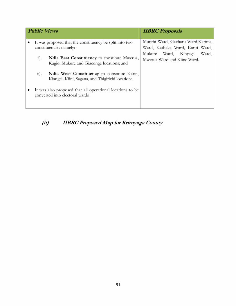
91
Public Views IIBRC Proposals
It was proposed that the constituency be split into two constituencies namely:
i). Ndia East Constituency to constitute Mwerua, Kagio, Mukure and Giaconge locations; and
ii). Ndia West Constituency to constitute Kariti, Kiangai, Kiini, Sagana, and Thigirichi locations.
It was also proposed that all operational locations to be converted into electoral wards
Mutithi Ward, Gacharu Ward,Karima
Ward, Kathaka Ward, Kariti Ward,
Mukure Ward, Kinyaga Ward,
Mwerua Ward and Kiine Ward.
(ii) IIBRC Proposed Map for Krirnyaga County
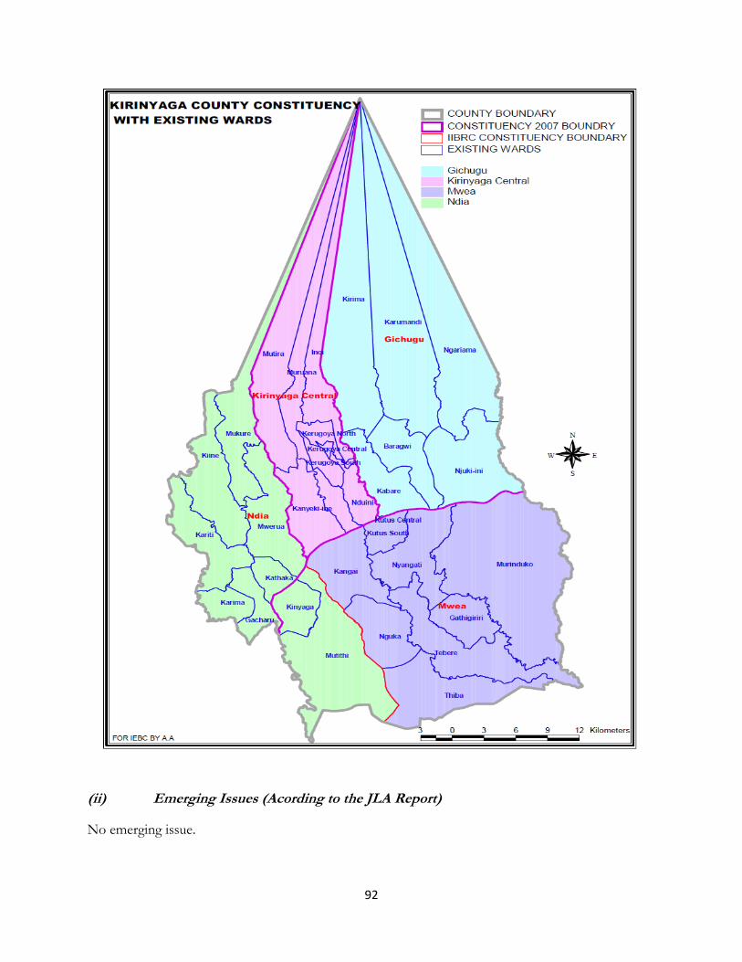
92
(ii) Emerging Issues (Acording to the JLA Report)
No emerging issue.

93
It is proposed that the recommendations of IIBRC Report be upheld.
4.3.22 Murang’a County (i) Public Presentations and IIBRC Proposals on Constituency Boundaries
Public Views IIBRC Proposals
1. Proposals related to Kangema Constituency
No proposals were submitted.
Kangema Constituency Kanyenyaini Ward, Iyego Ward, Gakira Ward, Watuha Ward, Gacharaigu Ward, Muringaini Ward, Kiairathe Ward, Rwathia Ward, Kihoyia Ward, Kiruri Ward, Ngathaithi Ward and Murarandia Ward.
2. Proposals related to Mathioya Constituency
No proposals were submitted concerning constituencies.
It was however proposed that Karunge ward In Karunge location and split Njumbi Ward into -Njumbi and Nyuro Wards
Mathioya Constituency Njumbi Ward, Kiria-ini Ward, Kiru Ward, Karung’e Ward, Gitugi Ward, Gaturi Ward, Kamacharia Ward and Locations of Muranga County.
3. Proposals related to Kiharu Constituency a) Four proposals were submitted;
i). It was propsed that Kiharu Constituency be split into three constituencies namely:
a. Kahuro Constituency to comprise of Muranda Division; Githamba, Theri, Gathaithi, Kaganda, Gatuya Locations; Mugoiri Division; Mirichu, Kiria, Gatundu, Kahuro locations.
b. Kiharu Constituency to comprise of
Weithaga Division; Kahuti, Wanjengi, Gatheru, Kahuhia; Kiharu Division: Township, Njoguini, Mbiri Locations.
c. Gaturi Constituency to comprise of Gaturi
division which comprises of Nyakihai, Gathukeini, and Mugeka Locations; Kimathi division covering Gikindu, Kigetuini and
Kiharu Constituency Kimathi Ward, Gikindu Ward,
Hospital Ward, Mumbi Ward,
Central Ward, Mukuyu Ward,
Njouini Ward, Maragi Ward, Mbiri
Rural Ward, Mirichu Ward,
Gatundu Ward, Kahuhia Ward and
Weithaga Ward.

94
Public Views IIBRC Proposals
Kimathi locations. ii). The Constituency to be split into four constituencies
namely Kahuro, Wangu, Gaturi, Kiharu. Boundaries were not proposed.
iii). To split the Kiharu constituency into Kahuro
Constituency to follow the current Kahuro Divisional boundary and Kiharu Constituency to follow the present Kiharu Divisional Boundary.
4. To create two constituencies (Kahuro Constituency -
covering Gathaithi, Gatundu, Mirichu and Gatuya
Locations- and Wangu Constituency covering Weithaga,
Kahuhia, Upper Murarandia Locations) from Kahuro
division and a further, 2 constituencies (Gaturi
constituency comprising of Gaturi, Kimathi, Gikindu
Locations and Kiharu constituency to cover Murang’a
municipality and Mbiri Location.) from Kiharu division.
5. Proposals related to Kigumo Constituency b) Kigumo constituency was proposed to be split into two
constituencies.
i). Kigumo Constituency to comprise of Kangari,
Kinyona, Kigumo, Makuyu location ;and
ii). Makuyu Constituency to comprise of Maragua
Ridge Location, Kambiti Location, Makuyu
Location, Kagunduini Location, Gaichanjiru
Location
Kigumo Constituency Kinyona Ward, Kibage Ward, Muthiti Ward, Kigumo East Ward, Kangare Ward, Kahumbu Ward and Kigumo West.
6. Proposals related to Maragwa Constituency c) A proposal was made to split Maragwa into two
constituencies;
i). Makuyu Constituency to consist of Kambiti,
Kirimiri, Wempa, Karimawaro, Kagunduini,
Mwuka, East and Makuyu, and Gaichanjiru wards
ii). Murang’a South Constituency to consist of
Kamahuha, Maragwa, Ridge Mbugwa, Samar
Gakoigo, Icagak and Nginda wards.
d) The other proposal with regard to existing wards was to have Nginda, Makuyu, Kamahuha, and Murang’a town split into two more wards and Kamahuha/Maranjau ward
Maragwa Constituency Mbugua Ward, Makuyu Ward, Ichagaki Ward, Kirimiri Ward, Samar Ward, Kabiti Ward, Maragwa Ridge Ward, Nginda Ward, Kamahuha-Maranjau Ward and Wempa Ward.

95
Public Views IIBRC Proposals
split into Sabasaba and Kamahuha Wards
7. Proposals related to Kandara Constituency Two proposals were forwarded:- Proposal 1.
i). To split Kandara constituency into two constituencies
that is Kandara South Constituency (Covering
ithiru East, Ithiru west, Ithiru South, Gacharage,
Ngararia, Naroo, Kiraga & Githumu) and Kandara
North Constituency (Covering kagungu-ini East,
Kagunduini West, Gaichanjiru, Nguruwe-ini, Muruka,
Kibaage, Kariua, Gichagi-ini & Gituru)
ii). To make all the current divisions of Gaichanjiru, Ithiru
and Ruchu Constituencies.
Kandara Constituency Kaguthi-Githuia Ward, gatundu-Kiiri-Kandara Ward, Kagunduini West Ward, Kagunduini East Ward, Gaichanjiru Ward, Githumo Ward, Ngararia Ward, Muruka Ward, Gakui-Karimamwaro Ward and Gathugu-Ruchu-Gakarara Ward.
8. Proposals Related to Gatanga Constituency
e) There were no proposals submitted for Gatanga
Constituency.
Gatanga Constituency Kariara Ward, Kihumbuini Ward,Gatanga Ward, Kigoro Ward, Samuru Ward, Mitubiri Ward, Kakuzi Ward, Kiriaini Ward, Mukarara ward and Mugomuini Ward.
(ii) IIBRC Proposed Map for Murang’a County
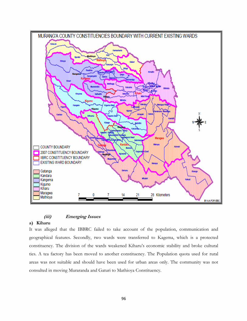
96
(iii) Emerging Issues
a) Kiharu
It was alleged that the IBBRC failed to take account of the population, communication and
geographical features. Secondly, two wards were transferred to Kagema, which is a protected
constituency. The division of the wards weakened Kiharu’s economic stability and broke cultural
ties. A tea factory has been moved to another constituency. The Population quota used for rural
areas was not suitable and should have been used for urban areas only. The community was not
consulted in moving Muraranda and Gaturi to Mathioya Constituency.
97
4.3.23 Kiambu County
(i) Public Presentations and IIBRC Proposals on Constituency Boundaries
Public Views IIBRC Proposals
1. Proposals related to Gatundu South
It was proposed that Gatundu south be split into two
constituencies:-
i). Gatundu South Constituency that will comprise of Kiamwangi, Ngenda, Kiganjo division and parts of Ruiru Division
ii). Gatundu Central Constituency to comprise of Kiganjo, Ndarugu, Ngenda Divisions and parts of Juja division
It was also proposed that the following Wards be created:
Rwabura and Munyuini from Ndarugo; Kimunyu from
Ng’enda South Mutati; Gathage from Kiamwangi;
Kiamworia and Gatitu from Mundoro and Kiganjo ward
Gatundu South Constituency Mundoro Ward, Ngenda South Ward, Ngenda North Ward, Kiganjo ward, Kiamwangi ward and Ndarugu Ward .
2. Proposals related to Gatundu North There were two proposals relating to Gatundu North.
Proposal 1. Split Gatundu North Constituency into: i. Chania Constituency, ii. Mang’u Constituency, iii. Githobokoni Constituency and
Creation of: Gikoe ward and Githobokoni ward.
Proposal 2.
Split Gatundu North Constituency into:-
Gatundu West Constituency to cover the Tea Zones;
and
Gatundu East Constituency to cover the Coffee zones.
Gatundu North Constituency Mangu Ward, Karuri Ward, Makwa Ward, Gathaite Ward, kamwangi ward, Gituamba ward and Githobokoni Ward.
3. Proposals related to Juja Constituency There was a proposal to split Juja into:
i). Githurai Constituency: covering Kahawa Sukari and Githurai Wards.
ii). Ruiru Constituency: covering Gitothua, Commercial
Juja Constituency Murera Ward, Gitothua Ward, Kalimoni Ward and Juja Ward. Thika Town Constituency Gatuanyaga Ward, Kiganda Ward, Makongeni Ward, Kamenu Ward,

98
Public Views IIBRC Proposals
and Murera wards and proposed Gikumari Division.
Ndururumo Ward, Mugumoini Ward, Majengo Ward, Market Ward, Hospital Ward and Biashara Ward of Kiambu County. Ruiru Constituency Kahawa Sukari Ward, Githurai Kimbo Ward and Gatongora Ward of Kiambu County.
4. Proposals related to Githunguri Constituency
It was proposed that Githunguri constituency be split into two Constituencies:
i). Githunguri West Constituency and ii). Githunguri East Constituency comprising of
Lower Lari, Karatina and Kamotoi Division.
It was also proposed that the following be split: i). Githiga ward into Gathangari and Githiga
wards; ii). Ikinu ward into Ikinu and Riuki wards; iii). Kiratina ward into Kiratina, Gathagu and
Kibichai Wards; iv). Ngewa ward into Nyaga and Kiri wards.
Githunguri Constituency Githunguri Ward, Ikinu Ward, Komathai Ward, Githiga Ward, Ngewa ward, Kiratina Ward,and Kanjai-Kiairia Ward.
5. Proposals related to Kiambaa Constituency
It was proposed that Kiambaa Constituencies be split into three constituencies as namely Kiambu Constituency, Kihara Constituency and Kiambaa Constituency and that the boundaries of the above should follow the current divisional Boundaries;
It was also proposed to merge Kiambu Municipal council, Karurri Town Council, and Ting’ang’a & Cianda Wards to form Kiambu Municipality
Kiambaa Constituency Cianda Ward, Kanunga Ward, Muchata Ward, Ndenderu Ward, Kihara Ward and Kiambaa Ward. Kaimbu Constituency Riabai Ward, Township Ward, Ting,ang,a Ward, Technology Ward, Ndumberi Ward, Kihongo Ward and Kanunga Ward of Kiambu County.
6. Proposals related to Kikuyu Constituency It was proposed that Kikuyu Constituency be split into two to be referred to as:
i). Kabete Constituency :Covering Muguga, Kabete, Nyathuna and parts of Kinoo Divisions [Kinoo &Uthiru]) ;and
ii). Kikuyu Constituency: Covering parts of Kinoo, Kikuyu and Karai division. The boundary between the two
Kabete Constituency Kabete Ward, Muguga Ward and Nyathuna Ward of Kiambu County. Kikuyu Constituency Kinoo Ward, Karai Ward, Nachu Ward and Kikuyu Ward of Kiambu County.

99
Public Views IIBRC Proposals
constituencies to be the great North road.
7. Proposals related to Limuru Constituency
It was proposed that Limuru Constituency be
split into two namely Limuru Ndeiya
Constituency and Limuru Constituency.
Retention of the existing wards were proposed,
Thigio, Ndeiya, and
Kiriri Wards.
Split Limuru into, Gecha, Limuru and Ndeiya wards.
Limuru Constituency Bibirioni Ward, Kamirithu Ward, Limuru Central Ward, Limuru East Ward, Ngecha Ward, Ndeiya Ward, Thigino Ward and Tigoni Ward.
8. Proposals related to Lari Constituency There were two proposals. i). Lari constituency to be split into Lari Upper
Consituency and Lari Lower. The boundary to be along
Komothai River to the East of Gatamayu division, Ruiru
River to the West, Kiambururu to the south and Gekohi
in Kerita division.
ii). To curve Gatamaiyu constituency from existing
Githunguri Constituency and Lari Constituencies to
consist of:
From Lari Constituency; Nyanduma location, Gatamaiyu location, Kamburu location
From Githunguri Constituency; Komothai location and Kirathina location
Lari Constituency Lari Ward, Kijabe Ward, Kirenga Ward, Gatamayu Ward, Namayu Ward and Kinale Ward.
(ii) IIBRC Proposed Map for Kiambu County

100
(ii) Emerging Issues (Acording to the JLA Report)
No issues raised as concerns the recommendations in the IIBRC Report.

101
4.3.24 Turkana County
(i) Public Presentations and IIBRC Proposals on Constituency Boundaries
Public Views IIBRC Proposals
1. Proposals related to Turkana North Constituency Several Proposals were given:- Proposal 1:
1. The constituency be divided into four parts:- Karach Constituency – that will comprise Polopoi Division and Kakuma Divisions;
2. Lokichoggio Constituency – that will comprise of
Lokichoggio and Nanam divisions Proposal 2: The Divisions to be merged to make five constituencies:-
1. Lokichogio Constituency: - Lokichoggio/Nanan divisions;
2. Kakuma Constituency: - Orupoi/Kakuma divisions. 3. Lokitaung’ Constituency:- Kataboi/Lokitaung
divisions; 4. Kaler Constituency: Kaleng/Lapur divisions; and 5. Kibich Constituency: Kibish/Kaikor divisions.
Proposal 3: The People with disability proposed:-
1. Kakuma Oropoi Constituency; 2. Lokichoggio/Ng’ang Constituency stretching from
Lokichoggio up to a place called Kaleng; and 3. Constituency stretching from Kataboi up to Kibish
Turkana North Constituency Lokitang Ward, Karebur Ward,Ngissiger Ward, Riakomor Ward, Kaeris Ward, Kataboi Ward, Kibish Ward, Naita Ward, Meyan Ward,Kaikor Ward, Kokuro Ward, Loruth Esokon Ward, Yapakuno Ward and Pelekech /Nakalate Ward (Part) of Turkana County.
Turkana West Constituency Nakalale-Pelekech (Part) Ward, Kakuma Ward, Loreng Ward, Oroboi Ward, Kalobeyei Ward, Songot Ward, Lokichoggio Ward, Loteteleit Ward, Nanaam-Mogila Ward and Lorau Ward of Turkana
County.
2. Proposals related to Turkana Central Constituency
The public proposed five constituencies namely Kalakol, Lodwar Town, Turkwell, Loima and Ekerio constituencies;
Proposed formartion of the following wards:- Kangirise; Nakoret; Kerio; Nakurio; Langatosa; Lomapus; Namukse; Kalokol; Kapua; Nakwele; Ekurot; Lomeyian; Napeling; Kapus; Nadapal; and Napeikar; Turkwel; Lorugum; Kotaruk; Lokitotota; Rangany; Kalemunyang; Lobei; Loyima; Push; Lokiriama; Urum; Loruinkipi; and Kahemanik.
Turkana Central Constituency Kang'irisae Ward, Kerio Ward, Nakwanga Ward, Napetet Ward, Napuu Ward, Kenyatta Ward,
Kanamkemer Ward, Kang‟atotha Ward, Kalokol Ward, Kapua-Namadak Ward, Kawalathe Ward and of Turkana County. Loima Constituency Lomeyan Ward, Loima Ward, Nadapal Ward, Turkwel Ward, Lokiriama Ward, Lobei Ward, Lorengippi Ward and Kotaruk
102
Public Views IIBRC Proposals
Ward of Turkana County.
3. Proposals related with Turkana South Constituency
Proposed that Turkana south be divided into 3 constituencies based on the existing divisions;
1) Turkana South Constituency should have the following divisions:-
i) Lokichar Division which has two locations and four sub-locations and also Kapese Location;
ii) Proposed Kalapata Division which will have three locations namely Kalapata, Akipur and Nakale locations;
iii) Proposing Locha to be a division with Locha, Aspurur and Lochariamois locations.
2) Turkana East Constituency will have:
i) Lochagulo Division with Acheder and Lothii locations with eight sub-locations, two for each;
ii) Lokor Division should have Lokor, Lotuba and Gangtit locations. There are six sub-locations;
iii) In Kapila Division, to have Kapila, Aparkat and Loriu locations. Each will have two sub-locations;
iv) Lonelo Division with Lonelo, Apar and Domelo locations with six sub-locations. Each location will have two sub-locations; and
v) Nataiton Division is the last one with Nataiton, Kamuge, Nyuluka locations, each with two sub-locations.
Turkana East Constituency should have 15 civic wards. Out of this, five Wards already exist and ten additional wards proposed.
It should also have five divisions out of which two exist. It should have 15 locations, out of which nine exist. It should also have 31 sub-locations, out of which 21 exist. (3) Turkwel Constituency to have three divisions. That is i) Katilu Division with Katilu, Almung’oroko,
Nakabasang and Lokafai locations. Each of them should have two sublocations;
ii) Kainuk Division which should have Kainuk and Lorokor and Kakong Location. All those three locations will have two sub-locations each;
iii) Nakwamoru Division: Nakwamoru, Kalamweya and Kaptir locations. Each of this will have two sub-locations
Turkana South Constituency Lokichar Ward, Kalapata Ward, Katilu Ward, Kaputir Ward and Lobokat Ward of Turkana County. Turkana East Constituency Katilia Ward, Kochodin Ward, Lokori Ward, Napeitom Ward and Kapedo Ward of Turkana County.

103
(ii) IIBRC Proposed Map for Turkana County

104
(ii) Emerging Issues (Acording to the JLA Report)
a) Turukana Central
The Population Quota used was not proper. Based on the population in the area and the entire
Turkana County, Turkana Central deserved 5 additional constituencies to ensure adequate
representation.
4.3.25 West Pokot County
(i) Public Presentations and IIBRC Proposals on Constituency Boundaries
Public Views IIBRC Proposals
1. Proposals related to Kapenguria Constituency Proposal 1. Split it to create Kapenguria and Pokot South constituencies Proposal 2. Split to create Kapenguria and LeLan constituencies Proposal 3 Split it to create Kapenguria and Sengwer constituencies
Kapenguria Constituency Endugh Ward, Ptoyo Ward, Nakwijit Ward, Miskwony Ward, Tamugh Ward, Sook Ward, Chekomos Ward, Chepkopegh Ward, Riwo Ward, Kanyarkwat Ward, Senetwo Ward, Kapenguria Ward, Kapenguria North Ward, Keringet-Psigirio Ward, Talau Ward, Keringet Ward, Chemwochoi Ward, Kisiaunet Ward and,Kaibos Ward of West Pokot County. Pokot South Constituency Lelan Ward, Tapach Ward, Kaptabuk Ward, Ywalateke Ward, Siyoi Ward, Parua Ward, Kapyogen Ward, Kopro ward, Sodany ward, Kapchemongen Ward and Chepareria-Kosulol Ward of West Pokot County.
2. Proposals related to Sigor Constituency Proposed Pokot South Constituency to be crated.
Sigor Constituency Porkoyu Ward, Masol Ward, Sekerr Ward, Wei-wei Ward, Lomut Ward, Sekerot Ward, Batei Ward, Cheptulel Ward, Mwino Ward and of West Pokot County.
3. Proposals related to Kacheliba Constituency Proposed to spilt it and create Pokot North Constituency
Kacheliba Constituency Akoret Ward, Chemorongit Ward, Lokitanyala Ward, Kalapata Ward, Kases Ward, Kiwawa Ward, Kasei Ward, Lopet Ward, Kapchok Ward, Kodich Ward and Suam Ward of West Pokot County.
(ii) IIBRC Proposed Map for West Pokot County

105
(ii) Emerging Issues (Acording to the JLA Report)
a) Sigor
The issue of Community of interest was not observed.
b) Kapeguria

106
Two wards, Kanyarkwat and Chemochoi, were wrongly taken to the new Pokot South
constituency.
4.3.26 Samburu County
(i) Public Presentations and IIBRC Proposals on Constituency Boundaries
Public Views IIBRC Proposals
1. Proposals related to Samburu West Constituency c) Proposal create one more constituency to be named
Samburu North
Samburu West Constituency El-Barta Ward, Nyiro East Ward, Nyiro West Ward, Nyiro South Ward, Baragoi Ward, Nachola Ward and Ndoto Ward of Samburu County. Samburu North Constituency Amaiya Ward, Baawa Ward, Ng’ari Ward, Lkorroto Ward, Milimani Ward, Biashara Ward, Shabaa Ward, Suguta Marmar Ward, Lpartuk Ward, Marti Ward, Kawap Ward, Arsim Ward, Lodokojek Ward, Latakweny Ward, Poro Ward, Loosuk Ward, Opiroi Ward, Angata Nanyokie Ward, Barsaloi Ward and Kisima Ward of Samburu County.
2. Proposals related to Samburu East Constituency d) No proposal was presented.
Samburu East Constituency Ngilai West Ward, Ngare Narok Ward, Wamba Ward, Ngaroni Ward, Lodungokwe Ward, Nairimirimo Ward, Waso West Ward, Waso East Ward and Sere-Olipi Ward of Samburu County.
(ii) IIBRC Proposed Map for Samburu County

107

108
(ii) Emerging Issues (Acording to the JLA Report)
No major emerging issues.
4.3.27 Trans Nzoia County
(i) Public Presentations and IIBRC Proposals on Constituency Boundaries
Public Views IIBRC Proposals
1. Proposals related to Saboti Constituency
Two constituencies proposed to be created: 1. Kitale Central Constitueny which is to comprise
Central Division and Waitaluk division with a population of 201,322;
2. Kitale West Constituency to comprise Saboti, Kiminini/Kinyoro and Central Divisions with 183, 000 people.
Another proposal was to divide the constituency into 3 constituencies:- 1. Kitale Town Constituency (the old central division); 2. Kitale Central Constituency (Kiminini Division and
the newly established Kinyoro which includes Kisawai); 3. Kitale West Constituency to include Sikhendu,
Machewa, Saboti na Timboroa divisions.
Proposal 3: the constituency to be divided into: 1. Kimini Constituency – To comprise Kiminini
Division, Waitaluk Division and part of the Central Division which is Kibomet Location (With an area of 391.3 sq km)
2. Saboti Constituency - Saboti Division, Kinyoro Division and part of Central Division which is the Municipality Location. (With an area of 350.2 sq);
Saboti Constituency Kisawai Ward, Kinyoro Ward, Matisi Ward, Kipsongo Ward,Saboti Ward, Machewa Ward, Nabiswa Ward, Sikhendu Ward, Mumia Ward and Tuwani Ward and Sokoni Ward of Trans-Nzoia County. Kiminini Constituency Kimini Ward, Sirende Ward, Waitaluk Ward, Milimani Ward, Kibomet Ward, Lessos Ward, Webuye Ward, Hospital Ward, Sokoni Ward and Masaba Ward of Trans-Nzoia County.
Endebese Constituency Endebess Ward, Matumbei Ward, Chepchoina Ward, Kaptega Ward and Mumberes Ward of Trans-Nzoia County.
2. Proposals related to Cherangany Constituency
It was proposed that the Constituency remains as it is;
Following wards were proposed:- Cherangany Ward; Suwerwa Ward; Geta Ward; Milimani Ward; Chepsiro Ward; Motosit Ward; Kaplamai Ward; Konyek Ward; Mukuyu Ward; Sitatunga Ward; Sinyereri Ward; Michai Ward and Makutano
Cherangany Constituency Makutano Ward, Sitatunga Ward, Kaplamai Ward, Motosiet Ward, Cherangani-Suwerwa Ward, Kiptoror Ward and Chepsiro Ward of Trans-Nzoia County.
3. Proposals related to Kwanza Constituency
Proposal 1: Kwanza Constituency should remain as it is;
Kwanza Constituency Kapkoi Ward, Keiyo Ward, Kapomboi Ward, Kwanza Ward, Kaisagat Ward, Kapsitwet Ward

109
Public Views IIBRC Proposals
Proposal 2: The constituency to be divided into two:
1. Entebess Constituency 2. Kwanza Constituency
and Sinyerere Ward of Trans-Nzoia County.
(ii) IIBRC Proposed Map for Trans Nzoia County
(ii) Emerging Issues (Acording to the JLA Report)
No major emerging issues in Trans Nzoia County.

110
4.3.28 Uasin Gishu County
(i) Public Presentations and IIBRC Proposals on Constituency Boundaries
Public Views IIBRC Proposals
1. Proposals related to Eldoret North Constituency
It was proposed that the following constituencies be created out of the current Eldoret North: 1. Soy/Moi’s bridge 2. Turbo/sosiani 3. Sirikwa
Soy Constituency Soy Ward, Kipsomba Ward, Koisagat Ward, Ziwa Ward, Moi’s Bridge North Ward , Moi’s Bridge South Ward, Stadium-Industrial Ward, Kidiwa-Kipsuswa Ward, Kiplombe (Kuinet Sublocations) Ward (Part) and Eldoret North Ward of Uasin Gishu County. Turbo Constituency Ngenyilel Ward, Tapsagoi Ward, Sugoi Ward,Kamagut Ward, Kamukunji Ward, Kapyemit Ward, Shauri Yako Ward and Kiplombe (Kiplombe and Kilimani sublocations) Ward (Part) of Uasin Gishu County.
2. Proposals related to Eldoret East Constituency
Split the constituency into two and rename them as indicated below: (i) Moiben Constituency; and (ii) Ainabokoi Constituency.
Moiben Constituency Moibeki Ward, Moiben Ward, Karuna Ward, Sergoit Ward, Tembelio Ward, Kimumu-Sergoit Ward, Hospital (Sigot Sublocation) Ward (Part), Market Ward and Kapyeimet Ward (Part) of Uasin Gishu County. Ainabkoi Constituency Chemng‟oror Ward, Kipkabus Ward, Kaptagat Ward, Kapsoya Ward, Olare Ward and Ainabkoi Ward of Uasin Gishu County.
3. Proposals related to Eldoret South Constituency
Proposed for the creation of Eldoret South and Wareng.
Kapseret Constituency Kipkenyo Ward, Langas Ward, Ngeria Ward, Race Course Ward, Simat-Kapsaret Ward, Kipchamo Ward, and Megun-Kesses Ward of Uasin Gishu County. Tarakwa Constituency Simotwa Ward, Tarakwa Ward, Cheptiret Ward, Oleinguse Ward, Pioneer-Elgon View Ward, Timboroa Ward, Kipchamo Ward, Race Course (Langas Sublocation) Ward (Part) and Tulwet-Chuiyat Ward of Uasin Gishu County.
(ii) IIBRC Proposed Map for Uasin GishuCounty
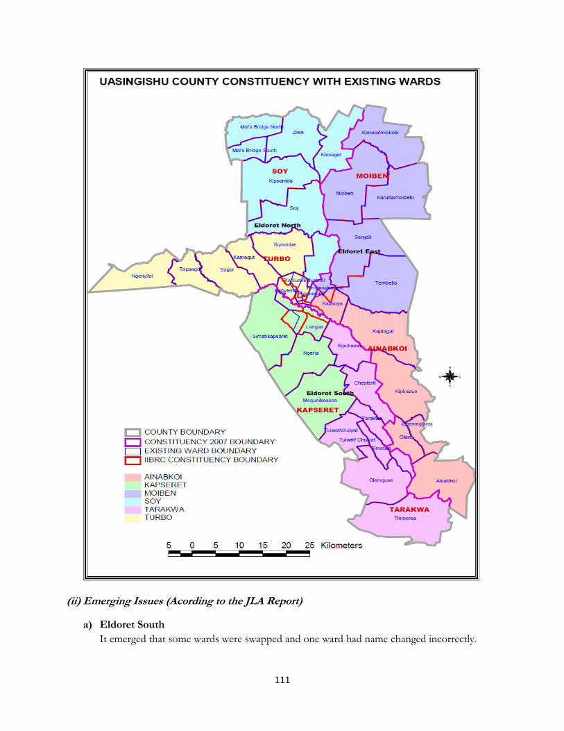
111
(ii) Emerging Issues (Acording to the JLA Report)
a) Eldoret South
It emerged that some wards were swapped and one ward had name changed incorrectly.

112
4.3.29 Elgeyo Marakwet County (i) Public Presentations and IIBRC Proposals on Constituency Boundaries
Public Views IIBRC Proposals
1. Proposals related to Keiyo North Constituency 2. Proposed a creation of two constituencies:- Keiyo
North and Keiyo East; 3. The boundary of the two constituencies should run
along Keiyo escarpment; 4. Eastern boundary should be Kerio River and the
current Keyio East Division to be elevated to a district and made a Constituency;
Keiyo North Constituency Kapchemutwa Ward, Kokwao Ward, Irong Ward, Kapkonga Ward, Kamogich Ward, Kessup Ward, Central Ward, Sergoit Ward, Kiptuilong Ward, Kapterik Ward, Mutei Ward, Keu Ward, of Elgeyo
2. Proposals related to Keiyo South Constituency
No issues presented.
Keiyo South Constituency Kaptarakwa Ward, Mosop Ward, Metkei Ward, Kapkwony Ward, Marichor West Ward, TumeiwoWard, Marichor East Ward, Maoi Ward, Kocholwo Ward, Nyaru Ward, Kamwosor Ward, Soy Ward, Kibargoi Ward, Chemoibon Ward, Chepsigot Ward, Kitany Ward and Kabiemit Ward of Elgeyo-Marakwet County.
3. Proposals related to Marakwet West Constituency
Divide into two constituencies: Marakwet West Constituency and Marakwet Central Constituency;
Marakwet West should comprise of Chebororwo Division which has the following locations:- Konda bilet; Yamurgoi; Tamarur; and Kiabai;
Kapcherop Division has Kapterit; Kamoi; Sengwer; and Kipteber; and
Another proposed name for the constituency is Kapcherop Constituency
Marakwet Central to be hived from the existing Marakwet West Constituency. It should comprise of Kapsowar Division, Chebiemit and Tunyo divisions.
Every existing location should be made a ward;
Marakwet East Constituency Chebororwa Ward, Cherangany Ward, Lelan Ward, Kamoi Ward, Sengwer Ward, Kuserwo Ward, Moiben Ward, Kapsowar Ward, Chesuman Ward, Kipsaiya Ward, Arror Ward and Koibarak Ward of Elgeyo-Marakwet County.
4. Proposals related to Marakwet East Constituency a) The constituency should remain as it is currently
constituted;
Marakwet East Constituency Endo Ward, Koibirir Ward, Embobut Ward, Embolot Ward, Murkutwo Ward, Mokoro Ward, Kipkaner Ward, Sambirir Ward, Mon Ward, Kaptich Ward and Kapyego Ward of Elgeyo-Marakwet
County.
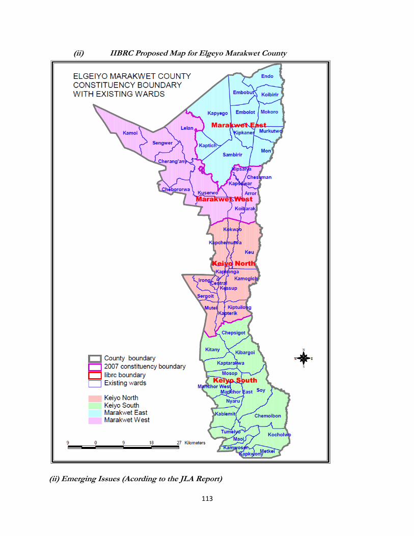
113
(ii) IIBRC Proposed Map for Elgeyo Marakwet County
(ii) Emerging Issues (Acording to the JLA Report)
114
a) Keiyo North
It emerged that the Community of interest, Historical, Economical and cultural ties were not
considered. The community also requested a review of the boundary between two neighboring
constituencies in different counties.
The Means of communication for resident of a location& sub-location in Eldoret East would like to
be moved to Keiyo North as they’re too far away from the service in their constituency
headquarters; and that the residents would like the issue of county boundaries looked at in future
boundaries review.
4.3.30 Nandi County (i) Public Presentations and IIBRC Proposals on Constituency Boundaries
Public Views IIBRC Proposals
1. Proposals related to Tinderet Constituency
(iii) Proposal to split Tinderet and create Kapng’etuny or Nandi Hills constituency
Tinderet Constituency O’llessos Ward, Sochoi Ward, Kapchorwa Ward, Siret Ward, Mogobich Ward, Kapkoros Ward,
Kapng‟etuny Ward, Miteitei Ward, Tindiret Ward and Kosoiywo Ward of Nandi County. Nandi Hills Constituency Chemase Ward, Chemilil Ward, Soba Ward, Kapsimotwo Ward, Chebarus Ward and Songhor Ward of Nandi County.
2. Proposals related to Aldai Constituency
(iv) No proposed constituency
Aldai Constituency Terik Ward, Maraba Ward, Kibwareng-Chebilat Ward, Kabwareng Ward, Kapkemich Ward, Koyo Ward, Ndurio Ward, Kaptumo Ward, Kemeloi Ward and Kaboi Ward of Nandi County.
3. Proposals related to Emgwen
Constituency
Proposal to split Emgwen constituency into two;
(v) Emgwen North and
(vi) Emgwen South
Emgwen North Constituency Kosirai Ward, Chepterit Ward, Chemundu-Kaptildil Ward, Kapsabet Ward, Mutwot-Ngechek Ward, Kaptel Ward, Sangalo Ward, Kiptuiya Ward, Itigo Ward, Lelmokwa (Bibiriet Location) Ward (Part), Songalo (Kipsomoite Sublocation) Ward (Part), Ward (Part) Kapsisiywa Ward and Kamoiywo Ward of Nandi County.

115
Public Views IIBRC Proposals
Emgwen South Constituency Kapkangani Ward, Chepkumia Ward, Kiminda Ward, Kamobo Ward, Kilibwoni North Ward, Kipture-Irimis Kimaam Ward, Kipsigak-Kipsotoi Ward, Kabirirsang Ward, and Arwos Ward of Nandi County.
4. Proposals related to Mosop Constituency
A proposal presented Split Mosop into three;
(a) Mosop Central Constituency
(b) Mosop West Constituency; and
(c) Mosop East Constituency
Mosop Constituency Chepterwai Ward, Surungai Ward, Kurgung Ward, Kabisaga Ward, Kipkaren Ward, Lelmokwo (Sigot, bibiriet and lelmokwo locations) Ward (Part), Kebulonik Ward, Kabiyet Ward, and Ndalat Ward of Nandi County.
(ii) IIBRC Proposed Map for Nandi County

116

117
(ii) Emerging Issues (Acording to the JLA Report)
a) Mosop &Emgwen
The Means of communication and consultation with all interested parties was not done. As aresult
some wards were omitted while others appeared in both constituencies .this needs to be corrected.
b) Tinderet
Not all interested parties were consulted. There was a mix up of wards and sub- locations, with
some going to Tinderet instead of new Nandi Hills Constituency.
4.3.31 Baringo County
(i) Public Presentations and IIBRC Proposals on Constituency Boundaries
Public Views IIBRC Proposals
1. Proposal related to Baringo East Constituency
Proposal to split the constituency into two and rename as indicated below:- (a) Tiatiy West ( Tiatiy) Constituency, (b) Tiatiy East Korosi Constituency
If not possible to split into two, then it should be renamed to Tiatiy Constituency
Baringo East Constituency Akoret Ward, Churo Ward, Tangulubei Ward, Korossi Ward, Kolowa Ward, Ribkwo-Kositei Ward, Loiyamorok Ward, Silale Ward and Tirioko Ward of Baringo County.
2. Proposal related to Baringo North Constituency
The Commission to consider splitting the constituency into two but no proposal was given to this effect.
Baringo North Constituency Ngo’rora-Kinyach Ward, Kabutiei Ward, Kaptebererwo Ward, Sibilo Ward, Kaboskei–Kerio Ward, Kaboskei-Kipkata Ward, Kalabata Ward, Lawan Ward, Kabutiei Ward, Kelyo Ward, Ossen Ward, Katiorin-Saimo South Ward, Saimo North Ward and Bartum Ward of Baringo County.
3. Proposal related to Baringo Central Constituency
Proposal 1.
Split Baringo Central to create Bogoria Constituency and Baringo central constituencies
Proposal 2.
Split Baringo Constituency into Marigat Constituency and
Baringo Central Constituency Proposal 3.
Baringo Central Constituency Tenges Ward, Emom-Kisonei Ward, Sacho Mosop Ward, Sacho Soi Ward, Kimalel Ward, Kabasis Ward, Nge’t Moi Ward, Kapsoo Borowonin Ward, Ewalel-Soi Kimondis Ward, Orokwo Ward, Seguton Ward, Chebano Ward, Kinyo Ward, Kaprogonya Ward, Kapsoo/Borowonin Ward, Kabarnet Soi Ward, Kituro Ward, Talai-Ewalel Ward and Kabasis Ward of BaringoCounty.

118
Public Views IIBRC Proposals
Split the Constituency into Ilchamus and baringo Central With the indicated Wards:- Ilchamus and Baringo Central.
Mochongoi Constituency Mukutani Ward, Salabani Ward, Ngambo Ward, Marigat Ward, Loboi Ward, Chebinyinyi- Arabel Ward, Kimoriot Ward, Ilchamus Ward and Mochongoi Ward of Baringo County.
4. Proposal related to Mogotio Constituency
Proposed to maintain the consistency as it is.
Mogotio Constituency Koibos-Soi Ward, Cheberen Ward, Kamar Ward, Sinende Ward, Ol Kokwe Ward, Kisanana Ward, Moguriny Ward, Emining Ward, Kakimor-Rosoga Ward, Lembus-Kiptoim Ward, Lembus Mogotio Ward and Kimngorom-Sirwa Ward of Baringo County.
5. Proposal related to Eldama Ravine Constituency
Change the name Eldama-Ravine constituency to Koibatek West or Koibatek Mosop.
Create Endorois constituency comprising of Mogorwo, Tenges, Bekibon, Loboi , Mochongoi and Kibos wards.
Eldama Ravine Constituency Kiplombe Ward, Solian Ward, Benonin Ward, Ravine Ward, Perkerra Ward, Kabimoi Ward, Saos- Kibias Ward, Poror Ward, Sigoro Ward, Lembus Torongo Ward, Lembus Mosop Ward, Mumberes Ward and Maji Mazuri Ward of Baringo County.
(ii) IIBRC Proposed Map for Baringo County

119
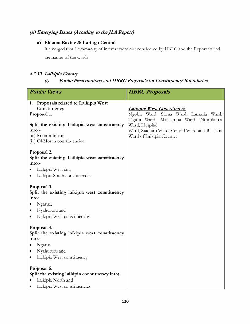
120
(ii) Emerging Issues (Acording to the JLA Report)
a) Eldama Ravine & Baringo Central
It emerged that Community of interest were not considered by IIBRC and the Report varied
the names of the wards.
4.3.32 Laikipia County
(i) Public Presentations and IIBRC Proposals on Constituency Boundaries
Public Views IIBRC Proposals
1. Proposals related to Laikipia West Constituency
Proposal 1.
Split the existing Laikipia west constituency into:- (iii) Rumuruti; and (iv) Ol-Moran constituencies Proposal 2. Split the existing Laikipia west constituency into:-
Laikipia West and
Laikipia South constituencies Proposal 3. Split the existing laikipia west constituency into:-
Ngarua,
Nyahururu and
Laikipia West constituencies Proposal 4. Split the existing laikipia west constituency into:-
Ngarua
Nyahururu and
Laikipia West constituency Proposal 5. Split the existing laikipia constituency into;
Laikipia North and
Laikipia West constituencies
Laikipia West Constituency Ngobit Ward, Sirma Ward, Lamuria Ward, Tigithi Ward, Mashamba Ward, Nturukuma Ward, Hospital Ward, Stadium Ward, Central Ward and Biashara Ward of Laikipia County.
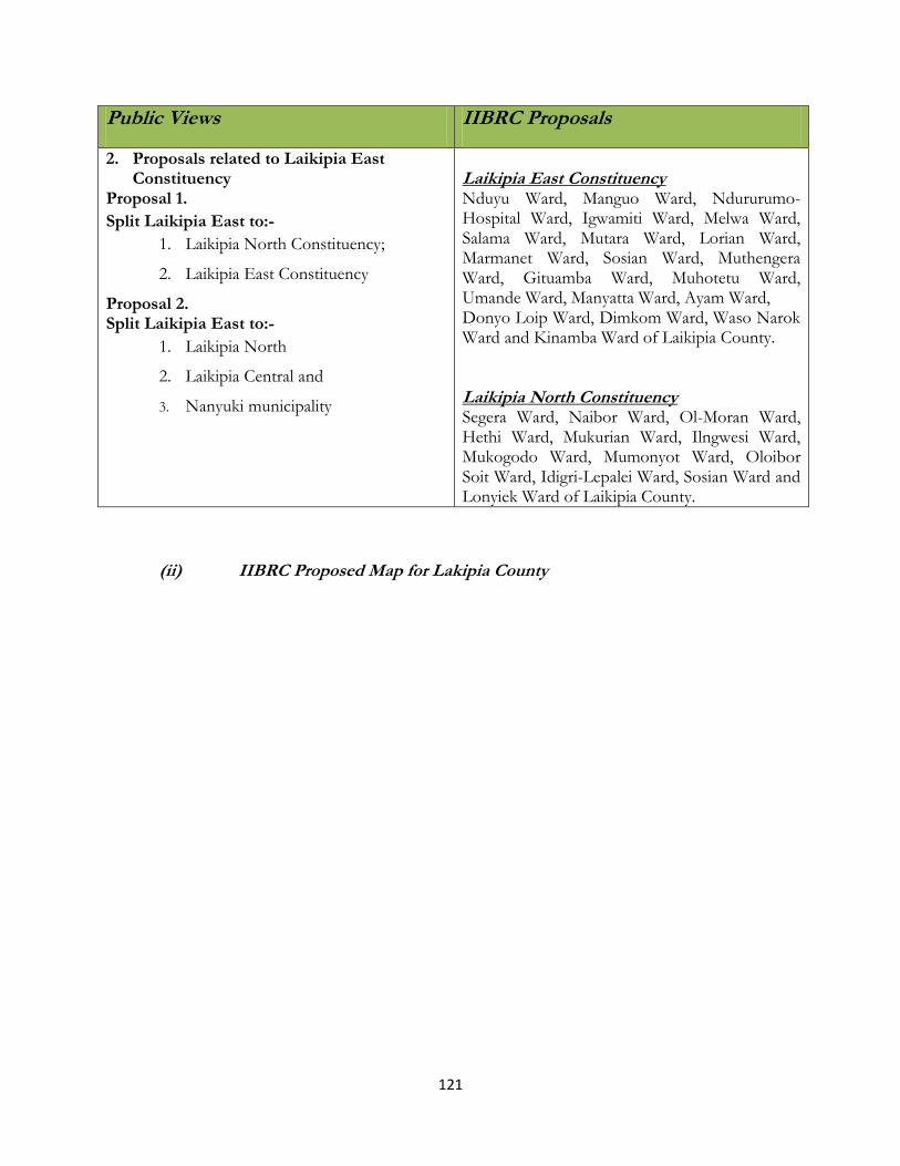
121
Public Views IIBRC Proposals
2. Proposals related to Laikipia East Constituency
Proposal 1.
Split Laikipia East to:-
1. Laikipia North Constituency;
2. Laikipia East Constituency
Proposal 2. Split Laikipia East to:-
1. Laikipia North
2. Laikipia Central and
3. Nanyuki municipality
Laikipia East Constituency Nduyu Ward, Manguo Ward, Ndururumo- Hospital Ward, Igwamiti Ward, Melwa Ward, Salama Ward, Mutara Ward, Lorian Ward, Marmanet Ward, Sosian Ward, Muthengera Ward, Gituamba Ward, Muhotetu Ward, Umande Ward, Manyatta Ward, Ayam Ward, Donyo Loip Ward, Dimkom Ward, Waso Narok Ward and Kinamba Ward of Laikipia County. Laikipia North Constituency Segera Ward, Naibor Ward, Ol-Moran Ward, Hethi Ward, Mukurian Ward, Ilngwesi Ward, Mukogodo Ward, Mumonyot Ward, Oloibor Soit Ward, Idigri-Lepalei Ward, Sosian Ward and Lonyiek Ward of Laikipia County.
(ii) IIBRC Proposed Map for Lakipia County

122

123
(ii) Emerging Issues (Acording to the JLA Report)
a) Laikipia West
It emerged that Laikipia West has a population of 100,361, with its neighbours also having higher
populations, but boundaries were not adjusted or a new constituency added.
4.3.33 Nakuru County (i) Public Presentations and IIBRC Proposals on Constituency Boundaries
Public Views IIBRC Proposals
1. Proposals related to Molo Constiuency Proposal 1. Whole of Eastern Mau Forest Complex Block be a constituency Proposal 2. Create Bogoria constituency out of Molo. Proposal 3. Split Molo into three:-
o Mau Ogiek o Molo o Njoro
Proposal 4 Molo constituency be split to:-
1. Molo 2. Njoro
Other Proposals Proposal by Ogiek community
Ogiek are an indigenous ethnic minority community found in most parts of the Mau Forest Complex.
Proposal by Endorois community Endorois are indigenous people.
Bogoria constituency be created from the existing locations
Bogoria constituency be created from the existing locations
Proposal by Mau Ogiek
Ogiek are an indigenous ethnic minority community. They propose Mau Ogiek constituency to be curved from the larger Molo constituency.
Proposal Boundaries
Molo Constituency Sachangwan Ward, Turi South Ward, Molo Ward, Mariashoni Ward, Elburgon Ward, Mutamaiyu Ward, Turi North Ward and Kiambiriria Ward of Nakuru County. Njoro Constituency Njoro Ward, Mukungugu Ward, Lare Ward, Nessuit Ward, Mauche Ward, Kihingo Ward, Naishi Ward, Sururu Ward, Naishi (Piave Location) Ward (Part) and Mau Narok Ward of Nakuru County.
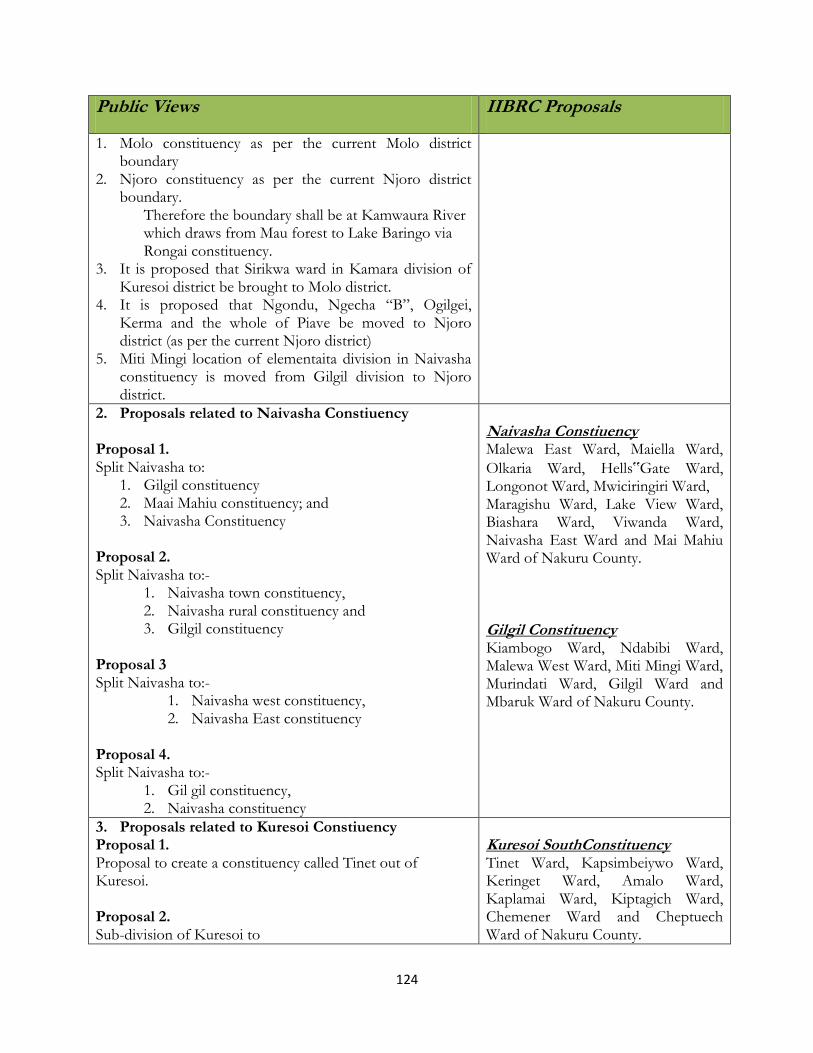
124
Public Views IIBRC Proposals
1. Molo constituency as per the current Molo district boundary
2. Njoro constituency as per the current Njoro district boundary.
Therefore the boundary shall be at Kamwaura River which draws from Mau forest to Lake Baringo via Rongai constituency.
3. It is proposed that Sirikwa ward in Kamara division of Kuresoi district be brought to Molo district.
4. It is proposed that Ngondu, Ngecha “B”, Ogilgei, Kerma and the whole of Piave be moved to Njoro district (as per the current Njoro district)
5. Miti Mingi location of elementaita division in Naivasha constituency is moved from Gilgil division to Njoro district.
2. Proposals related to Naivasha Constiuency Proposal 1. Split Naivasha to:
1. Gilgil constituency 2. Maai Mahiu constituency; and 3. Naivasha Constituency
Proposal 2. Split Naivasha to:-
1. Naivasha town constituency, 2. Naivasha rural constituency and 3. Gilgil constituency
Proposal 3 Split Naivasha to:-
1. Naivasha west constituency, 2. Naivasha East constituency
Proposal 4. Split Naivasha to:-
1. Gil gil constituency, 2. Naivasha constituency
Naivasha Constiuency Malewa East Ward, Maiella Ward,
Olkaria Ward, Hells‟Gate Ward, Longonot Ward, Mwiciringiri Ward, Maragishu Ward, Lake View Ward, Biashara Ward, Viwanda Ward, Naivasha East Ward and Mai Mahiu Ward of Nakuru County. Gilgil Constituency Kiambogo Ward, Ndabibi Ward, Malewa West Ward, Miti Mingi Ward, Murindati Ward, Gilgil Ward and Mbaruk Ward of Nakuru County.
3. Proposals related to Kuresoi Constiuency Proposal 1. Proposal to create a constituency called Tinet out of Kuresoi. Proposal 2. Sub-division of Kuresoi to
Kuresoi SouthConstituency Tinet Ward, Kapsimbeiywo Ward, Keringet Ward, Amalo Ward, Kaplamai Ward, Kiptagich Ward, Chemener Ward and Cheptuech Ward of Nakuru County.
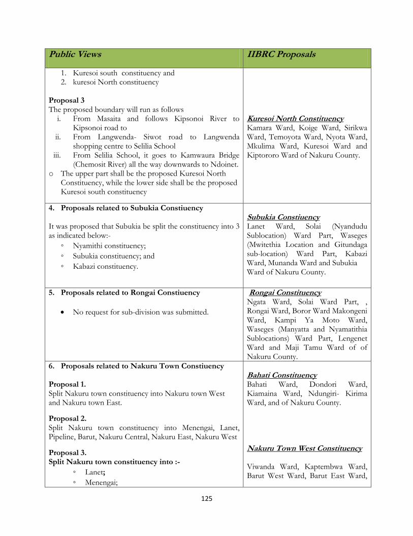
125
Public Views IIBRC Proposals
1. Kuresoi south constituency and 2. kuresoi North constituency
Proposal 3 The proposed boundary will run as follows
i. From Masaita and follows Kipsonoi River to Kipsonoi road to
ii. From Langwenda- Siwot road to Langwenda shopping centre to Selilia School
iii. From Selilia School, it goes to Kamwaura Bridge (Chemosit River) all the way downwards to Ndoinet.
o The upper part shall be the proposed Kuresoi North Constituency, while the lower side shall be the proposed Kuresoi south constituency
Kuresoi North Constituency Kamara Ward, Koige Ward, Sirikwa Ward, Temoyota Ward, Nyota Ward, Mkulima Ward, Kuresoi Ward and Kiptororo Ward of Nakuru County.
4. Proposals related to Subukia Constiuency It was proposed that Subukia be split the constituency into 3 as indicated below:-
◦ Nyamithi constituency;
◦ Subukia constituency; and
◦ Kabazi constituency.
Subukia Constiuency Lanet Ward, Solai (Nyandudu Sublocation) Ward Part, Waseges (Mwitethia Location and Gitundaga sub-location) Ward Part, Kabazi Ward, Munanda Ward and Subukia Ward of Nakuru County.
5. Proposals related to Rongai Constiuency
No request for sub-division was submitted.
Rongai Constituency Ngata Ward, Solai Ward Part, , Rongai Ward, Boror Ward Makongeni Ward, Kampi Ya Moto Ward, Waseges (Manyatta and Nyamatithia Sublocations) Ward Part, Lengenet Ward and Maji Tamu Ward of of Nakuru County.
6. Proposals related to Nakuru Town Constiuency Proposal 1. Split Nakuru town constituency into Nakuru town West and Nakuru town East.
Proposal 2. Split Nakuru town constituency into Menengai, Lanet, Pipeline, Barut, Nakuru Central, Nakuru East, Nakuru West
Proposal 3. Split Nakuru town constituency into :-
◦ Lanet;
◦ Menengai;
Bahati Constituency Bahati Ward, Dondori Ward, Kiamaina Ward, Ndungiri- Kirima Ward, and of Nakuru County. Nakuru Town West Constituency Viwanda Ward, Kaptembwa Ward, Barut West Ward, Barut East Ward,
126
Public Views IIBRC Proposals
◦ Nakuru west; and
◦ Lake Nakuru
Proposal 4
Split Nakuru town constituency to; 1. Nakuru town West and 2. Nakuru town East.
Proposal 5:
Kiamunyu, Ngata and Technology areas be part of the proposed constituency because of the current status of development and which needs provision of urban dwelling related services e.g. water and sewage system e.t.c.
Area around Wanyororo, Greenstead and Maili Moja should be made part of the town to benefit from the urban dwelling services.
Proposal 6:
Boundary of Nakuru Town East and Nakuru Town west constituency to be Crater View, KBC Transmitter, Nakuru Forest Station, Nakuru Municipal Main Treatment water Tank, Nakuru municipal Mortuary, Railway Flyover, Kanu Office, Kenyatta avenue round about, Bondeni road, N.C.C.K to Game Park Main Gate of Nakuru National Park.
Hospital Ward, Rhoda Ward and Shabab Ward of Nakuru County. Nakuru Town East Constituency Langa Langa Ward, Nakuru East Ward, Shauri Yako Ward, Biashara Ward, Bondeni Ward, Lake View Ward, Kivumbini Ward, Menengai Ward and of Nakuru County.
(ii) IIBRC Proposed Map for Nakuru County
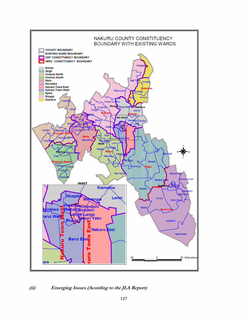
127
(ii) Emerging Issues (Acording to the JLA Report)
128
Subukia & Rongai
There was a mix-up in the transfer of divisions, locations and sub-location and
Minority group interests were not considered (Ogiek)
Naivasha
Community of interest, Historical, Economical and cultural ties not considered.
The area is home to diverse people groups, and would benefit from better representation.
Population quota; has high population of 226,056 and by the quota qualifies for 2 extra
conctituencies instead of one as proposed.
Molo
Re-drawing of boundaries: - one sub-location, Piape, was to be moved from Rongai to Njoro
constituency but this was not done.
Kuresoi
Community of interest, Historical, Economical and cultural Ties/Minorities/Marginalization not
taken into consideration.
The minority group & marginalized in the area, the Ogiek, will be further marginalized as the
new constituency, Njoro is bigger than the mother constituency, Molo, thus offering less chance
of representation of this people.
4.3.34 Narok County
(i) Public Presentations and IIBRC Proposals on Constituency Boundaries
Public Views IIBRC Proposals
1. Proposals related to Kilgoris Constituency .Proposal 1. Kilgoris constituency be split into:-
1. Trans- Mara East – to cover Meguarra tributaries between Shartuka and Ololtenet ward. It will follow along the river towards thicketed area Olomismis and Join Mogor river covering engulfing the former pirrar and kerindon Division and continue s along the valley of Operai downstream to Mara river.
2. Trans-Mara West- the remaining part of the entire district
Kiligoris Constituency Masurura Ward, Nkararo Ward, Osinoni Ward, Olomismis Ward, Shartuka Ward, Kapune Ward, Poroko Ward, Ololchani Ward, Shankoe Ward, Kimintet Ward, Oloirien Ward, Enoosaen Ward, Angata- Barrikoi Ward, Moyoi Ward and Sikawa Ward of Narok County.
129
Public Views IIBRC Proposals
Proposal 2. Kilgoris constituency be split into:-
1. Trans-Mara East- cover the previous Pirrar and Kerindon divisions;
2. Kilgoris Constituency Proposal 3. Kilgoris constituency be split into:- 1. Emurua Dikirr, (include Ololmaasani, Dikirr Divisions) 2. Trans Mara South,(Include Kirindon, Lolgorian,
Loirien); and 3. Trans Mara North (Include Keyian, Kilgoris,Pirrar)
Emurua Dikirr Constituency Osinoni Ward, Njipiship Ward, Ololmaasani Ward, Mogondo Ward, Ilkerin Ward, Emarti Ward, Kapsasian Ward, Emurua Dikirr Ward of Narok County.
2. Proposals related to Narok North Constituency
Proposal 1. Spilt Narok into:-Narok North and Narok East Proposal 2. Spilt Narok into:-Narok North, Narok east and Melili
Proposal 3. Spilt Narok into:- Narok North, Narok East and Melili
The Existing Narok North constituency be split into two, Narok North and East Constituencies. The Mau and Olokurto divisions will form the basis of splitting the constituency, Central division will be redistributed.
The residents of Ntulele Ward wanted the ward be split into two; Ntulele and Olenkomei.
It was proposed that the proposed Melili constituency would border Narok North along Olchorro/Entontol boundary separated by the Nairobi - Narok highway.
Reasons being:-
Representation and benefitting from the allocation of funds from the council. Equal distribution of resources and manpower if their requests were granted
Narok North Constituency
Olpusimoru Ward, Naisoya Ward, Olokurto Ward, Olorropil Ward, Entiani Ward, Olchorro Ward, Siyiapei Ward, Olopito Ward, Masikonde Ward, Entontol Ward, Stadium Ward, Imasharian-Morijo Ward, Oleleishwa Ward, Nkairamiram Ward, Nkareta North Ward, Olokurto Ward, Upper Melili Ward, Enabelbel Ward of Narok County. Narok East Constituency Mosiro Ward, Oletukat Ward, Ongata Naado Ward, Suswa Ward, Nkareta East Ward, Keekonyoike Ward, Ntulele Ward, Ololpironito Ward, Enoosupukia Ward and Idarmat Wards of Narok County.
3. Proposals related to Narok South Constituency Split Narok south into two;
1. Olululunga
2. Osupuko
Narok South Constituency Loita West Ward, Morijo Loita Ward,
Elang‟ata-Enterit Ward, Naroosura Ward, Naikarra Ward, Siana Ward, Mara Ward, Olderkesi Ward, Olkinyei
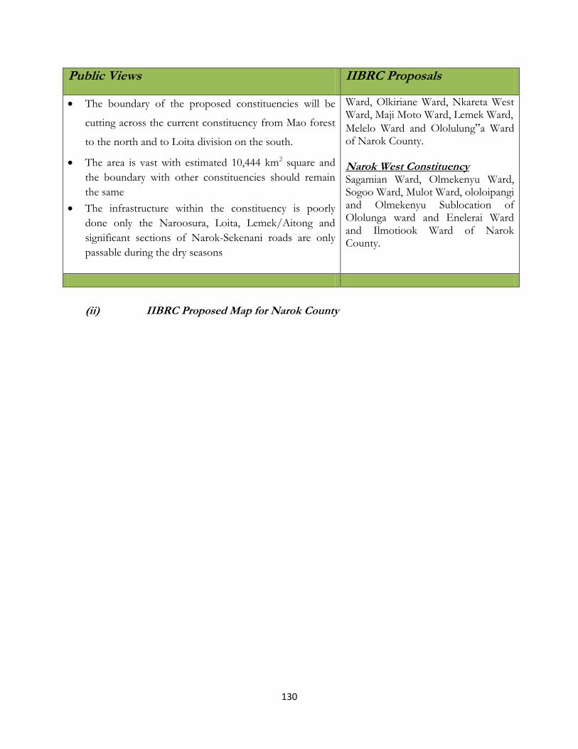
130
Public Views IIBRC Proposals
The boundary of the proposed constituencies will be
cutting across the current constituency from Mao forest
to the north and to Loita division on the south.
The area is vast with estimated 10,444 km2 square and
the boundary with other constituencies should remain
the same
The infrastructure within the constituency is poorly
done only the Naroosura, Loita, Lemek/Aitong and
significant sections of Narok-Sekenani roads are only
passable during the dry seasons
Ward, Olkiriane Ward, Nkareta West Ward, Maji Moto Ward, Lemek Ward,
Melelo Ward and Ololulung‟a Ward of Narok County. Narok West Constituency Sagamian Ward, Olmekenyu Ward, Sogoo Ward, Mulot Ward, ololoipangi and Olmekenyu Sublocation of Ololunga ward and Enelerai Ward and Ilmotiook Ward of Narok County.
(ii) IIBRC Proposed Map for Narok County

131
(ii) Emerging Issues (Acording to the JLA Report)
No issues emerged.
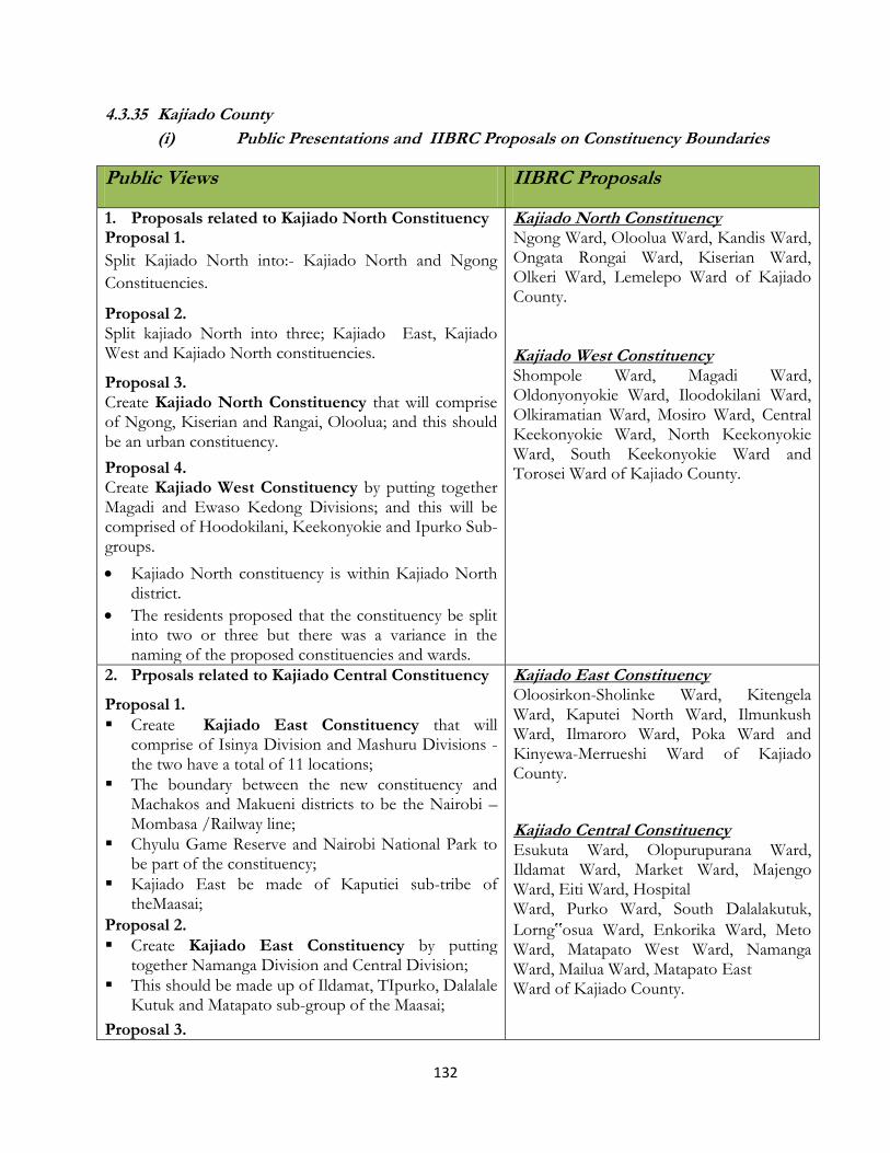
132
4.3.35 Kajiado County
(i) Public Presentations and IIBRC Proposals on Constituency Boundaries
Public Views IIBRC Proposals
1. Proposals related to Kajiado North Constituency Proposal 1.
Split Kajiado North into:- Kajiado North and Ngong
Constituencies.
Proposal 2. Split kajiado North into three; Kajiado East, Kajiado West and Kajiado North constituencies.
Proposal 3. Create Kajiado North Constituency that will comprise of Ngong, Kiserian and Rangai, Oloolua; and this should be an urban constituency.
Proposal 4. Create Kajiado West Constituency by putting together Magadi and Ewaso Kedong Divisions; and this will be comprised of Hoodokilani, Keekonyokie and Ipurko Sub-groups.
Kajiado North constituency is within Kajiado North district.
The residents proposed that the constituency be split into two or three but there was a variance in the naming of the proposed constituencies and wards.
Kajiado North Constituency Ngong Ward, Oloolua Ward, Kandis Ward, Ongata Rongai Ward, Kiserian Ward, Olkeri Ward, Lemelepo Ward of Kajiado County. Kajiado West Constituency Shompole Ward, Magadi Ward, Oldonyonyokie Ward, Iloodokilani Ward, Olkiramatian Ward, Mosiro Ward, Central Keekonyokie Ward, North Keekonyokie Ward, South Keekonyokie Ward and Torosei Ward of Kajiado County.
2. Prposals related to Kajiado Central Constituency
Proposal 1.
Create Kajiado East Constituency that will comprise of Isinya Division and Mashuru Divisions - the two have a total of 11 locations;
The boundary between the new constituency and Machakos and Makueni districts to be the Nairobi – Mombasa /Railway line;
Chyulu Game Reserve and Nairobi National Park to be part of the constituency;
Kajiado East be made of Kaputiei sub-tribe of theMaasai;
Proposal 2.
Create Kajiado East Constituency by putting together Namanga Division and Central Division;
This should be made up of Ildamat, TIpurko, Dalalale Kutuk and Matapato sub-group of the Maasai;
Proposal 3.
Kajiado East Constituency Oloosirkon-Sholinke Ward, Kitengela Ward, Kaputei North Ward, Ilmunkush Ward, Ilmaroro Ward, Poka Ward and Kinyewa-Merrueshi Ward of Kajiado County.
Kajiado Central Constituency Esukuta Ward, Olopurupurana Ward, Ildamat Ward, Market Ward, Majengo Ward, Eiti Ward, Hospital Ward, Purko Ward, South Dalalakutuk,
Lorng‟osua Ward, Enkorika Ward, Meto Ward, Matapato West Ward, Namanga Ward, Mailua Ward, Matapato East Ward of Kajiado County.

133
Public Views IIBRC Proposals
Kajiado West, Kajiado East(Isinya division of Kajiado North constituency and Mashuru division of Kajiado Central division), and Kajiado south.
Proposal 4. Create Ngong Constituency:- Boundaries of the proposed Ngong to be:-
The Ngong Hill to the West
The Kiserian River to the East
The Mbagathi river to the South;
Ngong Forest and Kibiko Escarpment to The South west.
Proposal 5. Option 1 Kajiado East:- They proposed to be curved from the two districts (Kajiado Central and Kajiado North) Option 2
1. Kajiado East 2. Kajiado West
The two constituencies to be curved from the two districts (Kajiado Central and Kajiado North) Option 3
1. Namanga 2. Kajiado West
The two constituencies to be curved from the two districts (Kajiado Central and Kajiado North
3. Proposals related to Kajiado South Constituency
Proposal 1.
change the name of Loitoktok constituency to Kajiado South Constituency and every location to be made a ward;
Kajiado South constituency should to remain as presently constituted (should not be divided);
Rombo Group Ranch to be squarely in Loitoktok constituency/District;
Proposal 2.
Split the constituency into two: Loitokitok West and Loitokitok East.
Kajiado South Constituency Lenkisim Ward, Entonet Ward, Mbirikani Ward, Kimana Ward, Olorika-Kuku Ward, Oloolopon Ward, Entarara Ward and Rombo-Njukini Ward of Kajiado County.
(ii) IIBRC Proposed Map for Kajiado County

134
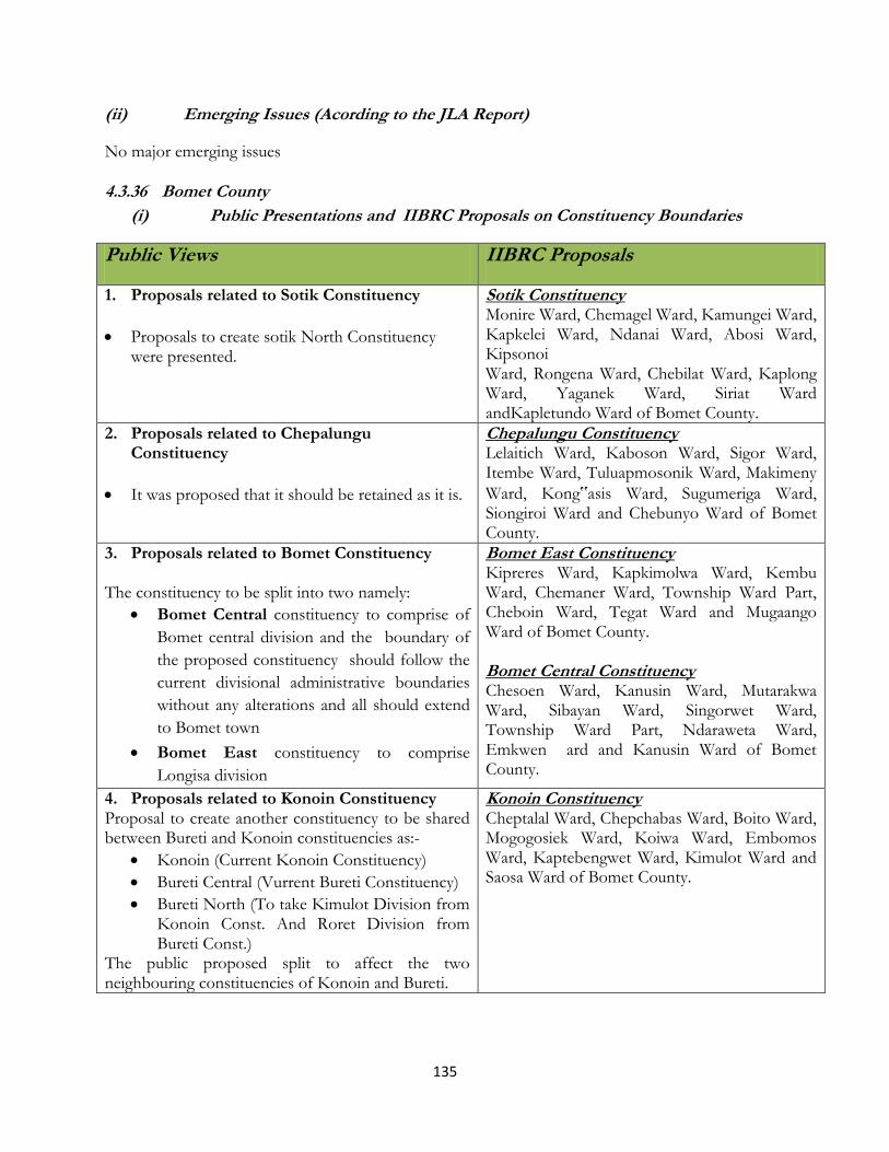
135
(ii) Emerging Issues (Acording to the JLA Report)
No major emerging issues
4.3.36 Bomet County
(i) Public Presentations and IIBRC Proposals on Constituency Boundaries
Public Views IIBRC Proposals
1. Proposals related to Sotik Constituency
Proposals to create sotik North Constituency were presented.
Sotik Constituency Monire Ward, Chemagel Ward, Kamungei Ward, Kapkelei Ward, Ndanai Ward, Abosi Ward, Kipsonoi Ward, Rongena Ward, Chebilat Ward, Kaplong Ward, Yaganek Ward, Siriat Ward andKapletundo Ward of Bomet County.
2. Proposals related to Chepalungu Constituency
It was proposed that it should be retained as it is.
Chepalungu Constituency Lelaitich Ward, Kaboson Ward, Sigor Ward, Itembe Ward, Tuluapmosonik Ward, Makimeny
Ward, Kong‟asis Ward, Sugumeriga Ward, Siongiroi Ward and Chebunyo Ward of Bomet County.
3. Proposals related to Bomet Constituency
The constituency to be split into two namely:
Bomet Central constituency to comprise of
Bomet central division and the boundary of
the proposed constituency should follow the
current divisional administrative boundaries
without any alterations and all should extend
to Bomet town
Bomet East constituency to comprise
Longisa division
Bomet East Constituency Kipreres Ward, Kapkimolwa Ward, Kembu Ward, Chemaner Ward, Township Ward Part, Cheboin Ward, Tegat Ward and Mugaango Ward of Bomet County. Bomet Central Constituency Chesoen Ward, Kanusin Ward, Mutarakwa Ward, Sibayan Ward, Singorwet Ward, Township Ward Part, Ndaraweta Ward, Emkwen ard and Kanusin Ward of Bomet County.
4. Proposals related to Konoin Constituency Proposal to create another constituency to be shared between Bureti and Konoin constituencies as:-
Konoin (Current Konoin Constituency)
Bureti Central (Vurrent Bureti Constituency)
Bureti North (To take Kimulot Division from Konoin Const. And Roret Division from Bureti Const.)
The public proposed split to affect the two neighbouring constituencies of Konoin and Bureti.
Konoin Constituency Cheptalal Ward, Chepchabas Ward, Boito Ward, Mogogosiek Ward, Koiwa Ward, Embomos Ward, Kaptebengwet Ward, Kimulot Ward and Saosa Ward of Bomet County.

136
(ii) IIBRC Proposed Map for Bomet County
(ii) Emerging Issues (Acording to the JLA Report)
No major emerging issues.
(iii) IEBC Proposals

137
4.3.37 Kericho County
(i) Public Presentations and IIBRC Proposals on Constituency Boundaries
Public Views IIBRC Proposals
1. Proposal related to Kipkelion Constituency
Proposal presented on the creation of Kepkelion West Constituency and Kepkelion East Constituency.
Kipkelion East Constituency Londiani Ward, Kimugul Ward, Kipsirichet Ward,Masaita-Toiyobei Ward, Chesinende Ward, Kedowa Ward, Sorget Ward, Lemotit Ward, Kapseger Ward,Cheboswa Ward, and Tendeno Ward of Kericho County. Kipkelion West Constituency Kunyak Ward, Kapseger Ward (Tugunon and Chepcholiet Sublocations) (Part), Moniat (Kamarus Sublocation) Ward Part, Kokwet Ward, Chilchila Ward, Kipteres Ward, Kamasian Ward, Barsiele Ward and Lesirwa Ward of Kericho County.
2. Proposal related to Ainamoi Constituency
No proposal was presented.
Ainanmoi Constituency Ainamoi Ward, Kapsaos Ward, Kipchimchim Ward, Kimugungu Ward, Kapkugerwet Ward, Majengo Ward, Soin (Kechiliat and Kapkomonom Sublocations) Ward (Part), Hospital-Biashara Ward, Motobo Ward, Chelimo Ward, Kenegut Ward and Kapsoit Ward of Kericho County.
3. Proposal related to Belgut Constituency
Three proposals given. Two indicating that it should remain as it is and the third one indicating that it should be subdivided into Belgut North Constituency and Belgut South Constituency
Belgut Constituency Chemamul Ward, Kabianga Ward, Waldai Ward, Kaptoboiti Ward, Seretut Ward, Cheptororiet Ward, Kipkoyan Ward, Kapsurer Ward, Chaik Ward and Saosa Ward of Kericho County. Sigowet Constituency Kaplelartet Ward, Kiptere Ward, Kebeneti Ward, Soliat Ward and Soin Ward Part of Kericho County.
4. Proposal related to Bureti Constituency
Two proposals given:- Split the Constituency into two to create Bureti North Constituency and Bureti South Constituency.
An additional constituency to be shared among, Buret, Konoin and Sotik Constituencies.
Bureti Constituency Cheplanget Ward, Kapkatet Ward, Kibugat Ward, Chemosot Ward, Cheborge Ward, Cheptendeniet Ward, Litein Ward, Kusumek Ward, Tebesonik Ward, Kisiara Ward and Techoget Ward of Kericho County.

138
(ii) IIBRC Proposed Map for Kericho County
(ii) Emerging Issues (Acording to the JLA Report)
a) Ainamoi
Historical ties were not considered during the delimitation and consultation was not done on where
the boundaries should be.
b) Kipkelion West
The Means of communication was no considered since the headquarters of the new constituency is
far from the residents. The Population quota of the wards needs to be redistributed to ensure
balanced population in the Kipkelion West and East Constituencies.

139
4.3.38 Kakamega County
(i) Public Presentations and IIBRC Proposals on Constituency Boundaries
Public Views IIBRC Proposals
1. Proposals related to Mumias Constituency The following proposals were made during the public hearings as concerns Mumias Constituency:
Split the current Mumias Constituency into two. The first part is Mumias which will comprise of Mumias Central Division and South Wanga Division. Its Population is estimated at 124,321 inhabitants with an area of 191.8 Km2 and Population Density of 648 people/Km2 . The Proposed wards for Mumias Constituency Etenje, Musanda, Eshikalawe, Buchifi, Emasinjira, Emukhuwa, Bungasi, Eshikhalame, Eshihaka, Municipality, Mwigunda, Matawa, Lubinu, Chibale, Ekero, Kamashia, Bomanyi, Nucleus and Lureko (Total of 18 wards).
The second one is Mumias East to comprise of East Wanga and Wanga Mukulu with an area of 134.6Km2.
The Projected population is103,230 and Population Density of 766.72 people/Km2. East Wanga Division has Eluchea, Eluche, Shibinga, Makhwale, Shianda wards.Wanga Mukulu Division comprise of Malaha, Aunga, Mbomini, Makunga, Mukubu, Isongo and Khaimba ward.
Mumias Constituency Mumias Central Ward, Nucleus-Mumias North Ward, Ekero Ward, Lureko Ward, Matawa Ward, Etenje Ward, Shikalame Ward and Musanda Ward of Kakamega County.
Mumias East Constituency
East Wanga Ward, Eluche Ward, Lusheya Ward, Mukulu Ward, Isongo Ward and Shibinga Ward of Kakamega County.
2. Proposals realted to Matungu constituency Split Matungu constituency into; 1. Koyonzo constituency - will comprise of the
following locations/wards: Indangalasia, Koyonzo, Lung’ganyiro, Namamali, Nanyeni, Munami, Mirere; and
2. Matungu Constituency- will comprise of the following locations/wards: Khalaba, Mayoni, Matungu, Kholera, Musamba, Makale, Mwira and Namulungu
3. Alternatively take;
Koyonzo, Nanyeni, Lung’anyiro, Munami, Emanani, Mirere, Indangalasia, Mayoni, Makale, Ikama, Matungu, Namulungu, Kholera, Khalaba and Musambe wards should form Matungu Constituency;
This should comprise of three (3) municipality wards and 12 county council making a total of 15 wards.
Matungu Constituency Matungu Ward, Lunga‟anyiro Ward, Namamali Ward, Koyonzo Ward, Mayoni Ward, Indangalasia Ward, Kholera Ward, Khalaba Ward of
Kakamega County.
3. Proposals for Khwisero Constituency Khwisero Constituency

140
Public Views IIBRC Proposals
(iii) Khwisero Costituency (Sub – divided) Khwisero East Constituency to cover proposed Khwisero North and Khwisero East division and Khwisero West Constituency to cover proposed Khwisero West division and Khwisero Central division.
It was proposed that Esherombe to be reinstated as a ward; Mulwanda should be divided into two wards (Mulwanda and Mushiangubu); North to be divided into two wards (North and Mundorerwa); and Central be divided into two (Central and Township);
It was further proposed that the Constituency be subdivided into two: East Bunyore and West Bunyore.
West Kisa Ward, Central Kisa Ward, East Kisa Ward; South Kisa Ward, Mulwanda Ward and North KisaWard of Kakamega County.
4 Proposals for Butere Constituency (iv) Proposal to split Butere (Butere North
Constituency) – to cover Lunza and Butere divisions. Shiatsala (Butere South Constituency) – to cover Shiatsala and proposed Marenyo divisions.
Alternatively:
Divide Butere into two Constituencies namely South Butere and North Butere and create new wards :- Eshitari, Imanga, Shiraha, and Marenyo;
South Butere Constituency should comprise of :-Marama South; Manyala; Shianda; Township; Marama Central; and Imanga;
North Butere Constituency should be formed by Marama North; Shiraha; Lunza; Buchenya; Marenyo and Eshitari.
Butere Constituency
North Marama Ward, Buchenya Ward, Lunza Ward, Central Marama Ward Butere Township Ward and South Marama Ward, Manyala Ward, Marenyo-Shianda Ward of Kakamega County.
5 Proposals for Lugari Constituency Proposal 1. (v) Split the current Lugari constituency into: Lugari
West - will cover lugari, lumakanda, chekalini, lwandenti and chevaywa locations and Lugari East - will cover nzoia, kongoni, likuyani, mautuma and sinoko locations
Proposal 2. (vi) Split the current Lugari constituency into: Likuyani
constituency; Matete constituency and Lugari constituency
Proposal 3. (vii) Split the current Lugari constituency into: Lugari
constituency - would comprise of the following
Lugari Constituency Mwamba Ward, Munyuki Ward, Marakusi Ward, Mautuma Ward, Chekalini Ward, Lugari Ward, Chevaywa Ward, Mabuye Ward, Luandeti Ward, Mahanga Maturu Ward of Kakamega County. Likuyani Constituency Likuyani Ward, Sango Ward, Kongoni
Ward, Moi‟s Bridge-Matunda Ward, Musemwa-Vinyenya Ward and Sinoko Ward of Kakamega County.
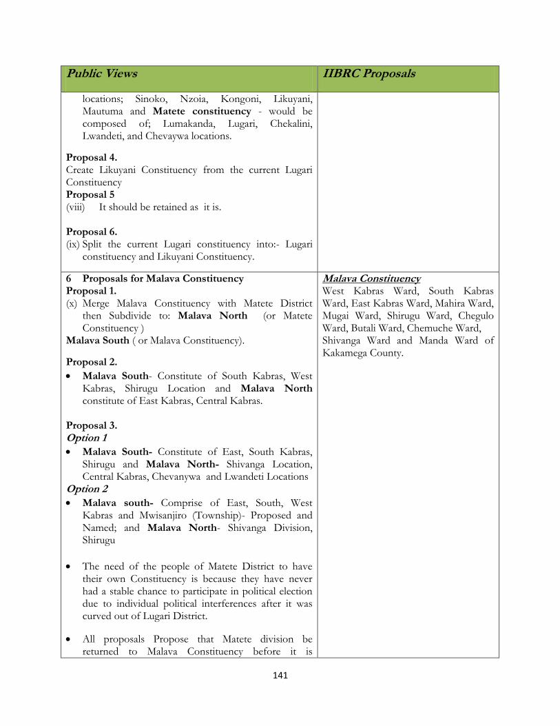
141
Public Views IIBRC Proposals
locations; Sinoko, Nzoia, Kongoni, Likuyani, Mautuma and Matete constituency - would be composed of; Lumakanda, Lugari, Chekalini, Lwandeti, and Chevaywa locations.
Proposal 4. Create Likuyani Constituency from the current Lugari Constituency Proposal 5 (viii) It should be retained as it is. Proposal 6. (ix) Split the current Lugari constituency into:- Lugari
constituency and Likuyani Constituency.
6 Proposals for Malava Constituency Proposal 1. (x) Merge Malava Constituency with Matete District
then Subdivide to: Malava North (or Matete Constituency )
Malava South ( or Malava Constituency).
Proposal 2.
Malava South- Constitute of South Kabras, West Kabras, Shirugu Location and Malava North constitute of East Kabras, Central Kabras.
Proposal 3. Option 1
Malava South- Constitute of East, South Kabras, Shirugu and Malava North- Shivanga Location, Central Kabras, Chevanywa and Lwandeti Locations
Option 2
Malava south- Comprise of East, South, West Kabras and Mwisanjiro (Township)- Proposed and Named; and Malava North- Shivanga Division, Shirugu
The need of the people of Matete District to have their own Constituency is because they have never had a stable chance to participate in political election due to individual political interferences after it was curved out of Lugari District.
All proposals Propose that Matete division be returned to Malava Constituency before it is
Malava Constituency West Kabras Ward, South Kabras Ward, East Kabras Ward, Mahira Ward, Mugai Ward, Shirugu Ward, Chegulo Ward, Butali Ward, Chemuche Ward, Shivanga Ward and Manda Ward of Kakamega County.

142
Public Views IIBRC Proposals
subdivided.
7 Proposals for Lurambi Constituency Proposal 1. a) Split Lurambi constituency into: Kakamega town;
Navakholo – (will comprise of West Bunyala,
Nambacha, and east Bunyala Locations-Navakolo
division); and Lurambi – (will comprise of the current
North Butsotso, South butsotso, Centaral Butsotso, and
East butsotso Locations).
Proposal 2. b) Split lurambi into:- Lurambi North; Lurambi South;
and Navakholo Constituencies.
Lurambi Constituency Sichirayi Ward, Central Ward, Milimani Ward, Amalemba Ward, Matende Ward Musaa Ward, Bukhulunya Ward, Shibiriri Ward, Maraba Ward, Mahiakalo Ward and Shikoti Ward, Bukura Ward, Central Butsotso Ward of Kakamega County.
Navakholo Constituency Shinoyi-Shikomari-Esumeiya Ward, Budonga Ward, Ingotse-Matiha Ward, Bunyala Central-Nambacha Ward, Bunyala East-Namirama Ward, Sidikho-Kochwa Ward of Kakamega County.
8 Proposals for Shinyalu Constituency c) Proposal to split Shinyalu constituency into: - Ileho
Constituency (to cover Ivihiga and Kambiri
divisions) and Shinyalu Constituency (comprising
of West and Central isukha divisions)
Shinyalu Constituency Kambiri Ward, East Isukha Ward, Murhanda Ward, Ivihiga Ward, Virhembe-Mukango Ward, Shing’oto- Shiasava Ward, Museno-Shirulu-Lukose Ward, Shidodo-Shitochi Ward and Ilesi Ward of Kakamega County.
9 Proposals for Ikolomani Constituency d) Split Ikolomani Constituency into two as follows:
Ikolomani North -( to comprise of proposed
Ikolomani North and central divisions) and
Ikolomani south -(To comprise of Ikolomani East
and South divisions).
Ikolomani Constituency Idakho North Ward, Idakho Central Ward, Idakho East Ward, Idakho North Ward and Idakho South Ward of Kakamega County.
(ii) IIBRC Proposed Map for Kakamega County

143
(ii) Emerging Issues (Acording to the JLA Report)
a) Malava
The Population quota was not adhered to. The population of Malava is beyond the National quota,
at a population of 205’166 in area of 427.40 sq.km and yet was not subdivided.
144
4.3.39 Vihiga County
(i) Public Presentations and IIBRC Proposals on Constituency Boundaries
Public Views IIBRC Proposals
1. Proposals related to Vihiga Constituency Proposal 1. b) Vihiga Municipal Constituency or “Wambale” for
the Maragolis to include: Wamuluma, Central Maragoli, Izava North, Izava South and part of Chavakali and West Maragoli locations; and
c) To be curved from Sabatia and Vihiga constituencies. Proposal 2.
Split Vihiga constituency to create:- Mbale constituency; The current Sabatia and Vihiga constituencies should be brought together so that a new constituency will be curved out to form Mbale constituency; and Mbale constituency will incorporate the current Chavakali division of Sabatia district in addition to Mbihi, chambiti, Kegoye and Chango sub - locations of Vihiga district; Sabatia constituency and Vihiga constituency.
Vihiga Constituency Wamuluma Ward, Lugaga Ward, Mungoma Ward, Central Maragoli Ward and South Maragoli Ward of Vihiga County.
2. Proposals related to Sabatia Constituency Proposal 1.
Convert the following proposed divisions to constituncy
i. Division 1-Wadonga and North Maragoli location,
ii. Division 2-Busali East and West iii. Division 3-West Maragoli and Chavakali
locations, iv. Division 4-Izava north and South location v. Division 6- Lugaga, Mung’oma location, vi. Division 5-Central and south maragoli location;
and vii. Vihiga municipality.
Proposal 2.
Merge Sabatia and Vihiga Constituency and create and create 3 constituencies namely: Mbale, Sabatia and Vihiga
Sabatia Constituency Busali Ward, Wodanga Ward, North Maragoli Ward, Chavakali Ward, Ezava Ward, Lyaduywa Ward and Sabatia West Ward of Vihiga County.
3. Proposals related to Hamisi Constituency Proposal 1.
Hamisi constituency split to; 1. Itirichi Yiivwakwe (East Tiriki)
Hamisi Constituency Muhudu Ward, Shiru Ward, Shaviringa
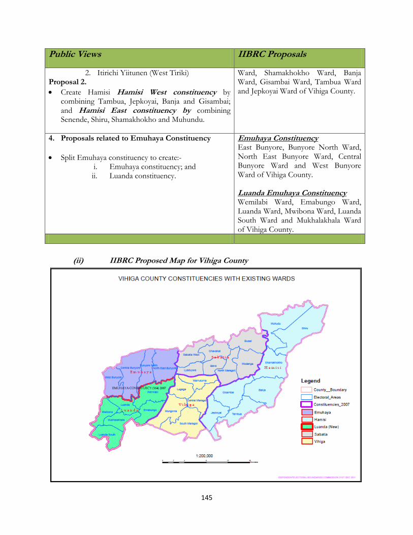
145
Public Views IIBRC Proposals
2. Itirichi Yiitunen (West Tiriki) Proposal 2.
Create Hamisi Hamisi West constituency by combining Tambua, Jepkoyai, Banja and Gisambai; and Hamisi East constituency by combining Senende, Shiru, Shamakhokho and Muhundu.
Ward, Shamakhokho Ward, Banja Ward, Gisambai Ward, Tambua Ward and Jepkoyai Ward of Vihiga County.
4. Proposals related to Emuhaya Constituency
Split Emuhaya constituency to create:- i. Emuhaya constituency; and ii. Luanda constituency.
Emuhaya Constituency East Bunyore, Bunyore North Ward, North East Bunyore Ward, Central Bunyore Ward and West Bunyore Ward of Vihiga County. Luanda Emuhaya Constituency Wemilabi Ward, Emabungo Ward, Luanda Ward, Mwibona Ward, Luanda South Ward and Mukhalakhala Ward of Vihiga County.
(ii) IIBRC Proposed Map for Vihiga County

146
(ii) Emerging Issues (Acording to the JLA Report)
No major emerging issues.
4.3.40 Bungoma County
(i) Public Presentations and IIBRC Proposals on Constituency Boundaries
Public Views IIBRC Proposals
1. Proposals realted to Mt. Elgon Constituency Option1 1. Mt. Elgon West constituency /district (Cheptais) will
comprise of Chepatis and Kopsiro divisions with Cheptais, Chepkube, Sasuri, Cheongenywo and Kapkateny locations;
2. Mt. Elgon East constituency (Kapsokwony) will comprise of Kapsokwony, Kaptama divisions with Kamuneru, Nomorio, Elgon, Kapsokwony, Chemoge, Kongit, Kaptama and Kaboywo locations;
Option 2 1. Mt. Elgon West constituency/district (Cheptais) will
comprise of Chepatis and Kopsiro divisions with Cheptais, Chepkube, Sasuri, Cheongenywo and Kapkateny locations;
2. Mt. Elgon East constituency/district (Kapsokwony) will comprise of Kapsokwony, Kaptama divisions with Kamuneru, Nomorio, Elgon, Kapsokwony, Chemoge, Kongit, Kaptama and Kaboywo locations;
3. Mt. Elgon Central constituency Option 3.
1. Create Endebese Constituency
Mt. Elgon
Cheptais Ward, Chepkube Ward, Sasur Ward, Chesikak Ward, Emmia Ward, Chengeywo Ward, Kapkateny Ward, Chepyuk Ward, Namorio Ward, Elgon Ward, Chemoge Ward, Kaboywo Ward and Kaptama Ward of Bungoma County.
2. Proposals realted to Sirisia Constituency It was proposed that:-
Kabuchai constituency to comprise of Nalondo, Kabuchai, Chwele and Mukuyuni divisions; this will cover the entire Bungoma central district
Sirisia constituency to comprise of the old Sirisia with code 171 and it will cover Sirisia, Namwela, Lwandanyi and Malakisi division which will cover the entire Bungoma west district with Changara.
Sirisia constituency to comprise of the old Sirisia with code 171 and it will cover Sirisia, Namwela, Lwandanyi and Malakisi division which will cover the entire Bungoma west district with Changara.
Sirisia Constituency Namwela Ward, Kulisiru Ward, Chongoyi Ward, Ndakalu Ward, Namubila Ward, Lwandanyi Ward, Chebukutumi Ward, Sitabicha-Mwalie East Ward and Tamlega-Mwalie West Ward of Bungoma County. Kabuchai Constituency Mukuyuni Ward, Chwele Ward, Kabuchai Ward, North Bukusu Ward, Luuya Ward and Sirare Ward of Bungoma County.
3. Proposals related to Bumula Constituency Proposal 1.
Proposed that the following locations form the Bumula constituency:-Musikoma, Mabusi, Bumula, Khasoko, Bukusu, Kabula;
Bumula Constituency Kabula Ward, South Bukusu Ward, Khasoko Ward, Bumula Ward, West Bukusu Ward, Kimaeti Ward, Siboti
147
Public Views IIBRC Proposals
Proposed the creation of Siboti Constituency having the following wards:-Kibuke; Kimaieti; Napara; Siboti; waisawahi and Mukwa;
The following Wards were proposed to be created:- Nakhawana, Nasianda, Mabusi, Watoya, Nabudalaya, Siboti, Mwomo, Mayanja, Lumboka, Isawahi, Musakasa.
Proposal 2. (vii) Kibabii constituency be created out of Bumula and
Kanduyi constituencies and it will comprise of Kibabii, Mukwa, Siboti, Napara, Kimaeti, West Bukusu Locations and Sinoko Ward and Siranyi Wards.
Ward, Napara Ward and Mukwa Ward of Bungoma County.
4. Proposals realted to Kanduyi Constituency Kanduyi constitutes: Bungoma South District, and Kanduyi
Division.
It was proposed for the creation of Sang’alo constituency to be curved out of Bumula and Kanduyi constituency which will comprise of the following areas: (i) Bukembe location (ii) East Bukusu location (iii) Khalaba sub-location and Parts of Kabula location;
Kanduyi Constituencies Bukembe West Ward, Bukembe East Ward, East Sang’alo Ward, West Sang’alo Ward Kibabii Ward, Stadium Ward, Siritanyi Ward,Sinoko Ward, Mjini Ward, Sio Ward, Musikoma Ward, Khalaba Ward, Namasanda Ward of Bungoma County.
5. Proposals realted to Webuye Constituency
An area of 214.8 Km2 as per 1999 census.
Proposed to divide Webuye into two constituencies: Ndivisi and Webuye;
Requested Kibisi location to be part of Ndivisi constituency;
Correct the mistake of wards done by transferring districts and transfer Lwandeti to Webuye and rename it Malaha while Lwandeti ward should remain in Lugari;
Ndivisi Constituency should have the following locations:- Chetambe; Lukusi; Namarambi and Ndirisi;
Requested for Mbakalu and Misikhu Sublocations to be added up the population to 97,384;
Proposed Ndivisi Constituency to comprise of the following locations:- Chetambe, Lukusi, Namarambi and Ndivisi;
Proposed to borrow Mbakalu sub-location and Misiku sub-location to form part of Ndivisi constituency.
Webuye Constituency Webuye South Ward, Nabuyoole Ward, Webuye North Ward, Webuye East Ward, Chetambe Ward, Lugusi Ward, Ndivisi Ward and Namarambi Ward of Bungoma County. Bokoli Constituency Bokoli Ward, Misikhu Ward, Milo Ward Sitikho Ward, Miendo Ward and Kituni Ward of Bungoma County.
6. Proposals realted to Kimilili Constituency Proposal 1.
It is formed out of current Kimilili and Bungoma North District with a Population 135,000 inhabitants;
The Bungoma North District should be divided create a new District called Tongaren which should in turn be Split into two constituencies.
Kimilili Constituency Chebukwabi Ward, Kibingei Ward, Kimilili SouthWard, North Ward, Maeni Ward, Makhonge Ward and Nabikoto Ward of Bungoma County. Tongaren Constituency

148
Public Views IIBRC Proposals
The two constituencies should be:-Tongaren constituency should run from River Nzoia to Kiminini River while Naitiri constituency should run from Kiminini river to Kamukuywa river.
Proposal 2. 1. Tongaren constituency to comprise of the old Tongaren and
Ndalu divisions. The feature that delineates the constituency is river Kamukuywa and it borders Saboti and Lugari constituency.
2. Naitiri constituency/Kimilili to comprise of two divisions namely Mbakalo and central division, the feature that delineates this constituency is river Kamukuywa as the district boundary for Kimilili constituency and Tongaren Constituency. This has been the old boundary for the two divisions and it borders Mt. Elgon, Webuye and Sirisia constituencies
Mbakalo Ward, Milima Ward, Kabuyefwe Ward, Tongaren Ward, Soysambu Ward, Kiminini Ward , Naitiri Ward and Ndalu Ward of Bungoma County.
(ii) IIBRC Proposed Map for Bungoma County
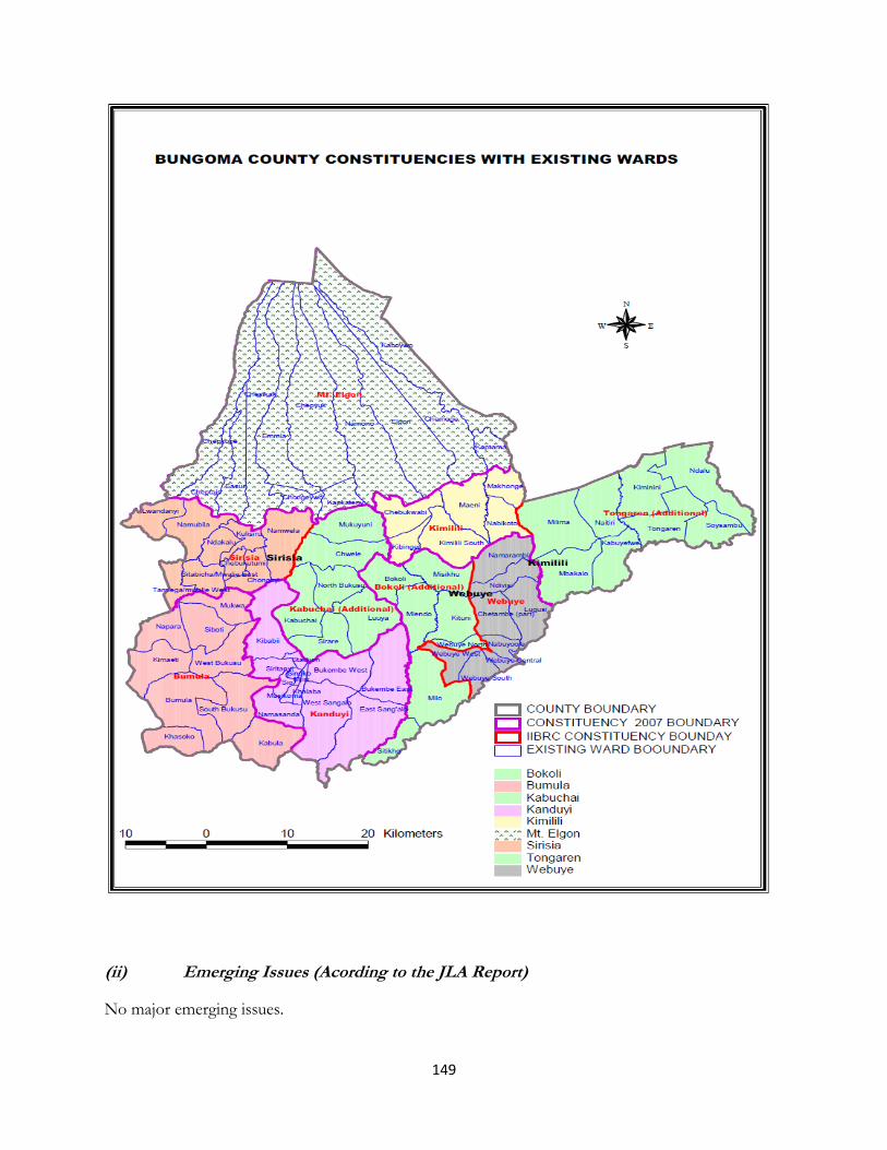
149
(ii) Emerging Issues (Acording to the JLA Report)
No major emerging issues.
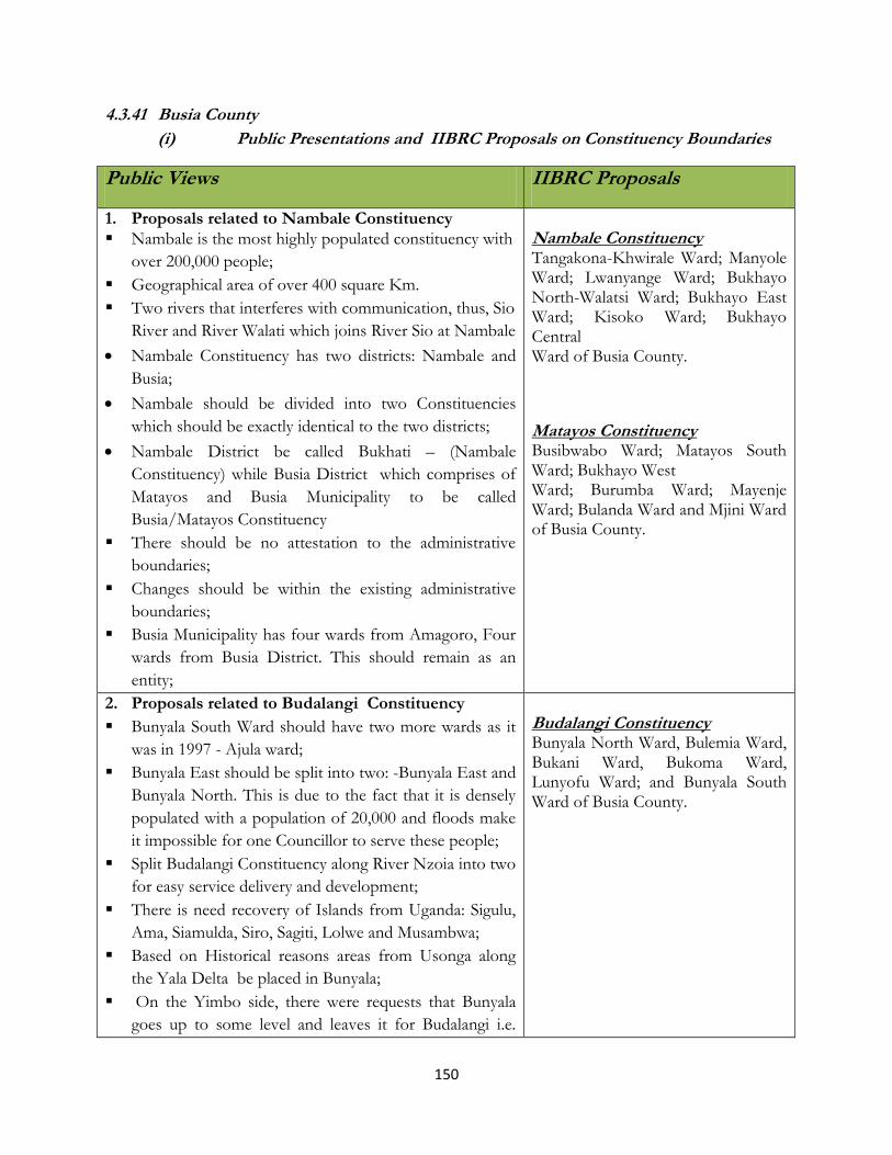
150
4.3.41 Busia County
(i) Public Presentations and IIBRC Proposals on Constituency Boundaries
Public Views IIBRC Proposals
1. Proposals related to Nambale Constituency
Nambale is the most highly populated constituency with
over 200,000 people;
Geographical area of over 400 square Km.
Two rivers that interferes with communication, thus, Sio
River and River Walati which joins River Sio at Nambale
Nambale Constituency has two districts: Nambale and
Busia;
Nambale should be divided into two Constituencies
which should be exactly identical to the two districts;
Nambale District be called Bukhati – (Nambale
Constituency) while Busia District which comprises of
Matayos and Busia Municipality to be called
Busia/Matayos Constituency
There should be no attestation to the administrative
boundaries;
Changes should be within the existing administrative
boundaries;
Busia Municipality has four wards from Amagoro, Four
wards from Busia District. This should remain as an
entity;
Nambale Constituency Tangakona-Khwirale Ward; Manyole Ward; Lwanyange Ward; Bukhayo North-Walatsi Ward; Bukhayo East Ward; Kisoko Ward; Bukhayo Central Ward of Busia County.
Matayos Constituency Busibwabo Ward; Matayos South Ward; Bukhayo West Ward; Burumba Ward; Mayenje Ward; Bulanda Ward and Mjini Ward of Busia County.
2. Proposals related to Budalangi Constituency
Bunyala South Ward should have two more wards as it
was in 1997 - Ajula ward;
Bunyala East should be split into two: -Bunyala East and
Bunyala North. This is due to the fact that it is densely
populated with a population of 20,000 and floods make
it impossible for one Councillor to serve these people;
Split Budalangi Constituency along River Nzoia into two
for easy service delivery and development;
There is need recovery of Islands from Uganda: Sigulu,
Ama, Siamulda, Siro, Sagiti, Lolwe and Musambwa;
Based on Historical reasons areas from Usonga along
the Yala Delta be placed in Bunyala;
On the Yimbo side, there were requests that Bunyala
goes up to some level and leaves it for Budalangi i.e.
Budalangi Constituency Bunyala North Ward, Bulemia Ward, Bukani Ward, Bukoma Ward, Lunyofu Ward; and Bunyala South Ward of Busia County.

151
Public Views IIBRC Proposals
Mau Mau road which is graded up to Goi River and
beyond the slopes of Got Ramogi;
The neighbouring road which Members of Parliament
grades some roads upto some level and leaves it for
Bundalangi i.e. Mau Mau road which is graded up to
Nyadorera and then its left about 12 Km thus, the
section should now be officially given to Budalangi.
The Chairman was not convinced that, the Bunyala had
agreed to divide the Constituency into two.
There were no figures, no maps or memorandum
presented on administrative units.
3. Proposals related to Funyula Constituency
Split Funyula Constituency into two:-Funyula North and Funyula South.
Funyula Constituency Funyula North Ward; Namboboto Ward; Odiado Ward, Wakhungu Ward; Nangina Ward; Funyula South Ward; and Bwiri Ward of Busia County.
4. Proposals related to Amagoro Constituency Proposal 1. Split Amagaro into two constituencies:Teso North- Colonial North Teso Location and Teso South – Colonial South Teso Location
Proposal 2. Split Amagoro into:- 1. Amukura Constituency – Comprise of : Busia town,
Ochude, Omong’ura, Asing’e, Apegei, Angorom, Okame, Kaujakito, Kaliwa, Kotur, Amukura, Kwang’amoru, Aremit, Akoret, okatekok
2. Amogoro Constituency – Walatsi, Lupinda (Bukhayo Reverted original name which is Lupinda), Kimaeti, Akadetewai, Amoni, Amagoro, Kamolo, Kamuriai, Katakwa, Kokare, Aboloi, Kocholya, Kotur, Okuleu, Osajai;
3. Angurai- Aboloi, Angurai, Changara, Chamasini, kakapel, Katakwe, Kolanya, Moding, Lwandanyi, Namubira, Malakisi
Teso South Constituency Malaba West Ward, Amukura East Ward, Amukura Central Ward, Akoret Ward, Chakol North Ward, Kaliwa Ward, Chakol Central Ward, Chakol South Ward, Alupe Ward,
Ang‟orom Ward, Amerikwai Ward and Agolot Ward of Busia County.
Teso North Constituency
Malaba Central Ward, Malaba South Ward, Malaba East Ward, Malaba
North Ward, Ang‟urai Ward,
Ang‟urai North Ward, Ang‟urai East Ward of Busia County.
152
Public Views IIBRC Proposals
5. Proposals related to Butula Constituency
No proposal to split constituency however, Split
Wards/Locations as follows:-
Marachi East, (Tingolo, Bumala, Elukongo), Elukhari (
Elukhari), Elugulu (Bukhuma, Elugulu,) Mariachi Central
(Bukhalalire, Sikoma, Kingandole,) Bumala Bujumba,
(Ikonzo Bujumba )
It is inhabited by Abamarachi Luhya sub-tribe. No expansion or interference with boundaries. They should remain intact;
Requested for more wards.
Butula Constituency Marachi West Ward, Bukhalalire Ward, Esikoma Ward, Elugulu Ward, Elukongo Ward, Elukhari Ward and Tingolo Ward of Busia County.
(ii) IIBRC Proposed Map for Busia County
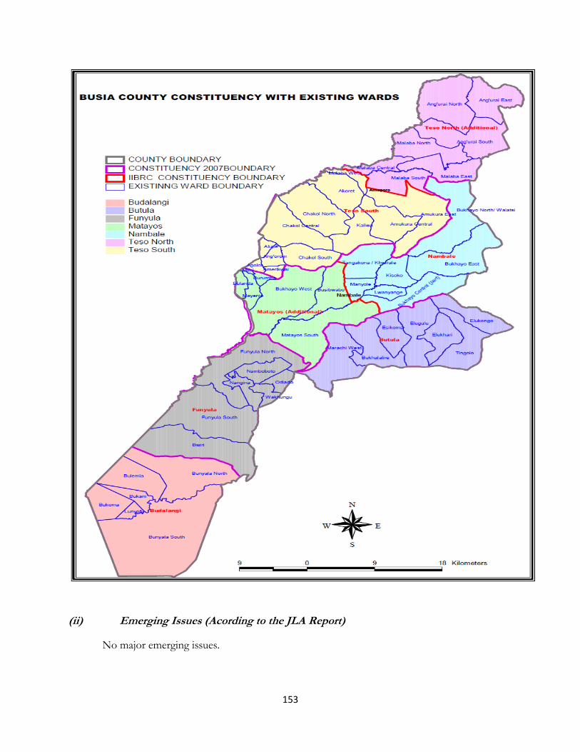
153
(ii) Emerging Issues (Acording to the JLA Report)
No major emerging issues.

154
4.3.42 Siaya County
(i) Public Presentations and IIBRC Proposals on Constituency Boundaries
Public Views IIBRC Proposals
1. Proposals related to Alego Constituency
Three proposals were made:
i). The constituency to be split into two namely: Alego East – comprising of Umala and Kogelo division and Alego West – Comprising of Boro and Uranga division of Siaya district.
ii). The constituency to be split into three namely;Alego East (Umala and Kogelo division)Alego Central (Boro division) and Alego West (Uranga division)
iii). Alego constituency be sub-divided into two; Alego Constituency – Eastern part comprising of East Alego, South East Alego, South Alego, Township and North Alego location.
Alego Usonga – (Central Alego, South Central Alego, South West Alego, West Alego and Usonga location.
Alego Usonga Constituency Mjini Ward, Siaya East Ward, Siaya West Ward, SiayaNorth Ward, Siaya Central Ward, Usonga Ward, West Alego Ward, South West Alego Ward, East AlegoWard, South Alego Ward, Boro West Ward, Boro EastWard and South East Alego Ward of Siaya County.
2. Proposals related to Ugenya Constituency
It was proposed to split Ugenya Constituency into Two namely Ugunja Constituency and Ugenya Constituency.
Ugenya Constituency Ukwala West Ward, Ukwala East Ward, North West,Ugenya Ward, North Ugenya Ward, West Ugenya Ward, East Ugenya Ward, Jera Ward, North East, Ugenya Ward and West Ugenya Ward of Siaya County. Ugunja Constituency Ugunja Ward, North Alego (Part) Ward, Uholo NorthWard, Uholo East Ward, Ugunja Ward, South Ugenya Ward, Umala Ward, Ambira-Ngunya Ward andMagoya-Rambula Ward of Siaya County.
3. Proposals related to Rarieda Constituency
It was proposed that Rarieda constituency be Sub-divided into two namely (i) Madiany constituency- made of Madiany East
Rarieda Constituency East Uyoma Ward, West Uyoma Ward, South UyomaWard, Central Uyoma Ward, East Asembo Ward
155
and West.
(ii) Rarieda constituency- made of Rarieda East and West
and Central Asembo Ward of Siaya County.
4. Proposals related Gem Constituency It was proposed that Gem be split into two namely:
(i) Gem Yala – to include Malanga, Yala Division
(ii) Gem-Wagai- comprising Wagai, Rera, Bar Kalare Divisions
Gem Constituency Anyiko-Sauri Ward, Nyamninia Ward, Jina Ward,Marenyo Ward, North Gem Ward, Central Gem Ward, East Gem Ward, Wagai North Ward, Wagai SouthWard and South Gem Ward of Siaya County.
5. Proposals related Bondo Constituency
Three proposals were made: (i) That Bondo Constituency be divided into two namely
Nyan’goma Constituency – Comprise Nyan’goma, Nango, Ouya divisions and Bondo Constituency
(ii) To split Bondo constituency into Usigu constituency
and Bondo constituency
(iii) To split Bondo constituency into Bondo Constituency
and Bondo South Constituency
Bondo Constituency Oyamo Island, Deda Island, Nyawita Ward, MarandaWest Ward, Bondo Town Ward, Ajigo Ward, BarKowino East Ward, Bar Kowino West Ward, UsiguEast Ward, Usigu West Ward, Central Yimbo Ward,North Sakwa Ward, South Sakwa Ward and Central Sakwa Ward of Siaya County.
(ii) IIBRC Proposed Map for Siaya County

156
(ii) Emerging Issues (Acording to the JLA Report)

157
No emergining issues.
4.3.43 Kisumu County
(i) Public Presentations and IIBRC Proposals on Constituency Boundaries
Public Views IIBRC Proposals
1. Proposals related to Kisumu Rural Constituency(Seme)
Five proposals were made: (i) To split Kisumu Rural into Maseno Constituency
and Kombewa Constituency. (ii) To split Kisumu Rural into Seme East and Seme
West and create Luanda Constituency (iii) To split Kisumu Rural into Kisumu Town and
Seme constituencies. (iv) To split Kisumu Rural into Kisumu Rural and
Seme
Seme Constituency North Central Seme Ward, South Central Seme Ward, West Seme Ward, South West Seme Ward, Otwenya Ward and East Seme Ward of Kisumu County.
2. Proposals related to Kisumu East Constituency
Three proposals were made (i) Kisumu East be split into Kibos constituency and
Kisumu Town East constituency (ii) Split KisumuTown East into;
a. Kisumu Town East constituency- Comprised East and west Kajulu, Kondele Locations
b. Kolwa Constituency- comprise of the entire West Kolwa as it is in the current administration structure; central and East Kolwa location bordering Nyando Constituency to the South of Muhoroni constituency at the Sidho-Obumba-Lie Lan’go Border
(iii) Split Kisumu Town East into Kisumu East constituency- (Kajulu East and West, Kolwa Central, Kolwa East and Miwani) Kisumu Central Constituency- Comprise of Town, Kondele, Nyalenda and Migosi
Kisumu East Constituency East Kajulu Ward, West Kajulu Ward, Manyatta Ward,Nyalenda A Ward, East Kolwa Ward and Central Kolwa Ward of Kisumu County.
3. Proposals related to Kisumu West Constituency
Three proposals were made: (i) To split Kisumu Town West into two namely
Kisumu Town West and Kisumu Rural and Re-name current Kisumu Rural to Seme Constituency.
(ii) To split Kisumu Town West into two and re-align boundaries of the Current Kisumu Town West
Kisumu West Constituency South West Kisumu Ward, Kisumu East Ward, Kisumu Central Ward, Kisumu North Ward, Kogony Ward, North West Kisumu Ward and West Kisumu Ward of Kisumu County.

158
Public Views IIBRC Proposals
Consituency (Proposed Seme Constituency) by transferring West and North West Kisumu Wards/ Locations to the proposed Kisumo Constituency
(a) Seme constituency ( To cover N.C Seme, S.C Seme, West Seme, S.W Seme, Otwenya, East Seme Locations)
(b) Kisumo Constituency (To Cover N.W Kisumu,
West Kisumu, S.W Kisumu, East Kisumu, Central Kisumu, North Kisumu Locations)
(iii) To split Kisumu Town West into two to create
Kisumu Central and Kisumu Constituency.
Kisumu Central Constituency Kondele Ward, Nyalenda “B” Ward, Railway Ward,Aerodrome Ward, Milimani Ward, Kibuye Ward, Stadium Ward, North Kisumu Ward, Market Ward,Kaloleni-Shauri Moyo Ward and Migosi Ward of Kisumu County
4. Proposals related to Nyando Constituency
Two proposals were made: (i) To split Nyando constituency into Kadibo
Constituency and Nyando Constituency (ii) To split Nyando constituency intoWinam
Constituency and Nyando Constituency
It was also proposed that the following wards be
created:
(i) A new Tura ward
(ii) Subdivision of Awasi to Osiri, EastAwasi, West
Awasi wards
Create:-
(i) Winam Constituency wards- Comprised of Katho,
Kombura, Kochieng’ East and West, Kanygwal,
Bwanda, Kawino North and Kawino South Wards
and for Remaining wards to constitute Nyando
constituency; and
(ii) Nyando constituency to consist of Tura (New),
Kakola, East Awasi(New), West Awasi Kochogo,
Onjiko, Ayweyo (New), Magina(New) East Kano
wards
Nyando Constituency Kochieng’ Ward, Kawino Ward, Kombura Ward,Bwanda-Kanyagwal Ward, Awasi Ward, East Kano Ward, Kombura-Katho Ward, Kakola Ward, KochogoWard and Onjiko-Wawidhi Ward of Kisumu County.
5. Proposals related to Muhoroni Constituency
Six proposals were made:
Split Muhoroni settlement Constituency- Comprise of Muhoroni and Miwani constituencies (Boundary of the Settlement will be adopted) and Muhoroni
Muhoroni Constituency Miwani Ward, Ombeyi North Ward, Masogo Ward,Nyang’oma Ward, Tamu Ward, Chemilil Ward, God Nyithindo Ward, Muhoroni Town Ward, Owaga Ward,Ward, Fort

159
Public Views IIBRC Proposals
Constituency- formed by the remaining part
And for North East Kano constituency to adopt the Miwani Division Boundaries
(i) Muhoroni to remain as it is. (ii) To review Nyando, Muhoroni and Kisumu East
Constituency boundaries and names to include Awasi, Kakola, Kikolo, Kochogo, Wawidhi, Onjiko wards;
(iii) Muhoroni Constituency to be renamed Kano North Constituency to nclude Muhoroni township, Chemelil, Fort Tenan, God Nyithindo, Koru, Nyang’oma, N.E Kano, Ombeyi, Miwani Locations
(iv) Nyando Constituency to be renamed Kano East Constituency
(v) Kano west Constituency – Comprise of
Bwanda/Kanyagwal, Kawino,
Kochieng’Kombura/Katho, Kolwa East and Central
Ternan Ward, Ombeyi South Ward and Kabar Ward of Kisumu County.
6. Proposals related to Nyakach Constituency
It was proposed that the existing Nyakach constituency be split into Upper Nyakach Constituency and Lower Nyakach Constituency.
The following was proposed for the wards: (i) Split Asawo to form Awaso and pap Onditi wards. (ii) Split Oboch to form Oboch and South West
Nyakach wards (iii) Split Nyalunya ward to form Nyalunya and Central
Nyakach wards (iv) Split North nyakach to form North Nyakach and
Rang’ul ward. (v) North Nyakach be split into South Nyakach and
South East Nyakach ward
Nyakach Constituency North Nyakach-Rangul Ward, North East NyakachWard, South West Nyakach Ward, Sigoti Ward, SouthNyakach Ward, Thurdibuoro Ward, East NyakachWard, West Nyakach Ward, Nyakach-Nyalunya Ward and Pap Onditi Ward of Kisumu County.
(ii) IIBRC Proposed Map for Kisumu County
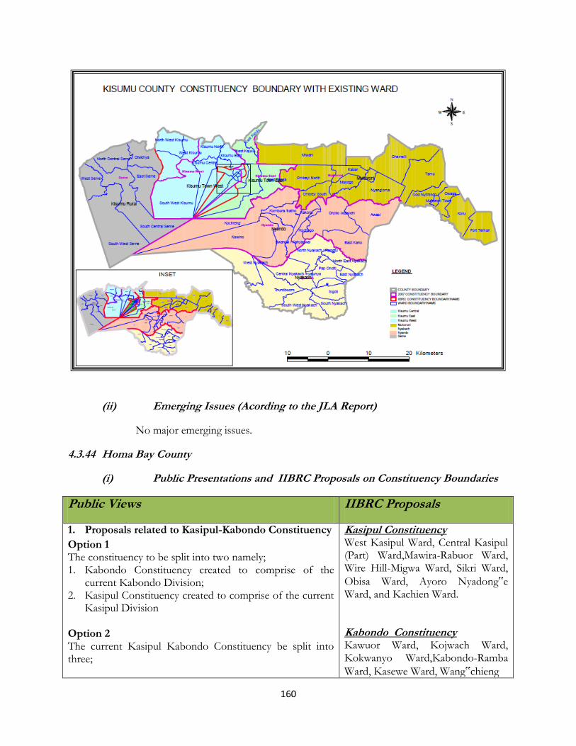
160
(ii) Emerging Issues (Acording to the JLA Report)
No major emerging issues.
4.3.44 Homa Bay County
(i) Public Presentations and IIBRC Proposals on Constituency Boundaries
Public Views IIBRC Proposals
1. Proposals related to Kasipul-Kabondo Constituency
Option 1 The constituency to be split into two namely; 1. Kabondo Constituency created to comprise of the
current Kabondo Division; 2. Kasipul Constituency created to comprise of the current
Kasipul Division Option 2 The current Kasipul Kabondo Constituency be split into three;
Kasipul Constituency West Kasipul Ward, Central Kasipul (Part) Ward,Mawira-Rabuor Ward, Wire Hill-Migwa Ward, Sikri Ward,
Obisa Ward, Ayoro Nyadong‟e Ward, and Kachien Ward. Kabondo Constituency Kawuor Ward, Kojwach Ward, Kokwanyo Ward,Kabondo-Ramba
Ward, Kasewe Ward, Wang‟chieng

161
Public Views IIBRC Proposals
1. Kasipul East Constituency; 2. Kasipul West Constituency; 3. Kabondo Constituency
Ward and Kakelo Ward
2. Proposals related to Karachuonyo Constituecny
Proposal 1.
Split the Constituency into three as follows, though
respective wards not indicated at all:
(i) Karachuonyo South (To Cover Kanyaluo and
Kibiri Divisions);
(ii) Karachuounyo West (To Cover West and North
West Divisions); and
(iii) Karachuonyo East (To Cover North East and
Central Divisions)
Split into two as follows: (i) West Karachuonyo ( Covering current West
Karachuonyo Divisions); (ii) East Karachuonyo (Covering current East
Karachuounyo Divisions)
Karachuonyo Constituency Kanam Ward, Kibiri Ward, Central KarachuonyoWard, Simbi-Kogembo Ward, Gumba-Jieri Ward,Gendia-Awach Ward, Rambira Ward, Kanyaluo Ward,Kakdhimu Ward, Kanjira-Kobier Ward, Kokoth Ward and Wang’chieng-Karabondi Ward.
3. Proposals related to Rangwe Constituency
Proposal 1.
Split Ragwe constituency into;
1. Homa Bay Town; Comprising of Homa Bay town,
East and West Kanyadas;
2. Rangwe; Comprising of Gem Asumbi, Kochia and
Kagan Locations
Proposal 2.
Split Ragwe constituency into;
(i) Homa Bay Constituency; Along the present
Asego Division Boundary; (ii) Rangwe; Along the present Rangwe Division
Boundary
Rangwe Constituency Gem West Ward, Gem Central Ward, Gem East Ward, Kochia West Ward, Kochia East Ward, Kagan WestWard and Kagan East Ward.
Homa Bay Town Constituency Kanyabala Ward, Katuma Ward, Posta-Bonde Ward,Hospital-Central-Market Ward, Kalanya Ward, Kanyadier-Kothidha Ward, West
Kanyada (Part) Ward and East
Kanyada (Part) Ward.
4. Proposals related to Ndhiwa Constituency
Proposal 1.
Split Ndhiwa into two to create the following:
(i) Ndiwa East (To cover Pala, Riana, Ndhiwa and
Kobodo Divisions);
(ii) Ndhiwa West (To cover Kobama and Nyarongi
Divisions).
Proposal 2.
Ndhiwa Constituency West Kwabwai Ward, East Kwabwai Ward, WestKanyidoto Ward, Riana West Ward, Kanyikela Ward, South Kanyamwa Ward, North Kanyamwa Ward,Central Kabuoch Ward, South Kabuoch Ward, Central Kanyamwa Ward and West Kanyamwa Ward.

162
Public Views IIBRC Proposals
Split Ndhiwa into two to create the following:
(i) Ndhiwa (To Cover Kobado and Ndhiwa
Divisions);
(ii) Ndiwa East or Riana Constituency (To cover
Pala, Riana, Divisions);
(iii) Ndhiwa West or Nyarongi Constituency (To
cover Kobama and Nyarongi Divisions)
5. Proposals related to Mbita Constituency
Option 1
1. Mbita East Constituency to comprise Mbita Mainland
made up of Gembe East, Gembe Central, Gembe West,
Lambwe East and Lambwe West locations
2. Mbita West Constituency to comprise all the Mbita
islands namely; Mfangano, Rusinga, Takawiri, Remba,
Ringiti, Atego, and other small island.
Option 2 1. Lambwe Constituency that, a constituency be created
along the boundaries of Lambwe Valley Settlement
Scheme curved out of Mbita constituency with its
original boundaries as prescribed by the beacons to
include Ruma location now in Gwassi Constituency. The
constituency is named Lambwe Valley Settlement
Scheme.
2. Mfangano Constituency
3. Mbita constituency
Mbita Constituency Takawiri Island, Remba Island, Rusinga East Ward,West Mfangano Ward, Mfangano South Ward, GembeEast Ward, Gembe Central Ward, Lambwe East Ward,Lambwe West Ward, Kamasengre Ward, Kaswanga-Wanyama Ward, Waware-Wakinga Ward, Kasgunga Central Ward and Kasgunga West Ward.
6. Proposals related to Mbita Constituency
Suba Central constituency; That, a new constituency be curved out from the old Suba district, i.e. Mbita and Gwassi constituencies should cede some of their parts and it shall be formed by Sumba, Central and Gwassi north divisions;
Suba Central constituency comprising parts hived off from Mbita constituency, namely the Mfangano division and Central Division hived off from Gwassi constituency. To this will also be added the islands of Ringiti, Remba, Takawiri and other small islands.
Gwasi Constituency Migingo Island, Kaksingri East Ward, Ruma Ward, Kaksingri West Ward, Gwasi North Ward, Gwasi Central Ward, Owich Kibwer Ward and Gwasi WestWard of Homa Bay County.
(ii) IIBRC Proposed Map for Homa Bay County
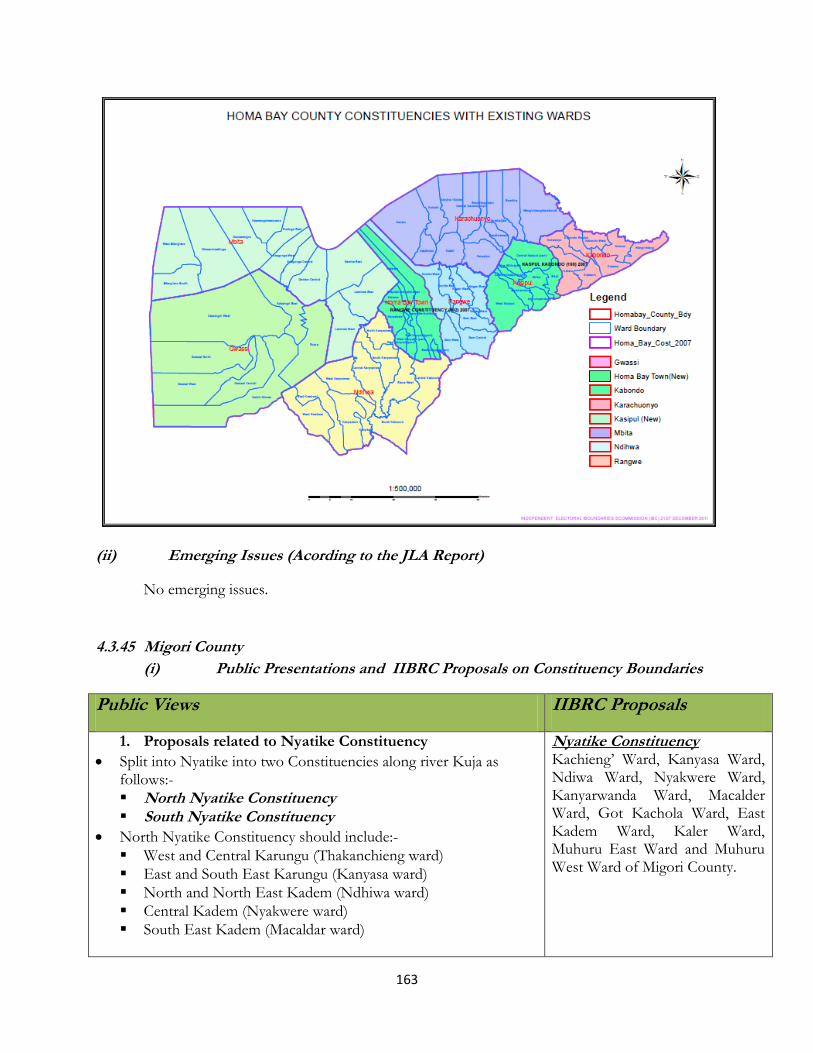
163
(ii) Emerging Issues (Acording to the JLA Report)
No emerging issues.
4.3.45 Migori County
(i) Public Presentations and IIBRC Proposals on Constituency Boundaries
Public Views IIBRC Proposals
1. Proposals related to Nyatike Constituency
Split into Nyatike into two Constituencies along river Kuja as follows:-
North Nyatike Constituency South Nyatike Constituency
North Nyatike Constituency should include:-
West and Central Karungu (Thakanchieng ward)
East and South East Karungu (Kanyasa ward)
North and North East Kadem (Ndhiwa ward)
Central Kadem (Nyakwere ward)
South East Kadem (Macaldar ward)
Nyatike Constituency Kachieng’ Ward, Kanyasa Ward, Ndiwa Ward, Nyakwere Ward, Kanyarwanda Ward, Macalder Ward, Got Kachola Ward, East Kadem Ward, Kaler Ward, Muhuru East Ward and Muhuru West Ward of Migori County.

164
Public Views IIBRC Proposals
South Nyatike Constituency to include:-
West Kadem ( Got Kachora ward)
Southern Kadem (Kanyarwanda ward)
Karer Location (Karer ward)
Muhuru West location (Muhuri West ward)
Muhuru East (Muhuru East ward)
Others suggested not to be split Nyatike due to uneven distribution of resources.
There were suggestion to split the existing 11 constituencies to 61. The new ones should be:- West Muiru, Mairu South East, Muiru East, Muiru Central, West Kadem, East Kadem, Kater, Central Kadem, South East Kadem, and North Kadem 2. Proposals related to Uriri Constituency
It was suggestions that Uriri be divided into two constituencies:-Uriri Constituency and Rapogi Constituency;
The Boundaries for Uriri Constituency should cover Oyani division and Uriri division;
Rapogi Constituency should include Kambogo division and Rapogi division;
Currently there are six wards, thus suggestions that each ward be divided into two = 12 wards to create 15 wards up from 12. These will be named as Central Kanyamkago; Karatini; Mpper Kamgundo; Lower Kamgundo; South Kanyamkago; Buware; Kawere; Karateng (New); Lwala; Bware (New); Kinyupe; Kinjope (New); Lower Central Kamyamkago; and Lower Kangundo.
Every location to have a councillor
Uriri Constituency North Kanyamkago Zone Ward, Central Kanyamkago Zone Ward, West Kanyamkago Zone Ward, South Kanyamkago Zone Ward, East Kanyamkago Zone Ward and Kamgundho Ward of Migori County.
3. Proposals related to Migori Constituency
Migori district has 2 divisions; Suba West which has seven locations and seven wards; and Suba East that has six locations and six wards;
Constituency should be divided into two:- Suba West Constituency and Suba East Constituency;
Alternatively, it can be divided into Suna West Constituency and Suna East Constituency;
Or it can be divided into Migori East and Migori West being split along river Migori;
The following existing wards Giribe ward, Mukuro ward, God Jope ward, Upper Suna ward, North Suna ward, Ngege ward , Ragana ward and Oruba ward should be divided to form the following new ones - Giribe ward, Wasimeeti ward, Mukuro ward, Rahaa ward, Suna East ward, God Jope ward Rabuor ward, Kwa ward, Otacho ward, North Suna ward, Mapera ward, Ngege ward,
Migori East
ConstituencyKakrao Ward, God
Jope Ward, Kwa Ward, Milimani
Ward, Kadika Ward, Genge Ward
and Nyasare Ward of Migori
County.
Migori West Constituency Giribe Ward, Suna South Ward, Mukuro Ward, Suna Nyabisawa Ward, Oruba Ward and Ragana Ward of Migori County.
165
Public Views IIBRC Proposals
Ragana ward, College ward, Oruba ward and Nyanguma ward
4. Proposals for Rongo Constituency
The Constituency be divided into two:- Rongo Constituency and
Awendo Constituency;
Boundaries for Awendo constituency to cover two divisions -
Awendo and Dede;
Rongo Constituency to have two divisions of Rongo and Chamgi
Wadu;
Proposed that all existing locations should become wards.
Rongo Constituency West Kamagambo Ward, South Kamagambo Ward, East Kamagambo Ward, North Kamagambo Ward and Central Kamagambo Ward of Migori County. Awendo Constituency North Sakwa Ward, South Sakwa Ward, Central Sakwa Ward, East Sakwa Ward and West Sakwa Ward of Migori County.
5. Proposals related to Kuria Constituency
Split Kuria Constituency into two constituencies:- o Kuria East Constituency that will comprise of the
following divisions; Kegonga, Chinato, Ntimaru, and Kwiho
o Kuria West Constituency that will comprise of the following divisions:- Kehancha, Ikerege, Mabera, Masaba, and Isebania;
Prposed 7 additional wards to the existing 25 to form a total of 32 wards.
Kuria West Constituency Nyamosense Ward, Taranga’nya Ward, Tagare Ward, Komosoko Ward, Getonga’nya Ward, Masaba Ward, Kombe Ward, Ikerege Ward, Nyamaharaga Ward, Bukira Central Ward, Gokeharaka Ward, Getambwega Ward, Kehancha Ward, Nyankore Ward, Nyabikaye Ward and Nyametaburo Ward of Migori County. Kuria East Constituency Nyabasi West Ward, Maeta Ward, Nyabasi North Ward, Kegonga Ward, Wangirabose Ward, Ntimaru Ward, Siabai Ward, Gwitembe Ward and Kebaroti Ward of Migori County.
(ii) IIBRC Proposed Map for Migori County (Kuria Excluded)

166
(ii) Emerging Issues (Acording to the JLA Report)
No emerging issues.
167
4.3.46 Kisii County
(i) Public Presentations and IIBRC Proposals on Constituency Boundaries
Public Views IIBRC Proposals
1. Proposals related to Bobasi Constituency It was proposed that Bobasi be split into two using tea processing zones to make demarcations as follows:-
Sameta Constituency and Bobasi/Borabu Constituency or Sameta Constituency and Nyancheki Constituency;
Sameta to be a Constituency (Bobasi Chache);
Nyacheki & Nyamache Division to form another (Bobasi Borabu);
Turwa sub-location and Nyabisia Sub-locations to be part of Mosora ward because of communication problem.
Alteranatively: Bobasi to be split into 2
1. Bassi Chache- Comprise of Itibo, Kenyerere and Orogare Division;
2. Basi Borabu Constituency- Comprised of Nyacheki, Bogetaorio, Suguta, Kiobegi Division
Bobasi Consitituency Emenwa-Nyoera Ward, Kiobegi-Gionseri Ward, Nyachogochogo Ward, Nyantira Ward, Nyacheki Ward, Maji Mazuri Ward, Mosora Ward, Bobasi Masige Ward, Nyangusu Ward and Bobasi Borabu Ward of Kisii County.
2. Proposals related to Bomachoge Constituency.
The Constituency comprise of two (2) districts namely:-Kenyenya District; and Ogembo District.
The Constituency be divided into two Constituencies as follows:- 1. Bomachoge Borabu Constituency (Current Kenyenya
District); and 2. Bomachoge Chache Constituency (Current Gucha
District).
Alternatively, divide Bomachoge into: 1. Kenyanya Constituency; and 2. Ogembo Constituency (Gucha Constituency).
It is suggested also that the formation of the following Wards: Kerongoroni; Kimonge; Bokione Borabu and Kenyenya.
There was suggestions to form the following wards for Kenyenya Town Council: Central Ward, Keberei Ward; Nyakoiba Ward; Omobera Ward; Enamba Ward and Nyabirongo Ward; and 3. It was further suggested that Bokiomonge and Bosoti
Bomachoge Constituency Mokubo Ward, Kenyenya Ward, Boochi Borabu Ward, Majoge Borabu Ward, Majoge Masaba Ward and Magenche Ward of Kisii County
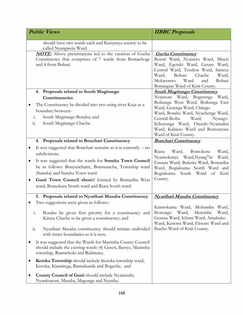
168
Public Views IIBRC Proposals
should have two wards each and Kenyenya society to be called Nyangweta Ward.
NOTE: Above presentations led to the creation of Gucha Constituency that comprises of 7 wards from Bomachoge and 4 from Bobasi
Gucha Constituency Bosoti Ward, Nyaisero Ward, Misesi Ward, Egetuki Ward, Getare Ward, Central Ward, Tendere Ward, Sameta Ward, Bobasi Chache Ward, Mokwerero Ward and Bobasi Boitangare Ward of Kisii County.
4. Proposals related to South Mugirango
Constituencies
The Constituency be divided into two using river Kuja as a
boundary between:-
i. South Mugirango Borabu; and
ii. South Mugirango Chache.
South Mugirango Constituency Nyansore Ward, Bogetenga Ward, Boikanga West Ward, Boikanga East Ward, Getenga Ward, Chitago Ward, Borabu Ward, Nyachenge Ward, Central-Ikoba Ward, Nyango-Kiburunga Ward, Otendo-Nyansakia Ward, Kabiero Ward and Bomonyara Ward of Kisii County.
4. Proposals related to Bonchari Constituency
It was suggested that Bonchari remains as it is currently – no
subdivisions.
It was suggested that the wards for Suneka Town Council
be as follows: Bonyanchaire, Bomwancha, Township ward
(Suneka) and Suneka Town ward.
Gusii Town Council should formed by Bomariba West
ward, Bomokura North ward and Riara South ward.
Bonchari Constituency Riana Ward, Bomokora Ward,
Nyamokenye Ward,Nyang‟iti Ward, Ensaria Ward, Bukeira Ward, Bomariba Ward, Bogiakumu North Ward and Bogiakumu South Ward of Kisii County.
5. Proposals related to Nyaribari Masaba Constituency
Two suggestions were given as follows:-
i. Borabu be given first priority for a constituency and Kitutu Chache to be given a constituency; and
ii. Nyaribari Masaba constituency should remain undivided with intact boundaries as it is now.
It was suggested that the Wards for Masimba County Council should include the existing wards (4) Geteri, Ikenye, Masimba township, Riamichoki and Riabitutu;
Keroka Township should include Keroka township ward, Keroka, Kiamirega, Riamakanda and Bogeche; and
County Council of Gusii should include Nyamasibi, Nyankononi, Masaba, Magonga and Nyasike.
Nyaribari Masaba Constituency Kiamokama Ward, Mobamba Ward, Ikorongo Ward, Metembe Ward, Gesusu Ward, Ichuni Ward, Amabuko Ward, Kerema Ward, Ekware Ward and Ibacho Ward of Kisii County.

169
Public Views IIBRC Proposals
6. Proposals related to Nyaribari Chache Constituency
It was suggestions as follows:-
Nyaribari Chache remains intact with its boundaries;
Gusii County Council should comprise of the 6 existing wards:- Nyamimiso; Nyosia; Nyanko; Nyamawa; Nyamesocho; Nyankororo; Taracha; Nyamarwe; Bomuagi; Matunwa; and Nyaguta;
Kisii Municipality should include 5 existing wards namely:- Kiamabundu; Masongo; Nyanchwa; Kionganyo; Nyamage; Nyongusu; Nyataro; Masongo; Nyasacha; Central East; and Hospital ward.
Nyaribari Chache Constituency Kegati Ward, Kiogoro Ward, Birongo Ward, Ibeno Ward, Keumbu Ward, Kanga Hill Ward, Nyansira Ward, Bobaracho Ward, Nyaura Ward, Mwembe Tayari Ward and Boronyi Ward of Kisii County.
7. Proposals related to Kitutu Chache Constituency
The following suggestions were presented:- Option 1.
Split the constituency into three constituencies namely: 1. North Kitutu Chache Constituency - comprising the upper
part. 2. South Kitutu Chache Constituency - comprising the Lower
part. 3. Kisii Town ( Getembe) Constituency Option 2.
i. Kitutu Chache Constituency be divided into two i.e. Marani Constituency and Mosocho Constituency.
ii. Marani Constituency to cover Marani district while Mosocho Constituency covering areas of Mosocho and Kisii Township in Kisii Central District.
The Wards within Kisii Township should be Nyabururu, Kiamuasi, Nyakongo, Daraja Mbili and Kiongongi but additional ones such as Getembe, Mwamogesa, Nyambira and Geticha wards.
Marani County Council should comprise of Mwamoriari, Mwagichana, Kegogi, Ikuma, Matongo/Gesangera and Sesi. They further requested for two more wards: Mwakibagendi and Gesangero wards
It was suggested that Mosocho should comprise of Bogisero ward, Bogeka ward, Nyakoe ward, Nyanguru ward and Nyatieko ward. Further create Bogisero South and Bogisero North wards.
Marani Constituency Kegogi Ward, Ikuruma Ward, Sensi
Ward, Mwamonari Ward, Marani Ward
and Matongo-Gesangero Ward of Kisii
County.
Mososcho Constituency Mosocho Ward, Bogeka Ward, Nyakoe
Ward, Nyatieko Ward, Nyankongo
Ward, Kiamwasi Ward, Nyabururu
Ward, Central Ward, Daraja Mbili Ward
and Kiongongi Ward of Kisii County.
(ii) IIBRC Proposed Map for Kisii County
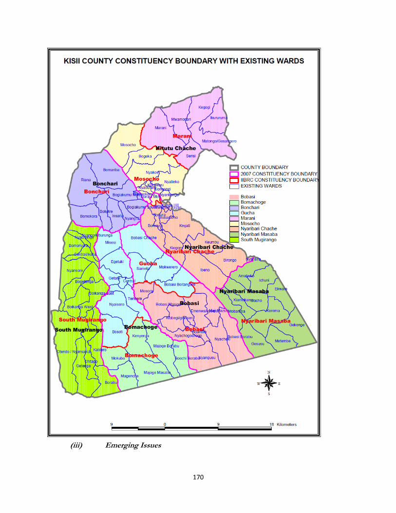
170
(iii) Emerging Issues

171
Nyaribari Chache The Community of interests were not considered. For instance a ward was curved out of Nyaribari
Chache and taken to Borabu.
Bobasi The re- drawing of boundaries was not consultatively done. The transfer of wards from the
neighboring Bobasi and Bamachoge constituencies to the new Gucha constituency was not
consultative.
4.3.47 Nyamira County
(i) Public Presentations and IIBRC Proposals on Constituency Boundaries
Public Views IIBRC Proposals
1. Proposals related to Kitutu Masaba Constituency
Kitutu Masaba comprises of Manga and Masaba Districts;
Manga district has three divisions namely:- Magombo Division, Kemera Division and Manga Division;
Masaba District has Gesima Division, Rioma Division and Gachuba Division;
It was suggested that Kitutu Masaba be split into two as follows:-
Kitutu Masaba Constituency
Central Kitutu Constituency
It was also suggested that the constituency can be along river Kuja
Kitutu Masaba South Constituency.
Kitutu Masaba North Constituency.
(i) There was a proposal that the existing 11 wards to the following:- Nyamakoroto, Riamoni, Esami, Rigena,
Geni, Nyaganya, East Kitutu, Sirate, Nyaguku, Gekano, Nyakongo, Ritongo, Nyikuro, Kianguso, and Nyangina.
Kitutu Masaba Constituency Magombo Ward, Gachuba Ward, Rigoma Ward, Getare Ward, Biticha sub-location in East Kitutu Ward, Nyankoba Ward, Tombe Ward, Omogonchoro Ward, Bugwendo Ward, Miriri Ward, Kemera Ward and North Manga Ward of Nyamira
County.
2. Proposals related to North Mugirango/Borabu Constituency
(ii) Divide the Constituency into two as follows:- i. Borabu Constituency (Borabu district) ii. North Mugirango Constituency
(iii) Recommended that the Constituency has 17 wards and should be increased to 30 due to population of the area. The following should be divided:-Omonono ward 2, Mekenene ward 2, Esakia ward 1, Central ward 2, Central ward 2, Nyanamba ward 2, Matutu ward 1, Mageri ward 2, Magwanga 3, Kiang’eni 2, Umwagamo 2, Itibo 3, Bokeira ward 3, Obwani
North Mugirango Constituency Omonono Ward, Nyaramba-Nyangoge Ward, Mageri Ward, Magwagwa Ward, Itibo Ward, Bokeira Ward, Obwari Ward, Mokomoni Ward, Ikonge Ward, Bomwagamo Ward and Nyankono-Kerumbe sublocation in Kiangeni Ward of Nyamira County.

172
Public Views IIBRC Proposals
2, Mokunguni 2 and Ikonge 2 Borabu Constituency Matutu Ward, Ensakia Ward, Gesima Ward, Embaro sub-location of East Kitutu Ward, Mochenwa Ward,Central Ward, Bocharia Ward, Nyasore Ward, Esise Ward, Manga Ward, Mekenene Ward and Kitaru sublocation in Kiangeni Ward of Nyamira County.
3. Proposals related to West Mugirango
(iv) The constituency has currently 12 wards and it is suggested
that each ward be divided into two to form 24 new wards.
West Mugirango Constituency Rangenyo Ward, Kebirigo Ward, Sironga Ward, Nyamira Ward, Bigege Ward, Motagara Ward, Bogichora (Part) Ward, Keera Ward, Bonyamatuta (Part) Ward, Ikobe Ward, Miruka Ward and Motontera Ward of Nyamira County.
(ii) IIBRC Proposed Map for Nyamira County

173
(ii) Emerging Issues (Acording to the JLA Report)
a) Kitutu Masaba

174
It emerged that about 60,000 people were moved to Borabu constituency without consultation while
some constituencies with less people were given more constituencies.
b) North Mugirango
Some wards were moved to the existing or new constituencies. The requested number of
constituencies were not granted. The community of interest request for North Mugirango to be
splitin two was not given.
Note: the wards used by IIBRC in delimitation of constituencies are the local government electoral
units as per 2007.

175
CHAPTER FIVE PROPOSALS ON DELIMTATIONS OF COUNTY ASSEMBLYWARDS
5.1 Introduction
The criteria for delimitation of wards is provided for in Article 89 (5) and (6) of the Constitution of
Kenya, 2010). Article 89(6) provides that the number of inhabitants of a constituency or Ward may
be greater or lesser than the population quota by a margin of not more than—
(a) forty per cent for cities and sparsely populated areas; and
(b) thirty per cent for the other areas.
Article 89(12) of the Constitution defines “population quota” by dividing the number of inhabitants
of Kenya with the number of constituencies or wards, as applicable.
Article 89(3) of the Constitution of Kenya, 2010 provides that the IEBC shall review the number,
names and boundaries of wards periodically. The Act requires that the Commission shoulr resolve
all issues arising from the IIBRC review. Specifically, the Commission is given the following
mandate as regards completion of the first review -
(a) re-distribution of such wards or administrative units in the affected constituencies as may
be appropriate;
(b) subject to the Constitution, addressing issues of new constituencies falling outside the
population quota as provided for by Article 89(6) of the Constitution but at the same
time ensuring that such a process shall –
(i) take into account the provisions of Article 89(7)(b) of the Constitution that
requires progressive efforts and not instant demographic equality of all towards
attaining the population quota in each constituency and Ward for the purposes of
the first review;
(ii) not be subject to new definitions of cities, urban areas and sparsely populated areas
or to new population figures;
(iii) be subject to the use of enumerated national census figures and not projected
figures.
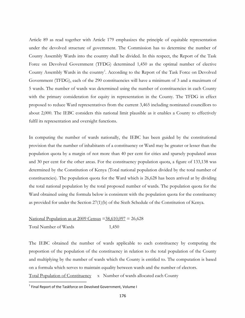
176
Article 89 as read together with Article 179 emphasizes the principle of equitable representation
under the devolved structure of government. The Commission has to determine the number of
County Assembly Wards into the country shall be divided. In this respect, the Report of the Task
Force on Devolved Government (TFDG) determined 1,450 as the optimal number of elective
County Assembly Wards in the country1. According to the Report of the Task Force on Devolved
Government (TFDG), each of the 290 constituencies will have a minimum of 3 and a maximum of
5 wards. The number of wards was determined using the number of constituencies in each County
with the primary consideration for equity in representation in the County. The TFDG in effect
proposed to reduce Ward representatives from the current 3,465 including nominated councillors to
about 2,000. The IEBC considers this national limit plausible as it enables a County to effectively
fulfil its representation and oversight functions.
In computing the number of wards nationally, the IEBC has been guided by the constitutional
provision that the number of inhabitants of a constituency or Ward may be greater or lesser than the
population quota by a margin of not more than 40 per cent for cities and sparsely populated areas
and 30 per cent for the other areas. For the constituency population quota, a figure of 133,138 was
determined by the Constitution of Kenya (Total national population divided by the total number of
constituencies). The population quota for the Ward which is 26,628 has been arrived at by dividing
the total national population by the total proposed number of wards. The population quota for the
Ward obtained using the formula below is consistent with the population quota for the constituency
as provided for under the Section 27(1)(b) of the Sixth Schedule of the Constitution of Kenya.
National Population as at 2009 Census =38,610,097 = 26,628
Total Number of Wards 1,450
The IEBC obtained the number of wards applicable to each constituency by computing the
proportion of the population of the constituency in relation to the total population of the County
and multiplying by the number of wards which the County is entitled to. The computation is based
on a formula which serves to maintain equality between wards and the number of electors.
Total Population of Constituency x Number of wards allocated each County
1 Final Report of the Taskforce on Devolved Government, Volume I

177
Total Population of each County
Applying the above formula ensures that even the smallest County has the required members of the
County Assembly to perform its function. This approach takes cognisance of the inherent inequities
in the populations of various counties and the imbalances in each constituency. This is because
counties were created by the Constitution without regard to their populations. The approach
therefore achieves equity of representation within the County and is therefore preferred by the
IEBC. The table below presents the proposed determination of wards by IEBC based on the above
approach and deviation from the quota.
This methodology results into an additional two County Assembly Wards due to mathematical
fractions. The Commission proposes to alloacate the extra County Assembly Wards on the principle
of highest population quota as per the County Assembly Wards.
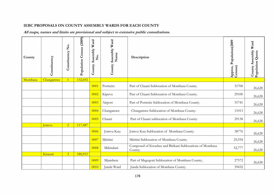
178
IEBC PROPOSALS ON COUNTY ASSEMBLY WARDS FOR EACH COUNTY
All maps, names and limits are provisional and subject to extensive public consultations.
County
Co
nst
itu
en
cy
Co
nst
itu
en
cy N
o.
Po
pu
lati
on
Cen
sus
(2009)
Co
un
ty A
ssem
bly
Ward
No
.
Co
un
ty A
ssem
bly
Ward
Nam
e
Description
Ap
pro
x.
Po
pu
lati
on
(2009
Cen
sus)
Co
un
ty A
ssem
bly
Ward
Po
pu
lati
on
Qu
ota
Mombasa Changamwe 1 132,692
0001 Portreitz Part of Chaani Sublocation of Mombasa County. 31700
26,628
0002 Kipevu Part of Chaani Sublocation of Mombasa County. 29100
26,628
0003 Airport Part of Portreitz Sublocation of Mombasa County. 31741
26,628
0004 Changamwe Changamwe Sublocation of Mombasa County. 11013
26,628
0005 Chaani Part of Chaani sublocation of Mombasa County. 29138
26,628
Jomvu 2 117,487
0006 Jomvu Kuu Jomvu Kuu Sublocation of Mombasa County. 38776
26,628
0007 Miritini Miritini Sublocation of Mombasa County. 25,934
26,628
0008 Mikindani Composed of Kwashee and Birikani Sublocations of Mombasa County.
52,777
26,628
Kisauni 3 180,915
0009 Mjambere Part of Magogoni Sublocation of Mombasa County.. 27572
26,628
0010 Junda Ward Junda Sublocation of Mombasa County. 39432

179
County
Co
nst
itu
en
cy
Co
nst
itu
en
cy N
o.
Po
pu
lati
on
Cen
sus
(2009)
Co
un
ty A
ssem
bly
Ward
No
.
Co
un
ty A
ssem
bly
Ward
Nam
e
Description
Ap
pro
x.
Po
pu
lati
on
(2009
Cen
sus)
Co
un
ty A
ssem
bly
Ward
Po
pu
lati
on
Qu
ota
26,628
0011 Bamburi Bamburi Sublocation. 24918
26,628
0012 Mwakirunge Mwakirunge and Maunguja Sublocations of Mombasa County. 8929
26,628
0013 Bombolulu Part of Magogoni Sublocation Of Mombasa County. 27572
26,628
0014 Mtopanga Part of Magogoni Sublocation of Mombasa County. 27,572
26,628
Nyali 4 199 210
0015 Shanzu Ward Shanzu and Mwembelegeza Sublocations of Mombasa County. 28803
26,628
0016 Frere Town Ward
Part of Kisauni Sublocation of Mombasa County. 39905
26,628
0017 Maweni Ward Maweni Sublocation 42187
26,628
0018 Nyali/Mkomani Part of Kongowea Sublocation of Mombasa County. 31996
26,628
0019 Kongowea Part of Kongowea Sublocation of Mombasa County. 31996
26,628
0020 Kisauni Ward Part of Kisauni Sublocation of Mombasa County. 39,905
26,628
Likoni 5 166 008
0021 Mtongwe Ward Mtongwe Sublocation of Mombasa County. 28,168
26,628

180
County
Co
nst
itu
en
cy
Co
nst
itu
en
cy N
o.
Po
pu
lati
on
Cen
sus
(2009)
Co
un
ty A
ssem
bly
Ward
No
.
Co
un
ty A
ssem
bly
Ward
Nam
e
Description
Ap
pro
x.
Po
pu
lati
on
(2009
Cen
sus)
Co
un
ty A
ssem
bly
Ward
Po
pu
lati
on
Qu
ota
0022 Shika Adabu Ward
Vijiweni and Vyemani Sublocation of Mombasa County. 26,036
26,628
0023 Bofu Ward Bofu Sublocation of Mombasa County 29,154
26,628
0024 Likoni Ward Likoni Sublocation of Mombasa County. 21,639
26,628
0025 Timbwani Ward
Timbawani Sublocation of Mombasa County. 61,011
26,628
Mvita 6 158 000
0026 Mji wa Kale/Makadara Ward
Mji wa kale, Makadara, Kizingo Sublocations of Mombasa County.
25875 26,628
0027 Tudor Tudor Estate and Tudor Four Sublocations of Mombasa County. 32100
26,628
0028 Tononoka Bondeni and Tononoka Sublocations of Mombasa County. 27513
26,628
0029 Shimanzi-Ganjoni
Ganjoni and Railways Sublocations of Mombasa County. 18806
26,628
0030 Majengo Ward Majengo, and Mwembe Tayari Sublocation of Mombasa County. 38,834
26,628
Kwale Msambweni 7 196 250
0031 Gombato Bongwe Ward
Gombato and Bongwe Sublocations of Kwale County. 34,846
26,628
0032 Ukunda ward Ukunda Sublocation of Kwale County. 38,629
26,628

181
County
Co
nst
itu
en
cy
Co
nst
itu
en
cy N
o.
Po
pu
lati
on
Cen
sus
(2009)
Co
un
ty A
ssem
bly
Ward
No
.
Co
un
ty A
ssem
bly
Ward
Nam
e
Description
Ap
pro
x.
Po
pu
lati
on
(2009
Cen
sus)
Co
un
ty A
ssem
bly
Ward
Po
pu
lati
on
Qu
ota
0033 Msambweni ward
Gazi, Kinondo, Milalani, and Vingujini Sublocations of Kwale County.
40,251
26,628
0034 Mivumoni Ward
Mivumoni,and Bumbani Sublocations of Kwale County. 30,127
26,628
0035 Pongwe Kidimu/Kigwede Ward
Majoreni, Mzizima, Shimoni, Wasini/Mkwiro, Funzi, Kingwede and Shirazi Sublocations of Kwale County.
32,284 26,628
Lunga Lunga (New)
8 92 173
0036 Dzombo Ward Malamba Sublocation of Kwale County. 41,509
26,628
0037 Kasemeni/Sega/ Kilimangodo Ward
Kasemeni , Kilimangodo and mwena sublocations of Kwale County.
34,628 26,628
0038 Vanga ward Jego, Kiwegu, Sega and Vanga Sublocations of Kwale County. 36,119
26,628
0039 Kwale Ward Golini, Kundutsi and mbuguni Sublocations of Kwale County. 28,196
26,628
Matuga 9 151 978
0040 Waa Ward Matuga, Kitivo, Kiteje, Ng’ombeni and Pungu Sublocations of Kwale County.
28,949
26,628
0041 Tiwi/Mazumalume Ward
Mazumalume, Simkumbe, Mkoyo,and Kombani Sublocations of Kwale County.
29,632
26,628

182
County
Co
nst
itu
en
cy
Co
nst
itu
en
cy N
o.
Po
pu
lati
on
Cen
sus
(2009)
Co
un
ty A
ssem
bly
Ward
No
.
Co
un
ty A
ssem
bly
Ward
Nam
e
Description
Ap
pro
x.
Po
pu
lati
on
(2009
Cen
sus)
Co
un
ty A
ssem
bly
Ward
Po
pu
lati
on
Qu
ota
0042 Kubo South/Mangawani
Tiribe, Manyatta, Makobe, Kipambani, Mwaluvanga, Shimba Hills, majimbo, Boyani, Msulwa, Lukore and Mangawani of Kwale County.
31,244 26,628
0043 Mwalupamba-Mkongani Ward
Mtsamviani, Mkomba, Kizibe,and Mlafyeni Sublocations of Kwale County.
29,540
26,628
Kinango 10 209 560
0044 Ndavaya ward Ndavaya, Mwandimu, Gulanze, Kifyonzo, sublocations of Kwale County
29,816
26,628
0045 Puma azola, Busa and Vigurungani sublocations of Kwale County 19,860
26,628
0046 Kinango Ward Kinango, Dumbule, Kibandaongo and Gandini Sublocations of Kwale County.
32,571
26,628
0047 Mackinon Road Ward
Vinyunduni, Makamini, Kilibasi, Dupharo and Macknon Road Sublocations of Kwale County.
31,128 26,628
0048 Chengoni/Samburu Ward
Chengoni, Maji ya Chumvi, Silaloni, Kinagoni and Matope Sublocations of Kwale County.
23887 26,628
0049 Mwavumbo Ward
Matumbi, Mwatate, Kalalani, and Mwabila Sublocations of Kwale County.
31902
26,628
0050 Kasemeni Ward Mnyenzeni, Mwamdudu, Chigato, mazeras, Mabesheni, Mtaa, Bofu Sublocations of Kwale County.
33,642
26,628
Kilifi Kilifi North (New)
11 110 236
0051 Tezo ward Ngerenya, Zowerani and Mtondia/Majaoni and Chumani Sublocations of Kilifi County.
34,612 26,628

183
County
Co
nst
itu
en
cy
Co
nst
itu
en
cy N
o.
Po
pu
lati
on
Cen
sus
(2009)
Co
un
ty A
ssem
bly
Ward
No
.
Co
un
ty A
ssem
bly
Ward
Nam
e
Description
Ap
pro
x.
Po
pu
lati
on
(2009
Cen
sus)
Co
un
ty A
ssem
bly
Ward
Po
pu
lati
on
Qu
ota
0052 Hospital/Sokoni
Hospital and Sokoni Sublocations of Kilifi County. 35027
26,628
0053 Kibarani Ezamoyo, Konjora and Kibarani Sublocations of Kilifi County. 24492
26,628
0054 Matsangoni Matsangoni, Roka, Mkongani and Uyombo Sublocations of Kilifi County.
34496
26,628
Kilifi South 12
0055 Junju Kuruwitu/Kapera/Chodari, Vipingo/Mikoani/Gongoni, Bomani/Junju/Mtomkuu Sublocations of Kilifi County.
31752 26,628
0056 Mwarakaya Mwarakaya, Kizingo, Ziani and Mwembekati , Sublocations of Kilifi County.
29,541
26,628
0057 Mnarani Mnarani, Takaungu, Mkomani/Mkwajuni, Mavueni/Majajani, and Kiriba Wangwani Sublocations of Kilifi County.
24825 26,628
0058 Shimo la Tewa Shimo la Tewa Sublocation of Kilifi County. 50846
26,628
0059 Chasimba Chasimba, Mwakambi, Kitsoeni Pingilikani and Ngomeni Sublocations of Kilifi County.
25,519 26,628
0060 Mtepeni Kijipwa, Kidutani/Mawamba and Kanamai Sublocations of Kilifi County
34,643
26,628
Kaloleni 13 119 111
0061 Mariakani Ward Mitangani/Mariakani , Kawala and Kanzonzo Sublocation of Kilifi County.
43,199
26,628
0062 Kayafungo Ward
Mbala mweni, Kinagoni, Miyani, Tsangatsini, Mrimani, and Mnyenzeni Sublocations of Kilifi County.
32,554 26,628

184
County
Co
nst
itu
en
cy
Co
nst
itu
en
cy N
o.
Po
pu
lati
on
Cen
sus
(2009)
Co
un
ty A
ssem
bly
Ward
No
.
Co
un
ty A
ssem
bly
Ward
Nam
e
Description
Ap
pro
x.
Po
pu
lati
on
(2009
Cen
sus)
Co
un
ty A
ssem
bly
Ward
Po
pu
lati
on
Qu
ota
0063 Kaloleni Ward Birini mwamleka, Vishakani/Kaloleni, Kinani, Makomboani, Mikiriani, Chalani/Mihingoni and, sublocations of Kilifi County.
39,589 26,628
0064 Mwanamwinga Viragoni, Kithengwani/Maziachenda and Kibwabwani Sublocations of Kilifi County.
29866
26,628
Rabai (New)
14 119 683
0065 Mwawesa Ward Bwagamoyo, Mwamtsunga, Mikahani, Buni Kisimani, Mwele Kisurutini, Sublocations of Kilifi County.
32914 26,628
0066 Ruruma Ward Jimba, Mleji and Miyuni Sublocations of Kilifi County. 22945
26,628
0067 Jibana Ward Chilulu, Tsagwa, Kwale, Nyalani 33,748
26,628
Pangani/maereni, Chauringo, Kikomani Mbwaka Sublocations.
26,628
0068 Mazeras Ward Mugumo/Patsa/Mazeras, Kaliang’ombe/Jimba sublocations of Kilifi County.
25251
26,628
Ganze 15 132 688
0069 Dungicha Ganze, Rare, Nyari, Petanguo, Mweza Migodomani, Mirihini, Mwambani, Ndigiria/ Mapotea, Magogoni, and Dungicha Sublocations of Kilifi County.
31333 26,628
0070 Bamba Paziani, Mwakala, Mtsara wa Tsatsu, Mitangani, Mikamini, Mitsemerini, Kidemu, Mnagoni, Dangarani, Gede, Goshi, Migujini and Midoina Sublocations of Kilifi County.
37830 26,628
185
County
Co
nst
itu
en
cy
Co
nst
itu
en
cy N
o.
Po
pu
lati
on
Cen
sus
(2009)
Co
un
ty A
ssem
bly
Ward
No
.
Co
un
ty A
ssem
bly
Ward
Nam
e
Description
Ap
pro
x.
Po
pu
lati
on
(2009
Cen
sus)
Co
un
ty A
ssem
bly
Ward
Po
pu
lati
on
Qu
ota
0071 Jaribuni Jaribuni, Mwapula, Marere, Chivara, Vinagoni, Magogoni/ Matolani, Mdangarani, Vyambani, Ngamani , Palakumi, and Mariani/Vitsapuni Sublocations of Kilifi County.
24958 26,628
0072 Vitengeni
Mitedzini, Mrima wa Ndege, Dulukiza, Milore, Vitengeni, Madamani, Mwahera, Ndugumunani, Kaembeni, Dzikunze, Mwangea, Bale, Kahingoni, Dida, and Ndigiria/ Mapotea Sublocations of Kilifi County.
38567
26,628
Malindi 16 249 355
26,628
0073 Langobaya Langobaya, Makobeni, Malanga, Mkondoni , Makongeni, Matolani , Kisiki Cha Wagiriama Sublocations of Kilifi County.
23090 26,628
0074 Madunguni Kakoneni/ Marikano, Jilore/ Ziani, Girimacha, Madunguni , Kakuyuni , Paziani, Mongotini, Bura/ Magongoloni and Malimo Sublocations of Kilifi County.
27113 26,628
0075 Ganda Ganda, Msabaha, Mere, Kijiwetanga Sublocations of Kilifi County.
32562
26,628
0076 Sabaki Sabaki Sublocation of Kilifi County. 16,317
0077 Malindi Town Comporises Central Sublocation of Kilifi County. 19,186
26,628
0078 Gede Ward Mbaraka Chembe, Chembe Kibabamche, Mkenge, Mijomboni Sublocations of Kilifi County.
19,502 26,628
0079 Shella Ward Shella Sublocation of Kilifi County 43,434
26,628
0080 Barani Barani Sublocation of Kilifi County 32068

186
County
Co
nst
itu
en
cy
Co
nst
itu
en
cy N
o.
Po
pu
lati
on
Cen
sus
(2009)
Co
un
ty A
ssem
bly
Ward
No
.
Co
un
ty A
ssem
bly
Ward
Nam
e
Description
Ap
pro
x.
Po
pu
lati
on
(2009
Cen
sus)
Co
un
ty A
ssem
bly
Ward
Po
pu
lati
on
Qu
ota
26,628
0081 Watamu Mida, Dabaso, Watamu, and Jimba Sublocations of Kilifi County
16501
26,628
Magarini 17 151 159
0082 Marafa Ward Bore, Madina, Mambasa, Bate, Kaya, Adu, Kadzandani and Bura Sublocations of Tana River County.
27,391 26,628
0083 Magarini Ward Marikebuni, Bomani, Pumwani, and Mambrui Sublocations of Kilifi County.
23,261
26,628
0084 Gongoni Ward Shomela, Fundissa, Ngomeni, and Gongoni Sublocations of Kilifi County
34,597
26,628
0085 Marereni Ward Marereni, Kamale and Ramada Sublocations of Kilifi County. 28460
26,628
0086 Garashi Ward Singwaya, Mikuyuni, Masindeni, Dakacha, Gandini, Baricho sublocations of Kilifi County.
19017
26,628
Tana River Garsen 18 96 664
0087 Kipini East Ward
Kipini, Kau, Matengeni, Mpeketoni, and Ozi Sublocation of of Tana River County.
19,577
26,628
0088 Garsen South Ward
Ngao, Tarasaa, Oda, Ongonyo, Kipao, Golbanti, Sublocations of Tana River County.
15,742 26,628
0089 Kipini West Ward
Odole, Kikomo, Chamwanamuma, Semi karo, Kurawa, and Handaruku Sublocations of Tana River County.
17,999
26,628
0090 Garsen Central Ward
Dumi, Danisa, Galili, Isowe, and Dalu Sublocations of Tana River County.
15,129
26,628
0091 Garsen West Garsen, Chira, Wema, Assa, Kone and Onjira Sublocations of 15,454

187
County
Co
nst
itu
en
cy
Co
nst
itu
en
cy N
o.
Po
pu
lati
on
Cen
sus
(2009)
Co
un
ty A
ssem
bly
Ward
No
.
Co
un
ty A
ssem
bly
Ward
Nam
e
Description
Ap
pro
x.
Po
pu
lati
on
(2009
Cen
sus)
Co
un
ty A
ssem
bly
Ward
Po
pu
lati
on
Qu
ota
Ward Tana River County. 26,628
0092 Salama Mwina Ward
Baomo, Benderani, Mikameni, Sera and Mnazini Sublocations of Tana River County.
12,760
26,628
Galole 19 60 866
0093 Kinakomba Ward
Maroni, Hara, Wenje, Majengo, Masalani, Bububu, Mkomani, Mazuni, Garufu and Hororesa Sublocations of Tana River County.
12,324 26,628
0094 Mikindani Ward Kalkacha, Lenda, Mikinduni, Bondeni, and Handampia sublocations of Tana River County.
9,568 26,628
0095 Chewani Ward Rhoka, Masabubu, Bubu, Ghorei, Laini, Bohoni, Kiarikungu, Chewani, Matanya, Hola, Hola Mission, and Kibuyu Sublocations of Tana River County.
18,756 26,628
Bura 20 82 545
0096 Chwele Biskidera, Metisil, Chwele, and Wedesa Sublocations of Tana River County.
17,565
26,628
0097 Hirimani ward Hirimani, Walesorhea, Dukanoti and Nanighi Sublocations of Tana River County.
14,221
26,628
0098 Bangale ward Sombo, Maramtu, Ziwani, Sala, bangale and Boka sublocations of Tana River County.
15,699 26,628
0099 Mbalambala ward
Kamanguru, Odowani, Pamba, Asako, Buwa and Kurati Sublocations of Tana River County.
16,736
26,628
0100 Madogo Ward Konoramadha, Madogo and Mororo Sublocations of Tana River County.
18,324
26,628
Lamu Lamu East 21 18 841

188
County
Co
nst
itu
en
cy
Co
nst
itu
en
cy N
o.
Po
pu
lati
on
Cen
sus
(2009)
Co
un
ty A
ssem
bly
Ward
No
.
Co
un
ty A
ssem
bly
Ward
Nam
e
Description
Ap
pro
x.
Po
pu
lati
on
(2009
Cen
sus)
Co
un
ty A
ssem
bly
Ward
Po
pu
lati
on
Qu
ota
0101 Faza Ward Ward
Dau, Kwatini, Kwatongani, Tchundwa, Myabogi, Siyu, Pate, and shanga Sublocations of Lamu County.
11224 26,628
0102 Kiunga Ward Rubu/Mwabore, Mkokoni, Mararani, Mangai, Milimani, Kizingitini, Sublocations of Lamu County.
7,072
26,628
Lamu West 22 82 698
0103 Shella Ward Shella and Manda Sublocations of Lamu County. 3,274
26,628
0104 Mkomani Ward Mkomani, Langoni, Matondoni and Kipungani Sublocations of Lamu County.
19,092
26,628
0105 Hindi Ward Hindi, Bargoni, Mokowe, Kilimani Sublocations of Lamu County. 10,700
26,628
0106 Mkunubi Ward Mkunubi, Mapenya, Uziwa and Ndambwe Sublocations of Lamu County.
11,724
26,628
0107 Hongwe ward Hongwe and Bomani Sublocations of Lamu County. 9,097
26,628
0108 Witu Ward Pandanguo, Chalamula, Moa and Witu Sublocations of Lamu County.
13,105
26,628
0109 Central ward Kiongwe, and Central Sublocations of Lamu County. 9,475
26,628
0110 Bahari ward Bahari, and Tewe ublocations of Lamu County. 6,231
26,628
Taita Taveta
Taveta 23 67,665

189
County
Co
nst
itu
en
cy
Co
nst
itu
en
cy N
o.
Po
pu
lati
on
Cen
sus
(2009)
Co
un
ty A
ssem
bly
Ward
No
.
Co
un
ty A
ssem
bly
Ward
Nam
e
Description
Ap
pro
x.
Po
pu
lati
on
(2009
Cen
sus)
Co
un
ty A
ssem
bly
Ward
Po
pu
lati
on
Qu
ota
0111 Chala Ward Lumi, Mahandakini, Njukini, Chumvini and Chala Sublocations of Taita taveta County.
18,065 26,628
0112 Kitobo Ward Ndilindau, Msengoni, Lesesia, Mrambani, NaKruto, Mahoo, Kitobo and Malukiloriti Sublocations of Taita Taveta County.
15,257
26,628
0113 Mjini Ward Mjini Sublocation of Taita Taveta County. 8,982
26,628
0114 Mboghoni Ward Eldoro, Njoro, Mboghoni and Kimongo Sublocations of Taita Taveta County.
17,044
26,628
0115 Mata Ward Kimala and Mata Sublocations of Taita Taveta County. 8,157
26,628
Wundanyi 24 56,021
0116 Wundanyi Ward Wundanyi, Shigaro, Sungululu, Mteni, sublocations of Taita Taveta County.
14,439
26,628
0117 Werugha Saghasa, Mmarumange, Mgambonyi, Mwamunge and Mlondo Sublocations of Taita Taveta County.
12,485
26,628
0118 Mbale Paranga, Nyanche, Mbechi, choke, Mbale, and Mbogho of Taita Taveta County.
6,942
26,628
0119 Mwanda Kishushe, Njawuli, Kishamba, Kishamba Mwanda, Mwaroko, Mgange Nyika, Lushangoni, Mgange Danida Sublocations of Taita Taveta County.
16,939 26,628
Mwatate 25 71,513 0120 Ronge Ward Ronge Nyika, Kigombo/Mrumbenyi, Msau Raghai, Kishau/Kiweto, Debonyi/Baghau, Kironge/Mwakaleti Sublocations of Taita Taveta County.
12,263 26,628

190
County
Co
nst
itu
en
cy
Co
nst
itu
en
cy N
o.
Po
pu
lati
on
Cen
sus
(2009)
Co
un
ty A
ssem
bly
Ward
No
.
Co
un
ty A
ssem
bly
Ward
Nam
e
Description
Ap
pro
x.
Po
pu
lati
on
(2009
Cen
sus)
Co
un
ty A
ssem
bly
Ward
Po
pu
lati
on
Qu
ota
0121 Mwatate Ward Mwatate, Mwachobo, Sembe Sublocations of Taita Taveta County.
14,505
26,628
0122 Mwaktau Ward Mwaktau, Godoma, Nyolo, Mwashuna, Ilole, Mnamu, Murugwa, Shaghaigu, Mlughi/Mwashuma Sublocations of Taita Taveta County.
16,885 26,628
0123 Mwachabo ward Mwachabo, Wumaru/Sechu, Mruru/Maganga Sublocations of Taita Taveta County.
12,263
26,628
0124 Chawia Ward Kishamba, Kaya Ilole, Mwachawaza, Wusi, Chawia, Kidaya/Ngerenyi Sublocations of Taita Taveta County.
17,042 26,628
Voi 26 89,458
0125 Mwangea ward Mwangea, Mraru, Tausa Sublocations of Taita Taveta County. 25,991
26,628
0126 Sagala Ward Talio, Teri, and Ndara/sagala Sublocations of Taita Taveta County.
10,816
26,628
0127 Kaloleni Kaloleni Sublocation of Taita Taveta County. 20,418
26,628
0128 Marungu Ward Maungu, Kishamba Sublocations of Taita Taveta County. 11,976
26,628
0129 Kasigau Ward Rukanga, Makwasenyi, and Buguta Sublocations of Taita Taveta County.
13,686
26,628
0130 Ngolia Ward Ghazi, Ndome and Wongonyi Sublocations of Taita Taveta County.
7,875
26,628
Garissa Dujis 027 108,440
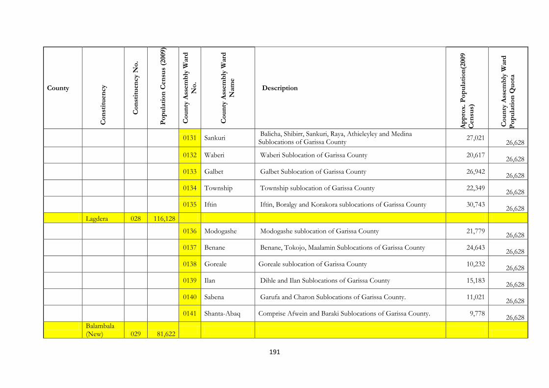
191
County
Co
nst
itu
en
cy
Co
nst
itu
en
cy N
o.
Po
pu
lati
on
Cen
sus
(2009)
Co
un
ty A
ssem
bly
Ward
No
.
Co
un
ty A
ssem
bly
Ward
Nam
e
Description
Ap
pro
x.
Po
pu
lati
on
(2009
Cen
sus)
Co
un
ty A
ssem
bly
Ward
Po
pu
lati
on
Qu
ota
0131 Sankuri
Balicha, Shibirr, Sankuri, Raya, Athieleyley and Medina Sublocations of Garissa County
27,021 26,628
0132 Waberi Waberi Sublocation of Garissa County 20,617
26,628
0133 Galbet Galbet Sublocation of Garissa County 26,942
26,628
0134 Township Township sublocation of Garissa County 22,349
26,628
0135 Iftin Iftin, Boralgy and Korakora sublocations of Garissa County 30,743
26,628
Lagdera 028 116,128
0136 Modogashe Modogashe sublocation of Garissa County 21,779
26,628
0137 Benane Benane, Tokojo, Maalamin Sublocations of Garissa County 24,643
26,628
0138 Goreale Goreale sublocation of Garissa County 10,232
26,628
0139 Ilan Dihle and Ilan Sublocations of Garissa County 15,183
26,628
0140 Sabena Garufa and Charon Sublocations of Garissa County. 11,021
26,628
0141 Shanta-Abaq Comprise Afwein and Baraki Sublocations of Garissa County. 9,778
26,628
Balambala (New) 029 81,622
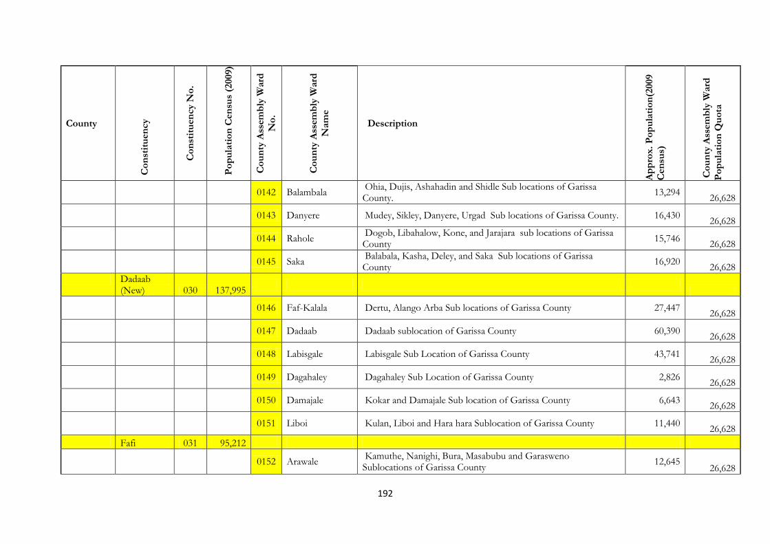
192
County
Co
nst
itu
en
cy
Co
nst
itu
en
cy N
o.
Po
pu
lati
on
Cen
sus
(2009)
Co
un
ty A
ssem
bly
Ward
No
.
Co
un
ty A
ssem
bly
Ward
Nam
e
Description
Ap
pro
x.
Po
pu
lati
on
(2009
Cen
sus)
Co
un
ty A
ssem
bly
Ward
Po
pu
lati
on
Qu
ota
0142 Balambala Ohia, Dujis, Ashahadin and Shidle Sub locations of Garissa County.
13,294
26,628
0143 Danyere Mudey, Sikley, Danyere, Urgad Sub locations of Garissa County. 16,430
26,628
0144 Rahole Dogob, Libahalow, Kone, and Jarajara sub locations of Garissa County
15,746
26,628
0145 Saka Balabala, Kasha, Deley, and Saka Sub locations of Garissa County
16,920
26,628
Dadaab (New) 030 137,995
0146 Faf-Kalala Dertu, Alango Arba Sub locations of Garissa County 27,447
26,628
0147 Dadaab Dadaab sublocation of Garissa County 60,390
26,628
0148 Labisgale Labisgale Sub Location of Garissa County 43,741
26,628
0149 Dagahaley Dagahaley Sub Location of Garissa County 2,826
26,628
0150 Damajale Kokar and Damajale Sub location of Garissa County 6,643
26,628
0151 Liboi Kulan, Liboi and Hara hara Sublocation of Garissa County 11,440
26,628
Fafi 031 95,212
0152 Arawale
Kamuthe, Nanighi, Bura, Masabubu and Garasweno Sublocations of Garissa County
12,645 26,628
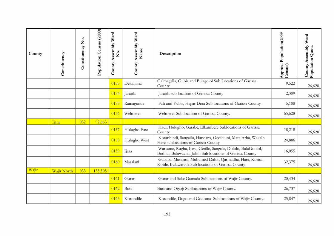
193
County
Co
nst
itu
en
cy
Co
nst
itu
en
cy N
o.
Po
pu
lati
on
Cen
sus
(2009)
Co
un
ty A
ssem
bly
Ward
No
.
Co
un
ty A
ssem
bly
Ward
Nam
e
Description
Ap
pro
x.
Po
pu
lati
on
(2009
Cen
sus)
Co
un
ty A
ssem
bly
Ward
Po
pu
lati
on
Qu
ota
0153 Dekaharia Galmagalla, Gubis and Bulagolol Sub Locations of Garissa County
9,522
26,628
0154 Jarajila Jarajila sub location of Garissa County 2,309
26,628
0155 Ramagudda Fafi and Yubis, Hagar Dera Sub locations of Garissa County 5,108
26,628
0156 Welmerer Welmerer Sub location of Garissa County. 65,628
26,628
Ijara 032 92,663
0157 Hulugho East Hadi, Hulugho, Garabe, Elkambere Sublocations of Garissa County
18,218
26,628
0158 Hulugho West
Koranhindi, Sangailu, Handaro, Gediluuni, Mata Arba, Wakalb Hare sublocations of Garissa County
24,886 26,628
0159 Ijara
Warsame, Rugha, Ijara, Gerille, Sangole, Dololo, BulaGoolol, Bodhai, Bulawacha, Jalish Sub locations of Garissa County
16,055 26,628
0160 Masalani
Gababa, Masalani, Muhumed Dahir, Qarmadha, Hara, Korisa, Kotile, Bulawarade Sub locations of Garissa County
32,375 26,628
Wajir Wajir North 033 135,505
0161 Gurar Gurar and Sake Gamada Sublocations of Wajir County. 20,434
26,628
0162 Bute Bute and Ogarji Sublocations of Wajir County. 26,737
26,628
0163 Korondile Korondile, Dugo and Godoma Sublocations of Wajir County. 25,847
26,628

194
County
Co
nst
itu
en
cy
Co
nst
itu
en
cy N
o.
Po
pu
lati
on
Cen
sus
(2009)
Co
un
ty A
ssem
bly
Ward
No
.
Co
un
ty A
ssem
bly
Ward
Nam
e
Description
Ap
pro
x.
Po
pu
lati
on
(2009
Cen
sus)
Co
un
ty A
ssem
bly
Ward
Po
pu
lati
on
Qu
ota
0164 Buna Buna, Lensayu, Lakole North, Ingirir and MalkaGufu Sublocations of Wajir County
23,830
26,628
0165 Ajawa Ajawa, kurrow and Batalu Sublocations of Wajir County. 16,447
26,628
0166 Danaba Danaba and Quadama Sublocations of Wajir County. 22,220
26,628
Wajir East 034 104,026
0167 Wagberi Wagber/H.Z Dam sub location of Wajir county 23,381
26,628
0168 Township Township, Bulla Hodhan, Ali Moaw sub locations of Wajir county
20,646
26,628
0169 Barwako Got Ade, Makoror and Barwago sub locations of Wajir county 30,070
26,628
0170 Khorof
Harar-Khorof Harar/Dawyare, Konto/Abakfin, Riba Balbala and Wajir Bor sub locations of Wajir county
29,772 26,628
Tarbaj (New) 035 120,392
0171 Elben Bumayo, Mansa, Ogorale, Elben sub-locations of Wajir county 27,014
26,628
0172 Sarman Sarman , Duntow,Dambas sub -locations of Wajir county 26,064
26,628
0173 Tarbaj Tarbaj, Lafaley/Johar and Dashega sub-locations of Wajir county 28,819
26,628
0174 Wargadud El-Kotulo, Kotulo, Hungai and Wargadud Sub-locations of Wajir 29,949
26,628

195
County
Co
nst
itu
en
cy
Co
nst
itu
en
cy N
o.
Po
pu
lati
on
Cen
sus
(2009)
Co
un
ty A
ssem
bly
Ward
No
.
Co
un
ty A
ssem
bly
Ward
Nam
e
Description
Ap
pro
x.
Po
pu
lati
on
(2009
Cen
sus)
Co
un
ty A
ssem
bly
Ward
Po
pu
lati
on
Qu
ota
Wajir West 036 90,541
0175 Arbajahan Arbajahan, Boji Heri and Garse Quftu Sublocations of Wajir County.
20,927
26,628
0176 Athibohol
Athibohol, Hadado North, Lolkuta North and Lagboghol North sub-locations of Wajir county
19,264 26,628
0177 Ademasajida Hadado South, Lolkuta South and Adamsajide sub –locations of WaJIR county
26,216
26,628
0178 Ganyure Barmishe, Ganyure and Kukale Sub locations of Wajir 12,119
26,628
0179 Wagalla El Nur, Griftu, Wagalla and Tula Tula sub-locations of Wajir County.
32,705
26,628
Eldas (New) 037 81,407
0180 Gurar Gurar and Sake Gamada Sublocations of Wajir County. 20,434
26,628
0181 Bute Bute and Ogarji Sublocations of Wajir County. 26,737
26,628
0182 Korondile Korondile, Dugo and Godoma Sublocations of Wajir County. 25,847
26,628
0183 Buna
Buna, Lensayu, Lakole North, Ingirir and MalkaGufu Sublocations of Wajir County
23,830
26,628
0184 Danaba Ajawa, Kurrow, Batalu, Danaba and Quadama Sublocations of Wajir County.
38,667
26,628
Wajir South 038 130,070

196
County
Co
nst
itu
en
cy
Co
nst
itu
en
cy N
o.
Po
pu
lati
on
Cen
sus
(2009)
Co
un
ty A
ssem
bly
Ward
No
.
Co
un
ty A
ssem
bly
Ward
Nam
e
Description
Ap
pro
x.
Po
pu
lati
on
(2009
Cen
sus)
Co
un
ty A
ssem
bly
Ward
Po
pu
lati
on
Qu
ota
0185 Benane
Benane, Sala, Serif, Shimbir Bul, Dagahaley, Sabule and Finni Sublocations of Wajir County.
23,609 26,628
0186 Burder Burder and Gullet Dere Sublocations of Wajir County. 7,048
26,628
0187 Dadaja Bulla Salalma, Hambalash, Diif and Dadaja Bulla Sublocations of Wajir County.
22,257
26,628
0188 Kibilai
Kiwanja Ndege, Habaswein, Dilmanyale, Dulgub, Abakore and Meri Sublocations of Wajir County.
23,935 26,628
0189 Kulaaley Kulaaley, Ibrahim Ure, Handaki and Gherille Sublocations of Wajir County.
18,708
26,628
0190 Tesore
Tesore, Leheley, Eyrib, Macheza and Lagboghol South Sublocattions of Wajir County.
22,631 26,628
Mandera Mandera West 039 141,633
0191 Tabaka South Comprise of Wangai Daham and Duduble SubLocations 26,601
26,628
0192 Takaba Comprise of Didkuro and Kubdishan Sub-Locations 25,373
26,628
0193 Tabaka North Comprise of Lag Sure and Takaba SubLocations 38,962
26,628
0194 Dandu Comprise of Dandu and El Danaba 32,675
26,628
0195 Gither Kubi Halo, Iresteno, Sake and Gither Sub-locations 27,700
26,628

197
County
Co
nst
itu
en
cy
Co
nst
itu
en
cy N
o.
Po
pu
lati
on
Cen
sus
(2009)
Co
un
ty A
ssem
bly
Ward
No
.
Co
un
ty A
ssem
bly
Ward
Nam
e
Description
Ap
pro
x.
Po
pu
lati
on
(2009
Cen
sus)
Co
un
ty A
ssem
bly
Ward
Po
pu
lati
on
Qu
ota
Banissa (New) 040 178,142
0196 Banissa Banissa and Guba Sub-locations 38,876
26,628
0197 Darkhale Goljo, Derkale Sub-Locations 32,078
26,628
0198 Eyemole Kiliwehiri, Eyemole and Lulis Sub-Locations 50,380
26,628
0199 Malkamari Malkamari, Hullow, Malka-ruqa and Choroko Sub-locations 36,740
26,628
Mandera North (New) 041 185,468
0200 Ashabito Quramdhow, Sukela Tifna, As-habito, Ogarwein Sub-locations 26,077
26,628
0201 Guticha Comprise of Shir-Shir, Guticha, Olla and Sarman sub-locations 33,658
26,628
0202 Girissa Kajaja, Marothile, Jabi-bar and Girissa Sub-locations 25,894
26,628
0203 Rhamu Yabicho, Rhamu and Shantoley Sublocations 36,555
26,628
0204 Rhamu Dimtu Mado, Kalicha, Rhamu Dimtu and Garsey Sub-Locations 30,119
26,628
Mandera South 042 231,836

198
County
Co
nst
itu
en
cy
Co
nst
itu
en
cy N
o.
Po
pu
lati
on
Cen
sus
(2009)
Co
un
ty A
ssem
bly
Ward
No
.
Co
un
ty A
ssem
bly
Ward
Nam
e
Description
Ap
pro
x.
Po
pu
lati
on
(2009
Cen
sus)
Co
un
ty A
ssem
bly
Ward
Po
pu
lati
on
Qu
ota
(New)
0205 Kutulo El Ramu, Kutulo, Lehele, Garsesala, Dabacity, Bojigarse and Kutayu Sub-locations
29,830
26,628
0206 Elwak South Bore Hole Eleven and Elwak South Sub-locations 30,515
26,628
0207 Elwak North Wante, Bulla Afya and Elwak Town Sub-locations 26,600
26,628
0208 Wargadud Elele, Wargadud East, Wargadud Town and Dasheng Wante Sub-locations
29,195
26,628
0209 Shimbir Fatuma Fincharo, Burmayo North, Bumayo South and Shimbir Fatuma Sub-locations
36,727
26,628
Mandera East 043 138,728
0210 Arabia
Oda/bamboo, Farey/Duhum Durwuay and Saro Hindi/Harare Arabia and Omar Jillow Sub-locations
67,717 26,628
0211 Libehia Libehia/Kuradeer, Gumbisu and Hareri Sub-locations 31,934
26,628
0212 Khalalio
Aresa, Gududiye, Kalaliyo, Gingo, Bella, Karo, Garba Qoley, Bokolo/barwako, Harire Hosley/bida/Kamor Elle, Bur Abor/Sharif and Bula Haji/figho Sub-locations
15,828 26,628
0213 Shafshafey Neboi, Shaf Shafey and Bulla Nguvu/Bulla Jamhuria/Bulla Power Sub-Locations
37,862
26,628
0214 Township Bulla Mpya, Kamor, Township and Border Point One Sub-locations
31,002
26,628
Lafey (New) 044 149,959

199
County
Co
nst
itu
en
cy
Co
nst
itu
en
cy N
o.
Po
pu
lati
on
Cen
sus
(2009)
Co
un
ty A
ssem
bly
Ward
No
.
Co
un
ty A
ssem
bly
Ward
Nam
e
Description
Ap
pro
x.
Po
pu
lati
on
(2009
Cen
sus)
Co
un
ty A
ssem
bly
Ward
Po
pu
lati
on
Qu
ota
0215 Sala Comprise of Sala Sub-Location 5,808
26,628
0216 Fino Comprise of Fino/hareri Tur Sublocation 16,632
26,628
0217 Lafey Comprise Kamora Liban, Kabo, Damasa and Lafey Sub-Locations
48,659
26,628
0218 Waranqara Gari, Waranqara/safo, Bambo and Barmile Sub-Locations 24,619
26,628
0219 Alungo Alango Gof Sub-Location 14,138
26,628
Marsabit Moyale 045 103,799
0220 Butiye
Comprised of Butiye, Sesi, Bori, Somare, Godoma and Kate Sublocations of Marsabit County.
22,793 26,628
0221 Sololo Anona, Woya Godha, Mado adi, and Sololo Sublocations of Marsabit County.
8,300
26,628
0222 Heillu/Manyatta Comprised of Kinisa, Mansile, Manyatta Burji Sublocations of Marsabit County.
21,152
26,628
0223 Golbo
Comprised of Golla, Dir Digma/Guyo/Timo/Dabel, Odda, Funanyatta, Godoma/Dik O Godoma, Nana, and Yabalolo Sublocations of Marsabit County.
25,834 26,628
0224 Moyale Township
Comprised of Township and Ngurumesa Sublocations of Marsabit County.
10,167
26,628
North Horr 046 75,196

200
County
Co
nst
itu
en
cy
Co
nst
itu
en
cy N
o.
Po
pu
lati
on
Cen
sus
(2009)
Co
un
ty A
ssem
bly
Ward
No
.
Co
un
ty A
ssem
bly
Ward
Nam
e
Description
Ap
pro
x.
Po
pu
lati
on
(2009
Cen
sus)
Co
un
ty A
ssem
bly
Ward
Po
pu
lati
on
Qu
ota
0225 Butiye
Comprised of Butiye, Sesi, Bori, Somare, Godoma and Kate Sublocations of Marsabit County.
22,793 26,628
0226 Sololo Anona, Woya Godha, Mado adi, and Sololo Sublocations of Marsabit County.
8,300
26,628
0227 Heillu/Manyatta Comprised of Kinisa, Mansile, Manyatta Burji Sublocations of Marsabit County.
21,152
26,628
0228 Golbo
Comprised of Golla, Dir Digma/Guyo/Timo/Dabel, Odda, Funanyatta, Godoma/Dik O Godoma, Nana, and Yabalolo Sublocations of Marsabit County.
25,834 26,628
0229 Moyale Township
Comprised of Township and Ngurumesa Sublocations of Marsabit County.
10,167
26,628
Saku 047 46,502
0230 Nagayo
Comprised of Jirime, Majengo/Nagayo and Qitta, Dakabaricha and Mata Aiba Sublocations of Marsabit County.
17,992
26,628
0231 Karare
Comprised of Hula Hula, Ongicho, Karare, Kitururi, songa and Townshi/wabera Sublocations of Marsabit County.
15,975 26,628
0232 Sagante Rukesa, Dirib Gombo, Jaldesa, Badasa, Sagante Sublocations of Marsabit County.
12,409
26,628
Laisamis 048 65,669
26,628
0233 Loiyangalani
Comprised of Moite, Gas, Elmoro Bay, Loiyangalan, Mt. Kulal, Olturot, Larach, Arapalal Sublocations of Marsabit County.
16,358 26,628
0234 South Horr Kurungu, Arge, South Horr, Kurkum, Kargi Sublocations of Marsabit County.
7,474
26,628

201
County
Co
nst
itu
en
cy
Co
nst
itu
en
cy N
o.
Po
pu
lati
on
Cen
sus
(2009)
Co
un
ty A
ssem
bly
Ward
No
.
Co
un
ty A
ssem
bly
Ward
Nam
e
Description
Ap
pro
x.
Po
pu
lati
on
(2009
Cen
sus)
Co
un
ty A
ssem
bly
Ward
Po
pu
lati
on
Qu
ota
0235 Ngurunit
Hafare, Illant, Korr, Halisirwa, ngurunit/Lonyor Pediau, Sublocations of Marsabit County.
21,305 26,628
0236 Logologo Logologo, Gudas/Soriadi and kambee sublocations of Marsabit County.
5,144
26,628
0237 Laisamis Laisamis, Koya, Irir, Lontolio, Ndikir, Merille Sublocations of Marsabit County.
13,109
26,628
Isiolo Isiolo North 049 100,176
0238
WAMBA NORTH
Ngare Narok,Lorrok-Onyokie,Raraiti,Swani,Lmarmaroi, Sub Locations of Samburu County
29,008 26,628
0239 BULLA PESA Bulla Pesa,Kiwanjani Sub Locations of Isiolo County 25,718
26,628
0240 CHARI Yamicha,Duma,Kom,Goda,Bulesa,Bisan Biliqo, Sub Locations of Isiolo County
5,138
26,628
0241 CHERAB
Malka Galla ,Korbesa,Bulto Bonsa,Merti North,Merti South Sub Locations of Isiolo County
12,072 26,628
0242 KIPSING Lenguruma,Kipsing Sub Locations of Isiolo County 5,560
26,628
0243 ODHA Burat,Isiolo West Sub Locations of Isiolo County 12,852
26,628
0244 OLDO-NYIRO Oldo-nyiro,Longopito Sub Locations of Isiolo County 9,828
26,628
Isiolo South 050 43,118

202
County
Co
nst
itu
en
cy
Co
nst
itu
en
cy N
o.
Po
pu
lati
on
Cen
sus
(2009)
Co
un
ty A
ssem
bly
Ward
No
.
Co
un
ty A
ssem
bly
Ward
Nam
e
Description
Ap
pro
x.
Po
pu
lati
on
(2009
Cen
sus)
Co
un
ty A
ssem
bly
Ward
Po
pu
lati
on
Qu
ota
0245
GARBA TULLA
Garba Tulla, South, Garba Tulla North Malka – Daka, Garfarsa Sub Locations of Isiolo County
22,563 26,628
0246 KINA Korbesa,Rapsu,Kinna,Bibi,Kula Mawe,Mado Yaka Sub Locations of Isiolo County
19,434
26,628
0247 MODOGASHE
Eldera,Modogashe South,Modogashe North,Gubatu,Sericho,Badana Garadida,Eresaboru,Muchuro Sub Locations of Isiolo County
27,267 26,628
Meru Igembe South 051 89,160
0248 Igembe South
Kianda, Nkiene, Ikuu, Antuambui, Amung’enti, Athimba, Antuanthama and Kiunyene
22,261 26,628
0249 Igembe South East
Lakathi, Thaicu, Antubakiru, Anjaru, Bwethaa, and Thuria. 26,731
26,628
0250 Igembe South West
Marega, Ugoti, Amunju, Tiira, Nceme, Kirindine, Auki and Amwamba
26,668
26,628
0251 Maua Town Anchenge, Giteretu, Amwathi, Kaibu, Burimaria, Makiri and Gitura
30,541
26,628
0252 Kiegoi Gitumi, Kinyanka,Ngundune and Mboone 17,275
26,628
Igembe Central ( New) 052 104,297
0253 Athuri Runjine Kathelwa, Machungulu, Thitha and Kaene. 64,782
26,628
0254 Igembe East Andiala, Kaurine, Kelingene, Baibariu, Nthambiro , Kitheo, 44,013
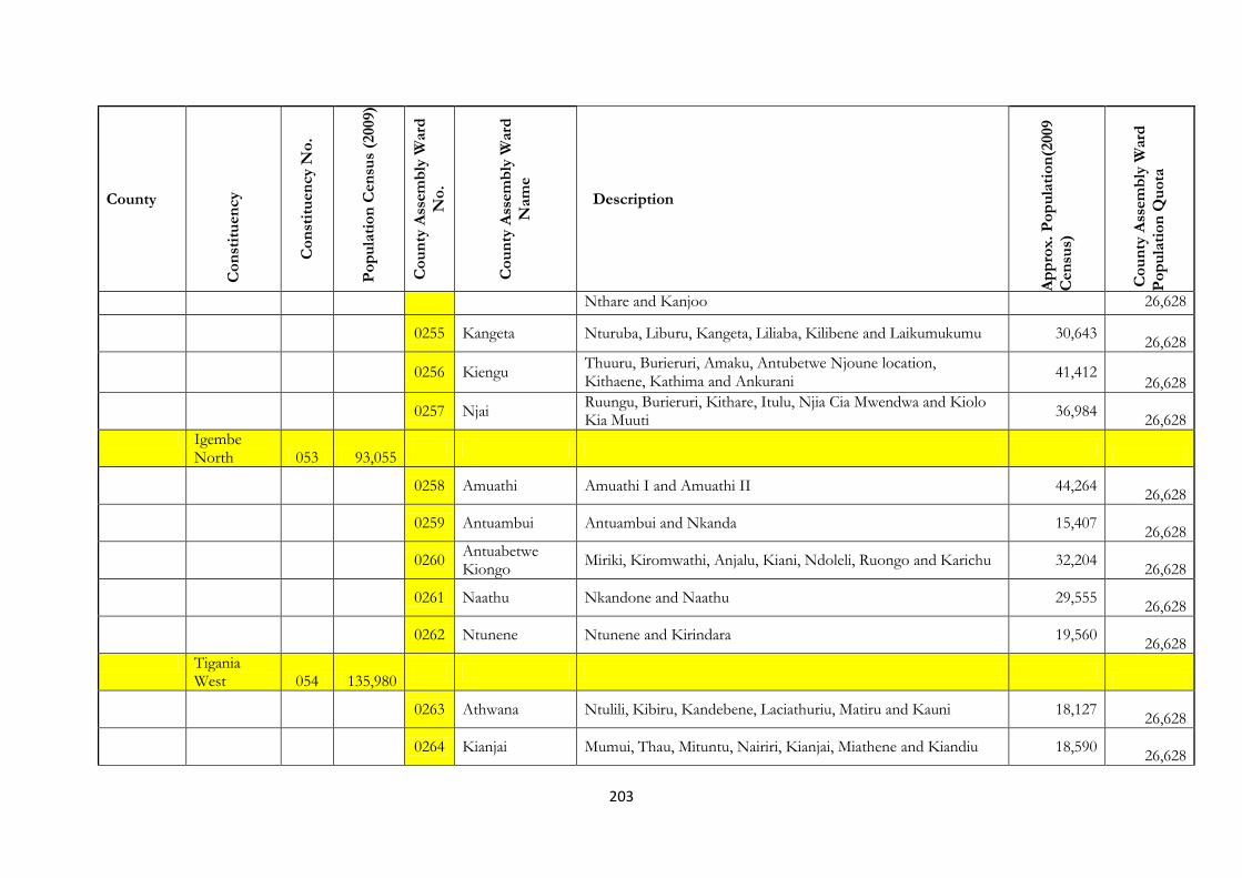
203
County
Co
nst
itu
en
cy
Co
nst
itu
en
cy N
o.
Po
pu
lati
on
Cen
sus
(2009)
Co
un
ty A
ssem
bly
Ward
No
.
Co
un
ty A
ssem
bly
Ward
Nam
e
Description
Ap
pro
x.
Po
pu
lati
on
(2009
Cen
sus)
Co
un
ty A
ssem
bly
Ward
Po
pu
lati
on
Qu
ota
Nthare and Kanjoo 26,628
0255 Kangeta Nturuba, Liburu, Kangeta, Liliaba, Kilibene and Laikumukumu 30,643
26,628
0256 Kiengu
Thuuru, Burieruri, Amaku, Antubetwe Njoune location, Kithaene, Kathima and Ankurani
41,412 26,628
0257 Njai Ruungu, Burieruri, Kithare, Itulu, Njia Cia Mwendwa and Kiolo Kia Muuti
36,984
26,628
Igembe North 053 93,055
0258 Amuathi Amuathi I and Amuathi II 44,264
26,628
0259 Antuambui Antuambui and Nkanda 15,407
26,628
0260 Antuabetwe Kiongo
Miriki, Kiromwathi, Anjalu, Kiani, Ndoleli, Ruongo and Karichu 32,204
26,628
0261 Naathu Nkandone and Naathu 29,555
26,628
0262 Ntunene Ntunene and Kirindara 19,560
26,628
Tigania West 054 135,980
0263 Athwana Ntulili, Kibiru, Kandebene, Laciathuriu, Matiru and Kauni 18,127
26,628
0264 Kianjai Mumui, Thau, Mituntu, Nairiri, Kianjai, Miathene and Kiandiu 18,590
26,628

204
County
Co
nst
itu
en
cy
Co
nst
itu
en
cy N
o.
Po
pu
lati
on
Cen
sus
(2009)
Co
un
ty A
ssem
bly
Ward
No
.
Co
un
ty A
ssem
bly
Ward
Nam
e
Description
Ap
pro
x.
Po
pu
lati
on
(2009
Cen
sus)
Co
un
ty A
ssem
bly
Ward
Po
pu
lati
on
Qu
ota
0265 Kitheo
Mweronkanga, Twale, Limbine, Maanthi, Karii, Mwili,Ntiba, Kaliati, Kitheo and Muchune
35,646 26,628
0266 Mbeu Mbeu, Kieru, Kimirii, Kibuline, Kiorimba and Machengene 20,160
26,628
0267 Nkomo Limaru, Kunene, Kilenchune, Amwari, Kamaroo and Ntombo 24,361
26,628
Tigania East 055 157,246
26,628
0268 Ankamia Igarie, Kunati, Giithu, Ankamia and Amugaa 26,855
26,628
0269 Karama Urru, Mbaranga, Ametho and Antuandurru 15,169
26,628
0270 Kiguchwa Micii Mukuru, Kiguchwa, Ametho and Abondii 19,172
26,628
0271 Mikinduri Anjuki, Athwana, Marega, Akaiga and Kiguru 33,796
26,628
0272 Muthara
Anthinga, Athanja, Lailuba (lower), Kitharene, Lailuba, Lanyiruu, Maburwa and Tiringwii
27,057
26,628
North Imenti 056 119,524
0273 Municipality Kaaga, Upper Igoki, Tuntu, Township Sub-Locations 16,171
26,628
0274 Gakaromone
Mpuri, Nthimbiri, kainginyo, Ngonyi, Kirugua, Nchaure, Gitugu, MuringoMbugi, Lower igoki, Magundu, Gachanka, Gakaromone Sub-locations.
54,749 26,628

205
County
Co
nst
itu
en
cy
Co
nst
itu
en
cy N
o.
Po
pu
lati
on
Cen
sus
(2009)
Co
un
ty A
ssem
bly
Ward
No
.
Co
un
ty A
ssem
bly
Ward
Nam
e
Description
Ap
pro
x.
Po
pu
lati
on
(2009
Cen
sus)
Co
un
ty A
ssem
bly
Ward
Po
pu
lati
on
Qu
ota
0275 Chugu Kithoka, Gankere, Kambiti, Kirimene, Chung’ari and Runogone Sublocations
25,940
26,628
0276 Giaki
Rwanyange, Mbeu, Kiamwatari, Njoka, Mukua, Kanyuango/Kathita, Kanjagi, Kambereu, Kirimaitune, Ciothirai, Gachua, Mbirikene Sub-Locations
35,962 26,628
Mbuuri (New) 057 139,423
0277 Kibirichia
Mutunyi, Ntumburi, Barrier, Kiamiogo, Mboroga, Mburuguti, Muriinya , Kimbo and Gathuine
26,940 26,628
0278 Kirimara Ngare Ndare, Buuri, Ntirimiti, Maritati, Mutarakwa, Kiambogo, Kithithina
41,710
26,628
0279 Naari Kithima, Nkando, Kiirua, Michogomone, Gitimine, Runkuru and Maitei.
27,299
26,628
0280 Ontulili Kangaita, Katheri, and Antubamwitu 16,980
26,628
0281 Ruiri Mugae, Kirwiro, Kithwene, Mutuuma, Nchoroiboro and kamutune
18,425
26,628
Central Imenti 058 141,768
0282 Kiagu kathwene, Kiamuri, Makandune, Matetu, Kiija, Gitie 21,275
26,628
0283 Mwangathia Nkandone, Igane, Gatuune, Kaongo, Gaitu and Mbajone Sub-locations
24,793
26,628
0284
Abothuguchi Central
Kiria, Kirirwa, Gitauga, Nkuene, Kariene, Nyweri, Ruiga, Baragu, Kirigara and Mariene Sub-Locations
22,885 26,628

206
County
Co
nst
itu
en
cy
Co
nst
itu
en
cy N
o.
Po
pu
lati
on
Cen
sus
(2009)
Co
un
ty A
ssem
bly
Ward
No
.
Co
un
ty A
ssem
bly
Ward
Nam
e
Description
Ap
pro
x.
Po
pu
lati
on
(2009
Cen
sus)
Co
un
ty A
ssem
bly
Ward
Po
pu
lati
on
Qu
ota
0285 Kithurune Muruugi, Kioru, Nduruma, Nkadone and Mbwinjeru Sub-locations
8,292
26,628
0286 Abothuguchi West
Kibaranyaki, Gikune, Kathiranga West, Kathiranga North, Kathita, Kariri North, kirima Kia Athi, Mwirang’ombe, Kathiringa Central, Kiadhumbi South, Nkiriri South, Kionjo North, kathiringa East, Gakurwene, Kaugu, Marathi, Karugwa, Kinjo South, Sub-Locations
21,460
26,628
South Imenti 059 179,604
0287 Mitunguu Kirendene and ng’onyi Sub-Locations 20,835
26,628
0288 Igoji East
Kithatu, Maraa, Kithakanaro, Igokine, Kairaa, Mweru, Mworoga, Gikui, Kiathathi, Miruriiri, Mitume, Kianjogu and Kuiri Sub-locations
33,803 26,628
0289 Abogeta East Ntharene, Baranga, Kothine and Mwichiune Sub-locations 17,638
26,628
0290 Igoji West Karia, Kiangua, Gakiiri, Kinoro, Kiroone, Kiamweri and Nkunjumu Sub-Locations
18,966
26,628
0291 Abogeta West Upper Kiungone, Upper Kithangari and Upper Chure 30,338
26,628
0292 Uruku/Kathera/Mikumbune
Mikumbune, Kigane, Kathera/taita/marimba, Uruku/ukuu/baitigitu Sub-locations
45,256
26,628
Tharaka -Nithi Nithi 060 128,134

207
County
Co
nst
itu
en
cy
Co
nst
itu
en
cy N
o.
Po
pu
lati
on
Cen
sus
(2009)
Co
un
ty A
ssem
bly
Ward
No
.
Co
un
ty A
ssem
bly
Ward
Nam
e
Description
Ap
pro
x.
Po
pu
lati
on
(2009
Cen
sus)
Co
un
ty A
ssem
bly
Ward
Po
pu
lati
on
Qu
ota
0293 Kaaringani
mariani,marembo,riamthiga,weru,kathangani,karangoni and rukindu sublocation of Tharaka-Nithi County.
15,977 26,628
0294 Igamangombe kathanje,mutino,kamonka,kamaturia,kajuki,makanyanga,kamaindi,igambangombe,kiaritha,kamwimbi,mbogoni and igamatundu sublocation of Tharaka-Nithi County.
30,160 26,628
0295 Mugumoni
Kinoru,kanthiri,karamani,rabate,mukuuni,kangakini,kathatwa,kabubeni,Mwonge,kogumo,njuri,nthambo and thuita sub location of Tharaka-Nithi county,
35,765 26,628
0296 Mugurirwa
kamucii,kaarani,gitareni nkuthika,muiru,mugurirwa and kirage sub location of Tharaka-Nithi County.
24,185 26,628
0297 Chuka Town
Njaina,ndagani,chukka township,mucwa and kiangondu sub location of Tharaka-Nithi County
20,207 26,628
Maara (New) 061 107,098
0298 Mwimbi
kathingitu,kaare,karii,magutini,kiroo,thigaa and iruma sub location of Tharaka-Nithi County
22,935
26,628
0299 Ganga
kirumi,mugumagu,kariakomo,nduguru,munga,kiriaini and kithare sublocation of Tharaka Nithii County.
23,689 26,628
0300
Mitheru/Muthambi
kamwangu,ndumbini,kandungu,karimba,chamunga,igamurathi,weru(muthambi),ruguta/gatua and iriga sub location of Tharaka-Nithi County.
40,250 26,628
0301 Chogora
gianchuku,gitombani, mukwego,chogoria,kianjagi,gantaraki and kiraro sub location of Tharaka-Nithi County
25,792 26,628
Tharaka 062 130,098
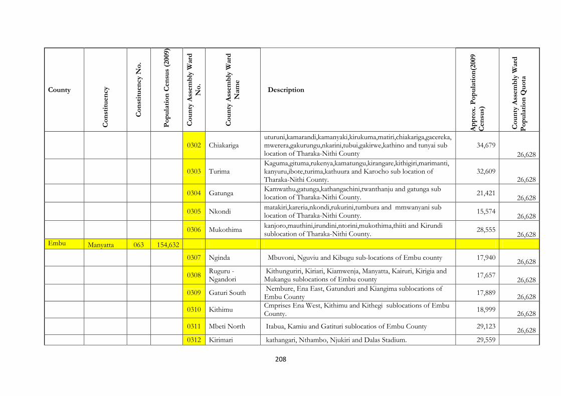
208
County
Co
nst
itu
en
cy
Co
nst
itu
en
cy N
o.
Po
pu
lati
on
Cen
sus
(2009)
Co
un
ty A
ssem
bly
Ward
No
.
Co
un
ty A
ssem
bly
Ward
Nam
e
Description
Ap
pro
x.
Po
pu
lati
on
(2009
Cen
sus)
Co
un
ty A
ssem
bly
Ward
Po
pu
lati
on
Qu
ota
0302 Chiakariga uturuni,kamarandi,kamanyaki,kirukuma,matiri,chiakariga,gacereka,mwerera,gakurungu,nkarini,tubui,gakirwe,kathino and tunyai sub location of Tharaka-Nithi County
34,679 26,628
0303 Turima
Kaguma,gituma,rukenya,kamatungu,kirangare,kithigiri,marimanti,kanyuru,ibote,turima,kathuura and Karocho sub location of Tharaka-Nithi County.
32,609 26,628
0304 Gatunga
Kamwathu,gatunga,kathangachini,twanthanju and gatunga sub location of Tharaka-Nithi County.
21,421
26,628
0305 Nkondi
matakiri,kareria,nkondi,rukurini,tumbura and mmwanyani sub location of Tharaka-Nithi County.
15,574 26,628
0306 Mukothima
kanjoro,mauthini,irundini,ntorini,mukothima,thiiti and Kirundi sublocation of Tharaka-Nithi County.
28,555 26,628
Embu Manyatta 063 154,632
0307 Nginda Mbuvoni, Nguviu and Kibugu sub-locations of Embu county 17,940
26,628
0308
Ruguru -Ngandori
Kithunguriri, Kiriari, Kiamwenja, Manyatta, Kairuri, Kirigia and Mukangu sublocations of Embu county
17,657 26,628
0309 Gaturi South Nembure, Ena East, Gatunduri and Kiangima sublocations of Embu County
17,889
26,628
0310 Kithimu Cmprises Ena West, Kithimu and Kithegi sublocations of Embu County.
18,999
26,628
0311 Mbeti North Itabua, Kamiu and Gatituri sublocatios of Embu County 29,123
26,628
0312 Kirimari kathangari, Nthambo, Njukiri and Dalas Stadium. 29,559

209
County
Co
nst
itu
en
cy
Co
nst
itu
en
cy N
o.
Po
pu
lati
on
Cen
sus
(2009)
Co
un
ty A
ssem
bly
Ward
No
.
Co
un
ty A
ssem
bly
Ward
Nam
e
Description
Ap
pro
x.
Po
pu
lati
on
(2009
Cen
sus)
Co
un
ty A
ssem
bly
Ward
Po
pu
lati
on
Qu
ota
26,628
Runyenjes 064 142,360
0313 Gaturi Kavutiri, Kianjuki, Makengi and Kevote Sublocations of Embu County.
20,239
26,628
0314 Gichera Gichera, Kigaa and Gichiche Sublocation of Embu County. 17,790
26,628
0315 Kagaari Mbui-Njeru, Kanja, Kiangungi, Gitare and Rukuriri Sublocations of Embu County.
17,365
26,628
0316 Karurumo Karurumo, Nyagari, Kathunguri, Kasafari and Kiringa Sublocations of Embu County.
10,420
26,628
0317 Kieni-Urban Mufu, Kathari, Kathanjure and Kigumo Sublocations of Embu County.
18,687
26,628
0318 Mukuuri
Mukuuri, Kawanjara, Gikuuri, Mbiruri and Nthangaiya Sublocations of Embu County.
19,720 26,628
Gachoka 065 130,185
0319 Mwea Wacharo, Karaba, Gategi, and Riakanau sub –locations of Embu county
30,117
26,628
0320 Makima Mwea, Makima and Mbondoni sub-locations of Embu county 21,265
26,628
0321 Mbeti South Kiamuringa, Gachoka, Gachuriri, Mbita and Kirima sub-locations of Embu county
33,175
26,628
0322 Mavuria Gikiiro, Gacegethiuri 26,693
26,628
0323 Kiambere Kithithiri, Gichiche,Kombomunyiri and Mavuria sublocations of 18,935

210
County
Co
nst
itu
en
cy
Co
nst
itu
en
cy N
o.
Po
pu
lati
on
Cen
sus
(2009)
Co
un
ty A
ssem
bly
Ward
No
.
Co
un
ty A
ssem
bly
Ward
Nam
e
Description
Ap
pro
x.
Po
pu
lati
on
(2009
Cen
sus)
Co
un
ty A
ssem
bly
Ward
Po
pu
lati
on
Qu
ota
Embu county 26,628
Siakago 066 89,035
26,628
0324 Nthanwa Gitiburi, Thura, Siakago and Riandu sub locations of Embu county
26,725
26,628
0325 Muminji
Karambari Gangara,Nguthi, Mutitu,Karie,Iria-itune and Nthmbu sub-locations of Embu county
27,433 26,628
0326 Evurore
Kariru, Kathera, Ngura, Nguthi,Evurore and Kamayindi sub locations of Embu County
34,877
26,628
Kitui Mwingi North 067 129,967
0327 Tseikuru
Usueni,Kyenini,Kaningo,Kitoroto,Kathiani,Ngaroni,Ngalenge,Nziitu and Kavirya sub location of Kitui County
27,308 26,628
0328 Ngomeni
Ikime,Mataka,Kakiani,Mitamisyi,Kimela,Kalwa,Ndatani,Kamula and Katika sub location of Kitui County
26,724 26,628
0329 Mumoni
Kamanda,Kathungu, gaturoni,Gacigongo and Gakombe sub location of Kitui County
11,911 26,628
0330 Kakuyu/Mikoya
Mukonga, Konyo,Mboroni,Ikongo,Ngongoni,Kokuyu,Kyondali and tya Kamuthahe sub location of Kitui County
17,611 26,628
0331 Kyuso
Gai, Ngarie,Itira-Nzou,Kimu,Kimangao,Masoki,Kisiuni and Twimyua sub location of Kitui County.
30,896 26,628
Mwingi Central 068 104,826

211
County
Co
nst
itu
en
cy
Co
nst
itu
en
cy N
o.
Po
pu
lati
on
Cen
sus
(2009)
Co
un
ty A
ssem
bly
Ward
No
.
Co
un
ty A
ssem
bly
Ward
Nam
e
Description
Ap
pro
x.
Po
pu
lati
on
(2009
Cen
sus)
Co
un
ty A
ssem
bly
Ward
Po
pu
lati
on
Qu
ota
(New)
0332 Eastern
Kamuitiu,Mathyakani,Kalanga,Mwalali,Ukasi,Mbuvu,Mwasuma and Kyavuka sub location of Kitui County
29,313
26,628
0333 Central Thonoa,Nyanyaa,Katitika,Kathoka,Enziu and Waita sub location of Kitui County.
22,168
26,628
0334 Southern
Kiomo,Mbondoni,Kavuvwani,Kalisasi,Mwingi,Maithyakani Kyanika, Ithumbi,Kivou,Kanzanzu and Kanzui sub location of Kitui County.
52,412 26,628
0335 Western
Mwambui,Kairungi,Kyothani,Ikuusya,Karura and Wikithuki sub location of Kitui County.
19,866 26,628
Mwingi South 069 130,155
26,628
0336 Kalitini/Mui Ingoo,Ngiluni,Ngugi,Itiko and Tumbu sub location of Kitui County
16,343
26,628
0337 North East
Yenzura,Thaana-Nzau,Kyusyami,Kalulini,Kaseri,Thokoa,Musuani, Winzyee and Kavaini sublocation of Kitui County
26,467 26,628
0338 South West
Kakululo,Nzawa,Nzalae,Ngongoni,Kavoloi,Kikiini,kitulani,kanyaa,Nzaini and Kasanga sub location of Kitui County
36,077 26,628
0339 Central
Muivu,Kyome,Itoloni,Kyamboo,Migwani,Nzatani,Nzeluni,Katalwa, Kwanugu and Kisoro sublocations of Kitui County.
34,582 26,628
0340 Eastern
Malawa,Ngaani,Nyaani,Mwambu,Ngieni,Mwangeni and Kyanguti sub location of Kitui County.
27,988
26,628
Kitui West 070 135,869

212
County
Co
nst
itu
en
cy
Co
nst
itu
en
cy N
o.
Po
pu
lati
on
Cen
sus
(2009)
Co
un
ty A
ssem
bly
Ward
No
.
Co
un
ty A
ssem
bly
Ward
Nam
e
Description
Ap
pro
x.
Po
pu
lati
on
(2009
Cen
sus)
Co
un
ty A
ssem
bly
Ward
Po
pu
lati
on
Qu
ota
0341 Eastern Kanyonyi and Mikuyumu sub location of Kitui County 11,326
26,628
0342 South
Syokithumbi,maselele,kathivo,kalindilo,kwa mulungu,kavuvuu,kalia,nzakame,katheuni,kyoondoni,kasaini,kathuma,maseki,musosya,kauma,and kitumbu sub location of Kitui County.
30,599
26,628
0343 Central
Kakumuti,mutonga,mithikwani,kiseveni,kithumula,kauwi,mithini,kaimu,musengo and kangii sublocation of Kitui County
47,043
26,628
0344 North
Kasakini,nzalae,katutu,kivaini,mutanda,kyenge,kisasyani,sangala,katheka,kangugi and kakeani sub location of Kitui County.
27,151 26,628
Kitui Rural (New) 071 94,894
0345 North East Ngangani,Kanzau,Kitungati,Ngiluni and Masimbini sub location of Kitui County
21,268
26,628
0346 East
Kiangwa,Makele, Ilusya,Mukameni,Mosa,katwala and Bitini sub location of Kitui County
27,111 26,628
0347 Central Maliku,Nguuni,Karibuni,Ndundune and Busyani sub location of Kitui County
16,404
26,628
0348 South
Syomonyu, Masimba,Kithiani,Kanyongonyo and Nzambia sub location of Kitui County
20,280
26,628
Kitui Central 072 135,869
0349 MIAMBANI Kamando/malili,Munganga and Mutula sub locations of Kitui County.
14,151
26,628
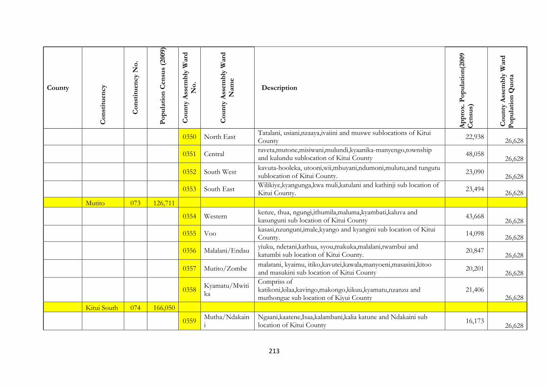
213
County
Co
nst
itu
en
cy
Co
nst
itu
en
cy N
o.
Po
pu
lati
on
Cen
sus
(2009)
Co
un
ty A
ssem
bly
Ward
No
.
Co
un
ty A
ssem
bly
Ward
Nam
e
Description
Ap
pro
x.
Po
pu
lati
on
(2009
Cen
sus)
Co
un
ty A
ssem
bly
Ward
Po
pu
lati
on
Qu
ota
0350 North East Tatalani, usiani,nzaaya,ivaiini and muswe sublocations of Kitui County
22,938
26,628
0351 Central
raveta,mutone,misiwani,mulundi,kyaanika-manyengo,township and kulundu sublocation of Kitui County
48,058 26,628
0352 South West
kavuta-hooleka, utooni,wii,mbuyani,ndumoni,mulutu,and tungutu sublocation of Kitui County.
23,090 26,628
0353 South East Wilikiye,kyangunga,kwa muli,katulani and kathinji sub location of Kitui County.
23,494
26,628
Mutito 073 126,711
0354 Western
kenze, thua, ngungi,ithumila,maluma,kyambati,kaluva and kasunguni sub location of Kitui County
43,668 26,628
0355 Voo kasasi,nzunguni,imale,kyango and kyangini sub location of Kitui County.
14,098
26,628
0356 Malalani/Endau
yiuku, ndetani,kathua, syou,makuka,malalani,twambui and katumbi sub location of Kitui County.
20,847 26,628
0357 Mutito/Zombe
malatani, kyaimu, itiko,kavutei,kawala,manyoeni,masasini,kitoo and masukini sub location of Kitui County
20,201
26,628
0358
Kyamatu/Mwitika
Compriss of katikoni,kilaa,kavingo,makongo,kikuu,kyamatu,nzanzu and muthongue sub location of Kiyui County
21,406 26,628
Kitui South 074 166,050
0359
Mutha/Ndakaini
Ngaani,kaatene,Isaa,kalambani,kalia katune and Ndakaini sub location of Kitui County
16,173 26,628

214
County
Co
nst
itu
en
cy
Co
nst
itu
en
cy N
o.
Po
pu
lati
on
Cen
sus
(2009)
Co
un
ty A
ssem
bly
Ward
No
.
Co
un
ty A
ssem
bly
Ward
Nam
e
Description
Ap
pro
x.
Po
pu
lati
on
(2009
Cen
sus)
Co
un
ty A
ssem
bly
Ward
Po
pu
lati
on
Qu
ota
0360
Mutumo/Kibwea
Kitoo, Kiatu,Ndilili,Mivune,Kivyuni,Kimani,Mwala,Kwaelu,Kibwea, Kandue and Kengo sub location of Kitui County
31,172 26,628
0361
Ikaanga/Kyatune
Vote,Ndatani,Kyatune,Ithumula,Kathungu,Yongela and Ngwani sub location of Kitui County
24,647 26,628
0362 Kanziko/Simisi
Ekani,Keitunda,Kivandeni,Mwanianga,Kyanyaa Simisi,Ilamba and Kiturwi sub location of Kitui County.
13,952 26,628
0363 Ikuutha/Kasaala
Kyaani,Nzamba,Kasaala,Ngwate,Ndili,Maaini,Ngawawuni,Kianguand Uiini sub location of Kitui County
26,176 26,628
0364
Athi/Muluma/Kilivu
Kituti,Mwambani,Makaie,Mongoni,KilawaKisilo,Kalivu,Maluma and Katilini sub location of Kitui County
39,835 26,628
Machakos Masinga 075 125,940
0365 Kivaa/Kithyoko
Kaewa, Kivaa, Liani, Kyondoni, Miangeni, Eendei, Thatha, and Kithyoko Sub-Locations of Machakos County.
34,092 26,628
0366
Masinga/Kangonde
Mukusu, Katulye, Masinga, Musumaa, Musingini, Kang’onde, Mikuyuni, and Kikumini Sub-Locations of Machakos County.
32,963 26,628
0367 Ekalakala/Ikatini
Ekalakala, Nzukini, Itunduimuni, and Ikaatini Sub-Locations of Machakos County.
19,013
26,628
0368 Muthesya Muthesy, Kikule, Kathukini, and Kivingoni Sub-Locations of Machakos County.
21,698
26,628
0369
Ndithini/Mananja
Mananja, Kasuvilo, Ndithini, Milaani, and Kiatineni Sub-Locations of Machakos County.
25,962 26,628
Yatta 076 147,579
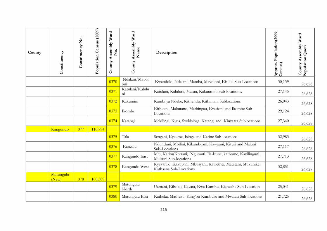
215
County
Co
nst
itu
en
cy
Co
nst
itu
en
cy N
o.
Po
pu
lati
on
Cen
sus
(2009)
Co
un
ty A
ssem
bly
Ward
No
.
Co
un
ty A
ssem
bly
Ward
Nam
e
Description
Ap
pro
x.
Po
pu
lati
on
(2009
Cen
sus)
Co
un
ty A
ssem
bly
Ward
Po
pu
lati
on
Qu
ota
0370 Ndalani/Mavoloni
Kwandolo, Ndalani, Mamba, Mavoloni, Kisiliki Sub-Locations 30,139
26,628
0371 Katulani/Kaluluni
Katulani, Kaluluni, Matuu, Kakuumini Sub-locations. 27,145
26,628
0372 Kakumini Kambi ya Ndeke, Kithendu, Kithimani Sublocations 26,043
26,628
0373 Ikombe Kitheuni, Makutano, Mathingau, Kyasioni and Ikombe Sub-Locations
29,124
26,628
0374 Katangi Mekilingi, Kyua, Syokisinga, Katangi and Kinyaata Sublocations 27,340
26,628
Kangundo 077 110,794
0375 Tala Sengani, Kyaume, Isinga and Katine Sub-locations 32,983
26,628
0376 Kanzalu Ndunduni, Mbilini, Kikambuani, Kawauni, Kitwii and Maiuni Sub-Locations
27,117
26,628
0377 Kangundo East Miu, Katitu(Kivaani), Ngumuti, Iia-Itune, kathome, Kavilinguni, Muisuni Sub-locations
27,713
26,628
0378 Kangundo West
Kyevaluki, Kakuyuni, Mbusyani, Kawethei, Matetani, Mukunike, Kathaana Sub-Locations
32,851 26,628
Matungulu (New) 078 108,309
0379 Matungulu North
Uamani, Kiboko, Kayata, Kwa Kumbu, Kianzabe Sub-Location 25,041
26,628
0380 Matungulu East Katheka, Matheini, King’oti Kambusu and Mwatati Sub-locations 21,725
26,628
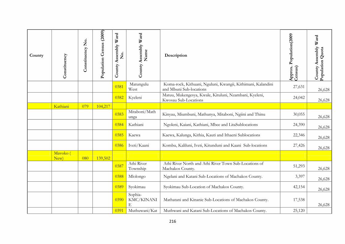
216
County
Co
nst
itu
en
cy
Co
nst
itu
en
cy N
o.
Po
pu
lati
on
Cen
sus
(2009)
Co
un
ty A
ssem
bly
Ward
No
.
Co
un
ty A
ssem
bly
Ward
Nam
e
Description
Ap
pro
x.
Po
pu
lati
on
(2009
Cen
sus)
Co
un
ty A
ssem
bly
Ward
Po
pu
lati
on
Qu
ota
0381
Matungulu West
Koma-rock, Kithuani, Nguluni, Kwangii, Kithimani, Kalandini and Mbuni Sub-locations
27,631 26,628
0382 Kyeleni Matuu, Mukengesya, Kwale, Kituluni, Nzambani, Kyeleni, Kwosau Sub-Locations
24,042
26,628
Kathiani 079 104,217
0383 Mitaboni/Mathunga
Kinyau, Miumbuni, Mathunya, Mitaboni, Ngiini and Thinu 30,055
26,628
0384 Kathiani Ngoleni, Kaiani, Kathiani, Mbee and LitaSublocations 24,390
26,628
0385 Kaewa Kaewa, Kalunga, Kithia, Kauti and Ithaeni Sublocations 22,346
26,628
0386 Iveti/Kaani Kombu, Kaliluni, Iveti, Kitunduni and Kaani Sub-locations 27,426
26,628
Mavoko ( New) 080 139,502
0387 Athi River Township
Athi River North and Athi River Town Sub-Locations of Machakos County.
51,293
26,628
0388 Mlolongo Ngelani and Katani Sub-Locations of Machakos County. 3,397
26,628
0389 Syokimau Syokimau Sub-Location of Machakos County. 42,154
26,628
0390
Sophia-KMC/KINANIE
Mathatani and Kinanie Sub-Locations of Machakos County. 17,538 26,628
0391 Muthuwani/Kat Muthwani and Katani Sub-Locations of Machakos County. 25,120

217
County
Co
nst
itu
en
cy
Co
nst
itu
en
cy N
o.
Po
pu
lati
on
Cen
sus
(2009)
Co
un
ty A
ssem
bly
Ward
No
.
Co
un
ty A
ssem
bly
Ward
Nam
e
Description
Ap
pro
x.
Po
pu
lati
on
(2009
Cen
sus)
Co
un
ty A
ssem
bly
Ward
Po
pu
lati
on
Qu
ota
ani 26,628
Machakos Town 081 199,211
0392 Kalama/Kyangal/Kimutua
Konza Sub-Location of Machakos Sub-Location of Machakos County.
1,451
26,628
0393 Katheka KIA/Eastleigh
Mikuyu, Katelembu, Kitanga, Katheka Kai Sub-Locations of Machakos County.
17,820
26,628
0394
Ngelani/Mutituni/Mua
Kyanda, Mua Hills, Kyaani, Kamuthanga, Nzoweni, Ngelani, Kivutini, Nduu, and Mutituni Sub-Locations of Machakos County
39,135 26,628
0395
Mumbuni South/Mjini
Upper Kiandani, Mjini, Eastleigh, and Misakwani Sub-Locations of Machakos County.
30,530 26,628
0396 Mumbuni North Kasinga, Mung’ala, and Lower Kiandani Sub-Locations of Machakos County.
28,319
26,628
0397
Muvuti/Kiima Kimwe
Muthini, Mwanyani, Katoloni, Kimwe, Kiima Mbilini, Muvuti, and Kivandini Sub-Locations of Machakos County.
32,413
26,628
0398
Kalama/Kyangali/Kimutua
Kimutwa, Kaathi, Kyanzasu, Kilitini, Nziuni, Kakayuni, Kyangala, and Kinoi Sub-Locations of Machakos County.
24,319 26,628
0399 Muumando/Kola
Muumandu, Liuni, and Katanga Sub-Locations of Machakos County.
24,585
26,628
Mwala 082 163,032
0400
Kathama/Mbiuni
Ulaani, Kwamutula, Etikoni, Kabaa, Nyaanyaa, Mumbuni, Makiliva, Mbiuni, Muthwani and Katitu Sub-locations
32,142
26,628
0401
Mwala/Makutano/Mango
Kangii, Ngulini, Kyawango, Myanyani, Maweli, Kibau, Kivandani, Kamwala, manthunthini, Kyamutwii, Kyanganga and Wetaa Sub-
32, 127 26,628
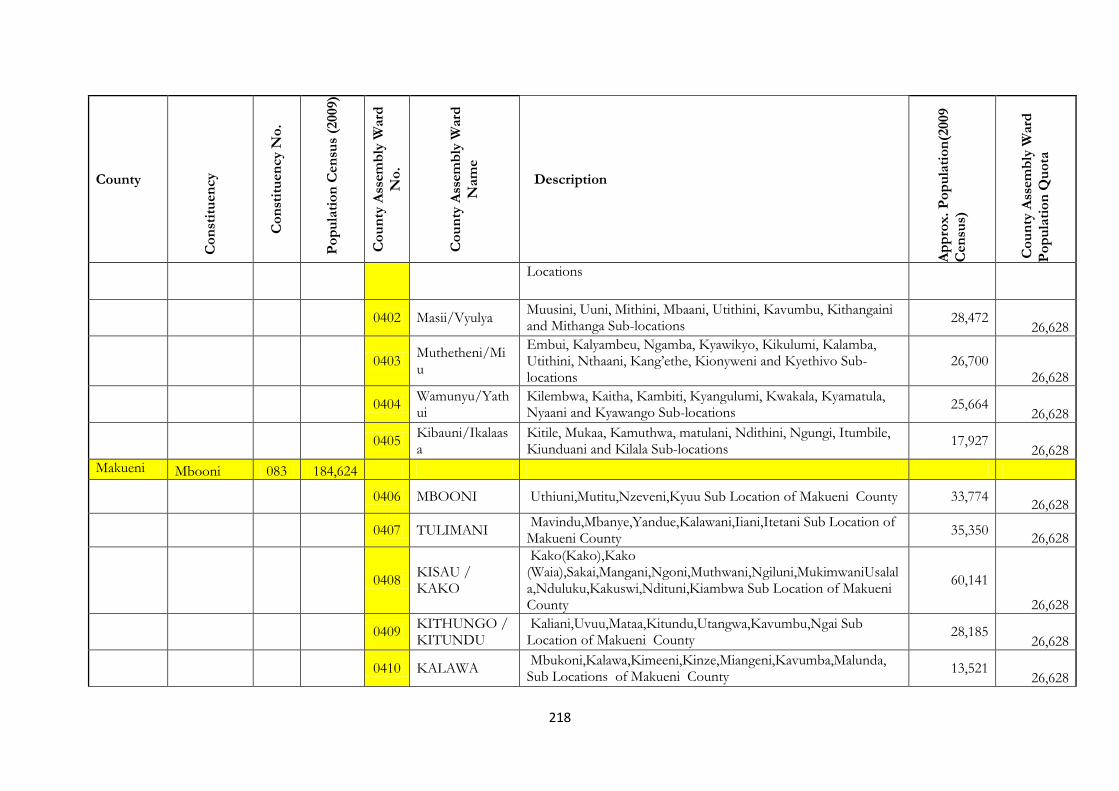
218
County
Co
nst
itu
en
cy
Co
nst
itu
en
cy N
o.
Po
pu
lati
on
Cen
sus
(2009)
Co
un
ty A
ssem
bly
Ward
No
.
Co
un
ty A
ssem
bly
Ward
Nam
e
Description
Ap
pro
x.
Po
pu
lati
on
(2009
Cen
sus)
Co
un
ty A
ssem
bly
Ward
Po
pu
lati
on
Qu
ota
Locations
0402 Masii/Vyulya
Muusini, Uuni, Mithini, Mbaani, Utithini, Kavumbu, Kithangaini and Mithanga Sub-locations
28,472
26,628
0403
Muthetheni/Miu
Embui, Kalyambeu, Ngamba, Kyawikyo, Kikulumi, Kalamba, Utithini, Nthaani, Kang’ethe, Kionyweni and Kyethivo Sub-locations
26,700 26,628
0404
Wamunyu/Yathui
Kilembwa, Kaitha, Kambiti, Kyangulumi, Kwakala, Kyamatula, Nyaani and Kyawango Sub-locations
25,664 26,628
0405
Kibauni/Ikalaasa
Kitile, Mukaa, Kamuthwa, matulani, Ndithini, Ngungi, Itumbile, Kiunduani and Kilala Sub-locations
17,927 26,628
Makueni Mbooni 083 184,624
0406 MBOONI Uthiuni,Mutitu,Nzeveni,Kyuu Sub Location of Makueni County 33,774
26,628
0407 TULIMANI Mavindu,Mbanye,Yandue,Kalawani,Iiani,Itetani Sub Location of Makueni County
35,350
26,628
0408 KISAU / KAKO
Kako(Kako),Kako (Waia),Sakai,Mangani,Ngoni,Muthwani,Ngiluni,MukimwaniUsalala,Nduluku,Kakuswi,Ndituni,Kiambwa Sub Location of Makueni County
60,141
26,628
0409
KITHUNGO / KITUNDU
Kaliani,Uvuu,Mataa,Kitundu,Utangwa,Kavumbu,Ngai Sub Location of Makueni County
28,185 26,628
0410 KALAWA
Mbukoni,Kalawa,Kimeeni,Kinze,Miangeni,Kavumba,Malunda, Sub Locations of Makueni County
13,521 26,628

219
County
Co
nst
itu
en
cy
Co
nst
itu
en
cy N
o.
Po
pu
lati
on
Cen
sus
(2009)
Co
un
ty A
ssem
bly
Ward
No
.
Co
un
ty A
ssem
bly
Ward
Nam
e
Description
Ap
pro
x.
Po
pu
lati
on
(2009
Cen
sus)
Co
un
ty A
ssem
bly
Ward
Po
pu
lati
on
Qu
ota
0411 KATANGINI
thwake,ndauni,ititu,kathongo,syotuvali,kathulumbi and kathongo sub location of Makueni County.
13,653 26,628
Kilome 084 87,864
0412 KASIKEU
Sultan Hamud,Muani,Kiou,Kwale,Wathini,Uvaleni,Kasikeu,Mumela Sub Locations of Makueni County
35,408 26,628
0413 MUKAA/KIMA KIU
Ngaamba,Kiima-Kiu,Mavivye,Kalanzoni Sub Locations of Makueni County
25,941
26,628
0414 MUKAA/KITAINGO
Kilome,Maini,Kiongwani,Kitaingo Sub Locations of Makueni County
26,525
26,628
Kaiti 085 120,116
0415 UKIA/IUANI
Nthangu,Kaumoni,Kilala,Iuani,Utaati,Kyuasini,Nzuuni , Mukuyuni Sub Locations of Makueni County
38,490 26,628
0416 KILUNGU Kyamuoso,Ndolo,Waulu, Musalala Sub Locations of Makueni County
26,649
26,628
0417 KITHEMBE / KIKOKO
Kalongo,Kithangathini,Kisekini,Nduu, 33,952
26,628
0418
WATEMA /KEE/KIVANI
Makongo ,Kivani,Ikalyoni,Kyamwalye,Kitindi,Ngluni,Kasunguni,Mutalani, Sub Locations of Makueni County
21,025 26,628
Makueni 086 158,610
0419 KITISE Mwania,Kitise,Kithuki,Yinthungu,Kimundi , Sub Locations of Makueni County
22,054
26,628

220
County
Co
nst
itu
en
cy
Co
nst
itu
en
cy N
o.
Po
pu
lati
on
Cen
sus
(2009)
Co
un
ty A
ssem
bly
Ward
No
.
Co
un
ty A
ssem
bly
Ward
Nam
e
Description
Ap
pro
x.
Po
pu
lati
on
(2009
Cen
sus)
Co
un
ty A
ssem
bly
Ward
Po
pu
lati
on
Qu
ota
0420
KATHONZWENI
Kiangini ,Kituluni,Kwa Kavisi,Ituka,Thavu,Kavingoni , Sub Locations of Makueni County
31,277 26,628
0421 MAVINDINI
Yekanga,Kanthuni,Ivinganzia,Mavindini,Muusini , Sub Locations of Makueni County
24,456
26,628
0422 KIKUMINI Kambi Mawe Kikumini(Wote) , Sub Locations of Makueni County
8,442
26,628
0423 MAKUENI Unoa,Nziu,Kamunyolo , Sub Locations of Makueni County 25,326
26,628
0424 MUVAU Muvau,Kitinyoni,Itaa,Mumbunu , Sub Locations of Makueni County
16,035
26,628
Kibwezi West (New) 087 147,397
0425 MTITO ANDEI EAST
Mtito Andei,Mang’elete , Sub Locations of Makueni County 31,692
26,628
0426 KAMBU Kathekani,Kitengei,Kambu , Sub Locations of Makueni County 22,212
26,628
0427 MTITO ANDEI WEST
Muthingiini,Utithi,Thange , Sub Locations of Makueni County 35,220
26,628
0428
MASONGALENI / NGWATA
Mukaange,Ulilinzi,Kyanguli,Masongaleni,Masimbani,Kinyambu Sub Locations of Makueni County
42,216
26,628
0429
KIKUMBULYU
Ngandani,Kathyaka,MikuyuniKalungu,Mbui Nzau,Ndetani,Ngulu Sub Locations of Makueni County
46,206 26,628
Kibwezi East 088 145,475
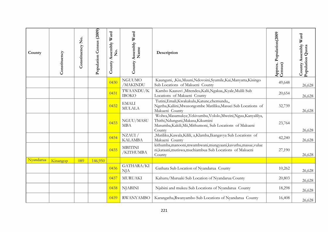
221
County
Co
nst
itu
en
cy
Co
nst
itu
en
cy N
o.
Po
pu
lati
on
Cen
sus
(2009)
Co
un
ty A
ssem
bly
Ward
No
.
Co
un
ty A
ssem
bly
Ward
Nam
e
Description
Ap
pro
x.
Po
pu
lati
on
(2009
Cen
sus)
Co
un
ty A
ssem
bly
Ward
Po
pu
lati
on
Qu
ota
0430
NGUUMO /MAKINDU
Kaunguni, ,Kiu,Muuni,Ndovoini,Syumile,Kai,Manyatta,Kisingo Sub Locations of Makueni County
49,648 26,628
0431
TWAANDU/KIBOKO
Kambo Kaasuvi ,Mitendeu,Kalii,Ngakaa,,Kyale,Mulili Sub Locations of Makueni County
20,654
26,628
0432
EMALI MULALA
Tutini,Emali,Kwakakulu,Katune,chemundu,, Ngetha,Kaliini,Mwasongombe Matiliku,Masuei Sub Locations of Makueni County
32,739 26,628
0433 NGUU/MASUMBA
Wolwa,Masamukye,Yekivumbu,Vololo,Mweini,Nguu,Kanyalilya, Thithi,Ndunguni,Makasa,Kikumini Masumba,Kakili,Mii,Mithumoni, Sub Locations of Makueni County
23,764
26,628
0434 NZAUI / KALAMBA
,Matiliku,Kawala,Kilili, a,Klamba,Ikangavya Sub Locations of Makueni County
42,240
26,628
0435
MBITINI /KITHUMBA
kithumba,manooni,mwambwani,mungyaani,kavuthu,masue,vulueni,kataani,mutiswa,muchiambua Sub Locations of Makueni County
27,190 26,628
Nyandarua Kinangop 089 146,950
0436 GATHARA/KINJA
Gathara Sub Location of Nyandarua County 10,262
26,628
0437 MURUAKI Kahuru/Muruaki Sub Location of Nyandarua County 20,803
26,628
0438 NJABINI Njabini and mukeu Sub Locations of Nyandarua County 18,298
26,628
0439 RWANYAMBO Karangatha,Rwanyambo Sub Locations of Nyandarua County 16,408
26,628

222
County
Co
nst
itu
en
cy
Co
nst
itu
en
cy N
o.
Po
pu
lati
on
Cen
sus
(2009)
Co
un
ty A
ssem
bly
Ward
No
.
Co
un
ty A
ssem
bly
Ward
Nam
e
Description
Ap
pro
x.
Po
pu
lati
on
(2009
Cen
sus)
Co
un
ty A
ssem
bly
Ward
Po
pu
lati
on
Qu
ota
0440 KARATI Karati,Matura, Sub Location of Nyandarua County 15,499
26,628
0441 MAGUMU Bamboo,Gitwe Sub Location of Nyandarua County 17,422
26,628
0442 JABINI / KIBURU
Kiburu and Tulanga Sub Location of Nyandarua County 18,979
26,628
0443 GITHABAI Githabai Sub Location of Nyandarua County 22,221
26,628
Kipipiri 090 140,767
0444 WANJOI Wanjoi,Gatondo,Rironi,Ndemi Sub Location of Nyandarua County
32,051
26,628
0445 KIPIPIRI Githioro,Mkungi,Miharati Makumbi Sub Location of Nyandarua County
39,616
26,628
0446 NANDARASI
North Kinangop, Mikeu ,Kiambogo,Geta,Makumbi Kinja Makumbi Sub Location of Nyandarua County
36,307 26,628
0447 LERESHWA / MURUNGARU
Murungaru,Kiriko,Lereshwa Makumbi Sub Location of Nyandarua County
27,040
26,628
Ol Kalou 091 98,316
0448 MATINDIRI Passega,Matura(Rurii) Sub Location of Nyandarua i County 23,952
26,628
0449 OLKALOU Munyeki,Mawingo Sub Location of Nyandarua County 25,514
26,628
0450 KANDUTURA Kandutura Sub Location of Nyandarua County 6,692
26,628
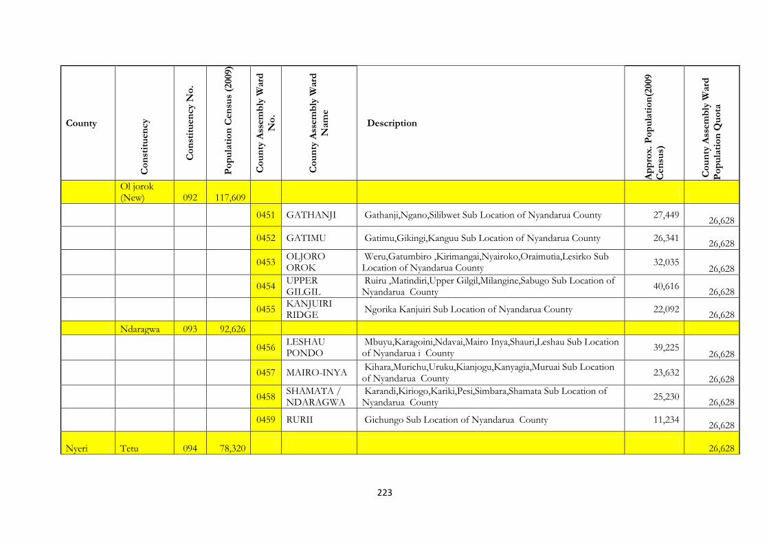
223
County
Co
nst
itu
en
cy
Co
nst
itu
en
cy N
o.
Po
pu
lati
on
Cen
sus
(2009)
Co
un
ty A
ssem
bly
Ward
No
.
Co
un
ty A
ssem
bly
Ward
Nam
e
Description
Ap
pro
x.
Po
pu
lati
on
(2009
Cen
sus)
Co
un
ty A
ssem
bly
Ward
Po
pu
lati
on
Qu
ota
Ol jorok (New) 092 117,609
0451 GATHANJI Gathanji,Ngano,Silibwet Sub Location of Nyandarua County 27,449
26,628
0452 GATIMU Gatimu,Gikingi,Kanguu Sub Location of Nyandarua County 26,341
26,628
0453
OLJORO OROK
Weru,Gatumbiro ,Kirimangai,Nyairoko,Oraimutia,Lesirko Sub Location of Nyandarua County
32,035 26,628
0454 UPPER GILGIL
Ruiru ,Matindiri,Upper Gilgil,Milangine,Sabugo Sub Location of Nyandarua County
40,616
26,628
0455 KANJUIRI RIDGE
Ngorika Kanjuiri Sub Location of Nyandarua County 22,092
26,628
Ndaragwa 093 92,626
0456
LESHAU PONDO
Mbuyu,Karagoini,Ndavai,Mairo Inya,Shauri,Leshau Sub Location of Nyandarua i County
39,225 26,628
0457 MAIRO-INYA
Kihara,Murichu,Uruku,Kianjogu,Kanyagia,Muruai Sub Location of Nyandarua County
23,632 26,628
0458 SHAMATA / NDARAGWA
Karandi,Kiriogo,Kariki,Pesi,Simbara,Shamata Sub Location of Nyandarua County
25,230
26,628
0459 RURII Gichungo Sub Location of Nyandarua County 11,234
26,628
Nyeri Tetu 094 78,320
26,628

224
County
Co
nst
itu
en
cy
Co
nst
itu
en
cy N
o.
Po
pu
lati
on
Cen
sus
(2009)
Co
un
ty A
ssem
bly
Ward
No
.
Co
un
ty A
ssem
bly
Ward
Nam
e
Description
Ap
pro
x.
Po
pu
lati
on
(2009
Cen
sus)
Co
un
ty A
ssem
bly
Ward
Po
pu
lati
on
Qu
ota
0460 MUHOYA
Kiruruni,Ngooru,Karunaini,Kanjora, Thatha,Ihururu,Ichagachiru,Kigogo-ini,Gatumbiro,Karaihu Sub Locations Nyeri County.
20,511 26,628
0461 KARUNDU
Hubuini,Gathuthi,Ihithe/Tuona,KiamutigaNdugamano,Karangi,Karigu-ini,Mbaa-ini,Kaigu-ini,Kianjogu,Mathakwa,KihoraUnjiru,KaiguriKikwandi Sub locations Nyeri county
31,003
26,628
0462 GAAKI
Kangaila,Kiawathanji,Mutathi-ini,Gichira,Mung’aria,Gititu,Huhoini,Thage-ini,Ithekahuno sub locations Nyeri County
20,511 26,628
Kieni 095 175,812
26,628
0463 MUHOYA
Kiruruni,Ngooru,Karunaini,Kanjora, Thatha,Ihururu,Ichagachiru,Kigogo-ini,Gatumbiro,Karaihu Sub Locations Nyeri County.
20,511 26,628
0464 KARUNDU
Hubuini,Gathuthi,Ihithe/Tuona,KiamutigaNdugamano,Karangi,Karigu-ini,Mbaa-ini,Kaigu-ini,Kianjogu,Mathakwa,KihoraUnjiru,KaiguriKikwandi Sub locations Nyeri county
31,003
26,628
0465
NARUMORU/KIAMATHAGA
Murichu,Tigithi,Kabendera,Narumoru,Ndiriti,Kamburaini,sub location of Nyeri county
26,291 26,628
0466 MWIYOGO Kabati,Mwiyogo,Muthuini,Labura sub Location of Nyeri County 11,730
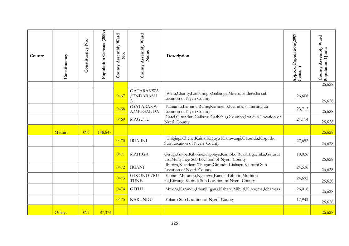
225
County
Co
nst
itu
en
cy
Co
nst
itu
en
cy N
o.
Po
pu
lati
on
Cen
sus
(2009)
Co
un
ty A
ssem
bly
Ward
No
.
Co
un
ty A
ssem
bly
Ward
Nam
e
Description
Ap
pro
x.
Po
pu
lati
on
(2009
Cen
sus)
Co
un
ty A
ssem
bly
Ward
Po
pu
lati
on
Qu
ota
26,628
0467
GATARAKWA/ENDARASHA
,Watu,Charity,Embaringo,Gakanga,Mitero,Enderesha sub Location of Nyeri County
26,606 26,628
0468
?GATARAKWA/MUGANDA
Kamariki,Lamuria,Ruirie,Karimeno,Nairutia,Kamiruri,Sub Location of Nyeri County
23,712
26,628
0469 MAGUTU
Gatei,Gitunduti,Gaikuyu,Gathehu,Gikumbo,Itat Sub Location of Nyeri County
24,114
26,628
Mathira 096 148,847
26,628
0470 IRIA-INI
Thigingi,Chehe,Kairia,Kaguyu Kiamwangi,Gatundu,Kiaguthu Sub Location of Nyeri County
27,652 26,628
0471 MAHIGA
Girugi,Gikoe,Kihome,Kagonye,Kamoko,Rukia,Ugachika,Gaturuturu,Munyange Sub Location of Nyeri County
18,026 26,628
0472 IRIANI
Ihuriro,Kiandemi,Thuguri,Gitundu,Kiahagu,Kairuthi Sub Location of Nyeri County
24,536
26,628
0473
GIKONDI/RUTUNE
Kariara,Mutundu,Ngamwa,Karaba Kibutio,Muthithi-ini,Kiirungi,Karindi Sub Location of Nyeri County
24,692
26,628
0474 GITHI Mweru,Karundu,Ithanji,Igana,Kaharo,Mihuti,Kirerema,Ichamara 26,018
26,628
0475 KARUNDU Kiharo Sub Location of Nyeri County 17,943
26,628
Othaya 097 87,374
26,628
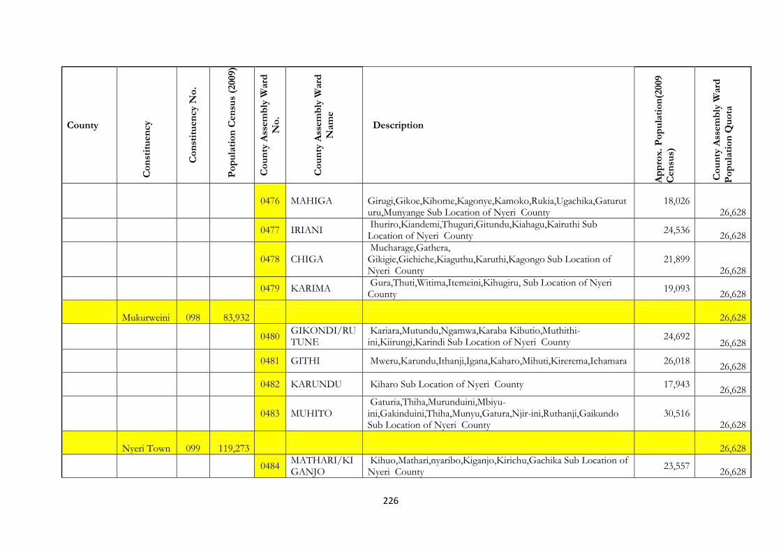
226
County
Co
nst
itu
en
cy
Co
nst
itu
en
cy N
o.
Po
pu
lati
on
Cen
sus
(2009)
Co
un
ty A
ssem
bly
Ward
No
.
Co
un
ty A
ssem
bly
Ward
Nam
e
Description
Ap
pro
x.
Po
pu
lati
on
(2009
Cen
sus)
Co
un
ty A
ssem
bly
Ward
Po
pu
lati
on
Qu
ota
0476 MAHIGA
Girugi,Gikoe,Kihome,Kagonye,Kamoko,Rukia,Ugachika,Gaturuturu,Munyange Sub Location of Nyeri County
18,026 26,628
0477 IRIANI
Ihuriro,Kiandemi,Thuguri,Gitundu,Kiahagu,Kairuthi Sub Location of Nyeri County
24,536
26,628
0478 CHIGA
Mucharage,Gathera, Gikigie,Gichiche,Kiaguthu,Karuthi,Kagongo Sub Location of Nyeri County
21,899 26,628
0479 KARIMA
Gura,Thuti,Witima,Itemeini,Kihugiru, Sub Location of Nyeri County
19,093
26,628
Mukurweini 098 83,932
26,628
0480
GIKONDI/RUTUNE
Kariara,Mutundu,Ngamwa,Karaba Kibutio,Muthithi-ini,Kiirungi,Karindi Sub Location of Nyeri County
24,692 26,628
0481 GITHI Mweru,Karundu,Ithanji,Igana,Kaharo,Mihuti,Kirerema,Ichamara 26,018
26,628
0482 KARUNDU Kiharo Sub Location of Nyeri County 17,943
26,628
0483 MUHITO
Gaturia,Thiha,Murunduini,Mbiyu-ini,Gakinduini,Thiha,Munyu,Gatura,Njir-ini,Ruthanji,Gaikundo Sub Location of Nyeri County
30,516 26,628
Nyeri Town 099 119,273
26,628
0484
MATHARI/KIGANJO
Kihuo,Mathari,nyaribo,Kiganjo,Kirichu,Gachika Sub Location of Nyeri County
23,557
26,628

227
County
Co
nst
itu
en
cy
Co
nst
itu
en
cy N
o.
Po
pu
lati
on
Cen
sus
(2009)
Co
un
ty A
ssem
bly
Ward
No
.
Co
un
ty A
ssem
bly
Ward
Nam
e
Description
Ap
pro
x.
Po
pu
lati
on
(2009
Cen
sus)
Co
un
ty A
ssem
bly
Ward
Po
pu
lati
on
Qu
ota
0485 MAJENGO Majengo Sub Location of Nyeri County 25,018
26,628
0486
GATITU/MURUGURU
Thunguma,Riamukure,Gatitu,Githiru,Muruguru,Marua Sub Location of Nyeri County
21,804
26,628
0487 RURING’U Ruring’u,Chorongi,Karia Sub Location of Nyeri County 22,160
26,628
0488 KAMAKWA
Muthuaini,Munungaini,Gitathani,Kamakwa,Kinunga,Kihatha Sub Location of Nyeri County
26,419 26,628
Kirinyaga Mwea 100 190,512
26,628
0489 Wamumu Wamumu Sublocation of Kirinyaga County. 17,881
26,628
0490 Thiba Thiba and Nguka Sublocation of Kirinyaga County. 23,219
26,628
0491 Kangai
Kambuini, Kathiga, Mathingaini and Kithiriti Sublocations of Kirinyaga County.
25,509
26,628
0492 Nyangati
Kangu, Kamigua (part), Kirimara, Nyangati and Riagicheru Sublocations of Kirinyaga County.
27,439
26,628
0493 Kangai
Kambuini, Kathiga, Mathingaini and Kithiriti Sublocations of Kirinyaga County.
25,509
26,628
0494 Nyangati
Kangu, Kamigua (part), Kirimara, Nyangati and Riagicheru Sublocations of Kirinyaga County.
27,439 26,628
0495 Mahiga-ini Mahiga-ini and Gathigiriri Sublocations of Kirinyaga County. 13,271
26,628

228
County
Co
nst
itu
en
cy
Co
nst
itu
en
cy N
o.
Po
pu
lati
on
Cen
sus
(2009)
Co
un
ty A
ssem
bly
Ward
No
.
Co
un
ty A
ssem
bly
Ward
Nam
e
Description
Ap
pro
x.
Po
pu
lati
on
(2009
Cen
sus)
Co
un
ty A
ssem
bly
Ward
Po
pu
lati
on
Qu
ota
0496 Kiarukungu Kiarukungu Sublocation of Kirinyaga County. 31,645
26,628
Gichugu 101 124,672
26,628
0497 Baragwi
Mikarara, Rukenya, Ruambiti, Gatu, Raimi and Thimu Sublocations of Kirinyaga County.
28,355 26,628
0498 Kabara
Mutige, Gachigi, Njuku, Ngiroche and Kiritini Sublocations of Kirinyaga County.
30,161
26,628
0499 Karumandi
Thumaita, Kiaruri, Guama and Kariru Sublocations of Kirinyaga County.
23,902
26,628
0500 Ngariama
Thirikwa, Nyangeni, Rung’eto and Kabari (Ngariama) Sublocations of Kirinyaga County.
18,064 26,628
0501 Njukiini
Kanjuu, Ngerwe, Mirichi and Ngirambu Sublocations of Kirinyaga County
24,190
26,628
Ndia 102 99,515
26,628
0502 Mkure
Mukure, Kagio-ini, Kanyokora and Gitaku Sublocations of Kirinyaga County.
26,119
26,628
0503 Kiinec
Kiangai, Ruiru, Nguguini, Kibingoti, Kianjang’a and Maitharui Sublocations of Kirinyaga County.
31,454
26,628
0504 Sagana
Nyangio, Mukui, Thigirichi, Gacharu and Sagana Sublocations of Kirinyaga County.
27,943
26,628
0505 Muthithi
Kithumbu, Kinyaga, Kabiriri, Rukanga and Kiandegwa Sublocations of Kirinyaga County.
38,393 26,628

229
County
Co
nst
itu
en
cy
Co
nst
itu
en
cy N
o.
Po
pu
lati
on
Cen
sus
(2009)
Co
un
ty A
ssem
bly
Ward
No
.
Co
un
ty A
ssem
bly
Ward
Nam
e
Description
Ap
pro
x.
Po
pu
lati
on
(2009
Cen
sus)
Co
un
ty A
ssem
bly
Ward
Po
pu
lati
on
Qu
ota
Kirinyaga Central 103 113,355
26,628
0506 Inoi
Ndimi, Kariko, Thaita, and Mbeti Sublocations of Kirinyaga County.
17,387
26,628
0507 Mutira
Kabar(Mutira), Kaguvu, Kagumo, and Kirunda Sublocations of Kirinyaga County.
23,359
26,628
0508 Kanyekine
Ndimi,Nduini, Kanyei, Ngaru, Kianjege Kathare and Kiaga Sublocations of Kirinyaga County.
32,333 26,628
0509 Kerugoya
Kaguyu(Kerugoya), Kimandi, Kaitheri, and Karia Sublocations of Kirinyaga County.
30,336
26,628
Murang’a Kangema 104 112,580
26,628
0510
Kanyenya-ini/Kiruri
Comprise of Wanjerere, Tuthu, Kihoya, Kiambogo, Kanyenyaini, Githiga, Gitugu and Rwathia SubLocations
30,861 26,628
0511 Muguru/Iyego
Comprise of Kiarathe, Gakira, kanorero, Watuha, Gikui, Githunguri, Gacharaigu and Nyakahura SubLocations
34,524 26,628
0512
Muraranda/Gathaithi
Comprise of Gatuya, Kaganda, Gathaithi, Theri, Murarandia, Ichichi, Kiruri and Karurumo SubLocations
35,320 26,628
26,628
Mathioya 105 108,074
26,628
0513 Kiru
Kairo, Kiambuthia, Kanjama, Kiriaini, Kanjama, Kagumoini, Kora and Gitugi Sub-locations
30,383 26,628

230
County
Co
nst
itu
en
cy
Co
nst
itu
en
cy N
o.
Po
pu
lati
on
Cen
sus
(2009)
Co
un
ty A
ssem
bly
Ward
No
.
Co
un
ty A
ssem
bly
Ward
Nam
e
Description
Ap
pro
x.
Po
pu
lati
on
(2009
Cen
sus)
Co
un
ty A
ssem
bly
Ward
Po
pu
lati
on
Qu
ota
0514 Kamacharia
Runyeki, Kambara, Gakuyu, Geitwa/Mugeka, Gathuku-ini, Thuita, Kairi, Kamune and Kamacharia Sub-locations
46,142 26,628
0515 Njumbi
Chui, Ngutu, Karung’e, Mihuti, Nyakianga, Gikoe, Gatunguru, Kagongo, Gacharageini and Kiamuturi Sub-locations
31,507
26,628
Kiharu 106 125,707
26,628
0516 Wangu Kahuti, Wangu, Kirogo and Wanjengi Sub-Locations 20,509
26,628
0517 Gatundu Kahuro, Gatundu and Gatheru Sub-locations 17,511
26,628
0518 Mugoiri Comprise of Kiria and Mirichu Sublocations 16,949
26,628
0519 Mbiri Muchungucha, Gikandu and Mukangu Sub-locations 17,252
26,628
0520 Township Comprise Njogu-ini, Karuri, Mukuyu and Maragi sub-locations 31,452
26,628
0521 Rurii Kigongo, Rurii and Nyakihai Sub-locations 13,533
26,628
0522 Gikindi Githuri, Minira, Kambirwa Sublocations 15,072
26,628
Kigumo 107 123,766
26,628
0523 Kahumbu
Kandani, Gakuyu, Mugomoini, Githembe, Kahariro and Githima Sub-locations
29,830
26,628
0524 Muthithi Kagurumo, Gikarangu, Munguini, Kiahiti, Muthithi and Kirere 30,515
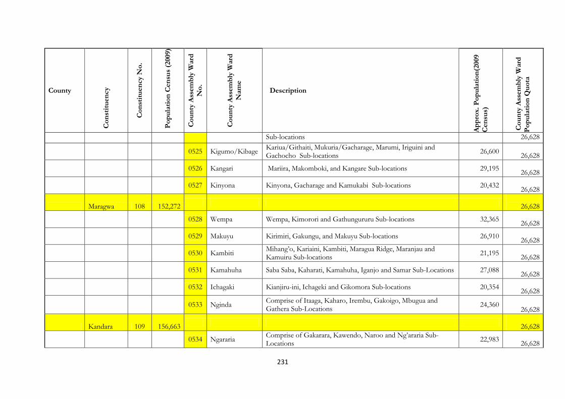
231
County
Co
nst
itu
en
cy
Co
nst
itu
en
cy N
o.
Po
pu
lati
on
Cen
sus
(2009)
Co
un
ty A
ssem
bly
Ward
No
.
Co
un
ty A
ssem
bly
Ward
Nam
e
Description
Ap
pro
x.
Po
pu
lati
on
(2009
Cen
sus)
Co
un
ty A
ssem
bly
Ward
Po
pu
lati
on
Qu
ota
Sub-locations 26,628
0525 Kigumo/Kibage
Kariua/Githaiti, Mukuria/Gacharage, Marumi, Iriguini and Gachocho Sub-locations
26,600
26,628
0526 Kangari Mariira, Makomboki, and Kangare Sub-locations 29,195
26,628
0527 Kinyona Kinyona, Gacharage and Kamukabi Sub-locations 20,432
26,628
Maragwa 108 152,272
26,628
0528 Wempa Wempa, Kimorori and Gathungururu Sub-locations 32,365
26,628
0529 Makuyu Kirimiri, Gakungu, and Makuyu Sub-locations 26,910
26,628
0530 Kambiti
Mihang’o, Kariaini, Kambiti, Maragua Ridge, Maranjau and Kamuiru Sub-locations
21,195
26,628
0531 Kamahuha Saba Saba, Kaharati, Kamahuha, Iganjo and Samar Sub-Locations 27,088
26,628
0532 Ichagaki Kianjiru-ini, Ichageki and Gikomora Sub-locations 20,354
26,628
0533 Nginda
Comprise of Itaaga, Kaharo, Irembu, Gakoigo, Mbugua and Gathera Sub-Locations
24,360 26,628
Kandara 109 156,663
26,628
0534 Ngararia
Comprise of Gakarara, Kawendo, Naroo and Ng’araria Sub-Locations
22,983
26,628

232
County
Co
nst
itu
en
cy
Co
nst
itu
en
cy N
o.
Po
pu
lati
on
Cen
sus
(2009)
Co
un
ty A
ssem
bly
Ward
No
.
Co
un
ty A
ssem
bly
Ward
Nam
e
Description
Ap
pro
x.
Po
pu
lati
on
(2009
Cen
sus)
Co
un
ty A
ssem
bly
Ward
Po
pu
lati
on
Qu
ota
0535 Muruka
Comprise of Kiranga/Muruka, Nguthuru and Gatitu Sublocations
23,535
26,628
0536 Kagundu-ini
Comprise Kariti, Kagunduini, Githunguri, Kabati and Gitura Sub-Locations
28,847
26,628
0537 Gaichanjiru
Kagumoini, Mariaini, Ngurweini, Gaichanjiru and Kagira Sub-Locations
22,171
26,628
0538 Ithiru Kiiri, Karimamwaro/Gakui, Githuya and Kaguthi Sub-Locations 22,204
26,628
0539 Ruchu
Comprise of Mung’aria/Mukangu, Githumu/Gichagi-ini and Gituru Sublocations
20,927
26,628
Gatanga 110 163,597
26,628
0540 Ithanga Ngelelia, Kaguku and Kiathanini Sub-locations 65,382
26,628
0541 Kakuzi Gituamba(kakuzi), Kinyangi, Nanga and Thuthua sublocations 31,144
26,628
0542 Mugumo-ini
Mwitingiri, Gathambara, Kigio, Ithangarari and Mugumoini Sub-location
17,582
26,628
0543 Kihumbu-ini
Mukurwe/thuita, Mukarara, Kihumbuini and Kiunyu/Gituamba Sub-locations
10,377
26,628
0544 Gatanga
Comprise of Gatura, Kiriaini, Chomo, Kirwara and Gatanga Sublocations
19,638
26,628
0545 Kariara
Kiarutara, Mbugiti, Ndakaini, Kigoro, Gitiri and Ndunyu Chege Sub-Locations
19,474
26,628
Kiambu Gatundu 111 114,180

233
County
Co
nst
itu
en
cy
Co
nst
itu
en
cy N
o.
Po
pu
lati
on
Cen
sus
(2009)
Co
un
ty A
ssem
bly
Ward
No
.
Co
un
ty A
ssem
bly
Ward
Nam
e
Description
Ap
pro
x.
Po
pu
lati
on
(2009
Cen
sus)
Co
un
ty A
ssem
bly
Ward
Po
pu
lati
on
Qu
ota
South 26,628
0546 Kiamwangi
Kiamwangi, Kigongo, Nembu,Gathage and Kahunguini Sublocations of Kiambu County.
26,170
26,628
0547 Kiganjo
Mundoro, Gachika, Ndundu, Handege,Kiganjo, Gatitu and Kiamworia Sublocations of Kiambu County.
30,631 26,628
0548 Ndarugo
Kirangi, Munyu-ini, Gacharage, Karatu, Gitwe, Karinga and Ritho Sublocations of Kiambu County.
25,282 26,628
0549 Ngenda
Ituru, Wamwangi, Kirangari, Kimunyu and Githunguchu Sublocations of Kiambu County.
32,097 26,628
Gatundu North 112 100,611
26,628
0550 Gituamba
Mataara, Gitumbua Kiriko, Ngorongo and Kanyoni Sublocations of Kiambu County.
22,463 26,628
0551 Gathaithi
Kieni, Gakoe, Kamunyaka, Njahi Mwimuto, Gathaithe and Gatei Sublocations of Kiambu County.
18,890 26,628
0552 Kamwangi
Kamwangi, Nguna, Kairi, Karuri, and Muirigo sublocations of Kiambu County.
20,490
26,628
0553 Mang’u
Nyamangara, Miteero, Mukurwe, Mangu, Gatukuyu and Makwa Sublocations of Kiambu County.
26,785
26,628
Juja 113 169,655
26,628
0554 Gitothua Ruiru Sublocation of Kiambu County. 41,596
26,628
0555 Murera Mugutha Sublocation of Kiambu County. 15,886

234
County
Co
nst
itu
en
cy
Co
nst
itu
en
cy N
o.
Po
pu
lati
on
Cen
sus
(2009)
Co
un
ty A
ssem
bly
Ward
No
.
Co
un
ty A
ssem
bly
Ward
Nam
e
Description
Ap
pro
x.
Po
pu
lati
on
(2009
Cen
sus)
Co
un
ty A
ssem
bly
Ward
Po
pu
lati
on
Qu
ota
26,628
0556 Theta Theta Sublocation of Kiambu County. 23,134
26,628
0557 Juja Kiaora Sublocation of Kiambu County. 21,896
26,628
0558 Witeithie Komo and Witeithie Sublocations of Kiambu County. 25,777
26,628
0559 Kalimoni Kalimoni Sublocation of Kiambu County. 19,861
26,628
Thika Town (New) 114 136,579
26,628
0560 Township Kariminu and Biashara Sublocations of Kiambu County. 29,442
26,628
0561 Kamenu Komu sublocation of Kiambu County. 36,672
26,628
0562 Hospital Majengo Sublocation of Kiambu County. 17,194
26,628
0563 Gatuanyaga Munyu and Gatuanyaga Sublocations of Kiambu County. 11,614
26,628
0564 Ngoliba Ngoliba Sublocation of Kiambu County. 11,636
26,628
Ruiru (New) 115 179,887
26,628
0565 Biashara Viwanda/Biashara Sublocation of Kiambu County. 37,580
26,628

235
County
Co
nst
itu
en
cy
Co
nst
itu
en
cy N
o.
Po
pu
lati
on
Cen
sus
(2009)
Co
un
ty A
ssem
bly
Ward
No
.
Co
un
ty A
ssem
bly
Ward
Nam
e
Description
Ap
pro
x.
Po
pu
lati
on
(2009
Cen
sus)
Co
un
ty A
ssem
bly
Ward
Po
pu
lati
on
Qu
ota
0566 Gatongora Gatongora Sublocation of Kiambu County. 13,807
26,628
0567 Kahawa/Sukari Kahawa Sukari Sublocation of Kiambu County. 8,744
26,628
0568
Kahawa Wendani
Kahawa Wendani Sublocation of Kiambu County 16,711
26,628
0569 Kiuu Kiuu sublocation of Kiambu County 46,351
26,628
0570 Mwiki Mwiki sublocation of Kiambu County 44,760
26,628
0571 Mwihoko Mwihoko sublocation of Kiambu County 11,934
26,628
Githunguri 116 147,763
26,628
0572 Githunguri Gathangari and Githunguri Sublocations of Kiambu County. 24,352
26,628
0573 Githiga Gitiha, Githiga, and Matuguta Sublocations of Kiambu County. 17,785
26,628
0574 Ikinu
Ikinu, Kiaibabu, Ngemwa, Rioki, and Giathieko Sublocations of Kiambu County.
28,110
26,628
0575
Kimothai/Ngemwa Ward
Kaujai, Kiambururu, Kiruathi, Nyaga and Mbari ya Igi Sublocations of Kiambu County.
26,823
26,628
0576 Karatina
Gathugu, Karatina, Kibichoi and Thuita Sublocations of Kiambu County.
26,777
26,628
Kiambu 117 116,465

236
County
Co
nst
itu
en
cy
Co
nst
itu
en
cy N
o.
Po
pu
lati
on
Cen
sus
(2009)
Co
un
ty A
ssem
bly
Ward
No
.
Co
un
ty A
ssem
bly
Ward
Nam
e
Description
Ap
pro
x.
Po
pu
lati
on
(2009
Cen
sus)
Co
un
ty A
ssem
bly
Ward
Po
pu
lati
on
Qu
ota
(New) 26,628
0577 Ting’ang’a
Ting’ang’a, Kagongo, Anmer, Kamiti and Riabai Sublocations of Kiambu County.
34,086
26,628
0578 Ndumberi
Ndumberi, Kihingo and Karunga Sublocations of Kiambu County.
35,048
26,628
0579 Township Kiambu Sublocation of Kiambu County. 7,893
26,628
0580 Technology Kiamumbi and Thindigua Sublocations of Kiambu County. 19,346
26,628
Kiambaa 118 137,286
26,628
0581 Cianda
Cianda, Kawaida, Kanunga and Ngegu Sublocations of Kiambu County.
28,984
26,628
0582 Karuri
Njiku, Kiambaa, Karuri and Gathanga Sublocations of Kiambu County.
44,100
26,628
0583 Ndenderu
Karura, Ndenderu, Wangunyu, Mahindi Sublocations of Kiambu County.
22,365
26,628
0584 Ruaka Muchatha, Njoro and Ruaka Sublocations of Kiambu County. 31,502
26,628
0585 Gachie , Kihara and gachie Sublocations of Kiambu County. 36,877
26,628
Kabete 119 116,132
26,628
0586 Gitaru Gitaru, Kanyariri, and Chura sublocations of Kiambu County. 29,177
26,628

237
County
Co
nst
itu
en
cy
Co
nst
itu
en
cy N
o.
Po
pu
lati
on
Cen
sus
(2009)
Co
un
ty A
ssem
bly
Ward
No
.
Co
un
ty A
ssem
bly
Ward
Nam
e
Description
Ap
pro
x.
Po
pu
lati
on
(2009
Cen
sus)
Co
un
ty A
ssem
bly
Ward
Po
pu
lati
on
Qu
ota
0587 Muguga Muguga, Kahuho and Ruku Sublocations of Kiambu County. 27,527
26,628
0588 Nyadhuna
Nyadhuna, Karangari, Karura and Gathiga Sublocations of Kiambu County.
28,771
26,628
0589 Kabete Lower Kabete and Kibichiku Sublocations of Kiambu County. 30,657
26,628
Kikuyu (New) 120 149,697
26,628
0590 Karai Karai, Gikambura and Gitiba Sublocations of Kiambu County. 20,420
26,628
0591 Nachu
Nachu, Renguti, Kari aaand Lusigetti Sublocations of Kiambu County.
18,655
26,628
0592 Sigona Kerwa, and Sigona Sublocations of Kiambu County. 26,823
26,628
0593 Kikuyu Kikuyu and Thogoto Sublocations of Kiambu County. 32,422
26,628
0594 Kinoo Kinoo Sublocation of Kiambu County. 27,082
26,628
0595 Uthiru Uthiru Sublocation of Kiambu County. 24,295
26,628
Limuru 121 131,132
26,628
0596 Bibirioni Bibirioni Sublocation of Kiambuu County. 21,202
26,628
0597 Limuru Central Limuru Town and Kimirithu Sublocations of Kiambu County. 21,676
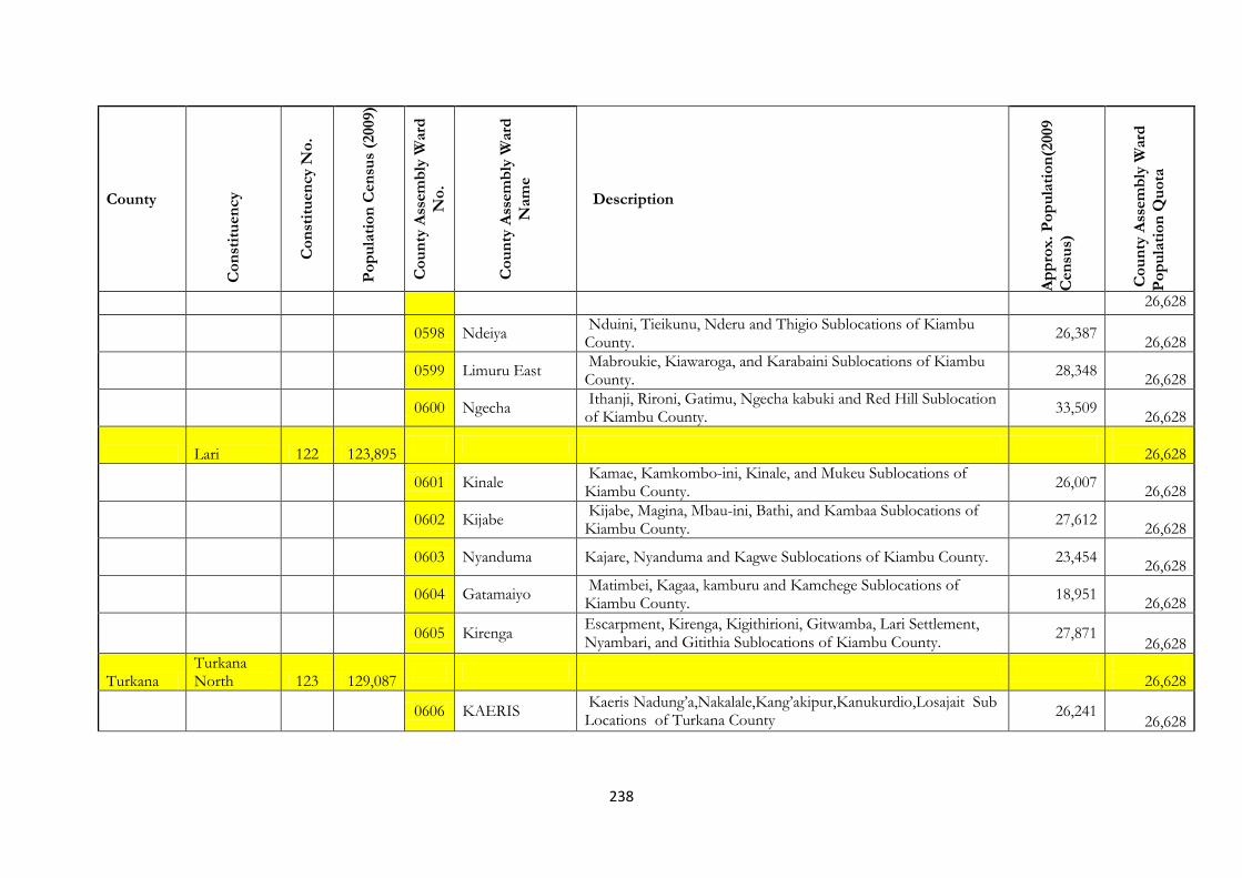
238
County
Co
nst
itu
en
cy
Co
nst
itu
en
cy N
o.
Po
pu
lati
on
Cen
sus
(2009)
Co
un
ty A
ssem
bly
Ward
No
.
Co
un
ty A
ssem
bly
Ward
Nam
e
Description
Ap
pro
x.
Po
pu
lati
on
(2009
Cen
sus)
Co
un
ty A
ssem
bly
Ward
Po
pu
lati
on
Qu
ota
26,628
0598 Ndeiya
Nduini, Tieikunu, Nderu and Thigio Sublocations of Kiambu County.
26,387
26,628
0599 Limuru East
Mabroukie, Kiawaroga, and Karabaini Sublocations of Kiambu County.
28,348
26,628
0600 Ngecha
Ithanji, Rironi, Gatimu, Ngecha kabuki and Red Hill Sublocation of Kiambu County.
33,509
26,628
Lari 122 123,895
26,628
0601 Kinale
Kamae, Kamkombo-ini, Kinale, and Mukeu Sublocations of Kiambu County.
26,007
26,628
0602 Kijabe
Kijabe, Magina, Mbau-ini, Bathi, and Kambaa Sublocations of Kiambu County.
27,612
26,628
0603 Nyanduma Kajare, Nyanduma and Kagwe Sublocations of Kiambu County. 23,454
26,628
0604 Gatamaiyo
Matimbei, Kagaa, kamburu and Kamchege Sublocations of Kiambu County.
18,951
26,628
0605 Kirenga
Escarpment, Kirenga, Kigithirioni, Gitwamba, Lari Settlement, Nyambari, and Gitithia Sublocations of Kiambu County.
27,871 26,628
Turkana Turkana North 123 129,087
26,628
0606 KAERIS
Kaeris Nadung’a,Nakalale,Kang’akipur,Kanukurdio,Losajait Sub Locations of Turkana County
26,241
26,628
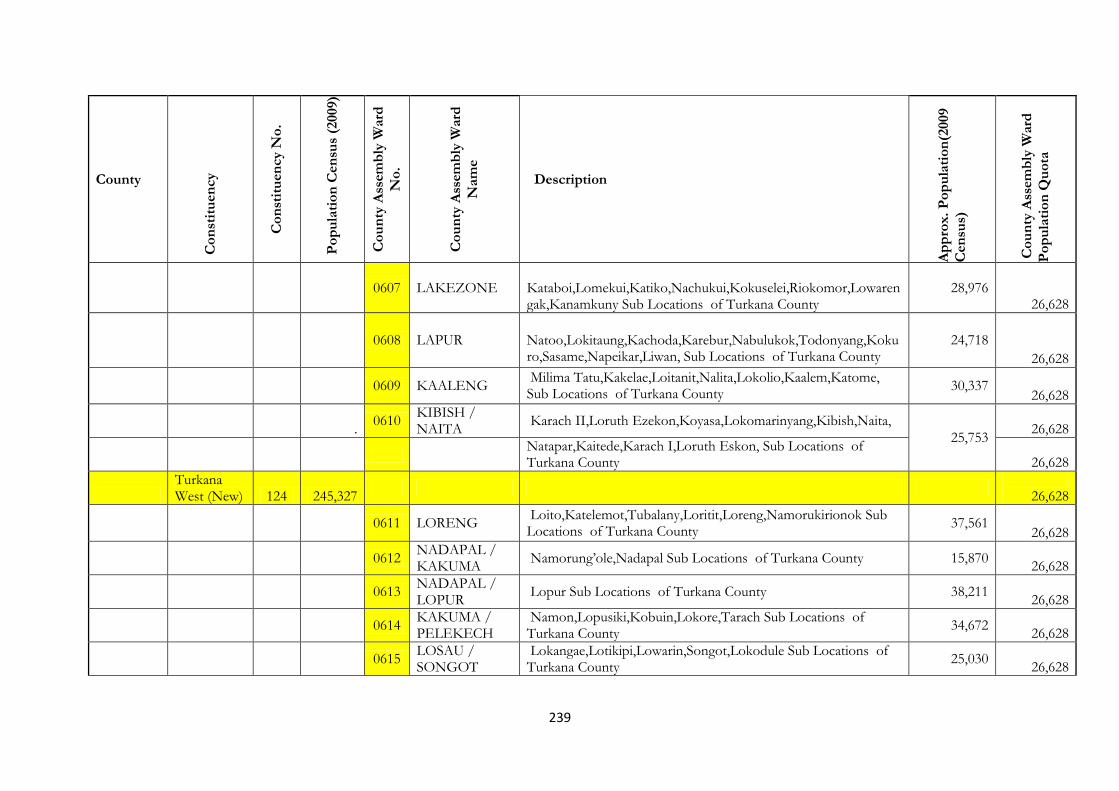
239
County
Co
nst
itu
en
cy
Co
nst
itu
en
cy N
o.
Po
pu
lati
on
Cen
sus
(2009)
Co
un
ty A
ssem
bly
Ward
No
.
Co
un
ty A
ssem
bly
Ward
Nam
e
Description
Ap
pro
x.
Po
pu
lati
on
(2009
Cen
sus)
Co
un
ty A
ssem
bly
Ward
Po
pu
lati
on
Qu
ota
0607 LAKEZONE
Kataboi,Lomekui,Katiko,Nachukui,Kokuselei,Riokomor,Lowarengak,Kanamkuny Sub Locations of Turkana County
28,976 26,628
0608 LAPUR Natoo,Lokitaung,Kachoda,Karebur,Nabulukok,Todonyang,Kokuro,Sasame,Napeikar,Liwan, Sub Locations of Turkana County
24,718 26,628
0609 KAALENG
Milima Tatu,Kakelae,Loitanit,Nalita,Lokolio,Kaalem,Katome, Sub Locations of Turkana County
30,337
26,628
. 0610
KIBISH / NAITA
Karach II,Loruth Ezekon,Koyasa,Lokomarinyang,Kibish,Naita,
25,753
26,628
Natapar,Kaitede,Karach I,Loruth Eskon, Sub Locations of Turkana County
26,628
Turkana West (New) 124 245,327
26,628
0611 LORENG
Loito,Katelemot,Tubalany,Loritit,Loreng,Namorukirionok Sub Locations of Turkana County
37,561 26,628
0612
NADAPAL / KAKUMA
Namorung’ole,Nadapal Sub Locations of Turkana County 15,870
26,628
0613
NADAPAL / LOPUR
Lopur Sub Locations of Turkana County 38,211
26,628
0614
KAKUMA / PELEKECH
Namon,Lopusiki,Kobuin,Lokore,Tarach Sub Locations of Turkana County
34,672
26,628
0615
LOSAU / SONGOT
Lokangae,Lotikipi,Lowarin,Songot,Lokodule Sub Locations of Turkana County
25,030
26,628

240
County
Co
nst
itu
en
cy
Co
nst
itu
en
cy N
o.
Po
pu
lati
on
Cen
sus
(2009)
Co
un
ty A
ssem
bly
Ward
No
.
Co
un
ty A
ssem
bly
Ward
Nam
e
Description
Ap
pro
x.
Po
pu
lati
on
(2009
Cen
sus)
Co
un
ty A
ssem
bly
Ward
Po
pu
lati
on
Qu
ota
0616 KALOBEYEI
Kalobeyei, Natiira,Lonyuduk,Nalapatui,Oropi Sub Locations of Turkana County
18,272
26,628
0617 LOKICHOGIO Lokichogio,Lokariwon Sub Locations of Turkana County 29,267
26,628
0618
NANAAM / MOGILA
Nanaam,Lomeyan,Lopiding,Mogila Sub Locations of Turkana County
34,805
26,628
Turkana Central 125 134,674
26,628
0619
KERIO/KANG’IRISAE
Kang’irisae,Nakoret,Nakurio,Kerio,Kakimat,Kang’agetei, Nadoto, Sub Locations of Turkana County
45,798 26,628
0620
KANG’ATOTHE NAPEPETI
Naoros,Lomopus,,Lochor Ekeny,Namukuse, Napeteti Sub Locations of Turkana County
53,327 26,628
0621
KOLOKOL /KAPUA---NAMADAK
Namadak, Kalokol,Kapua Sub Locations of Turkana County, 42,172 26,628
0622
KAWALATHE/ KENYATTA
Lodwar Town, Sub Location of Turkana County 59,857
26,628
0623
KANAMKEMER / NAPUU
Nawoitolog, Loreg’elup Sub Locations of Turkana County 24,957
26,628
Loima(New) 126 119,932
26,628
0624
KOTARUK /LOBEI
Kotaruk,Naipa,Lokipetot Areng’an,Kalemunyang Sub Locations of Turkana County
31,629
26,628
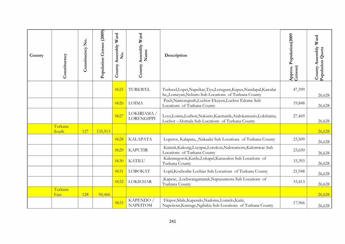
241
County
Co
nst
itu
en
cy
Co
nst
itu
en
cy N
o.
Po
pu
lati
on
Cen
sus
(2009)
Co
un
ty A
ssem
bly
Ward
No
.
Co
un
ty A
ssem
bly
Ward
Nam
e
Description
Ap
pro
x.
Po
pu
lati
on
(2009
Cen
sus)
Co
un
ty A
ssem
bly
Ward
Po
pu
lati
on
Qu
ota
0625 TURKWEL Turkwel,Lopei,Napeikar,Tiya,Lorugum,Kapus,Nandapal,Kawalathe,,Lomeyan,Nchuro Sub Locations of Turkana County
47,399 26,628
0626 LOIMA
Puch,Namoruputh,Lochor-Ekuyen,Lochor Edome Sub Locations of Turkana County
19,848
26,628
0627
LOKIRIAMA / LORENGIPPI
Loya,Loima,Lodwat,Nakurio,Kaemanik,Atalokamusio,Lokiriama,Lochor –Alomala Sub Locations of Turkana County
27,469 26,628
Turkana South 127 135,913
26,628
0628 KALAPATA Loperot, Kalapata, ,Nakaalei Sub Locations of Turkana County 23,509
26,628
0629 KAPUTIR
Kainuk,Kakong,Loyapat,Lorokon,Nakwamoru,Kalomwae Sub Locations of Turkana County
23,650 26,628
0630 KATILU
Kalemngorok,Katilu,Lokapel,Kanaodon Sub Locations of Turkana County
33,393
26,628
0631 LOBOKAT Lopii,Kochodin Lochiar Sub Locations of Turkana County 21,948
26,628
0632 LOKICHAR
,Kapese, ,Lochwangamatak,Napusumoru Sub Locations of Turkana County
33,413
26,628
Turkana East 128 90,466
26,628
0633
KAPENDO / NAPEITOM
Ekipor,Silale,Kapendo,Nadome,Lomelo,Katir, Napeitom,Kamuge,Ngilukia Sub Locations of Turkana County
17,966 26,628

242
County
Co
nst
itu
en
cy
Co
nst
itu
en
cy N
o.
Po
pu
lati
on
Cen
sus
(2009)
Co
un
ty A
ssem
bly
Ward
No
.
Co
un
ty A
ssem
bly
Ward
Nam
e
Description
Ap
pro
x.
Po
pu
lati
on
(2009
Cen
sus)
Co
un
ty A
ssem
bly
Ward
Po
pu
lati
on
Qu
ota
0634 KATILIA Elekea,Paragati,Katilia Sub Locations of Turkana County 20,983
26,628
0635
LOKORI / KOCHODIN
Lokori,Kang’itit,Lotubae,Lopii,Lokwamosing, 11,363
26,628
Kakulit,Lochakula,Kochodin Sub Locations of Turkana County
26,628
West Pokot Kapenguria 129 109,584
26,628
0636 CHEPKIPEGH
Shalpough,Chepkopech,Chesira,Naramach,Cheptung’uny,Korellach,Senetwo,Ngileyo,Chepkechir,Kochar , Sia Sub Locations of West Pokot County
19,732
26,628
0637 ENDUGH
Simat,Psapai,Ketiam,Tompul,Cheptram,Ptoyo,Krich,Tunoyo,Rukei,Nakwijit,Merur,Tamarukwo,Kesot,Chewarany,Kasitei Sub Locations of West Pokot County
19,530
26,628
0638 MISKWONY
Miskwony ,Chemakeu,Chesira (Miskwony),Empoasis Sub Locations of West Pokot County
6,817 26,628
0639 KANYARKWAT
Simatwa,Poole,Mtembur,Chepkram,Serewo,Kamayech,Cheptuya,Mortome,Lokomoi,Kreswo,Katikomor,Adurkoit,Kitelakapal,Kongelai,Simatwa Sub Locations of West Pokot County
21,978
26,628
0640 KAPENGURIA Komoi, Kisiaunet,Suku,Kaprom,Tilak,Chemochoi,Kamatira,Lityei,Tartar,Kamatira,
66,683 26,628
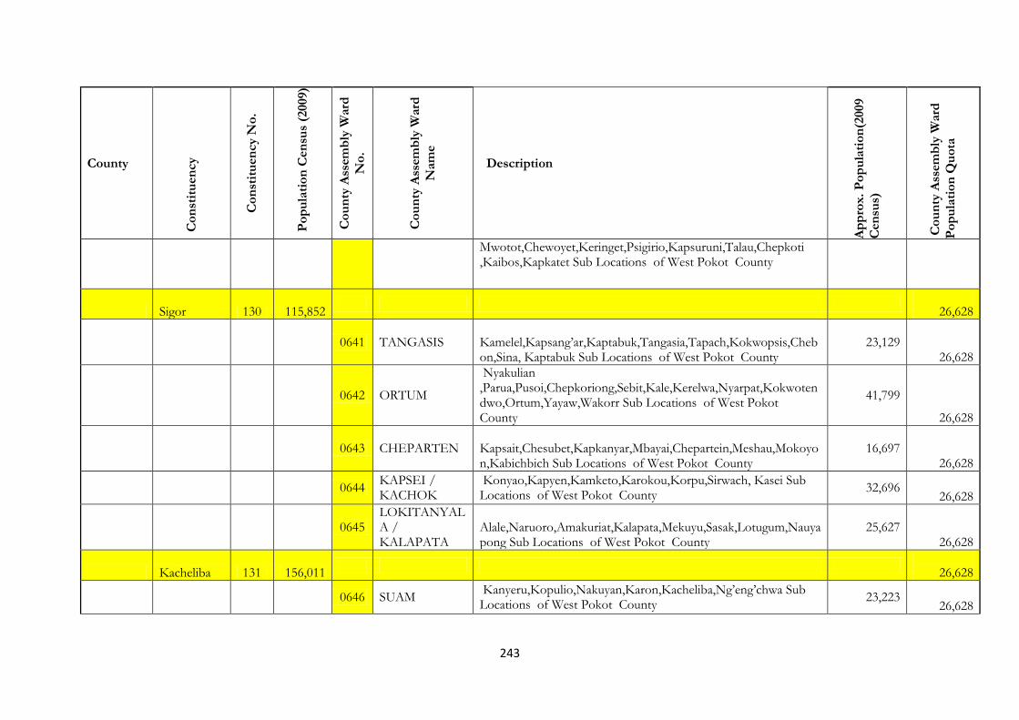
243
County
Co
nst
itu
en
cy
Co
nst
itu
en
cy N
o.
Po
pu
lati
on
Cen
sus
(2009)
Co
un
ty A
ssem
bly
Ward
No
.
Co
un
ty A
ssem
bly
Ward
Nam
e
Description
Ap
pro
x.
Po
pu
lati
on
(2009
Cen
sus)
Co
un
ty A
ssem
bly
Ward
Po
pu
lati
on
Qu
ota
Mwotot,Chewoyet,Keringet,Psigirio,Kapsuruni,Talau,Chepkoti ,Kaibos,Kapkatet Sub Locations of West Pokot County
Sigor 130 115,852
26,628
0641 TANGASIS
Kamelel,Kapsang’ar,Kaptabuk,Tangasia,Tapach,Kokwopsis,Chebon,Sina, Kaptabuk Sub Locations of West Pokot County
23,129 26,628
0642 ORTUM
Nyakulian ,Parua,Pusoi,Chepkoriong,Sebit,Kale,Kerelwa,Nyarpat,Kokwotendwo,Ortum,Yayaw,Wakorr Sub Locations of West Pokot County
41,799
26,628
0643 CHEPARTEN
Kapsait,Chesubet,Kapkanyar,Mbayai,Chepartein,Meshau,Mokoyon,Kabichbich Sub Locations of West Pokot County
16,697 26,628
0644
KAPSEI / KACHOK
Konyao,Kapyen,Kamketo,Karokou,Korpu,Sirwach, Kasei Sub Locations of West Pokot County
32,696 26,628
0645
LOKITANYALA / KALAPATA
Alale,Naruoro,Amakuriat,Kalapata,Mekuyu,Sasak,Lotugum,Nauyapong Sub Locations of West Pokot County
25,627 26,628
Kacheliba 131 156,011
26,628
0646 SUAM
Kanyeru,Kopulio,Nakuyan,Karon,Kacheliba,Ng’eng’chwa Sub Locations of West Pokot County
23,223 26,628

244
County
Co
nst
itu
en
cy
Co
nst
itu
en
cy N
o.
Po
pu
lati
on
Cen
sus
(2009)
Co
un
ty A
ssem
bly
Ward
No
.
Co
un
ty A
ssem
bly
Ward
Nam
e
Description
Ap
pro
x.
Po
pu
lati
on
(2009
Cen
sus)
Co
un
ty A
ssem
bly
Ward
Po
pu
lati
on
Qu
ota
0647 KODICH
Lochir,Orolwo,Karemongrok,Cherangen,Karameri Sub Locations of West Pokot County
16,956 26,628
0648
KAPSEI / KACHOK
Konyao,Kapyen,Kamketo,Karokou,Korpu,Sirwach, Kasei Sub Locations of West Pokot County
32,696
26,628
0649
LOPETI / KIWAWA
Kaptolomwo,Ompollon,Kamunono,Lopet,Mbaru,Chepropogh, Sub Locations of West Pokot County
10,057 26,628
0650
AKORET/CHEMORONGIT/KASES
Kases,Pcholio,Kamunai,Kopito,Lorsuk,Kola,Kodil,Akoret 14,955 26,628
Pokot South (New) 132 101,327
26,628
0651 TANGASIS
Kamelel,Kapsang’ar,Kaptabuk,Tangasia,Tapach,Kokwopsis,Chebon,Sina, Kaptabuk Sub Locations of West Pokot County
23,129 26,628
0652 ORTUM
Nyakulian ,Parua,Pusoi,Chepkoriong,Sebit,Kale,Kerelwa,Nyarpat,Kokwotendwo,Ortum,Yayaw,Wakorr Sub Locations of West Pokot County
41,799
26,628
0653 CHEPRERIA Morpus, Sobukwo,Soka Sub Locations of West Pokot County 7,977
26,628
0654 CHEPARTEN
Kapsait,Chesubet,Kapkanyar,Mbayai,Chepartein,Meshau,Mokoyon,Kabichbich Sub Locations of West Pokot County
16,697 26,628

245
County
Co
nst
itu
en
cy
Co
nst
itu
en
cy N
o.
Po
pu
lati
on
Cen
sus
(2009)
Co
un
ty A
ssem
bly
Ward
No
.
Co
un
ty A
ssem
bly
Ward
Nam
e
Description
Ap
pro
x.
Po
pu
lati
on
(2009
Cen
sus)
Co
un
ty A
ssem
bly
Ward
Po
pu
lati
on
Qu
ota
0655 SOOK
Simotwo,Tonoyon,Chepkono ,Siyoi,Kapchila,Paraywa,Kosulol,Tampatai Sub Locations of West Pokot County
23,907 26,628
Samburu Samburu West 133 59,801
26,628
0656
BARGOI /EL-BARTA
Masikita,Suyan,Marti,Ngilai,Bendera,Baragoi,Naling’angor Sub Locations of Samburu County
13,675 26,628
0657
KAWAP / NACHOLA
Nachola,Nakuparat,Terter Lonyangaten,Losurkoi,Nakweny Sub Locations of Samburu County
10,625
26,628
0658
NDOTO / ARSIM
Latakweny,Nguronit,Loikumkum,Illaut,Arsim, 12,479
26,628
0659 NYIRO
Lkotikal,Uaso Rongai,Simale,South Horr,Tuum,Parkati,Ijuk,Loonjorin,Lkayo Sub Locations of Samburu County
17,051 26,628
Samburu North (New) 134 105,052
26,628
0660 LODOKEJEK
Mugur,Kirimun,Garma,Lodokejek,Mbarigon,Lonkaitolia,Imisigiyoi Sub Locations of Samburu County
11,917 26,628
0661
SUGUTAMARMAR
Logorate,Suguta Marmar,Longewan,Amaiya,Nasur,Limolog Sub Locations of Samburu County
11,905 26,628
0662
BAAWA / OPIROI
Moru,Baawa,Ikiroriti,Nauneri,Ibukoi,Mabati,Opiroi,Lorrok-Iolmong,o Sub Locations of Samburu County
13,805 26,628

246
County
Co
nst
itu
en
cy
Co
nst
itu
en
cy N
o.
Po
pu
lati
on
Cen
sus
(2009)
Co
un
ty A
ssem
bly
Ward
No
.
Co
un
ty A
ssem
bly
Ward
Nam
e
Description
Ap
pro
x.
Po
pu
lati
on
(2009
Cen
sus)
Co
un
ty A
ssem
bly
Ward
Po
pu
lati
on
Qu
ota
0663 MARALAL
Maralal Town,Ledero,Ikoroto,Shabaa,Ng’ari,Milimani, Ipartuk Sub Locations of Samburu County
36,755 26,628
0664 LOOSUK
Ngejumuny,Sirata Oirobi,Lemisigiyo,Loosuk,Tinga,Malaso,PuraSub Locations of Samburu County
13,732 26,628
0665
BARSALOI / ANGATA NANYOKIE
Lulu,Morijo,Soit Naibor,Barsoi,Loibashai,Angata Nyokie, Sub Locations of Samburu County
16,938 26,628
0666
MARTI / PORRO
Seketet ,Mugur,Siambu,Lporowuai / Malaso , Morua – Akiring, Kalele,Lokorkor Sub Locations of Samburu County
7,833 26,628
Samburu East 135 59,094
26,628
0667 WASO
Archer’s Post,Lerata,Lasesia,Sere-Olipi,Ndonyo Wuasin Sub Locations of Samburu County
15,489 26,628
0668
WAMBA WEST
Lpus Leluai,Ngutuk Ong’iron,Remot,Sesia,Lengei,Ltrimin,Lpus, Nkaloni, Resim Sub Locations of Samburu County
12,440 26,628
0669 WAMBA EAST Lpashe,Koiting,Wamba,Matakwani,Golgoltim, 19,221
26,628
0670
WAMBA NORTH
Nkare Narok,Lorrok-Onyokie,Raraiti,Swani,Lmarmaroi, Sub Locations of Samburu County
8,364 26,628
Trans Nzoia
Kwanza 136 170 916
26,628
0671 Kapkoi Kapkoi,Kolongolo and Keiyo 33,317
26,628
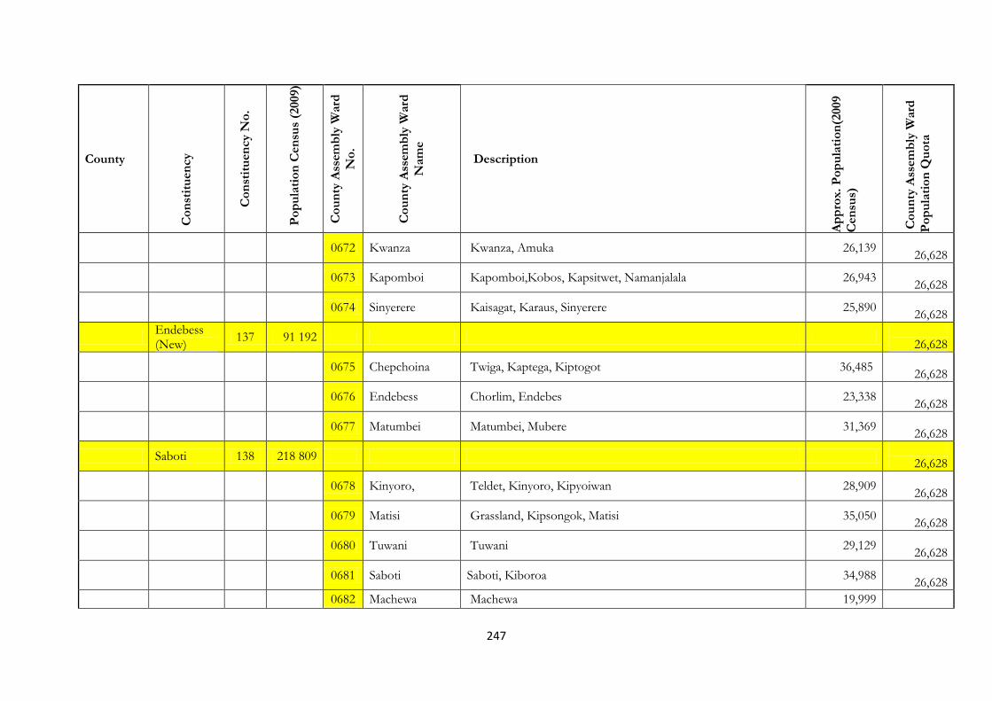
247
County
Co
nst
itu
en
cy
Co
nst
itu
en
cy N
o.
Po
pu
lati
on
Cen
sus
(2009)
Co
un
ty A
ssem
bly
Ward
No
.
Co
un
ty A
ssem
bly
Ward
Nam
e
Description
Ap
pro
x.
Po
pu
lati
on
(2009
Cen
sus)
Co
un
ty A
ssem
bly
Ward
Po
pu
lati
on
Qu
ota
0672 Kwanza Kwanza, Amuka 26,139
26,628
0673 Kapomboi Kapomboi,Kobos, Kapsitwet, Namanjalala 26,943
26,628
0674 Sinyerere Kaisagat, Karaus, Sinyerere 25,890
26,628
Endebess (New)
137 91 192
26,628
0675 Chepchoina Twiga, Kaptega, Kiptogot 36,485
26,628
0676 Endebess Chorlim, Endebes 23,338
26,628
0677 Matumbei Matumbei, Mubere 31,369
26,628
Saboti 138 218 809
26,628
0678 Kinyoro, Teldet, Kinyoro, Kipyoiwan 28,909
26,628
0679 Matisi Grassland, Kipsongok, Matisi 35,050
26,628
0680 Tuwani Tuwani 29,129
26,628
0681 Saboti Saboti, Kiboroa 34,988
26,628
0682 Machewa Machewa 19,999
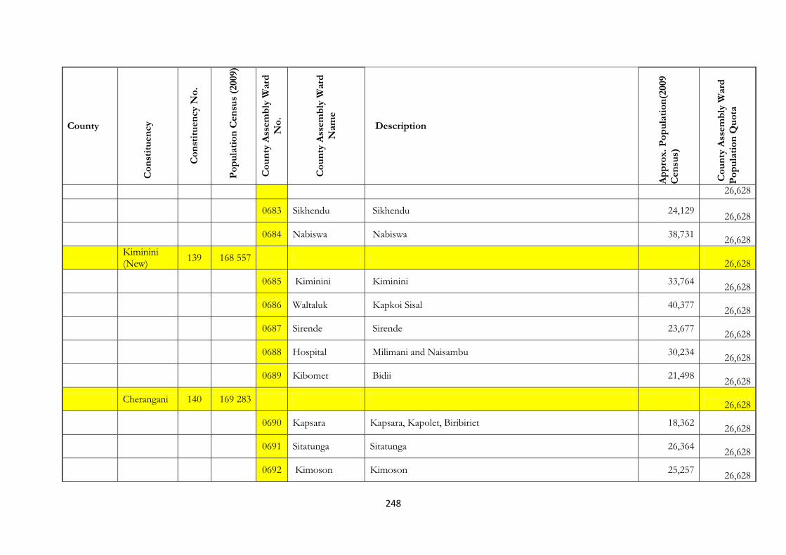
248
County
Co
nst
itu
en
cy
Co
nst
itu
en
cy N
o.
Po
pu
lati
on
Cen
sus
(2009)
Co
un
ty A
ssem
bly
Ward
No
.
Co
un
ty A
ssem
bly
Ward
Nam
e
Description
Ap
pro
x.
Po
pu
lati
on
(2009
Cen
sus)
Co
un
ty A
ssem
bly
Ward
Po
pu
lati
on
Qu
ota
26,628
0683 Sikhendu Sikhendu 24,129
26,628
0684 Nabiswa Nabiswa 38,731
26,628
Kiminini (New)
139 168 557
26,628
0685 Kiminini Kiminini 33,764
26,628
0686 Waltaluk Kapkoi Sisal 40,377
26,628
0687 Sirende Sirende 23,677
26,628
0688 Hospital Milimani and Naisambu 30,234
26,628
0689 Kibomet Bidii 21,498
26,628
Cherangani 140 169 283
26,628
0690 Kapsara Kapsara, Kapolet, Biribiriet 18,362
26,628
0691 Sitatunga Sitatunga 26,364
26,628
0692 Kimoson Kimoson 25,257
26,628
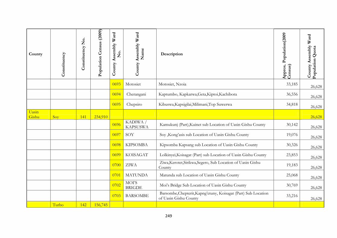
249
County
Co
nst
itu
en
cy
Co
nst
itu
en
cy N
o.
Po
pu
lati
on
Cen
sus
(2009)
Co
un
ty A
ssem
bly
Ward
No
.
Co
un
ty A
ssem
bly
Ward
Nam
e
Description
Ap
pro
x.
Po
pu
lati
on
(2009
Cen
sus)
Co
un
ty A
ssem
bly
Ward
Po
pu
lati
on
Qu
ota
0693 Motosiet Motosiet, Nzoia 33,185
26,628
0694 Cherangani Kaptumbo, Kapkarwa,Geta,Kiptoi,Kachibora 36,556
26,628
0695 Chepsiro Kibuswa,Kapsigilai,Milimani,Top Suwerwa 34,818
26,628
Uasin Gishu Soy 141 234,910
26,628
0696
KADIWA / KAPSUSWA
Kamukunj (Part),Kuinet sub Location of Uasin Gishu County 30,142
26,628
0697 SOY Soy ,Kong’asis sub Location of Uasin Gishu County 19,076
26,628
0698 KIPSOMBA Kipsomba Kapsang sub Location of Uasin Gishu County 30,326
26,628
0699 KOISAGAT Lolkinyei,Koisagat (Part) sub Location of Uasin Gishu County 23,853
26,628
0700 ZIWA
Ziwa,Kerotet,Sirikwa,Segero, Sub Location of Uasin Gishu County
19,183
26,628
0701 MATUNDA Matunda sub Location of Uasin Gishu County 25,068
26,628
0702
MOI’S BRIGDE
Moi’s Bridge Sub Location of Uasin Gishu County 30,769
26,628
0703 BARSOMBE
Barsombe,Chepterit,Kapng’etuny, Koisagat (Part) Sub Location of Uasin Gishu County
33,216 26,628
Turbo 142 156,745

250
County
Co
nst
itu
en
cy
Co
nst
itu
en
cy N
o.
Po
pu
lati
on
Cen
sus
(2009)
Co
un
ty A
ssem
bly
Ward
No
.
Co
un
ty A
ssem
bly
Ward
Nam
e
Description
Ap
pro
x.
Po
pu
lati
on
(2009
Cen
sus)
Co
un
ty A
ssem
bly
Ward
Po
pu
lati
on
Qu
ota
(New) 26,628
0704 Ngenyilel chepsaita and osorongai sub locations of Uasin Gishu County 30,805
26,628
0705 Tapsagoi
tapsagoi,turbo,kaptebee and kapkong sub location of Uasin Gishu County
30,515
26,628
0706 Kamagut sosiani and leseru sub locations of Uasin Gishu County 28,330
26,628
0707 Kamukunji
Kilombe,Kilimani and kamukunji sub location of Uasin Gishu County.
53,194
26,628
0708 Kapyemit kapyemit sublocation of Uasin Gishu County 15,090
26,628
Moiben 143 138,409
26,628
0709
Karuma/meibeki
meibeki,kapsiliot,cheplaskei,uswo,kaplolo,sosiyo and kapsubere sub location of Uasin Gishu County.
28,722 26,628
0710 Moiben
moiben,toloita,merewet and torochmoi sub location of Uasin Gishu County
23,100
26,628
0711 Sergoit kelji,chepkoilel and sergoit sub location of Uasin Gishu County 16,220
26,628
0712 Tembelio
cheburbur,kimoning,kamaua,kaptuktuk,tuiyo-luk,elgeyo border and kapkei sub location of Uasin Gishu County.
28,021 26,628
0713 Kimumu sigot and kimumu sub location Uasin Gishu County. 42,346
26,628
Ainabkoi (New) 144 103,042
26,628
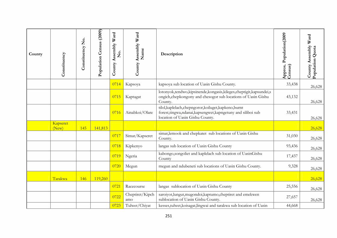
251
County
Co
nst
itu
en
cy
Co
nst
itu
en
cy N
o.
Po
pu
lati
on
Cen
sus
(2009)
Co
un
ty A
ssem
bly
Ward
No
.
Co
un
ty A
ssem
bly
Ward
Nam
e
Description
Ap
pro
x.
Po
pu
lati
on
(2009
Cen
sus)
Co
un
ty A
ssem
bly
Ward
Po
pu
lati
on
Qu
ota
0714 Kapsoya kapsoya sub location of Uasin Gishu County. 33,438
26,628
0715 Kaptagat
lotonyok,tendwo,kipsinende,kongasis,kileges,cheptigit,kapsundei,songich,chepkongony and chesogor sub locations of Uasin Gishu County.
43,132 26,628
0716 Ainabkoi/Olare tilol,kaplelach,chepngoror,koiluget,kapkeno,burnt forest,tingwa,ndanai,kapsengwet,kapngetuny and siliboi sub location of Uasin Gishu County.
33,431 26,628
Kapseret (New) 145 141,813
26,628
0717 Simat/Kapseret
simat,lemook and chepkatet sub locations of Uasin Gishu County.
31,030
26,628
0718 Kipkenyo langas sub location of Uasin Gishu County 93,436
26,628
0719 Ngeria
kabongo,songoliet and kaplelach sub location of UasinGishu County
17,437
26,628
0720 Megun megun and ndubeneti sub locations of Uasin Gishu County. 9,328
26,628
Tarakwa 146 119,260
26,628
0721 Racecourse langas sublocation of Uasin Gishu County 25,556
26,628
0722
Cheptiret/Kipchamo
saroiyot,lungut,mugondoi,kaptumo,cheptiret and emekwen sublocation of Uasin Gishu County.
27,657 26,628
0723 Tulwet/Chiyat kesses,tulwet,koisagat,lingwai and tarakwa sub location of Uasin 44,668
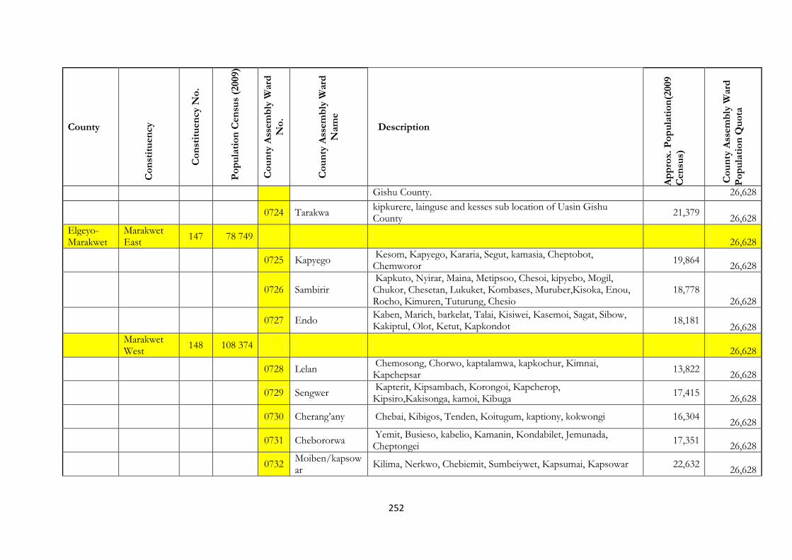
252
County
Co
nst
itu
en
cy
Co
nst
itu
en
cy N
o.
Po
pu
lati
on
Cen
sus
(2009)
Co
un
ty A
ssem
bly
Ward
No
.
Co
un
ty A
ssem
bly
Ward
Nam
e
Description
Ap
pro
x.
Po
pu
lati
on
(2009
Cen
sus)
Co
un
ty A
ssem
bly
Ward
Po
pu
lati
on
Qu
ota
Gishu County. 26,628
0724 Tarakwa
kipkurere, lainguse and kesses sub location of Uasin Gishu County
21,379
26,628
Elgeyo-Marakwet
Marakwet East
147 78 749
26,628
0725 Kapyego Kesom, Kapyego, Kararia, Segut, kamasia, Cheptobot, Chemworor
19,864
26,628
0726 Sambirir Kapkuto, Nyirar, Maina, Metipsoo, Chesoi, kipyebo, Mogil, Chukor, Chesetan, Lukuket, Kombases, Muruber,Kisoka, Enou, Rocho, Kimuren, Tuturung, Chesio
18,778 26,628
0727 Endo Kaben, Marich, barkelat, Talai, Kisiwei, Kasemoi, Sagat, Sibow, Kakiptul, Olot, Ketut, Kapkondot
18,181 26,628
Marakwet West
148 108 374
26,628
0728 Lelan Chemosong, Chorwo, kaptalamwa, kapkochur, Kimnai, Kapchepsar
13,822
26,628
0729 Sengwer Kapterit, Kipsambach, Korongoi, Kapcherop, Kipsiro,Kakisonga, kamoi, Kibuga
17,415
26,628
0730 Cherang’any Chebai, Kibigos, Tenden, Koitugum, kaptiony, kokwongi 16,304
26,628
0731 Chebororwa Yemit, Busieso, kabelio, Kamanin, Kondabilet, Jemunada, Cheptongei
17,351
26,628
0732 Moiben/kapsowar
Kilima, Nerkwo, Chebiemit, Sumbeiywet, Kapsumai, Kapsowar 22,632
26,628

253
County
Co
nst
itu
en
cy
Co
nst
itu
en
cy N
o.
Po
pu
lati
on
Cen
sus
(2009)
Co
un
ty A
ssem
bly
Ward
No
.
Co
un
ty A
ssem
bly
Ward
Nam
e
Description
Ap
pro
x.
Po
pu
lati
on
(2009
Cen
sus)
Co
un
ty A
ssem
bly
Ward
Po
pu
lati
on
Qu
ota
0733 Arror Kipsaiya, Sisiya, Resim, Chepkum, Kapchemuta, Arror, Niwai, Kobuswo, Sangurur, Tuiyobei, Koitilial.
17,490 26,628
Keiyo North
149 73 715
26,628
0734 Kamariny Kaplamai,Kapkessum,Sergoit,Kiptabus,Katalel,Kipsoen,Chelingwa,Kapteren and Kapkoi.
18,760 26,628
0735 Tambach Kapchelal,Chgilet,Kaptum,Kobulwo,Kibendo,Kamoingon,Siroch and Anin.
19,591
26,628
0736 Rimoi Rimoi,Kessup,Setek,Kapterik and,Kipka 15,930
26,628
0737 Kapchemutwa Kapkatui,Bugar,Kapkonga,Sing’ore,Chebokokwa,Mindililwo and Iten Township
21,003
26,628
Keiyo South 150 109 160
26,628
0738 Kaptarakwa Chebior, Kitany, Kaptarakwa, Mokwo, Kaptagat 14,230
26,628
0739 Marichor Kiptulos, Kapkenda, Flax, Cherota, Chepkorio, Lelboinet, Kamelil, Samich
19,400
26,628
0740 Soy Kabito, Chebinyiny, Chepsigot, Epke, Cheptebo, Rokocho, Emsea, Changach, Sego, Muskut, Morop, Chop, turesia
20,886
26,628
0741 Chepkorio Kapcheptek, Kipsaina, Mwen, Kapchebelel, Kabiemit, Cheboen, Kipriria
15,710
26,628
0742 Tumeiyo Chepsirei, Koimur, Tumeiyo, Ketigoi, Tambul, Kapkitony, Kipkomwo, Tumeiyo, Chepkosom, Chepkumum
17,399 26,628

254
County
Co
nst
itu
en
cy
Co
nst
itu
en
cy N
o.
Po
pu
lati
on
Cen
sus
(2009)
Co
un
ty A
ssem
bly
Ward
No
.
Co
un
ty A
ssem
bly
Ward
Nam
e
Description
Ap
pro
x.
Po
pu
lati
on
(2009
Cen
sus)
Co
un
ty A
ssem
bly
Ward
Po
pu
lati
on
Qu
ota
0743 Metkei Kapchorua, Kamwosor, Kombatich, Kimamet, Kiptengwer, Kipsaos, Enego, Kocholwo, Tugumoi, Kabirirsus, Salawa, Molol, Kapsokom
21,535 26,628
Nandi Tinderet 151 77 055
26,628
0744 Chemase Chemursoi,Kibisem,Kibgong and Kapkuong 8,711
26,628
0745 Kapsimatwo Tumbul,Chemelil,Kimwani,Chepsire,Barasendu,Kibwareng,Kapsimatwo,Chematich,Matema,Chepsangor and Kiptegat.
17,535 26,628
0746 Songhor/Soba
Taunet,Songhor,Sokosik,Kibukwo,Cherendo,Kabirer,Matambach,Kabutiei,Kaplelach,Gotnelel,Kimatkei,Tebeson,Senetwo,Sigoria,Kamilet,Kapkitany,Mombwo,Cheptonon,Soba River and Mbogovale.
39,247
26,628
0747 Tinderet Tinderet,Chemamul,Chebangang,Kipyaor,Kabikwen,Kipsiwo,Chepkemel,Toroton,Tereno,Kapsokio,Kapkoros,Kisoga,Anaipngetuny,Ngatipkong,Kapsoen,Meteitei and Setek.
37,166 26,628
0748 Kapbwareng Koibarak,chebara,kereri,kenyor,chepkuny,kapkeben 27,905
26,628
Aldai 152 157 967
0750 Kapbwareng Koibarak,chebara,kereri,kenyor,chepkuny,kapkeben 27,905
26,628
0750 Terik Kapsenger,kapkerer, kesengei, kapsamoch, chepkurgung 20,465
26,628
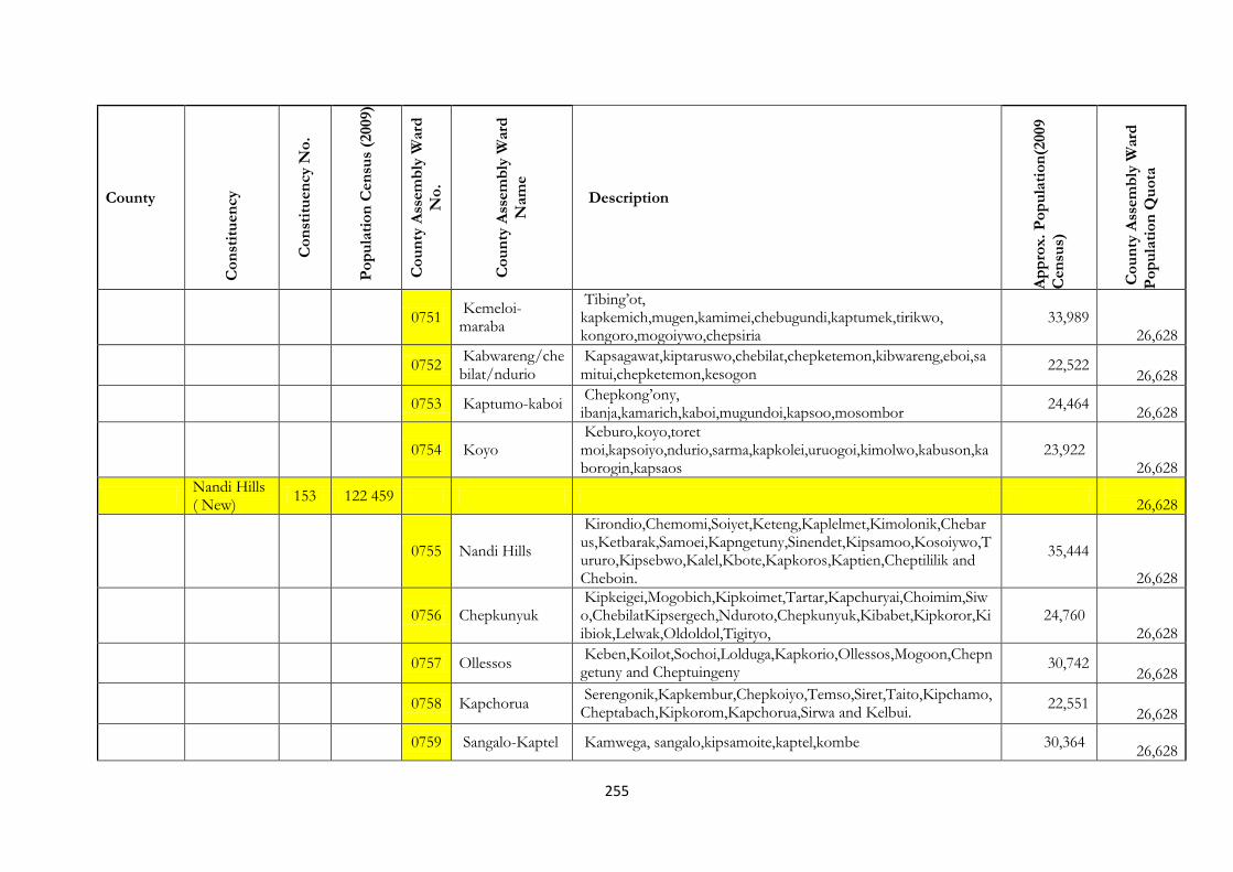
255
County
Co
nst
itu
en
cy
Co
nst
itu
en
cy N
o.
Po
pu
lati
on
Cen
sus
(2009)
Co
un
ty A
ssem
bly
Ward
No
.
Co
un
ty A
ssem
bly
Ward
Nam
e
Description
Ap
pro
x.
Po
pu
lati
on
(2009
Cen
sus)
Co
un
ty A
ssem
bly
Ward
Po
pu
lati
on
Qu
ota
0751 Kemeloi-maraba
Tibing’ot, kapkemich,mugen,kamimei,chebugundi,kaptumek,tirikwo, kongoro,mogoiywo,chepsiria
33,989 26,628
0752 Kabwareng/chebilat/ndurio
Kapsagawat,kiptaruswo,chebilat,chepketemon,kibwareng,eboi,samitui,chepketemon,kesogon
22,522 26,628
0753 Kaptumo-kaboi Chepkong’ony, ibanja,kamarich,kaboi,mugundoi,kapsoo,mosombor
24,464
26,628
0754 Koyo Keburo,koyo,toret moi,kapsoiyo,ndurio,sarma,kapkolei,uruogoi,kimolwo,kabuson,kaborogin,kapsaos
23,922 26,628
Nandi Hills ( New)
153 122 459
26,628
0755 Nandi Hills
Kirondio,Chemomi,Soiyet,Keteng,Kaplelmet,Kimolonik,Chebarus,Ketbarak,Samoei,Kapngetuny,Sinendet,Kipsamoo,Kosoiywo,Tururo,Kipsebwo,Kalel,Kbote,Kapkoros,Kaptien,Cheptililik and Cheboin.
35,444
26,628
0756 Chepkunyuk Kipkeigei,Mogobich,Kipkoimet,Tartar,Kapchuryai,Choimim,Siwo,ChebilatKipsergech,Nduroto,Chepkunyuk,Kibabet,Kipkoror,Kiibiok,Lelwak,Oldoldol,Tigityo,
24,760 26,628
0757 Ollessos Keben,Koilot,Sochoi,Lolduga,Kapkorio,Ollessos,Mogoon,Chepngetuny and Cheptuingeny
30,742 26,628
0758 Kapchorua Serengonik,Kapkembur,Chepkoiyo,Temso,Siret,Taito,Kipchamo,Cheptabach,Kipkorom,Kapchorua,Sirwa and Kelbui.
22,551 26,628
0759 Sangalo-Kaptel Kamwega, sangalo,kipsamoite,kaptel,kombe 30,364
26,628

256
County
Co
nst
itu
en
cy
Co
nst
itu
en
cy N
o.
Po
pu
lati
on
Cen
sus
(2009)
Co
un
ty A
ssem
bly
Ward
No
.
Co
un
ty A
ssem
bly
Ward
Nam
e
Description
Ap
pro
x.
Po
pu
lati
on
(2009
Cen
sus)
Co
un
ty A
ssem
bly
Ward
Po
pu
lati
on
Qu
ota
Emgwen North
154 167 117
26,628
0760 Chemundu/Kaptildil
Kamoiywo,talai,saniak,chepkober,sironoi,kimngeru,baraton,kaptildil
33,247
26,628
0761 Kosirai
Kapkongorwo,lelmokwo,ainamoi,itigo,kiboswa,ndonyo ngatia,mutwot,tebeson,cheptarit,kokwet,ndaptabwa,mosoriot,mateget,kosirai,belekenya,segut,chepterit,kamonjil,lelboinet,ngechek,kipchunu
24,879
26,628
0762 Kapsabet Kapng’etuny, kapsabet town 20,468
26,628
0763 Kiptuiya Kiptuiya, kaptobongen,kapchorwa 24,879
26,628
Emgwen South ( New)
155 63 937 26,628
0764 Chepkumia Chepkumia andCheboite 21,283
26,628
0765 Kapkangani Chepsonoi,Tindinyo andKiborgok 23,994
26,628
0766 Kamobo Kiminda,Meswo,Kamobo and Kamurguiywo 33,347
26,628
0767 Kilibwoni
Kipsotoi,Kipsigak,Kapkeruge,ChesuweKabirirsang,Underit,Kimaam,Kipture,Irimis,Kaplamai,Kapsumbeiywo,Kapchemoiywo,KaptagunyoTiryo,Arwos,KaptendonKilibwoni,Kaplonyo,Kapchepsir,Kapchumba,Kiptenden,Tulon,Kapnyeberai,Emdin,Terige,Songoli
26,946
26,628

257
County
Co
nst
itu
en
cy
Co
nst
itu
en
cy N
o.
Po
pu
lati
on
Cen
sus
(2009)
Co
un
ty A
ssem
bly
Ward
No
.
Co
un
ty A
ssem
bly
Ward
Nam
e
Description
Ap
pro
x.
Po
pu
lati
on
(2009
Cen
sus)
Co
un
ty A
ssem
bly
Ward
Po
pu
lati
on
Qu
ota
et,Kiplorok,Lolminingai,Kabore and Ndubeneti.
Mosop 156 164 430
26,628
0768 Chepterwai Kamasai,Soimining,ChepterwaiCheptonon,Teresia and Cheptilil. 13,849
26,628
0769 Surungai Surungai,Koiban,Kipng’oror,Ngoroin,Kapkoimur, and Kapkenyoloi
20,651
26,628
0770 Kipkaren Sarora,Kapserton,Laboret,Ngenilel,Kipkaren Salient,Chepkemel. 19,991
26,628
0771 Kebulonik/Kurgung
Cheplelaibei,Kebulonik,Rubet,Kurgung,Kamungei,Kaptich and Kapsabaot
20,188
26,628
0772 Kabiyet Chemnoet,Kapkagaron,Kamasia,Lolkeringet,Cheptuiyet,Kabiyet Township,Ndulele,Kaiboi and Koisolik
22,697 26,628
0773 Ndalat Kabiemit,Kapkatet and Kaplemur 16,736
26,628
Baringo Baringo East 157 133,189
26,628
0774 Tiriko Ward
Comprised of Ng’aina, Mirgisi, Ng’oron, Angoritiang, Kulol, Akoret and Kapedo North Sublocations of Baringo County.
16,271 26,628
0775 Kolowa ward
Comprised of Kolowa, Barbello, Chepkererat, Tilingwo, Loiwat, and Kipnai Sublocations of baringo County.
19,499 26,628

258
County
Co
nst
itu
en
cy
Co
nst
itu
en
cy N
o.
Po
pu
lati
on
Cen
sus
(2009)
Co
un
ty A
ssem
bly
Ward
No
.
Co
un
ty A
ssem
bly
Ward
Nam
e
Description
Ap
pro
x.
Po
pu
lati
on
(2009
Cen
sus)
Co
un
ty A
ssem
bly
Ward
Po
pu
lati
on
Qu
ota
0776 Ribkwo Ward
Comprised of Maron, Nginyang West, Kositei, Sereton, and Chesakam Sublocations of Baringo County.
12,929 26,628
0777 Silale Ward
Comprised of Kapedo East, Nakoko, and Losikiriamoi Sublocations of baringo County.
13,649
26,628
0778
Loiyamorok Ward
Comprised of Nginyang East, Paka, Kokore, Loruk-Kongasis Sublocations of Baringo County.
15,024 26,628
0779 Tangulbei Ward
Comprised of Orus, Tangulbei, Nakorete, Kechii,Chemoigut and Korosi Sublocations of Baringo County.
17,251 26,628
0780 Churo ward
Comprised of Putere, Amaya, Churo, Tebelekwo, and Kaptuya Sublocations of Baringo County.
21,227 26,628
Baringo North 158 93,789
26,628
0781 Lawan
Ayatya, Marigut, Kuikui, Kaptiyomwa, Balwesa, Konoo, Kasaka and Kapkoiwa Sublocations of Baringo County.
17,056 26,628
0782 Kabar Tonjo
Keturwo, Katibei,Muchukwo, Kapluk, Tiloi, Kaptum, Sumeiyon, Kaimugul Lelian and Tiriondonin Sublocations of Baringo County.
22,640 26,628
0783 Baratum
Taimon, Akorian, Koroto, Kasisit, Kipcherere, Kapchepkor, Kaptere, Mosop, Kapkiamo and Tirmionin Sublocations of Baringo County.
20,488 26,628
0784 Kipsaramani
Loruk,Sibilo,Rondimin, Barkatei Sublocations of Baringo County.
10,768
26,628
0785 Ngoroba
Kinyachi, Kapturo, Kalabata, Baratabwa, Kesumet, Atiar, Terik, and Tuluk Sublocations of Baringo County.
11,851 26,628

259
County
Co
nst
itu
en
cy
Co
nst
itu
en
cy N
o.
Po
pu
lati
on
Cen
sus
(2009)
Co
un
ty A
ssem
bly
Ward
No
.
Co
un
ty A
ssem
bly
Ward
Nam
e
Description
Ap
pro
x.
Po
pu
lati
on
(2009
Cen
sus)
Co
un
ty A
ssem
bly
Ward
Po
pu
lati
on
Qu
ota
Baringo Central 159 89,174
26,628
0786
Kabarnet Soi Ward
Comprised of Lelmen, Kapyemit, Salawa, Kimoso, Sironoi, Kiboino, Moloi, Segutin, Kewanoi and Kapchepterit Sublocations of Baringo County.
23,430 26,628
0787 Sacho Ward
Comprised of Kaptunoi, Saimet, Kapkelewa, Kaptrioni, Koibarak, Ochi, Kibei, Kaplel, Kisitani, Kabarak, Tiboiwa, Kapcherebet, Kapronya, Karurumbompsoo, and Sagasaki Sublocations of Baringo County.
19,340
26,628
0788 Tenges Ward
Comprised of Euti, Kisonei, Tuluongoi, tebei, Tenges, Timunoi, and Bekibon Sublocations of Baringo County.
11,983 26,628
0789
Kabarnet East Ward
Comprised of Koriema, Kimalel, Sabor, Kibingori, Kabusa, Koitilioni, Chebunyur, Kapkiai, Tiriony, Kaptich, Sosioni and Sirwet Sublocations of Baringo County.
12,237 26,628
0790
Kabarnet West Ward
Comprised of Kaptumo, Sogon, Moigutiwo, Riwo, Seretunin, Morop, Chebano, Kinyo, Kapsolo/Borowonin and Kituro Sublocations of Baringo County.
23,817 26,628
Mochongoi 160 73,177
26,628
0791 Margat ward
Comprised of Perkerra, yatoi, Endao, Salabani, and Meisoi Sublocations of Baringo County.
24,739 26,628
0792 Ng’ambo Ward Comprised of Ng’ambo, Sintaani, Ilng’arua, Longewan, Kailer, Eldume, Kaptombes, Mbechot, Maji Ndege, Chelaba, Kapkuikui Sublocations of Baringo County.
17,041 26,628

260
County
Co
nst
itu
en
cy
Co
nst
itu
en
cy N
o.
Po
pu
lati
on
Cen
sus
(2009)
Co
un
ty A
ssem
bly
Ward
No
.
Co
un
ty A
ssem
bly
Ward
Nam
e
Description
Ap
pro
x.
Po
pu
lati
on
(2009
Cen
sus)
Co
un
ty A
ssem
bly
Ward
Po
pu
lati
on
Qu
ota
0793
Mochongoi Ward
Comprised of Chebinyiny, Kasiela, Mochongoi, Kamnarok, Kamailel, Kimoriot and Kapkecher Sublocations of Baringo County
21,894 26,628
0794 Mukutani Ward
Comprised of Rugus, Mukutani, Ngeleche, Arabal, Logumgum and Kiserian Sublocations of Baringo County .
9,503 26,628
Mogotio 161 60,959
26,628
0795 Mogotio Ward
Comprised of Sore, Sirwa, Kaburgei, Kapterit, Koitebes, Rosoga, Nguberet, Chemongoch, Kipsogon and Mogotio Sublocations of Baringo County.
23,547 26,628
0796 Kamar Ward
Comprised of Kaplelwo, Radad, Molos, Kamar, Molo Sirwe, Kimose, Cheberen, Kabogor, Emining, Oterit, and Chemoinoi Sublocations of Baringo County.
19,437 26,628
0797 Ol Lokwe Ward
Comprised of Maji Moto, Chebirebei, Waseges, Kiribot, Nyalibuch, kabuswo, kamasi, Kabargei, Ng’endalel, Kisanana, Koisaran, Oldebes, Chomiek, Mugurin, Mukuyuni, Turkulu Sublocations of Baringo County.
17,975
26,628
Eldama Ravine 162 105,273
26,628
0798 Mogotio Ward
Comprised of Sore, Sirwa, Kaburgei, Kapterit, Koitebes, Rosoga, Nguberet, Chemongoch, Kipsogon and Mogotio Sublocations of Baringo County.
23,547 26,628
0799 Kamar Ward
Comprised of Kaplelwo, Radad, Molos, Kamar, Molo Sirwe, Kimose, Cheberen, Kabogor, Emining, Oterit, and Chemoinoi Sublocations of Baringo County.
19,437 26,628

261
County
Co
nst
itu
en
cy
Co
nst
itu
en
cy N
o.
Po
pu
lati
on
Cen
sus
(2009)
Co
un
ty A
ssem
bly
Ward
No
.
Co
un
ty A
ssem
bly
Ward
Nam
e
Description
Ap
pro
x.
Po
pu
lati
on
(2009
Cen
sus)
Co
un
ty A
ssem
bly
Ward
Po
pu
lati
on
Qu
ota
0800 Ol Lokwe Ward
Comprised of Maji Moto, Chebirebei, Waseges, Kiribot, Nyalibuch, kabuswo, kamasi, Kabargei, Ng’endalel, Kisanana, Koisaran, Oldebes, Chomiek, Mugurin, Mukuyuni, Turkulu Sublocations of Baringo County.
62,289
26,628
Laikipia Laikipia West 163 100,361
26,628
0801 Ol moran
Ol Moran,Ndonyoloip,Dimkom,Mwenje,Mithiga and mwenje sublocations
49,207
26,628
0802
Rumuruti Township
Maundu Meri,Ndurumo,and Rumuruti Township sublocations 20,543
26,628
0803 Kinamba Mweje,Mithiga, 28,102
26,628
0804 Muhotetu
Muhotetu,Karaba,Kabage,Melwa,Thigio and Kiambogo sublocations
30,738
26,628
0805 Oljabet Kaiti,Oljabet,Siron sublocations 23,916
26,628
0806 Ngoru
Ngoru,Shamanei,Losogwa,Maina,Ndunyu and manguo sublocations
15,466
26,628
Laikipia East 164 200,056
26,628
0807 Ngobit Withare,Wiyumire,Kariguni and Muhonia sublocations 13,795
26,628
0808 Lamuria Comprise Lamuria sublocation 12,214
26,628
0809 Tigithi Matanya,and Marura sublocations 21,549

262
County
Co
nst
itu
en
cy
Co
nst
itu
en
cy N
o.
Po
pu
lati
on
Cen
sus
(2009)
Co
un
ty A
ssem
bly
Ward
No
.
Co
un
ty A
ssem
bly
Ward
Nam
e
Description
Ap
pro
x.
Po
pu
lati
on
(2009
Cen
sus)
Co
un
ty A
ssem
bly
Ward
Po
pu
lati
on
Qu
ota
26,628
0810 Majengo Thingithu,Ntukuruma and Majengo sublocations 42,620
26,628
Laikipia North 165 98,810
26,628
0811 Ol Moran Lonyiek,Magadi,Kirimon and Sisian (Ol Maisor) 12,966
26,628
0812 Segera Impala,Segena,Rugutu,and Ngareng’iro sublocations 10,794
26,628
0813 Naibor Naibor,Umande and Ethi sublocations 8,499
26,628
0814 Ewaso
Ewaso,Ilimotiok,Tura,Lipolei,Mumonyot,Seek,Kurikuri,Makurian,Aljijo,Sieku,Ngarendare,and Sang’a sublocations
27,437 26,628
Nakuru Molo 166 124,438
26,628
0815 Mariashoni kiptunga,kitiro and ndosua sub location of Nakuru County 12,454
26,628
0816 Elburgon arimi,elburgon amd mutamaiyu sub locations of Nakuru County 43,438
26,628
0817 Turi
turi south,turi north and kiambiriria sub location of Nakuru County
25,448
26,628
0818 Molo
matumaini,molo town and kabianga sub location of Nakuru County
37,844
26,628
Njoro ( New) 167 178,180
26,628

263
County
Co
nst
itu
en
cy
Co
nst
itu
en
cy N
o.
Po
pu
lati
on
Cen
sus
(2009)
Co
un
ty A
ssem
bly
Ward
No
.
Co
un
ty A
ssem
bly
Ward
Nam
e
Description
Ap
pro
x.
Po
pu
lati
on
(2009
Cen
sus)
Co
un
ty A
ssem
bly
Ward
Po
pu
lati
on
Qu
ota
0819 Mau Narok siapei and kianjoya sub locations of Nakuru County 35,429
26,628
0820 Mauche
chebitet,kipkembu,kiptulel,lelechwet,loitopes,mauche,siriat,tachasis and teret sub locations of Nakuru County.
34,044 26,628
0821 Kihingo
bagaria,lusiru,milimani and naishi sub locations of Nakuru County.
14,404
26,628
0822 nesuit misipei,nesuit and sigotic sub location of Nakuru County. 13,488
26,628
0823 Lare
sinendet,pwani,nduleve,lare and gichobo sub location of Nakuru County.
17,862
26,628
0824 Njoro Mukungugu and Njoro 47,750
26,628
Naivasha 168 246,056
26,628
0825 Biashara karati sub location of Nkuru County. 8,302
26,628
0826 Hellsgate Mirera sub location of Nakuru County 39,209
26,628
0827 Lake View Lakeview sub location of Nakuru County. 20,082
26,628
0828 Mai mahiu
satelight,mahi mahiu and longonetsub location of Nakuru County.
29,796
26,628
0829 Kongoni
satelight,mahi mahiu and longonetsub location of Nakuru County.
45,672
26,628
0830 Maeilla of kongoni and maeilla sub location of Nakuru County 13,324

264
County
Co
nst
itu
en
cy
Co
nst
itu
en
cy N
o.
Po
pu
lati
on
Cen
sus
(2009)
Co
un
ty A
ssem
bly
Ward
No
.
Co
un
ty A
ssem
bly
Ward
Nam
e
Description
Ap
pro
x.
Po
pu
lati
on
(2009
Cen
sus)
Co
un
ty A
ssem
bly
Ward
Po
pu
lati
on
Qu
ota
26,628
0831 Olkaria o f Olkaria sub location of Nakuru County. 25,437
26,628
0832 Naivasha East muninga and maraingishu sub location of Nakuru County. 18,691
26,628
0833 Viwanda sokoni sub location of Nakuru County. 45,543
26,628
Gilgil (New) 169 130,187
26,628
0834 Gil Gil Gilgil sub location of Nakuru County 47,603
26,628
0835 Kiambogo kiambogo and elementaita sub location of Nakuru County. 27,504
26,628
0836 Mbaruk maruk,kongasis and eburo sub location of Nakuru County 33,395
26,628
0837 Malewa West karati,tarambete,kipkonyo,mndabibi and moidabi 31,175
26,628
0838 Murindat langalanga,gitare and kanunga sub location of Nakuru County. 21,685
26,628
Kuresoi South 170 115,435
26,628
0839 Amalo
chepakundi,kaplamai,kiptaragon,sinendet and amalo sub locations of Nakuru County.
21,086 26,628
0840 Kapsimbeiywo
barget,chebaraa,kapsimbeiywo,keringet,milimet,ribot,silibwet and siwot sub locations of Nakuru County
20,628 26,628

265
County
Co
nst
itu
en
cy
Co
nst
itu
en
cy N
o.
Po
pu
lati
on
Cen
sus
(2009)
Co
un
ty A
ssem
bly
Ward
No
.
Co
un
ty A
ssem
bly
Ward
Nam
e
Description
Ap
pro
x.
Po
pu
lati
on
(2009
Cen
sus)
Co
un
ty A
ssem
bly
Ward
Po
pu
lati
on
Qu
ota
0841 Kiptagit
ainamoi,arurwet,cheboti,chepwet,emitik,irongo,kapugunot,kiptagichi and koiseguth sub locations of Nakuru County.
35,073 26,628
0842 Tinet
chemaner,chepalungu,kapnanda,kipsonoi,tegat and tinet sub locations of Nakuru County.
51,218
26,628
Kuresoi North (New) 171 124,050
26,628
0843 Kiptororo
kuresoi,kongoi,onemare,chemtach,tulwet and kikewa sub location of Nakuru North County.
41,668 26,628
0844 Nyota
nyota,langwenda,mawingo,sollat,mungweny,ikumbi,cheptagun and obumbu sub locations of Nakuru Town
35,377 26,628
0845 Sirikwa sectotes and sirikwa sub location of Nakuru County.K 17,042
26,628
0846 Kamara
mau samit,kamara,sarambei,koige,mau and sinendet sub location of Nakuru County
29,963 26,628
Subukia 172 95,322
26,628
0847 Munanda subukia East and munanda sub locations of Nakuru County. 17,598
26,628
0848 Subukia subukia west and wei sub location of Nakuru County. 10,926
26,628
0849
Kabazi/mogamano
Nyadundo,rugongo and kabazi sub location of Nakuru County. 43,049
26,628
Rongai 173 142,499
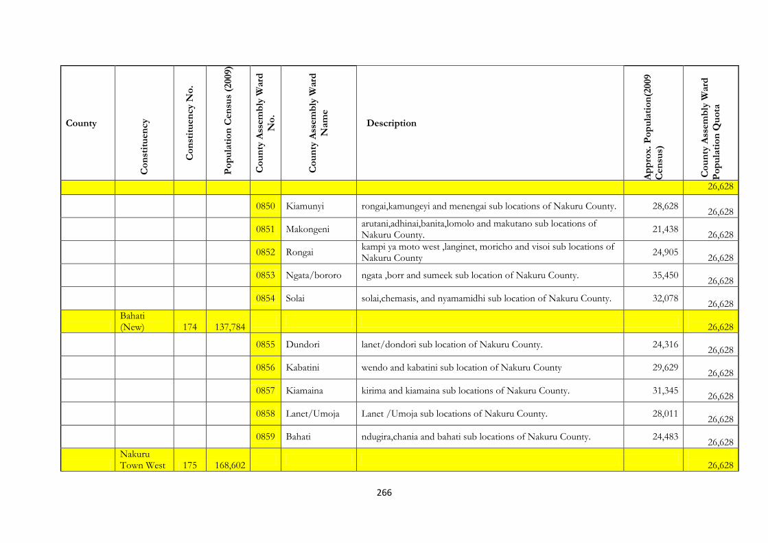
266
County
Co
nst
itu
en
cy
Co
nst
itu
en
cy N
o.
Po
pu
lati
on
Cen
sus
(2009)
Co
un
ty A
ssem
bly
Ward
No
.
Co
un
ty A
ssem
bly
Ward
Nam
e
Description
Ap
pro
x.
Po
pu
lati
on
(2009
Cen
sus)
Co
un
ty A
ssem
bly
Ward
Po
pu
lati
on
Qu
ota
26,628
0850 Kiamunyi rongai,kamungeyi and menengai sub locations of Nakuru County. 28,628
26,628
0851 Makongeni
arutani,adhinai,banita,lomolo and makutano sub locations of Nakuru County.
21,438
26,628
0852 Rongai
kampi ya moto west ,langinet, moricho and visoi sub locations of Nakuru County
24,905
26,628
0853 Ngata/bororo ngata ,borr and sumeek sub location of Nakuru County. 35,450
26,628
0854 Solai solai,chemasis, and nyamamidhi sub location of Nakuru County. 32,078
26,628
Bahati (New) 174 137,784
26,628
0855 Dundori lanet/dondori sub location of Nakuru County. 24,316
26,628
0856 Kabatini wendo and kabatini sub location of Nakuru County 29,629
26,628
0857 Kiamaina kirima and kiamaina sub locations of Nakuru County. 31,345
26,628
0858 Lanet/Umoja Lanet /Umoja sub locations of Nakuru County. 28,011
26,628
0859 Bahati ndugira,chania and bahati sub locations of Nakuru County. 24,483
26,628
Nakuru Town West 175 168,602
26,628

267
County
Co
nst
itu
en
cy
Co
nst
itu
en
cy N
o.
Po
pu
lati
on
Cen
sus
(2009)
Co
un
ty A
ssem
bly
Ward
No
.
Co
un
ty A
ssem
bly
Ward
Nam
e
Description
Ap
pro
x.
Po
pu
lati
on
(2009
Cen
sus)
Co
un
ty A
ssem
bly
Ward
Po
pu
lati
on
Qu
ota
0860 Barut baruti west and baruti east sub location of Nakuru County. 15,737
26,628
0861 London afraha and vianda sub location of Nakuru County 12,955
26,628
0862
Kaptembwa East
kaptembwa sub location of Nakuru County 82,699
26,628
0863
Kaptembwa West
viwanda sub location of Nakuru County 16,239
26,628
0864 Rhoda Rhoda sub location of Nakuru County 23,821
26,628
0865 Shaabab viwanda sub location of Nakuru County. 17,151
26,628
Nakuru Town East 176 140,822
0866 Bondeni afraha and baharini sub location Nakuru County 18,833
26,628
0867 Kivunbini baharini and lanet sub location of Nakuru County. 20,574
26,628
0868 Langalanga baharini sub location of Nakuru County. 31,723
26,628
0869 Menengai Lanet and afraha sub location of Nakuru County. 25,426
26,628
0870 Nakuru East Lanet sub location of Nakuru County. 19,276
26,628
Narok Kilgoris 177 178,895

268
County
Co
nst
itu
en
cy
Co
nst
itu
en
cy N
o.
Po
pu
lati
on
Cen
sus
(2009)
Co
un
ty A
ssem
bly
Ward
No
.
Co
un
ty A
ssem
bly
Ward
Nam
e
Description
Ap
pro
x.
Po
pu
lati
on
(2009
Cen
sus)
Co
un
ty A
ssem
bly
Ward
Po
pu
lati
on
Qu
ota
0871 Kilgoris Central
nakuyana,naronyo,olbosoito,olomismis,olesentu,oltanki,osupuko and poroko sub location of Narok County.
23,281 26,628
0872 Kilgoris East
abosse,kapkoros,njipiship and olo masani sub location of Narok County
24,821
26,628
0873 Kilgoris South
angat barikoi,enkoperiai,longorian,mashangwa,oldonyorok and olkiloriti sub location of Narok County.
18,998 26,628
0874 Kilgoris West
langata osain,enoosaen,ildolisho,ilpashire,isampin,mapashi,masurura,mooita,narolong,inkarau,oldanyati oluntare and sikawa sub locations of Narok County.
31,998
26,628
0875 Lepolosi
endoinyonkopit,ilmashuki,lepolosi,olalui,olreko,olo chani,osinoni and shankoye
19,122
26,628
0876 Megwara
kapune,nimegwara,oronkai,romosha and shartuka sub locations of Narok County
18,201
26,628
Emurua Dikirr (New) 178 95,637
0877 Pussangi pussangi,uloololo and sitoka sub location of Narok County. 5,290
26,628
0878 Ilkerin emuru adikiir,soit naibua,ilkerin 26,357
26,628
0879 Ololmongo ololmongi and kerinkani sub locations of Narok County 8,068
26,628
0880 Emarti emarti,kapsasien and ntulele sub location of Narokk County. 22,576
26,628

269
County
Co
nst
itu
en
cy
Co
nst
itu
en
cy N
o.
Po
pu
lati
on
Cen
sus
(2009)
Co
un
ty A
ssem
bly
Ward
No
.
Co
un
ty A
ssem
bly
Ward
Nam
e
Description
Ap
pro
x.
Po
pu
lati
on
(2009
Cen
sus)
Co
un
ty A
ssem
bly
Ward
Po
pu
lati
on
Qu
ota
Narok North 179 153,147
0881 Narok Town narok town and oleleshwa sub locations of Narok County 47,517
26,628
0882 Olposimuru
entiani,ilkiani,ilkeremisho,ilmoleliani,iltuati,kamurar,naituyupaki,nkokolani,olengape,olmariko,olokurtho,olongoi and olpusimur sub locations of Narok County.
33,972 26,628
0883 Olokurto sub locations of Narok County. 41,080
26,628
0884 Olorropil
empatipat,enengetia,isonkoro,kisiriri,olchoro,oloropil,palkarara and topoti sub locations of Narok County.
40,717 26,628
0885 Sakutiek
enaibor ajijik,eleiser,ilekaiki,olkinyei,sakutie and siapei sub locations of Narok County.
29,817 26,628
26,628
Narok East (New) 180 97,863
26,628
0886 Sagamian mogoyuet,sagamien and tendewet sub locations of Narok County 21,057
26,628
0887 Sagoo enkaroni and sago sub location of Narok County. 28,743
26,628
0888 Mulot mulot and kuto sub locations of Narok County. 21,850
26,628
0889 llmotiok ochoro-oirua,ngiito and iilmotiok sub locations of Narok County 17,813
26,628

270
County
Co
nst
itu
en
cy
Co
nst
itu
en
cy N
o.
Po
pu
lati
on
Cen
sus
(2009)
Co
un
ty A
ssem
bly
Ward
No
.
Co
un
ty A
ssem
bly
Ward
Nam
e
Description
Ap
pro
x.
Po
pu
lati
on
(2009
Cen
sus)
Co
un
ty A
ssem
bly
Ward
Po
pu
lati
on
Qu
ota
0890 Enelrai rongema and enelrai sub locations of Narok County 12,209
26,628
Narok South 181 219,981
26,628
0891 Naroosura
oloiroua,olenkulo,oldonyo-rash,ntuka,nkimpa,naroosura,maji moto,enturoto,enkutoto,enkiu elengata-enterit sub locations of Narok County
33,372 26,628
0892 Naikara
esoit,leshota,naikarra,olderkesi osarara sub locations of Narok County.
22,508
26,628
0893 Entesekera
entersekera,imarrai,imartin,mausa,morijo,nkopon,olmesutie,olngarua, and olote sub locations of Narok County
22,873 26,628
0894 Mara
aitong,koiyaki,lemekmararainda and sekenani sub locations of Narok County
19,433
26,628
0895 Siana
eldonyo narashi,nkineji,nkoilale,olkinyei and siana sub locations of Narok County
25,353
26,628
0896 Melelo
Oloolunga, Melelo, endonyo Ngiro sublocations of Narokk county
35,069
26,628
0897 Olashapani
erereti,melelo,nkoben,nkor korri,olashapani,olkeriane and ololulunga sub location of Narok County.
20,246
26,628
0898 Nkarreta nkareta and isoya sub location of Narok County. 41,127
26,628
Narok West (New) 182 105,397
11,696
26,628
0899 Suswa
kilongisa,mosiro,nkoiraroi, ,nturumeti,angat naado ,sosianolesharo,oloikarare and olulturot sub locations of Narok
16,451
26,628

271
County
Co
nst
itu
en
cy
Co
nst
itu
en
cy N
o.
Po
pu
lati
on
Cen
sus
(2009)
Co
un
ty A
ssem
bly
Ward
No
.
Co
un
ty A
ssem
bly
Ward
Nam
e
Description
Ap
pro
x.
Po
pu
lati
on
(2009
Cen
sus)
Co
un
ty A
ssem
bly
Ward
Po
pu
lati
on
Qu
ota
County
0900 Ololpironito
enaramatisshorereki,enkorika,enooseiyia,oloombokishi and olopikidongoe sub locations of Narok County
8,295
26,628
0901 Enoosupukia enoosupukia and keekonyoike sub locations of Narok County. 29,185
26,628
0902 Ntulele ntulele sub location of Narok County 16,968
26,628
Kajiado Kajiado North 183 164,741
26,628
0903 Kiserian of upper matasia and olteyani sub locations of Kajiado County. 12,716
26,628
0904 Lemolopo lemolopo sub location of Kajiado County. 12,597
26,628
0905 Ongata Rongai ongata rongai sublocation of Kajiado County. 40,178
26,628
0906 Nkaimuranya olkeri,empakasi and kandis sub location of Kajiado County 16,006
26,628
0907 Oloolua kerarapon,bulbul and oloolua sub location of Kajiado County 25,190
26,628
0908 Ngong kibiko and township sub location of Kajiado County. 25,724
26,628
Kajiado Central 184 123,988
26,628
0909 Lorngosua ruanche and lorngosua sub location of Kajiado County. 5,885
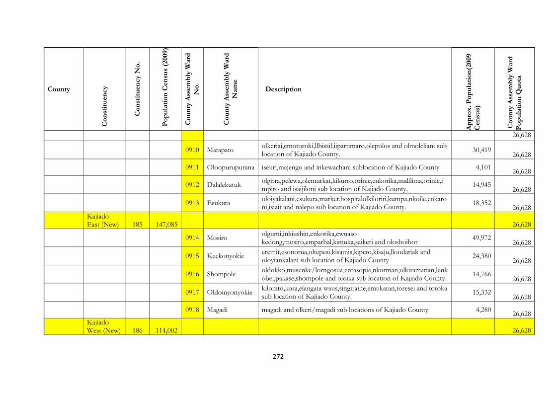
272
County
Co
nst
itu
en
cy
Co
nst
itu
en
cy N
o.
Po
pu
lati
on
Cen
sus
(2009)
Co
un
ty A
ssem
bly
Ward
No
.
Co
un
ty A
ssem
bly
Ward
Nam
e
Description
Ap
pro
x.
Po
pu
lati
on
(2009
Cen
sus)
Co
un
ty A
ssem
bly
Ward
Po
pu
lati
on
Qu
ota
26,628
0910 Matapato
olkeriai,emotoroki,llbissil,iipartimaro,olepolos and olmoleliani sub location of Kajiado County.
30,419
26,628
0911 Oloopurupurana iseuri,majengo and inkewachani sublocation of Kajiado County 4,101
26,628
0912 Dalalekutuk
olgirra,pelewa,olemurkat,kikurro,orinie,enkorika,malilima,orinie,impiro and isaijiloni sub location of Kajiado County.
14,945 26,628
0913 Esukuta
oloiyakalani,esukuta,market,hospitalolkiloriti,kumpa,nkoile,enkaroni,isiait and nalepo sub location of Kajiado County.
18,352 26,628
Kajiado East (New) 185 147,085
26,628
0914 Mosiro
olgumi,inkiushin,enkorika,ewuaso kedong,mosiro,emparbal,kimuka,saikeri and oloshoibor
49,972 26,628
0915 Keekonyokie
eremit,esonorua,oltepesi,kisamis,kipeto,kisaju,lloodariak and oloyiankalani sub location of Kajiado County
24,380 26,628
0916 Shompole
oldokko,musenke/lorngosua,entasopia,nkurman,olkiramatian,lenkobei,pakase,shompole and oloika sub location of Kajiado County.
14,766 26,628
0917 Oldoinyonyokie
kilonito,kora,elangata waus,singiraine,emukatan,toresei and toroka sub location of Kajiado County.
15,332
26,628
0918 Magadi magadi and olkeri/magadi sub locations of Kajiado County 4,280
26,628
Kajiado West (New) 186 114,002
26,628

273
County
Co
nst
itu
en
cy
Co
nst
itu
en
cy N
o.
Po
pu
lati
on
Cen
sus
(2009)
Co
un
ty A
ssem
bly
Ward
No
.
Co
un
ty A
ssem
bly
Ward
Nam
e
Description
Ap
pro
x.
Po
pu
lati
on
(2009
Cen
sus)
Co
un
ty A
ssem
bly
Ward
Po
pu
lati
on
Qu
ota
0919 Kenyawa
nkama,imbilin,imbuko,merrueshi,kiboko,masimba,email and sultan hamud sub locations of Kajiado County.
26,226 26,628
0920 llmaroro
mashuuru,arroi,lesonkoyo,kiloh,erankau andemarti sub location of Kajiado County.
17,096
26,628
0921 Kaputei North
enkirgiri,iiposolat,olturoto and kisaju/isinya sub location of Kajiado County.
22,171
26,628
0922 Kitengela
kitengela,sholinke and oloosirkon sub locations of Kajiado County.
34,175
26,628
Kajiado South 187 137,496
26,628
0923 Namanga meto,namanga and mailua sub locations of Kajiado County 22,295
26,628
0924 Entonet lenkisim and entonet sub locations of Kajiado County 6,274
26,628
0925 Kimana mbirikani and kimana sub location of Kajiado County 24,402
26,628
0926 Olorika
olorika/kuku and mitito andei west sub location of Kajiado County.
30,898
26,628
0927
Entarara/Oloolopon
oloolopon,entarara and rombo/njukini sub location of Kajiado County.
46,973
26,628
Kericho Kipkelion East
188 117 148
26,628
0928 Londiani, Jagoror,Kipsirichet,Chepkongony,TegunotKalyet and Saramek. 30,762
26,628
0929 Kedowa Kedowa,Kibiemit,Kisabo,Kimasian,Kimugul, and Kibiemit 27,459

274
County
Co
nst
itu
en
cy
Co
nst
itu
en
cy N
o.
Po
pu
lati
on
Cen
sus
(2009)
Co
un
ty A
ssem
bly
Ward
No
.
Co
un
ty A
ssem
bly
Ward
Nam
e
Description
Ap
pro
x.
Po
pu
lati
on
(2009
Cen
sus)
Co
un
ty A
ssem
bly
Ward
Po
pu
lati
on
Qu
ota
26,628
0930 Chesinende Chagaik,Chepsir,Cheymen,Kapkugerwet,Chesinende and Momoniat
29,705
26,628
0931 Tendeno Tendeno,Subukia,Sorget,Kongoni,Tuiyobei and Masaita. 22,643
26,628
Kipkelion West (New)
189 89 442
26,628
0932 Kokwet Chemogoch,Kapkwen,Chesonoi,Timbilil,Kokwet and Tulwoapmoi.
30,834
26,628
0933 Kimasian Chepkechei,Mutaragon,Kutung,Song’onyet,Bartera,Tuiyobei(Kipsegi),Leldet,Lelu and Kapkures.
26,940 26,628
0934 Barsiele Barsiele,Segetet,Ting’oro,Macheisok,Tombo,Kipkelion Town, and Lesirwa.
20,185
26,628
0935 Momoniat Siwot,Koisagat,Siret,Chepcholiet and Tugunon. 25,783
26,628
Ainamoi 190 144 313
26,628
0936 Kapsoit Kenegut,Chepsoo,Chepkoinik,Sitotwet,Kapsoit and Ketitui. 24554
26,628
0937 Ainamoi Poiywek,Ainamoi and Kipchimchim 24,037
26,628
0938 Kapkugerwet Kapkugerwet and Taiywet 26,605
26,628
0939 Chelimo Kapsuser(Part),Kakiptui(part), and Motobo. 18713
26,628

275
County
Co
nst
itu
en
cy
Co
nst
itu
en
cy N
o.
Po
pu
lati
on
Cen
sus
(2009)
Co
un
ty A
ssem
bly
Ward
No
.
Co
un
ty A
ssem
bly
Ward
Nam
e
Description
Ap
pro
x.
Po
pu
lati
on
(2009
Cen
sus)
Co
un
ty A
ssem
bly
Ward
Po
pu
lati
on
Qu
ota
0940 Township Township 36705
26,628
Bureti 191 167 649
26,628
0941 Roret/Kisiara . Mabasi,Roret,Mosore,Kelelwaand Kaproret, 21,402
26,628
0942 Tebesonik. Ngoina,Kelunet,,Kibugat,Siongi, Tebesonik,Kitome and Kapkisara.
20,912
26,628
0943 Cheborge/Cheboin.
Cheborge,Kabarus,Cheboin,Ng’ororga,Kimagit,Korongoi,Kaptele and Kapsogut.
22,834
26,628
0944 Chemosot Chemosot,Kusumek,Lalagin,Kapkarin,Getarwet,Chemoiywa,Kabartegan,Kipkerieny and Kaminnjeiwet.
32,944
26,628
0945 Litein Rungun,Litein,Roronya,Chemoiben,Ngesumin,Kamanamsim,Chebwagan,Cheribo,Kibwastuiyo,Kaminjeiwa and Arokyet.
35,151 26,628
0946 Cheplanget Butuik , Tiriitab Moita and Cheplanget. 17,300
26,628
0947 Kapkatet Sosit and Itoik. 17,106
26,628
Belgut 192 109 950
26,628
0948 WALDAI waldai Location of Bomet county 17,983
26,628
0949 Kabianga Chemalul, Kabianga and Mobego sublocations of Bomet county 24,260
26,628
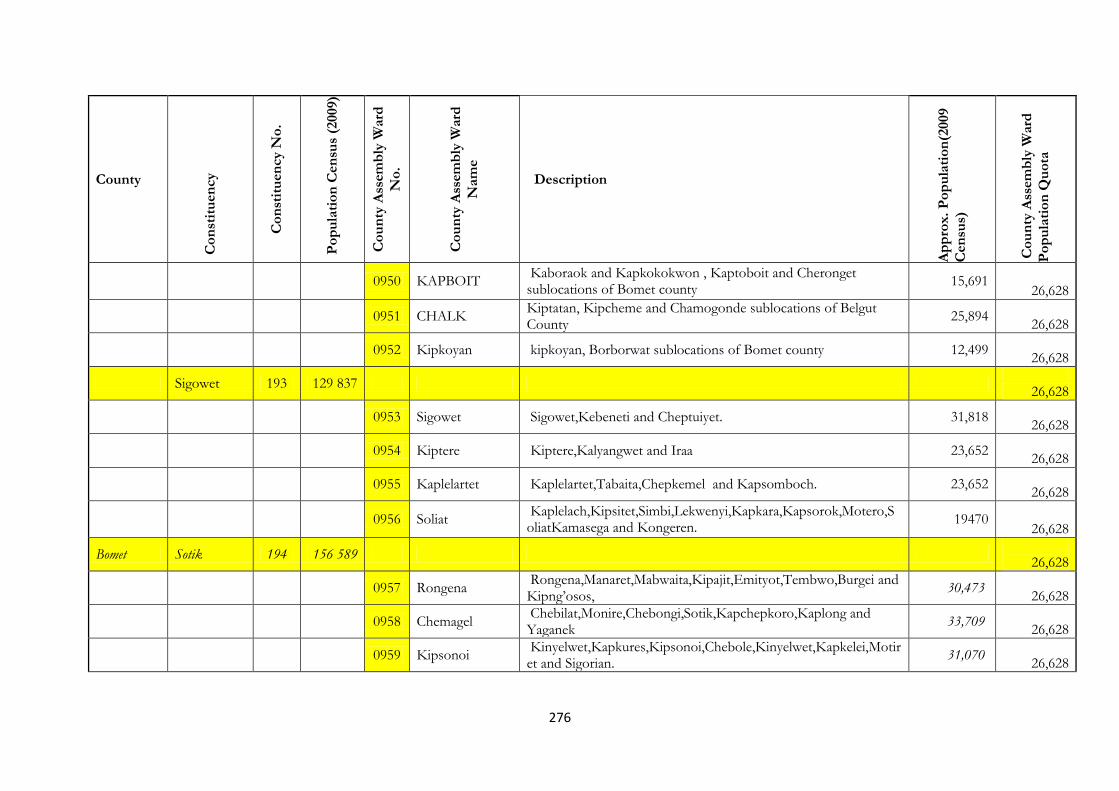
276
County
Co
nst
itu
en
cy
Co
nst
itu
en
cy N
o.
Po
pu
lati
on
Cen
sus
(2009)
Co
un
ty A
ssem
bly
Ward
No
.
Co
un
ty A
ssem
bly
Ward
Nam
e
Description
Ap
pro
x.
Po
pu
lati
on
(2009
Cen
sus)
Co
un
ty A
ssem
bly
Ward
Po
pu
lati
on
Qu
ota
0950 KAPBOIT Kaboraok and Kapkokokwon , Kaptoboit and Cheronget sublocations of Bomet county
15,691 26,628
0951 CHALK Kiptatan, Kipcheme and Chamogonde sublocations of Belgut County
25,894
26,628
0952 Kipkoyan kipkoyan, Borborwat sublocations of Bomet county 12,499
26,628
Sigowet 193 129 837
26,628
0953 Sigowet Sigowet,Kebeneti and Cheptuiyet. 31,818
26,628
0954 Kiptere Kiptere,Kalyangwet and Iraa 23,652
26,628
0955 Kaplelartet Kaplelartet,Tabaita,Chepkemel and Kapsomboch. 23,652
26,628
0956 Soliat Kaplelach,Kipsitet,Simbi,Lekwenyi,Kapkara,Kapsorok,Motero,SoliatKamasega and Kongeren.
19470 26,628
Bomet Sotik 194 156 589
26,628
0957 Rongena Rongena,Manaret,Mabwaita,Kipajit,Emityot,Tembwo,Burgei and Kipng’osos,
30,473
26,628
0958 Chemagel Chebilat,Monire,Chebongi,Sotik,Kapchepkoro,Kaplong and Yaganek
33,709
26,628
0959 Kipsonoi Kinyelwet,Kapkures,Kipsonoi,Chebole,Kinyelwet,Kapkelei,Motiret and Sigorian.
31,070
26,628
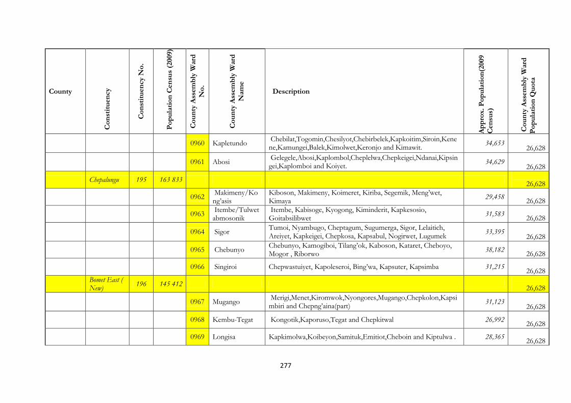
277
County
Co
nst
itu
en
cy
Co
nst
itu
en
cy N
o.
Po
pu
lati
on
Cen
sus
(2009)
Co
un
ty A
ssem
bly
Ward
No
.
Co
un
ty A
ssem
bly
Ward
Nam
e
Description
Ap
pro
x.
Po
pu
lati
on
(2009
Cen
sus)
Co
un
ty A
ssem
bly
Ward
Po
pu
lati
on
Qu
ota
0960 Kapletundo Chebilat,Togomin,Chesilyot,Chebirbelek,Kapkoitim,Siroin,Kenene,Kamungei,Balek,Kimolwet,Keronjo and Kimawit.
34,653 26,628
0961 Abosi Gelegele,Abosi,Kaplombol,Cheplelwa,Chepkeigei,Ndanai,Kipsingei,Kaplomboi and Koiyet.
34,629
26,628
Chepalungu 195 163 833
26,628
0962 Makimeny/Kong’asis
Kiboson, Makimeny, Koimeret, Kiriba, Segemik, Meng’wet, Kimaya
29,458
26,628
0963 Itembe/Tulwetabmosonik
Itembe, Kabisoge, Kyogong, Kiminderit, Kapkesosio, Goitabsilibwet
31,583
26,628
0964 Sigor Tumoi, Nyambugo, Cheptagum, Sugumerga, Sigor, Lelaitich, Areiyet, Kapkeigei, Chepkosa, Kapsabul, Nogirwet, Lugumek
33,395 26,628
0965 Chebunyo Chebunyo, Kamogiboi, Tilang’ok, Kaboson, Kataret, Cheboyo, Mogor , Riborwo
38,182
26,628
0966 Singiroi Chepwastuiyet, Kapoleseroi, Bing’wa, Kapsuter, Kapsimba 31,215
26,628
Bomet East ( New)
196 145 412
26,628
0967 Mugango Merigi,Menet,Kiromwok,Nyongores,Mugango,Chepkolon,Kapsimbiri and Chepng’aina(part)
31,123 26,628
0968 Kembu-Tegat Kongotik,Kaporuso,Tegat and Chepkitwal 26,992
26,628
0969 Longisa Kapkimolwa,Koibeyon,Samituk,Emitiot,Cheboin and Kiptulwa . 28,365
26,628
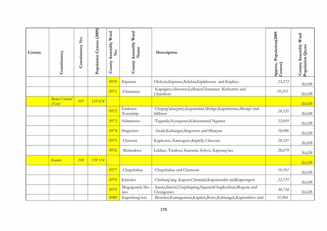
278
County
Co
nst
itu
en
cy
Co
nst
itu
en
cy N
o.
Po
pu
lati
on
Cen
sus
(2009)
Co
un
ty A
ssem
bly
Ward
No
.
Co
un
ty A
ssem
bly
Ward
Nam
e
Description
Ap
pro
x.
Po
pu
lati
on
(2009
Cen
sus)
Co
un
ty A
ssem
bly
Ward
Po
pu
lati
on
Qu
ota
0970 Kipreres Olokyin,Kipreres,Ndubai,Kiplabotwa and Kapliyo. 23,272
26,628
0971 Chemaner Kapsigiryo,Sitotwet,Lelkatet,Chemaner Kichutmo and Chambori.
19,233
26,628
Bomet Central (New)
197 155 074
26,628
0972 Emkwen Township
Chepng’aina(part),Kapsimbiri,Motigo,Kapsimotwa,Motigo and Silibwet
28,321
26,628
0973 Ndaraweta Teganda,Nyongores,Kabusareand Ngainet 22,059
26,628
0974 Singorwet Aisaik,Kabungut,Singorwet and Sibaiyan 18,496
26,628
0975 Chesoen Kapkoros, Kamogoso,Kiplelji, Chesoen 28,321
26,628
0976 Mutarakwa Leldaet, Tarakwa, Kanusin, Solyot, Kapsang’aru 20,679
26,628
Konoin 198 139 114
26,628
0977 Chepchabas Chepchabas and Chemosit 19,761
26,628
0978 Kimulot Chebang’ang ,Kapset,Chemalal,Kapsinendet andKapsengere 22,735
26,628
0979 Mogogosiek/Koiwo
Saseta,Simoti,Cheptingting,NgereritChepkochun,Mogone and Chongenwo
30,734
26,628
0980 Kaptebeng’wet Besiobei,Kamagomon,Kaptien,Boito,Kabiangek,Kaptembwo and 31,964

279
County
Co
nst
itu
en
cy
Co
nst
itu
en
cy N
o.
Po
pu
lati
on
Cen
sus
(2009)
Co
un
ty A
ssem
bly
Ward
No
.
Co
un
ty A
ssem
bly
Ward
Nam
e
Description
Ap
pro
x.
Po
pu
lati
on
(2009
Cen
sus)
Co
un
ty A
ssem
bly
Ward
Po
pu
lati
on
Qu
ota
Chemelet. 26,628
0981 Cheptalal/Embomos
Kimarwandi,Siomo,Embomos,Kirimose,Terek,Kiptenden,Satiet,Kugerwet,Bosto.
33,920
26,628
KAKAMEGA
Lugari 199 167,014
26,628
0982 Mautuma Consists of Makuyu and Mbagara Sublocations of Mautuma Location
25,082
26,628
0983 Lugari-Marakusi Consists of Lugari and Marakusi Sublocations of Lugari Location 31,381
26,628
0984 Mwamba-Munyuki
Consists of Mwamba and Munyuki Sub locations of Lumakanda Location
29,955
26,628
0985 Chekalini Koromaiti and Musembe sublocations of Chekalini Location 19,705
26,628
0986 Chevaywa Kivaywa, Kiliboti and Kulumbeni sub-locations of Chevaywa Location
33,145
26,628
0987 Lwandeti Luandeti, Maturu, Mabuye and Mahanga Sub-locations of Luandeti Location
27,746
26,628
Likuyani 200 125,137
26,628
0988 Likuyani Soy and Seregeya sub-locations of Likuyani Location 27,243
26,628
0989 Sango Sango and Mawe tatu sub-locations of Kongoni Location 22,853
26,628
0990 Kongoni Kongoni Sublocation of Kongoni Location 23,701
26,628
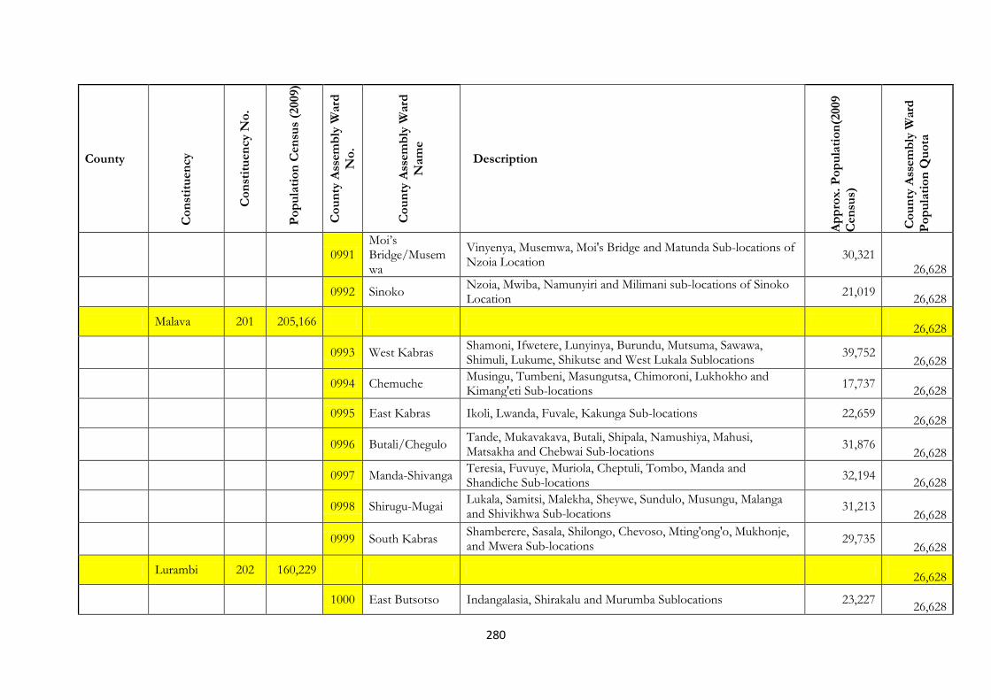
280
County
Co
nst
itu
en
cy
Co
nst
itu
en
cy N
o.
Po
pu
lati
on
Cen
sus
(2009)
Co
un
ty A
ssem
bly
Ward
No
.
Co
un
ty A
ssem
bly
Ward
Nam
e
Description
Ap
pro
x.
Po
pu
lati
on
(2009
Cen
sus)
Co
un
ty A
ssem
bly
Ward
Po
pu
lati
on
Qu
ota
0991 Moi’s Bridge/Musemwa
Vinyenya, Musemwa, Moi's Bridge and Matunda Sub-locations of Nzoia Location
30,321 26,628
0992 Sinoko Nzoia, Mwiba, Namunyiri and Milimani sub-locations of Sinoko Location
21,019
26,628
Malava 201 205,166
26,628
0993 West Kabras Shamoni, Ifwetere, Lunyinya, Burundu, Mutsuma, Sawawa, Shimuli, Lukume, Shikutse and West Lukala Sublocations
39,752 26,628
0994 Chemuche Musingu, Tumbeni, Masungutsa, Chimoroni, Lukhokho and Kimang'eti Sub-locations
17,737
26,628
0995 East Kabras Ikoli, Lwanda, Fuvale, Kakunga Sub-locations 22,659
26,628
0996 Butali/Chegulo Tande, Mukavakava, Butali, Shipala, Namushiya, Mahusi, Matsakha and Chebwai Sub-locations
31,876 26,628
0997 Manda-Shivanga Teresia, Fuvuye, Muriola, Cheptuli, Tombo, Manda and Shandiche Sub-locations
32,194
26,628
0998 Shirugu-Mugai Lukala, Samitsi, Malekha, Sheywe, Sundulo, Musungu, Malanga and Shivikhwa Sub-locations
31,213 26,628
0999 South Kabras Shamberere, Sasala, Shilongo, Chevoso, Mting'ong'o, Mukhonje, and Mwera Sub-locations
29,735
26,628
Lurambi 202 160,229
26,628
1000 East Butsotso Indangalasia, Shirakalu and Murumba Sublocations 23,227
26,628

281
County
Co
nst
itu
en
cy
Co
nst
itu
en
cy N
o.
Po
pu
lati
on
Cen
sus
(2009)
Co
un
ty A
ssem
bly
Ward
No
.
Co
un
ty A
ssem
bly
Ward
Nam
e
Description
Ap
pro
x.
Po
pu
lati
on
(2009
Cen
sus)
Co
un
ty A
ssem
bly
Ward
Po
pu
lati
on
Qu
ota
1001 South Butsotso Bukura, Matioli, Emukaya and Eshibeye Sublocations 17,377
26,628
1002 Central Butsotso Shibuli, Eshisiru and Shiyunzu Sub-locations 25,744
26,628
1003 Sheywe Sichirayi and Township sublocations 38,249
26,628
1004 Mahiakalo Mahiakalo Sub-location of Bukhungu Location 22,122
26,628
1005 Shirere Shirere Sub-location of Bukhungu Location 33,510
26,628
Navakholo 203 137,165
26,628
1006 Shinoyi – Shikomari – Esumeyia
Esumeyia, Shinoyi and Shikomari Sub-locations 25,352 26,628
1007 Ingotse – Matiha
Matiha and Ingotse Sub-locations 22,091
26,628
1008 Bunyala Central Mukhweso, sirigoi, Navakholo and Buchangu Sub-locations 29,193
26,628
1009 Bunyala East Sivilie and Namirama Sub-locations 22,122
26,628
1010 Bunyala West Sidikho, Kochwa, Budonga and Lusumu Sublocations 38,407
26,628
Mumias 204 123,094
26,628

282
County
Co
nst
itu
en
cy
Co
nst
itu
en
cy N
o.
Po
pu
lati
on
Cen
sus
(2009)
Co
un
ty A
ssem
bly
Ward
No
.
Co
un
ty A
ssem
bly
Ward
Nam
e
Description
Ap
pro
x.
Po
pu
lati
on
(2009
Cen
sus)
Co
un
ty A
ssem
bly
Ward
Po
pu
lati
on
Qu
ota
1011 Mumias Central Ward
Township, Lureko and Matawa Sublocations 37,214
26,628
1012 Mumias North Ward
Ekero and Nucleus Sublocations 26,997
26,628
1013 Etenje Buchifwi, Emasinjira, Bukeya and Shikalame Sub-locations 35,333
26,628
1014 Musanda Musanda, Bungasi, Eshihaka Sublocations 23,550
26,628
Mumias East
205 89,724
26,628
1015 Lusheya-Lubinu-Makunga Ward
Lusheya-Lubinu-Makunga Sublocations 37,111 26,628
1016 Khaunga-Malaha-Isongo ward
Khaunga-Malaha-Isongo ward Sublocations 28,042 26,628
1017 East Wanga ward
Eluche and Mung'ang'a Sublocations 24,571
26,628
Matungu 206 146,563
26,628
1018 Koyonzo Koyonzo, Indangalasia and Nanyeni Sublocation 35,812
26,628
1019 Kholera Kholera and Namulungu sublocation 28,821
26,628
1020 Khalaba Musamba and Khalaba Sublocation 19,778
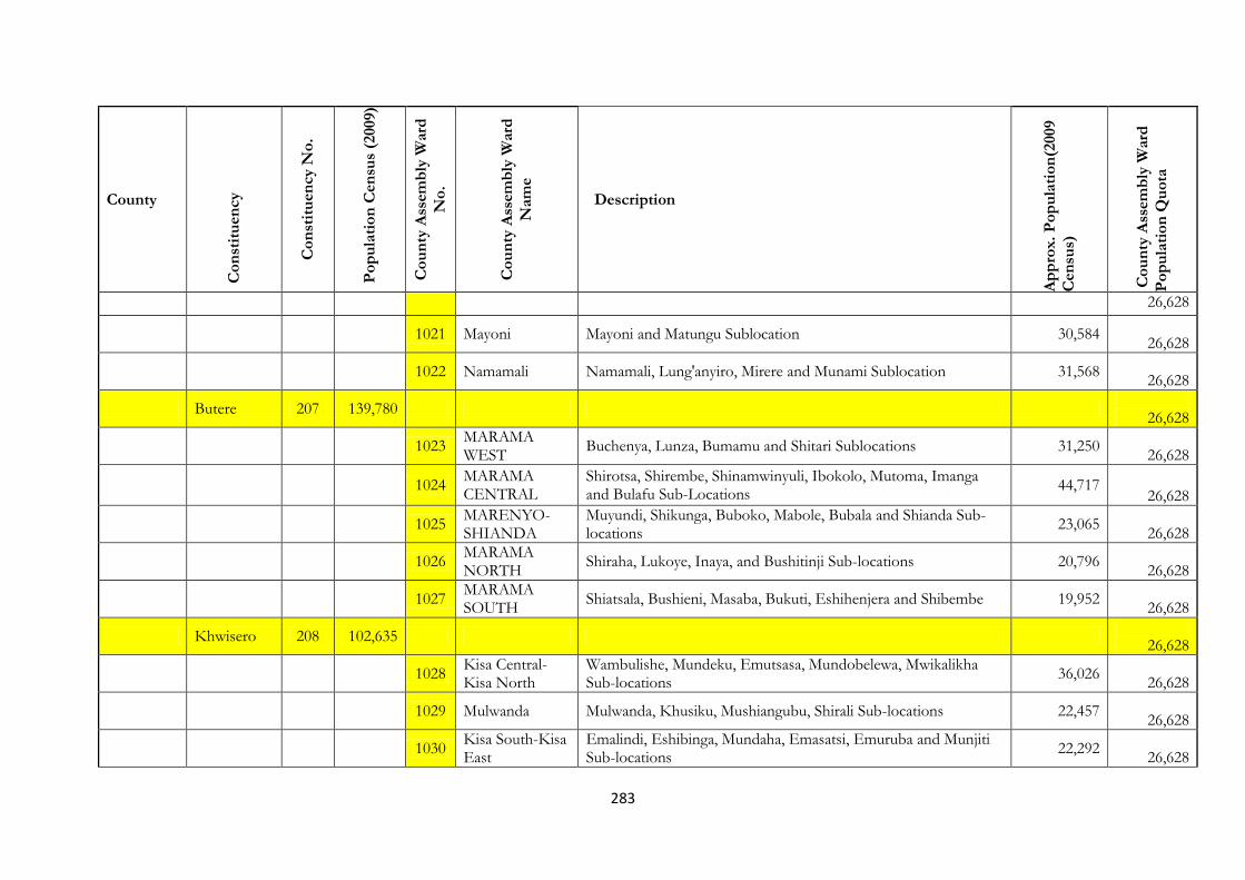
283
County
Co
nst
itu
en
cy
Co
nst
itu
en
cy N
o.
Po
pu
lati
on
Cen
sus
(2009)
Co
un
ty A
ssem
bly
Ward
No
.
Co
un
ty A
ssem
bly
Ward
Nam
e
Description
Ap
pro
x.
Po
pu
lati
on
(2009
Cen
sus)
Co
un
ty A
ssem
bly
Ward
Po
pu
lati
on
Qu
ota
26,628
1021 Mayoni Mayoni and Matungu Sublocation 30,584
26,628
1022 Namamali Namamali, Lung'anyiro, Mirere and Munami Sublocation 31,568
26,628
Butere 207 139,780
26,628
1023 MARAMA WEST
Buchenya, Lunza, Bumamu and Shitari Sublocations 31,250
26,628
1024 MARAMA CENTRAL
Shirotsa, Shirembe, Shinamwinyuli, Ibokolo, Mutoma, Imanga and Bulafu Sub-Locations
44,717 26,628
1025 MARENYO-SHIANDA
Muyundi, Shikunga, Buboko, Mabole, Bubala and Shianda Sub-locations
23,065
26,628
1026 MARAMA NORTH
Shiraha, Lukoye, Inaya, and Bushitinji Sub-locations 20,796
26,628
1027 MARAMA SOUTH
Shiatsala, Bushieni, Masaba, Bukuti, Eshihenjera and Shibembe 19,952
26,628
Khwisero 208 102,635
26,628
1028 Kisa Central-Kisa North
Wambulishe, Mundeku, Emutsasa, Mundobelewa, Mwikalikha Sub-locations
36,026
26,628
1029 Mulwanda Mulwanda, Khusiku, Mushiangubu, Shirali Sub-locations 22,457
26,628
1030 Kisa South-Kisa East
Emalindi, Eshibinga, Mundaha, Emasatsi, Emuruba and Munjiti Sub-locations
22,292
26,628

284
County
Co
nst
itu
en
cy
Co
nst
itu
en
cy N
o.
Po
pu
lati
on
Cen
sus
(2009)
Co
un
ty A
ssem
bly
Ward
No
.
Co
un
ty A
ssem
bly
Ward
Nam
e
Description
Ap
pro
x.
Po
pu
lati
on
(2009
Cen
sus)
Co
un
ty A
ssem
bly
Ward
Po
pu
lati
on
Qu
ota
1031 Kisa West Dudi, Muhaka Doho, Ebuhala, Ekomero Sub-locations 21,230
26,628
Shinyalu 209 159,475
26,628
1032 Kambiri Comprise of Lubao, Bulovi, Buyangu and Ivakale Sub-locations 23,496
26,628
1033 Murhanda Mukulusu, Shisembe, Shiswa, Itenyi Sub-locations 28,285
26,628
1034 Shibuye-Shing'oto
Shing'oto, Mukhango, Shiasava, Virhembe Sub-Locations 34,545
26,628
1035 Khayega-Lugose Shitochi, Museno, Shirulu, Lugose Sub-locations 25,003
26,628
1036 Ilesi-Shidodo Mukhonje, Malimili, Mugomari and Shidodo Sub-locations 30,216
26,628
1037 Ivihiga Kakamega Forest, Lunyu, Lukusi and Ikuywa Sublocations. 17,930
26,628
Ikolomani 210 104,669
26,628
1038 IDAKHO NORTH
Mutaho, Shikulu, Shiseso, Shimanyiro, Shivagala Sublocations 33,161
26,628
1039 IDAKHO WEST
Musoli, Shibuname, Lunenere, Mukongolo and Malinya Sub-locations
23,834
26,628
1040 IDAKHO EAST
Lirhembe, Savane, Makhokho, Shiveye, Ivonda and Shitoli sublocations
26,757
26,628
1041 IDAKHO Shabwali, Madivini, Kaluni, Shisejeri, Shanjetso and Lukose 20,917
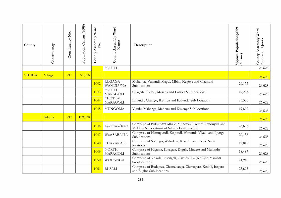
285
County
Co
nst
itu
en
cy
Co
nst
itu
en
cy N
o.
Po
pu
lati
on
Cen
sus
(2009)
Co
un
ty A
ssem
bly
Ward
No
.
Co
un
ty A
ssem
bly
Ward
Nam
e
Description
Ap
pro
x.
Po
pu
lati
on
(2009
Cen
sus)
Co
un
ty A
ssem
bly
Ward
Po
pu
lati
on
Qu
ota
SOUTH 26,628
VIHIGA Vihiga 211 91,616
26,628
1042 LUGAGA - WAMULUMA
Muhanda, Vunandi, Magui, Mbihi, Kegoye and Chambiti Sublocations
29,153
26,628
1043 SOUTH MARAGOLI
Chageda, Ideleri, Masana and Lusiola Sub-locations 19,293
26,628
1044 CENTRAL MARAGOLI
Emanda, Chango, Ikumba and Kidundu Sub-locations 23,370
26,628
1045 MUNGOMA Vigulu, Mahanga, Madzuu and Kisienye Sub-locations 19,800
26,628
Sabatia 212 129,678
26,628
1046 Lyaduywa/Izava Comprise of Bukulunya Mbale, Munoywa, Demesi Lyaduywa and Mukingi Sublocations of Sabatia Constituency
25,605 26,628
1047 West SABATIA Comprise of Hamuyundi, Kegondi, Wanondi, Viyalo and Igunga Sublocations
20,138
26,628
1048 CHAVAKALI Comprise of Solongo, Walodeya, Kisatiru and Evojo Sub-locations
19,815
26,628
1049 NORTH MARAGOLI
Comprise of Kigama, Kivagala, Digula, Mudete and Mulundu Sublocations
18,487
26,628
1050 WODANGA Comprise of Vokoli, Lusengeli, Gavudia, Gaigedi and Mambai Sub-locations
21,940
26,628
1051 BUSALI Comprise of Budaywa, Chamakanga, Chavogere, Kedoli, Itegero and Bugina Sub-locations
23,693 26,628
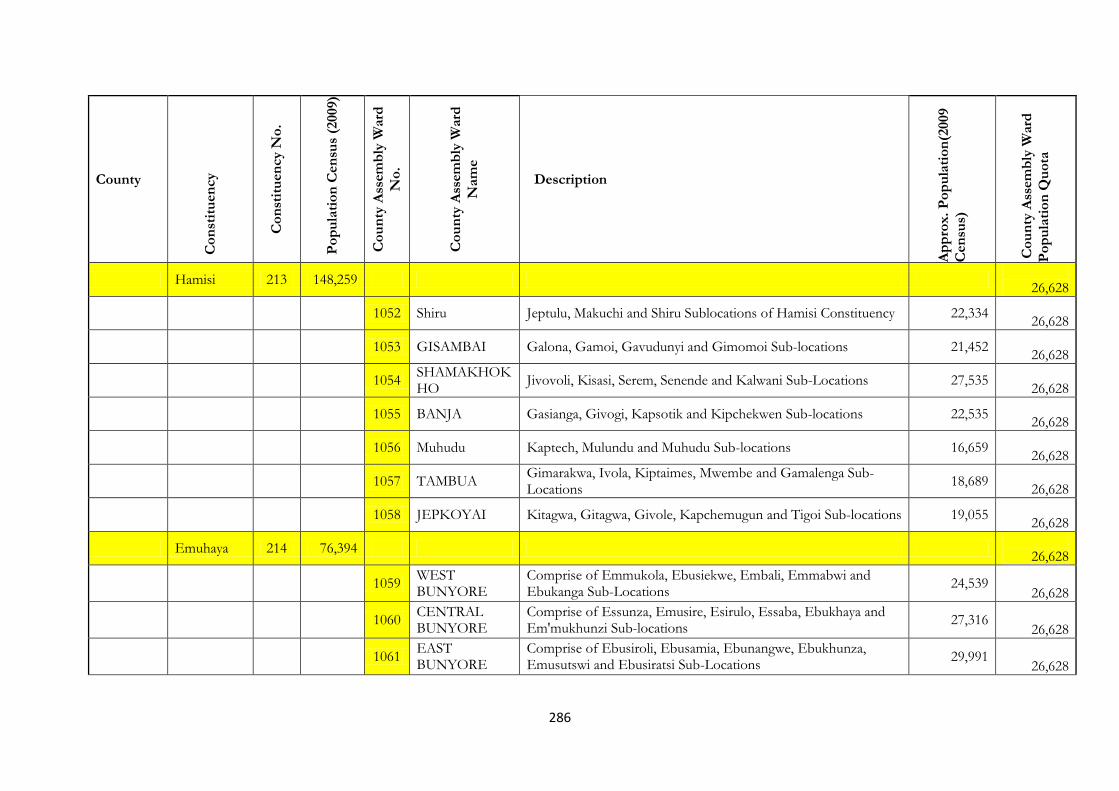
286
County
Co
nst
itu
en
cy
Co
nst
itu
en
cy N
o.
Po
pu
lati
on
Cen
sus
(2009)
Co
un
ty A
ssem
bly
Ward
No
.
Co
un
ty A
ssem
bly
Ward
Nam
e
Description
Ap
pro
x.
Po
pu
lati
on
(2009
Cen
sus)
Co
un
ty A
ssem
bly
Ward
Po
pu
lati
on
Qu
ota
Hamisi 213 148,259
26,628
1052 Shiru Jeptulu, Makuchi and Shiru Sublocations of Hamisi Constituency 22,334
26,628
1053 GISAMBAI Galona, Gamoi, Gavudunyi and Gimomoi Sub-locations 21,452
26,628
1054 SHAMAKHOKHO
Jivovoli, Kisasi, Serem, Senende and Kalwani Sub-Locations 27,535
26,628
1055 BANJA Gasianga, Givogi, Kapsotik and Kipchekwen Sub-locations 22,535
26,628
1056 Muhudu Kaptech, Mulundu and Muhudu Sub-locations 16,659
26,628
1057 TAMBUA Gimarakwa, Ivola, Kiptaimes, Mwembe and Gamalenga Sub-Locations
18,689
26,628
1058 JEPKOYAI Kitagwa, Gitagwa, Givole, Kapchemugun and Tigoi Sub-locations 19,055
26,628
Emuhaya 214 76,394
26,628
1059 WEST BUNYORE
Comprise of Emmukola, Ebusiekwe, Embali, Emmabwi and Ebukanga Sub-Locations
24,539 26,628
1060 CENTRAL BUNYORE
Comprise of Essunza, Emusire, Esirulo, Essaba, Ebukhaya and Em'mukhunzi Sub-locations
27,316 26,628
1061 EAST BUNYORE
Comprise of Ebusiroli, Ebusamia, Ebunangwe, Ebukhunza, Emusutswi and Ebusiratsi Sub-Locations
29,991
26,628
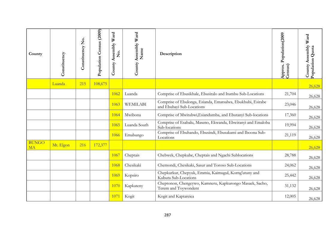
287
County
Co
nst
itu
en
cy
Co
nst
itu
en
cy N
o.
Po
pu
lati
on
Cen
sus
(2009)
Co
un
ty A
ssem
bly
Ward
No
.
Co
un
ty A
ssem
bly
Ward
Nam
e
Description
Ap
pro
x.
Po
pu
lati
on
(2009
Cen
sus)
Co
un
ty A
ssem
bly
Ward
Po
pu
lati
on
Qu
ota
Luanda 215 108,675
26,628
1062 Luanda Comprise of Ebusikhale, Ebusiralo and Itumbu Sub-Locations 21,704
26,628
1063 WEMILABI Comprise of Ebulonga, Esianda, Ematsalwa, Ebukhubi, Esirabe and Ebubayi Sub-Locations
23,046 26,628
1064 Mwibona Comprise of Mwitubwi,Esiandumba, and Ebutanyi Sub-locations 17,360
26,628
1065 Luanda South Comprise of Esabalu, Maseno, Ekwanda, Ebwiranyi and Emaloba Sub-locations
19,994
26,628
1066 Emabungo Comprise of Ebuhando, Ebusindi, Ebusakami and Iboona Sub-Locations
21,119
26,628
BUNGOMA
Mt. Elgon 216 172,377
26,628
1067 Cheptais Chebwek, Chepkube, Cheptais and Ngachi Sublocations 28,788
26,628
1068 Chesikaki Chemondi, Chesikaki, Sasur and Toroso Sub-Locations 24,062
26,628
1069 Kopsiro Chepkurkur, Chepyuk, Emmia, Kaimugul, Korng'utuny and Kubura Sub-Locations
25,442
26,628
1070 Kapkateny Cheptonon, Chengeywo, Kamneru, Kapkurongo Masaek, Sacho, Terem and Toywondent
31,132 26,628
1071 Kogit Kogit and Kaptareiea 12,005
26,628
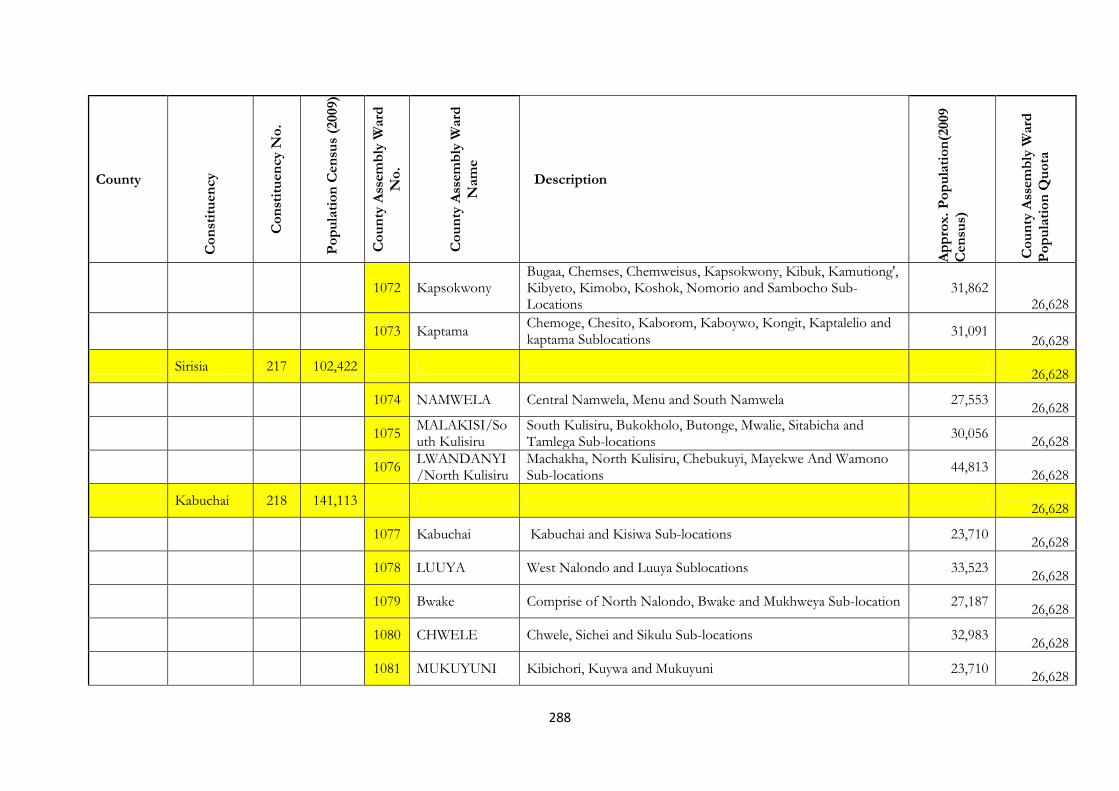
288
County
Co
nst
itu
en
cy
Co
nst
itu
en
cy N
o.
Po
pu
lati
on
Cen
sus
(2009)
Co
un
ty A
ssem
bly
Ward
No
.
Co
un
ty A
ssem
bly
Ward
Nam
e
Description
Ap
pro
x.
Po
pu
lati
on
(2009
Cen
sus)
Co
un
ty A
ssem
bly
Ward
Po
pu
lati
on
Qu
ota
1072 Kapsokwony Bugaa, Chemses, Chemweisus, Kapsokwony, Kibuk, Kamutiong', Kibyeto, Kimobo, Koshok, Nomorio and Sambocho Sub-Locations
31,862 26,628
1073 Kaptama Chemoge, Chesito, Kaborom, Kaboywo, Kongit, Kaptalelio and kaptama Sublocations
31,091 26,628
Sirisia 217 102,422
26,628
1074 NAMWELA Central Namwela, Menu and South Namwela 27,553
26,628
1075 MALAKISI/South Kulisiru
South Kulisiru, Bukokholo, Butonge, Mwalie, Sitabicha and Tamlega Sub-locations
30,056
26,628
1076 LWANDANYI/North Kulisiru
Machakha, North Kulisiru, Chebukuyi, Mayekwe And Wamono Sub-locations
44,813
26,628
Kabuchai 218 141,113
26,628
1077 Kabuchai Kabuchai and Kisiwa Sub-locations 23,710
26,628
1078 LUUYA West Nalondo and Luuya Sublocations 33,523
26,628
1079 Bwake Comprise of North Nalondo, Bwake and Mukhweya Sub-location 27,187
26,628
1080 CHWELE Chwele, Sichei and Sikulu Sub-locations 32,983
26,628
1081 MUKUYUNI Kibichori, Kuywa and Mukuyuni 23,710
26,628
289
County
Co
nst
itu
en
cy
Co
nst
itu
en
cy N
o.
Po
pu
lati
on
Cen
sus
(2009)
Co
un
ty A
ssem
bly
Ward
No
.
Co
un
ty A
ssem
bly
Ward
Nam
e
Description
Ap
pro
x.
Po
pu
lati
on
(2009
Cen
sus)
Co
un
ty A
ssem
bly
Ward
Po
pu
lati
on
Qu
ota
Bumula 219 178,897
26,628
1082 South Bukusu Lunao, Bumula, Lumboka, Mateka and Muanda Sublocations 35,724
26,628
1083 Khasoko Kimatuni, Mabusi, Khasoko, Mungore and Namatotoa Sub-locations
33,369
26,628
1084 Kabula Kabula and Watoya Sub-locations 20,756
26,628
1085 West Bukusu Kibuke, Lwanja, Mayanja, Ng'oli and Nakhwana Sub-Locations 28,119
26,628
1086 Kimaeti/Napara Bitobo, Khasolo and Siyombe Sub-location 28,422
26,628
1087 Mukwa Kisawayi, Mukwa 14,297
26,628
1088 Siboti East Siboti, and Musakasa Sub-Locations 18,210
26,628
Kanduyi 220 229,701
26,628
1089 Bukembe West Ndengelwa and Namirembe Sub-Locations 20,311
26,628
1090 Bukembe East Comprise of North Sang'alo and Kongoli sublocation 26,749
26,628
1091 Township Comprise of Township Ward 19,017
26,628
1092 Khalaba Comprise of Khalaba Sublocation 24,499
290
County
Co
nst
itu
en
cy
Co
nst
itu
en
cy N
o.
Po
pu
lati
on
Cen
sus
(2009)
Co
un
ty A
ssem
bly
Ward
No
.
Co
un
ty A
ssem
bly
Ward
Nam
e
Description
Ap
pro
x.
Po
pu
lati
on
(2009
Cen
sus)
Co
un
ty A
ssem
bly
Ward
Po
pu
lati
on
Qu
ota
26,628
1093 Nyamasanda/Tuti
Tuti and Namasanda Sublocation of Bungoma County 29,069
26,628
1094 Musikoma Namasanda and South Kanduyi Sub-Location 37,933
26,628
1095 East Sangalo East Sang'alo and Mwikhupo Sub-Locations 32,288
26,628
1096 Tuuti Marakaru Tuuti and Marakaru Sub-Locations 35,781
26,628
1097 West Sangalo West Sang'alo and Namwacha Sublocations 33,123
26,628
Webuye 221 113,073
26,628
1098 Chetambe Comprise of Mihuu and Mitikuyu sub-Locations 23,620
26,628
1099 Ndivisi/Lugusi Comprise of Misimo, Lutacho, Magemo and Sitabicha/Sinoko Sub-locations
33,257
26,628
1100 Namarambi Wabukonyi, Marinda, Misemwa and Makuselwa Sub-Locations 20,722
26,628
1101 Webuye Township
Matulo(part), Webuye Township and Maraka Sub-Locations 35,474
26,628
Bokoli 222 117,180
26,628
1102 Sitikho Sitikho, Milo and Khalumuli Sublocation 30,055
26,628

291
County
Co
nst
itu
en
cy
Co
nst
itu
en
cy N
o.
Po
pu
lati
on
Cen
sus
(2009)
Co
un
ty A
ssem
bly
Ward
No
.
Co
un
ty A
ssem
bly
Ward
Nam
e
Description
Ap
pro
x.
Po
pu
lati
on
(2009
Cen
sus)
Co
un
ty A
ssem
bly
Ward
Po
pu
lati
on
Qu
ota
1103 Matisi/Malaha/Matulo
Malaha, Matisi, Matulo(part) and Webuye Township(part) Sub-locations
30,367
26,628
1104 Misikhu Misikhu and Kituni Sublocations 31,382
26,628
1105 Miendo/Bokoli Bokoli, Mahanga and Miendo Sublocations 25,376
26,628
Kimilili 223 132,822
26,628
1106 Chebukwabi Chebukwabi and Kibingei Sublocation 34,458
26,628
1107 Kimili Kimilili rural and Township Sublocations 36,267
26,628
1108 Maeni Nasusi and Sikhendu Sub-locations 24,209
26,628
1109 Kamukuywa Makhonge and Nabikoto Sub-location 37,888
26,628
Tongaren 224 187,478
26,628
1110 Milima Comprise of Milima Sub-Location 33,352
26,628
1111 Mbakalo Kibisi and Mbakalo Sub-location 32,229
26,628
1112 Naitiri/Kabuyefwe
Kabuyefwe, Naitiri and Sirakalu Sub-location 38,023
26,628
1113 Soysambu Soysambu sub-location of Bungomma county 17,704
292
County
Co
nst
itu
en
cy
Co
nst
itu
en
cy N
o.
Po
pu
lati
on
Cen
sus
(2009)
Co
un
ty A
ssem
bly
Ward
No
.
Co
un
ty A
ssem
bly
Ward
Nam
e
Description
Ap
pro
x.
Po
pu
lati
on
(2009
Cen
sus)
Co
un
ty A
ssem
bly
Ward
Po
pu
lati
on
Qu
ota
26,628
1114 Tongaren Comprise of Tongaren Soysambu sub-location 24,970
26,628
1115 Kimini Comprise of Tabani and Kiminini Sublocation 16,455
26,628
1116 Ndalu Comprise of Ndalu and Mitua Sub-location 24,745
26,628
BUSIA Teso North 225 117,947
26,628
1117 Malaba Central Akiriamasit, Amagoro, Ikapolok, Kajei, Komirai, Olobai and Township
25,192
26,628
1118 Malaba North Kakoli, Korisai, Koruruma, Okuleu, Onyurnyur (of Osajai Location) and Osasame Sub-Locations
13,765 26,628
1119 Ang'urai South Aedomoru, Akachachat, Akolong', Kakapel, Katelepai, Kakalet and Rwatama Sub-Locations
20,791 26,628
1120 Ang'urai North Adumai, Apokor, Chelelemuk, Kakurkit, Katotoi, Kolait, Moding Sublocations
19,008
26,628
1121 Ang'urai East Akobwait, Aloete, Aterait, Changara, Kakamer and Kolanya Sub-locations
13,699
26,628
1122 Malaba South Kamolo, Keng'atuny, Kiriko, Kocholia, Kodedema, Kokare, Koteko, Onyurnyur (of Kamolo Location) Sub-Locations
19,250 26,628
Teso South 226 137,924
26,628
1123 Busia Township Comprise of Agolot, Alupe and Amerikwai Sub-Locations 26,162
293
County
Co
nst
itu
en
cy
Co
nst
itu
en
cy N
o.
Po
pu
lati
on
Cen
sus
(2009)
Co
un
ty A
ssem
bly
Ward
No
.
Co
un
ty A
ssem
bly
Ward
Nam
e
Description
Ap
pro
x.
Po
pu
lati
on
(2009
Cen
sus)
Co
un
ty A
ssem
bly
Ward
Po
pu
lati
on
Qu
ota
26,628
1124 Chakol South Comprise of Adungosi, Alumodoi, Amaase, Obuchun, Ong'ariama, Okiludu, Olepito, Ong'aroi and Otimong' Sub-locations
31,571 26,628
1125 Chakol North Comprise of Achit, Akites, Aludeka. Aterait, Moru Karisa and Ng'elechom Sub-Locations
18,655 26,628
1126 Amukura West Comprise of Aderema, Akiriamas, Akoret, Odiyoi, Okook and Osuret Sub-Locations
17,423
26,628
1127 Amukura East Comprise of Akobwait, Amukura, Aturet, Kidera, Kochek, Kotur, Kwalamor and Okisimo Sub- Locations
19,571 26,628
1128 Amukura Central
Comprise of Apatit, Apokor, Kaliwa, Katelenyang' and Okatekok Sub-Locations
24,542
26,628
Nambale 227 94,637
26,628
1129 NAMBALE TOWNSHIP
Nambale, Kisoko and Siekunya Sub-Locations 32,293
26,628
1130 BUKHAYO NORTH/WALATSI
Kapina, Khwilare, Lupida and Musokoto Sub-Locations 22,459 26,628
1131 BUKHAYO EAST
Buyofu, Madibo, Mungatsi and Sikinga Sub-Locations 21,696
26,628
1132 Bukhayo Central/Lwanyange
Lwanyange, Malanga and Sidende Sub-Locations 18,189 26,628

294
County
Co
nst
itu
en
cy
Co
nst
itu
en
cy N
o.
Po
pu
lati
on
Cen
sus
(2009)
Co
un
ty A
ssem
bly
Ward
No
.
Co
un
ty A
ssem
bly
Ward
Nam
e
Description
Ap
pro
x.
Po
pu
lati
on
(2009
Cen
sus)
Co
un
ty A
ssem
bly
Ward
Po
pu
lati
on
Qu
ota
Matayos 228 111,345
26,628
1133 BUKHAYO WEST
Bugengi and Esikulu Sub-Locations 23,514
26,628
1134 Mayenye Comprise of Mayenje and Mundika Sublocation 19,136
26,628
1135 MATAYOS SOUTH
Buyama, Lung'a, Mabunge, Busende, Igero, Luliba, Murende, Munyafwa, and Nang'oma
30,874 26,628
1136 BUSIBWABO Nakhakina, Alung'oli and Nasira 11,328
26,628
1137 Burumba Comprised of Mjini Sub-Location 26,493
26,628
Butula 229 121,870
26,628
1138 MARACHI WEST
Bujumba, Bukhakhala, Bumala 'a', Burinda, Busire, Ikonzo and Namwitsula
28,231
26,628
1139 MARACHI CENTRAL
Bulemia, Bukati, Kanjala and Sikarira Sub-Locations 16,764
26,628
1140 Bukhalalire Bukhalalire and Kingandole Sub-locations 19,209
26,628
1141 MARACHI EAST
Tingolo, Bumala'B' and Elukongo Sublocations 31,669
26,628
1142 Elugulu Comprise of Bulwani, Bwaliro and Emukhweso Sub-Locations 11,463
26,628
1143 Marachi Esikoma and Namusala Sub-Locations 14,534

295
County
Co
nst
itu
en
cy
Co
nst
itu
en
cy N
o.
Po
pu
lati
on
Cen
sus
(2009)
Co
un
ty A
ssem
bly
Ward
No
.
Co
un
ty A
ssem
bly
Ward
Nam
e
Description
Ap
pro
x.
Po
pu
lati
on
(2009
Cen
sus)
Co
un
ty A
ssem
bly
Ward
Po
pu
lati
on
Qu
ota
North/Esikoma 26,628
Funyula 230 93,500
26,628
1144 Bwiri Busembe, Busijo, Hakati and Namuduru Sub-Locations 19,786
26,628
1145 Funyula South Ageng'a, Bujwang'a Bukiri, Nanderema, Ojibo, Rumbiye and Sigalame Sublocations
25,378
26,628
1146 Nangina Comprise of Wakhungu, Budalanga, Sigulu, Bukhulungu, Sirekeresi, Luchumilo, Luanda and Buloma Sublocations
23,519 26,628
1147 Funyula North Comprise of Ganjala, Kabwodo, Ludacho, Lugala, Mango, Mudoma, Namboboto, Nyakhobi, Odiado and Sibinga Sub-Locations
24,817 26,628
Budalangi 231 66,723
26,628
1148
BUNYALA NORTH
Comprise of Budalangi, Mudembi, Mundere, Ruambwa and Sisenye Sublocations
20,948
26,628
1149 BUKANI
Comprise of Bukani, Bukoma, Bulemia and Siginga Sub-Locations
21,237
26,628
1150 BUNYALA SOUTH
Ebulwani, Lugale, Mabinju-Mabusu, Magombe Central, Magombe East, Magombe West, Obaro, Rugunga and Rukala
24,538
26,628
SIAYA Ugenya 232 95,382
26,628
1151
North East Ugenya
yiro east,yiro west,simenya and rangala sub locations of Siaya County
20,499
26,628

296
County
Co
nst
itu
en
cy
Co
nst
itu
en
cy N
o.
Po
pu
lati
on
Cen
sus
(2009)
Co
un
ty A
ssem
bly
Ward
No
.
Co
un
ty A
ssem
bly
Ward
Nam
e
Description
Ap
pro
x.
Po
pu
lati
on
(2009
Cen
sus)
Co
un
ty A
ssem
bly
Ward
Po
pu
lati
on
Qu
ota
1152 North Alego nyamula,nyalgunga and hono sublocation of Siaya County 15,363
26,628
1153 Ugunja
ugunja,ngunya,ambira,umala,rambula south,north rambula and magoya sub location of Siaya County
14,299 26,628
1154 Uholo
got osimbo,mungao,sigomre,madungu,asango east,asango west,tingare west and tingare east sub location of siaya county
19,632 26,628
1155 Ambira
Ambira, Umala, Ngunya, Ugunja, Rambula North, Rambula South and Mugoya Sublocations of Siaya County
25,589 26,628
Ugunja 233 121,379
26,628
1156 North Ugenya
Nyalenya, Kagonya, Uyundo, Ndenga, Karadolo East and Karadolo West Sublocations of Siaya County
32,953 26,628
1157 North Uholo
Tingare West, Asango West, Asango East, North Rambula, South Rambula and Mageyo Sublocations of Siaya County
19,221 26,628
1158 Ukwala
Yenga. Siranga, Simur, Simur Kondiek, Doho East, Doho West, Masat East, Masat West, Sifuyo West and Sifuyo East Sublocations of Siaya County.
30,626 26,628
1159
North East Ugenya
Jera, Ramunde, Sihayi,Anyiko, Ligega, Kathieno ‘a’, Kathieno ‘b’ and Kathieno ‘c’ Sublocations of Siaya County
25,355
26,628
Alego Usonga 234 187,243
26,628
1160 Usonga
Sumba, Nyadorera ‘a’ and Nyadorera ‘b’ Sublocations of Siaya County
13,601
26,628

297
County
Co
nst
itu
en
cy
Co
nst
itu
en
cy N
o.
Po
pu
lati
on
Cen
sus
(2009)
Co
un
ty A
ssem
bly
Ward
No
.
Co
un
ty A
ssem
bly
Ward
Nam
e
Description
Ap
pro
x.
Po
pu
lati
on
(2009
Cen
sus)
Co
un
ty A
ssem
bly
Ward
Po
pu
lati
on
Qu
ota
1161 West Alego
Kalkada Uradi, Komenya Kalaka, Komenya Kowala, Kodiere and Mahola Ulawe Sublocations of Siaya County
14,370 26,628
1162
South West Alego
Gangu, Kaugagi Hawinga, Kaugagi Udenda, Sigoma Uraga and Kabura Uhuyi Sublocations of Siaya County
17,864
26,628
1163 Central Alego
Ojuando ‘a’ Ojuando ‘b’, Kochieng ‘a’ Kochieng ‘a’, Koyeyo, Kakumu Kombewa, Kadenge and Obambo.
30,993 26,628
1164 Siaya Township
Holo, Komolo, Mulaha, Nyandiwa and Karapul Sublocations of Siaya County
45,583
26,628
1165 East Alego
Nyang’oma, Masumbi, Mur-ng’iya, Olwa, Umala, Ulafu and Bar-agulu Sublocations of Siaya County
31,090 26,628
1166 South Alego
Randago, Bar- olengo, Mur-malanga, Bar- osimbo, Nyajuok, Bar-ding and Pap-oriang Sublocations of Siaya County
25,363
26,628
Gem 235 160,675
26,628
1167 North Gem
Malanga, Got Regea, Ndere, Nyabeda, Lundha and Maliera Sublocations of Siaya County
26,593 26,628
1168 West Gem
Asayi, Sirembe, Malunga West, Malunga Central, Malunga East, Wagai West, Wagai East and Uriri Sublocations of Siaya County.
25,318 26,628
1169 Central Gem
Gongo, Nyandiwa, Nyawara, Siriwo and Kagilo Sublocations of Siaya County.
23,854
26,628
1170
North East Gem
Anyiko, Sauri, Nyamninia and Jina Sublocations pf Siaya County. 23,151
26,628
1171 East Gem
Marenyo, Uranga, Lihanga and Ramula Sublocations of Siaya County.
24,764
26,628

298
County
Co
nst
itu
en
cy
Co
nst
itu
en
cy N
o.
Po
pu
lati
on
Cen
sus
(2009)
Co
un
ty A
ssem
bly
Ward
No
.
Co
un
ty A
ssem
bly
Ward
Nam
e
Description
Ap
pro
x.
Po
pu
lati
on
(2009
Cen
sus)
Co
un
ty A
ssem
bly
Ward
Po
pu
lati
on
Qu
ota
1172 South Gem
Dienya East, Dienya West, Nguge, Rera, Kambare, Ndori, Kanyadet, Kaudha East, Kaudha West, Onyinyore and Gombe Sublocations of Siaya County.
36,995 26,628
Bondo 236 157,522
26,628
1173 Got Agulu
usennge,got agulu,mahanga, and mitundu sub location of Siaya County
28,503
26,628
1174 Ndeda/Oyamo ndeda/oyamo and uyawi sub location of siaya county. 11,097
26,628
1175 Nyaguda
nyaguda,got abiero,East Migwena,West migwena and nyangoma sub location of siaya county.
27,729 26,628
1176 Bar-Kanyango
usigu,got ramogi,bar-kanyango,nyamonye,othach and pala sub locations of Siaya County
27,189 26,628
1177 Kapiyo
utonga,kapiyo,maranda,usire and nyawita sub location of siaya county.
25,313
26,628
1178 Abom
bar kowino,ajigo,bar chando and abom sub location of siaya county
33,164
26,628
Rarieda 237 134,558
26,628
1179 North Ramba
omia mwalo,omia diere,omia malo,south ramba and north ramba sub locations of Siaya County.
32,486 26,628
1180 Akom
nyagoko,siger,mahaya,akom, and mamba sub location of Siaya County.
33,072
26,628
1181 East Katwenga
masala,rachar,kobong,west katwenga,,ochienga,east katwenga and ragegni sub location of Siaya County.
29,111 26,628

299
County
Co
nst
itu
en
cy
Co
nst
itu
en
cy N
o.
Po
pu
lati
on
Cen
sus
(2009)
Co
un
ty A
ssem
bly
Ward
No
.
Co
un
ty A
ssem
bly
Ward
Nam
e
Description
Ap
pro
x.
Po
pu
lati
on
(2009
Cen
sus)
Co
un
ty A
ssem
bly
Ward
Po
pu
lati
on
Qu
ota
1182 Lieta lieta,ndigwa and naya sub location of Siaya County. 19,536
26,628
1183 Kagwa nyabera,kokwiri and kagwa sub location of Siaya County. 19,953
26,628
KISUMU Kisumu East 238 150,124
26,628
1184
Mkendwa/Kajulu
Mkendwa, Konya, Okok, Got Nyabondo, Kadero_K, and Wathorego Sub-Locations of Kisumu County.
41,908 26,628
1185 Chiga Chiga Sub-Location of Kisumu County. 9,876
26,628
1186 East Kolwa Nyalunya and Mayenya Sub-Locations of Kisumu County 10,000
26,628
1187 Buoye Buoye Sub-Location of Kisumu County 5,789
26,628
1188
Manyatta/Central Kolwa
Manyatta B and Kasule Sub-Locations of Kisumu County. 37,204
26,628
Kisumu West 239 143,800
26,628
1189 South West Ojolla, Osiri and Kanyawegi sub locations of Kisumu County 22,126
26,628
1190 Central Kisumu
Korando ‘a’, korando ‘b’ and Kogony sublocation of Kisumu County
38,128
26,628
1191 Kisumu North dago,bar ‘a’, bar ‘b’ and Nyahera sub location of Kisumu County 23,858
26,628
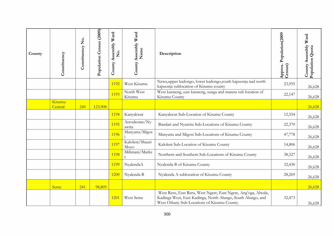
300
County
Co
nst
itu
en
cy
Co
nst
itu
en
cy N
o.
Po
pu
lati
on
Cen
sus
(2009)
Co
un
ty A
ssem
bly
Ward
No
.
Co
un
ty A
ssem
bly
Ward
Nam
e
Description
Ap
pro
x.
Po
pu
lati
on
(2009
Cen
sus)
Co
un
ty A
ssem
bly
Ward
Po
pu
lati
on
Qu
ota
1192 West Kisumu
Newa,upper kadongo, lower kadongo,south kapuonja nad north kapuonja sublocation of Kisumu county
23,955 26,628
1193
North West Kisumu
West karateng, east karateng, sunga and marera sub location of Kisumu County
22,147
26,628
Kisumu Central 240 123,908
26,628
1194 Kanyakwar Kanyakwar Sub-Location of Kisumu County 12,554
26,628
1195
Aerodrome/Nyawita
Bandari and Nyawita Sub-Locations of Kisumu County 22,370
26,628
1196
Manyatta/Migosi
Manyatta and Migosi Sub-Locations of Kisumu County 47,778
26,628
1197
Kaloleni/Shauri Moyo
Kaloleni Sub-Location of Kisumu County 14,806
26,628
1198
Milimani/Market
Northern and Southern Sub-Locations of Kisumu County 38,527
26,628
1199 NyalendaA Nyalenda B of Kisumu County 32,430
26,628
1200 Nyalenda B Nyalenda A sublocation of Kisumu County 28,269
26,628
Seme 241 98,805
26,628
1201 West Seme West Reru, East Reru, West Ngere, East Ngere, Ang’oga, Alwala, Kadinga West, East Kadinga, North Alungo, South Alungo, and West Othany Sub-Locations of Kisumu County.
32,473 26,628
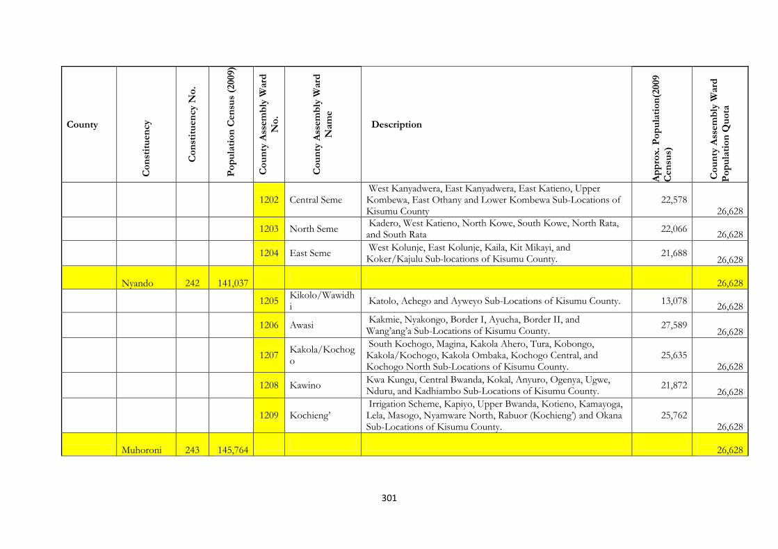
301
County
Co
nst
itu
en
cy
Co
nst
itu
en
cy N
o.
Po
pu
lati
on
Cen
sus
(2009)
Co
un
ty A
ssem
bly
Ward
No
.
Co
un
ty A
ssem
bly
Ward
Nam
e
Description
Ap
pro
x.
Po
pu
lati
on
(2009
Cen
sus)
Co
un
ty A
ssem
bly
Ward
Po
pu
lati
on
Qu
ota
1202 Central Seme
West Kanyadwera, East Kanyadwera, East Katieno, Upper Kombewa, East Othany and Lower Kombewa Sub-Locations of Kisumu County
22,578 26,628
1203 North Seme
Kadero, West Katieno, North Kowe, South Kowe, North Rata, and South Rata
22,066
26,628
1204 East Seme
West Kolunje, East Kolunje, Kaila, Kit Mikayi, and Koker/Kajulu Sub-locations of Kisumu County.
21,688 26,628
Nyando 242 141,037
26,628
1205
Kikolo/Wawidhi
Katolo, Achego and Ayweyo Sub-Locations of Kisumu County. 13,078
26,628
1206 Awasi
Kakmie, Nyakongo, Border I, Ayucha, Border II, and Wang’ang’a Sub-Locations of Kisumu County.
27,589 26,628
1207
Kakola/Kochogo
South Kochogo, Magina, Kakola Ahero, Tura, Kobongo, Kakola/Kochogo, Kakola Ombaka, Kochogo Central, and Kochogo North Sub-Locations of Kisumu County.
25,635 26,628
1208 Kawino
Kwa Kungu, Central Bwanda, Kokal, Anyuro, Ogenya, Ugwe, Nduru, and Kadhiambo Sub-Locations of Kisumu County.
21,872 26,628
1209 Kochieng’
Irrigation Scheme, Kapiyo, Upper Bwanda, Kotieno, Kamayoga, Lela, Masogo, Nyamware North, Rabuor (Kochieng’) and Okana Sub-Locations of Kisumu County.
25,762 26,628
Muhoroni 243 145,764
26,628

302
County
Co
nst
itu
en
cy
Co
nst
itu
en
cy N
o.
Po
pu
lati
on
Cen
sus
(2009)
Co
un
ty A
ssem
bly
Ward
No
.
Co
un
ty A
ssem
bly
Ward
Nam
e
Description
Ap
pro
x.
Po
pu
lati
on
(2009
Cen
sus)
Co
un
ty A
ssem
bly
Ward
Po
pu
lati
on
Qu
ota
1210 MIWANI Kibigori,Miwani North,Miwani East,Miwani East,Miwani Cetral,Miwani West, East Kabar, Central Kabar,Sidho East II, Sidho I, West Kabar,Sub Locations of Kisumu County
35,608 26,628
1211 OMBEYI
Obumba,Kang’o,Ramula,Kore, Ahero Irrigation Scheme Sub Locations of Kisumu County
26,307 26,628
1212 MASOGO
Wang,aya I, ,Wang’aya II ,Kamswa South,Wang’anya I Sub Locations of Kisumu County
21,654 26,628
1213 CHEMELIL
Chemelil ,Nyangore,West Songhor,East Songhor,God Abuoro,Upper Tamu, Lower Tamu Sub Locations of Kisumu County
27,738 26,628
1214
MUHORONI TOWNSHIP
Orrgo,Tonde,Owaga,Koru,Nyando,Ochoria,Fort-Ternan Muhoroni East ,Homa Line Sub Locations of Kisumu County
34,457 26,628
Nyakach 244 133,041
26,628
1215
SOUTH WEST NYAKACH
East Koguta,Ramogi, Gari,West Kadiang’a Sub Locations of Kisumu County
27,554
26,628
1216
NORTH –EAST NYAKACH
Agoro East,Jimo East,Awach,Agoro West ,Kandaria Sub Locations of Kisumu County
20,321 26,628
1217
EAST NYAKACH
Rarieda,Lisana,KasayeJimo Middle Gem Rae Gem Nam Sub Locations of Kisumu County
13,186
26,628
1218 NYALUNYA
Moro,Kabodho, East,Olwalo,Jimo West,Kabodho West Sub Locations of Kisumu County
25,282 26,628

303
County
Co
nst
itu
en
cy
Co
nst
itu
en
cy N
o.
Po
pu
lati
on
Cen
sus
(2009)
Co
un
ty A
ssem
bly
Ward
No
.
Co
un
ty A
ssem
bly
Ward
Nam
e
Description
Ap
pro
x.
Po
pu
lati
on
(2009
Cen
sus)
Co
un
ty A
ssem
bly
Ward
Po
pu
lati
on
Qu
ota
1219
THURDIBUORO
Upper Kadiang’a,Anding’o Opanga,West Koguta,Nyong’onga,Lower Kadiang’a Sub Locations of Kisumu County
26,403 26,628
1220 Ramogi
East Kaguta, West Kadiang'a and Gari Sublocations of Kisumu County.
20,522
26,628
HOMABAY Kasipul 245 87,310
26,628
1221 West Kasipul
Kadel Kamidigo, Kodera Kamyawa, Kotieno Kochich, Kotieno Konuong'a and Kadel Karabach sublocations of Homa bay county
25,807 26,628
1222
Kokech/Kowidi
Kanyango, Kasimba, Kawino and Kokal sublocations of Homa bay county
25,691
26,628
1223 Central Kasipul
Kawere East, Kawere West, North Kachien, Nyalenda and South Kachien sublocations of Homa bay county
26,016 26,628
1224 East Kamagak Kachieng' and Sino Kagola sublocations of Homa bay county 15,588
26,628
1225 West Kamagak Kamuma and Obisa sublocations of Homa bay county 21,015
26,628
Kabondo 246 106,050
26,628
1226 Kabondo East
Kakang'utu East, Kodhoch East, Kodumo East, Kowidi, Miriu and Rongo/pala sublocations of Homa bay county
26,601 26,628
1227 Kabondo West
Kakang'utu West, Kakumu, Kasewe, Kasewe 'b', Kilusi, Kodumo West, Lower Kodhoch West and Upper Kodhoch West sublocations of Homa bay county
31,131 26,628
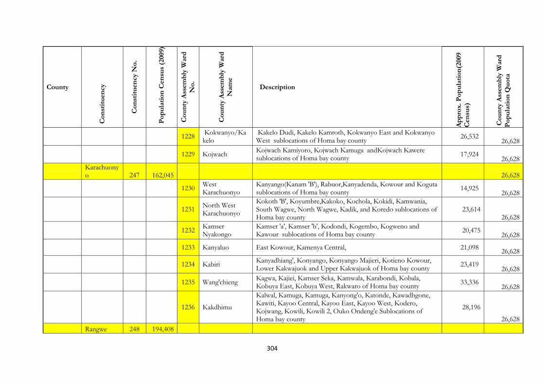
304
County
Co
nst
itu
en
cy
Co
nst
itu
en
cy N
o.
Po
pu
lati
on
Cen
sus
(2009)
Co
un
ty A
ssem
bly
Ward
No
.
Co
un
ty A
ssem
bly
Ward
Nam
e
Description
Ap
pro
x.
Po
pu
lati
on
(2009
Cen
sus)
Co
un
ty A
ssem
bly
Ward
Po
pu
lati
on
Qu
ota
1228
Kokwanyo/Kakelo
Kakelo Dudi, Kakelo Kamroth, Kokwanyo East and Kokwanyo West sublocations of Homa bay county
26,532 26,628
1229 Kojwach
Kojwach Kamiyoro, Kojwach Kamuga andKojwach Kawere sublocations of Homa bay county
17,924
26,628
Karachuonyo 247 162,045
26,628
1230
West Karachuonyo
Kanyango(Kanam 'B'), Rabuor,Kanyadenda, Kowour and Koguta sublocations of Homa bay county
14,925 26,628
1231
North West Karachuonyo
Kokoth 'B', Koyumbre,Kakoko, Kochola, Kokidi, Kamwania, South Wagwe, North Wagwe, Kadik, and Koredo sublocations of Homa bay county
23,614 26,628
1232
Kamser Nyakongo
Kamser 'a', Kamser 'b', Kodondi, Kogembo, Kogweno and Kawour sublocations of Homa bay county
20,475 26,628
1233 Kanyaluo East Kowour, Kamenya Central, 21,098
26,628
1234 Kabiri
Kanyadhiang', Konyango, Konyango Majieri, Kotieno Kowour, Lower Kakwajuok and Upper Kakwajuok of Homa bay county
23,419 26,628
1235 Wang'chieng
Kagwa, Kajiei, Kamser Seka, Kamwala, Karabondi, Kobala, Kobuya East, Kobuya West, Rakwaro of Homa bay county
33,336
26,628
1236 Kakdhimu
Kalwal, Kamuga, Kamuga, Kanyong'o, Katonde, Kawadhgone, Kawiti, Kayoo Central, Kayoo East, Kayoo West, Kodero, Kojwang, Kowili, Kowili 2, Ouko Ondeng'e Sublocations of Homa bay county
28,196
26,628
Rangwe 248 194,408
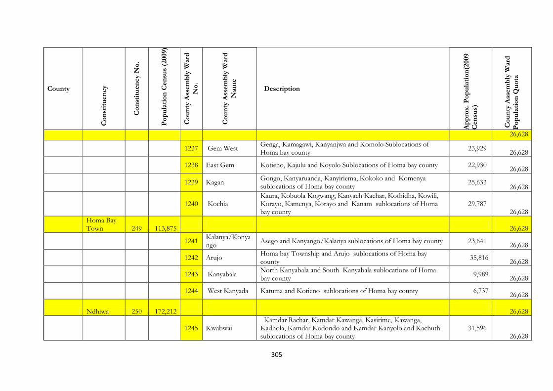
305
County
Co
nst
itu
en
cy
Co
nst
itu
en
cy N
o.
Po
pu
lati
on
Cen
sus
(2009)
Co
un
ty A
ssem
bly
Ward
No
.
Co
un
ty A
ssem
bly
Ward
Nam
e
Description
Ap
pro
x.
Po
pu
lati
on
(2009
Cen
sus)
Co
un
ty A
ssem
bly
Ward
Po
pu
lati
on
Qu
ota
26,628
1237 Gem West
Genga, Kamagawi, Kanyanjwa and Komolo Sublocations of Homa bay county
23,929
26,628
1238 East Gem Kotieno, Kajulu and Koyolo Sublocations of Homa bay county 22,930
26,628
1239 Kagan
Gongo, Kanyaruanda, Kanyiriema, Kokoko and Komenya sublocations of Homa bay county
25,633 26,628
1240 Kochia
Kaura, Kobuola Kogwang, Kanyach Kachar, Kothidha, Kowili, Korayo, Kamenya, Korayo and Kanam sublocations of Homa bay county
29,787 26,628
Homa Bay Town 249 113,875
26,628
1241
Kalanya/Konyango
Asego and Kanyango/Kalanya sublocations of Homa bay county 23,641
26,628
1242 Arujo
Homa bay Township and Arujo sublocations of Homa bay county
35,816
26,628
1243 Kanyabala
North Kanyabala and South Kanyabala sublocations of Homa bay county
9,989
26,628
1244 West Kanyada Katuma and Kotieno sublocations of Homa bay county 6,737
26,628
Ndhiwa 250 172,212
26,628
1245 Kwabwai
Kamdar Rachar, Kamdar Kawanga, Kasirime, Kawanga, Kadhola, Kamdar Kodondo and Kamdar Kanyolo and Kachuth sublocations of Homa bay county
31,596 26,628
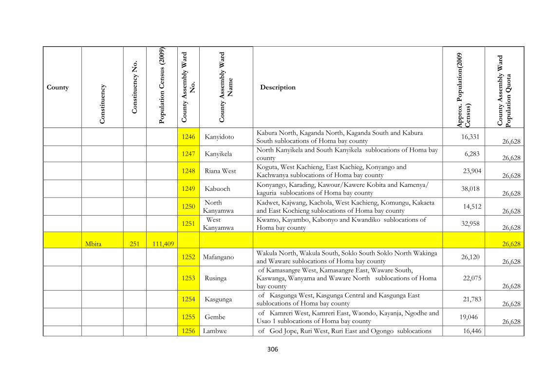
306
County
Co
nst
itu
en
cy
Co
nst
itu
en
cy N
o.
Po
pu
lati
on
Cen
sus
(2009)
Co
un
ty A
ssem
bly
Ward
No
.
Co
un
ty A
ssem
bly
Ward
Nam
e
Description
Ap
pro
x.
Po
pu
lati
on
(2009
Cen
sus)
Co
un
ty A
ssem
bly
Ward
Po
pu
lati
on
Qu
ota
1246 Kanyidoto
Kabura North, Kaganda North, Kaganda South and Kabura South sublocations of Homa bay county
16,331 26,628
1247 Kanyikela
North Kanyikela and South Kanyikela sublocations of Homa bay county
6,283
26,628
1248 Riana West
Koguta, West Kachieng, East Kachieg, Konyango and Kachwanya sublocations of Homa bay county
23,904 26,628
1249 Kabuoch
Konyango, Karading, Kawour/Kawere Kobita and Kamenya/ kaguria sublocations of Homa bay county
38,018 26,628
1250
North Kanyamwa
Kadwet, Kajwang, Kachola, West Kachieng, Komungu, Kakaeta and East Kochieng sublocations of Homa bay county
14,512 26,628
1251
West Kanyamwa
Kwamo, Kayambo, Kabonyo and Kwandiko sublocations of Homa bay county
32,958
26,628
Mbita 251 111,409
26,628
1252 Mafangano
Wakula North, Wakula South, Soklo South Soklo North Wakinga and Waware sublocations of Homa bay county
26,120 26,628
1253 Rusinga
of Kamasangre West, Kamasangre East, Waware South, Kaswanga, Wanyama and Waware North sublocations of Homa bay county
22,075 26,628
1254 Kasgunga
of Kasgunga West, Kasgunga Central and Kasgunga East sublocations of Homa bay county
21,783 26,628
1255 Gembe
of Kamreri West, Kamreri East, Waondo, Kayanja, Ngodhe and Usao 1 sublocations of Homa bay county
19,046 26,628
1256 Lambwe of God Jope, Ruri West, Ruri East and Ogongo sublocations 16,446
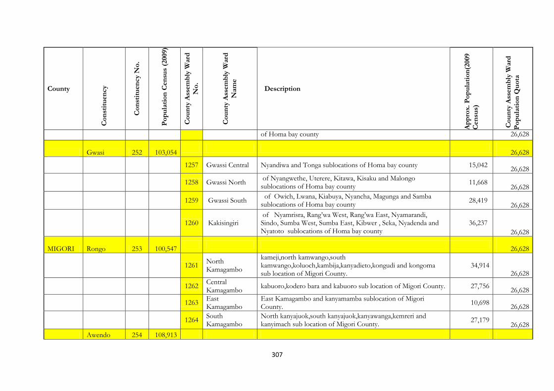
307
County
Co
nst
itu
en
cy
Co
nst
itu
en
cy N
o.
Po
pu
lati
on
Cen
sus
(2009)
Co
un
ty A
ssem
bly
Ward
No
.
Co
un
ty A
ssem
bly
Ward
Nam
e
Description
Ap
pro
x.
Po
pu
lati
on
(2009
Cen
sus)
Co
un
ty A
ssem
bly
Ward
Po
pu
lati
on
Qu
ota
of Homa bay county 26,628
Gwasi 252 103,054
26,628
1257 Gwassi Central Nyandiwa and Tonga sublocations of Homa bay county 15,042
26,628
1258 Gwassi North
of Nyangwethe, Uterere, Kitawa, Kisaku and Malongo sublocations of Homa bay county
11,668 26,628
1259 Gwassi South
of Owich, Lwana, Kiabuya, Nyancha, Magunga and Samba sublocations of Homa bay county
28,419
26,628
1260 Kakisingiri of Nyamrisra, Rang’wa West, Rang’wa East, Nyamarandi, Sindo, Sumba West, Sumba East, Kibwer , Seka, Nyadenda and Nyatoto sublocations of Homa bay county
36,237 26,628
MIGORI Rongo 253 100,547
26,628
1261
North Kamagambo
kameji,north kamwango,south kamwango,koluoch,kambija,kanyadieto,kongudi and kongoma sub location of Migori County.
34,914 26,628
1262
Central Kamagambo
kabuoro,kodero bara and kabuoro sub location of Migori County. 27,756
26,628
1263
East Kamagambo
East Kamagambo and kanyamamba sublocation of Migori County.
10,698
26,628
1264
South Kamagambo
North kanyajuok,south kanyajuok,kanyawanga,kemreri and kanyimach sub location of Migori County.
27,179 26,628
Awendo 254 108,913
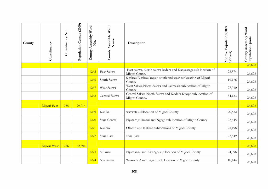
308
County
Co
nst
itu
en
cy
Co
nst
itu
en
cy N
o.
Po
pu
lati
on
Cen
sus
(2009)
Co
un
ty A
ssem
bly
Ward
No
.
Co
un
ty A
ssem
bly
Ward
Nam
e
Description
Ap
pro
x.
Po
pu
lati
on
(2009
Cen
sus)
Co
un
ty A
ssem
bly
Ward
Po
pu
lati
on
Qu
ota
26,628
1265 East Sakwa
East sakwa, North sakwa-kadera and Kanyasrega sub location of Migori County
28,574
26,628
1266 South Sakwa
S.sakwa,E.sakwa,kogalo south and west sublocation of Migori County
19,176
26,628
1267 West Sakwa
West Sakwa,North Sakwa and kakmasia sublocation of Migori County
27,010
26,628
1268 Central Sakwa
Central Sakwa,North Sakwa and Kodera Kuoyo sub location of Migori County.
34,153
26,628
Migori East 255 99,014
26,628
1269 Kadika wasweta sublocation of Migori County 20,522
26,628
1270 Suna Central Nyasere,milimani and Ngege sub location of Migori County 27,645
26,628
1271 Kakrao Otacho and Kakrao sublocations of Migori County 23,198
26,628
1272 Suna East suna East 27,649
26,628
Migori West 256 62,694
26,628
1273 Mukuru Nyamanga and Kirengo sub location of Migori County 24,096
26,628
1274 Nyabisawa Wasweta 2 and Kagero sub location of Migori County 10,444
26,628
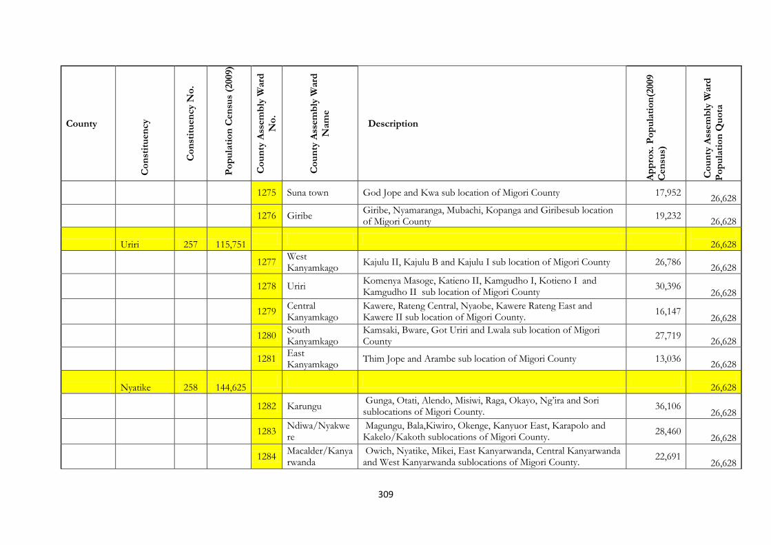
309
County
Co
nst
itu
en
cy
Co
nst
itu
en
cy N
o.
Po
pu
lati
on
Cen
sus
(2009)
Co
un
ty A
ssem
bly
Ward
No
.
Co
un
ty A
ssem
bly
Ward
Nam
e
Description
Ap
pro
x.
Po
pu
lati
on
(2009
Cen
sus)
Co
un
ty A
ssem
bly
Ward
Po
pu
lati
on
Qu
ota
1275 Suna town God Jope and Kwa sub location of Migori County 17,952
26,628
1276 Giribe
Giribe, Nyamaranga, Mubachi, Kopanga and Giribesub location of Migori County
19,232
26,628
Uriri 257 115,751
26,628
1277
West Kanyamkago
Kajulu II, Kajulu B and Kajulu I sub location of Migori County 26,786
26,628
1278 Uriri
Komenya Masoge, Katieno II, Kamgudho I, Kotieno I and Kamgudho II sub location of Migori County
30,396 26,628
1279
Central Kanyamkago
Kawere, Rateng Central, Nyaobe, Kawere Rateng East and Kawere II sub location of Migori County.
16,147 26,628
1280
South Kanyamkago
Kamsaki, Bware, Got Uriri and Lwala sub location of Migori County
27,719
26,628
1281
East Kanyamkago
Thim Jope and Arambe sub location of Migori County 13,036
26,628
Nyatike 258 144,625
26,628
1282 Karungu
Gunga, Otati, Alendo, Misiwi, Raga, Okayo, Ng’ira and Sori sublocations of Migori County.
36,106
26,628
1283
Ndiwa/Nyakwere
Magungu, Bala,Kiwiro, Okenge, Kanyuor East, Karapolo and Kakelo/Kakoth sublocations of Migori County.
28,460 26,628
1284
Macalder/Kanyarwanda
Owich, Nyatike, Mikei, East Kanyarwanda, Central Kanyarwanda and West Kanyarwanda sublocations of Migori County.
22,691 26,628

310
County
Co
nst
itu
en
cy
Co
nst
itu
en
cy N
o.
Po
pu
lati
on
Cen
sus
(2009)
Co
un
ty A
ssem
bly
Ward
No
.
Co
un
ty A
ssem
bly
Ward
Nam
e
Description
Ap
pro
x.
Po
pu
lati
on
(2009
Cen
sus)
Co
un
ty A
ssem
bly
Ward
Po
pu
lati
on
Qu
ota
1285 Kaler Kiasa and Olasi sublocations of Migori County. 9,775
26,628
1286
Got Kochola/East Kadem
Nyandago, Bande, Amoyo, Winam and Aneko sublocations of Migori County.
22,338 26,628
1287 Muhuru
Ibencho, Winjo, Tagache, Nyankondo, Nyabomo, Sumba,Nyancha and Kithi sublocations of Migori County.
23,018 26,628
Kuria East 259 150,846
26,628
1288
Gokeharaka/Getambwega
Comprise of Gokeharaka and Getambwega SubLocations 30,544
26,628
1289 Bukura East Comprise of Kehancha and Tarang’anya Sub-Locations 19,476
26,628
1290
Bukura Central/Ikerege
Comprise of Ikerege and Bukira Central SubLocations 10,657
26,628
1291 Nyamaharaga
Comprise of Nyamaharaga, Nyabikaye and Nyametaburo Sub-Locations
39,943
26,628
1292 Masaba Kombe, Masaba and Getong’anya Sub-locations 11,465
26,628
1293
Tagare/Getonganya
Tagare and Nyankore 19,375
26,628
1294
Nyamosonge/Komosoko
Komosoko and Nyamusense Sub-locations 30,355
26,628
Kuria West 260 72,740
26,628

311
County
Co
nst
itu
en
cy
Co
nst
itu
en
cy N
o.
Po
pu
lati
on
Cen
sus
(2009)
Co
un
ty A
ssem
bly
Ward
No
.
Co
un
ty A
ssem
bly
Ward
Nam
e
Description
Ap
pro
x.
Po
pu
lati
on
(2009
Cen
sus)
Co
un
ty A
ssem
bly
Ward
Po
pu
lati
on
Qu
ota
1295 Ntimaru West Ntimaru and Kebaroti Sub-Locations 9,921
26,628
1296 Ntimaru East Wangirabose, Siabai and Gitwembe Sub-locations 14,380
26,628
1297 Nyabasi East Nyabasi North and Kegonga 12,279
26,628
1298 Nyabasi West Maeta and Nyabasi West Sub-locations 18,278
26,628
KISII Bonchari 261 114,615
26,628
1299
Bomariba/Bogiakumu
Comprise of Keboye, Bomariba, Boroko, Bonyando and Bomwanda SubLocations
38696
26,628
1300 Nyamokenye/Nyang’iti
Consists of Bogiakumu, Bomwancha and Bonyaoro Sub- Location
19,509
26,628
1301 Bokeira/Insaria Consists of Bokeire, Bomakombi and Bonyanchare Sub- Location 22,059
26,628
1302 Riana/Iyabe Consists of Bogitaa, Nyamwari and Bomokora Sub-Location 34,351
26,628
South Mugirango
261 159,048
1303 North Bosinange, Bomonyara, Tabaka, Nyansore and Bomonyama Sub-locations
47,309
26,628
1304 Bomonyama Nyansore and Bomonyama Sublocations of Kisii County. 15,194
26,628
1305 Nyakembene Ikoro, Bogetenga and Boikanga 27,502

312
County
Co
nst
itu
en
cy
Co
nst
itu
en
cy N
o.
Po
pu
lati
on
Cen
sus
(2009)
Co
un
ty A
ssem
bly
Ward
No
.
Co
un
ty A
ssem
bly
Ward
Nam
e
Description
Ap
pro
x.
Po
pu
lati
on
(2009
Cen
sus)
Co
un
ty A
ssem
bly
Ward
Po
pu
lati
on
Qu
ota
26,628
1306 Chitago/Nyakembene
Nyakorere, Kiangware, Amakara and Boige Sub-locations 20,408
26,628
1307 Otendo/Nyansakia
Ndonyo, Nyabera, Eburi and Nyatario Sub-Locations 26,611
26,628
1308 Getenga Muma, Bosaga and Nyaramba Sub-Locations 14,905
26,628
1309 Mugirango/Monianku
Moniaku, Nyamondo and Botabori 22,314
26,628
1310 Borabu/Masaba Comprise of Kenyenya and Igorera Sublocation 33,755
26,628
Bomachoge 263 106,717
1311 Boochi Borabu Emesa, Kiango and Ritembu Sub-locations 24,675
26,628
1312 Bokimonge Comprise Nyabitunwa and Bokimonge sub-locations 15,066
26,628
1313 Magenche Magenche, Mokubo and Nyamecheo Sub-locations 33,703
26,628
Bobasi 264 126,362
1314 Bassi Masige Mosora, Orogare, Omusaria, Turwa, Omokonge, Nyanchenge and Nyabiswa Sublocations
24,620 26,628
1315 Nyamache Kegochi, Emenwa, Masisi/Igoma Sub-locations 19,762
26,628
1316 West Kiobegi, Nyantira, Rogongo, Nyachogochogo, Gionseri and 22,961

313
County
Co
nst
itu
en
cy
Co
nst
itu
en
cy N
o.
Po
pu
lati
on
Cen
sus
(2009)
Co
un
ty A
ssem
bly
Ward
No
.
Co
un
ty A
ssem
bly
Ward
Nam
e
Description
Ap
pro
x.
Po
pu
lati
on
(2009
Cen
sus)
Co
un
ty A
ssem
bly
Ward
Po
pu
lati
on
Qu
ota
Kiobegi Sub-locations 26,628
1317 South Eastern Maji Mazuri, Bosansa, Riosuga, Borangi, Nyoera Sub-locations 29,933
26,628
1318 Southern Isena, Riomoro, Riotweka, Ritube and Nyangusu Sub-locations 28,986
26,628
Gucha 265 157,241
1319 Misesi /Egetuki Misesi and Kanyimbo Sub-locations 23,482
26,628
1320 Bobasi Chache Getenga, Gesure, Giasaiga and Bogetairo II Sub-locations 22,004
26,628
1321 Sameta/Mokwerero
Etora, Sameta, Kanyerere, Kiong’ongi 27,575
26,628
1322 Bobasi/Boitangare
Nyamagwa and Igare 14,233
26,628
1323 Getare/Tendere Keragia, Nyansakia, Mang’ere and Boochi 33,197
26,628
1324 Nyaisero/Bosoti Nyaisero and Bosoti 36,851
26,628
Nyaribari Masaba
266 122,070
1325 Amabuko/Bogeche
Amabuko and Bogeche Sub-Locations 12,935
26,628
1326 Ichuni Ichuni, Ekware, Nyamisibi, Nyankononi, Gesabakwa and Giensembe
32,116
26,628

314
County
Co
nst
itu
en
cy
Co
nst
itu
en
cy N
o.
Po
pu
lati
on
Cen
sus
(2009)
Co
un
ty A
ssem
bly
Ward
No
.
Co
un
ty A
ssem
bly
Ward
Nam
e
Description
Ap
pro
x.
Po
pu
lati
on
(2009
Cen
sus)
Co
un
ty A
ssem
bly
Ward
Po
pu
lati
on
Qu
ota
1327 Kerema/Gekonge
Comprise of Metembe, Riamichoki, Bong’onta, Sosera, Nyasike, Engorwa, Riuri and Ibanchore
26,685 26,628
1328 Gesusu Chibwobi, Getacho, Kerema, Suguta, Nyamesocho, Geteri and Ikenye Sub-Locations
22,063
26,628
1329 Mobamba/Kiamokama
Comprise of Masaba, Mogweko, Chironge, Getare, Kegogi,Mobamba, Emeroka and Ibacho
25,354 26,628
Nyaribari Chache
267 142,389
1330 Bosongo/Kiogoro
Comprise of Nyamemiso, Bobaracho Nyaura, Nyanchwa Sublocations
36,374
26,628
1331 Kiogoro Masongo, Boronyi and Nyaguta Sub-Locations 18,615
26,628
1332 Kegati/Ichuni Ichuni (Nyanguru) and Kegati Sub-Locations 16,135
26,628
1333 Bomwagi/Nyamware
Nyamware and Bomwagi Sub-Locations 15,024
26,628
1334 Keumbu Comprise of Keumbu (Taracha) and Birongo Sublocations 19,368
26,628
1335 Ibeno Kerera, Kirwa, Kabosi, Chirichiro, Nyamagwa and Matumwa Sublocations
24,229
26,628
Marani 268 103,869
1336 Kegogi Mutembe and Ngokoro Sub-locations 20,558
26,628
1337 Ngenyi Ikuruma, Matongo and Gesangero sublocations 27,611

315
County
Co
nst
itu
en
cy
Co
nst
itu
en
cy N
o.
Po
pu
lati
on
Cen
sus
(2009)
Co
un
ty A
ssem
bly
Ward
No
.
Co
un
ty A
ssem
bly
Ward
Nam
e
Description
Ap
pro
x.
Po
pu
lati
on
(2009
Cen
sus)
Co
un
ty A
ssem
bly
Ward
Po
pu
lati
on
Qu
ota
26,628
1338 Sensi Sensi and Kiong’anyo Sub-location 10,522
26,628
1339 Marani Igemo, Onywere, Nyamage and Kiomoncha Sub-location 28,161
26,628
1340 Mwamonari Comprise of Rioma and Nyakeiri Sublocations 17,017
26,628
Mosocho 269 119,487
1341 Mosocho Bigege, Raganga, Matieko and Santa 24,872
26,628
1342 Bogeka Gesoni and Mogusi Sub-locations 13,254
26,628
1343 Nyakoe Bonyagatanyi, Iranda, Rieteba and Nyagisasi 23,096
26,628
1344 Township Nyanchwa, Township/Mwamosioma 25,282
26,628
1345 Darajambili Daraja Mbili Part of Township Sublocation of Kisii County. 25,181
26,628
1346 Mwamanwa/Mwamosioma
Mwamanwa and Mwamosioma Sub-Locations 20,546
26,628
NYAMIRA
KITUTU MASABA
199,136
1347 Nyankoba nyankoba and bitich asub locations of Nyamira County 15,986
26,628
1348 Gachuba girongo and rigena sub locations of Nyamira County. 23,067
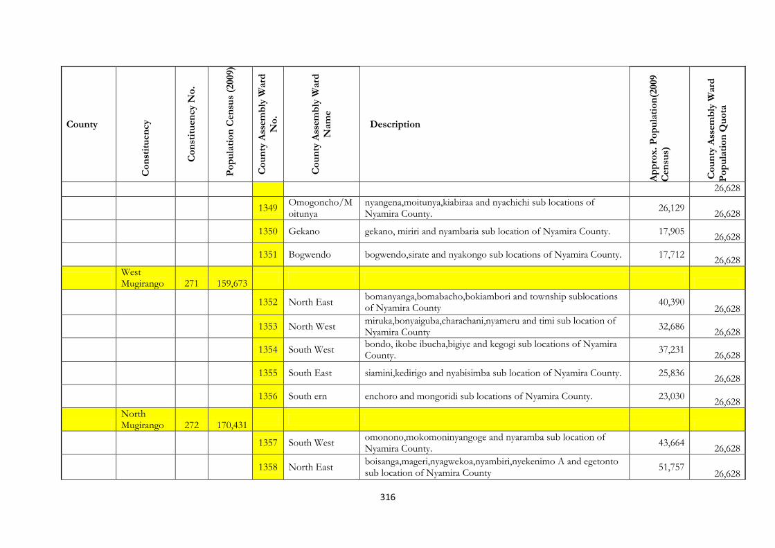
316
County
Co
nst
itu
en
cy
Co
nst
itu
en
cy N
o.
Po
pu
lati
on
Cen
sus
(2009)
Co
un
ty A
ssem
bly
Ward
No
.
Co
un
ty A
ssem
bly
Ward
Nam
e
Description
Ap
pro
x.
Po
pu
lati
on
(2009
Cen
sus)
Co
un
ty A
ssem
bly
Ward
Po
pu
lati
on
Qu
ota
26,628
1349 Omogoncho/Moitunya
nyangena,moitunya,kiabiraa and nyachichi sub locations of Nyamira County.
26,129
26,628
1350 Gekano gekano, miriri and nyambaria sub location of Nyamira County. 17,905
26,628
1351 Bogwendo bogwendo,sirate and nyakongo sub locations of Nyamira County. 17,712
26,628
West Mugirango 271 159,673
1352 North East
bomanyanga,bomabacho,bokiambori and township sublocations of Nyamira County
40,390 26,628
1353 North West
miruka,bonyaiguba,charachani,nyameru and timi sub location of Nyamira County
32,686
26,628
1354 South West
bondo, ikobe ibucha,bigiye and kegogi sub locations of Nyamira County.
37,231
26,628
1355 South East siamini,kedirigo and nyabisimba sub location of Nyamira County. 25,836
26,628
1356 South ern enchoro and mongoridi sub locations of Nyamira County. 23,030
26,628
North Mugirango 272 170,431
1357 South West
omonono,mokomoninyangoge and nyaramba sub location of Nyamira County.
43,664
26,628
1358 North East
boisanga,mageri,nyagwekoa,nyambiri,nyekenimo A and egetonto sub location of Nyamira County
51,757 26,628

317
County
Co
nst
itu
en
cy
Co
nst
itu
en
cy N
o.
Po
pu
lati
on
Cen
sus
(2009)
Co
un
ty A
ssem
bly
Ward
No
.
Co
un
ty A
ssem
bly
Ward
Nam
e
Description
Ap
pro
x.
Po
pu
lati
on
(2009
Cen
sus)
Co
un
ty A
ssem
bly
Ward
Po
pu
lati
on
Qu
ota
1359 Northern
nyokenimo,matongo,magwagwa,bonyongwe A and bonyongwe B sub locations of Nyamira County.
46,794 26,628
1360 Central
bokurati,ikonge,bonyakoni, and nyankono sublocation of nyamira county.
24,322
26,628
Borabu 273 133,217
1361 North East
Kitaru, Mogusii, Mwongori and Riamoni sublocations of Nyamira County.
28,812
26,628
1362 Bocharia Embaro and Bocharia sublocations of Nyamira County. 27,314
26,628
1363 North West
Nyatieno, Nyamakoroto, Karantini, Nyabiosi, Embaro and Bocharia sublocations of Nyamira County.
48,736 26,628
1364 Central Nyansiongo/Gesima and Matutu of Nyamira County. 27,495
26,628
1365 South Isoge/Kineni, Manga/Lietego and Ekerubo of Nyamira County. 26,955
26,628
Nairobi Westlands 274 203,891
1366 KITUSURU Kitusuru,Loresho and Kyuna Sublocation of Nairobi County 31,242
26,628
1367 HIGHRIDGE
Karura, Highridge and Mauthaiga Sublocations of Nairobi County
53,720
26,628
1368 KANGEMI Kangemi Sublocations of Nairobi County 44,564
26,628
1369
KILELESHWA/PARKLANDS
Muthangari, Spring Valley and Upper Parklands and Kileleshwa Sublocations of Nairobi County
27,202 26,628

318
County
Co
nst
itu
en
cy
Co
nst
itu
en
cy N
o.
Po
pu
lati
on
Cen
sus
(2009)
Co
un
ty A
ssem
bly
Ward
No
.
Co
un
ty A
ssem
bly
Ward
Nam
e
Description
Ap
pro
x.
Po
pu
lati
on
(2009
Cen
sus)
Co
un
ty A
ssem
bly
Ward
Po
pu
lati
on
Qu
ota
1370 Parklands
Muthangari, Spring Valley and Upper Parklands Sublocations of Nairobi County
11,117
26,628
1371 Mountain View Mountain View and Gichagi Sublocations of Nairobi County 38,319
26,628
Kawangware (New) 275 156,417
1372 KATINA Katina Sublocation of Nairobi County 45,872
26,628
1373
KAWANGWARE
Kawagrware Part of Kawangware Sublocation of Nairobi County
33,707
26,628
1374 KILIMANI Kilimani and Maziwa Sublocation of Nairobi County 43,122
26,628
1375 MUSLIM
Kawagrware Part of Kawangware Sublocation of Nairobi County
33,707
26,628
Dagoretti 276 180,747
1376 MUTUINI Kirigo and Mutuini Sublocation of Nairobi County 17,973
26,628
1377 NGANDO Ngando Sublocation of Nairobi County 34,014
26,628
1378 RIRUTA Riruta Sublocation of Nairobi County 65,320
26,628
1379
UTHIRU/RUTHIMITU
Uthiru and Ruthimitu Sublocation of Nairobi County 32,575
26,628
1380 WAITHAKA Waithaka and Kabiria Sublocations of Nairobi County 31,054
26,628

319
County
Co
nst
itu
en
cy
Co
nst
itu
en
cy N
o.
Po
pu
lati
on
Cen
sus
(2009)
Co
un
ty A
ssem
bly
Ward
No
.
Co
un
ty A
ssem
bly
Ward
Nam
e
Description
Ap
pro
x.
Po
pu
lati
on
(2009
Cen
sus)
Co
un
ty A
ssem
bly
Ward
Po
pu
lati
on
Qu
ota
Karen-Langata 277 196,290
1381 Karengata
Karen, Langata, Hardy and Lenana Sublocation of Nairobi County
33,303
26,628
1382 Nairobi West Nairobi West Sublocation of Nairobi County 47,202
26,628
1383 MUGUMO-INI Mugumoini and Bomas Sublocation of Nairobi County 47,037
26,628
1384 South C South C Sublocation of Nairobi County 33,377
26,628
1385
WOODLEY-KENYATTA GOLF COURSE
Kenyatta/Golfdourse and Woodley Sublocations of Nairobi County
35,355
26,628
Kibra (New) 278 194,281
1386 LAINI SABA Liani Shabba Sublocation of Nairobi County 28,182
26,628
1387 LINDI Lindi Sublocation of Nairobi County 44,944
26,628
1388 MAKINA Makina Sublocation of Nairobi County 25,242
26,628
1389
NYAYO HIGHRISE
Highrise Sublocation of Nairobi County 41,554
26,628
1390 SARANG'OMB Gatwikira/Olympic Sublocation of Nairobi County 54,347
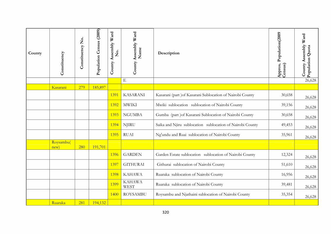
320
County
Co
nst
itu
en
cy
Co
nst
itu
en
cy N
o.
Po
pu
lati
on
Cen
sus
(2009)
Co
un
ty A
ssem
bly
Ward
No
.
Co
un
ty A
ssem
bly
Ward
Nam
e
Description
Ap
pro
x.
Po
pu
lati
on
(2009
Cen
sus)
Co
un
ty A
ssem
bly
Ward
Po
pu
lati
on
Qu
ota
E 26,628
Kasarani 279 185,897
1391 KASARANI Kasarani (part )of Kasarani Sublocation of Nairobi County 30,658
26,628
1392 MWIKI Mwiki sublocation sublocation of Nairobi County 39,156
26,628
1393 NGUMBA Gumba (part )of Kasarani Sublocation of Nairobi County 30,658
26,628
1394 NJIRU Saika and Njiru sublocation sublocation of Nairobi County 49,453
26,628
1395 RUAI Ng'undu and Ruai sublocation of Nairobi County 35,961
26,628
Roysambu(new) 280 191,701
1396 GARDEN Garden Estate sublocation sublocation of Nairobi County 12,324
26,628
1397 GITHURAI Githurai sublocation of Nairobi County 51,610
26,628
1398 KAHAWA Ruaraka sublocation of Nairobi County 16,956
26,628
1399
KAHAWA WEST
Ruaraka sublocation of Nairobi County 39,481
26,628
1400 ROYSAMBU Roysambu and Njathaini sublocation of Nairobi County 35,354
26,628
Ruaraka 281 194,132
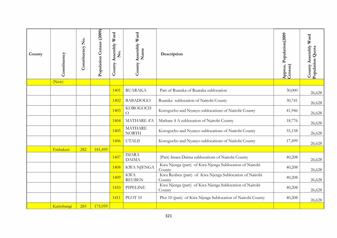
321
County
Co
nst
itu
en
cy
Co
nst
itu
en
cy N
o.
Po
pu
lati
on
Cen
sus
(2009)
Co
un
ty A
ssem
bly
Ward
No
.
Co
un
ty A
ssem
bly
Ward
Nam
e
Description
Ap
pro
x.
Po
pu
lati
on
(2009
Cen
sus)
Co
un
ty A
ssem
bly
Ward
Po
pu
lati
on
Qu
ota
(New)
1401 RUARAKA Part of Ruaraka of Ruaraka sublocation 30,000
26,628
1402 BABADOGO Ruaraka sublocation of Nairobi County 30,741
26,628
1403
KOROGOCHO
Korogocho and Nyanyo sublocations of Nairobi County 41,946
26,628
1404 MATHARE 4'A Mathare 4 A sublocation of Nairobi County 18,776
26,628
1405
MATHARE NORTH
Korogocho and Nyanyo sublocations of Nairobi County 55,158
26,628
1406 UTALII Korogocho and Nyanyo sublocations of Nairobi County 17,499
26,628
Embakasi 282 181,499
1407
IMARA DAIMA
(Part) Imara Daima sublocations of Nairobi County 40,208
26,628
1408 KWA NJENGA
Kwa Njenga (part) of Kwa Njenga Sublocation of Nairobi County
40,208
26,628
1409
KWA REUBEN
Kwa Reuben (part) of Kwa Njenga Sublocation of Nairobi County
40,208
26,628
1410 PIPELINE
Kwa Njenga (part) of Kwa Njenga Sublocation of Nairobi County
40,208
26,628
1411 PLOT 10 Plot 10 (part) of Kwa Njenga Sublocation of Nairobi County 40,208
26,628
Kariobangi 283 175,959
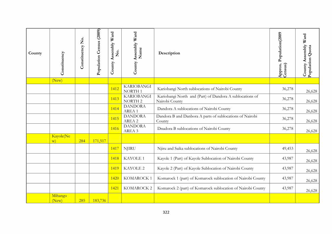
322
County
Co
nst
itu
en
cy
Co
nst
itu
en
cy N
o.
Po
pu
lati
on
Cen
sus
(2009)
Co
un
ty A
ssem
bly
Ward
No
.
Co
un
ty A
ssem
bly
Ward
Nam
e
Description
Ap
pro
x.
Po
pu
lati
on
(2009
Cen
sus)
Co
un
ty A
ssem
bly
Ward
Po
pu
lati
on
Qu
ota
(New)
1412
KARIOBANGI NORTH 1
Kariobangi North sublocations of Nairobi County 36,278
26,628
1413
KARIOBANGI NORTH 2
Kariobangi North and (Part) of Dandora A sublocations of Nairobi County
36,278
26,628
1414
DANDORA AREA 1
Dandora A sublocations of Nairobi County 36,278
26,628
1415
DANDORA AREA 2
Dandora B and Danbora A parts of sublocations of Nairobi County
36,278
26,628
1416
DANDORA AREA 3
Dnadora B sublocations of Nairobi County 36,278
26,628
Kayole(New) 284 171,517
1417 NJIRU Njiru and Saika sublocations of Nairobi County 49,453
26,628
1418 KAYOLE 1 Kayole 1 (Part) of Kayole Sublocation of Nairobi County 43,987
26,628
1419 KAYOLE 2 Kayole 2 (Part) of Kayole Sublocation of Nairobi County 43,987
26,628
1420 KOMAROCK 1 Komarock 1 (part) of Komarock sublocation of Nairobi County 43,987
26,628
1421 KOMAROCK 2 Komarock 2 (part) of Komarock sublocation of Nairobi County 43,987
26,628
Mihango (New) 285 183,736

323
County
Co
nst
itu
en
cy
Co
nst
itu
en
cy N
o.
Po
pu
lati
on
Cen
sus
(2009)
Co
un
ty A
ssem
bly
Ward
No
.
Co
un
ty A
ssem
bly
Ward
Nam
e
Description
Ap
pro
x.
Po
pu
lati
on
(2009
Cen
sus)
Co
un
ty A
ssem
bly
Ward
Po
pu
lati
on
Qu
ota
1422 SAVANNA Savanna (part )of Savanna sublocation of Nairobi County 37,944
26,628
1423 DONHOLM Donholm (part )of Savanna sublocation of Nairobi County 37,944
26,628
1424 EMBAKASI Embakasi sublocation of Nairobi County 32,517
26,628
1425 UTAWALA Utawala (part )of Embakasi sublocation of Nairobi County 32,517
26,628
1426 MIHANGO Mihango sublocation of Nairobi County 22,936
26,628
Umoja (New) 286 192,393
1427 HARAMBEE
Harambee sublocation of Nairobi County sublocations of Nairobi County
26,259
26,628
1428 UMOJA 'A' UmojaII (part) sublocation ( starting from )of Nairobi County 50,738
26,628
1429 UMOJA 'B' Umoja I (part) sublocation ( starting from )of Nairobi County 50,739
26,628
1430 MOWLEM
Mbotela , Ofafa, Lumumba abd Hamza sublocation of Nairobi COunty sublocations of Nairobi County
22,953 26,628
1431
KARIOBANGI SOUTH
Mbotela , Ofafa, Lumumba abd Hamza sublocation of Nairobi COunty sublocations of Nairobi County
33,036 26,628
Makadara 287 151,795
1432
LANDMAWE-MAKONGENI
Airbase sublocations of Nairobi County 38,911
26,628

324
County
Co
nst
itu
en
cy
Co
nst
itu
en
cy N
o.
Po
pu
lati
on
Cen
sus
(2009)
Co
un
ty A
ssem
bly
Ward
No
.
Co
un
ty A
ssem
bly
Ward
Nam
e
Description
Ap
pro
x.
Po
pu
lati
on
(2009
Cen
sus)
Co
un
ty A
ssem
bly
Ward
Po
pu
lati
on
Qu
ota
1433
MARINGO-HAMZA
Mbotela , Ofafa, Lumumba abd Hamza sublocation of Nairobi COunty sublocations of Nairobi County
31,375 26,628
1434
NAIROBI SOUTH
Nairobi South and Hazina sublocations of Nairobi COunty sublocations of Nairobi County
26,026
26,628
1435 VIWANDANI
Viwandani sublocation of Nairobi COunty sublocations of Nairobi County
44,881
26,628
Kamukunji 288 191,271
1436 AIRBASE Airbase sublocations of Nairobi County 43,168
26,628
1437 CALIFONIA California sublocations of Nairobi County 21,699
26,628
1438
EASTLEIGH NORTH
Eistleigh North sublocation of Nairobi County 43,258
26,628
1439
EASTLEIGH SOUTH
Eistleigh South sublocation of Nairobi County 66,264
26,628
1440
KAMUKUNJI/SHAURI MOYO/MUTHURWA
Muthurwa, Kamkunji and Shauri Moyo sublocations of Nairobi County
19,591
26,628
Starehe 289 193,427
1441 CENTRAL
city square,River Road and Nairobi Central sublocations of Nairobi County
9,857
26,628
1442 NGARA EAST Ngara East Sublocation of Nairobi County 15,583
26,628

325
County
Co
nst
itu
en
cy
Co
nst
itu
en
cy N
o.
Po
pu
lati
on
Cen
sus
(2009)
Co
un
ty A
ssem
bly
Ward
No
.
Co
un
ty A
ssem
bly
Ward
Nam
e
Description
Ap
pro
x.
Po
pu
lati
on
(2009
Cen
sus)
Co
un
ty A
ssem
bly
Ward
Po
pu
lati
on
Qu
ota
1443 NGARA WEST Ngara West sublocation of Nairobi County 9,771
26,628
1444 PANGANI Pangani sublocation of Nairobi County 37,062
26,628
1445
ZIWANI/KARIOKOR
Ziwani/Kariokor, Ngolofani/Bondeni and Majengo sublocation of Nairobi County
8,918
26,628
Mathare (New) 290 193,416
1446 Mlango Kubwa Mlango Kubwa sublocation of Nairobi County 20,463
26,628
1447 Mabitini
Mabatini (4B and Githaturu)and mathare sublocations of Nairobi County
48,723
26,628
1448 Huruma A Huruma A (part) Sublocation of Nairobi county 36,248
26,628
1449 Huruma B Huruma B (part) Sublocation of Nairobi county 36,247
26,628
1450 Kiamaiko kiamiko sublocation of Nairobi County 33,824
26,628
326
CHAPTER SIX
PROPOSALS & WAYFORWARD
6.1 Introduction
The Independence Constitution of Kenya provided key criteria to guide the boundary
delimitation process. These criteria guided all the boundary reviews that were done prior to the
promulgation of the Constitution of Kenya 2010. The Current constitution in Article 89 puts in
place the criteria supposed to be used in the delimitation of boundaries – from the first review
and other delimitations that will follow later. Notably, the authority and criteria for delimitation
of local authority electoral areas is the same as that of Constituencies.2
6.2 Methodology and criteria for boundary delimitation
In reviewing constituency and ward boundaries, the Constitution of Kenya 2010 requires the
Commission to consult all interested parties.3 It is noted that in the first review of boundaries, as
documented by IIBRC eight provincial visits were held with a total number of 106 public
hearings where of 20,726 people attended. The objective of the public consultations was to
collect views regarding to electoral and administrative boundaries. All stakeholders were
requested to present to the Commission oral submissions or written submissions either as
individuals or groups and the public invited to give presentations through scheduled public
hearings in existing constituencies.
While recognizing the above task done by IIBRC, it is prudent to note that IEBC’s role in the
resolution of all issues arising from the first review will be limited to the provisions of Section 36
of IEBC Act, 2011, and Paragraph 3(2) and (3) of the Fifth Schedule of the Act. The IEBC
through the presentation of the proposals herein, invites all stakeholders to present oral
submissions either as individuals or groups. Further, the public is invited to give presentations
through scheduled public hearings in existing constituencies.
6.3 Applicable Framework
In the first review done by IIBRC many of the submissions received offered suggestions on
delimitation of both administrative and electoral boundaries. Whereas IEBC appreciates that
administrative and electoral units were within the initial mandate of IIBRC, the emphasis in the
2 As provided under the Local Government Act
3 Article 89(7) of the Constitution

327
consultations as a result of the first review will be on constitutional criterion. This will be in
consideration of the criteria under Article 89 (5) of the Constitution. Thus, public submissions
and petitions should be presented within three key limits;
a) Geographical Features: For purposes of resolving issues arising from the first review
focus is on patterns of human settlement; land use and road networks and land cover for
communications (TV; mobile telephony). Also inclusive of equities in resource allocation,
natural and water resources and national security.
b) Community Interests: This is relating to the historical, political, economic and cultural
ties existing in various parts of the country. As such areas of economic interest to the
community and the existence of a favorable economic infrastructure (schools; hospitals;
market centers); presence of harmonious co-existence between communities and political
stability that also protects the rights of minorities and marginalized communities posit as
boundary concerns.
c) Means of Communication: Means of communication also considers roads networks,
telecommunications (mobile and radio telephony) and postal and courier services.
All submissions should focus thereof on access to these services and infrastructure and the
Commission in retrospect shall take into account views of the communities affected.
6.4 Work Plan
The work plan for the delimitation exercise is developed on the basis of the mandate provided
under the fifth schedule to the IEBC Act 2011.
i. Collection, Analysis and presentation of data
Information and data collected having been interpreted and legally analyzed informs the
delimitation exercise. This involves collection and analysis of population data based on
the constitutional provisions. Literature review undertaken not only covers the relevant
documents cited under the IEBC Act but also covers maps and archival data on
boundaries and boundary delimitation in Kenya, including best practices.
ii. Field Visits
Public hearings provide a tool for gathering and compiling relevant information from the
general public on matters of concern in delimitation. This will also offer immediate
feedback on emerging issues on suggestions for boundary variations.
328
Field visits are organized to sensitise the general public and stakeholders on the mandate
and responsibility of the IEBC and providing Kenyans and opportunity to contribute
their views. These will be structured to clusters of a minimum of 6 to a maximum of 12
constituencies per public hearing based on vicinity of selected constituencies per county
and conducted for a consecutive period that will be stipulated by the commission.
iii. Memorandum
Written submissions-memoranda will be presented to the IEBC by all interested parties,
either individuals or groups seeking to have their views equally taken into consideration.
These will be strictly based on the mandate of the IEBC and Constitutional criteria for
resolution of issues arising from the first review.
iv. Analysis of data collected
Data from field visits and public hearings will be analysed against the constitutional
provisions and in relation to constituency and community groupings on community
interest, geographical features and means of communication. Analytical tools-ICT and
GIS and qualitative methods will be used for the purposes of developing a just and
considerate decision for all the electorates.
6.5 Communications to the public
The most appropriate medium for communication will be identified and employed by the
Commission to reach the stakeholders and general public. And to achieve optimum results, it is
expected, through voter education; that the general public will be equipped with the requisite
knowledge on the process of resolving issues arising from the first review to enable them submit
their views against the constitutional provisions. Stakeholder, consultation will focus on key
principles in the public and private sector and the strategy may be further supplemented by
interactive media briefings.