Embed Size (px)
Citation preview
LIT 5355
Idle & Torne
Abstraction licensing strategy February 2013
A licensing strategy to manage water resources sustainably
Environment Agency Idle & Torne CAMS Licensing Strategy 1
We are the Environment Agency. It's our job to look after
your environment and make it a better place - for you, and
for future generations.
Your environment is the air you breathe, the water you drink
and the ground you walk on. Working with business,
Government and society as a whole, we are making your
environment cleaner and healthier.
The Environment Agency. Out there, making your
environment a better place.
Published by: Environment Agency Horizon House Deanery Road Bristol BS1 5AH Tel: 0370 8506506 Email: [email protected] www.environment-agency.gov.uk © Environment Agency All rights reserved. This document may be reproduced with prior permission of the Environment Agency.
Environment Agency Idle & Torne CAMS Licensing Strategy 2
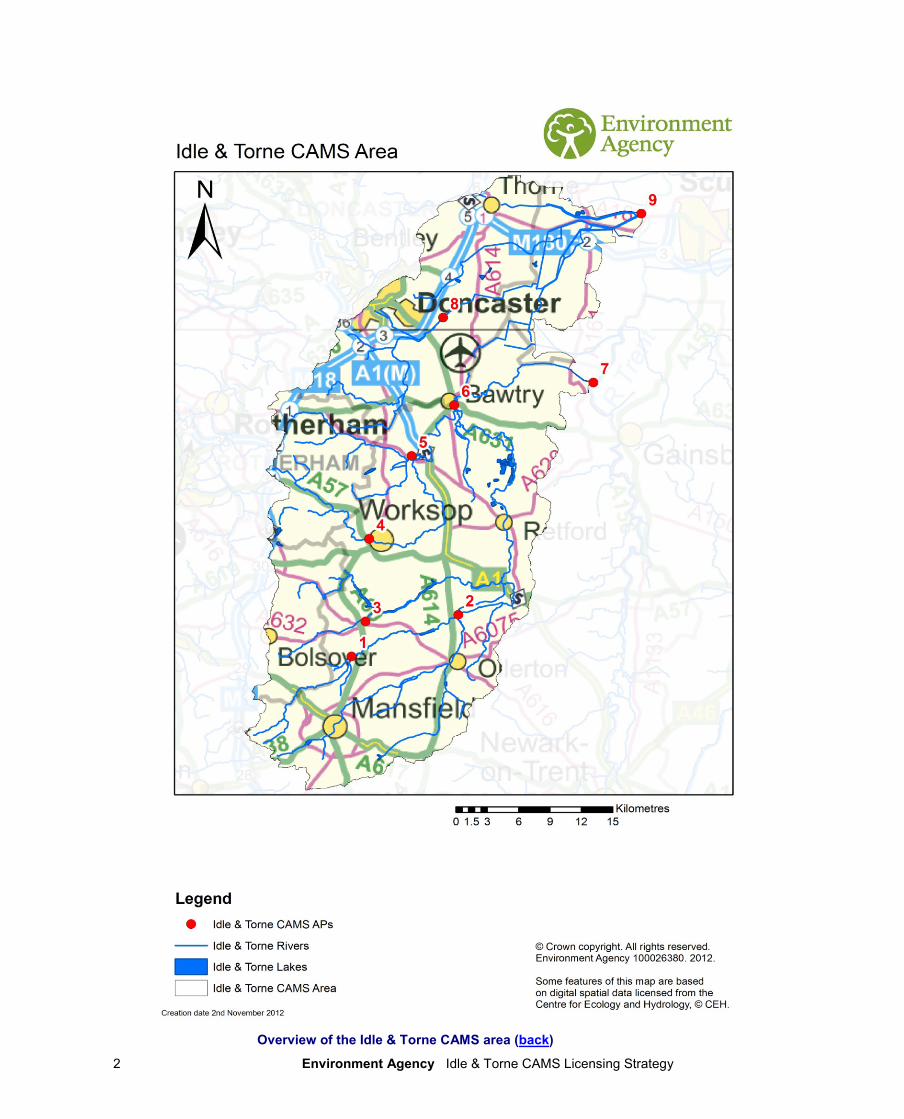
Overview of the Idle & Torne CAMS area (back)
Environment Agency Idle & Torne CAMS Licensing Strategy 3
Foreword
Water is the most essential of our natural resources, and it is our job to ensure that
we manage and use it effectively and sustainably.
Our rivers and groundwater resources support a diverse range of wildlife and
habitats, yet with population growth and the latest climate change predictions, our
water resources are under increasing pressure to support the needs of society, the
economy and the environment.
This licensing strategy sets out how we will manage water resources in the Idle &
Torne catchment, provides information on how existing abstraction is regulated
and if water is available for further abstraction. The plan will also detail how it
protects our requirements under the Water Framework Directive, ensuring no
ecological deterioration to our rivers.
It is important that our activities today do not damage the environment or water
supplies of the future. We have a shared responsibility to use water wisely- in the
home, at work and for recreational activities- a challenge this licence strategy will
help us to meet.
Lee Rawlinson
Area Manager- Midlands East
Environment Agency Idle & Torne CAMS Licensing Strategy 4
Contents
Overview Map of Idle & Torne CAMS area .......................................................... 2
1. About the Licensing Strategy .......................................................................... 5
2. Idle & Torne CAMS area ................................................................................... 7
3. Water resource availability of the Idle & Torne area ..................................... 8
4. How we manage abstractions in the Idle & Torne area ............................... 15
Glossary of terms ............................................................................................... 28
List of abbreviations .......................................................................................... 29
Environment Agency Idle & Torne CAMS Licensing Strategy 5
1. About the Licensing Strategy This Licensing Strategy sets out how water resources are managed in the Idle & Torne area. It provides information about where water is available for further abstraction and an indication of how reliable a new abstraction licence may be. This strategy was produced in finalised in February 2013 and it supersedes the strategy issued in March 2007. How CAMS contributes to achieving environmental objectives under the (WFD) Water Framework Directive The Water Framework Directive’s main objectives are to protect and enhance the water environment and ensure the sustainable use of water resources for economic and social development. Catchment Abstraction Management Strategies (CAMS) set out how we will manage the water resources of a catchment and contribute to implementing the WFD. CAMS contribute to the WFD by:
providing a water resource assessment of rivers, lakes, reservoirs, estuaries and groundwater referred to as water bodies under the WFD;
identifying water bodies that fail flow conditions expected to support good ecological status;
preventing deterioration of water body status due to new abstractions;
providing results which inform River Basin Management Plans (RBMPs). When is an abstraction licence required? You need a licence from us if you want to abstract more than 20m
3/day (4,400 gallons) of water per
day from a:
river or stream
reservoir, lake or pond
canal
spring or
an underground source Whether or not a licence is granted depends on the amount of water available after the needs of the environment and existing abstractors are met and whether the justification for the abstraction is reasonable. If you want to apply for an abstraction licence or make changes to a licence that you already have then, please contact us:
by telephone on 03708 506 506
by email at [email protected]
or visit our website at www.environment-agency.gov.uk.
Environment Agency Idle & Torne CAMS Licensing Strategy 6
Sustainable abstraction This licensing strategy has been produced using evidence and information gathered during the Catchment Abstraction Management Strategy (CAMS) process. Through this process we consider the impact of abstraction at all flows. This helps to manage future abstraction more sustainably. We now assess water resources at a sub-catchment level called water bodies. This means that we can provide more detailed information on the availability of water resources in the Idle & Torne CAMS area compared to the scale used in the previous strategy. Within this strategy we also outline where we may need to reduce current rates of abstraction and our approach on time limiting licences. The background, aims and principles of CAMS, the over arching principles we use when managing abstraction licences and links with other initiatives are detailed in our document: Managing Water Abstraction. You should read Managing Water Abstraction when reading this catchment specific licensing strategy.
Environment Agency Idle & Torne CAMS Licensing Strategy 7
2. Idle & Torne CAMS area
The catchment of the Idle and Torne rivers covers an area approximately 1,200km2.
Nottinghamshire and South Yorkshire are the principle counties. However, Derbyshire and North Lincolnshire cover areas to the south west and north east of the catchment area respectively. Located on the northern boundary of the CAMS area, lies the principal urban area of Doncaster with a population of approximately 286,866, although only the south-eastern outskirts of the city falls within the boundary of the CAMS area. Other significant towns include Mansfield, Worksop, Retford, Maltby and Bawtry.
The Idle drains a catchment area of approximately 879km2 and the Torne an area of approximately
328km2. The River Idle is a significant tributary of the River Trent. The Rivers Maun, Meden and
Poulter meet near Gamston, south of Retford to form the River Idle, joined downstream by the River Ryton. At Bawtry, north of Retford, the River Idle turns eastwards to its confluence with the River Trent at the village of West Stockwith, north of Gainsborough. The River Torne rises near Tickhill and flows north-eastward around the south east of Doncaster, through the heavily drained area of the Isle of Axholme, to its confluence with the River Trent at Keadby.
The Chesterfield Canal enters the catchment to the west of Worksop and traverses towards and through Retford before continuing to and entering the River Trent at West Stockwith. The Stainforth & Keadby Canal as traverses the catchment but has no hydrological interaction with the Idle & Torne catchment.
The Lower Magnesian Limestone, Sherwood Sandstone and Mercia Mudstone dominate the geology of the Idle and Torne CAMS area. The Magnesian Limestone and Sherwood Sandstone are both classified as ‘principal’ aquifers. They outcrop in vertical bands running north to south, the strata dipping to the east with the older Lower Magnesian Limestone outcropping in the west and is subsequently confined by the Sherwood Sandstone, which lies to the east. The area has a rich history of coal mining with extensive measures of coal underlying the Lower Magnesian Limestone. The Sherwood Sandstone has historically been heavily exploited for abstraction.
The Idle & Torne is a predominantly moderate to lowland catchment. Its highest areas are located in an area between Mansfield in the south west and Maltby to the south of Doncaster. The lowest points lie north of a line drawn between Retford and Doncaster. Much of the northern half of the CAMS area is drained by pumps and high level carriers. Here the land is at or below sea level. Most of the higher areas are undulating in nature, but with no great inclines. Most watercourses flow in a north eastward direction and the topography reflects this. Throughout the catchment, agriculture is the dominant land use, particularly arable agriculture. Consequently, agriculture is vitally important to the economy of the CAMS area. Agriculture relies heavily on local surface and groundwater abstraction as part of its process, principally for irrigation. The headwaters of the rivers in the catchment are industrialised particularly around Mansfield and Worksop. However, there are a number of Sites of Special Scientific Interest (SSSIs) within the catchment highlighting the diverse nature of the environment. These can be found throughout the catchment. Thorne and Hatfield Moors have been designated Special Areas of Conservation under the Habitats Directive and Specially Protected Areas under the Birds Directive.
Public water supply in the catchment is primarily sourced from the principal aquifer of the Sherwood Sandstone with multiple borehole sites located throughout the catchment. However, the catchment also receives imported water from Derbyshire. Public water supply places the biggest pressure on groundwater levels as well as agriculture. Agricultural abstraction dominates surface water with its need for irrigation. This water is predominantly needed in the summer months, which places added pressure on surface waters. Heavy industry accounted for a significant part of abstraction particularly around Mansfield, Worksop and Doncaster. However, due to the decline in heavy industry, parts of Doncaster have seen groundwater levels rise. The Overview map shows the geographical area of the Idle & Torne catchment.
Environment Agency Idle & Torne CAMS Licensing Strategy 8
3. Water resource availability of the Idle & Torne area 3.1 Resource assessment Resource assessment is at the heart of abstraction management. To manage water effectively we need to understand how much is available and where it is available, after considering the needs of the environment. We have a monitoring network to measure river flows and groundwater levels. We use this data along with our knowledge of human influences and environmental needs to establish a baseline of water availability for each water body that builds into a picture for the catchment. The main components of this assessment that help us to understand the availability of water resources are:
a resource allocation for the environment defined as a proportion of natural flow, known as the Environmental Flow Indicator (EFI);
the Fully Licensed (FL) scenario - the situation if all abstraction licences were being used to full capacity;
the Recent Actual (RA) scenario – the amount of water which has actually been abstracted on average over the previous six years.
River flows change naturally throughout the year, so we want to protect flow variability in our rivers from low to high flow conditions. We use flow statistics to help to do this. Flow statistics are expressed as the percentage of time that flow is exceeded. Resource availability is calculated at four different flows, Q95 (lowest), Q70, Q50 and Q30 (highest). This information gives a realistic picture of what the current resource availability is within a given water body. Water bodies are sub-catchment surface water units or groundwater units on which we carry out assessments and map results. NB: Natural flows for CAMS Assessment Points (AP) water bodies have been taken from information provided in the CAMS ledgers. Natural flows for other water bodies have been derived based on simple interpolation between, or downstream of, CAMS APs, based on catchment area.
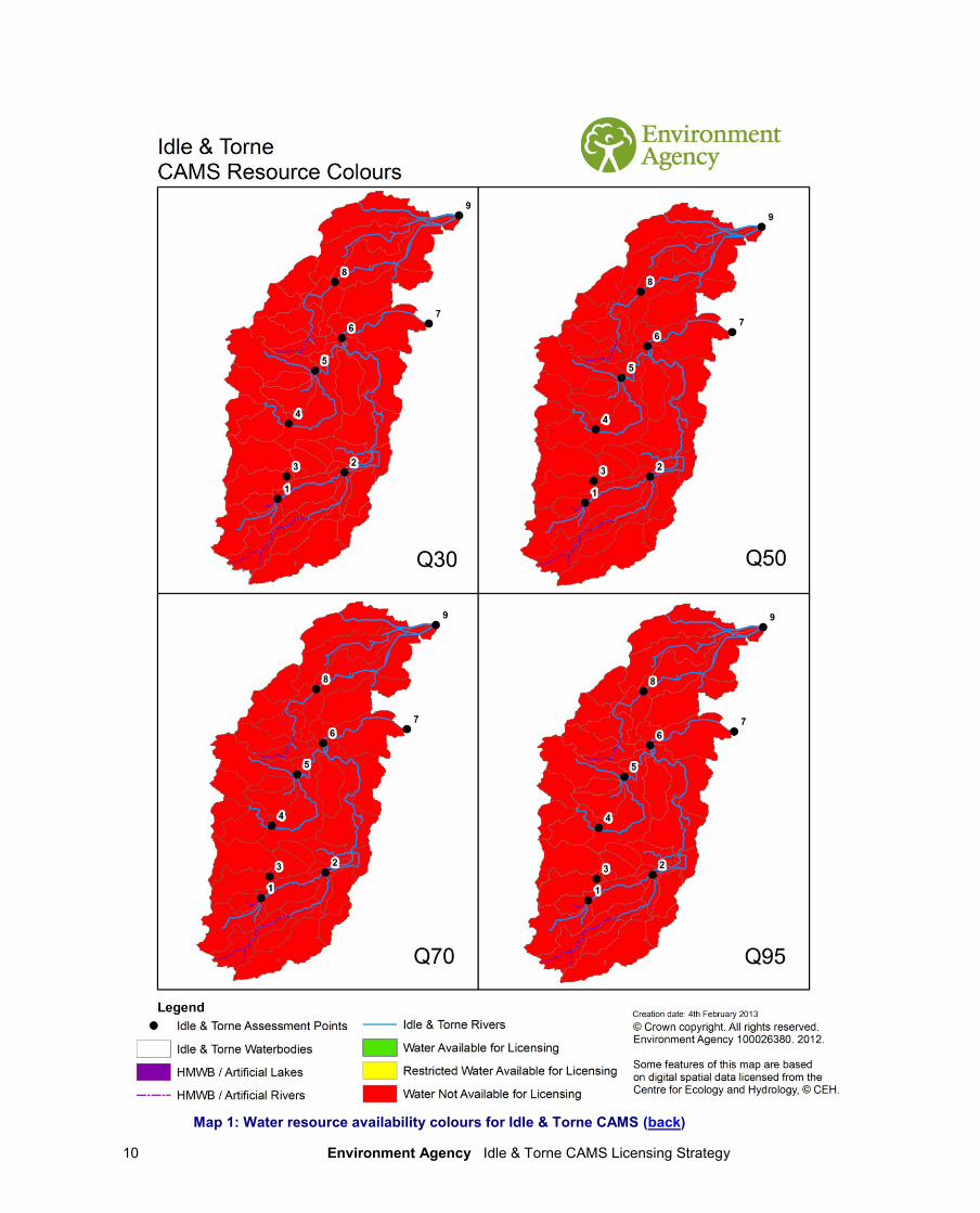
3.2 Resource availability 3.2.1 Surface water If you want to abstract water, you need to know what water resources are available within a catchment and where abstraction for consumptive purposes is allowed. To show this we have developed a classification system which indicates:
the relative balance between the environmental requirements for water and how much is licensed for abstraction;
whether water is available for further abstraction;
areas where abstraction may need to be reduced. The availability of water for abstraction is determined by the relationship between the fully licensed and recent actual flows in relation to the EFI. The results mapped onto these water bodies are represented by different water resource availability colours showing the availability of water resource for further abstraction. The water resource availability colours are explained in Table 1. In addition to these water resource availability colours we’ve classified some surface water bodies as ‘high hydrological status’ which are coloured blue on the maps. In these water bodies very little actual abstraction occurs and they show virtually undisturbed, or close to natural, flow conditions. Another category of water bodies are Heavily Modified Water Bodies (HMWB). These can be classified for many reasons but for water resources they are classified if they contain a lake and/or
Environment Agency Idle & Torne CAMS Licensing Strategy 9
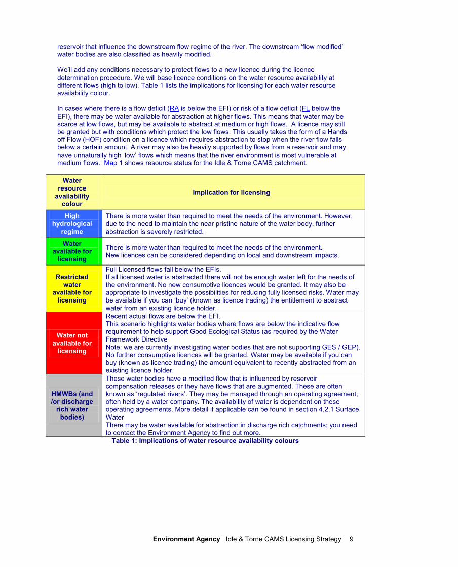
reservoir that influence the downstream flow regime of the river. The downstream ‘flow modified’ water bodies are also classified as heavily modified. We’ll add any conditions necessary to protect flows to a new licence during the licence determination procedure. We will base licence conditions on the water resource availability at different flows (high to low). Table 1 lists the implications for licensing for each water resource availability colour. In cases where there is a flow deficit (RA is below the EFI) or risk of a flow deficit (FL below the EFI), there may be water available for abstraction at higher flows. This means that water may be scarce at low flows, but may be available to abstract at medium or high flows. A licence may still be granted but with conditions which protect the low flows. This usually takes the form of a Hands off Flow (HOF) condition on a licence which requires abstraction to stop when the river flow falls below a certain amount. A river may also be heavily supported by flows from a reservoir and may have unnaturally high ‘low’ flows which means that the river environment is most vulnerable at medium flows. Map 1 shows resource status for the Idle & Torne CAMS catchment.
Water resource
availability colour
Implication for licensing
High hydrological
regime
There is more water than required to meet the needs of the environment. However, due to the need to maintain the near pristine nature of the water body, further abstraction is severely restricted.
Water available for
licensing
There is more water than required to meet the needs of the environment. New licences can be considered depending on local and downstream impacts.
Restricted water
available for licensing
Full Licensed flows fall below the EFIs. If all licensed water is abstracted there will not be enough water left for the needs of the environment. No new consumptive licences would be granted. It may also be appropriate to investigate the possibilities for reducing fully licensed risks. Water may be available if you can ‘buy’ (known as licence trading) the entitlement to abstract water from an existing licence holder.
Water not available for
licensing
Recent actual flows are below the EFI. This scenario highlights water bodies where flows are below the indicative flow requirement to help support Good Ecological Status (as required by the Water Framework Directive Note: we are currently investigating water bodies that are not supporting GES / GEP). No further consumptive licences will be granted. Water may be available if you can buy (known as licence trading) the amount equivalent to recently abstracted from an existing licence holder.
HMWBs (and /or discharge
rich water bodies)
These water bodies have a modified flow that is influenced by reservoir compensation releases or they have flows that are augmented. These are often known as ‘regulated rivers’. They may be managed through an operating agreement, often held by a water company. The availability of water is dependent on these operating agreements. More detail if applicable can be found in section 4.2.1 Surface Water There may be water available for abstraction in discharge rich catchments; you need to contact the Environment Agency to find out more.
Table 1: Implications of water resource availability colours
Environment Agency Idle & Torne CAMS Licensing Strategy 10
Map 1: Water resource availability colours for Idle & Torne CAMS (back)
Environment Agency Idle & Torne CAMS Licensing Strategy 11
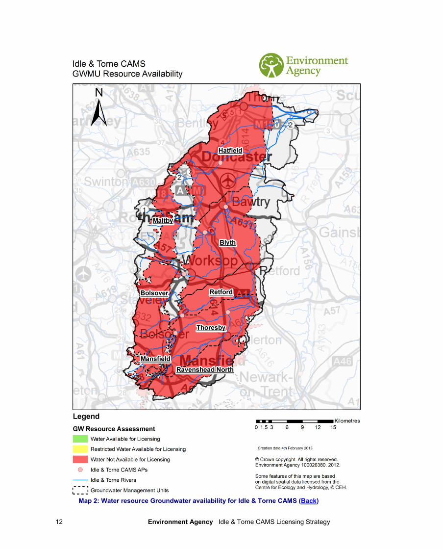
3.2.2 Groundwater Groundwater availability is guided by the surface water resource availability colours unless we have better information on principle aquifers or are aware of local issues we need to protect. For the Idle & Torne catchment, groundwater has been assessed using a number of groundwater management units (GWMU) to represent the water resource status for groundwater. The Sherwood Sandstone is a principal aquifer of strategic importance. It provides a large area of Nottinghamshire and surrounding areas with a potable water supply. It has a vast outcrop area within the catchment running in a wide vertical band in the centre of the catchment. As it has a large outcrop area, the Sherwood Sandstone has been split in to a number of different GWMUs, which can be seen in Map 2. The Magnesian Limestone is an important principal aquifer. Although not as strategically important as the Sherwood Sandstone, it provides many agricultural abstractors with a sustainable source of water. It is situated immediately to the west and runs parallel to the Sherwood Sandstone. As it is a narrower band of bedrock, it is represented by three GWMUs in the Idle & Torne catchment. Further details of all the GWMUs can be found in section 4.2.2. Map 1 shows the water resource availability colours in Idle & Torne area. The same availability is applied to groundwater and surface water. In cases where this is different, Map 2 shows water resource availability colours in Idle & Torne area, specifically for groundwater.
GWMU resource
availability colour
Implication for licensing
Water available for
licensing
Groundwater unit balance shows groundwater available for licensing. New licences can be considered depending on impacts on other abstractors and on surface water.
Restricted water
available for licensing
Groundwater unit balance shows more water is licensed than the amount available, but that recent actual abstractions are lower than the amount available OR that there are known local impacts likely to occur on dependent wetlands, groundwater levels or cause intrusions but with management options in place. In restricted groundwater units no new consumptive licences will be granted. It may also be appropriate to investigate the possibilities for reducing fully licensed risks. Water may be available if you can ‘buy’ (known as licence trading) the entitlement to abstract water from an existing licence holder. In other units there may be restrictions in some areas e.g. in relation to saline intrusion
Water not available for
licensing
Groundwater unit balance shows more water has been abstracted based on recent amounts than the amount available. No further consumptive licences will be granted.
Table 2: Implications of Groundwater resource availability colours
Environment Agency Idle & Torne CAMS Licensing Strategy 12
Map 2: Water resource Groundwater availability for Idle & Torne CAMS (Back)
Environment Agency Idle & Torne CAMS Licensing Strategy 13
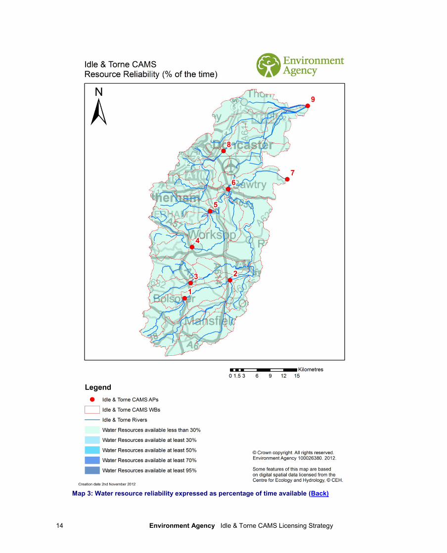
3.3 Resource reliability If you want to apply for a licence, it is worth considering that in some areas a new, consumptive abstraction may not be 100% reliable. Reliability information is based on CAMS resource availability colours and is a way of presenting the reliability of new abstractions at all flows. The availability of water for abstraction within a river varies greatly from high to low flows. By assessing the quantity of water available at different flows it is possible to see when there is a surplus or deficit of water and the associated reliability of an abstraction. This is an indication only; actual reliability of a licence will be discussed on application. Table 3 shows the resource availability colour associated with the percentage reliability of consumptive abstraction. Map 3 gives an indication of the resource reliability in Idle & Torne area expressed as percentage of time.
Resource Percentage of the time additional consumptive resource may be available
Consumptive abstraction available less than 30% of the time.
Consumptive abstraction available at least 30% of the time.
Consumptive abstraction available at least 50% of the time.
Consumptive abstraction available at least 70% of the time.
Consumptive abstraction available at least 95% of the time.
Not assessed
Table 3: Percentage reliability of consumptive abstraction
Environment Agency Idle & Torne CAMS Licensing Strategy 14
Map 3: Water resource reliability expressed as percentage of time available (Back)
Environment Agency Idle & Torne CAMS Licensing Strategy 15
4. How we manage abstractions in the Idle & Torne area
4.1 Principles The document Managing Water Abstraction outlines the over-arching principles that we follow in managing our water resources. How we apply these principles in the Idle & Torne area is outlined in this section. If you want to abstract water it outlines where water is available for further abstraction and the principles we follow in assessing your application for a licence.
Abstraction licence application process Anyone wanting to take more than 20m
3/day (4, 400 gallons) from a ‘source of supply’ (river,
stream, lake, well, groundwater, etc) must have an abstraction licence. The application process for abstraction is similar to the planning process in that we may require the application to be advertised and may require supporting environmental information. When considering the application we check that the quantities applied for and the purpose of the abstraction are reasonable, that there is sufficient water available to support it and that the potential impacts on the environment and other water users are acceptable. Depending on the outcome of our investigations we will issue a licence either as applied for, or with conditions that restrict the abstraction to protect the environment or other users. In certain cases we may have to refuse the application. Any applicant who is not happy with our determination (decision) has the right to appeal against it. Each application is determined on its own merits Whilst this document may say that water is available for further abstraction, this does not guarantee that all applications will be successful. We’ll determine each application upon its own merits and any local impacts. A licence does not guarantee that water is available It’s important to understand that when we issue a licence we do not guarantee the supply of water. We have to protect the environment and rights of other abstractors. To do this we may add constraints to licences. Licence holders need to understand the implications of this as it affects the reliability of supply. For example, in drier years it’s more likely that conditions will come into effect and abstraction is more likely to be stopped. Abstractions are managed to protect the environment. No ecological deterioration We assess the impact of new applications for water to make sure that the resultant river flows:
will maintain a good ecology or if the ecology is not good, will not deteriorate the ecology of our rivers further;
will maintain the near pristine condition of high hydrological regime water bodies. We’ll also take action if necessary to limit the increase in current abstraction, if we think this will lead to deterioration of the ecology or the near pristine condition of our high hydrological regime water bodies. These principles apply to the water body in which the abstraction is located and also to all downstream water bodies that may be affected by any reduction in abstraction related flow. Doing this means that we will maintain the water body status as reported in the River Basin Management Plans (2009) and ensure compliance with the European Union Water Framework Directive.
Water efficiency and demand management We need to make the best use of our existing water resources. Adopting water efficiency and demand management measures can help us achieve this goal. Water efficiency is one of the tests that will need to be satisfied before we grant a new licence or renew a time limited licence. We will promote the wise and efficient use of water and actions to limit demand (and reduce leakage) to curb the growth in abstraction and limit the impact on flows and any consequent impact on the ecology. For further details on our general approach to licensing please see the document Managing Water Abstraction.
Environment Agency Idle & Torne CAMS Licensing Strategy 16
Impoundments Applications for impoundments will be dealt with on a case-by-case basis. An impoundment is a dam, weir or other construction in an inland waterway that obstructs or impedes flow and/or raises water levels. Hydropower Water abstraction for hydropower schemes is non-consumptive, with all water used returned to the watercourse. Hands off Flows and maximum abstraction volumes are determined in line with the Environment Agency's Hydropower Good Practice Guidelines and based on the assessment of environmental risk for each scheme. For further information please refer to our website.
4.2 Abstraction restrictions When issuing a licence we have to protect the environment and rights of other abstractors. To do this we may add conditions to licences.
Time limited licences In recognition of changing pressures on water resources all new licences and variations (other than downward variations or minor variations having no environmental impact) will have a time limit imposed. This allows for the periodic review and changes to abstraction licences where circumstances have changed since the licence was granted. All new licences within a CAMS area have a common end date (CED) so they can be reviewed at the same time. When an application is made within six years of the CED, we will generally apply the subsequent CED to any licence granted. This is to avoid issuing shorter and shorter duration licences as the CED approaches. This means that the initial CED on a licence may be between six and 18 years duration. On replacement the normal duration will then usually be 12 years. However, where we are uncertain about the long term impacts of an abstraction we will grant a short term licence during which time potential impacts are monitored. 25% of the licences in Idle & Torne CAMS are time-limited. CEDs occur every twelve years. The next CED for Idle & Torne CAMS is 31
st March 2026. We have the discretion to apply short or long
time limits to a licence and this will be done on a case by case basis, following discussion between the applicant and ourselves. Time limited licences will be renewed providing the abstraction:
is environmentally sustainable
has a continued justification of need
Is an efficient use of water We expect that most applications for same terms licence replacement will be granted. When the three tests above are not met the licence may not be re-issued or re-issued with different conditions. Additional information about the replacement of time limited licences is available in Managing Water Abstraction.
Hands off flow conditions To protect the environment we may issue a licence with a condition referred to as a ‘Hands-Off Flow’ (HOF). This specifies that if the flow in the river drops below that which is required to protect the environment abstraction must stop, hence ‘Hands-Off Flow’. Please see section 4.2.1 for details relating to licence restrictions
Environment Agency Idle & Torne CAMS Licensing Strategy 17
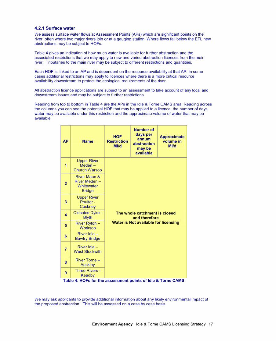
4.2.1 Surface water
We assess surface water flows at Assessment Points (APs) which are significant points on the river, often where two major rivers join or at a gauging station. Where flows fall below the EFI, new abstractions may be subject to HOFs. Table 4 gives an indication of how much water is available for further abstraction and the associated restrictions that we may apply to new and varied abstraction licences from the main river. Tributaries to the main river may be subject to different restrictions and quantities. Each HOF is linked to an AP and is dependent on the resource availability at that AP. In some cases additional restrictions may apply to licences where there is a more critical resource availability downstream to protect the ecological requirements of the river. All abstraction licence applications are subject to an assessment to take account of any local and downstream issues and may be subject to further restrictions. Reading from top to bottom in Table 4 are the APs in the Idle & Torne CAMS area. Reading across the columns you can see the potential HOF that may be applied to a licence, the number of days water may be available under this restriction and the approximate volume of water that may be available.
AP Name HOF
Restriction Ml/d
Number of days per annum
abstraction may be
available
Approximate volume in
Ml/d
1 Upper River
Meden – Church Warsop
The whole catchment is closed and therefore
Water is Not available for licensing
2
River Maun & River Meden –
Whitewater Bridge
3 Upper River
Poulter - Cuckney
4 Oldcotes Dyke -
Blyth
5 River Ryton –
Worksop
6 River Idle –
Bawtry Bridge
7 River Idle –
West Stockwith
8 River Torne –
Auckley
9 Three Rivers -
Keadby
Table 4: HOFs for the assessment points of Idle & Torne CAMS We may ask applicants to provide additional information about any likely environmental impact of the proposed abstraction. This will be assessed on a case by case basis.
Environment Agency Idle & Torne CAMS Licensing Strategy 18
We have an obligation to protect all Habitats Directive sites and implement the needs of the Eels Regulations 2009, as amended in 2011. Conditions may be added to new licences and variations to ensure the protection of fish, other aquatic wildlife and protected sites. The following conditions may not apply if the abstraction is non-consumptive (i.e. it doesn’t result in a loss of water to any part of the catchment). The following conditions may also not apply if the licence results in an overall environmental benefit and this will be assessed on a case by case basis. AP1, Upper River Meden (Church Warsop) For AP1, Upper River Meden, Water is not available for licensing. This means for new licences: The catchment is closed to any further consumptive abstraction from both surface water and groundwater and new licences are not available. Existing Licences: There is a presumption of renewal, subject to the following renewal criteria and local considerations.
environmental sustainability is not in question
there is a continued justification of need for the water
the water is used efficiently. We will also take into account any objections received to renewal of the licence. We will endeavour to give six years notice if a licence will not be renewed or is to be renewed on more restrictive terms that impact significantly on the use of that licence. AP2, Rivers Maun & Meden (Whitewater Bridge) For AP2, Rivers Maun and Meden, Water is not available for licensing This means for new licences: The catchment is closed to any further consumptive abstraction from both surface water and groundwater and new licences are not available. Existing Licences: There is a presumption of renewal, subject to the following renewal criteria and local considerations.
environmental sustainability is not in question
there is a continued justification of need for the water
the water is used efficiently. We will also take into account any objections received to renewal of the licence. We will endeavour to give six years notice if a licence will not be renewed or is to be renewed on more restrictive terms that impact significantly on the use of that licence. AP3, Upper River Poulter (Cuckney) For AP3, Upper River Poulter, Water is not available for licensing. This means for new licences: The catchment is closed to any further consumptive abstraction from both surface water and groundwater and new licences are not available.
Environment Agency Idle & Torne CAMS Licensing Strategy 19
Existing Licences: There is a presumption of renewal, subject to the following renewal criteria and local considerations.
environmental sustainability is not in question
there is a continued justification of need for the water
the water is used efficiently. We will also take into account any objections received to renewal of the licence. We will endeavour to give six years notice if a licence will not be renewed or is to be renewed on more restrictive terms that impact significantly on the use of that licence. AP4, Oldcotes Dyke (Blyth) For AP4, Oldcotes Dyke, Water is not available for licensing. This means for new licences: The catchment is closed to any further consumptive abstraction from both surface water and groundwater and new licences are not available. Existing Licences: There is a presumption of renewal, subject to the following renewal criteria and local considerations.
environmental sustainability is not in question
there is a continued justification of need for the water
the water is used efficiently. We will also take into account any objections received to renewal of the licence. We will endeavour to give six years notice if a licence will not be renewed or is to be renewed on more restrictive terms that impact significantly on the use of that licence. AP5, River Ryton (Worksop) For AP5, River Ryton, Water is not available for licensing. This means for new licences: The catchment is closed to any further consumptive abstraction from both surface water and groundwater and new licences are not available. Existing Licences: There is a presumption of renewal, subject to the following renewal criteria and local considerations.
environmental sustainability is not in question
there is a continued justification of need for the water
the water is used efficiently. We will also take into account any objections received to renewal of the licence. We will endeavour to give six years notice if a licence will not be renewed or is to be renewed on more restrictive terms that impact significantly on the use of that licence.
Environment Agency Idle & Torne CAMS Licensing Strategy 20
AP6, River Idle (Bawtry Bridge) For AP1, River Idle (up to Bawtry Bridge), Water is not available for licensing. This means for new licences: The catchment is closed to any further consumptive abstraction from both surface water and groundwater and new licences are not available. Existing Licences: There is a presumption of renewal, subject to the following renewal criteria and local considerations.
environmental sustainability is not in question
there is a continued justification of need for the water
the water is used efficiently. We will also take into account any objections received to renewal of the licence. We will endeavour to give six years notice if a licence will not be renewed or is to be renewed on more restrictive terms that impact significantly on the use of that licence. AP7, River Idle (West Stockwith) For AP7, River Idle (between Bawtry Bridge & West Stockwith), Water is not available for licensing. This means for new licences: The catchment is closed to any further consumptive abstraction from both surface water and groundwater and new licences are not available. Existing Licences: There is a presumption of renewal, subject to the following renewal criteria and local considerations.
environmental sustainability is not in question
there is a continued justification of need for the water
the water is used efficiently. We will also take into account any objections received to renewal of the licence. We will endeavour to give six years notice if a licence will not be renewed or is to be renewed on more restrictive terms that impact significantly on the use of that licence. AP8, River Torne (Auckley) For AP8, River Torne (up to Auckley), Water is not available for licensing. This means for new licences: The catchment is closed to any further consumptive abstraction from both surface water and groundwater and new licences are not available. Existing Licences: There is a presumption of renewal, subject to the following renewal criteria and local considerations.
environmental sustainability is not in question
there is a continued justification of need for the water
the water is used efficiently.
Environment Agency Idle & Torne CAMS Licensing Strategy 21
We will also take into account any objections received to renewal of the licence. We will endeavour to give six years notice if a licence will not be renewed or is to be renewed on more restrictive terms that impact significantly on the use of that licence. AP9, Three Rivers (Keadby) For AP9, Three Rivers (from Auckley to Keadby, not including the Stainforth & Keadby Canal), Water is not available for licensing. This means for new licences: The catchment is closed to any further consumptive abstraction from both surface water and groundwater and new licences are not available. Existing Licences: There is a presumption of renewal, subject to the following renewal criteria and local considerations.
environmental sustainability is not in question
there is a continued justification of need for the water
the water is used efficiently. We will also take into account any objections received to renewal of the licence. We will endeavour to give six years notice if a licence will not be renewed or is to be renewed on more restrictive terms that impact significantly on the use of that licence. Heavily Modified (HMWB) & Artificial Water Bodies A heavily modified water body is an existing body of water that has had its original appearance significantly changed to suit a specific purpose. For example, a river water body that has undergone extensive re-alignment for navigation, or a flood defended coastline Artificial water bodies describe water bodies that are entirely man-made for example canals. They also include lakes where no significant water body existed previously (gravel pits) or impounded rivers or lakes with an artificial catchment (reservoirs). Artificial waterbodies and HMWB are considered in the together and in the same way. Within the Idle & Torne CAMS catchment, there are no watercourses that are designated HMWB for water resources reasons. This is mainly due to the fact that there are no public water supply impounding reservoirs within the Idle & Torne catchment and no public water supply surface water abstraction. There are a number of water bodies that are designated HMWB for reasons other than water resources. These include parts of the Rivers Maun, Idle and Torne. There are also a number of lakes and drain water bodies which are designated ‘Artificial’. Both the HMWB and the Artificial water bodies are designated for reasons including flood protection, land drainage, recreation, urbanisation and the wider environment.
Environment Agency Idle & Torne CAMS Licensing Strategy 22
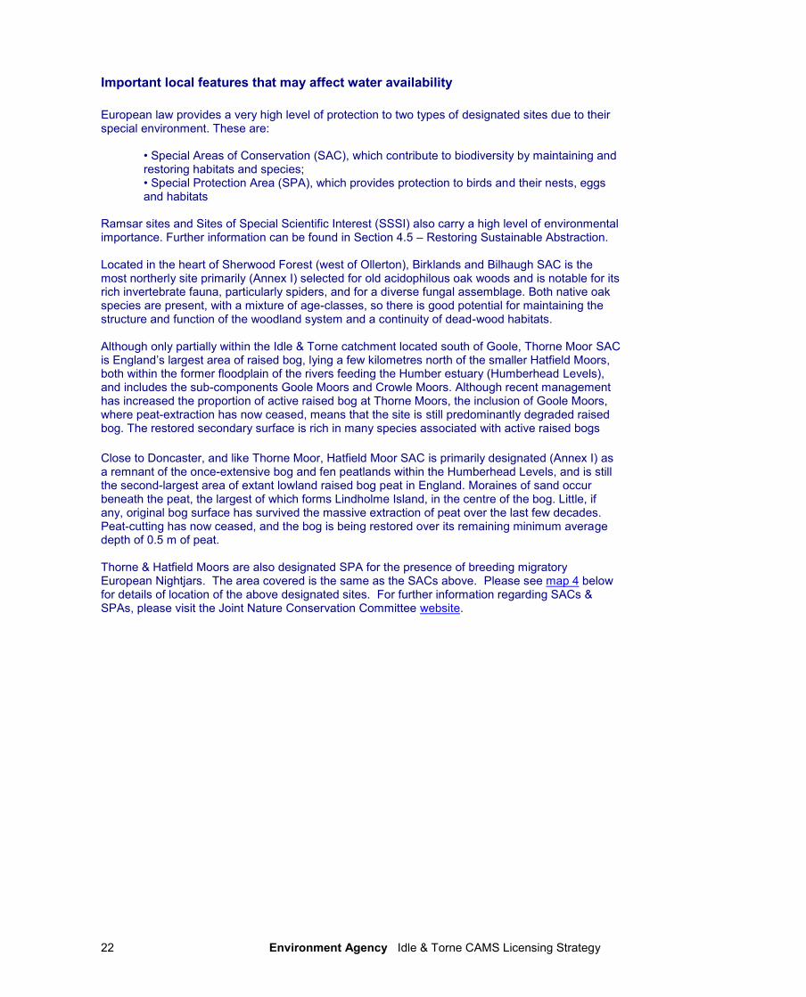
Important local features that may affect water availability
European law provides a very high level of protection to two types of designated sites due to their special environment. These are:
• Special Areas of Conservation (SAC), which contribute to biodiversity by maintaining and restoring habitats and species; • Special Protection Area (SPA), which provides protection to birds and their nests, eggs and habitats
Ramsar sites and Sites of Special Scientific Interest (SSSI) also carry a high level of environmental importance. Further information can be found in Section 4.5 – Restoring Sustainable Abstraction. Located in the heart of Sherwood Forest (west of Ollerton), Birklands and Bilhaugh SAC is the most northerly site primarily (Annex I) selected for old acidophilous oak woods and is notable for its rich invertebrate fauna, particularly spiders, and for a diverse fungal assemblage. Both native oak species are present, with a mixture of age-classes, so there is good potential for maintaining the structure and function of the woodland system and a continuity of dead-wood habitats. Although only partially within the Idle & Torne catchment located south of Goole, Thorne Moor SAC is England’s largest area of raised bog, lying a few kilometres north of the smaller Hatfield Moors, both within the former floodplain of the rivers feeding the Humber estuary (Humberhead Levels), and includes the sub-components Goole Moors and Crowle Moors. Although recent management has increased the proportion of active raised bog at Thorne Moors, the inclusion of Goole Moors, where peat-extraction has now ceased, means that the site is still predominantly degraded raised bog. The restored secondary surface is rich in many species associated with active raised bogs
Close to Doncaster, and like Thorne Moor, Hatfield Moor SAC is primarily designated (Annex I) as a remnant of the once-extensive bog and fen peatlands within the Humberhead Levels, and is still the second-largest area of extant lowland raised bog peat in England. Moraines of sand occur beneath the peat, the largest of which forms Lindholme Island, in the centre of the bog. Little, if any, original bog surface has survived the massive extraction of peat over the last few decades. Peat-cutting has now ceased, and the bog is being restored over its remaining minimum average depth of 0.5 m of peat. Thorne & Hatfield Moors are also designated SPA for the presence of breeding migratory European Nightjars. The area covered is the same as the SACs above. Please see map 4 below for details of location of the above designated sites. For further information regarding SACs & SPAs, please visit the Joint Nature Conservation Committee website.
Environment Agency Idle & Torne CAMS Licensing Strategy 23
Map 4: Idle & Torne CAMS Specially Designated Areas (back)
Environment Agency Idle & Torne CAMS Licensing Strategy 24
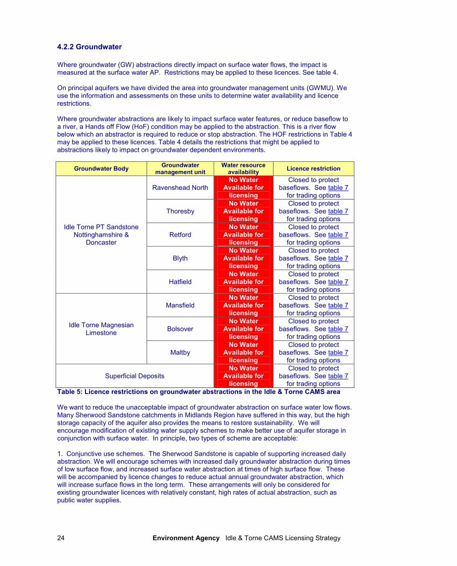
4.2.2 Groundwater
Where groundwater (GW) abstractions directly impact on surface water flows, the impact is measured at the surface water AP. Restrictions may be applied to these licences. See table 4. On principal aquifers we have divided the area into groundwater management units (GWMU). We use the information and assessments on these units to determine water availability and licence restrictions. Where groundwater abstractions are likely to impact surface water features, or reduce baseflow to a river, a Hands off Flow (HoF) condition may be applied to the abstraction. This is a river flow below which an abstractor is required to reduce or stop abstraction. The HOF restrictions in Table 4 may be applied to these licences. Table 4 details the restrictions that might be applied to abstractions likely to impact on groundwater dependent environments.
Groundwater Body Groundwater
management unit Water resource
availability Licence restriction
Idle Torne PT Sandstone Nottinghamshire &
Doncaster
Ravenshead North No Water
Available for licensing
Closed to protect baseflows. See table 7
for trading options
Thoresby No Water
Available for licensing
Closed to protect baseflows. See table 7
for trading options
Retford No Water
Available for licensing
Closed to protect baseflows. See table 7
for trading options
Blyth No Water
Available for licensing
Closed to protect baseflows. See table 7
for trading options
Hatfield No Water
Available for licensing
Closed to protect baseflows. See table 7
for trading options
Idle Torne Magnesian Limestone
Mansfield No Water
Available for licensing
Closed to protect baseflows. See table 7
for trading options
Bolsover No Water
Available for licensing
Closed to protect baseflows. See table 7
for trading options
Maltby No Water
Available for licensing
Closed to protect baseflows. See table 7
for trading options
Superficial Deposits No Water
Available for licensing
Closed to protect baseflows. See table 7
for trading options
Table 5: Licence restrictions on groundwater abstractions in the Idle & Torne CAMS area We want to reduce the unacceptable impact of groundwater abstraction on surface water low flows. Many Sherwood Sandstone catchments in Midlands Region have suffered in this way, but the high storage capacity of the aquifer also provides the means to restore sustainability. We will encourage modification of existing water supply schemes to make better use of aquifer storage in conjunction with surface water. In principle, two types of scheme are acceptable: 1. Conjunctive use schemes. The Sherwood Sandstone is capable of supporting increased daily abstraction. We will encourage schemes with increased daily groundwater abstraction during times of low surface flow, and increased surface water abstraction at times of high surface flow. These will be accompanied by licence changes to reduce actual annual groundwater abstraction, which will increase surface flows in the long term. These arrangements will only be considered for existing groundwater licences with relatively constant, high rates of actual abstraction, such as public water supplies.
Environment Agency Idle & Torne CAMS Licensing Strategy 25
2. Surface to groundwater exchange licence schemes. We will consider exchanging surface water licences for groundwater licences where water resources are available and where there are benefits to the surface water environment. In both cases, we will only consider schemes that achieve real improvements in surface water low-flow conditions. All schemes will be subject to environmental assessment.
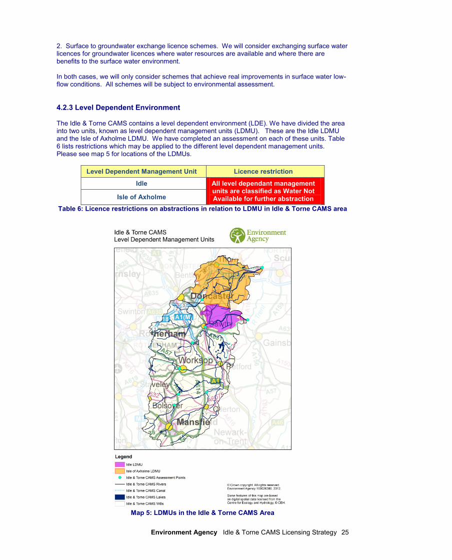
4.2.3 Level Dependent Environment The Idle & Torne CAMS contains a level dependent environment (LDE). We have divided the area into two units, known as level dependent management units (LDMU). These are the Idle LDMU and the Isle of Axholme LDMU. We have completed an assessment on each of these units. Table 6 lists restrictions which may be applied to the different level dependent management units. Please see map 5 for locations of the LDMUs.
Level Dependent Management Unit Licence restriction
Idle All level dependant management units are classified as Water Not Available for further abstraction Isle of Axholme
Table 6: Licence restrictions on abstractions in relation to LDMU in Idle & Torne CAMS area
Map 5: LDMUs in the Idle & Torne CAMS Area
Environment Agency Idle & Torne CAMS Licensing Strategy 26
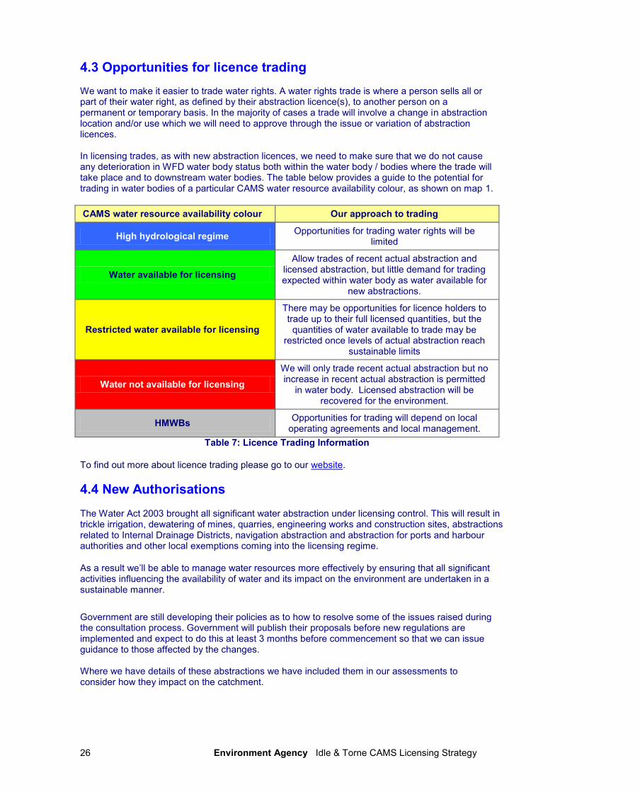
4.3 Opportunities for licence trading We want to make it easier to trade water rights. A water rights trade is where a person sells all or part of their water right, as defined by their abstraction licence(s), to another person on a permanent or temporary basis. In the majority of cases a trade will involve a change in abstraction location and/or use which we will need to approve through the issue or variation of abstraction licences. In licensing trades, as with new abstraction licences, we need to make sure that we do not cause any deterioration in WFD water body status both within the water body / bodies where the trade will take place and to downstream water bodies. The table below provides a guide to the potential for trading in water bodies of a particular CAMS water resource availability colour, as shown on map 1.
CAMS water resource availability colour Our approach to trading
High hydrological regime Opportunities for trading water rights will be
limited
Water available for licensing
Allow trades of recent actual abstraction and licensed abstraction, but little demand for trading expected within water body as water available for
new abstractions.
Restricted water available for licensing
There may be opportunities for licence holders to trade up to their full licensed quantities, but the quantities of water available to trade may be
restricted once levels of actual abstraction reach sustainable limits
Water not available for licensing
We will only trade recent actual abstraction but no increase in recent actual abstraction is permitted
in water body. Licensed abstraction will be recovered for the environment.
HMWBs Opportunities for trading will depend on local
operating agreements and local management.
Table 7: Licence Trading Information
To find out more about licence trading please go to our website.
4.4 New Authorisations
The Water Act 2003 brought all significant water abstraction under licensing control. This will result in trickle irrigation, dewatering of mines, quarries, engineering works and construction sites, abstractions related to Internal Drainage Districts, navigation abstraction and abstraction for ports and harbour authorities and other local exemptions coming into the licensing regime.
As a result we’ll be able to manage water resources more effectively by ensuring that all significant activities influencing the availability of water and its impact on the environment are undertaken in a sustainable manner.
Government are still developing their policies as to how to resolve some of the issues raised during the consultation process. Government will publish their proposals before new regulations are implemented and expect to do this at least 3 months before commencement so that we can issue guidance to those affected by the changes. Where we have details of these abstractions we have included them in our assessments to consider how they impact on the catchment.
Environment Agency Idle & Torne CAMS Licensing Strategy 27
4.5 Restoring Sustainable Abstraction
Where water abstractions cause or potentially cause actual flows to fall short of the EFIs and result in environmental damage, we may need to change or even revoke existing abstractions in order to achieve a sustainable abstraction regime. Within the Idle & Torne CAMS there are 15 water bodies in which recent actual flows have fallen below the EFI. The abstraction licences within these water bodies that cause these issues are being investigated as part of the RSA programme. Investigations into the impact caused by these licences, individually or cumulatively, will result in options being developed with licence holders on how to improve sustainability. Investigations will include a cost/benefit analysis. Information on how licences in the RSA programme are dealt with can be found in our Step by Step guide on our website. Habitats Directive Under the Habitats Regulations we have assessed the effects of existing abstraction licences and will assess new applications to make sure they are not impacting on internationally important nature conservation sites. These sites are known as Special Areas of Conservation (SAC’s) and Special Protection Areas (SPA’s). If your current licence has been reviewed under this legislation to assess its impact you will already know about the review. If we haven’t contacted you yet then your licence is either not near a SAC/SPA or isn’t having an impact on these sites. If our assessment shows that a new application could have an impact on a SAC/SPA we have to follow strict rules in setting a time limit for that licence. These are: • We may be able to grant the licence but only with a short time limit. This allows us to monitor the impact of the abstraction on a SAC/SPA and change the licence if necessary; • If we can’t determine that your application will not affect the site we have to either put conditions on the licence so that it cannot affect the site or refuse the application. If we grant the licence we may ask you to monitor its impact; • If our assessment shows that there isn’t an impact on the site we will manage the application according to the principles in this document.
Environment Agency Idle & Torne CAMS Licensing Strategy 28
Glossary of terms
Abstraction Removal of water from a source of supply (surface or groundwater).
Abstraction licence
The authorisation granted by the Environment Agency to allow the removal of water.
Assessment Point Unit
Point at which the flow from upstream catchment is assessed.
Catchment The area from which precipitation and groundwater will collect and contribute to the flow of a specific river.
Consumptive abstraction
Abstraction where a significant proportion of the water is not returned either directly or indirectly to the source of supply after use. For example for the use of spray irrigation. (back)
Discharge The release of substances (i.e. water, sewage, etc.) into surface waters.
Environmental flow indicator
Flow indicator to prevent environmental deterioration of rivers, set in line with new UK standards set by UKTAG.
Full licence A licence to abstract water from a source of supply over a period of 28 days or more
Groundwater Water that is contained in underground rocks.
Hands off flow A condition attached to an abstraction licence which states that if flow (in the river) falls below the level specified on the licence, the abstractor will be required to reduce or stop the abstraction.
Hands off level A river flow or borehole (groundwater) level below which an abstractor is required to reduce or stop abstraction.
Impoundment An impoundment is a structure that obstructs or impedes the flow of inland water, such as a dam, weir or other constructed works. (back)
Outcrop Any bedrock type that is not overlain (confined) by any other bedrock type
Protected right Means a right to abstract, which someone has by virtue of the small abstractions exemptions defined in the Water Act 2003 or by virtue of having an abstraction licence. The right protected is the quantity that can be abstracted up to that allowed by the exemption or the terms of the licence. The small abstraction exemptions defined by the Water Act 2003 are for domestic and agricultural purposes (excluding spray irrigation) not exceeding 20 m
3/d.
Surface water This is a general term used to describe all water features such as rivers, streams, springs, ponds and lakes.
Transfer licence A licence to abstract water from one source of supply over a period of 28 days or more for the purpose of;
1. transferring water to another source of supply; or, 2. transferring water to the same source of supply, but at another
point, in the course of dewatering activities in connection with mining, quarrying, engineering, building or other operations (whether underground or on the surface); without intervening use.
Water body Units of either surface water or groundwater at which assessments are completed for WFD.
Environment Agency Idle & Torne CAMS Licensing Strategy 29
List of abbreviations
AMP Asset Management Plans
AP Assessment Point
ASB Abstraction Sensitivity Bands
AWB Artificial Water body
CAMS Catchment Abstraction Management Strategies
CED Common End Date
Defra Department of Environment Fisheries and Rural Affairs
EA Environment Agency
EFI Ecological Flow Indicator
FL Full Licensed (scenario)
GEP Good Ecological Potential
GES Good Ecological Status
GW Groundwater
HES High Ecological Status
HMWB Heavily Modified Water Body
HoF Hands off Flow
HoL Hands off Level
LDE Level Dependent Environment
m3 Cubic metres
Ml/d Megalitres per day (1Ml/d = 1,000m3/day = 1,000,000litres/day)
maOD Metres above ordnance datum
Q95 The flow of a river which is exceeded on average for 95% of the time.
RA Recent Actual (scenario)
RSA Restoring Sustainable Abstraction
RBMP River Basin Management Plans
SAC Special Areas of Conservation
SPA Special Protection Areas
SSSI Sites of Special Scientific Interest
SW Surface water
UKTAG United Kingdom’s Technical Advisory Group
WB Water body
WFD Water Framework Directive
WRGIS Water Resources Geographical Information System
Environment Agency Idle & Torne CAMS Licensing Strategy 30
Would you like to find out more about us,
or about your environment?
Call us on
08708 506 506* (Mon-Fri 8am-6pm)
or visit our website
www.environment-agency.gov.uk
incident hotline 0800 80 70 60 (24 hours)
floodline 0845 988 1188
* Approximate calls costs: 8p plus 6p per minute (standard landline). Please note charges will vary across telephone providers
Environment first: This publication is printed on paper made from 100 per cent previously used waste. By-products from making the pulp and paper are used for composting and fertiliser, for making cement and for generating energy.