Embed Size (px)
Citation preview

EARTHSYSTEMS
2015
On‐going PhD Projects

EARTHSYSTEMS: Lisbon Doctoral School on Earth System Science, an FCT‐PhD Program
Supporting institutions: IDL (University of Lisbon, Faculty of Sciences, leading), MARE, Centre for Statistics,
IPMA (Portuguese Institute for the Ocean and Atmosphere)
The following pages describes current research by all (16) EARTHSYSTEMS PhD students in the 2 first
editions (2014, 2015, identified by the PD‐F banner) and 6 other students which were supported by
individual FCT fellowships, but followed the same training rules.

IDL Science Highlights 2015: Ongoing PhD projects (EARTHSYSTEMS) 1
Ana Cunha, started March 2015, EARTHSYSTEMS
Climate change, sea‐level rise and risk of inundation of high intertidal areas Supervision: Maria da Conceição Freitas (IDL, FCUL)
Motivation
Wetlands are essential ecosystems both from the ecological and biological point of view. Furthermore, they constitute an important social niche, providing valuable economic and protection functions. Thus, understanding their rates and patterns of sedimentation is critical for functional management and rehabilitation, specially under increasing sea level.
Previous work in Tagus estuary suggests that the morphological and sedimentological dynamics of each salt marsh expansion is site specific in function of sediment budget and geomorphological framework. Thus, the evolution of marsh surfaces will be contrasting across the estuarine domain and between estuaries, although impacted by similar oceanographic forcing.
The motivation of this project is: (1) to understand the behavior of salt marshes in the last century, already in a context of positive eustatism; (2) to characterize the spatial variation in sedimentation rates within an estuary; (3) to model response scenarios of estuarine marshes to sea‐level rise projected until the end of the 21st century.
Objectives
Specific aims of this project are:
‐ To determine the main past evolutionary patterns of natural/re‐naturalized margins of the Tagus estuary (sedimentation/erosion) at a century time‐scale;
‐ To identify the importance of anthropogenic pressure over sedimentation budget and patterns;
‐ To assess, in sedimentation‐dominated areas, changes in marsh volume and surface;
‐ To characterize the relation between sediment budgets and sea level changes;
‐ To determine the response of high intertidal estuarine margins to future changes in sea level;
‐ To study existent management solutions and their applicability to the studied areas considering their hydrographic and geological characteristics.
Work Plan
The first step in this work will be to identify the areas of interest and determine which ones should be sampled.
For the purposes of this project, sampling consists of sediment coring for sedimentological analysis, litostratigraphic interpretation and radiochronology (14C, 210Pb, 137Cs, 239‐240Pu e 238Pu/239‐240Pu); sediment traps; horizon markers; surface elevation tables; or of a pair of these techniques.
In order to integrate the geomorphological evolution of the estuary with its hydrological conditions and sea level variations, data on sea level and tide regimes also needs to be gathered. However, considering the amount of hydrodynamic modelling that has been developed for Tejo Estuary in the last few years, this information can probably be obtained from the literature, without any new measurements.
To be able to build up a fully functioning model of the estuary, including both marsh and intertidal areas, the topography of these areas should be carefully studied. Until now there is no well known method to provide the necessary shallow underwater information. Coming up with a solution to this problem is one of the most important concerns at the moment.
Mendes, R.N., Ceia, R., Silva, T., Rilo, A., Guerreiro, M., Catalão, J., Taborda, R., Freitas, M.C., Andrade, C., Melo, R., Fortunato, A.B., Freire, L.P. (2012). Deteção remota e cartografiado intertidal. O contributo do projeto MORFEED, 2as Jornadas da Engenharia Hidrográfica, Instituto Hidrográfico, ISBN 978‐989‐705‐035‐0, 341‐344.
Figure 1 ‐ General morphology of Tejo estuary and distribution of marshs (green), islets (brown) and intertidal areas (white) (Mendes et al., 2012).

IDL Science Highlights 2015: Ongoing PhD projects (EARTHSYSTEMS) 2
Andreia Pereira, started March 2014, EARTHSYSTEMS
Investigation of fin whales using ocean bottom recordings Supervision: Luis Matias (IDL), Len Thomas, Peter Tyack (University of St. Andrews)
Motivation
Fin whales are an endangered species and therefore knowledge of stock structure, population size and spatial and temporal patterns is essential for good management strategies. Among the various sounds they produce, there is a very distinctive one, referred to as the “20 Hz” call (Fig. 1) that is easily detected by ocean bottom seismometers (OBS) and it has been used to characterize populations and to provide spatial information. In Portugal, sightings of fin whales off mainland waters are rare and are insufficient to assess any kind of trend. Given the scarce background information about the occurrence of this species in Portuguese waters, seismic datasets may become the only source of information on a year‐round basis, allowing the assessment of their status and possible trends.
Objectives
Using recordings of OBS from the Gulf of Cadiz (1 year deployment) and Azores (>4 years deployment), the proposed project aims to: (1) optimize current procedures and develop new approaches to detect and classify fin whale calls; (2) use different location methods to estimate the position of fin whales; (3) explore the previous results in terms of fin whale occurrence, acoustics, population structure, density estimates, and behavior.
Results
Two types of fin whale calls were identified off Gulf of Cadiz: 20 Hz calls and backbeats (Fig. 1). So, far the two methods for sound detection (waveform matched‐filter and spectrogram correlation) applied to 20‐Hz calls have been performing differently (Fig. 2). Fin whale call propagation range seems to be short (Fig 3).
Figure 1 – Spectrogram showing a backbeat (left) and a 20 Hz call
(right) of fin whales off Gulf of Cadiz.
Figure 2 – ROC curve of detection methods for fin whale 20 Hz calls.
Figure 4 – Propagation range of fin whale 20 Hz calls considering a travel time with a sound velocity of 1.5 km/h.
Work Plan
The ecological component of the analysis will be developed in collaboration with the University of St. Andrews. The results are expected to contribute to the optimization and use of seismic data to study large cetaceans. The ecological results will be of valuable importance to the understanding of fin whale status, occurrence and connectivity among populations, which ultimately will have a contribution to the conservation of this species in the Atlantic Ocean.
Publications
Pereira A, Harris D, Thomas L, Tyack P, Matias L (2015) Detection and propagation range of fin whale calls off Gulf of Cadiz. 7th Detection, Classification, Location and Density Estimates Workshop. La Jolla, USA,
Matias L, Pereira A, Harris D (2015) Characterization of fin whale vocalizations in the Gulf of Cadiz using Ocean Bottom Seismometers. 7th Detection, Classification, Location and Density Estimates Workshop. La Jolla, USA,
Martinho F, Pereira A, Brito C, Gaspar R, Carvalho I (2014) Structure and abundance of bottlenose dolphins (Tursiops truncatus) in coastal Setúbal Bay, Portugal. Mar Biol Res, DOI: 10.1080/17451000.2014.894244.
Pereira A, Martinho F, Brito C, Carvalho I (2013) Bottlenose dolphin Tursiops truncatus at São Tomé Island (São Tomé and Príncipe) — relative abundance, site fidelity and social structure. Afr J Mar Sci, 35, 501‐5.
IDL Science Highlights 2015: Ongoing PhD projects (EARTHSYSTEMS) 3
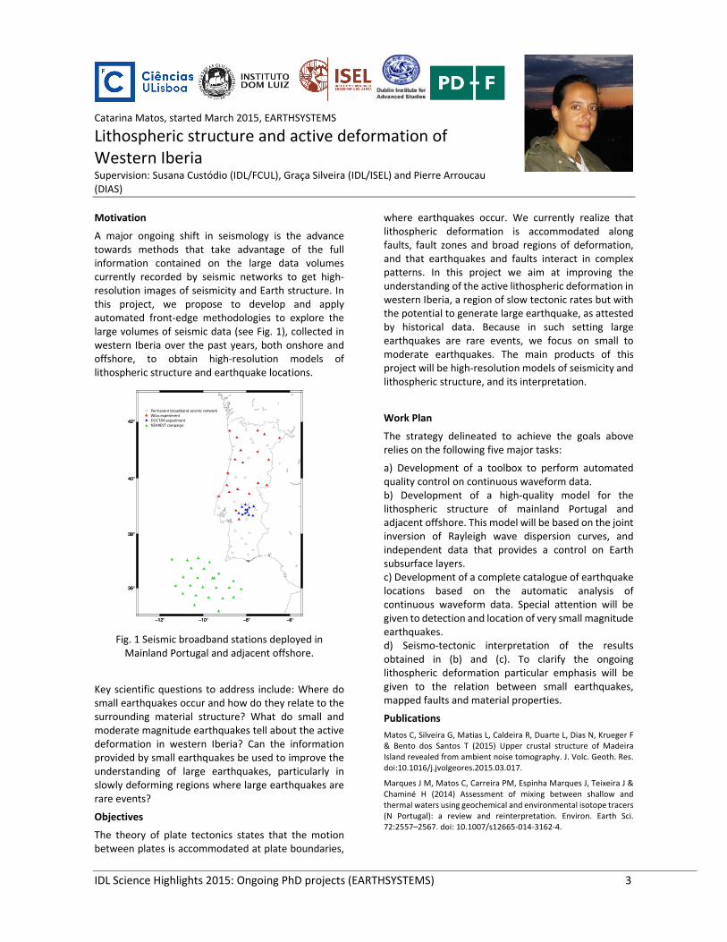
Catarina Matos, started March 2015, EARTHSYSTEMS
Lithospheric structure and active deformation of Western Iberia Supervision: Susana Custódio (IDL/FCUL), Graça Silveira (IDL/ISEL) and Pierre Arroucau (DIAS)
Motivation
A major ongoing shift in seismology is the advance towards methods that take advantage of the full information contained on the large data volumes currently recorded by seismic networks to get high‐resolution images of seismicity and Earth structure. In this project, we propose to develop and apply automated front‐edge methodologies to explore the large volumes of seismic data (see Fig. 1), collected in western Iberia over the past years, both onshore and offshore, to obtain high‐resolution models of lithospheric structure and earthquake locations.
Fig. 1 Seismic broadband stations deployed in Mainland Portugal and adjacent offshore.
Key scientific questions to address include: Where do small earthquakes occur and how do they relate to the surrounding material structure? What do small and moderate magnitude earthquakes tell about the active deformation in western Iberia? Can the information provided by small earthquakes be used to improve the understanding of large earthquakes, particularly in slowly deforming regions where large earthquakes are rare events?
Objectives
The theory of plate tectonics states that the motion between plates is accommodated at plate boundaries,
where earthquakes occur. We currently realize that lithospheric deformation is accommodated along faults, fault zones and broad regions of deformation, and that earthquakes and faults interact in complex patterns. In this project we aim at improving the understanding of the active lithospheric deformation in western Iberia, a region of slow tectonic rates but with the potential to generate large earthquake, as attested by historical data. Because in such setting large earthquakes are rare events, we focus on small to moderate earthquakes. The main products of this project will be high‐resolution models of seismicity and lithospheric structure, and its interpretation.
Work Plan
The strategy delineated to achieve the goals above relies on the following five major tasks:
a) Development of a toolbox to perform automated quality control on continuous waveform data. b) Development of a high‐quality model for the lithospheric structure of mainland Portugal and adjacent offshore. This model will be based on the joint inversion of Rayleigh wave dispersion curves, and independent data that provides a control on Earth subsurface layers. c) Development of a complete catalogue of earthquake locations based on the automatic analysis of continuous waveform data. Special attention will be given to detection and location of very small magnitude earthquakes. d) Seismo‐tectonic interpretation of the results obtained in (b) and (c). To clarify the ongoing lithospheric deformation particular emphasis will be given to the relation between small earthquakes, mapped faults and material properties.
Publications
Matos C, Silveira G, Matias L, Caldeira R, Duarte L, Dias N, Krueger F & Bento dos Santos T (2015) Upper crustal structure of Madeira Island revealed from ambient noise tomography. J. Volc. Geoth. Res. doi:10.1016/j.jvolgeores.2015.03.017.
Marques J M, Matos C, Carreira PM, Espinha Marques J, Teixeira J & Chaminé H (2014) Assessment of mixing between shallow and thermal waters using geochemical and environmental isotope tracers (N Portugal): a review and reinterpretation. Environ. Earth Sci. 72:2557–2567. doi: 10.1007/s12665‐014‐3162‐4.
IDL Science Highlights 2015: Ongoing PhD projects (EARTHSYSTEMS) 4
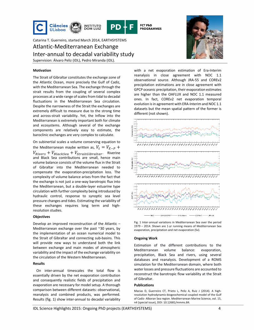
Catarina T. Guerreiro, started March 2014, EARTHSYSTEMS
Atlantic‐Mediterranean Exchange Inter‐annual to decadal variability study Supervision: Álvaro Peliz (IDL), Pedro Miranda (IDL).
Motivation
The Strait of Gibraltar constitutes the exchange zone of the Atlantic Ocean, more precisely the Gulf of Cadiz, with the Mediterranean Sea. The exchange through the strait results from the coupling of several complex processes at a wide range of scales from tidal to decadal fluctuations in the Mediterranean Sea circulation. Despite the narrowness of the Strait the exchanges are extremely difficult to measure due to the strong time and across‐strait variability. Yet, the Inflow into the Mediterranean is extremely important both for climate and ecosystems. Although several of the exchange components are relatively easy to estimate, the baroclinic exchanges are very complex to calculate.
On subinertial scales a volume conserving equation to
the Mediterranean maybe written as,
. Riverine and Black Sea contributions are small, hence main volume balance consists of the volume flux in the Strait of Gibraltar into the Mediterranean needed to compensate the evaporation‐precipitation loss. The complexity of volume balance arises from the fact that the exchange is not just a one‐way barotropic flux into the Mediterranean, but a double‐layer estuarine type circulation with further complexity being introduced by hydraulic control, response to synoptic sea level pressure changes and tides. Estimating the variability of these exchanges requires long term and high‐resolution studies.
Objectives
Develop an improved reconstruction of the Atlantic – Mediterranean exchange over the past ~30 years, by the implementation of an ocean numerical model to the Strait of Gibraltar and connecting sub‐basins. This will provide new ways to understand both the link between exchange and main modes of atmospheric variability and the impact of the exchange variability on the circulation of the Western Mediterranean.
Results
On inter‐annual timescales the total flow is essentially driven by the net evaporation contribution and consequently realistic fields of precipitation and evaporation are necessary for model setup. A thorough comparison between different datasets: observational, reanalysis and combined products, was performed. Results (fig. 1) show inter‐annual to decadal variability
with a net evaporation estimation of Era‐Interim reanalysis in close agreement with NOC 1.1 observational source. Although JRA‐55 and COREv2 precipitation estimations are in close agreement with GPCP oceanic precipitation, their evaporation estimates are higher than the OAFLUX and NOC 1.1 measured ones. In fact, COREv2 net evaporation temporal evolution is in agreement with ERA‐Interim and NOC 1.1 datasets but the mean spatial pattern of the former is different (not shown).
Fig. 1 Inter‐annual variations in Mediterranean Sea over the period 1979 – 2014. Shown are 1‐yr running means of Mediterranean Sea evaporation, precipitation and net evaporation (Sv).
Ongoing Work
Estimation of the different contributions to the Mediterranean volume balance: evaporation, precipitation, Black Sea and rivers, using several databases and reanalysis. Development of a ROMS simulation for the Mediterranean domain, where both water losses and pressure fluctuations are accounted to reconstruct the barotropic flow variability at the Strait of Gibraltar.
Publications
Macias D, Guerreiro CT, Prieto L, Peliz A, Ruiz J (2014). A high‐resolution hydrodynamic‐biogeochemical coupled model of the Gulf of Cadiz‐ Alboran Sea region. Mediterranean Marine Science, vol. 15, n4 (special issue), DOI: 10.12681/mmms.84.

IDL Science Highlights 2015: Ongoing PhD projects (EARTHSYSTEMS) 5
Daniela Lima, started March 2015, EARTHSYSTEMS
Global Coastal Low Level Jets in a Changing Climate Supervision: Pedro Soares (IDL), Álvaro Semedo (Escola Naval)
Motivation
Coastal Low‐level Jets (CLLJ) play an important role in coastal weather and have significant impacts on regional climate. These types of jets are related to sharp land‐sea temperature gradients, and coastal topography, giving rise to strong coast parallel winds that are responsible for upwelling. Coastal jets are mainly located offshore California, Peru‐Chile, Benguela, Portugal‐Canaries and West Australia, along cold eastern boundary currents, and offshore Yemen‐Oman (Ranhja et al. 2013; Fig.1). Coastal jets are an atmospheric dynamic phenomena that emerges from the interactions between atmosphere, land and ocean. It is known that feedback processes between CLLJ, upwelling and aridity play a crucial role in the regional climate. A significant impact of climate change in these regions is expected to occur, with major losses of precipitation and increasing aridity, e.g. in Iberia. Regarding the Benguela CLLJ, Nicholson et al. (2010) was the first to show the main properties of this CLLJ using NCEP reanalysis data. Soares et al. (2014a) identified and characterized in a detailed manner the Iberia‐Canaries CLLJ for present climate, using a 20 years WRF simulation at 9km resolution. Recent studies reveal a strong projected increase in CLLJ occurrence in this region for the end of the 21st century. Some studies show that global climate simulations, even at relatively coarse resolution, are useful to study the properties of CLLJs. It is expected that dynamical downscaling with coupled atmosphere‐ocean systems will allow these analysis in a deeper way, resolving the main properties of the CLLJ and the related ocean‐atmosphere feedbacks between wind and upwelling.
Objectives
The main goal of this thesis is to improve the understanding about the future evolution of the CLLJ regional climate in the regions where they occur, and where feedbacks between these jets, upwelling and aridity play a crucial role. In particular, the Benguela and Iberian‐Canaries CLLJ systems will be studied in a detailed manner. A new set of global simulations with the EC‐Earth model (v3) at higher resolution T255/L91 will be performed to improve the representation of CLLJs at the global scale, to build better global climate change scenarios and to understand the impact of global warming in these systems, and finally to have an improved forcing data for RCMs. The EC‐Earth 3 is based on the IFS model, cycle 36r4, on the NEMO ocean model and on the Louvain‐la‐Neuve Sea Ice Model. The simulations will cover the
period between 1850 and 2100, and the future period will follow the RCP8.5 scenario. These simulations will be part of an ensemble in the framework of CMIP6 that will allow the characterization of the robustness and uncertainty of the results. A new set of continental scale (Africa and Mediterranean CORDEX domains) RCM simulations, at high resolution, will be carried out with the latest WRF model version, to analyse the Iberian‐Canaries and the Benguela CLLJ and its feedbacks with upwelling and local aridity. The RCM simulation will allow characterizing the regional climate of the Benguela and Iberian‐Canaries CLLJ, its dynamics and structures and how will evolve in the future. The effect of changes of large‐scale structures, like the mean location, intensity and persistency of anti‐cyclones in the CLLJs will be investigated through clustering analysis. The comparison between future and present climate simulations will enable the assessment of the climate change impact on the main properties of CLLJs and on their impact on regional climate, addressing the evolution of the key feedbacks. (a)
(b)
(%)
Fig. 1 Global maps of CLLJ frequency of occurrence (%) for (a) JJA, (b)
DJF, for the EC‐EARTH CONTROL simulation, with two members (Semedo et al. 2015 (in revision)).
Publications
Semedo A, Soares PMM, Lima DCA, Cardoso RM, Bernardino M, Miranda PMA (2015 The impact of Climate Change on the Global Low‐Level Wind Jets: EC‐EARTH simulations. In revision to Global Planetary Change.
Cardoso R, Soares PMM, Lima DCA, Semedo A (2015) The impact of Climate Change on the Iberian Low‐Level Wind Jet: EURO‐CORDEX regional climate simulation. In revision to Tellus A.
Semedo, A., R. Vettor, O. Breivik, A. Sterl, M. Reistad, C.G. Soares, D. Lima, 2015: The Wind Sea and Swell Waves Climate in the Nordic Sea. Ocean Dynamics, DOI 10.1007/s10236‐014‐0788‐4.

IDL Science Highlights 2015: Ongoing PhD projects (EARTHSYSTEMS) 6
Diogo Martins, started March 2014
Drought seasonal predictability related with atmospheric variability and its impacts in agriculture Supervision: C. Pires (IDL, FCUL), L. S. Pereira (CEER, ISA), A. A. Paulo (CEER, ISA)
Motivation
Drought is both a hazard and a disaster; a hazard because it is an accident of unpredictable occurrence, part of the naturally variable climate system; disaster because it corresponds to the failure of the precipitation regime, causing the disruption of the water supply to the natural and agricultural ecosystems as well as to other human activities For water management, particularly in agriculture is important to study the seasonal predictability of droughts. With good predictions of precipitation and temperature, drought indices can be applied to predict dry conditions which, combined with water balance and crop models, can improve drought risk management and contribute to mitigate agriculture vulnerability to droughts.
Objectives
The main objectives of this work plan are: o Contribute to understanding the main sources of
predictability of droughts in Portugal o Compute drought indices (SPI, PDSI, MedPDSI)
with the climatic variables (precipitation, maximum and minimum temperature) based on hindcasts.
o Contribute to the development of tools, based on the forecasts of the meteorological variables that drive droughts, to support drought risk management in agriculture.
Work Plan and Preliminary Results
In order to accomplish thesis program objective the
following tasks are defined: 1) Gathering 006Ff
meteorological data to compute drought indices from
different sources for the Mediterranean region. These
datasets will be compared against each other and with
observations. 2) Search for linear and non‐linear
correlations between the drought indices, computed
with the data retrieved in task 1, and large‐circulation
indices to identify the most significant drought
predictors for the region. 3) Assess drought quality
forecasts based on hindcasts of seasonal forecasts from
ECMWF (3 months leads) and from the Euro‐SIP project
which includes up to 6‐month forecasts of daily data. 4)
compare drought indices with vegetation indices, like
the to assess the impact of droughts in the selected
crops and understand the relation between drought
severity and crop yield losses. 5) The forecasts of
precipitation and temperature obtained in previous
tasks will be applied to water‐balance and crop models
considering several irrigation schemes, allowing having
information up to 6 months regarding the available soil‐
water for the plants, thus providing an adequate
irrigation scheduling that accounts for the possibility of
dry spells in the future.
Regarding tasks 1 and 2 preliminary results are
presented in two publications: i) in which the spatial
and temporal patterns of SPI with different time scales
are analyzed using different datasets for Portugal. The
results of this study show that two main sub‐regions
with similar regional drought patterns are identified in
Portugal, one representing the North and another the
Southern Portugal, which are stable and are
independent of the dataset used (rainfall observations
and PT02 and GPCC rainfall gridded datasets ), the SPI
time scale or the time window selected for analysis.
In i) drought periodicity is studied in mainland Portugal,
using Fourier Analysis applied to SPI with 12‐month
time scale, considering the results obtained previously.
Results point to a 6‐year cycle across the country and a
9.4‐year cycle in central and southern Portugal likely
showing the influence of the North Atlantic Oscillation
(NAO) on the occurrence and severity of droughts in
Portugal.
Publications Moreira EE, Martins DS, Pereira LS (2015). Assessing drought cycles in SPI time series using a Fourier analysis. Nat Hazard Earth Sys, 571‐585. Popova Z, Ivanova M, Martins D, Pereira LS., Doneva K, Alexandrov, V, Kercheva M. (2014). Vulnerability of Bulgarian agriculture to drought and climate variability with focus on rainfed maize systems. Natural Hazards, 74(2), 865‐886. Raziei T, Martins DS, Bordi I, Santos JF, Portela MM, Pereira LS, Sutera A (2014) SPI Modes of Drought Spatial and Temporal Variability in Portugal: Comparing Observations, PT02 and GPCC Gridded Datasets. Water Resour Manag, 1‐18. .

IDL Science Highlights 2015: Ongoing PhD projects (EARTHSYSTEMS) 7
Fabiano Mota da Silva, started October 2015, CAPES (Brazil) fellowship
Applications of geophysical methods and remote sensing to the brittle structure of the septentrional portion of Borborema province Supervision: Fernando Monteiro Santos (IDL, FCUL), R. Mariano G. Castelo Branco (Geofisica, UFC ‐ BRAZIL)
Motivation
The structure under study has a length of 500 km and cut three seismotectonic domains in the northeast Brazil (Borborema Province). The area is characterized by relative intense seismological activities which have social and economic impacts.
Objectives
The general objective of this doctoral thesis is to apply potential and electromagnetic methods, along with remote sensing and geology to map and characterize the main geological structures responsible for observed seismicity.
The application of geophysical methods to the area is intended to verify the occurrence of gravimetric, magnetic and resistivity anomalies that may indicate different structural domains in the province.
Preliminary Results
Preliminary results includes: RGB compositions, individual band analysis, SRTM radar image analysis, allowing the visualization of mega folds and shear zones that cut and affect much of the study area.
Figure 1: Composition Landsat7 RGB 7/2 2/5 4/2.
It was observed that regional foliation is almost parallel to the features seen in the satellite images (lineaments), showing that fractures were developed in the weakest areas (foliation).
Figure 2: SRTM Image.
Figure 3: Extractions of guidelines
Future Work
Geological mapping of the whole area under study
Data acquisition (magnetotelluric data)
Data processing (Potential‐Airborne data).
Processing data and digital images (PDI)
Figure 4: Rosettes diagram of tectonic stress regimes

IDL Science Highlights 2015: Ongoing PhD projects (EARTHSYSTEMS) 8
Federico Ienna, started March 2015, EARTHSYSTEMS
Remote tracking of Mediterranean water eddies (meddies) in the Subtropical Northeast Atlantic Supervision: Igor Bashmachnikov (MARE), Joaquim Dias (IDL, MARE), Alvaro Peliz (IDL)
Motivation
Salt and heat transport by Mediterranean water eddies (meddies) is thought to have critically important implications for water property distribution and dynamics in the North Atlantic. In‐situ studies of meddy dynamics by oceanographic surveys and subsurface drifters (Armi et al., 1989; Richardson et al., 2000) have been recently complemented with satellite‐based observations on their sea surface expressions (Bashmachnikov et al., 2009; Ienna et al. 2014). The aim of this research is to develop methodologies for consistent detection and tracking of meddies by satellite, offering the potential for radical progress in the study of their dynamics on a cost‐effective and continuous basis, and to provide robust estimates of their impact on regional ocean dynamics. The goals will be achieved via a combination of theoretical studies of meddy manifestation at the sea‐surface along with the development of a robust and dependable methodology for detecting and tracking meddies by satellite.
Objectives
Meddies are subsurface vortices occurring in the northeast Atlantic at a depth of 1000 meters. It is therefore relatively difficult to identify, track, and study meddies in a consistent manner. However, while existing at depth, they also produce a distinctive sea surface expression observable in both temperature and sea‐level anomaly, which can be used as a proxy for identification, tracking, and observation of meddies by remote sensing techniques. The aim of this research is to concentrate scientific efforts on the development and refinement of a reliable method for detection and tracking of meddies with remote sensing data. This will allow for consistent and continuous study of these phenomena, leading to major breakthroughs in the ability to study meddy dynamics and their impact on the temperature and salinity distribution in the Atlantic. The ability to effectively observe meddies by altimetry will complement the recent increase in model‐output data on meddy behaviour, allowing for a full understanding of their characteristics. Additionally, the ability to consistently observe meddies will lead the way to understanding how the exchange of heat and salt between the Atlantic and the Mediterranean will vary in a future climate.
Fig. 1 A meddy tracked for a 6‐and‐a‐half‐month time span using satellite altimetry and in‐situ XBT data..
Work Plan
The methodology will be developed through a comprehensive statistical analysis of the known meddy observations, which will be contrasted with corresponding observations from various satellite sensors. In particular, the surface signature of meddies will be seeked out in sea‐level anomaly and sea surface temperature maps, in an attempt to find the distinctive feature that make meddies recognizeable. In order to fully understand meddy surface expressions, a theoretical analysis and a model study will be produced. This research will be aimed at developing a theoretical basis for the short‐term surface dynamics involved in modifying the surface expressions above meddies, examining how eddy kinetic energy is carried from the meddy core upward to the surface creating a surface rotation and a measurable anomaly.
Publications
Ienna, Federico, Young‐Heon Jo, and Xiao‐Hai Yan. "A new method for tracking Meddies by satellite altimetry." Journal of Atmospheric and Oceanic Technology 31.6 (2014): 1434‐1445.
Jo, Young‐Heon, Federico Ienna, and Xiao‐Hai Yan. "An analysis of the
evolution of Meddies in the North Atlantic using floats and
multisensor satellite data." Journal of Geophysical Research:
Oceans 120.3 (2015): 1904‐1917.

IDL Science Highlights 2015: Ongoing PhD projects (EARTHSYSTEMS) 9
Javier Cano, started March 2015
Atmospheric circulation and Climate of the Euro‐Atlantic sector since 1685 based on new directional flow indices Supervision: Ricardo Trigo (IDL, FCUL), David Barriopedro (UCM, Madrid)
Motivation
One way to study atmospheric circulation and its role in climate variability is using large scale circulation patterns such as the North Atlantic Oscillation (NAO) or the Blocking pattern, both extremely important to understand climate variability and climate extremes in Europe. Unfortunately, our knowledge of atmospheric variability before the mid‐19th century strongly relies on scattered historical data over land and mainly climatic proxies, which suffer from a number of limitations. An alternative method of exploring past climatic variability without using proxies is through the systematic analysis of early instrumental data over land.
Ships’ logbooks, which have been poorly exploited, contain well‐dated sub‐daily evidence on the weather that ships encountered along their route and are a key source of climatic information. In particular, wind direction information kept in logbooks was measured with a 32‐point compass, similar to modern days.
Objectives
The objective is to study the atmospheric variability over the Euro‐Atlantic using daily marine observations over the English Chanel back to 1685. Using Royal Navy logbooks we will construct 4 monthly indices (one for each direction Northerly (NI), Easterly (EI), Southerly (SI) and Westerly (WI)). The indices indicate the persistence of the wind over this sector, and will be the longest observational record of atmospheric circulation to date, allowing the exploration of long‐term (interannual‐to‐multidecadal) atmospheric variability and trends over the eastern Atlantic. After the assembling of the indices the next step will be to evaluate their climatic impacts over Europe and to assess their capacity to explain climate variability in Europe.
Preliminary results
During the firsts months of the PhD I worked to obtain all wind observations available over the English Channel. I used two different databases. For the period 1685 to 1870, data from Royal Navy ships’ logbooks kept in the National Maritime Museum and the UK National Archives were employed. From 1750 onwards to 2012, the ICOADS v2.5 dataset was used. As the logbooks’ observations are direct measures of the wind direction, they provide the wind direction respect to the magnetic north, so a correction factor is required to
convert them into wind direction observations respect to the true north. This in turn requires a dataset with magnetic declination fields over the English Channel for 1685 to 1870, which was obtained from the NOAA National Geophysical Data Center (NGDC).These monthly declination values, were applied to the wind observations derived from logbooks. Thus, currently, daily wind direction observations (with respect to true north) are available from 1685 to 2012. Before 1870 there is often just one wind observation per day over the English Channel, while, after post‐1870 period, there is high spatial density of observations, with only short missing periods during both world wars (WWI, WWII) (Fig.1).
Fig. 1 (a) Annual mean (1750‐2012) frequency of days with observations (in % with respect to the total number of annual days) over a regular grid of 0.5ºx0.5º in longitude‐latitude
Work plan
Over the following months I will work on merging both data sets in order to construct a unique time series with every day classified in only one wind direction This will require the design of a stepwise algorithm, since there are days with more than one wind observation. Finally the indices will be defined as the proportion of days per month (in %) with wind blowing from one of the four main directions). Next, I will evaluate the impact of major volcanic eruptions as well as the 11 year solar cycle on every index and link those with previously described impacts on the atmospheric circulation. I will also work on studying the impact of positive and negative phases of each index in variables such as temperature, precipitation or pressure in Europe in order to use the indices as variables for reconstructions of temperature, precipitation or pressure in the past.
IDL Science Highlights 2015: Ongoing PhD projects (EARTHSYSTEMS) 10
Joana Ribeiro, started March 2014, EARTHSYSTEMS
Magnetotelluric studies in detecting an old structure zone and major crustal scale shear zones (Iberia) Supervision: Fernando Monteiro Santos (FCUL, IDL), Manuel Francisco Pereira (UE, IDL)
Motivation
For a better understanding of the geodynamics of the complex region of the Variscan chain it is necessary to comprehend what happens at the subsurface. The passive geophysical technique Magnetotelluric (MT) will bring a valuable contribute to provide information about the substructure of the Earth from near surface till great depths. This method uses the interaction of the natural electromagnetic waves in the Earth to measure the electrical conductivity. With this information it is possible to map in interior of the Earth and characterize it in terms of apparent resistivities.
Objectives
The main purpose of this PhD study to use the MT method is to seek and detect the i) main structures of the continental crust at depth, ii) the geometry of various igneous bodies, the host rocks and the shear zone, and iii) a possible major suture.
This project will focus on two distinct areas of the Variscan chain: Trancoso – Momenta‐da‐Beira (Northeast of Portugal) and Montemor‐o‐Novo – Évora (Southwest of Portugal)
Preliminary Results
In 2014, a total of 18 MT sounding were acquired with a site spacing of approximately about 5 km. The four horizontal components of the electric and magnetic field were measured in E‐W and N‐S directions in a period range from 0.0013 to 163 s in the region of Figueira de Castelo Rodrigo – Almeida.
The methodology chosen for the data dimensionality analysis was the Phase Tensor Method developed by Caldwell et. al. (2004) as it has been proven to have no influence by the presence of galvanic induction and does not require assumptions about the underlying dimensionality as others decompositions methods (Swift, 1967, 1986; Bahr, 1999, 1991; Groom and Bailey, 1989).
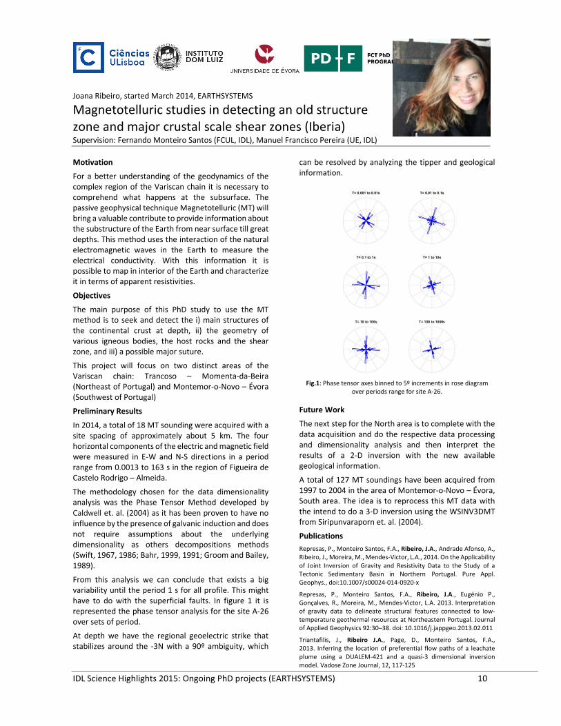
From this analysis we can conclude that exists a big variability until the period 1 s for all profile. This might have to do with the superficial faults. In figure 1 it is represented the phase tensor analysis for the site A‐26 over sets of period.
At depth we have the regional geoelectric strike that stabilizes around the ‐3N with a 90º ambiguity, which
can be resolved by analyzing the tipper and geological information.
Fig.1: Phase tensor axes binned to 5º increments in rose diagram
over periods range for site A‐26.
Future Work
The next step for the North area is to complete with the data acquisition and do the respective data processing and dimensionality analysis and then interpret the results of a 2‐D inversion with the new available geological information.
A total of 127 MT soundings have been acquired from 1997 to 2004 in the area of Montemor‐o‐Novo – Évora, South area. The idea is to reprocess this MT data with the intend to do a 3‐D inversion using the WSINV3DMT from Siripunvaraporn et. al. (2004).
Publications
Represas, P., Monteiro Santos, F.A., Ribeiro, J.A., Andrade Afonso, A., Ribeiro, J., Moreira, M., Mendes‐Victor, L.A., 2014. On the Applicability of Joint Inversion of Gravity and Resistivity Data to the Study of a Tectonic Sedimentary Basin in Northern Portugal. Pure Appl. Geophys., doi:10.1007/s00024‐014‐0920‐x
Represas, P., Monteiro Santos, F.A., Ribeiro, J.A., Eugénio P., Gonçalves, R., Moreira, M., Mendes‐Victor, L.A. 2013. Interpretation of gravity data to delineate structural features connected to low‐temperature geothermal resources at Northeastern Portugal. Journal of Applied Geophysics 92:30–38. doi: 10.1016/j.jappgeo.2013.02.011
Triantafilis, J., Ribeiro J.A., Page, D., Monteiro Santos, F.A., 2013. Inferring the location of preferential flow paths of a leachate plume using a DUALEM‐421 and a quasi‐3 dimensional inversion model. Vadose Zone Journal, 12, 117‐125

IDL Science Highlights 2015: Ongoing PhD projects (EARTHSYSTEMS) 11
Jorge Ponte, started March 2014
Environmental magnetism and paleomagnetism of speleothems: a new tool for documenting high‐frequency instabilities of the Earth’s magnetic field and climate Supervision: Eric Font (IDL), Cristina Veiga‐Pires (CIMA‐UALG), Claude Marcel‐Hillaire (GEOTOP)
Motivation
Magnetic properties of speleothems have received much recent attention, due to their potential for documenting environmental changes and high‐frequency instabilities of the Earth’s magnetic field. In this project we have the opportunity to acquire the first paleomagnetic data of a speleothem from Algarve and for the estimated age between 5000 and 6000 years. If the paleomagnetic data is proven reliable it can be incorporated in high‐resolution geomagnetic models, which are very important to study and understand the geodynamo’s processes. A multidisciplinary high‐resolution analysis of speleothems has never been conducted in this area and will provide new ground for future geophysical and geological studies of speleothems.
Objectives
After confirming the primary signature of our
paleomagnetic data, the main objective is to analyse the
magnetic directions recorded in the stalagmite and test
the presence of a post‐depositional error due to calcite
growth layer orientation. For this purpose, we plot the
magnetic declination and inclination in function of the
estimated growth layers angle with the horizontal plane
(Fig.1). Additionally we compared the paleomagnetic data
with a paleosecular variation (PSV) model (Fig.2).
Fig. 1 Magnetic declination and inclination in function of the estimated
of the calcite growth angle with the horizontal plane. Each color represent one site (group of samples with same age).
Results
The magnetic inclination shows a significant negative correlation with the calcite growth angle in all sites (A to E). Magnetic inclination decreases linearly with the dip of the calcite growth bedding, with a maximum difference of 4 to 9º (Fig.1). This suggests a close relationship between the dip of the calcite growths and the corresponding magnetic inclination. On contrary, the magnetic
declination shows no significant correlation with the shape of the stalagmite. Comparing our data with a PSV model (Fig.2), we observe that magnetic inclination obtained from samples with sub‐horizontal growth layers fits the model very well (Fig.2C), while for sub‐vertical samples the magnetic inclination is generally underestimated (Fig.2D). This result supports the evidence that the magnetic directions obtained from samples with sub‐vertical growth layers may present a non‐negligible systematic error. The effect of gravity should shift the elongated axis of the anisotropic magnetic particles toward the vertical plane, which leads to more flattened or vertical values of the positive or negative magnetic inclination, respectively. However, this post‐depositional error doesn’t enable the use of stalagmites in geomagnetic field reconstructions, although we should consider it. The site‐based mean declination and inclination values (Fig.2A and B) are within the 95% confidence interval of the PSV model, proving stalagmites as good candidates for recent paleomagnetic data. For now, we suggest the speleothem’s researchers to prefer sub‐horizontal samples when using paleomagnetism.
Fig. 2 Comparison of the SPAIII magnetic data with PSV model
SHA.DIF.14k. Site‐based mean A) declination and B) inclination values; Magnetic inclination value for specimen with C) sub‐horizontal and D)
sub‐vertical calcite growth layers.
Publications
Ponte, J., Font, E., Veiga‐Pires, C., Hillaire‐Marcel, C. (2015), Influence of calcite growth layer orientation on the Natural Remanent Magnetisation recorded in a stalagmite, Geophysical Research Letters (in submission)

IDL Science Highlights 2015: Ongoing PhD projects (EARTHSYSTEMS) 12
Manuela Ramos, EARTHSYSTEMS, started March 2015
Signature of deep‐sea mining disturbances in deep‐sea ecosystems Supervisors: Telmo Morato (MARE‐UAz/DOP), Marina Carreiro‐Silva (MARE‐UAz/DOP) and Henrique Cabral (MARE‐UL)
Motivation
The increased demand for natural and mineral resources fuelled by rapid technological development opened the exploitation of previously inaccessible areas, and a sharp expansion of human activities toward deeper areas. These new activities will further impact seamount and deep‐sea biodiversity and, consequently, ecosystem functioning. Therefore, assessing the impacts of existing and future human activities on deep‐sea marine ecosystem is one of the major challenges for future research aiming at informing sustainable management of marine ecosystems. Under the recently funded EU/FP7 Project MIDAS 'Managing Impacts of Deep‐seA reSource exploitation' where IMAR‐UAc is an active partner (see: http://www.eu‐midas.net/) this project will explore the impact of sediment plumes resulting from deep‐sea mining on seamount ecosystem.
Objectives
The overall objective of this PhD project is to explore the impact of sediment plumes resulting from deep‐sea mining on deep‐sea ecosystem, how it may impact other human activities including fishing, and how spatially‐oriented ecosystem based management can address the cumulative effects of multiple uses. Under these lines, the major research questions of this PhD research plan are:
1‐ What are the relevant ecosystem functions and services that may be affect by future human disturbances in deep‐sea?
2‐ What will be the impacts of sediment plumes resulting from deep‐sea mining on the physiological condition of mobile benthic fish species?
3‐ What will be the impact of sediment plumes resulting from deep‐sea mining on ecosystem goods and services?
4‐ What areas will be important for reconciling different resources exploitation
Work Plan
1. Assess the impacts of sediment plumes on commercially important fish
This chapter aims at assessing the impact of sediment plumes resulting from deep‐se mining on commercially important fish. To determine threshold levels of
suspended sediment plumes necessary to disrupt basic physiological and behavioural processes, this PhD project will conduct controlled laboratory experiments on a key benthic deep‐sea fish species, Helicolenus dactylopterus dactylopterus as a model organism. Suspended sediment levels of similar properties to those likely to be produced from mining operations, will be adjusted in aquaria to four concentrations: control (∼0 mg l‐1), low (10 mg l‐1), medium (20 mg l‐1), and high (30 mg l‐1). We will start by measuring respiration, predation success and larval survivorship with specific assays for each response.
2. Quantifying the spatial extent of the impact of sediment plumes on commercially important fish
In brief, this chapter will, develop a spatial analyses to quantifying the spatial extent of the impact of sediment plumes (produced from existing mining areas) on commercially important fish. 3‐D oceanographic models are being used to build spatial scenarios of plume dispersal and will be obtained by a close collaboration with LAMTec (Laboratório de Ambiente Marinho e Tecnologia). These models will permit running different mining scenarios and create maps of the likelihood of an area to be impacted by the plumes. Additionally, maps of species distribution and biodiversity hotspots are being created for areas with interest for deep‐sea mining. This PhD project will then develop spatial analyses to quantify the areas where the distribution of commercial fish species overlap with different concentrations of sediment plumes produced in claimed areas, to come up with a quantitative estimate of the impact of deep‐sea mining on commercial fish. Finally, this findings may be related to existing maps of fishing effort, to quantify the potential fisheries loss due to mining activities.
3. Identifying important areas for reconciling different resources exploitation
Finally, this PhD project will identifying areas where deep‐sea mining may significant impact existing fishing activities at a larger scale to suggest “set aside areas” for reconciling different resources exploitation. It will develop from chapter 3 but enlarge the analyses to a larger areas. Species and habitats spatial distribution metrics, sediment plume dispersal scenarios, and maps of fishing activities will provide key information for identifying set aside areas for reconciling different resources exploitation.

IDL Science Highlights 2015: Ongoing PhD projects (EARTHSYSTEMS) 13
Maria Chinita, started March 2014, EARTHSYSTEMS
Dynamics of the stable boundary layer Supervision: Pedro Miranda (IDL), Georgios Matheou, João Teixeira (NASA/JPL)
Motivation
The stable boundary layer (SBL) remains one of the least understood elements of the atmosphere. Most of the challenges in predicting the SBL stem from the largely unknown nature of stratified turbulence. Better understanding and prediction of the SBL, including the morning and evening transitions, could improve the prediction of the diurnal cycle and dispersion of pollutants, in addition to advances directly related to the SBL such as the formation of fog and nocturnal temperature forecasting.
Objectives
The work plan for the current year that has been developed at JPL (USA) with the supervision of Georgios Matheou, can be summarized as following: (1) Evaluation of the formulations for the equilibrium height of the SBL proposed by Zilitinkevich et al. (2007) and Kozovic and Curry (2000) with LES data produced using JPL’s Large‐Eddy Simulation (LES) model (Matheou and Chung, 2014). (2) Investigation of intermittency and collapsing turbulence in strongly stratified SBL. (3) Participation in the inter‐comparison study GABLS4 (GEWEX Atmospheric Boundary Layer Study) with LES data from the JPL LES model. GABLS4 aims to study a SBL with strong stability (Ri >> 1) whereas previous GABLS cases only considered moderately stable conditions.
Results
The SBL height is an important quantity for several applications. It is used to describe the relevant processes that play an important role in the SBL development and its vertical structure, e.g., pollution dispersion under stable stratification Accordingly, several formulations have been proposed in recent decades but since there is no consensus it is still an open subject. To evaluate the Zilitinkevich et al. (1996, 2007) and Kosović and Curry (2000) formulations for SBL equilibrium height in a quasi‐steady state SBL, I’m using a number of LES. Both formulations account for the combined effects of rotation, surface heat flux, and static stability in a free flow. Currently, a set of 14 simulations with different combinations of the governing parameters, such as geostrophic wind, latitude, surface cooling rate, inversion strength, surface roughness and model resolution, have been completed. Figure 1 shows the comparison between the boundary layer height computed from the LES and the parameterization of Zilitinkevich et al. (2007, Equation 3). The performance of the parameterization is good overall, for the current cases. However, the number of LES simulations is insufficient to test the entire range of
applicability of the parameterization and to identify the weaknesses of the formulation. The final results will further assess the current formulation and provide guidance for improvements, if needed.
Fig. 1 Comparison between the SBL heights. htheory calculated from
Equation 3 of Zilitinkevich et al. (2007) and hLES calculated from LES data according to the definition | | 0.05 ∗ ∗ where is the vertical turbulent flux of momentum. The marker size corresponds to the
intensity of the geostrophic wind.
For the study of intermittent and collapsing turbulence a set of LES has been carried out with a resolution of 0.1 meters in domains of about 25 meters. Figure 2 shows a snapshot of a vertical cross‐section of potential temperature from one of the simulations where the SBL is very shallow, a few meters, and strongly stratified. The strong stratification produces shallow atmospheric flows with vigorous turbulence very near the surface and progressively weakening overturning motions as height increases. This is a difficult regime for LES models, because most models cannot sustain turbulence in the strongly stratified regime and erroneously predict a global turbulence collapse.
Fig. 2 Snapshot of a vertical cross‐section of potential temperature in
an LES of a strongly stratified SBL..
Publications
Soares PMM, Cardoso RM, Semedo A, Chinita MJ, Ranjha R (2014) Climatology of Iberia Coastal Low‐Level Wind Jet: WRF High Resolution Results, Tellus A, 66, 22377.
log10
hLES
2.5 3 3.5 4 4.5 5 5.5
log
10 h
the
ory
2.5
3
3.5
4
4.5
5
5.5
GW3GW5GW8GW11GW5c050GW5c100GW8c050GW8c100GW8in00GW8in20GW8lat22GW8lat45GW8sr005GW8sr020

IDL Science Highlights 2015: Ongoing PhD projects (EARTHSYSTEMS) 14
Mariana Santos, started March 2014, EARTHSYSTEMS
Harmful Algal Blooms (HAB) in a changing world: the case of W‐S Iberian Bays Supervision: Maria Teresa Moita, Paulo Oliveira (IPMA), Ana Amorim (MARE‐FCUL), Adriana Zingone (SZN)
Motivation
Some species of phytoplankton produce toxic substances that seriously threaten public health and cause economic losses to fisheries, aquaculture and tourism. It is currently accepted that these harmful algal blooms (HABs) have been expanding globally, in frequency and extension, and new species are emerging in new areas. There are several anthropic and natural environmental causes contributing to this, among which climate change.
Portugal, located in the temperate sub‐tropical boundary, had already evidence of biogeographical limits expansion of several taxa, including HAB species. An example is the occurrence of blooms of the sub‐tropical/tropical benthic dinoflagellate Ostreopsis in the south coast of Portugal (D. Ana beach, Algarve). This genus has in the last decades been responsible for outbreaks in the Mediterranean Sea leading to human respiratory intoxication and economic losses due to beach closures during the summer season.
Objectives
The present study aims to investigate the influence of physical and biological processes on phytoplankton diversity and on HAB dynamics in Portugal.
The main questions to investigate are as following: i) Are there recent changes in phytoplankton biodiversity? ii) Are known HABs changing their phenology? iii) Why is Ostreopsis blooming in Lagos Bay? iv) Are emergent HAB species spreading to other areas?
Work Plan
The retention areas studied are the Bays located at SE of the two most prominent SW Iberia headlands: Capes Roca and S. Vicente. The considered sentinel sites, located on the shadow of those capes, are Cascais (W coast) and Dª Ana beach (S coast).
Cascais is a long‐term phytoplankton sampling site, sampled weekly since 2001, allowing the investigation of changes on phytoplankton biodiversity and HAB dynamics. Dª Ana beach is the local where Ostreopsis blooms have been recorded since 2011. This site will allow the study of the local ecological processes that are contributing to the observed HAB changes. A third study site (Porto Mós), located offshore at 1 NM from the coast, off Ponta da Piedade, will allow comparing
the physical processes inshore and offshore, in order to better understand why Ostreopsis is blooming in Dª Ana beach. Phytoplankton time series will be related to physical and meteorological variables and processes. The analysis will focus on the separation of the coastal upwelling jet, the development of recirculation structures around the capes, and the influence of the time‐varying flow patterns on the transport of surface waters. The developed empirical models will be used to assess the impact of environmental variables in the frequency and spatial distribution of the blooms off West Iberia.
Work Progress
Since the beginning of my PhD study weekly samples are being collected in each study site and processed in laboratory in order to answer the main questions of the study. Also, the first molecular studies of Ostreopsis strains were performed in Zoological Station of Anton Dohrn (Naples, Italy). About physical data, at Porto Mós station, a complete year of temperature data in two different depths (3 and 25 m) was already collected by using “TidbiT Temperature Data Logger” (Fig. 1). In June this year it was also placed there an ADCP in order to provide data of local water current velocity.
Fig. 1 – Porto Mós and Dª Ana temperature data.
Publications
Santos, M., P.R. Costa, F.M. Porteiro and M.T. Moita (2014). First report of a massive bloom of Alexandrium minutum (Dinophyceae) in middle North Atlantic: a coastal lagoon in S. Jorge Island, Azores. Toxicon, 90, 265‐268.……………………………………………………………………… Santos, M., M.T. Moita, I. Bashmachnikov, G.M. Menezes, V. Carmo, C.M. Loureiro, A. Mendonça, A.F. Silva and A. Martins (2013). Phytoplankton variability and oceanographic conditions at Condor seamount, Azores (NE Atlantic). Deep‐Sea Research. II, 98 Part A, 52‐62. Carmo, V., M. Santos, G.M. Menezes, C. M. Loureiro, P. Lambardi and A. Martins (2013). Variability of zooplankton communities at Condor seamount and surrounding areas, Azores (NE Atlantic), Deep‐Sea Research II, 98 Part A, 63‐74.
.

IDL Science Highlights 2015: Ongoing PhD projects (EARTHSYSTEMS) 15
Pedro Almeida, started March 2014, EARTHSYSTEMS
Testing induced subduction initiation along the West Iberian Margin: tectonic analysis and analog modelling of key domains between the Estremadura Spur and the Gorringe Bank Supervision: Filipe Rosas (FCUL), Pedro Terrinha (IPMA)
Motivation
The existence of a diffuse plate boundary between the Eurasia and Nubia tectonic plates along with the presence of a high instrumental and historical seismicity record (1755 Lisbon Earthquake as the main example) and the most recent morphotectonic mapping in the Gulf of Cadiz domain (SW Iberian margin offshore) where the starting point to renew the idea of induced subduction initiation along the Western Iberian Margin (WIM). In this model, WIM induced subduction process may result from westwards stress propagation from the Gibraltar roll‐back subduction zone to the SW Iberian margin (SWIM), where its record would correspond to the active and seismogenic NW directed major tectonic thrust faults (e.g. Horseshoe, Gorringe, Marquês do Pombal and Tagus thrust faults).
Objectives
This research project will focus on finding evidences for the tectonic inversion and possible northwards induced subduction process that may be initiating along the WIM, up until the northern limit of the Estremadura Spur. To test , two main methodological approaches were defined, namely: 1) the production a detailed morphotectonic map of WIM, by integrating systematically multibeam swath bathymetry data interpretation with the seismic reflection data, emphasizing the relative dating of the activity of different tectonic structures along this margin; and 2) analogue and numerical modelling of the considered key structural and tectonic scenarios at different scales. In this main overall research line, the key Estremadura Spur morphotectonic feature and its relation with its present day seismicity, its active tectonic structures and regional Cretaceous magmatism will be taken in account.
Work plan and previous results
This research project is will be developed at IDL and at IPMA, by pursuing two main approaches, namely a) the detailed tectonic mapping and interpretation of selected key domains in the WIM offshore, between
the Gorringe Bank and the Estremadura Spur, and b) modelling the main tectonic interpretations arising from the above first approach, by doing analogue modelling using both granular (sand‐box) and viscous materials, and also through matching numerical modelling when possible. Modelling processes will be focused at both regional scale interpretation (crossing onshore and offshore geological information) and on smaller scale structures and processes. Based on this principles analogue modelling work as been developed focused on understanding the influence of variable thrust ramp geometry on a deformable hanging wall, namely by comparing flat‐ramp‐flat with different deep angle inclination concavo‐convex ramps as well the influence of a basal velocity discontinuity (VD) in the mechanics of the hanging wall deformation, either when its present or absent in the model. Our preliminary results suggest that both investigated variables play a important role on the mechanical structural characterizing the hanging‐wall deformation of convergent tectonic settings were such thrust‐ramp systems were recognized.
Publications
Almeida, P., Tomás, R. , Rosas, F. , Duarte, J. , Terrinha, P. (2015) – Flat‐ramp vs. convex‐concave thrust geometries in a deformable hanging wall: new insights from analogue modeling experiments. Geophysical Research Abstracts. Vol. 17, EGU2015‐716, 2015. EGU General Assembly 2015.
Tomás, R. , Rosas, F. , Duarte, J. , Terrinha, P., Kullberg, M., Almeida, J., Barata, F., Carvalho, B., Almeida, P. (2015) – Analogue modeling of strike‐slip fault propagation across a rheological/morphological crustal anisotropy: implications for the morphotectonic evolution of the Gloria Fault ‐ Tore Madeira Rise area in NE Atlantic. Geophysical Research Abstracts. Vol. 17, EGU2015‐716, 2015. EGU General Assembly 2015.
Machado, G., Silva, I & Almeida, P. (2012) – Palynology, stratigraphy and Geometry of the Pennsylvanian Continental Santa Susana Basin (SW Portugal). Journal of Iberian Geology Universidade Cumplutense de Madrid. ISSN 1886‐7995 (available online http://www.ucm.es/info/estratig/JIG/vol_content/abstjour38_2.htm).

IDL Science Highlights 2015: Ongoing PhD projects (EARTHSYSTEMS) 16
Rodrigo Silva, started March 2015, EARTHSYSTEMS
Solar power forecasting using Artificial Neural Networks and spatially‐distributed data Supervision: Miguel Brito (IDL, FCUL), Sue Haupt (RAL, NCAR)
Motivation
Due to its ongoing price reduction and technological development over the last decades, photovoltaics (PV) has been standing out from other renewable energy sources. Its growth even lead to a upwards revision on the PV penetration expected for 2050 by the International Energy Agency (IEA) [1].
However, its time variability is an issue needed to be dealt with in order for a high penetration to become feasible. Solar power possesses the solar radiation's strong daily and intra‐annual cycle where not only the solar beam geometry but also the interaction with the atmosphere changes. Nonetheless, it is the short‐term variability introduced by clouds which is the most troublesome factor for electrical grid management. Additionally, cloud physics and dynamics make it difficult to predict.
The development of robust and accurate forecasting models that allow a more timely and informed management from the grid operators is considered a key topic tool for an assertive deployment of PV, being pointed out as one of the main objectives for 2015‐2020 by a report from the IEA [1].
Figure 3 ‐ Daily global solar irradiation profile for Lisbon,
1 minute resolution, 05/03/2014 [2]
Objectives
The purpose of this thesis is the development and evaluation of a solar power generation forecasting model based on Artificial Neural Networks (ANN).
The main focus of study for this model would be the use of spatially distributed PV system’s data as the main input. The impact of using datasets consisting of distributed PV systems at different spatial scales, such as neighboring roofs and buildings farther away, is also one of the topics of study.
Work Plan
Being ANN a data‐driven model, data is then required. Currently, there are ongoing conversations with several entities such as EDP ‐ Energias de Portugal, Galp Energia and the National Center for Atmospheric Research (NCAR), in order to acquire distributed PV systems data.
Being the use of PV spatially distributed data the key point for this thesis, there would be parallel models built in order to fully assess the impact of this variable. Distributed PV data and weather variables would be incorporated first separately and then together on a Nonlinear Autoregressive ANN. Traditional Linear Autoregressive and Persistence methods would also be developed to use as baseline references.
Several forecasting horizons would be studied, where both practical (from 15 minutes up to several hours) and scientific (anything below that) interests would be sought.
A stay at NCAR is scheduled for 2016, where real‐time forecasting tools, based on different data sources and models, are already operational.
Finally, it is interesting to note that the concept of this thesis would create synergies between distributed PV systems installation (more data) and the ability to better forecast, and therefore better manage, its production. As a final consequence, the technical conditions for the grid operators being able to efficiently manage the electrical grid, even in a context of high photovoltaic penetration, would be met.
References
[1] International Energy Agency (IEA), “Technology Roadmap: Solar Photovoltaic Energy,” 2014.
[2] “Solar Radiation Data (SoDa).” [Online]. Available: http://www.soda‐is.com/eng/index.html. [Accessed: 20‐Mar‐2015].
0
2
4
6
8
10
7 10 13 16 19Glo
ba
l So
lar
Irra
dia
tion
[W
.m-2
]
Time [hour]

IDL Science Highlights 2015: Ongoing PhD projects (EARTHSYSTEMS) 17
Fig. 1 – Spatial distribution of coefficients of the kernel model (RGB where R and G represent the emissivity and solar kernels, respectively).
Sofia Ermida, started March 2014
Harmonization of Remote Sensing Land Surface Products: correction of clear sky bias and characterization of directional effects Supervision: I.F. Trigo (IPMA), C. C. daCamara (IDL, FCUL), C. Prigent (Obs. de Paris)
Motivation
Land surface temperature (LST) is an important climatological variable and a diagnostic parameter of land surface conditions, since it is the primary variable determining the upward thermal radiation and one of the main controllers of sensible and latent heat fluxes between the surface and the atmosphere. The reliable and long‐term estimation of LST is therefore highly relevant for a wide range of applications, including, amongst others: (i) model validation and monitoring; (ii) data assimilation; (iii) hydrological applications; and (iv) climate monitoring. Remote sensing constitutes the most effective method to observe LST over large areas and on a regular basis.
Objectives and work plan
This PhD plan targets two of the issues still open in LST remote sensing: the correction of the clear sky bias of infrared based products; and the consistency among LST retrievals. Our goal is to develop and validate methodologies that allow a combined use of LST products from IR and micro‐wave sensors, as follows: 1) Understand and characterize the effects of viewing and illumination geometry (directional effects) on LST derived from IR sensors towards the harmonization of different IR LST products. 2) Understand the differences in the physical variable “land surface temperature” measured by IR and micro‐wave sensors. 3) Quantify the clear‐sky bias of the most commonly used IR‐based LST products, taking into account micro‐wave LST estimates. 4) Propose a methodology to allow merging different LST products applicable to data from IR and micro‐wave sensors, leading to a harmonized un‐biased all‐weather LST.
Results
We propose a methodology where a statistical model
of angular anisotropy of LST (Vinnikov et al., 2012) is
used to characterize the LST dependence on viewing
and illumination angles. The model follows a “kernel”
approach commonly used for the description of the
Bidirectional Reflectance Distribution function (BRDF)
in the visible band. It allows the correction of LST
retrievals to a reference view angle, e.g. nadir, or the
derivation of a directionally independent equivalent
physical temperature.
Figure 1 shows the obtained parameters of this kernel
model, calibrated with LST observations from NASA’s
MODIS and LSA‐SAF’s SEVIRI, collocated in space and
time. It is clear that the kernel model captures
vegetation and most notably orography patterns,
which are known to have the most significant effects on
directionality of LST.
A methodology based on neural network inversion
(Aires et al., 2001) is used to estimate LST from passive
microwave observations. Discrepancies between LST
estimated from infrared and microwave observations
may be attributed to different factors. Contrary to the
thermal infrared, microwave emissivities vary strongly
with surface properties. In addition, the spatial
resolution of the microwave observations is much
lower and, for some surfaces, the microwave radiation
may emanate from the subsurface instead of the
surface skin. Nonetheless microwave estimates allow
retrieving a large amount of LST observations not
possible to the infrared due to cloudiness (Fig. 2).
Results from comparison of LST obtained from
microwave sensors with those from IR and insitu
stations are very promising and pave the way to
building up a combined LST product with improved
quality.
Fig. 2 – LST as retrieved from MODIS (IR) and AMSR‐E (MW)
observations for all night‐time scans during 01/01/2011.
Publications
Ermida SL, Trigo IF, DaCamara CC, Goettsche FM, Olesen FS, Hulley G (2014) Validation of remotely sensed surface temperature over an oak woodland landscape – the problem of viewing and illumination geometries, Remote Sensing of Environment, 148, 16‐
.

IDL Science Highlights 2015: Ongoing PhD projects (EARTHSYSTEMS) 18
Umberto Andriolo, started March 2014, EARTHSYSTEMS
Nearshore bathymetry derived from video imagery: Application to high energy coastal environments Supervision: Rui Taborda (IDL, FCUL), Cristina Lira (FCUL)
Motivation
The nearshore coastal region is a highly dynamic system. In this energetic region, ocean waves shoal and interact with sea bottom morphology. Predictive understanding of the evolving beach bathymetry remains one of the primary interest for coastal studies. However, direct measurements are costly, and fail to provide the required spatial (meters to kilometres) and temporal (hours to years) resolution of the morphodynamic parameters, particularly during high energetic wave conditions.
Video monitoring is a remote sensing technique that allows a cost‐efficient and high spatial‐temporal resolution data collection and analysis. For example, it has been applied for studying nearshore beach morphology evolution (Harley et al., 2013), for intertidal topography assessment (Vousdoukas et al., 2011), for estimating cross‐shore sediment transport (Andriolo et al., 2013). Besides, it has been demonstrated the potentiality of applying video monitoring to derive bathymetry. However, the bathymetry studies carried out low precision models that are case dependent and tested just in low to medium energy environments.
Objectives
The main goal of the ongoing work is the development of a new video derived bathymetry model for rocky‐shore platform environments. Here sea bottom elevation is known and well constricted, making possible to test different data analysis technique, bathymetric configurations and energy settings (low to high energy).
Nearshore processes and its interaction with the bottom have a visible signature at the sea surface that can be exploited by the video remote sensing technique. Nearshore depths will be estimated from video‐derived wave propagation characteristics, namely depth‐induced wave breaking, cross‐shore changes in local wave number and wave celerity. The video‐derived bathymetry will be coupled with a 2‐D model for wave propagation, long waves and mean flow, sediment transport and morphological changes of the nearshore area ‐ X‐Beach (Callaghan et al., 2013).
Fig 1. Timestack image. Breaking wave trajectories identify wave
celerity over the bathymetry profile
Work Plan
The ongoing project will be developed at IDL, and it will be improved through international partner collaboration.
A new algorithm for linear/non‐linear bathymetry inversion from video imagery will be carried out. Bottom depth estimations will be coupled with a 2‐D process‐based morphodynamic model for data assimilation. Currently, video imagery datasets are available from two different sites in west Portuguese beaches. However, more field data will be acquired for extending sites dataset.
The results are expected to improve coastal dynamics analysis, in order to sustain the contemporary demand for coastal zone management. In particular, probabilistic assessment for coastal storm flooding risk will support scientific research and decision makers.
Publications
Andriolo U, Sancho F, Freire P, Oliveira F (2013) Integrated video‐sediment tracer technique for sand transport measurements. Proceeding of 6th Short Course/Conference on Applied Coastal Research, Lisbon, Portugal, 2013.
Harley M, Andriolo U, Ciavola P, Armaroli C (2013) A study of shoreline rotation and response to nourishment of a gravel pocket beach using low‐cost video‐monitoring techniques. Journal of Coastal Conservation 01/2014; 18:551‐565. doi: 10.1007/s11852‐013‐0292‐x
Vousdoukas MI, Ferreira PM, Almeida LP, Dodet G, Psaros F, Andriolo U, Silva AN, Taborda R, Ruano A, Ferreira O (2011) Performance of intertidal topography video monitoring of a meso‐tidal reflective beach in South Portugal. Ocean Dynamics, Vol. 61, Issue 10, pp. 1521‐1540

IDL Science Highlights 2015: Ongoing PhD projects (EARTHSYSTEMS) 19
Vânia Veloso Lima, started June 2014
A Combined Model for Tsunami Wave Propagation, Dispersion, Breaking and Fluid‐Structure Interaction Supervision: MA Baptista (ISEL‐IDL), PA Avilez‐Valente (CIMAR‐UP), JM Miranda (FCUL‐IPMA)
Motivation
Following several catastrophic tsunami events, tsunami models are continuously being improved by the scientific community. With the 2004 Indian Ocean Tsunami (IOT), many models were developed and expanded to better simulate propagation, inundation and runup processes. Still critical gaps exist in modelling the offshore and onshore resultant processes, failing to accurately reproduce the media interactions. The most widely used tsunami models are based on the shallow water (SW) equation sets ‐ denoted as LSW (linear) and NLSW (nonlinear) ‐ as tsunami waves behave as long waves. In general the NLSW are enough to model tsunami propagation but some aspects are missing as they are inherently non dispersive. Dispersive wave models are then necessary to describe features which the shallow water equations do not adequately describe. Frequency dispersion is present even in shallow waters and Boussinesq‐type models will behave better, namely in case of wave fission. It has been showed that tsunamis waves triggered by large earthquakes are wave packets in general highly affected by frequency dispersion. The dispersion effect of IOT has been discussed and a detailed study was conducted, which reaffirmed the importance of the dispersion mechanism in the tsunami hazard mitigation. Also it has been showed that nonlinear and dispersive wave models are required for landslide tsunamis. Another complex aspect of these events is related to the coastal processes and impact, which generally have unexpected proportions, differing from what is predicted by the models. Most models output runup, runin and inundation estimates but lack specific models and solvers of the involved complex fluid flow problems, giving incomplete estimation of relevant impact parameters.
Objectives
The aim of this project is the development of a novel robust combined tsunami model, which covers the whole tsunami life‐cycle and coastal interaction and impact. A fully‐combined tsunami model is proposed, focusing on 2DH tsunami wave propagation, dispersion, breaking and 3D tsunami‐coastal structure interaction. The study plan involves both laboratorial and numerical components, the latter being performed by combining a finite volume tsunami generation‐propagation model, a fully‐nonlinear dispersive Boussinesq model code for
wave propagation, breaking, inundation analysis and a CFD code for wave‐structure impact and 3D‐breaking analysis.
Work Plan
The project is being developed at IDL and CIIMAR. The development of this Fully Combined Tsunami Model will be accomplished through the:
1. Numerical study and implementation of the combined model, constituted by the tsunami generation model GeoClaw and FUNWAVE‐TVD code, and benchmarking of the combined model to evaluate its performance.
2. Numerical study and implementation of the combined model, constituted by the tsunami propagation model FUNWAVE‐TVD and OpenFOAM model, and benchmarking of the combined model to evaluate its performance.
Several laboratory experiments are planned and its results, as well as data from the literature, will be used to validate the implemented models.
The final benchmarking of the combined model will be accomplished through the analysis of two case‐studies of tsunami generation, propagation, dispersion, breaking and attack on the Portuguese coast, interaction with coastal defense structures and overall coastal impact.
Work Progress
GeoClaw v.5.2.2. and FUNWAVE‐TVD v.2.0. have been tested and benchmarked with some mandatory benchmark problems. GeoClaw v.5.2.2. has been benchmarked for the first time. The case study of 1969 Portugal Tsunami has been studied with GeoClaw code. Possible coupling methodologies to be applied to the original models are being analyzed and developed. Also the analysis and study of laboratorial experimental settings is under progress.
Publications
Lima, V. V., Miranda, J. M., Baptista, M. A., Catalão, J., Gonzalez, M., Otero, L., Olabarrieta, M., Álvarez‐Gómez, J. A., and Carreño, E.: Impact of a 1755‐like tsunami in Huelva, Spain, Nat. Hazards Earth Syst. Sci., 10, 139‐148, doi:10.5194/nhess‐10‐139‐2010, 2010.
Lima, V. V., Baptista, M. A., Miranda, J. M.: Tsunami impact studyusing the Cornell Multi‐grid Coupled Tsunami Model (COMCOT). 13th International workshop on Multiscale (Un)‐structured mesh numerical Modeling for coastal, shelf, and global ocean dynamics, LNEC, Lisbon, Portugal, 25‐27 August 2014

IDL Science Highlights 2015: Ongoing PhD projects (EARTHSYSTEMS) 20
Vasco Conde, started March 2015, EARTHSYSTEMS
Soil moisture and snow water content retrieval from polarimetric SAR data using different frequency bands Supervision: João Catalão (IDL, FCUL), Giovanni Nico (IAC, CNR)
Motivation
Soil moisture and seasonal snow cover are important components in investigations of land‐surface climate and hydrology. They are recognized by the Global Climate Observing System of fundamental importance in the study of climate and environment. Snow causes a seasonal variation in surface albedo, and it has a low thermal conductivity, so it insulates the soil surface from large, rapid temperature fluctuations. Of hydrological significance, snow stores water during the winter season and releases it in spring and summer. The soil moisture content is linked to evaporation and the heat fluxes from land to the atmosphere and are in some regions strongly coupled with precipitation. It is also an important variable for diagnostic of surface conditions in view of hydrologic and agricultural processes as the surface runoff, infiltration or drought development. The systematic monitoring of soil moisture and snow cover with a high spatial and temporal resolution is today a challenge concerning the configuration and implementation of an adequate observation system as well as concerning the development of a robust inversion/estimation methodology. Remote sensing methods are necessary to provide information on the spatial and temporal variability of snow properties, which drive and verify models of climate and hydrology. In the visible, near‐infrared and shortwave‐infrared, sensors cannot see through clouds, which are pervasive in some regions and may prohibit the timely acquisition of information needed for both operational and research applications. Because active microwave sensors can see through clouds, their potential to map snow and soil moisture is important.
Among all microwave sensors, SAR remote sensing is the only system capable of monitoring the soil moisture and snow water content and its variability with high spatial resolution over large areas on a regular basis. Furthermore, SAR remote sensing has the capability to penetrate the vegetation and also in the first layer of the soil, up to 10 cm, for C band. Hence, a continuous
soil monitoring along the plant growth cycle is possible as long as the volume scattering is not dominant.
With the launch of Sentinel‐1 satellite, C‐band, with dual polarimetric products (VV‐VH) a new era of continuous acquisition of SAR data with a time sampling of 3 days, will be available. Furthermore, polarimetric SAR acquisitions in X‐band are currently provided by TerraSAR‐X and CosmoSkyMed sensors. Advanced methods for SAR polarimetric data processing are foreseen to provide information about the soil and snow water content with unprecedented temporal and spatial resolution to be assimilated in weather and hydrological models.
Objectives
Develop and validate methodologies that allow the retrieval of soil moisture and snow water content using polarimetric SAR images acquired in different bands.
Work Plan
Study of polarimetric SAR decomposition techniques.
Build an experimental project using the terrestrial C‐band radar antennas to analyze how the radar signal responds to controlled soil moisture.
Acquisitions of in‐situ measurements of soil moisture and snow water content (Time‐Domain‐Reflectometry (TDR), ground‐penetrating radar, …).
Calibration of spaceborne SAR data for soil moisture and snow water content estimation.
Publications
Catalão J, Nico G, Lollino, P, Conde V, Lorusso G, Silva C (2015) Integration of InSAR Analysis and Numerical Modeling for the Assessment of Ground Subsidence in the City of Lisbon, Portugal. Selected Topics in Applied Earth Observations and Remote Sensing, IEEE Journal of, vol.PP, no.99, pp.1‐11 doi: 10.1109/JSTARS.2015.2428615
Casaca J, Braz N, Conde V (2015) Combined adjustment of angle and distance measurements in a dam monitoring network. Survey Review. 47(342), 181‐184. doi: 10.1179/1752270614Y.0000000106
Catalão J, Nico G, Conde V (2011) Detection of ground subsidence in the city of Lisbon: comparison of InSAR and topographic measurements. Joint Urban Remote Sensing Event, Munich, doi: 10.1109/JURSE.2011.5764808

IDL Science Highlights 2015: Ongoing PhD projects (EARTHSYSTEMS) 21
Virgílio Bento, started March 2014, EARTHSYSTEMS
Long‐term monitoring of drought episodes and of vegetation stress over Africa and Southern Europe using information from Meteosat First and Second Generation satellites Supervision: Isabel Trigo (IPMA), Carlos da Camara (IDL)
Motivation
Drought is a major disaster that affects the largest number of people on Earth. The unique characteristics of drought, namely its unnoticeable starting and its cumulative developing have turned remote‐sensed information into an invaluable tool for large‐scale monitoring of drought and for early detection of signals of vegetation stress. Most operational systems for drought monitoring rely on empirically developed indices of vegetation health based on NDVI and on brightness temperature. Since September 1983 the Meteosat spacecrafts have been continuously providing radiation data in the short and long wave domains over the so‐called Meteosat disk that encompasses Africa and Mediterranean Europe – areas that are particularly affected by severe drought episodes but where long‐term and reliable in situ measurements are scarce. MVIRI, the 3‐channel radiometer on‐board Meteosat First Generation (MFG) platforms was replaced by the SEVIRI instrument, with 12 spectral bands, in Meteosat Second Generation. Despite the poorer spectral resolution of the first series, its information is of invaluable use for climate monitoring, namely that of drought.
Objectives
This PhD plan aims at developing a set of indices of vegetation stress as derived from a spatially and temporally consistent long‐term database of surface albedo and land surface temperature obtained from Meteosat data. Developed indices will be used to perform a large‐scale monitoring of drought events in the Horn of Africa and over the Mediterranean Region.
Results
Since the Meteosat instrument on‐board Meteosat 2 to 7 is equipped with a single thermal channel, single‐channel LST retrieval algorithms are used to ensure consistency across Meteosat satellites. The present study compares the performance of two single‐channel LST retrieval algorithms: (1) a Physical radiative transfer‐based Mono‐Window (PMW) and (2) a Statistical Mono‐Window model (SMW). The performance of the single‐channel algorithms is assessed using a database of synthetic radiances for a wide range of atmospheric profiles and surface
variables. The two single‐channel algorithms are evaluated against the commonly used Generalized Split‐Window (GSW) model. The three algorithms are verified against more than 60,000 LST ground observations with dry to very moist atmospheres (total column water vapour, TCWV 1‐56 mm). An assessment is made of the total impact of model and input uncertainties, as measured by the RMSE of retrieved LST versus the “true” surface temperature in the database for different values of VZA and TCWV (Fig‐1).
Fig. 1. Uncertainty in LST estimates using the RTM‐based (left) and Statistical based (right) approaches. The values correspond to LST
RMSE, assuming uncertainties in the algorithm inputs.
This comprehensive validation study, which included more than 60,000 in‐situ LST measurements for very different atmospheric conditions, demonstrated that Meteosat‐based single‐channel LSTs agree with those from GSW to within 0.1‐0.5 K and are within or very close to the 2 K target accuracy of the LSA SAF Meteosat LST data, except for very moist atmospheres (TCWV > 45 mm), but with the added benefit that they can be applied across satellite generations. TCWVs above 45 mm primarily occur in tropical and subtropical regions which are regularly cloud covered and correspond to less than 5 % of the MSG disk. It is therefore to be expected that the overall majority of MSG single‐channel LSTs will meet the 2‐3 K “currently achievable performance” defined by GCOS.
2.0
4.0
8.0 10
2.0
10 20 30 40 50
10
20
30
40
50
60
70V
ZA
(º)
TCWV (mm)
PMW LST RMSE (K)
2.0
4.0 6.0
4.0
10 20 30 40 50
10
20
30
40
50
60
70
VZ
A (
º)
TCWV (mm)
SMW LST RMSE (K)