Embed Size (px)
Citation preview

Identifying Sensitive Aquifers in Ohio
Chris Kenah, Michael. W. Slattery, Linda. D. Slattery, and Michael Eggert
Ohio EPA, Division of Drinking and Ground Waters
DMT’06

Outline
• Logic for identifying sensitive aquifers• Suspected sensitive aquifers• Water Quality/SWAP data - Impacted PWSs• Analysis of ODNR glacial aquifer attributes
and location of impacted PWSs– Differences between geologic setting and lithologic
attributes
• Ohio Sensitive Aquifers


Data Sources
• Geologic Information– Recharge Pathways – ODNR Aquifer Maps
• PWS Compliance and Ambient Data – Nitrate, VOC, SOC
• Special Study Knowledge

Logic for Sensitive Aquifer ID
• Short or Rapid Recharge Pathways
• Areas of Ground Water - Surface Water Interaction
• Recharge through Glacial Drift– Identify glacial settings with rapid recharge


Sensitive Glacial Settings
• Buried Valleys - sand & gravel aquifers– Fine to coarse grained material– Buried valley, alluvial, out wash/kame, and
beach ridge geologic settings
• Thin Glacial Drift - over bedrock aquifers– Fined grained - tills and lacustrine deposits – Lacustrine, ground and end moraine settings
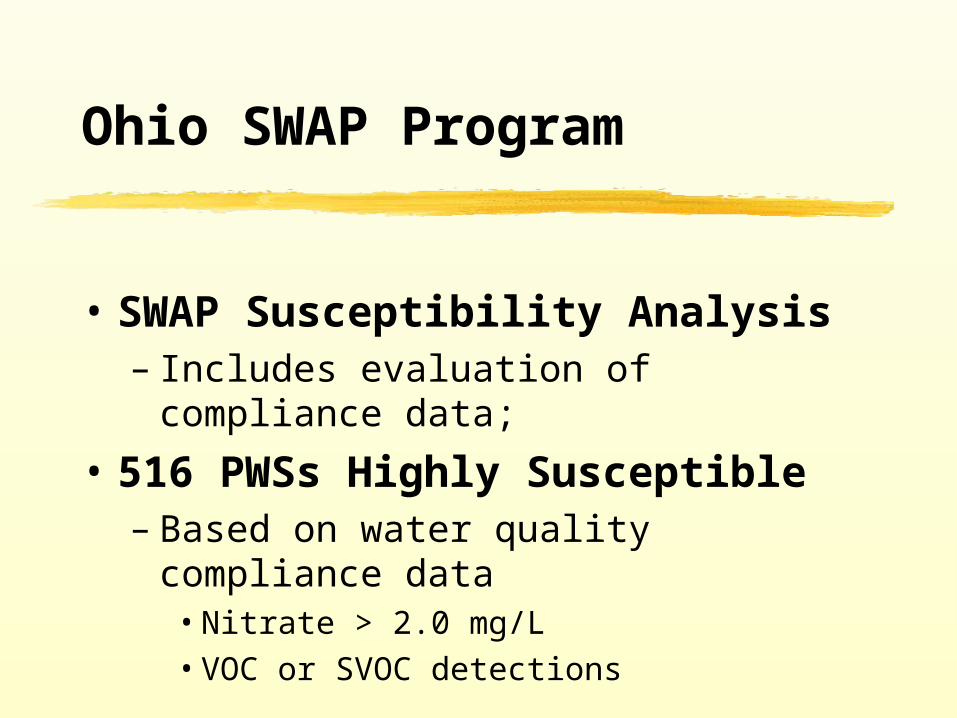
Ohio SWAP Program
• SWAP Susceptibility Analysis– Includes evaluation of compliance data;
• 516 PWSs Highly Susceptible – Based on water quality compliance data
• Nitrate > 2.0 mg/L• VOC or SVOC detections


WQ Impacts in Sensitive Aquifers?
• Attach glacial aquifer attributes to PWS locations
• Evaluate PWS WQ impact association with:– Glacial geologic settings– Glacial lithologies
• Compare percentage of PWSs impacted

Data Limitations
• ODNR aquifer maps thickness are ranges not well depths– If glacial drift < 25’, bedrock production well likely– If glacial drift > 25’, production may be in drift
• In thicker glacial sand and gravels, well depth may not approach glacial drift thickness
• In thicker till lithologies, production may come from sand lenses or bedrock
• Utilizing statewide generalizations

Rapid Recharge to Fractured Bedrock

PWS Water Quality Impacts - Geologic Settings
Thickness ofGlacial Unit (Feet)
Number of PWSs in Glacial Unitwith Impacts
Total Number of GW Based PWSs in Glacial Unit
Percentage ofImpacted PWSs
Sand and Gravel Aquifer Settings
0-25 10 39 25.6 %
25-100 92 487 18.9 %
>100 153 1066 14.4 %
Bedrock Aquifers Below Thin Uplands and Lacustrine Deposits
0-25 133 904 14.7 %
25-100 103 1032 10.0 %
>100 8 28 28.6 %
Moraine Deposits
0-25 0 0 0.0 %
25-100 27 704 3.8 %
>100 13 559 2.3 %

Thickness ofGlacial Unit (Feet)
Number of PWSs in Glacial Unitwith Impacts
Total Number of GW Based PWSs in Glacial Unit
Percentage ofImpacted PWSs
Sand and Gravel Lithologies
0-25 6 9 66.7 %
25-100 50 133 37.6 %
>100 113 495 22.8 %
Fine Grained Lithologies
0-25 4 36 11.1 %
25-100 44 405 10.9 %
>100 37 464 8.0 %
Till Lithologies
0-25 133 898 14.8 %
25-100 128 1682 7.6 %
>100 24 697 3.4 %
PWS Water Quality Impacts – Lithologic Association


Sensitive Aquifers
• PWSs with WQ impacts associated with:– Coarse S&G aquifers– Thin Tills (0-25 ‘)
• Aquifers composed of fines provide more protection than S&G aquifers and thin tills over bedrock aquifers;
• Thick tills are associated with low % of PWSs with WQ impacts (3-4 %)


Future Activities - Sensitive Aquifers
• Attach glacial drift thickness, DRASTIC ranking, and soil properties to PWS locations for analysis of WQ impacts
• Incorporate well casing length and depth as analysis factors
• Evaluate dissolved vs particulate sensitivity• Identify areas where horizontal flow pro-vides
rapid recharge• Short term sampling in sensitive aquifers

Rapid Horizontal Recharge Linked with Flooding

Acknowledgments
Data:• Ohio EPA Staff• PWS Operators• ODNR Aquifer Map
GIS Support:• Ohio EPA, DDAGW GIS Unit