Embed Size (px)
Citation preview

Identifying Maps on the World Wide Web
Matthew Michelson, Aman Goel, and Craig A. Knoblock?
University of Southern California,Information Sciences Institute,
Marina del Rey, CA 90292, USA,{michelso,amangoel,knoblock}@isi.edu,
WWW home page: http://www.isi.edu/integration
Abstract. This paper presents an automatic approach to mining col-lections of maps from the Web. Our method harvests images from theWeb and then classifies them as maps or non-maps by comparing themto previously classified map and non-map images using methods fromContent-Based Image Retrieval (CBIR). Our approach outperforms theaccuracy of the previous approach by 20% in F1-measure. Further, ourmethod is more scalable and less costly than previous approaches thatrely on more traditional machine learning techniques.
1 Introduction
As more and more information comes online, disciplines ranging from medicineto geography benefit from the proliferation of freely available data. For example,in the field of geography, huge repositories of maps can be built by harvestingmaps from all of the images on the Web. Once harvested, these maps can thenbe aligned to known geographic sources in a process known as “georeferencing”[1–3]. Previous work georeferences maps to satellite images by first automati-cally extracting the roads and intersections from the map image [4–6], and thenusing those roads and intersections to automatically align the map to the satel-lite image in a process known as conflation [1, 2]. Once georeferenced, the mapcollection can be queried using the same spatial queries used on the satelliteimages, such as queries by region, latitude/longitude, street name, etc. Further,not only are the maps returned for the given query, but they can be put in con-text by overlaying the map images on top of the satellite image. An example ofa conflated map with a satellite image is given in Figure 1.
? This research is based upon work supported in part by the National Science Foun-dation under award number IIS-0324955, in part by the United States Air Forceunder contract number FA9550-08-C-0010, and in part by a gift from Microsoft.The U.S. Government is authorized to reproduce and distribute reports for Govern-mental purposes notwithstanding any copyright annotation thereon. The views andconclusions contained herein are those of the authors and should not be interpretedas necessarily representing the official policies or endorsements, either expressed orimplied, of any of the above organizations or any person connected with them.

Fig. 1. A bus map for Washington, DC conflated with a satellite image of the city.
In this paper we focus on the first of these problems, automatically harvestingmaps from the freely available images on the Web. However, given that thereis no filter for publishing on the Web, a major challenge exists in separatingthe map images from the other types of images. Manually sifting through theimages is both tedious and costly, especially given the huge amounts of datathat must be examined. In this paper we address the problem of automaticallyseparating geographic maps from other images collected on the World Wide Web.An autonomous approach not only eases the cost associated with identifyingmaps, but it also provides an easy and scalable approach to growing a collectionof maps over time. Once collected, such maps are useful for data integration,intelligence analysis and geographic information systems. While we focus on theparticular task of identifying maps, we believe the approach is general enoughto work for other specific image types, such as medical images.
More specifically, we start with a collection of images harvested from theWeb and our goal is to sort the images into maps and other images. Rather thancollecting the images ourselves, which is costly, we leverage the image-searchdatabases of large companies such as Microsoft, Yahoo!, and Google who indexand collect millions of images from all over the Web. Since these databases arerefreshed frequently with new content, this allows us to collect new maps overtime without having to spider the Web itself. Using such image databases, wecan collect the search results and classify each returned image as a map or non-map, storing the newly classified maps in a map server. These stored maps canthen be georeferenced for future querying. Figure 2 shows this process.
As shown in Figure 2, we exploit two repositories, one of maps and one ofnon-maps, to do our classification. While the specifics of our classifier are givenin Section 2, intuitively, if an image to be classified is more similar to the mapsin our repository than the non-maps, then it is more likely a map itself. Thatis, using techniques from Content-Based Image Retrieval (CBIR), we select themost similar images from the repositories for a given map and use those returnedimages to decide if the input image is a map or not. We find that our CBIRmethod is both more scalable than machine learning methods (as justified in

Fig. 2. A software system for automatically collecting maps from the Web.
Section 2), and it is also more accurate (as shown in the experiments of Section3). This is the basis of our contribution: a method to sort images into maps thatis scalable, robust, autonomous and accurate.
The rest of this paper is organized as follows. We describe the details of ourCBIR map classifier in Section 2. We then describe our experiments and justifyour approach in Section 3. We next present related work in Section 4, and wefinish with our conclusions and future research in Section 5.
2 Automatically Classifying Maps
The focus of this paper is the classification of maps from images harvested fromthe Web. In this paper we broadly define a map as any digital image whichcontains “map like” characteristics such as lines, intersections and labels. Theimportant aspect for our task is that we remain consistent in our definition ofmaps versus non-maps.
Our map classifier exploits techniques from Content-Based Image Retrieval(CBIR).1 CBIR is essentially the image equivalent to traditional text based Websearch. Instead of finding the most similar Web pages for a given set of queryterms, in CBIR the most similar images from a set are returned for a given query1 See [7] for an excellent survey of the topic

Fig. 3. An example of Content-Based Image Retrieval
image. For example, consider Figure 3. In this figure, the query image comes intothe system and the top three most similar images are returned. This is the basisof our classifier.
To exploit CBIR for classification, we use a voting, k-Nearest Neighbor clas-sifier [8]. We first use CBIR to find the nine most similar images (neighbors)from the combined set of images in the map and non-map repositories. Thesimilarity measure in our CBIR method is based on Water-Filling features [9].Water-filling uses the edge maps of an image to quantify measures such as edgecomplexity (based on forking), edge lengths, etc. These Water-Filling featuresare well suited for images with clear edge structures [9], such as maps. Further,by using edge-based features we make our classifier color invariant.
We then employ a simple majority voting mechanism [8]. If the majority ofreturned images are maps, we classify the query image as a map. If the majorityof returned images are non-maps, we classify the query image as a non-map. Thissimple algorithm is shown in Figure 4. Therefore, although it may be the casethat other images on the Web will have clear edge structures (such as diagrams),since our technique relies not only on the edge features themselves, but also onthe similarity to the edge features of the images in our map repository, suchimages will be filtered out. The accuracy of our experimental results indeedshow this to be the case.
We choose a CBIR based k-Nearest Neighbor classifier over more traditionalmachine learning methods for the following reasons. First, CBIR similarity meth-

Fig. 4. A k-Nearest Neighbor map classifier using CBIR.
ods allow us to exploit image similarities without explicitly modeling them. Forinstance, hydrography maps are similar to other hydrography maps and urbancity maps are more similar to urban city maps but these types of maps maybe quite different from each other. By using CBIR methods, these similaritiescan be exploited without modeling them explicitly because the returned imagesencompass the image similarities implicitly (that is why they are returned assimilar). If we use traditional machine learning methods, such as Support Vec-tor Machines, we have two options to capture these different types of imagesimilarity. On the one hand, we can train a model for each class of map, then ifan incoming image matches any of these map classes, we know it is a map (sinceeach class composes the image similarities). That is, we can take the hydographymaps and learn a model of what a hydrography map should be. We can thentake the urban city map and learn an urban city map model.
There are several problems with trying to learn a model for each type ofmap. For one, the number of such classes is not known in advance. Therefore,a user will have to make a decision as to which maps constitute a class andhope he or she made the correct choices to lead to accurate classification. Alongthese lines, the user must make decisions as to the granularity of the classes (isan urban-hydrographical map its own class?), which can further complicate thecreation of classes. Also, learning a new model may be a non-trivial process both

in the work and time required. So, if a new class is discovered or needed, thiscan become a prohibitively costly problem.
Instead, rather than modeling all of the different types of image similaritiesin distinct classes, one could try to learn a single model that encompasses all ofthese different types of similarities. However, since different types of map imagescan vary wildly, trying to generalize to cover all of these different similarities leadsto a learned model that does not discriminate well (as shown in our experiments).
The other reason we chose CBIR instead of machine learning has to do withrobustness and scalability. We can exploit huge repositories in our method, whichis not the case using machine learning. In machine learning, learning modelsfrom massive amounts of data can take so long that it is not practical. CBIRtechniques, however, are built on methods from information retrieval which themajor search engines have shown to be fast and robust in very large, practicalsettings. Further, we can freely tweak the size and composition of our repositoryto test the effect (something we do in the experiments to test this idea). Usingmachine learning, we have to retrain a model each time we tweak the repository(training data). In situations where training is costly, this is not a good solution.Therefore, by using CBIR methods we can grow the repository over time withoutretraining which allows for a scalable and autonomous solution to classifyingmaps and building good map repositories. In our experiments, we show theeffects of growing the repository on the accuracy of classification.
3 Experiments
We collected 1,704 map images and 3,462 non-map images for our experiment.We used Yahoo Image Search2 to gather all of the map images and some ofthe non-map images. Most of the non-map images come from the CALTECH101 data set [10], which is a set of pictures of objects belonging to 101 differentcategories. Table 1 presents the distribution of images by source. Note that welabeled all images as maps or non-maps manually.
Our experimental collection includes not only cities in the United States,but also international cities. Specifically, we included maps from New Dehli,and the maps retrieved for the keywords “city maps” include maps from China,Hungary, Israel, Ireland, France, Scotland and many other countries. Further, themaps in our collection retrieved by city keywords (such as “Pittsburgh maps”)include not only urban street level maps, but also county maps, highway maps,weather maps, “metro area” maps, tourist maps (such as parks), and other types.Therefore, our map collection is diverse and interesting.
Our CBIR-based classifier builds upon LIRE3, an open source CBIR librarywritten in Java,4 which we augmented to use Water-Filling features[9]. Previouswork demonstrated that Water-Filling features increase performance in the re-trieval of images with clear edge structures [9], a condition that applies well to2 images.search.yahoo.com3 http://www.semanticmetadata.net/lire/4 LIRE is part of the Calif&Emir project [11].
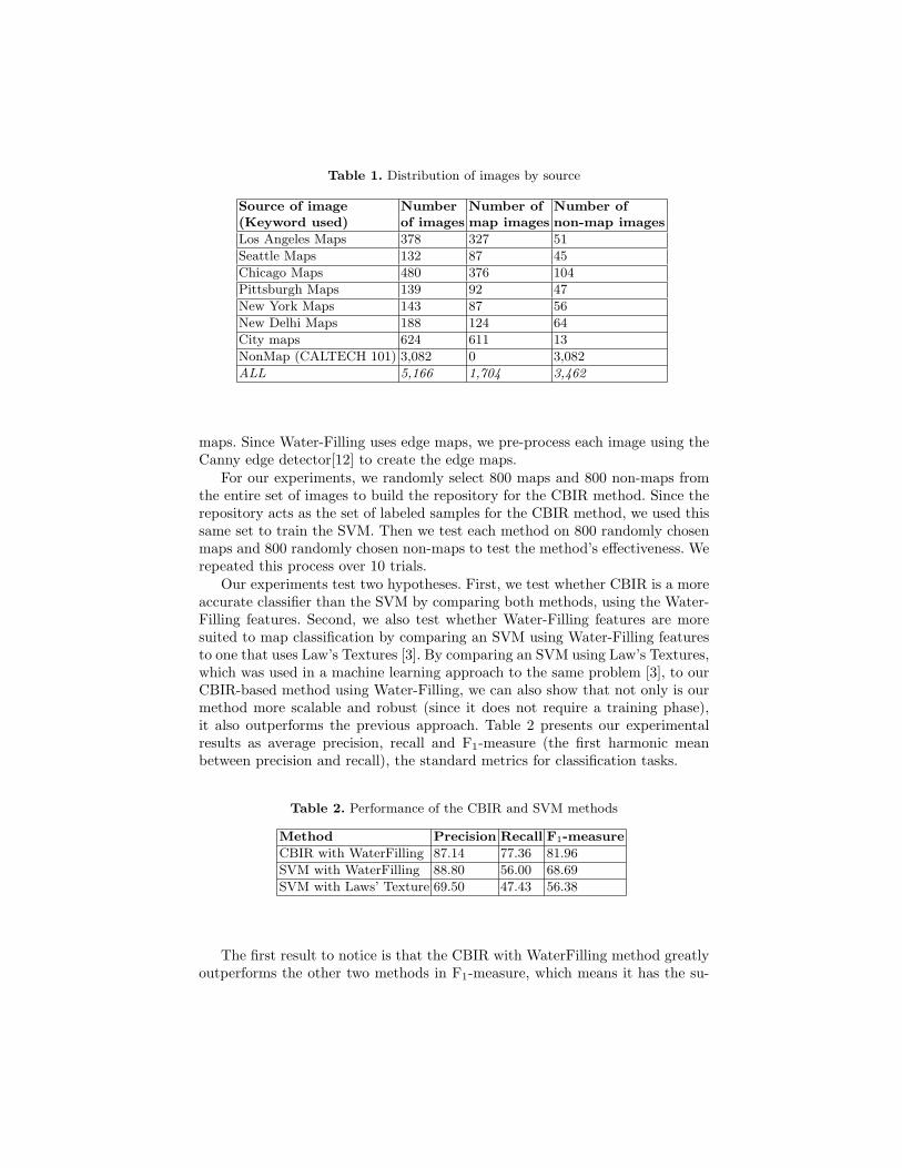
Table 1. Distribution of images by source
Source of image Number Number of Number of(Keyword used) of images map images non-map images
Los Angeles Maps 378 327 51
Seattle Maps 132 87 45
Chicago Maps 480 376 104
Pittsburgh Maps 139 92 47
New York Maps 143 87 56
New Delhi Maps 188 124 64
City maps 624 611 13
NonMap (CALTECH 101) 3,082 0 3,082
ALL 5,166 1,704 3,462
maps. Since Water-Filling uses edge maps, we pre-process each image using theCanny edge detector[12] to create the edge maps.
For our experiments, we randomly select 800 maps and 800 non-maps fromthe entire set of images to build the repository for the CBIR method. Since therepository acts as the set of labeled samples for the CBIR method, we used thissame set to train the SVM. Then we test each method on 800 randomly chosenmaps and 800 randomly chosen non-maps to test the method’s effectiveness. Werepeated this process over 10 trials.
Our experiments test two hypotheses. First, we test whether CBIR is a moreaccurate classifier than the SVM by comparing both methods, using the Water-Filling features. Second, we also test whether Water-Filling features are moresuited to map classification by comparing an SVM using Water-Filling featuresto one that uses Law’s Textures [3]. By comparing an SVM using Law’s Textures,which was used in a machine learning approach to the same problem [3], to ourCBIR-based method using Water-Filling, we can also show that not only is ourmethod more scalable and robust (since it does not require a training phase),it also outperforms the previous approach. Table 2 presents our experimentalresults as average precision, recall and F1-measure (the first harmonic meanbetween precision and recall), the standard metrics for classification tasks.
Table 2. Performance of the CBIR and SVM methods
Method Precision Recall F1-measure
CBIR with WaterFilling 87.14 77.36 81.96
SVM with WaterFilling 88.80 56.00 68.69
SVM with Laws’ Texture 69.50 47.43 56.38
The first result to notice is that the CBIR with WaterFilling method greatlyoutperforms the other two methods in F1-measure, which means it has the su-

perior map classification performance. Note that all differences, except for one,are statistically significant, using a two-tailed t-test with α set to 0.05. The onlydifference that is not statistically significant is the precision between the CBIRwith WaterFilling and the SVM with WaterFilling methods.
Note that while the precision using WaterFilling is similar (not statisticallysignificant) using either the SVM or the CBIR method, the recall is much im-proved using the CBIR method, yielding the best F1-measure. This supportsour notion that CBIR generalizes to many map types better than SVM does. Inorder to increase the SVM’s recall, we would need to train it for the various mapclasses. As it stands, training it to learn a single “meta-map” class only resultsin its classification of roughly half of the maps correctly. Meanwhile, becausethe CBIR method returns the nearest neighbors, which may be of arbitrary maptypes, it is able to cover many more map classes, and return a higher propor-tion of the maps. It does this while maintaining a high level of precision, and istherefore a more accurate classifier.
The next result to notice is that WaterFilling features are much better suitedfor the map classification task. This is clear by examining the difference in preci-sion between the SVM method using WaterFilling features and the SVM methodusing Law’s Textures. Both methods have very similar recall values, generallycapturing half of the maps in the testing data, but the Law’s Textures methoddoes a far worse job at distinguishing noise from the true maps. As stated, sincemaps have a strong-edge structure, Water-Filling can do a much better job atdistinguishing true maps from false positives.
We also analyze the effect of the size of the repository on the CBIR method’sclassification performance. Since the repository is equivalent to the training datafor the SVM method, this is analogous to studying the effect of the amount oftraining data on the SVM. To do this, we repeated the above classificationexperiment, this time varying the repository size (training data) by 200 mapsand 200 non-maps, starting with 200 maps and 200 non-maps up to 1,400 mapsand 1,400 non-maps. Figure 5 again compares the F1-measures for the threemethods, CBIR with WaterFilling, SVM with WaterFilling, and SVM with Law’sTextures.
Figure 5 suggests that even with a small repository, the CBIR method out-performs the SVM methods. Moreover, as we add more images to the repository,the CBIR method’s F1-measure improves steadily. Again, the primary cause forboth of the SVM methods’ low F1-measure is their low recall. As we argueabove, the primary reason for the low recall is that maps vary dramatically intheir shapes and density, such that when the SVM tries to learn one model forall of these types as maps, it converges to a set of feature values which are anaverage over these maps. As a result it defines a hyperplane approximately inthe middle of the feature space resulting in lots of maps falling on the non-mapside of the plane. In fact the recall hovers around the 50% mark reaching 56%for the most training. Note that the way to overcome this would be train anSVM for each map type, but this is infeasible given that we do not know themap types on the Web ahead on time.

Fig. 5. Comparison of CBIR and SVM varying the repository size
Lastly, we examine the maps misclassified by the CBIR method. Since theprecision is high, we focus on issues dealing with recall. Specifically, we delvemore deeply into false-negatives (maps that are errantly classified as non-maps),which are the determinant for recall misses. We realized that the majority offalse-negative cases are caused when there is one more non-map than map inthe returned neighbors, which leads the system to classify the input image asa non-map (since it has a five to four majority). In most of these cases, it isa small set of non-map images that repeatedly get included as these neighborswhich sway the vote to an errant classification. We call these “culprit” images.Figure 6 shows the edge-map of an example culprit image. This image is a personin front of a stack of books. However, the edge map for the stack of books inthe background looks quite similar to an urban map (it has lots of squares andintersections). To deal with “culprit images” we plan to use relevance feedbacktechniques to find this small set of non-map images and remove them from therepository.

(a) (b)
Fig. 6. An image where the edge map looks like a city map; Figure (a) shows theoriginal image, Figure (b) shows the edge map
4 Related Work
CBIR methods have been applied to various scientific disciplines ranging fromastronomy[13] to botany[14]. Much attention has been given to CBIR methodsin medicine, where they can have tremendous impact [15]. For example, in onemedical system the authors use a CBIR-based, k-Nearest Neighbor approach toclassify medical images [16]. This work also includes Water-Filling features forthe CBIR component. However, their work (and most of those above) differsfrom ours in the context in which it is applied. Our system is geared towardautomatically harvesting maps from the Web, while their system is used toclassify images so that images can be queried categorically. More specifically,these authors use many different types of features to classify their images, whilewe use only water-filling in the interest of accurate classification. Further, we arethe first to use CBIR methods to automatically harvest maps from the Web.
Although we are the first to propose CBIR-based classification for map har-vesting, other work has been proposed to automatically classify (and harvest)maps from the Web [3]. As stated in our experiments, Desai, et. al. [3] pro-pose machine learning methods to classify maps versus non-maps. In our exper-iments we find this method is less effective than our CBIR based classifier. Morespecifically, not only is the machine learning component not as accurate as theCBIR-based classifier, but a machine learning method requires different modelsfor each map type, since our experiments show that learning a single model tocover all maps leads to inaccurate classification.
Our experiments point to the necessity of using the correct features for CBIR.While we choose Water-Filling, which are good for images such as maps withstrong edge maps, other methods could perhaps work as well. For instance,authors have proposed “salient point” features based on wavelets [17]. Anotherset of features based on shape similarity [18] could be well suited for our taskas well, since maps seems to share certain shapes within them. Lastly, methodshave been proposed to more efficiently store color information [19], which makesretrieval more efficient. Although we use textures based on edge maps to make

our method color invariant, color information might help in discriminating maps.Our CBIR-method is not tied to Water-Filling, though those features performwell. It will be interesting future work to compare the various features and theirefficiency and accuracy for map classification.
5 Conclusion
In this paper we present an autonomous, robust and accurate method for clas-sifying maps from images collected on the World Wide Web. We find that aCBIR based classification method outperforms a machine learning based method,largely because we do not have to explicitly model the different types of mapsthat should be covered by the classifier. That is, by leveraging CBIR we can clas-sify a variety of maps without having to explicitly train a classification model foreach one. Further, we find that Water-Filling features, which are shown to workwell on images with clear edge structures, work well for maps in our classifier.
However, although our method performs well, there are still areas for im-provement. For example, some maps are misclassified when the majority vote isborderline (for example, one image sways the classification as a map or non-map).In this case, we can deal with the ambiguity by employing relevance feedbacktechniques from information retrieval. Such relevance feedback could help usto identify and prune away “culprit” images who consistently sway the vote inmiss-classifications. Other future work involves exploring different features suchas wavelets and shape similarities.
Nonetheless, despite the future work proposed above, our technique providesan automatic, accurate, practical and scalable solution to the problem of creat-ing useful image repositories from the Web. More importantly, by plugging ourmethod in with methods for aligning raster maps with satellite images we cancreate a harvesting framework for scouring the freely available images on theWeb to build map collections for any given region in the world.
6 Acknowledgment
The authors thank Vipul Verma for helping implement the Water-Filling featuresand CBIR method.
References
1. Chen, C.C., Knoblock, C.A., Shahabi, C.: Automatically conflating road vectordata with orthoimagery. Geoinformatica 10(4) (2006) 495–530
2. Chen, C.C., Knoblock, C.A., Shahabi, C.: Automatically and accurately conflatingraster maps with orthoimagery. GeoInformatica (in press, 2008)
3. Desai, S., Knoblock, C.A., Chiang, Y.Y., Desai, K., Chen, C.C.: Automaticallyidentifying and georeferencing street maps on the web. In: Proceedings of the 2ndInternational Workshop on Geographic Information Retrieval. (2005)

4. Chiang, Y.Y., Knoblock, C.A., Shahabi, C., Chen, C.C.: Accurate and automaticextraction of road intersections from raster maps. Geoinformatica (in press, 2008)
5. Chiang, Y.Y., Knoblock, C.A.: Classification of line and character pixels onraster maps using discrete cosine transformation coefficients and support vectormachines. In: Proceedings of the 18th International Conference on Pattern Recog-nition. (2006)
6. Chiang, Y.Y., Knoblock, C.A., Chen, C.C.: Automatic extraction of road intersec-tions from raster maps. In: Proceedings of the 13th ACM International Symposiumon Advances in Geographic Information Systems. (2005)
7. Smeulders, A.W.M., Worring, M., Santini, S., Gupta, A., Jain, R.: Content-basedimage retrieval at the end of the early years. IEEE Transactions on Pattern Anal-ysis and Machine Intelligence 22 (2000) 1349–1380
8. Fix, E., Hodges, J.L.: Discriminatory analysis, nonparametric discrimination: Con-sistency properties. Technical report 4, USAF School of Aviation Medicine, Ran-dolph Field, TX (1951)
9. Zhou, X.S., Rui, Y., Huang, T.S.: Water-filling: A novel way for image struc-tural feature extraction. In: Proceedings of the International Conference on ImageProcessing. (1999) 570–574
10. Fei-Fei, L., Fergus, R., Perona, P.: Learning generative visual models from fewtraining examples: an incremental bayesian approach tested on 101 object cat-egories. In: Proceedings of IEEE CVPR Workshop on Generative-Model BasedVision. (2004)
11. Lux, M., Becker, J., Krottmaier, H.: Caliph&emir: Semantic annotation and re-trieval in personal digital photo libraries. In: Proceedings of CAiSE ’03 Forum at15th Conference on Advanced Information Systems Engineering. (2003)
12. Canny, J.: A computational approach to edge detection. IEEE Trans. PatternAnalysis and Machine Intelligence 8 (1986) 679–714
13. Csillaghy, A., Hinterberger, H., Benz, A.O.: Content based image retrieval inastronomy. Information Retrieval 3(3) (2000) 229–241
14. Wang, Z., Chi, Z., Feng, D.: Fuzzy integral for leaf image retrieval. In: Proc. ofIEEE Intl. Conference on Fuzzy Systems. (2002)
15. Muller, H., Michoux, N., Bandon, D., Geissbuhler, A.: A review of content-basedimage retrieval systems in medical applicationsclinical benefits and future direc-tions. International Journal of Medical Informatics 73 (2004) 1–23
16. Lehmann, T.M., Guld, M.O., Deselaers, T., Keysers, D., Schubert, H., Spitzer, K.,Ney, H., Wein, B.B.: Automatic categorization of medical images for content-basedretrieval and data mining. Computerized Medical Imaging and Graphics 29 (2005)143–155
17. Tian, Q., Sebe, N., Lew, M.S., Loupias, E., Huang, T.S.: Image retrieval usingwavelet-based salient points. Journal of Electronic Imaging 10(4) (2001) 835–849
18. Latecki, L.J., Lakamper, R.: Shape similarity measure based on correspondenceof visual parts. IEEE Trans. Pattern Analysis and Machine Intelligence 22(10)(2000) 1185–1190
19. Deng, Y., Manjunath, B.S., Kenney, C., Moore, M.S., Shin, H.: An efficient colorrepresentation for image retrieval. IEEE Trans. Image Processing 10(1) (2001)140–147