Embed Size (px)
Citation preview
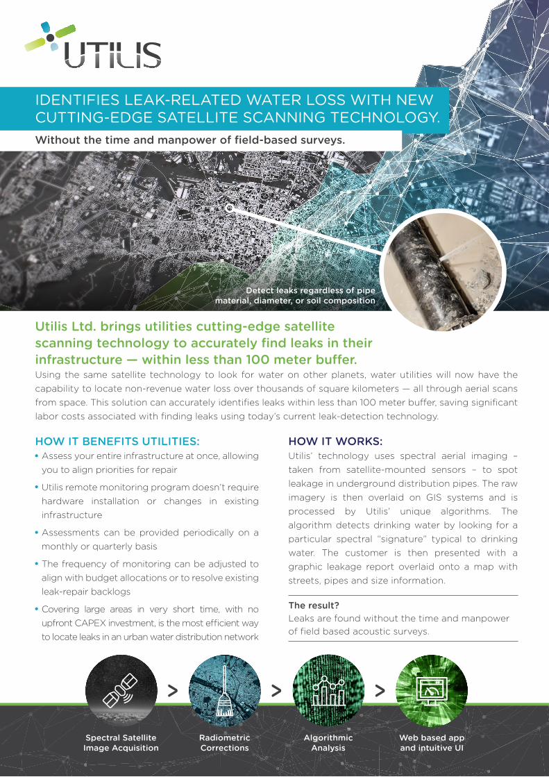
IDENTIFIES LEAK-RELATED WATER LOSS WITH NEW CUTTING-EDGE SATELLITE SCANNING TECHNOLOGY.Without the time and manpower of field-based surveys.
Utilis Ltd. brings utilities cutting-edge satellite scanning technology to accurately find leaks in their infrastructure — within less than 100 meter bu�er.Using the same satellite technology to look for water on other planets, water utilities will now have the capability to locate non-revenue water loss over thousands of square kilometers — all through aerial scans from space. This solution can accurately identifies leaks within less than 100 meter bu�er, saving significant labor costs associated with finding leaks using today’s current leak-detection technology.
HOW IT BENEFITS UTILITIES:Assess your entire infrastructure at once, allowing you to align priorities for repair
Utilis remote monitoring program doesn’t require hardware installation or changes in existing infrastructure
Assessments can be provided periodically on a monthly or quarterly basis
The frequency of monitoring can be adjusted to align with budget allocations or to resolve existing leak-repair backlogs
Covering large areas in very short time, with no upfront CAPEX investment, is the most e�cient way to locate leaks in an urban water distribution network
HOW IT WORKS:Utilis’ technology uses spectral aerial imaging – taken from satellite-mounted sensors – to spot leakage in underground distribution pipes. The raw imagery is then overlaid on GIS systems and is processed by Utilis’ unique algorithms. The algorithm detects drinking water by looking for a particular spectral “signature” typical to drinking water. The customer is then presented with a graphic leakage report overlaid onto a map with streets, pipes and size information.
The result?Leaks are found without the time and manpower of field based acoustic surveys.
Detect leaks regardless of pipe material, diameter, or soil composition
Spectral Satellite Image Acquisition
Radiometric Corrections
Algorithmic Analysis
Web based app and intuitive UI

For the past five years, Melbourne, Australia has been selected as the “World’s Most Livable City” by the Economist Intelligence Unit. Above ground, life is great.
But beneath it’s infrastructure, it su�ers from about 12% of non-revenue water every year.
In December 2015, Utilis undertook a pilot program to verify its technology can address this water loss— all from detailed area scans from space.
In the preliminary run of the program already, 18 leaks were detected in 4 days in the Melbourne suburbs. Utilis provided crews with a detailed “Leak Sheet Report” for every suspected leak. “Based on this pilot, we estimate Utilis remote sensing technology will substantially improve our leak detection process, saving us time and resources which we use today to detect leaks.” Said Dean Barnett, Program Manager, Pipe Rover & Leak Detection at IWN [www.iwn.org.au].
TECHNICAL SPECS:Utilis’ innovative satellite scanning technology detects leaks e�ciently, accurately and faster than existing solutions.
Remote sensing of subterranean water leakage is based on a primary algorithm that detects underground leaks by analyzing micro-spectral satellite imagery. Utilis receives microwave satellite images as input and then applies mathematical manipulation and analysis to provide a vector of coordinates.
The Utilis system is based on microwave reflectometry, or microwave electromagnetic signals. Microwaves are particularly useful for water detection, as water exhibits a high value of relative dielectric permittivity, therefore enabling the discovery and measurement of water in soil.
Utilis has selected a specific microwave wavelength not only for its ability to penetrate the ground, but also due to its high sensitivity to treated water characteristics.
Utilis surveys an entire network periodically, providing monthly or quarterly results as requested.
Each scan typically requires only 2-4 days of field correlation to isolated the leak, raising the e�ectiveness of acoustic teams so that they can focus on the last few meters of a leak detection.
CASE STUDY: MELBOURNE AUSTRALIASCANNING “THE LAND DOWN UNDER” FOR LOST WATER REVENUE.
During the program,Utilis benchmarked two metrics:
Location accuracy: field sta� were able to verify a suspected leak’s location, within a 100 meter radius bu�er of the original coordinates.
The minimum detectable leak size was0.1 liters per minute.
We were able to confirm that our minimum detectable leak size is 0.1–0.3 liters per minute, based on our microwave imagery, Utilis not only detected leaks accurately, it also provided a reliable indication of leak sizes.
1.
2.
“
“Elly Perets, Utilis CEO
23 HaMelacha St., Park Afeq, Rosh Ha’ayin 4809175 Israel • US: +1-408-216-8053 • IL: +972-9-886-6676w w w . u t i l i s c o r p . c o m