Embed Size (px)
Citation preview
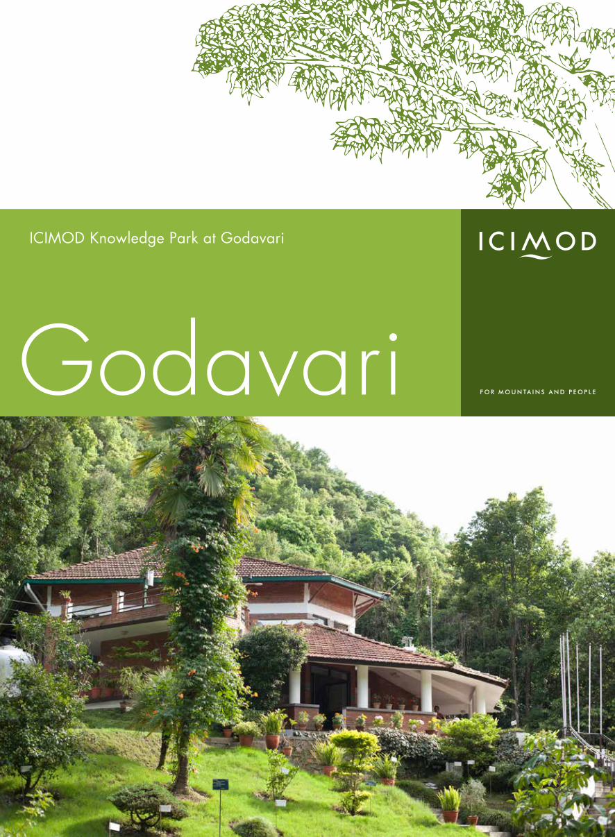
ICIMOD Knowledge Park at Godavari
Godavari
ICIMOD Knowledge Park at Godavari
ICIMOD Knowledge Park at Godavari
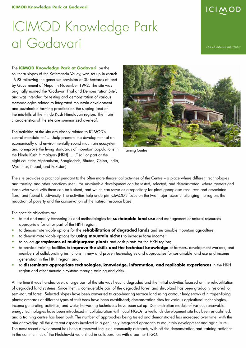
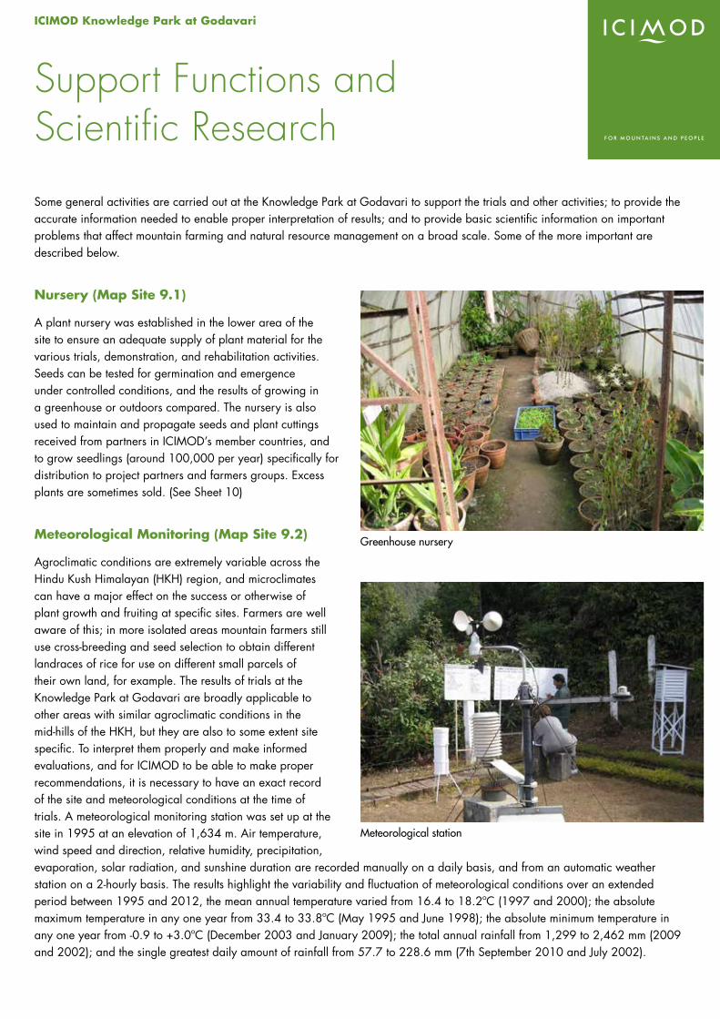
The ICIMOD Knowledge Park at Godavari, on the southern slopes of the Kathmandu Valley, was set up in March 1993 following the generous provision of 30 hectares of land by Government of Nepal in November 1992. The site was originally named the ‘Godavari Trial and Demonstration Site’, and was intended for testing and demonstration of various methodologies related to integrated mountain development and sustainable farming practices on the sloping land of the mid-hills of the Hindu Kush Himalayan region. The main characteristics of the site are summarized overleaf.
The activities at the site are closely related to ICIMOD’s central mandate to “…..help promote the development of an economically and environmentally sound mountain ecosystem and to improve the living standards of mountain populations in the Hindu Kush Himalayas (HKH)……” (all or part of the eight countries Afghanistan, Bangladesh, Bhutan, China, India, Myanmar, Nepal, and Pakistan).
The site provides a practical pendant to the often more theoretical activities of the Centre – a place where different technologies and farming and other practices useful for sustainable development can be tested, selected, and demonstrated; where farmers and those who work with them can be trained; and which can serve as a repository for plant germplasm resources and associated floral and faunal biodiversity. The activities help underpin ICIMOD’s focus on the two major issues challenging the region: the reduction of poverty and the conservation of the natural resource base.
The specific objectives are• to test and modify technologies and methodologies for sustainable land use and management of natural resources
appropriate for all or part of the HKH region;• to demonstrate viable options for the rehabilitation of degraded lands and sustainable mountain agriculture; • to demonstrate viable options for using mountain niches to increase farm income;• to collect germplasms of multipurpose plants and cash plants for the HKH region; • to provide training facilities to improve the skills and the technical knowledge of farmers, development workers, and
members of collaborating institutions in new and proven technologies and approaches for sustainable land use and income generation in the HKH region; and
• to disseminate appropriate technologies, knowledge, information, and replicable experiences in the HKH region and other mountain systems through training and visits.
At the time it was handed over, a large part of the site was heavily degraded and the initial activities focused on the rehabilitation of degraded land systems. Since then, a considerable part of the degraded forest and shrubland has been gradually restored to semi-natural forest. Selected slopes have been converted to crop-bearing terrace land using contour hedgerows of nitrogen-fixing plants; orchards of different types of fruit trees have been established; demonstration sites for various agricultural technologies, income generating activities, and water harvesting techniques have been set up. Demonstration models of various renewable energy technologies have been introduced in collaboration with local NGOs; a wetlands development site has been established; and a training centre has been built. The number of approaches being tested and demonstrated has increased over time, with the aim of covering all the different aspects involved in a genuinely integrated approach to mountain development and agriculture. The most recent development has been a renewed focus on community outreach, with off-site demonstration and training activities in the communities of the Phulchowki watershed in collaboration with a partner NGO.
Training Centre
International Centre for Integrated Mountain Development Knowledge Park at GodavariGPO Box 3226, Kathmandu, Khumaltar, Lalitpur, Nepal
Tel +977-1-5003222 Fax +977-1-5003299 Email [email protected] Web www.icimod.orgGodavari Site Tel +977-012239658/012220789
Sheet 1October 2013
All plants are grown under organic conditions, that is without inputs of inorganic fertilizer or pesticides. Thus the test results reflect the results that could be obtained by the mostly poor farmers in remote areas of the Hindu Kush Himalayas who have little access to and cannot afford commercial agricultural inputs.
Activities in an integrated agricultural system are by their nature cross-cutting and often interactive and interdependent. The activities at the ICIMOD Knowledge Park are linked within a holistic approach that covers a broad range of the possibilities for livelihood – and quality of life – improvement of mountain farmers, especially those in the mid-hill areas of the HKH region. For purposes of description, the activities are classified broadly under the following headings, but many have multiple functions, and/or are directly interlinked with each other. The major areas of activities are • Vegetation management• Soil management• Water management• Income generation through high-value cash crops, horticulture, and beekeeping• Livestock and fish• Biodiversity• Renewable energy technologies• Support functions and scientific research• Community outreach – off-site demonstration and training and provision of materials• Training and visitors• Publications
More details of the specific activities are given under these headings on the accompanying sheets.
Major Characteristics of the ICIMOD Knowledge Park Site
LatitudeLongitudeAltitudeAreaSlope gradient
27°35’19’’ to 27°35’41’’N85°23’16” to 85°23’44” E1540-1800 masl30 ha5°-60° (north-facing)
Climate subtropical to warm temperate
Temperature (1995-2012, manual data)
average annual maximumaverage annual minimumaverage annual meanmean hottest month (June)mean coldest month (January)absolute minimum (30 Dec 2003)absolute maximum (10 June 1998)
22.0°C 12.4°C 17.0°C 22.4°C 9.0°C -0.9°C 33.8°C
Mean annual rainfall(1995-2012)
1,904 mm, 80% between June and September
Soil texturedepthpHorganic matter content (0-30 cm)
clay loam to sandy and silty clay loam25-100 cm4.2-5.5 8.3%
Natural vegetation mixed deciduous and evergreen broadleaved forest
Catchment area 4 mini watersheds and 12 mini sub-catchments within the main Phulchowki watershed
Flora and Fauna • 694 species of flora representing 10% of the reported 7,000 vascular plants of Nepal (Biomass Study Report, 2002)
• diverse fauna from leeches to large mammals; so far a total of 231 different species recorded and identified

ICIMOD Knowledge Park at Godavari
Vegetation Management
At the time that ICIMOD established the Godavari site, the land had been reduced to almost completely degraded forest and shrubland through continuous excessive removal of useful species by people, grazing, and forest fires. The area was once a natural high forest rich in biodiversity and stocked with valuable tree species, but the natural species composition had been replaced through invasion and encroachment by aggressive, hardy, but less useful thorny shrubs, bushes, and weeds. The timber volume was low with very few fuelwood, fodder tree, or other useful species.
ICIMOD embarked on a long-term programme using various assisted natural regeneration techniques to restore the forest. In ten years, the overall biomass more than doubled as did the number of plant species. Agroforestry models were established, and sightings of wildlife increased. Regeneration is a long-term process and there is still a long way to go in terms of increasing biomass and species diversity – even so the site already has one of the best forests surrounding the Kathmandu valley. This is a living example of what can be done for the degraded forests of the mid hills. Some of the specific approaches are summarized below. By their nature, most of the vegetation management activities are also concerned with biodiversity conservation, as outlined in the sheet on ‘Biodiversity’ (Sheet 7).
Different Approaches in the Different Physiographic Zones (Map Site 2.1a,b)
The site has an elevation range from 1,540 to 1,800 masl and can be divided physiographically into three ecological vegetation zones – shrub/bushland on the valley floor, shrubland on mixed slopes, and natural forest on steep slopes – and ten vegetation types. Appropriate management systems are being designed and tested for each of these in a research and development programme for assisted regeneration.
The shrubland on the valley floor covers an area of 8 hectares between 1,550 and 1,600 masl. It consists mainly of invaded weed vegetation, thorny shrubs, and bushes with some swampy and dry grassland areas. The climate is sub-tropical and the soil is rich clay loam. The plant nursery, floriculture, sub-tropical and citrus fruits, beekeeping, goat husbandry and angora rabbits trial areas, and the field office buildings are all located in this area.
The shrubland on mixed slopes covers an area of 12 hectares with slopes of 15-35 degrees between 1,600 masl and 1,650 masl. It mostly contains coppice growth of less useful and unwanted species with a different vegetation type in the gullies to the intervening areas. The slopes are typical of the mountain farming systems in the HKH region, and this zone is suitable for development and/or planting of fruit trees, floriculture, vegetables, medicinal, aromatic and wild edible plants, fodder trees, multi-purpose trees, shrubs, grasses, and nitrogen-fixing species.
The natural forest on steep slopes covers an area of 10 hectares between 1,650 and 1,800 masl. It consists of shrubland in the lower parts, and small trees with a few remnants of the once tall natural forests at higher elevations. The trees are mostly defective or less useful species with little natural regeneration and pole-size stands, and the area is infested with climbers and weeds. This zone is suitable for investigation and establishment of natural forest management; shrubland management; enrichment planting; biomass enhancement; multistoreyed forest systems; selection, selection-cum-improvement, coppice, and coppice with standard silvicultural systems; non-timber forest products; plants with income potential; medicinal and aromatic plants; natural and artificial regeneration; and for conducting research and development on such themes as lopping, harvesting, transport of forest products and their proper use, management regimes, and intensities.
Rehabilitation of degraded land
International Centre for Integrated Mountain Development Knowledge Park at GodavariGPO Box 3226, Kathmandu, Khumaltar, Lalitpur, Nepal
Tel +977-1-5003222 Fax +977-1-5003299 Email [email protected] Web www.icimod.orgGodavari Site Tel +977-012239658/012220789
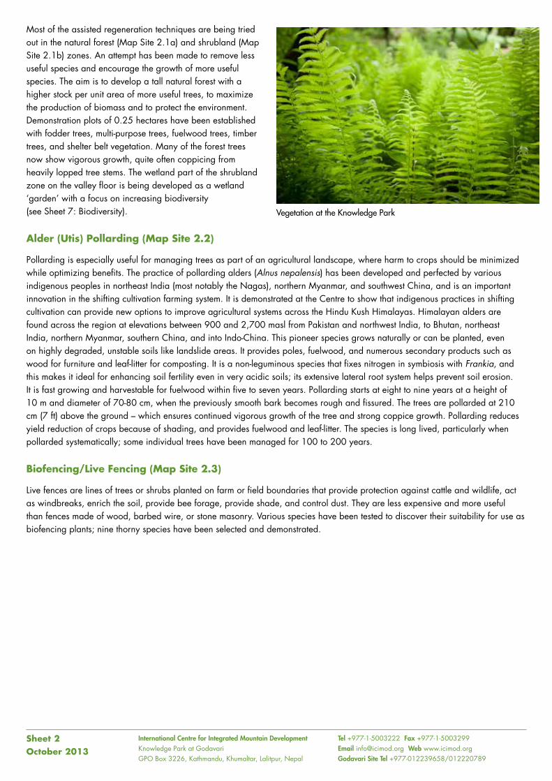
Most of the assisted regeneration techniques are being tried out in the natural forest (Map Site 2.1a) and shrubland (Map Site 2.1b) zones. An attempt has been made to remove less useful species and encourage the growth of more useful species. The aim is to develop a tall natural forest with a higher stock per unit area of more useful trees, to maximize the production of biomass and to protect the environment. Demonstration plots of 0.25 hectares have been established with fodder trees, multi-purpose trees, fuelwood trees, timber trees, and shelter belt vegetation. Many of the forest trees now show vigorous growth, quite often coppicing from heavily lopped tree stems. The wetland part of the shrubland zone on the valley floor is being developed as a wetland ‘garden’ with a focus on increasing biodiversity (see Sheet 7: Biodiversity).
Alder (Utis) Pollarding (Map Site 2.2)
Pollarding is especially useful for managing trees as part of an agricultural landscape, where harm to crops should be minimized while optimizing benefits. The practice of pollarding alders (Alnus nepalensis) has been developed and perfected by various indigenous peoples in northeast India (most notably the Nagas), northern Myanmar, and southwest China, and is an important innovation in the shifting cultivation farming system. It is demonstrated at the Centre to show that indigenous practices in shifting cultivation can provide new options to improve agricultural systems across the Hindu Kush Himalayas. Himalayan alders are found across the region at elevations between 900 and 2,700 masl from Pakistan and northwest India, to Bhutan, northeast India, northern Myanmar, southern China, and into Indo-China. This pioneer species grows naturally or can be planted, even on highly degraded, unstable soils like landslide areas. It provides poles, fuelwood, and numerous secondary products such as wood for furniture and leaf-litter for composting. It is a non-leguminous species that fixes nitrogen in symbiosis with Frankia, and this makes it ideal for enhancing soil fertility even in very acidic soils; its extensive lateral root system helps prevent soil erosion. It is fast growing and harvestable for fuelwood within five to seven years. Pollarding starts at eight to nine years at a height of 10 m and diameter of 70-80 cm, when the previously smooth bark becomes rough and fissured. The trees are pollarded at 210 cm (7 ft) above the ground – which ensures continued vigorous growth of the tree and strong coppice growth. Pollarding reduces yield reduction of crops because of shading, and provides fuelwood and leaf-litter. The species is long lived, particularly when pollarded systematically; some individual trees have been managed for 100 to 200 years.
Biofencing/Live Fencing (Map Site 2.3)
Live fences are lines of trees or shrubs planted on farm or field boundaries that provide protection against cattle and wildlife, act as windbreaks, enrich the soil, provide bee forage, provide shade, and control dust. They are less expensive and more useful than fences made of wood, barbed wire, or stone masonry. Various species have been tested to discover their suitability for use as biofencing plants; nine thorny species have been selected and demonstrated.
Sheet 2October 2013
Vegetation at the Knowledge Park
ICIMOD Knowledge Park at Godavari
Soil Management
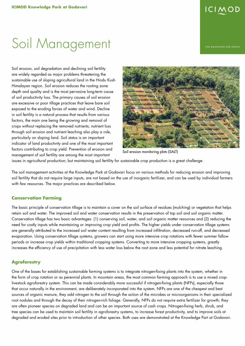
Soil erosion, soil degradation and declining soil fertility are widely regarded as major problems threatening the sustainable use of sloping agricultural land in the Hindu Kush Himalayan region. Soil erosion reduces the rooting zone depth and quality and is the most pervasive long-term cause of soil productivity loss. The primary causes of soil erosion are excessive or poor tillage practices that leave bare soil exposed to the eroding forces of water and wind. Decline in soil fertility is a natural process that results from various factors, the main one being the growing and removal of crops without replacing the removed nutrients; nutrient loss through soil erosion and nutrient leaching also play a role, particularly on sloping land. Soil status is an important indicator of land productivity and one of the most important factors contributing to crop yield. Prevention of erosion and management of soil fertility are among the most important issues in agricultural production; but maintaining soil fertility for sustainable crop production is a great challenge.
The soil management activities at the Knowledge Park at Godavari focus on various methods for reducing erosion and improving soil fertility that do not require large inputs, are not based on the use of inorganic fertilizer, and can be used by individual farmers with few resources. The major practices are described below.
Conservation Farming
The basic principle of conservation tillage is to maintain a cover on the soil surface of residues (mulching) or vegetation that helps retain soil and water. The improved soil and water conservation results in the preservation of top soil and soil organic matter. Conservation tillage has two basic advantages: (1) conserving soil, water, and soil organic matter resources and (2) reducing the need for costly inputs while maintaining or improving crop yield and profits. The higher yields under conservation tillage systems are generally attributed to the increased soil water content resulting from increased infiltration, decreased run-off, and decreased evaporation. Using conservation tillage systems, growers can start using more intensive crop rotations with fewer summer fallow periods or increase crop yields within traditional cropping systems. Converting to more intensive cropping systems, greatly increases the efficiency of use of precipitation with less water loss below the root zone and less potential for nitrate leaching.
Agroforestry
One of the bases for establishing sustainable farming systems is to integrate nitrogen-fixing plants into the system, whether in the form of crop rotation or as perennial plants. In mountain areas, the most common farming approach is to use a mixed crop-livestock agroforestry system. This can be made considerably more successful if nitrogen-fixing plants (NFPs), especially those that occur naturally in the environment, are deliberately incorporated into the system. NFPs are one of the cheapest and best sources of organic manure, they add nitrogen to the soil through the action of the microbes or microorganisms in their specialized root nodules and through the decay of their nitrogen-rich foliage. Generally, NFPs do not require extra fertilizer for growth; they are often pioneer species on degraded land and can be an important source of cash crops. Nitrogen-fixing herb, shrub, and tree species can be used to maintain soil fertility in agroforestry systems, to increase forest productivity, and to improve soils at degraded and eroded sites prior to introduction of other species. Both uses are demonstrated at the Knowledge Part at Godavari.
Soil erosion monitoring plots (SALT)
Sloping Agricultural Land Technology (SALT) (Map Site 3.1)
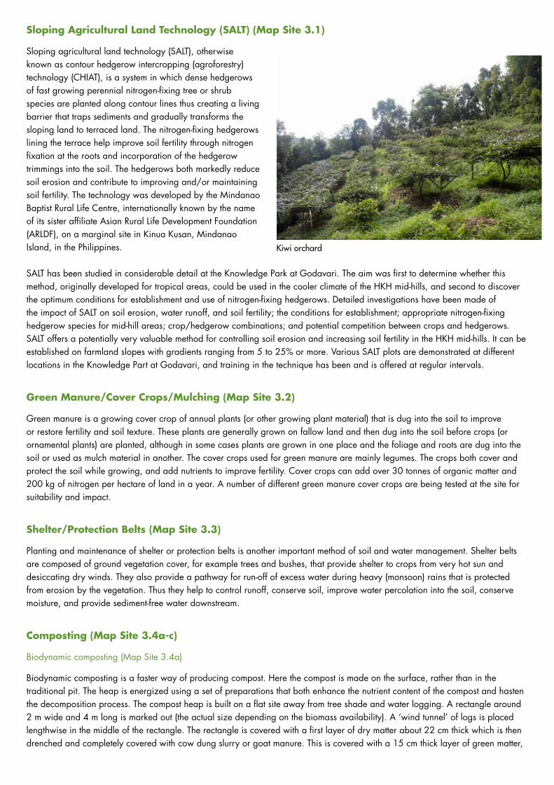
Sloping agricultural land technology (SALT), otherwise known as contour hedgerow intercropping (agroforestry) technology (CHIAT), is a system in which dense hedgerows of fast growing perennial nitrogen-fixing tree or shrub species are planted along contour lines thus creating a living barrier that traps sediments and gradually transforms the sloping land to terraced land. The nitrogen-fixing hedgerows lining the terrace help improve soil fertility through nitrogen fixation at the roots and incorporation of the hedgerow trimmings into the soil. The hedgerows both markedly reduce soil erosion and contribute to improving and/or maintaining soil fertility. The technology was developed by the Mindanao Baptist Rural Life Centre, internationally known by the name of its sister affiliate Asian Rural Life Development Foundation (ARLDF), on a marginal site in Kinua Kusan, Mindanao Island, in the Philippines.
SALT has been studied in considerable detail at the Knowledge Park at Godavari. The aim was first to determine whether this method, originally developed for tropical areas, could be used in the cooler climate of the HKH mid-hills, and second to discover the optimum conditions for establishment and use of nitrogen-fixing hedgerows. Detailed investigations have been made of the impact of SALT on soil erosion, water runoff, and soil fertility; the conditions for establishment; appropriate nitrogen-fixing hedgerow species for mid-hill areas; crop/hedgerow combinations; and potential competition between crops and hedgerows. SALT offers a potentially very valuable method for controlling soil erosion and increasing soil fertility in the HKH mid-hills. It can be established on farmland slopes with gradients ranging from 5 to 25% or more. Various SALT plots are demonstrated at different locations in the Knowledge Part at Godavari, and training in the technique has been and is offered at regular intervals.
Green Manure/Cover Crops/Mulching (Map Site 3.2)
Green manure is a growing cover crop of annual plants (or other growing plant material) that is dug into the soil to improve or restore fertility and soil texture. These plants are generally grown on fallow land and then dug into the soil before crops (or ornamental plants) are planted, although in some cases plants are grown in one place and the foliage and roots are dug into the soil or used as mulch material in another. The cover crops used for green manure are mainly legumes. The crops both cover and protect the soil while growing, and add nutrients to improve fertility. Cover crops can add over 30 tonnes of organic matter and 200 kg of nitrogen per hectare of land in a year. A number of different green manure cover crops are being tested at the site for suitability and impact.
Shelter/Protection Belts (Map Site 3.3)
Planting and maintenance of shelter or protection belts is another important method of soil and water management. Shelter belts are composed of ground vegetation cover, for example trees and bushes, that provide shelter to crops from very hot sun and desiccating dry winds. They also provide a pathway for run-off of excess water during heavy (monsoon) rains that is protected from erosion by the vegetation. Thus they help to control runoff, conserve soil, improve water percolation into the soil, conserve moisture, and provide sediment-free water downstream.
Composting (Map Site 3.4a-c)
Biodynamic composting (Map Site 3.4a)
Biodynamic composting is a faster way of producing compost. Here the compost is made on the surface, rather than in the traditional pit. The heap is energized using a set of preparations that both enhance the nutrient content of the compost and hasten the decomposition process. The compost heap is built on a flat site away from tree shade and water logging. A rectangle around 2 m wide and 4 m long is marked out (the actual size depending on the biomass availability). A ‘wind tunnel’ of logs is placed lengthwise in the middle of the rectangle. The rectangle is covered with a first layer of dry matter about 22 cm thick which is then drenched and completely covered with cow dung slurry or goat manure. This is covered with a 15 cm thick layer of green matter,
Kiwi orchard
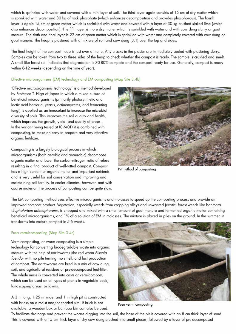
which is sprinkled with water and covered with a thin layer of soil. The third layer again consists of 15 cm of dry matter which is sprinkled with water and 30 kg of rock phosphate (which enhances decomposition and provides phosphorous). The fourth layer is again 15 cm of green matter which is sprinkled with water and covered with a layer of 30 kg crushed slaked lime (which also enhances decomposition). The fifth layer is more dry matter which is sprinkled with water and with cow dung slurry or goat manure. The sixth and final layer is 22 cm of green matter which is sprinkled with water and completely covered with cow dung or goat manure. The heap is plastered with a mixture of soil and cow dung (3:1) over the top and sides.
The final height of the compost heap is just over a metre. Any cracks in the plaster are immediately sealed with plastering slurry. Samples can be taken from two to three sides of the heap to check whether the compost is ready. The sample is crushed and smelt. A smell like forest soil indicates that degradation is 70-80% complete and the compost ready for use. Generally, compost is ready within 8-12 weeks (depending on the time of year).
Effective microorganisms (EM) technology and EM composting (Map Site 3.4b)
‘Effective microorganisms technology’ is a method developed by Professor T. Higa of Japan in which a mixed culture of beneficial microorganisms (primarily photosynthetic and lactic acid bacteria, yeasts, actinomycetes, and fermenting fungi) is applied as an innoculant to increase the microbial diversity of soils. This improves the soil quality and health, which improves the growth, yield, and quality of crops. In the variant being tested at ICIMOD it is combined with composting, to make an easy to prepare and very effective organic fertilizer.
Composting is a largely biological process in which microorganisms (both aerobic and anaerobic) decompose organic matter and lower the carbon-nitrogen ratio of refuse resulting in a final product of well-rotted compost. Compost has a high content of organic matter and important nutrients and is very useful for soil conservation and improving and maintaining soil fertility. In cooler climates, however, and with coarse material, the process of composting can be quite slow.
The EM composting method uses effective microorganisms and molasses to speed up the composting process and provide an improved compost product. Vegetation, especially weeds from cropping alleys and unwanted (exotic) forest weeds like banmara (Euphatorium adenophorum), is chopped and mixed with a small amount of goat manure and fermented organic matter containing beneficial microorganisms, and 1% of a solution of EM in molasses. The mixture is placed in piles on the ground. In the summer, it transforms into mature compost in 5-6 weeks.
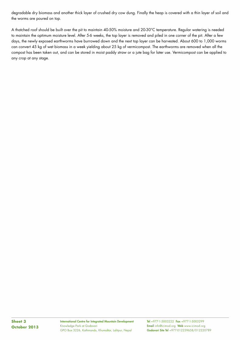
Pusa vermicomposting (Map Site 3.4c)
Vermicomposting, or worm composting is a simple technology for converting biodegradable waste into organic manure with the help of earthworms (the red worm Eisenia foetida) with no pile turning, no smell, and fast production of compost. The earthworms are bred in a mix of cow dung, soil, and agricultural residues or pre-decomposed leaf-litter. The whole mass is converted into casts or vermicompost, which can be used on all types of plants in vegetable beds, landscaping areas, or lawns.
A 3 m long, 1.25 m wide, and 1 m high pit is constructed with bricks on a moist and/or shaded site. If brick is not available, a wooden box or bamboo bin can also be used. To facilitate drainage and prevent the worms digging into the soil, the base of the pit is covered with an 8 cm thick layer of sand. This is covered with a 15 cm thick layer of dry cow dung crushed into small pieces, followed by a layer of pre-decomposed
Pit method of composting
Pusa vermi composting
International Centre for Integrated Mountain Development Knowledge Park at GodavariGPO Box 3226, Kathmandu, Khumaltar, Lalitpur, Nepal
Tel +977-1-5003222 Fax +977-1-5003299 Email [email protected] Web www.icimod.orgGodavari Site Tel +977-012239658/012220789
degradable dry biomass and another thick layer of crushed dry cow dung. Finally the heap is covered with a thin layer of soil and the worms are poured on top.
A thatched roof should be built over the pit to maintain 40-50% moisture and 20-30°C temperature. Regular watering is needed to maintain the optimum moisture level. After 5-6 weeks, the top layer is removed and piled in one corner of the pit. After a few days, the newly exposed earthworms have burrowed down and the next top layer can be harvested. About 600 to 1,000 worms can convert 45 kg of wet biomass in a week yielding about 25 kg of vermicompost. The earthworms are removed when all the compost has been taken out, and can be stored in moist paddy straw or a jute bag for later use. Vermicompost can be applied to any crop at any stage.
Sheet 3October 2013
ICIMOD Knowledge Park at Godavari
Water is one of the basic necessities for life, and water scarcity is one of the most important limiting factors for sustainable development initiatives. Rural communities not only need clean water for drinking and basic hygiene, they also need water for growing crops and watering animals. At the same time, water has a destructive potential. Heavy rainfall over short periods can lead to massive erosion of soil, particularly on slopes where the soil is exposed. Rainfall over longer periods can lead to nutrient leaching as well as more catastrophic events like landslides. Surface erosion is a natural process, but soil erosion in the Hindu Kush Himalayan (HKH) region has increased drastically as a result of inappropriate land use and management, and the current amount exceeds the natural rates many times.
In the HKH region, water is generally found high up (snow and glaciers) or deep down in the valley bottoms. Most human settlements, however, lie inbetween on the mid-slopes. Rainfall, the main source of water, is both seasonal and erratic in distribution, duration, and intensity. Water scarcity is a problem in most parts of the HKH region, even in those areas where the total annual rainfall is high. Cherrapunjee in the northeastern Indian Himalayas is a good example: it is one of the world’s highest rainfall areas, but is called a ‘wet desert’ because it still suffers from water scarcity. Similarly, in Godavari, a typical mid-hill area, 80% of the total annual rainfall falls during the monsoon period, the remaining eight months are more-or-less dry. Poor land management has led to increased water problems in the region; deforestation has increased surface runoff and decreased groundwater replenishment. For the estimated 150 million people of the HKH, water is a scarce commodity and improved water management practices are critical for ensuring the availability of drinking water, production of food, meeting the need for biomass, and for improved living conditions.
Water-related activities at the Knowledge Park at Godavari focus on methods of water harvesting (collection, storage, and use of the run-off of available sources of water) to provide water for household and agricultural use and land management practices to decrease runoff and soil erosion and increase water uptake and recharge of aquifers. Various methods have been tested that are appropriate for different needs and conditions. Sustainable harvesting of water, including rainwater, can contribute markedly to resolving the challenge of water scarcity for hill and mountain households.
The following methods are demonstrated at the site.
Water Harvesting (Map Site 4.1a,b)
Natural spring water harvesting
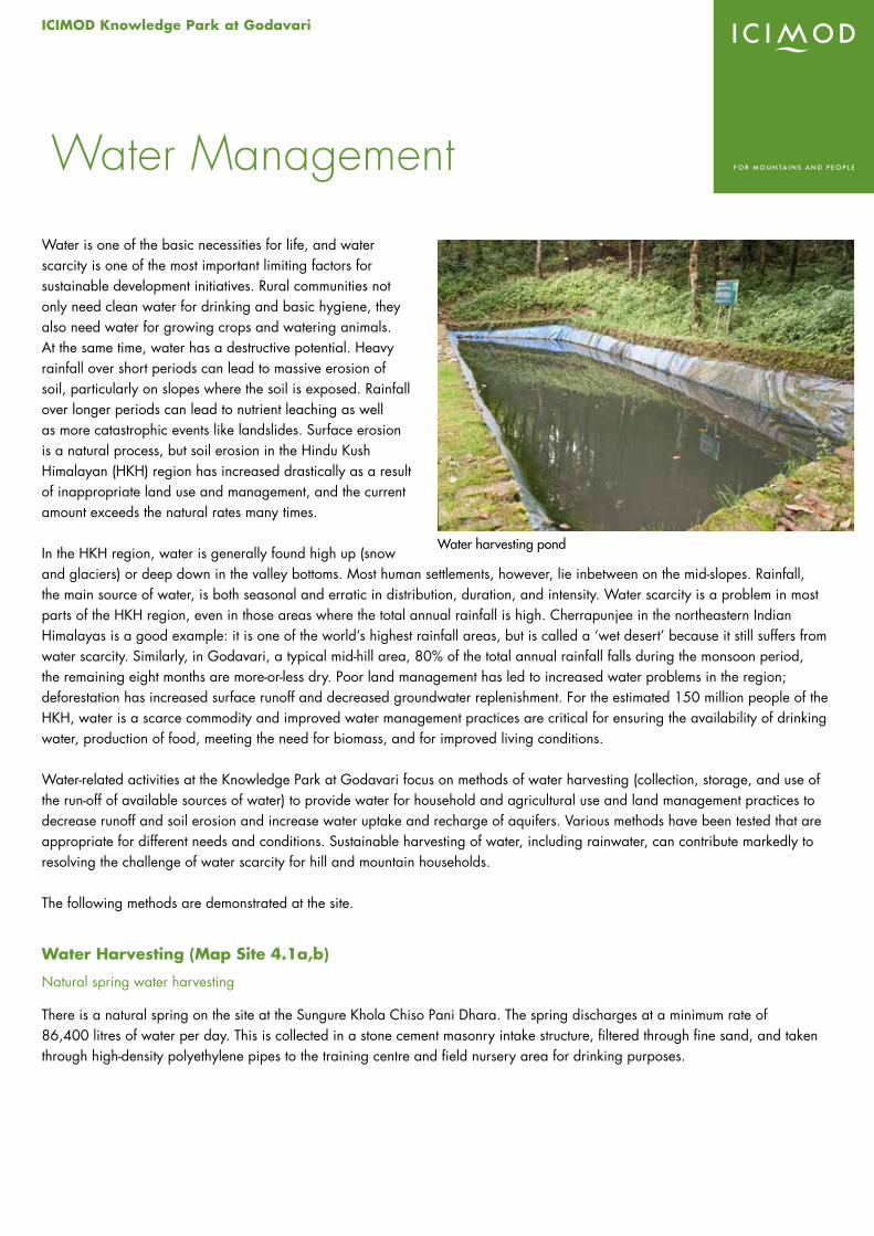
There is a natural spring on the site at the Sungure Khola Chiso Pani Dhara. The spring discharges at a minimum rate of 86,400 litres of water per day. This is collected in a stone cement masonry intake structure, filtered through fine sand, and taken through high-density polyethylene pipes to the training centre and field nursery area for drinking purposes.
Water Management
Water harvesting pond
Roof top rain water harvesting (Map Site 4.1a)
Rainwater is collected from the rooftop of the Training Centre and training room buildings and stored in ferro-cement jars. Each jar has a capacity of 2,000 litres and costs approximately NPR 10,000 (in 2012, approximately equivalent to USD140). It provides a useful source of drinking water and/or water for irrigation of a kitchen garden. The method is suitable for scattered houses in mountain areas where there are seasonal rains followed by long dry spells and no nearby perennial sources of potable water. It reduces the time spent by women and children (in most cases) in fetching water, and minimizes the risks of collecting water in the rainy season when paths are often slippery and difficult to negotiate.
Multiple Use of Water System (MUS)
It is a combined system of water facility that provides water for drinking and irrigation. It is a combination of transmission lines, reservoir tanks, distribution lines, domestic tap stands and irrigation systems. The Thai improved jar is used for collecting rain water harvested from rooftop and distributed for drinking and irrigation.
Water collection reservoirs (Map Site 4.1b)
Water collection reservoirs have been constructed that take advantage of the Knowledge Park’s topography and the presence of perennial water sources to provide a simple and cost-effective system of irrigation. Three water collection reservoirs have been constructed with high-density polyethylene sheet and SILPAULIN (multi-layered, cross-laminated, UV-stabilized plastic sheet) linings at suitable locations above the cropping plots. Water reservoirs can also be used for fish farming (see Sheet 6: Livestock and Fish)
Irrigation (Map Site 4.2a,b)
Gravity sprinkler irrigation (Map Site 4.2a)
Water from the reservoirs passes through high-density polethylene pipes laid-out with hydrants in different experimental plots and nurseries covering approximately five hectares of land. The force of the gravitational flow is sufficient to activate simple sprinklers without additional power. These are used to irrigate different field plots. The sprinkler irrigation system helps reduce run-off and soil loss.
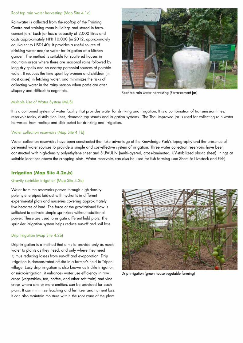
Drip Irrigation (Map Site 4.2b)
Drip irrigation is a method that aims to provide only as much water to plants as they need, and only where they need it, thus reducing losses from run-off and evaporation. Drip irrigation is demonstrated off-site in a farmer’s field in Tripeni village. Easy drip irrigation is also known as trickle irrigation or micro-irrigation, it enhances water use efficiency in row crops (vegetables, tea, coffee, and other soft fruits) and vine crops where one or more emitters can be provided for each plant. It can minimize leaching and fertilizer and nutrient loss. It can also maintain moisture within the root zone of the plant.
Roof top rain water harvesting (Ferro-cement jar)
Drip irrigation (green house vegetable farming)
International Centre for Integrated Mountain Development Knowledge Park at GodavariGPO Box 3226, Kathmandu, Khumaltar, Lalitpur, Nepal
Tel +977-1-5003222 Fax +977-1-5003299 Email [email protected] Web www.icimod.orgGodavari Site Tel +977-012239658/012220789
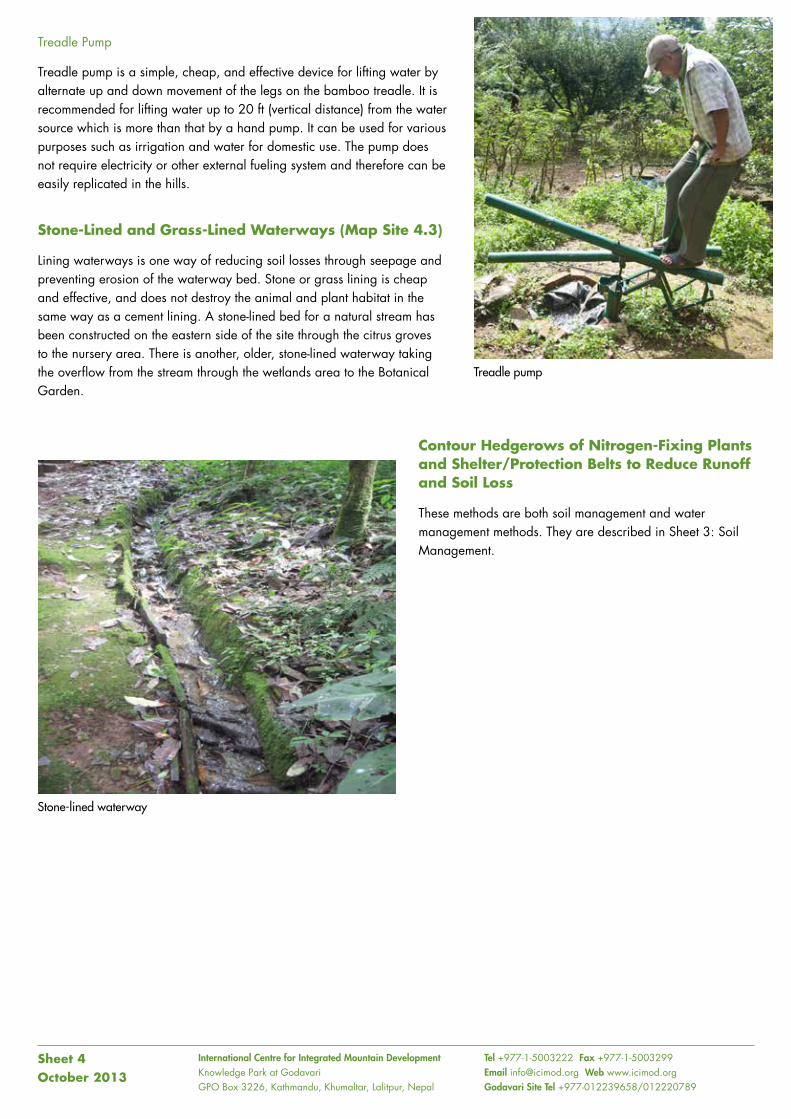
Treadle Pump
Treadle pump is a simple, cheap, and effective device for lifting water by alternate up and down movement of the legs on the bamboo treadle. It is recommended for lifting water up to 20 ft (vertical distance) from the water source which is more than that by a hand pump. It can be used for various purposes such as irrigation and water for domestic use. The pump does not require electricity or other external fueling system and therefore can be easily replicated in the hills.
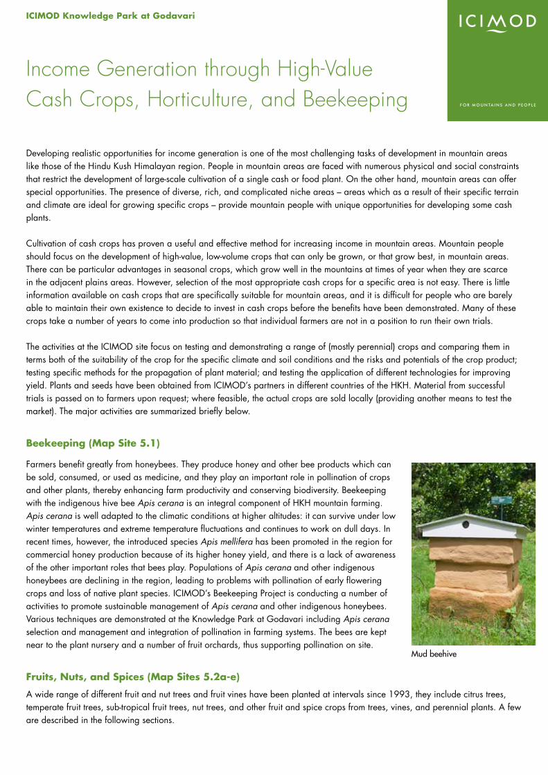
Stone-Lined and Grass-Lined Waterways (Map Site 4.3)
Lining waterways is one way of reducing soil losses through seepage and preventing erosion of the waterway bed. Stone or grass lining is cheap and effective, and does not destroy the animal and plant habitat in the same way as a cement lining. A stone-lined bed for a natural stream has been constructed on the eastern side of the site through the citrus groves to the nursery area. There is another, older, stone-lined waterway taking the overflow from the stream through the wetlands area to the Botanical Garden.
Contour Hedgerows of Nitrogen-Fixing Plants and Shelter/Protection Belts to Reduce Runoff and Soil Loss
These methods are both soil management and water management methods. They are described in Sheet 3: Soil Management.
Sheet 4October 2013
Stone-lined waterway
Treadle pump

ICIMOD Knowledge Park at Godavari
Developing realistic opportunities for income generation is one of the most challenging tasks of development in mountain areas like those of the Hindu Kush Himalayan region. People in mountain areas are faced with numerous physical and social constraints that restrict the development of large-scale cultivation of a single cash or food plant. On the other hand, mountain areas can offer special opportunities. The presence of diverse, rich, and complicated niche areas – areas which as a result of their specific terrain and climate are ideal for growing specific crops – provide mountain people with unique opportunities for developing some cash plants.
Cultivation of cash crops has proven a useful and effective method for increasing income in mountain areas. Mountain people should focus on the development of high-value, low-volume crops that can only be grown, or that grow best, in mountain areas. There can be particular advantages in seasonal crops, which grow well in the mountains at times of year when they are scarce in the adjacent plains areas. However, selection of the most appropriate cash crops for a specific area is not easy. There is little information available on cash crops that are specifically suitable for mountain areas, and it is difficult for people who are barely able to maintain their own existence to decide to invest in cash crops before the benefits have been demonstrated. Many of these crops take a number of years to come into production so that individual farmers are not in a position to run their own trials.
The activities at the ICIMOD site focus on testing and demonstrating a range of (mostly perennial) crops and comparing them in terms both of the suitability of the crop for the specific climate and soil conditions and the risks and potentials of the crop product; testing specific methods for the propagation of plant material; and testing the application of different technologies for improving yield. Plants and seeds have been obtained from ICIMOD’s partners in different countries of the HKH. Material from successful trials is passed on to farmers upon request; where feasible, the actual crops are sold locally (providing another means to test the market). The major activities are summarized briefly below.
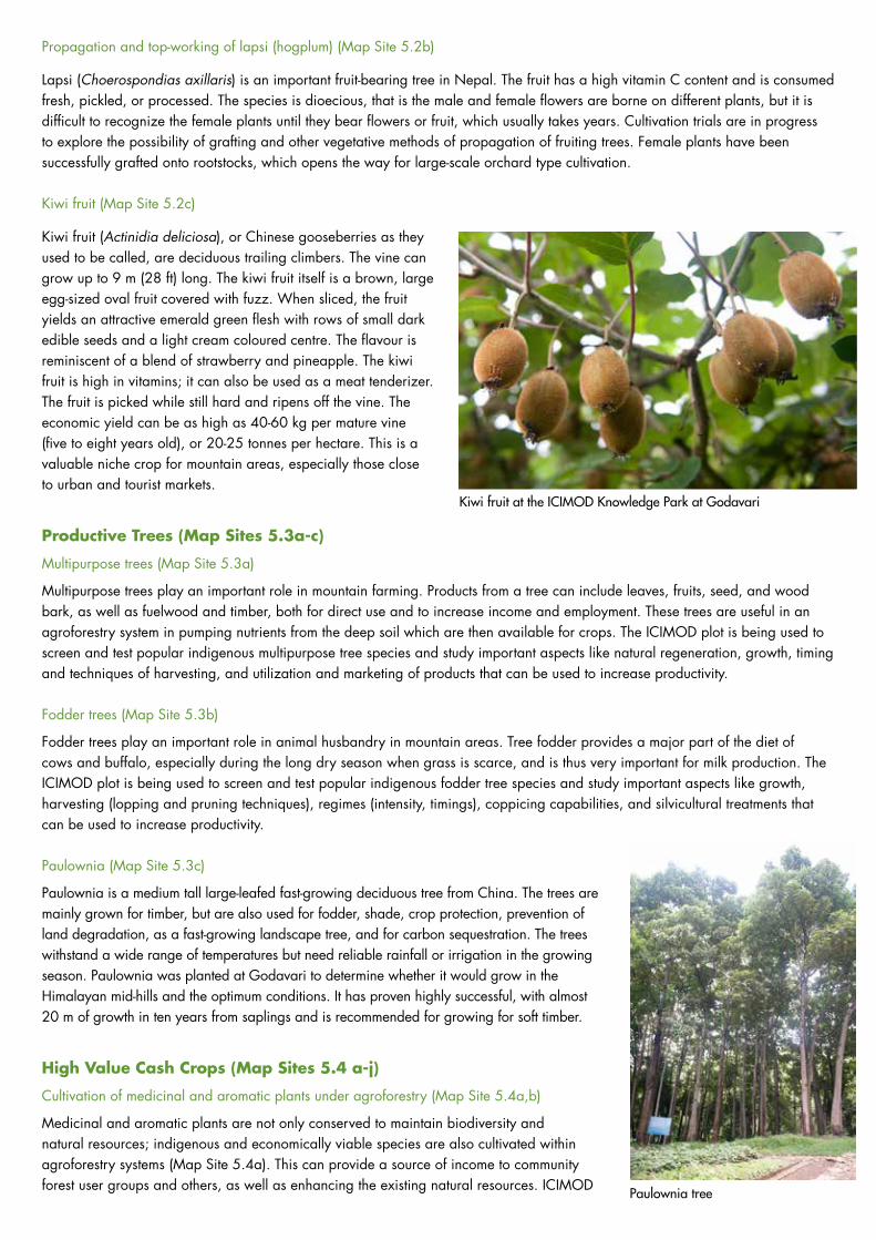
Beekeeping (Map Site 5.1)
Farmers benefit greatly from honeybees. They produce honey and other bee products which can be sold, consumed, or used as medicine, and they play an important role in pollination of crops and other plants, thereby enhancing farm productivity and conserving biodiversity. Beekeeping with the indigenous hive bee Apis cerana is an integral component of HKH mountain farming. Apis cerana is well adapted to the climatic conditions at higher altitudes: it can survive under low winter temperatures and extreme temperature fluctuations and continues to work on dull days. In recent times, however, the introduced species Apis mellifera has been promoted in the region for commercial honey production because of its higher honey yield, and there is a lack of awareness of the other important roles that bees play. Populations of Apis cerana and other indigenous honeybees are declining in the region, leading to problems with pollination of early flowering crops and loss of native plant species. ICIMOD’s Beekeeping Project is conducting a number of activities to promote sustainable management of Apis cerana and other indigenous honeybees. Various techniques are demonstrated at the Knowledge Park at Godavari including Apis cerana selection and management and integration of pollination in farming systems. The bees are kept near to the plant nursery and a number of fruit orchards, thus supporting pollination on site.
Fruits, Nuts, and Spices (Map Sites 5.2a-e)
A wide range of different fruit and nut trees and fruit vines have been planted at intervals since 1993, they include citrus trees, temperate fruit trees, sub-tropical fruit trees, nut trees, and other fruit and spice crops from trees, vines, and perennial plants. A few are described in the following sections.
Income Generation through High-Value Cash Crops, Horticulture, and Beekeeping
Mud beehive
Propagation and top-working of lapsi (hogplum) (Map Site 5.2b)
Lapsi (Choerospondias axillaris) is an important fruit-bearing tree in Nepal. The fruit has a high vitamin C content and is consumed fresh, pickled, or processed. The species is dioecious, that is the male and female flowers are borne on different plants, but it is difficult to recognize the female plants until they bear flowers or fruit, which usually takes years. Cultivation trials are in progress to explore the possibility of grafting and other vegetative methods of propagation of fruiting trees. Female plants have been successfully grafted onto rootstocks, which opens the way for large-scale orchard type cultivation.
Kiwi fruit (Map Site 5.2c)
Kiwi fruit (Actinidia deliciosa), or Chinese gooseberries as they used to be called, are deciduous trailing climbers. The vine can grow up to 9 m (28 ft) long. The kiwi fruit itself is a brown, large egg-sized oval fruit covered with fuzz. When sliced, the fruit yields an attractive emerald green flesh with rows of small dark edible seeds and a light cream coloured centre. The flavour is reminiscent of a blend of strawberry and pineapple. The kiwi fruit is high in vitamins; it can also be used as a meat tenderizer. The fruit is picked while still hard and ripens off the vine. The economic yield can be as high as 40-60 kg per mature vine (five to eight years old), or 20-25 tonnes per hectare. This is a valuable niche crop for mountain areas, especially those close to urban and tourist markets.
Productive Trees (Map Sites 5.3a-c)
Multipurpose trees (Map Site 5.3a)
Multipurpose trees play an important role in mountain farming. Products from a tree can include leaves, fruits, seed, and wood bark, as well as fuelwood and timber, both for direct use and to increase income and employment. These trees are useful in an agroforestry system in pumping nutrients from the deep soil which are then available for crops. The ICIMOD plot is being used to screen and test popular indigenous multipurpose tree species and study important aspects like natural regeneration, growth, timing and techniques of harvesting, and utilization and marketing of products that can be used to increase productivity.
Fodder trees (Map Site 5.3b)
Fodder trees play an important role in animal husbandry in mountain areas. Tree fodder provides a major part of the diet of cows and buffalo, especially during the long dry season when grass is scarce, and is thus very important for milk production. The ICIMOD plot is being used to screen and test popular indigenous fodder tree species and study important aspects like growth, harvesting (lopping and pruning techniques), regimes (intensity, timings), coppicing capabilities, and silvicultural treatments that can be used to increase productivity.
Paulownia (Map Site 5.3c)
Paulownia is a medium tall large-leafed fast-growing deciduous tree from China. The trees are mainly grown for timber, but are also used for fodder, shade, crop protection, prevention of land degradation, as a fast-growing landscape tree, and for carbon sequestration. The trees withstand a wide range of temperatures but need reliable rainfall or irrigation in the growing season. Paulownia was planted at Godavari to determine whether it would grow in the Himalayan mid-hills and the optimum conditions. It has proven highly successful, with almost 20 m of growth in ten years from saplings and is recommended for growing for soft timber.
High Value Cash Crops (Map Sites 5.4 a-j)
Cultivation of medicinal and aromatic plants under agroforestry (Map Site 5.4a,b)
Medicinal and aromatic plants are not only conserved to maintain biodiversity and natural resources; indigenous and economically viable species are also cultivated within agroforestry systems (Map Site 5.4a). This can provide a source of income to community forest user groups and others, as well as enhancing the existing natural resources. ICIMOD
Kiwi fruit at the ICIMOD Knowledge Park at Godavari
Paulownia tree
is developing and demonstrating cultivation methods for a range of perennial medicinal and aromatic (spice) plants, whose leaves, fruits, or bark can be collected and sold. These include two large sites of the spice large (black) cardamom planted under (nitrogen-fixing) Alnus trees (Map Site 5.4b).
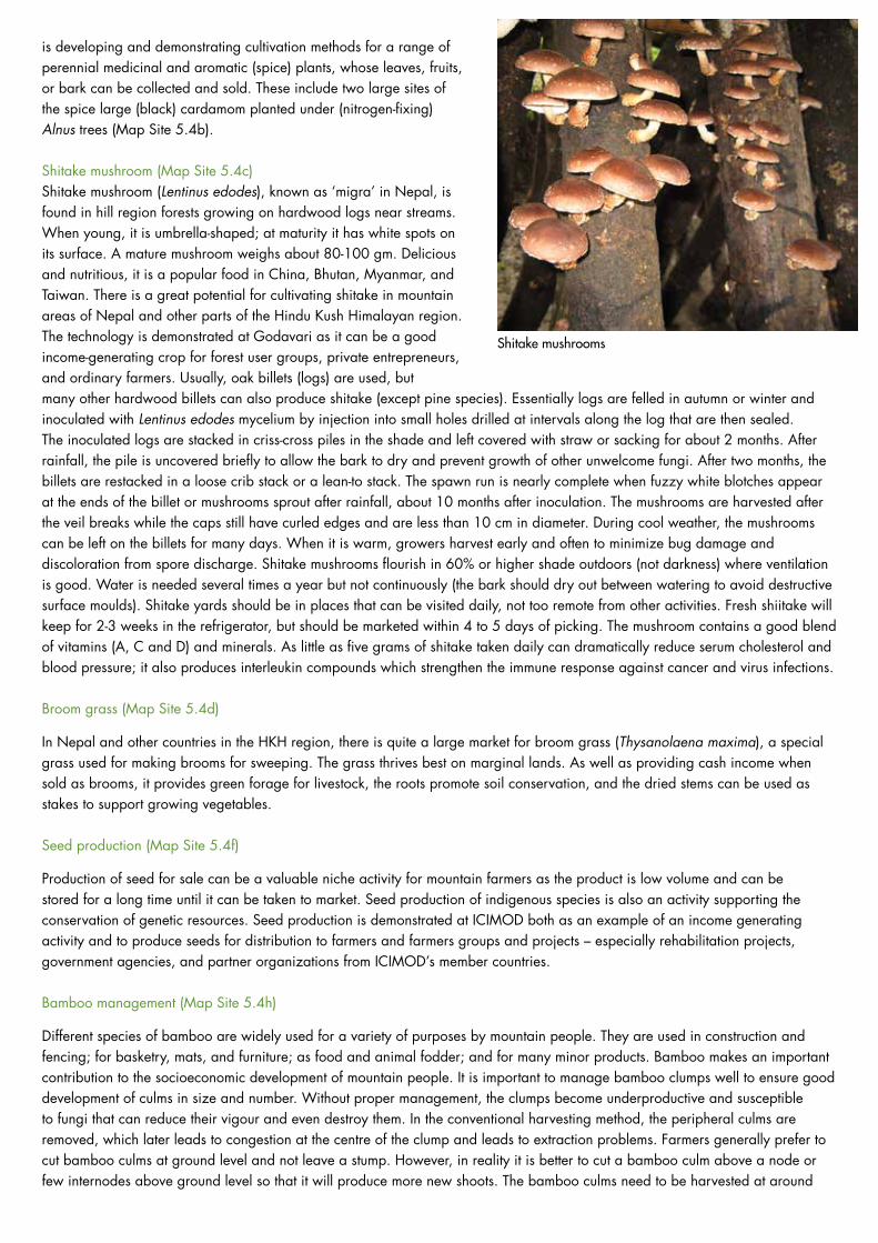
Shitake mushroom (Map Site 5.4c)Shitake mushroom (Lentinus edodes), known as ‘migra’ in Nepal, is found in hill region forests growing on hardwood logs near streams. When young, it is umbrella-shaped; at maturity it has white spots on its surface. A mature mushroom weighs about 80-100 gm. Delicious and nutritious, it is a popular food in China, Bhutan, Myanmar, and Taiwan. There is a great potential for cultivating shitake in mountain areas of Nepal and other parts of the Hindu Kush Himalayan region. The technology is demonstrated at Godavari as it can be a good income-generating crop for forest user groups, private entrepreneurs, and ordinary farmers. Usually, oak billets (logs) are used, but many other hardwood billets can also produce shitake (except pine species). Essentially logs are felled in autumn or winter and inoculated with Lentinus edodes mycelium by injection into small holes drilled at intervals along the log that are then sealed. The inoculated logs are stacked in criss-cross piles in the shade and left covered with straw or sacking for about 2 months. After rainfall, the pile is uncovered briefly to allow the bark to dry and prevent growth of other unwelcome fungi. After two months, the billets are restacked in a loose crib stack or a lean-to stack. The spawn run is nearly complete when fuzzy white blotches appear at the ends of the billet or mushrooms sprout after rainfall, about 10 months after inoculation. The mushrooms are harvested after the veil breaks while the caps still have curled edges and are less than 10 cm in diameter. During cool weather, the mushrooms can be left on the billets for many days. When it is warm, growers harvest early and often to minimize bug damage and discoloration from spore discharge. Shitake mushrooms flourish in 60% or higher shade outdoors (not darkness) where ventilation is good. Water is needed several times a year but not continuously (the bark should dry out between watering to avoid destructive surface moulds). Shitake yards should be in places that can be visited daily, not too remote from other activities. Fresh shiitake will keep for 2-3 weeks in the refrigerator, but should be marketed within 4 to 5 days of picking. The mushroom contains a good blend of vitamins (A, C and D) and minerals. As little as five grams of shitake taken daily can dramatically reduce serum cholesterol and blood pressure; it also produces interleukin compounds which strengthen the immune response against cancer and virus infections.
Broom grass (Map Site 5.4d)
In Nepal and other countries in the HKH region, there is quite a large market for broom grass (Thysanolaena maxima), a special grass used for making brooms for sweeping. The grass thrives best on marginal lands. As well as providing cash income when sold as brooms, it provides green forage for livestock, the roots promote soil conservation, and the dried stems can be used as stakes to support growing vegetables.
Seed production (Map Site 5.4f)
Production of seed for sale can be a valuable niche activity for mountain farmers as the product is low volume and can be stored for a long time until it can be taken to market. Seed production of indigenous species is also an activity supporting the conservation of genetic resources. Seed production is demonstrated at ICIMOD both as an example of an income generating activity and to produce seeds for distribution to farmers and farmers groups and projects – especially rehabilitation projects, government agencies, and partner organizations from ICIMOD’s member countries.
Bamboo management (Map Site 5.4h)
Different species of bamboo are widely used for a variety of purposes by mountain people. They are used in construction and fencing; for basketry, mats, and furniture; as food and animal fodder; and for many minor products. Bamboo makes an important contribution to the socioeconomic development of mountain people. It is important to manage bamboo clumps well to ensure good development of culms in size and number. Without proper management, the clumps become underproductive and susceptible to fungi that can reduce their vigour and even destroy them. In the conventional harvesting method, the peripheral culms are removed, which later leads to congestion at the centre of the clump and leads to extraction problems. Farmers generally prefer to cut bamboo culms at ground level and not leave a stump. However, in reality it is better to cut a bamboo culm above a node or few internodes above ground level so that it will produce more new shoots. The bamboo culms need to be harvested at around
Shitake mushrooms

International Centre for Integrated Mountain Development Knowledge Park at GodavariGPO Box 3226, Kathmandu, Khumaltar, Lalitpur, Nepal
Tel +977-1-5003222 Fax +977-1-5003299 Email [email protected] Web www.icimod.orgGodavari Site Tel +977-012239658/012220789
three to four years of age; after four years, fewer shoots are produced and the quality of the bamboo slowly deteriorates. The bamboo management plot was established to demonstrate better ways of managing bamboo clumps to produce more shoots and higher quality bamboo. The management methods demonstrated at the centre (traditional vs tunnel method) were tested by research institutes in China and the Forest Research and Survey Center, Nepal.
Floriculture – landscaping with indigenous and exotic flowers (Map Sites 5.4i)
An increasing number of houses and public buildings are being built in the newly expanding urban areas of Nepal, opening up a new market for decorative flowers and garden plants, and a new possibility for income generation for farmers with access to these areas. The activities at the site focus on propagation of indigenous and exotic plants for use in landscaping and decorative gardens. The results are being used in practice in the landscaping of the new ICIMOD Headquarters building and the Knowledge Park at Godavari.
Cultivation Support (Map Sites 5.5a-c)
Polythene film technology (PFT) (Map Site 5.5a)
Polythene (plastic) film technology (PFT) is a method for increasing production of field crops by covering the soil between the plants with a sheet of polythene film 0.003 to 0.014 mm thick. Covering the surface of the soil increases the temperature, helps retain moisture, promotes seed germination and emergence, accelerates the growth and development of the roots and the whole plant, and leads to improved quality and higher yields of crops. The method is demonstrated with appropriate crops on selected terraces within the site.
Polypit and hotbeds (Map Site 5.5b)
One of the problems that mountain farmers face is raising of forest or horticultural plants in nurseries and growing high-value vegetables during the off-season, especially in regions with high annual variation in temperature and relatively severe winters. Low temperatures and frost delay germination and subsequent growth, and lead to high plant mortality, poor plant quality, lack of uniformity in plant size, and overall low plant productivity. These constraints can be overcome to a great extent using ‘polypit’ technology. A polypit is a rectangular pit, usually about 1m deep, dug in the ground and covered with semi-transparent polythene sheet, preferably UV stabilized, supported by a bamboo frame. A mud wall about 30 cm high is built on one side so that the cover slopes. The polythene sheet is sealed on the (higher) side, leaving three sides unsealed. These are normally held in place with stones, but can be lifted to access the pit. The base and sides of the pit are left rough without any plastering (even with mud). In general, the polythene cover is opened from 11 o’clock in the morning to 4 o’clock in the afternoon, except on rainy and very cold days. The size of the pit can vary according to availability of space and the kind of crops or plants to be raised. A hotbed can be constructed inside the pit using different layers of dry straw or biomass, animal manure, and good top soil. The bed generates heat slowly and can support plant growth in winter. The polypit technique has several advantages: 1) it is a simple, inexpensive, practical, and effective technique for raising plants and protecting them from severe winter temperatures; 2) CO2
enrichment inside the polypit leads to a gain in plant biomass and growth; 3) plants raised inside a polypit are better acclimatized to the outside environment as the polythene cover is removed everyday; and 4) the frequency of irrigation is reduced.
Biopesticides and plant tonics (Map Site 5.5c)
Biopesticides are plant proteins with broad biocidal properties against insects, pests, and fungal and bacterial pathogens; they offer a good alternative to chemical pesticides in controlling crop diseases and pests. Application of chemical pesticides is increasingly associated with negative impacts to human health and the environment, whereas biopesticides are safer and environmentally friendly. Insect repellent plant species such as titopati (Artemia vulgaris), bojho (Acorus calamus) and neem (Azadirachta indica) can be used as a base. Around 30 kg of the insect repellent plant species is chopped into small pieces and mixed with 30 kg fresh cow dung and 100 litres fresh cow urine in a 200 litre plastic drum. Approximately 10 gm yeast and a little salt is added to speed fermentation. The mixture is stirred for five minutes every day for a week and then once a week for 4-5 weeks. It is then filtered through a plain cloth to give concentrated biopesticide solution. The concentrated solution is diluted 1:10 with water before applying to plants. The procedure used to prepare biopesticides can also be used to prepare a plant tonic (liquid fertilizer) by substituting an appropriate plant species. Any kind of grass that is not edible by livestock can be used (e.g., banmara or Eupatorium adhenophorum). The biopesticides and plant tonics should be used within six months of preparation.
Sheet 5October 2013
ICIMOD Knowledge Park at Godavari
Livestock are an integral component of the mixed farming system practiced by the great majority of farmers in the hill and lower mountain regions of the Hindu Kush Himalayan (HKH) region. Livestock eat crop and food processing residues and vegetation from areas that cannot be used for crops and turn them into valuable manure for fields and kitchen gardens; milk, meat, and eggs for consumption and sale; raw materials for clothing; and power for ploughing and transport. Cattle, buffalo, goats, pigs, and chickens are the most common animals kept in the mid-hills. Until recently most animals were kept for subsistence purposes, but in recent times farmers are looking increasingly at livestock as a source of income, and have started rearing other animals like ducks, rabbits, and fish for income generation.
ICIMOD’s livestock-related activities at Godavari focus on new approaches for using livestock for income generation, taking advantage of the experience of ICIMOD’s partners in other countries.
Animal Husbandry (Map Site 6.1a,b)
Goat husbandry (Map Site 6.1a)
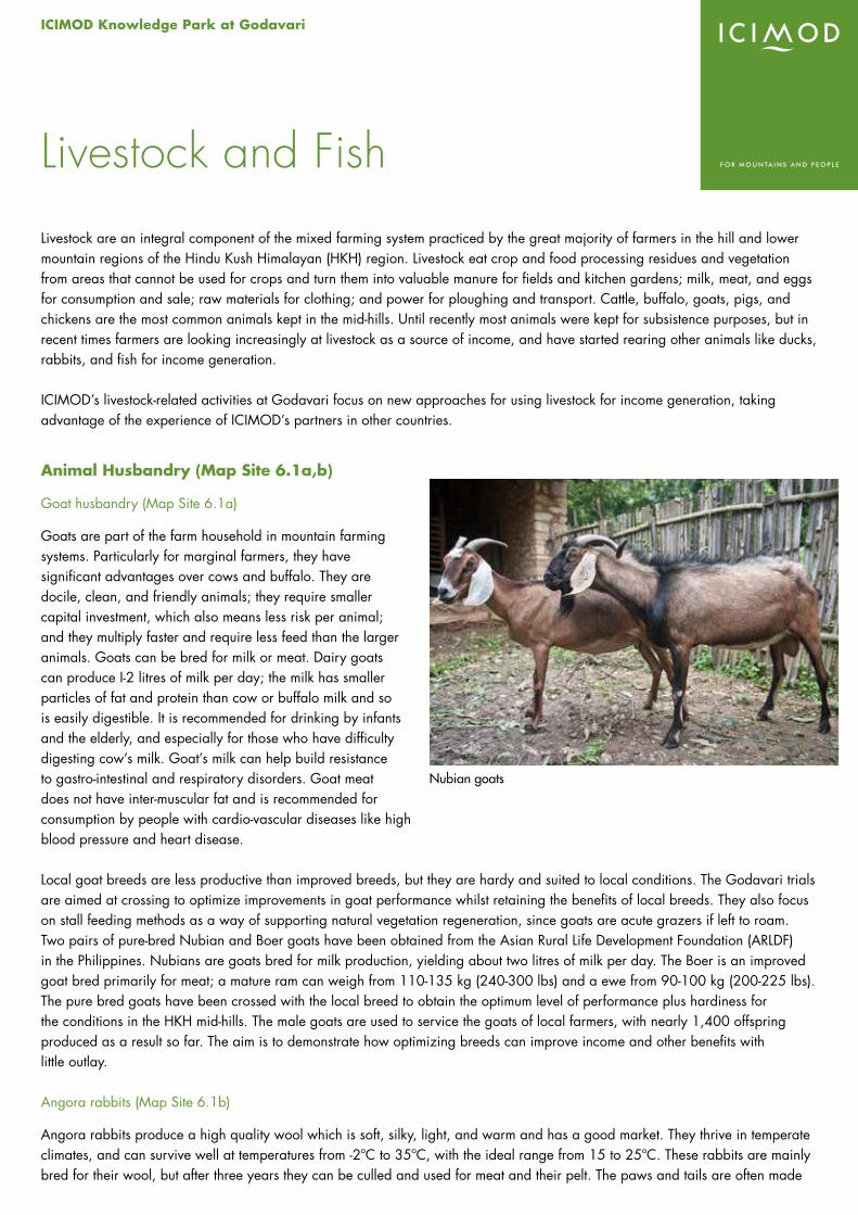
Goats are part of the farm household in mountain farming systems. Particularly for marginal farmers, they have significant advantages over cows and buffalo. They are docile, clean, and friendly animals; they require smaller capital investment, which also means less risk per animal; and they multiply faster and require less feed than the larger animals. Goats can be bred for milk or meat. Dairy goats can produce I-2 litres of milk per day; the milk has smaller particles of fat and protein than cow or buffalo milk and so is easily digestible. It is recommended for drinking by infants and the elderly, and especially for those who have difficulty digesting cow’s milk. Goat’s milk can help build resistance to gastro-intestinal and respiratory disorders. Goat meat does not have inter-muscular fat and is recommended for consumption by people with cardio-vascular diseases like high blood pressure and heart disease.
Local goat breeds are less productive than improved breeds, but they are hardy and suited to local conditions. The Godavari trials are aimed at crossing to optimize improvements in goat performance whilst retaining the benefits of local breeds. They also focus on stall feeding methods as a way of supporting natural vegetation regeneration, since goats are acute grazers if left to roam. Two pairs of pure-bred Nubian and Boer goats have been obtained from the Asian Rural Life Development Foundation (ARLDF) in the Philippines. Nubians are goats bred for milk production, yielding about two litres of milk per day. The Boer is an improved goat bred primarily for meat; a mature ram can weigh from 110-135 kg (240-300 lbs) and a ewe from 90-100 kg (200-225 lbs). The pure bred goats have been crossed with the local breed to obtain the optimum level of performance plus hardiness for the conditions in the HKH mid-hills. The male goats are used to service the goats of local farmers, with nearly 1,400 offspring produced as a result so far. The aim is to demonstrate how optimizing breeds can improve income and other benefits with little outlay.
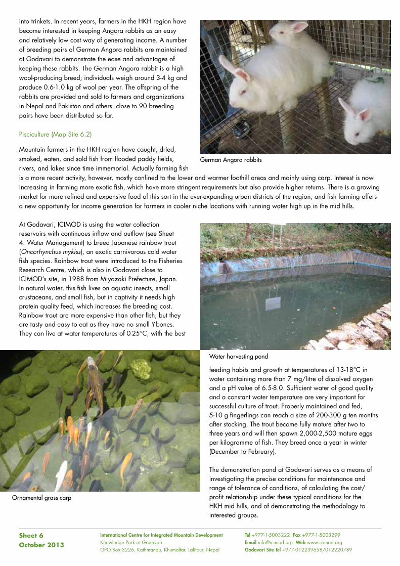
Angora rabbits (Map Site 6.1b)
Angora rabbits produce a high quality wool which is soft, silky, light, and warm and has a good market. They thrive in temperate climates, and can survive well at temperatures from -2ºC to 35ºC, with the ideal range from 15 to 25ºC. These rabbits are mainly bred for their wool, but after three years they can be culled and used for meat and their pelt. The paws and tails are often made
Livestock and Fish
Nubian goats
International Centre for Integrated Mountain Development Knowledge Park at GodavariGPO Box 3226, Kathmandu, Khumaltar, Lalitpur, Nepal
Tel +977-1-5003222 Fax +977-1-5003299 Email [email protected] Web www.icimod.orgGodavari Site Tel +977-012239658/012220789
into trinkets. In recent years, farmers in the HKH region have become interested in keeping Angora rabbits as an easy and relatively low cost way of generating income. A number of breeding pairs of German Angora rabbits are maintained at Godavari to demonstrate the ease and advantages of keeping these rabbits. The German Angora rabbit is a high wool-producing breed; individuals weigh around 3-4 kg and produce 0.6-1.0 kg of wool per year. The offspring of the rabbits are provided and sold to farmers and organizations in Nepal and Pakistan and others, close to 90 breeding pairs have been distributed so far.
Pisciculture (Map Site 6.2)
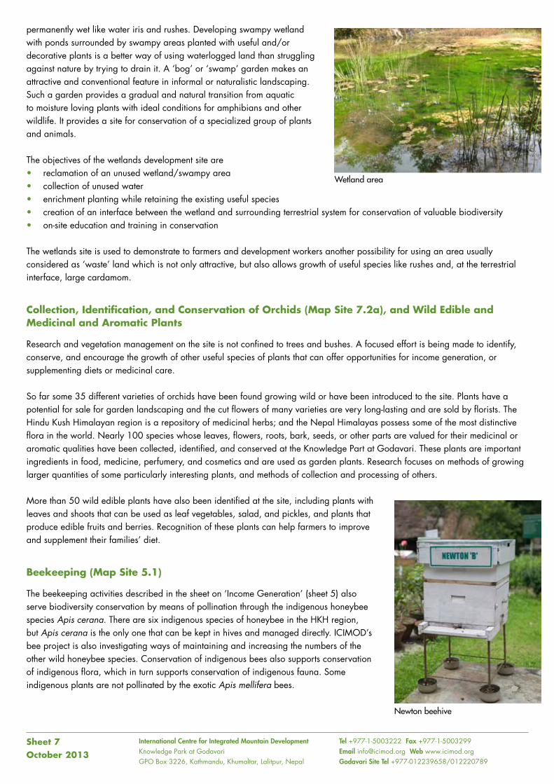
Mountain farmers in the HKH region have caught, dried, smoked, eaten, and sold fish from flooded paddy fields, rivers, and lakes since time immemorial. Actually farming fish is a more recent activity, however, mostly confined to the lower and warmer foothill areas and mainly using carp. Interest is now increasing in farming more exotic fish, which have more stringent requirements but also provide higher returns. There is a growing market for more refined and expensive food of this sort in the ever-expanding urban districts of the region, and fish farming offers a new opportunity for income generation for farmers in cooler niche locations with running water high up in the mid hills.
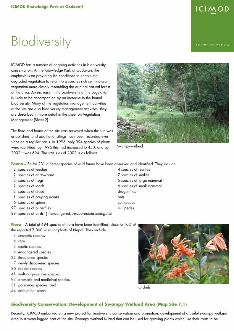
At Godavari, ICIMOD is using the water collection reservoirs with continuous inflow and outflow (see Sheet 4: Water Management) to breed Japanese rainbow trout (Oncorhynchus mykiss), an exotic carnivorous cold water fish species. Rainbow trout were introduced to the Fisheries Research Centre, which is also in Godavari close to ICIMOD’s site, in 1988 from Miyazaki Prefecture, Japan. In natural water, this fish lives on aquatic insects, small crustaceans, and small fish, but in captivity it needs high protein quality feed, which increases the breeding cost. Rainbow trout are more expensive than other fish, but they are tasty and easy to eat as they have no small Y-bones. They can live at water temperatures of 0-25°C, with the best
feeding habits and growth at temperatures of 13-18°C in water containing more than 7 mg/litre of dissolved oxygen and a pH value of 6.5-8.0. Sufficient water of good quality and a constant water temperature are very important for successful culture of trout. Properly maintained and fed, 5-10 g fingerlings can reach a size of 200-300 g ten months after stocking. The trout become fully mature after two to three years and will then spawn 2,000-2,500 mature eggs per kilogramme of fish. They breed once a year in winter (December to February).
The demonstration pond at Godavari serves as a means of investigating the precise conditions for maintenance and range of tolerance of conditions, of calculating the cost/ profit relationship under these typical conditions for the HKH mid hills, and of demonstrating the methodology to interested groups.
Sheet 6October 2013
German Angora rabbits
Ornamental grass carp
Water harvesting pond
ICIMOD Knowledge Park at Godavari
ICIMOD has a number of ongoing activities in biodiversity conservation. At the Knowledge Park at Godavari, the emphasis is on providing the conditions to enable the degraded vegetation to return to a species rich semi-natural vegetation more closely resembling the original natural forest of the area. An increase in the biodiversity of the vegetation is likely to be accompanied by an increase in the faunal biodiversity. Many of the vegetation management activities at the site are also biodiversity management activities, they are described in more detail in the sheet on Vegetation Management (Sheet 2).
The flora and fauna of the site was surveyed when the site was established, and additional sitings have been recorded ever since on a regular basis. In 1993, only 394 species of plants were identified, by 1996 this had increased to 450, and by 2002 it was 694. The status as of 2002 is as follows.
Fauna – So far 231 different species of wild fauna have been observed and identified. They include 2 species of leeches 4 species of reptiles 2 species of earthworms 7 species of snakes 2 species of frogs 5 species of large mammal 2 species of toads 6 species of small mammal 2 species of crabs dragonflies 1 species of preying mantis ants 6 species of spider centipedes97 species of butterflies millipedes88 species of birds, (1 endangered, Aroborophila mufogalis)
Flora – A total of 694 species of flora have been identified; close to 10% of the reported 7,000 vascular plants of Nepal. They include 3 endemic species 4 rare 3 exotic species 4 endangered species22 threatened species 7 newly discovered species20 fodder species41 multi-purpose tree species93 aromatic and medicinal species31 poisonous species, and54 edible fruit plants.
Biodiversity Conservation: Development of Swampy Wetland Area (Map Site 7.1)
Recently, ICIMOD embarked on a new project for biodiversity conservation and promotion: development of a useful swampy wetland area in a water-logged part of the site. Swampy wetland is land that can be used for growing plants which like their roots to be
Biodiversity
Orchids
Swampy-wetland
International Centre for Integrated Mountain Development Knowledge Park at GodavariGPO Box 3226, Kathmandu, Khumaltar, Lalitpur, Nepal
Tel +977-1-5003222 Fax +977-1-5003299 Email [email protected] Web www.icimod.orgGodavari Site Tel +977-012239658/012220789
permanently wet like water iris and rushes. Developing swampy wetland with ponds surrounded by swampy areas planted with useful and/or decorative plants is a better way of using waterlogged land than struggling against nature by trying to drain it. A ‘bog’ or ‘swamp’ garden makes an attractive and conventional feature in informal or naturalistic landscaping. Such a garden provides a gradual and natural transition from aquatic to moisture loving plants with ideal conditions for amphibians and other wildlife. It provides a site for conservation of a specialized group of plants and animals.
The objectives of the wetlands development site are • reclamation of an unused wetland/swampy area • collection of unused water • enrichment planting while retaining the existing useful species• creation of an interface between the wetland and surrounding terrestrial system for conservation of valuable biodiversity • on-site education and training in conservation
The wetlands site is used to demonstrate to farmers and development workers another possibility for using an area usually considered as ‘waste’ land which is not only attractive, but also allows growth of useful species like rushes and, at the terrestrial interface, large cardamom.
Collection, Identification, and Conservation of Orchids (Map Site 7.2a), and Wild Edible and Medicinal and Aromatic Plants
Research and vegetation management on the site is not confined to trees and bushes. A focused effort is being made to identify, conserve, and encourage the growth of other useful species of plants that can offer opportunities for income generation, or supplementing diets or medicinal care.
So far some 35 different varieties of orchids have been found growing wild or have been introduced to the site. Plants have a potential for sale for garden landscaping and the cut flowers of many varieties are very long-lasting and are sold by florists. The Hindu Kush Himalayan region is a repository of medicinal herbs; and the Nepal Himalayas possess some of the most distinctive flora in the world. Nearly 100 species whose leaves, flowers, roots, bark, seeds, or other parts are valued for their medicinal or aromatic qualities have been collected, identified, and conserved at the Knowledge Part at Godavari. These plants are important ingredients in food, medicine, perfumery, and cosmetics and are used as garden plants. Research focuses on methods of growing larger quantities of some particularly interesting plants, and methods of collection and processing of others.
More than 50 wild edible plants have also been identified at the site, including plants with leaves and shoots that can be used as leaf vegetables, salad, and pickles, and plants that produce edible fruits and berries. Recognition of these plants can help farmers to improve and supplement their families’ diet.
Beekeeping (Map Site 5.1)
The beekeeping activities described in the sheet on ‘Income Generation’ (sheet 5) also serve biodiversity conservation by means of pollination through the indigenous honeybee species Apis cerana. There are six indigenous species of honeybee in the HKH region, but Apis cerana is the only one that can be kept in hives and managed directly. ICIMOD’s bee project is also investigating ways of maintaining and increasing the numbers of the other wild honeybee species. Conservation of indigenous bees also supports conservation of indigenous flora, which in turn supports conservation of indigenous fauna. Some indigenous plants are not pollinated by the exotic Apis mellifera bees.
Sheet 7October 2013
Wetland area
Newton beehive
ICIMOD Knowledge Park at Godavari
Access to sources of energy is still a major limiting factor to sustainable development in many parts of the Hindu Kush Himalayan (HKH) region. Large areas are still not electrified, and where there is electricity it is often unreliable or prohibitively expensive. Fossil fuels are often not easily available or are too expensive for daily use. Mountain people have always relied on renewable energies like wood, animal dung, and draught power for survival – be they for cooking food, keeping the house warm, milling grain, ploughing fields, or transporting goods; but the traditional energy sources are no longer sufficient to meet people’s needs, and there is increasing concern about the negative impacts associated with their use. Wood is becoming scarce increasing the time spent on collection; deforestation is leading to land degradation and loss of groundwater recharge amongst others; and indoor pollution from wood and dung smoke is a major cause of respiratory and other health problems.
However, mountain areas have vast untapped sources of potential energy in the form of running water and long hours of sunshine. Recent developments in technologies for renewable energy, offer possibilities for using this energy on a small-scale at low cost to reduce household drudgery, provide electricity for domestic use, and support and sustain income-generating activities. Overall, the potential for sustainable use of renewable energy resources in the Hindu Kush Himalayas (HKH) exceeds by far the total energy consumption in the region.
The activities at the Knowledge Part at Godavari focus on the demonstration of simple low-cost renewable energy technologies that can be used by farmers to support agricultural, domestic, or small-scale income generation activities. Most of the demonstrations are provided in partnership with different local NGOs. We welcome other groups to use the site for demonstration of appropriate technologies that complement the ongoing demonstration and training activities.
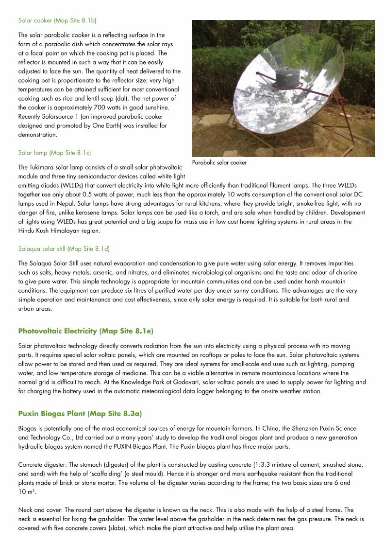
Solar Energy (Map Sites 8.1 a-e)
Solar energy has been used for centuries for drying crops, clothes, wood, and crop residues and heating buildings. But now methods have been developed to make these activities more efficient and to use solar energy in different ways. There are two main types of solar energy technology: passive solar (heat) and photovoltaic. Selected examples of both are demonstrated at the site.
Solar drier (Map Site 8.1a)
This is a method for increasing the efficiency and cleanliness of solar drying. Fruit and vegetables are dried on racks in a small chamber with a solid earth back wall and plastic film covering. The drier is constructed from available stone, mud, bamboo and white plastic sheet and built facing south to maximize the sunshine it receives. The design ensures a constant airflow.
Renewable Energy Technology
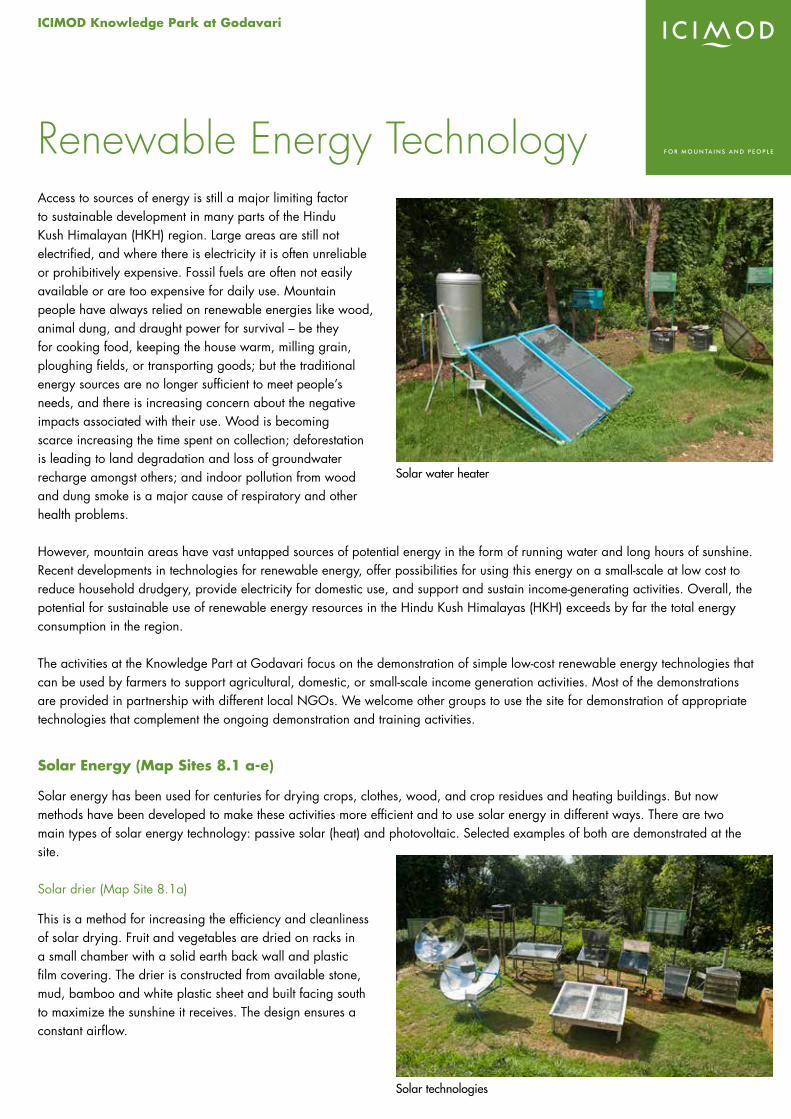
Solar water heater
Solar technologies
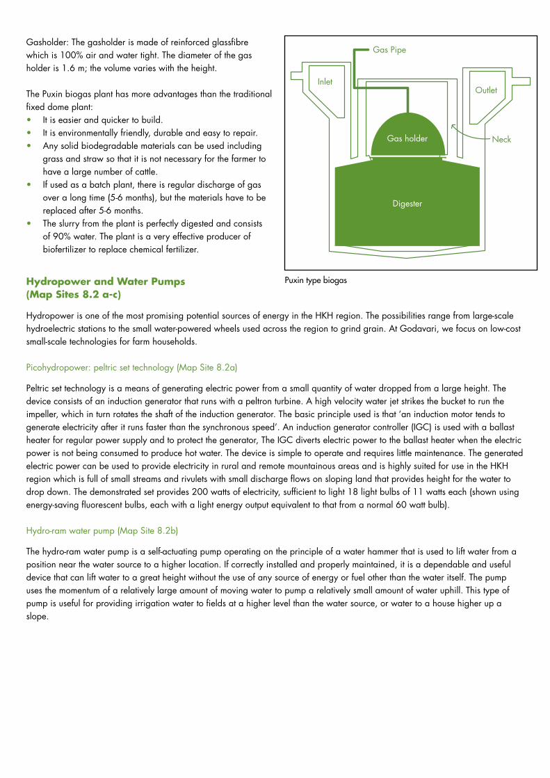
Solar cooker (Map Site 8.1b)
The solar parabolic cooker is a reflecting surface in the form of a parabolic dish which concentrates the solar rays at a focal point on which the cooking pot is placed. The reflector is mounted in such a way that it can be easily adjusted to face the sun. The quantity of heat delivered to the cooking pot is proportionate to the reflector size; very high temperatures can be attained sufficient for most conventional cooking such as rice and lentil soup (dal). The net power of the cooker is approximately 700 watts in good sunshine. Recently Solarsource 1 (an improved parabolic cooker designed and promoted by One Earth) was installed for demonstration.
Solar lamp (Map Site 8.1c)
The Tukimara solar lamp consists of a small solar photovoltaic module and three tiny semiconductor devices called white light emitting diodes (WLEDs) that convert electricity into white light more efficiently than traditional filament lamps. The three WLEDs together use only about 0.5 watts of power, much less than the approximately 10 watts consumption of the conventional solar DC lamps used in Nepal. Solar lamps have strong advantages for rural kitchens, where they provide bright, smoke-free light, with no danger of fire, unlike kerosene lamps. Solar lamps can be used like a torch, and are safe when handled by children. Development of lights using WLEDs has great potential and a big scope for mass use in low cost home lighting systems in rural areas in the Hindu Kush Himalayan region.
Solaqua solar still (Map Site 8.1d)
The Solaqua Solar Still uses natural evaporation and condensation to give pure water using solar energy. It removes impurities such as salts, heavy metals, arsenic, and nitrates, and eliminates microbiological organisms and the taste and odour of chlorine to give pure water. This simple technology is appropriate for mountain communities and can be used under harsh mountain conditions. The equipment can produce six litres of purified water per day under sunny conditions. The advantages are the very simple operation and maintenance and cost effectiveness, since only solar energy is required. It is suitable for both rural and urban areas.
Photovoltaic Electricity (Map Site 8.1e)
Solar photovoltaic technology directly converts radiation from the sun into electricity using a physical process with no moving parts. It requires special solar voltaic panels, which are mounted on rooftops or poles to face the sun. Solar photovoltaic systems allow power to be stored and then used as required. They are ideal systems for small-scale end uses such as lighting, pumping water, and low temperature storage of medicine. This can be a viable alternative in remote mountainous locations where the normal grid is difficult to reach. At the Knowledge Park at Godavari, solar voltaic panels are used to supply power for lighting and for charging the battery used in the automatic meteorological data logger belonging to the on-site weather station.
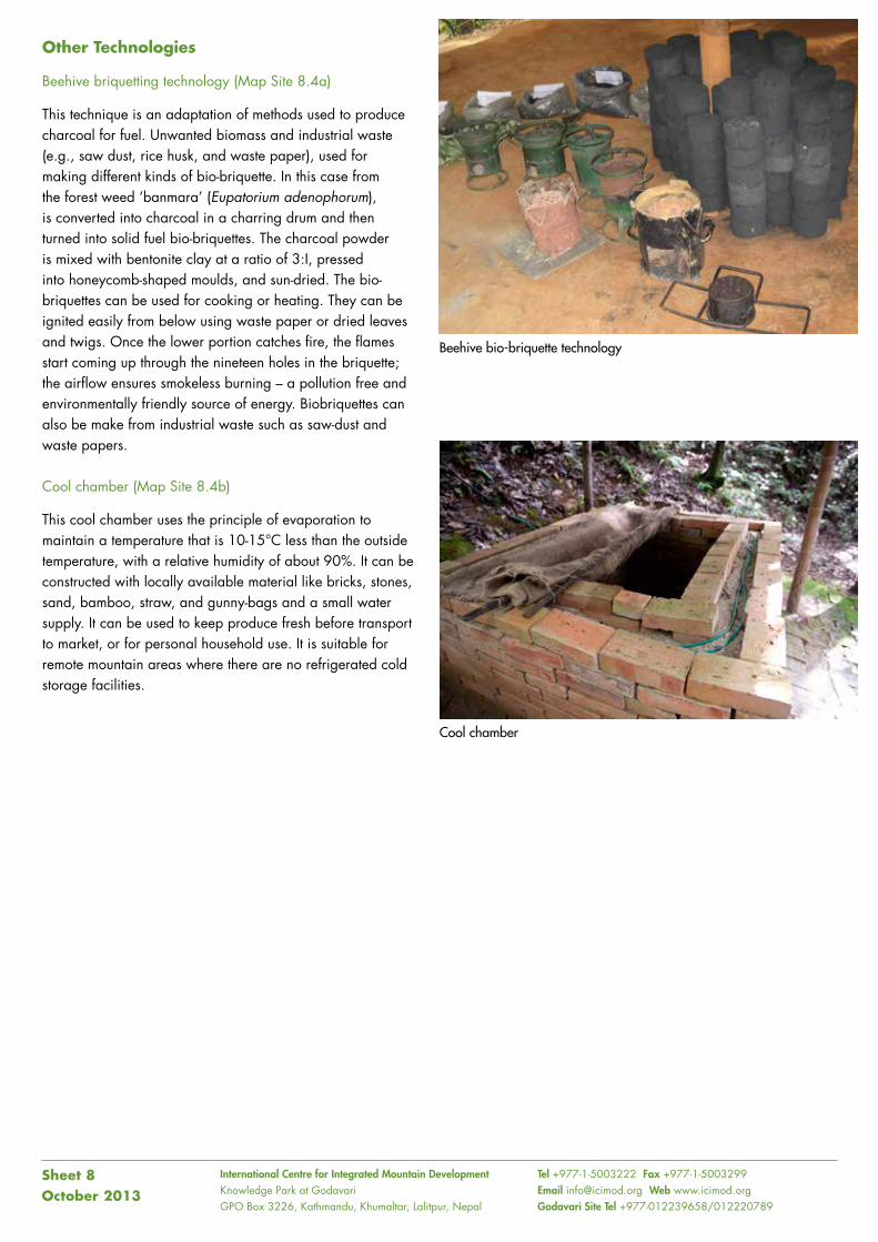
Puxin Biogas Plant (Map Site 8.3a)
Biogas is potentially one of the most economical sources of energy for mountain farmers. In China, the Shenzhen Puxin Science and Technology Co., Ltd carried out a many years’ study to develop the traditional biogas plant and produce a new generation hydraulic biogas system named the PUXIN Biogas Plant. The Puxin biogas plant has three major parts.
Concrete digester: The stomach (digester) of the plant is constructed by casting concrete (1:3:3 mixture of cement, smashed stone, and sand) with the help of ‘scaffolding’ (a steel mould). Hence it is stronger and more earthquake resistant than the traditional plants made of brick or stone mortar. The volume of the digester varies according to the frame; the two basic sizes are 6 and 10 m3.
Neck and cover: The round part above the digester is known as the neck. This is also made with the help of a steel frame. The neck is essential for fixing the gasholder. The water level above the gasholder in the neck determines the gas pressure. The neck is covered with five concrete covers (slabs), which make the plant attractive and help utilise the plant area.
Parabolic solar cooker
Gasholder: The gasholder is made of reinforced glassfibre which is 100% air and water tight. The diameter of the gas holder is 1.6 m; the volume varies with the height.
The Puxin biogas plant has more advantages than the traditional fixed dome plant:• It is easier and quicker to build.• It is environmentally friendly, durable and easy to repair.• Any solid biodegradable materials can be used including
grass and straw so that it is not necessary for the farmer to have a large number of cattle.
• If used as a batch plant, there is regular discharge of gas over a long time (5-6 months), but the materials have to be replaced after 5-6 months.
• The slurry from the plant is perfectly digested and consists of 90% water. The plant is a very effective producer of biofertilizer to replace chemical fertilizer.
Hydropower and Water Pumps (Map Sites 8.2 a-c)
Hydropower is one of the most promising potential sources of energy in the HKH region. The possibilities range from large-scale hydroelectric stations to the small water-powered wheels used across the region to grind grain. At Godavari, we focus on low-cost small-scale technologies for farm households.
Picohydropower: peltric set technology (Map Site 8.2a)
Peltric set technology is a means of generating electric power from a small quantity of water dropped from a large height. The device consists of an induction generator that runs with a peltron turbine. A high velocity water jet strikes the bucket to run the impeller, which in turn rotates the shaft of the induction generator. The basic principle used is that ‘an induction motor tends to generate electricity after it runs faster than the synchronous speed’. An induction generator controller (IGC) is used with a ballast heater for regular power supply and to protect the generator, The IGC diverts electric power to the ballast heater when the electric power is not being consumed to produce hot water. The device is simple to operate and requires little maintenance. The generated electric power can be used to provide electricity in rural and remote mountainous areas and is highly suited for use in the HKH region which is full of small streams and rivulets with small discharge flows on sloping land that provides height for the water to drop down. The demonstrated set provides 200 watts of electricity, sufficient to light 18 light bulbs of 11 watts each (shown using energy-saving fluorescent bulbs, each with a light energy output equivalent to that from a normal 60 watt bulb).
Hydro-ram water pump (Map Site 8.2b)
The hydro-ram water pump is a self-actuating pump operating on the principle of a water hammer that is used to lift water from a position near the water source to a higher location. If correctly installed and properly maintained, it is a dependable and useful device that can lift water to a great height without the use of any source of energy or fuel other than the water itself. The pump uses the momentum of a relatively large amount of moving water to pump a relatively small amount of water uphill. This type of pump is useful for providing irrigation water to fields at a higher level than the water source, or water to a house higher up a slope.
Gas holder
Digester
OutletInlet
Neck
Gas Pipe
Puxin type biogas
International Centre for Integrated Mountain Development Knowledge Park at GodavariGPO Box 3226, Kathmandu, Khumaltar, Lalitpur, Nepal
Tel +977-1-5003222 Fax +977-1-5003299 Email [email protected] Web www.icimod.orgGodavari Site Tel +977-012239658/012220789
Other Technologies
Beehive briquetting technology (Map Site 8.4a)
This technique is an adaptation of methods used to produce charcoal for fuel. Unwanted biomass and industrial waste (e.g., saw dust, rice husk, and waste paper), used for making different kinds of bio-briquette. In this case from the forest weed ‘banmara’ (Eupatorium adenophorum), is converted into charcoal in a charring drum and then turned into solid fuel bio-briquettes. The charcoal powder is mixed with bentonite clay at a ratio of 3:I, pressed into honeycomb-shaped moulds, and sun-dried. The bio-briquettes can be used for cooking or heating. They can be ignited easily from below using waste paper or dried leaves and twigs. Once the lower portion catches fire, the flames start coming up through the nineteen holes in the briquette; the airflow ensures smokeless burning – a pollution free and environmentally friendly source of energy. Biobriquettes can also be make from industrial waste such as saw-dust and waste papers.
Cool chamber (Map Site 8.4b)
This cool chamber uses the principle of evaporation to maintain a temperature that is 10-15°C less than the outside temperature, with a relative humidity of about 90%. It can be constructed with locally available material like bricks, stones, sand, bamboo, straw, and gunny-bags and a small water supply. It can be used to keep produce fresh before transport to market, or for personal household use. It is suitable for remote mountain areas where there are no refrigerated cold storage facilities.
Sheet 8October 2013
Beehive bio-briquette technology
Cool chamber
ICIMOD Knowledge Park at Godavari
Some general activities are carried out at the Knowledge Park at Godavari to support the trials and other activities; to provide the accurate information needed to enable proper interpretation of results; and to provide basic scientific information on important problems that affect mountain farming and natural resource management on a broad scale. Some of the more important are described below.
Nursery (Map Site 9.1)
A plant nursery was established in the lower area of the site to ensure an adequate supply of plant material for the various trials, demonstration, and rehabilitation activities. Seeds can be tested for germination and emergence under controlled conditions, and the results of growing in a greenhouse or outdoors compared. The nursery is also used to maintain and propagate seeds and plant cuttings received from partners in ICIMOD’s member countries, and to grow seedlings (around 100,000 per year) specifically for distribution to project partners and farmers groups. Excess plants are sometimes sold. (See Sheet 10)
Meteorological Monitoring (Map Site 9.2)
Agroclimatic conditions are extremely variable across the Hindu Kush Himalayan (HKH) region, and microclimates can have a major effect on the success or otherwise of plant growth and fruiting at specific sites. Farmers are well aware of this; in more isolated areas mountain farmers still use cross-breeding and seed selection to obtain different landraces of rice for use on different small parcels of their own land, for example. The results of trials at the Knowledge Park at Godavari are broadly applicable to other areas with similar agroclimatic conditions in the mid-hills of the HKH, but they are also to some extent site specific. To interpret them properly and make informed evaluations, and for ICIMOD to be able to make proper recommendations, it is necessary to have an exact record of the site and meteorological conditions at the time of trials. A meteorological monitoring station was set up at the site in 1995 at an elevation of 1,634 m. Air temperature, wind speed and direction, relative humidity, precipitation, evaporation, solar radiation, and sunshine duration are recorded manually on a daily basis, and from an automatic weather station on a 2-hourly basis. The results highlight the variability and fluctuation of meteorological conditions over an extended period between 1995 and 2012, the mean annual temperature varied from 16.4 to 18.2ºC (1997 and 2000); the absolute maximum temperature in any one year from 33.4 to 33.8ºC (May 1995 and June 1998); the absolute minimum temperature in any one year from -0.9 to +3.0ºC (December 2003 and January 2009); the total annual rainfall from 1,299 to 2,462 mm (2009 and 2002); and the single greatest daily amount of rainfall from 57.7 to 228.6 mm (7th September 2010 and July 2002).
Support Functions and Scientific Research
Greenhouse nursery
Meteorological station
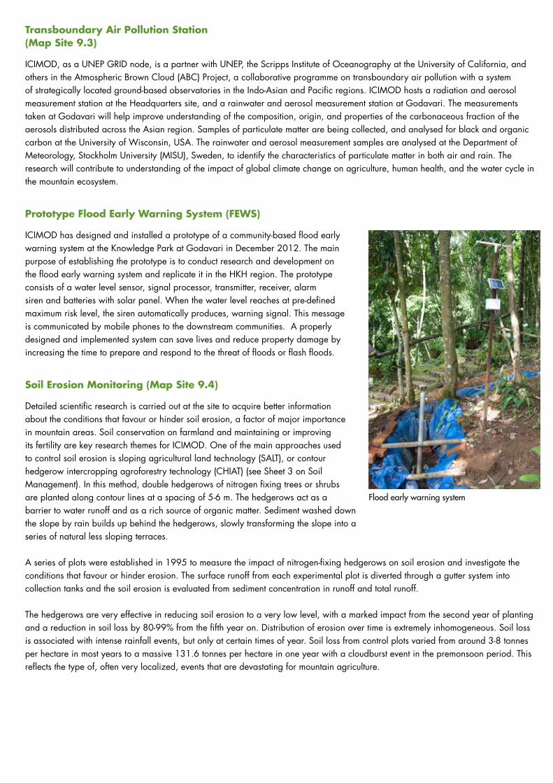
Transboundary Air Pollution Station (Map Site 9.3)
ICIMOD, as a UNEP GRID node, is a partner with UNEP, the Scripps Institute of Oceanography at the University of California, and others in the Atmospheric Brown Cloud (ABC) Project, a collaborative programme on transboundary air pollution with a system of strategically located ground-based observatories in the Indo-Asian and Pacific regions. ICIMOD hosts a radiation and aerosol measurement station at the Headquarters site, and a rainwater and aerosol measurement station at Godavari. The measurements taken at Godavari will help improve understanding of the composition, origin, and properties of the carbonaceous fraction of the aerosols distributed across the Asian region. Samples of particulate matter are being collected, and analysed for black and organic carbon at the University of Wisconsin, USA. The rainwater and aerosol measurement samples are analysed at the Department of Meteorology, Stockholm University (MISU), Sweden, to identify the characteristics of particulate matter in both air and rain. The research will contribute to understanding of the impact of global climate change on agriculture, human health, and the water cycle in the mountain ecosystem.
Prototype Flood Early Warning System (FEWS)
ICIMOD has designed and installed a prototype of a community-based flood early warning system at the Knowledge Park at Godavari in December 2012. The main purpose of establishing the prototype is to conduct research and development on the flood early warning system and replicate it in the HKH region. The prototype consists of a water level sensor, signal processor, transmitter, receiver, alarm siren and batteries with solar panel. When the water level reaches at pre-defined maximum risk level, the siren automatically produces, warning signal. This message is communicated by mobile phones to the downstream communities. A properly designed and implemented system can save lives and reduce property damage by increasing the time to prepare and respond to the threat of floods or flash floods.
Soil Erosion Monitoring (Map Site 9.4)
Detailed scientific research is carried out at the site to acquire better information about the conditions that favour or hinder soil erosion, a factor of major importance in mountain areas. Soil conservation on farmland and maintaining or improving its fertility are key research themes for ICIMOD. One of the main approaches used to control soil erosion is sloping agricultural land technology (SALT), or contour hedgerow intercropping agroforestry technology (CHIAT) (see Sheet 3 on Soil Management). In this method, double hedgerows of nitrogen fixing trees or shrubs are planted along contour lines at a spacing of 5-6 m. The hedgerows act as a barrier to water runoff and as a rich source of organic matter. Sediment washed down the slope by rain builds up behind the hedgerows, slowly transforming the slope into a series of natural less sloping terraces.
A series of plots were established in 1995 to measure the impact of nitrogen-fixing hedgerows on soil erosion and investigate the conditions that favour or hinder erosion. The surface runoff from each experimental plot is diverted through a gutter system into collection tanks and the soil erosion is evaluated from sediment concentration in runoff and total runoff.
The hedgerows are very effective in reducing soil erosion to a very low level, with a marked impact from the second year of planting and a reduction in soil loss by 80-99% from the fifth year on. Distribution of erosion over time is extremely inhomogeneous. Soil loss is associated with intense rainfall events, but only at certain times of year. Soil loss from control plots varied from around 3-8 tonnes per hectare in most years to a massive 131.6 tonnes per hectare in one year with a cloudburst event in the premonsoon period. This reflects the type of, often very localized, events that are devastating for mountain agriculture.
Flood early warning system
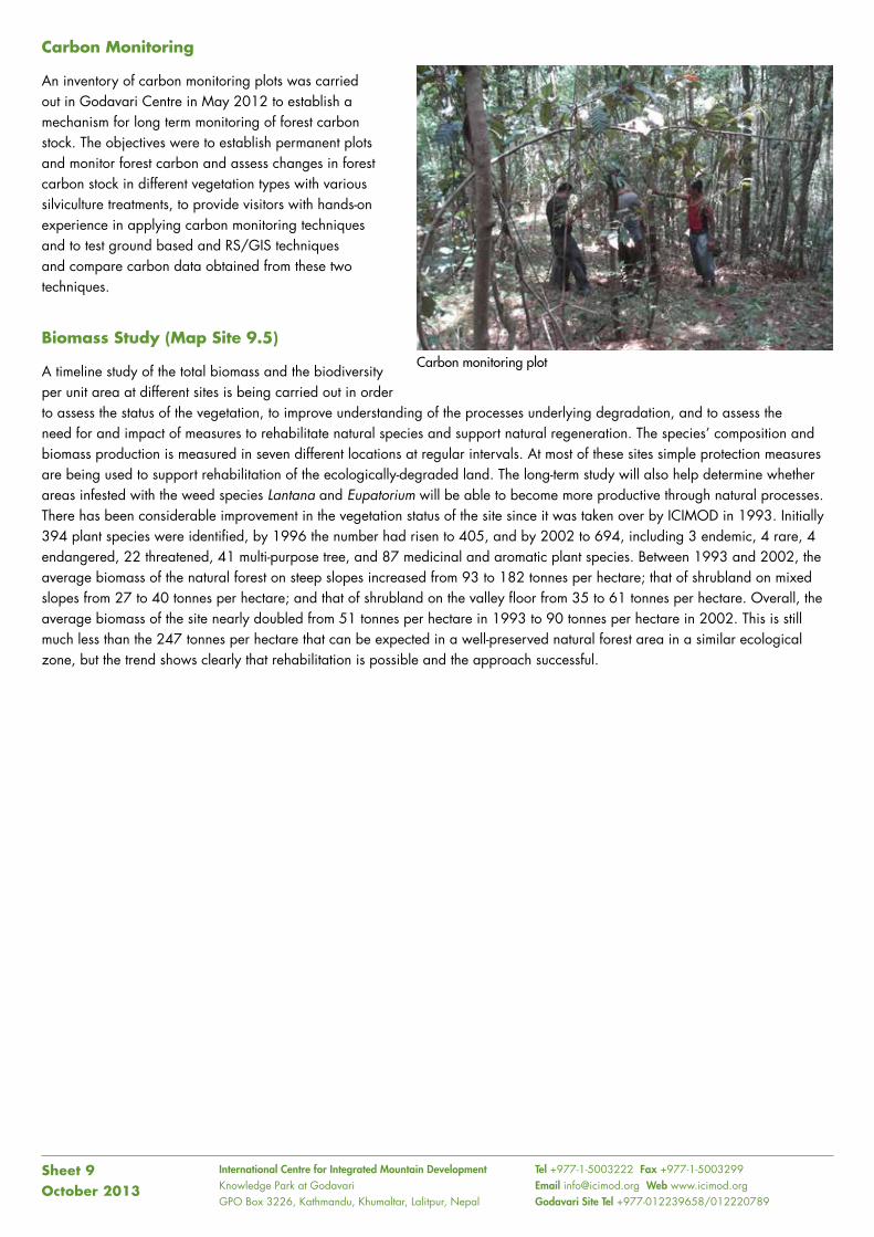
International Centre for Integrated Mountain Development Knowledge Park at GodavariGPO Box 3226, Kathmandu, Khumaltar, Lalitpur, Nepal
Tel +977-1-5003222 Fax +977-1-5003299 Email [email protected] Web www.icimod.orgGodavari Site Tel +977-012239658/012220789
Carbon Monitoring
An inventory of carbon monitoring plots was carried out in Godavari Centre in May 2012 to establish a mechanism for long term monitoring of forest carbon stock. The objectives were to establish permanent plots and monitor forest carbon and assess changes in forest carbon stock in different vegetation types with various silviculture treatments, to provide visitors with hands-on experience in applying carbon monitoring techniques and to test ground based and RS/GIS techniques and compare carbon data obtained from these two techniques.
Biomass Study (Map Site 9.5)
A timeline study of the total biomass and the biodiversity per unit area at different sites is being carried out in order to assess the status of the vegetation, to improve understanding of the processes underlying degradation, and to assess the need for and impact of measures to rehabilitate natural species and support natural regeneration. The species’ composition and biomass production is measured in seven different locations at regular intervals. At most of these sites simple protection measures are being used to support rehabilitation of the ecologically-degraded land. The long-term study will also help determine whether areas infested with the weed species Lantana and Eupatorium will be able to become more productive through natural processes. There has been considerable improvement in the vegetation status of the site since it was taken over by ICIMOD in 1993. Initially 394 plant species were identified, by 1996 the number had risen to 405, and by 2002 to 694, including 3 endemic, 4 rare, 4 endangered, 22 threatened, 41 multi-purpose tree, and 87 medicinal and aromatic plant species. Between 1993 and 2002, the average biomass of the natural forest on steep slopes increased from 93 to 182 tonnes per hectare; that of shrubland on mixed slopes from 27 to 40 tonnes per hectare; and that of shrubland on the valley floor from 35 to 61 tonnes per hectare. Overall, the average biomass of the site nearly doubled from 51 tonnes per hectare in 1993 to 90 tonnes per hectare in 2002. This is still much less than the 247 tonnes per hectare that can be expected in a well-preserved natural forest area in a similar ecological zone, but the trend shows clearly that rehabilitation is possible and the approach successful.
Sheet 9October 2013
Carbon monitoring plot

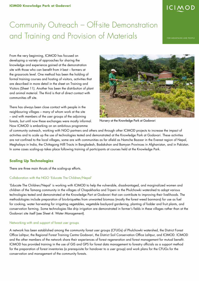
ICIMOD Knowledge Park at Godavari
From the very beginning, ICIMOD has focused on developing a variety of approaches for sharing the knowledge and experience gained at the demonstration site with those who can benefit from it best – farmers at the grassroots level. One method has been the holding of formal training courses and hosting of visitors, activities that are described in more detail in the sheet on Training and Visitors (Sheet 11). Another has been the distribution of plant and animal material. The third is that of direct contact with communities off site.
There has always been close contact with people in the neighbouring villages – many of whom work at the site – and with members of the user groups of the adjoining forests, but until now these exchanges were mostly informal. Now ICIMOD is embarking on an ambitious programme of community outreach, working with NGO partners and others and through other ICIMOD projects to increase the impact of activities and to scale up the use of technologies tested and demonstrated at the Knowledge Park at Godavari. These activities are not confined to the local villages, some are with communities as far afield as Namche Bazaar in the Everest region of Nepal, Meghalaya in India, the Chittagong Hilll Tracts in Bangladesh, Badakshan and Bamyan Provinces in Afghanistan, and in Pakistan. In some cases scaling-up takes place following training of participants at courses held at the Knowledge Park.
Scaling Up Technologies
There are three main thrusts of the scaling-up efforts.
Collaboration with the NGO ‘Educate The Children/Nepal’
‘Educate The Children/Nepal’ is working with ICIMOD to help the vulnerable, disadvantaged, and marginalized women and children of the Tamang community in the villages of Chapakharka and Tripeni in the Phulchowki watershed to adopt various technologies tested and demonstrated at the Knowledge Part at Godavari that can contribute to improving their livelihoods. The methodologies include preparation of bio-briquettes from unwanted biomass (mostly the forest weed banmara) for use as fuel for cooking, water harvesting for irrigating vegetables, vegetable backyard gardening, planting of fodder and fruit plants, and conservation farming. Some technologies like drip irrigation are demonstrated in farmer’s fields in these villages rather than at the Godavari site itself (see Sheet 4: Water Management).
Networking with and support of forest user groups
A network has been established among the community forest user groups (CFUGs) of Phulchowki watershed, the District Forest Office Lalitpur, the Regional Forest Training Centre Godavari, the District Soil Conservation Office Lalitpur, and ICIMOD. ICIMOD and the other members of the network share their experiences of forest regeneration and forest management for mutual benefit. ICIMOD has provided training in the use of GIS and GPS for forest data management to forestry officials as a support method for the preparation of forest inventories (a prerequisite for handover to a user group) and work plans for the CFUGs for the conservation and management of the community forests.
Community Outreach – Off-site Demonstration and Training and Provision of Materials
Nursery at the Knowledge Park at Godavari
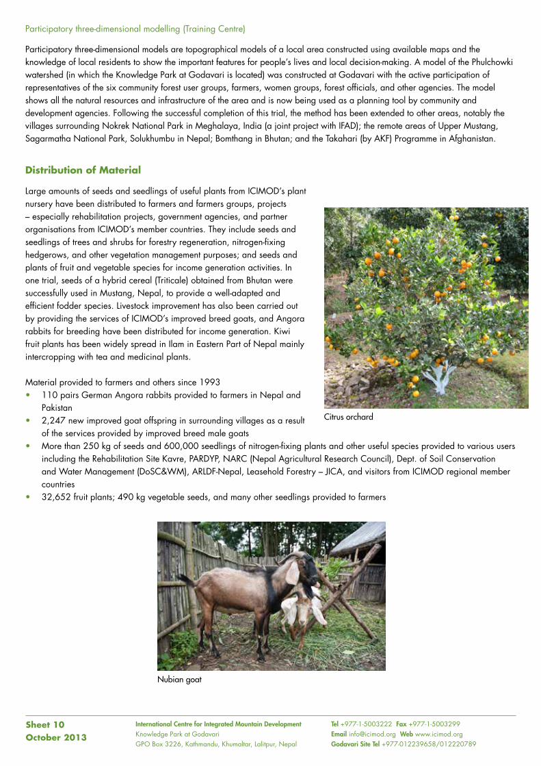
International Centre for Integrated Mountain Development Knowledge Park at GodavariGPO Box 3226, Kathmandu, Khumaltar, Lalitpur, Nepal
Tel +977-1-5003222 Fax +977-1-5003299 Email [email protected] Web www.icimod.orgGodavari Site Tel +977-012239658/012220789
Participatory three-dimensional modelling (Training Centre)
Participatory three-dimensional models are topographical models of a local area constructed using available maps and the knowledge of local residents to show the important features for people’s lives and local decision-making. A model of the Phulchowki watershed (in which the Knowledge Park at Godavari is located) was constructed at Godavari with the active participation of representatives of the six community forest user groups, farmers, women groups, forest officials, and other agencies. The model shows all the natural resources and infrastructure of the area and is now being used as a planning tool by community and development agencies. Following the successful completion of this trial, the method has been extended to other areas, notably the villages surrounding Nokrek National Park in Meghalaya, India (a joint project with IFAD); the remote areas of Upper Mustang, Sagarmatha National Park, Solukhumbu in Nepal; Bomthang in Bhutan; and the Takahari (by AKF) Programme in Afghanistan.
Distribution of Material
Large amounts of seeds and seedlings of useful plants from ICIMOD’s plant nursery have been distributed to farmers and farmers groups, projects – especially rehabilitation projects, government agencies, and partner organisations from ICIMOD’s member countries. They include seeds and seedlings of trees and shrubs for forestry regeneration, nitrogen-fixing hedgerows, and other vegetation management purposes; and seeds and plants of fruit and vegetable species for income generation activities. In one trial, seeds of a hybrid cereal (Triticale) obtained from Bhutan were successfully used in Mustang, Nepal, to provide a well-adapted and efficient fodder species. Livestock improvement has also been carried out by providing the services of ICIMOD’s improved breed goats, and Angora rabbits for breeding have been distributed for income generation. Kiwi fruit plants has been widely spread in Ilam in Eastern Part of Nepal mainly intercropping with tea and medicinal plants.
Material provided to farmers and others since 1993• 110 pairs German Angora rabbits provided to farmers in Nepal and
Pakistan• 2,247 new improved goat offspring in surrounding villages as a result
of the services provided by improved breed male goats• More than 250 kg of seeds and 600,000 seedlings of nitrogen-fixing plants and other useful species provided to various users
including the Rehabilitation Site Kavre, PARDYP, NARC (Nepal Agricultural Research Council), Dept. of Soil Conservation and Water Management (DoSC&WM), ARLDF-Nepal, Leasehold Forestry – JICA, and visitors from ICIMOD regional member countries
• 32,652 fruit plants; 490 kg vegetable seeds, and many other seedlings provided to farmers
Sheet 10October 2013
Citrus orchard
Nubian goat
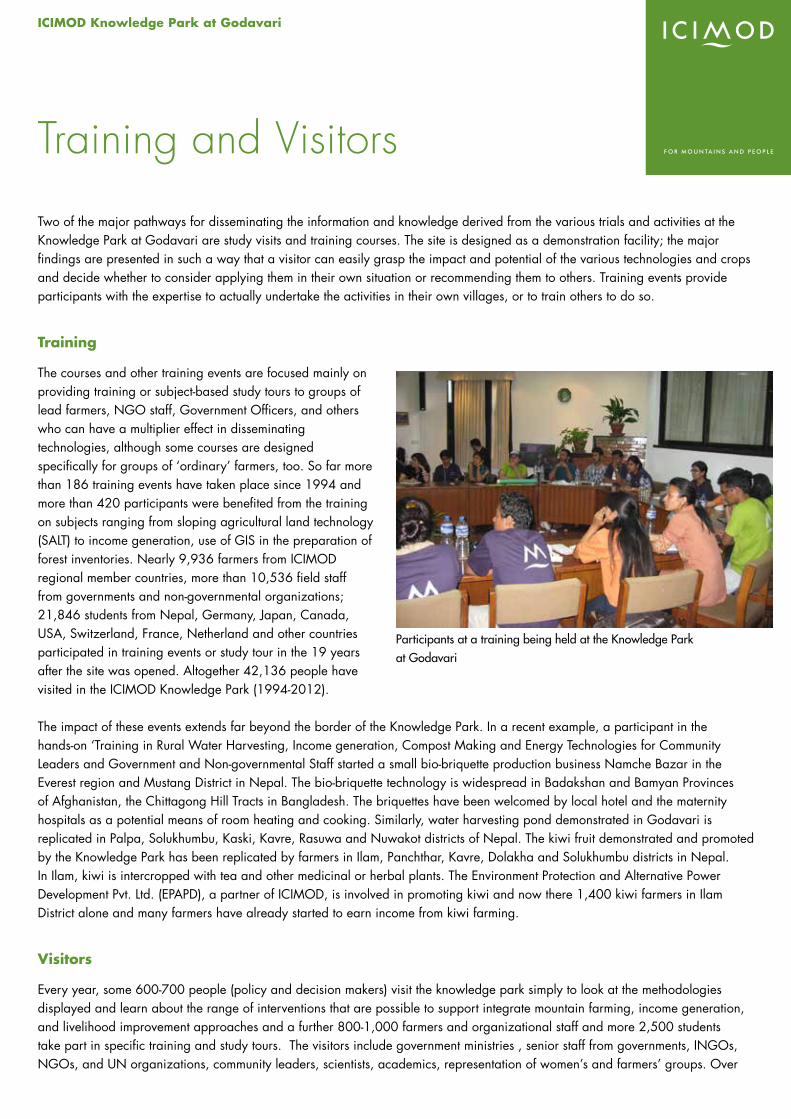
ICIMOD Knowledge Park at Godavari
Two of the major pathways for disseminating the information and knowledge derived from the various trials and activities at the Knowledge Park at Godavari are study visits and training courses. The site is designed as a demonstration facility; the major findings are presented in such a way that a visitor can easily grasp the impact and potential of the various technologies and crops and decide whether to consider applying them in their own situation or recommending them to others. Training events provide participants with the expertise to actually undertake the activities in their own villages, or to train others to do so.
Training
The courses and other training events are focused mainly on providing training or subject-based study tours to groups of lead farmers, NGO staff, Government Officers, and others who can have a multiplier effect in disseminating technologies, although some courses are designed specifically for groups of ‘ordinary’ farmers, too. So far more than 186 training events have taken place since 1994 and more than 420 participants were benefited from the training on subjects ranging from sloping agricultural land technology (SALT) to income generation, use of GIS in the preparation of forest inventories. Nearly 9,936 farmers from ICIMOD regional member countries, more than 10,536 field staff from governments and non-governmental organizations; 21,846 students from Nepal, Germany, Japan, Canada, USA, Switzerland, France, Netherland and other countries participated in training events or study tour in the 19 years after the site was opened. Altogether 42,136 people have visited in the ICIMOD Knowledge Park (1994-2012).
The impact of these events extends far beyond the border of the Knowledge Park. In a recent example, a participant in the hands-on ‘Training in Rural Water Harvesting, Income generation, Compost Making and Energy Technologies for Community Leaders and Government and Non-governmental Staff started a small bio-briquette production business Namche Bazar in the Everest region and Mustang District in Nepal. The bio-briquette technology is widespread in Badakshan and Bamyan Provinces of Afghanistan, the Chittagong Hill Tracts in Bangladesh. The briquettes have been welcomed by local hotel and the maternity hospitals as a potential means of room heating and cooking. Similarly, water harvesting pond demonstrated in Godavari is replicated in Palpa, Solukhumbu, Kaski, Kavre, Rasuwa and Nuwakot districts of Nepal. The kiwi fruit demonstrated and promoted by the Knowledge Park has been replicated by farmers in Ilam, Panchthar, Kavre, Dolakha and Solukhumbu districts in Nepal. In Ilam, kiwi is intercropped with tea and other medicinal or herbal plants. The Environment Protection and Alternative Power Development Pvt. Ltd. (EPAPD), a partner of ICIMOD, is involved in promoting kiwi and now there 1,400 kiwi farmers in Ilam District alone and many farmers have already started to earn income from kiwi farming.
Visitors
Every year, some 600-700 people (policy and decision makers) visit the knowledge park simply to look at the methodologies displayed and learn about the range of interventions that are possible to support integrate mountain farming, income generation, and livelihood improvement approaches and a further 800-1,000 farmers and organizational staff and more 2,500 students take part in specific training and study tours. The visitors include government ministries , senior staff from governments, INGOs, NGOs, and UN organizations, community leaders, scientists, academics, representation of women’s and farmers’ groups. Over
Training and Visitors
Participants at a training being held at the Knowledge Park at Godavari
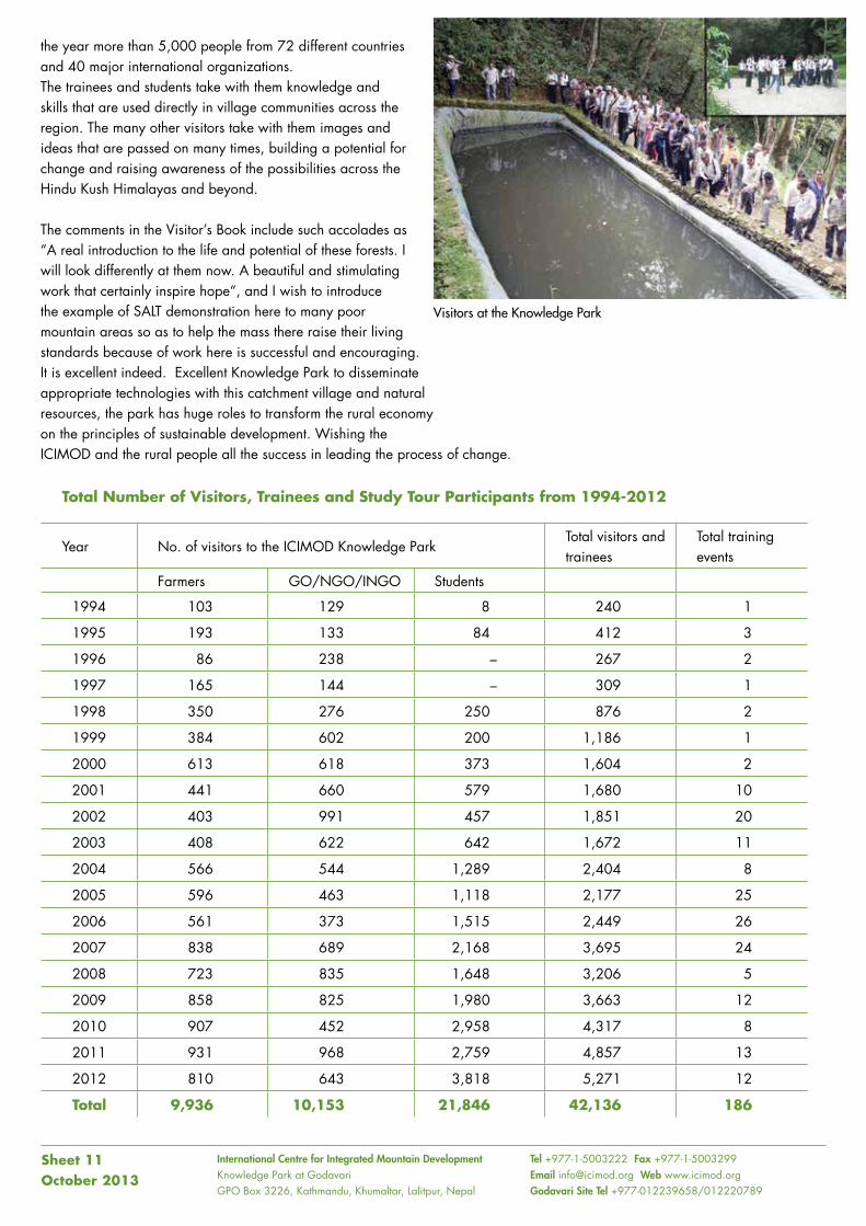
International Centre for Integrated Mountain Development Knowledge Park at GodavariGPO Box 3226, Kathmandu, Khumaltar, Lalitpur, Nepal
Tel +977-1-5003222 Fax +977-1-5003299 Email [email protected] Web www.icimod.orgGodavari Site Tel +977-012239658/012220789
the year more than 5,000 people from 72 different countries and 40 major international organizations. The trainees and students take with them knowledge and skills that are used directly in village communities across the region. The many other visitors take with them images and ideas that are passed on many times, building a potential for change and raising awareness of the possibilities across the Hindu Kush Himalayas and beyond.
The comments in the Visitor’s Book include such accolades as “A real introduction to the life and potential of these forests. I will look differently at them now. A beautiful and stimulating work that certainly inspire hope“, and I wish to introduce the example of SALT demonstration here to many poor mountain areas so as to help the mass there raise their living standards because of work here is successful and encouraging. It is excellent indeed. Excellent Knowledge Park to disseminate appropriate technologies with this catchment village and natural resources, the park has huge roles to transform the rural economy on the principles of sustainable development. Wishing the ICIMOD and the rural people all the success in leading the process of change.
Total Number of Visitors, Trainees and Study Tour Participants from 1994-2012
Year No. of visitors to the ICIMOD Knowledge ParkTotal visitors and trainees
Total training events
Farmers GO/NGO/INGO Students
1994 103 129 8 240 1
1995 193 133 84 412 3
1996 86 238 – 267 2
1997 165 144 – 309 1
1998 350 276 250 876 2
1999 384 602 200 1,186 1
2000 613 618 373 1,604 2
2001 441 660 579 1,680 10
2002 403 991 457 1,851 20
2003 408 622 642 1,672 11
2004 566 544 1,289 2,404 8
2005 596 463 1,118 2,177 25
2006 561 373 1,515 2,449 26
2007 838 689 2,168 3,695 24
2008 723 835 1,648 3,206 5
2009 858 825 1,980 3,663 12
2010 907 452 2,958 4,317 8
2011 931 968 2,759 4,857 13
2012 810 643 3,818 5,271 12
Total 9,936 10,153 21,846 42,136 186
Sheet 11October 2013
Visitors at the Knowledge Park
ICIMOD Knowledge Park at Godavari
Over the years a large amount of information has been accumulated related to the activities at the Godavari site. It includes background information about technologies, species, and general approaches for integrated mountain development; results of trials and recommendations of appropriate species and technologies; training materials; and many others. ICIMOD makes these available to a broader audience in a number of ways, formal and informal.
Detailed information sheets are prepared on farming technologies, renewable energy methodologies, trees and plants for particular purposes (fodder, fruit etc.), and specific species. These are reproduced and provided as handouts to interested visitors and trainees. Course material on particular topics is also prepared and provided to trainees. This informal material is often distributed far beyond the borders of the Centre, with visitors and trainees reproducing the sheets for others back in their home countries and villages. Some of this material is also reproduced on ICIMOD’s web site at www.icimod.org.
Scientific results are published in articles in journals, project reports, and books and other documents prepared by the ICIMOD programmes that have main responsibility for the activity.
General information about the site, ongoing activities, training courses and visitors is also published in ICIMOD’s newsletter, annual reports, and programme reports, all of which are also available online.
A book series – ‘Focus on Godavari’ – has been developed to provide a platform for formal publication and wider dissemination of information related to the Godavari centre activities. The books will cover topics that provide general background information as well as the specific results and recommendations from trials.
Publications
International Centre for Integrated Mountain Development Knowledge Park at GodavariGPO Box 3226, Khumaltar, Lalitpur, Kathmandu, Nepal
Tel +977-1-5003222 Fax +977-1-5003299 Email [email protected] Web www.icimod.orgGodavari Site Tel +977-1-5560289/5560991
Sheet 12October 2013
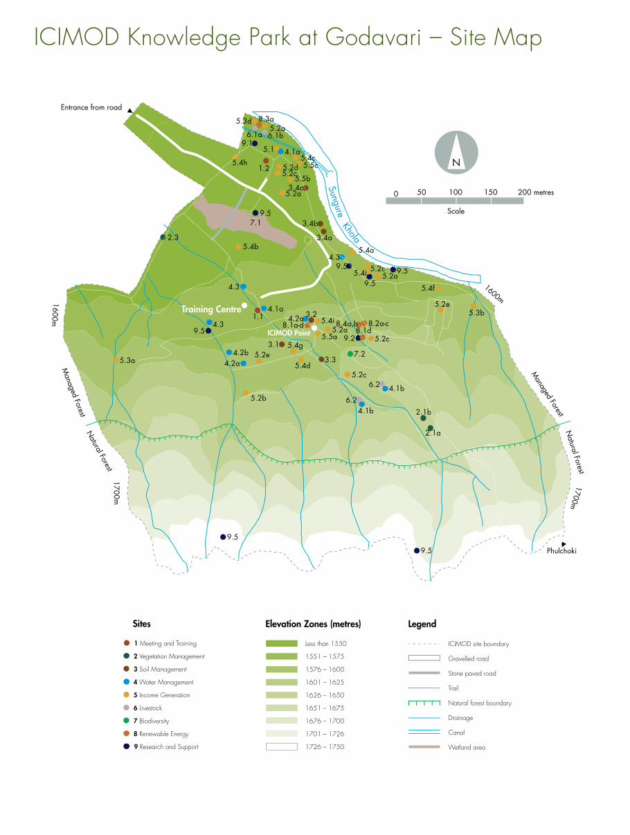
International Centre for
Integrated Mountain Development
GPO Box 3226, Kathmandu, Nepal
Tel +977-1-5003222
Fax +977-1-5003299
Email [email protected]
Web www.icimod.org
Godavari Site Tel +977-012239658
The ICIMOD Knowledge Park at Godavari, on the southern slopes of the Kathmandu Valley, was set up in March 1993, following the generous provision of 30 hectares of land by the Government of Nepal in November 1992. The Knowledge Park is used to test, select, and demonstrate different technologies and farming and agroforestry practices useful for sustainable development and natural resource management; to train farmers and those who work with them; and as a repository for plant germplasm resources. Present-day activities focus on vegetation management; soil management; water management; income-generation through high value cash crops, horticulture, and beekeeping; livestock; biodiversity; renewable energy technologies; community outreach/off-site demonstration, training, and provision of materials; scientific research; and training and dissemination.
The major partners for the Knowledge Park are Practical Action-Nepal (formerly Intermediate Technology Development Group-Nepal), Centre for Rural Technology-Nepal (CRT-Nepal), and Centre for Energy and Environment (CEE-Nepal), and in off-site activities Educate the Children (ETC-Nepal), Foundation for Sustainable Technology-Nepal (FoST-Nepal), local community forest user groups and women’s groups, the Department of Forests of Nepal, the Regional Forest Training Centre, and the Nepal Agricultural Research Council (NARC) Fisheries Research Centre. Many other partners from ICIMOD’s regional member countries support activities of the Knowledge Park and have provided plants and other materials.
The information sheets in this folder are also available on the ICIMOD website at www.icimod.org\himaldoc
ICIMOD Knowledge Park at Godavari – Site Map ICIMOD is a regional knowledge development and learning centre serving the eight regional member countries of the Hindu Kush Himalayas – Afghanistan, Bangladesh, Bhutan, China, India, Myanmar, Nepal, and Pakistan. We’re working to develop an economically and environmentally sound mountain ecosystem to improve the livelihoods of mountain populations – now, and for the future.
ICIMOD gratefully acknowledges the support of its core donors: the Governments of Afghanistan, Australia, Austria, Bangladesh, Bhutan, China, India, Myanmar, Nepal, Norway, Pakistan, Switzerland, and the United Kingdom.
6 Livestock
Sites
1 Meeting and Training
2 Vegetation Management
3 Soil Management
4 Water Management
5 Income Generation
7 Biodiversity
8 Renewable Energy
9 Research and Support
Sungure Khola
Training Centre
ICIMOD Point
Elevation Zones (metres)
Less than 1550
1551 – 1575
1576 – 1600
1601 – 1625
1626 – 1650
1651 – 1675
1676 – 1700
1701 – 1726
1726 – 1750
ICIMOD site boundary
Gravelled road
Stone paved road
Wetland area
Trail
Natural forest boundary
Drainage
Canal
Legend
1.1
1.2
2.1a
2.1b
3.1
3.2
3.3
3.4a
3.4c
4.1a5.1
4.1b6.2
4.1b6.2
4.1a
4.2b4.2a
4.3
5.2a5.2c
5.2d5.2c
5.2b
5.2e5.4d
5.4g
5.4b
5.4i
4.3
4.35.2a
5.2c
5.2c
5.2e5.3b
5.4f
4.2a
5.4i
5.4a
5.5b
5.4h
5.5a
5.3a
6.1a 6.1b
2.3
7.1
7.2
Natural Forest
Managed Forest
1700m
1700m
1600m
8.1d9.2
8.2a-c8.1a-d
5.2a
9.5
9.5
9.5
9.5
9.5
9.5
9.5
8.4a,b
1600m
5.3d 8.3a5.2a
5.4c5.5c
9.1
Entrance from road
Phulchoki
Scale
0 50 100 150 200 metres
N
Managed Forest
Natural Forest
3.4b

ICIMOD Knowledge Park at Godavari
Godavari


![[Day 2] Center Presentation: ICIMOD (1/2)](https://img.pdfslide.us/doc/110x75/5552d083b4c90581158b51f4/day-2-center-presentation-icimod-12.jpg)