Embed Size (px)
Citation preview

ICA Workshop on Geospatial Analysis and Modeling 8 July 2006 Vienna
ICA Workshop on Geospatial Analysis and Modeling 8 July 2006 Vienna
A TOOL PERFORMING TOPOLOGICAL CORRECTION
IN GIS
A TOOL PERFORMING TOPOLOGICAL CORRECTION
IN GIS
Stefano BellesiStefano Bellesi - Regione Marche - Ancona (Italy) [email protected]
Eva Savina MalinverniEva Savina Malinverni - Università Politecnica delle Marche - Ancona (Italy) [email protected]

GENERALITYGENERALITY
THE GIS DATA STRUCTURETHE GIS DATA STRUCTURE
THE DATA MAINTENANCETHE DATA MAINTENANCE
APPLICATIONSAPPLICATIONS

TOPICSTOPICSTOPICSTOPICS
ANALYSIS OF THE TOPOLOGICAL ANALYSIS OF THE TOPOLOGICAL INCONSISTENCY IN SPATIAL INCONSISTENCY IN SPATIAL DATABASES COMING FROM DATABASES COMING FROM NUMERICAL CARTOGRAPHY NUMERICAL CARTOGRAPHY
ORGANIZED IN INFORMATIVE LAYERSORGANIZED IN INFORMATIVE LAYERS
ANALYSIS OF THE TOPOLOGICAL ANALYSIS OF THE TOPOLOGICAL INCONSISTENCY IN SPATIAL INCONSISTENCY IN SPATIAL DATABASES COMING FROM DATABASES COMING FROM NUMERICAL CARTOGRAPHY NUMERICAL CARTOGRAPHY
ORGANIZED IN INFORMATIVE LAYERSORGANIZED IN INFORMATIVE LAYERS
GENERALIZATION IN THE GIS GENERALIZATION IN THE GIS PRESERVING THE PRESERVING THE
CORRESPONDENCES AND THE CORRESPONDENCES AND THE DATA STRUCTURESDATA STRUCTURES
GENERALIZATION IN THE GIS GENERALIZATION IN THE GIS PRESERVING THE PRESERVING THE
CORRESPONDENCES AND THE CORRESPONDENCES AND THE DATA STRUCTURESDATA STRUCTURES
IMPLEMENTATION OF A NEW TOOL “IMPLEMENTATION OF A NEW TOOL “TOPOLOGY TOPOLOGY ”” IN A COMMERCIAL IN A COMMERCIAL SOFTWARE TO SOLVE SOME TOPOLOGICAL PROBLEMSSOFTWARE TO SOLVE SOME TOPOLOGICAL PROBLEMS
IMPLEMENTATION OF A NEW TOOL “IMPLEMENTATION OF A NEW TOOL “TOPOLOGY TOPOLOGY ”” IN A COMMERCIAL IN A COMMERCIAL SOFTWARE TO SOLVE SOME TOPOLOGICAL PROBLEMSSOFTWARE TO SOLVE SOME TOPOLOGICAL PROBLEMS

TYPOLOGIES OF DATA STRUCTURESTYPOLOGIES OF DATA STRUCTURESTYPOLOGIES OF DATA STRUCTURESTYPOLOGIES OF DATA STRUCTURES
VECTOR MODEL: objects which have a position in the space (2D-3D)
TOPOLOGY: spatial relationships among the objects (2D)
ATTRIBUTE: the description of the objects
……the spatial relations, typically derived from positional information, are often imprecise and they can produce some results in conflict with the geometric representation of the real objects…...
……the spatial relations, typically derived from positional information, are often imprecise and they can produce some results in conflict with the geometric representation of the real objects…...
HoweverHowever
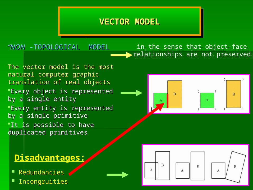
““NONNON -TOPOLOGICAL” MODEL -TOPOLOGICAL” MODEL
The vector model is the most natural The vector model is the most natural computer graphic translation of real computer graphic translation of real objectsobjects Every object is represented by a Every object is represented by a single entitysingle entityEvery entity is represented by a single Every entity is represented by a single primitiveprimitiveIt is possible to have duplicated It is possible to have duplicated primitivesprimitives
VECTOR MODELVECTOR MODELVECTOR MODELVECTOR MODEL
RedundanciesRedundancies IncongruitiesIncongruities
Disadvantages:
in the sense that object-face relationships are not preserved
in the sense that object-face relationships are not preserved

• There are not primitives There are not primitives parzially or totally overlappedparzially or totally overlapped
•It needs to divide the entities It needs to divide the entities according to the primitivesaccording to the primitives
• Different entities can share the Different entities can share the same primitivessame primitives
•This type of data manipulation This type of data manipulation involves concepts such as involves concepts such as adjacency, connectivity and adjacency, connectivity and containmentcontainment
The topological model repeats the traditional drawing in cartography
The topological model repeats the traditional drawing in cartography
Advantages:
THE SPATIAL RELATIONSHIPS PLAY AN IMPORTANT ROLE IN THE THE SPATIAL RELATIONSHIPS PLAY AN IMPORTANT ROLE IN THE SPATIAL DATABASE, SINCE THEY ARE USUALLY THE BASE FOR A SPATIAL DATABASE, SINCE THEY ARE USUALLY THE BASE FOR A CORRECT USE OF THE QUERIESCORRECT USE OF THE QUERIES
THE SPATIAL RELATIONSHIPS PLAY AN IMPORTANT ROLE IN THE THE SPATIAL RELATIONSHIPS PLAY AN IMPORTANT ROLE IN THE SPATIAL DATABASE, SINCE THEY ARE USUALLY THE BASE FOR A SPATIAL DATABASE, SINCE THEY ARE USUALLY THE BASE FOR A CORRECT USE OF THE QUERIESCORRECT USE OF THE QUERIES
TOPOLOGICAL MODELTOPOLOGICAL MODELTOPOLOGICAL MODELTOPOLOGICAL MODEL
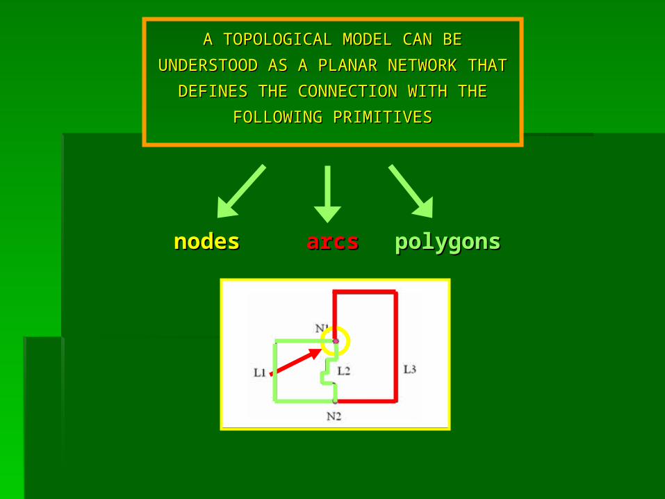
A TOPOLOGICAL MODEL CAN BE A TOPOLOGICAL MODEL CAN BE
UNDERSTOOD AS A PLANAR NETWORK UNDERSTOOD AS A PLANAR NETWORK
THAT DEFINES THE CONNECTION WITH THE THAT DEFINES THE CONNECTION WITH THE
FOLLOWING PRIMITIVESFOLLOWING PRIMITIVES
nodesnodes arcsarcs polygonpolygonss

DATA MAINTENANCE REQUIREMENTSDATA MAINTENANCE REQUIREMENTSDATA MAINTENANCE REQUIREMENTSDATA MAINTENANCE REQUIREMENTS
TO MAINTAIN RELATIONSHIPS BETWEEN THE PRIMITIVESTO MAINTAIN RELATIONSHIPS BETWEEN THE PRIMITIVES
TO USE TOPOLOGICAL RELATIONS TO DETECT AND CORRECT ERRORS IN GIS DATA SETS
TO USE TOPOLOGICAL RELATIONS TO DETECT AND CORRECT ERRORS IN GIS DATA SETS
Spatial relations are typically derived by data manipulation such Spatial relations are typically derived by data manipulation such that the check of the topological inconsistency involves not only that the check of the topological inconsistency involves not only
the control of the stored data, but also the control of the data the control of the stored data, but also the control of the data manipulation resultsmanipulation results

TOPOLOGICAL CORRECTION APPROACHTOPOLOGICAL CORRECTION APPROACHTOPOLOGICAL CORRECTION APPROACHTOPOLOGICAL CORRECTION APPROACH
A COMPLETE APPROACH REQUIRES THREE DIFFERENT TASKS:
THE DEFINITION OF THE ERRORSTHE DEFINITION OF THE ERRORS
THE CHECK OF THE DATABASETHE CHECK OF THE DATABASE
THE CORRECTION OF THE ERRORSTHE CORRECTION OF THE ERRORS
A COMPLETE APPROACH REQUIRES THREE DIFFERENT TASKS:
THE DEFINITION OF THE ERRORSTHE DEFINITION OF THE ERRORS
THE CHECK OF THE DATABASETHE CHECK OF THE DATABASE
THE CORRECTION OF THE ERRORSTHE CORRECTION OF THE ERRORS
Since an error is defined as a forbidden topological relation between the objects, the way to correct it will be to create the
correct topological relationships between these objects
Since an error is defined as a forbidden topological relation between the objects, the way to correct it will be to create the
correct topological relationships between these objects

•Data qualityData quality
•Computational geometryComputational geometry
THE MOST FREQUENT PROBLEMS WHICH CAN HAPPEN ARE: THE MOST FREQUENT PROBLEMS WHICH CAN HAPPEN ARE:
Why topology is Why topology is so important?so important?
Why topology is Why topology is so important?so important?
TOPOLOGICAL INCONSISTENCYTOPOLOGICAL INCONSISTENCYTOPOLOGICAL INCONSISTENCYTOPOLOGICAL INCONSISTENCY
double and redundant verticesdouble and redundant vertices
overlapped arcsoverlapped arcs
double and tangent arcsdouble and tangent arcs
missed tangency between two arcsmissed tangency between two arcs
double and redundant verticesdouble and redundant vertices
overlapped arcsoverlapped arcs
double and tangent arcsdouble and tangent arcs
missed tangency between two arcsmissed tangency between two arcs

TOPOLOGICAL CHECKTOPOLOGICAL CHECKTOPOLOGICAL CHECKTOPOLOGICAL CHECK
If the datum is already topologically consistent it is possible to create, without mistakes, the topological structure before to verify the correctness of the data from a geometric point of view and successively to create the topological relationships
If the datum is already topologically consistent it is possible to create, without mistakes, the topological structure before to verify the correctness of the data from a geometric point of view and successively to create the topological relationships
SOME TOPOLOGICAL CONTROLS ARE SOME TOPOLOGICAL CONTROLS ARE APPLICABLE TO MONO-DIMENSIONAL APPLICABLE TO MONO-DIMENSIONAL
ELEMENTSELEMENTS
SOME TOPOLOGICAL CONTROLS ARE SOME TOPOLOGICAL CONTROLS ARE APPLICABLE TO MONO-DIMENSIONAL APPLICABLE TO MONO-DIMENSIONAL
ELEMENTSELEMENTS

MAPINFO PROFESSIONAL 7.5MAPINFO PROFESSIONAL 7.5
MAPBASIC 7.0MAPBASIC 7.0
MAPINFO PROFESSIONAL 7.5MAPINFO PROFESSIONAL 7.5
MAPBASIC 7.0MAPBASIC 7.0
A TOPOLOGICAL CORRECTION TOOLA TOPOLOGICAL CORRECTION TOOLA TOPOLOGICAL CORRECTION TOOLA TOPOLOGICAL CORRECTION TOOL
Some commercial GIS software have some evident gaps Some commercial GIS software have some evident gaps performing a topological investigationperforming a topological investigation
Some commercial GIS software have some evident gaps Some commercial GIS software have some evident gaps performing a topological investigationperforming a topological investigation
These software do not deal with topological relations or consider only few relations so that the correction tools do not always work in an automatic way
but sometimes require the support of an human operator
These software do not deal with topological relations or consider only few relations so that the correction tools do not always work in an automatic way
but sometimes require the support of an human operator
How to create a correct How to create a correct topological model?topological model?

Message Windows
Menu Toolbar
THE VISUAL INTERFACE FOR END-USERSTHE VISUAL INTERFACE FOR END-USERSTHE VISUAL INTERFACE FOR END-USERSTHE VISUAL INTERFACE FOR END-USERS
To help and inform about the performancesTo help and inform about the performances
To choice the type of topological checksTo choice the type of topological checks
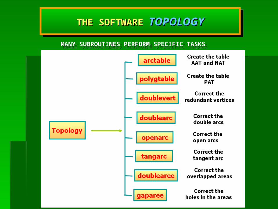
MANY SUBROUTINES PERFORM SPECIFIC TASKSMANY SUBROUTINES PERFORM SPECIFIC TASKS
THE SOFTWARE THE SOFTWARE TOPOLOGYTOPOLOGYTHE SOFTWARE THE SOFTWARE TOPOLOGYTOPOLOGY
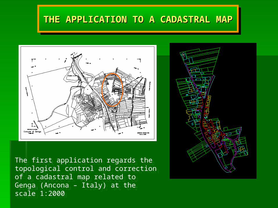
THE APPLICATION TO A CADASTRAL MAPTHE APPLICATION TO A CADASTRAL MAPTHE APPLICATION TO A CADASTRAL MAPTHE APPLICATION TO A CADASTRAL MAP
The first application regards the topological control and correction of a cadastral map related to Genga (Ancona – Italy) at the scale 1:2000
The first application regards the topological control and correction of a cadastral map related to Genga (Ancona – Italy) at the scale 1:2000
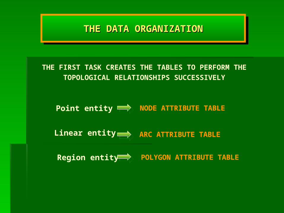
THE FIRST TASK CREATES THE TABLES TO PERFORM THE TOPOLOGICAL RELATIONSHIPS SUCCESSIVELY
Linear entity
Point entity
Region entity
THE DATA ORGANIZATIONTHE DATA ORGANIZATIONTHE DATA ORGANIZATIONTHE DATA ORGANIZATION
NODE ATTRIBUTE TABLENODE ATTRIBUTE TABLE
ARC ATTRIBUTE TABLEARC ATTRIBUTE TABLE
POLYGON ATTRIBUTE TABLEPOLYGON ATTRIBUTE TABLE

Subroutine ‘ Arctable’Subroutine ‘ Arctable’ Subroutine ‘ Arctable’Subroutine ‘ Arctable’
Sub Arctable
Create Table AAT
Create Table NAT
Create Map For AAT
Create Map For NATCommit Table AAT
Commit Table NAT
Alter menu
“ Table AAT and NAT”End Sub
prepares the data
prepares the data
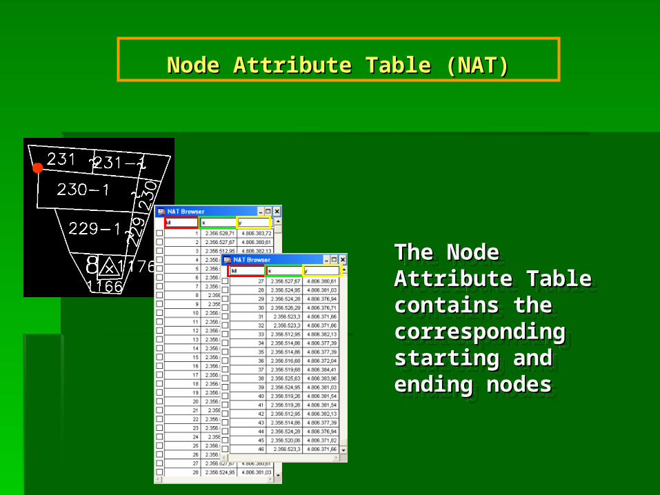
Node Attribute Table (NAT)Node Attribute Table (NAT)
The Node Attribute The Node Attribute Table contains the Table contains the corresponding corresponding starting and ending starting and ending nodesnodes
The Node Attribute The Node Attribute Table contains the Table contains the corresponding corresponding starting and ending starting and ending nodesnodes
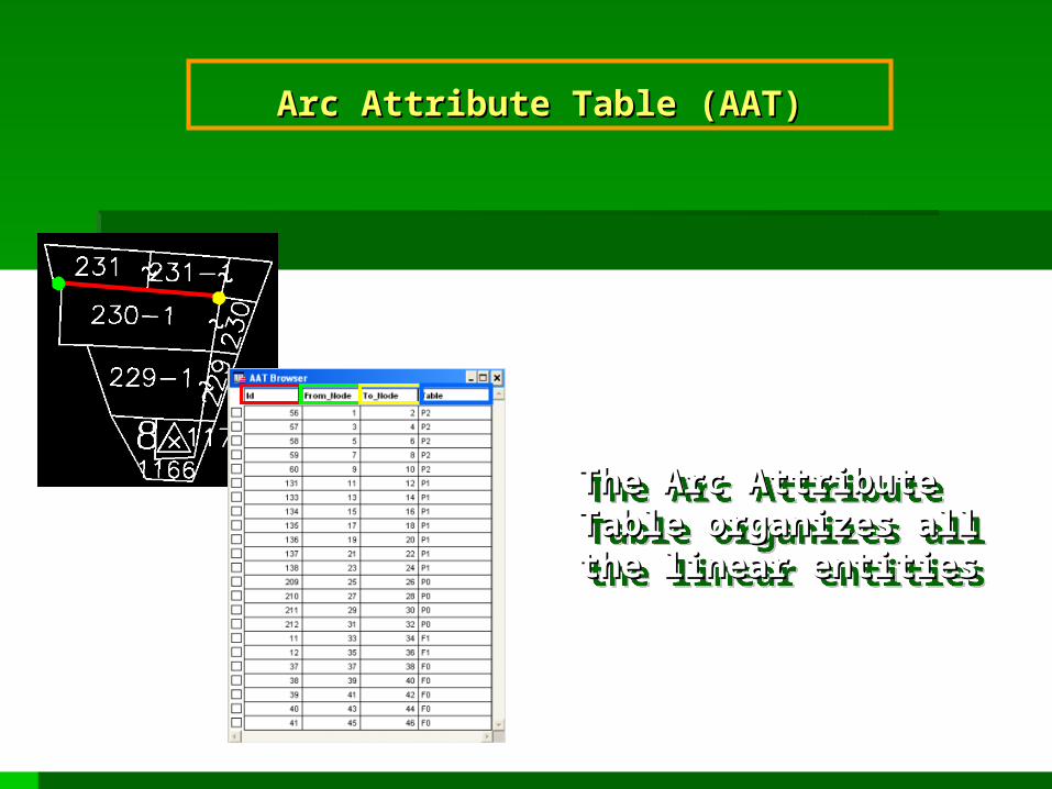
Arc Attribute Table (AAT)Arc Attribute Table (AAT)
The Arc Attribute Table The Arc Attribute Table organizes all the linear organizes all the linear entitiesentities
The Arc Attribute Table The Arc Attribute Table organizes all the linear organizes all the linear entitiesentities

Polygon Attribute Table (PAT)Polygon Attribute Table (PAT)
Polygon Attribute Table (PAT) Polygon Attribute Table (PAT) contains all the areas in the map contains all the areas in the map
identified by the coordinates of their identified by the coordinates of their own centroidown centroid
Polygon Attribute Table (PAT) Polygon Attribute Table (PAT) contains all the areas in the map contains all the areas in the map
identified by the coordinates of their identified by the coordinates of their own centroidown centroid
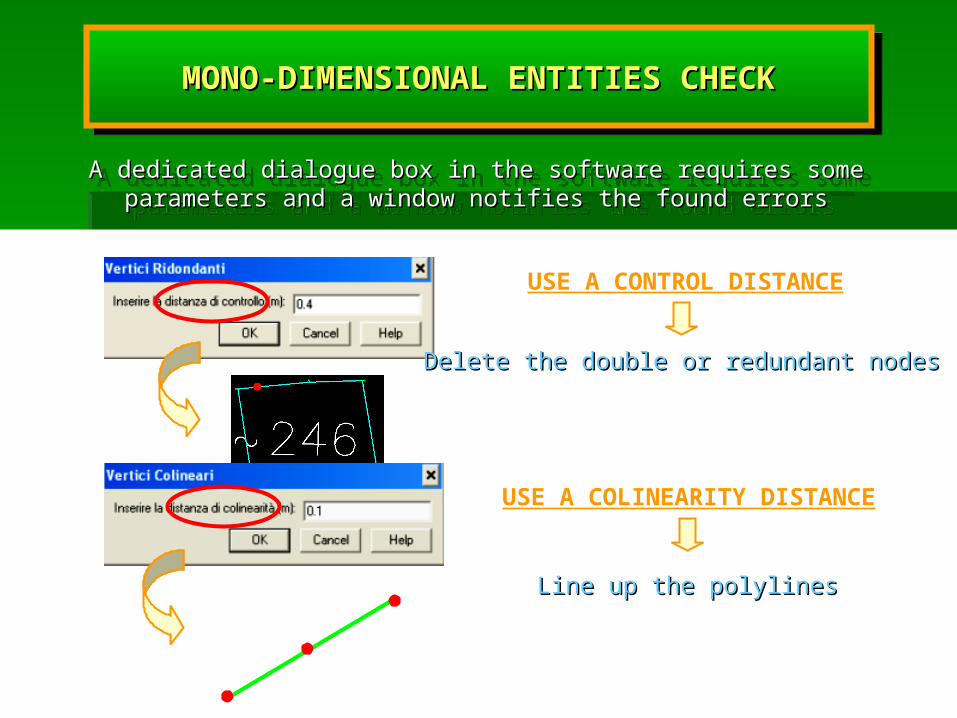
USE A CONTROL DISTANCE
Delete the double or redundant nodesDelete the double or redundant nodes
USE A COLINEARITY DISTANCE
Line up the polylinesLine up the polylines
A dedicated dialogue box in the software requires some parameters and a A dedicated dialogue box in the software requires some parameters and a window notifies the found errorswindow notifies the found errors
A dedicated dialogue box in the software requires some parameters and a A dedicated dialogue box in the software requires some parameters and a window notifies the found errorswindow notifies the found errors
MONO-DIMENSIONAL ENTITIES CHECKMONO-DIMENSIONAL ENTITIES CHECKMONO-DIMENSIONAL ENTITIES CHECKMONO-DIMENSIONAL ENTITIES CHECK
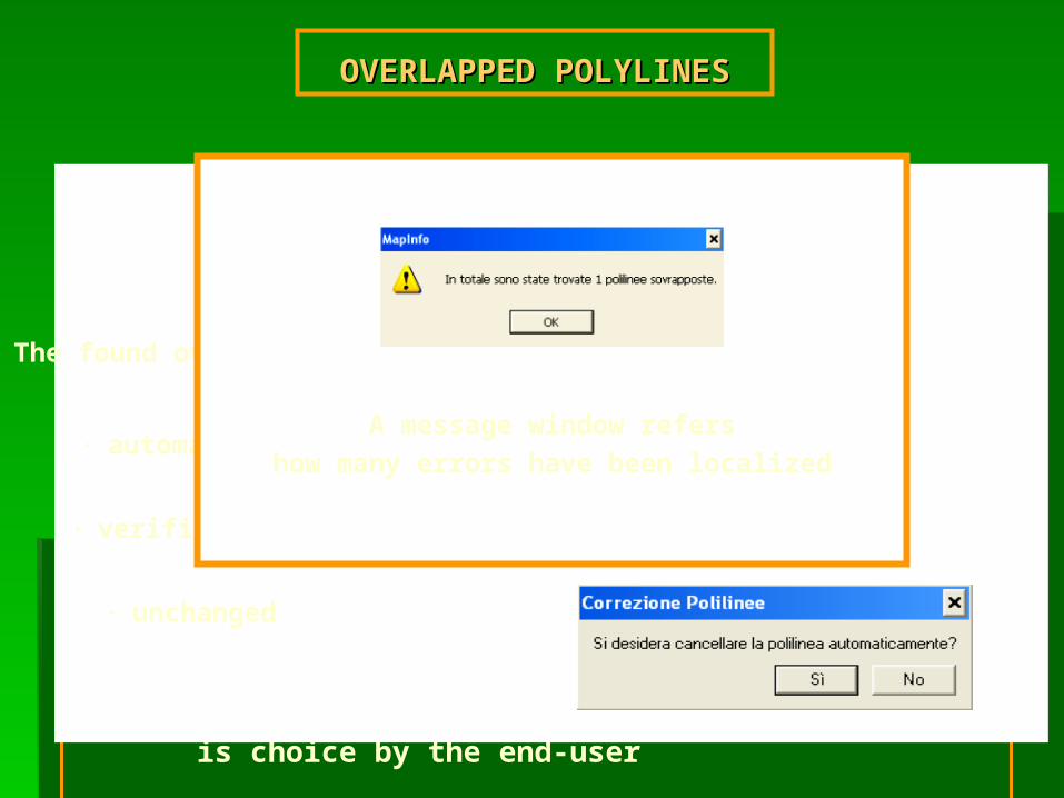
To recognize the overlapped polylines a buffer is traced around every linear element
To recognize the overlapped polylines a buffer is traced around every linear element
This verifies that any other polyline is not entirely contained in this area of control
The buffer value is choice by the end-user
OVERLAPPED OVERLAPPED POLYLINESPOLYLINES
The found overlapped entities can be:
٠ automatically deleted
٠ verified and manually deleted
٠ unchanged
A message window refershow many errors have been localized

Topological error correction
Node Attribute TableThe nodes are counted at least twice
٠ buffer around the node
٠ test of the presence of another node or polyline
٠ closure of the polylines
Buffer value based on the graphic error multiplied by the scale of the map
WARNING: if the buffer value is too small, the program requires another value
CHECK OF THE PERFECT CLOSURE IN CHECK OF THE PERFECT CLOSURE IN CORRESPONDENCE OF THE NODESCORRESPONDENCE OF THE NODES

Node of a polyline next to an arc
USE A CONTROL DISTANCEUSE A CONTROL DISTANCE
A way to correct such an error is to create an intersection point and to split the polyline in the tangent points
MISSED TANGENCYMISSED TANGENCY

REGION topological control
Bi-dimensional entities directly depend on the
mono-dimensional ones
If these entities do not contain topological errors also the areas are correct
Overlapped Areas
Test the adjacency of every area
The software automatically verifies the exixtence of the overlaps
The overlapped areas are highlighted and cut
Area containing holes inside
USE A THRESHOLD VALUE TO IDENTIFY THE HOLE
BI-DIMENSIONAL ENTITIES CHECKBI-DIMENSIONAL ENTITIES CHECKBI-DIMENSIONAL ENTITIES CHECKBI-DIMENSIONAL ENTITIES CHECK
The HOLE is filledThe HOLE is filledThe HOLE is filledThe HOLE is filled

SOME REMARKSSOME REMARKSSOME REMARKSSOME REMARKS
The use of the program has underlined two problems during The use of the program has underlined two problems during the correction phasesthe correction phases
The use of the program has underlined two problems during The use of the program has underlined two problems during the correction phasesthe correction phases
ONE REGARDS THE OPENED ARCS WITHOUT INTERSECTIONONE REGARDS THE OPENED ARCS WITHOUT INTERSECTIONONE REGARDS THE OPENED ARCS WITHOUT INTERSECTIONONE REGARDS THE OPENED ARCS WITHOUT INTERSECTION
They are not automatically removed, but the operator, examining the They are not automatically removed, but the operator, examining the map, decides to make some changes and the procedure can be iteratedmap, decides to make some changes and the procedure can be iterated
They are not automatically removed, but the operator, examining the They are not automatically removed, but the operator, examining the map, decides to make some changes and the procedure can be iteratedmap, decides to make some changes and the procedure can be iterated
SECOND ONE REGARDS THE CLOSURE OF ARCS IN SECOND ONE REGARDS THE CLOSURE OF ARCS IN CORRESPONDENCE OF THE NODESCORRESPONDENCE OF THE NODESSECOND ONE REGARDS THE CLOSURE OF ARCS IN SECOND ONE REGARDS THE CLOSURE OF ARCS IN CORRESPONDENCE OF THE NODESCORRESPONDENCE OF THE NODES
Where the control area value is too small to perform the closure, it is Where the control area value is too small to perform the closure, it is necessary to perform a manual correctionnecessary to perform a manual correction
Where the control area value is too small to perform the closure, it is Where the control area value is too small to perform the closure, it is necessary to perform a manual correctionnecessary to perform a manual correction
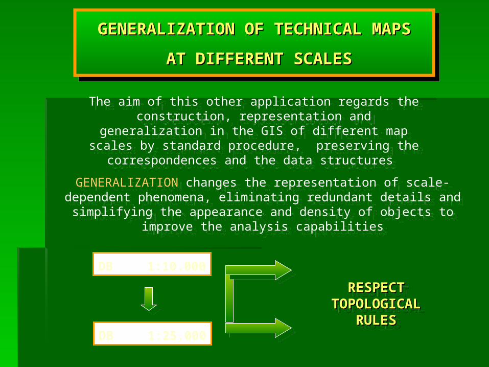
The aim of this other application regards the construction, representation and generalization in the GIS of different map
scales by standard procedure, preserving the correspondences and the data structures
The aim of this other application regards the construction, representation and generalization in the GIS of different map
scales by standard procedure, preserving the correspondences and the data structures
GENERALIZATION OF TECHNICAL MAPSGENERALIZATION OF TECHNICAL MAPS
AT DIFFERENT SCALESAT DIFFERENT SCALES
GENERALIZATION OF TECHNICAL MAPSGENERALIZATION OF TECHNICAL MAPS
AT DIFFERENT SCALESAT DIFFERENT SCALES
GENERALIZATION changes the representation of scale-dependent phenomena, eliminating redundant details and simplifying the appearance
and density of objects to improve the analysis capabilities
GENERALIZATION changes the representation of scale-dependent phenomena, eliminating redundant details and simplifying the appearance
and density of objects to improve the analysis capabilities
DB 1:10.000
DB 1:25.000
RESPECTRESPECTTOPOLOGICAL TOPOLOGICAL
RULESRULES
RESPECTRESPECTTOPOLOGICAL TOPOLOGICAL
RULESRULES
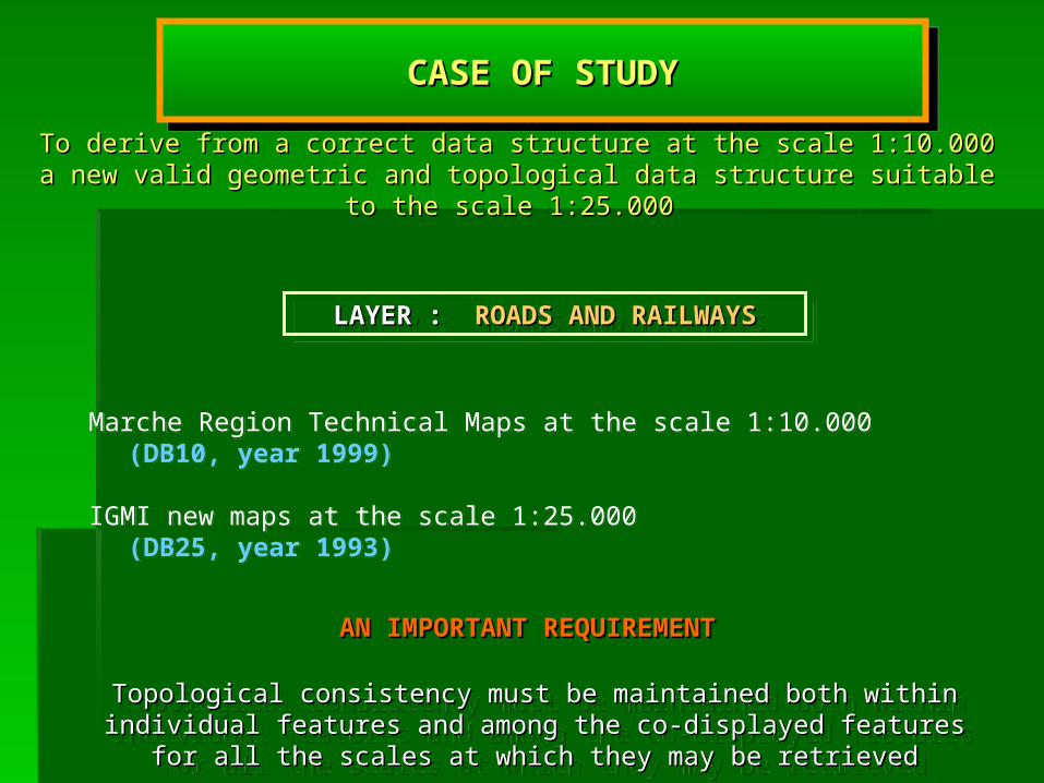
Topological consistency must be maintained both within individual features Topological consistency must be maintained both within individual features and among the co-displayed features for all the scales at which they may be and among the co-displayed features for all the scales at which they may be
retrievedretrieved
Marche Region Technical Maps at the scale 1:10.000 (DB10, year 1999)
IGMI new maps at the scale 1:25.000 (DB25, year 1993)
Marche Region Technical Maps at the scale 1:10.000 (DB10, year 1999)
IGMI new maps at the scale 1:25.000 (DB25, year 1993)
CASE OF STUDYCASE OF STUDYCASE OF STUDYCASE OF STUDY
LAYER : LAYER : ROADS AND RAILWAYSROADS AND RAILWAYSLAYER : LAYER : ROADS AND RAILWAYSROADS AND RAILWAYS
To derive from a correct data structure at the scale 1:10.000 a new valid geometric To derive from a correct data structure at the scale 1:10.000 a new valid geometric and topological data structure suitable to the scale 1:25.000 and topological data structure suitable to the scale 1:25.000
AN IMPORTANT REQUIREMENTAN IMPORTANT REQUIREMENTAN IMPORTANT REQUIREMENTAN IMPORTANT REQUIREMENT

List of all the features in the map organized by code, List of all the features in the map organized by code, description and geometric primitivesdescription and geometric primitives
List of all the features in the map organized by code, List of all the features in the map organized by code, description and geometric primitivesdescription and geometric primitives
ROAD NETWORK REPRESENTATION ROAD NETWORK REPRESENTATION
BY NODES AND ARCSBY NODES AND ARCS
ROAD NETWORK REPRESENTATION ROAD NETWORK REPRESENTATION
BY NODES AND ARCSBY NODES AND ARCS
In the DB25 there are much more classes than in the DB10 and different In the DB25 there are much more classes than in the DB10 and different types of symbolic representationstypes of symbolic representations
ROAD AND RAILWAY
DB 1:10.000
TOPOLOGICALTOPOLOGICAL RECONSTRUCTIONRECONSTRUCTION
TOPOLOGICALTOPOLOGICAL RECONSTRUCTIONRECONSTRUCTION
DB 1:25.000
POLYLINE FEATURES
POINT FEATURES
POLYGON FEATURES
POLYLINE FEATURES
POINT FEATURES
POLYGON FEATURES
POINT FEATURES
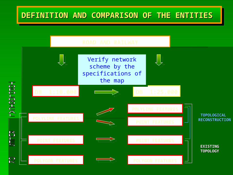
Verify network scheme by the specifications of
the map
Verify network scheme by the specifications of
the map
DEFINITION AND COMPARISON OF THE ENTITIES DEFINITION AND COMPARISON OF THE ENTITIES DEFINITION AND COMPARISON OF THE ENTITIES DEFINITION AND COMPARISON OF THE ENTITIES
EXISTINGEXISTINGTOPOLOGYTOPOLOGYEXISTINGEXISTING
TOPOLOGYTOPOLOGY
POLYLINESDB 1:10.000
BUFFER
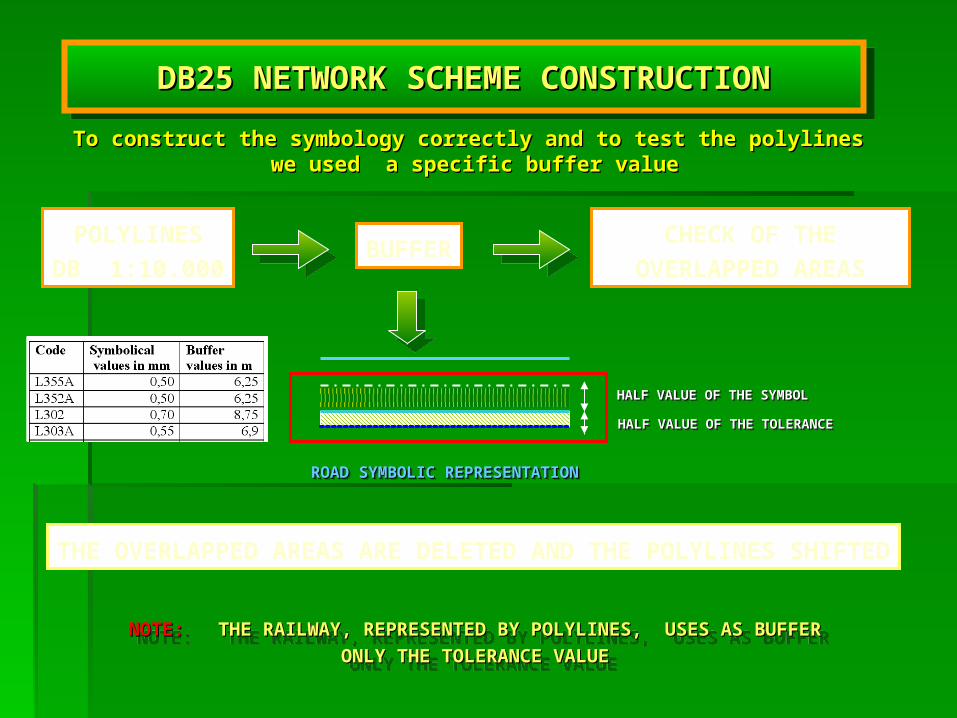
DB25 NETWORK SCHEME CONSTRUCTIONDB25 NETWORK SCHEME CONSTRUCTIONDB25 NETWORK SCHEME CONSTRUCTIONDB25 NETWORK SCHEME CONSTRUCTION
CHECK OF THE OVERLAPPED AREAS
ROAD SYMBOLIC REPRESENTATIONROAD SYMBOLIC REPRESENTATIONROAD SYMBOLIC REPRESENTATIONROAD SYMBOLIC REPRESENTATION
HALF VALUE OF THE SYMBOLHALF VALUE OF THE SYMBOLHALF VALUE OF THE SYMBOLHALF VALUE OF THE SYMBOL
HALF VALUE OF THE TOLERANCEHALF VALUE OF THE TOLERANCEHALF VALUE OF THE TOLERANCEHALF VALUE OF THE TOLERANCE
THE OVERLAPPED AREAS ARE DELETED AND THE POLYLINES SHIFTED
NOTE:NOTE: THE RAILWAY, REPRESENTED BY POLYLINES, USES AS BUFFER ONLY THE RAILWAY, REPRESENTED BY POLYLINES, USES AS BUFFER ONLY
THE TOLERANCE VALUETHE TOLERANCE VALUE
NOTE:NOTE: THE RAILWAY, REPRESENTED BY POLYLINES, USES AS BUFFER ONLY THE RAILWAY, REPRESENTED BY POLYLINES, USES AS BUFFER ONLY
THE TOLERANCE VALUETHE TOLERANCE VALUE
To construct the symbology correctly and to test the polylines To construct the symbology correctly and to test the polylines we used a specific buffer valuewe used a specific buffer value

The change of the network scheme risks to lose the topological The change of the network scheme risks to lose the topological consistency of the data structureconsistency of the data structure
case (a)(a) deletes a non connected arc case (a)(a) deletes a non connected arc
case (b)(b) detects two new dangle nodes (regarding the bridge) which are automatically corrected by means of a tolerance value
case (b)(b) detects two new dangle nodes (regarding the bridge) which are automatically corrected by means of a tolerance value
case (c)(c) simplifies the intersectionscase (c)(c) simplifies the intersections
THREE POSSIBLE CASES OF ALTERATIONTHREE POSSIBLE CASES OF ALTERATIONTHREE POSSIBLE CASES OF ALTERATIONTHREE POSSIBLE CASES OF ALTERATION
TOPOLOGICAL TOPOLOGICAL RECONSTRUCTIONRECONSTRUCTION
(case b)(case b)
TOPOLOGICAL TOPOLOGICAL RECONSTRUCTIONRECONSTRUCTION
(case b)(case b)POLYLINE FEATURES
POLYLINE FEATURES
POINT FEATURES
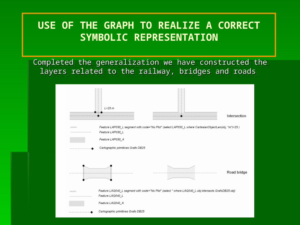
USE OF THE GRAPH TO REALIZE A CORRECT SYMBOLIC REPRESENTATION
Completed the generalization we have constructed the layers related to the Completed the generalization we have constructed the layers related to the railway, bridges and roads railway, bridges and roads
Completed the generalization we have constructed the layers related to the Completed the generalization we have constructed the layers related to the railway, bridges and roads railway, bridges and roads

SOME REMARKSSOME REMARKSSOME REMARKSSOME REMARKS
NO BUFFER FLATNO BUFFER FLAT
NO MERGENO MERGE
NEW DEVELOPMENTS OF THE TOOL NEW DEVELOPMENTS OF THE TOOL ““TOPOLOGYTOPOLOGY ”
ADDING MORE COMMANDSADDING MORE COMMANDS
RECONSTRUCTION OF OTHER NETWORKS
HYDROGRAPHYTECHNOLOGICAL NETWORKS
AND SO ON
MAPINFO SOFTWARE DISADVANTEGES
NO CHECK on lines and symbols of millimeter sizeNO CHECK on lines and symbols of millimeter size
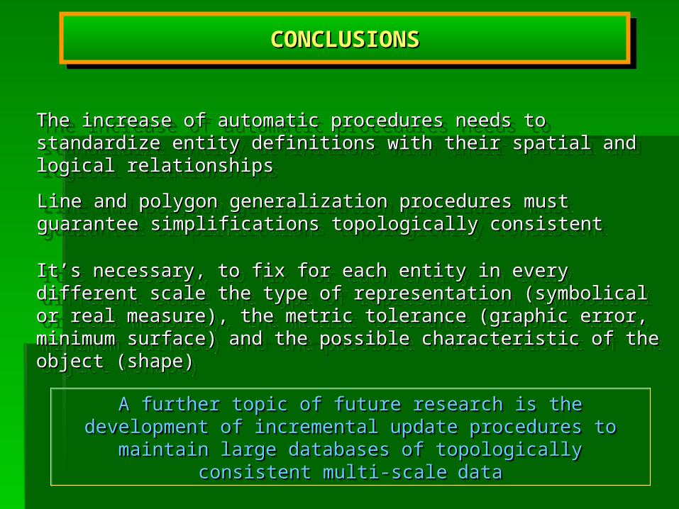
CONCLUSIONSCONCLUSIONSCONCLUSIONSCONCLUSIONS
The increase of automatic procedures needs to standardize entity The increase of automatic procedures needs to standardize entity definitions with their spatial and logical relationships definitions with their spatial and logical relationships
The increase of automatic procedures needs to standardize entity The increase of automatic procedures needs to standardize entity definitions with their spatial and logical relationships definitions with their spatial and logical relationships
Line and polygon generalization procedures must guarantee simplifications Line and polygon generalization procedures must guarantee simplifications topologically consistenttopologically consistent
Line and polygon generalization procedures must guarantee simplifications Line and polygon generalization procedures must guarantee simplifications topologically consistenttopologically consistent
It’s necessary, to fix for each entity in every different scale the type of It’s necessary, to fix for each entity in every different scale the type of representation (symbolical or real measure), the metric tolerance (graphic representation (symbolical or real measure), the metric tolerance (graphic error, minimum surface) and the possible characteristic of the object error, minimum surface) and the possible characteristic of the object (shape)(shape)
It’s necessary, to fix for each entity in every different scale the type of It’s necessary, to fix for each entity in every different scale the type of representation (symbolical or real measure), the metric tolerance (graphic representation (symbolical or real measure), the metric tolerance (graphic error, minimum surface) and the possible characteristic of the object error, minimum surface) and the possible characteristic of the object (shape)(shape)
A further topic of future research is the development of incremental A further topic of future research is the development of incremental update procedures to maintain large databases of topologically update procedures to maintain large databases of topologically
consistent multi-scaleconsistent multi-scale datadata

Thank you
for your attention
Thank you
for your attention